final stevens creek trail feasibility study
TRANSCRIPT

Joint Cities Coordinated Stevens Creek Trail Feasibility Study
Prepared for: Cities of Sunnyvale, Cupertino,
Los Altos and Mountain View and Santa Clara Valley Water District
In conjunction with: Joint Cities Working Team
Citizens Working Group
September 2015

Joint Cities Coordinated
Stevens Creek Trail Feasibility Study
Prepared for: Cities of Sunnyvale, Cupertino,
Los Altos and Mountain View and Santa Clara Valley Water District
In conjunction with:
Joint Cities Working Team Citizens Working Group
Prepared by: Sokale Environmental Planning
Hill Associates Mark Thomas & Company
Fehr and Peers Cotton, Shires and Associates
September 2015


A C K N O W L E D G E M E N T S
Joint Cities Coordinated Stevens Creek Trail Feasibility Study Page i
Thank you to all who have participated in the preparation of the Joint Cities Coordinated Stevens Creek Trail Feasibility Study. The investigation was completed under the direction of the Joint Cities Working Team and guidance of the Citizens Working Group. Community members provided comments that helped shape the recommendations prepared by the Citizens Working Group and Joint Cities Working Team.
Joint Cities Working Team
Jeannie Bruins, Mayor Pro Tem, City of Los Altos Ronit Bryant, Councilmember, City of Mountain View*
Nai Hsueh, Director, District 5, Santa Clara Valley Water District Patrick Kwok, Boardmember, District 5, Santa Clara Valley Water District*
Orrin Mahoney, Councilmember, City of Cupertino* Tara Martin-Milius, Vice Mayor, City of Sunnyvale
Tom Means, Councilmember, City of Mountain View* Chris Moylan, Councilmember, City of Sunnyvale*
Darcy Paul, Councilmember, City of Cupertino Megan Satterlee, Mayor, City of Los Altos*
Patricia Showalter, Vice Mayor, City of Mountain View
Citizens Working Group
LaNae Avra, City of Los Altos Judy Fulton, City of Los Altos
Rocky Gunderson, City of Cupertino Camie Hackson, City of Sunnyvale
Gary Hedden, City of Los Altos Ross Heitkamp, City of Mountain View
Rodney Jenny, City of Cupertino* Larry Klein, City of Sunnyvale Jim Miller, City of Cupertino Anne Ng, City of Cupertino Tim Oey, City of Sunnyvale
Jasneet Sharma, City of Mountain View Greg Unangst, City of Mountain View

A C K N O W L E D G E M E N T S
Page ii Joint Cities Coordinated Stevens Creek Trail Feasibility Study
Public Agency Staff
City of Sunnyvale Kent Steffens, Assistant City Manager
Manuel Pineda, Director of Public Works Jack Witthaus, Transportation & Traffic Manager*
Patricia Lord, Senior Management Analyst* Carla Ochoa, Traffic Engineer
Christina Uribe, Administrative Aide - Confidential
City of Cupertino Mark Linder, Director of Parks and Recreation*
Gail Seeds, Park Improvement Manager
City of Los Altos Cedric Novenario, Transportation Services Manager
City of Mountain View J.P. de la Montaigne, Community Services Director
Bob Kagiyama, Deputy Public Works Director* John Marchant, Recreation Manager
Santa Clara Valley Water District Chris Elias, Lower Peninsula Watershed Deputy Operating Officer*
Liang Lee, Hydraulics Unit Manager Pat Showalter, Senior Project Manager*
County of Santa Clara, Parks and Recreation Department Jane Mark, Senior Park Planner*
Will Fourt, Park Planner * Denotes Past Member

C O N S U L T A N T T E A M
Joint Cities Coordinated Stevens Creek Trail Feasibility Study Page iii
Lead Consultant
Sokale Environmental Planning Newark, California
Jana Sokale, Principal Planner
Subconsultants
Hill Associates, Landscape Architecture Aptos, California
Bruce Hill, Principal Landscape Architect Dominic Lopez, Landscape Architect
Mark Thomas & Company, Civil and Structural Engineering San Jose, California
Po Chen, Structure Division Manager
Fehr & Peers, Traffic Engineering San Jose, California
Nikki Nagaya, Senior Transportation Engineer Alexandra Sweet, Transportation Planner
Ian Moore, Senior Associate
Cotton, Shires and Associates, Consulting Engineers and Geologists Los Gatos, California
Ted Sayre, Principal Engineering Geologist David Schrier, Principal Geotechnical Engineer

Page iv Joint Cities Coordinated Stevens Creek Trail Feasibility Study
This page is intentionally left blank.

T A B L E O F C O N T E N T S
Joint Cities Coordinated Stevens Creek Trail Feasibility Study
Executive Summary ………………………………………………………………..….. i Chapter 1 – Purpose and Benefits …………………………………………………… 1 Purpose ………………………………………………………………………………………… 2 Regional Setting ………………………………………………………………………………... 2 Watershed Setting ……………………………………………………………………………… 2 History of the “Stevens Creek Park Chain” Concept ………………………………….…… 3 Stevens Creek: A Plan of Opportunities ……………………………………………..………. 4 Regional Trail Planning Efforts ………………………………………………………………. 4 Past City Trail Planning Efforts ………………………………………………………………. 5 Current Status of Trail Development ……………………………………………………...…. 5 Mountain View Stevens Creek Trail, Reach 4, Segment 2 Final EIR ……………………… 5 Cupertino Stevens Creek Corridor Master Plan and Restoration Plan…………………… 5 Los Altos Stevens Creek Trail Feasibility Report ………………………………………..….. 6 Bicycle and Pedestrian Goals and Policies of the Four Cities ……………………………… 6 Sunnyvale General Plan …………………………………………………………………… 6 Los Altos General Plan ………………………………………………………. …………… 8 Cupertino General Plan …………………………………………………………………… 8 Mountain View General Plan …………………………………………………………….. 10 Feasibility Study Goals ………………………………………………………………………… 13 Study Methodology ……………………………………………………………………………. 14 Trail Planning Process …………………………………………………………………..… 14 Technical Evaluations …………………………………………………………………….. 15 Outreach to Agencies ……………………………………………………………………... 15 Community Meetings …………………………………………………………………….. 15 Benefits and Significance ……………………………………………………………………… 15 Inclusion in Regional Trail Plans ………………………………...………………………. 17 Connections to City Parks, Recreation Facilities and Attractions ………………..…... 17 Transportation Benefits …………………………………………………………………… 17 Safe Routes to Schools………………………..…………………………………..…… 18 Complete Streets Program …………………………………………………………… 18 Environmental Benefits …………………………………………………………………… 19 Enhancement of Natural Resources………………………..………………………… 19 Improved Air Quality ………………………………………………………………… 19 Health Benefits ………………………………………………………………………..…… 20 Chapter 2 – Feasibility Criteria and Existing Conditions ………………………. 21 Land Availability ……………………………………………………………………………… 22 Ownership…………………………………………………………………………..……… 22 Trail Design Guidelines ……………………………………………………………..…… 22 Top-of-Bank Width ……………………………………………………………………..… 27 Habitat Sensitivity ……………………………………………………………………….….… 28
Riparian Forest ……………………………………………………………………………. 28 Oak Woodland ……………………………………………………………………………. 29 Urban Open Space ………………………………………………………………………… 30
Special Status Species ……………………………………………………………….…… 31 Invasive Plant Species …………………………………………………………………… 32 Evaluation of Grade-Separations at Bridges along Stevens Creek ……………………… 33 Other Grade-Separation Investigations ……………………………………………………. 34 Design Criteria for On-Street Bicycle and Pedestrian Facilities …………………………… 36
California Department of Transportation Highway Design Manual: ……………… 37 Chapter 1000 Bicycle Transportation Design Santa Clara Valley Transportation Authority Bicycle Technical Guidelines ………... 38

T A B L E O F C O N T E N T S
Joint Cities Coordinated Stevens Creek Trail Feasibility Study
AASHTO Guide for the Development of Bicycle Facilities ……………………………. 38 AASHTO Guide for the Planning, Design and Operation of Pedestrian Bicycle …… 38 Facilities Summary of Referenced Design Guidelines ………………………………………….... 39 Unique Traffic Conditions ………………………………………………………………. 40 Bicycle and Pedestrian Collisions ………………………………………………………. 40 On-Street Feasibility Summary ……………………………………………………………… 41 Feasibility Report Definitions ……………………………………………………………….. 41 Engineered Structures ……………………………………….……………………………….. 41 Chapter 3 – Alignment Options …………………………………….…………...…. 47 Creek Corridor and Bernardo Paths…….…………………………………………………… 48 Connecting to Foothill……………………………………….…………………….…….... 48 Connecting to I-280 Overpass ………………………………………………….…….….. 48 Creek Corridor Path and City Streets ………………...………………………………..….… 50 Fremont Ave/Grant Rd Option …………………...………………..………………..…. 50 Fallen Leaf Lane Option …………………...………………….……..………………..…. 50 Belleville Way Option ………………………..……...………………..………………..…. 50 Partial Creek Corridor Path to Mary Avenue ………………...……………………….….… 51 All City Streets ………………...…………………………………………………...……..….… 51 Chapter 4 – Pedestrian/Bicycle Paths …………………………………….………... 53 Creek Corridor Path…….……………………………………………………………………… 54 Location and Ownership ……………………………………….……………………….... 54 Site Analysis Summary ………………………………………………………….…….….. 54 Creek Character, Plant Communities and Wildlife ………………...…………….….… 54 Conceptual Alignments ……………………………...………………..………………..…. 55 Access to the Open Space from the North ……………………………..………….... 55 Option 1 – Relocate the Soundwall ………………………………………..……. 55 Option 2 – Extend Trail behind Parking Lot at Heatherstone Apartments…. 55 Option 3 – Use City Streets to Mockingbird Lane …………..…………………. 56 Crossing the Creek ………………………………………...……………………..……. 56 Access from the Open Space to Fremont Avenue ……………………..…………… 58 Option 1 – Trail Underpass beneath State Route 85 …………………………... 58 Option 2 – Pedestrian Overcrossing to Bernardo Avenue…………………….. 60 Option 3 – Pedestrian Overcrossing to Mountain View High School ………. 63 Option 4 – Pedestrian/Bicycle Bridge to West Remington Drive……………. 63 Bernardo Avenue Path ………………………………………………………………………… 63 Roadway Conditions ………………………………………………….…………………... 63 Conceptual Alignment ……………………………………………..………….…………. 63 Crossing State Route 85 at Homestead Road…………………………………...………. 64 Fallen Leaf Lane Path …………………………………………………………………….…… 64 Fremont Avenue/Grant Road Path …………………………………………………………. 65 Foothill Expressway Path……………………………………………………..………………. 65 Interstate 280/Foothill Expressway Interchange Modifications…………………………… 66 Pedestrian Overcrossing at Interstate 280……………………………………………………. 69 Grade Separated Crossing at Stevens Creek Boulevard …………………………..…...…. 70 Connection to Rancho San Antonio County Park …………………………………..………. 70 Chapter 5 – On-Street Routes ………………………………………….……….……. 73 Study Segment 1 ………………………………………………………………………………… 75 Existing Facilities ……………………………………….………………………………….. 75 Feasible Facilities ………………………………………………………….………….….… 75

T A B L E O F C O N T E N T S
Joint Cities Coordinated Stevens Creek Trail Feasibility Study
Study Segment 2 ………………………………………………….…………………………… 77 Existing Facilities ……………………………………….………………………………….. 77 Feasible Facilities ………………………………………………………….………….….… 77 Study Segment 3………………………………………………….…………………………… 79 Existing Facilities ……………………………………….………………………………….. 79 Feasible Facilities ………………………………………………………….………….….… 79 Study Segment 4 ………………………………………………….…………………………… 82 Existing Facilities ……………………………………….………………………………….. 82 Feasible Facilities ………………………………………………………….………….….… 82 Chapter 6 – Development Challenge …………………………………….……..…. 83 Budget Assumptions ………………………………………...………………..…………. 83 Unit Cost Estimates for On-Street Bicycle and Pedestrian Improvements…………… 85 Creek Corridor Path Construction Budget Estimate – Option 1…………………….… 86 Creek Corridor Path Construction Budget Estimate – Option 2…………………….… 87 Bernardo Avenue Path Construction Budget Estimate…………….………………..… 88 State Route 85 Crossing at Homestead Road Construction Budget Estimate…….… 89 Foothill Expressway Path Construction Budget Estimate…………….…………….… 90 Pedestrian Overcrossing at Interstate 280 Construction Budget Estimate………….. 91 Staging Area and Trail Access to Rancho San Antonio County Park ………….…… 92 Construction Budget Estimate Land Acquisitions and Easements ………………………………………...……………. 93 Chapter 7 – References Agencies Contacted ………………………………………...…………………………..… 95 Bibliography ………………………………………...………………..…………..….……. 97 Appendices Appendix A – Summary of Meetings Appendix B – Summary of Studied Routes Appendix C – Summary of Public Comments Maps Map 1 – Study Area Map ………………………………………...……………………..…… 2 Map 2 – Study Segment 1: Dale/Heatherstone to Fremont Avenue Ownership Map .. 23 Map 3 – Study Segment 2: Fremont Avenue to Homestead Road Ownership Map …. 24 Map 4 – Study Segment 3: Homestead Road to Stevens Creek Boulevard …………..... 26 Ownership Map Map 5 – Study Segment 1: Dale/Heatherstone to Fremont Avenue Habitat and .......... 28 Land Availability Map Map 6 – Study Segment 2: Fremont Avenue to Homestead Road Habitat and ….......... 29 Land Availability Map Map 7 – Study Segment 3: Homestead Road to Stevens Creek Boulevard Habitat …… 30 and Land Availability Map Map 8 – Alignment Options Map………………………………………………………….... 49 Map 9 – Study Segment 1: Dale/Heatherstone to Fremont Avenue Alignments Map… 61 Map 10 – Study Segment 2: Fremont Avenue to Homestead Road Alignments Map …. 62 Map 11 – Study Segment 3: Homestead Road to Stevens Creek Boulevard ……………... 67 Alignments Map Map 12 – Study Segment 4: Stevens Creek Boulevard Connection to Rancho ………….... 68 San Antonio County Park Alignments Map
T A B L E O F C O N T E N T S
Joint Cities Coordinated Stevens Creek Trail Feasibility Study
Illustrations Illustration 1 – Trail underpass beneath State Route 85 north of Fremont Avenue …….... 59 Illustration 2 – Astoria to The Dalles on Bernardo …………….…………………………...... 64 Illustration 3 – The Dalles to Helena on Bernardo …………….…………………………...... 64 Illustration 4 – Fallen Leaf Lane as a Signed Bike Route.…………………………………...... 79 Illustration 5 – Fallen Leaf Lane as a Neighborhood Greenway with Walking Space…….. 79 Figures Figure 1 – Sunnyvale General Plan goals and polices relating to pedestrian ………........... 7 and bicycle facilities. Figure 2 – Los Altos General Plan goals and polices relating to the movement of ………. 8 pedestrian and bicycle facilities. Figure 3 – Cupertino General Plan goals and polices relating to pedestrian ……...….…... 9 and bicycle facilities. Figure 4 – Cupertino General Plan goals and polices relating to trails and creeks. …… 10 Figure 5 – Mountain View General Plan goals and polices relating to pedestrian ……. 11 and bicycle facilities. Figure 6 – Mountain View General Plan goals and polices relating to parks, ……….... 12 open space and trails. Figure 7 – Trail planning process.……………………….………………………………….. 14 Figure 8 – Summary of parks, schools and attractions within the study area…………. 16 Figure 9 – 1995 Santa Clara Countywide Trails Master Plan Definitions.…………....... 18 Figure 10 – Countywide Trails Master Plan Guideline G-2 – Shared Use Trail – ………. 25 Paved Tread Double Track. Figure 11 – Top-of-Bank Land Availability Criteria.………………………......................... 27 Figure 12 – Wildlife species with the potential to occur within the study area…………. 32 Figure 13 – Summary of grade-separated crossing feasibility at existing roadway ……. 34 bridges along Stevens Creek. Figure 14 – Summary of grade-separated crossing feasibility at other structures ……… 35 in the study area. Figure 15 – Caltrans Bikeway Designations. ………………………………………………..... 37 Figure 16 – Bicycle Lane Widths on Arterials/Collectors at a Range of Posted Speeds... 39 Figure 17 – Summary of 2008-2013 Bicycle and Pedestrian Collisions on Studied ….… 40 Roadways. Figure 18 – Dale/Heatherstone to Fremont Avenue feasibility of studied roadways to… 43
support pedestrian and bicycle facilities for linking the Stevens Creek Trail Figure 19 – Fremont Avenue to Homestead Road feasibility of studied roadways to … 44 support pedestrian and bicycle facilities for linking the Stevens Creek Trail Figure 20 – Homestead Road to Stevens Creek Boulevard feasibility of studied ………. 45 arterial roadways to support pedestrian and bicycle facilities for linking the Stevens Creek Trail Figure 21 – Homestead Road to Stevens Creek Boulevard feasibility of studied ……….. 46 residential streets to support pedestrian and bicycle facilities for linking the Stevens Creek Trail. Figure 22 – Trail behind Heatherstone Apartment with reconstructed soundwall …….. 56 Figure 23 – Engineering solutions for constrained areas along State Route 85 soundwall. 58 Figure 24 – Grade-separated options for connecting to Fremont Avenue……………….. 60 Figure 25 – Plan view of path parallel to Foothill Expressway…………………………….. 66 Figure 26 – Cross-section of reconfigured Foothill Expressway underpass ……………… 66 beneath Interstate 280 Figure 27 – Potentially feasible pedestrian overcrossings of Interstate 280 …………….... 70 Figure 28 – Staging Area and Trail Connection Concept Plan ……………………………. 71

T A B L E O F C O N T E N T S
Joint Cities Coordinated Stevens Creek Trail Feasibility Study
Figure 29 – Dale/Heatherstone to Fremont Avenue existing and feasible ……………..... 76 on-street bicycle facilities. Figure 30 – Fremont Avenue to Homestead Road existing and feasible ……………… 78 on-street bicycle facilities. Figure 31 – Homestead Road to Stevens Creek Boulevard existing and ………………. 80 feasible on-street bicycle facilities on collector and arterial streets. Figure 32 – Homestead Road to Stevens Creek Boulevard existing and ………………. 81 feasible on-street bicycle facilities on residential streets. Figure 33 – Unit Cost Estimates for On-Street Bicycle and Pedestrian Improvements . 85 Figure 34 – Creek Corridor Path – Option 1 Trail Underpass beneath Highway 85…… 86
Construction Budget Estimate Figure 35 – Creek Corridor Path – Option 2 Trail Overcrossing Spanning Fremont…… 87
Avenue Construction Budget Estimate Figure 36 – Bernardo Avenue Path Construction Budget Estimate………………...……… 88 Figure 37 – State Route 85 Crossing at Homestead Road Construction Budget Estimate 89 Figure 38 – Foothill Expressway Path Construction Budget Estimate…………….……… 90 Figure 39 – Pedestrian Overcrossing at Interstate 280 Construction Budget Estimate….. 91 Figure 40 – Staging Area and Trail Access to Rancho San Antonio County Park …….… 92

T A B L E O F C O N T E N T S
Joint Cities Coordinated Stevens Creek Trail Feasibility Study
This page is intentionally left blank.

E X E C U T I V E S U M M A R Y
Joint Cities Coordinated Stevens Creek Trail Feasibility Study Page i
This feasibility report explores the potential for extending the Stevens Creek Trail through the cities of Sunnyvale, Cupertino, Los Altos and Mountain View. The study evaluated the technical feasibility of developing bicycle and pedestrian facilities along approximately four miles of creek corridor and surrounding city streets. The goal of the study was to assess the feasibility of a wide range of potential alignments that could close the gap in the trail between the Dale/Heatherstone pedestrian overcrossing in Mountain View and Stevens Creek Boulevard in Cupertino. The study area boundaries extend from Heatherstone Way to the north, Mary Avenue to the east, Grant Road to the west and to Stevens Creek Boulevard to the south. The study area also includes the open space lands along Stevens Creek Boulevard and adjacent to Rancho San Antonio County Park in Cupertino. The four cities initiated this study and have worked collaboratively to identify options to complete the Stevens Creek Trail. Goals and policies regarding the development of the Stevens Creek Trail have been integrated into the long-range planning documents of all the cities. The trail could provide access to eleven city parks, two regional parks and open space preserves, 16 K-12 schools and DeAnza College. The trail currently connects to the San Francisco Bay Trail and the Bay Area Ridge Trail providing access to other regional open space lands. The trail also provides access to Caltrain and Light Rail in downtown Mountain View providing opportunities for multi-modal commuting. The feasibility study determined that a variety of routes and facility types are feasible through the four cities, but challenges are associated with each alignment. This feasibility study assessed the potential for developing the routes against a variety of adopted design guidelines for bicycle and pedestrian facilities and by establishing criteria to measure land availability, habitat sensitivity and roadway and creek
crossings. The report provides decision makers with an assessment of the technical feasibility for extending the trail by identifying potential alignments and conceptual engineering solutions. The feasibility study is the first step in a trail planning process. The feasible alignments provide a range of choices for decision makers to consider for completing the trail through the four cities. The next step would involve the development of a trail master plan, which would be evaluated under the California Environmental Quality Act (CEQA). All future trail planning and environmental review will provide opportunities for public involvement. The study area was divided into four study segments to facilitate the presentation of the feasibility findings. The segments vary by length and begin and end at city streets. The four study segments include (See Maps 9-12 – Alignment Maps): ◆ Study Segment 1: Dale Avenue/ Heatherstone Way to Fremont Avenue ◆ Study Segment 2: Fremont Avenue to
Homestead Road ◆ Study Segment 3: Homestead Road to
Stevens Creek Boulevard ◆ Study Segment 4: Trail Connections to
Rancho San Antonio County Park via Stevens Creek Boulevard
The feasibility report consists of seven chapters. An introductory page precedes each chapter and describes the specific content. Chapter 1 – Purpose and Benefits describes the purpose, provides an overview of the study area, summarizes the history and current status of trail planning, introduces the adopted pedestrian and bicycle transportation goals and policies of the four cities, discusses the feasibility study methodology and details the significance and benefits of the trail to the community.

E X E C U T I V E S U M M A R Y
Page ii Joint Cities Coordinated Stevens Creek Trail Feasibility Study
Chapter 2 – Feasibility Criteria and Existing Conditions describes criteria used to evaluate the feasibility for connecting the Stevens Creek Trail along city streets and through open space lands along the stream corridor. Land availability, habitat sensitivity, roadway and creek crossings were evaluated within the creek corridor. Roadway width, traffic volume and speed, roadway intersections and pedestrian and bicycle collision history were evaluated for on-street routes. This chapter also defines the types of pedestrian and bicycle facilities and engineered structures evaluated for the trail. Chapter 3 – Alignment Options provides an introduction to the feasible alignments for completing the trail through the four cities. These alignments represent complete routes through the four cities, but do not represent every feasible segment or type of facility studied (See Map 8 – Alignment Options Map). Chapter 4 – Pedestrian/Bicycle Paths details the feasible pedestrian/bicycle paths. These routes most closely approximate the trail user experience present in the constructed sections of the trail in Mountain View and Cupertino. The assessments of land availability, habitat sensitivity and roadway, creek and on-street crossing feasibilities are highlighted for each feasible alignment. These routes provide for the exclusive use of pedestrians and bicyclists and minimize roadway crossings. Pedestrian/bicycle paths are feasible both in the open space parcels along the creek and within the public right-of-way of a few streets. This chapter also describes the engineered structures needed for the routes. Chapter 5 – On-Street Routes describes the feasible on-street bicycle and pedestrian facilities. Roadway width, traffic volume and speed, roadway intersections and pedestrian and bicycle collision history were evaluated for on-street routes to determine the opportunities and constraints. This feasibility study reviewed a wide
range of on-street routes and identifies the types of bicycle and pedestrian facilities that are feasible on each street. Chapter 6 – Development Challenge provides unit cost estimates for constructing on-street bicycle and pedestrian facilities and preliminary budget estimates for constructing pedestrian/bicycle path segments. This chapter also identifies six areas along the pedestrian/bicycle path alignments where acquisition of land or easements would facilitate construction. Chapter 7 – References identifies reports, plans, studies, databases, ordinances, maps and record drawings reviewed in the preparation of the feasibility report. This chapter also identifies all persons contacted during the study.

E X E C U T I V E S U M M A R Y
Page ii Joint Cities Coordinated Stevens Creek Trail Feasibility Study

C H A P T E R 1 – P U R P O S E A N D B E N E F I T S
Joint Cities Coordinated Stevens Creek Trail Feasibility Study Page 1
This feasibility study investigated the potential to develop bicycle and pedestrian facilities along approximately four miles of Stevens Creek and the city streets surrounding the stream corridor. The goal of the study was to assess the feasibility of a wide range of potential alignments that could link together existing segments of the Stevens Creek Trail. The cities of Mountain View, Sunnyvale, Los Altos and Cupertino have worked collaboratively to identify options for closing the gap in the Stevens Creek Trail. Chapter 1 explains the purpose, provides an overview of the study area, summarizes the history and current status of trail planning, introduces the adopted pedestrian and bicycle transportation goals and policies of the four cities, discusses the feasibility study methodology and details the significance and benefits of the trail to the community. The study area reviewed in this feasibility report includes the open space and parklands along Stevens Creek from the Dale/Heatherstone pedestrian overcrossing, the current trail terminus in Mountain View, to Stevens Creek Boulevard where the trail ends in Cupertino. The study also includes the open space lands along Stevens Creek Boulevard and adjacent to Rancho San Antonio County Park. City streets located from Heatherstone Way to Stevens Creek Boulevard and Grant Road to Mary Avenue have also been evaluated as potential routes to link the trail. The Stevens Creek Trail serves residents and area employees who enjoy spending time in the open space corridor for recreation, alternative commuting and nature appreciation. The communities of Mountain View and Cupertino have celebrated the natural beauty of the stream corridor and invested in habitat restoration and interpretation of these resources concurrent with trail development. Opportunities for additional habitat enhancement are present within this study area.
Eleven city parks, two regional open space facilities, 16 K-12 schools and DeAnza College are located within the study area and would be served by the Stevens Creek Trail. The trail currently connects to the San Francisco Bay Trail and the Bay Area Ridge Trail providing access to regional open space lands. The trail also provides access to Caltrain and Light Rail in downtown Mountain View providing opportunities for multi-modal commuting. Most users feel proximity to home, the natural scenery and wildlife and connectivity of the route are the best features of the trail. Residents enjoy relaxing walks, conversations with neighbors, fitness runs and time spent in the outdoors on the Stevens Creek Trail. The feasibility study is the first step in a trail planning process. The next step would involve the development of a trail master plan, which would be evaluated under the California Environmental Quality Act (CEQA). All future trail planning and environmental review will provide opportunities for public involvement.
Stevens Creek in Mountain View.

C H A P T E R 1 – P U R P O S E A N D B E N E F I T S
Page 2 Joint Cities Coordinated Stevens Creek Trail Feasibility Study
PURPOSE The purpose of the feasibility study is to provide a comprehensive report to the City Councils of Sunnyvale, Cupertino, Los Altos and Mountain View that will assist them in determining next steps in narrowing feasible trail alternatives, selecting a preferred route and coordinating completion of the Stevens Creek Trail. The study reviewed existing trail reports, plans and policies, solicited community opinions and evaluated physical opportunities and constraints to trail development. This report identifies a broad range of trail alternatives based on existing plans and policies, community input, property ownership and physical conditions including biological, geological and hydrological processes of the creek corridor and traffic and circulation patterns of the roadway system. Much of the work undertaken to assess potential routes focused on the technical engineering and environmental challenges presented by the constrained landscape. REGIONAL SETTING Stevens Creek is a spring-fed stream that flows northeast from the Santa Cruz Mountains to San Francisco Bay through the cities of Cupertino, Sunnyvale, Los Altos and Mountain View. The area evaluated in this feasibility report includes approximately four miles of the creek corridor from the Dale/Heatherstone pedestrian overcrossing in Mountain View south to Stevens Creek Boulevard in Cupertino. It also includes the open space lands along Stevens Creek Boulevard and adjacent to Rancho San Antonio County Park in Cupertino. Finally, the study evaluates on-street routes within the study area boundaries that extend from Heatherstone Way to the north, Mary Avenue to the east, Grant Road to the west and Stevens Creek Boulevard to the south (See Map 1 - Regional Setting Map). The study area is approximately 3.25 miles north to south and 1.50 miles east to west as the crow flies.
The study area was divided into four study segments to facilitate the presentation of the feasibility findings. The segments vary by length and begin and end at natural termini that are likely to be used in developing future construction phasing limits. The four study segments include: ◆ Study Segment 1: Dale Avenue/ Heatherstone Way to Fremont Avenue ◆ Study Segment 2: Fremont Avenue to
Homestead Road ◆ Study Segment 3: Homestead Road to
Stevens Creek Boulevard ◆ Study Segment 4: Trail Connections to
Rancho San Antonio County Park via Stevens Creek Boulevard
Map 1 - Regional Setting Map WATERSHED SETTING Stevens Creek is a primary stream originating in the Santa Cruz Mountains draining runoff from a 29-square-mile watershed into South San Francisco Bay. Most of the upper watershed is

C H A P T E R 1 – P U R P O S E A N D B E N E F I T S
Joint Cities Coordinated Stevens Creek Trail Feasibility Study Page 3
undeveloped forest and rangeland that is managed by Midpeninsula Regional Open Space District and Santa Clara County Parks and Recreation Department. Water is impounded on its 20-mile flow to the Bay at Stevens Creek Reservoir, which is operated by the Santa Clara Valley Water District. The creek extends 12.5 miles below the dam. The creek corridor has been buffered from the full effects of urbanization through thoughtful land use planning and the result of development choices. Land use policies codified in the Cupertino General Plan promoted the acquisition of floodplain lands as open space. These policies minimized the amount of urban development immediately adjacent to the creek corridor in Cupertino. In the downstream communities of Los Altos, Sunnyvale and Mountain View much of the stream corridor was ultimately protected by the construction of State Route 85, which roughly parallels Stevens Creek from Fremont Avenue to US Highway 101 (US 101). The California Department of Transportation (Caltrans) purchased large swaths of right-of-way in the 1960s for the development of State Route 85. The excess land was eventually transferred to the City of Mountain View as open space. These land use decisions and policies limited the amount of development that could occur directly adjacent the stream corridor, preserved much of the integrity of the riparian habitat and may have helped to maintain the population of threatened Central California Coast steelhead in Stevens Creek. These land protections, suitable habitat and the year-round presence of steelhead led NOAA National Marine Fisheries Service to designate Stevens Creek as “critical habitat” for the recovery of Central California Coast steelhead. Stevens Creek Dam releases typically maintain surface flow in the channel northward from the reservoir during dry months through a 5.7-mile groundwater recharge area ending at approximately Fremont Avenue. In the two miles immediately below the reservoir, located in Stevens Creek County Park, the creek
passes through two golf courses, McClellan Ranch Preserve and Blackberry Farm Park where incision and entrenchment are low and the inset valley is fairly wide. The dam has reduced gravel loads available to replenish the stream system thereby contributing to creek bed downcutting. Water from Permanente Creek is diverted to Stevens Creek six miles below the reservoir during winter storms. This diversion reduces flooding in the lower Permanente Creek watershed, but increases scour and erosion in lower Stevens Creek. The downstream segments of the creek are steeply incised from lack of upstream sediment as a result of the dam and high peak flows from urbanization, which exacerbate erosion and creek bank slumping. The feasibility of a streamside trail is constrained by these ongoing hydrogeomorphic processes. HISTORY OF THE “STEVENS CREEK PARK CHAIN” CONCEPT (1961) COUNTY OF SANTA CLARA PLANNING DEPARTMENT In 1961, the County of Santa Clara Planning Department prepared the first plan for the “Stevens Creek Park Chain.” This concept plan provided a framework for land preservation and public access along the creek. The plan envisioned that creeks be “preserved in their natural state and augmented by parks and other public open spaces, these creeks can be priceless possessions of the metropolitan area, emerald necklaces of parks and connecting trailways. Along these creek chains one can walk, cycle, or horse-back ride for long distances, protected from automobile traffic (Santa Clara County, 1961, p. 1).” In the 1960s and 1970s, land along the Valley floor and upper watershed was preserved in response to this concept plan. Santa Clara County acquired properties that have become Stevens Creek County Park and Upper Stevens Creek County Park. The City of Mountain View acquired the excess right-of-way from the construction of SR 85.

C H A P T E R 1 – P U R P O S E A N D B E N E F I T S
Page 4 Joint Cities Coordinated Stevens Creek Trail Feasibility Study
The original 1961 Stevens Creek Park Chain Plan (Courtesy of Don Weden). STEVENS CREEK: A PLAN OF OPPORTUNITIES (1980) SANTA CLARA VALLEY WATER DISTRICT, MIDPENINSULA REGIONAL OPEN SPACE DISTRICT AND CITY OF MOUNTAIN VIEW The 1980 Plan of Opportunities evaluated the creek corridor from Homestead Road north to San Francisco Bay. This comprehensive management plan addressed flooding and erosion, biological resources and urban recreational opportunities of the open space lands along Stevens Creek. This plan outlined concepts, goals and management guidelines for preserving and restoring the biological resources while integrating recreational activities at nodes along the park chain that complemented the natural setting of the creek corridor. The report stressed the importance of preserving the natural creek corridor while allowing recreational access to the open space land along the creek. Environmental restoration of the creek corridor was first proposed in this report. Only those recreational uses that would integrate with the natural environment of Stevens Creek were recommended. Walking, jogging, bicycling and nature exploration were defined as appropriate passive recreational uses of the creek corridor. REGIONAL TRAIL PLANNING EFFORTS Over the past several decades, Santa Clara County Parks and Recreation Department and Midpeninsula Regional Open Space District have acquired open space lands and developed much of the Stevens Creek Trail in the upper watershed. The Tony Look Stevens Creek Trail extends through
Stevens Creek County Park connecting to the Canyon Trail in Upper Stevens Creek County Park. The trail is named for Claude A. “Tony” Look, the late County Parks and Recreation commissioner and executive director and board member of Sempervirens Fund who worked to expand land protection in the Santa Cruz Mountains and encouraged the development of the Stevens Creek Trail until his death in 2006.
Excess lands from the construction of SR 85. The Stevens Creek Nature Trail begins in the headwaters in Monte Bello Open Space Preserve and links to the Canyon Trail that follows the drainage south toward Saratoga Gap. A segment of trail is missing from the Canyon Trail, although recent acquisitions are helping to close this gap. Eventually, trail users will be able to hike through the entire upper watershed and connect to the Skyline-to-the-Sea Trail via the Table Mountain Fire Road and Saratoga Gap Trail. The Skyline-to-the-Sea Trail extends 29 miles from Saratoga Gap to the Pacific

C H A P T E R 1 – P U R P O S E A N D B E N E F I T S
Joint Cities Coordinated Stevens Creek Trail Feasibility Study Page 5
Ocean at Waddell Creek in Big Basin State Park. When the gaps in the Stevens Creek Trail are completed, trail users will be able to travel from San Francisco Bay to the Pacific Ocean. The passage by voters of 2014 Measure AA - Regional Open Space Access, Preservation and Restoration Bond specifically supports the completion of the Stevens Creek Trail across the valley floor and through the upper watershed as determined by city and neighborhood trail routing solutions. This bond also identifies stream corridor restoration and steelhead habitat enhancement below Stevens Creek Dam as a priority. PAST CITY TRAIL PLANNING EFFORTS The four cities have undertaken focused trail planning efforts subsequent to the early regional open space planning reports. These efforts have resulted in the preparation of local trail plans and the construction of approximately five miles in Mountain View and one mile in Cupertino of the Stevens Creek Trail. The focused trail plans include: ♦ 1991 Stevens Creek Trail and Wildlife
Corridor – Mountain View ♦ 1994 Evaluation of Policy and Planning
Issues Related to Proposed Stevens Creek Trail as Impacting Sunnyvale – Sunnyvale
♦ 2002 Stevens Creek Trail, Reach 4, Segment 2 – Mountain View
♦ 2002 Stevens Creek Trail Feasibility Study – Cupertino
♦ 2006 Stevens Creek Corridor Park Master Plan and Restoration Plan – Cupertino
♦ 2008 Stevens Creek Trail Feasibility Study – Los Altos
CURRENT STATUS OF TRAIL DEVELOPMENT Today, the Stevens Creek Trail extends five miles from San Francisco Bay to the Dale/Heatherstone pedestrian overcrossing in Mountain View and one mile from Stevens Creek Boulevard upstream to McClellan Road. An approximately three-
mile trail gap exists between the Dale/Heatherstone pedestrian overcrossing and Stevens Creek Boulevard. The four cities have each independently adopted plans and integrated goals and policies regarding development of the Stevens Creek Trail into long-range planning documents. The trail plans and policy documents of each city are summarized to provide the context for this feasibility study focused on closing the trail gap across the valley floor. MOUNTAIN VIEW STEVENS CREEK TRAIL, REACH 4, SEGMENT 2 FINAL EIR (2004) The most recent trail planning effort by Mountain View culminated in 2004 with the release of the Final Environmental Impact Report for Reach 4, Segment 2. This work reexamined the trail alignment from Yuba Drive to the open space lands south of Dale Avenue and Heatherstone Way. Since 2004, Mountain View has successfully constructed the trail from Yuba Drive to the Dale/Heatherstone pedestrian overcrossing. The final phase is planned to extend from Dale/Heatherstone to Mountain View High School through open space land owned by Mountain View to the east of State Route 85. The trail would extend along the west side of the creek between the soundwall and the top-of-bank until reaching the large meadow. The trail would meander through the meadow to a pedestrian overcrossing spanning State Route 85 and touch down in a city-owned parcel adjacent to Mountain View High School. No funding is currently budgeted for design or construction of this final trail phase. Mountain View is collaborating on this trail feasibility study to identify a final trail alignment that will best serve area residents and users of the Stevens Creek Trail. CUPERTINO STEVENS CREEK CORRIDOR MASTER PLAN AND RESTORATION PLAN INITIAL STUDY/MITIGATED NEGATIVE DECLARATION (2006) In 2002, Cupertino studied the feasibility of extending the Stevens Creek Trail and the Juan Bautista de Anza National Historic

C H A P T E R 1 – P U R P O S E A N D B E N E F I T S
Page 6 Joint Cities Coordinated Stevens Creek Trail Feasibility Study
Trail from Rancho San Antonio County Park to Stevens Creek County Park. This trail feasibility study was followed in 2006 with master plan and restoration plan for the lands along Stevens Creek from McClellan Road to Stevens Creek Boulevard. The trail in this area was developed in two phases and is open to the public. Santa Clara County Parks and Recreation Department developed portion of the Juan Bautista de Anza National Historic Trail through Rancho San Antonio County Park. A trail connection along city streets from Rancho San Antonio County Park to the Stevens Creek Trail in Cupertino is evaluated in this study. LOS ALTOS STEVENS CREEK TRAIL FEASIBILITY STUDY (2008) In 2008, Los Altos studied the feasibility of developing the Stevens Creek Trail through the open space lands north of Fremont Avenue and along city streets through Los Altos. Los Altos selected a preferred route that extended along the creek corridor to Fremont Avenue and Grant Road, but did not adopt this alignment. The route is planned as a Class I multi-use path that parallels these collector streets and is constructed within the public right-of-way. The route jogs west on Fremont Avenue and then extends south and southeast on Grant Road for approximately two miles to connect to Foothill Expressway at Homestead Road/Vineyard Drive. The existing westbound bike lane on the north side of Fremont Avenue and southbound bike lane on the west side of Grant Road are integrated into the new multi-use path in an effort to preserve more oak trees and provide a landscape buffer between the trail and auto traffic. Twelve side streets, two cul de sacs and the driveways to the Woodland Branch Library and Lucky Supermarket intersect the proposed two-mile multi-use path. The 2012 Los Altos Bicycle Transportation Plan notes “The final alignment for this project has not yet confirmed. The Class I pathway is only recommended if it is confirmed to be part of the Stevens Creek Trail or serve as a connector trail (Los Altos, 2012, p. 5-16).”
BICYCLE AND PEDESTRIAN GOALS AND POLICIES OF THE FOUR CITIES The feasibility study is guided not only by the previous trail planning efforts, but also by the plans and policies of the four cities relative to pedestrian and bicyclist mobility. The adopted general plan, bicycle plan and pedestrian plan goals, policies and strategies that guided the development of the potential Stevens Creek Trail routes are highlighted. SUNNYVALE GENERAL PLAN (2011) The City of Sunnyvale recently updated its General Plan. Goals and policies regarding the movement of pedestrians and bicyclists are included in the Land Use and Transportation Chapter. It should be noted that in 2009, the Sunnyvale City Council revised the 1994 General Plan to strike Policy 2.2.C.5 which opposed development of the Stevens Creek Trail within the creek corridor open space parcels. This action has allowed for a wider range of trail alternatives to be considered between the Dale/Heatherstone pedestrian overcrossing and Fremont Avenue than would have previously been considered. The revised policy states: “Policy LT-9.4 Support a regional trail system by coordinating with adjacent jurisdictions to facilitate trail connections wherever possible (Sunnyvale, 2011, p. 3-43).” In 2006, Sunnyvale developed Key Initiatives to respond to demands for increased open space and the areas identified as having “service gaps” and being underserved by current open space offerings. These Key Initiatives were further evaluated in the 2009 Parks of the Future Study. The 2006 Key Initiatives and the 2009 Parks of the Future Study identified the goal to “explore the potential for new off-street trails and coordination of on-street bike connections (Sunnyvale, 2011, p. 3-38).” An additional policy direction incorporated into the 2011 General Plan gives precedence to the movement people over stationary uses (parking) of the roadway system.

C H A P T E R 1 – P U R P O S E A N D B E N E F I T S
Joint Cities Coordinated Stevens Creek Trail Feasibility Study Page 7
Sunnyvale General Plan
Land Use and Transportation Goals and Policies
GOAL LT-5 Effective, Safe, Pleasant and Convenient TransportationC3 .5) Policy LT-5.5 Support a variety of transportation modes. LT-5.5a Promote alternate modes of travel to the automobile. LT-5.5d Maximize the provision of bicycle and pedestrian facilities. LT-5.5e Implement the City of Sunnyvale Bicycle Plan. LT-5.5g Ensure safe and efficient pedestrian and bicycle connections to neighborhood transit stops. Policy LT-5.8 Provide a safe and comfortable system of pedestrian and bicycle pathways. 3–22 Policy LT-5.9 Appropriate accommodations for motor vehicles, bicycles, and pedestrians shall be determined for city streets to increase the use of bicycles for transportation and to enhance the safety and efficiency of the overall street network for bicyclists, pedestrians, and motor vehicles. Policy LT-5.10 All modes of transportation shall have safe access to city streets. Policy LT-5.12 City streets are public space dedicated to the movement of vehicles, bicycle and pedestrians. Providing safe accommodation for all transportation modes takes priority over non-transportation uses. Facilities that meet minimum appropriate safety standards for transportation uses shall be considered before non-transportation uses are considered. Policy LT-5.13 Parking is the storage of transportation vehicles and shall not be considered a transport use. Policy LT-5.14 Historical precedence for street space dedicated for parking shall be lesser consideration than providing street space for transportation uses when determining the appropriate future use of street space. GOAL LT-8 Adequate and Balanced Open Space Policy LT-8.8 Support the acquisition or joint use through agreements with partners of suitable sites to enhance Sunnyvale’s open spaces and recreation facilities based on community need and through such strategies as development of easements and right-of-ways for open space use, conversion of sites to open space from developed use of land and landbanking. Policy LT-8.10 Facilitate and encourage pedestrian traffic in public recreational open spaces and utilize the Santa Clara Valley Transportation Authority’s Authority Pedestrian Technical Design Guidelines whenever appropriate and feasible. GOAL LT-9 Regional Approach to Open Space Policy LT-9.2 Support public and private efforts in and around Sunnyvale to acquire, develop and maintain open space and recreation facilities and service for public use. Policy LT-9.4 Support a regional trail system by coordinating with adjacent jurisdictions to facilitate trail connections wherever possible (See also City of Sunnyvale Bicycle Plan).
Figure 1 – Sunnyvale General Plan goals and polices relating to pedestrian and bicycle facilities.

C H A P T E R 1 – P U R P O S E A N D B E N E F I T S
Page 8 Joint Cities Coordinated Stevens Creek Trail Feasibility Study
“Sunnyvale Policy LT-5.12 City streets are public space dedicated to the movement of vehicles, bicycles and pedestrians. Providing safe accommodation for all transportation modes takes priority over non-transportation uses. Facilities that meet minimum appropriate safety standards for transportation uses shall be considered before non-transportation uses are considered (Sunnyvale, 2011, p. 3-23).” Many of Sunnyvale’s General Plan goals and policies support human-powered modes of transportation (See Figure 1 – Sunnyvale General Plan goals and polices relating to pedestrian and bicycle facilities).
Figure 2 – Los Altos General Plan goals and polices relating to the movement of pedestrian and bicycle facilities.
LOS ALTOS GENERAL PLAN (2002) The Los Altos General Plan - Circulation Element includes a bikeways map with both existing and proposed Class I bike paths, Class II bike lanes and Class III bike routes. The General Plan includes language that relates to the Stevens Creek Trail. The Circulation Element states that where feasible, paths and trails should be added to City right-of-way to help separate pedestrians and vehicles (See Figure 2 – Los Altos General Plan goals and polices relating to the movement of pedestrian and bicycle facilities). CUPERTINO GENERAL PLAN 2000-2020 (2000) The 1964, 1972, 1993 and 2000 Cupertino General Plans have supported the acquisition of the lands adjacent to Stevens Creek to preserve the floodplain as open space and to develop an urban trail along the creek corridor. In keeping with this long-range vision, the City of Cupertino purchased McClellan Ranch, Blackberry Farm and Golf Course, the Simms and Stocklmeir properties between 1972 and 1999. Cupertino purchased the final floodplain parcel between McClellan Road and Stevens Creek Boulevard, a single-family residence, from a willing seller in 2014. The Stevens Creek Trail supports City Council goals for enhancing bicycling and walking throughout the community. The trail implements elements of the 2011 Cupertino Bicycle Transportation Plan and 2002 Cupertino Pedestrian Transportation Guidelines. Goals and policies regarding the movement of pedestrians and bicyclists are included in the Circulation and Environmental Resources/Sustainability Elements of the Cupertino General Plan (See Figure 3 – Cupertino General Plan goals and polices relating to pedestrian and bicycle facilities and Figure 4 – Cupertino General Plan goals and polices relating to trails and creeks).
Los Altos General Plan
Circulation Goals and Policies
Goal 4 of the Circulation Element states that Los Altos should provide for the convenient and safe movement of bicyclists and pedestrians throughout the City to meet the commuter and recreation needs of the community. Relevant policies to achieve this goal include (Los Altos, 2002, pp. 23-24): Policy 4.1: Develop and maintain a comprehensive and integrated system of bikeways that promote bicycling riding for commuting and recreation. Policy 4.2: Provide for safe and convenient pedestrian connections to and between Downtown, other commercial districts, neighborhoods, and major activity centers within the City, as well as within surrounding jurisdictions. Policy 4.4: Provide trails, sidewalks or separated pathways in areas where needed to provide safe bicycle and pedestrian access to schools. Policy 4.5: Consider separated bicycle and pedestrian pathways along arterial and collector roadways. Policy 4.6: Pursue potential rights-of-way such as Santa Clara Valley Water District and other utility easements for bicycle and pedestrian trail development.

C H A P T E R 1 – P U R P O S E A N D B E N E F I T S
Joint Cities Coordinated Stevens Creek Trail Feasibility Study Page 9
Cupertino General Plan
Circulation Goals and Policies
GOAL C - A Comprehensive Network of Pedestrian and Bicycle Routes and Facilities Policy 4-3: Cupertino Pedestrian Transportation Guidelines and the Cupertino Bicycle (Cupertino, 2000, pp. 4.7-4.9). Transportation Plan. Implement the programs and projects recommended in the Cupertino Pedestrian Transportation Guidelines and in the Cupertino Bicycle Transportation Plan, as well as other programs that promote this goal.
Strategies 1. The Pedestrian Guidelines. Implement the projects recommended in the Pedestrian Guidelines including: • After engineering review, and where found to be feasible, improve safety at selected intersections by one or more of the following: prohibit right turn-on-red, add time to the pedestrian signal phase, construct a median and/or reduce corner radii. • Where feasible provide missing sidewalks on arterial and collector streets and on neighborhood streets as desired by residents. 3. Safe Routes to School. Work with the School Districts to promote the Safe Route to Schools program. 4. Pedestrian Time on Traffic Signals. With engineering review, provide additional time for pedestrians to cross streets at appropriate intersections. Added time would be most appropriate near shopping districts, schools and senior citizen developments. This strategy should be considered even if it could reduce the Level of Service (LOS) for automobile traffic. 5. Pedestrian Improvements. To enhance walking, consider various improvements to roadways to make them more pedestrian friendly and less auto-centric. Where a median is provided, it should be wide enough to safely accommodate pedestrians. Streets such as Homestead, Bollinger, Rainbow, Prospect or Stelling should be evaluated for potential improvements for pedestrians. Working with the neighborhood, consider reducing residential street widths to promote slower traffic and less pervious surface 6. Crosswalk Marking, Medians, and “Chokers.” Following engineering review, mark crosswalks with pavement treatment scaled to the speed of traffic. Use medians and “chokers” to narrow the width of the street where feasible and appropriate. 8. Implementation of the Bicycle Plan. Implement the Bikeway Network as recommended in the Bicycle Plan. 9. Bicycle Facilities in New Developments. Encourage the developers of major new or remodeled buildings to include secure interior and/or fully weather protected bicycle parking. 10.Traffic Calming on Bicycle Routes. Where feasible and appropriate, implement traffic calming on those bicycle routes where automobile traffic volumes are low. Bicycle traffic flows best where automobile traffic volume and speeds are low and where there are no stop signs or traffic signals to hinder through traffic flow. Policy 4-4: Regional Trail Development Continue to plan and provide for a comprehensive system of trails and pathways consistent with regional systems, including the Bay Trail, Stevens Creek Corridor and Ridge Trail. The General Alignment of the Bay Trail, as shown in the Association of Bay Area Governments’ Bay Trail planning document, is incorporated in the General Plan by reference.
Figure 3 – Cupertino General Plan goals and polices relating to pedestrian and bicycle facilities.

C H A P T E R 1 – P U R P O S E A N D B E N E F I T S
Page 10 Joint Cities Coordinated Stevens Creek Trail Feasibility Study
Cupertino General Plan
Environmental Resources/Sustainability Goals and Policies GOAL E – Protection of Special Areas of Natural Vegetation and Wildlife Habitation as Integral Parts of a Sustainable Environment Policy 5-13: Recreation in Natural Areas (Cupertino, 2000, pp. 5.12-5.13). Limit recreation in natural areas to activities compatible with preserving natural vegetation, such as hiking, horseback riding, mountain biking and camping. Policy 5-14: Recreation and Wildlife Trails Provide open space linkages within and between properties for both recreational and wildlife activities, most specifically for the benefit of wildlife that is threatened, endangered or designated as species of special concern. Strategy Require identification of creeks and watercourses on site plans and require that they be protected from adjacent development. State that trail easements for trail linkages may be required if analysis determines that they are needed.
Figure 4 – Cupertino General Plan goals and polices relating to trails and creeks. MOUNTAIN VIEW 2030 GENERAL PLAN (2012) The City of Mountain View recently updated its General Plan. Goals and policies regarding the mobility of pedestrians and bicyclists are included in the Mobility and Parks, Open Space and Community Facilities Elements. Enhancing the multi-modal transportation system was identified as a top priority to advance mobility in Mountain View (See Figure 5 – Mountain View General Plan goals and polices relating to pedestrian and bicycle facilities). Mobility improvements will target alternative travel modes including shared-use bicycle and pedestrian paths, transit services and corridors, shuttle buses and complete streets designed for all users (Mountain View, 2012, p. 109). A key strategy identified in the 2030 General Plan for addressing the opportunities and challenges of providing adequate parks, open spaces and community facilities with increasing urbanization as denser housing is built, is the continued expansion of the Mountain View’s trail system (See Figure 6 – Mountain
View General Plan goals and polices relating to parks, open space and trails). The trail system, with emphasis on completion of several trails and links through entry points, pathways and bridges, is identified as a top priority for present and future decision makers (Mountain View, 2012, p. 148).

C H A P T E R 1 – P U R P O S E A N D B E N E F I T S
Joint Cities Coordinated Stevens Creek Trail Feasibility Study Page 11
City of Mountain View
Mobility Goals and Policies
“Mountain View’s mobility needs are fulfilled by a range of travel modes–including driving, walking, bicycling and public transit. Streets, sidewalks and trails serve a variety of social, recreational, ecological and accessibility goals. This Mobility Element reinforces the City’s significant long-term strategy to improve access for all means of travel and streets designed for all users (Mountain View, 2012, p. 95).” Complete Streets Complete streets policies encourage efficient and attractive streets that consider the needs of diverse members of the community, balance the different modes of transportation, promote physical activity and support environmental sustainability. Goal MOB-1: Streets that safely accommodate all transportation modes and persons of all abilities. Policies MOB 1.1: Multi-modal planning. Adopt and maintain master plans and street design standards to optimize mobility for all transportation modes. MOB 1.2: Accommodating all modes. Plan, design and construct new transportation improvement projects to safely accommodate the needs of pedestrians, bicyclists, transit riders, motorists and persons of all abilities. MOB 1.3: Pedestrian and bicycle placemaking. Promote pedestrian and bicycle improvements that improve connectivity between neighborhoods, provide opportunities for distinctive neighborhood features and foster a greater sense of community. MOB 1.6: Traffic calming. Provide traffic calming, especially in neighborhoods and around schools, parks and gathering places (Mountain View, 2012, p. 110). Walkability Walkability policies encourage a livable, healthy, sustainable and connected city with a safe and comfortable pedestrian network among its various neighborhoods, parks, trails, employment centers, community facilities, village centers and commercial areas. Goal MOB-3: A safe and comfortable pedestrian network for people of all ages and abilities at all times. Policies MOB 3.1: Pedestrian network. Provide a safe and comfortable pedestrian network. MOB 3.2: Pedestrian connections. Increase connectivity through direct and safe pedestrian connections to public amenities, neighborhoods, village centers and other destinations throughout the city. MOB 3.3: Pedestrian and bicycle crossings. Enhance pedestrian and bicycle crossings at key locations across physical barriers. MOB 3.5: Walking and bicycling outreach. Actively engage the community in promoting walking and bicycling through education, encouragement and outreach on improvement projects and programs (Mountain View, 2012, p. 111). Bikeability Bikeability policies encourage a livable, healthy, sustainable and connected city with adequate bicycle parking and a safe and comfortable network to enhance bicycling as a convenient form of transportation for commute and leisure trips. Goal MOB-4: A comprehensive and well-used bicycle network that comfortably accommodates bicyclists of all ages and skill levels.

C H A P T E R 1 – P U R P O S E A N D B E N E F I T S
Page 12 Joint Cities Coordinated Stevens Creek Trail Feasibility Study
Policies MOB 4.1: Bicycle network. Improve facilities and eliminate gaps along the bicycle network to connect destinations across the city. MOB 4.2: Planning for bicycles. Use planning processes to identify or carry out improved bicycle connections and bicycle parking. MOB 4.3: Public bicycle parking. Increase the amount of well-maintained, publicly accessible bicycle parking and storage throughout the city. MOB 4.4: Bicycle parking standards. Maintain bicycle parking standards and guidelines for bicycle parking and storage in convenient places in private development to enhance the bicycle network. MOB 4.5: Promoting safety. Educate bicyclists and motorists on bicycle safety (Mountain View, 2012, p. 111). Safe Routes to Schools Safe routes to schools policies protect the safety of schoolchildren and other vulnerable populations. They promote health, environmental sustainability and social interaction. They leverage local, regional and national Safe Routes to Schools Program resources to support increased walking and bicycling to schools. Goal MOB-6: Safe and convenient pedestrian and bicycling access to schools for all children. Policies MOB 6.1: Safe routes to schools. Promote Safe Routes to Schools programs for all schools serving the city. MOB 6.2: Prioritizing projects. Ensure that bicycle and pedestrian safety improvements include projects to enhance safe accessibility to schools. MOB 6.3: Connections to trails. Connect schools to the citywide trail systems (Mountain View, 2012, p. 112).
Figure 5 – Mountain View General Plan goals and polices relating to pedestrian and bicycle facilities.

C H A P T E R 1 – P U R P O S E A N D B E N E F I T S
Joint Cities Coordinated Stevens Creek Trail Feasibility Study Page 13
Mountain View General Plan
Parks, Open Space and Community Facilities Goals and Policies “Parks and open space, community facilities, recreational programs and the arts are all important to Mountain View. They enhance the city’s neighborhoods and Downtown and offer recreation, social interaction and community-building activities and programs. Parks, open space and natural areas benefit human health and the environment through opportunities for physical exercise and access to nature for people, and habitats for plants and animals (Mountain View, 2012, p. 141).” Parks and Open Space Parks and open space policies outline means of acquisition, distribution, design and protection of parks, open space and park facilities. Goal POS-3: Open space areas with natural characteristics that are protected and sustained. Policy POS 3.1: Preservation of natural areas. Preserve natural areas, creeks and Shoreline at Mountain View Regional Park primarily for low-intensity uses. In special circumstances more active uses may be permitted if the overall natural character of the larger area is retained (Mountain View, 2012, p. 149). Trails Trails policies encourage recreation, improve health and reduce greenhouse gas emissions by providing active transportation links to neighborhoods, parks, transit and other destinations throughout Mountain View. Goal POS-6: An integrated system of multi-use trails connecting to key local and regional destinations and amenities. Policies POS 6.1: Citywide network of pathways. Develop a citywide network of pedestrian and bicycle pathways to connect neighborhoods, employment centers, open space resources and major destinations within the city. POS 6.2: At-grade crossings. Minimize at-grade crossings of major roads when building new trails (Mountain View, 2012, p. 150).
Figure 6 – Mountain View General Plan goals and polices relating to parks, open space and trails. FEASIBILITY STUDY GOALS The feasibility study goals were derived from the plans and policies of the four cities and served to guide the trail planning process and development of potential trail alignments. The existing Stevens Creek Trail provides a completely separated pathway for the exclusive use of bicyclists and pedestrians. The trail serves a wide range ability levels and is especially suited for younger and less experienced bicyclists. Any extension of the trail must strive to offer a similar experience whether within the creek corridor lands or along city streets. The feasibility study goals include identifying potential routes:
◆ On public or quasi-public lands and coordinated with all relevant jurisdictions.
◆ Complete the trail between Mountain View
and Cupertino. ◆ Suitable for a wide range of pedestrian and
bicyclist abilities. ◆ Separate from traffic where possible. ◆ Integrate with the natural environment. ◆ Provide recreation and alternative
transportation benefits to residents, students and local employees.
◆ Offer an opportunity to enhance the creek
corridor as habitat for wildlife and city streets as an inviting urban forest for residents and visitors.

C H A P T E R 1 – P U R P O S E A N D B E N E F I T S
Page 14 Joint Cities Coordinated Stevens Creek Trail Feasibility Study
STUDY METHODOLOGY This feasibility study has been guided by the Joint Cities Working Team and Citizens Working Group. The Joint Cities Working Team was formed as a result of discussions by policy makers and City staff following the completion of a 2008 Stevens Creek Trail Feasibility Study by the City of Los Altos. During the discussions facilitated by Mountain View Council Members and staff, the attendees agreed that coordination of trail planning between Mountain View, Sunnyvale, Cupertino and Los Altos can potentially maximize the regional recreational and bicycle commute benefits of the trail. The purpose of the Joint Cities Working Team is to coordinate inter-jurisdictional trail planning. The working team includes an elected official and staff member from each of the four cities along Stevens Creek. The Joint Cities Working Team secured funding and selected the consultant team. In the fall of 2012, a citizens committee was recruited by the Joint Cities Working Team to assist with the trail planning process. The Citizens Working Group was to provide input on the feasibility study, gather public comments on the trail alignment alternatives and review the draft trail feasibility report. The Citizens Working Group was comprised of residents, trail user group members and environmental organization leaders from the four cities. The Citizens Working Group began meeting in November 2012 and has worked directly with City staff and the consultant team. The Citizens Working Group has reviewed preliminary feasibility findings and assisted with gathering public comment on the potential trail routes through working sessions and series of community meetings. The analyses supplied by the consultants, reviewed first by the Citizens Working Group and then the Joint Cities Working Team and refined through comments made by community members are included in this report.
A total of 18 working sessions and four community meetings have been held with the Joint Cities Working Team, Citizens Working Group and the community to gather feedback on the potential trail routes (See Appendix A – Summary of Meetings). In addition, numerous technical meetings were also held with regulatory agencies, adjacent landowners and individual stakeholders. TRAIL PLANNING PROCESS A feasibility study is the first step in the trail planning process. A trail master plan, with a narrower range of potential trail routes, is then undertaken to more fully develop the alignments. The trail feasibility findings will provide significant background documentation for a trail master plan. A trail master plan process would provide additional opportunities for public input. Ultimately, a trail master plan must be evaluated under the California Environmental Quality Act (CEQA) prior to adoption by governing agencies. All of these trail planning and environmental review efforts will provide opportunities for further public involvement in shaping the future of the Stevens Creek Trail (See Figure 7 – Trail Planning Process).
Figure 7 – Trail Planning Process.

C H A P T E R 1 – P U R P O S E A N D B E N E F I T S
Joint Cities Coordinated Stevens Creek Trail Feasibility Study Page 15
TECHNICAL EVALUATIONS The trail feasibility study began in 2012 with technical evaluations. These feasibility investigations included a review of property ownership, an assessment of the biological resources, on-street facilities inventory and identification of geotechnical and hydrological constraints associated with the streambanks and bridges spanning Stevens Creek. The results of these technical studies were used to develop engineering solutions at constrained sites and identify opportunities on the roadway system for extending the Stevens Creek Trail. The technical evaluations began with a review of background information pertinent to the study area to become familiar with the projects and processes that created the existing opportunities and constraints to trail development. Significant time was spent directly observing field conditions. Site visits were conducted to assess corridor feasibility and gather additional data needed to refine conceptual engineering solutions to constrained areas. During the fieldwork, information was gathered on opportunities and constraints to creek trail development including land availability, roadway and creek crossings, habitat sensitivity and institutional issues associated with land managing agencies. During the fieldwork, information was gathered on the connectivity to the on-street bicycle and pedestrian system and adjacent points of interest along the potential trail routes. OUTREACH TO AGENCIES Preliminary trail alignment alternatives were identified and presented to the agencies with jurisdiction along corridor and adjacent lands. Conceptual engineering solutions to constrained areas of the corridor were further evaluated and brought forward for preliminary discussions with impacted agencies including Santa Clara Valley Water District, Caltrans, Cupertino Union School District, Santa Clara County Park and Recreation Department and Santa Clara County Roads
& Airports Department as well as all of the participating cities, which included Sunnyvale, Los Altos, Cupertino and Mountain View. Continued outreach with these agencies will be necessary throughout the trail planning process.
COMMUNITY MEETINGS
Seven community meetings were held over a period of three years to gather input on the preliminary findings and potential trail alignments. The meetings were held in November 2012, January, February and June of 2013 and May and June of 2015 (See Appendix A – Summary of Public Meetings). Comments and suggestions from meeting participants were incorporated into this report as applicable.
Any subsequent trail planning efforts and associated environmental review materials will come before the public.
BENEFITS AND SIGNIFICANCE
The Stevens Creek Trail is used by residents and area employees who enjoy spending time recreating, commuting and observing the flora and fauna of the creek corridor. Eleven city parks, two regional recreation facilities, 16 K-12 schools and DeAnza College are located within the study area and would be served by the Stevens Creek Trail. The trail connects to the San Francisco Bay Trail and the Bay Area Ridge Trail providing access to regional open space lands. The trail provides access to Caltrain and Light Rail in downtown Mountain View providing opportunities for multi- modal commuting (See Figure 8 – Summary of Parks, Schools and Attractions).
Extension of the Stevens Creek Trail has the potential to open to the public 22 acres of open space land located between Stevens Creek and State Route 85. This site provides an opportunity to extend the trail south to Fremont Avenue and to enhance the habitat

C H A P T E R 1 – P U R P O S E A N D B E N E F I T S
Page 16 Joint Cities Coordinated Stevens Creek Trail Feasibility Study
Summary of Parks, Schools and Attractions
Sunnyvale Los Altos Cupertino Mountain View
City Parks and Natural Areas
DeAnza Park Mango Park San Antonio Park
Grant Park
Blackberry Farm Park Mary Avenue Dog Park Memorial Park Somerset Park Varian Park
Cooper Park Cuesta Park
Regional Parks and Trails
Stevens Creek Trail to SF Bay Trail
Rancho San Antonio County Park Rancho San Antonio OSP
Rancho San Antonio County Park Rancho San Antonio OSP
Stevens Creek Trail to SF Bay Trail
Public and Private Schools
Cherry Chase Elementary Cupertino Middle School South Peninsula Hebrew Day School Stratford School Sunnyvale Middle School West Valley Elementary
Monarch Christian School Montclaire Elementary Oak Elementary St. Simon Elementary
De Anza College Garden Gate Elementary Homestead High School Stevens Creek Elementary
Alta Vista High School Mountain View High School
Transit VTA Bus Route 53
VTA Bus Routes 51 and 55
VTA Bus Routes 23, 51 and 53
Caltrain VTA Light Rail VTA Bus Route 51
Other Attractions US Post Office
Foothill Crossings Shopping Center Woodland Branch Library Woodland Plaza Commercial District
Blackberry Farm Golf Course Cupertino Senior Center The Oaks Shopping Center US Post Office
El Camino Hospital
Figure 8 – Summary of parks, schools and attractions within the study area.

C H A P T E R 1 – P U R P O S E A N D B E N E F I T S
Joint Cities Coordinated Stevens Creek Trail Feasibility Study Page 17
along the creek for wildlife. Public access to these lands would contribute parkland for passive recreation activities (walking, bicycling, jogging, photography and environmental education) that integrate with the creek corridor setting. These lands would provide a nearby amenity in the densely populated urban area. INCLUSION IN REGIONAL TRAIL PLANS Stevens Creek was first identified as a regional recreation asset more than 50 years ago and was included in the Regional Parks, Trails and Scenic Highways Element of the Santa Clara County General Plan. Today, the Stevens Creek corridor is identified as a sub-regional trail (Route S-2) in the 1995 Santa Clara Countywide Trails Master Plan and significant portions of the trail have been developed by the City of Mountain View, City of Cupertino, Santa Clara County Parks and Recreation Department and Midpeninsula Regional Open Space District. The 1995 Santa Clara Countywide Trails Master Plan defines three types of trails: regional, sub-regional and connector trails. These definitions specify the purposes served by the various trail types. The Stevens Creek Trail is a sub-regional trail identified as Route S-2 (See Figure 9 – 1995 Santa Clara Countywide Trails Master Plan Definitions). The Stevens Creek Trail is recognized by the Association of Bay Area Governments (ABAG) as a connector trail to the San Francisco Bay Trail Plan (ABAG, 1989). The inclusion of the Stevens Creek Trail in many regional and local plans further points to its significance as a recreation and alternative transportation corridor and as an open space resource in north Santa Clara County. The Stevens Creek Trail connects to the Juan Bautista de Anza National Historic Trail in Cupertino. The Juan Bautista de Anza National Historic Trail was placed on the National Trail System Map in 1996. This federally recognized historic trail
commemorates the 1775-1776 expedition led by Juan Bautista de Anza, which established an overland route for the Spanish. The route extends through two states and today includes both bicycling and hiking trails and an auto route. Juan Bautista de Anza’s expedition camped in Cupertino and first sighted San Francisco Bay from a prominent knoll in Rancho San Antonio County Park (Juan Bautista de Anza National Historic Trail Comprehensive Management and Use Plan, 1996). A 2.3-mile section of the Anza Trail is located within Rancho San Antonio County Park. The trail features the location in which Anza and his expedition first spotted the San Francisco Bay, a knoll between the Permanente Creek and Stevens Creek watersheds. CONNECTIONS TO CITY PARKS, RECREATION FACILITIES AND ATTRACTIONS Locally, the Stevens Creek Trail will provide children and families with improved access to 11 city parks located within the study area. The trail could also provide improved bicycle and pedestrian access to Rancho San Antonio County Park and Open Space Preserve. The trail could facilitate bicycling and walking to local shops, restaurants, post offices and libraries along the route. TRANSPORTATION BENEFITS The Stevens Creek Trail will enhance walkability and expand the alternative transportation opportunities for residents, students and employees. Intermodal commute opportunities will be created through connections to Caltrain and Light Rail in downtown Mountain View and to the Santa Clara Valley Transportation Authority (VTA) bus routes. All VTA buses are equipped with bicycle racks. This will facilitate bus-bike trips to and from work and school. The Stevens Creek Trail will connect to three VTA bus routes. The bus lines that connect with the Stevens Creek Trail include Routes 23, 51 and 53, which run along Bernardo, Remington and Mary

C H A P T E R 1 – P U R P O S E A N D B E N E F I T S
Page 18 Joint Cities Coordinated Stevens Creek Trail Feasibility Study
Santa Clara County Tra i l Def in i t ions
Regional Trail Routes are those trails of National, State or regional recreation significance. In all cases, Regional trail routes extend beyond the borders of Santa Clara County. Regional Trails are generally envisioned as shared-use trail routes in that they would accommodate a variety of trail users. In some instances, where topography and other physical constraints dictate, separate trails along the same general trail route may be needed to accommodate different users. Sub-Regional Trail Routes are those that in some way: ◆ Provide regional recreation and transportation benefits such as providing key links for accessing rail stations, bus routes or park-and-ride facilities; ◆ Provide for continuity between cities; generally crossing a city or passing through more than one city; or ◆ Provide convenient long-distance trail loop opportunities by directly linking two or more Regional Trail to create an urban trail network. Connector Trail Routes are those that: ◆ Form convenient means of access and linkages from urban areas, developed areas, and public lands within the county to the primary trail network of Regional and Sub-Regional Trails.
Figure 9 – 1995 Santa Clara Countywide Trails Master Plan Definitions (County of Santa Clara, 1995, pp. 40-46). in Sunnyvale, Fremont and Grant in Los Altos and Stevens Creek Boulevard in Cupertino. SAFE ROUTES TO SCHOOLS In 1999, California was the first state in the country to legislate a Safe Routes to School program (AB 1475), which requires that a portion of federal transportation funds be used to construct bicycle and pedestrian safety and traffic calming projects that encourage increased walking and bicycling by students. Increasing the number of students walking and bicycling to school can reduce traffic congestion. Studies have shown that school travel accounts for 10-14 percent of autos on the road during the morning commute (McDonald, 2009). The study area evaluated in this feasibility report includes two public high school districts (Fremont Union and Mountain View-Los Altos) and four public K-8 school districts (Cupertino Union, Los Altos, Mountain View Whisman, and Sunnyvale). Most of the students attending public schools in the study area live within bicycling distance to school, but traffic
conditions discourage them from doing so. Several Cupertino Union School District schools within the study area have active Safe Routes to School programs that encourage students to walk and bike to school. The Stevens Creek Trail will provide safer bicycling and walking routes for these students, which can reduce auto traffic in the neighborhoods in which the schools are located.
COMPLETE STREETS PROGRAM
In 2008, California enacted the Complete Streets Program (AB 1358), which requires that the planning of all improvements to the transportation system meet the needs of all users. A complete street is a transportation facility that is planned, designed, operated, and maintained to provide safe mobility for all users, including bicyclists, pedestrians, transit vehicles, truckers and motorists. Complete street concepts apply to all roadways in all contexts including local roads and state highways in rural, suburban, and urban areas. Some of the benefits of complete streets include increased transportation choices, more livable communities, enhanced traveler

C H A P T E R 1 – P U R P O S E A N D B E N E F I T S
Joint Cities Coordinated Stevens Creek Trail Feasibility Study Page 19
safety, improved public health with infrastructure that support walking and bicycling and enhanced air quality by encouraging vehicular trips to be replaced with non-motorized or public transit trips (California Department of Transportation, 2014). All pedestrian and bicycle improvements proposed on local roadways in this study support the goals of California’s Complete Streets Program. ENVIRONMENTAL BENEFITS The Stevens Creek corridor offers a rare setting where visitors can experience the natural world within a densely developed urban center. Environmental conditions along the creek corridor should be enhanced in conjunction with the development of the trail. Trail projects provide opportunities to restore habitat resources and decrease dependency on the automobile as a primary form of local transportation. The wetland, riparian and oak woodland habitats along Stevens Creek should be preserved and enhanced for wildlife. The addition of native flora would enhance the integrity and biodiversity of the habitat. All trail construction projects should include a habitat enhancement component that addresses both the stream and upland habitats. Projects should also include a maintenance and monitoring component to ensure that the goal of enhancing the creek corridor is being achieved simultaneously with development of the trail. ENHANCEMENT OF NATURAL RESOURCES Construction of the trail should include geomorphic enhancements within the stream corridor to support passage of aquatic species and installation of locally native riparian and upland plants to increase habitat complexity for wildlife. These natural resource investments will create an inviting place in which to recreate and commute on foot and by bicycle and provide an opportunity to experience a little of the natural world within the heavily urbanized Bay Area.
Stevens Creek Trail through Cupertino. IMPROVED AIR QUALITY The Stevens Creek corridor offers an opportunity to extend the trail through open space lands that are separated from the roadway system. These types of bicycling facilities support bicyclists of all ability levels and may therefore encourage an increase in bicycling and walking. As part of the 2010 Mountain View Pedestrian Master Plan process, a pedestrian and bicycle activity survey was conducted to clarify current usage and demand, establish a baseline in order to measure future progress, and apply for funding for infrastructure improvements. Trail use on the Stevens Creek Trail was assessed on two weekend days in May 2010. A total of 1,468 trail users (822 bicyclists and 646 pedestrians) passed by West Evelyn on May 1 and 1,220 trail users (681 bicyclists and 539 pedestrians) passed by Moffett Boulevard on May 8 (Mountain View, 2010, pp. 5-7). These figures provide one snapshot of trail use from the downstream end of the trail corridor near the North Bayshore high technology employment center. The Bay Area Air Quality Management District (BAAQMD) suggests that construction of an efficient bicycle and pedestrian circulation system can decrease dependence on the automobile by 2%. Development of bicycle and pedestrian facilities is often recommended as one strategy to mitigate the air quality impacts

C H A P T E R 1 – P U R P O S E A N D B E N E F I T S
Page 20 Joint Cities Coordinated Stevens Creek Trail Feasibility Study
of large-scale development projects (BAAQMD, 2005). BAAQMD, in cooperation with the Metropolitan Transportation Commission (MTC) and Association of Bay Area Governments (ABAG), has established Transportation Control Measures (TCM) as part of a broad strategy to make progress toward meeting State ozone standards. These TCMs will also help to reduce greenhouse gas emissions. The TCM measure listed below will be implemented by closing the gap in the Stevens Creek Trail (BAAQMD, 2005, pp. D-15 – D-19, D-27 – D-32, D-64 – D-66).
♦ TCM 5 – Improve Access to Rail and Ferries
♦ TCM 9 – Improve Bicycle Access and Facilities
♦ TCM 10 – Youth Transport ♦ TCM 19 – Improve Pedestrian Access
and Facilities
HEALTH BENEFITS
Studies in association with The Centers for Disease Control and Prevention indicate that 64% of the U.S. population is clinically overweight with over 31% obese. This condition is tied to lack of physical activity resulting in increased heart disease, cancer, diabetes, anxiety, depression, cognitive decline and other health problems. Providing nearby trails offers a convenient opportunity for regular physical activity that can lower rates of obesity and health care costs.
Trails for Health is a Centers for Disease Control and Prevention (CDC) initiative to help Americans of all ages achieve the health benefits of physical activity by increasing opportunities for fitness and exercise. Trails for Health supports the Department of Health and Human Services’ Steps to a HealthierUS initiative, which promotes behavior changes and encourages healthier lifestyle choices to help advance the President Obama’s goal of building a stronger, healthier nation. Trails for Health supports CDC’s Active Community Environments (ACES), an initiative to
promote walking, bicycling, and the development of accessible recreation facilities. ACES was developed in response to data that suggest that characteristics of our communities such as proximity of facilities, street design, and availability of pedestrian and bicycle facilities such as trails play a significant role in promoting or discouraging physical activity. Scientific evidence from the Guide to Community Preventive Services shows that providing access to places for physical activity, such as trails, increases the level of physical activity in a community. Trails can provide a wide variety of opportunities for being physically active including walking, jogging, running, hiking, in-line skating and bicycling. All of the activities are supported by the Stevens Creek Trail.

C H A P T E R 2 – F E A S I B I L I T Y C R I T E R I A A N D S I T E A N A L Y S I S
Joint Cities Coordinated Stevens Creek Trail Feasibility Study Page 21
This chapter describes criteria used to evaluate the feasibility for connecting the Stevens Creek Trail along city streets and through open space lands along the stream corridor. Land availability, habitat sensitivity, roadway and creek crossings were evaluated within the creek corridor. In areas where a streamside trail was not feasible, on-street alignments were evaluated to link together the existing segments of the regional trail. Roadway width, traffic volume and speed, roadway intersections and pedestrian and bicycle collision history were evaluated for on-street routes to determine opportunities and constraints to closing the gap in the Stevens Creek Trail. The trail feasibility was assessed by applying design guidelines and standards. Results of these site analyses were then used to develop a range of potential trail alignments described in Chapters 3 and 4. Land availability explored property ownership and land use and compared this information to the land needed to construct a trail. The amount of land necessary to develop a trail was based upon various trail design guidelines and the operations and maintenance requirements of the Santa Clara Valley Water District (SCVWD). The guidelines used to determine adequate trail width included the Caltrans Highway Design Manual: Chapter 1000 Bicycle Transportation Design (California Department of Transportation, 2012) and the Santa Clara Countywide Trails Master Plan - Design and Management Guidelines (County of Santa Clara, 1995). The habitat sensitivity of the creek corridor was evaluated through field surveys and a review of federal and state-listed species that have the potential to occur in the area. Previous habitat enhancement efforts undertaken along the Stevens Creek were also evaluated for implications to trail development. The type and quality of the habitats along the creek corridor are summarized in this chapter. The five existing roadway bridges that span Stevens Creek (State Route 85, Fremont
Avenue, Homestead Road, Interstate 280 and Stevens Creek Boulevard) were individually evaluated for the potential to create in-channel underpasses that would maintain the trail within the corridor. The single pedestrian/bicycle bridge spanning Stevens Creek at West Valley Elementary School Creek was evaluated for use in the potential trail alignments. In-channel underpasses allow the trail to be grade-separated from automobile traffic. The vehicular bridge structures were assessed for the ability to accommodate a trail underpass suitable for year-round pedestrian and bicycle passage excluding those periods of winter flood events. The potential to construct pedestrian/bicycle overcrossings were explored at Interstate 280 and State Route 85. Conceptual engineering solutions for retrofitting the bridges to support underpasses and developing overcrossings are described in Chapter 3. The guidelines used to determine adequate roadway width for bicycle and pedestrian facilities included Santa Clara Valley Transportation Authority Bicycle Technical Guidelines (VTA, 2012), California Department of Transportation Highway Design Manual: Chapter 1000 Bicycle Transportation Design (California Department of Transportation, 2012), American Association of State Highway and Transportation Officials Guide for the Development of Bicycle Facilities (AASHTO, 2012) and American Association of State Highway and Transportation Officials Guide for the Planning, Design, and Operation of Pedestrian Facilities (AASHTO, 2004). This feasibility study reviewed a wide range of on-street routes and identifies the types of bicycle and pedestrian facilities that are feasible on each street.

C H A P T E R 2 – F E A S I B I L I T Y C R I T E R I A A N D S I T E A N A L Y S I S
Page 22 Joint Cities Coordinated Stevens Creek Trail Feasibility Study
LAND AVAILABILITY Land availability addresses the amount of public and quasi-public land available for trail development. Stevens Creek has been modified by the upstream dam and in-channel water management structures, roadway crossings, utility infrastructure and adjacent urban development. All of these features of urbanization reduce the amount of land along the creek corridor and constrain trail development. The first step in assessing trail feasibility was to determine land availability throughout the study area. OWNERSHIP The intent of this study was to evaluate the feasibility of developing the Stevens Creek Trail on existing public lands or on lands that are subject to discretionary development approvals. Public land does not extend the full length of the study area. The majority of public land is located in the north of the study area between Dale Avenue to just south of Fremont Avenue. Public land along the creek corridor is primarily owned by the City of Mountain View, City of Sunnyvale and the Santa Clara Valley Water District. Other public or quasi-public agencies control additional parcels of land along the corridor. These agencies include California Department of Transportation (Caltrans), Santa Clara County Roads & Airports Department (County Roads), City of Los Altos, Mountain View/Los Altos High School District, Sunnyvale School District, Los Altos School District and Cupertino Union School District. Some private companies providing public services or quasi-public agencies control additional parcels of land along the corridor and include California Water Service Company (Cal Water), Pacific Gas & Electric Company (PG&E) and Union Pacific Railroad (UPRR). In general, the potential trail alignments are proposed within or spanning these lands (See Map 2 – Dale/Heatherstone to Fremont Avenue Ownership Map, Map 3 – Fremont Avenue to Homestead Road Ownership Map and Map 4 – Homestead Road to Stevens Creek Boulevard Ownership Map).
TRAIL DESIGN GUIDELINES Trail design guidelines were reviewed to determine if sufficient land existed to accommodate construction of the trail. Guidelines established by Caltrans and the Santa Clara Valley Water District (SCVWD) were used to determine the land availability requirements along the creek. Caltrans defines three types of bike facilities, each with specific dimensions. Class I Bike Paths are located off-street and Class II Bike Lanes and Class III Bike Routes are located within the roadway right-of-way. A Class I Bicycle Pathway serves the exclusive use of pedestrians and bicyclists and is defined as a right-of-way completely separated from motor vehicle street and highway traffic (Caltrans, Highway Design Manual: Chapter 1000, 2012). The minimum trail width for a Class I Bicycle Pathway is 8 feet (10 feet preferred) with minimum 2-foot shoulders on each side of the trail.
Inadequate top-of-bank behind the soundwall along State Route 85 at a channel meander.

C H A P T E R 2 – F E A S I B I L I T Y C R I T E R I A A N D S I T E A N A L Y S I S
Joint Cities Coordinated Stevens Creek Trail Feasibility Study Page 23
Map 2 – Dale/Heatherstone to Fremont Avenue Ownership Map.

C H A P T E R 2 – F E A S I B I L I T Y C R I T E R I A A N D S I T E A N A L Y S I S
Page 24 Joint Cities Coordinated Stevens Creek Trail Feasibility Study
Map 3 – Fremont Avenue to Homestead Road Ownership Map.

C H A P T E R 2 – F E A S I B I L I T Y C R I T E R I A A N D S I T E A N A L Y S I S
Joint Cities Coordinated Stevens Creek Trail Feasibility Study Page 25
Trail Design Guidelines are included as an appendix to the 1995 Santa Clara Countywide Trails Master Plan. These guidelines suggest "trail tread widths should be determined by the amount and intensity of trail use and field conditions such as topography, vegetation and sensitivity of environmental resources” (County of Santa Clara, 1995, Chapter 5, p. 70). Countywide Trails Master Plan Guideline G-2 – Shared-use Trail – Paved Tread Double Track has application for evaluating the feasibility of developing a trail in the Stevens Creek corridor (See Figure 10). This guideline recommends that a trail serving multiple uses meet an optimum width of 12 feet and provide a hard paved surface to accommodate multi-use. In situations where uses are limited, tread width is narrowed. Although these guidelines establish very specific tread width and surfacing types, they do not set a standard. They each represent one perspective for evaluating the feasibility of trail development. Ultimately, any trail must be designed to accommodate the intended trail use and intensity.
Santa Clara County's Trail Easement Dedication Policies and Practices usually require a 25-foot wide easement to accommodate trail development in the urban service areas (County of Santa Clara, 1992). The 25-foot wide easement is intended to include the trail tread, shoulders, privacy setback and habitat enhancements or landscaping. This easement width would be necessary when designing for this type of a multi-use path. In addition to Caltrans and the Santa Clara County recommendations, SCVWD maintains guidelines for maintenance access through the creek corridors. These guidelines recommend a minimum 20 to 22 foot clearance for maintenance vehicle movement along the creek channels. These guidelines are important because in many areas both trail users and maintenance vehicles would likely travel the same pathway.
Figure 10 – Countywide Trails Master Plan Guideline G-2 – Shared-use Trail – Paved Tread Double Track (County of Santa Clara, 1995, Chapter 5, p. 70).

C H A P T E R 2 – F E A S I B I L I T Y C R I T E R I A A N D S I T E A N A L Y S I S
Page 26 Joint Cities Coordinated Stevens Creek Trail Feasibility Study
Map 4 – Homestead Road to Stevens Creek Boulevard Ownership Map.

C H A P T E R 2 – F E A S I B I L I T Y C R I T E R I A A N D S I T E A N A L Y S I S
Joint Cities Coordinated Stevens Creek Trail Feasibility Study Page 27
TOP-OF-BANK WIDTH Top-of-Bank (TOB) distances were categorized into three conditions. They included Ideal TOB, Adequate TOB and Inadequate TOB for trail development (See Figure 11 – Top-of-Bank Land Availability Criteria). Ideal TOB is characterized by 15 to 25 feet of land available for trail development. This condition is most often found within the city-owned open space parcels adjacent to State Route 85 and at school or park sites adjacent to Stevens Creek. Many of these areas are multi-acre parcels that also provide opportunities as mitigation sites or for habitat enhancement. Adequate TOB conditions include areas that have between 10 to 15 feet of land available for trail development. These areas meet Caltrans and County minimum tread width requirements, but have little land for setbacks or habitat enhancement.
Inadequate TOB is characterized by less than 10 feet of land. Segments of Adequate TOB and Inadequate TOB are present in areas where State Route 85 encroaches on the channel meanders in Stevens Creek. In these areas, minimal land remains between the highway soundwall and the edge of the creek bank. These constrained areas require engineering solutions to accommodate a trail (See Map 5 – Dale/Heatherstone to Fremont Avenue Habitat and Land Availability Map). Inadequate TOB is also present from approximately Fremont Avenue to Stevens Creek Boulevard where very little land is in public ownership (See Map 6 – Fremont Avenue to Homestead Road Habitat and Land Availability Map and Map 7 – Homestead Road to Stevens Creek Boulevard Habitat and Land Availability Map). The available TOB is indicated on the maps in areas of public ownership only.
Top-of-Bank (TOB) Land Availability Criteria
Condition Width of Available Land General Locations
Ideal TOB 15 to 25 feet or greater Open space parcels, schools and parks
Adequate TOB 10 to 15 feet Pinch points between State Route 85 and meanders in Stevens Creek
Inadequate TOB 10 feet or less Areas of no public ownership Figure 11 – Top-of-Bank Land Availability Criteria.
Inadequate Top-of-Bank south of the SCVWD Fremont Drop Structure adjacent to State Route 85.

C H A P T E R 2 – F E A S I B I L I T Y C R I T E R I A A N D S I T E A N A L Y S I S
Page 28 Joint Cities Coordinated Stevens Creek Trail Feasibility Study
Map 5 – Dale/Heatherstone to Fremont Avenue Habitat and Land Availability Map. HABITAT SENSITIVITY An assessment of biological resources was conducted to evaluate habitat sensitivity and the presence of rare, threatened and endangered species throughout the study area with particular emphasis on the Stevens Creek corridor. The bioassessment included a review of species known to or having the potential to occur within the study area based on a search of the California Natural Diversity Database and the California Native Plant Society Inventory within the Cupertino (ID#: 37122C1) U.S. Geological Service 7.5-Minute Quadrangle. Field surveys were simultaneously conducted during the land availability assessment of the corridor. The field surveys were conducted to determine the location and extent of habitats. A variety of habitat types were found in the open space lands within the study area. Three general habitat categories are
mapped. These included riparian forest, oak woodland and urban open space (See Map 5 – Dale/Heatherstone to Fremont Avenue Habitat and Land Availability Map, Map 6 – Fremont Avenue to Homestead Road Habitat and Land Availability Map and Map 7 – Homestead Road to Stevens Creek Boulevard Habitat and Land Availability Map). RIPARIAN FOREST The riparian forest area includes freshwater wetlands, riverine habitat and California sycamore woodland. The California sycamore woodland plant community includes California sycamore (Platanus racemosa), Fremont cottonwood (Populus fremontii), coast live oak (Quercus agrifolia), valley oak (Quercus lobata), white alder (Alnus rhombifolia), red willow (Salix laevigata) and arroyo willow (Salix lasiolepsis)(Sawyer, 2009). Stevens Creek is managed as a natural channel and receives storm flows, dam releases and urban

C H A P T E R 2 – F E A S I B I L I T Y C R I T E R I A A N D S I T E A N A L Y S I S
Joint Cities Coordinated Stevens Creek Trail Feasibility Study Page 29
runoff. The creek bottom is gravel and contains patches of in-stream freshwater wetlands. SCVWD operates the Stevens Creek reservoir. Water is impounded behind the dam for purposes of groundwater recharge. Typically, summer releases from the dam maintain downstream flows to approximately Fremont Avenue. The area between the dam and Interstate 280 is considered a “cold water management area” intended to support the spawning and rearing of the federally threatened Central California Coast steelhead (Oncorhynchus mykiss). The California sycamore forest, freshwater wetlands and riverine habitat are considered sensitive by the resource agencies, either because they support rare species or because the habitats are protected by law.
OAK WOODLAND The mapped oak woodland areas include Coast live oak woodland and ruderal grassland. The Coast live oak woodland extends from the edge of the stream bank across the alluvial terraces of the creek corridor. Along Stevens Creek this plant community includes box elders (Acer negundo), black walnut (Juglans californica), California sycamore (Platanus racemosa), Fremont cottonwood (Populus fremontii), Coast live oak (Quercus agrifolia), valley oak (Quercus lobata) and arroyo willow (Salix lasiolepsis) (Sawyer, 2009). In disturbed areas the woodland is interspersed by ruderal grassland comprised of both native grasses and forbes and many non-native annual grasses. “California's oak woodlands provide habitat for nearly half
Map 6 – Fremont Avenue to Homestead Road Habitat and Land Availability Map.

C H A P T E R 2 – F E A S I B I L I T Y C R I T E R I A A N D S I T E A N A L Y S I S
Page 30 Joint Cities Coordinated Stevens Creek Trail Feasibility Study
of the 632 terrestrial vertebrates found in the state but they are under threat from development and climate change. Acorns are a key resource for 40 different wildlife species such as deer, squirrels, turkeys, jays, quail and bear. Standing dead trees are an important habitat resource in oak woodlands for animals including raptors, bats, salamanders, and lizards. Coarse woody tree material lying on the ground, particularly large logs, are very important habitat element because they retain moisture in a relatively dry ecosystem. Oak woodlands near riparian resources like creeks, rivers or lakes support the greatest
number of wildlife species (California Wildlife Foundation/California Oaks Project, 2010).” URBAN OPEN SPACE The urban open space lands include landscaped parks and schools. These lands offer both native and ornamental trees that provide roosting and nesting habitat. The majority of these areas are turfed lawns that provide minimal habitat value to wildlife.
Map 7 – Homestead Road to Stevens Creek Boulevard Habitat and Land Availability Map.

C H A P T E R 2 – F E A S I B I L I T Y C R I T E R I A A N D S I T E A N A L Y S I S
Joint Cities Coordinated Stevens Creek Trail Feasibility Study Page 31
SPECIAL STATUS SPECIES Based upon the field surveys and the review of the databases, 15 special-status animals have been documented within a five-mile radius of the creek corridor. Figure 12 identifies the species that are known to occur or may occur due to potentially suitable habitat for these species. Rare species documented or expected to occur in the area of the Stevens Creek corridor within the study boundaries include San Francisco dusky-footed woodrat, white-tailed kite, Cooper’s hawk and other birds of prey, western pond turtle and steelhead trout. Species that have the potential to occur in Rancho San Antonio County Park and the surrounding open space lands include California tiger salamander, California red-legged frog, Western burrowing owl, Vaux’s swift and loggerhead shrike. In landscaped park and school sites other raptors may be observed foraging or nesting in mature trees. Rare plant species may also occur within the study area boundaries. An assessment
California sycamore in winter.
of plant species by location should be undertaken in conjunction with the development of a trail master plan and environmental review documents. The most important biological constraints to trail development revolve around these rare species and protected habitats. The identified trail alignments are designed to avoid and minimize impacts to natural resources.
Fremont cottonwood in winter. INVASIVE PLANT SPECIES The Stevens Creek corridor hosts numerous invasive plant species through the study area. Giant reed (Arundo donax), Cape ivy (Delairea odorata), English ivy (Hedera helix) and Himalayan blackberry (Rubus discolor) are the most abundant non-native plants through the 22-acre open space adjacent to State Route 85. The majority of these plants are found in the riparian forest and are outcompeting native understory species.

C H A P T E R 2 – F E A S I B I L I T Y C R I T E R I A A N D S I T E A N A L Y S I S
Page 32 Joint Cities Coordinated Stevens Creek Trail Feasibility Study
Sensitive Wildlife Species with Potential to Occur in the Study Area
Common Name Scientific Name Status
Central California Coast Steelhead Oncorhynchus mykiss FT
California Tiger Salamander Ambystoma californiense FT, ST, SSC
California Red-legged Frog Rana draytonii FT, SSC
Western Pond Turtle Actinemys marmorata SSC
Northern Harrier Circus cyaneus SSC
White-tailed Kite Elanus leucurus FP
Sharp-shinned Hawk Accipiter striatus WL
Cooper’s Hawk Accipiter cooperii WL
Western Burrowing Owl Athene cunicularia SSC
Vaux’s Swift Chaetura vauxi SSC
Loggerhead Shrike Lanius ludovicianus SSC
Yellow Warbler Dendroica petechial SSC
Pallid Bat Antrozous pallidus SSC
Townsend’s Big-eared Bat Corynorhinus Townsendii SCT, SSC
San Francisco Dusky-footed Woodrat Neotoma fuscipes annectens SSC Figure 12 – Wildlife species with the potential to occur within the study area (FT=Federally listed as Threatened, ST=State-listed as Threatened, SCT=State Candidate for listing as Threatened, SSC=California Species of Special Concern, FP=California Fully Protected, WL=California Watch List).
Steelhead spawning in Stevens Creek – March 2013 (Photo courtesy of NOAA National Marine Fisheries Service).

C H A P T E R 2 – F E A S I B I L I T Y C R I T E R I A A N D S I T E A N A L Y S I S
Joint Cities Coordinated Stevens Creek Trail Feasibility Study Page 33
EVALUATION OF GRADE SEPARATIONS AT BRIDGES ALONG STEVENS CREEK Five roadway bridges span Stevens Creek within the study area. Each of these bridges was individually investigated to determine the feasibility of providing a grade-separated trail underpass beneath the bridge that maintained an uninterrupted trail alignment adjacent to the stream corridor. The one pedestrian/bicycle bridge on Stevens Creek within the study area was evaluated for use in the trail alignments. Investigation of the bridges included fieldwork and measurements, evaluation of topographic information, review of as-built drawings and an assessment of 100-year water surface elevations to determine if the bridge structures could potentially be modified to accommodate in-channel trail underpasses.
Only the State Route 85 bridge can be modified to provide trail access via an underpass beneath the highway. The approximately 275-foot long tunnels that extend beneath Interstate 280 and the UPRR line have some potential to carry the trail. However, inadequate public land exists to the south. A trail in this area would likely be subject to seasonal closures due to flooding. Any alignment beneath these transportation corridors would require coordination with SCVWD and concurrence with Caltrans and UPRR. The remaining bridges require different types of crossing solutions such as a separate tunnel or pedestrian overcrossing or the use of an at-grade street crossing to accommodate the trail alignments. A summary of the bridges and the potential engineering solutions that may support a grade-separated trail is provided in Figure 13.
The concrete arch bridge that spans Stevens Creek at Fremont Avenue cannot be modified to accommodate a trail underpass.

C H A P T E R 2 – F E A S I B I L I T Y C R I T E R I A A N D S I T E A N A L Y S I S
Page 34 Joint Cities Coordinated Stevens Creek Trail Feasibility Study
Summary of Grade-Separated Crossing Feasibility
at Existing Roadway Bridges
Bridge Location
In-channel Underpass Feasibility
Proposed Crossing Solution
Comments
State Route 85 Yes In-channel Underpass
In-channel underpass appears feasible on southeast bank. Private ownership along the northwest bank precludes underpass on northwest bank.
Fremont Avenue Maybe
In-channel Underpass
only possible with New
Bridge
In-channel underpass requires easement along east bank and replacement of Fremont Avenue bridge. Private ownership along the west bank precludes underpass on west bank.
Homestead Road No At-grade
Crossing
Area lacks public land for trail underpass ramps and would require replacement of Homestead Road bridge.
Interstate 280 No Pedestrian Overcrossing
Two locations show promise for providing a pedestrian overcrossing using city and Caltrans owned properties. The potential locations include: Caroline to Madera and Peninsular to Somerset Square Park
Stevens Creek Boulevard No Parallel
Tunnel
A tunnel parallel to the creek channel may be possible, but needs further investigation. Recent land acquisition by Cupertino may enhance feasibility.
Figure 13 – Summary of grade-separated crossing feasibility at existing roadway bridges along Stevens Creek. See Maps 9-12 for crossing locations. OTHER GRADE SEPARATION INVESTIGATIONS The potential to provide grade-separated crossings of several roadways to extend the trail south was also undertaken as a part of this feasibility study. Other crossing investigations outside of the creek corridor were undertaken at Fremont Avenue, Homestead Road, State Route 85 and Interstate 280. Investigation at these locations included fieldwork and measurements, evaluation of topographic information and review of as-built drawings to determine if structures could potentially be developed to accommodate grade-separations of these roadways. A summary of the crossing feasibility and the potential engineering solutions at each location are provided in Figure 14.
An overpass spanning Fremont Avenue may be feasible paralleling the northbound State Route 85 on-ramp to city-owned right-of-way along Bernardo Avenue.

C H A P T E R 2 – F E A S I B I L I T Y C R I T E R I A A N D S I T E A N A L Y S I S
Joint Cities Coordinated Stevens Creek Trail Feasibility Study Page 35
Summary of Grade-Separated Crossings Feasibility at Other Structures
Roadway and Location
Proposed Crossing Solution Comments
State Route 85 at Mountain View High School
Pedestrian Overcrossing –
Feasible
The pedestrian overcrossing from the 22-acre open space to city-owned land adjacent to Mountain View High School was previously evaluated by the City of Mountain View and is carried forward into this study.
Fremont Avenue at Bernardo
Pedestrian Overcrossing – Likely Feasible
A pedestrian overcrossing within Caltrans right-of-way parallel to northbound State Route 85 on-ramp from Fremont Ave. to city-owned roadway right-of way on Bernardo may be feasible to maintain a grade-separated trail above Fremont Ave.
State Route 85 at Bernardo and Homestead Road
Pedestrian/Bicycle Bridge parallel to Homestead Road
Bridge – Likely Feasible
A pedestrian/bicycle bridge could span State Route 85 parallel to the existing Homestead Road bridge to provide a separated crossing of State Route 85 for the trail.
State Route 85 at Bernardo and Homestead Road
Widening of Homestead Road
Bridge – Likely Feasible
It may be possible to widen the existing Homestead Road bridge to provide trail access over State Route 85.
Interstate 280 from SCVWD lands to Groveland Drive
Pedestrian Overcrossing – Not
Feasible
Difficult grades and two PG&E transmission towers near the potential landing site.
Interstate 280 from SCVWD lands to Madera Drive
Pedestrian Overcrossing – Not
Feasible
Difficult topography and challenging grades. PG&E transmission towers. Long angled span results in poor geometrics unlikely to receive Caltrans support.
Interstate 280 from SCVWD lands through tunnels to Madera Drive
Use of Existing Tunnels –
Potentially Feasible
Difficult topography and challenging grades. Long, remote stretch of corridor. Frequent flooding. Property needed to the south. Location uses SCVWD, county and city properties. Needs Caltrans support.
Interstate 280 from Peninsular to Somerset Park
Pedestrian Overcrossing –
Potentially Feasible
Coordination with SR85/I280 Interchange Improvements to fully assess future feasibility.
Interstate 280 from Caroline to Madera
Pedestrian Overcrossing –
Potentially Feasible
Coordination with SR85/I280 Interchange Improvements to fully assess future feasibility.
UPRR at Rancho San Antonio County Park
Pedestrian/Bicycle Bridge - Feasible
A pedestrian/bicycle bridge is feasible above UPRR line serving Lehigh Quarry. The bridge would require an easement from UPRR for the access ramp and bridge.
Figure 14 – Summary of grade-separated crossing feasibility at other structures in the study area.

C H A P T E R 2 – F E A S I B I L I T Y C R I T E R I A A N D S I T E A N A L Y S I S
Page 36 Joint Cities Coordinated Stevens Creek Trail Feasibility Study
DESIGN CRITERIA FOR ON-STREET BICYCLE AND PEDESTRIAN FACILITIES In areas where the trail could not be aligned along the creek corridor due to lack of land availability, sensitive habitats, constrained roadway crossings or other factors, on-street alignments were evaluated to link together segments of the trail that extend through the open space lands. The criteria used for evaluating on-street routes are described below. This study draws upon four guidelines as the primary sources of criteria for assessing the feasibility of developing bicycle and pedestrian facilities on roadways to close the gap in the Stevens Creek Trail. Guidelines addressing on-street bicycle and pedestrian facilities were reviewed to determine if sufficient roadway right-of-way existed to accommodate potential trail connections. These local, state and federal guidelines establish minimum through optimal criteria for developing bicycle and
pedestrian facilities within the roadway right-of-way. These four guidelines apply to various elements of the on-street facilities investigated during this study. The guidelines include: • 2012 California Department of
Transportation Highway Design Manual: Chapter 1000 Bicycle Transportation Design (See Figure 15).
• 2012 Santa Clara Valley Transportation
Authority Bicycle Technical Guidelines • 2012 American Association of State
Highway and Transportation Officials (AASHTO) Guide for the Development of Bicycle Facilities
• 2004 American Association of State
Highway and Transportation Officials (AASHTO) Guide for the Planning, Design, and Operation of Pedestrian Facilities
Homestead Road was one of many streets assessed for closing the gap in the Stevens Creek Trail.

C H A P T E R 2 – F E A S I B I L I T Y C R I T E R I A A N D S I T E A N A L Y S I S
Joint Cities Coordinated Stevens Creek Trail Feasibility Study Page 37
CALTRANS HIGHWAY DESIGN MANUAL – BIKEWAY DESIGNATIONS
The Caltrans Highway Design Manual is the primary manual for bikeway design in California. Caltrans defines three types of bikeway facilities each with specific dimensions and geometries: Bike Path, Bike Lane and Bike Route. Bike Paths (Class I Bikeway) are located off-street and serves the exclusive use of pedestrians and bicyclists. A Bike Path is defined as an exclusive right-of-way with cross flows by vehicles minimized (Caltrans, Highway Design Manual: Chapter 1000, 2012). The minimum width for a Class I Bikeway is 8 feet, 10-feet preferred, with minimum 2-foot shoulders on each side of the trail. Generally, bike paths should be used to serve corridors not served by streets and highways or where wide right-of-way exists, permitting such facilities to be constructed away from the influence of parallel streets. Bike paths should offer opportunities not provided by the road system. They can either provide a recreational opportunity, or in some instances, can serve as direct high-speed commute routes if cross flow by motor vehicles and pedestrian conflicts can be minimized. Bike Lanes (Class II Bikeway) are established along streets in corridors where there is significant bicycle demand, and where there are distinct needs that can be served. The purpose should be to improve conditions for bicyclists in the corridors. Bike lanes are intended to delineate the right-of-way assigned to bicyclists and motorists and to provide for more predictable movements by each. A more important reason for constructing bike lanes is to better accommodate bicyclists through corridors where insufficient room exists for side-by-side sharing of existing streets by motorists and bicyclists. This can be accomplished by reducing the number of lanes, reducing lane width, or prohibiting or reconfiguring parking on given streets in order to delineate bike lanes. In addition, other things can be done on bike lane streets to improve the situation for bicyclists that might not be possible on all streets (e.g., improvements to the surface, augmented sweeping programs, special signal facilities, etc.). Generally, pavement markings alone will not measurably enhance bicycling. Bike Routes (Class III Bikeway) are intended to provide continuity to the bikeway system. Bike routes are established along through routes not served by Class I or Class II bikeways, or to connect discontinuous segments of bikeway (normally bike lanes). Class III facilities are shared with motor vehicles on the street and established by placing bike route signs along roadways. Class III facilities can be enhanced by adding shared roadway markings along the route. As with bike lanes, designation of bike routes should indicate to bicyclists that there are particular advantages to using these routes as compared with alternative routes. This means that responsible agencies have taken actions to assure that these routes are suitable as shared routes and will be maintained in a manner consistent with the needs of bicyclists. Normally, bike routes are shared with motor vehicles. It is emphasized that the designation of bikeways as Class I, II and III should not be
construed as a hierarchy of bikeways; that one is better than the other. Each class of bikeway has its appropriate application.
Figure 15 – Caltrans Bikeway Designations.

C H A P T E R 2 – F E A S I B I L I T Y C R I T E R I A A N D S I T E A N A L Y S I S
Page 38 Joint Cities Coordinated Stevens Creek Trail Feasibility Study
SANTA CLARA VALLEY TRANSPORTATION AUTHORITY BICYCLE TECHNICAL GUIDELINES “The VTA Bicycle Technical Guidelines (BTG) present standards and guidance for planning, designing, operating, retrofitting and maintaining roadways and bikeways. They are intended to improve the quality of bicycle accommodation and to ensure countywide consistency in the design and construction of not only bicycle projects but all roadways (VTA, 2012, p. 1-1).” These guidelines apply and adapt federal and state guidance on bicycle facility design to local conditions. The VTA Bicycle Technical Guidelines offered guidance for bike paths, bike lanes and signed bike routes. The recommendations for bike lanes and signed bike routes were applied in the evaluation of the roadways. Bike Lanes - The Bicycle Technical Guidelines indicate urban arterials and collectors carrying 2000 or more vehicles per day per lane (vpdpl) (e.g. 4000 vpd for a two-lane roadway) should have bike lanes. Optimally, the width of bike lanes should increase as motor vehicle travel speed increases and when roadway grades are greater than 5% (See Figure 16 - Bicycle Lane Widths Relative to Traffic Volume and Speed). In areas of steep grades (5% or greater), where pavement widening potential is limited, additional lane width should be provided in the uphill direction to accommodate cyclists pedaling at slower speeds. See Figure 16 for guidance for three ranges of posted speeds and bike lanes widths (VTA 2012, pp. 7-2 – 7-3). Signed Bike Routes - Residential roadways can make excellent bike routes particularly if they are designed and/or retrofitted for speeds of less than 25 mph. The street design should balance cyclists’ needs for wider lanes with the trend for narrower cross-sections to discourage speeding. For traffic volumes less than 2,000 vpd, a roadway width of 30 feet maximum will reinforce slow speeds while bicyclists can comfortably share the full lane due to the low traffic volumes. Curb radii should be
15 feet maximum to discourage fast right turns (VTA 2012, p. 8-1). AASHTO GUIDE FOR THE DEVELOPMENT OF BICYCLE FACILITIES “This guide provides information on how to accommodate bicycle travel and operations in most riding environments. It is intended to present sound guidelines that result in facilities that meet the needs of bicyclists and other highway users. Sufficient flexibility is permitted to encourage designs that are sensitive to local context and incorporate the needs of bicyclists, pedestrians, and motorists. However, in some sections of this guide, suggested minimum dimensions are provided. These are recommended only where further deviation from desirable values could increase crash frequency or severity (AASHTO, 2012, p. 1-2).” AASHTO GUIDE FOR THE PLANNING, DESIGN AND OPERATION OF PEDESTRIAN FACILITIES The purpose of this guide is to provide guidance on the planning, design, and operation of pedestrian facilities along streets and highways. Specifically, the guide focuses on identifying effective measures for accommodating pedestrians on public rights-of-way. Appropriate methods for accommodating pedestrians, which vary among roadway and facility types, are described in this guide. AASHTO also recognizes the profound effect that land use planning and site design have on pedestrian mobility and addresses these topics in this guide (AASHTO, 2004).

C H A P T E R 2 – F E A S I B I L I T Y C R I T E R I A A N D S I T E A N A L Y S I S
Joint Cities Coordinated Stevens Creek Trail Feasibility Study Page 39
Bicycle Lane Widths Relative to Traffic Volume and Speed
With Posted Speeds Less Than or Equal to 30 mph The optimum width for a bike lane on an arterial/collector with no on-street parking with speeds of 30 mph or less is five feet. The optimal minimum width to the longitudinal joint with the gutter pan is four feet; (Caltrans HDM states that a minimum width of 3 feet shall be provided.) If there is on-street parallel parking, an additional eight feet should be provided. With Posted Speeds between 35 and 40 mph The optimal width for a bike lane on an arterial/collector with no on-street parking with posted speeds of 35 mph to 40 mph, is six feet. The optimal minimum width to the longitudinal joint with the gutter pan is five feet. If there is on-street parallel parking, an additional eight feet should be provided. With Posted Speeds of 45 mph or more The optimum width for a bike lane on an arterial/collector with no on-street parking with posted speeds of 45 mph or more is eight feet. The optimal minimum width to the longitudinal joint with the gutter pan is seven feet. If there is on-street parallel parking, an additional eight feet should be provided.
Figure 16 – Bicycle Lane Widths on Arterials/Collectors at a Range of Posted Speeds (VTA 2012, pp. 7-2 – 7-3). SUMMARY OF REFERENCED DESIGN GUIDELINES A number of relevant documents have provided criteria for assessing trail feasibility and guidelines for developing trail design concepts. These documents include: 2012 American Association of State
Highway and Transportation Officials (AASHTO) Guide for the Development of Bicycle Facilities
2007 BNSF Railway/Union Pacific Railroad Guidelines for Railroad Grade Separation Projects 2012 California Department of Transportation
Highway Design Manual: Chapter 1000 Bicycle Transportation Design 1995 Santa Clara Countywide Trails
Master Plan
1999 Santa Clara County Interjurisdictional Trail Design, Use and Management Guidelines
2005 Santa Clara County Parks and
Recreation Department Trail Maintenance Manual
2012 Santa Clara Valley Transportation
Authority Bicycle Technical Guidelines: A Guide for Local Agencies in the Planning, Design and Maintenance of Bicycle Facilities and Bicycle-Friendly Roadways
2006 Santa Clara Valley Water District, Water
Resources Protection Manual: Guidelines & Standards for Land Use Near Streams

C H A P T E R 2 – F E A S I B I L I T Y C R I T E R I A A N D S I T E A N A L Y S I S
Page 40 Joint Cities Coordinated Stevens Creek Trail Feasibility Study
Summary of Bicycle and Pedestrian Collisions on Studied Roadways
Roadway Segments (North to South)
Car/Bike Injury
Car/Bike No Injury
Car/Bike Fatality
Car/Ped Injury
Car/Ped No Injury
Car/Ped Fatality Other
Knickerbocker Drive Heatherstone to Mary 2 0 0 1 0 0 2
Mary Avenue Knickerbocker to Homestead 6 2 0 2 2 0 0
Belleville Way Fremont to Homestead 1 0 0 1 0 0 0
Bernardo Road Fremont to Homestead 2 0 0 0 0 0 0
Homestead Road Mary to Belleville 4 0 0 0 1 0 0
Fremont Avenue Mary to Belleville 2 0 0 0 0 0 0
Fremont Avenue Los Altos City Limit near State Route 85 to Grant Road
6 0 0 0 0 0 0
Grant Road Fremont to Foothill Expressway 5 0 0 0 0 0 0
Foothill Boulevard Cristo Rey Drive to Stevens Creek Boulevard
6 0 0 1 0 2 0
Homestead Road Homestead Court to Mary 5 2 0 0 0 0 0
Mary Avenue Homestead to Stevens Creek Blvd.
0 1 0 1 0 0 0
Stevens Creek Boulevard Cupertino western City Limit to Mary Avenue
5 4 1 3 1 0 0
Figure 17 – Summary of 2008-2013 Bicycle and Pedestrian Collisions on Studied Roadways. UNIQUE TRAFFIC CONDITIONS The study also identified areas with unique traffic considerations. Unique traffic considerations included truck routes, uncontrolled freeway interchanges, schools that create short-term traffic congestion during student drop-off and pickup and areas of steep grades defined as greater than 5%.
BICYCLE AND PEDESTRIAN COLLISIONS This study also reviewed bicycle and pedestrian collision data for the past five years (2008-2013) to identify areas that could benefit from bicycle and pedestrian facility enhancements. A summary of the collision data is provided in Figure 17. The data includes mid-block and intersection collisions.

C H A P T E R 2 – F E A S I B I L I T Y C R I T E R I A A N D D E S I G N G U I D E L I N E S
Joint Cities Coordinated Stevens Creek Trail Feasibility Study Page 41
ON-STREET FEASIBILITY SUMMARY An assessment of on-street alignments was conducted to evaluate the feasibility of linking isolated segments of the trail via city streets. These on-street routes also provide connections to the creek corridor. This feasibility study reviewed a wide range of on-street alternatives and identifies the types of bicycle and pedestrian facilities that are feasible on each street (See Figures 18, 19, 20 and 21). The ability to provide a continuous and reasonably direct route between the existing segments of the trail was an important consideration. The number of directional movements and turns required to navigate the on-street alignment were considered to make the route simple to follow. Ease in returning to the creek corridor from city streets was viewed as an important criterion for encouraging the public to find and use the on-street facilities. The varying level of bicycle riding ability of those individuals attracted to trail facilities should be considered in the selection of a preferred alignment. Streets that accommodate beginner bicyclists are more consistent with the fully separated pathway experience offered by the existing Stevens Creek Trail. Finally, convenience and safety were evaluated at all intersections. Roads with rights of way that minimized the need to stop are preferred over those routes that were frequently interrupted by stop signs. Major intersections were evaluated for signal lights or the probability of installing new lights that might be required to accommodate the additional pedestrian and bicycle use are identified on the potential trail alignment maps in Chapter 3. FEASIBILITY REPORT DEFINITIONS This report uses the following terms to describe existing and proposed bicycle and pedestrian facilities. These terms are used in Figures 18, 19, 20 and 21 which summarize the feasibility of studied roadways to support pedestrian and bicycle facilities for linking the Stevens Creek Trail.
Pedestrian/Bike Path is a trail or path separated from auto traffic. These facilities are proposed in open space lands and parallel to roadways. A pedestrian/bike path is considered to be 10-feet wide with 2-foot shoulders on each side of the facility. Pedestrian/Bike Paths are intended to serve a wide-range of trail users with varying skill levels. Bike Lanes are indicated on arterial and collector streets carrying average daily traffic of more than 4,000 vehicles per day. Bike lanes provide a striped lane in either direction on the roadway and are intended for one-way bike travel. Bike lanes are assumed to be 6-feet wide unless otherwise noted in this report. Signed Bike Routes are indicated on streets having low traffic volume as measured by average daily traffic of less than 2,000 vehicles per day and speeds less than 25 mph. Bike route signs and optional pavement markings are used to designate a street as a signed bike route. Bike routes are placed on streets with and without parallel parking. Neighborhood Greenway is a signed bike route that includes neighborhood enhancements to manage vehicle speed and volume and prioritize bicycle traffic. Neighborhood greenways are identified on streets where the addition of roadway markings, corner curb bulb-outs with landscaping and other amenities are feasible within the roadway right-of-way. Sidewalks are designated walking spaces along roadways. Sidewalks may be directly adjacent to the roadway curb or may include a planting strip that provides buffer to the roadway and an opportunity for street trees and landscaping. ENGINEERED STRUCTURES Engineered trail improvements include underpasses, overcrossings, tunnels, pedestrian bridges and at-grade street crossings. Several structures have been proposed throughout the trail alignments. In most cases, these engineered

C H A P T E R 2 – F E A S I B I L I T Y C R I T E R I A A N D D E S I G N G U I D E L I N E S
Page 42 Joint Cities Coordinated Stevens Creek Trail Feasibility Study
improvements retrofit existing roadway bridges and provide an opportunity for human-scale transportation. Underpasses extend along the creek banks and cross beneath the roadways. The underpasses follow existing Santa Clara Valley Water District (SCVWD) maintenance access roads where feasible. The underpasses retrofit existing roadway bridges to provide grade-separated trail crossings. The in-channel underpasses are typically designed to handle bicyclists, pedestrians and light duty maintenance vehicles. Overcrossings span major roadways and exclusively serve bicyclists and pedestrians. The overcrossings are proposed when no opportunity exists to retrofit the existing roadway and where grade-separations are preferred for extending the grade-separated the Stevens Creek Trail. The overcrossings provide grade-separated trail crossings and are feasible at some highway and local streets locations.
Pedestrian overcrossing at State Route 85 in Mountain View. A Tunnel is under consideration in one location to provide grade-separated crossings beneath Stevens Creek Boulevard. The tunnel is proposed when no opportunity exists to retrofit the existing roadway bridge spanning Stevens Creek.
Pedestrian/Bicycle Bridges are proposed to provide connections across the creek corridor to extend the trail and over UPRR line to access Rancho San Antonio County Park from Stevens Creek Boulevard. Pedestrian/bicycle bridges are intended to be of equal width to the trail and to completely span the creek without need for in-channel support. This type of a structure is referred to as a clear span bridge. These bridges can also be designed to accommodate vehicle loading should an area of a trail require regular vehicle access. At-Grade Street Crossings are proposed at junctions where the trail meets a roadway and at the intersections along the routes. Several at-grade street crossings are proposed for modification. The at-grade street crossings are proposed at controlled intersections or require modifications to those intersections that do not meet these criteria.

C H A P T E R 2 – F E A S I B I L I T Y C R I T E R I A A N D S I T E A N A L Y S I S
Joint Cities Coordinated Stevens Creek Trail Feasibility Study Page 43
Evaluated Roadway Existing Facilities Roadway
Width (Curb to
Curb)
Posted Speed Limit (85th Percentile)
Traffic Volume (ADT)
Unique Traffic Conditions
(Defined on Page 40)
Proposed On-Street Bicycle/Pedestrian Facilities
Feasibility by Roadway Segment Bike Route
Bike Lanes
Side-walks Parking
Heatherstone Way (Dale to Bernardo) None None Both
Directions Both
Directions 40 feet 25 mph Low volume residential
Cherry Chase Elementary School
Neighborhood Greenway Proposed as a Bike Boulevard in the
2008 Mountain View Bicycle Transportation Plan
Knickerbocker Drive (Heatherstone to Mango) None Yes Both
Directions Both
Directions 50 feet 25 mph (30 mph) 1,661 None Existing Bike Lanes
Mockingbird Lane (Stevens Creek to Knickerbocker)
None None Both Directions
Both Directions 39 feet 25 mph
Very low volume
residential None Neighborhood Greenway
Remington Drive (Bernardo to Mary) None Yes Both
Directions Both
Directions 62 feet 35 mph Low volume residential None Existing Bike Lanes
Bernardo Avenue (Heatherstone to Remington)
None Yes Both Directions
Both Directions 50 feet 30 mph 10,084 Cherry Chase
Elementary School Existing Bike Lanes
Bernardo Avenue (Remington to Fremont) None None Both
Directions Both
Directions 40 feet 30 mph 10,084 None Bicycle Lanes Requires removal of one side of on-street parking south of Remington
Mary Avenue (Heatherstone to Fremont)
None None Both Directions
Both Directions 64 feet 35 mph
(40 mph) 14,662 None Bike Lanes Approved with the
Mary Avenue Street Space Allocation Project by eliminating one lane of auto travel in each direction and creating a single left hand turn lane
Diericx Drive (Franklin to Lubich) None None Incomplete
Sidewalks Both
Directions 40 feet 25 mph Low volume residential
Mountain View High School Neighborhood Greenway
Franklin Avenue (Sleeper to Levin) None None Incomplete
Sidewalks Both
Directions 38 feet 25 mph Low volume residential
Mountain View High School Neighborhood Greenway
Bryant Avenue (Grant to Truman) None Yes Incomplete
Sidewalks Limited 40-50 feet 30 mph Low volume residential
Mountain View High School Existing Bicycle Lanes
Truman Avenue (Bryant to Fremont) None None Incomplete
Sidewalks Both
Directions 44 feet 30 mph 4,500 Mountain View High School
Bicycle Lanes Requires removal of one side of on-street parking south of Oak
Bike Lanes from Oak to Fremont proposed in 2012 Los Altos Bicycle Transportation Plan
Fremont Avenue (State Route 85 N/B Off-ramp to Fallen Leaf)
None Yes None None 62 feet 30 mph (38 mph) 16,300 Busy collector Pedestrian/Bike Path on north side
Retain 4’ Bike Lane on south side
Fremont Avenue (Fallen Leaf to Grant Road)
None Bike Lanes None None 100 feet 30 mph
(38 mph) 16,300
Commute traffic backs up at Belleville forcing
residents living north of Fremont to turn west and U-turn to cross
Fremont Avenue
Existing Bike Lanes OR Pedestrian/Bike Path proposed along north side (no add’l bike lane) and
bike lane on south side as identified in 2008 Los Altos Stevens Creek Trail Feasibility Study and
2012 Los Altos Bicycle Transportation Plan Figure 18 – Dale/Heatherstone to Fremont Avenue feasibility of studied roadways to support pedestrian and bicycle facilities for linking the Stevens Creek Trail.

C H A P T E R 2 – F E A S I B I L I T Y C R I T E R I A A N D S I T E A N A L Y S I S
Page 44 Joint Cities Coordinated Stevens Creek Trail Feasibility Study
Evaluated Roadway Existing Facilities Roadway
Width (Curb to Curb)
Posted Speed Limit
(85th Percentile)
Traffic Volume (ADT)
Unique Traffic Conditions
(Defined on Page 40)
Proposed On-Street Bicycle/Pedestrian Facilities
Feasibility by Roadway Segment Bike Route
Bike Lanes Sidewalks Parking
Bernardo Avenue (Fremont to Homestead)
None None East Side East Side
35-40 feet including
right-of-way along
soundwall
30 mph 2,532
Cupertino Middle School and South
Peninsula Hebrew Day School
Pedestrian/Bike Path along Soundwall - Requires either a 1-way street or loss of parking
OR Neighborhood Greenway
Belleville Way (Fremont to Homestead) None None Both
Directions
Both
Directions
40 feet 25 mph 1,343 West Valley Elementary School
Bicycle Lanes Requires removal of one side of on-street parking
Bedford Avenue (Belleville to Ecola) Ecola Lane (Bedford to Barton)
None None Both Directions
Both Directions 40 feet 25 mph Low volume
residential West Valley
Elementary School Neighborhood Greenway
Fallen Leaf Lane (Fremont to Louise) None None None Both
Directions 60 feet 25 mph 1,350 None
Pedestrian/Bike Path along east side Requires use of entire city-owned right-of-way
OR Neighborhood Greenway using existing pavement only
OR Signed Bike Route using existing pavement only as
identified in 2002 Los Altos General Plan and 2012 Los Altos Bicycle Transportation Plan
Louise Lane (Fallen Leaf to Homestead)
None None None Both Directions 36 feet 25 mph Low volume
residential None Neighborhood Greenway using existing pavement only
OR Signed Bike Route using existing pavement only
Newcastle Drive (Fremont to Grant) None None
Two short segments
only Yes 40 feet 25 mph Low volume
residential None Bike Route proposed in 2012 Los Altos Bicycle Transportation Plan
Mary Avenue (Fremont to Homestead) None Yes Yes Yes 64 feet 35 mph 8,564 Homestead High
School Existing Bike Lanes
Homestead Road (Belleville to Grant) None Yes South side
only None 56 feet
80 feet total ROW
35 mph (41 mph) 16,390 Busy collector Existing Bike Lanes and
Existing Pedestrian/Bike Path along north side
Figure 19 – Fremont Avenue to Homestead Road feasibility of studied roadways to support pedestrian and bicycle facilities for linking the Stevens Creek Trail.

C H A P T E R 2 – F E A S I B I L I T Y C R I T E R I A A N D S I T E A N A L Y S I S
Joint Cities Coordinated Stevens Creek Trail Feasibility Study Page 45
Evaluated Roadway Existing Facilities Roadway
Width (Curb to Curb)
Posted Speed Limit
(85th Percentile)
Traffic Volume (ADT)
Unique Traffic Conditions
(Defined on Page 40)
Proposed On-Street Bicycle/Pedestrian Facilities
Feasibility by Roadway Segment Bike Route
Bike Lanes Sidewalks Parking
Grant Road (Fremont to Foothill Expressway)
None Yes
Incomplete Sidewalk on East
Side
None 90 feet varies
25 mph (37 mph) 10,700
Grant Road traffic heavy at commute hours, and
during at school drop-off and pick-up
Existing Bike Lanes Pedestrian/Bike Path proposed along east side in
2008 Los Altos Stevens Creek Trail Feasibility Study
Grant Road (Foothill Expressway to Homestead)
Yes None
Incomplete Sidewalk on North
Side
None 42 feet 25 mph unknown Grant Road traffic heavy at commute hours
Existing Bike Route Bike Lanes proposed in
2012 Los Altos Bicycle Transportation Plan OR
Pedestrian/Bike Path proposed along north side in 2008 Los Altos Stevens Creek Trail Feasibility Study
Foothill Expressway (Grant Road to Foothill Boulevard)
None None None None 80-100 feet 45 mph 20,402
Must cross I-280 Interchange,
Foothill Expressway serves as a Truck Route
Pedestrian/Bike Path with an optimal 8-foot under I-280, Expressway has a delineated shoulder but no designated
bicycle facilities as part of the Santa Clara County “Delineate but not Designate” policy.
Foothill Boulevard (Cristo Rey to Stevens Creek Blvd.)
None Yes Both Directions None 80-100 feet
40 mph (44 mph south
and 45 mph north)
16,001 Must cross I-280
Interchange at Foothill, Serves as Truck Route
Existing Bike Lanes
Stevens Creek Boulevard (Foothill Blvd. to Stevens Creek Trail)
None Yes Both Directions
Both Directions 50-100 feet 35 mph
(40 mph) 10,850 Serves as Truck Route,
Very steep downgrade to creek corridor
Existing Bicycle Lanes
Mary Avenue (Don Burnett Bicycle-Pedestrian Bridge to Stevens Creek Blvd.)
None Yes East Side Both Directions 70 feet 35 mph
(34 mph) 3,850 None Existing Bicycle Lanes
Stevens Creek Boulevard (Mary Avenue to Stevens Creek Trail)
None Yes Both Directions
Both Directions 50-100 feet 35 mph
(40 mph) 34,980
Must cross SR85 interchange at SC Blvd., Serves as Truck Route,
Steep downgrade to creek corridor
Existing Bicycle Lanes
Figure 20 – Homestead Road to Stevens Creek Boulevard feasibility of studied arterial roadways to support pedestrian and bicycle facilities for linking the Stevens Creek Trail.

C H A P T E R 2 – F E A S I B I L I T Y C R I T E R I A A N D S I T E A N A L Y S I S
Page 46 Joint Cities Coordinated Stevens Creek Trail Feasibility Study
Evaluated Roadway Existing Facilities Roadway
Width (Curb to
Curb)
Posted Speed Limit
(85th Percentile)
Traffic Volume (ADT)
Unique Traffic Conditions
(Defined on Page 40)
Proposed On-Street Bicycle/Pedestrian Facilities
Feasibility by Roadway Segment Bike Route
Bike Lanes Sidewalks Parking
Barranca Drive (Homestead to Peninsular)
None None None Both Directions 40 feet
25 mph
Very low volume
residential None
5-foot Bike Lanes Requires removal of one side of on-street parking
OR Neighborhood Greenway
Peninsular Avenue (Barranca to Caroline) None None None Both Directions 34 feet 25 mph
Very low volume
residential
None
4-foot Bike Lanes Requires removal of one side of on-street parking
OR Neighborhood Greenway
Caroline Drive (Peninsular to Maxine) None None None Both Directions 42 feet
25 mph
Very low volume
residential None
Bike Lanes Requires removal of one side of on-street parking
OR Neighborhood Greenway
Maxine Avenue (Caroline to Homestead) None None East Side
only Both Directions 40 feet 25 mph Very low volume
residential None
5-foot Bike Lanes Requires removal of one side of on-street parking
OR Neighborhood Greenway
Stokes Avenue (Somerset Park to Demptster)
None None Both Directions Both Directions 40 feet 25 mph
Very low volume
residential None
5-foot Bike Lanes Requires removal of one side of on-street parking
OR Neighborhood Greenway
Dempster Avenue (Stokes to Peninsula) None None Both
Directions Both Directions 40 feet 25 mph
Very low volume
residential None
5-foot Bike Lanes Requires removal of one side of on-street parking
OR Neighborhood Greenway
Peninsula Avenue (Dempster to Stevens Creek Blvd.)
None None East Side only Both Directions 38 feet 25 mph
Very low volume
residential None
5-foot Bike Lanes Requires removal of one side of on-street parking
OR Neighborhood Greenway
Phar Lap (Madera to Stevens Creek Blvd.)
None None Both
Directions to Creekside Ct
Both Directions 40 feet 25 mph Very low volume
residential None Neighborhood Greenway
Madera Drive (UPRR to Dos Palos Ct.) None None None None 35 feet 25 mph
Very low volume
residential None Neighborhood Greenway
Mann Drive (Dos Palos Court to Stevens Creek Blvd.)
None None None Both Directions 40 feet 25 mph Very low volume
residential None Neighborhood Greenway
Figure 21 – Homestead Road to Stevens Creek Boulevard feasibility of studied residential streets to support pedestrian and bicycle facilities for linking the Stevens Creek Trail.

C H A P T E R 3 – A L I G N M E N T O P T I O N S
Joint Cities Coordinated Stevens Creek Trail Feasibility Study Page 47
Chapter 3 provides a summary of the feasible alignments for completing the trail through the four cities. These alignments have been developed to provide a range of choices for decision makers to consider. Each alignment offers different benefits to the communities. The routes range from a pedestrian/bicycle pathway separated from traffic that is nearly complete from the Dale/Heatherstone pedestrian overcrossing to the trail connection at Stevens Creek Boulevard in Cupertino, to an all city street alignment. Several alignments that combine the creek corridor path and city street facilities are also feasible. Each of these routes is introduced in this chapter. These alignments represent complete routes through the four cities, but do not represent every feasible segment or type of facility studied. Chapter 4 – Pedestrian/Bicycle Paths and Chapter 5 – On-street Routes provide greater detail about these feasible alignments and the associated engineering concepts and other feasible segments. Chapter 6 – Development Challenge provides unit costs and budget estimates for developing the feasible routes. Appendix B – Summary of Studied Routes provides a matrix of all the routes evaluated for the feasibility study including both feasible and infeasible alignments. The summary combines all the pedestrian/bike paths and on-street routes into a chart that presents the alignments from north to south. The study segments, routes and improvement options evaluated along each alignment and the opportunities and constraints associated with each site are highlighted in the matrix. A feasibility assessment is provided for all routes. The purpose of the feasibility study is to identify the potential alignments and costs associated with completing the Stevens Creek Trail through the study area. The identification of alignments in this feasibility study should not be interpreted as routes approved by the four cities or imply future actions by the four cities to develop the routes described in this study. This feasibility study is intended to provide decision makers with an assessment of the
technical feasibility for extending the trail. The four cities may opt to give further consideration to any of these routes or portions of the routes contained in this report. Many of these routes have technical challenges similar to other successfully completed segments of the Stevens Creek Trail in Mountain View and Cupertino. Any of the routes or segments identified by decision makers for further consideration would require additional investigations that may include a trail master plan, traffic studies for selected areas, geotechnical investigations for engineered structures and hydraulic modeling for trail features within the floodplain. Any route or segment considered for development would also require environmental review under the California Environmental Quality Act (CEQA). The complete alignments identified for extending the trail through the four cities include (See Map 8 – Alignment Options Map): ♦ Creek Corridor/Bernardo Avenue Path
• Connecting to Foothill Boulevard • Connecting to I-280 Overcrossing
♦ Creek Corridor Path to City Streets
• Fremont Avenue/Grant Road Option • Fallen Leaf Lane Option • Belleville Way Option
♦ Partial Creek Corridor Path to
Remington Drive and Mary Avenue ♦ All City Streets Route along
Heatherstone Way, Knickerbocker Drive and Mary Avenue

C H A P T E R 3 – A L I G N M E N T O P T I O N S
Page 48 Joint Cities Coordinated Stevens Creek Trail Feasibility Study
CREEK CORRIDOR/BERNARDO AVENUE PATH The Creek Corridor/Bernardo Avenue Path would extend along the west side of Stevens Creek between the State Route 85 soundwall and the stream corridor from the Dale/Heatherstone pedestrian overcrossing to Fremont Avenue and adjacent to the soundwall along Bernardo Avenue from Fremont Avenue to Homestead Road (See Map 8 – Alignment Options Map). The path would extend through 22 acres of open space that is currently inaccessible to the public. This study determined that a pedestrian/bicycle path would require a change in the allocation of street space on Bernardo Avenue. The roadway would either become a one-way street or be maintained as a two-way street with significantly less on-street parking to support a pedestrian/bicycle path separated from automobile traffic. This 2.45-mile pedestrian/bicycle path could be completely separated from traffic along this route with the addition of a pedestrian overcrossing at Fremont Avenue and a crossing of State Route 85 at Homestead Road. A pedestrian overcrossing at Fremont Avenue may be feasible using excess Caltrans right-of-way along the State Route 85 northbound on-ramp at Fremont Avenue. A pedestrian overcrossing supported by piers would extend along the property line of the northbound on-ramp, span Fremont Avenue and touch down in a Sunnyvale-owned parcel adjacent to Bernardo Avenue. At Homestead Road the existing bridge crossing State Route 85 could be widened to provide a separate path for pedestrians and bicyclists or a new pedestrian/bicycle bridge could be installed parallel to the Homestead Road bridge. Either crossing option would connect to the path extending along the soundwall on Bernardo Avenue to the new pedestrian/bicycle path on the north side of Homestead Road in Los Altos. This route provides a continuous grade-separated trail free from vehicular cross traffic from the Dale/Heatherstone pedestrian overcrossing to Homestead Road. The route could also be maintained
at-grade through the Bernardo/Fremont intersection. Connecting to Foothill Boulevard The Creek Corridor/Bernardo Avenue Path could connect to Foothill Boulevard via the path on Homestead Road through Los Altos to a short pedestrian/bicycle path on the west side of Foothill Expressway. This path would parallel the expressway from the intersection of Homestead Road/Vineyard Road and Foothill Expressway to the intersection of Starling Drive/Cristo Rey Drive with Foothill Boulevard. The path would use Caltrans and Santa Clara County Roads & Airports Department excess expressway right-of-way and pass beneath Interstate 280. The route would link the new pedestrian/bicycle path extending along the north side of Homestead Road to existing bicycle lanes and sidewalks on Foothill Boulevard. This trail concept requires squaring up the on- and off-ramps to eliminate all free right-turn lanes and control traffic at the Interstate 280/Foothill Interchange. It would also require widening and reconstructing the southbound travel lanes of Foothill Expressway through modifications to the Caltrans bridge and extending a pedestrian/bicycle path along the west side of Foothill Expressway. At Starling Drive/Cristo Rey Drive pedestrians and bicyclists would be guided to existing bicycle lanes and sidewalks on Foothill and Stevens Creek Boulevards. Foothill Expressway, Foothill Boulevard and Stevens Creek Boulevard serve as truck routes, which also provide access to the quarry operations in the Santa Cruz Mountains above Cupertino. The Foothill Boulevard connection requires pedestrians and bicyclists to navigate these high traffic volume/speed streets and to traverse the very steep hill on Stevens Creek Boulevard to reach to the existing trail that extends through Blackberry Farm Park to Stevens Creek Boulevard.

C H A P T E R 3 – A L I G N M E N T O P T I O N S
Joint Cities Coordinated Stevens Creek Trail Feasibility Study Page 49
Map 8 – Alignment Options Map.

C H A P T E R 3 – A L I G N M E N T O P T I O N S
Page 50 Joint Cities Coordinated Stevens Creek Trail Feasibility Study
Connecting to I-280 Overcrossing The Creek Corridor/Bernardo Avenue Path could connect to Cupertino via a new grade-separated crossing of Interstate 280. Two locations north of the I-280/SR85 Interchange may provide technically feasible options for a pedestrian overcrossing. These locations include Peninsular Avenue to Somerset Square Park and Caroline Drive to Madera Drive. These routes require use of very low-density residential streets in neighborhoods without any through traffic. These neighborhoods back up to Interstate 280. The Peninsular Avenue to Somerset Square Park route would connect to Stevens Creek Boulevard via Peninsula Avenue located just east of the Union Pacific Railroad line near the US Post Office in Cupertino. The Caroline Drive to Madera Drive route would span both Interstate 280 and the Union Pacific Railroad (UPRR) line connecting to Stevens Creek Boulevard via Phar Lap Drive. The Interstate 280 overcrossing would provide a more direct connection to Blackberry Farm Park and eliminate the need to use the higher traffic volume/speed collector and arterial streets. CREEK CORRIDOR PATH TO CITY STREETS The Creek Corridor Path extends south approximately 1.35 miles through the 22 acres of open space land adjacent to creek from the Dale/Heatherstone pedestrian overcrossing to Fremont Avenue to connect to bicycle and pedestrian facilities extending along city streets. The pedestrian/bicycle path would connect to Fremont Avenue via a trail underpass on the south side of the State Route 85 bridge. The path would emerge from the trail underpass and parallel the State Route 85 Fremont Avenue southbound off-ramp. This option maintains a grade-separated path to Fremont Avenue and provides a connection to the Fremont Avenue/Grant Road pedestrian/bicycle path and other city street alignments.
Fremont Avenue/Grant Road Option The Creek Corridor Path could link with a proposed 10-foot wide path that would be constructed within the existing right-of-way of Fremont Avenue and Grant Road. This pedestrian/bicycle path jogs west on Fremont Avenue and then extends south and southeast on Grant Road for approximately two miles to connect to Foothill Expressway at Homestead Road/Vineyard Drive. Twelve side streets, two cul de sacs and the driveways to the Woodland Branch Library and Lucky Supermarket intersect the proposed two-mile path. The route could then connect to Foothill Boulevard via the proposed pedestrian/bicycle path on the west side of Foothill Expressway from Homestead Road/Vineyard Drive to Starling Drive/Cristo Rey Drive. At Starling Drive/Cristo Rey Drive pedestrians and bicyclists would be guided to existing bicycle lanes and sidewalks on Foothill and Stevens Creek Boulevards. This route also requires pedestrians and bicyclists to navigate high traffic volume/speed streets that serve as truck routes and to traverse the steep hill on Stevens Creek Boulevard to reach to the existing trail that extends through Blackberry Farm Park to Stevens Creek Boulevard. Fallen Leaf Lane Option The Creek Corridor Path could also connect to Fallen Leaf Lane. The public right-of-way on Fallen Leaf Lane is 60 feet wide of which 42 feet is developed as a paved roadway. Fallen Leaf Lane has no sidewalks. A bike route or neighborhood greenway is feasible within the existing 42-foot paved roadway. On Fallen Leaf Lane there is adequate paved roadway width to develop a neighborhood greenway with or without a 6-foot walking space on the east side of the street. The 6-foot walking space would accommodate pedestrians and bicyclists would share the road with vehicular traffic.

C H A P T E R 3 – A L I G N M E N T O P T I O N S
Joint Cities Coordinated Stevens Creek Trail Feasibility Study Page 51
Belleville Way Option Belleville Way is suitable for bike lanes, but this option would require a change in the allocation of street space to support these on-street bicycle facilities. This study determined that bike lanes would require the removal of parking from one side of the street. Removal of parking was a concern expressed by Cupertino Union School District representatives. West Valley Elementary School is located on Belleville Way and the roadway is very busy during school drop-off and pickup when parents queue and park to collect children. Belleville Way has sidewalks to accommodate pedestrians. The Fallen Leaf Lane and Belleville Way routes could link to either Foothill Boulevard or the Interstate 280 overcrossing via the pedestrian/bicycle path on Homestead Road. PARTIAL CREEK CORRIDOR PATH TO REMINGTON DRIVE AND MARY AVENUE The pedestrian/bicycle path could exit the creek corridor in Sunnyvale at West Remington Drive to connect to city streets. This partial creek corridor route would link with existing and planned bicycle lanes and sidewalks on West Remington Drive and Mary Avenue. A pedestrian/bicycle bridge would span the creek at the end of West Remington Drive to provide a connection to the city streets. This pedestrian/bicycle bridge could also serve as a trail access point for area residents. Sunnyvale will be reallocating street space to extend bike lanes on Mary Avenue. Bike lanes exist from Fremont Avenue south to Homestead Road and connect to Homestead High School and the Don Burnett Bicycle-Pedestrian Bridge at Mary Avenue. New bikes lanes will be added through the feasibility study area from El Camino Real south to Fremont Avenue by eliminating one vehicle travel lane in each direction and adding a two-way left turn
lane. This will create street space for bike lanes. Parking and sidewalks will be retained on the street. The partial creek corridor route takes advantage of these planned on-street facilities. The Don Burnett Bicycle-Pedestrian Bridge at Mary Avenue spans Interstate 280 providing access to Stevens Creek Boulevard. Bicyclists and pedestrians would use existing bike lanes and sidewalks on Stevens Creek Boulevard to link to the trail at Blackberry Farm Golf Course. Currently, bicyclists and pedestrians must navigate the free right-turn lane to northbound State Route 85. Stevens Creek Boulevard carries high volumes of traffic, serves as a busy interchange to State Route 85 and adjacent Interstate 280, provides access to DeAnza College and includes a steep hill to reach to the existing trail that extends through Blackberry Farm Park to Stevens Creek Boulevard. Facilities exist to support the movement of bicyclists and pedestrians, but the character of this heavily trafficked roadway is significantly different than the creek corridor trail in Mountain View and Cupertino. ALL CITY STREETS ROUTE ALONG HEATHERSTONE WAY, KNICKERBOCKER DRIVE AND MARY AVENUE The all city street route bypasses the creek corridor entirely and extends along city streets from the Dale/Heatherstone pedestrian overcrossing to Mary Avenue. A neighborhood greenway is feasible on Heatherstone Way. This would connect to existing and planned bicycle lanes and sidewalks on Knickerbocker Drive and Mary Avenue. The remainder of this route is identical to the partial creek corridor route. The all city street route would use the Don Burnett Bicycle-Pedestrian Bridge at Mary Avenue to reach Stevens Creek Boulevard and the existing trail in Cupertino.

C H A P T E R 3 – A L I G N M E N T O P T I O N S
Page 52 Joint Cities Coordinated Stevens Creek Trail Feasibility Study
This page is intentionally left blank.

C H A P T E R 4 – P E D E S T R I A N / B I C Y C L E P A T H S
Joint Cities Coordinated Stevens Creek Trail Feasibility Study Page 53
Chapter 4 details the feasible pedestrian/bicycle paths throughout the study area. The assessments of land availability, habitat sensitivity and roadway, creek and on-street crossing feasibilities are highlighted for each route. The pedestrian/bicycle paths most closely approximate the trail user experience present in the constructed sections of the trail in Mountain View and Cupertino. These potential alignments provide for the exclusive use of pedestrians and bicyclists and minimize roadway crossings. Pedestrian/bicycle paths are feasible both in the open space parcels along the creek and within the public right-of-way of a few roadways. A unique set of technical challenges is associated with each route. This chapter is devoted to individually describing each of the feasible pedestrian/ bicycle paths and associated conceptual engineering solutions identified to address these technical issues. Engineering solutions have been identified for specific sites along the routes. These solutions include the reconstruction of roadway features and new pedestrian/ bicycle bridges, trail underpasses and pedestrian overcrossings. The path alignments and conceptual crossing solutions meet the feasibility criteria described in Chapter 2. These routes and conceptual engineering solutions have also been preliminarily reviewed by agencies with jurisdiction over the creek corridor and roadway system. The potential alignments and engineered structures were presented to these agencies to obtain feedback sufficient for determining conceptual feasibility. Throughout the course of this trail feasibility investigation, information was gathered from north to south and divided into four study segments to facilitate presentation of the feasibility findings. The study segments vary by length and begin and end at natural termini that are likely to be used in developing future construction phasing limits. Maps, cross-sections and drawings are provided to illustrate the feasible pedestrian/bicycle paths and associated engineering concepts.
The pedestrian/bicycle paths described in this chapter are listed beneath each of the four study segments noted below: ♦ Study Segment 1: Dale Avenue/
Heatherstone Way to Fremont Avenue • Creek Corridor Path
♦ Study Segment 2: Fremont Avenue to
Homestead Road • Bernardo Avenue Path parallel to
State Route 85 soundwall • Fremont Avenue and Grant Road
Path parallel to the roadways
♦ Study Segment 3: Homestead Road to Stevens Creek Boulevard • Foothill Expressway Path parallel to
the expressway from Homestead/ Vineyard to Cristo Rey/Starling
♦ Study Segment 4: Trail Connections to
Rancho San Antonio County Park via Stevens Creek Boulevard • Stevens Creek Boulevard Path to
Rancho San Antonio County Park The study identified many on-street routes where the conditions could be improved for bicyclists and pedestrians to access to the creek corridor thus closing the gap in this regional trail. The investigation also determined that many on-street routes and crossing locations were not suitable or feasible to support the extension of the Stevens Creek Trail. Many roadways lack adequate width to support new pedestrian and bicycle facilities. These on-street findings are the subject of Chapter 5. All of these feasible pedestrian/bicycle paths and conceptual engineering solutions will require further investigation through the development of a trail master plan. The engineered structures proposed with these pedestrian/bicycle paths are described in detail within this chapter. Cost estimates have been prepared for the pedestrian/bicycle path alternatives and are provided in Chapter 6.

C H A P T E R 4 – P E D E S T R I A N / B I C Y C L E P A T H S
Page 54 Joint Cities Coordinated Stevens Creek Trail Feasibility Study
CREEK CORRIDOR PATH This investigation determined that extending the Stevens Creek Trail south approximately 1.35 miles through the 22 acres of open space land adjacent to creek from the Dale/Heatherstone pedestrian overcrossing to Fremont Avenue is feasible. This pedestrian/bicycle path has a number of technical challenges that will require engineering solutions. The route offers several alternatives for connecting with city streets. LOCATION AND OWNERSHIP The open space land in Study Segment 1 connects the cities of Mountain View, Sunnyvale and Los Altos. The majority of the 22 acres of open space is encircled by the steep banks of Stevens Creek and soundwalls of State Route 85. The site is currently inaccessible to the public. Study Segment 1 includes State Route 85, which is owned and operated by California Department of Transportation (Caltrans), and Fremont Avenue, which is jointly managed by the cities of Los Altos and Sunnyvale. These roadways span Stevens Creek and present constraints to developing the trail. Single-family residential neighborhoods are located across the creek from the open space lands. An industrial parcel is located on the corner of Fremont Avenue and State Route 85. The public land along the creek corridor is primarily owned by the City of Mountain View and the City of Sunnyvale. The Santa Clara Valley Water District, Caltrans, California Water Service Company (Cal Water) and Pacific Gas & Electric Company (PG&E) control additional parcels of land in this study segment. SITE ANALYSIS SUMMARY The land availability assessment determined that approximately 85% of the west bank provides adequate to ideal width to support the development of a path. Approximately 15% provides inadequate width to support the development of a trail along the creek corridor. There are several
pinch points along the west bank where State Route 85 was constructed very close to the top-of-bank of Stevens Creek and inadequate width remains to support a trail without engineering structures to bridge these constrained sites. CREEK CHARACTER, PLANT COMMUNITIES AND WILDLIFE The land in Study Segment 1 includes riverine habitat and in-stream wetlands shaded by a California sycamore woodland (Sawyer, 2009). The upper banks host an oak woodland and ruderal grasslands. This riparian habitat includes a number of tree species including California sycamore (Platanus racemosa), black cottonwood (Populus trichocarpa), coast live oak (Quercus agrifolia), white alder (Alnus rhombifolia), red willow (Salix laevigata) and arroyo willow (Salix lasiolepsis) which line the stream banks along this stretch of the creek. Water releases from Stevens Creek Dam typically maintain surface flow year-round through a 5.7-mile groundwater recharge area that ends at approximately Fremont Avenue. Flows often reach to the Fremont Drop Structure located just downstream of the State Route 85 bridge. The Fremont Drop Structure is intended to aid in groundwater recharge through this high percolation zone of Stevens Creek. A fish ladder runs along the east side of this concrete structure. Passage by federally threatened Central California Coast steelhead (Oncorhynchus mykiss) is limited to certain flow regimes. NOAA National Marine Fisheries Service has designated Stevens Creek as “critical habitat” for the recovery of Central California Coast steelhead. More than 225 species of birds, mammals, reptiles and amphibians rely on riparian habitat. Riparian habitat hosts the most diverse bird communities in the west. Less than 5% of California’s riparian habitat remains (Riparian Habitat Joint Venture, 2004). The Baylands Ecosystem Habitat Goals Project states that in the South Bay, “Riparian restoration and enhancement of tributary streams would improve stream and riparian habitat and benefit anadromous fishes, amphibians, small

C H A P T E R 4 – P E D E S T R I A N / B I C Y C L E P A T H S
Joint Cities Coordinated Stevens Creek Trail Feasibility Study Page 55
mammals and birds (Baylands Project, 1999, p. 129). Mammals including raccoon, opossum, striped skunk, gray fox, Eastern gray squirrel, Eastern fox squirrel, ground squirrel and black-tailed deer frequent the creek corridor and open space lands. Two California species of special concern are also known to occur in the creek corridor including the western pond turtle (Actinemys marmorata) and San Francisco dusky-footed woodrat (Neotoma fuscipes annectens). The creek supports four native fish species: three-spined stickleback, Sacramento sucker, California roach and Central California Coast steelhead.
Western pond turtles persist in Stevens Creek. The mapped oak woodland areas include Coast live oak woodland and ruderal grassland. The Coast live oak woodland extends from the edge of the stream bank across the alluvial terraces of the creek corridor. Along Stevens Creek this plant community includes box elders (Acer negundo) black walnut (Juglans californica), California sycamore (Platanus racemosa), black cottonwood (Populus trichocarpa), Coast live oak (Quercus agrifolia), valley oak (Quercus lobata) and arroyo willow (Salix lasiolepsis) (Sawyer, 2009). In disturbed areas the woodland is interspersed by ruderal grassland comprised of both native grasses and forbes and many non-native annual grasses. CONCEPTUAL ALIGNMENTS The proposed pedestrian/bicycle path between Dale/Heatherstone and Fremont Avenue would extend along the west side
of Stevens Creek between the State Route 85 soundwall and the stream corridor (See Map 9 – Study Segment 1: Dale/Heatherstone to Fremont Avenue Alignments Map). Access into the Open Space from the North The trail must pass by Heatherstone Apartments before entering the open space lands. Three alternatives to accessing the open space lands are retained for further review. Option 1 – Relocate the Soundwall The first alternative routes the path through existing Caltrans right-of-way and requires relocation of approximately 1,000 feet of the soundwall behind Heatherstone Apartments. Excess right-of-way, beyond that needed for future widening of State Route 85, exists on the highway side of the soundwall. The future widening of State Route 85 will include four 12-foot travel lanes and two 10-foot wide shoulders totaling 68 feet. Placement of the trail behind a reconstructed soundwall is preferred over placing the trail on the highway side of the soundwall. The footing design of the new soundwall would need to accommodate the future highway widening and grade changes in this area. Caltrans has expressed a potential interest in selling the right-of-way that would eventually be located behind the new soundwall (See Figure 22 – Trail behind Heatherstone Apartment with reconstructed soundwall). Option 2 – Extend Trail behind Parking Lot at Heatherstone Apartments The second alternative would extend the trail between the existing soundwall and the parking lot at Heatherstone Apartments. This option would require a trail easement from the property owner (See Chapter 6 – Development Challenge). The alignment would include some redesign of the parking lot and landscape strip between the parking lot and the soundwall. Placement of the trail behind the existing soundwall would buffer trail users from the noise of State Route 85.

C H A P T E R 4 – P E D E S T R I A N / B I C Y C L E P A T H S
Page 56 Joint Cities Coordinated Stevens Creek Trail Feasibility Study
Option 3 – Use City Streets to Mockingbird Lane This option would route the trail on city streets from the Dale/Heatherstone pedestrian overcrossing to Mockingbird Lane. Bicyclists would share the street with automobiles on Heatherstone Way, Knickerbocker Drive and Mockingbird Lane through the combination of a new neighborhood greenway and existing bike lanes. An approximately 90-foot pedestrian/bicycle bridge would span the creek at the end of Mockingbird lane to provide access to the open space lands and continue the trail to the south. This route is less direct and requires trail users to navigate city streets, but does provide an alternate northern connection to the open space acreage (See Map 9 – Study Segment 1: Dale/Heatherstone to Fremont Avenue Alignments Map). Crossing the Creek Stevens Creek crosses beneath State Route 85 twice within this study segment. In the north, the creek swings west at Heatherstone Apartments near Village Court and passes beneath State Route 85 as it flows to San Francisco Bay. The creek flows through a box culvert that provides no opportunity for a trail underpass. This constraint to providing trail access to Mountain View residents living to the east of State Route 85 was overcome with the construction of the Dale/Heatherstone
pedestrian overcrossing, but must be tackled from the east bank to extend the trail south through the 22 acres of open space land. Option 3 above uses a pedestrian/bicycle bridge at the end of Mockingbird Lane to route the trail from the east bank to the west bank. In Option 1 and 2 the trail must span the bend in Stevens Creek near Village Court. An approximately 300-foot pedestrian/bicycle bridge (constructed of two spans 180 feet and 120 feet) is proposed to span the channel and narrow section of land located between the soundwall and the top-of-bank of Stevens Creek. This pedestrian/bicycle bridge would be designed as a clear span over the creek and freestanding structure unattached to any Caltrans structures. Adequate to ideal top-of-bank, with the exception of two pinch points, exists beyond this location to convey the trail south. The top-of-bank in the two constrained areas is too narrow to support a trail. One pinch point is located just downstream of Mockingbird Lane and another near the Permanente Creek Bypass Channel. State Route 85 was constructed very close to the edge of the creek bank at these bends in the stream. The proximity of State Route 85 combined with changes in the streambed have caused significant erosion to occur in these locations. Construction of Stevens Creek reservoir and dam has starved the lower reaches of the creek of sediment. The loss of upstream
Figure 22 – Trail behind Heatherstone Apartment with reconstructed soundwall.

C H A P T E R 4 – P E D E S T R I A N / B I C Y C L E P A T H S
Joint Cities Coordinated Stevens Creek Trail Feasibility Study Page 57
sediment combined with increased peak storm flows from continued urbanization has resulted in downcutting of the streambed and subsequent bank erosion. These hydrogeomorphic changes have created the pinch points that are constraints to trail development. Engineering solutions are required at these sites. An approximately 100-foot structure slab trail on piles with curtain wall is proposed just north of Mockingbird Lane and an approximately 380-foot structure slab trail on piles is recommended from the Permanente Creek Bypass Channel south to the large meadow located across the creek from Remington Drive. These two structures would be built immediately adjacent to the soundwall (See Figure 23 – Engineering solutions for constrained areas along State Route 85 soundwall). The piles and curtain wall would help to protect the Caltrans soundwall and stabilize the channel embankment. Habitat restoration is proposed along the streambed to support
Pinch point downstream of Mockingbird Lane.
threatened Central California Coast steelhead (Oncorhynchus mykiss). A hydrology study would be required to further assess the impact of the proposed engineered structures. All of the engineered trail structures that parallel the soundwall would be constructed from the freeway side of the soundwall. The costs estimates prepared for these structures included soundwall demolition and reconstruction (See Chapter 6 – Development Challenge).
Pinch point near Permanente Creek Bypass.

C H A P T E R 4 – P E D E S T R I A N / B I C Y C L E P A T H S
Page 58 Joint Cities Coordinated Stevens Creek Trail Feasibility Study
Figure 23 – Engineering solutions for constrained areas along State Route 85 soundwall. Access from the Open Space to Fremont Avenue The trail must exit the open space lands to the south. Four alternatives to accessing Fremont Avenue are retained for consideration. Option 1: Trail Underpass with Ramps beneath State Route 85 The trail could continue south meandering through the meadow past the Cal Water property. Stevens Creek flows beneath State Route 85 just downstream from Fremont Avenue. Public property between Fremont Avenue and this upstream crossing of State Route 85 is very limited. A trail underpass is feasible only on the south side of the State Route 85 bridge due to limited public ownership. A pedestrian/ bicycle bridge is proposed downstream of the Sana Clara Valley Water District (SCVWD) Fremont Drop Structure to convey the path across the creek to the east bank. The trail would extend along the east bank for a short distance through City of Sunnyvale and SCVWD lands to the State Route 85 bridge. The path must access the trail underpass from the east to take
advantage of the public lands. The properties along the east side of the creek in this area are owned by the City of Sunnyvale, SCVWD and Caltrans. A concrete trail underpass and ramps are proposed to extend along the east bank and beneath State Route 85 to connect the path to Fremont Avenue. At State Route 85, the trail would be ramped below the roadway into the channel. Sufficient vertical clearance exists to create a trail underpass within the southern bent of the bridge and preserve the flood carrying capacity of the channel. The trail underpass would be subject to flooding during significant winter storms resulting in temporary trail closures. A hydrology study would be required to further assess the impact of the proposed trail underpass. The path would emerge from the trail underpass and parallel the State Route 85 Fremont Avenue southbound off-ramp (See Illustration 1 – Trail underpass beneath State Route 85 north of Fremont Avenue). The alignment must accommodate the future widening of the off-ramp to two lanes at full design standards. Sufficient right-of-

C H A P T E R 4 – P E D E S T R I A N / B I C Y C L E P A T H S
Joint Cities Coordinated Stevens Creek Trail Feasibility Study Page 59
way appears available to accommodate the trail to Fremont Avenue. A short wall along the highway side of the southbound off-ramp may be required to retain the slope to gain maximum right-of-way width (See Figure 24 – Grade-separated options for connecting to Fremont Avenue). The trail connection to Fremont Avenue would need to consider the design and signal timing of the intersections along Fremont Avenue with specific emphasis on where the trail would cross Fremont to extend the route south and to place bicyclists in the proper direction of travel in the eastbound bicycle lanes on Fremont Avenue. This option maintains a grade-separated trail to Fremont Avenue and may be an advantageous connection to the Fremont Avenue/Grant Road path. In 2008, Los Altos identified a pedestrian/bicycle path on the north side of Fremont Avenue and east side of Grant Road as the preferred alignment for the Stevens Creek Trail and as trail access for Los Altos residents (See Fremont Avenue/Grant Road Path discussion below).
Fremont Avenue Bridge Traffic operations and pedestrian and bicycle circulation in this area could be enhanced with a new bridge over the Stevens Creek at Fremont Avenue. The existing bridge is approximately 55 feet wide with a 10-foot wide cantilevered wooden path attached to the north side of the bridge structure. This bridge conveys a single lane of traffic in each direction with a merge lane heading west into Los Altos. Traffic speeds are 9 mph faster than the posted 30 mph speed limit and the area is subject to significant traffic backups (Los Altos, 2011, pp. 63-64). A wider bridge would allow for improved traffic queuing and complete pedestrian and bicycle facilities. A new bridge would also provide an opportunity to construct a trail underpass that would safely convey trail users to both sides of the bridge and into the appropriate travel direction of the bicycle lanes and possible Fremont/Grant path alignment. A trail underpass is not feasible with the current concrete arch bridge built in 1911.
Illustration 1 – Trail underpass beneath State Route 85 north of Fremont Avenue.

C H A P T E R 4 – P E D E S T R I A N / B I C Y C L E P A T H S
Page 60 Joint Cities Coordinated Stevens Creek Trail Feasibility Study
A trail underpass would require an easement through the industrial property on the corner of Fremont Avenue and State Route 85. The 5.88-acre privately-held parcel at 1195 W. Fremont Avenue is bordered by Stevens Creek, State Route 85 and Fremont Avenue. Pacific Gas & Electric Company and Santa Clara Valley Water District have easements over a portion of the site. Acquisition of a portion of the parcel or a trail easement along the creekside of the property would provide the opportunity to extend the trail to Fremont Avenue and assist with the development of a grade-separated trail underpass beneath Fremont Avenue (See Chapter 6 – Development Challenge for additional details). If this were feasible the path alignment along the State Route 85 southbound off-ramp would not be necessary. Option 2: Pedestrian Overcrossing to Bernardo Avenue A pedestrian overcrossing of Fremont Avenue may be feasible using excess Caltrans right-of-way along the Fremont Avenue northbound on-ramp. A pedestrian overcrossing supported by piers would extend along the property line of the
northbound on-ramp, span Fremont Avenue and touch down in a Sunnyvale-owned parcel adjacent to Bernardo Avenue (See Figure 24 – Plan View of Options 1 and 2 for Connecting to Fremont Avenue). A retaining wall along the highway side of the northbound on-ramp may be required to gain additional width to support both the full design of the on-ramp and elevated trail structure. This potential structure requires additional study and consultation with Caltrans. In Option 2 the pedestrian/bicycle bridge conveying trail users from the west bank to the east bank is proposed immediately downstream and parallel to the State Route 85 bridge. This pedestrian bicycle bridge would convey the path across the creek to a short stretch of trail that would then enter the proposed pedestrian overcrossing (See Map 9 – Study Segment 1: Dale/Heatherstone to Fremont Avenue Alignments Map). This option maintains a grade-separated trail beyond Fremont Avenue and may be advantageous if a grade-separated path was desired along the length of Bernardo Avenue (See Bernardo Avenue Path discussion below).
Figure 24 – Grade-separated options for connecting to Fremont Avenue.

C H A P T E R 4 – P E D E S T R I A N / B I C Y C L E P A T H S
Joint Cities Coordinated Stevens Creek Trail Feasibility Study Page 61
Map 9 – Study Segment 1: Dale/Heatherstone to Fremont Avenue Alignments Map.

C H A P T E R 4 – P E D E S T R I A N / B I C Y C L E P A T H S
Page 62 Joint Cities Coordinated Stevens Creek Trail Feasibility Study
Map 10 – Study Segment 2: Fremont Avenue to Homestead Road Alignments Map

C H A P T E R 4 – P E D E S T R I A N / B I C Y C L E P A T H S
Joint Cities Coordinated Stevens Creek Trail Feasibility Study Page 63
Option 3: Pedestrian Overcrossing to Mountain View High School In 2004, Mountain View planned to extend the trail from Dale/Heatherstone to Mountain View High School. The route was to extend through the meadow and over State Route 85 on a pedestrian overcrossing similar to the existing Dale/Heatherstone trail facility. This structure would touch down in a Mountain View-owned parcel adjacent to Mountain View High School. This concept is retained for consideration. As with all structures spanning Caltrans facilities the pedestrian overcrossing would need to meet or exceed Caltrans design standards. More recently, Caltrans has been recommending 12-foot wide pedestrian overcrossings. The trail and engineered structures in Mountain View are typically 10 feet wide. Option 4: Pedestrian/Bicycle Bridge to West Remington Drive This option would route the trail on city streets from the West Remington Drive to Fremont Avenue. Bicyclists would share the street with automobiles on a combination of West Remington Drive with either Bernardo Avenue or Mary Avenue to access Fremont Avenue. The route would use proposed and existing bike lanes. A pedestrian/bicycle bridge would span the creek at the end of West Remington Drive to provide a connection to the city streets. A pedestrian/bicycle bridge at West Remington Drive could also serve as a midpoint access for area residents (See Map 9 – Study Segment 1: Dale/Heatherstone to Fremont Avenue Alignments Map). BERNARDO AVENUE PATH This study determined that a pedestrian/bicycle path adjacent to the soundwall along Bernardo Avenue from Fremont Avenue to Homestead Road is feasible if either the roadway becomes a one-way street or parking is reduced. The potential to reallocate street space to create a separated pedestrian/bicycle path is
feasible, but would require additional traffic studies to fully evaluate the impacts of the roadway change (See Map 9 – Study Segment 2: Fremont Avenue to Homestead Road Alignments Map). ROADWAY CONDITIONS Bernardo Avenue between Fremont Avenue and Homestead Road is a two-lane street with low traffic volume (See Figure 19 – Fremont Avenue to Homestead Road feasibility of studied roadways to support pedestrian and bicycle facilities.). The State Route 85 soundwall lies to the west and single-family residences to the east of the roadway. A pedestrian/bicycle path along the soundwall would be fully separated from automobile traffic. The pavement section on Bernardo Avenue measures 32 feet wide. A sidewalk and planter strip measuring 10 ½ feet runs along the east side of the street. No changes to the east side of the street are envisioned. The width of the undeveloped street right-of-way from back of curb to the soundwall on the west side of the street varies from 3 to 8 feet. CONCEPTUAL ALIGNMENT Areas with a wider undeveloped street right-of-way (8 feet) would allow for a landscape buffer with street trees between the path and travel lane on Bernardo Avenue. The narrower condition (3 feet) would allow for a curb and fencing (See Illustration 2 – Astoria to The Dalles on Bernardo and Illustration 3 – The Dalles to Helena on Bernardo). The separated pedestrian/bike path would extend behind the gas station to Homestead Road in the location of the existing pathway. The path would connect at-grade to the signal lights on Fremont Avenue as well as selected residential streets such as Astoria Drive, The Dalles and Helena Drive. Path access would be guided by the results of traffic studies. However, the existing pedestrian overcrossing of State Route 85 at The Dalles would make this street a likely location for trail access.

C H A P T E R 4 – P E D E S T R I A N / B I C Y C L E P A T H S
Page 64 Joint Cities Coordinated Stevens Creek Trail Feasibility Study
Illustration 2 – Astoria to The Dalles on Bernardo
Illustration 3 – The Dalles to Helena on Bernardo
The pedestrian/bicycle path could also connect to the grade-separated crossing of Fremont Avenue (See Option 2 – Access from Open Space to Fremont Avenue) and a proposed crossing of State Route 85 at Homestead Road. Two options for crossing State Route 85 have potential to link the Bernardo Avenue pathway to the new pedestrian/bicycle path on the north side of Homestead Road. This path was completed in 2013 and extends from the Los Altos city limit on west side of Stevens Creek to El Sereno Avenue, which is opposite the busy Foothill Crossings Shopping Center. Los Altos also plans an exclusive green bike track that will assist cyclists through the Grant/Homestead signal and into and out of Foothill Crossing Shopping Center. Crossing State Route 85 at Homestead Road The two options for crossing State Route 85 at Homestead Road include widening the existing roadway bridge to provide a separate path for pedestrians and bicyclists or installing a new pedestrian/bicycle bridge parallel to the Homestead Road bridge over the highway that would be directly accessed from the Bernardo path.
Either bridge option would require extension of the pathway improvements on the north side of Homestead Road from the east side of Stevens Creek to the State Route 85 southbound off-ramp to close the gap in this alignment. These improvements would be located within Sunnyvale. FALLEN LEAF LANE PATH A pedestrian/bicycle path is also feasible along the east side of Fallen Leaf Lane from Fremont Avenue to Homestead Road, but would require use of the 60-foot wide public right-of-way of which 18 feet is currently undeveloped and integrated into the front yards of homes along the street. The pathway would be aligned along the east side of the street to minimize cross traffic as the streets to the east are all short cul de sacs that dead end at the creek. Development of a pedestrian/bicycle path would also address other needed street maintenance including pavement improvements. Other on-street routing solutions that could be implemented within the existing paved 42-foot right-of-way are also feasible on Fallen Leaf Lane. These on-street options, which include a bike route and neighborhood greenway, are described in Chapter 5.

C H A P T E R 4 – P E D E S T R I A N / B I C Y C L E P A T H S
Joint Cities Coordinated Stevens Creek Trail Feasibility Study Page 65
FREMONT AVENUE/GRANT ROAD PATH In 2008, Los Altos selected a preferred Stevens Creek Trail alignment that extended south through the creek corridor then turned west to parallel Fremont Avenue and Grant Road. Los Altos did not adopt this alignment and opted to work collaboratively with the four cities. However, the preferred alignment is identified in the 2012 Los Altos Bicycle Transportation Plan. The route is planned as a 10-foot wide Class I multi-use path that would be constructed within the existing right-of-way of these collector streets. The route jogs west on Fremont Avenue and then extends south and southeast on Grant Road for approximately two miles to connect to Foothill Expressway at Homestead Road/Vineyard Drive. The existing westbound bike lane on the north side of Fremont Avenue and southbound bike lane on the west side of Grant Road are integrated into the new multi-use path in an effort to preserve some oak trees in the undeveloped right-of-way. Twelve side streets, two cul de sacs and the driveways to the Woodland Branch Library and Lucky Supermarket intersect the proposed two-mile multi-use path. The 2012 Los Altos Bicycle Transportation Plan notes “The final alignment for this project has not yet confirmed. The Class I pathway is only recommended if it is confirmed to be part of the Stevens Creek Trail or serve as a connector trail (Los Altos, 2012, p. 5-16).” These pedestrian and bicycle improvements proposed for Fremont Avenue and Grant Road were considered a high priority to connect to the Stevens Creek Trail regardless of whether or not the trail is eventually routed through Los Altos. In particular, the safety improvements proposed for the intersection of Truman and Fremont and the bike path proposed for Grant Road would improve the school routes for Mountain View High School and Montclaire Elementary School, respectively (Los Altos, 2012, p. D-5).
FOOTHILL EXPRESSWAY PATH The potential to extend a short pedestrian/bicycle path from the intersection of Homestead Road and Vineyard Drive with Foothill Expressway to the intersection of Starling Drive and Cristo Rey Drive with Foothill Boulevard appears feasible. This path would parallel the expressway and require reconfiguration of the west side of the Interstate 280 bridge underpass (See Figure 25 – Plan view of path parallel to Foothill Expressway). The pathway would use Caltrans and Santa Clara County Roads & Airports Department excess expressway right-of-way and pass beneath Interstate 280. The path would link the new pedestrian/bicycle path extending along the north side of Homestead Road to existing bicycle lanes on Foothill Boulevard. This trail concept requires squaring up and controlling traffic at the Interstate 280/Foothill Interchange, widening and reconstructing the southbound travel lanes of Foothill Expressway through modifications to the Caltrans bridge and extending a multi-use path along the west side of Foothill Expressway. This concept would also include improved shoulder width for bicyclists on the street (See Figure 26 – Cross-section of reconfigured Foothill Expressway underpass beneath Interstate 280). The modifications to the bicycle lanes at the underpass should attempt to meet Santa Clara Valley Transportation Authority Bicycle Technical Guidelines for steep grades and expressway speed (VTA, 2012, pp. 7-2 and 7-3). These guidelines suggest 8-foot wide bike lanes in the uphill and 2-foot wide lane in the downhill direction. The proposed path would be adjacent to the uphill bike lane separated by safety rail. The bicycle and pedestrian concepts incorporated into the path and on-street facilities improvements build upon the 2008 Comprehensive County Expressway Planning Study Update - Pedestrian Route for Foothill Expressway, which is currently the subject of the Expressway Plan 2040 Study. It also moves forward the Caltrans and Santa Clara County goal of controlling interchange traffic.

C H A P T E R 4 – P E D E S T R I A N / B I C Y C L E P A T H S
Page 66 Joint Cities Coordinated Stevens Creek Trail Feasibility Study
Figure 25 – Plan view of path parallel to Foothill Expressway. Interstate 280/Foothill Expressway Interchange Modifications A parallel path requires squaring up the on- and off-ramps to eliminate all free right-turn lanes and control traffic at the Interstate 280/Foothill Interchange. A traffic operations/queuing analysis would be required to assess these roadway changes. Santa Clara County Roads & Airports Department traffic forecasts indicate that the northbound Interstate 280 off-ramp will be operating at LOS F (Level
of Service F) by 2025 with queue spillbacks onto the freeway. Santa Clara County is studying adding an auxiliary lane between the off-ramp to Homestead Road to reduce backups. This study assumes maintaining the existing free right-turn at the off-ramp. Significant additional ramp storage would likely be needed if the free right-turn were removed (See Map 11 – Study Segment 3: Homestead Road to Stevens Creek Boulevard Alignments Map).
Figure 26 – Cross-section of reconfigured Foothill Expressway underpass beneath Interstate 280.

C H A P T E R 4 – P E D E S T R I A N / B I C Y C L E P A T H S
Joint Cities Coordinated Stevens Creek Trail Feasibility Study Page 67
Map 11 – Study Segment 3: Homestead Road to Stevens Creek Alignments Map

C H A P T E R 4 – P E D E S T R I A N / B I C Y C L E P A T H S
Page 68 Joint Cities Coordinated Stevens Creek Trail Feasibility Study
Map 12 – Study Segment 4: Stevens Creek Boulevard Connection to Rancho San Antonio County Park Alignments Map.

C H A P T E R 4 – P E D E S T R I A N / B I C Y C L E P A T H S
Joint Cities Coordinated Stevens Creek Trail Feasibility Study Page 69
PEDESTRIAN OVERCROSSING AT INTERSTATE 280 A grade-separated crossing of Interstate 280 was investigated to continue the trail south into Cupertino. There are two existing crossings of Interstate 280 that connect to Stevens Creek Boulevard. The Don Burnett Bicycle-Pedestrian Bridge at Mary Avenue provides access over Interstate 280 connecting to Stevens Creek Boulevard at DeAnza College. Foothill Expressway passes beneath Interstate 280 becoming Foothill Boulevard to connect with Stevens Creek Boulevard. Pedestrians use a sidewalk on the east side of Foothill and bicyclists share the travel lane with vehicles. These two locations require pedestrians and bicyclists to navigate city streets, highway interchanges and the steep hill on Stevens Creek Boulevard to connect to Cupertino’s existing trail along the creek that extends through Blackberry Farm Park to Stevens Creek Boulevard. Five locations were evaluated for a pedestrian overcrossing that would eliminate the need to navigate highway interchanges and the steep grade on Stevens Creek Boulevard. The use of the existing tunnels that convey
Stevens Creek flows beneath Interstate 280 and use of Santa Clara Valley Water District lands along the creek to either Groveland Drive or Madera Drive were deemed infeasible without the support of Caltrans (See Appendix B–Summary of Studied Routes). The other two locations may provide a technically feasible option for a pedestrian overcrossing north of the I-280/SR85 Interchange. These locations include Peninsular Avenue to Somerset Park and Caroline Drive to Madera Drive (See Figure 27–Potentially feasible pedestrian overcrossings of Interstate 280). Both of the routes require use of very low-density residential streets in neighborhoods without any through traffic. These neighborhoods back up to Interstate 280. The Peninsular Avenue to Somerset Park route would connect to Stevens Creek Boulevard via Peninsula Avenue located just east of the Union Pacific Railroad line near the US Post Office. The Caroline Drive to Madera Drive route would span both Interstate 280 and the Union Pacific Railroad (UPRR) line connecting to Stevens Creek Boulevard via Phar Lap Drive located at the existing Stevens Creek Trail terminus.
The two tunnels beneath I-280 and Union Pacific Railroad require further study with Caltrans.

C H A P T E R 4 – P E D E S T R I A N / B I C Y C L E P A T H S
Page 70 Joint Cities Coordinated Stevens Creek Trail Feasibility Study
Figure 27 – Potentially feasible pedestrian overcrossings of Interstate 280. Caltrans has indicated that at some point in the future the connector ramp from southbound State Route 85 to northbound Interstate 280 might be redesigned to improve geometrics. The northbound Interstate 280 off-ramp at Foothill Expressway may also be improved. These potential highway improvements make it difficult to fully evaluate the pedestrian overcrossing feasibility at these locations. These improvements are not currently identified in any transportation plans, but could be added in the future. A new pedestrian overcrossing of Interstate 280 would likely be the last element of the Stevens Creek Trail to be completed on the valley floor. Feasibility of this potential overcrossing structure should continue to be assessed as Caltrans plans for the area develop. GRADE SEPARATED CROSSING AT STEVENS CREEK BOULEVARD The City of Cupertino acquired an additional parcel of land along the creek in 2014. This parcel fronts Stevens Creek Boulevard and is situated between the Blackberry Farm Golf Course parking area and Stevens Creek. An in-channel trail
underpass beneath Stevens Creek Boulevard is not feasible, but the recent land acquisition may provide an opportunity for a pedestrian tunnel beneath the roadway. There are two possible options to the east of the creek that take advantage of this new acquisition and one additional tunnel location to the west of the creek. The site to the west would require the acquisition of additional floodplain land on the northwest corner of the bridge that spans Stevens Creek (See Chapter 6 – Development Challenge). These three sites require additional study, but hold promise for providing a grade separated crossing of Stevens Creek Boulevard for pedestrians and bicyclists (See Appendix B – Summary of Studied Routes). CONNECTION TO RANCHO SAN ANTONIO COUNTY PARK A trail connection and staging area off Stevens Creek Boulevard to Rancho San Antonio County Park was first identified in the Cupertino 2002 Stevens Creek Trail Feasibility Study. This study identifies a location for a pedestrian and bicycle bridge spanning the UPRR line in the area off Stevens Creek Boulevard where the tracks

C H A P T E R 4 – P E D E S T R I A N / B I C Y C L E P A T H S
Joint Cities Coordinated Stevens Creek Trail Feasibility Study Page 71
slice through the hillside. The trail and bridge location is down slope from the Hammond-Snyder historical house and would require access through undeveloped land along Stevens Creek Boulevard owned by Santa Clara County Roads & Airports Department and UPRR. The pedestrian and bicycle bridge would also require both ground and aerial rights along and over the UPRR line. The ramps to the bridge would be elevated approximately three feet above the existing hillside grade to the 485-foot contour to provide adequate clearance for train passage. The 485-foot elevation provides approximately 28 feet of clearance between the tracks and pedestrian/bike bridge. The staging area would require acquisition of undeveloped Santa Clara County Roads & Airports Department land that parallels both the UPRR line and Stevens Creek Boulevard west of Stonebridge. Acquisition of a portion of the UPRR lands adjacent to the rail corridor may also benefit the staging area (See Map 12 – Study Segment 4: Stevens Creek Boulevard Connection to Rancho San Antonio County Park Alignments Map).
The UPRR Rail line runs between Rancho San Antonio County Park and Stevens Creek Boulevard. Rancho San Antonio County Park is the second most heavily visited County Park and the parking areas are often full. A trail staging area would provide additional parking, restrooms, signage and a trail connection to the existing Hammond-Snyder Loop Trail in Rancho San Antonio County Park (See Figure 28 – Staging Area and Trail Connection Concept Plan). A trail connection from Stevens Creek Boulevard
Figure 28 – Staging Area and Trail Connection Concept Plan.

C H A P T E R 4 – P E D E S T R I A N / B I C Y C L E P A T H S
Page 72 Joint Cities Coordinated Stevens Creek Trail Feasibility Study
could also enhance recreational opportunities between Cupertino and Los Altos. A trail extending through Rancho San Antonio County Park from St. Joseph Avenue in Los Altos to Stevens Creek Boulevard in Cupertino was evaluated as a part of this study. The 1992 Rancho San Antonio County Park Master Plan also evaluated such a route. Some of the trails required to provide a route through the park do not support multiuse. The trails along Permanente Creek are designated for hiking only. Although a multiuse route supporting hiking and bicycling through the park from Los Altos to Cupertino is technically feasible, such a route would require a policy change to the master plan (County of Santa Clara Parks and Recreation Department, 1992). Rancho San Antonio County Park is operated under a management agreement with Midpeninsula Regional Open Space District (MROSD). Any changes to the operation of the County Park would also require discussion and coordination with MROSD. No changes to the current park operation are proposed in this study. CONNECTION TO THE PREVIOUSLY STUDIED UNION PACIFIC RAIL TRAIL The trail connection and staging area off Stevens Creek Boulevard would also provide access to the Union Pacific Rail Trail, a proposed trail extending along the UPRR right-of-way from Cupertino to Los Gatos. This proposed pedestrian and bicyclist route is a long-range goal for area cities. A trail could be developed within the railroad right-of-way when the rail line is no longer in operation and the property has been acquired. Currently, the rail line serves Lehigh Quarry and Cement Plant. The preliminary trail routing and crossing concepts for the Union Pacific Rail Line were developed in 2001 (Alta, 2001).

C H A P T E R 5 – O N -S T R E E T R O U T E S
Joint Cities Coordinated Stevens Creek Trail Feasibility Study Page 73
Chapter 5 details the existing and feasible on-street bicycle and pedestrian facilities throughout the study area. Roadway width, traffic volume and speed, roadway intersections and pedestrian and bicycle collision history were evaluated for on-street routes to determine the opportunities and constraints to closing the gap in the Stevens Creek Trail. The feasibility to implement bicycle and pedestrian facilities on the roadways was assessed by applying the established design guidelines and standards. This study draws upon four guidelines as the primary sources of criteria for assessing the feasibility of developing bicycle and pedestrian facilities on roadways. Guidelines addressing on-street bicycle and pedestrian facilities were reviewed to determine if sufficient roadway right-of-way existed to accommodate potential trail connections. These local, state and federal guidelines establish minimum through optimal criteria for developing bicycle and pedestrian facilities within the roadway right-of-way. These four guidelines apply to various elements of the on-street facilities investigated during this study. The guidelines include (See Chapter 2 for details): • 2012 California Department of
Transportation Highway Design Manual: Chapter 1000 Bicycle Transportation Design (See Figure 15).
• 2012 Santa Clara Valley Transportation
Authority Bicycle Technical Guidelines • 2012 American Association of State
Highway and Transportation Officials (AASHTO) Guide for the Development of Bicycle Facilities
• 2004 American Association of State
Highway and Transportation Officials (AASHTO) Guide for the Planning, Design, and Operation of Pedestrian Facilities
This feasibility study reviewed a wide range of on-street routes and identifies the types of bicycle and pedestrian facilities that are feasible on each street. In instances where a roadway could support bicyclists and pedestrians only through reallocation of street space, it is assumed that traffic studies would need to be conducted to fully evaluate the impacts of any roadway change. Throughout the course of this trail feasibility investigation information was gathered from north to south and divided into four study segments to facilitate the presentation of the feasibility findings. Maps, charts and drawings are provided to illustrate the feasible on-street bicycle and pedestrian facilities. The study segment include: ♦ Study Segment 1: Dale Avenue/
Heatherstone Way to Fremont Avenue
♦ Study Segment 2: Fremont Avenue to Homestead Road
♦ Study Segment 3: Homestead Road to
Stevens Creek Boulevard
♦ Study Segment 4: Trail Connections to Rancho San Antonio County Park via Stevens Creek Boulevard
FACILITY DEFINITIONS This report uses the following terms to describe existing and feasible on-street bicycle and pedestrian facilities. These terms are used in Figures 29, 32, 33 and 34 which summarize the feasibility of studied roadways to support pedestrian and bicycle facilities for linking the Stevens Creek Trail. Pedestrian/Bike Path is a trail or path separated from auto traffic. These facilities are proposed in open space lands and parallel to roadways. A pedestrian/bike path is considered to be 10-feet wide with 2-foot shoulders on each side of the facility. Pedestrian/Bike Paths are intended to serve a wide-range of trail users with varying skill levels (See Chapter 4 for details of feasible pedestrian/bicycle paths).

C H A P T E R 5 – O N -S T R E E T R O U T E S
Page 74 Joint Cities Coordinated Stevens Creek Trail Feasibility Study
Bike Lanes are indicated on arterial and collector streets carrying average daily traffic of more than 4,000 vehicles per day. Bike lanes provide a striped lane in either direction on the roadway and are intended for one-way bike travel. Bike lanes are assumed to be 6-feet wide unless otherwise noted in this report. Signed Bike Routes are indicated on streets having low traffic volume as measured by average daily traffic of less than 2,000 vehicles per day and speeds less than 25 mph. Bike route signs and optional pavement markings are used to designate a street as a signed bike route. Bike routes are placed on streets with and without parallel parking.
Neighborhood Greenway is a signed bike route that includes neighborhood enhancements to manage vehicle speed and volume and prioritize bicycle traffic. Neighborhood greenways are identified on streets where the addition of roadway markings, corner curb bulb-outs with landscaping and other amenities are feasible within the roadway right-of-way. Sidewalks are designated walking spaces along roadways. Sidewalks may be directly adjacent to the roadway curb or may include a planting strip that provides buffer to the roadway and an opportunity for street trees and landscaping.
Stevens Creek Boulevard looking west past the Oaks Shopping Center.

C H A P T E R 5 – O N -S T R E E T R O U T E S
Joint Cities Coordinated Stevens Creek Trail Feasibility Study Page 75
STUDY SEGMENT 1: DALE AVENUE/HEATHERSTONE WAY TO FREMONT AVENUE Study Segment 1 extends from the Dale/Heatherstone Overpass to Fremont Avenue and from Grant Road to Mary Avenue. State Route 85 bisects the communities and limits pedestrian and bicycle movement east to west. The Dale/Heatherstone pedestrian overcrossing is the only structure that provides passage across State Route 85 for walkers or bicyclists between El Camino Real and Fremont Avenue. The potential on-street routes for extending the trail south are located to the east in Sunnyvale and to the west in Mountain View and Los Altos on either side of the state highway. These communities have developed pedestrian and bicycle facilities on many of the local collector streets in these areas. These facilities serve the city limits and connect students to several schools located within the study area (See Figure 8 – Summary of parks, schools and attractions in the study area). EXISTING FACILITIES On the Sunnyvale side of the highway bike lanes exist on Knickerbocker Drive, West Remington Drive and Bernardo from Heatherstone to West Remington Drive. Bike lanes also extend along Fremont Avenue and passing through the interchange and under State Route 85. In Mountain View bike lanes exist on a short segment of Bryant between Shady Springs Lane and Truman Avenue. This route facilitates access to Mountain View High School. Mountain View has studied the streets around Mountain View High School on several occasions. These investigations have attempted to balance the needs of pedestrians, bicyclists, area homeowners and students and faculty who commute to the school. These efforts have implemented a range of pedestrian and bicycle facilities and programs and parking restrictions in the neighborhood.
FEASIBLE FACILITIES On the Mountain View/Los Altos side of the highway neighborhood greenways could be extended from existing Sleeper Avenue trailhead along residential streets including Franklin, Diericx, Levin, St. Giles, Shady Springs, Brower to Mountain View High School (See Figure 29 – Dale/Heatherstone to Fremont Avenue existing and feasible on-street bicycle facilities). These routes are circuitous and connect to a narrow segment of Truman Avenue that borders Mountain View High School. Los Altos has plans to add bike lanes to Truman south of Oak to Fremont Avenue within city limits to facilitate travel to the school (See Map 9 – Study Segment 1: Dale/Heatherstone to Fremont Avenue Alignments Map). In Sunnyvale neighborhood greenways could be extended along residential streets including Heatherstone Way, Mockingbird Lane and Robin Way. Bike lanes could be extended south on Bernardo from West Remington Drive to Fremont Avenue, but would require removal of the parking from one side of the street south of Remington.

C H A P T E R 5 – O N -S T R E E T R O U T E S
Page 76 Joint Cities Coordinated Stevens Creek Trail Feasibility Study
Evaluated Roadway Existing Bicycle Facilities
Feasible Bicycle Facilities
Heatherstone Way (Dale to Bernardo) Undesignated
Neighborhood Greenway OR Proposed as a Bike Boulevard in the
2008 Mountain View Bicycle Transportation Plan
Knickerbocker Drive (Heatherstone to Mango)
Existing Bike Lanes
Mockingbird Lane (Stevens Creek to Knickerbocker)
Undesignated Neighborhood Greenway
Remington Drive (Bernardo to Mary) Existing Bike Lanes
Bernardo Avenue (Heatherstone to Remington)
Existing Bike Lanes
Bernardo Avenue (Remington to Fremont) Undesignated
Bike Lanes require removal of one side of on-street parking south of
Remington
Mary Avenue (Heatherstone to Fremont)
Undesignated
Bike Lanes approved with the Mary Avenue Street Space Allocation
Project by eliminating one lane of auto travel in each direction and creating a
single left hand turn lane
Diericx Drive (Franklin to Lubich) Undesignated Neighborhood Greenway
Franklin Avenue (Sleeper to Levin) Undesignated Neighborhood Greenway
Bryant Avenue (Grant to Truman) Existing Bike Lanes
Truman Avenue (Bryant to Fremont) Undesignated
Bike Lanes require removal of one side of on-street parking south of Oak
Bike Lanes from Oak to Fremont proposed in 2012 Los Altos Bicycle
Transportation Plan
Fremont Avenue (State Route 85 N/B Off-ramp to Fallen Leaf)
Existing Bike Lanes Retain 4’ Bike Lane on
south side
Fremont Avenue (Fallen Leaf to Grant Road)
Existing Bike Lanes
Pedestrian/Bike Path proposed along north side as identified in 2008 Los
Altos Stevens Creek Trail Feasibility Study and 2012 Los Altos Bicycle
Transportation Plan, Westbound bike lane integrated into path
Figure 29 – Dale/Heatherstone to Fremont Avenue existing and feasible on-street bicycle facilities.

C H A P T E R 5 – O N -S T R E E T R O U T E S
Joint Cities Coordinated Stevens Creek Trail Feasibility Study Page 77
STUDY SEGMENT 2: FREMONT AVENUE TO HOMESTEAD ROAD Study Segment 2 extends from Fremont Avenue to Homestead Road and from Grant Road to Mary Avenue. State Route 85 bisects Sunnyvale and Los Altos in this study segment. The Dalles pedestrian overcrossing is the only structure that provides passage across State Route 85 for walkers or bicyclists between Fremont Avenue and Homestead Road. It serves students accessing local elementary, middle and high schools. The potential on-street routes for extending the trail south are located to the east in Sunnyvale and to the west in Los Altos on either side of the state highway. EXISTING FACILITIES Existing bicycle facilities in this study segment are limited to the collector and arterial roadways including Fremont Avenue, Grant Road, Mary Avenue and Homestead Road. These roadways support high traffic volumes and higher speed limits than the undesignated residential streets in the study segment. Most of the intersections on these streets are controlled with signal lights. Cross traffic also includes unsignalized residential side streets, single-family residences and business establishments. FEASIBLE FACILITIES In Sunnyvale, neighborhood greenways are suitable between Mary Avenue and Bernardo Avenue on The Dalles Avenue, Helena Drive and Samedra Street. A neighborhood greenway or a pedestrian/ bike path is feasible on Bernardo Avenue (See Chapter 4 for discussion of Bernardo Avenue Path). No changes to the allocation of street space on Bernardo would be needed to support a neighborhood greenway (See Figure 30 – Fremont Avenue to Homestead Road existing and feasible on-street bicycle facilities). A neighborhood greenway could also extend along Bedford Avenue. Belleville Way could support bike lanes, but this would require removal of parking
from one side of the street. Removal of parking was a concern expressed by Cupertino Union School District representatives. West Valley Elementary School is located on Belleville and the through roadway is very busy during school drop-off and pickup (See Map 10 – Study Segment 2: Fremont Avenue to Homestead Road Alignments Map). In Los Altos, Fallen Leaf Lane has adequate right-of-way to support many types of bicycle and pedestrian improvements. The public right-of-way is 60 feet wide. However, the developed pavement section is only 42 feet wide. The remaining 18 feet of the public right-of-way is currently undeveloped and integrated into the front yards of the homes along the roadway. Bike lanes or a pedestrian/bike path would each require use of the majority of the 60-foot right-of-way. A bike route or neighborhood greenway is feasible within the existing 42-foot paved roadway. The 2012 Los Altos Bicycle Transportation Plan proposes a signed bike routes on both Fallen Leaf Lane and on Newcastle Drive (Los Altos, 2012, pp. 5-5 and 5-11). On Fallen Leaf Lane there is adequate paved roadway width to develop a neighborhood greenway with or without a 6-foot walking space on the east side of the street (Illustration 4 – Fallen Leaf Lane as a signed bike route and Illustration 5 – Fallen Leaf Lane as a neighborhood greenway with walking space). The 2012 Los Altos Bicycle Transportation Plan proposes bike lanes on Grant Road along the Foothill Expressway frontage to Homestead Road (Los Altos, 2012, p. 2-10). A pedestrian/bike path along the north side of Fremont Avenue is identified in the 2012 Los Altos Bicycle Transportation Plan (See Chapter 4 for discussion of Fremont Avenue/Grant Road Path). The plan notes that the “pathway is only recommended if it is confirmed to be part of the Stevens Creek Trail or serve as a connector trail (Los Altos, 2012, p. 5-16).”

C H A P T E R 5 – O N -S T R E E T R O U T E S
Page 78 Joint Cities Coordinated Stevens Creek Trail Feasibility Study
Evaluated Roadway Existing Designated Bicycle Facilities
Feasible Bicycle Facilities
Bernardo Avenue (Fremont to Homestead)
Undesignated
Pedestrian/Bike Path along Soundwall - Requires either a
1-way street or loss of parking OR Neighborhood Greenway
Belleville Way (Fremont to Homestead) Undesignated Bike Lanes - Requires removal of
one side of on-street parking
Bedford Avenue (Belleville to Ecola) Ecola Lane (Bedford to Barton)
Undesignated Neighborhood Greenway
Fallen Leaf Lane (Fremont to Louise) Undesignated
Pedestrian/Bike Path along east side or Bike Lanes
Require use of entire city-owned right-of-way
OR Neighborhood Greenway using
existing pavement only OR Signed Bike Route using existing
pavement only as identified in 2002 Los Altos General Plan and
2012 Los Altos Bicycle Transportation Plan
Louise Lane (Fallen Leaf to Homestead)
Undesignated
Neighborhood Greenway using existing pavement only
OR Signed Bike Route using existing pavement only
Newcastle Drive (Fremont to Grant) Undesignated Bike Route proposed in 2012 Los
Altos Bicycle Transportation Plan
Mary Avenue (Fremont to Homestead) Existing Bike Lanes
Homestead Road (Belleville to Grant)
Existing Bike Lanes and Existing Pedestrian/Bike
Path along north side
Figure 30 – Fremont Avenue to Homestead Road existing and feasible on-street bicycle facilities.

C H A P T E R 5 – O N -S T R E E T R O U T E S
Joint Cities Coordinated Stevens Creek Trail Feasibility Study Page 79
Illustration 4 – Fallen Leaf Lane as a signed bike route.
Illustration 5 – Fallen Leaf Lane as a neighborhood greenway with walking space.
STUDY SEGMENT 3: HOMESTEAD ROAD TO STEVENS CREEK BOULEVARD Study Segment 3 extends from Homestead Road to Stevens Creek Boulevard and from Grant Road to Mary Avenue. This study segment is bisected east-west by State Route 85 and north-south by Interstate 280. The Don Burnett Bicycle-Pedestrian Bridge at Mary Avenue spans Interstate 280 and Foothill Expressway passes beneath this freeway providing access for pedestrians and bicyclists. Stevens Creek Boulevard and Foothill Expressway serve as interchanges to these highways. The potential on-street routes for extending the trail south are located to the east in Sunnyvale and Cupertino and to the west in Los Altos and Cupertino. EXISTING FACILITIES Existing bicycle facilities in this study segment are limited to the collector and arterial roadways including Homestead Road, Grant Road, Mary Avenue, Foothill Boulevard and Stevens Creek Boulevard. Los Altos recently completed a pedestrian/bicycle path along the north side of Homestead Road from Stevens Creek to Grant Road. Foothill Expressway is a well-used bicycle facility. The road shoulder is delineated but not designated for bicycle use (See Map 11 – Study Segment
3: Homestead Road to Stevens Creek Boulevard Alignments Map). These collector and arterial roadways support high traffic volumes and higher speed limits than the undesignated residential streets in the study segment. Foothill Expressway, Foothill Boulevard and Stevens Creek Boulevard serve as truck routes, which also provide access to the quarry operations in the Santa Cruz Mountains above Cupertino. Most of the intersections on these streets are controlled with signal lights. Free right-hand turns exist at the Foothill/I-280 interchange. Cross traffic also includes unsignalized residential side streets, single-family residences and business establishments (See Figure 31 – Homestead Road to Stevens Creek Boulevard existing and feasible on-street bicycle facilities on collector and arterial streets). FEASIBLE FACILITIES In Cupertino, neighborhood greenways are feasible on Maxine Avenue, Caroline Drive, Peninsular Avenue, Barranca, Madera, Phar Lap, Mann, Stokes, Dempster and Peninsula (See Figure 32 – Homestead Road to Stevens Creek Boulevard existing and feasible on-street bicycle facilities on residential streets). These residential streets provide access to the two potentially feasible Interstate 280 pedestrian overcrossing locations (See Map 10 – Study Segment 2: Fremont Avenue to Homestead Road Alignments Map).

C H A P T E R 5 – O N -S T R E E T R O U T E S
Page 80 Joint Cities Coordinated Stevens Creek Trail Feasibility Study
Evaluated Roadway Existing Designated Bicycle Facilities
Feasible Bicycle Facilities
Grant Road (Fremont to Foothill Expressway)
Existing Bike Lanes
Pedestrian/Bike Path proposed along east side in 2008 Los Altos
Stevens Creek Trail Feasibility Study
Grant Road (Foothill Expressway to Homestead)
Existing Bike Route
Bike Lanes proposed in 2012 Los Altos Bicycle Transportation Plan OR
Pedestrian/Bike Path proposed along north side in
2008 Los Altos Stevens Creek Trail Feasibility Study
Foothill Expressway (Grant Road to Foothill Boulevard)
2-foot delineated shoulder but no
designated bicycle facilities as part of Santa Clara County “Delineate but not Designate” policy
for Expressway shoulders
Pedestrian/Bike Path with an optimal 8-foot “Delineate but not
Designate” shoulder on the Expressway – May not be sufficient
room to create optimal shoulder conditions
Foothill Boulevard (Cristo Rey to Stevens Creek Blvd.)
Existing Bike Lanes
Mary Avenue (Don Burnett Bicycle-Pedestrian Bridge to Stevens Creek Blvd.)
Existing Bicycle Lanes
Stevens Creek Boulevard (Stonebridge to Foothill Blvd. to Stevens Creek Trail to Mary Avenue)
Existing Bicycle Lanes
Figure 31 – Homestead Road to Stevens Creek Boulevard existing and feasible on-street bicycle facilities on collector and arterial streets.

C H A P T E R 5 – O N -S T R E E T R O U T E S
Joint Cities Coordinated Stevens Creek Trail Feasibility Study Page 81
Evaluated Roadway Existing Designated Bicycle Facilities
Feasible Bicycle Facilities
Barranca Drive (Homestead to Peninsular)
Undesignated
5-foot Bike Lanes Requires removal of one side of
on-street parking OR Neighborhood Greenway
Peninsular Avenue (Barranca to Caroline) Undesignated
4-foot Bike Lanes Requires removal of one side of
on-street parking OR Neighborhood Greenway
Caroline Drive (Peninsular to Maxine) Undesignated
Bike Lanes Requires removal of one side of
on-street parking OR Neighborhood Greenway
Maxine Avenue (Caroline to Homestead) Undesignated
5-foot Bike Lanes Requires removal of one side of
on-street parking OR Neighborhood Greenway
Stokes Avenue (Somerset Park to Dempster)
Undesignated
5-foot Bike Lanes Requires removal of one side of
on-street parking OR Neighborhood Greenway
Dempster Avenue (Stokes to Peninsula) Undesignated
5-foot Bike Lanes Requires removal of one side of
on-street parking OR Neighborhood Greenway
Peninsula Avenue (Dempster to Stevens Creek Blvd.)
Undesignated
5-foot Bike Lanes Requires removal of one side of
on-street parking OR Neighborhood Greenway
Phar Lap (Madera to Stevens Creek Blvd.)
Undesignated Neighborhood Greenway
Madera Drive (UPRR to Dos Palos Ct.) Undesignated Neighborhood Greenway
Mann Drive (Dos Palos Court to Stevens Creek Blvd.)
Undesignated Neighborhood Greenway
Figure 32 – Homestead Road to Stevens Creek Boulevard existing and feasible on-street bicycle facilities on residential streets.

C H A P T E R 5 – O N -S T R E E T R O U T E S
Page 82 Joint Cities Coordinated Stevens Creek Trail Feasibility Study
STUDY SEGMENT 4: TRAIL CONNECTIONS TO RANCHO SAN ANTONIO COUNTY PARK STEVENS CREEK BOULEVARD Study Segment 4 encompasses Stevens Creek Boulevard west of Foothill Boulevard and the open space lands west of Stonebridge, the last residential development along the roadway. This study segment is bisected east-west by State Route 85 and north-south by Interstate 280. Stevens Creek Boulevard west of Foothill Boulevard serves residences and Lehigh Quarry and Cement Plant. EXISTING FACILITIES Bike lanes extend on Foothill Boulevard from Cristo Rey Drive to Stevens Creek Boulevard. Bike lanes extend along Stevens Creek Boulevard from the Stevens Creek Trail at Blackberry Farm Golf Course to Stonebridge. FEASIBLE FACILITIES A trail connection and staging area off Stevens Creek Boulevard to Rancho San Antonio County Park is proposed to provide additional access and parking to the second most heavily visited regional park and open space preserve (See Chapter 4 for a discussion of the path to Rancho San Antonio County Park). A pedestrian/bicycle path is feasible within the roadway right-of-way on the north side of Stevens Creek Boulevard. The pedestrian/bicycle path would extend from Stonebridge to the proposed staging area located near the historic Hammond-Snyder house. The pedestrian/bicycle path would use Santa Clara County Roads and Airports Department and UPRR property to reach the proposed staging area and pedestrian/bike bridge spanning the UPRR line (See Map 12 – Study Segment 4: Stevens Creek Boulevard Connection to Rancho San Antonio County Park Alignments Map).

C H A P T E R 6 – D E V E L O P M E N T C H A L L E N G E
Joint Cities Coordinated Stevens Creek Trail Feasibility Study Page 83
Chapter 6 provides unit cost estimates for developing on-street bicycle and pedestrian facilities and preliminary budget estimates for constructing the various pedestrian/bicycle path segments considered for closing the gap in the Stevens Creek Trail. This chapter also identifies six areas along the pedestrian/bicycle path alignments where acquisition of land or easements would facilitate construction. Numerous routes and types of facilities were investigated during this study. The budget estimates do not reflect the selection of any alignment. Unit cost estimates are provided for the on-street bicycle and pedestrian improvements identified as feasible on many roadways (See Figure 33). More detailed line item budget estimates are provided for the pedestrian/bicycle path segments, which require significantly more engineering, environmental review and permitting by regulatory and resource agencies (See Figures 34-40). The preliminary budget estimates for developing the pedestrian/bicycle path segments are based upon the various alignments and conceptual engineering options. The unit costs were developed by reviewing a range of recently awarded trail construction costs that included pedestrian overcrossings, concrete trail underpasses, clear span pedestrian/ bicycle bridges, trail paving in asphalt and concrete, native plant landscaping, habitat enhancement and typical trailside amenities. The construction subtotals are increased by 30% for design and engineering for trail segments along the creek or within Caltrans right-of-way. All other trail segment subtotals are increased by 20% for design and engineering. The estimates include costs for other services associated with delivering construction projects. These costs include technical studies, permitting, construction management and testing and inspections. The estimates do not include internal city project management and administration costs.
The figures should be viewed as rough estimates to develop functional trails. These estimates would require review through the trail master plan and further refinement through construction plans and specifications. Due to the preliminary nature of a feasibility study a 20% project contingency is applied to the totals to capture the uncertainties associated with the conceptual alignments and engineering solutions. Annual cost escalations have not been included in the budget estimates. Trail development costs, like all other capital projects, vary with the bidding climate that has fluctuated significantly over the past decade. The cost estimates in this report reflect the 2014 bidding climate. Budget Assumptions The budget estimates reflect current trail design standards including Caltrans Highway Manual, ADA Standards for Accessible Design, Santa Clara County Uniform Inter-jurisdictional Trail Design, Use and Management Guidelines and Valley Transportation Authority Bicycle Technical Guidelines. The budget estimates are based on a 12-foot wide asphalt trail with 2-foot shoulders. Trail overcrossings, underpasses and pedestrian/bicycle bridges are based on a 10-foot wide trail. In many instances, the constrained areas that require these structures will support only the 10-foot width due to limited land availability or cross-sectional area of the creek channel needed to pass high storm flows. Ramps to these grade-separated structures are based upon 5% grade to meet access guidelines. Vertical clearance for trail underpasses is assumed to be a minimum of eight feet. Overcrossing clearance above roadways is assumed to be 18.5 feet and above rail lines to be 23.5 feet. Trail segments that are proposed below the top-of-bank are estimated as poured concrete structures. All engineered structure lengths are considered approximations and are based upon the topographic information available at each location.

C H A P T E R 6 – D E V E L O P M E N T C H A L L E N G E
Page 84 Joint Cities Coordinated Stevens Creek Trail Feasibility Study
The budget estimates provided in this study do not include the cost for acquiring land or easements. The budget estimates do not address potential mitigation measures associated with trail development that may be determined in the course of conducting the environmental review under California Environmental Quality Act (CEQA). The estimates do not include elements that may enhance the visual appeal or user experience that may include interpretive elements or specialty entry features. These estimates are for standard materials that fulfill the functional requirements of the design. Different construction materials may be selected during design. The selection of unique materials may alter budget estimates.

C H A P T E R 6 – D E V E L O P M E N T C H A L L E N G E
Joint Cities Coordinated Stevens Creek Trail Feasibility Study Page 85
PRELIMINARY UNIT COST ESTIMATES FOR ON-STREET BICYCLE AND PEDESTRIAN IMPROVEMENTS Intersection Treatments ITEM UNIT COST/UNIT Traffic Signal Each $250,000-$350,000 Push Button Activated Pedestrian Signal Each $70,000-$90,000 Curb Extensions Each $20,000-$40,000 Signal Timing Change Each $3,000-$4,000 Bicycle Signal Each $6,000-$7,000 Neighborhood Crosswalk Each $2,000-$4,000 Bicycle Loop Detector Each $1,500-$2,000 Bicycle Loop Detector Pavement Legend SF $5-$6 Video Detection Each $20,000-$25,000 Push Buttons Each $2,000-$2,500 Signage ITEM UNIT COST/UNIT Trail Sign and Post Each $700-$800 Trail Sign on Existing Post Each $500-$550 Relocate Existing Sign and Post Each $400-$500 Remove and Salvage Sign and Post Each $150-$200 Stripping ITEM UNIT COST/UNIT Class II Bike Lanes LF $2-$3 Class II Buffered Bike Lanes LF $3-$4 Bicycle Lane Pavement Legend SF $5-$6 Sharrow Legend SF $5-$6 Integral Colored AC Paving SF $10-$15 Figure 33 – Unit Cost Estimates for On-Street Bicycle and Pedestrian Improvements

C H A P T E R 6 – D E V E L O P M E N T C H A L L E N G E
Page 86 Joint Cities Coordinated Stevens Creek Trail Feasibility Study
PRELIMINARY COST ESTIMATE CREEK CORRIDOR PATH – OPTION 1 TRAIL UNDERPASS BENEATH STATE ROUTE 85 Dale/Heatherstone Overpass to 500’ South of the Permanente Creek Bypass (3,000 feet) Two-Span Steel Truss Bridge over Stevens Creek (180 + 120 feet) $ 800,000 Pile with Curtain Wall at First Pinch Point – S. of Stevens Creek (100 feet) $ 275,000 Pile with Curtain Wall at Second Pinch Point – S. of Permanente Bypass (350 ft) $ 825,000 Remove and Reconstruct Soundwall and Retaining Wall (1,000 feet) $ 2,800,000 Asphalt Paving (1,200 feet) $ 180,000 Fencing and Railings (1,200 feet) $ 65,000 Native Plant Landscaping and Irrigation $ 200,000 Trail Amenities and Signage $ 50,000 Clear and Grub $ 50,000 Mobilization 10% $ 500,000 Subtotal $ 5,745,000 Option 1 – Permanente Creek Bypass to State Route 85 Underpass to Fremont Avenue State Route 85 Underpass and Ramps (480 feet) $ 750,000 Pedestrian/Bicycle Bridge downstream of Fish Ladder Structure (150 feet) $ 450,000 Pedestrian/Bicycle Bridge at Remington Court (180 feet) $ 600,000 Fremont Off Ramp Trail Improvements (275 feet) $ 350,000 Asphalt Paving (2,900 feet) $ 435,000 Native Plant Landscaping and Irrigation $ 275,000 Trail Amenities and Signage $ 50,000 Clear and Grub $ 35,000 Mobilization 10% $ 260,000 Subtotal $ 3,205,000 Construction Subtotal $ 8,950,000 Design and Engineering 30% $ 2,685,000 Construction Management 15% $ 1,345,000 Testing and Inspections 5% $ 445,000 Design and Construction Subtotal $ 13,425,000 Caltrans Review Fees $ 200,000 Technical Studies $ 180,000 Permitting $ 180,000 Project Contingency 20% $ 2,685,000 Project Total $ 16,670,000 Budget Note – The construction subtotal for a Pedestrian Overcrossing to Mountain View High School is estimated at $5,000,000. Figure 34 – Creek Corridor Path – Option 1 Trail Underpass beneath Highway 85 Construction Budget Estimates.

C H A P T E R 6 – D E V E L O P M E N T C H A L L E N G E
Joint Cities Coordinated Stevens Creek Trail Feasibility Study Page 87
PRELIMINARY COST ESTIMATE CREEK CORRIDOR PATH – OPTION 2 TRAIL OVERCROSSING SPANNING FREMONT AVE Dale/Heatherstone Overpass to 500’ South of the Permanente Creek Bypass (3,000 feet) Two-Span Steel Truss Bridge over Stevens Creek (180 + 120 feet) $ 800,000 Pile with Curtain Wall at First Pinch Point – S. of Stevens Creek (100 feet) $ 275,000 Pile with Curtain Wall at Second Pinch Point – S. of Permanente Bypass (350 ft) $ 825,000 Remove and Reconstruct Soundwall and Retaining Wall (1,000 feet) $ 2,800,000 Asphalt Paving (1,200 feet) $ 180,000 Fencing and Railings (1,200 feet) $ 65,000 Native Plant Landscaping and Irrigation $ 200,000 Trail Amenities and Signage $ 50,000 Clear and Grub $ 50,000 Mobilization 10% $ 500,000 Subtotal $ 5,745,000 Option 2 – Permanente Creek Bypass to Fremont Avenue Pedestrian Overcrossing Fremont Avenue Pedestrian Overcrossing (1,100 feet) $ 2,500,000 Pedestrian/Bicycle Bridge adjacent to Highway 85 (135 feet) $ 425,000 Pedestrian/Bicycle Bridge at Remington Court (180 feet) $ 600,000 Pile with Curtain Wall at Third Pinch Point u/s of Fish Ladder (150 feet) $ 275,000 Asphalt Paving (3,700 feet) $ 555,000 Native Plant Landscaping and Irrigation $ 325,000 Trail Amenities and Signage $ 50,000 Clear and Grub $ 50,000 Mobilization 10% $ 475,000 Subtotal $ 5,255,000 Construction Subtotal $ 11,000,000 Design and Engineering 30% $ 3,300,000 Construction Management 15% $ 1,500,000 Testing and Inspections 5% $ 550,000 Design and Construction Subtotal $ 16,350,000 Technical Studies $ 180,000 Permitting $ 180,000 Project Contingency 20% $ 3,350,000 Project Total $ 20,060,000 Figure 35 – Creek Corridor Path – Option 2 Trail Overcrossing Spanning Fremont Avenue Construction Budget Estimates.

C H A P T E R 6 – D E V E L O P M E N T C H A L L E N G E
Page 88 Joint Cities Coordinated Stevens Creek Trail Feasibility Study
PRELIMINARY COST ESTIMATE BERNARDO AVENUE PATH Fremont Avenue to The Dalles (2,700 feet) Asphalt Paving (2,700 feet) $ 540,000 Rough Grading and Off-haul $ 80,000 Finish Grading $ 15,000 Split Rail Fence in Planting Strip (2,700 feet) $ 135,000 6” Concrete Curb (2,700 feet) $ 135,000 Irrigation $ 45,000 24” Box Trees (20 trees) $ 5,000 5 Gallon Shrubs (350 shrubs) $ 10,000 Bark Mulch and Soil Amendments (50 CY) $ 5,000 Trail Amenities and Signage $ 15,000 Demolition $ 40,000 Clear and Grub $ 20,000 Mobilization 10% $ 125,000 Subtotal $ 1,170,000 The Dalles to Homestead Road (2,900 feet) Asphalt Paving (2,900 feet) $ 580,000 Rough Grading and Off-haul $ 80,000 Finish Grading $ 15,000 Split Rail Fence in Planting Strip (2,900 feet) $ 145,000 6” Concrete Curb (2,900 feet) $ 145,000 Trail Amenities and Signage $ 15,000 Demolition $ 40,000 Clear and Grub $ 20,000 Mobilization 10% $ 125,000 Subtotal $ 1,165,000 Construction Subtotal $ 2,335,000 Design and Engineering 20% $ 465,000 Construction Management 15% $ 350,000 Testing and Inspections 5% $ 120,000 Design and Construction Subtotal $ 3,270,000 Project Contingency 20% $ 655,000 Project Total $ 3,925,000 Figure 36 – Bernardo Avenue Path Construction Budget Estimate.

C H A P T E R 6 – D E V E L O P M E N T C H A L L E N G E
Joint Cities Coordinated Stevens Creek Trail Feasibility Study Page 89
PRELIMINARY COST ESTIMATES STATE ROUTE 85 CROSSING AT HOMESTEAD ROAD PROVIDING TRAIL CONNECTION TO BERNARDO AVENUE Alternative 1 – State Route 85 Pedestrian/Bicycle Bridge (325 feet) Pedestrian/Bicycle Bridge adjacent to Homestead Road Bridge (325 feet) $ 1,200,000 Trail Amenities and Signage $ 10,000 Demolition $ 10,000 Clear and Grub $ 20,000 Mobilization 10% $ 125,000 Subtotal $ 1,365,000 Construction Subtotal $ 1,365,000 Design and Engineering 30% $ 275,000 Construction Management 15% $ 200,000 Testing and Inspections 5% $ 70,000 Design and Construction Subtotal $ 1,910,000 Caltrans Review Fees $ 80,000 Technical Studies $ 50,000 Project Contingency 20% $ 410,000 Project Total for Alternative 1 $ 2,450,000 Alternative 2 – Homestead Road Bridge Widening over State Route 85 (325 feet) Widening of Homestead Road Bridge – No new substructure (325 feet) $ 350,000 Trail Amenities and Signage $ 10,000 Demolition $ 40,000 Clear and Grub $ 20,000 Mobilization 10% $ 45,000 Subtotal $ 465,000 Construction Subtotal $ 465,000 Design and Engineering 30% $ 140,000 Construction Management 15% $ 70,000 Testing and Inspections 5% $ 25,000 Design and Construction Subtotal $ 700,000 Caltrans Review Fees $ 80,000 Technical Studies $ 50,000 Project Contingency 20% $ 170,000 Project Total for Alternative 2 $ 1,000,000 Figure 37 – State Route 85 Crossing at Homestead Road Construction Budget Estimates.
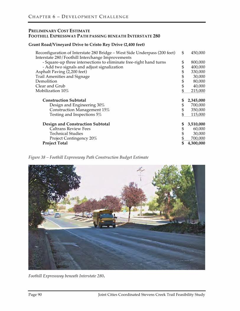
C H A P T E R 6 – D E V E L O P M E N T C H A L L E N G E
Page 90 Joint Cities Coordinated Stevens Creek Trail Feasibility Study
PRELIMINARY COST ESTIMATE FOOTHILL EXPRESSWAY PATH PASSING BENEATH INTERSTATE 280 Grant Road/Vineyard Drive to Cristo Rey Drive (2,400 feet) Reconfiguration of Interstate 280 Bridge – West Side Underpass (200 feet) $ 450,000 Interstate 280/Foothill Interchange Improvements - Square-up three intersections to eliminate free-right hand turns $ 800,000 - Add two signals and adjust signalization $ 400,000 Asphalt Paving (2,200 feet) $ 330,000 Trail Amenities and Signage $ 30,000 Demolition $ 80,000 Clear and Grub $ 40,000 Mobilization 10% $ 215,000 Construction Subtotal $ 2,345,000 Design and Engineering 30% $ 700,000 Construction Management 15% $ 350,000 Testing and Inspections 5% $ 115,000 Design and Construction Subtotal $ 3,510,000 Caltrans Review Fees $ 60,000 Technical Studies $ 30,000 Project Contingency 20% $ 700,000 Project Total $ 4,300,000 Figure 38 – Foothill Expressway Path Construction Budget Estimate
Foothill Expressway beneath Interstate 280.

C H A P T E R 6 – D E V E L O P M E N T C H A L L E N G E
Joint Cities Coordinated Stevens Creek Trail Feasibility Study Page 91
PRELIMINARY COST ESTIMATE PEDESTRIAN OVERCROSSING AT INTERSTATE 280 Interstate 280 Pedestrian Overcrossing (POC) – Estimate is for either POC location. Interstate 280 Pedestrian Overcrossing and Ramps (1,500 feet) $ 7,500,000 Paving (255 feet) $ 40,000 Native Plant Landscaping and Irrigation $ 30,000 Trail Amenities and Signage $ 10,000 Clear and Grub $ 60,000 Mobilization 10% $ 760,000 Construction Subtotal $ 8,400,000 Design and Engineering 30% $ 2,520,000 Construction Management 15% $ 1,250,000 Testing and Inspections 5% $ 420,000 Design and Construction Subtotal $ 12,590,000 Caltrans Review Fees $ 200,000 Technical Studies $ 180,000 Permitting $ 120,000 Project Contingency 20% $ 2,520,000 Project Total $ 15,615,000 Figure 39 – Pedestrian Overcrossing at Interstate 280 Construction Budget Estimate
Dale/Heatherstone pedestrian overcrossing spanning State Route 85 on the Stevens Creek Trail.

C H A P T E R 6 – D E V E L O P M E N T C H A L L E N G E
Page 92 Joint Cities Coordinated Stevens Creek Trail Feasibility Study
PRELIMINARY COST ESTIMATE STAGING AREA AND TRAIL ACCESS TO RANCHO SAN ANTONIO COUNTY PARK AND OPEN SPACE PRESERVE Stonebridge to Hammond-Snyder Loop Trail Asphalt Paving – SC Blvd. to Hammond-Snyder Loop Trail (1,670 feet) $ 425,000 Rough Grading and Limited Off-haul for Trail Ramps $ 165,000 Finish Grading – Entire Site $ 50,000 Steel Truss Ped/Bike Bridge spanning UPRR (130 feet x 10 feet) $ 150,000 Restroom $ 100,000 Utilities for Restroom $ 20,000 Gravel Parking Lot $ 380,000 Split Rail Fence around Parking Lot $ 30,000 Gathering Area and Kiosk $ 50,000 Native Plant Landscaping $ 25,000 Trail Amenities and Signage $ 15,000 Clear and Grub $ 30,000 Mobilization 10% $ 75,000 Construction Subtotal $ 1,515,000 Design and Engineering 30% $ 450,000 Construction Management 15% $ 225,000 Testing and Inspections 5% $ 75,000 Design and Construction Subtotal $ 2,265,000 UPRR Fees $ 40,000 Technical Studies $ 60,000 Permitting $ 40,000 Project Contingency 20% $ 450,000 Project Total* $ 2,855,000 Budget Note: This estimate does not include land acquisition costs associated with UPRR and Santa Clara County Roads and Airports Department. Figure 40 – Staging Area and Trail Access to Rancho San Antonio County Park and Open Space Preserve Construction Budget Estimate


C H A P T E R 6 – D E V E L O P M E N T C H A L L E N G E
Page 92 Joint Cities Coordinated Stevens Creek Trail Feasibility Study
LAND ACQUISITION The budget estimates provided in this study do not include the cost for acquiring land or easements. The trail alignments are primarily proposed on creek corridor parcels and city streets that are in public ownership. However, not all of the parcels reviewed as a part of this study are publicly held or held by the public agency that may develop and maintain the Stevens Creek Trail. It is likely the trail will be implemented by the individual cities with support and collaboration from neighboring cities and resource and regulatory agencies. Each city that develops a segment of the trail may be required to enter into a joint use agreement with the Santa Clara Valley Water District and possibly other public and quasi-public agencies with ownership along the trail alignments. There are six areas along the trail alignments where acquisition of additional land or easements would facilitate trail construction. In other areas, property leases, transfers or joint use agreements must occur between different County departments and the cities or between cities. Encroachment agreements would be required where the trail enters or spans Caltrans property. The land acquisition or trail easement areas are detailed below and previously referenced in Chapter 4 in connection with the feasible trail alignments. HEATHERSTONE APARTMENTS 877 HEATHERSTONE WAY MOUNTAIN VIEW, CALIFORNIA The 5.11-acre privately held parcel at 877 Heatherstone Way is bordered by State Route 85, Village Court, Heatherstone Way and the Dale/Heatherstone pedestrian overcrossing on the Stevens Creek Trail. Pacific Gas & Electric Company has an easement over a portion of the site. Acquisition or a trail easement along the State Route 85 soundwall on the edge of the property would provide an opportunity to directly extend the trail from the Dale/Heatherstone pedestrian overcrossing
to the Stevens Creek corridor. Various trail alignment options, some that include relocation of a segment of the soundwall, have been highlighted in this area. Acquisition or a trail easement through this property would facilitate trail development. 1195 W. FREMONT AVENUE SUNNYVALE, CALIFORNIA The 5.88-acre privately-held parcel at 1195 W. Fremont Avenue is bordered by Stevens Creek, State Route 85 and Fremont Avenue. Pacific Gas & Electric Company and Santa Clara Valley Water District have easements over a portion of the site. Acquisition or a trail easement along the edge of the property bordering the creek would provide the opportunity to extend the trail to Fremont Avenue and assist with development of a grade-separated trail underpass beneath the Fremont Avenue bridge spanning Stevens Creek. A trail underpass is not feasible with the current bridge. However, securing a portion of the property would immediately facilitate a trail connection to Fremont Avenue farther away from the State Route 85 on and off ramps. The trail underpass proposed beneath State Route 85 that connects to Fremont Avenue is currently proposed to extend between the southbound off ramp and 1195 W. Fremont Avenue on Caltrans property. Access through 1195 W. Fremont Avenue would facilitate a connection to Fremont Avenue and provide a future opportunity for developing a trail underpass along the creek when the Fremont Avenue bridge is replaced. SANTA CLARA COUNTY ROADS AND AIRPORTS DEPARTMENT PROPERTY ON FOOTHILL EXPRESSWAY LOS ALTOS, CALIFORNIA Santa Clara County Roads and Airports Department (County Roads) controls Foothill Expressway right-of-way between Vineyard Drive and Cristo Rey Drive. Excess right-of-way may be available to the west of the expressway. This potentially excess right-of-way could provide sufficient land to extend the trail from the intersection of Grant Road and Foothill

C H A P T E R 6 – D E V E L O P M E N T C H A L L E N G E
Joint Cities Coordinated Stevens Creek Trail Feasibility Study Page 93
Expressway in Los Altos under Interstate 280 to intersection of Cristo Rey Drive and Foothill Boulevard in Cupertino. The trail would then connect with existing bicycle lanes on Foothill Boulevard. This potentially feasible route would also require reconfiguration of the Interstate 280 on and off ramps to control traffic. The intersections would be squared up, eliminating free right-hands turns and requiring signalization. Acquisition or a trail easement through this County Roads property would facilitate development of a separate bicycle/pedestrian pathway. NORTHWEST CORNER OF STEVENS CREEK BOULEVARD BRIDGE SPANNING STEVENS CREEK CUPERTINO, CALIFORNIA The 0.85-acre privately-held floodplain parcel off Crescent Court is bordered by Stevens Creek, Varian Park, Stevens Creek Boulevard and private residences on the hill above the stream corridor. Acquisition of this property bordering the creek may provide an opportunity for a grade separated crossing west of Stevens Creek connecting to the Stocklmeir Ranch in Cupertino. SANTA CLARA COUNTY ROADS AND AIRPORTS DEPARTMENT PROPERTY ON STEVENS CREEK BOULEVARD CUPERTINO, CALIFORNIA Santa Clara County Roads and Airports Department (County Roads) controls a 2.83-acre parcel between Stevens Creek Boulevard and the Union Pacific Railroad line extending to the Lehigh Permanente Quarry and Cement Plant. Rancho San Antonio County Park is adjacent to the Union Pacific Railroad property. This site is proposed as a trail staging area to access Rancho San Antonio County Park and Open Space Preserve via the Hammond-Snyder Loop Trail. This long narrow parcel parallels Stevens Creek Boulevard and is bordered by Union Pacific Railroad, Lehigh Permanente Plant and the Stonebridge residential development. The site would provide an ideal location for parking, restrooms and other trail amenities.
UNION PACIFIC RAILROAD PROPERTY ON STEVENS CREEK BOULEVARD CUPERTINO, CALIFORNIA Union Pacific Railroad owns the land adjacent to the 2.83-acre County Roads parcel on Stevens Creek Boulevard. This parcel is approximately three times the size of County Roads property and the rail line runs along the northern edge of the site. Acquisition of a portion of this property would further facilitate development of the trail staging area. In addition, an easement over the rail line would be required for the proposed pedestrian and bicycle bridge, which would provide a grade-separated crossing of this transportation corridor. This parcel is bordered by Rancho San Antonio County Park to the north and County Roads property to the south.

C H A P T E R 6 – D E V E L O P M E N T C H A L L E N G E
Page 94 Joint Cities Coordinated Stevens Creek Trail Feasibility Study
This page is intentionally left blank.

C H A P T E R 7 – B I B L I O G R A P H Y
Joint Cities Coordinated Stevens Creek Trail Feasibility Study Page 95
CITY STAFF CONTACTED(* Denotes Former Staff)
CITY OF SUNNYVALE Kent Steffens, Director of Public Works Manuel Pineda, Assistant Director of Public Works Jack Witthaus, Transportation & Traffic Manager* Patricia Lord, Senior Management Analyst* Jim Stark, Parks Manager Carla Ochoa, Traffic Engineer Joel Arreola, Transportation Engineer Christina Uribe, Administrative Aide - Confidential
CITY OF CUPERTINO Mark Linder, Director of Parks and Recreation* Gail Seeds, Park Improvement Manager David Stillman, Senior Civil Engineer Jo Anne Johnson, Engineering Technician
CITY OF LOS ALTOS Cedric Novenario, Transportation Services Manager Larry Lind, Senior Engineer* Kathy Small, Assistant Engineer
CITY OF MOUNTAIN VIEW J.P. de la Montaigne, Community Services Director Bob Kagiyama, Deputy Public Works Director* Helen Kim, Public Works Project Manager John Marchant, Recreation Manager AGENCIES CONTACTED CALTRANS Nick Saleh, District 4 Division Chief, South Region Larry Moore, Design Reviewer, Headquarters Beth Thomas, Pedestrian & Bicycle Coordinator, District 4 Dina El-Tawansy, Project Manager, District 4 Fariba Zohoury, Project Manager, District 4 SANTA CLARA VALLEY WATER DISTRICT Sue Tippetts, Director, Community Projects Review Unit Usha Chatwani, Associate Civil Engineer, Community Projects Review Unit Chris Elias, Lower Peninsula Watershed Deputy Operating Officer Liang Lee, Hydraulics Unit Manager Pat Showalter, Senior Project Manager CUPERTINO UNION SCHOOL DISTRICT Toby Smith, Director, Maintenance, Operations & Transportation Rick Hausman, Chief Business Officer, Business Services COUNTY OF SANTA CLARA ROADS & AIRPORTS DEPARTMENT Dawn Cameron, County Transportation Planner Planning, Land Development & Survey Unit

C H A P T E R 7 – B I B L I O G R A P H Y
Page 96 Joint Cities Coordinated Stevens Creek Trail Feasibility Study
COUNTY OF SANTA CLARA PARKS AND RECREATION DEPARTMENT Jane Mark, Senior Planner* Tim Heffington, Senior Real Estate Agent Will Fourt, Park Planner

C H A P T E R 7 – B I B L I O G R A P H Y
Joint Cities Coordinated Stevens Creek Trail Feasibility Study Page 97
BIBLIOGRAPHY REPORTS, PLANS, STUDIES AND DATABASES Alta Transportation Consulting. Union Pacific Rail Trail Feasibility Study. October 2001. American Association of State Highway and Transportation Officials. 2012. Guide for the Development of Bicycle Facilities. American Association of State Highway and Transportation Officials. 2004. Guide for the Planning, Design, and Operation of Pedestrian Facilities. Bay Area Air Quality Management District, Metropolitan Transportation Commission and Association of Bay Area Governments. 2005. Bay Area 2005 Ozone Strategy. California Department of Fish and Game. 2011. California Natural Diversity Database, Wildlife Habitat Data Analysis Branch, California Department of Fish and Game. Sacramento: California. Available from http://www.dfg.ca.gov/biogeodata/cnddb. California Department of Transportation. 2012. Caltrans Highway Design Manual: Chapter 1000 Bicycle Transportation Design. California Department of Transportation. 2014. Complete Streets Implementation Action Plan. California Native Plant Society. 2010. Inventory of Rare and Endangered Plants (online edition, v8). California Native Plant Society, Sacramento. Available from http://cnps.org/inventory. California Partners in Flight. 2002. Version 2.0. The oak woodland bird conservation plan: a strategy for protecting and managing oak woodland habitats and associated birds in California (S. Zack, lead author). Point Reyes Bird Observatory, Stinson Beach, CA. http://www.prbo.org/calpif/plans.html.City of Cupertino. 2005. 2000-2020 Cupertino General Plan. California Wildlife Foundation/California Oaks Project. 2010. Wildlife Habitat, Oak Woodlands and Climate Change. www.californiaoaks.org City of Cupertino. 2000. General Plan 2000-2020. City of Cupertino. 2002. Stevens Creek Trail Feasibility Study. City of Cupertino. 2002. Pedestrian Transportation Guidelines. City of Cupertino. 2006. Stevens Creek Corridor Park Master Plan and Restoration Plan, Initial Study/Mitigated Negative Declaration. City of Cupertino. 2011. Stevens Creek Corridor Park and Restoration Project, Phase 2 Initial Study and Mitigated Negative Declaration. City of Cupertino. 2011. Bicycle Transportation Plan. City of Los Altos. 2002. General Plan.

C H A P T E R 7 – B I B L I O G R A P H Y
Page 98 Joint Cities Coordinated Stevens Creek Trail Feasibility Study
City of Los Altos. 2008. Stevens Creek Trail Feasibility Study. City of Los Altos. 2011. Collector Traffic Calming Plan. City of Los Altos. 2012. Bicycle Transportation Plan. City of Mountain View. 1991. Stevens Creek Trail and Wildlife Corridor Feasibility Report. City of Mountain View. 1992. Initial Study/Environmental Assessment for the Stevens Creek Trail and Wildlife Corridor Project. City of Mountain View Council Report: Stevens Creek Trail, Reach 4 Alignment Study, Project 96-26 (February 24, 1998) City of Mountain View. 2001. Stevens Creek Trail Feasibility Study, Reach 4, Segment 2 Final Report. City of Mountain View. 2002. Stevens Creek Trail, Reach 4, Segment 2, Final EIR. City of Mountain View. 2008. Bicycle Transportation Plan. City of Mountain View. 2010. Pedestrian and Bicycle Count Results for May 2010. City of Mountain View. 2012. 2030 General Plan. City of Sunnyvale. 1994. Evaluation of Policy and Planning Issues Related to Proposed Stevens Creek Trail as Impacting Sunnyvale. City of Sunnyvale. 2011. General Plan: Consolidated in 2011. City of Sunnyvale. 2013. Mary Avenue Street Space Allocation Study. City of Sunnyvale. 2006. Bicycle Plan. City of Sunnyvale. 2009. Parks of the Future Study. County of Santa Clara Planning Department. 1961. Stevens Creek Park Chain. County of Santa Clara Parks and Recreation Department. 1992. Rancho San Antonio County Park Master Plan. County of Santa Clara Parks and Recreation Department. 1993. Stevens Creek County Park Master Plan. County of Santa Clara Parks and Recreation Department. 1994. Stevens Creek County Park Master Plan Environmental Impact Report. County of Santa Clara Parks and Recreation Department. 1995. Santa Clara Countywide Trails Master Plan. County of Santa Clara Parks and Recreation Department. 1999. Santa Clara County Uniform Interjurisdictional Trails Design, Use and Management Guidelines.

C H A P T E R 7 – B I B L I O G R A P H Y
Joint Cities Coordinated Stevens Creek Trail Feasibility Study Page 99
County of Santa Clara Parks and Recreation Department. 2001. County of Santa Clara Stevens Creek Trail Master Plan. County of Santa Clara Parks and Recreation Department. 2002. Stevens Creek Trail Initial Study/Mitigated Negative Declaration for Study Area A. County of Santa Clara Roads and Airports Department. 2005. Trail Maintenance Manual. County of Santa Clara Parks and Recreation Department. 2008. Comprehensive County Expressway Planning Study: 2008 Update. March 3, 2009. Goals Project. 1999. Baylands Ecosystem Habitat Goals. A report of habitat recommendations prepared by the San Francisco Bay Area Wetlands Ecosystem Goals Project. U.S. Environmental Protection Agency, San Francisco, Calif./S.F. Bay Regional Water Quality Control Board, Oakland, California. McDonald, Noreen C. et al. 2009. U.S. School Travel, American Journal of Preventive Medicine, Volume 41, Issue 2, 146 – 151. Riparian Habitat Joint Venture. 2004. Version 2.0. The riparian bird conservation plan: a strategy for reversing the decline of riparian associated birds in California. California Partners in Flight. http://www.prbo.org/calpif/pdfs/riparian.v-2.pdf. Santa Clara Valley Transportation Authority. 2008. Countywide Bicycle Plan. Santa Clara Valley Transportation Authority. 2011. Valley Transportation Plan 2040. Santa Clara Valley Transportation Authority. 2012. Bicycle Technical Guidelines. Santa Clara Valley Water District. 2003. Draft Settlement Agreement Regarding Water Rights of the Santa Clara Valley Water District on Coyote, Guadalupe and Stevens Creeks. Santa Clara Valley Water District. 2004. Stevens Creek Limiting Factors Analysis Technical Report, Stillwater Sciences. Santa Clara Valley Water District. 2005. Lower Peninsula Watershed Stewardship Plan. http://cf.valleywater.org/_wmi/Stewardship_plan/Comments/watershedprod.cfm?watershedid=3 Santa Clara Valley Water District. 2006. Water Resources Protection Manual: Guidelines & Standards for Land Use Near Streams. Santa Clara Valley Water District. 2010. FAHCE Stevens Creek Fish Passage Enhancement Project No. 00294001, Final Planning Study Report. Sawyer, J. O., T. Keeler-Wolf, and J. M. Evens. 2009. A Manual of California Vegetation. Second Edition. California Native Plant Society, Sacramento, CA. Sibley, D. A. 2000. The Sibley Guide to Birds. Alfred A. Knopf, New York. The Planning Collaborative Inc., 1980. Stevens Creek: A Plan of Opportunities.

C H A P T E R 7 – B I B L I O G R A P H Y
Page 100 Joint Cities Coordinated Stevens Creek Trail Feasibility Study
Thomas, J.H. 1961. Flora of the Santa Cruz Mountains of California. Stanford Univ. Press, Stanford, California. U.S. Architectural and Transportation Barriers Compliance Board. 2013. Recommendations for Accessibility Guidelines: Outdoor Developed Areas Final Report. Washington, DC. U.S. Department of Justice. 2010. ADA Standards for Accessible Design. ORDINANCES, MAPS AND RECORD DRAWINGS California Department of Transportation. 2012. SR 85 Express Lane Project Plans – I-280 to US 101: Pavement Delineation and Typical Cross-Section Sheets. City of Cupertino. Flood Zone Map. City of Cupertino. Municipal Code Chapter 14.18: Protected Trees. City of Mountain View. 2011. Construction Plans: Dale/Heatherstone Extension. City of Mountain View. Bid Summaries of previous segments of Stevens Creek Trail. City of Mountain View. Aerial photos of Stevens Creek Park Chain to Fremont Avenue. City of Sunnyvale. 2005 Bicycle Map. Darren Howe, Gary Stern (2013-04-19). Stevens Creek Survey and Observations (Report). NOAA/NMFS. Santa Clara Valley Transportation Authority. 2011 Santa Clara Valley Bikeways Map. Santa Clara Valley Water District. 1974. Stevens Creek Improvements Plans – Fremont Drop Structure: Plan and Profile Sheets. Santa Clara Valley Water District. 1980. Stevens Creek Improvements Plans – Fremont Drop Structure Repair: Plan and Profile Sheets.