finalised implementation guide renewable energy · 2018-12-18 · implementation guide for...
TRANSCRIPT

Implementation Guide for Renewable Energy Proposals
1
Angus Local Plan Review (2009)
Implementation Guide for Renewable Energy Proposals
Policies ER34 Renewable Energy Developments
& ER35 Wind Energy Development
Angus Council June 2012

Implementation Guide for Renewable Energy Proposals
2

Implementation Guide for Renewable Energy Proposals
3
PREFACE There is increasing interest through both informal enquiries and planning applications
for the establishment of renewable energy projects in Angus. While the majority are
in connection with a range of wind turbine projects, proposals for a number of hydro
schemes have also come forward.
The Angus Local Plan Review, formally adopted in February 2009, establishes the
Council’s land use planning policies in relation to dealing with renewable energy
proposals. This Implementation Guide therefore clarifies and expands on Local Plan
Review Policies ER34 Renewable Energy Development and ER35 Wind Energy
Development and those factors that will be taken into account in considering and
advising on proposals for renewable energy projects in Angus. It also directs
developers and other interested parties to other relevant documents, policies,
regulations and guidance. The Implementation Guide has been developed through consultation with a wide range of stake holders. A Strategic Environmental Assessment of the Implementation Guide has also been
undertaken and the Environmental Report is published alongside the Implementation
Guide and submitted to the Scottish Gateway.
Angus Council June 2012
Implementation Guide for Renewable Energy Proposals
4
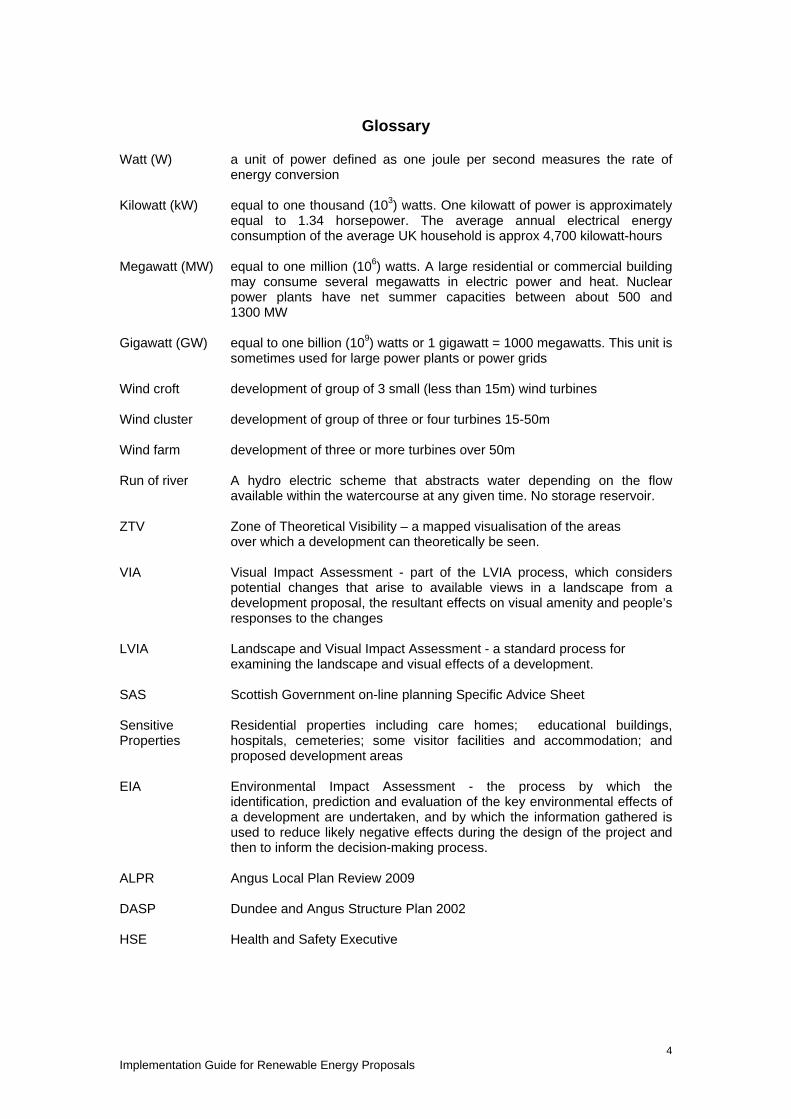
Glossary
Watt (W) a unit of power defined as one joule per second measures the rate of
energy conversion
Kilowatt (kW) equal to one thousand (103) watts. One kilowatt of power is approximately equal to 1.34 horsepower. The average annual electrical energy consumption of the average UK household is approx 4,700 kilowatt-hours
Megawatt (MW) equal to one million (106) watts. A large residential or commercial building may consume several megawatts in electric power and heat. Nuclear power plants have net summer capacities between about 500 and 1300 MW
Gigawatt (GW) equal to one billion (109) watts or 1 gigawatt = 1000 megawatts. This unit is sometimes used for large power plants or power grids
Wind croft development of group of 3 small (less than 15m) wind turbines
Wind cluster development of group of three or four turbines 15-50m
Wind farm development of three or more turbines over 50m
Run of river A hydro electric scheme that abstracts water depending on the flow available within the watercourse at any given time. No storage reservoir.
ZTV Zone of Theoretical Visibility – a mapped visualisation of the areas over which a development can theoretically be seen.
VIA Visual Impact Assessment - part of the LVIA process, which considers potential changes that arise to available views in a landscape from a development proposal, the resultant effects on visual amenity and people’s responses to the changes
LVIA Landscape and Visual Impact Assessment - a standard process for examining the landscape and visual effects of a development.
SAS Scottish Government on-line planning Specific Advice Sheet
Sensitive Properties
Residential properties including care homes; educational buildings, hospitals, cemeteries; some visitor facilities and accommodation; and proposed development areas
EIA Environmental Impact Assessment - the process by which the identification, prediction and evaluation of the key environmental effects of a development are undertaken, and by which the information gathered is used to reduce likely negative effects during the design of the project and then to inform the decision-making process.
ALPR Angus Local Plan Review 2009
DASP Dundee and Angus Structure Plan 2002
HSE Health and Safety Executive

Implementation Guide for Renewable Energy Proposals
5
Contents Page
Preface 3
Glossary 4
1. Purpose and Scope of the Implementation Guide 7 1.1 Context 7
1.2 Supporting Documents 7
2. Renewable Energy Overview 9 2.1 Hydro 9
2.2 Bioenergy 9
2.3 Landfill Gas 10
2.4 Solar/Photovoltaics 10
2.5 Anaerobic Digestion 10
2.6 Onshore Wind 10
2.7 Offshore Wind 10
3. Guidance for Applicants 11 3.1 Land use Planning Context 12
3.2 Development Plan Context 13
3.3 Application Checklist 14
3.4 Additional Guidance
• Policy ER 34: Renewable Energy Developments 22
• Policy ER 35: Wind Energy Development 31
4. Landscape and Visual Assessment for Wind Energy Proposals 38
5. Noise Assessment for Wind Energy Proposals 46 Figures
1 Wind Energy Development Geographic Areas 39
2 Scale Buildings in Angus 45
3 Wind Turbine Components 45
Tables
1 Land Use Planning Context 12
2 Application Checklist 14

Implementation Guide for Renewable Energy Proposals
6
3 Landscape Classification 40
4 Levels of Acceptable Landscape Character Change 42
Appendices
1 Renewable Development within Angus 48
2 Development Plan – Renewable Energy Policies 51
3 List of other relevant development plan policies 52
4 Print Version Maps*
Map 1 ALPR Boundary
Map 2 International Designations
Map 3 National Designations
Map 4 Local Designations
Map 5 Other Considerations
*The print maps are illustrative of detailed information that can be accessed via the web-based version of the Implementation Guide, They are intended to indicate the location and range of International, National and Local designation within the ALPR area.

Implementation Guide for Renewable Energy Proposals
7
1. Purpose and Scope of this Implementation Guide 1.1 Context Tackling climate change is, potentially, one of the biggest challenges we face. In 1992 the United Nations Framework Convention on Climate Change (http://unfccc.int/2860.php) was adopted as the basis of a global response to the problem. Signatory governments have since agreed to reduce emissions which contribute to climate change and global warming. To help achieve this, the Scottish Government set initial targets to generate 80% of Scotland’s electricity (8GW) from renewable sources by 2020, with an interim target 31% by 2011 (5GW). In May 2011 the Scottish Government announced that the 2011 interim target had been exceeded and raised the renewable energy target for 2020 to 100% and 16GW of installed capacity. The planning system will contribute to achieving these targets by ensuring that projects are well located and designed. The Angus Local Plan Review establishes the development plan policies to be taken into account when assessing proposals for renewable energy projects – policies ER34 Renewable Energy Development and ER35 Wind Energy Development. In support of the development plan position the Implementation Guide provides:-
• more detailed information and clarification of the main factors that will be taken into account in considering and determining renewable energy proposals in Angus;
• an application checklist (Section 3.3); • specific guidance for landscape and visual assessment issues in relation to
wind turbines (Section 4); and • specific guidance for guidance on noise assessment in relation to wind
turbines (Section 5). Commentary on technical constraints such as landform, access to the transmission network, accessibility, etc is included as these may have implications for effective development. The Implementation Guide also directs developers and other interested parties to relevant documents, policies and regulations. Angus Council has reservations about mapping specific areas of search and constraint for wind energy proposals. The identified constraints will naturally restrict development opportunity, but need not prevent it. Applying cumulative impact as a significant constraint is problematic - as each planning application approved alters the potential cumulative impact. Also, there is not a direct correlation between the number of wind energy proposals and the degree of impact. It is appropriate to consider each proposal within the development context of each application rather than apply a theoretical limit. (The Council expressed concerns during the consultation on SPP 6 Renewable Energy Development in 2006, relating to the 20MW threshold in the Location Framework given that the area, turbine size and siting are the cause of impact, not output. Committee Report 1196/06 can be viewed at www.angus.gov.uk/ccmeetings/reports-committee2006/infrastructure/1196.pdf ) 1.2 Supporting Documents This Implementation Guide has been prepared under the provisions of the Town and Country Planning (Scotland) Act 1997 and is subject to the following supporting assessments:-
Implementation Guide for Renewable Energy Proposals
8
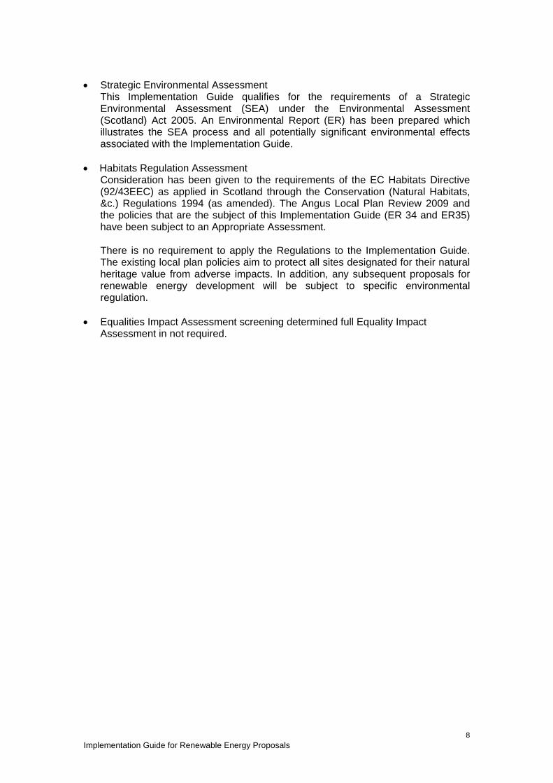
• Strategic Environmental Assessment
This Implementation Guide qualifies for the requirements of a Strategic Environmental Assessment (SEA) under the Environmental Assessment (Scotland) Act 2005. An Environmental Report (ER) has been prepared which illustrates the SEA process and all potentially significant environmental effects associated with the Implementation Guide.
• Habitats Regulation Assessment Consideration has been given to the requirements of the EC Habitats Directive (92/43EEC) as applied in Scotland through the Conservation (Natural Habitats, &c.) Regulations 1994 (as amended). The Angus Local Plan Review 2009 and the policies that are the subject of this Implementation Guide (ER 34 and ER35) have been subject to an Appropriate Assessment. There is no requirement to apply the Regulations to the Implementation Guide. The existing local plan policies aim to protect all sites designated for their natural heritage value from adverse impacts. In addition, any subsequent proposals for renewable energy development will be subject to specific environmental regulation.
• Equalities Impact Assessment screening determined full Equality Impact Assessment in not required.

Implementation Guide for Renewable Energy Proposals
9
2. Renewable Energy Overview Planning permission will be required for most renewable energy developments from either the local planning authority or the Scottish Government. Some small scale renewable energy proposals on both domestic and non domestic buildings are allowed under Permitted Development Rights as defined in Planning Circular 2/2010 http://www.scotland.gov.uk/Publications/2010/03/05114236/0 and as amended in 2010 http://www.oqps.gov.uk/legislation/ssi/ssi2010/ssi_20100027_en_1 and Circular 2/2011 http://www.scotland.gov.uk/Publications/2011/03/17092643/0 There are a wide range of renewable energy technologies which may be considered, and in many cases the scale of the proposal correlates with the scale of potential planning matters that may arise. It should be noted that some developments will also require to be considered under other legislation including, noise, emissions, pollution control which are not part of the planning process and may therefore require additional consents or licences. 2.1 Hydro The primary source of hydroelectric power in Angus is anticipated to be run of river schemes where water is abstracted from a water course, diverted through pipes to a turbine and returned to the water course. The main elements for the panning system include:-
• Water abstraction – usually by a low, ground or underwater intake weir; • Pipeline route; • Turbine house and ancillary structures; • Water return – usually in the form of a tailrace; • Access routes; and • Effect on the water course and its ecology.
Where dams are constructed these are likely to be small scale and planning matters will include:-
• Location and scale of the dam itself; • Turbine house and other associated structures; • Outflow/spillway; and • Hydrogeology.
In all cases the transmission of power, construction works/compound and access routes, and environmental impact should be considered by the applicant. Landscaping and planting proposals may reduce landscape and/or visual impact and improve biodiversity. 2.2 Bio-energy Bio-energy or biomass ranges from small scale domestic boilers up to major commercial generators. The main issues will relate to commercial electricity generation, but proposals for domestic bio-energy facilities will still require to demonstrate there are no unacceptable adverse effects, particularly emissions. For commercial generators, not only are there the effects of the plant itself to consider, but the Scottish Government has indicated that fuel source over the life of the plant will be a valid planning consideration to ensure sustainable bio-energy can be sourced. While woody biomass is the major source, there are projects based on straw, distillery waste etc. These later sources are likely to be utilised in smaller facilities, often based around an existing business and reducing their energy costs. The primary planning issues relating to large biomass plants will include:-

Implementation Guide for Renewable Energy Proposals
10
• Scale, design and location; • Emissions; • Fuel Source; • Access; and • Storage facilities.
2.3 Landfill Gas There will be limited opportunity for this method of generation in Angus, given limited landfill sites and the current waste to heat plant in operation at Lochhead Landfill site. The main planning issues will relate to:-
• Suitability of the location in terms of design and compatibility with surrounding land uses etc. Obviously the choice of location will be restricted by where landfill sites are located;
• Emissions; and • Design.
2.4 Solar/photovoltaics There has been no large scale commercial proposal in Angus to date. The primary interest is for roof mounted or free standing arrays associated with existing or proposed properties. In many cases small scale proposals are permitted development, but localised planning concerns can arise and include:-
• Visual impact and surrounding amenity; • Visual impact where the property is a Listed Building or within a Conservation
Area and compatibility with these designations; 2.5 Anaerobic Digestion This generation method is likely to be of interest to the agriculture and food processing sectors in Angus, where biodegradable waste and farm slurry can be used to generate methane to produce heat and/or electricity. It is a constant and manageable process with a product that can produce energy for onsite or offsite use. The primary planning considerations relate to:-
• Siting and location; • Fuel source and the implications of importing material to the proposed site; • Landscape and visual impact; and • Proposed management and mitigation measures.
There are three types of digester which relate to the temperature of the process: 1. Psychrophylic (15-250C) – stable and easy to manage but slow. 2. Mesophylic (35-400C) – process takes 15 to 20 days, but process robust, simple
and relatively cheap. 3. Thermophylic (50-600C) – 12 to 15 days with higher conversion but more
complex and costly. Mesophylic or thermophylic digesters provide higher yields, and can require less space. The process and plant are flexible enough to meet the needs of farm units, through food processing to municipal organic waste disposal. Proposals may also require to meet regulations relating to emissions, odour and noise. 2.6 Onshore Wind Development proposals range from small single turbines to major windfarms subject to S36 of the Electricity Act, which are the responsibility of the Energy Consents and Deployment Unit of the Scottish Government. This is the primary area of renewable

Implementation Guide for Renewable Energy Proposals
11
energy proposals in Angus and the planning considerations are strongly influenced by the scale and location of the proposal including:-
• Landscape and visual impact; • Potential adverse effects on designated natural and built heritage sites,
protected species; • Impact on residential amenity, soils and water bodies; and • Access
2.7 Offshore Wind Applications for offshore wind farms are submitted to and processed by Marine Scotland. Angus Council has the opportunity to feed into this process through consultation at all stages and to date input has been made on the proposals at Inchcape, Seagreen Phase 1, 2 and 3, and Neart na Gaoithe. The Council is also actively involved in the development for the landfall and transmission of the energy from Seagreen and Inchcape in Angus.

Implementation Guide for Renewable Energy Proposals
12
3. Guidance for Applicants 3.1 The land use planning context The context for renewable development proposals is summarised below. Table 1: Land Use Planning Context The National Planning Framework 2 (NPF2) • aims to ‘realise the potential of Scotland’s renewable energy resources and facilitate the
generation of power and heat from clean, low carbon sources, including … producing heat and power from renewable sources …’
• requires ‘landscape and visual impacts … to be important considerations in decision-making on developments’
• identifies major infrastructure projects needed to deliver the national strategy, including the electricity grid through Angus. http://www.scotland.gov.uk/Resource/Doc/278232/0083591.pdf;
Scottish Planning Policy (SPP 2010) - planning is about:- • where development should happen; • where it should not; and • how it interacts with its surroundings. This involves promoting and facilitating development while protecting and enhancing the natural and built environment in which we live, work and spend our leisure time. http://www.scotland.gov.uk/Resource/Doc/300760/0093908.pdf Planning Advice Notes (PANs) provide information and advice on technical planning matters including:- • web based Renewables Advice
http://www.scotland.gov.uk/Topics/Built-Environment/planning/National-Planning-Policy/themes/renewables
• PAN 45 Annex 1 Planning for Micro Renewables (2006) http://www.scotland.gov.uk/Publications/2006/10/03093936/0
Dundee and Angus Structure Plan:- makes positive provision for renewable energy generating developments where they are compatible with other environmental and community interests. Angus Local Plan Review aims to promote:- • renewable energy development and • low or zero carbon emissions in new development.
www.angus.gov.uk/localplan/
The Implementation Guide aims to:- • clarify and expand policies ER34 : Renewable Energy Development and ER35 : Wind
Energy Development: and • support the Council’s climate change commitment
Under the Electricity (Scotland) Act 1989, Scottish Ministers determine applications for large scale renewable energy (Section 36) and overhead power lines and associated infrastructure (Section 37). Further information on Section 36 and Section 37 consents
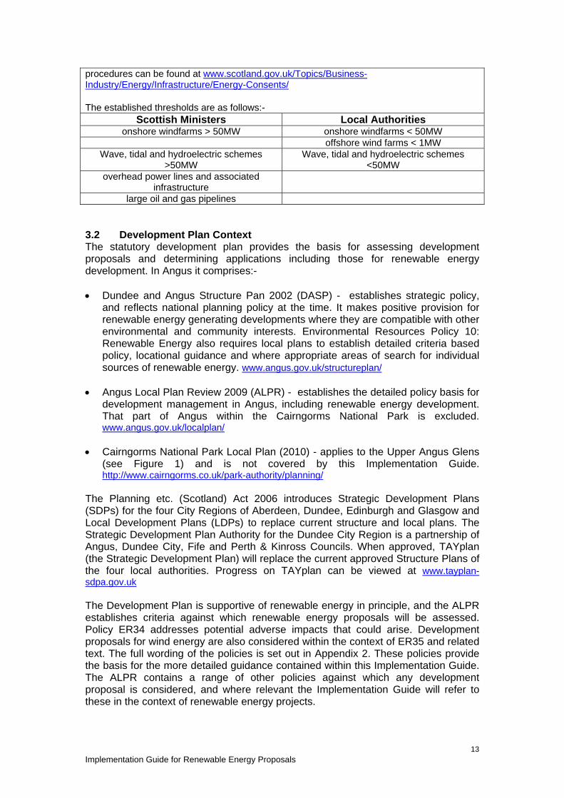
Implementation Guide for Renewable Energy Proposals
13
procedures can be found at www.scotland.gov.uk/Topics/Business-Industry/Energy/Infrastructure/Energy-Consents/ The established thresholds are as follows:-
Scottish Ministers Local Authorities onshore windfarms > 50MW onshore windfarms < 50MW
offshore wind farms < 1MW Wave, tidal and hydroelectric schemes
>50MW Wave, tidal and hydroelectric schemes
<50MW overhead power lines and associated
infrastructure
large oil and gas pipelines 3.2 Development Plan Context The statutory development plan provides the basis for assessing development proposals and determining applications including those for renewable energy development. In Angus it comprises:- • Dundee and Angus Structure Pan 2002 (DASP) - establishes strategic policy,
and reflects national planning policy at the time. It makes positive provision for renewable energy generating developments where they are compatible with other environmental and community interests. Environmental Resources Policy 10: Renewable Energy also requires local plans to establish detailed criteria based policy, locational guidance and where appropriate areas of search for individual sources of renewable energy. www.angus.gov.uk/structureplan/
• Angus Local Plan Review 2009 (ALPR) - establishes the detailed policy basis for
development management in Angus, including renewable energy development. That part of Angus within the Cairngorms National Park is excluded. www.angus.gov.uk/localplan/
• Cairngorms National Park Local Plan (2010) - applies to the Upper Angus Glens
(see Figure 1) and is not covered by this Implementation Guide. http://www.cairngorms.co.uk/park-authority/planning/
The Planning etc. (Scotland) Act 2006 introduces Strategic Development Plans (SDPs) for the four City Regions of Aberdeen, Dundee, Edinburgh and Glasgow and Local Development Plans (LDPs) to replace current structure and local plans. The Strategic Development Plan Authority for the Dundee City Region is a partnership of Angus, Dundee City, Fife and Perth & Kinross Councils. When approved, TAYplan (the Strategic Development Plan) will replace the current approved Structure Plans of the four local authorities. Progress on TAYplan can be viewed at www.tayplan-sdpa.gov.uk The Development Plan is supportive of renewable energy in principle, and the ALPR establishes criteria against which renewable energy proposals will be assessed. Policy ER34 addresses potential adverse impacts that could arise. Development proposals for wind energy are also considered within the context of ER35 and related text. The full wording of the policies is set out in Appendix 2. These policies provide the basis for the more detailed guidance contained within this Implementation Guide. The ALPR contains a range of other policies against which any development proposal is considered, and where relevant the Implementation Guide will refer to these in the context of renewable energy projects.

Implementation Guide for Renewable Energy Proposals
14
Although community owned renewable energy generation is supported in principle where proposals are compatible with development plan policy, it must be made clear that negotiating or securing local community benefit is wholly separate from the planning application process. Angus Council’s position is set out in Para 3.86, page 97 of the adopted Angus Local Plan Review. It is however recognised that where renewable energy schemes accord with the development plan there may be opportunity to secure contributions from developers for local community initiatives. However any such negotiations between the community and developers and any local contributions secured are totally separate from the land use planning and planning gain processes and will not be considered as part of any planning application. Such local community benefit initiatives will therefore not fall within the obligations required under Section 75 Planning Agreements and will require to be managed by other means. Proposals for renewable energy development in that part of Angus within the Cairngorms National Park, will be determined by the Cairngorms National Park Authority (CNPA) within the context of the polices of the Cairngorms National Park Plan. Renewable Energy proposals within Angus that may affect the National Park, or its setting, will be referred to the CNPA for comment, and their views taken into account by Angus Council in the determination of any planning application. 3.3 Applications Checklist In accordance with the Land Use Planning Context outline above, Table 2: Applications Checklist summarises the supporting information that may be required to accompany a planning application for renewable energy development. This is an aid for applicants, and for detailed information should be read in conjunction with the rest of this Implementation Guide, the Development Plan and other relevant legislation, policy and advice.

Implementation Guide for Renewable Energy Proposals
15
Table 2: Applications Checklist The checklist is designed to identify the supporting information required to determine a planning application for renewable energy development. The information should be proportionate to the proposal, and the checklist indicates the requirements for different technologies and scales of development. It is intended as an aid to applicants, and whilst it aims to be comprehensive there may be site specific considerations or changes to legislation or guidance from the Scottish Government and statutory agencies. Applications will be considered in the context of current guidance.
Wind Energy Development
(Height to blade tip unless otherwise stated)
Turbine height up to 15m
Turbine height 15 - 50m Turbine height greater than 50m OR groups of 6 or more
turbines in excess of 25m height
Projects > 50MW
(Section 36 applications)
Other Renewable
Energy Development
Landscape and Visual Representation
Technical information from the turbine supplier often adequate. Photomontage may be requested to illustrate relationship. Eight figure grid reference for each proposed turbine
Basic level of VIA should include :- • ZTV map covering an area
up to 20km (radius) from the turbine;
• wireline drawings and/or photomontages from a limited number of key viewpoints:
• viewpoints to be agreed with Angus Council, and SNH where appropriate:
• design statement may be required in the case of multiple turbines; and
• eight figure grid reference for each proposed turbine
Full Landscape and Visual Impact (LVIA) should address the sensitivity, magnitude and significance of landscape and visual impact and include: • ZTV map covering an area up to 35km (radius) from
the turbine; • wireline drawings and/or photomontages from key
viewpoints; • assessment of landscape sensitivity, magnitude of
change and residual impacts. • viewpoints to be agreed with Angus Council, and
SNH where appropriate; • design statement identifying design objectives and
process; and • eight figure grid reference for each proposed turbine.
VIA or LVIA may be required for larger structures depending on scale, type and location of the proposal.

Implementation Guide for Renewable Energy Proposals
16
Wind Energy Development (Height to blade tip unless otherwise stated)
Turbine height up to 15m
Turbine height 15 - 50m Turbine height greater than 50m OR groups of 6 or more
turbines in excess of 25m height
Projects > 50MW
(Section 36 applications)
Other Renewable
Energy Development
Where proposals are within the ALPR area but may affect the Cairngorms National Park or its setting, applicants are advised to consult the Cairngorms National Park Authority. Applications.
Cumulative Assessment
A significant constraint to potential wind energy development. The proposals eligible for inclusion in a Cumulative Assessment is dynamic. An appropriate date for baseline data should be agreed with the authority and relevant proposals identified and agreed with Angus Council prior to commencement. Cumulative assessments will normally be required where turbines are >50m to blade tip. The assessment will require to take account of agreed existing/proposed developments over 50m. They may also require to consider agreed existing/proposed smaller turbines where they visually interact with the proposal. Cumulative assessments have not normally been required where turbines are 25-50m to blade tip, but as more turbines under 50m are constructed, a cumulative assessment may be required if turbine density within the area of a ZTV map is deemed to have a potentially unacceptable cumulative impact.
A cumulative ZTV (CZTV) should be produced on a clear and legible 1:50k Ordnance Survey Base plan. The CZTV would typically have a radius of up to 60km, in accordance with SNH guidance. The CZTV should:- 1. include all consents and operational turbines over 50m to blade tip; 2. include extant planning consents and submitted applications which pre-date the
submission and which are assessed by the Council to have a realistic expectation of a decision within 12 months;
3. include turbines under 50m (applications at an advanced stage, consents or operational) depending on their scale and location in relation to the application site i.e. visual interaction. This will only apply in specific circumstances;
Depending on scale, type and location of the proposal there may be a requirement to assess its impact in conjunction with other existing or proposed development.
Implementation Guide for Renewable Energy Proposals
17
Wind Energy Development (Height to blade tip unless otherwise stated)
Turbine height up to 15m
Turbine height 15 - 50m Turbine height greater than 50m OR groups of 6 or more
turbines in excess of 25m height
Projects > 50MW
(Section 36 applications)
Other Renewable
Energy Development
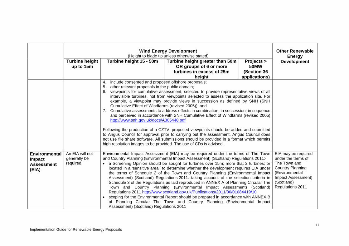
4. include consented and proposed offshore proposals; 5. other relevant proposals in the public domain; 6. viewpoints for cumulative assessment, selected to provide representative views of all
intervisible turbines, not from viewpoints selected to assess the application site. For example, a viewpoint may provide views in succession as defined by SNH (SNH Cumulative Effect of Windfarms (revised 2005)); and
7. Cumulative assessments to address effects in combination; in succession; in sequence and perceived in accordance with SNH Cumulative Effect of Windfarms (revised 2005) http://www.snh.gov.uk/docs/A305440.pdf
Following the production of a CZTV, proposed viewpoints should be added and submitted to Angus Council for approval prior to carrying out the assessment. Angus Council does not use file share software. All submissions should be provided in a format which permits high resolution images to be provided. The use of CDs is advised.
Environmental Impact Assessment (EIA)
An EIA will not generally be required.
Environmental Impact Assessment (EIA) may be required under the terms of The Town and Country Planning (Environmental Impact Assessment) (Scotland) Regulations 2011:- • a Screening Opinion should be sought for turbines over 15m; more that 2 turbines; or
located in a ‘sensitive area’* to determine whether the development requires EIA under the terms of Schedule 2 of the Town and Country Planning (Environmental Impact Assessment) (Scotland) Regulations 2011. taking account of the selection criteria in Schedule 3 of the Regulations as laid reproduced in ANNEX A of Planning Circular The Town and Country Planning (Environmental Impact Assessment) (Scotland) Regulations 2011 http://www.scotland.gov.uk/Publications/2011/06/01084419/10
• scoping for the Environmental Report should be prepared in accordance with ANNEX B of Planning Circular The Town and Country Planning (Environmental Impact Assessment) (Scotland) Regulations 2011
EIA may be required under the terms of The Town and Country Planning (Environmental Impact Assessment) (Scotland) Regulations 2011

Implementation Guide for Renewable Energy Proposals
18
Wind Energy Development
(Height to blade tip unless otherwise stated)
Turbine height up to 15m
Turbine height 15 - 50m Turbine height greater than 50m OR groups of 6 or more
turbines in excess of 25m height
Projects > 50MW
(Section 36 applications)
Other Renewable
Energy Development
• an EIA will require to demonstrate potential impacts, including length and significance of effect and mitigation measures for all components of an application
• where EIA is not be required, environmental information may still be required to consider agreed impacts.
* Sensitive Areas are defined in the Regulations as :- Sites of Special Scientific Interest; Land subject to Nature Conservation Orders; International Conservation Sites; National Scenic Areas; World Heritage Sites; Scheduled Monuments; and National Parks.
Formal screening requests and determination will be publically available. Screening Determinations are valid for 12 months.
Natural Heritage Designation
Applicants can use SNHi to check protected areas .
Applicants are advised to refer to SNH Small Scale Wind Energy Guidance and to use SNHi to check protected areas within a 20km radius of the proposal. http://www.snh.gov.uk/publications-data-and-research/snhi-information-service/
International and National Designation – Supporting information must demonstrate that proposals (including all associated works) will not affect such sites to an unacceptable degree. Where proposals may have a significant effect on European Sites (SAC or SPA), they should be screened in accordance with the Habitats Regulations Directive. A Habitats Regulation Appraisal may be required. Where mitigation measures are proposed these must be shown to be:- • achievable; • agreed with SNH and any organisation responsible for managing the designated site or with responsibility for the maintenance of

Implementation Guide for Renewable Energy Proposals
19
the site and the integrity of the reason for its designation; and • subject to planning conditions or a Section 75 agreement as appropriate.
Other Natural Heritage designations should be accorded appropriate protection and/or mitigation
http://www.taysidebiodiversity.co.uk/

Implementation Guide for Renewable Energy Proposals
20
Wind Energy Development (Height to blade tip unless otherwise stated)
Turbine height up to 15m
Turbine height 15- 50m Turbine height greater than 50m OR groups of 6 or more
turbines in excess of 25m height
Projects > 50MW
(Section 36 applications)
Other Renewable
Energy Development
Supporting information should identify historic and archaeological sites affected by the proposal, proportionate with the scale and number of turbines; the effect of the proposal and all associated works on the integrity of a site, its setting; requirements for archaeological survey and recording; and any proposed mitigation measures.
Historic Environment
Guidance on assessing impacts on historic views has recently been published by English Heritage and may be used to inform the Council’s assessment of wind energy developments. http://www.english-heritage.org.uk/content/publications/docs/seeing-history-in-view.pdf
Noise Assessment
Where a noise assessment is required the methodology and cumulative considerations must be agreed with Angus Council Environmental and Consumer Protection. Failure to agree the methodology or to provide sufficient information may result in the application being recommended for refusal on the basis of lack of information. (See Section 5)
Peat and soils Where proposals affect peat soils, applicants should demonstrate carbon savings are calculated in accordance with Scottish Government advice and that SEPA and SNH have been consulted. http://www.scotland.gov.uk/Resource/Doc/229725/0062213.pdf A peat depth survey will be required where appropriate.
Development should minimise disruption to soils in accordance with the Scottish Soils Framework http://www.scotland.gov.uk/Resource/Doc/273170/0081576.pdf
Water Environment
Development proposals should not lead to the deterioration in the condition of any water body, in accordance with the Tay Area Management Plan.
Where proposals are within the source catchment area of any private water supply potential impact must be considered and, if necessary, mitigation measures implemented

Implementation Guide for Renewable Energy Proposals
21
Supporting information should include a drainage assessment as appropriate.
Implementation Guide for Renewable Energy Proposals
22
Wind Energy Development (Height to blade tip unless otherwise stated)
Turbine height up to 15m
Turbine height 15 - 50m Turbine height greater than 50m OR groups of 6 or more
turbines in excess of 25m height
Projects > 50MW
(Section 36 applications)
Other Renewable
Energy Development
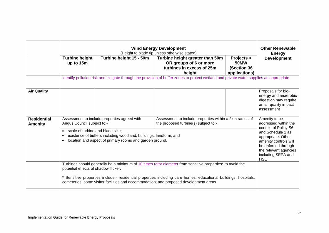
Identify pollution risk and mitigate through the provision of buffer zones to protect wetland and private water supplies as appropriate
Air Quality Proposals for bio-energy and anaerobic digestion may require an air quality impact assessment
Assessment to include properties agreed with Angus Council subject to:-
Assessment to include properties within a 2km radius of the proposed turbine(s) subject to:-
Residential Amenity
• scale of turbine and blade size; • existence of buffers including woodland, buildings, landform; and • location and aspect of primary rooms and garden ground,
Amenity to be addressed within the context of Policy S6 and Schedule 1 as appropriate. Other amenity controls will be enforced through the relevant agencies including SEPA and HSE
Turbines should generally be a minimum of 10 times rotor diameter from sensitive properties* to avoid the potential effects of shadow flicker. * Sensitive properties include:- residential properties including care homes; educational buildings, hospitals, cemeteries; some visitor facilities and accommodation; and proposed development areas

Implementation Guide for Renewable Energy Proposals
23
Wind Energy Development (Height to blade tip unless otherwise stated)
Turbine height up to 15m
Turbine height 15 - 50m Turbine height greater than 50m OR groups of 6 or more
turbines in excess of 25m height
Projects > 50MW
(Section 36 applications)
Other Renewable
Energy Development
Access likely to be feasible within existing road network Angus Council Roads Division will be consulted.
Access to be agreed with Angus Council Roads Division.
Access arrangements and traffic management plan and suitable route for large vehicles to be agreed with Angus Council Roads Division. Any required road improvements to be implemented prior to commencement of construction.
Access to be agreed with Angus Council Roads Division, including management plan and suitable route for large vehicles where necessary.
Any new tracks to be included in the planning application, supporting information and decommissioning /reinstatement agreement.
Access and Traffic Management
Transport Scotland advise that a wind turbine should be located no closer than 1.5 x the Wind Turbine height to the nearside Trunk Road kerb line. For the avoidance of doubt the nearside kerb line is either the kerb of the live carriageway or the nearside heel kerb of the Trunk Road footway if present. Angus Council will apply this principle to all turbine proposals adjacent to a public road, for reasons of road safety.
Other Supporting information should include reasons for site selection and evidence of viability
Where proposals are within the Cairngorms National Park Area, they will be referred to, and may be called in for determination by, the Cairngorms National Park Authority.
Where proposals are located on the coast, applications should demonstrate they have been assessed within the context of the developer/undeveloped coast as defined in the SPP and Angus Local Plan Review and Shoreline Management Plan for Angus. Advice on the sustainable use of the Tay Estuary and adjacent coastal waters can be found in the Management Plan published by the Tay Estuary Forum (http://www.dundee.ac.uk/crsem/TEF/PDFS/Management%20Plan%20Final.pdf )
Implementation Guide for Renewable Energy Proposals
24
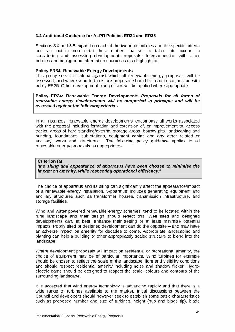
3.4 Additional Guidance for ALPR Policies ER34 and ER35 Sections 3.4 and 3.5 expand on each of the two main policies and the specific criteria and sets out in more detail those matters that will be taken into account in considering and assessing development proposals. Interconnection with other policies and background information sources is also highlighted. Policy ER34: Renewable Energy Developments This policy sets the criteria against which all renewable energy proposals will be assessed, and where wind turbines are proposed should be read in conjunction with policy ER35. Other development plan policies will be applied where appropriate. Policy ER34: Renewable Energy Developments Proposals for all forms of renewable energy developments will be supported in principle and will be assessed against the following criteria:- In all instances ‘renewable energy developments’ encompass all works associated with the proposal including formation and extension of, or improvement to, access tracks, areas of hard standing/external storage areas, borrow pits, landscaping and bunding, foundations, sub-stations, equipment cabins and any other related or ancillary works and structures . The following policy guidance applies to all renewable energy proposals as appropriate:- Criterion (a) ‘the siting and appearance of apparatus have been chosen to minimise the impact on amenity, while respecting operational efficiency;’
The choice of apparatus and its siting can significantly affect the appearance/impact of a renewable energy installation. ‘Apparatus’ includes generating equipment and ancillary structures such as transformer houses, transmission infrastructure, and storage facilities. Wind and water powered renewable energy schemes, tend to be located within the rural landscape and their design should reflect this. Well sited and designed developments can, at best, enhance their setting or at least minimise potential impacts. Poorly sited or designed development can do the opposite – and may have an adverse impact on amenity for decades to come. Appropriate landscaping and planting can help a building or other appropriately scaled structure to blend into the landscape. Where development proposals will impact on residential or recreational amenity, the choice of equipment may be of particular importance. Wind turbines for example should be chosen to reflect the scale of the landscape, light and visibility conditions and should respect residential amenity including noise and shadow flicker. Hydro-electric dams should be designed to respect the scale, colours and contours of the surrounding landscape. It is accepted that wind energy technology is advancing rapidly and that there is a wide range of turbines available to the market. Initial discussions between the Council and developers should however seek to establish some basic characteristics such as proposed number and size of turbines, height (hub and blade tip), blade

Implementation Guide for Renewable Energy Proposals
25
number, colour and style although it is recognised that this may be amended as the project feasibility is developed. Similarly where a full planning application is submitted this must include details of all aspects of the proposal. Where a specific proposal has been approved by the Council any alteration to that project must be agreed in writing with the Council prior to implementation. Other Relevant ALPR policies Policy S3: Design Quality Policy S6: Development Principles and Schedule 1: Development Principles Policy ER10: Light Pollution Policy ER11: Noise Pollution Additional information Tayside Landscape Character Assessment http://www.snh.org.uk/pubs/detail.asp?id=310 Criterion (b) there will be no unacceptable adverse landscape and visual impacts having regard to landscape character, setting within the immediate and wider landscape, and sensitive viewpoints;
Landscape and visual impact varies with the location, scale and type of renewable energy scheme proposed. For example wind turbines tend to be in exposed locations, and visible over a long distance; while hydroelectric schemes may be contained within a river valley; and solar panels fitted to an existing property roof tend to have a localised impact. As the extent and degree of landscape and visual impact increases so to does the need to assess potential cumulative issues and mitigation measures. The supporting information and accompanying visual/graphic information should be commensurate with the scale and location of the proposal. It is likely the small hydro proposals will continue to come forward, and where they can be accommodated without detriment to the local environment and water courses, will be supported. Larger schemes can generate greater impact on water courses, fish, and the surrounding area as the diversion of water is much greater and more evidence of impact and mitigation will be required in order to determine any planning application. . Where river dams and associated buildings are proposed landscaping, contouring and planting can help structures blend into their setting, whilst also promoting biodiversity and habitat creation/enhancement. A range of advice is available for applicants considering hydro schemes including landscape and visual impacts. Consideration of associated infrastructure (pump house, tailrace, access, transmission, pipe routes etc) should be included in supporting information. All forms of renewable energy development should be considered within their landscape context where applicable, Policy S6: Development Principles and Schedule 1 : Development Principles will form the basis for the assessment of small scale proposals, which have a local impact only. Scottish Natural Heritage has developed a series of Advice Notes on assessing the landscape impact of a range of renewable energy developments on the landscape, and their advice will be sought by the Council as appropriate. Landscape and Visual Impact of Wind Turbines
Implementation Guide for Renewable Energy Proposals
26
Wind turbines are likely to have the greatest landscape and visual impact over the greatest distance and this aspect is addressed in Section 4 Landscape and Visual Assessment of Wind Energy Proposals. Other Relevant ALPR policies ER5: Conservation of Landscape Character ER12: Development Affecting Conservation Areas ER16: Development Affecting the Setting of a Listed Building ER18: Archaeological Sites of National Importance ER19: Archaeological Sites of Local Importance ER20: Historic Gardens and Designed Landscapes ER29: Coastal Development Additional information Scottish Natural Heritage (SNH) provides a comprehensive range of advice regarding landscape and visual impact on the natural heritage while Historic Scotland, Architecture and Design Scotland (ADS) and the local planning authority can advise on the built environment. Design statements can help applicants preparing development proposals to consider and articulate the processes undertaken in reaching final layout, siting and design and help inform the decision making process. SNH Policy Statement 02/02 Strategic Locational Guidance for Onshore Windfarms in respect of Natural Heritage (updated 2009). www.snh.gov.uk/docs/A247182.pdf Associated Maps – www.snh.gov.uk/docs/C208971.pdf www.snh.gov.uk/docs/C208972.pdf www.snh.gov.uk/docs/C208973.pdf www.snh.gov.uk/docs/C208974.pdf www.snh.gov.uk/docs/C208975.pdf SNH Visual Representation of Windfarms (2006) www.snh.gov.uk/docs/A305436.pdf SNH Visual Assessment of Windfarms Best Practice (2002) www.snh.gov.uk/docs/A305437.pdf SNH Siting and designing Windfarms in the Landscape (2009) www.snh.gov.uk/docs/A317537.pdf Renewable energy technologies and the potential impacts on landscape and nature http://www.snh.gov.uk/planning-and-development/renewable-energy/ Guidance on Hydro electric Schemes and the Natural Heritage http://www.snh.gov.uk/docs/C278964.pdf Aiding the Hydro-scheme development process - web-links to useful information sources http://www.snh.gov.uk/docs/C252875.pdf Tayside Landscape Character Assessment www.snh.org.uk/pubs/detail.asp?id=310 Angus Windfarms – Landscape Capacity and Cumulative Impacts Study (2008) www.angus.gov.uk/devcontrol/LandscapeCapacityandCumulativeImpactAssessmentFinal.pdf Historic Scotland - Scottish Historic Environment Policy (SHEP) www.historic-scotland.gov.uk/index/heritage/policy/shep.htm

Implementation Guide for Renewable Energy Proposals
27
Criterion (c) the development will have no unacceptable detrimental effect on any sites designated for natural heritage, scientific, historic or archaeological reasons;
There are a number of sites throughout Angus designated for their built, cultural, biodiversity, and natural heritage qualities. These range in scale from individual listed properties up to extensive areas such as Montrose Basin or that part of Angus designated as part of the Cairngorms National Park. Their value is established, and they are safeguarded for present and future generations, through legislation. The integrity of such designations may be affected by activity beyond site boundaries and even into other authorities. Much will depend on the details of an individual proposal – scale, location and type. In assessing development proposals, priority will be given to the maintenance of the quality of the built and natural heritage. Where appropriate, mitigation measures should be investigated and their efficacy demonstrated to ensure compatibility with protected sites. Natural heritage and scientific designations are subject to a range of legislation, policy, and guidance. Development proposals must be able to demonstrate that there will be no unacceptable direct or indirect adverse affects on the integrity of designated sites or the reason for their protection. There is a hierarchy of designated sites, habitats and species ranging from international to local significance with levels of protection proportionate to status. Where remediation measures can successfully redress potential adverse impact, these must be agreed with the relevant advisory agency and subject to a planning condition or legal agreement. There are no international designations within the ALPR area, but there are a number of European sites (SPAs and SCAs) including The River Tay, River South Esk and Firth of Tay SACs and SPAs at Montrose Basin, Kinnordy and Lintrathen Lochs and the Firth of Tay. There are no local nature conservation sites designated within Angus to guide developers, but where locally important habitat or beauty spots are affected, these should be afforded appropriate protection. Local factors will be assessed as part of the consideration of development proposals and where identified through EIA screening and scoping studies should be addressed by supporting information. Where a proposal affects a designated site an Environmental Impact Assessment may be required, depending on the scale of the proposal and anticipated impact. Proposals which come within the provisions of the Electricity Act 1989 will require to meet the terms of the Electricity Works (Environmental Impact Assessment) (Scotland) Regulations 2000. www.scotland.gov.uk/Topics/Business-Industry/Energy/Infrastructure/Energy-Consents/Guidance/EIA-Guidance Sites and areas designated for historic and archaeological reasons are also subject to a range of policy, guidance and legislation. No World Heritage Sites have been identified within Angus, and Historic Scotland is responsible for the protection of sites of national and international status. Angus Council is responsible for determining applications for Listed Building Consent (LBC) and the identification of Conservation Areas and their subsequent protection. Protection of the built heritage extends beyond the actual property and curtilage to encompass its character and setting. This includes Historic Gardens and Designed Landscapes; all listed buildings; and scheduled ancient monuments. Historic Scotland and the Council’s

Implementation Guide for Renewable Energy Proposals
28
Archaeological Service are consulted as appropriate. Where local archaeological sites and areas are known, or suspected, the Council will seek advice on the assessing and recording of any features. Appropriate Level of Assessment Proposals of more than two turbines or a hub height more than 15m tall, or and hydroelectric scheme with a capacity of over 0.5MW, fall within Schedule 2 of the Environmental Impact Assessment (Scotland) Regulations 2011. Such applications and those within or affecting:
• Sites of Special Scientific Interest • Land subject to Nature Conservation Orders • International Conservation Sites • National Scenic Areas • World Heritage Sites • Scheduled Monuments and their settings • National Parks.
may require a screening opinion from the planning authority to determine whether a formal EIA of the proposed development is required. Where appropriate, proposals will be judged in conjunction with the consultation agencies as to whether a formal EIA is required. While only a small proportion of development proposals are likely to require EIA, an EIA is not discretionary if significant effects on the environment are likely and should be prepared in accordance with the relevant legislation and guidance listed below. Where a development is of a scale or in a location where a formal EIA is deemed not necessary, the applicant must submit a planning statement on impact, including any proposed mitigation measures. In the case of wind turbines, the statement should address the constraints identified in the SAS for Onshore Wind Turbines. The level of detail should also reflect the scale and location of the proposal. Guidance can be obtained from SNH, in their publication Hydroelectric Schemes and the Natural Heritage http://www.snh.gov.uk/docs/C278964.pdf Other Relevant ALPR policies Policy ER1: Natura 2000 and Ramsar Sites Policy ER2: National Nature Reserves and Sites of Special Scientific Interest Policy ER3: Regional and Local Designations Policy ER4: Wider Natural Heritage and Biodiversity Policy and Legislation Scottish Government Planning Circular 3 The Town and Country Planning (Environmental Impact Assessment)(Scotland) Regulations (2011) http://www.scotland.gov.uk/Publications/2011/06/01084419/10 PAN 58 Environmental Impact Assessment (1998) http://www.scotland.gov.uk/Publications/1999/10/pan58-root/pan58 EIA Screening Checklist - http://www.scotland.gov.uk/Resource/Doc/212607/0117167.pdf PAN 2/2011 Planning and Archaeology http://www.scotland.gov.uk/Publications/2011/081041322003/0 Scottish Government – web based Renewables Specific Advice Sheets http://www.scotland.gov.uk/Topics/Built-Environment/planning/National-Planning-Policy/themes/renewables

Implementation Guide for Renewable Energy Proposals
29
The Electricity Works (Environmental Impact Assessment) (Scotland) Amendment Regulations 2008 (Revised 2009) http://www.scotland.gov.uk/Topics/Business-Industry/Energy/Infrastructure/Energy-Consents/Guidance/EIA-Amendment-Regs-2008 Town and Country Planning (Scotland) Act 1997 (As Amended) Environmental Impact Assessment (Scotland) Regulations 2011 EU Birds Directive and Annex1 EU Habitats Directive and Annexes 1 and 2 Habitats/protectedareas/NATURA Additional information IEEM Guidelines for Ecological Impact Assessment in the United Kingdom http://www.ieem.net/ecia/impact-assess.html SNH Handbook of Environmental Assessment (2009 Draft) http://www.snh.gov.uk/docs/B460796.pdf SNH Renewable Energy Information page http://www.snh.gov.uk/planning-and-development/renewable-energy/ Wild Land http://www.snh.gov.uk/protecting-scotlands-nature/looking-after-landscapes/landscape-policy-and-guidance/wild-land/ Guidance on Assessing Connectivity with Special Protection Areas (SPAs) http://www.snh.gov.uk/docs/A675474.pdf Soils and Natural Heritage http://www.snh.gov.uk/docs/A327906.pdf SNH, Perth and Kinross Council, SEPA and Angus Council River Tay Special Area of Conservation (SAC) – Advicce to Developers http://www.snh.org.uk/pdfs/publications/designatedareas/River%20Tay%20SAC.pdf SNH, SEPA and Angus Council River South Esk Special Area of Conservation (SAC) – Advicce to Developers http://www.snh.org.uk/pdfs/publications/designatedareas/River%20South%20Esk%20SAC.pdf Historic Scotland Scottish Historic Environment Policy http://www.historic-scotland.gov.uk/index/heritage/policy/shep.htm Environmental Assessment http://www.historic-scotland.gov.uk/index/heritage/policy/environmental-assessment.htm Gardens and Designed Landscapes http://www.historic-scotland.gov.uk/index/heritage/gardens.htm Scottish Government Historic Environment http://www.scotland.gov.uk/Topics/Built-Environment/planning/National-Planning-Policy/themes/historic Natural Environment http://www.scotland.gov.uk/Topics/Built-Environment/planning/National-Planning-Policy/themes/natural-heritage Angus Council State of the Environment Report www.angus.gov.uk/sustainability/pdfs/StateofEnvironment2011.pdf

Implementation Guide for Renewable Energy Proposals
30
Cairngorms National Park Authority http://www.cairngorms.co.uk/resource/docs/boardpapers/22072011/CNPA.Paper.4440.Planning%20Committee.Paper.8.-..Appe.pdf Criterion (d) no unacceptable environmental effects of transmission lines, within and beyond the site;
Ancillary works required to transmit electricity from the site should form part of any renewable energy development proposal to ensure their inclusion in any EIA. Where deemed necessary by the planning authority, consideration will be given to undergrounding of cables and pipe work. Most overhead power lines will be determined by Scottish Government under S37 of the Electricity (Scotland) Act 1989. Criterion (e) access for construction and maintenance traffic can be achieved without compromising road safety or causing unacceptable permanent change to the environment and landscape,
Renewable energy projects, by their very nature, may promote sites which have limited or no existing vehicular access. The construction, repair, maintenance and decommissioning will normally require access by heavy and/or long vehicles over the life of the project. In some cases, there may be a continuation of the life of a scheme with consequent renewal, replacement or upgrading in the longer term. Any project proposal must therefore prepare and submit a route assessment and traffic management plan, which demonstrates:- • how access is to be achieved; • selected routes have been assessed and are capable of accommodating traffic
generated; • traffic management over the construction phase; and • longer term access requirements. If road improvements are required, these must be approved by Angus Council Roads division, part of Infrastructure Services. Site access should allow all vehicles visiting the site to have space to manoeuvre to ensure safe access and egress. The formation of new, or upgrading of existing, tracks over open countryside/uplands should be designed to avoid generating run off/surface water flooding and be re-instated on completion of construction, where they will not be regularly in use. Provision must be made for the re-instatement of any existing and proposed tracks when the site is decommissioned. Other Relevant ALPR policies Policy S2: Accessible Development Policy S3: Design Quality Policy S4: Environmental Protection

Implementation Guide for Renewable Energy Proposals
31
Policy S6: Development Principles and Schedule 1: Development Principles Additional information SNH – Constructed Tracks in the Scottish Uplands (2005) http://www.snh.gov.uk/docs/A308736.pdf SNH and Forestry Commission Scotland – Floating Roads on Peat http://www.roadex.org/uploads/publications/Seminars/Scotland/FCE:SNH%20Floating%20Roads%20on%20Peat%20report.pdf Scottish Renewables, SNH, SEPA and Forestry Commission Scotland – Good Practice During Windfarm Construction http://www.snh.org.uk/pdfs/strategy/renewables/Good%20practice%20during%20windfarm%20construction.pdf Angus Council The Roads Division is part of the Infrastructure Services Department, Angus Council, County Buildings, Market Street, Forfar, Angus, DD8 3LG Contact: [email protected] Criterion (f) that there will be no unacceptable impacts on the quantity or quality of groundwater or surface water resources during construction, operation and decommissioning of the energy plant.
Ground and surface water – including coastal waters, water courses, standing water, peat soils, wetlands and ground water – is an important environmental and commercial asset in Angus. Their identification and quality classification has been established through the Water Framework Directive and the Tay Area Management Plan sets the framework for development that affects them. Applicants will require to demonstrate that development proposals should maintain or enhance ground and surface waters features, not cause deterioration. Groundwater wetlands should be incorporated in Phase 1 Habitat surveys and where appropriate include a buffer zone of 100m between features and roads, tracks and trenches, increasing to 250m for borrow pits and foundations. Water Supply The protection of drinking water, both public and private supplies, will be a priority. Where a development proposal is deemed to affect a potable supply the applicant will require to demonstrate there are no unacceptable adverse effects, or how these can be mitigated if feasible. This may include the requirement for a buffer zone of 100m between features and roads, tracks and trenches, increasing to 250m for borrow pits and foundations. Any works within these distances should demonstrate (e.g. through a hydrogeological assessment) that impacts on abstractions are acceptable. Flooding The SPP www.scotland.gov.uk/Resource/Doc/300760/0093908.pdf establishes a risk framework which provides a basis for planning decisions where there is a potential flood risk. Development proposals located within, or affecting known flood risk areas, will be considered within the context of this framework and referred to SEPA where necessary. Angus Council Roads are the Flood Prevention Authority and advise on flood prevention and flood risk standards for new roads, car parks and footpaths.

Implementation Guide for Renewable Energy Proposals
32
SEPA have produced an Indicative River and Coastal Flood Map which can be viewed at www.sepa.org.uk/flooding/flood_map/view_the_map.aspx Water Quality The water environment is a potential constraint to renewable energy development, particularly in relation to construction works. Applicants should demonstrate that • no unacceptable damage to the water environment will result from their
development; • all pollution risks and mitigation measures during construction, operation and
decommissioning have been identified; • developments are designed to avoid engineering activities (such as culverts) in
the water environment; and • project management is in place to mitigate potential adverse impacts during the
construction phase. Peat Soils Where peat soils are affected by potential renewable energy development applicants should consider:- • Ground water contamination; • Damage to peatland habitat, especially on or adjacent to designated sites. Early
consultation with SNH and SEPA is advised where a proposed development is likely to affect peatland or mire systems;
• In relation to wind energy proposals Scottish Government advice on calculating carbon savings should be used when preparing applications. Information on this is available at http://www.scotland.gov.uk/Topics/Business-Industry/Energy/Energy-sources/19185/17852-1/CSavings ;
• Measures to minimise soil disturbance during construction, operation and decommissioning to maximise carbon balance savings; and
• Potential for slippage; • Need for a peat depth survey to demonstrate that the layout and design of the
proposal avoids areas of deep peat and minimises disturbance to other areas of peat.; and
• Procedures for any extraction and disposal of peat during construction. Applicants should consult SNH and SEPA at an early stage where proposed development is likely to affect peatland or mire systems Other Relevant ALPR policies Policy ER27: Flood Risk – Consultation Policy ER28: Flood Risk Assessment Policy ER25: Water Resource Protection Policy and Legislation Scottish Government Water Framework Directive in Scotland (WFD) www.scotland.gov.uk/Topics/Environment/Water/15561/WFD Flood Risk Management (Scotland) Act 2009 www.scotland.gov.uk/Topics/Environment/Water/Flooding/FRMAct A Policy Statement on Hydropower and Water Environment Protection www.scotland.gov.uk/Topics/Business-Industry/Energy/Energy-sources/19185/17851-1/HydroPolicy Additional information Scottish Environment Protection Agency

Implementation Guide for Renewable Energy Proposals
33
The Tay Area Management Plan 2009 - 2015 www.sepa.org.uk/water/river_basin_planning/area_advisory_groups/idoc.ashx?docid=442c3ee6-588d-468f-bbd5-97cbc7de9e38&version=-1 Guidance for hydropower development www.sepa.org.uk/water/hydropower.aspx Planning Advice http://www.sepa.org.uk/planning/energy.aspx Controlled Activities Regulations (CAR); Guidance for Applicants on Supporting Information requirements for Hydropower Applications http://www.sepa.org.uk/water/idoc.ashx?docid=358677fe-61f7-4fc9-baab-79cb93671387&version=-1 Engineering Activities in the Water Environment http://www.sepa.org.uk/planning/engineering-water_environments.aspx Scottish Government Wind Farms and Carbon Savings on Peatlands http://www.scotland.gov.uk/Topics/Business-Industry/Energy/Energy-sources/19185/17852-1/CSavings Angus Council Environment and Consumer Protection and Roads Division are part of the Infrastructure Services Department, Angus Council, County Buildings, Market Street, Forfar, Angus, DD8 3LG Contact: [email protected] [email protected]

Implementation Guide for Renewable Energy Proposals
34
Policy ER 35 Wind Energy Development Onshore wind turbines are the main subject of renewable energy proposals in Angus. The scale, location and impacts of wind energy developments raise a number of specific issues for consideration and Policy ER35 establishes criteria to aid the assessment of such planning applications. The ALPR addresses additional issues raised by wind energy development. it identifies three geographic areas –Highland (1); Lowland and Hills (2); and Coast (3) - based on the landscape classification that was developed in the Tayside Landscape Character Assessment (1999) www.snh.org.uk/pdfs/publications/review/122.pdf and SNH Policy Statement 02/02 www.snh.gov.uk/docs/A247182.pdf. The broad geographic areas are shown in Figure 1 (see page 39). The ALPR recognises that the open and exposed nature of the Coast and Highland areas are sensitive to potential landscape and visual impact from turbines. The Lowland and Hills area is recognised as of generally lower sensitivity to turbines in terms of visual, landscape and natural heritage interests. However, there may be areas within the Lowland and Hills Area where large turbines would have an unacceptable impact, or where properly sited and designed wind energy development can be accommodated in areas of higher natural heritage, landscape and visual sensitivity. Policy ER 35: Wind Energy Development: Wind energy developments must meet the requirements of Policy ER34 and also demonstrate:- (policy criteria a) - g) are set out and discussed below)
Criterion (a) the reasons for site selection;
Applicants should present their rationale for site selection. Applicants should demonstrate that proposals are in locations where the technology can operate efficiently. Where a consent lapses, that proposal will be deleted from the Council’s database of active proposals. Any re-application will be subject to full cumulative assessment in relation to visual, landscape and environmental impact as appropriate. Applicants should demonstrate that site selection considered all technical, environmental, amenity, visual and landscape impact and mitigation where feasible. Other Land Uses Applicants should demonstrate that their selected site is compatible with other existing land uses and economic activities including:-
• tourism - proximity to visitor attractions such as historic properties, visitor centres, hotels, viewpoints and ‘beauty spots’;
• leisure and recreation (particularly outdoors) – foot and cycle paths, facilities (particularly outdoors) such as golf courses, activity centres;
• forestry – impact of felling for access and turbine clearance; • quiet or remote places valued for their tranquillity; • ancient woodland; and • tourist routes and viewpoints.
Applicants should also demonstrate where site selection can enhance an area, and provide added value. This could include improving access, parking provision, visitor facilities on site such as interpretative facilities and amenities.

Implementation Guide for Renewable Energy Proposals
35
Residential Amenity Applicants must be able to demonstrate that the site was selected to avoid unacceptable impact on the amenity of occupied residential property. The SPP advises a 2km separation distance between areas of search for windfarms over 20MW and the edge of towns and villages, and confirms the development up to this distance is likely to be a prominent feature in open landscapes. When considering potential visual impact of wind energy proposals on residential amenity, Angus Council will use 2km as a guide. Within 2km of residential properties information required will depend on the scale and location of the individual proposal.’ Applicants should be able to demonstrate that factors such as scale, location and topography will allow the development without unacceptable detrimental effect. Views from principal rooms looking towards a proposed turbine, and extent and location of garden ground will be factors in considering potential impact on residential amenity. Additional Information SNH Historic and Ancient Woodlands www.snh.gov.uk/land-and-sea/managing-the-land/forestry-and-woodlands/history/ Criterion (b) that no wind turbines will cause unacceptable interference to birds, especially those that have statutory protection and are susceptible to disturbance, displacement or collision;
This criterion applies to areas designated under the European Habitats and the European Birds Directives for their significance to birds (Natura 2000 sites), and to the flight paths of protected species; and those protected under the Convention on Wetlands of International Importance (Ramsar sites). As well as these internationally designated sites, there are a number of nationally important sites such as Sites of Special Scientific Interest (SSSIs) and RSPB significant bird habitats (which are adjacent to and support designated sites at Kinnordy Loch and Montrose Basin). The protection afforded to these sites extends beyond their boundaries to allow for foraging, roosting and flight paths.
There is a growing body of experience on the management and design of wind farms to reduce or prevent unacceptable impact on birds which may help in the design and layout of a proposed wind farm. SNH will advise on bird surveys and guidance on assessing the impacts of wind farms on birds is available on their website at www.snh.gov.uk/planning-and-development/renewable-energy/onshore-wind/ Other Relevant ALPR policies Policy ER1: Natura 2000 and Ramsar Sites (4) Policy ER2: National Nature Reserves and Sites of Special Scientific Interest Policy ER3: Regional and Local Designations Policy ER4: Wider Natural Heritage and Biodiversity Policy and legislation EU Habitats Directive and Annexes 1 and 2 EU Birds Directive and Annex1 Habitats/protectedareas/NATURA

Implementation Guide for Renewable Energy Proposals
36
Additional information The RSPB and SNH have produced a Bird Sensitivity Map. Details can be found at: www.rspb.org.uk/news/details.aspx?id=tcm:9-179628 Criterion (c) there is no unacceptable detrimental effect on residential amenity, existing land use or road safety by reason of shadow flicker, noise or reflected light; Shadow Flicker and Reflected Light Shadow flicker is where the moving shadow flicker appears through a narrow window opening. The occurrence of flicker can be predicted by calculation, and is therefore identifiable and can be addressed. Scottish Government on–line guidance for Onshore Wind Turbines advises that in most cases the problem can be resolved through separation between wind turbines and nearby dwellings (as general rule 10 rotor diameter). Turbines can also cause flashes of reflected light, which can be visible for some distance. It is possible to ameliorate the flashing but not to eliminate it. Careful choice of blade colour and surface finish can help reduce the effect. Noise There are two sources of noise from wind turbines - the mechanical noise from the turbines and the aerodynamic noise from the blades. Mechanical noise can be reduced through engineering design. Good acoustical design and siting of turbines is essential to ensure there is no significant increase in ambient noise levels as they affect the environment and any nearby sensitive property/receptors. Where appropriate planning conditions will be imposed to control any impact to within reasonable levels. The evaluation of noise will be addressed on a site specific basis, given the range of factors to be considered and further detailed guidance is provided in Section 5 : Noise Assessment for Wind Energy Proposals Other Relevant ALPR policies Policy ER11: Noise Pollution Policy and Legislation Scottish Government – 1/2011 Planning and Noise http://www.scotland.gov.uk/Publications/2011/02/28153945/0 Scottish Government - web based Renewables Specific Advice Sheets http://www.scotland.gov.uk/Topics/Built-Environment/planning/National-Planning-Policy/themes/renewables Additional Information Working Group on Noise and Turbines, Final Report 1996 – ETSU-R-97 www.semantise.com/~lewiswindfarms/FOV1-00021BAE/FOV1-00021BD2/1996:00:00%20ETSU-R-97%20-%20Exec%20Summary.pdf?FCItemID=S000C081A The Influence of Colour on the Aesthetics of Wind Turbine Generators’ – ETSU W/14/00533/00/00 Angus Council Environmental and Consumer Protection is part of the Infrastructure Services Department, Angus Council, County Buildings, Market Street, Forfar, ANGUS DD8 3LG Contact: [email protected]

Implementation Guide for Renewable Energy Proposals
37
Further information turbine noise level prediction can also be found in Section 5 : Noise Assessment for Wind Energy Proposals Criterion (d) that no wind turbines will interfere with authorised aircraft activity;
Military Aircraft There are MOD bases, RAF Leuchars in Fife and RM Condor at Arbroath, with flight paths for landing and take-off which affect Angus. Parts of the area are also subject to low fly zones. Barry Buddon Camp is an army training facility, with live firing capacity. The approach zones for the Air Traffic Control Radar at RAF Leuchars affect areas across south Angus.. The MOD has commented on/objected to a number of wind energy proposals in South Angus on the grounds of interference with radar resulting in false signals being recorded by air traffic controllers, which can threaten aircraft safety. The safety of military personnel and aircraft will be taken into account by Angus Council in considering planning applications.
Where radar interference is identified as a potential constraint and effective mitigation measures have been agreed with the MOD, these must be submitted in writing to Angus Council. Only where a scheme is demonstrated to be deliverable or can be secured through application of a condition, will planning permission be granted
Contact details and further information can be found at: www.mod.uk/DefenceInternet/MicroSite/DE/WhatWeDo/Operations/ModSafeguarding.htm Civilian Aircraft There are two civilian facilities which affect Angus - Dundee Airport and the Gliding Club at Roundyhill, between Glamis and Kirriemuir. No unofficial safeguarding maps are known to have been lodged with the Council e.g. for local emergency service Air Support Units or a former unlicensed airfield in the vicinity of Montrose. Applicants must consult NERL Safeguarding, the Civil Aviation Authority (CAA) and the local authority before submitting a planning application. The applicant should provide an analysis of possible impact, and appropriate measures to alleviate any identified adverse effects on broadcast communications and signals. These consultees may advise on aircraft safety, including lighting. Where this is the case their advice will be acted upon by Angus Council. There is an international civil aviation requirement for all structures of 91.4 metres or more to be charted on aeronautical charts. This is achieved by notifying Defence Geographic Centre prior to the construction/erection of wind turbines and/or anemometer/meteorological masts. Any structure of 150 metres or more must be lit in accordance with the Air Navigation Order and should be appropriately marked. Smaller structures may also be required to be lit by aviation stakeholders particularly if they fall under Section 47 of the Aviation Act Contacts: Civil Aviation Authority NERL Safeguarding

Implementation Guide for Renewable Energy Proposals
38
CAA House 45-59 Kingsway London WC2B 6TE
NATS-CTC Mailbox 23 4000Parkway Solent Business Park Whitely Hampshire PO15 7FL
Dundee Airport Riverside Dundee DD2 1UH
Policy and Legislation Scottish Government Circular 2/2003 Safeguarding of Aerodromes, Technical sites and Military Explosives Storage Areas. http://www.scotland.gov.uk/Resource/Doc/47021/0026439.pdf Additional Information Civil Aviaton Authority Guidance on CAA Planning Consultation Requirements http://www.caa.co.uk/docs/33/DAP_GuidanceOnCAAPlanningConsultationRequirements.pdf CAP 764 CAA Policy and Guidelines on Wind Turbines http://www.caa.co.uk/docs/33/Cap764.pdf Criterion (e) that no electromagnetic disturbance is likely to be caused by the proposal to any existing transmitting or receiving system, or (where such disturbances may be caused) that measures will be taken to minimise or remedy any such interference; Wind turbines have the potential to interfere with electronic communication media, which includes television and radio (which may cause interference, loss of sound or picture and ‘ghosting’), and micro wave links (which may be affected by reflection, diffraction or blocking). Operators suggest a minimum distance of 100m between the alignment of the microwave and any turbine to prevent interference. These interference effects can be reduced through changes to turbine siting and discussion with operators will confirm an appropriate distance. Applicants must consult Ofcom (Office of Communication - which acts as the central point of contact for any television and radio broadcasting, telecommunication and wireless communication issues); the emergency services; utility companies; and the local authority before submitting a planning application. The applicant should provide details of possible adverse effects, and proposed measures to mitigate adverse effects on broadcast communications and signals. Applicants should contact: Ofcom Riverside House 2a Southwark Bridge Road London
Wind Farm Team The Joint Radio Company Limited, Dean Bradley House 52 Horseferry Road

Implementation Guide for Renewable Energy Proposals
39
SE1 9HA Further information is available at www.ofcom.org.uk/
London SW1P 2AF Telephone: +44 20 7706 5197 Further information on The Joint Radio Company Limited is available at www.jrc.co.uk
Criterion (f) that the proposal must be capable of co-existing with other existing or permitted wind energy developments in terms of cumulative impact particularly on visual amenity and landscape, including impacts from development in neighbouring local authority areas; Although a number of consents have been granted in Angus for wind turbines of around 90m to blade tip, only one has yet been constructed. There are a number of large scale turbines close to the boundary of Angus; in Perth and Kinross (Drumderg 16 x 107m), Dundee (Michelin 2 x 120.5m) and Aberdeenshire (Tullo 8 x 100m). These developments are clearly visible from parts of Angus, but no cross local authority boundary landscape/capacity assessment has been undertaken as those commissioned are normally for and by individual local authorities or refer to a specific proposal. Major landscape features such as the highland boundary fault however can extend across several council areas.
The SAS for Onshore Wind Turbines identifies potential cumulative impact as a significant constraint for wind farms, but as noted previously, there is no cross boundary context. The potential impact changes as each development is constructed and the actual scale and potential impact of a windfarm or large turbine will vary depending on the site, layout and turbines selected. Cumulative effects of wind energy developments are a matter of great significance in determining any application. Assessment of landscape and visual impact is contentious and every effort should be made to provide accurate visual representations and to ensure potential cumulative impact on the natural and built environment is fully addressed. The assessment of cumulative impact will reflect the operational, consented and planning applications for turbines, as well as the specific site characteristics. As this will be different for each application and over the passage of time, it is increasingly difficult to map areas of constraint imposed by cumulative impact. Each proposal should demonstrate how its particular characteristics relate to other proposals at the assessment stage. Regard should be given to the extensive advice available on assessing and representing potential cumulative visual and landscape impact. Ecology, Ornithology and Hydrology There is also potential for the combined effect of wind energy development to increase impact on sensitive habitats and/or protected species to an unacceptable level. Where existing development already affects a protected or vulnerable habitat, applicants must demonstrate subsequent proposals through the combined effect of development, will not cause impacts to be intensified to an unacceptable level. This will be particularly important where sites are designated as of international or national importance, but damage to all vulnerable habitats and species should be avoided. (Natura 2000 sites may require a Habitats Regulation Assessment (HRA) by Angus Council as competent authority)

Implementation Guide for Renewable Energy Proposals
40
Cumulative Impact Cumulative ecological impact should be addressed through a formal EIA or an environmental statement, the terms of which should be agreed with the local authority, and other agencies as appropriate. Where the responsibility lies with the local authority to determine acceptable level of impact or viability of mitigation measures, advice will be sought from relevant agencies. Where mitigation measures are proposed and agreed, these will be subject to the application of conditions or legal agreement as appropriate. Post operational monitoring of impact on habitat and species may be required and will be subject to the application of conditions or legal agreement as appropriate. Cumulative landscape and visual assessments should establish search area identifying:-
• any constructed or consented windfarm; • any undetermined windfarm application; • any windfarm proposal which has been subject to an EIA scoping request to the relevant authority; and • any other windfarm proposal that the Planning Authority, and/or SNH, considers relevant for study and which is within the public domain (eg as a result of a public announcement or community meeting).
Installed, consented and proposed offshore windfarms should also be presented on the base plan to enable a decision on whether to include these in the assessment. The cumulative landscape and visual effect will be those which are additional to an agreed baseline of wind energy developments reflecting the scale of the development under consideration. The search area considered will relate to the height of the proposed turbine and the visual interaction with other turbines within an agreed distance For larger turbines the study area should extend to a minimum of 35km from the outer margin of the application site. The size of the study area should also be influenced by the locations and ZTVs of other windfarms likely to interact with the new proposal; and by transport routes to be assessed for sequential effects. The study area may not be circular in shape but could be larger in some directions than others. Sequential impacts may need to be assessed for a distance of more than 60km from the proposed windfarm. For smaller proposals appropriate distances will be agreed with the developer in accordance with SNH guidance Policy and Legislation Scottish Government - web based Renewables Specific Advice Sheets http://www.scotland.gov.uk/Topics/Built-Environment/planning/National-Planning-Policy/themes/renewables SNH Assessing the Cumulaive Impacts of Onshore Wind Energy Developments http://www.snh.gov.uk/docs/A675503.pdf Visual Representaion of Windfarms Good Practice Guidance http://www.snh.gov.uk/docs/A305436.pdf Criterion (g)

Implementation Guide for Renewable Energy Proposals
41
a realistic means of achieving the removal of any apparatus when redundant and the restoration of the site are proposed.
The anticipated lifespan of a wind farm/turbine is currently around 25 years. Once established the operational capacity and equipment is likely to be reviewed. Extension of existing consents will be assessed in accordance with legislation and guidance pertaining at that time, and continued use of an existing location may be an appropriate option. Where time of operation is extended, the decommissioning statement and re-instatement plan will also be reviewed, updated to contemporary standards, and extended. The applicant will be required by planning conditions or legal agreement to ensure acceptable re-instatement standards. A decommissioning statement and reinstatement plan should be submitted detailing removal of all apparatus and associated works; restoration of the site and any after care arrangements; and timescale. It is likely a financial bond will be required by Angus Council to ensure restoration is implemented should the applicant/operator cease to trade. The decommissioning statement should be updated prior to the cessation of energy generation. Where a site has been inactive for six months, the planning authority will require the instigation of the decommissioning process within the six months of the site being confirmed inactive.

Implementation Guide for Renewable Energy Proposals
42
4. Landscape and Visual Assessment of Wind Energy Proposals
The potential landscape and visual impact of wind turbines, both individually and cumulatively is a major factor in the assessment of any planning application. The Tayside Landscape Character Assessment (TLCA) was prepared by Land Use Consultants in 1999, as part of a series of assessments for Scotland prepared on behalf of SNH and the local authorities. It develops a landscape classification which identifies and describes a range of character areas. It also provides guidance on accommodating development and land use change. Whilst some of this guidance has been superseded, the definition of the landscape character areas and their vulnerability to some types of development remains valid, and should be used in conjunction with the evolving SNH guidance. The landscape character areas form the basis of The Wind Energy Geographic Areas in the ALPR as follows (Figure 1, page 39):- • Area 1 Highland - primarily the Angus Glens along and to the north of the
Highland Boundary Fault; • Area 2 Lowland and Hills - mainly rolling farmland and low hills; • Area 3 Coast - a mix of sand, cliffs and, around Montrose, lowland basin. The ALPR identifies areas 1 Highland and 3 Coast as having a greater potential sensitivity to the landscape and visual impact of large turbines. This principle is developed in the Landscape Capacity and Cumulative Impacts Study undertaken by Ironside Farrar on behalf of the Council in 2008. This study primarily considered landscape capacity and cumulative impact in Angus at a strategic level in order to assist in the determination of two planning applications for wind turbines and based on the TLCA character area it identifies Landscape Capacity for Windfarms and current windfarm character type. www.angus.gov.uk/devcontrol/LandscapeCapacityandCumulativeImpactAssessmentFinal.pdf Area 3 Coast also has specific locational factors such as coastal flooding potentially exacerbated in future by rising sea levels, the protection of the undeveloped coast, shoreline management and the interrelationship with off-shore proposals. Development proposals on the coast will be required to address these issues as appropriate in any applications and supporting information. The ALPR and TLCA form the basis for the strategic assessment of landscape capacity and potential visual and landscape impact. Applicants will require to establish the parameters for their individual site assessment with the Council taking cognisance of the detailed landscape and visual implications and suitable representations Where proposals are for turbines between 15 and 50m are proposed a basic VIA should be submitted and for turbines over 50m a full LVIA should be undertaken as detailed in Table 2. Scottish Natural Heritage has developed a series of Advice Notes on the impacts of windfarms on the landscape, and their advice will be sought by the Council as appropriate.
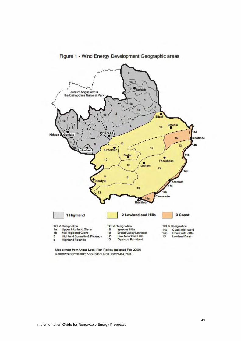
Implementation Guide for Renewable Energy Proposals
43

Implementation Guide for Renewable Energy Proposals 44
The ‘Landscape Capacity and Cumulative Impacts Study’ is a strategic level study providing a context for the consideration of the cumulative effects of existing and potential future windfarm developments. It develops a classification of landscape types in terms of the degree of wind turbine development (Table 3) which is applied in Table 4: Levels of Acceptable Landscape Character Change. Table 3: Landscape Classification Landscape Type Landscape Character Visual
Experience Landscape with no Windfarms
A landscape type or area in which no windfarms or wind turbines are present and none are clearly visible form neighbouring areas
There would be no discernable effects on visual receptors.
Landscape with Views of Windfarms
A landscape type or area within which, or immediately adjacent, there are no windfarms or wind turbines physically located, but from which windfarms are clearly visible in a separate landscape character area. Character may vary considerably according to proximity and scale of neighbouring windfarm(s).
The experience of a visual receptor would be noticeably affected, but windfarms are a background feature clearly not associated with the landscape in which the receptor is located. Visual effects may vary considerably according to proximity and scale of neighbouring windfarm(s)
Landscape with Occasional Windfarms
A landscape type or area in which windfarms or wind turbines are located or are very close to and visible. However they are not of such a size, number, extent or contrast in character that they become one of the defining characteristics of the landscape’s character.
Visual receptors would experience occasional close-quarters views of a windfarm or turbines and more frequent background views of windfarms or turbines. Some turbines may or may not be perceived as being located in the landscape character area. No overall perception of windfarms being a defining feature of the landscape.
Landscape with Windfarms
A landscape type or area in which a windfarm, windfarms or wind turbines are located and visible to such an extent that they become a defining characteristic of the Landscape Character. However, they are clearly separated and not the single most dominant characteristic of the landscape
Visual receptors would experience frequent views of windfarms or wind turbines as foreground, mid-ground or background features, affecting their perception of the landscape character. However there would be sufficient separation between windfarms and turbines and sufficient areas from which wind turbines are not visible such that they would not be seen as dominating the landscape over all other landscape features.
Windfarm Lands
A landscape type or area in which windfarms or wind turbines are extensive, frequent and nearly always visible. They become the dominant, defining characteristic of the landscape. Nevertheless there is a clearly defined separation between developed areas.
Visual receptors would experience views of windfarms as foreground, mid-ground and background features, to the extent that they are seen to dominate landscape character. Few areas would be free of views of wind turbines
Windfarm Landscape fully developed as a windfarm with no clear separation between groups of turbines. Few if any areas where turbines not visible.
Visual receptors would always be close to and nearly always in full view of wind turbines.
Table 4: Levels of Acceptable Landscape Character Change also incorporates the SNH classification of landscape and visual cumulative effects :- a) ‘in combination - where two or more features are seen together at the same time from
the same place, in the same (arc of) view where their visual effects are combined;

Implementation Guide for Renewable Energy Proposals 45
b) in succession - where two or more features are present in views from the same place
(viewpoint) but cannot be seen at the same time, together because they are not in the same arc of view - the observer has to turn to see new sectors of view whereupon the other features unfold in succession;
c) in sequence - where two or more features are not present in views from the same place
(viewpoint) and cannot, therefore, ever be seen at the same time, even if the observer moved round the arc of view, the observer has to move to another viewpoint to see the second or more of them, so they will then appear in sequence. The frequency of occurrence in the sequence may be highly variable, ranging from frequently sequential when the features keep appearing regularly and with short time lapses between (clearly speed of travel influences this as well as distance between the viewpoints) down to occasionally sequential where there may be long time lapses between appearances, because the observer is moving very slowly and / or the there are large distances between the viewpoints (even if not between the features);
d) perceived - where two or more features are present but one or more is never seen by he
observer, for example, because they are screened, or the observer is unable or unwilling to attend a viewpoint from where they would be seen. However, the observer is aware that others are there because, for example, they may have read or heard about them or seen signs to them; this is an apprehended or perceived effect but can be strongly felt; it could also, nevertheless, be mistaken because the observer's information or interpretation of it is wrong.’ (David Tyldesley for SNH at PLI – Proposed Windfarm, An Suidhe, Inveraray, Argyll. November 2002).
New large scale proposals close to established wind farm or turbine development in landscape and/or visual terms should consider their relationship with existing turbine type, scale, colour and layout from all directions from which the wind farms or turbines are viewed in combination. As the number of sites generating energy from wind increase, so does potential for conflict between different scales of development, and between proposed and existing development. Where proposals are submitted, the relative height and style of turbine (e.g. tower construction, number of blades, blade length) should increasingly reflect those already consented to promoted a harmonious development pattern. The Levels of Acceptable Landscape Character Change established in Table 4 provides guidance on the Councils assessment of the potential impact of wind energy development in Angus. Additional Information SNH Cumulative Effect of Windfarms (revised 2005) http://www.snh.gov.uk/docs/A305440.pdf

Implementation Guide for Renewable Energy Proposals 46
Table 4: Levels of Acceptable Landscape Character Change Within Development Boundaries (as defined in the ALPR) it is not possible to define maximum turbine heights. Proposals for turbine development in towns and villages will be considered in the context of the ALPR policies and take account of the following considerations: • Scale and location • Landscape setting • Residential amenity including noise, shadow flicker, visual impact etc • Historic environment including townscape • Compatibility with adjacent uses • Proximity to sensitive receptors such as educational buildings, open space and leisure facilities, hospitals, residential care homes,
cemeteries, visitor facilities and accommodation and proposed development areas • Access • Design • Security of equipment/facility • Ancillary works Outwith development boundaries, in countryside locations it is considered that there is scope for turbines to be accommodated within the following defined landscape types. The guide heights are extrapolated from sources including the Tayside Landscape Character Assessment, the Landscape Capacity and Cumulative Impacts Study, Reporters findings from planning appeals, responses from statutory consultees and reflect the particular scale and landscape of Angus. There may be scope for turbines of greater height, where this can be demonstrated by the applicant. This will be strongly influenced by the elevation of the turbine site, the scale of the landscape and proximity of scale features and buildings. ALPR Zone
Landscape Type (LT) Landscape Units (LU)
Existing Windfarm Character
Acceptable Future Windfarm Character
Guidance (Height to blade tip unless otherwise stated)
1 1a. Upper Highland Glens • Glen Isla • Glen Lethnot • Milton and Upper Tarf
Valley
Landscape with no Windfarms & Landscape with Views of Windfarms
Landscape with Views of Windfarms
This LT is of medium scale; predominantly unsettled; with wild/slightly tamed level of naturalness and with narrow corridor views. Accordingly, it is considered to have no scope for turbines other than domestic scale turbines (less than 25m in height).

Implementation Guide for Renewable Energy Proposals 47
ALPR Zone
Landscape Type (LT) Landscape Units (LU)
Existing Windfarm Character
Acceptable Future Windfarm Character
Guidance (Height to blade tip unless otherwise stated)
1b. Mid Highland Glens • Glen Esk • West Water Valley • Glen Clova • Glen Prosen • Glen Isla
Landscape with no Windfarms & Landscape with Views of Windfarms
Landscape with Occasional Windfarms
Due to the small to medium scale of this LT and the corridor nature of views, it is considered to have scope for turbines circa 50m in height.
3. Highland Summits & Plateaux • Caenlochan Forest/ Glen
Doll Forest
Landscape with Views of Windfarms
Landscape with Views of Windfarms
Considered to have no scope for wind turbines.
5. Highland Foothills • Alyth Foothills • Kirriemuir Foothills • Menmuir Foothills • Edzell Foothills
Landscape with Views of Windfarms
Landscape with Occasional Windfarms
The Highland Foothills provide a dramatic transition between highland and lowland. The contrast between the rolling topography of Strathmore (LT 10) and the foothills is important in defining the character of both LT 10 & 5. Whilst the Foothills appear big next to Strathmore, they are relatively low lying hills. In order to avoid the risk of turbines adversely affecting perceived scale, it is considered that there is scope for turbines less than circa 80m tall located on lower ground only, where they do not adversely affect the setting of landscape features and monuments such as Airlie Monument and the White & Brown Caterthuns.
2 8. Igneous Hills • Sidlaws
Landscape with Views of Windfarms
Landscape with Occasional Windfarms
Considered to have scope for turbines circa 80m in height which do not disrupt the principle ridgelines or adversely affect the setting of important landscape features monuments such as Kinpurney Monument and Auchterhouse hillfort.

Implementation Guide for Renewable Energy Proposals 48
ALPR Zone
Landscape Type (LT) Landscape Units (LU)
Existing Windfarm Character
Acceptable Future Windfarm Character
Guidance (Height to blade tip unless otherwise stated)
10. Broad Valley Lowland • Strathmore
Landscape with Views of Windfarms
Landscape with Occasional Windfarms
Considered to have scope for turbines circa 80m in height.
12. Low Moorland Hills • Forfar Hills
Landscape with Views of Windfarms
Landscape with Occasional Windfarms
Considered to have scope for turbines circa 80m in height which do not disrupt the principle ridgelines or adversely affect the setting of important landscape features and monuments such as Balmashanner Monument; and Finavon and Turin hillforts.
13. Dipslope Farmland • SE Angus Lowland
Landscape with Views of Windfarms
Landscape with Occasional Windfarms
Considered to have scope for turbines circa 80m in height.
14a. Coast with Sand • Barry Links • Elliot • Lunan Bay • Montrose
Landscape with Views of Windfarms
Landscape with Views of Windfarms
14b. Coast with Cliffs • Carnoustie • Auchmithie • Usan
Landscape with Views of Windfarms
Landscape with Views of Windfarms
3
15. Lowland Basins • Montrose Basin
Landscape with Views of Windfarms
Landscape with Views of Windfarms
Due to the often open nature of the Angus coastline and in order to avoid the risk of turbines being visually prominent and therefore adversely affecting the character of the undeveloped coast, it is generally considered there is scope for domestic turbines of circa 25m in height.
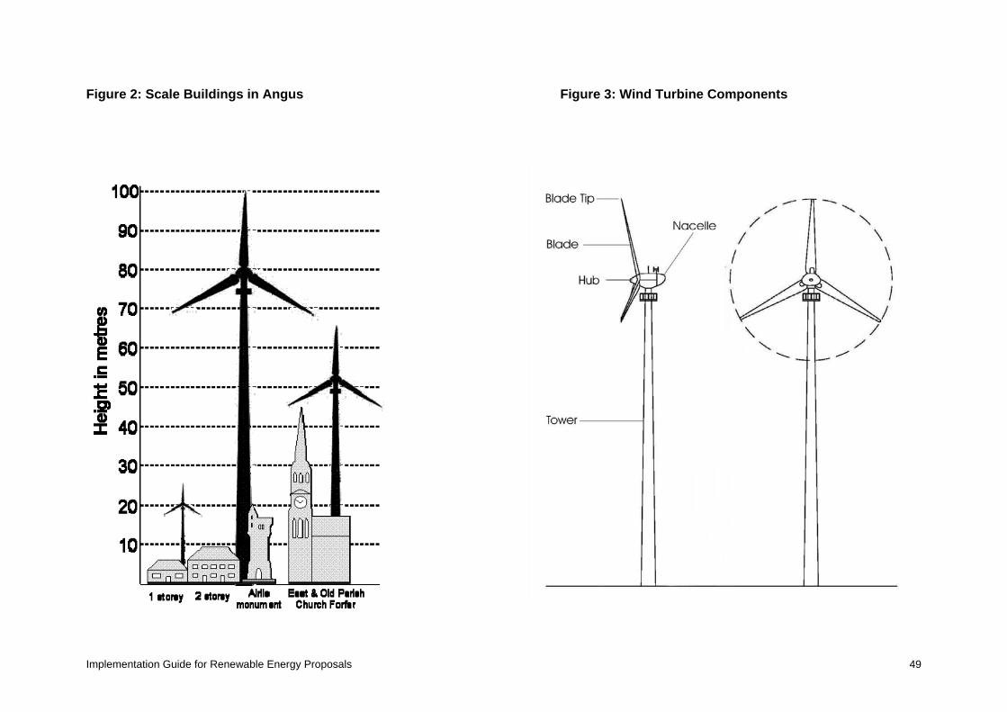
Implementation Guide for Renewable Energy Proposals 49
Figure 2: Scale Buildings in Angus Figure 3: Wind Turbine Components

Implementation Guide for Renewable Energy Proposals 50
5. Noise Assessment for Wind Energy Proposals Noise from wind turbines can be an important factor in the assessment of wind energy developments. Applicants are advised to contact the Environmental and Consumer protection Service at Angus Council at an early stage to establish an agreed methodology for noise assessment. Initial guidance is outlined below:- Assessment Criteria 1. Subject to the points below the criteria specified in ETSU-R-97; the assessment and
rating of noise from wind farms should be used as appropriate noise assessment criteria. 2. If absolute lower noise limits are to be used then the significance of these in relation to
the existing background noise levels should be considered. 3. Amplitude modulation should be considered in terms of the current level of technical
knowledge on the subject. Angus Council will consider the use of appropriate Planning Conditions to control AM on a case by case basis.
4. Where it is suggested that any property benefits financially from the scheme and the higher absolute lower limit of 45 dB(A) maybe applied to that property, full details of the financial benefit and how the occupiers of the relevant property will receive that benefit for the life of the development should be clearly stated. A valid financial benefit is considered to be one which relates directly to the power or income generated by the turbine. One-off lump sum payments are unlikely to be considered acceptable because occupiers could change during the life of the development.
5. Where criteria are derived from background noise measurements the additional points below should be taken into account.
6. It is generally considered that the ETSU-R-97 simplified method criteria is not suitable for small wind turbines i.e. those with a rotor diameter of less than 16m. For developments involving small turbines a noise limit of 40 dB LAEQ(10mins) assessed using the BWEA method referred to below is considered appropriate.
Background noise measurements 1. It is recommended that the type of noise meter, microphone and protection kit for each
monitoring location is agreed. An appropriate windshield (usually double skinned) is required in order to prevent any wind over the microphone affecting readings.
2. It is recommended that the exact position of the monitoring equipment is agreed not just the general location and photographic evidence of the location is taken. Where monitoring data is to be used for more than one property this should be agreed before hand in order to ensure that sufficient locations are monitored to represent all of the neighbouring properties. It is recommended that a list of properties is drawn up and monitoring positions allocated to each for discussion.
3. Monitoring should be avoided next to running water or trees in leaf (unless the measurement location solely represents a single property and the noise environment is not likely to alter seasonally) or on the noisy side of a building (unless it faces the proposed turbine location)
4. It is recommended that the method for determining periods of heavy rainfall and the measurement period to be excluded due to heavy rain is agreed prior to the commencement of monitoring. Heavy rainfall should be taken to mean periods of more than 4mm per hour.
5. The period of monitoring should be sufficient to obtain a reasonable amount of data at each wind speed from 3-12m/s.Depending upon weather conditions this can take longer than 7 days so this should be considered a minimum only.

Implementation Guide for Renewable Energy Proposals 51
6. The method for Simultaneous wind speed measurement should be agreed before hand with Environmental & Consumer protection Service. Derived not measured 10m high wind speeds may need to be used to take account of site specific wind shear.
Turbine noise level prediction 1. Wind turbine noise predictions should follow the methodology used in ISO 9613 and take
into account the detailed guidance published in The Institute of Acoustics bulletin Vol 34 no 2 2009.
2. For small wind turbines i.e. those with a rotor diameter of less than 16m the BWEA small wind turbine performance and safety standard, Feb 2008 guidance maybe used as an alternative methodology to predict the separation distance required to comply with the relevant noise criteria.
3. Turbine noise data must be referenced to test reports. 4. Where any type of noise calculator is used a detailed explanation of the formulae used
and the data used should be given. 5. The noise level prediction should take into account the cumulative impact of other
turbines.

Implementation Guide for Renewable Energy Proposals 52
Appendices APPENDIX 1: Renewable Energy Development in Angus Renewable Energy provides opportunities to develop locally based sources of power, with minimal impact on the local, national and global environment. It can aid progress towards sustainable development, reduce dependence on energy imports, broaden the energy supply base, and create jobs and investment. The growing number of development enquiries and proposals reflects increasing awareness of renewable energy capacity, financial incentives and technological advances all contributing to renewable energy generation across Angus. The current position is set out below. Planning Applications and Consents (as at May 2012) The following Tables will provide the base line for monitoring the Implementation Guide and future renewable energy development within Angus. Table 1 - Status of Applications for Single Turbines (May 2012) Year <25m
25-50m >50
App Ref Pen App Ref Pen App Ref Pen
2004 1 1 - - - - - - - 2005 2 - - - - - - - - 2006 9 - - - - - - - - 2007 8 - - - - - - - - 2008 9 - - - - - - - - 2009 10 1 - - - - 2 - - 2010 13 2 - 2 - - 2 - - 2011 6 1 - 7 1 8 3 3 4 2012 - - 3 4 1 1 - - 2 Total 58 5 3 13 2 9 7 3 6
App – planning application approved Ref – planning application refused Pen – decision pending Table 2 - Status of Applications for Multiple Turbines (May 2012) Year No of turbines 2
No of turbines 3-6 No of turbines >6
App Ref Pen App Ref Pen App Ref Pen
2004 - - - - - - 1 - - 2005 - - - - - - - - - 2006 - - - - - - - - - 2007 - - - - 3 - - 1 - 2008 - - - - - - - - - 2009 - - - - 4 - - - 2010 4 - 1 1 - - - - - 2011 12 1 2 - - 1 - - 2 2012 2 - 1 - - 1 - - - Total 18 1 8 1 7 2 1 1 2
App – planning application approved Ref – planning application refused Pen – decision pending
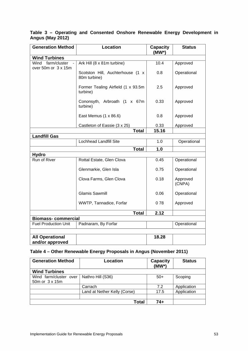
Implementation Guide for Renewable Energy Proposals 53
Table 3 – Operating and Consented Onshore Renewable Energy Development in Angus (May 2012) Generation Method
Location
Capacity (MW*)
Status
Wind Turbines Wind farm/cluster - over 50m or 3 x 15m
Ark Hill (8 x 81m turbine) Scotston Hill, Auchterhouse (1 x 80m turbine) Former Tealing Airfield (1 x 93.5m turbine) Cononsyth, Arbroath (1 x 67m turbine) East Memus (1 x 86.6) Castleton of Eassie (3 x 25)
10.4
0.8
2.5
0.33
0.8
0.33
Approved Operational Approved Approved Approved Approved
Total 15.16 Landfill Gas
Lochhead Landfill Site 1.0 Operational
Total 1.0 Hydro Run of River
Rottal Estate, Glen Clova Glenmarkie, Glen Isla Clova Farms, Glen Clova Glamis Sawmill WWTP, Tannadice, Forfar
0.45
0.75
0.18
0.06
0 78
Operational Operational Approved (CNPA) Operational Approved
Total 2.12 Biomass- commercial Fuel Production Unit Padnaram, By Forfar Operational
All Operational and/or approved
18.28
Table 4 – Other Renewable Energy Proposals in Angus (November 2011) Generation Method
Location
Capacity (MW*)
Status
Wind Turbines Wind farm/cluster over 50m or 3 x 15m
Nathro Hill (S36) 50+ Scoping
Carrach 7.2 Application Land at Nether Kelly (Corse) 17.5 Application
Total 74+

Implementation Guide for Renewable Energy Proposals 54
Other Energy Related Projects Transmission Network SHETL has indicated that once the Beauly-Denny transmission line has been upgraded, the upgrade along the western side of Strathmore will proceed. This will utilise existing towers and renew cables and insulation to increase capacity from 275 to 400KV. Grid access licences are normally subject to this upgrade being implemented.

Implementation Guide for Renewable Energy Proposals 55
APPENDIX 2: Development Plan – Renewable Energy Policies Dundee and Angus Structure Plan Environmental Resources Policy 1: Renewable Energy Proposals for renewable energy development will be favourably considered where they deliver quantifiable environmental and economic benefits and any significant or cumulative adverse impacts on the natural and historic environment, landscape and local communities can be satisfactorily addressed. Development proposals will be considered in the context of the wider environmental policies of the Structure Plan. Detailed criteria based policy, locational guidance and, where appropriate, areas of search for individual sources of renewable energy will be established by Local Plans. An Environmental Statement will be required for all large scale proposals or where development is likely to have significant effects on the environment. Angus Local Plan Review Policy ER34: Renewable Energy Developments Proposals for all forms of renewable energy developments will be supported in principle and will be assessed against the following criteria: (a) the siting and appearance of apparatus have been chosen to minimise the impact on
amenity, while respecting operational efficiency; (b) there will be no unacceptable adverse landscape and visual impacts having regard to
landscape character, setting within the immediate and wider landscape, and sensitive viewpoints;
(c) the development will have no unacceptable detrimental effect on any sites designated for natural heritage, scientific, historic or archaeological reasons;
(d) no unacceptable environmental effects of transmission lines, within and beyond the site; and
(e) access for construction and maintenance traffic can be achieved without compromising road safety or causing unacceptable permanent change to the environment and landscape, and
(f) that there will be no unacceptable impacts on the quantity or quality of groundwater or surface water resources during construction, operation and decommissioning of the energy plant.
Angus Local Plan Review Policy ER35: Wind Energy Development Wind energy developments must meet the requirements of Policy ER34 and also demonstrate: (a) the reasons for site selection; (b) that no wind turbines will cause unacceptable interference to birds, especially those that
have statutory protection and are susceptible to disturbance, displacement or collision; (c) there is no unacceptable detrimental effect on residential amenity, existing land uses or
road safety by reason of shadow flicker, noise or reflected light; (d) that no wind turbines will interfere with authorised aircraft activity; (e) that no electromagnetic disturbance is likely to be caused by the proposal to any
existing transmitting or receiving system, or (where such disturbances may be caused) that measures will be taken to minimise or remedy any such interference;
(f) that the proposal must be capable of co-existing with other existing or permitted wind energy developments in terms of cumulative impact particularly on visual amenity and landscape, including impacts from development in neighbouring local authority areas;
(g) a realistic means of achieving the removal of any apparatus when redundant and the restoration of the site are proposed.

Implementation Guide for Renewable Energy Proposals 56
APPENDIX 3: Other Relevant Development Plan Policies Dundee and Angus Structure Plan (2002)* The Structure Plan was approved by Scottish Ministers in October 2002. The document can be viewed and down loaded at http://www.angus.gov.uk/structureplan/ The main policies relevant to energy proposals are listed below: Environmental Resources Policy 1: Natural Heritage Designations Environmental Resources Policy 2: The Wider Natural Heritage Environmental Resources Policy 3: Coastal Development and Protection Environmental Resources Policy 4: Flooding and Development Environmental Resources Policy 5: Historic Environment Angus Local Plan Review (2009)* The Angus Local Plan was adopted by Angus Council in February 2009. The document can be viewed and downloaded at www.angus.gov.uk/localplan The main policies that may be relevant to energy proposals are listed below under the document headings: General Policies S1: Development Boundaries S2: Accessible Development S3: Design Quality S4: Environmental Protection S5: Safeguard Areas S6: Development Principles and Schedule 1 : Development Principles Building Sustainable Communities SC19: Rural Employment Environment and Resources ER1: Natura 2000 and Ramsar Sites ER2: National Nature Reserves and Sites of Special Scientific Interest ER3: Regional and Local Designations ER4: Wider Natural Heritage and Biodiversity ER5: Conservation of Landscape Character ER6: Trees, Woodlands and Hedgerows ER7: Trees on Development Sites ER10: Light Pollution ER12: Development Affecting Conservation Areas ER16: Development Affecting the Setting of a Listed Building ER18: Archaeological Sites of National Importance ER19: Archaeological Sites of Local Importance ER20: Historic Gardens and Designed Landscapes ER25: Water Resource Protection ER27: Flood Risk – Consultation ER28: Flood Risk Assessment ER29: Coastal Development ER30: Agricultural Land *Hard copies of these documents can also be viewed at Angus Council libraries and ACCESS offices; and at Planning & Transport Reception County Buildings Forfar

Implementation Guide for Renewable Energy Proposals 57
APPENDIX 4: Print Version Maps The print maps are illustrative of detailed information that can be accessed via the web-based version of the Implementation Guide, They are intended to indicate the location and range of International, National and Local designations and other considerations within the ALPR area. Map 1 ALPR Boundary
Map 2 International Designations
Map 3 National Designations
Map 4 Local Designations
Map 5 Other Considerations

FIFE
ABERDEENSHIRE
Angus - LocationThe National Context
Inverness
Aberdeen
Note: The Angus Local Plan Review excludes that part of northern Anguswhich lies within the designated boundary of the Cairngorms National Park.
ANGUS
ARBROATH
BRECHIN
FORFAR
CARNOUSTIE
MONTROSE
PERTH& KINROSS
DUNDEE CITY
PERTH
KIRRIEMUIR
EdinburghGlasgow
Perth
Dundee
Local Plan AreaBoundary
MONIFIETH
Area of Angus withinthe Cairngorms National Park
(C) CROWN COPYRIGHT, ANGUS COUNCIL 100023404, 2012.
Map 1

0 10 205 Kilometers
International DesignationsAngus Council BoundaryArea of Angus within Cairngorms National ParkSpecial Areas of Conservation (SAC)RAMSAR sitesSpecial Protection Areas (SPA)
Map 2 - International Designations
(c) Crown Copyright, All rights reserved, 100023404, 2012 .Infrastructure ServicesPlanning & TransportCounty BuildingsMarket StreetForfarDD8 3LG
Date Produced: 30/01/2012Drawn by: CM1:250,000Scale:

0 10 205 Kilometers
National DesignationsAngus Council BoundaryArea of Angus within Cairngorms National ParkRSPB Important Bird AreasHistoric Scotland Listed BuildingsSites of Special Scientific Interest (SSSI)Historic Scotland Scheduled Ancient MonumentsNational Nature Reserves (NNR)Scotland Ancient Woodland InventoryHistoric Gardens and Designated Landscapes (HGDL)Woodland Map of Scotland200yr SEPA map Coastal Flooding200yr SEPA map Fluvial Flooding
Map 3 - National Designations
(c) Crown Copyright, All rights reserved, 100023404, 2012 .Infrastructure ServicesPlanning & TransportCounty BuildingsMarket StreetForfarDD8 3LG
Date Produced: 30/01/2012Drawn by: CM1:250,000Scale:

0 10 205 Kilometers
Local DesignationsAngus Council BoundaryArea of Angus within Cairngorms National ParkDevelopment BoundariesScottish Wildlife Trust Reserves
! Archaeological PointsCountry ParksArcheological AreasAngus Wildlife Sites (Points)Angus Wildlife Sites (Areas)Tree Preservation Orders (Point)Tree Preservation Orders (Polygons)Conservation AreasLocal Nature ReservesDevelopment Boundaries Plus 2km
Map 4 - Local Designations
(c) Crown Copyright, All rights reserved, 100023404, 2012 .Infrastructure ServicesPlanning & TransportCounty BuildingsMarket StreetForfarDD8 3LG
Date Produced: 30/01/2012Drawn by: CM1:250,000Scale:

0 10 205 Kilometers
Other ConsiderationsAngus Council BoundaryArea of Angus within Cairngorms National ParkPrivate AirfieldsNational Cycle NetworkAdopted Core PathsShell PipelineBP PipelineNational Grid High Pressure Gas Pipe
Map 5 - Other Considerations
(c) Crown Copyright, All rights reserved, 100023404, 2012 .Infrastructure ServicesPlanning & TransportCounty BuildingsMarket StreetForfarDD8 3LG
Date Produced: 30/01/2012Drawn by: CM1:250,000Scale: