finding the right green road for cycle...
TRANSCRIPT
Finding the right green road for cycle routes Smith, M Aldridge, D Page | 0
IPENZ Transportation Group Conference Auckland – March, 2016
FINDING THE RIGHT GREEN ROAD FOR CYCLE ROUTES
Mike Smith, National Specialist – Road Safety
MET, University of Canterbury, NZCE (Civil)
MWH New Zealand Ltd, 6 Hazeldean Road, Hazeldean Business Park, Christchurch
E-Mail: [email protected]
Dave Aldridge, Technical Director – Civil Engineering
NZCE (Civil)
Beca, Colombo Street, Christchurch
E-Mail: [email protected]
ABSTRACT
The provision of on and off road cycle facilities in an existing road network is the big challenge. With the devil being in the detail, the process of route selection, linkage of facilities and social and network impacts has a large impact on the viability of a route for suitable treatments.
The deployment of an extended Multi-Criteria Assessment (MCA) evaluation process in Christchurch has allowed for the robust analysis that is repeatable and justifiable, and assists the Authorities in their decision making process. The MCA process developed allows for the evaluation of cycle and community elements, to better understand the impacts when selecting a route and facility type. It is important that the process is not locked into the Individual argument (my needs outweigh the needs of others); it needs to be changed to the Social Argument (the need of the wider community outweighs the need of an individual). This takes the distraction away from the NIMBY1, and back to finding the best solution for the community.
This paper will outline the processes developed, explore some issues identified causing road blocks, detail how a robust process can assist with political support and highlight the effect that various facility designs have on both the community and network.
ACKNOWLEDGMENTS
The authors would like to acknowledge the large body of work that the combined team of the Papanui Parallel Cycle Route team and assessment teams have undertaken.
This work has required the stretching of boundaries, inclusion of innovative thinking and willingness to try things new.
1 NIMBY - Not-In-My-Back-Yard
Finding the right green road for cycle routes Smith, M Aldridge, D Page | 1
IPENZ Transportation Group Conference Auckland – March, 2016
INTRODUCTION
The selection of an appropriate route for a cycle network is fraught with difficulty, and can lead to much frustration and consternation trying to get it “right”.
Many off road facilities take a simple approach in using land that is easy to adapt, such as rail corridors, parks and public space. While we have challenges in access, this process allows us to deploy a suitable facility with minimal disruption to the public use of roads.
The development of on-road facilities, in comparison, is problematic, and is often subject to NIMBYism. Often we have a societal need or want for a facility, conflicting with a desire to maintain historic network flows and capacity.
This paper explores the recent process developed and deployed in Christchurch for the Papanui Parallel Cycle Route, and seeks to introduce a robust methodology that could be repeated in other centres. The paper outlines some key design details that need to be considered when selecting the best facility type for the lands use and operating speed.
MANDATE FOR FACILITIES
Following the Christchurch earthquake, Christchurch City Council (CCC) found itself in the unusual position of a large-scale repair of its infrastructure. This gave them the opportunity to re-evaluate the old, and provide direction for a new look for the city. Key to this was walking alongside the public on the journey, and understanding what their desires and needs were for a revitalised city. In seeking public opinion and guidance, the combined authorities of the CCC and Christchurch Earthquake Recovery Authority (CERA) launched Share an Idea. Share an Idea approach gave CCC a clear direction of what was wanted for the recovery of Christchurch. Share an Idea resulted in some 106,000 responses (from a population base of 300,000), with a clear direction for the City rebuild.
The message was that people wanted:
A liveable city,
Facilities that provided for shared use,
Slow speeds, and
Excellent cycle facilities.
Clearly, there was a strong mandate from the public for a change, and the provision of appropriate facilities throughout the city. The task was then how does this aspiration translate through the current (or future) process to facilities on the ground.
CCC as part of its Christchurch Strategic Transport Plan set in place a network of cycle ways (Major Cycleway Routes (MCRs)). These cycle ways are not the traditional “painted edge lines on the side of the road but separated cycle facilities targeting the “Interested but Concerned” group of the community in an attempt to bring about a modal shift.
Often we get stuck in the individual argument & opposition from those who’s view is no-bike no-way (while the larger proportion of the public are cyclists or interested but concerned), and spend a disproportionate amount of time dealing with “someone’s” problem, rather than the real societal argument. If the public have spoken about what they would like, is it correct to spend a lot of time in a one-on-one argument?
Engineers and planners, it is your responsibility to ensure that the decision makers have confidence in what is being proposed, and a strong confidence in its delivery.
Finding the right green road for cycle routes Smith, M Aldridge, D Page | 2
IPENZ Transportation Group Conference Auckland – March, 2016
ROUTE SELECTION
Begin with the end in mind (Stephen Covey)
A traditional approach for route selection could sometimes be considered archaic. A group of “experts” sitting in a room pondering over maps of a city, discussing the perceived “desires” of the user, for a route that may be based upon “memory” of what the road / route looked like.
The conventional thinking (old approach) in route selection internationally considers many different factors such as:
1. Safety,
2. Directness,
3. Coherence and connectivity,
4. Attractiveness and social safety, and
5. Comfort
These are well defined in literature such as the Design Manual for Bicycle Traffic (CROW, 2007) and the Guide to Road Design Part 6A: Pedestrian and Cyclist Paths (Austroads).
However, even with this in mind, we have still been producing facilities that have been substandard, and have drawn a lot of negative publicity. While this has not been the intention of the designers, one must learn from these mistakes, and seek a new way forward.
The selection of a route for a cycleway must consider many varied (and often conflicting) needs. A route may be best for directness, but may also be a key arterial route or bus route. Therefore, the public may perceive the route as unsafe due to the traffic. An alternate route may be safe, but take the user well off their desire line and hence not be well used.
Recent MCR work undertaken by a consortium grasped this challenge, and sought to develop a new way of thinking for route selection, that would be robust, repeatable and provide support to our political representatives moving forward. It was identified that there were a number of decisions / impacts that had to be assessed, that were not adequately covered in the conventional thinking, to ensure that a holistic and practicable assessment was undertaken.
As raised in recent media attention (eg Island Bay / South Dunedin Cycle Network), the general public felt that there was poor consideration on impact to business, parking, access and street amenity. The challenge was to extend and develop additional assessment elements that considered these (and other) elements.
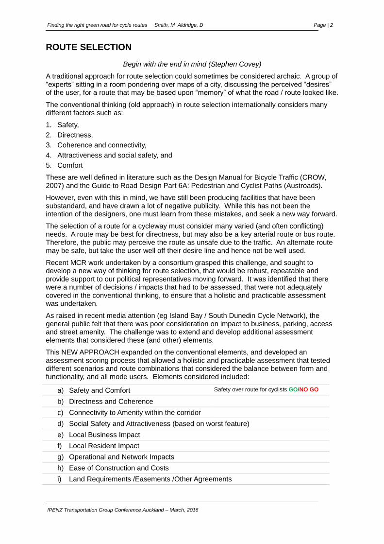
This NEW APPROACH expanded on the conventional elements, and developed an assessment scoring process that allowed a holistic and practicable assessment that tested different scenarios and route combinations that considered the balance between form and functionality, and all mode users. Elements considered included:
a) Safety and Comfort Safety over route for cyclists GO/NO GO
b) Directness and Coherence
c) Connectivity to Amenity within the corridor
d) Social Safety and Attractiveness (based on worst feature)
e) Local Business Impact
f) Local Resident Impact
g) Operational and Network Impacts
h) Ease of Construction and Costs
i) Land Requirements /Easements /Other Agreements

Finding the right green road for cycle routes Smith, M Aldridge, D Page | 3
IPENZ Transportation Group Conference Auckland – March, 2016
These elements are considered further in the sections below.
Key Origins and Destinations
A key objective for the selection of a route is in knowing the origin and destination for the journey. Generally this is home to work, home to school, or home to shops. Typically the assessment of coherence (a) and connectivity (b) would be done based upon the judgement of the network planner, often from an office and based upon memory. The new convention had the assessment team walking / driving / cycling the proposed route options to get an appreciation first-hand of the road environment.
In the revised approach we undertook a determination of sub-destinations that would be attractive to the user. Be they sports facilities, parks, churches or linkages to other facilities (d). In knowing these key facilities and destinations, a plan was generated in GIS to display the results, and allow the inclusion of key road characteristics for the evaluation of selected routes to achieve the desired outcome.
Through the process, it was identified that there may be some exclusion areas that were considered too unsafe, or have an unacceptable level of impact. For instance, a cycleway across the entrance to a freight hub, or a major traffic generator may not be desirable. This does not exclude the route, but in knowing these sites, the route selection process can ensure that all aspects of the route are evaluated, ensuring a robust analysis.
Route / Sub-Route Comparison
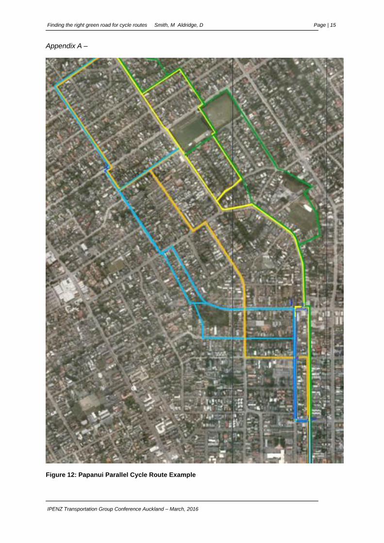
Often there are a number of permutations of viable routes, as can be seen in Figure 1.
Each of these routes must be considered on their own merits to ensure that a suitable route is not overlooked.
As required under the RMA process, this is especially important where the route may track through a heavily industrial area, or an area of significant impact such as a Metro Sports hub, where there is a high left turn movement from a one-way street over a proposed separated bi-directional facility.
Essential to the comparison is the regimented evaluation and documentation procedure. Decision made under a pressure cooker environment need to be recorded, and the basis of those the decisions documented well.
Future reviews, with the luxury of time may not see things as the assessment team did.
Figure 1: Route Options Papanui Parallel Cycleway
(reproduced in Appendix A)
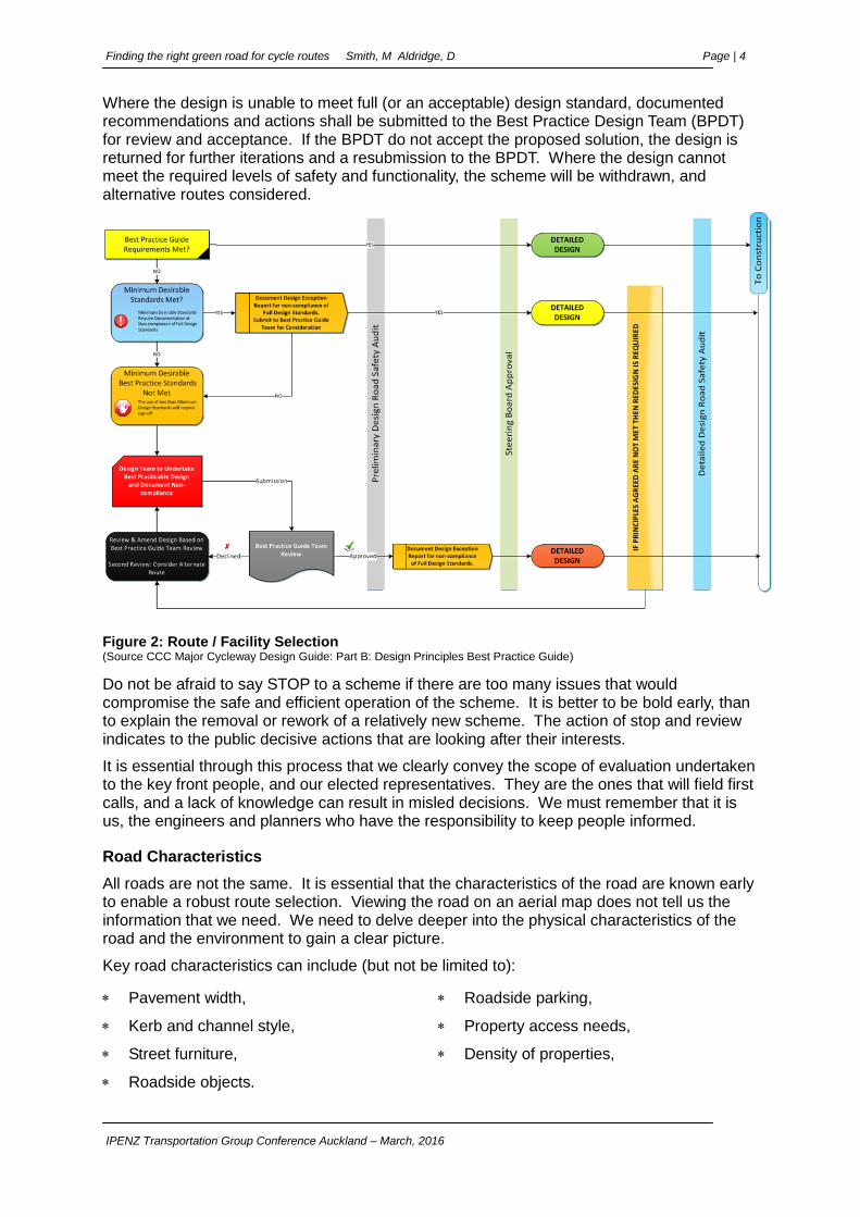
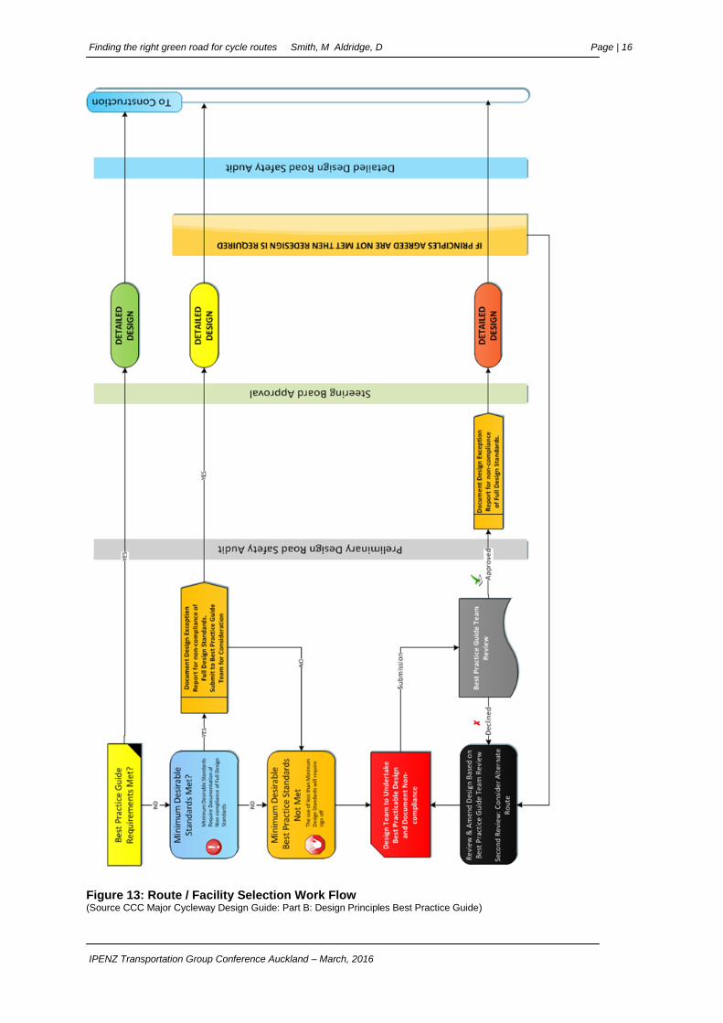
A work flow process (Figure 2) was developed detailing the steps and level or reporting required to pass through the respective gateways. This workflow is reproduced in full in Appendix A for clarity.
The work flow takes the user through the required gateways, and depending on the level of compliance with best practice, outlines to the user the level of documentation required for the non-compliance with the full design standards.
Finding the right green road for cycle routes Smith, M Aldridge, D Page | 4
IPENZ Transportation Group Conference Auckland – March, 2016
Where the design is unable to meet full (or an acceptable) design standard, documented recommendations and actions shall be submitted to the Best Practice Design Team (BPDT) for review and acceptance. If the BPDT do not accept the proposed solution, the design is returned for further iterations and a resubmission to the BPDT. Where the design cannot meet the required levels of safety and functionality, the scheme will be withdrawn, and alternative routes considered.
Figure 2: Route / Facility Selection (Source CCC Major Cycleway Design Guide: Part B: Design Principles Best Practice Guide)
Do not be afraid to say STOP to a scheme if there are too many issues that would compromise the safe and efficient operation of the scheme. It is better to be bold early, than to explain the removal or rework of a relatively new scheme. The action of stop and review indicates to the public decisive actions that are looking after their interests.
It is essential through this process that we clearly convey the scope of evaluation undertaken to the key front people, and our elected representatives. They are the ones that will field first calls, and a lack of knowledge can result in misled decisions. We must remember that it is us, the engineers and planners who have the responsibility to keep people informed.
Road Characteristics
All roads are not the same. It is essential that the characteristics of the road are known early to enable a robust route selection. Viewing the road on an aerial map does not tell us the information that we need. We need to delve deeper into the physical characteristics of the road and the environment to gain a clear picture.
Key road characteristics can include (but not be limited to):
Pavement width, Roadside parking,
Kerb and channel style, Property access needs,
Street furniture, Density of properties,
Roadside objects.
Finding the right green road for cycle routes Smith, M Aldridge, D Page | 5
IPENZ Transportation Group Conference Auckland – March, 2016
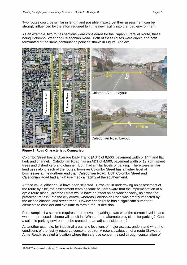
Two routes could be similar in length and possible impact, yet their assessment can be strongly influenced by the effort required to fit the new facility into the road environment.
As an example, two routes sections were considered for the Papanui Parallel Route, these being Colombo Street and Caledonian Road. Both of these routes were direct, and both terminated at the same continuation point as shown in Figure 3 below.
Colombo Street Layout
Caledonian Road Layout
Figure 3: Road Characteristic Comparison
Colombo Street has an Average Daily Traffic (ADT) of 8,500, pavement width of 14m and flat kerb and channel. Caledonian Road has an ADT of 4,500, pavement width of 12.75m, street trees and dished kerb and channel. Both had similar levels of parking. There were similar land uses along each of the routes, however Colombo Street has a higher level of businesses at the northern end than Caledonian Road. Both Colombo Street and Caledonian Road had a high use medical facility at the southern end.
At face value, either could have been selected. However, in undertaking an assessment of the route by bike, the assessment team became acutely aware that the implementation of a cycle route along Colombo Street would have an effect on network capacity, as it was the preferred “rat-run” into the city centre, whereas Caledonian Road was greatly impacted by the dished channel and street trees. However each route has a significant number of elements to consider and evaluate to form a robust decision.
For example, if a scheme requires the removal of parking, state what the current level is, and what the proposed scheme will result in. What are the alternate provisions for parking? Can a suitable parking environment be created on an adjacent side road?
As another example, for industrial areas and locations of major access, understand what the conditions of the facility resource consent require. A recent evaluation of a route (Sawyers Arms Road) revealed a location where the safe-use concern raised through consultation of
Cale
do
nia
n R
oa
d
Co
lom
bo
Str
eet
14 m
12.75 m m
Finding the right green road for cycle routes Smith, M Aldridge, D Page | 6
IPENZ Transportation Group Conference Auckland – March, 2016
providing a cycle way over an access was about the trucks reversing into the yard from the road. A review of the resource consent revealed that the location was specifically forbidden from that movement. It had developed as a result of clutter in the off street area, and had been allowed to continue.
MULTI-CRITERIA ANALYSIS
As presented earlier, the normal process for the evaluation of a route (or combination of routes) is the assessment against the normal elements of Safety, Directness, Coherence and Connectivity, Attractiveness and Social Safety, and Comfort.
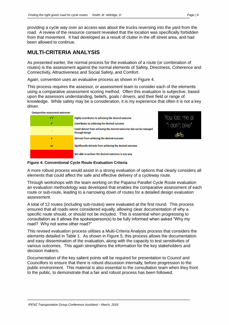
Again, convention uses an evaluative process as shown in Figure 4.
This process requires the assessor, or assessment team to consider each of the elements using a comparative assessment scoring method. Often this evaluation is subjective, based upon the assessors understanding, beliefs, goals / drivers, and their field or range of knowledge. While safety may be a consideration, it is my experience that often it is not a key driver.
Figure 4: Conventional Cycle Route Evaluation Criteria
A more robust process would assist in a strong evaluation of options that clearly considers all elements that could affect the safe and effective delivery of a cycleway route.
Through workshops with the team working on the Papanui Parallel Cycle Route evaluation an evaluation methodology was developed that enables the comparative assessment of each route or sub-route, leading to a narrowing down of routes for a detailed design evaluation assessment.
A total of 12 routes (including sub-routes) were evaluated at the first round. This process ensured that all roads were considered equally, allowing clear documentation of why a specific route should, or should not be included. This is essential when progressing to consultation as it allows the spokesperson(s) to be fully informed when asked “Why my road? Why not some other road?”
This revised evaluation process utilises a Multi-Criteria Analysis process that considers the elements detailed in Table 1. As shown in Figure 5, this process allows the documentation and easy dissemination of the evaluation, along with the capacity to test sensitivities of various outcomes. This again strengthens the information for the key stakeholders and decision makers.
Documentation of the key salient points will be required for presentation to Council and Councillors to ensure that there is robust discussion internally, before progression to the public environment. This material is also essential to the consultation team when they front to the public, to demonstrate that a fair and robust process has been followed.
Finding the right green road for cycle routes Smith, M Aldridge, D Page | 7
IPENZ Transportation Group Conference Auckland – March, 2016
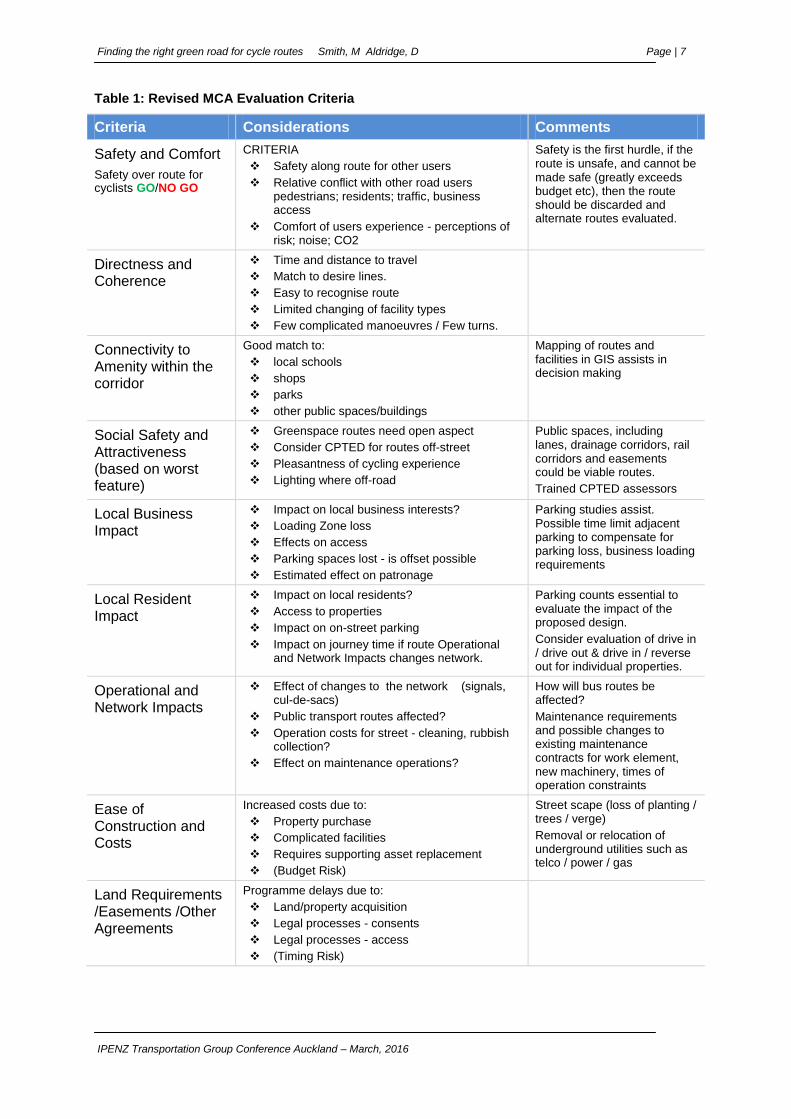
Table 1: Revised MCA Evaluation Criteria
Criteria Considerations Comments
Safety and Comfort
Safety over route for cyclists GO/NO GO
CRITERIA
Safety along route for other users
Relative conflict with other road users pedestrians; residents; traffic, business access
Comfort of users experience - perceptions of risk; noise; CO2
Safety is the first hurdle, if the route is unsafe, and cannot be made safe (greatly exceeds budget etc), then the route should be discarded and alternate routes evaluated.
Directness and Coherence
Time and distance to travel
Match to desire lines.
Easy to recognise route
Limited changing of facility types
Few complicated manoeuvres / Few turns.
Connectivity to Amenity within the corridor
Good match to:
local schools
shops
parks
other public spaces/buildings
Mapping of routes and facilities in GIS assists in decision making
Social Safety and Attractiveness (based on worst feature)
Greenspace routes need open aspect
Consider CPTED for routes off-street
Pleasantness of cycling experience
Lighting where off-road
Public spaces, including lanes, drainage corridors, rail corridors and easements could be viable routes.
Trained CPTED assessors
Local Business Impact
Impact on local business interests?
Loading Zone loss
Effects on access
Parking spaces lost - is offset possible
Estimated effect on patronage
Parking studies assist. Possible time limit adjacent parking to compensate for parking loss, business loading requirements
Local Resident Impact
Impact on local residents?
Access to properties
Impact on on-street parking
Impact on journey time if route Operational and Network Impacts changes network.
Parking counts essential to evaluate the impact of the proposed design.
Consider evaluation of drive in / drive out & drive in / reverse out for individual properties.
Operational and Network Impacts
Effect of changes to the network (signals, cul-de-sacs)
Public transport routes affected?
Operation costs for street - cleaning, rubbish collection?
Effect on maintenance operations?
How will bus routes be affected?
Maintenance requirements and possible changes to existing maintenance contracts for work element, new machinery, times of operation constraints
Ease of Construction and Costs
Increased costs due to:
Property purchase
Complicated facilities
Requires supporting asset replacement
(Budget Risk)
Street scape (loss of planting / trees / verge)
Removal or relocation of underground utilities such as telco / power / gas
Land Requirements /Easements /Other Agreements
Programme delays due to:
Land/property acquisition
Legal processes - consents
Legal processes - access
(Timing Risk)
Finding the right green road for cycle routes Smith, M Aldridge, D Page | 8
IPENZ Transportation Group Conference Auckland – March, 2016
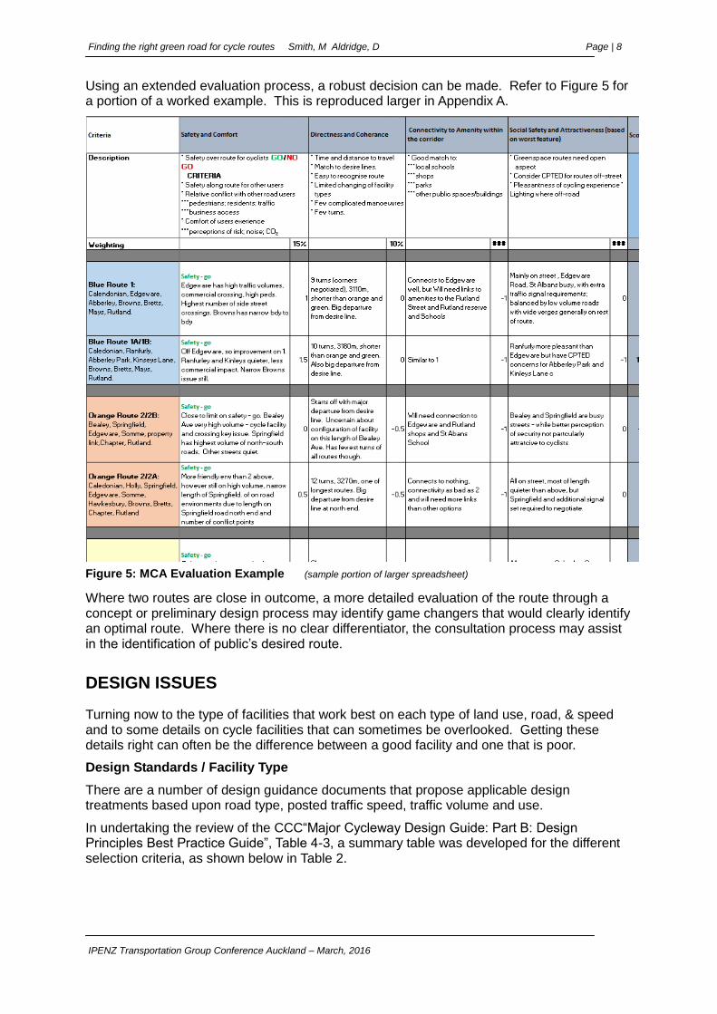
Using an extended evaluation process, a robust decision can be made. Refer to Figure 5 for a portion of a worked example. This is reproduced larger in Appendix A.
Figure 5: MCA Evaluation Example (sample portion of larger spreadsheet)
Where two routes are close in outcome, a more detailed evaluation of the route through a concept or preliminary design process may identify game changers that would clearly identify an optimal route. Where there is no clear differentiator, the consultation process may assist in the identification of public’s desired route.
DESIGN ISSUES
Turning now to the type of facilities that work best on each type of land use, road, & speed and to some details on cycle facilities that can sometimes be overlooked. Getting these details right can often be the difference between a good facility and one that is poor.
Design Standards / Facility Type
There are a number of design guidance documents that propose applicable design treatments based upon road type, posted traffic speed, traffic volume and use.
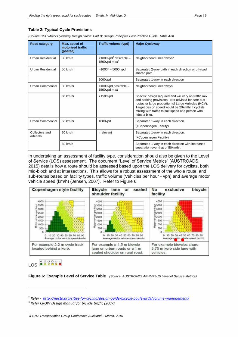
In undertaking the review of the CCC“Major Cycleway Design Guide: Part B: Design Principles Best Practice Guide”, Table 4-3, a summary table was developed for the different selection criteria, as shown below in Table 2.
Finding the right green road for cycle routes Smith, M Aldridge, D Page | 9
IPENZ Transportation Group Conference Auckland – March, 2016
Table 2: Typical Cycle Provisions
(Source CCC Major Cycleway Design Guide: Part B: Design Principles Best Practice Guide, Table 4-3)
Road category Max. speed of motorized traffic (posted)
Traffic volume (vpd) Major Cycleway
Urban Residential 30 km/h <1000vpd2 desirable –
1500vpd max3
Neighborhood Greenways*
Urban Residential 50 km/h >1000* – 5000 vpd Separated 2-way path in each direction or off-road shared path
5000vpd Separated 1-way in each direction
Urban Commercial 30 km/hr <1000vpd desirable – 1500vpd max
Neighborhood Greenways
30 km/hr >1500vpd Specific design required and will vary on traffic mix and parking provisions. Not advised for core bus routes or large proportion of Large Vehicles (HCV). Target design speed would be 20km/hr if cyclists mixing with traffic to suit speed of a person who rides a bike.
Urban Commercial 50 km/hr 1000vpd Separated 1-way in each direction.
(+Copenhagen Facility)
Collectors and arterials
50 km/h Irrelevant Separated 1-way in each direction.
(+Copenhagen Facility)
50 km/h Separated 1-way in each direction with increased separation over that of 50km/hr.
In undertaking an assessment of facility type, consideration should also be given to the Level of Service (LOS) assessment. The document “Level of Service Metrics” (AUSTROADS, 2015) details how a route should be assessed based upon the LOS delivery for cyclists, both mid-block and at intersections. This allows for a robust assessment of the whole route, and sub-routes based on facility types, traffic volume (Vehicles per hour - vph) and average motor vehicle speed (km/h) (Jensen, 2007). Refer to Figure 6.
LOS
Figure 6: Example Level of Service Table (Source: AUSTROADS AP-R475-15 Level of Service Metrics)
2 Refer - http://nacto.org/cities-for-cycling/design-guide/bicycle-boulevards/volume-management/ 3 Refer CROW Design manual for bicycle traffic (2007)

Finding the right green road for cycle routes Smith, M Aldridge, D Page | 10
IPENZ Transportation Group Conference Auckland – March, 2016
Utilising these LOS tables, it is found that while the typical cycle provision guidance would have an upper limit of 1500 vpd (150 vph) for a neighbourhood greenway as defined in Table 4.3 of the CCC Design Principles Best Practice Guide, using the Austroads level of service tables the acceptable traffic volume (vph) may in fact be higher for an acceptable LOS, if the traffic speed is reduced, as shown by red dots in the No exclusive bicycle facility graph. This is conducive with a slow speed neighbourhood greenway.
A robust evaluation or decision of facility type can only be undertaken by people who are conversant with the varying design standards and evaluation techniques. This can best be undertaken by a diverse panel utilising the varying skills that they offer. Consider bringing in facility users or advisors early, especially the mobility and visually impaired. They will be the mode use group that could be most challenged by the new facilities, especially where innovative design is deployed.
Turning movements
Typically, in undertaking the assessment for turning movements, we assume a number of variables such as lane position, direction of travel (forward / reverse), position of adjacent parked vehicles etc. However, in undertaking recent Road Safety Audits (RSA) for facilities, and through observations on street in undertaking a safety review of access movement (Safety Review of Turn Movements: Smith / Hughes; 2015) it was found that a number of these assumptions may not be correct, and in fact, if adopted, could lead to an unsafe facility.
As an example, we assume that a car will drive in and drive out. Yet if we look carefully at the properties along a route we will find a high proportion of drive in – reverse out. This greatly affects the driver’s view line requirements due to the physical construction of the vehicle as shown in Photo 1 and Photo 2 below.
Photo 1: - Car reversing from behind property hedge line.
Photo 2: - Projection of vehicle before the driver can obtain a sight line.
This visibility can also be affected by driver physical impediments such as limited mobility (especially elderly for head / body rotation) and vision impediments (loss of peripheral vision etc).
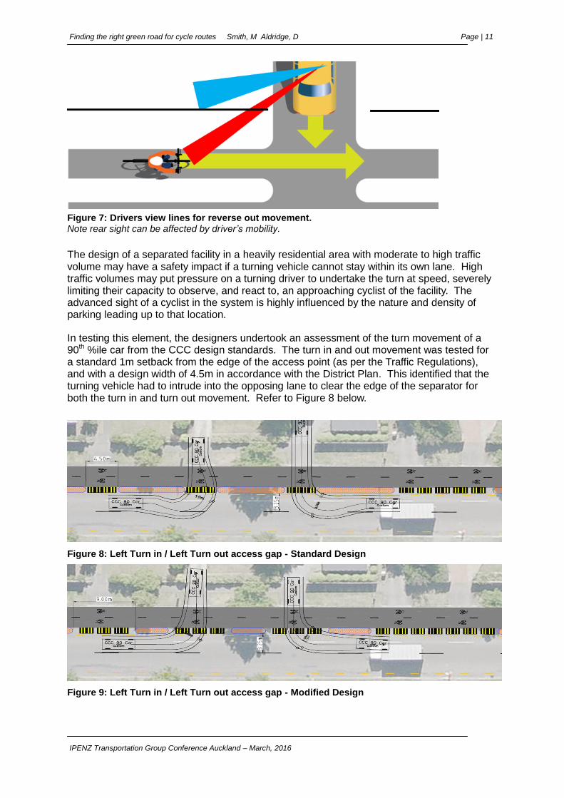
The reverse out movement has the driver on the opposite side of the driveway, and further back, than that for a drive out movement, thus a reassessment of driver’s sight lines must be made.This alters the position of the driver, and hence changes the position of the vehicle, whereby the driver can see the footpath and cycleway facility. An example of this sight line is given in Figure 7 below.
Finding the right green road for cycle routes Smith, M Aldridge, D Page | 11
IPENZ Transportation Group Conference Auckland – March, 2016
Figure 7: Drivers view lines for reverse out movement. Note rear sight can be affected by driver’s mobility.
The design of a separated facility in a heavily residential area with moderate to high traffic volume may have a safety impact if a turning vehicle cannot stay within its own lane. High traffic volumes may put pressure on a turning driver to undertake the turn at speed, severely limiting their capacity to observe, and react to, an approaching cyclist of the facility. The advanced sight of a cyclist in the system is highly influenced by the nature and density of parking leading up to that location.
In testing this element, the designers undertook an assessment of the turn movement of a 90th %ile car from the CCC design standards. The turn in and out movement was tested for a standard 1m setback from the edge of the access point (as per the Traffic Regulations), and with a design width of 4.5m in accordance with the District Plan. This identified that the turning vehicle had to intrude into the opposing lane to clear the edge of the separator for both the turn in and turn out movement. Refer to Figure 8 below.
Figure 8: Left Turn in / Left Turn out access gap - Standard Design
Figure 9: Left Turn in / Left Turn out access gap - Modified Design

Finding the right green road for cycle routes Smith, M Aldridge, D Page | 12
IPENZ Transportation Group Conference Auckland – March, 2016
This element was tested further to determine the crossing width required to ensure that the vehicle remained within its own lane. This was found to be 9 m, twice that required under the District Plan. Refer to Figure 9. At 9 m it was identified that the gap was very large and that the impact of the separator structures was greatly diminished.
Parking offset
There have been a number of considerations on the desirable offset for parking at access points along residential streets. These relate to intervisibility sight lines, turn movements, parking stall width and proximity of adjacent facilities such as cycleways and footpaths. There are many conflicting offsets presented by the various design guides, and these often conflict with each other on what is “best practice”.
CCC commissioned a safety review of the different offsets, with a specific request to visit a number of existing sites to determine what would be the best nominal offset for a range of circumstances. This would form the basis of a change to the existing CCC design standards. This review was undertaken by Tim Hughes, National Traffic and Safety Engineer, NZ Transport Agency and Mike Smith, National Specialist – Road Safety, MWH.
An on-site inspection of the existing separated cycleway facility along Tennison Street, and the proposed separated cycleway facility along Colombo Street (north of Bealey Avenue) was undertaken for the purpose of this review.
The team undertook an assessment of the available parking spaces between access ways and then applied a test for the parking offsets to determine the impacts on intervisibility sight lines for all users to and from the proposed adjacent cycleway.
It was determined that the following elements had a large effect on the available sight lines, and hence the setback requirements:
Preceding access way spacing. Where close access ways were found, and therefore single parking opportunities, it was determined that the left turn driver would have sufficient advance awareness of a cyclist on the facility. This natural gapping offered good sight windows to allow recognition of a cyclist on the separated facility.
Where there were a large number of vehicles parked (or able to park) between access ways, and hence little windows of sight for the intervisibility, there was a very strong reliance on the sight at the left turn in movement.
The size, type and design of the vehicle parked created a large variance in sight line availability.
Through this evaluation the left turn out movement was considered the minimum offset requirement to allow the safe exiting of the car as defined through the turning circle assessment. This in turn set one of the parameters for the determination of the remaining car park spaces. The number of the preceding parking density for each gap between accesses were a large determinant in the left turn in setback.
In summary, the parking spaces are determined by:
1. Available preceding parking spaces,
2. Separation of driveways – what is the site separation of parks
3. Available “observation” space of cyclist on the facility. Does the parked vehicle block out windows of observation for the left turn drivers to the cyclist on the facility?
4. Street layout – utilities / features / furniture that would obstruct clear intervisibility
It was determined that there is not a “one rule” for this area. The team thought that there is so much dependence on the actual site characteristics that a single rule would not work.
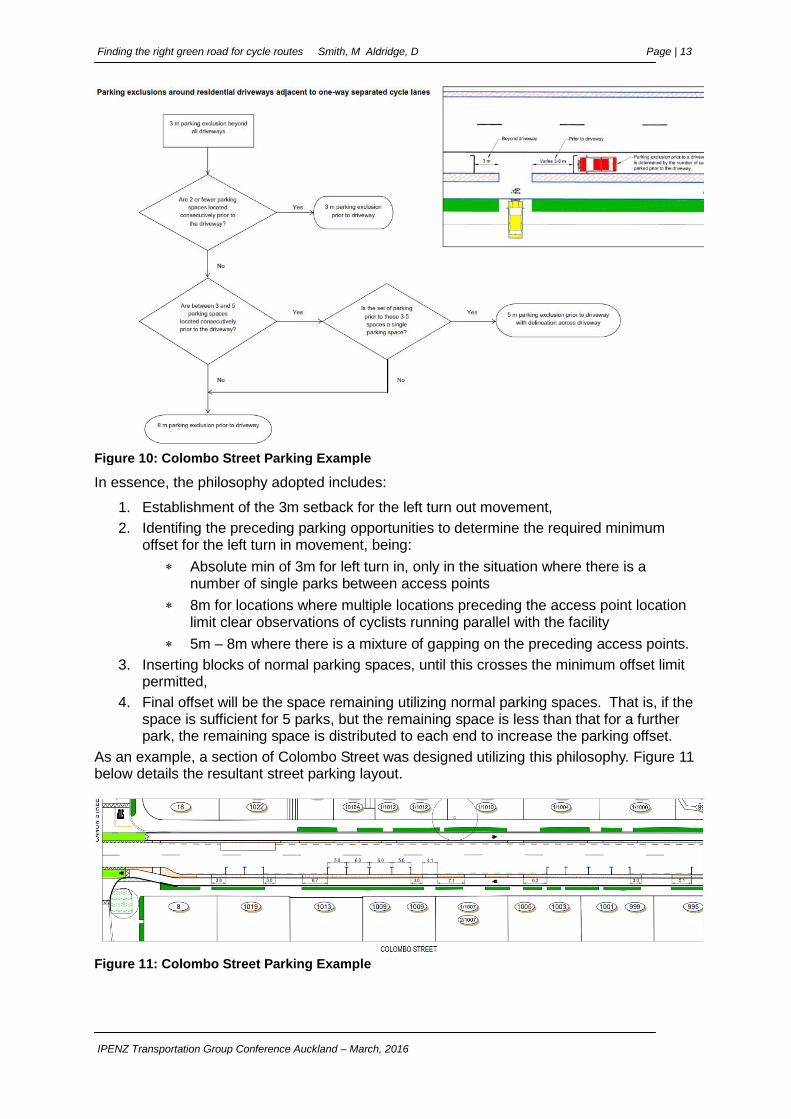
As a guide – the team came up with the flow chart detailed in Figure 10 to assist with the selection.
Finding the right green road for cycle routes Smith, M Aldridge, D Page | 13
IPENZ Transportation Group Conference Auckland – March, 2016
Figure 10: Colombo Street Parking Example
In essence, the philosophy adopted includes:
1. Establishment of the 3m setback for the left turn out movement,
2. Identifing the preceding parking opportunities to determine the required minimum offset for the left turn in movement, being:
Absolute min of 3m for left turn in, only in the situation where there is a number of single parks between access points
8m for locations where multiple locations preceding the access point location limit clear observations of cyclists running parallel with the facility
5m – 8m where there is a mixture of gapping on the preceding access points.
3. Inserting blocks of normal parking spaces, until this crosses the minimum offset limit permitted,
4. Final offset will be the space remaining utilizing normal parking spaces. That is, if the space is sufficient for 5 parks, but the remaining space is less than that for a further park, the remaining space is distributed to each end to increase the parking offset.
As an example, a section of Colombo Street was designed utilizing this philosophy. Figure 11 below details the resultant street parking layout.
Figure 11: Colombo Street Parking Example
Finding the right green road for cycle routes Smith, M Aldridge, D Page | 14
IPENZ Transportation Group Conference Auckland – March, 2016
SUMMARY
The selection of the best cycle route is fraught with hidden issues that if not addressed early, will result in a facility that is either not accepted by the public, or is installed and found unsafe. The recent examples of facilities being built and then removed (South Dunedin Cycleway) highlights that problems can be encountered that require a reassessment of the design.
Authorities must be acutely aware of their mandate for the provisions of cycle facilities – if this is unclear, go out to the public to get a clear direction. Be mindful of the “no-bike, no-way” vocal minority. Don’t get distracted by the individual argument, and focus on the social argument.
Care should be taken to ensure that all aspects of the proposed route(s) are carefully and robustly evaluated, and fully documented. Do not be afraid to say no to a route where the required levels of safety cannot be delivered.
The use of a robust and repeatable multi-criteria analysis process is essential to provide the confidence that a decision is the best solution. This is critical when conveying the outcomes to our representatives. They must have confidence that the process is strong.
Exception decisions must be documented, and where necessary, peer reviewed by experts with the appropriate skill sets to ensure that the outcome meets the required safety outcome.
Planners, Engineers and Designers must understand the characteristics of the roads being considered. Time to get off the seat and on the bike, ride the route to understand the issues first hand. Look at every intersection, stop at every major access way to comprehend the movements and probable vehicle usage.
Use appropriate design standards and guidelines for the selection of facility type. This is an exciting new time that we are going into, and we will be trying out new and innovative techniques and mechanisms. Seek expert advice where something new is happening.
Have a clear understanding of how the traffic will use the new facility. Review on the ground the way that the residents and businesses use their access ways. Never assume that it is drive in – drive out.
Engage suitably qualified safety auditors, with skills in multi-modal facilities, early and often. Do not use “off the shelf” auditors, remember – this is a specialty field and is not the realm of the generic auditor. If in doubt, ask for examples of previous audits to ensure that you are confident.
REFERENCES
CROW (2007). Design Manual for Bicycle Traffic (Netherlands)
Austroads. Guide to Road Design Part 6A: Pedestrian and Cyclist Paths
M Smith / T Hughes (2015). Safety Review of Turn Movements, CCC Briefing Document
Finding the right green road for cycle routes Smith, M Aldridge, D Page | 15
IPENZ Transportation Group Conference Auckland – March, 2016
Appendix A –
Figure 12: Papanui Parallel Cycle Route Example
Finding the right green road for cycle routes Smith, M Aldridge, D Page | 16
IPENZ Transportation Group Conference Auckland – March, 2016
Figure 13: Route / Facility Selection Work Flow (Source CCC Major Cycleway Design Guide: Part B: Design Principles Best Practice Guide)