fishing zones- ‘parts’ of the fisherydpipwe.tas.gov.au/documents/2018 abalone operational...
TRANSCRIPT

COMMERCIAL
ABALONE FISHERY
OPERATIONAL INFORMATION PAPER
FOR THE 2018 FISHING YEAR
ISSUED: DECEMBER 2017
Depar tmen t o f P r imary Indus t r ies ,
Pa rks , W ate r & Env i ronmen t
Wi ld F ishe r ies Managemen t B ranch

Page 2
TABLE OF CONTENTS
TOTAL ALLOWABLE CATCH FOR 2018 ........................................................ 4
FISHING ZONES: ‘PARTS’ OF THE FISHERY ................................................. 4
Number of parts .................................................................................................................... 4 PRIOR FISHING REPORT .................................................................................... 7
CHANGE TO OVER-CATCH .............................................................................. 8
REVERSE CAP OF SOME PARTS OF THE GREENLIP FISHERY .................. 8
CLOSURE OF THE NORTH-EAST BLACKLIP FISHERY ............................... 8
JANUARY, FEBRUARY AND MARCH CLOSURE OF THE EASTERN PART
OF THE FISHERY .................................................................................................. 8
NORTHERN BOUNDARY OF FREYCINET 145 MM AREA ........................... 9
TAKING ABALONE IN A CLOSED AREA ........................................................ 9
ALL VESSELS OVER-NIGHTING MUST HAVE VMS .................................... 10
ALL VESSELS OVER-NIGHTING MUST MAKE A PRIOR LANDING
REPORT ................................................................................................................ 10
ANY DIVER DRIVING THEIR FISH TO A PROCESSOR MUST MAKE A
POST FISHING REPORT ................................................................................... 10 SPARE DATA LOGGERS AT CERTAIN POLICE STATIONS AND
VESSELS ............................................................................................................... 10
BIOSECURITY ..................................................................................................... 11
COMMON BOUNDARIES.................................................................................. 11
The parts/zones of the fishery .............................................................................................. 12 Single zone fishing ............................................................................................................... 12 SIZE LIMITS ......................................................................................................... 13
Commercial blacklip ............................................................................................................. 13 Boundaries .......................................................................................................................... 13 The areas ............................................................................................................................. 15 Commercial greenlip ............................................................................................................ 16 FISHING IN THE NORTHERN ZONE ............................................................. 18
Fishing the northern zone at 127 mm ................................................................................... 19 Fishing the northern zone at 129 mm ................................................................................... 19 Fishing the northern zone at 132 mm ................................................................................... 19 Mother boats in the northern area ....................................................................................... 19 FISHING IN THE BASS STRAIT ZONE ........................................................... 21
Fishing in the north coast blacklip area ................................................................................. 22 Operational restrictions ....................................................................................................... 22 To fish the Bass Strait zone ................................................................................................... 22 Mother boats in the Bass Strait zone .................................................................................... 22 Vessel monitoring systems and designated ports in the Bass Strait zone ................................ 24 LEAVING SUB-BLOCKS 5D, 6A, 6B OR 6C WITH 132 MM ABALONE .... 25
RESEARCH AREAS ............................................................................................. 26
Bay of Fires Research Area ................................................................................................... 26 George III Rock Research Area .............................................................................................. 26 Inner Sister Island Research Area .......................................................................................... 28 Swan Island Research Area ................................................................................................... 29 Doughboys Research Area .................................................................................................... 30 Waterwitch Reef Research Area ........................................................................................... 31 Elephant Rock Research Area ............................................................................................... 32

Page 3
North Bay Research Area...................................................................................................... 33 PROCESSORS ...................................................................................................... 34
Receiving small fish .............................................................................................................. 34 Northern blacklip area ......................................................................................................... 34 Bass Strait area .................................................................................................................... 34 Marine farmed abalone........................................................................................................ 34 Biosecurity ........................................................................................................................... 34 MARGIN FOR ERROR (OVER-CATCH) .......................................................... 35
SHARE DIVING (TEAM DIVING) ..................................................................... 38
SUSTAINABLE CATCH TARGETS ................................................................. 39
GPS AND DEPTH LOGGERS MANDATORY ................................................. 40
ADDITIONAL INFORMATION ........................................................................ 40
Page 4
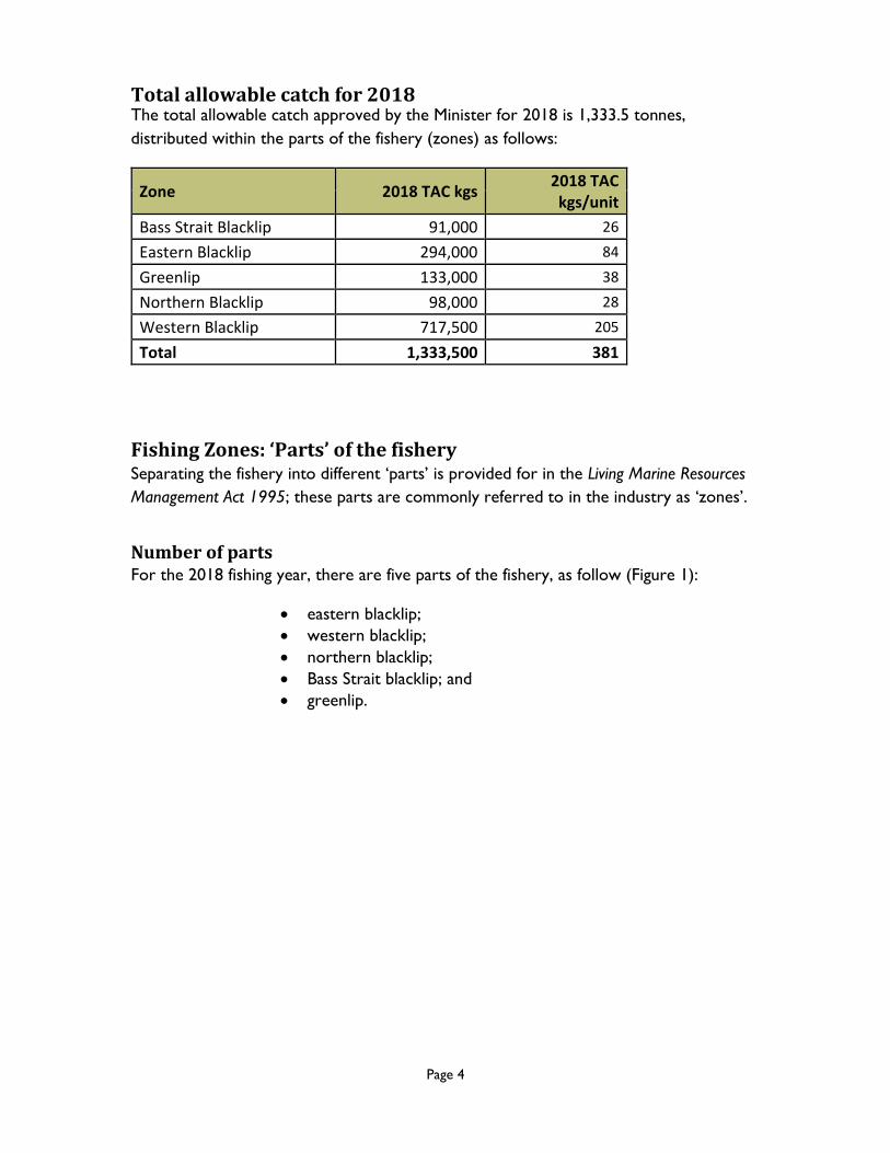
Total allowable catch for 2018 The total allowable catch approved by the Minister for 2018 is 1,333.5 tonnes,
distributed within the parts of the fishery (zones) as follows:
Zone 2018 TAC kgs 2018 TAC kgs/unit
Bass Strait Blacklip 91,000 26
Eastern Blacklip 294,000 84
Greenlip 133,000 38
Northern Blacklip 98,000 28
Western Blacklip 717,500 205
Total 1,333,500 381
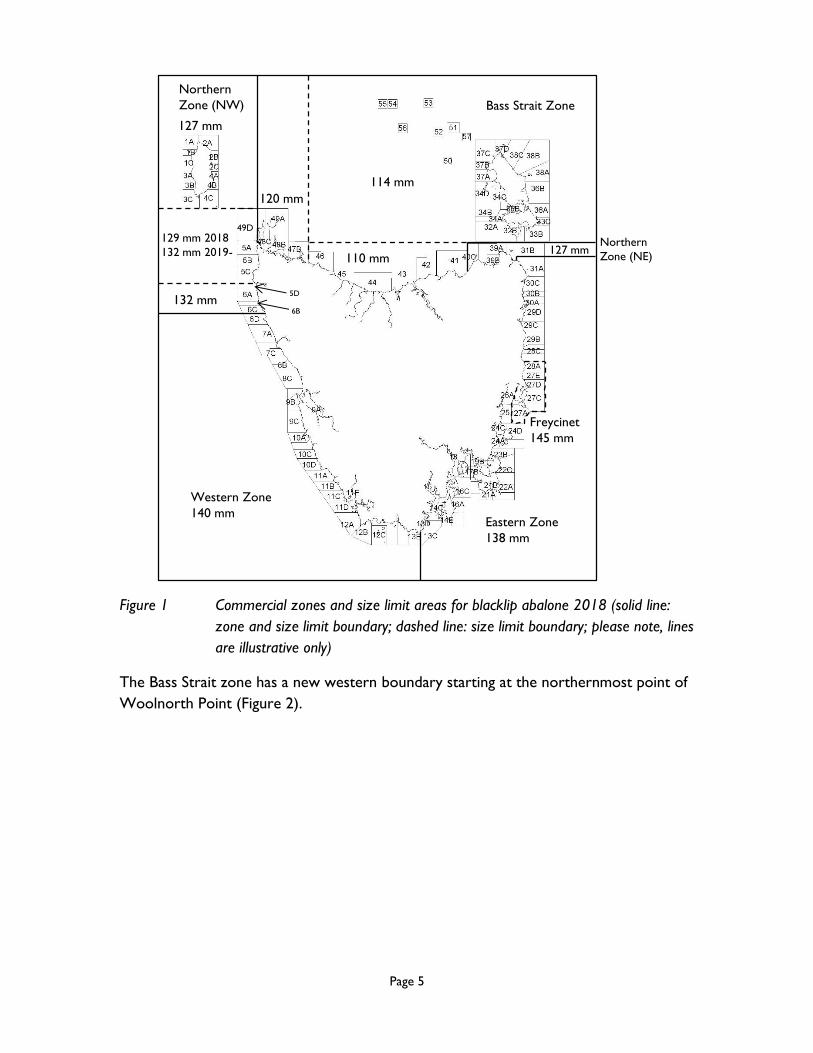
Fishing Zones: ‘Parts’ of the fishery Separating the fishery into different ‘parts’ is provided for in the Living Marine Resources
Management Act 1995; these parts are commonly referred to in the industry as ‘zones’.
Number of parts For the 2018 fishing year, there are five parts of the fishery, as follow (Figure 1):
eastern blacklip;
western blacklip;
northern blacklip;
Bass Strait blacklip; and
greenlip.
Page 5
Western Zone
140 mmEastern Zone
138 mm
Freycinet
145 mm
132 mm
129 mm 2018
132 mm 2019-
127 mm
120 mm
110 mm
114 mm
127 mm
Bass Strait Zone
Northern
Zone (NW)
Northern
Zone (NE)
5D
6B
49D
Figure 1 Commercial zones and size limit areas for blacklip abalone 2018 (solid line:
zone and size limit boundary; dashed line: size limit boundary; please note, lines
are illustrative only)
The Bass Strait zone has a new western boundary starting at the northernmost point of
Woolnorth Point (Figure 2).

Page 6
Northern
Zone
Bass Strait
Zone
49D
49C
49B
5A
48C
49A
Hunter
Island
Woolnorth Point
Figure 2 New zone and sub-block boundaries for Bass Strait and Northern zones for
2018; pinpoint shown is the point of latitude 40° 37’ 14.40” South, longitude
144° 41’ 37.87” East (please note, lines are illustrative only)
The boundary then runs approximately north-west to the point of latitude 40° 37’
14.40” South, longitude 144° 41’ 37.87” East, then runs due north to the outer limit of
State waters. Thus, Bird Island and Hunter Island are in the Bass Strait zone, and Trefoil
Island, Brown Rocks, Nares Rocks, Steep Island and Albatross Island are in the northern
zone. Please note that the former Albatross Island sub-block, 49D, has been enlarged to
include Brown Rocks, Nares Rocks, Steep Island and Albatross Island in the northern
zone. Sub-blocks 49B and 49C now relate to the western side of Hunter Island in the
Bass Strait zone only. Sub-blocks 48C and 49A in the Bass Strait zone are unchanged.
Sub-block 5A in the northern zone is unchanged.
Please note that three new ports have been designated for the enlarged Bass Strait zone,
namely: Stanley; Smithton and Woolnorth Anchorage.
Page 7
To facilitate dinghy fishing in the Furneaux Group, the area within a radius of 50 metres
on the landward side from the high-tide mark closest to the point of launching or
retrieving a fishing vessel from anywhere on Flinders Island is included in the list of
designated ports.
Please note that the south-east boundary of the Bass Strait zone runs through
Banks Strait. The Bass Strait zone does not include any northern zone blocks off north-
east mainland Tasmania. A VMS is needed to bring blacklip abalone taken in the Bass
Strait zone into the northern zone.
In 2018, the central western part of the fishery is absorbed into the northern zone.
Thus, sub-blocks 5D, 6A, 6B and 6C come into the northern zone, and the central
western zone disappears. The northern zone is therefore bounded down the west coast
by Wild Wave River.
The northern boundary of the western part of the fishery is Wild Wave River.
Prior fishing report Due to the change in size limit at Arthur River for 2018, the boundary of the northern
AREA remains at Arthur River, whereas the northern ZONE/PART boundary has
been moved south to Wild Wave River. The northern AREA relates to movement and
reporting.
In divers’ prior fishing report, divers are asked to state which ZONE/PART of the
fishery they intend to fish.
By answering “northern”, divers are indicating they intend to fish somewhere from
Wild Wave River to Great Musselroe Bay, excluding the Bass Strait part of the fishery.
The next question asks divers who are fishing in the northern AREA, i.e., north of
Arthur River, whether they intend to take abalone less than 132 mm. If divers are fishing
north of Arthur River at 129 mm, the answer to this question is “yes”. By answering
“yes” divers may not enter the 132 mm area of the northern ZONE/PART of the
fishery south of Arthur River, unless on a mother boat.
If divers are NOT fishing in the northern AREA, i.e., they are fishing south of Arthur
River in the northern ZONE/PART, they should answer “no” they do not intend to
fish in the northern AREA and take abalone less than 132 mm. By answering “no”
divers may fish in the 132 mm area south of Arthur River in sub-blocks 5D, 6A, 6B and
6C only.
Finally, if a diver IS fishing in the northern AREA at 132 mm, i.e., they are fishing north
of Arthur River at 132 mm, they should answer “no” they do not intend to take abalone
Page 8
less than 132 mm. By answering “no” divers may fish in the northern AREA at 132 mm
north of Arthur River only.
Please note that it is thus not possible to fish at 132 mm both north and south of Arthur
River on the same fishing trip.
Change to over-catch If a diver goes into over-catch and does NOT transfer the abalone in the landing area
or acquire additional quota within the quota period, and does NOT wish to dive in that
zone again in that quota year, the diver must pay to the Crown an administrative penalty
equal to the average beach price of that total excess catch for the first 10 per cent of
over-catch, and twice the average beach price of that excess catch for between 10 and
20 per cent of over-catch, based on the last formally calculated beach price. An invoice
will ordinarily be raised by the Department about February following the end of the
quota period. Please note that, should the diver elect to pay out the over-
catch during the quota period, the diver is still not allowed to dive in that
zone again in the quota period.
Reverse cap of some parts of the greenlip fishery The commercial greenlip abalone fishery in State waters off parts of the north coast of
Tasmania is being closed from 1 January 2018 until further notice. The closure includes,
in the north-west, fishing blocks 48 (not including sub-block 48A), 49 and 5 and down
the west coast, and in the north-east, blocks 31, 32, 33, 39, 40 and down the east coast.
The closed areas will be opened when eight tonnes have been caught in the 132 mm
central north coast greenlip area (excluding sub-block 48A [Perkins Bay]) and 60 tonnes
has been caught in the remaining open areas (Perkins Bay, King Island and the Furneaux
Group [not including blocks 32 and 33]).
Closure of the north-east blacklip fishery The commercial blacklip abalone fishery in State waters off the north-east coast of
Tasmania will be closed from 1 January 2018 until further notice to align it with the
reverse cap greenlip closure. This closed area relates to commercial blacklip abalone
fishing in fishing sub-blocks 31B, 39A, 39B, 40A, 40B and 40C only. It will open when the
north-east greenlip fishery is opened.
January, February and March closure of the eastern part of the fishery The eastern part of the commercial blacklip abalone fishery will be closed in 2018 for
the months of January, February and March inclusive.

Page 9
With the exception of sub-block 31A, which remains open at a size limit of 138 mm for
the entire sub-block, all sub-blocks in the eastern part of the fishery are closed to
commercial blacklip abalone fishing from 1 January 2018 to 31 March 2018 inclusive.
The reason for the closure is so that abalone in the warming waters of the east coast
are left undisturbed during spawning.
Northern boundary of Freycinet 145 mm area The northern boundary of the 145 mm area off the east coast around the Freycinet
Peninsula remains the northern boundary of sub-block 28A in 2018, namely
Peggys Point.
Taking abalone in a closed area Please be aware that taking abalone in a closed area is a serious offence. Less than 100
kilograms of abalone taken illegally is all that is required to put a licence in jeopardy. The
last page of this document is provided to assist you keep track of which sub-blocks have
been closed during the year. Listed on the page are the known closures for 2018. Take
this page and keep it with your dive docket books. As the Department notifies you of
further closures during the year, note these on the page. Consult the page as needed.
Moreover, please note that the Department posts all closures on its website at:
http://dpipwe.tas.gov.au/sea-fishing-aquaculture/commercial-fishing/abalone-
fishery/abalone-closures
Please be aware that areas of the fishery may also be subject to biosecurity
closures from time to time resulting, e.g., from harmful algal blooms. Any
such closures may be viewed via the following:
Biosecurity Tasmania website:
http://dpipwe.tas.gov.au/biosecurity-tasmania/product-integrity/food-
safety/seafood/shellfish-quality/harvest-area-status
Department of Agriculture and Water Resources website:
http://www.agriculture.gov.au/export/controlled-goods/fish/industry-advice-notices/2017
Finally, please note that the holder of a fishing licence (abalone dive) can not, on a fishing
trip, enter the water by swimming or diving in both an open and a closed part of the
fishery for the same species.

Page 10
All vessels over-nighting must have VMS Any vessel used on a fishing trip that finishes on a day after it commenced must now be
fitted with a VMS that is registered and polling with the Department. (Vessels used from
a mother boat need not have a VMS provided the mother boat is fitted with a VMS.)
Should you wish to register a VMS with the Department, or check the status of your
VMS, please telephone Angela Iles, Fisheries Compliance and Systems Officer, on
6165 3038.
All vessels over-nighting must make a prior landing report The skipper of any vessel on a fishing trip that finishes on a day after it commenced must
now make a prior landing report to the telephone reporting service. Divers need no
longer make this report. The telephone number is as for all other reports (1800 773
243, in-dial 03 8199 7339). The prior landing report must be made no less than two
hours prior to landing.
Any diver driving their fish to a processor must make a post fishing
report Any diver leaving the landing area with their fish to deliver them to a processor must
make a post fishing report to the telephone reporting service, not a movement report.
The telephone number is as for all other reports (1800 773 243, in-dial 03 8199 7339).
Please note that, before leaving the landing area, part A of the commercial abalone dive
docket must be complete; this will require weighing the fish using a certified set of
scales.
Spare data loggers at certain police stations and vessels Spare data loggers have now been placed with geographically strategic police stations
throughout Tasmania as well as with certain police vessels. Should a diver need to
access a spare set of loggers, as a short-term expediency, they should contact one of the
offices or police vessels below. Please note that unless the need is urgent, the
preference is that divers work with IMAS to address any issue with data loggers. On
receiving any data loggers from a police station, divers must follow the written
instructions that come with those data loggers in their entirety.
Police stations and vessels with spare data loggers:
St Helens – 0417 374 144
Stanley – 0408 144 059
Strahan – 0409 405 642
Hobart (Glenorchy) – 0427 655 557

Page 11
Currie – 0427 828 070
Whitemark – 0428 417 857
George Town – 0417 541 645
Police Vessel Van Diemen – 0428 137 298, sat. phone 0011 8816 214 578 69
Police Vessel Cape Wickham – 0437 981 874, sat. phone 0011 870 773 257 781
Biosecurity Divers should acquaint themselves with the contents of the voluntary code of practice
for biosecure fishing available on the Tasmanian Abalone Council Ltd’s website
(http://tasabalone.com.au/). For any enquiries, please telephone Travis Baulch, Abalone
Biosecurity Officer, on 6165 3029.
Common boundaries The lines forming common boundaries of the various parts/zones of the fishery are as
follows (Figure 1):
Woolnorth Point: An imaginary line running from the northernmost point of
Woolnorth Point to the point of latitude 40° 37’ 14.40” South,
longitude 144° 41’ 37.87” East, then running due north to the outer
limit of State waters.
Anderson Bay: An imaginary line beginning where the line of longitude 147° 27’ 00”
East meets the high-water mark of the north coast of the mainland
of Tasmania in Anderson Bay, then running due north until its
junction with the line of latitude 40° 39’ South, then due east along
that line of latitude to the limit of State waters.
Great Musselroe Bay: An imaginary line from the northern side of the mouth of the Great
Musselroe River where Musselroe Bay enters Great Musselroe Bay
then 100 metres off the shore around to the northern tip of
Musselroe Point then due north up to latitude 40 48’ South then
due east (i.e., you can launch inside the northern zone but fish south
of Musselroe Bay in the eastern zone).
Whale Head: An imaginary straight line running due south from Whale Head
(longitude 146 52’ 11” East).
Wild Wave River: An imaginary straight line running due west from the mouth of the
Wild Wave River near Sandy Cape.

Page 12
The parts/zones of the fishery Eastern
The east and south-east coast from Great Musselroe Bay in the north to Whale Head in
the south.
Western
The west and south-west coast from Wild Wave River in the north to Whale Head in
the south.
Northern
The north-west and north-east coasts from Wild Wave River in the north-west to
Great Musselroe Bay in the north-east but excluding the area of the Bass Strait zone.
Bass Strait
The north coast and Bass Strait, including the Furneaux Group of islands, bounded in the
west by an imaginary line running from the northernmost point of Woolnorth Point to
the point of latitude 40° 37’ 14.40” South, longitude 144° 41’ 37.87” East, then running
due north to the outer limit of State waters and in the east by an imaginary line
beginning where the line of longitude 147° 27’ 00” East meets the high-water mark of
the north coast of the mainland of Tasmania in Anderson Bay, then running due north
until its junction with the line of latitude 40° 39’ South, then due east along that line of
latitude to the limit of State waters.
Greenlip
Single zone for greenlip abalone with no geographic boundaries in State waters.
Single zone fishing Single zone blacklip abalone fishing applies in the fishery. Fishers are able to take greenlip
abalone on a trip in a blacklip zone as long as they fulfill all the requirements for both
species. Requirements are as follow:
Only one blacklip zone can be fished on a fishing trip.
Divers nominate which blacklip zone is to be fished by prior fishing report and
then can only fish that blacklip zone on that trip, including for greenlip abalone.
Please note that, if part of a dive team that lands greenlip abalone, both divers
must complete a greenlip dive docket regardless of whether he or she personally
took any greenlip abalone.

Page 13
If fishing the eastern zone, fishers must not enter the waters, even on a vessel, of
the western zone on that trip.
For zones other than the northern zone and the Bass Strait zone, divers can
start and finish a trip, but not dive, outside that zone.
Regarding size limits, divers can not bring smaller fish into a larger size limit area
unless on a mother boat with a VMS that is polling with the Department.
NB: Divers can only transfer excess abalone to, or receive excess abalone
from, a diver who has been fishing in the same blacklip zone at the time of
landing. Be aware that transfer of excess abalone can not be used to bring a
diver below 20 per cent excess.
The whole amount of the excess must be transferred to only one other diver. Divers
can not receive a transfer of excess abalone if that transfer would take their quota
balance below zero.
Divers should be aware, also, that they may make a changing part of the fishery report to the reporting service provided they have not taken any abalone on the fishing
trip at the time of making the report, no abalone is on the vessel and there has been no
diving or swimming beneath the surface of the water on the fishing trip at the time of
making the report.
If a diver is not going to undertake the fishing trip reported, the diver must lodge a cancellation report, provided the fishing trip has not been started, i.e., a dinghy has
not been launched or a mother boat has not left port. The report must be lodged within
two hours of when the fishing activity was to have started.
Note on cancellation reports: If a diver starts a fishing trip and does not dive, a docket
must be completed for that fishing trip and all other normal reporting requirements
followed.
Size Limits
Commercial blacklip The following size limits apply to the commercial blacklip abalone fishery: 110 mm,
114 mm; 120 mm; 127 mm; 129 mm; 132 mm; 138 mm, 140 mm and 145 mm (Figure 1).
Boundaries The lines forming the size limit areas are as follow:
Wild Wave River: Imaginary straight line due west of the mouth.

Page 14
Arthur River: Imaginary straight line due west from the mouth.
Upper-west blacklip area: means the area of State waters adjacent to the upper-
west coast of Tasmania enclosed by an imaginary line
running from the northernmost point of Woolnorth
Point to the point of latitude 40o 37’ 14.40” South,
longitude 144o 41’ 37.87” east, then running due north to
the line of latitude 40o 16’ 58.41” South, then running due
west to the line of longitude 144o 26’ 18.11” East, then
running due south to the line of latitude 41o 21’ 58.85”
South, then running due east to the mouth of the Wild
Wave River near Sandy Cape, and following the line of
high water in a generally northerly direction to the point
of commencement at Woolnorth Point.
Great Musselroe Bay: From the northern side of the mouth of the Great
Musselroe River where Musselroe Bay enters Great
Musselroe Bay then 100 metres off the shore around to
the northern tip of Musselroe Point then due north up to
latitude 40 48’ South then due east, i.e., you can launch
inside the northern zone but fish south of Musselroe Bay
in the eastern zone (Figure 3).

Page 15
Figure 3 Great Musselroe Bay boundary delineating the northern (north-east) (127 mm)
and the eastern parts/zones of the commercial abalone fishery
Whale Head: A straight line running due south from Whale Head
(longitude 146 52’ 11” East).
Anderson Bay: A line beginning in Anderson Bay at longitude 147 27’
00” East, then running due north until its junction with
the line of latitude 40° 39’ South, then due east along that
line of latitude to the limit of State waters.
Cowrie Point: The line of longitude 145 22’ 42” East near Cowrie
Point.
North coast blacklip area: means the area of State waters adjacent to the north
coast of mainland Tasmania bounded by an imaginary line
starting at the point where the line of longitude 145° 22’
42” East meets the high-water mark near Cowrie Point
and running due north along that line of longitude until its
junction with the line of latitude 40° 39’ 00” South, then
due east along that line of latitude until its junction with
the line of longitude 147° 27’ 00” East and then due south
along that line of longitude to the high-water mark of the
north coast of the mainland of Tasmania in Anderson Bay.
Woolnorth Point: An imaginary line running from the northernmost point of
Woolnorth Point to the point of latitude 40° 37’ 14.40”
South, longitude 144° 41’ 37.87” East, then running due
north to the outer limit of State waters (western
boundary of 120 mm blacklip size limit).
An imaginary line from the northernmost point of
Woolnorth Point to the point of latitude 40° 37’ 14.40”
South, longitude 144° 41’ 37.87” East, then running due
north to the line of latitude 40° 16’ 58.41” South, and
running due west to the limit of State waters (southern
boundary of 127 mm blacklip size limit for King Island).
The areas 110 mm area
110 mm applies along the central north coast between the Cowrie Point boundary and
the Anderson Bay boundary, i.e., to the north coast blacklip area.

Page 16
114 mm area
114 mm applies in part of Bass Strait, including the Furneaux Group of islands, between
the Cowrie Point boundary and the Anderson Bay boundary.
120 mm area
120 mm applies in part of Bass Strait in blocks 47, 48 and 49A, 49B and 49C.
127 mm area
127 mm applies in the north-east between Great Musselroe Bay and the Anderson Bay
boundary.
127 mm applies around King Island.
129 mm area
129 mm applies off the north-west coast from Arthur River north as far as Albatross
Island.
132 mm area
132 mm applies between the Arthur River and the Wild Wave River.
138 mm area
138 mm applies on the east and south-east coasts between Great Musselroe Bay and
Whale Head.
140 mm area
140 mm applies on the west and south-west coasts from Wild Wave River to Whale
Head.
145 mm area
145 mm applies around the Freycinet Peninsula and up to Peggys Point at Bicheno in
sub-blocks 26B, 26C, 26D, 27A, 27B, 27C, 27D, 27E and 28A.
Commercial greenlip For the commercial greenlip abalone fishery, 145 mm applies Statewide except for:
Waters around King Island where 150 mm applies (note that greenlip abalone
smaller than 150 mm can not be taken into the 150 mm area).
The north coast greenlip area where 132 mm applies (note that greenlip
abalone smaller than 145 mm can not be taken or possessed on State waters
Page 17
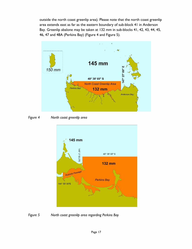
outside the north coast greenlip area). Please note that the north coast greenlip
area extends east as far as the eastern boundary of sub-block 41 in Anderson
Bay. Greenlip abalone may be taken at 132 mm in sub-blocks 41, 42, 43, 44, 45,
46, 47 and 48A (Perkins Bay) (Figure 4 and Figure 5).
Figure 4 North coast greenlip area
Figure 5 North coast greenlip area regarding Perkins Bay

Page 18
Fishing in the northern zone
The northern zone does not include the Bass Strait zone.
You can fish greenlip on a northern zone fishing trip provided all the requirements
for fishing blacklip (and greenlip) are fulfilled. If you fish the northern zone you can
not fish any other blacklip zone on that trip.
Due to the change in size limit at Arthur River for 2018, the boundary of the
northern AREA remains at Arthur River, whereas the northern ZONE/PART
boundary has been moved south to Wild Wave River. The northern AREA relates
to movement and reporting.
In divers’ prior fishing report, divers are asked to state which ZONE/PART of the
fishery they intend to fish.
By answering “northern”, divers are indicating they intend to fish somewhere from
Wild Wave River to Great Musselroe Bay, excluding the Bass Strait part of the
fishery.
The next question asks divers who are fishing in the northern AREA, i.e., north of
Arthur River, whether they intend to take abalone less than 132 mm. If divers are
fishing north of Arthur River at 129 mm, the answer to this question is “yes”. By
answering “yes” divers may not enter the 132 mm area of the northern
ZONE/PART of the fishery south of Arthur River, unless on a mother boat.
If divers are NOT fishing in the northern AREA, i.e., they are fishing south of
Arthur River in the northern ZONE/PART, they should answer “no” they do not
intend to fish in the northern AREA and take abalone less than 132 mm. By
answering “no” divers may fish in the 132 mm area south of Arthur River in sub-
blocks 5D, 6A, 6B and 6C only.
Finally, if a diver IS fishing in the northern AREA at 132 mm, i.e., they are fishing
north of Arthur River at 132 mm, they should answer “no” they do not intend to
take abalone less than 132 mm. By answering “no” divers may fish in the northern
AREA at 132 mm north of Arthur River only.
Please note that it is thus not possible to fish at 132 mm both north and south of
Arthur River on the same fishing trip.
Divers must start and finish trips either in the northern area (with provisions to
allow mother boats to start and finish outside the area [see below]), or south of
Arthur River in sub-blocks 5D, 6A, 6B and 6C.

Page 19
Divers must launch and retrieve either between the Arthur River and Great
Musselroe Bay (unless on a mother boat), or south of Arthur River in sub-blocks
5D, 6A, 6B and 6C.
Divers must not leave the northern area within a fishing trip (unless on a mother
boat) or take fish or dive outside the northern area when on such a trip.
Fishing the northern zone at 127 mm
Divers may fish the northern zone at 127 mm around King Island and in sub-blocks
31B, 39A, 39B, 40A, 40B and 40C.
Divers must not take or possess any blacklip abalone less than 127 mm.
Divers must launch and retrieve between Arthur River and Great Musselroe Bay
(unless on a mother boat).
Fishing the northern zone at 129 mm
Divers may fish the northern zone at 129 mm in sub-blocks 5A, 5B, 5C and 49D
(see below map for new boundaries of sub-block 49D).
Divers must not take or possess any blacklip abalone less than 129 mm.
Divers must launch and retrieve between Arthur River and Great Musselroe Bay
(unless on a mother boat).
Divers may not enter the water south of Arthur River (unless on a mother boat).
Fishing the northern zone at 132 mm
Divers may fish the northern zone at 132 mm in sub-blocks 5D, 6A, 6B and 6C.
Divers must not take or possess any blacklip abalone less than 132 mm.
Divers may launch and retrieve north or south of Arthur River.
Divers must not take abalone north of Arthur River.
Mother boats in the northern area

Page 20
Divers on a mother boat in the northern area
All divers on a mother boat must nominate the same zone.
If the mother boat starts the trip outside the northern area, intending to fish the
northern area, the diver must complete the prior-fishing report before the vessel
leaves port (prior-fishing reports should always be done before the diver
commences the fishing trip).
No fishing or diving may be undertaken before the mother boat enters the zone
nominated to be fished.
The trip must be completed within the northern area unless the leaving area
requirements for mother boats set out below are fulfilled.
Mother boat operators in the northern area
If starting a trip to fish the northern area from outside that area, the supervisor of
the mother boat must complete a leaving port report to the telephone service
before leaving port.
No such report is required if starting the trip inside the area.
No fishing may be undertaken before entering the northern zone, there must be no
abalone on the vessel before entering the zone, and all dinghies must be securely
fastened onboard the boat while travelling to the fishing zone.
Mother boats can finish a northern fishing trip outside the northern area under the
following conditions:
1. the supervisor of the mother boat completes a leaving area report to the
reporting service no less than two hours before leaving the area;
2. on the east coast, the boat does not go south of St Helens Point other than in
Georges Bay;
3. if fishing the northern zone, mother boats can traverse through the western
zone provided the boat does not go south of Strahan further than Yellow Bluff
in Macquarie Harbour, but only with abalone of a legal minimum length of 132
mm or greater;

Page 21
4. the vessel is fitted with VMS that is operating according to Department
procedure;
5. all dinghies are securely fastened on the mother boat while in waters not in the
northern area; and
6. the mother boat proceeds directly to port after leaving the northern area.
Note: these arrangements allow 127 mm fish to be taken out of the area at the eastern
boundary to St Helens, and 132 mm fish to be taken to Strahan. These arrangements do
not allow fish smaller than 132 mm to be taken to Strahan.
Note for starting and finishing a trip in the northern zone
The requirement to start and finish a fishing trip within the northern area boundaries
allows both divers and mother boats to start and finish trips between Arthur River and
Great Musselroe Bay, including those waters within the Bass Strait area. Divers may also
start and finish a fishing trip south of Arthur River regarding sub-blocks 5D, 6A, 6B and
6C.
However, if any diving is undertaken, or any fish are taken in the Bass Strait zone, this
constitutes a Bass Strait trip not a northern zone trip and all the requirements for
fishing the Bass Strait zone apply (both zones can not be fished on the same trip).
In other words, if undertaking a northern zone trip, it is illegal to undertake any diving,
or to take any abalone in the Bass Strait zone. No abalone below 127 mm can be taken
or possessed on a northern zone trip launching or retrieving in the Bass Strait zone.
For divers, these arrangements mean they can start a northern trip within the Bass
Strait area without a leaving port report and finish a trip in the Bass Strait area without a
leaving area report or a VMS being required.
Fishing in the Bass Strait zone Please note that compliance with Commonwealth requirements is needed to transit any
Commonwealth marine reserve, a number of which come to within three nautical miles
of the Tasmanian coast. For example, compliance is almost certainly required to dive in
the Northern Bass Strait Region in respect of the Beagle Commonwealth Marine
Reserve.
Please be aware that class approvals have now replaced general approvals. That is,
commercial fishing operations are now allowed through a single class approval. Under

Page 22
the class approval there is no need for commercial fishers to register to be approved.
The class approval sets out the Network management zones where commercial fishing
can occur, fishing methods that can be used, and the conditions that commercial fishers
need to follow when fishing in the South-east Commonwealth Marine Reserves
Network. It is important that commercial fishers make themselves aware of the
conditions contained in the class approval and comply with these conditions when
operating in the South-east Commonwealth Marine Reserves Network.
For those operating a vessel with a VMS, there is a free geo-fencing service available.
Details are on the Commonwealth website at:
http://www.environment.gov.au/topics/marine/marine-reserves/south-east/management
Fishing in the north coast blacklip area Commercial fishing for blacklip abalone in blocks 41-46 is at 110 mm.
110 mm blacklip abalone can not be possessed west of Cowrie Point.
Operational restrictions
Single blacklip zone fishing applies in the Bass Strait zone (you can fish greenlip on
the same trip provided all the requirements for fishing blacklip and greenlip abalone
are fulfilled).
Divers must start and finish trips in the Bass Strait zone (with some provisions to
allow mother boats to start and finish trips outside the zone [see below]).
To fish the Bass Strait zone
In the prior fishing report, divers must nominate that they will fish the Bass Strait
zone.
Divers must depart from and return to a designated port within the Bass Strait area
(unless on a mother boat). Please note that three new ports have been designated
for the enlarged area, namely:
Stanley; Smithton and Woolnorth Anchorage.
On a fishing trip in the Bass Strait area, divers must not leave the Bass Strait area
(unless on a mother boat) or take fish or dive outside the Bass Strait area.
Mother boats in the Bass Strait zone

Page 23
Divers on a mother boat in the Bass Strait zone
All divers on a mother boat must nominate the same zone.
If the mother boat starts the trip outside the Bass Strait area intending to fish the
Bass Strait zone, divers must complete the prior fishing report before the vessel
leaves port (prior-fishing reports should always be done before the diver
commences the fishing trip).
No fishing or diving may be undertaken before the mother boat enters the
Bass Strait zone.
The trip must be completed within the Bass Strait area unless the leaving area
requirements for mother boats described below are fulfilled.
No fishing or diving on the trip can be undertaken after leaving the Bass Strait zone.
Mother boat operators in the Bass Strait zone
If starting a trip to fish the Bass Strait zone from outside that zone, the supervisor of
the mother boat must complete a leaving port report to the telephone service
before leaving port.
No such report is required if starting the trip inside the zone.
No fishing may be undertaken before entering the Bass Strait zone, there must be
no abalone on the vessel before entering that zone, and all dinghies must be securely
fastened onboard the boat while travelling to the Bass Strait zone.
Mother boats can finish a Bass Strait trip outside the Bass Strait zone under the
following conditions:
1. there is no possession of blacklip abalone smaller than 110 mm;
2. the supervisor of the mother boat completes a leaving area report to the
reporting service no less than two hours before leaving the zone;
3. on the east coast, the boat does not go south of St Helens Point except in the
waters of Georges Bay;

Page 24
4. the vessel is fitted with VMS that is operating according to Department
procedure;
5. all dinghies are securely fastened on the mother boat while in waters not in the
Bass Strait zone; and
6. the mother boat proceeds directly to port after leaving the Bass Strait zone.
Vessel monitoring systems and designated ports in the Bass Strait zone
The holder of a fishing licence (abalone dive) must not undertake a fishing trip on a
fishing vessel during which the holder takes, or intends to take, blacklip abalone in the
Bass Strait part of the fishery unless:
That vessel is fitted with an operating vessel monitoring system; or
That vessel is transported on and operates from a mother boat fitted with an
operating vessel monitoring system; transportation includes to and from areas of
fishing as well as the carriage, storage and transportation to the port of
unloading of all abalone taken by that holder on that fishing trip; in other words,
dinghies without a VMS can be used from a mother boat fitted with a VMS (note
that the mother boat must transport and unload all the abalone taken); or
That vessel departs from and returns to a designated port; where:
“designated port” means:
- Killiecrankie on Flinders Island;
- North East River on Flinders Island;
- Lady Barron on Flinders Island;
- Bridport;
- Tam O’Shanter Bay (Lulworth);
- Georgetown;
- Low Head;
- Beauty point;
- Port Sorell;
- Devonport;
- Burnie;
- Wynyard;
- Sisters Beach;
- Stanley;
- Smithton;
- Woolnorth Anchorage; and
Page 25
- the area within a radius of 50 metres on the landward side from the
high-tide mark closest to the point of launching or retrieving a fishing
vessel from anywhere on Flinders Island.
Thus, vessels, i.e., licensed dinghies, that depart from and return to one of the
designated ports do not require a VMS. Vessels not departing from and returning to one
of the designated ports require a VMS.
Note: Once the supervisor of a fishing licence (vessel) is directed to fit a VMS, it is an
offence to operate the vessel without the VMS operating. If the VMS ceases to
operate, the supervisor must notify the Department immediately. The supervisor must
take reasonable technological steps to ensure that he or she is alerted if the VMS
ceases to operate.
Leaving sub-blocks 5D, 6A, 6B or 6C with 132 mm abalone
Divers may leave sub-blocks 5D, 6A, 6B or 6C either north or south with abalone taken
in sub-blocks 5D, 6A, 6B or 6C at a shell length of 132 mm or greater, provided in the
south they are on a mother boat and go no further than of an imaginary line running due
west from Cape Sorell to the limit of State waters. From Cape Sorell, divers are also
allowed in the waters of the Channel into Macquarie Harbour as well as in Macquarie
Harbour itself which allows access to Strahan.

Page 26
Research areas
Bay of Fires Research Area
Includes all waters off the east coast of Tasmania bounded in the north by the line of
latitude 40 59’ 40” South and in the south by the line of latitude 41 12’ 30” South
(from Eddystone Point to the southern end of Taylors Beach) (Figure 6).
Figure 6 Bay of Fires Research Area
This research area represents the whole of sub-blocks 30B and 30C and is closed to
commercial abalone fishing. The Institute for Marine and Antarctic Studies (IMAS)
supervised some structured commercial fishing in sub-blocks 30B and 30C in 2013, 2014
and 2017. The preliminary conclusion from this fishing is that the area presently does
not contain commercial quantities of abalone. The area remains closed while
consideration is given to its status. Sub-block 30A is open to commercial fishing except
for in the Elephant Rock Research Area.
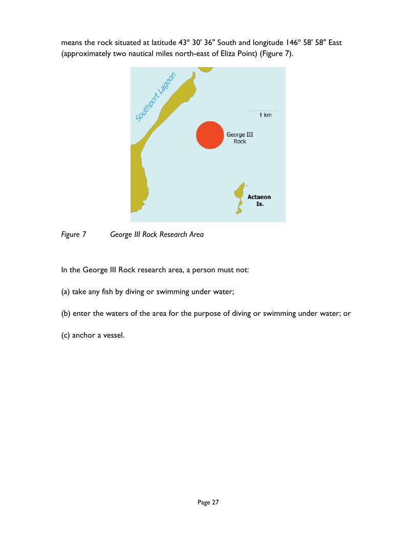
George III Rock Research Area
George III Rock research area is defined to be the waters within an imaginary circle
having a radius of 500 metres and centred at George III Rock, where George III Rock
Taylors Beach
Page 27
means the rock situated at latitude 43º 30' 36" South and longitude 146º 58' 58" East
(approximately two nautical miles north-east of Eliza Point) (Figure 7).
Figure 7 George III Rock Research Area
In the George III Rock research area, a person must not:
(a) take any fish by diving or swimming under water;
(b) enter the waters of the area for the purpose of diving or swimming under water; or
(c) anchor a vessel.

Page 28
Inner Sister Island Research Area
Includes waters adjacent to the western side of Inner Sister Island in the Furneaux
Group of Islands bounded in the north by the line of latitude 39 41’ 8” South, in the
south by the line of latitude 39 42’ 6” South, in the east by the western shore of Inner
Sister Island between those two lines of latitude forming the northern and southern
boundaries, and in the west by an imaginary line 500 metres from the high water mark
of the shore of Inner Sister Island running between those 2 lines of latitude forming the
northern and southern boundaries (Figure 8).
Figure 8 Inner Sister Island Research Area
The following restrictions apply:
(a) taking any fish by diving or swimming underwater is prohibited; and
(b) entering the waters of those areas for the purpose of diving or swimming
underwater is prohibited.

Page 29
Swan Island Research Area
For commercial abalone divers, the research area includes waters adjacent to the east
coast of Swan Island off the north-east coast of Tasmania within an area bounded by an
imaginary line starting from the point of latitude 40 43’ 49.22’’ South and longitude
148 8’ 0.22’’ East running due west to the first point of land on the east coast of
Swan Island, then following the high tide mark in a generally south-easterly direction
along the coast to the point on the east coast of Swan Island that is due north-west of
the point of latitude 40 44’ 16.28’’ South and longitude 148 7’ 16.04’’ East, then due
south-east to that point, then in a generally north-easterly direction 500 metres from
the high tide mark of Swan Island to the point of origin. (Figure 9).
N
4043’ 49.22’’ S1488’ 0.22’’ E
4044’ 16.28’’ S1487’ 16.04’’ E
Figure 9 Swan Island Research Area
The following restrictions apply:
(c) taking any fish by diving or swimming underwater is prohibited; and
(d) entering the waters of those areas for the purpose of diving or swimming
underwater is prohibited.

Page 30
Doughboys Research Area
Includes waters adjacent to the west coast of Tasmania near Cape Grim around The
Doughboys bounded in the north by the line of latitude 40 40’ 12” South and in the
east by the line of longitude 144 40’ 54” East and in the south by the line of latitude 40
40’ 32” South and in the west by the line of longitude 144 39’ 59” East (Figure 10).
Figure 10 The Doughboys Research Area
The following restrictions apply:
(e) taking any fish by diving or swimming underwater is prohibited; and
(f) entering the waters of those areas for the purpose of diving or swimming
underwater is prohibited.
Page 31
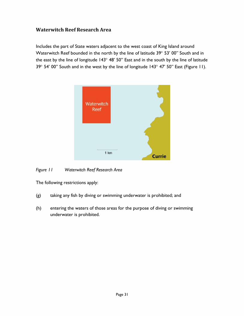
Waterwitch Reef Research Area
Includes the part of State waters adjacent to the west coast of King Island around
Waterwitch Reef bounded in the north by the line of latitude 39 53’ 00” South and in
the east by the line of longitude 143 48’ 50” East and in the south by the line of latitude
39 54’ 00” South and in the west by the line of longitude 143 47’ 50” East (Figure 11).
Figure 11 Waterwitch Reef Research Area
The following restrictions apply:
(g) taking any fish by diving or swimming underwater is prohibited; and
(h) entering the waters of those areas for the purpose of diving or swimming
underwater is prohibited.

Page 32
Elephant Rock Research Area
The Research Area commences at the intersection of the high-water mark and the line
of Latitude 41° 15’ 9.0” South then to the point latitude 41° 14’ 47.6” South, longitude
148° 20’ 16.0” East; then to the point latitude 41° 14’ 48.1” South, longitude 148° 20’
38.5” East; then to the point latitude 41° 15’ 26.51” South, longitude 148° 20’ 41.4” East;
then due west along the line of latitude 41° 15’ 26.51” South to the high-water mark
(Figure 12).
Figure 12 Elephant Rock Research Area
No fishing by diving is allowed in the research area.
Page 33
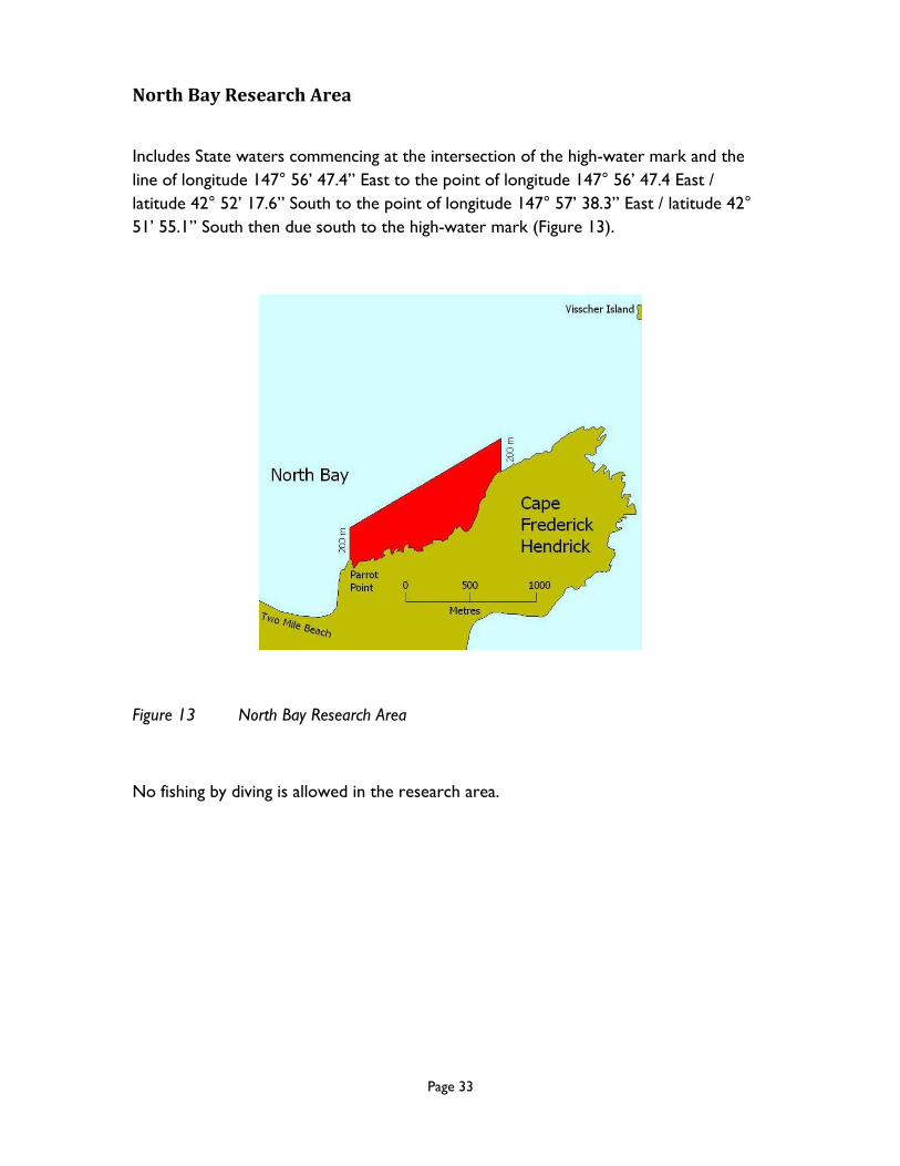
North Bay Research Area
Includes State waters commencing at the intersection of the high-water mark and the
line of longitude 147° 56’ 47.4” East to the point of longitude 147° 56’ 47.4 East /
latitude 42° 52’ 17.6” South to the point of longitude 147° 57’ 38.3” East / latitude 42°
51’ 55.1” South then due south to the high-water mark (Figure 13).
Figure 13 North Bay Research Area
No fishing by diving is allowed in the research area.

Page 34
Processors All processors of wild abalone must hold a current fish processing licence authorised to
process wild abalone.
Receiving small fish Processors receiving blacklip abalone from the northern blacklip area or the Bass Strait
area are required to separate and mark fish as described below.
Northern blacklip area Processors receiving blacklip abalone from the northern blacklip area must transport
and store abalone before processing in bins or containers marked with the words
“northern area” or with a red tag marked with the words “northern area”.
Bass Strait area Processors receiving blacklip abalone from the Bass Strait area must transport and store
abalone before processing in bins or containers marked with the words “Bass Strait
area” or with a red tag marked with the words “Bass Strait area”.
Marine farmed abalone All processors of marine farmed abalone must hold a current fish processing licence
authorised to process marine farmed abalone. Provided all necessary reporting
requirements are fulfilled, processors may then receive, possess and process from
marine farms abalone that are less than the minimum size in the wild fishery. All abalone
received from a marine farm are to be stored separately in appropriately labelled
containers prior to processing. Processors should consult the Fisheries (Processing and
Handling) Rules 2010 for rules pertaining to the necessary processor requirements for
marine farmed abalone.
Biosecurity Processors should acquaint themselves with requirements relating to treatment of
abalone live-holding discharge water (telephone Travis Baulch, Abalone Biosecurity
Officer, 6165 3029).

Page 35
Margin for error (over-catch) A system exists to accommodate over-catch where care has been taken to catch no
more than the positive quota balance for that zone at the time, noting that all abalone
taken above the size limit must be landed.
Please note that you may only fish quota added to your entitlement if you
have received confirmation from the Department that the quota has been
added either by receipt of the fishing licence (abalone dive) which indicates
the quota units have been authorised or by contacting the DPIPWE during
business hours. You must not fish any such quota if you have not received
confirmation.
Please note, all commercial abalone divers must hold a current fishing
licence (personal) to take abalone. The fishing licence (personal) has a fixed
expiry date of 31st August annually. It is an offence to take abalone for
commercial purposes if the diver does not hold a current fishing licence
(personal).
A diver (or diving team) may fish to the quota limit on his /her/their FLAD but with a
provision for a margin of error on a trip. This margin is 20 per cent of the positive quota
balance for that zone at the time. That is, the diver (diving team) may land up to an
additional 20 per cent of his/her/their positive quota balance.
Divers (diving teams) are required to fish to the actual quota held with the error
allowance being only a provision to accommodate a difference between the estimated
and actual weights taken.
The diver (diving team) then has a number of choices as to how to deal with that excess
catch. The diver or diving team can only use one of the following options. A
combination of options can not be used.
First, the diver (or diving team) can ‘transfer’ the whole amount of excess abalone to
one other diver only, who is also completing a commercial abalone fishing trip at the
same landing area. The receiving diver must have enough positive quota balance to
cover the total amount of abalone. Blacklip abalone transfers may only occur between
divers who have fished in the same zone.
Only abalone which is in excess of a diver’s (or diving team) positive quota
balance (by less than 20 per cent) may be transferred to another diver. The
total amount of excess abalone must be transferred to only one other diver,
a diver cannot transfer part of the over-catch. Be aware that receiving of
transferred abalone can not take that diver into a negative quota balance. A

Page 36
diving team must exhaust the total amount of their combined quota balance
before an over-catch can be recorded.
Note, if a diver transfers an amount of excess abalone that is more than 20% (this is
outside the over-catch options in the Rules) the diver who took the abalone will
still be required to pay the administrative penalty for the excess abalone as if
they themselves landed the excess abalone.
Both divers must complete separate abalone transfer dockets for the amount of abalone
involved. The pink copy of that docket is then forwarded to the Department with the
relevant pink Dive Docket.
The transfer must take place before Part A of the Dive Docket is completed, and no
abalone from either diver can leave the landing area before both divers have completed
their transfer dockets. The current requirements of when Part A of the Dive Docket
must be completed determines the ‘window of opportunity’ within which excess
abalone can be transferred to another diver.
Under this scenario, both divers complete their own Dive Docket as usual. Both divers
record their own personal catch and effort information in the fishing details section.
However, for reporting against quota in the rest of the docket, the divers indicate the
amount they are deducting off their quota. That is, the recipient diver records the
amount he or she caught plus the amount he or she is given, and the diver giving the
abalone records an amount calculated by subtracting the amount he or she gives away
from their catch.
The second option available to the diver (or diving team) with excess catch (which does
not exceed the 20 per cent limit) is to keep the excess abalone and cover the entire
excess amount with extra quota (in one administrative transaction) within the quota
period.
That is, the diver has until the end of the year to get additional quota units specified on
the dive licence against which the total excess catch will be reconciled. Under this
scenario, the full amount of abalone is reported on the Dive Docket and a negative
quota balance results.
The over-catch amount will be reconciled against the next quota unit(s) assigned on the
dive licence. Thus, the onus is on the diver to identify which unit(s) is/are to be used or
else reconciliation will occur regarding the first unit(s) entered, noting that when a
number of quota units are authorised at the same time, the excess will be allocated to
quota units in listed, usually numerical, order unless otherwise requested.
If a diver does not acquire additional quota within the quota period, and does NOT
wish to dive in that zone again in that quota year, the diver must pay to the Crown an
Page 37
administrative penalty equal to the average beach price of that total excess catch for the
first 10 per cent of over-catch, and twice the average beach price of that excess catch
for between 10 and 20 per cent of over-catch, based on the last formally calculated
beach price. Please note that, should the diver elect to pay out the over-catch
during the quota period, the diver is still not allowed to dive in that zone
again in the quota period.
A diver can not dive in a zone with a negative quota balance; that deficit
must be addressed either through acquisition of additional quota (within the
quota period).
NB: This restriction also includes diving as part of a dive team. No member
of a dive team can dive in a zone where they have a negative quota balance.
There are also provisions for the last trip each year in each zone.
Each diver will conduct one final trip in each zone. Again, for abalone up to 10 per cent
in excess of the positive quota balance at the time, payment to the Crown of an
administrative penalty will be required for the average beach price of that abalone. For
abalone between 10 per cent to 20 per cent in excess, a payment of twice the average
beach price will be required. The average beach price of the fish will be calculated from
the beach price for the last quarter of the year. The amount of the administrative
penalty will be communicated in the new quota year (divers can commence fishing the
new quota year). Divers must pay the Crown the total amount of the administrative
penalty within 30 days of notification. Failure to do so may result in prosecutorial action
being commenced. If the diver does not wish to fish that zone again in that year, the
negative quota balance will remain and will become the last trip for that year, and a
letter detailing the administrative penalty to address the over-catch will be generated in
the new quota year under the last trip provisions.
The possibility of a diver having a negative quota balance raises issues for the transfer of
dive licences and replacement of licence supervisors. Licences will not be transferred
until any outstanding negative quota balance is addressed by either acquisition of
additional quota within the quota period or by payment of the administrative penalty.
Similarly, a change of supervisor will not be approved until a negative quota balance is
rectified.
There is provision for a financial administrative penalty in lieu of prosecution regarding a
less than 20 kilograms amount of over-catch greater than 20 per cent or an amount of
over-catch between 20 per cent and 30 per cent. Please note that the administrative
penalty is an amount equal to twice the last beach price for the entire amount of excess
abalone up to the maximum of 30 per cent, not just for the percentage greater than 10
per cent or greater than 20 per cent. Please note that the diver will not be
allowed to dive in that zone again in the quota period.

Page 38
For amounts greater than 30 per cent, the diver will be liable for the financial
administrative penalty for the amount of excess up to 30% and be liable to prosecution
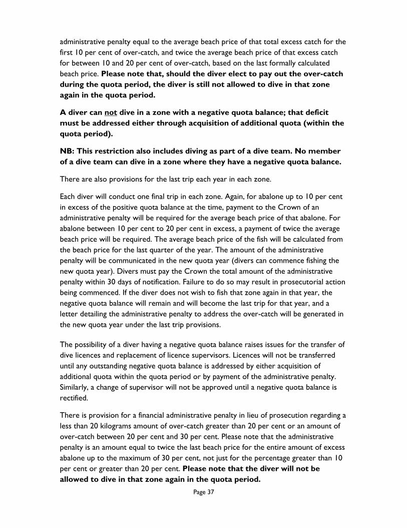
for any amount over 30% (Figure 14). Please note that the diver will not be
allowed to dive in that zone again in the quota period.
10%
30%
20%
0
% of prior
fishing balance
prosecution
either
transfer
- or -
quota unit
- or -
x 1 beach price
either
transfer
- or -
quota unit
- or -
x 2 beach price
plus
x 1 beach price
x 2 beach price x 2 beach price
can choose
1 option only
can choose
1 option only
No option No option
Figure 14 Over-catch steps
Share diving (team diving) Note that divers do NOT have to form a diving team if they are simply working from
the same vessel on a fishing trip. In such cases, divers should keep their catch separate
for purposes of size limit policing and quota reconciliation.
Members of a diving team, on the other hand, are authorised on a fishing trip to take
quota specified on the licences of the team members combined. Divers should still keep
their catch identifiably separate for purpose of size limit policing.
The framework for share diving is as follows:
The unit is defined as a ‘diving team’.
The diving team arrangement applies for one fishing trip.
A team may comprise of a maximum of two divers.
A diving team must be formed PRIOR to the divers commencing the diving
trip. Divers must declare that they have formed a diving team when making

Page 39
their prior fishing report. Divers must remain in a diving team for the
duration of the diving trip.
Any over-catch notwithstanding, the team may not take on a fishing trip more
than the amount authorised in total for the team; both divers are responsible
for the amount taken.
The total amount of over-catch taken by a diving team must be dealt with
by only one of the abovementioned options.
Neither diver can enter into over-catch if the other diver has a positive quota
balance; i.e., all combined quota must be exhausted before either diver can
enter into over-catch.
A diving team must be defined by each diver completing a separate diving
team docket.
Diving team dockets must be completed before each trip starts; the docket is
sent to the Department with the relevant Dive Docket for the trip.
To form a new or different team, the existing trip must be finished, all abalone
must be landed and dive dockets completed. A new dive docket and fishing
trip are then commenced.
Members of the team each complete his or her Dive Docket; each diver
completes his or her own catch and effort activity for the amount they take,
the catch of the team must be recorded on the Dive Docket, and all abalone
caught combined must be attributed to one or both licences, according to
which licence(s) the quota is to be decremented.
Both divers forming a dive team must be physically able and equipped to dive.
Both divers must participate in the diving activity.
Team divers must start the fishing trip on the same vessel and all abalone
taken must be landed from that vessel.
Team divers must dive and catch from the same vessel or dinghy, including if
operating on a mother boat.
No minimum amount of quota is needed on either licence, but neither diver
can commence a fishing trip with a negative quota balance for that part of the
fishery.
Over-catch is calculated from the combined total of quota
authorised to BOTH licences. One diver can not avail themselves
on any of the over-catch provisions if the other diver still has quota
authorised on their licence.
Sustainable Catch Targets Fishing effort needs to be distributed across the fishery to reduce the likelihood of
localised overfishing. Each year, therefore, a number of areas in the fishery have catch
caps applied to them. When an area is to be closed due to its cap having been reached,
Page 40
divers and processors will be informed in writing by e-mail. If you have not provided
your e-mail address to the Department, you should do so.
Please note that, as a matter of course, notice of closures is now being texted to you by
the Tasmanian Abalone Council Ltd, and the Department is posting all closures on its
website (http://dpipwe.tas.gov.au/sea-fishing-aquaculture/commercial-fishing/abalone-
fishery/abalone-closures).
GPS and depth loggers mandatory All divers are required to carry and use the working GPS and depth loggers registered
to them by the Institute for Marine and Antarctic Studies (IMAS). Without either of the
loggers, divers cannot commence a fishing trip. Should any problem be experienced with
either of the loggers, telephone 0408 301 367 to talk with a technician during business
hours prior to the trip commencing. Outside business hours, use this number to leave a
voice message. Importantly, if you have departed on a fishing trip and a fault occurs, and
you can not reach a technician, SMS your message; you will receive an automatic SMS
reply which provides a record that you have notified IMAS of the fault. With this SMS
reply, you may undertake ONE fishing trip only; the fault must be rectified or a
replacement logger obtained to undertake any subsequent trips. IMAS will respond to
your message as soon as possible.
It is an offence punishable by heavy penalties for a diver to take abalone on a
commercial abalone dive trip without an operating data logger.
Additional Information For further information please contact:
Wild Fisheries Management Branch (03) 6165 3033.
For licensing and quota authorization enquiries (03) 6165 3000.
For docket book and quota balance enquiries (03) 6165 3000.
Page 41
2018 SUB-BLOCK CLOSURES
BLACKLIP:
East coast: Eddystone Point to Whale Head is closed from 1 January 2018 until 31 March
2018 inclusive. The closure does not include sub-block 31A.
North-east: sub-blocks 31B, 39A, 39B, 40A, 40B and 40C only from 1 January 2018 until
north-east greenlip fishery opens.
GREENLIP:
North coast: in the north-west, fishing blocks 48 (excluding sub-block 48A), 49 and 5 and
down the west coast, and in the north-east, blocks 31, 32, 33, 39, 40 and down the east
coast from 1 January 2018 until further notice.