flood extent prediction from lake heights and water level ... · pdf fileflood extent...
TRANSCRIPT

FLOOD EXTENT PREDICTION FROM LAKE HEIGHTS AND WATER LEVEL ESTIMATION FROM FLOOD EXTENTS USING RIVER GAUGES, ELEVATION
MODELS AND ENVISAT DATA
ANDREOLI Rémi(1), LI Jiren(2), YESOU Hervé(1)
(1) SERTIT, Université Louis Pasteur,
Bld Sébastien Brant, BP 10413 F-67412 Illkirch-Graffenstaden, France, [email protected]
(2) IWHR, Ministry Water Resource, Beijing, China [email protected]; [email protected]
ABSTRACT Water levels and water extents are essential information in flood monitoring and forecasting. Two experimental and complementary ways were explored in order to estimate water level and water extent and forecast them: 1) The estimation of water level through combining water extents derived from earth observation data with elevation from a Digital Elevation Model; 2) The estimation of flood extents with respect to water levels by combining water levels recorded at a reference gauge station with the corresponding water extents derived from earth observation data. The results are very promising. The average error of estimated water level near the Hukou gauge station (north of the Poyang Lake) is about 1.26 meters using low and medium resolution ENVISAT products combined with 3 arc second SRTM DEM. Also, a first flood extent forecast map was estimated using ENVISAT low and medium resolution data and water levels recorded at Hukou gauge station. Keywords: water level, flood extent, ENVISAT low and medium resolution data, ASAR, MERIS, SRTM DEM, earth observation. 1. INTRODUCTION Water extent and water level are two essentials information in flood monitoring and forecasting, and these two parameters are closely linked with water volume and storage capability of the hydrological system. Water levels recorded at gauge stations are commonly used for flood basin surveys and are not systematically combined with water extents. Water levels and extents are often difficult to obtain simultaneously particularly over large basins. Since the availability of high resolution remotely sensed data, the estimation of water level from remote sensing data is under study. The first approaches were qualitative, providing classes of height based on SPOT or Landsat TM data. These approaches were mostly based on the intersection of water extents derived from earth observation data and exogenous data such as parcelling and topography [1]. With the increasing resolution, the possibility of describing hydraulic parameters has made height estimate improvement possible [2, 3]. Radar phase signal has also been
exploited for height level estimation [4, 5]. Very impressive results have been obtained exploiting altimetric SAR time-series from ERS, ENVISAT and Topex-Poseidon sensors, over a few large rivers, enabling water level monitoring at the cross section between river and satellite track [6, 7, 8]. Low and medium resolution earth observation data are particularly adapted to monitoring wide hydrological basins and can be used to derive water extents and water levels by intersecting water extents with a DEM. The approach shown in this paper is very complementary in terms of temporal revisit and the areas covered to the altimetric method which is very precise in time and height but is limited to punctual nodes. As part of the Flood DRAGON Project [9, 10, 11], this study benefits from the rich earth observation database set up over the Poyang Lake (P.R. China, Jiangxi Province). With a watershed of about 162,000 km², Poyang Lake undergoes very significant water level variations over a year (9m variation) and its size fluctuates from less than 1,000 km² during the dry winter period to more than 4,000 km² during the wet summer season. Poyang Lake also constitutes a major hydrological subsystem for flood water storage and regulation of the middle Yangtze River (Changjiang) basin. Two experimental and complementary ways were explored in order to estimate water level and water extent and forecast them: 1) The estimation of water level through combining water extents derived from earth observation data with elevations from a Digital Elevation Model; 2) The estimation of flood extents with respect to water levels by combining water levels recorded at a reference gauge station with the corresponding water extents derived from earth observation data. 2. DATABASE 2.1. Earth Observation database The earth observation database covering the Poyang Lake area includes a set of optical high resolution reference data (2 Landsat images, Table 1) at different hydrological periods, ENVISAT MERIS and ASAR data (113 datasets, Table 2) and 3 arc-second (90 m) SRTM Digital Elevation Model.
_____________________________________________________
Proc. ‘Envisat Symposium 2007’, Montreux, Switzerland 23–27 April 2007 (ESA SP-636, July 2007)
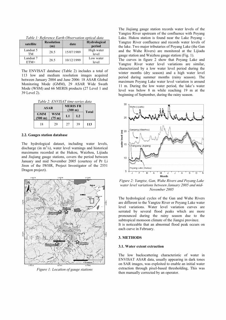
Table 1: Reference Earth Observation optical data satellite Resolution
(m) date Hydrological period
Landsat 5 TM 28.5 15/07/1989 High water
level Landsat 7
ETM+ 28.5 10/12/1999 Low water level
The ENVISAT database (Table 2) includes a total of 113 low and medium resolution images acquired between January 2004 and June 2006: 18 ASAR Global Monitoring Mode (GMM), 29 ASAR Wide Swath Mode (WSM) and 66 MERIS products (27 Level 1 and 39 Level 2).
Table 2: ENVISAT time-series data
ASAR MERIS FR (300 m)
GMM (500 m)
WSM (75 m) L1 L2
Total
18 29 27 39 113
2.2. Gauges station database The hydrological dataset, including water levels, discharge (in m3/s), water level warnings and historical maximums recorded at the Hukou, Waizhou, Lijiadu and Jiujiang gauge stations, covers the period between January and mid November 2005 (courtesy of Pr Li Jiren of the IWHR, Project Investigator of the 2551 Dragon project).
Figure 1: Location of gauge stations
The Jiujiang gauge station records water levels of the Yangtze River upstream of the confluence with Poyang Lake. Hukou station is found near the Lake Poyang - Yangtze River confluence and records water levels of the lake. Two major tributaries of Poyang Lake (the Gan and the Wuhe Rivers) are monitored at the Lijiadu gauge station and Waizhou gauge station (Fig. 1). The curves in figure 2 show that Poyang Lake and Yangtze River water level variations are similar, characterized by a low water level period during the winter months (dry season) and a high water level period during summer months (rainy season). The maximum Poyang Lake water level variation is around 11 m. During the low water period, the lake’s water level was below 8 m while reaching 19 m at the beginning of September, during the rainy season.
Figure 2: Yangtze, Gan, Wuhe Rivers and Poyang Lake water level variations between January 2005 and mid-
November 2005 The hydrological cycles of the Gan and Wuhe Rivers are different to the Yangtze River or Poyang Lake water level variations. Water level variation curves are serrated by several flood peaks which are more pronounced during the rainy season due to the subtropical monsoon climate of the Jiangxi province. It is noticeable that an abnormal flood peak occurs on each curve in February. 3. METHODS 3.1. Water extent extraction The low backscattering characteristic of water in ENVISAT ASAR data, usually appearing in dark tones on SAR images, was exploited to enable an initial water extraction through pixel-based thresholding, This was then manually corrected by an operator.

Due to product characteristics, water extraction techniques aren’t similar for MERIS Level 1 and Level 2 products. Two methods were used jointly to extract water bodies from MERIS Level 1 products, according to the hydrological period. During low water-level periods, a single threshold using band 14 (Near Infrared) was performed. During high water-level periods, an NDVImean, using the Eq. 1, was used to extract water bodies through thresholding.
A single threshold, using either band 10 or band 13 (Near Infrared), was used to extract water bodies from all MERIS Full Resolution (FR) Level 2 products. 3.2. Water height estimation The methodology selected in this study consists of estimating water level through the intersection of topographic data, from a 3 arc-second SRTM DEM, with water bodies extracted from ENVISAT Low and Medium Resolution products (Fig. 3). The SRTM DEM's resolution (90 m) is conform with ENVISAT Low and Medium resolutions (from 75 m to 1 km).
Figure 3: water height estimation methodology
The water level estimation methodology consists of estimating local water levels from the DEM using a buffer at the boundary of each water body derived from ENVISAT data and averaging local water levels over the selected areas (Eq. 2).
: : where
1
levels water local levels water estimated
1
w
i
nle
hw
hn
w
le
w∑=
=
(2)
The Hukou sector was selected to estimate Poyang Lake water levels due to the presence of a gauge station and also because there is a correlation between water levels recorded at Hukou gauge station and lake surfaces extracted from ENVISAT Low and Medium resolution products (Fig. 4).
Figure 4: Linear relationship between Poyang Lake's surface and water levels recorded at Hukou gauge
station 4. WATER HEIGHT ESTIMATIONS AND WATER EXTENT FORECASTING 4.1. Water height estimations: preliminary results 66 suitable (ie cloud free or undisturbed images over the Hukou area) ENVISAT GMM, WSM and MERIS data were exploited in estimating Poyang Lake's water levels (Fig. 5). These results appear promising and none of the estimates seem anomalous. Also, they show seasonal trends corresponding to infilling and draw-off for the years 2004, 2005 and the beginning of 2006. 21 estimates derived from ENVISAT Low and Medium resolution products were compared with water levels recorded at Hukou gauge station (Fig. 6). The average error is about 1.26 meters and the standard deviation is 1.83. Absolute minimum error is about 0.04 m and absolute maximum error reaches 3.90 m. Only one estimate was derived from an ENVISAT Global Monitoring Mode water body layer (for the 8th of March 2005) with an error of 0.04 m compared with the water level recorded at Hukou gauge station the same day.
⎪⎪⎩
⎪⎪⎨
⎧
===
=
+
−
=
∑∑
∑∑
==
==
bands red ofnumber bands infrarednear ofnumber
valueereflectancnumber band
:
11
11
9
6
15
10
9
6
15
10
nn
nn
nnNDVI
red
pir
iredipir
iredipirmean
DNi
With
DNDN
DNDN
(1)
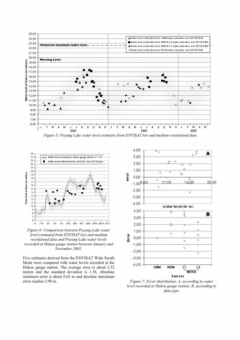
Figure 5: Poyang Lake water level estimates from ENVISAT low and medium resolutiond data
Figure 6: Comparison between Poyang Lake water
level estimated from ENVISAT low and medium resolutiond data and Poyang Lake water levels
recorded at Hukou gauge station between January and November 2005.
Five estimates derived from the ENVISAT Wide Swath Mode were compared with water levels recorded at the Hukou gauge station. The average error is about 2.52 meters and the standard deviation is 1.38. Absolute minimum error is about 0.62 m and absolute maximum error reaches 3.90 m.
Figure 7: Error distribution; A. according to water
level recorded at Hukou gauge station; B. according to data type.

Fifteen water level estimates derived from ENVISAT MERIS Level 1 and 2 were compared with those recorded at Hukou gauge station. The average error is about 0.95 meters and the standard deviation is 0.87m. Absolute minimum error is about 0.35 m and absolute maximum error reaches 3.81 m. The preliminary analysis of error distribution (Fig. 7) shows that lake water levels do not seem to influence estimate errors (Fig. 7, A.). Also water levels appear to be over-estimated (only 5 error values are lower than 0). Considering separately each type of sensor (Fig. 7, B.), estimates based on water bodies extracted from ENVISAT WSM data are all over-estimated, while under-estimations tend to compensate over-estimations in estimates derived from MERIS L1 and L2 data. 4.2. Spatialization of water levels and water extents: preliminary results One of flood monitoring's purposes is that of flood modelling and water extent forecasting. This second approach relies on the exploitation of a case-base of 17 water extents extracted from ENVISAT ASAR and MERIS data during the year 2005 for which lake water levels recorded at Hukou gauge station exist (Table 3).
Figure 8: flood extent forecast map
A height value corresponding to the water level recorded at Hukou gauge station was allocated to each water extent boundary extracted from earth observation data. The derived water level curve was then combined in a GIS and values between curves were interpolated using a cubic convolution. Lowest and highest values were corrected with water levels estimated from Landsat reference data over Poyang Lake (the water level was estimated at less than 10 m for the 1999 dry season and greater than 18 m for the 1989 flood season considering water extent and the corresponding water levels in 2005). There is a lack of data for water levels between 12 and 13 meters. Water extents for these water levels were interpolated using cubic convolution in a moving window. Table 3. Data used for flood forecasting map
Date ENVISAT data type
Water surface estimated
from EO data
Water level (daily mean in meters)
20/02/2005 WSM 2712.0 13.31 08/03/2005 GMM 1088.3 11.86 31/03/2005 MERIS L1 1591.9 11.36 03/04/2005 MERIS L1 1745.6 11.56 20/04/2005 WSM 1656.0 11.87 28/05/2005 MERIS L1 2603.3 17.19 06/06/2005 MERIS L1 2687.0 18.25 15/06/2005 MERIS L1 2486.0 18.30 02/07/2005 MERIS L1 2879.0 17.66 24/07/2005 MERIS L2 3022.0 17.11 02/08/2005 MERIS L2 2284.2 17.14 08/08/2005 MERIS L2 2507.5 16.99 08/10/2005 MERIS L2 2442.2 15.71 11/10/2005 MERIS L2 2748.5 16.10 17/10/2005 MERIS L2 1922.9 15.60 24/10/2005 MERIS L2 1841.0 14.54 30/10/2005 MERIS L2 1488.2 13.50
A preliminary flood extent forecast map was estimated using ENVISAT low and medium resolution showing flood extents for a given water level at Hukou gauge station (Fig. 8). This preliminary map shows areas which were submerged according to the water level at Hukou gauge station. 5. DISCUSSION AND CONCLUSION These two complementary approaches have given promising results. Water level estimation using low and medium resolution data and SRTM DEM has an average error of 1.26 m which is better than expected bearing in mind that SRTM accuracy over flat areas is about +/- 1 m [12]. However, hydrological reference data are required covering 2004 and 2006 while filling the November and

December 2005 gap in order: to assess water level estimation according to data type (ASAR versus optical, low resolution versus high resolution); to define statistical and/or methodological adjustments. Furthermore, the preliminary flood extent forecast map shows the Poyang Lake extent according to its water level. This result is a preliminary estimate of forecasted flood extents because the modelling integrates only normal conditions and requires the integration of crisis data such as 1998 flood extents and water heights. Also, a DEM with better spatial/vertical resolution (a precise Poyang Lake’s topography database) could be used in the estimation of water level. In addition, a further step would be to test this approach over a second test site: the Dongting Lake. In fact, ENVISAT Altimeter measurements are available over this area and this kind of data could be used to improve water height estimation, calibration and validation. 6. ACKNOWLEDGMENTS The authors are grateful to ESA because this work was realized within the framework of the Sino-European joint research (ESA-NRSCC) DRAGON project 2551 and supported by ESA's “Support Training of Young European Scientists”. 7. REFERENCES 1. Hubert-Moy, L. ; Ganzetti, I. ; Bariou, R. ; Mounier, J.
1992. Une cartographie des zones inondables en Ille-et-Vilaine par teledetection Norois. v 155 pp 337-347.
2. Puech C., Raclot D., 2002. Using geographical information systems and aerial photographs to determine water levels during floods, Hydrological Processes, 16 (8), pp1593-1602.
3. Roux H, Raclot D., Darthus D., et Puech C., 2003. Hydraulic parameter identification using areal photographs. Proceedings of IGARSS 2003 Toulouse
4. Alsdorf D.E., Smith L.C., Melack J.M., 2001. Amazon water level changes measured with interferometric SIR-C radar, IEEE Transactions on Geoscience and Remote Sensing, Vol. 39 (2), pp423-431.
5. Wdowinski S., Amelung ., Dixon T., Miralles-Wilhelm and Carande R. 2004. Insar based hydrology in South Florida. Envisat & ERS Symposium, Salzburg, Austria
6. Frappart F., Dominh K., Lhermitte J., Ramilllien G., Cazenave A. and LeToan T., 2006. Water volume change in the lower MEKONG basin from satellite altimetry and other remote sensing data, Geophys. J. Int., 167, pp570-584.
7. Frappart, F., S. Calmant, M. Cauhopé, F. Seyler et A. Cazenave, 2006. Results of ENVISAT RA-2 Derived levels Validation over the Amazon basin, Remote Sensing of Environment, 100, pp252-264.
8. De Oliveira Campos, I., Mercier, F., Maheu, C., Cochonneau, G., Kosuth, P., Blitzkow, D., Cazenave, A. 2001. Temporal variations of river basin waters from Topex/Poseidon satellite altimetry. Application to the Amazon basin. C.R. Acad. Sci. Paris 333, pp 633-643.
9. Yésou, H., Li, J., Li, J., Wang, X., Yida, F., Wang, Y., Huang, S., Xin, J., de Fraipont, P., 2004. Assessment of the Synergistic Exploitation of ENVISAT ASAR and MERIS Data for Plain Flood Rapid Mapping: a Part of the Dragon Flood Project. ENVISAT Symposium Salzburg 6-10 September 2004.
10. Li J., Yésou H., Huang S., Li J., Li X., Xin J., Wang X., Andreoli R., 2006. ENVISAT ASAR medium and high resolution images for Near Real Time flood monitoring in China during the 2005 flood season. Proc. 2005 Dragon Symposium “Mid-Term Results”, Santorini, Greece 27 June – 1 July 2005, ESA SP-611: 213-226.
11. King, C., Li, J., Costes, M., Yésou, H., Prinet, V., 2004. WARM Water Risk. Management Research Network CEOS meeting Information, Products and Services for Disaster Management, Beijing China, 17-19 November 2004.
12. Rabus, B., Eineder, M., Roth, A., Bamler, R. 2003. The Shuttle Topography Mission – A New Class of Digital Elevation Models Acquired by Spaceborne Radar, ISPRS J. of Photogrammetry & Remote Sensing 57, pp 241-262