flood mapping and flood management in amur-heilong … · flood mapping and flood management in ......
TRANSCRIPT

Flood mapping and flood management in Amur-Heilong River Basin.
Joint efforts of Russia and China. Dr.Eugene Simonov (Rivers without Boundaries),
Dr.Andrey Shalygin (State Hydrological Institute), Dr.Evgeny Egidarev (PIG FEBRAS and WWF- Amur)

Rivers without Boundaries work on Protection of Asian Transboundary Rivers
CHINA

Amur-Heilong Transboundary River Basin
Area -2.1 million sq.km, Length 4444 km, Annual flow: 364 cubic km., Maximum discharge 46000 cub.m/sec in 2013 .

Flooding – key ecosystem process. Floodplains – most important wetland type
Flood on Eerguna-Argun River in Amur Headwaters f
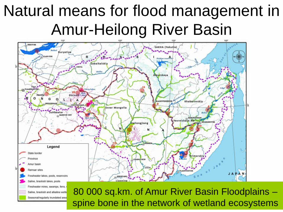
Natural means for flood management in Amur-Heilong River Basin
80 000 sq.km. of Amur River Basin Floodplains – spine bone in the network of wetland ecosystems

Specific conditions for cooperation • 3550 km of - state boundaries marked along major rivers. • Population density increasing on China banks
and decreasing in Russia • Provincial cities in China located on
tributaries, in Russia - on transboundary Amur River.
• Development density relatively low on both banks of Amur
• Mutual relations in last 100 years market by alteration of periods of cooperation ( 1949-61, 1986-2014) with periods of confrontation.
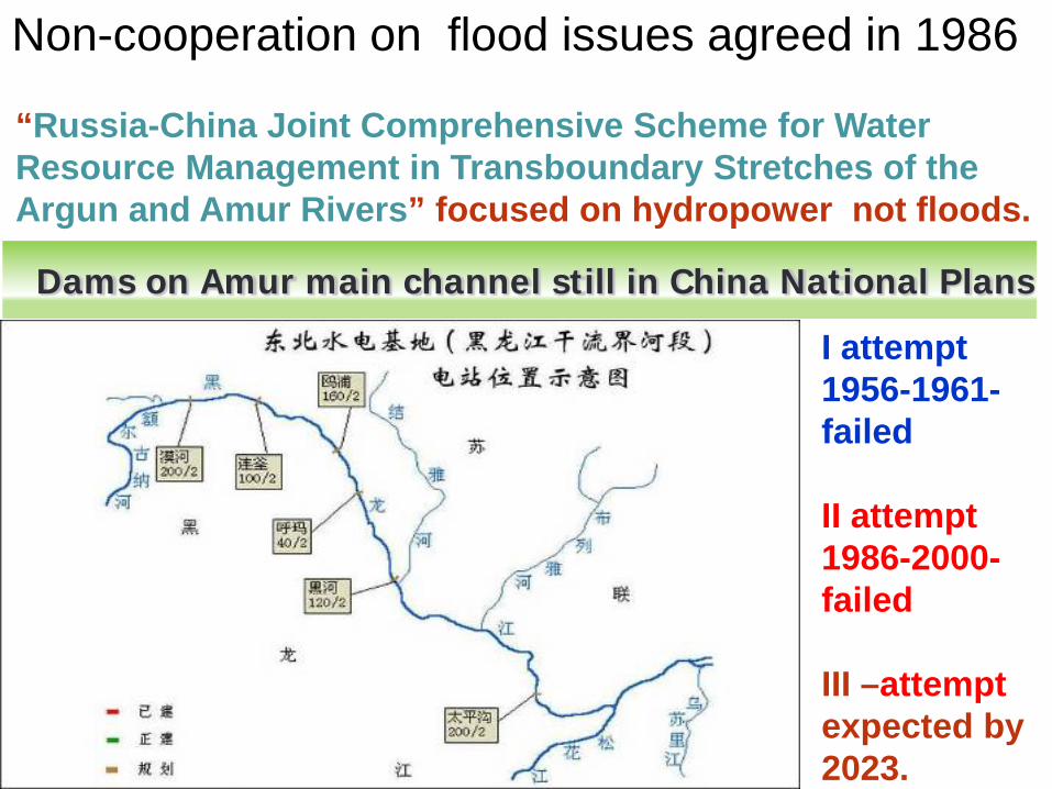
“Russia-China Joint Comprehensive Scheme for Water Resource Management in Transboundary Stretches of the Argun and Amur Rivers” focused on hydropower not floods.
Dams on Amur main channel still in China National Plans
I attempt 1956-1961-failed II attempt 1986-2000-failed III –attempt expected by 2023.
Non-cooperation on flood issues agreed in 1986

LIKELY REASON:BOTH SIDES EMPLOY EMBANKEMENTS AND DYKES TO PROTECT “MOTHERLAND”, resulting in destroying wetlands and natural processes, and increasing flood level.
Such measures could be avoided through redefining border demarcation rules and treaties

General cooperation mechanisms • Sino-Russian Agreement on Use and
Protection of Transboundary Waters 2008 • Sino-Russian Environmental Sub-
commission under the Commission on Regular Meetings of Heads of State
• MOU between Russian Ministry of emergencies and China Ministry of Environment on environmental emergencies and China Ministry of Water Resources.
• Ramsar Convention on wetlands of international importance

Other mechanisms • Since 1986 Russia and China again exchange
hydrological data on daily water levels at 14 gauging stations on each side. In flood emergency they also exchange flood water level forecasts.
• “Sino-Russian Strategy for Transboundary System of Protected Areas in Amur River Basin" prescribes joint assessment and preservation measures of ecological functions of transboundary ecosystems, which is directly relevant to flood-retention functions.

2013 Flood - the largest in history In Russia flood affected 5 provinces and 3 largest cities of the Russian Far East. 170000 people affected and 30000 evacuated. 15000 houses damaged. Extensive impact on roads, bridges, crops, farms, etc. 1 person drowned.
In China had breaches in 340 kilometers of 20 dykes (13% of total dyke length along Chinese Amur). Including 3 catastrophic. 1000 settlements with 5 million people were affected in Jilin, IMAR and Heilongjiang. 300 000 persons evacuated, 37000 houses damaged, 30 lives lost.

Flood became top theme in the mass media and folklore

New sound policies emerge due to flood
For example Zhenlai county in Heilongjiang Province issued new policy: ”River-lake-pond-connectivity for water management”- calling to use floodplain retention capacity to store water for local needs.
Russian Amur Coordination Committee in urged 5 member provinces to develop flood risk maps and land-use regulations to control floodplain development

Cooperation on 2013 flood risk assessment and reduction
• Prime ministers Li Keqiang and Medvedev had a special phone call to discuss joint measures.
• Exchange of hydro-meteorological information was intensified
• Joint discharge measurements were taken again first time in several decades.
• Some field cooperation took place between emergency services of Russia and China

Joint Report on 2013 Flood Working Group was appointed at the 6th meeting of China- Russia Transboundary Water Joint Commission in Jan. 2014 to do the research on 2013 flood, and to submit a 《Chinese-Russian Joint Report on the analysis of the extreme flood in Amur River in 2013》. For Report-writing the two sides established group of experts, the Chinese group was led by Bureau of Hydrology of Water Resources Ministry, and supported by Bureau of Hydrology of Songliao Water Resources Commission and Bureau of Hydrology of Heilongjiang Province. Russian group was led by Water Problems Institute of the Russian Academy of Sciences, and supported by Moscow State University, Lengiprorechtrans Company, and State Hydrological Institute.

Evaluation of cooperation by China: • 1) Strengthened the collaborative project
regulation to alleviate the pressure of flood protection.
• 2) Responded rapidly, set up smooth information bulletin mechanism.
• 3) Timely cooperation in the implementation of trans-boundary flow measurement.
• 4)Collaborated actively and supported each other in the flood control and disaster relief

Shortcomings and key problems • -Lack of shared information systems
preventing understanding of situation and modelling and forecast;
• - Uneven and insufficient monitoring network falling behind WMO standard;
• - Use of reservoirs for flood-retention needs improvement and coordination;
• - Floodplains' flood retention volume reduced by dykes, embankments, etc.

Reservoir regulation risks
Zeya Reservoir has 50 km3 live volume, used only 14 km3 in 2013. Graph shows reduced peak, but prolonged high stage duration due to emptying insufficient flood retention space before flood season.

Better use of or existing retention volume or building new hydro?
• RusHydro proposed "flood control hydropower" plan with 4+ new dams on tributaries and discusses with China Three Gorges Co ways to advance any of these projects.
• Planned live volume of those 4 hydropower reservoirs cumulatively is less than 18 cubic kilometers and therefore much less useful than already existing major reservoirs on the same rivers.
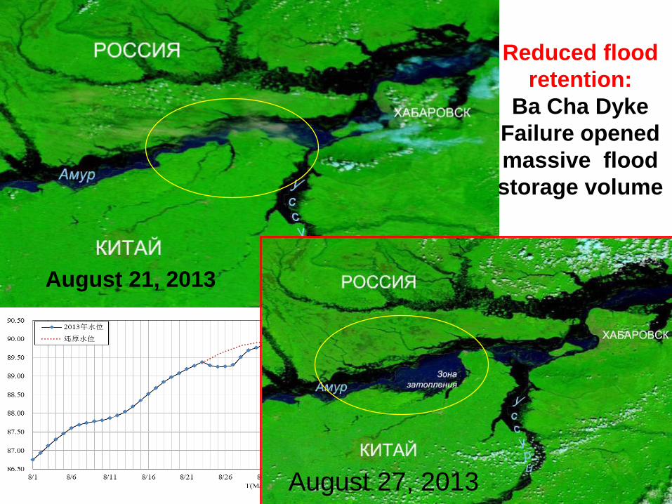
Reduced flood retention:
Ba Cha Dyke Failure opened massive flood storage volume
August 21, 2013
August 27, 2013

Luobei dyke 210 км3 Suibin dyke
96 км3 Ba Cha dyke 764 км3
据卫星遥感影像图片分析,3处溃口区最大淹没面积分别为210、91、764平方公里。
Failure of just 3 dykes resulted in "adding" of at least 5.5 cubic kilometers of flood retention volume on floodplains.
This suggests that 30-70 cubic kilometers of floodplain retention volume is likely eliminated by dykes in China.

Unfortunately in summer 2014 China was raising dykes along Ussury and Amur by 2-5 meters

Future Needs for Cooperation : • Joint modelling and forecasting information
system • Floodplain mapping • Mapping and regulation of land use in flood-
prone areas • Strategic environmental assessment of flood
risk management plans and other water management schemes.
• Protection of floodplain ecosystems: protected areas and environmental flow norms

Forecasting and modelling Enhance technique exchange and cooperation on hydrological forecasting. The following cooperation measures are suggested: (i) regular workshop on flood forecasting
techniques in Amur river basin; (ii) to exchange middle and long term
meteorological and hydrological trend forecasting in the beginning of every month during flood season;
(iii)cooperation on development of Amur river basin hydrological model and flood forecasting operating system.

On-going efforts in modelling
Russian side developed 48 cross-sections
China side assessed 2013 deformations

To sustain and manage natural flood retention capacity of Amur floodplains and other wetlands a joint effort is needed: • To create transboundary GIS map of major
river valleys in transboundary basin
• Develop map of flood-prone areas flooded with 0.5%,1%,10% probability occurrence.
Floodplain mapping

Floodplain mapping (by PIG FEBRAS -WWF 2010-2014)
Floodplains in large river basins >10 000 square kilometers

• Identify floodplain water retention areas most important for reducing risks in 2013 and previous floods.
• Evaluate already achieved reduction in natural flood-retention capacity and risks of further reduction due to water infrastructure development and other human-induced and natural factors.
• Cooperate on strategic environmental assessment of flood-management plans.
Assessment and planning

Estimated natural flood retention volume
Volume of water retained by floodplains during the 2013 flood exceed 130 cubic kilometers.

Floodplain management and Wetland conservation synergy
• Develop joint comprehensive program for preservation and enhancement of natural flood retention capacity of floodplains
• Develop and implement land-use regulations that limit development in flood-prone areas.
• Identify floodplain complexes of high biodiversity value that should be added to transboundary network of protected areas.

Floodplains protection analysis

Planning of a new protected area that cover priority floodplains in accordance with
Sino-Russian Strategy on Transboundary Network of Protected Areas (2011)

THANK YOU!