flood mitigation plan township of montgomery
TRANSCRIPT

Pike Run at Bridgepoint Road looking east, Flood of June 3, 1946
Flood Mitigation Plan
Township of Montgomery Somerset County, New Jersey
January 2006
Prepared with assistance from USDA Natural Resources Conservation Service
220 Davidson Avenue, 4th Floor Somerset, NJ 08873
732-537-6040

Montgomery Township Flood Mitigation Plan January 2006
USDA Natural Resources Conservation Service
2
Montgomery Township Flood Mitigation Plan January 2006
USDA Natural Resources Conservation Service
3
Table of Contents Table of Contents................................................................................................................ 3 List of Tables ...................................................................................................................... 5 List of Figures ..................................................................................................................... 7 List of Photos ...................................................................................................................... 9 Acknowledgements........................................................................................................... 10 Preface............................................................................................................................... 11
Setting .......................................................................................................................... 11 Section A - Community Organization .............................................................................. 15 Section B - Public Involvement ........................................................................................ 15
Initial Public Meeting .................................................................................................. 15 Public Meeting on Draft Plan .................................................................................... 15 Public Information Activities...................................................................................... 16 Questionnaires............................................................................................................ 16 Solicitation of Comments .......................................................................................... 17 Planning Process, Planning Committee Meetings ................................................ 17
Section C - Coordination with Other Agencies ................................................................ 17 Initial Contact with Agencies, Comments ............................................................... 17 Meetings with Agencies............................................................................................. 17
Agency Comments on Draft Action Plan ......................................................................... 18 Review of Community Needs, Goals, Plans for the Area .................................... 18
Section D – Assessing the Hazard .................................................................................... 18 Background Information: Record of Past Floods ................................................. 18 FEMA Flood Insurance Study .................................................................................. 19
Principal Flood Problems ...................................................................................... 19 Flood Prone Areas Map ........................................................................................ 33 Description of Other Natural Hazards ................................................................. 33
Section E – Assessing the Problem................................................................................... 47 Repetitive Flood Losses ............................................................................................ 47 Affected Structures .................................................................................................... 47 Description and Impact of Flooding......................................................................... 51 Critical Facilities in Plan Area................................................................................... 51 Description of Development, Redevelopment, Population Trends, and Discussion of Possible Future Development and Redevelopment in the Floodplain, Watershed and Natural Resource Areas ........................................... 56 Beneficial Function Areas ......................................................................................... 58 Impact of Flooding...................................................................................................... 62 Existing Flood Protection Measures........................................................................ 62 Procedures for Warning and Evacuating Residents and Visitors....................... 62
Section F – Set Goals........................................................................................................ 63 Section G – Review of Possible Activities ....................................................................... 64 Section H – Implementation of an Action Plan ................................................................ 64
Recommendations ..................................................................................................... 64
Montgomery Township Flood Mitigation Plan January 2006
USDA Natural Resources Conservation Service
4
I. Evacuation Route Enhancement........................................................................... 64 II. Incorporation of Flood Mitigation Planning into Local...................................... 65 Ordinances and Master Planning .............................................................................. 65 III. Private Property Flood and other Natural Hazard (Erosion) ............................. 66 Mitigation.................................................................................................................. 66 IV. Public Participation............................................................................................ 68 V. Post-Disaster Mitigation Policies and Procedures .............................................. 69
Section I – Plan Adoption................................................................................................. 71 Section J – Plan Monitoring and Evaluation .................................................................... 72 Bibliography ..................................................................................................................... 74 Appendix........................................................................................................................... 76
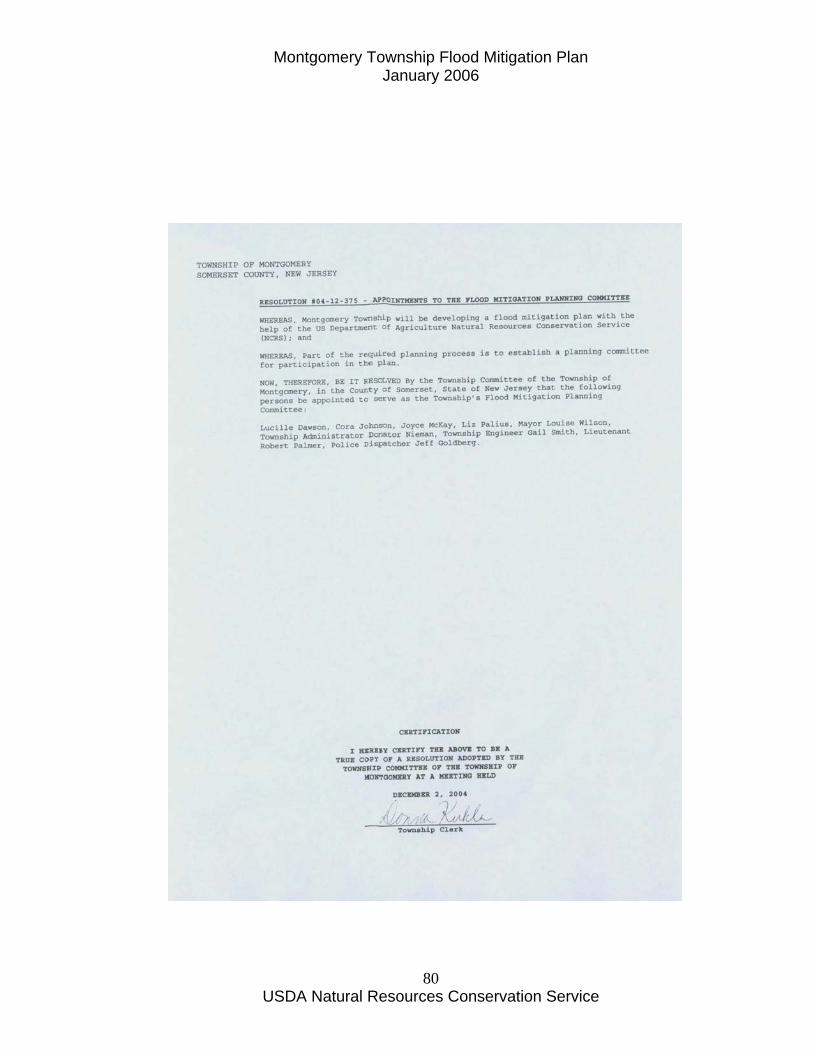
Resolution Establishing the Montgomery Township Flood Mitigation Committee....................................................................................................................................... 78 Montgomery Township Flood Mitigation Planning Committee Minutes............. 82 Property Owner Survey Questionnaire and Final Survey Results ................... 111 Letter to Neighboring Municipalities, State and County Agencies ................... 126 Comments Received from Others ......................................................................... 130 Montgomery Township Flood Plain Ordinance ................................................... 134 Suggested Changes to Existing Flood Damage Prevention Ordinance.......... 153 Preliminary Damage Assessment Report and Emergency Log for Hurricane Floyd in Montgomery Township ............................................................................. 160 Community Rating System ..................................................................................... 162 Flood Mitigation Funding Sources and Contact Information ............................. 170 Resolution of Adoption of Flood Mitigation Plan ................................................. 174
Montgomery Township Flood Mitigation Plan January 2006
USDA Natural Resources Conservation Service
5
List of Tables
Table 1 - Gaging Station in the Montgomery Township Vicinity.................................... 18 Table 2 - Major Floods and Their Recurrence Interval .................................................... 21 Table 3 - Summary of Discharges .................................................................................... 22 Table 4 – Summary of Number of Flood First Floor Vulnerable Residential Properties
along Millstone River and Lower Bedens Brook in Montgomery Township* ........ 48 Table 5 – Summary of Number and Type of Structures Affected by 100 Year Flood
Event Along Millstone River and Lower Bedens Brook in Montgomery Township48 Table 6 – Critical Facilities in Montgomery Township.................................................... 55 Table 7 – Suitable Habitat Types in Montgomery Township........................................... 59 Table 8 – Action Plan Timetable ...................................................................................... 70 Table 8 – Action Plan Timetable (Continued).................................................................. 71

Montgomery Township Flood Mitigation Plan January 2006
USDA Natural Resources Conservation Service
6
Montgomery Township Flood Mitigation Plan January 2006
USDA Natural Resources Conservation Service
7
List of Figures Figure 1 – Montgomery Township Location Map ....................................................... 13 Figure 2 – Annual Peak Discharges at Blackwells Mills Gaging Station .................. 23 Figure 3 – Location of Reported Flood Damages ........................................................ 27 Figure 4 – Dollar Value of Reported Flood Damages.................................................. 29 Figure 5 – Frequency of Flood Damages ...................................................................... 31 Figure 6 – Location of Reported Streambank Erosion ............................................... 35 Figure 7 – Repetitive Flood Loss and Historic Flood Loss Areas .............................. 49 Figure 8 – Critical Facilities in Montgomery Township ............................................. 53 Figure 9 – Montgomery Township Beneficial Functions Map ................................... 60

Montgomery Township Flood Mitigation Plan January 2006
USDA Natural Resources Conservation Service
8
Montgomery Township Flood Mitigation Plan January 2006
USDA Natural Resources Conservation Service
9
List of Photos
Photo 1 – County Route 533 (River Road) at Pike Run ................................................... 37 Photo 2 – September 17, 1999 Flood at Long House on Griggstown Causeway............ 38 Photo 3 – September 17, 1999 Flood at Bridgepoint Bridge at Pike Run ........................ 39 Photo 4 – September 17, 1999 Flood Damage on Rock Brook at Camp Meeting Road.. 40 Photo 5 – September 17, 1999 Flood Damage on Route 206 at Bedens Brook ............... 41 Photo 6 – Tornquist’s Store (now Griggstown Canoe Rental) August 27-28, 1971
(Hurricane Doria) Flood ........................................................................................... 42 Photo 7 – Pike Run at Harlingen Road, August 27-28, 1971 ........................................... 43 (Hurricane Doria) Flood ................................................................................................... 43 Photo 8 – County Route 518 at Bedens Brook on August 28, 1971................................. 44 Photo 9 - Bridgepoint Road at Pike Run on January 20, 1996 ........................................ 45 Photo 10 – Former Mill at Bridgepoint Road at Pike Run on January 20, 1996.............. 46
Montgomery Township Flood Mitigation Plan January 2006
USDA Natural Resources Conservation Service
10
Acknowledgements Members of the Montgomery Township Flood Mitigation Planning Committee, Donato Nieman - Montgomery Township Administrator Gail Smith - Montgomery Township Engineer Lt. Robert Palmer – Montgomery Township Emergency Management Coordinator Jeffrey Goldberg – Montgomery Township Assistant Emergency Management Coordinator Robert Marmion – Montgomery Township Community Development & GIS Lucille Dawson -- Property owner Cora Johnson - Property Owner Elizabeth Palius -- Property owner Township staff I wish to acknowledge include Kim Pickett, Administrative Assistant; Alexandra Luhrman and Pat McDonald, GIS Specialists; Eleanor Blake, Tax Assessor; and Lori Savron,Planning Director. Also, acknowledgement is given Kim Pickett for excellent job of keeping minutes of the Flood Mitigation Planning Committee. Also, I wish to thank Montgomery News, Lucille Dawson, Cora Johnson, Lloyd Staats, Lori Savron, Lori Campbell Loiza for pictures of historic flooding. I would also like to acknowledge the over 181 residents who participated in the property owner survey. Gregory J. Westfall Water Resource Planner
Montgomery Township Flood Mitigation Plan January 2006
USDA Natural Resources Conservation Service
11
Preface
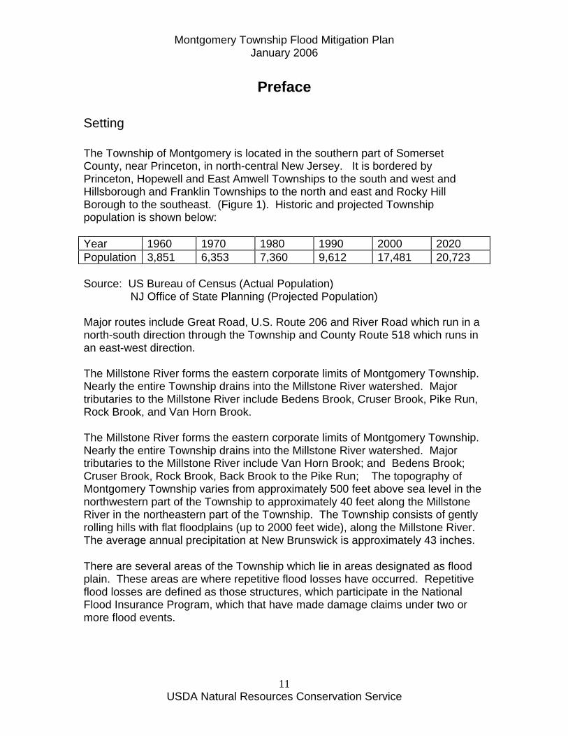
Setting The Township of Montgomery is located in the southern part of Somerset County, near Princeton, in north-central New Jersey. It is bordered by Princeton, Hopewell and East Amwell Townships to the south and west and Hillsborough and Franklin Townships to the north and east and Rocky Hill Borough to the southeast. (Figure 1). Historic and projected Township population is shown below: Year 1960 1970 1980 1990 2000 2020 Population 3,851 6,353 7,360 9,612 17,481 20,723 Source: US Bureau of Census (Actual Population) NJ Office of State Planning (Projected Population) Major routes include Great Road, U.S. Route 206 and River Road which run in a north-south direction through the Township and County Route 518 which runs in an east-west direction. The Millstone River forms the eastern corporate limits of Montgomery Township. Nearly the entire Township drains into the Millstone River watershed. Major tributaries to the Millstone River include Bedens Brook, Cruser Brook, Pike Run, Rock Brook, and Van Horn Brook. The Millstone River forms the eastern corporate limits of Montgomery Township. Nearly the entire Township drains into the Millstone River watershed. Major tributaries to the Millstone River include Van Horn Brook; and Bedens Brook; Cruser Brook, Rock Brook, Back Brook to the Pike Run; The topography of Montgomery Township varies from approximately 500 feet above sea level in the northwestern part of the Township to approximately 40 feet along the Millstone River in the northeastern part of the Township. The Township consists of gently rolling hills with flat floodplains (up to 2000 feet wide), along the Millstone River. The average annual precipitation at New Brunswick is approximately 43 inches. There are several areas of the Township which lie in areas designated as flood plain. These areas are where repetitive flood losses have occurred. Repetitive flood losses are defined as those structures, which participate in the National Flood Insurance Program, which that have made damage claims under two or more flood events.

Montgomery Township Flood Mitigation Plan January 2006
USDA Natural Resources Conservation Service
12

Montgomery Township Flood Mitigation Plan January 2006
USDA Natural Resources Conservation Service
13
Figure 1 – Montgomery Township Location Map

Montgomery Township Flood Mitigation Plan January 2006
USDA Natural Resources Conservation Service
14
Montgomery Township Flood Mitigation Plan January 2006
USDA Natural Resources Conservation Service
15
Section A - Community Organization Montgomery Township received notification from the State Office of Emergency Management (OEM) that they had received a grant to develop this Flood Mitigation Plan in 2003. The Montgomery Township Council approved a resolution to fund an agreement with the USDA Natural Resources Conservation Service on December 18, 2003. A Flood Mitigation Planning Committee was organized by the Montgomery Township Council on December 12, 2004. A copy of the letter mailed to the prospective Committee members is in the Appendix. The following people agreed to accept their appointment to the Committee: Louise Wilson - Mayor Donato Nieman - Montgomery Township Administrator Gail Smith - Montgomery Township Engineer Lt. Robert Palmer – Montgomery Township Emergency Management Coordinator Jeffrey Goldberg – Montgomery Township Assistant Emergency Management Coordinator Robert Marmion – Montgomery Township Community Development & GIS – Environmental Commission/Planning Board Cora Johnson - Property Owner Elizabeth Palius - Property owner Lucille Dawson - Property owner This plan was prepared with the assistance of Gregory J. Westfall, Water Resource Planner, with the USDA Natural Resources Conservation Service.
Section B - Public Involvement Initial Public Meeting A public meeting was held on May 27, 2004 at the Montgomery Township Municipal Building. The purpose of this meeting was to notify the local residents of the intention to prepare a Flood Mitigation Plan and to seek public input for flood problems and possible solutions. The public was informed of this meeting by selecting their addresses using Geographic Information System technology and identifying all properties in or within 200 feet of the FEMA Flood Insurance Study flood zone. A copy of the public meeting minutes appears in the Appendix.
Public Meeting on Draft Plan

Montgomery Township Flood Mitigation Plan January 2006
USDA Natural Resources Conservation Service
16
A second public meeting was held on February 23, 2005 at the Montgomery Township Municipal Building. The purpose of this meeting was to discuss the draft Flood Mitigation Plan. Comments were received from the Township Committee and the public and were incorporated into the Plan. A copy of the public meeting minutes appears in the Appendix.
Public Information Activities Montgomery Township distributed in their Township newsletter a notice of their intent to prepare the Flood Mitigation Plan and requesting the input of over 800 Township property owners. The Township notified the residents of the public meetings to discuss flooding and the preparation of the Flood Mitigation Plan.
Questionnaires In addition, the Township distributed a questionnaire to all Township residents known to be in or within 200 feet of the flood prone areas of the Millstone River, Van Horn Brook, Bedens Brook, and Cruser, Rock and Back Brooks to Pikes Run. A total of 800 surveys were mailed to property owners in or adjacent to the floodplain. A total of 181 responses were received. Period of property ownership ranged from approximately one year to 75 years with an average of 16 years. Fifty five of the respondents had had flood damages from Hurricane Floyd (1999). Eleven of the respondents had flood damages in Hurricane Doria (1971) and eight had flood damage in both. Flood damages reported ranged from less than $100 to over $10,000 (7 respondents). The most common street address for flood damage reporting was Millstone River Road, however, significant damages (over $10,000) were reported by one or more respondents on Dead Tree Run Road, Opossum Road, Camp Meeting Avenue, Cherry Hill Road, Garrison Court, Woodward Drive and Barrington Road. Only 14 of those 129 responding that question had flood insurance at the time of their flood loss. Currently only 21 of 152 responding to that question have flood insurance. Many solutions were proposed, with “stopping development upstream” being a common theme. A copy of the questionnaire and the survey summary is in the Appendix.
Montgomery Township Flood Mitigation Plan January 2006
USDA Natural Resources Conservation Service
17
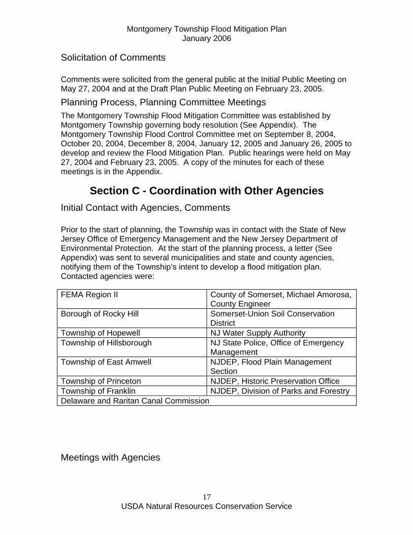
Solicitation of Comments Comments were solicited from the general public at the Initial Public Meeting on May 27, 2004 and at the Draft Plan Public Meeting on February 23, 2005.
Planning Process, Planning Committee Meetings The Montgomery Township Flood Mitigation Committee was established by Montgomery Township governing body resolution (See Appendix). The Montgomery Township Flood Control Committee met on September 8, 2004, October 20, 2004, December 8, 2004, January 12, 2005 and January 26, 2005 to develop and review the Flood Mitigation Plan. Public hearings were held on May 27, 2004 and February 23, 2005. A copy of the minutes for each of these meetings is in the Appendix.
Section C - Coordination with Other Agencies Initial Contact with Agencies, Comments Prior to the start of planning, the Township was in contact with the State of New Jersey Office of Emergency Management and the New Jersey Department of Environmental Protection. At the start of the planning process, a letter (See Appendix) was sent to several municipalities and state and county agencies, notifying them of the Township’s intent to develop a flood mitigation plan. Contacted agencies were: FEMA Region II County of Somerset, Michael Amorosa,
County Engineer Borough of Rocky Hill Somerset-Union Soil Conservation
District Township of Hopewell NJ Water Supply Authority Township of Hillsborough NJ State Police, Office of Emergency
Management Township of East Amwell NJDEP, Flood Plain Management
Section Township of Princeton NJDEP, Historic Preservation Office Township of Franklin NJDEP, Division of Parks and Forestry Delaware and Raritan Canal Commission
Meetings with Agencies
Montgomery Township Flood Mitigation Plan January 2006
USDA Natural Resources Conservation Service
18
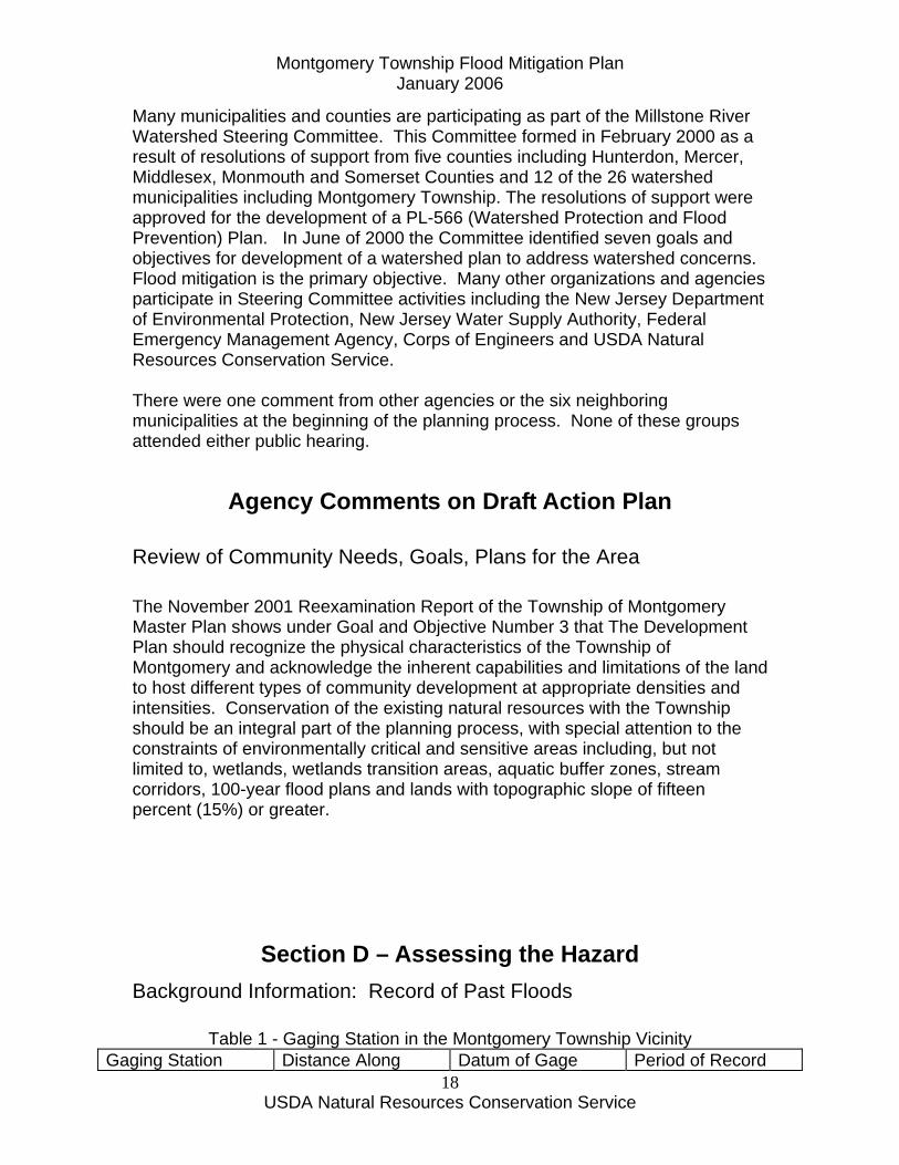
Many municipalities and counties are participating as part of the Millstone River Watershed Steering Committee. This Committee formed in February 2000 as a result of resolutions of support from five counties including Hunterdon, Mercer, Middlesex, Monmouth and Somerset Counties and 12 of the 26 watershed municipalities including Montgomery Township. The resolutions of support were approved for the development of a PL-566 (Watershed Protection and Flood Prevention) Plan. In June of 2000 the Committee identified seven goals and objectives for development of a watershed plan to address watershed concerns. Flood mitigation is the primary objective. Many other organizations and agencies participate in Steering Committee activities including the New Jersey Department of Environmental Protection, New Jersey Water Supply Authority, Federal Emergency Management Agency, Corps of Engineers and USDA Natural Resources Conservation Service. There were one comment from other agencies or the six neighboring municipalities at the beginning of the planning process. None of these groups attended either public hearing.
Agency Comments on Draft Action Plan
Review of Community Needs, Goals, Plans for the Area The November 2001 Reexamination Report of the Township of Montgomery Master Plan shows under Goal and Objective Number 3 that The Development Plan should recognize the physical characteristics of the Township of Montgomery and acknowledge the inherent capabilities and limitations of the land to host different types of community development at appropriate densities and intensities. Conservation of the existing natural resources with the Township should be an integral part of the planning process, with special attention to the constraints of environmentally critical and sensitive areas including, but not limited to, wetlands, wetlands transition areas, aquatic buffer zones, stream corridors, 100-year flood plans and lands with topographic slope of fifteen percent (15%) or greater.
Section D – Assessing the Hazard Background Information: Record of Past Floods
Table 1 - Gaging Station in the Montgomery Township Vicinity Gaging Station Distance Along Datum of Gage Period of Record

Montgomery Township Flood Mitigation Plan January 2006
USDA Natural Resources Conservation Service
19
Channel (Feet) Above Mouth with Raritan River
Above Mean Sea Level
Millstone River at Blackwells Mills
149,800 26.97 feet (1929 Datum)
83 years
The Millstone River, a braided stream from State Route 27 to the Carnegie Lake Dam, is bordered by the Delaware and Raritan Canal bank and State Route 27. Along this short reach, no overflow of the canal bank is known to have occurred in recent times. Carnegie Lake (constructed in 1905) provides a large area on which to store floodflows and consequently, the range in lake stage from normal low water to highest known has been relatively small (about 4 feet since records began). The Lake is bordered by the Delaware and Raritan Canal along the right (east) bank and by a comparatively high left bank with little flood plain subject to inundation below (north of) Washington Road bridge. Water in the Delaware and Raritan Canal is conveyed across the Millstone River by an aqueduct. Floodflows in Carnegie Lake or Millstone River infrequently overtop the aqueduct at an elevation of 55.9 feet. However, most of the water which overflows into the Canal is returned to the Millstone River through waste gates below Carnegie Lake Dam and above the canal lock at Kingston FEMA Flood Insurance Study The following information is abstracted from the October 1, 1980 FEMA Flood Insurance Study (FIS) report for Montgomery Township:
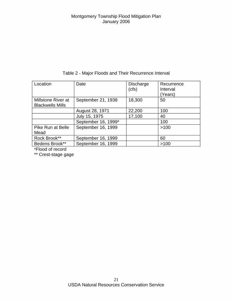
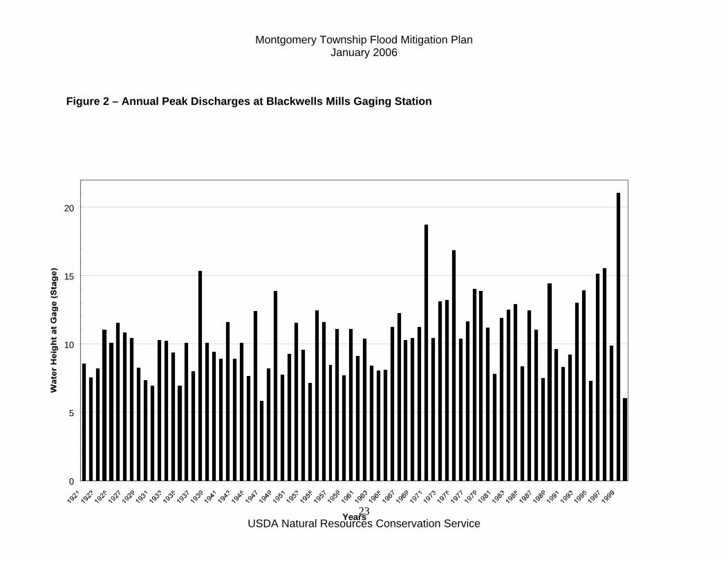
Principal Flood Problems Past history of flooding on the streams within the Township indicates that flooding may occur during any season of the year. The majority of major flood events has occurred during June, July, August, and September and is usually the result of thunderstorms or tropical storms. There have been a number of major floods in the Raritan River Basin during the last hundred years. The seven highest floods of record occurred in September 1882, February 1896, September 1938, August 1955, August 1971, July 1975 and September 1999. The estimated return period associated with these floods varies from 10 years to over 100 years. The flood of September 16-17, 1999, caused by Hurricane Floyd, was the highest of these floods. Its estimated return period was just over 100 years for the Millstone River, and was over 100 years for Bedens and Pike Run. Table 2 shows the major floods and their recurrence interval.
Montgomery Township Flood Mitigation Plan January 2006
USDA Natural Resources Conservation Service
20
Montgomery Township Flood Mitigation Plan January 2006
USDA Natural Resources Conservation Service
21
Table 2 - Major Floods and Their Recurrence Interval
Location Date Discharge (cfs)
Recurrence Interval (Years)
Millstone River at Blackwells Mills
September 21, 1938 18,300 50
August 28, 1971 22,200 100 July 15, 1975 17,100 40 September 16, 1999* 100 Pike Run at Belle Mead
September 16, 1999 >100
Rock Brook** September 16, 1999 60 Bedens Brook** September 16, 1999 >100 *Flood of record ** Crest-stage gage
Montgomery Township Flood Mitigation Plan January 2006
USDA Natural Resources Conservation Service
22
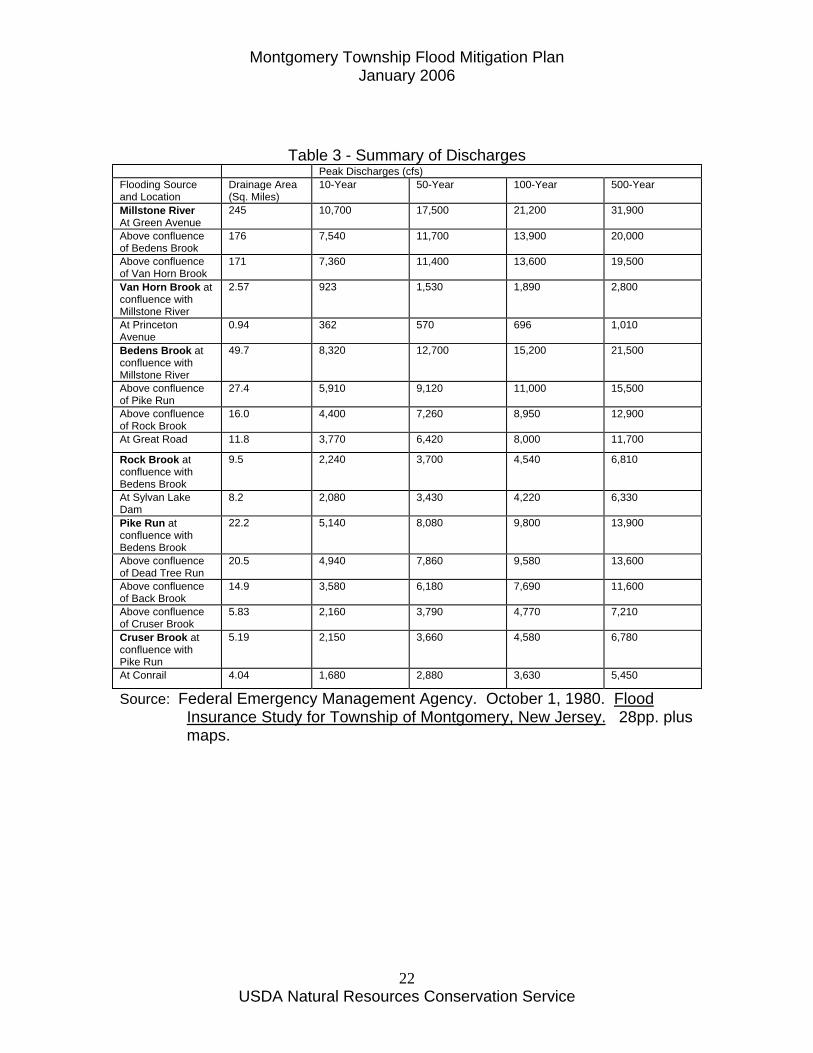
Table 3 - Summary of Discharges Peak Discharges (cfs) Flooding Source and Location
Drainage Area (Sq. Miles)
10-Year 50-Year 100-Year 500-Year
Millstone River At Green Avenue
245 10,700 17,500 21,200 31,900
Above confluence of Bedens Brook
176 7,540 11,700 13,900 20,000
Above confluence of Van Horn Brook
171 7,360 11,400 13,600 19,500
Van Horn Brook at confluence with Millstone River
2.57 923 1,530 1,890 2,800
At Princeton Avenue
0.94 362 570 696 1,010
Bedens Brook at confluence with Millstone River
49.7 8,320 12,700 15,200 21,500
Above confluence of Pike Run
27.4 5,910 9,120 11,000 15,500
Above confluence of Rock Brook
16.0 4,400 7,260 8,950 12,900
At Great Road 11.8 3,770 6,420 8,000 11,700
Rock Brook at confluence with Bedens Brook
9.5 2,240 3,700 4,540 6,810
At Sylvan Lake Dam
8.2 2,080 3,430 4,220 6,330
Pike Run at confluence with Bedens Brook
22.2 5,140 8,080 9,800 13,900
Above confluence of Dead Tree Run
20.5 4,940 7,860 9,580 13,600
Above confluence of Back Brook
14.9 3,580 6,180 7,690 11,600
Above confluence of Cruser Brook
5.83 2,160 3,790 4,770 7,210
Cruser Brook at confluence with Pike Run
5.19 2,150 3,660 4,580 6,780
At Conrail 4.04 1,680 2,880 3,630 5,450
Source: Federal Emergency Management Agency. October 1, 1980. Flood Insurance Study for Township of Montgomery, New Jersey. 28pp. plus maps.
Montgomery Township Flood Mitigation Plan January 2006
USDA Natural Resources Conservation Service
23
Figure 2 – Annual Peak Discharges at Blackwells Mills Gaging Station
0
5
10
15
20
Years

Montgomery Township Flood Mitigation Plan January 2006
USDA Natural Resources Conservation Service
24

Montgomery Township Flood Mitigation Plan January 2006
USDA Natural Resources Conservation Service
25

Montgomery Township Flood Mitigation Plan January 2006
USDA Natural Resources Conservation Service
26
Figures 3, 4, and 5 show the location, dollar value and frequency of flood damages relative to the major watersheds (Cruser Brook, Pike Run, Rock Brook, Bedens Brook and Van Horn Brook) within the Township.
Montgomery Township Flood Mitigation Plan January 2006
USDA Natural Resources Conservation Service
27
Figure 3 – Location of Reported Flood Damages

Montgomery Township Flood Mitigation Plan January 2006
USDA Natural Resources Conservation Service
28

Montgomery Township Flood Mitigation Plan January 2006
USDA Natural Resources Conservation Service
29
Figure 4 – Dollar Value of Reported Flood Damages

Montgomery Township Flood Mitigation Plan January 2006
USDA Natural Resources Conservation Service
30
Montgomery Township Flood Mitigation Plan January 2006
USDA Natural Resources Conservation Service
31
Figure 5 – Frequency of Flood Damages

Montgomery Township Flood Mitigation Plan January 2006
USDA Natural Resources Conservation Service
32

Montgomery Township Flood Mitigation Plan January 2006
USDA Natural Resources Conservation Service
33
Flood Prone Areas Map
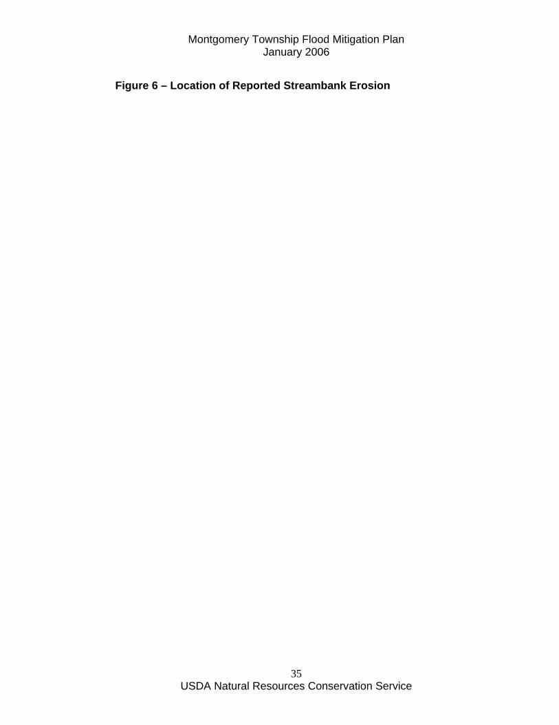
Description of Other Natural Hazards Flooding represents the primary natural hazard for Montgomery residents. Soil erosion is also a natural hazard in Montgomery Township. Approximately a dozen of the 181 respondents to the survey questionnaire reported soil erosion was a problem on their property. Soil erosion was most often associated with that erosion occurring due to streambank erosion. The streambank erosion was often made worse during flood events. Figure 6 shows the location of the reported streambank erosion.

Montgomery Township Flood Mitigation Plan January 2006
USDA Natural Resources Conservation Service
34
Montgomery Township Flood Mitigation Plan January 2006
USDA Natural Resources Conservation Service
35
Figure 6 – Location of Reported Streambank Erosion

Montgomery Township Flood Mitigation Plan January 2006
USDA Natural Resources Conservation Service
36
Montgomery Township Flood Mitigation Plan January 2006
USDA Natural Resources Conservation Service
37
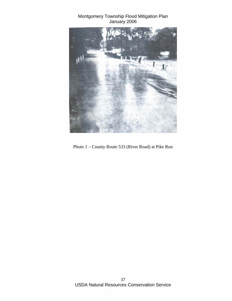
Photo 1 – County Route 533 (River Road) at Pike Run

Montgomery Township Flood Mitigation Plan January 2006
USDA Natural Resources Conservation Service
38
Photo 2 – September 17, 1999 Flood at Long House on Griggstown Causeway
Montgomery Township Flood Mitigation Plan January 2006
USDA Natural Resources Conservation Service
39
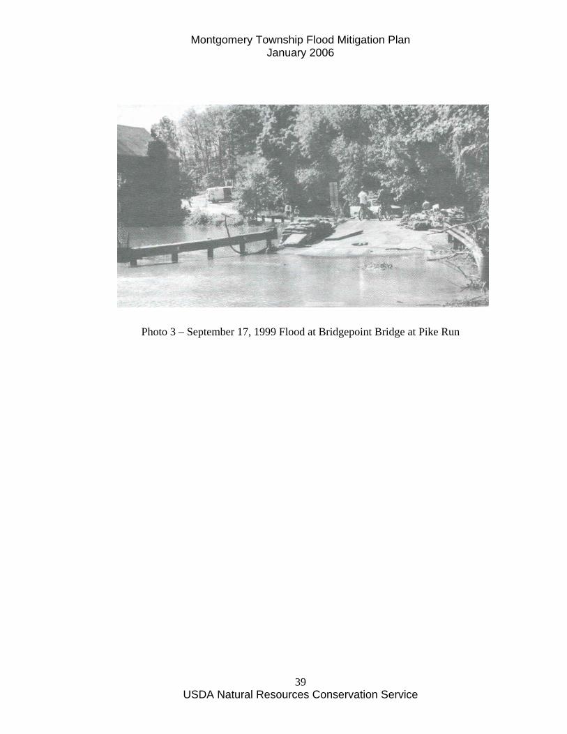
Photo 3 – September 17, 1999 Flood at Bridgepoint Bridge at Pike Run
Montgomery Township Flood Mitigation Plan January 2006
USDA Natural Resources Conservation Service
40
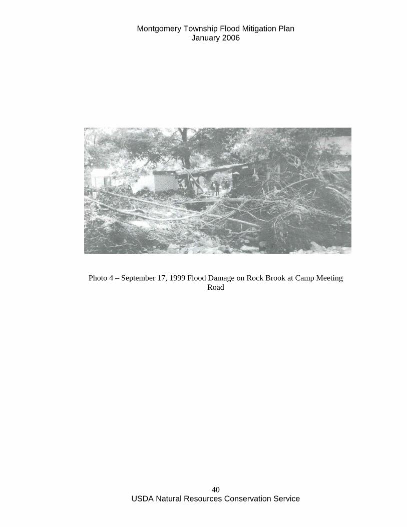
Photo 4 – September 17, 1999 Flood Damage on Rock Brook at Camp Meeting Road
Montgomery Township Flood Mitigation Plan January 2006
USDA Natural Resources Conservation Service
41
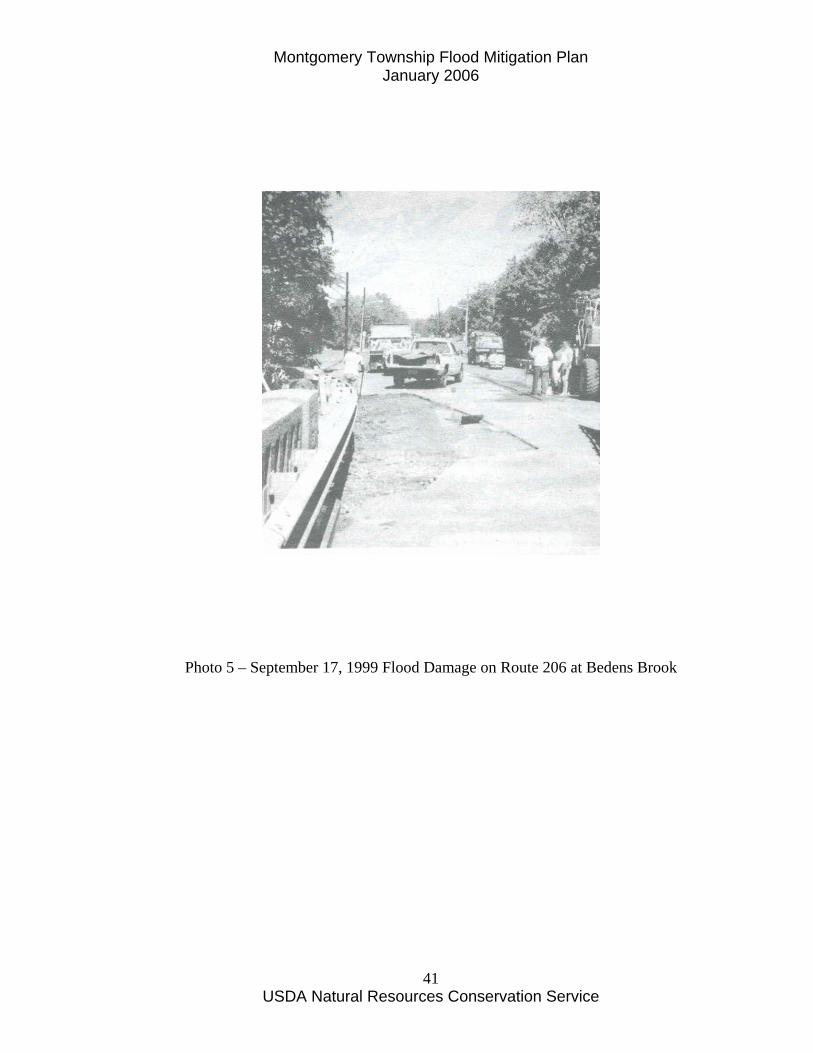
Photo 5 – September 17, 1999 Flood Damage on Route 206 at Bedens Brook

Montgomery Township Flood Mitigation Plan January 2006
USDA Natural Resources Conservation Service
42
Photo 6 – Tornquist’s Store (now Griggstown Canoe Rental) August 27-28, 1971 (Hurricane Doria) Flood
Montgomery Township Flood Mitigation Plan January 2006
USDA Natural Resources Conservation Service
43
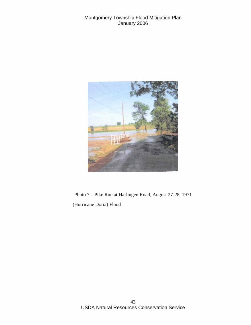
Photo 7 – Pike Run at Harlingen Road, August 27-28, 1971
(Hurricane Doria) Flood
Montgomery Township Flood Mitigation Plan January 2006
USDA Natural Resources Conservation Service
44
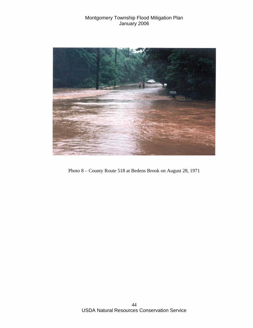
Photo 8 – County Route 518 at Bedens Brook on August 28, 1971
Montgomery Township Flood Mitigation Plan January 2006
USDA Natural Resources Conservation Service
45
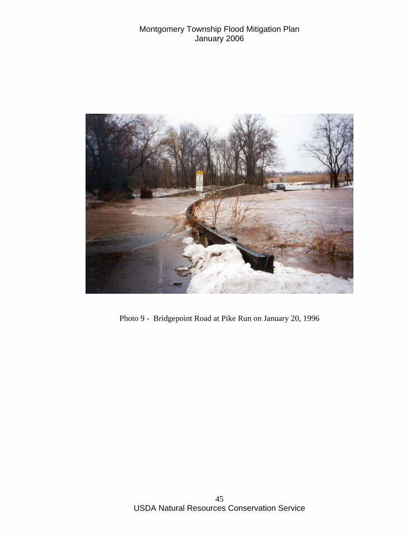
Photo 9 - Bridgepoint Road at Pike Run on January 20, 1996
Montgomery Township Flood Mitigation Plan January 2006
USDA Natural Resources Conservation Service
46
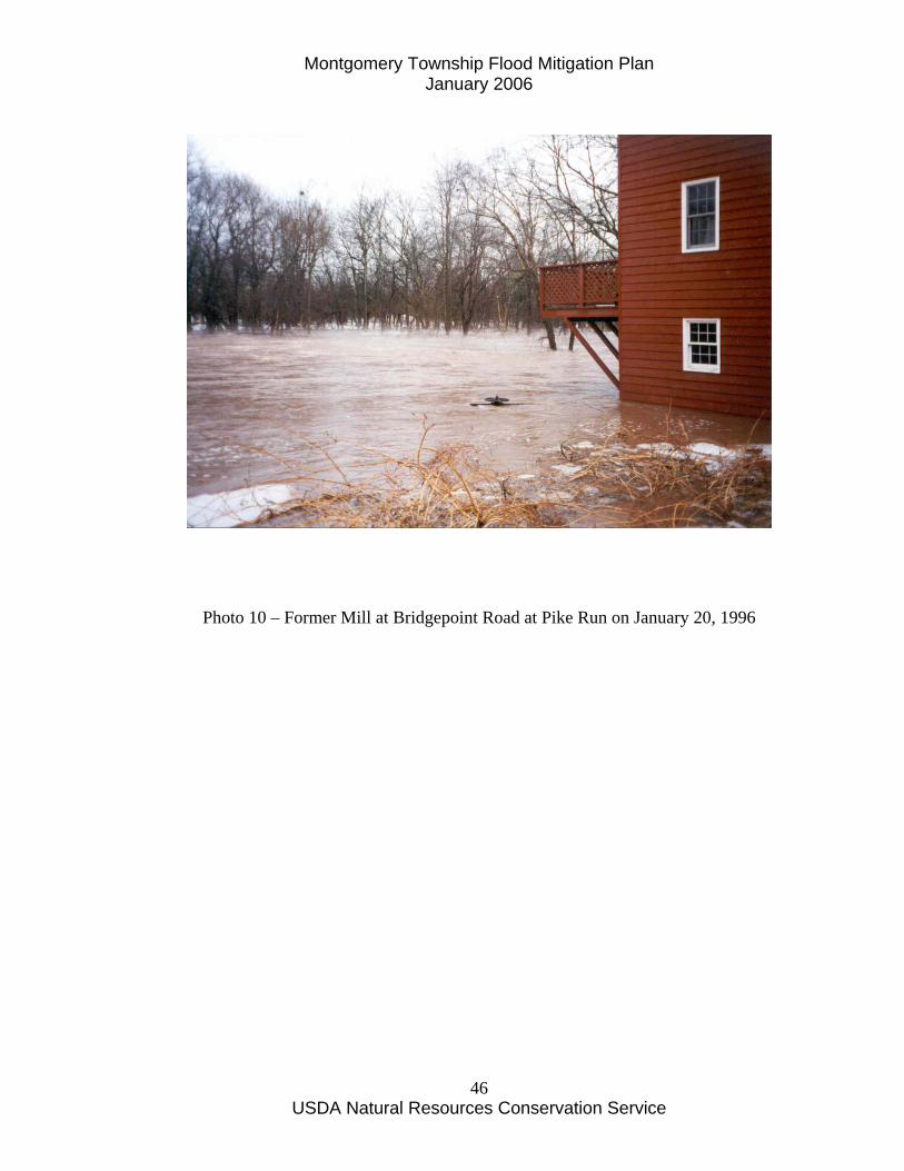
Photo 10 – Former Mill at Bridgepoint Road at Pike Run on January 20, 1996
Montgomery Township Flood Mitigation Plan January 2006
USDA Natural Resources Conservation Service
47
Section E – Assessing the Problem Repetitive Flood Losses Repetitive flood losses are those where two or more National Flood Insurance Program claims have been made for the same property during the 1977-2003 period. By this strict definition, there are three structures in the Township have been identified as having repetitive losses (Rizzo, 2004). The specific location of structures is private information and on file. One of these properties, following Hurricane Floyd flooding in September 1999, was elevated by the property owner. The repetitive flood loss areas in the Township are shown in Figure 7. There may be other structures which have had repeated flood losses but may not have had flood insurance and so are not recorded in the database of National Flood Insurance Program claims. A primary goal of this Flood Mitigation Plan is to reduce or eliminate the repetitive flood loss claims for these properties.
Affected Structures The Natural Resources Conservation Service surveyed the first floor, low opening and adjacent ground elevations for structures along Millstone River Road which includes structures affected by the Millstone River and the lower Bedens Brook. The purpose of the survey was to determine the vulnerability to flooding for each structure and to permit an assessment of the mitigation measures for each structure that would be cost- effective. Table 4 presents a summary of the number and types of property that are vulnerable to flooding (in the Millstone River and lower Bedens Brook vicinity) as defined by the 100, 50, and 2 year flood events by the 1980 FEMA Flood Insurance study for Montgomery Township. It should be pointed out that there are a significant number of structures which have been and continue to be affected by historic flooding throughout the Township but are not considered to be repetitive flood losses. These properties may not be considered to be repetitive flood loss properties for several reasons including:
1. Previous owner did not carry flood insurance 2. Previous flooding occurred prior to the existence of the National
Flood Insurance Program These properties occur adjacent to Bedens Brook, Dead Tree Run, Pike Run and Rock Brook. The historic flood loss areas are shown in Figure 7.
Montgomery Township Flood Mitigation Plan January 2006
USDA Natural Resources Conservation Service
48
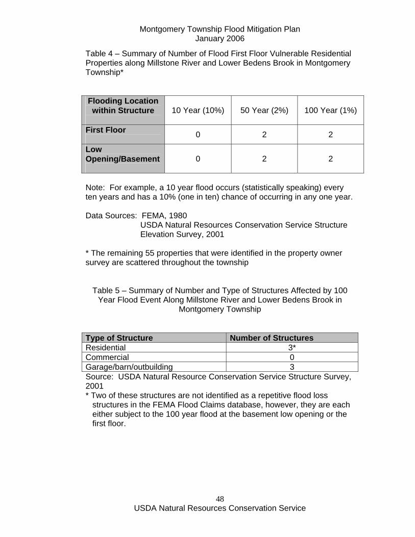
Table 4 – Summary of Number of Flood First Floor Vulnerable Residential Properties along Millstone River and Lower Bedens Brook in Montgomery Township* Flooding Location within Structure
10 Year (10%) 50 Year (2%) 100 Year (1%)
First Floor 0 2 2
Low Opening/Basement
0 2 2
Note: For example, a 10 year flood occurs (statistically speaking) every ten years and has a 10% (one in ten) chance of occurring in any one year. Data Sources: FEMA, 1980 USDA Natural Resources Conservation Service Structure Elevation Survey, 2001 * The remaining 55 properties that were identified in the property owner survey are scattered throughout the township
Table 5 – Summary of Number and Type of Structures Affected by 100 Year Flood Event Along Millstone River and Lower Bedens Brook in
Montgomery Township Type of Structure Number of Structures Residential 3* Commercial 0 Garage/barn/outbuilding 3 Source: USDA Natural Resource Conservation Service Structure Survey, 2001 * Two of these structures are not identified as a repetitive flood loss structures in the FEMA Flood Claims database, however, they are each either subject to the 100 year flood at the basement low opening or the first floor.
Montgomery Township Flood Mitigation Plan January 2006
USDA Natural Resources Conservation Service
49
Figure 7 – Repetitive Flood Loss and Historic Flood Loss Areas

Montgomery Township Flood Mitigation Plan January 2006
USDA Natural Resources Conservation Service
50
Montgomery Township Flood Mitigation Plan January 2006
USDA Natural Resources Conservation Service
51
Description and Impact of Flooding Montgomery Township is estimated to have a 100 percent participation rate in the National Flood Insurance Program. The rate of participation was derived by dividing the number of policies in force by the number of residential and commercial structures reported as being located in the Special Flood Hazard Area (SFHA) of the municipality. As of 2004, Montgomery Township had 68 insurance policies in force, representing $16,655,400 in coverage (Rizzo, 2004). Since 1978, there have been 29 paid losses totaling $542,042 claims paid. The National Flood Insurance Program (NFIP) claims filed between 1978 and 1999 show that Montgomery Township had the fourth highest dollars of flood damage claims filed in the 26 municipalities in the Millstone River watershed. There are three repetitive loss structures in Montgomery Township (Rizzo, 2004). Past flooding has had an impact on buildings as shown in Table 5. Flooding has had a major impact on Millstone River roadway crossings, including the Griggstown Causeway which is in Montgomery and Franklin Townships. This causeway is closed an average of six to eight times per year for periods of up to three days. This causes major traffic dislocation and costs to commuters and others who have to take a different route to their place of employment. During severe flooding periods at least two of the major, heavily used north and south routes (Route 206 and Route 533/River Road) through the Township can be closed due to flooding over the roadway. This can pose severe safety hazards to motorists who attempt to use flooded roadways.
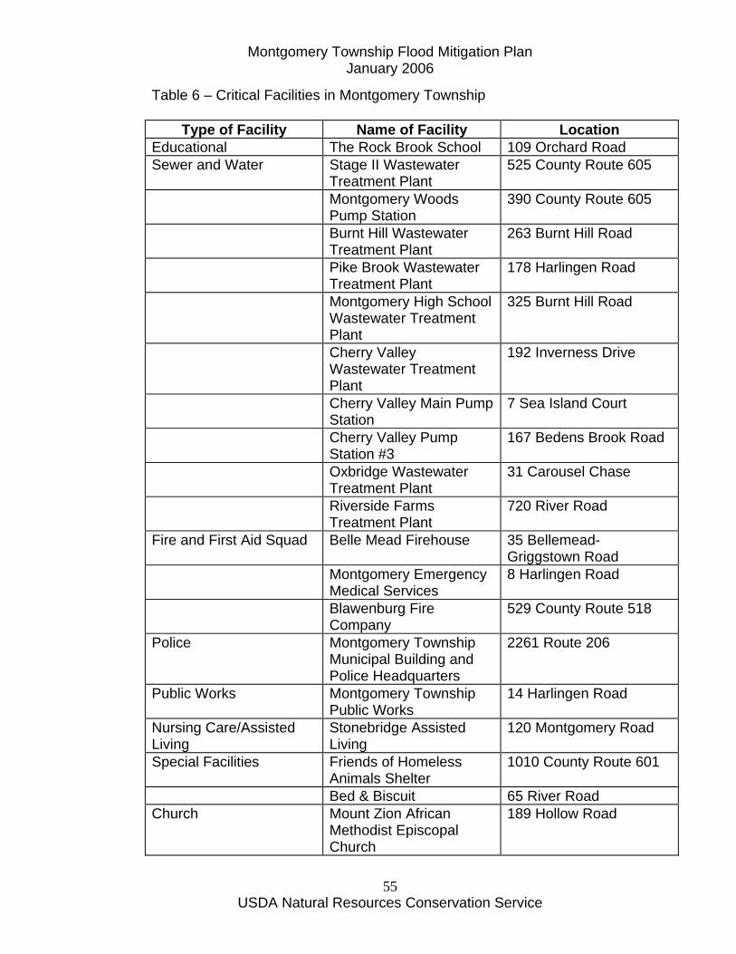
Critical Facilities in Plan Area Critical facilities are those facilities that are essential for community functions. These include schools, nursing homes, fire stations, sewer and water treatment facilities, post office and other essential structures. Figure 8 shows the location of these critical facilities and Table 5 lists these facilities.

Montgomery Township Flood Mitigation Plan January 2006
USDA Natural Resources Conservation Service
52
Montgomery Township Flood Mitigation Plan January 2006
USDA Natural Resources Conservation Service
53
Figure 8 – Critical Facilities in Montgomery Township

Montgomery Township Flood Mitigation Plan January 2006
USDA Natural Resources Conservation Service
54
Montgomery Township Flood Mitigation Plan January 2006
USDA Natural Resources Conservation Service
55
Table 6 – Critical Facilities in Montgomery Township
Type of Facility Name of Facility Location Educational The Rock Brook School 109 Orchard Road Sewer and Water Stage II Wastewater
Treatment Plant 525 County Route 605
Montgomery Woods Pump Station
390 County Route 605
Burnt Hill Wastewater Treatment Plant
263 Burnt Hill Road
Pike Brook Wastewater Treatment Plant
178 Harlingen Road
Montgomery High School Wastewater Treatment Plant
325 Burnt Hill Road
Cherry Valley Wastewater Treatment Plant
192 Inverness Drive
Cherry Valley Main Pump Station
7 Sea Island Court
Cherry Valley Pump Station #3
167 Bedens Brook Road
Oxbridge Wastewater Treatment Plant
31 Carousel Chase
Riverside Farms Treatment Plant
720 River Road
Fire and First Aid Squad Belle Mead Firehouse 35 Bellemead-Griggstown Road
Montgomery Emergency Medical Services
8 Harlingen Road
Blawenburg Fire Company
529 County Route 518
Police Montgomery Township Municipal Building and Police Headquarters
2261 Route 206
Public Works Montgomery Township Public Works
14 Harlingen Road
Nursing Care/Assisted Living
Stonebridge Assisted Living
120 Montgomery Road
Special Facilities Friends of Homeless Animals Shelter
1010 County Route 601
Bed & Biscuit 65 River Road Church Mount Zion African
Methodist Episcopal Church
189 Hollow Road
Montgomery Township Flood Mitigation Plan January 2006
USDA Natural Resources Conservation Service
56
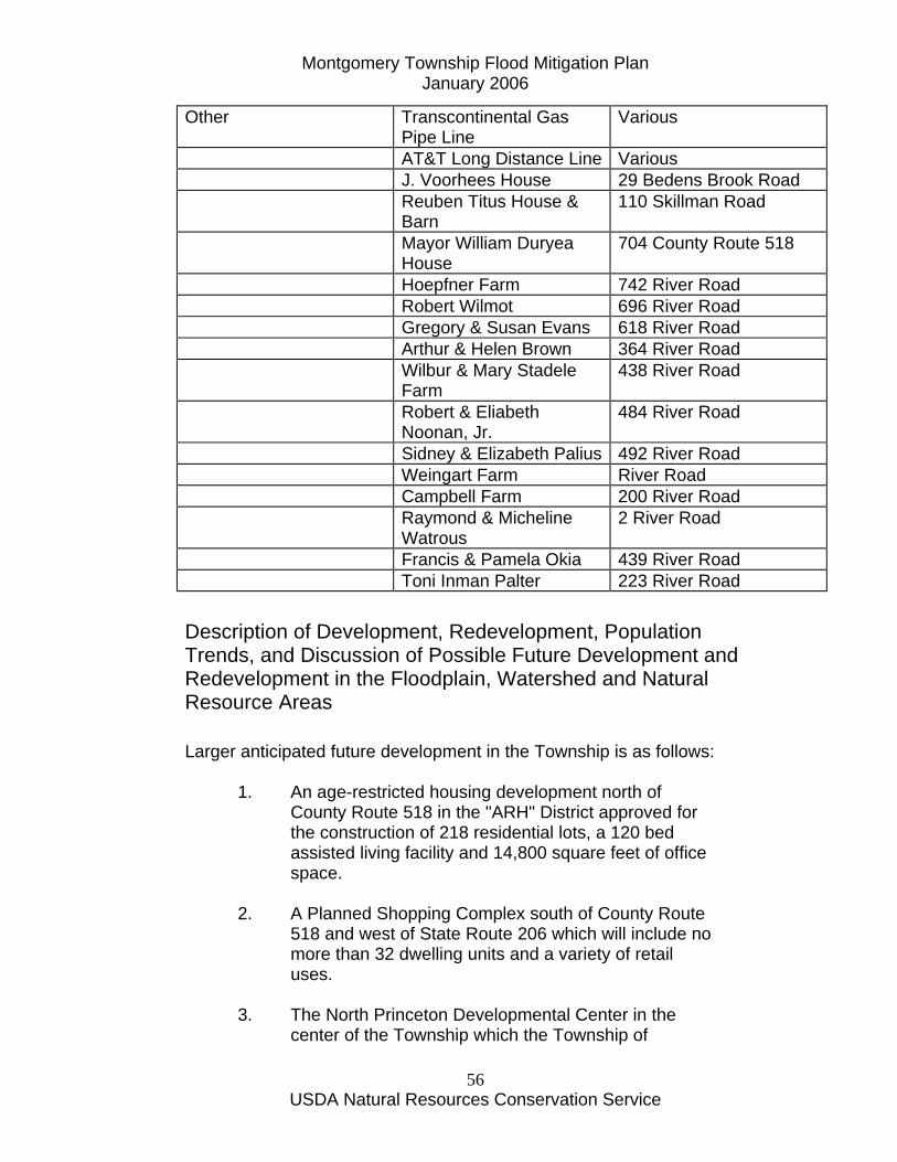
Other Transcontinental Gas Pipe Line
Various
AT&T Long Distance Line Various J. Voorhees House 29 Bedens Brook Road Reuben Titus House &
Barn 110 Skillman Road
Mayor William Duryea House
704 County Route 518
Hoepfner Farm 742 River Road Robert Wilmot 696 River Road Gregory & Susan Evans 618 River Road Arthur & Helen Brown 364 River Road Wilbur & Mary Stadele
Farm 438 River Road
Robert & Eliabeth Noonan, Jr.
484 River Road
Sidney & Elizabeth Palius 492 River Road Weingart Farm River Road Campbell Farm 200 River Road Raymond & Micheline
Watrous 2 River Road
Francis & Pamela Okia 439 River Road Toni Inman Palter 223 River Road
Description of Development, Redevelopment, Population Trends, and Discussion of Possible Future Development and Redevelopment in the Floodplain, Watershed and Natural Resource Areas Larger anticipated future development in the Township is as follows:
1. An age-restricted housing development north of County Route 518 in the "ARH" District approved for the construction of 218 residential lots, a 120 bed assisted living facility and 14,800 square feet of office space.
2. A Planned Shopping Complex south of County Route
518 and west of State Route 206 which will include no more than 32 dwelling units and a variety of retail uses.
3. The North Princeton Developmental Center in the
center of the Township which the Township of
Montgomery Township Flood Mitigation Plan January 2006
USDA Natural Resources Conservation Service
57
Montgomery is acquiring from the State of New Jersey for future redevelopment.
4. Lands owned by the Carrier Clinic on Mountain Road
and Trent Place; lands owned by Belle Mead Development Corporation on Trent Place and on State Route 206 in the Belle Mead node of the Township; and lands owned by Bloomberg south of County Route 518.
Any development in Montgomery Township is subject to a "Critical Areas" ordinance which, in part, regulates activities within the Township stream corridors. All waterways identified in the Township are depicted on a Hydrography Map and are subject to the imposition of a stream corridor, which is defined as:
"The area within a floodway, flood plain, flood hazard area, buffer strips one hundred (100) feet from the top of the channel banks of the stream, intermittent stream and/or state open water, and the area that extends one hundred (100) feet from the one hundred flood hazard line on both sides of the stream. If there is no one hundred year flood hazard line delineated, the distance of one hundred (100) feet shall be measured outward from the top of the banks of the stream channel on both sides of the stream, intermittent stream and/or state open water. If slopes greater than 15% abut the outer boundary of the stream corridor, the area of such slopes shall also be included as the stream corridor. If the flood plain or flood hazard area extends for more than one hundred (100) feet from the top of the channel bank, said larger area shall be the stream corridor."
Stream corridor and "critical areas" protection is of vital importance in Montgomery Township. Essentially, development is prohibited in these areas, except for certain agricultural and undeveloped recreational uses. When relief is granted from the stream corridor requirements where no possible alternative exists, an averaging at a two to one ratio of the stream corridor and a rehabilitation/reforestation plan is required.
Montgomery Township Flood Mitigation Plan January 2006
USDA Natural Resources Conservation Service
58
Beneficial Function Areas Montgomery Township has many patches of natural areas which provide diverse ecological functions and societal values to the community, including passive recreation, habitat for wildlife, plant biodiversity, runoff reduction, and floodwater storage. Forested areas and wetlands in watersheds improve water quality by intercepting rain water and reducing runoff, storing floodwaters for slower release, storing and cycling nutrients, removing some pollutants, providing shade and more stable temperatures for aquatic organisms, and increasing biological diversity and organic food bases for downstream species communities. Figure _ displays Suitable Habitat locations within Montgomery Township. The GIS data in Figure 9 were obtained from the NJ DEP “Landscape Project” Version 2 dataset. The data combine information on rare species occurrences with land use/land cover classification to provide a tool for planning habitat protection strategies. Most of the important ecological functions tend to occur in the areas depicted on the map, although some smaller habitat patches may not have been captured because of the relatively large scale (1: 12,000) of the mapping process. The Landscape Project criteria apply a set of ratings to each habitat patch. These ratings range from 1 to 5, and indicate not only whether the patch is suitable for the types of wildlife species often found in that habitat, but also whether or not threatened or endangered species have been observed in that patch. Additional ratings points are given based upon whether a species is listed as state threatened, state endangered, federally threatened or federally endangered. For the purposes of this document, we aggregated all 5 classes to produce a “general” map of habitat suitability. More specific information can be obtained from the NJ DEP Landscape Project web page: http://www.state.nj.us/dep/fgw/ensp/landscape/ The table below summarizes the approximate acreages in each of four habitat classes. Most areas classified as forested wetland wildlife habitat are also classified as forest wildlife habitat. Therefore, the total area mapped as suitable habitat would be approximately 11,700 acres, or about 56 percent of the total land area within the township. The Landscape Project data were compiled based upon landuse/landcover data derived from 1995 air photos. Many changes in the landscape may have occurred since that time.
Montgomery Township Flood Mitigation Plan January 2006
USDA Natural Resources Conservation Service
59
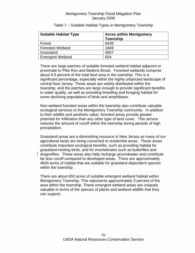
Table 7 – Suitable Habitat Types in Montgomery Township Suitable Habitat Type Acres within Montgomery
Township Forest 6439 Forested Wetland 1849 Grassland 4607 Emergent Wetland 654 There are large patches of suitable forested wetland habitat adjacent or proximate to Pike Run and Bedens Brook. Forested wetlands comprise about 8.9 percent of the total land area in the township. This is a significant percentage, especially within the highly urbanized landscape of central New Jersey. These areas are widely distributed within the township, and the patches are large enough to provide significant benefits to water quality, as well as providing breeding and foraging habitat for some declining populations of birds and amphibians. Non-wetland forested areas within the township also contribute valuable ecological services to the Montgomery Township community. In addition to their wildlife and aesthetic value, forested areas provide greater potential for infiltration than any other type of land cover. This service reduces the amount of runoff within the township during periods of high precipitation. Grassland areas are a diminishing resource in New Jersey as many of our agricultural lands are being converted to residential areas. These areas contribute important ecological benefits, such as providing habitat for grassland-nesting birds, and for invertebrates such as butterflies and dragonflies. These areas also help recharge groundwater and contribute far less runoff compared to developed areas. There are approximately 4600 acres of habitat that are suitable for grassland dependent species within the township. There are about 650 acres of suitable emergent wetland habitat within Montgomery Township. This represents approximately 3 percent of the area within the township. These emergent wetland areas are uniquely valuable in terms of the species of plants and wetland wildlife that they can support.

Montgomery Township Flood Mitigation Plan January 2006
USDA Natural Resources Conservation Service
60
Figure 9 – Montgomery Township Beneficial Functions Map
Montgomery Township Flood Mitigation Plan January 2006
USDA Natural Resources Conservation Service
61

Montgomery Township Flood Mitigation Plan January 2006
USDA Natural Resources Conservation Service
62
Impact of Flooding The economic impact of flooding in Montgomery Township has not been assessed previously. An economic assessment of Hurricane Floyd damages was done for New Jersey with specific references to Manville and Bound Brook (EDA/FEMA, 2000). However, a summary of the Preliminary Damage Assessment Report describing flood damages following Hurricane Floyd flooding is shown in the Appendix.
Existing Flood Protection Measures There are no structural flood protection measures in Montgomery, except for some small ponds. Regulations to control the use and development of the flood plains of Bedens Brook and the Millstone River as delineated in flood hazard reports for these two streams were enacted in 1975 by the New Jersey Water Policy and Supply Council (New Jersey, 1973; New Jersey, 1973a) The Township has an ordinance (see Appendix) which restricts new development in flood plain areas in accordance with FEMA regulations.
Procedures for Warning and Evacuating Residents and Visitors The Twp. has identified structures at-risk for flooding as a result of our Pre-Disaster Mitigation Planning process. Those structures at greatest risk have been plotted on the Twp.'s GIS system, and as such, can be readily notified by OEM officials of an impending flood event. Property owners may be notified in a combination of ways, including the Somerset County Flood Information System (SCFIS) available via internet or FAX distribution. Notification may also be accomplished via loudspeaker equipped emergency service vehicles deployed to effected areas and the New Jersey State Police Reverse 911 system. Through its Local Emergency Planning Council (LEPC) the Twp. OEM encourages all residents to be aware of impending hazardous weather by monitoring relevant sources. One Twp. Fire Co. maintains a swift water rescue boat and a cadre swift-water rescue trained fire fighters that can be deployed for evacuation and rescue purposes. Oversize Twp. Dept. of Public Works vehicles are available to assist in evacuation measures if necessary. The Twp. is
Montgomery Township Flood Mitigation Plan January 2006
USDA Natural Resources Conservation Service
63
exploring the feasibility of erecting electronic sign boards for the purpose of diverting traffic away from flooded highways to avert vehicle loss and prevent drowning. The Twp. is expected to endorse the NWS "Turn Around - Don't Drown" campaign, erecting program signs at appropriate locations. The Twp. OEM continuously monitors multiple sources for hazardous weather information in anticipation of required responses including: *NOAA Weather Radio *New Jersey Law Enforcement Telecommunications Network (NJLETS) *AWS Weather Bug *The Weather Channel *SCFIS
Section F – Set Goals The November 1971 Master Plan for the Township gives the following goals for flood plain preservation:
• To anticipate increased surface water runoff due to the construction of more roads and roofs;
• To create greenways serving as neighborhood dividers and visual breaks to encourage the continuation of the rural atmosphere;
• To create rambling open space, portions of which can be developed for active recreational uses to serve the expected population growth;
• To preserve natural drainage course where sanitary sewer collection systems can be located; and
• To create areas where small dams may be constructed in the future to create small lakes and reservoirs serving as sources of water for fire fighting purposes as well as flood control, recreation, water recharge of underground aquifers, and increased aesthetics.
The November 2001 Reexamination Report of the Township of Montgomery Master Plan shows under Goal and Objective Number 3 that The Development Plan should recognize the physical characteristics of the Township of Montgomery and acknowledge the inherent capabilities and limitations of the land to host different types of community development at appropriate densities and intensities. Conservation of the existing natural resources with the Township should be an integral part of the planning process, with special attention to the constraints of

Montgomery Township Flood Mitigation Plan January 2006
USDA Natural Resources Conservation Service
64
environmentally critical and sensitive areas including, but not limited to, wetlands, wetlands transition areas, aquatic buffer zones, stream corridors, 100-year flood plains and lands with topographic slope of fifteen percent (15%) or greater.
Section G – Review of Possible Activities Past and ongoing activities taken by the Township of Montgomery have included emergency response during major flood events and rerouting of traffic within and through the Township. At least one private property owner, with some assistance of FEMA following Hurricane Floyd flooding, has elevated their structure above the 100 year flood elevation along Bedens Brook. Future activities will include on a Township study of Township-owned detention basins in 2005. Montgomery Township will be developing a municipal stormwater management plan as part of the Phase II requirements for stormwater.
Section H – Implementation of an Action Plan The Montgomery Township Flood Mitigation Committee recommends that Montgomery Township and other entities, including State and County government, shall implement the activities as shown in Table 7. Recommendations are prioritized by the number shown for the four major categories and actions within each category are also prioritized. Financing of each action will be through municipal budgeting over time and grant applications from available funding sources (Nieman, 2005). Funding will be sought from a variety of sources including FEMA Flood Mitigation Planning Project Grants (75 percent FEMA, 25 percent local funding) resulting from this Plan development.
Recommendations
I. Evacuation Route Enhancement 1. Conduct a study to identify potential improvement in traffic flow and/or Alternate (other than major routes such as State Route 206, County Route Routes 533 and 601) and provide signage to direct traffic to these routes and away from the flooding vicinity. 2. Install electronic warning signage at key locations. One example of this effort would be along State Route 206 (tied into the County Flood
Montgomery Township Flood Mitigation Plan January 2006
USDA Natural Resources Conservation Service
65
Information System) to direct traffic away from flooding vicinity. Signage should be located at Belle Mead – Griggstown Road, Willow Road and River Road intersections with State Route 206. The Township should install signage following the “Turn Around Don’t Drown” NOAA campaign. 3. Montgomery Township should work with the State of New Jersey to Enhance the reliability of the use of State Route 206 for flood evacuation and movement of traffic within and through Montgomery Township.
II. Incorporation of Flood Mitigation Planning into Local
Ordinances and Master Planning 1. Revise Flood Damage Prevention Ordinance as per recommended changes (See Appendix). Also, incorporate a provision to give the Township first option to purchase flood damaged properties following a flooding event in cooperation with Green Acres, D&R Greenways and other funding sources. 2. Identify the Bedens Brook Corridor as a “Potential Future Greenway” in the Township Master Plan Conservation Plan to encourage future open space acquisition in flood-prone areas. 3. Identify and train the local flood plain manager, planning director, building code/zoning official, and engineer regarding the Flood Damage Prevention Ordinance. 4. Identify and incorporate the FEMA Flood Insurance Study Flood Zone boundaries (and future amendments) as an overlay zone in the Township Zoning ordinance. The Flood Zone overlay would add additional regulations to the underlying residential or commercial zoning. Township would have first option to buyout any property within the flood zone that has been substantially damaged in a flood.
Montgomery Township Flood Mitigation Plan January 2006
USDA Natural Resources Conservation Service
66
5. Incorporation of Disaster Mitigation Planning in Master Plan The Township should include disaster mitigation planning as an element in its Master Plan. The Flood Mitigation Plan should be incorporated by reference into the Township Master Plan. 6. Request that the State place Montgomery Township on its priority list for redevelopment of the hydrology and hydraulics (so as to reflect current conditions) so as to update the Township Flood Insurance Study.
III. Private Property Flood and other Natural Hazard (Erosion)
Mitigation 1. Identification of Funding Sources Financing of each action will be through municipal budgeting over time and grant applications from available funding sources (Nieman, 2005). 2. Conduct Property Owner Survey Conduct property owner survey of those flood-prone properties to determine the level of interest in pursuing funding, implementing flood mitigation measures, and other property information (eg. underground storage tanks) 3. Implement Flood Mitigation Measures The Township should work with willing property owners who have had two or more claims against the National Flood Insurance Program for flood losses to implement measures. Measures include alternatives such as elevation of a structure, relocation of a structure, buyout and removal of the structure from the flood zone. a. Elevation This option would entail the in-place elevation of existing flood-prone buildings and would require the construction of new, stronger foundations. This option is effective for minimizing flood-related damages. Elevation of structures could still be eligible for listing in the National Register of Historic Places if elevation work included the recreation of the original grading, landscaping, and other elements so that they approximate their original scale and setting. Elevation of

Montgomery Township Flood Mitigation Plan January 2006
USDA Natural Resources Conservation Service
67
structures which are currently subject to first floor flooding during flood events up to and including the 100 year (1%) flood is recommended where the property owners have an interest. Elevation of a structure would involve the raising of the structure so that the first floor has one foot of freeboard (base flood elevation below the first floor joists) above the base flood elevation or 1% or 100 year flood. Estimated costs for elevation, including egress to high ground, range from $69,000 to $204,700 with typical costs being approximately $115,950 per structure (FEMA). b. Relocation This option would result in the relocation of flood-prone structures out of the floodplain. This option is highly effective in reducing potential harm from flooding. Relocation of structures is recommended where the property owner currently has property at a higher elevation to which the structure or structures can be moved. Participation by individual property owners would be voluntary. c. Acquisition and Demolition (Buyout) This option would include the demolition of flood-prone structures, leaving the property in “open space” usage. Demolition would remove affected properties completely out of the path of future flooding, eliminating future disaster costs. Purchase of structures is recommended where frequently flooding and flooding to depths that are not feasible for other measures and where the property owners have an interest. Purchased structures would be demolished and the property would become deed-restricted so that no future development could occur on the site. 4. Township Develop a Property Owner Information Sheet for Streambank Erosion The Township should work with Somerset-Union Soil Conservation District to develop a property owner’s information sheet with information on sources of technical and financial assistance for streambank erosion control as well as identification of the regulations and necessary permits to implement measures to control streambank erosion. The Township, as its contribution to this private property owner effort, should help obtain necessary permits for work to proceed.

Montgomery Township Flood Mitigation Plan January 2006
USDA Natural Resources Conservation Service
68
5. Identify Emergency Funding Sources and Incorporate into Township Emergency Response Plan The Township should have the Township Engineer and Emergency Management Coordinator become aware of and incorporate any emergency funding sources and their program contacts in Emergency Response Plans and other documentation. Examples of these programs include the NRCS Emergency Watershed Program for restoration of stream channels and protection of high value structures following a major natural disaster event, including flooding, that have left roadways, bridges and/or public/private structures in imminent jeopardy due to streambank erosion, etc. 6. Recommend that the Township apply for State Office of Emergency Management funding and/or Natural Resources Conservation Service PL83-566 project funding to implement various facets of this Plan.
IV. Public Participation 1. Public Information The Township should implement a program to inform their residents to the threats of flooding and the benefits of continuing flood insurance coverage (after mortgages are paid off) and direct them to the appropriate sources of assistance in this matter. Targeted mailings (using the GIS-generated list for the survey questionnaire), township newsletter, website and local newspapers will provide the necessary outreach to carry this out. This will involve working with area insurance agents to assure their input. 2. Community Rating System The Township, working through the Flood Mitigation Planning Committee in an ongoing manner, should implement measures to address one or more of the 18 activities in the Community Rating System to reduce or minimize property owner flood insurance premiums. 3. Pursue Funding Sources to Improve Public Understanding of the Extent and Nature of the Flood and Erosion Hazards

Montgomery Township Flood Mitigation Plan January 2006
USDA Natural Resources Conservation Service
69
V. Post-Disaster Mitigation Policies and Procedures The Township critiques its procedures employed after all flood events and seeks out sources of funding through appropriate channels to recover from and mitigate future losses. After the 1999 Hurricane Floyd flood event, the Township invested in additional equipment and training for its swift water rescue program. This program played a pivotal role during that event. The Township Stage II Waste Water Treatment Plant which incurred heavy damage after Floyd was equipped with watertight doors to diminish the likelihood of future floodwater invasion. The Township has undertaken all measures required thus far in compliance with the Pre-Disaster Mitigation Program in furtherance of our commitment to mitigate destruction from future flooding events.
Montgomery Township Flood Mitigation Plan January 2006
USDA Natural Resources Conservation Service
70
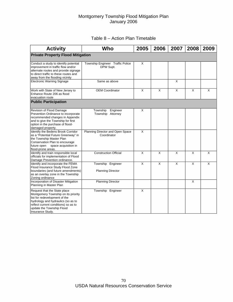
Table 8 – Action Plan Timetable
Activity Who 2005 2006 2007 2008 2009Private Property Flood Mitigation
Conduct a study to identify potential improvement in traffic flow and/or alternate routes and provide signage to direct traffic to these routes and away from the flooding vicinity
Township Engineer Traffic Police DPW Supt.
X
Electronic Warning Signage Same as above X
Work with State of New Jersey to Enhance Route 206 as flood evacuation route
OEM Coordinator X X X X X
Public Participation
Revision of Flood Damage Prevention Ordinance to incorporate recommended changes in Appendix and to give the Township for first option in the purchase of flood-damaged property.
Township Engineer Township Attorney
X
Identify the Bedens Brook Corridor as a “Potential Future Greenway” in the Township Master Plan Conservation Plan to encourage future open space acquisition in flood-prone areas.
Planning Director and Open Space Coordinator
X
Identify and train responsible local officials for implementation of Flood Damage Prevention ordinance.
Construction Official X X X X X
Identify and incorporate the FEMA Flood Insurance Study Flood Zone boundaries (and future amendments) as an overlay zone in the Township Zoning ordinance
Township Engineer
Planning Director
X X X X X
Incorporation of Disaster Mitigation Planning in Master Plan
Planning Director X
Request that the State place Montgomery Township on its priority list for redevelopment of the hydrology and hydraulics (so as to reflect current conditions) so as to update the Township Flood Insurance Study.
Township Engineer X

Montgomery Township Flood Mitigation Plan January 2006
USDA Natural Resources Conservation Service
71
Table 8 – Action Plan Timetable (Continued)
Activity Who 2005 2006 200
7 2008 200
9 Private Property Flood Mitigation Identification of Funding Sources OEM Coordinator
Grants Coordinator Planning Director
X X X
Property Owner Survey Public Information Officer X Implement Flood Mitigation Measures
Township Administrator X X
Develop Property Owner Information Sheet for Streambank Erosion
Township Engineer X
Identify Emergency Funding Sources and Incorporate into Township Emergency Response Plan
OEM Coordinator
Grants Coordinator
X
Apply for NJOEM funding to implement various facets of this Plan
OEM Coordinator X X X X X
Public Participation Public Information Public Information Officer X X X X X Community Rating System Township Engineer X X X X X Pursue Funding Sources to Educate Public
Grants Coordinator X X X X X
Each action will be financed by municipal budgeting over time and grant applications.
Section I – Plan Adoption This Flood Mitigation Plan was formally adopted by the Montgomery Township Committee at their meeting on September 15, 2005. A copy of the resolution is located in the Appendix. Formal certification by the Federal Emergency Management Agency occurred on December 21, 2005.
Montgomery Township Flood Mitigation Plan January 2006
USDA Natural Resources Conservation Service
72
Section J – Plan Monitoring and Evaluation The Montgomery Township Flood Mitigation Committee shall meet following the certification of this Plan by FEMA. The Committee will prepare an annual report that identifies the plan's failures and successes as determined by the result of implementing the selected mitigation strategies outlined in the plan. Mitigation measures for those strategies that have not been successful will be analyzed to determine why they failed. Based upon these findings, the mitigation strategy will be revised accordingly. The Committee will follow-up on the Plan actions. Specifically, the Committee will identify applicable projects for possible grant funding, monitor the implementation of the various recommendations including the Township Committee’s pursuance of resolutions and preparation of public information documentation.

Montgomery Township Flood Mitigation Plan January 2006
USDA Natural Resources Conservation Service
73
Montgomery Township Flood Mitigation Plan January 2006
USDA Natural Resources Conservation Service
74
Bibliography
Anonymous. November 1971. Master Plan Township of Montgomery, Somerset County, New Jersey. Prepared by Alvin E. Gershen Associates, Trenton, New Jersey. 38 pp. Bettendorf, J.A. January 1966. Extent and Frequency of Inundation of Flood Plain in Vicinity of Princeton, New Jersey. U.S. Geological Survey. Open – file Report. Prepared in cooperation with State of New Jersey Department of Conservation and Economic Development. Division of Water Policy and Supply. Trenton, NJ. 31pp. Coppola R. T. and C.D. Coppola. November 2001. Master Plan and Development Regulations Periodic Reexamination Report. Prepared By Coppola & Coppola Associates, Princeton Junction, NJ. 77 pp plus addendum. Federal Emergency Management Agency. October 1, 1980. Flood Insurance Study for Township of Montgomery, New Jersey. 28pp. plus maps and flood profiles. Gilman, Clark. January 20, 2004. Written Communication. Recommendations for Flood Plain Ordinance Changes. Nieman, Donato. May 11, 2005. Oral Communication. Rizzo, K. May 10, 2004. Written Communication. State of New Jersey 1973. Delineation of Flood Hazard Areas, Raritan River Basin, Bedens Brook. Flood Hazard Report No. 5. Department of Environmental Protection, Division of Water Resources. Trenton, NJ. State of New Jersey. 1973a. Delineation of Flood Hazard Areas, Raritan River Basin, Millstone River – Rock Brook. Flood Hazard Report No. 12. Department of Environmental Protection, Division of Water Resources. Trenton, NJ.

Montgomery Township Flood Mitigation Plan January 2006
USDA Natural Resources Conservation Service
75
Montgomery Township Flood Mitigation Plan January 2006
USDA Natural Resources Conservation Service
76
Appendix

Montgomery Township Flood Mitigation Plan January 2006
USDA Natural Resources Conservation Service
77
Montgomery Township Flood Mitigation Plan January 2006
USDA Natural Resources Conservation Service
78
Resolution Establishing the Montgomery Township Flood Mitigation Committee

Montgomery Township Flood Mitigation Plan January 2006
USDA Natural Resources Conservation Service
79
Montgomery Township Flood Mitigation Plan January 2006
USDA Natural Resources Conservation Service
80

Montgomery Township Flood Mitigation Plan January 2006
USDA Natural Resources Conservation Service
81

Montgomery Township Flood Mitigation Plan January 2006
USDA Natural Resources Conservation Service
82
Montgomery Township Flood Mitigation Planning Committee Minutes

Montgomery Township Flood Mitigation Plan January 2006
USDA Natural Resources Conservation Service
83
Montgomery Township Flood Mitigation Plan January 2006
USDA Natural Resources Conservation Service
84
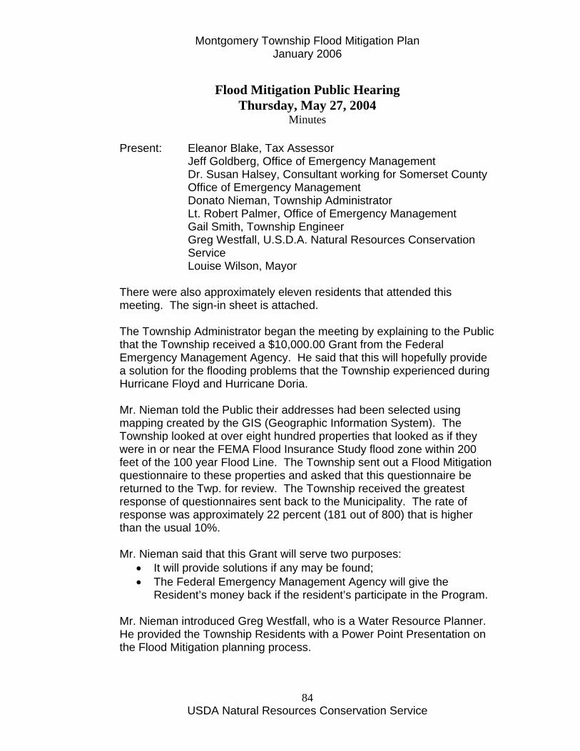
Flood Mitigation Public Hearing
Thursday, May 27, 2004 Minutes
Present: Eleanor Blake, Tax Assessor
Jeff Goldberg, Office of Emergency Management Dr. Susan Halsey, Consultant working for Somerset County Office of Emergency Management
Donato Nieman, Township Administrator Lt. Robert Palmer, Office of Emergency Management Gail Smith, Township Engineer Greg Westfall, U.S.D.A. Natural Resources Conservation Service Louise Wilson, Mayor
There were also approximately eleven residents that attended this meeting. The sign-in sheet is attached. The Township Administrator began the meeting by explaining to the Public that the Township received a $10,000.00 Grant from the Federal Emergency Management Agency. He said that this will hopefully provide a solution for the flooding problems that the Township experienced during Hurricane Floyd and Hurricane Doria. Mr. Nieman told the Public their addresses had been selected using mapping created by the GIS (Geographic Information System). The Township looked at over eight hundred properties that looked as if they were in or near the FEMA Flood Insurance Study flood zone within 200 feet of the 100 year Flood Line. The Township sent out a Flood Mitigation questionnaire to these properties and asked that this questionnaire be returned to the Twp. for review. The Township received the greatest response of questionnaires sent back to the Municipality. The rate of response was approximately 22 percent (181 out of 800) that is higher than the usual 10%. Mr. Nieman said that this Grant will serve two purposes:
• It will provide solutions if any may be found; • The Federal Emergency Management Agency will give the
Resident’s money back if the resident’s participate in the Program. Mr. Nieman introduced Greg Westfall, who is a Water Resource Planner. He provided the Township Residents with a Power Point Presentation on the Flood Mitigation planning process.

Montgomery Township Flood Mitigation Plan January 2006
USDA Natural Resources Conservation Service
85
During the Power Point Presentation, Mr. Westfall mentioned that the purpose is to go through what the planning procedure is. He said that The Office of Emergency Management’s Representative is Kathy Lear, she is with the NJ State Police, located in West Trenton. She provides project funding. Mr. Westfall also said that the goals of this Flood Mitigation Plan were to:
• reduce flood damage loss; • be proactive by being prepared for a flood; • and, to reduce repetitive flood losses (those where two or more
National Flood Insurance Program claims have been made.) Greg Westfall said that there are at least two properties that the Township knows about that are identified by FEMA as repetitive flood loss properties. He said that the residents must assess the problem and then set goals. Donato Nieman added that the Township does have a Flood Plan Ordinance and it can be viewed in the Township Clerk’s Office. Donato mentioned that if the Plan becomes available the Flood Insurance rates will be decreased. He mentioned there were a few ways that the Township could proceed in trying to solve the flooding problems:
• The residence/business on a threatened piece of property could be raised a few feet to prevent the water from coming into the structure;
• Relocation of the residence/business; • Provide an option for a buy-out and the house/business will be
demolished. Mr. Nieman added that the above options are voluntary and not mandatory! That concluded the Power Point Presentation. The floor was opened up to the resident’s who were attending this Public Hearing. Martha Stockton, of 192 Princeton Avenue, asked Greg Westfall what the date was of the 100 year flood? Mr. Westfall said that it was a shame that people call it that. He added that was the Hydrologist way of predicting the flood. Martha Stockton asked if a house is in the one hundred year flood area how often does flooding occur. Dr. Halsey answered by stating that a flood could happen every year. Mayor Wilson asked how may 100 year floods have we (the Township) had? Mr. Westfall responded, “Hurricane Floyd and Hurricane Doria.” Mr. Westfall went on to say that old geology reports show there were huge floods, previous to Doria. The largest flood on record was that of 1892 but that Hurricane Floyd is the largest flood of record.
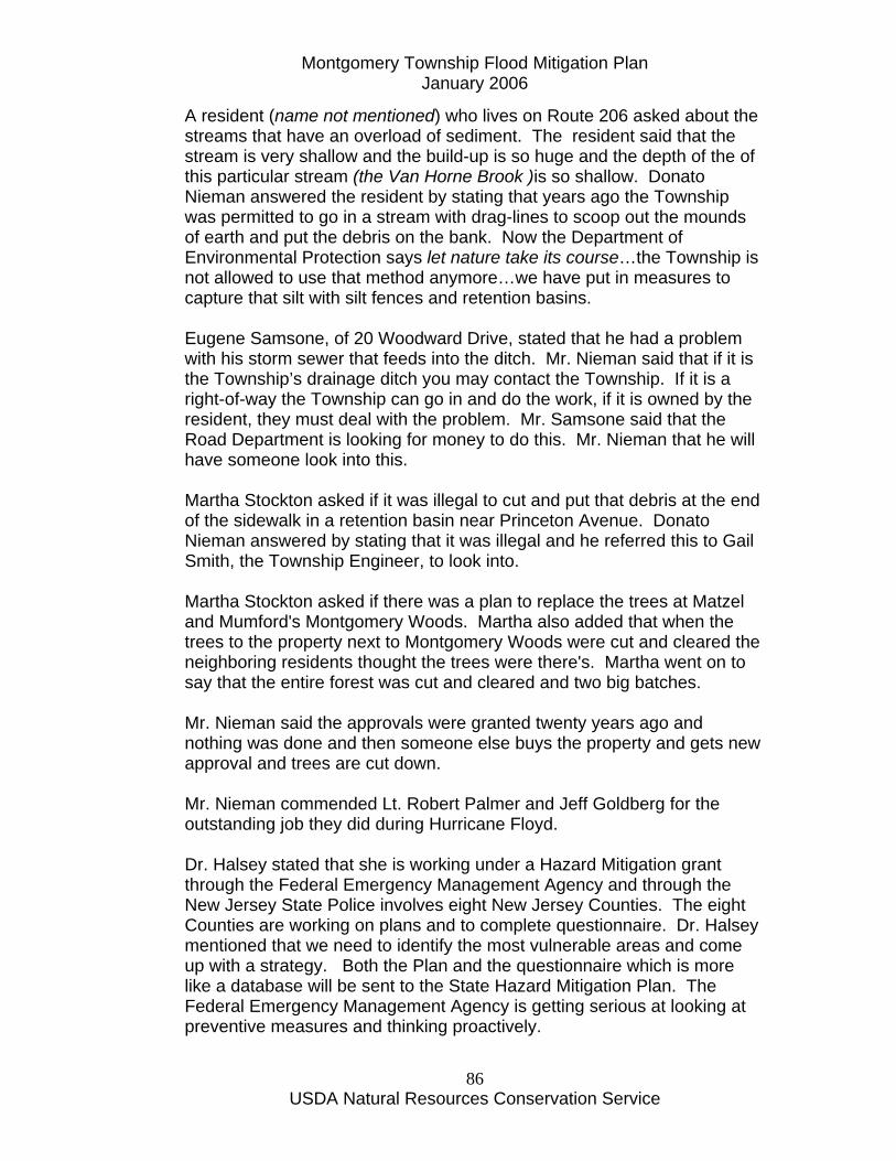
Montgomery Township Flood Mitigation Plan January 2006
USDA Natural Resources Conservation Service
86
A resident (name not mentioned) who lives on Route 206 asked about the streams that have an overload of sediment. The resident said that the stream is very shallow and the build-up is so huge and the depth of the of this particular stream (the Van Horne Brook )is so shallow. Donato Nieman answered the resident by stating that years ago the Township was permitted to go in a stream with drag-lines to scoop out the mounds of earth and put the debris on the bank. Now the Department of Environmental Protection says let nature take its course…the Township is not allowed to use that method anymore…we have put in measures to capture that silt with silt fences and retention basins. Eugene Samsone, of 20 Woodward Drive, stated that he had a problem with his storm sewer that feeds into the ditch. Mr. Nieman said that if it is the Township’s drainage ditch you may contact the Township. If it is a right-of-way the Township can go in and do the work, if it is owned by the resident, they must deal with the problem. Mr. Samsone said that the Road Department is looking for money to do this. Mr. Nieman that he will have someone look into this. Martha Stockton asked if it was illegal to cut and put that debris at the end of the sidewalk in a retention basin near Princeton Avenue. Donato Nieman answered by stating that it was illegal and he referred this to Gail Smith, the Township Engineer, to look into. Martha Stockton asked if there was a plan to replace the trees at Matzel and Mumford's Montgomery Woods. Martha also added that when the trees to the property next to Montgomery Woods were cut and cleared the neighboring residents thought the trees were there's. Martha went on to say that the entire forest was cut and cleared and two big batches. Mr. Nieman said the approvals were granted twenty years ago and nothing was done and then someone else buys the property and gets new approval and trees are cut down. Mr. Nieman commended Lt. Robert Palmer and Jeff Goldberg for the outstanding job they did during Hurricane Floyd. Dr. Halsey stated that she is working under a Hazard Mitigation grant through the Federal Emergency Management Agency and through the New Jersey State Police involves eight New Jersey Counties. The eight Counties are working on plans and to complete questionnaire. Dr. Halsey mentioned that we need to identify the most vulnerable areas and come up with a strategy. Both the Plan and the questionnaire which is more like a database will be sent to the State Hazard Mitigation Plan. The Federal Emergency Management Agency is getting serious at looking at preventive measures and thinking proactively.

Montgomery Township Flood Mitigation Plan January 2006
USDA Natural Resources Conservation Service
87
A resident asked if a company, such as Bloomberg, could release water from their Pond when it is flooding to protect their property, i.e., parking lot? Gail Smith said that any business cannot control an emergency spill basin. Mr. Johnson, of 14 Camp Meeting Avenue, asked about what was happening with Bedens Brook Road Bridge? He also mentioned that the stream has a tendency to flood because of perhaps the silt in the stream being overloaded. Mr. Nieman said we ensure that the Township will not make it worse. Gail Smith said that they do study after study that guarantees it does not get worse. Mr. Johnson also asked whether dredging could be done? Mr. Nieman said that the Township can dredge the brook, but we need to get permit for this. The problem is the disposal of the silt...it is considered a hazardous material. Donato said to that if the Township does not participate in this plan the Township will not get any money. Mr. Nieman added that the next part of the puzzle would be to set-up an Ad-Hoc Committee. This will consist of volunteers who will be discussing potential plans for mitigation and to come up with suggestions on specifics for private property owners. Two residents from the audience volunteered to be on the Ad-Hoc Committee: Cora Johnson, of 14 Camp Meeting Avenue and Lucille Dawson, of 687 Route 518. Mr. Nieman said that he would be in contact with these volunteers. The meeting was concluded at 8:45 p.m.
Flood Mitigation Meeting Minutes
Wednesday, September 8, 2004 2:00 p.m.
Present: Volunteers:
Lucille Dawson Cora Johnson Liz Palius
Staff: Sgt. Jim Curry, Representing Police Dept.
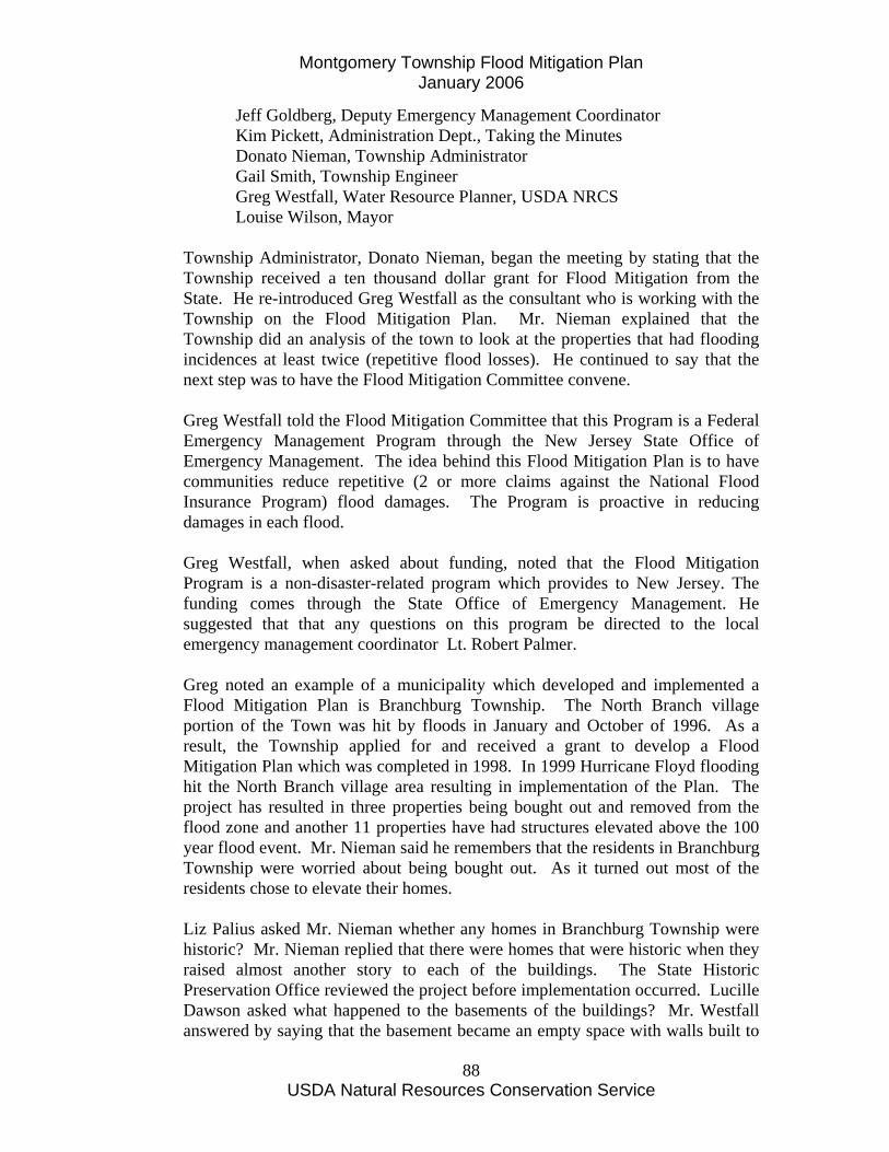
Montgomery Township Flood Mitigation Plan January 2006
USDA Natural Resources Conservation Service
88
Jeff Goldberg, Deputy Emergency Management Coordinator Kim Pickett, Administration Dept., Taking the Minutes Donato Nieman, Township Administrator Gail Smith, Township Engineer Greg Westfall, Water Resource Planner, USDA NRCS Louise Wilson, Mayor
Township Administrator, Donato Nieman, began the meeting by stating that the Township received a ten thousand dollar grant for Flood Mitigation from the State. He re-introduced Greg Westfall as the consultant who is working with the Township on the Flood Mitigation Plan. Mr. Nieman explained that the Township did an analysis of the town to look at the properties that had flooding incidences at least twice (repetitive flood losses). He continued to say that the next step was to have the Flood Mitigation Committee convene. Greg Westfall told the Flood Mitigation Committee that this Program is a Federal Emergency Management Program through the New Jersey State Office of Emergency Management. The idea behind this Flood Mitigation Plan is to have communities reduce repetitive (2 or more claims against the National Flood Insurance Program) flood damages. The Program is proactive in reducing damages in each flood. Greg Westfall, when asked about funding, noted that the Flood Mitigation Program is a non-disaster-related program which provides to New Jersey. The funding comes through the State Office of Emergency Management. He suggested that that any questions on this program be directed to the local emergency management coordinator Lt. Robert Palmer. Greg noted an example of a municipality which developed and implemented a Flood Mitigation Plan is Branchburg Township. The North Branch village portion of the Town was hit by floods in January and October of 1996. As a result, the Township applied for and received a grant to develop a Flood Mitigation Plan which was completed in 1998. In 1999 Hurricane Floyd flooding hit the North Branch village area resulting in implementation of the Plan. The project has resulted in three properties being bought out and removed from the flood zone and another 11 properties have had structures elevated above the 100 year flood event. Mr. Nieman said he remembers that the residents in Branchburg Township were worried about being bought out. As it turned out most of the residents chose to elevate their homes. Liz Palius asked Mr. Nieman whether any homes in Branchburg Township were historic? Mr. Nieman replied that there were homes that were historic when they raised almost another story to each of the buildings. The State Historic Preservation Office reviewed the project before implementation occurred. Lucille Dawson asked what happened to the basements of the buildings? Mr. Westfall answered by saying that the basement became an empty space with walls built to
Montgomery Township Flood Mitigation Plan January 2006
USDA Natural Resources Conservation Service
89
withstand the water velocity/pressure and vents to permit the water to flow through. He also noted that the property owner has to agree not to use these “basements” for any storage or other purpose. Ms. Dawson asked whether the purpose of the Flood Mitigation Plan was to protect buildings or roads? Greg Westfall said that is was to eliminate the damage to the structures that have had two or more claims to the Federal Emergency Management Agency. Liz Palius noted that the Village of Millstone is interesting…It once was the County-seat of Somerset. She continued to say that with all the development that has gone on, the area floods. She said that it is not an easy solution to come up with, but do we elevate the buildings? Greg Westfall stated that the National Flood Insurance Program (NFIP) is a self-sustaining program. It is not funded by taxes. Some mitigation plans may have evacuation plans, electronic signage, etc. Greg noted that the National Flood Insurance Act was reauthorized through 2008 on June 30th, when the President signed the Bunning-Bereuter-Blumenauer Flood Insurance Reform Act of 2004 (Public Law 108-264), reauthorizing the National Flood Insurance Program (NFIP) through September 30, 2008, and reforming the law to help states and communities mitigate repetitive loss properties. Established in 1968, the NFIP is a federal insurance program administered by the Federal Emergency Management Agency (FEMA) that provides flood insurance to over 4.4 million property owners across the U.S. FEMA has found that repetitive loss properties incur $200 million in losses annually (representing only one percent of insured properties, but 25 to 30 percent of all claims losses), and have become a significant monetary burden on the NFIP. The new law aims to address this and move the NFIP towards a more free-market insurance model by authorizing a five-year pilot program requiring owners of severe repetitive loss properties, as defined by the law, to either accept mitigation assistance, move, or face significantly higher premiums. Activities eligible for assistance in communities that choose to participate in the program include acquisition, elevation, relocation, demolition (with or without rebuilding), floodproofing, and minor physical flood control. While authorizing the appropriation of $40 million a year for the pilot program, the new law also increases the amount authorized to be appropriated for the existing flood mitigation program by $20 million each year and authorizes the appropriation of an additional $10 million a year for mitigating potential flood damage to individual properties in states and communities that are not able to participate in the Flood Mitigation Assistance program or do not have the

Montgomery Township Flood Mitigation Plan January 2006
USDA Natural Resources Conservation Service
90
capacity to manage their own mitigation programs. Among the law's miscellaneous provisions are directives to FEMA to make information more accessible; simplify the claims process with new processes, forms and documents; and establish minimum training and education requirements for insurance agents. For more detailed information, read the new law online at http://www.floods.org/PDF/FIRA2004_Act.pdf. Visit http://www.fema.gov/fima/nfip.shtm to learn more about the NFIP. Mr. Westfall showed the Flood Mitigation Maps to the Flood Mitigation Committee. He acknowledged the assistance of the Township GIS staff Pat McDonald and Alexandra Lurman. He stated that when the survey was complete, GIS made maps. They were trying to capture as many people who had flooding as they could. The second map broke the Township up in sub-water sheds that are broken up by color on each map. The third map showed the Flood Damage Frequency, while the fourth map showed the Owner Survey Damage Cost. Ms. Dawson was not sure how accurate the third map was because some people never had a claim. Mr. Nieman told the Committee that they were going to recommend what should be done. Their recommendations will be added to the Emergency Plan. Liz Palius asked what it would take to get everyone together in Hillsborough to discuss the Flood Mitigation Plan. Greg Westfall contacted Hillsborough Township to see what their availability would be to get together with Montgomery Township to discuss the Flood Mitigation Plan. Greg stated in his e-mail, dated 09/10/04, to Donato Nieman that a Hillsborough official stated: "Hillsborough has not moved forward on any flood Mitigation Plan because budgets are too tight and not enough residents are complaining to our Township Committee. Money is only spent on critical items that the residents are complaining about such as roadways, sidewalks...., maybe next year." Greg Westfall showed a video entitled Flood Mitigation Planning and Flood Mitigation Planning – The First Steps which was produced by the Association of State Flood Plain Managers. He also distributed a hand-out entitled New Jersey Office of Emergency Management Flood Mitigation Planning Checklist Lucille Dawson asked whether the Federal Emergency Management Agency has been active in the relocation of the Washington Well Bridge. Mr. Westfall said he didn’t think so. Mr. Nieman said they have been in contact with the Federal Emergency Management Agency.

Montgomery Township Flood Mitigation Plan January 2006
USDA Natural Resources Conservation Service
91
Mr. Nieman said that at the next meeting the discussion will include the type of damage that occurred so that the Flood Mitigation Committee may decide what direction the Township should go in. Mr. Westfall said the Committee can also look at the survey at a later meeting also. Lucille Dawson asked how levees work. Mr. Nieman discussed a possible bridge crossing near Griggstown which have two locations are at the Franklin side and the Montgomery side…30 foot pilings would be needed on the Montgomery side. Engineers will only increase to the Flood Levy under the Stream Enchroachment. Greg Westfall noted the Natural Resources Conservation Service studied levees as one option to prevent flooding at Hillsborough, Millstone Borough, East Millstone and Griggstown in Franklin Township but the benefits did not exceed the costs of this option. Mr. Nieman told the Committee that we would schedule another meeting within one month, towards the end of October. Ms. Dawson asked Mr. Nieman his thoughts on how to prevent losses on homes, perhaps elevating the buildings. Mr. Nieman replied that some of the houses may be simple, like putting French drains in. Others may be complex . He continued to say that he did not know of any that may need to be raised for the exception of Bed & Biscuit; however, that has already been raised. Ms. Johnson asked what was going on with the dam at North Princeton Developmental Center. Due to State Dam safety considerations, Mr. Nieman said they were going to breach the dam and then remove it. Rock Brook will go down to its original (pre-dam) natural level. Mr. Westfall asked for picture of the flood that anyone may have. He told everyone to bring the pictures with them at the next meeting. To conclude Mayor Louise Wilson asked Donato Nieman whether he had spoken about the different types of damage to the houses that received flooding. Mr. Nieman said that he did speak of that. Most of the damage was water-seeping into the houses. He said that the Flood Mitigation Committee was going to take a look at the survey at the next meeting. The meeting concluded at approximately 3:30 p.m.
Montgomery Township Flood Mitigation Plan January 2006
USDA Natural Resources Conservation Service
92
Flood Mitigation Meeting Minutes
Wednesday, October 20, 2004 2:00 p.m.
Present: Volunteers:
Lucille Dawson Cora Johnson
Staff: Jeff Goldberg, Deputy Emergency Management Coordinator Lt. Robert Palmer, Emergency Management Coordinator Kim Pickett, Administration, Taking the Minutes Donato Nieman, Township Administrator Gail Smith, Township Engineer Greg Westfall, Water Resource Planner, USDA NRCS The meeting began by Donato Nieman stating that this meeting would be for looking at the damage that was done in Montgomery by flooding. Mr. Nieman said that Franklin Township will work with us in regard to the Flood Mitigation Grant. Greg Westfall added that Hillsborough Township will not participate this year because they have limited staffing. Mr. Nieman said that Somerset County will work at arm’s length with the Township. Mr. Westfall requested a letter be sent to the Neighboring communities and the D&R Commission advising each municipality of Montgomery Township’s plan to develop a Flood Mitigation Plan funded by the grant from the F.E.M.A. through the State Office of Emergency Management. Mr. Westfall said that he would e-mail the Administration Department a draft of this letter that should be mailed to the above. Mr. Westfall also requested that he obtain a copy of the Resolution naming the volunteers and other appointed members of the Flood Mitigation Committee (He had e-mailed a sample to the Administration Dept. previously.) Mr. Westfall said that the Preliminary Draft Plan needed a lot of work. He recommended that the Flood Mitigation Committee thoroughly review the draft report and make any suggestions and revisions to it. Mr. Nieman added that if the Committee had any questions while reviewing this in the next few weeks that they feel free to call the Administration Dept. to discuss their questions. Mr. Westfall asked if anyone could bring in photographs of the flooding that occurred in any of the past recent floods effecting Montgomery Township. Mr. Westfall said that he wanted to scan the photographs. Lucille Dawson mentioned that she had given Mr. Westfall a newspaper article that had a picture of the flooding. Mr. Westfall told Mrs. Dawson that he has the newspaper.
Montgomery Township Flood Mitigation Plan January 2006
USDA Natural Resources Conservation Service
93
Mr. Nieman showed the maps (created by the GIS Department) showing the information on flood damage. The maps follow all the stream corridors, both major and minor. All the stream corridors feed into the Millstone River. Mr. Westfall recommended that the maps be revised to show the repetitive flood loss areas. Repetitive flood areas are those areas where individual structures property owners have made two or more flood damage claims under the National Flood Insurance Program. Even though real estate professionals are required by state law to notify prospective buyers that a given property is in a flood zone, identification of individual structures that have suffered repetitive flood losses may affect their market value. He said the NJ Office of Emergency Management will want to see this revision. Mr. Nieman was speaking about the cost of the flooding. Mrs. Dawson asked if there was any way to consider extra Police Patrol when a Road is flooded? Mr. Nieman said that the Federal Emergency Management Agency (F.E.M.A.) will reimburse all expenditures directly contributed to the State of Emergency. Mr. Nieman added that the Township received back from the State approximately 80% reimbursement. While reviewing the Preliminary Draft Plan section on the Preliminary Damage Assessment from the Hurricane Floyd event, Mrs. Dawson noted that there was a lot of money spent on the Roads. Mr. Nieman said that the Roads come apart when there is a lot of water on them. Mr. Nieman asked the Committee to turn to Pages 65-66 in the Preliminary Draft Report to look at the Survey Results. Mr. Nieman said he thought the dollar amount was interesting in that the damage was spread all over town. Mr. Westfall commented that, while looking at the survey results, it looked like River Road got the worst of the flood damage. Lt. Palmer handed out to both Mrs. Dawson and Mrs. Johnson a copy of the Emergency Service Maps showing all the newer roads within the Township. Mrs. Johnson said a lot of people are not active in the schools anymore so many people who do have grown children do not know where all the new roads are located. Mr. Nieman and Mr. Westfall agreed that there were three repetitive flood structures within the Township. Mrs. Dawson asked the question, “Where do people get flood insurance from?” Gail Smith answered by stating that people can get it through their Insurance Company. Mrs. Johnson said not all Homeowner’s Insurance Policies offer the Flood Insurance. She said that she gets hers from another Policy. The annual premium ranges from $740.00 to $1,600.00. Mrs. Johnson noted that this year they added Earthquake coverage. Mr. Nieman said that there are not a lot of insurance carriers that cover Flood Insurance. Mrs. Johnson said that she only knows one in this area.
Montgomery Township Flood Mitigation Plan January 2006
USDA Natural Resources Conservation Service
94
Ms. Smith said that one of the goals is to increase participation by Homeowners. She added that in order for a Resident to qualify for Flood Insurance the Municipality has to qualify. The municipality must have a flood damage prevention ordinance which identifies who the local floodplain manager is. Montgomery does have an Ordinance. Mr. Westfall asked who the Local Floodplain Manager is in Montgomery Township. Ms. Smith said that she fills this position. Mrs. Johnson said that before Ms. Smith was the Official, her predecessor was, former Township Engineer, Kent Scully. Mr. Westfall asked Ms. Smith when was the last time the Department of Environmental Protection approached her for training. Ms. Smith said that she had never been approached. Mr. Westfall continued by asking how she knows if a new application is in the floodplain or not. She said that she checks the Critical Area Map. Mr. Nieman asked Ms. Smith to explain the Critical Area Map. Ms. Smith said that this map shows:
• Stream Corridors • Steep Slopes • Certain Soils – Soils that don’t Perk • Floodplains • Wetlands
Mr. Westfall discussed the age of the F.E.M.A. maps that are twenty-five years old. During that time period development, weather patterns and other factors have likely changed flood risk. He noted that TP-40, developed about 1960 by the US Weather Bureau and which provides the information on the 24 hour rainfall frequency, has recently been updated. He will provide the updated file to Gail Smith. He suggested the Township make a request to the D.E.P. to be put on the State Priority List to revise the hydrology and hydraulics study used to develop the F.E.M.A. Map. He said to send the request in writing to: Mr. Clark Gilman, Telephone Number: (609) 292-1220 Flood Plain Management (609) 292-2296 New Jersey Department of Environment Protection Fax: (609) 984-1908 501 East State Street e-mail: [email protected] P. O. Box 419 Trenton, New Jersey 08625-0419 Mrs. Dawson recommended that the revised map should show the retaining ponds: Bloomberg and Cherry Valley. Ms. Smith asked Mr. Westfall if there would be anything that she could put in the letter of request that would make this Township more of a priority than the others. Mr. Westfall recommended that she write, based on the National Flood Insurance Program flood claims database, damages sustained in this Township are the fourth highest in terms of the dollar amount of damage in the twenty-six towns. Ms. Smith asked if she should write
Montgomery Township Flood Mitigation Plan January 2006
USDA Natural Resources Conservation Service
95
the letter? Mr. Westfall responded by stating that Ms. Smith, the Mayor or Mr. Nieman would be appropriate parties to write the letter. Mr. Nieman recommended that the Committee be prepared to give their suggestions and/or revisions on the Preliminary Draft Plan for the next meeting in the middle of November. Lt. Palmer said he was going to forward a copy of the Draft to Dr. Susan Halsey for review. Mrs. Johnson recommended that Montgomery Township assist with a plan for homeowners who could not afford Flood Insurance. Mr. Nieman said that perhaps that could be added in the Plan or have that idea put into a survey. This meeting concluded at 3:30 p.m.
Montgomery Township Flood Mitigation Plan January 2006
USDA Natural Resources Conservation Service
96
Flood Mitigation Meeting Minutes
December 8, 2004 10:00 a.m.
Present: Volunteers: Lucille Dawson Cora Johnson Liz Palius Staff: Jeff Goldberg, Deputy Emergency Management Coordinator
Lt. Robert Palmer, Emergency Management Coordinator Kim Pickett, Administration Dept., (Taking Minutes) Donato Nieman, Township Administrator Gail Smith, Township Engineer
Greg Westfall, Water Resource Planner, USDA NRCS Louise Wilson, Mayor Greg Westfall began the meeting by stating that he has spoken to Kathy Lear of the Office of Emergency Management of the New Jersey State Police. Ms. Lear said that Montgomery Township’s Flood Mitigation Plan must be certified before the end of September 2005. Mr. Westfall also said that there is an extra 1.6 million dollars available. He added that the money can be spent anywhere in the State of New Jersey. Mr. Westfall said that he has notified, via e-mail, the municipalities that he is working with about this money. The Municipalities are Franklin Township, Montgomery Township, Millstone Borough and Princeton Township. Donato Nieman said he went through the information from the last meeting and there were a few points that he would like to bring to the Committee’s attention:
• Joyce McCay, of the Bed & Biscuit, at 65 River Road, will be joining the Committee. Her property, as well as her neighbors property, were completely flooded during the Hurricane Floyd flood.
• The Committee should think about recommending an early warning sign
to let the public know that the Township is thinking about acquiring property or raising property above floodplain level.
Ms. Palius said that there was one house in Montgomery Township that was in a floodplain and it was raised because it was an historical property. Ms. Palius added that the woman who owned the house had to go back to work, out of retirement, to pay for the raising of the house. F.E.M.A. paid for very little. Page Two
Montgomery Township Flood Mitigation Plan January 2006
USDA Natural Resources Conservation Service
97
Flood Mitigation Meeting Minutes 12/08/2004 Mr. Westfall said that he had been searching for photographs showing Montgomery’s flooding over the years, including pictures from Hurricane Floyd. Following numerous contacts with residents, particularly in the Millstone River Road vicinity, he has not been very successful in locating flood photos. Ms. Palius recommended that a Traffic Circulation Plan be used when it is flooding. Jeff Goldberg responded by stating that the Township uses a Traffic Plan from the State showing what roads are to be used depending upon what roads are flooding…but it is only on an as needed basis. Ms. Palius also recommended that there be a Study done showing how cul-de-sacs can be connected, in order to get around within the Township, when a flooding emergency is occurring. Mr. Nieman responded by saying that the Township does not have the political will to open cul-de-sacs…Residents may not want their cul-de-sacs to be “destroyed” even in emergency. Ms. Palius said that she understood, however, this would be a way for residents to get around within the Township in an emergency situation. She asked Jeff Goldberg how much traffic was able to get through the Township during Hurricane Floyd? Mr. Goldberg said that very few of the motoring people were able to get through. Ms Johnson said that what everyone has to remember is that after 12:30 p.m. no one could get through anywhere! Ms. Palius asked whether pursuing a Study was a worthwhile cause. Mr. Nieman said that if we want to try to get funding for this it may be worthwhile to look into doing a Study for a Traffic Plan. Mr. Westfall asked if the Committee wanted to put this as a recommendation in the Flood Mitigation Plan. The Committee decided to recommend a study be conducted for potential improvements and/or an alternate Evacuation Plan. It was also recommended that the Township use any future money for Warning Signs. Mr. Nieman said that Early Warning Signs would be helpful. Mr. Goldberg asked if the money can be used for the signs. Mr. Westfall said that he would check with Kathy Lear of the Office of Emergency Management. Lucille Dawson asked where in Montgomery the signs would be placed. Mr. Nieman said they would be placed on River Road, Route 206, Belle-Mead Griggstown Road and perhaps Willow Road. Mr. Westfall said that he would put something in the Plan mentioning the Early Warning Signs.
Montgomery Township Flood Mitigation Plan January 2006
USDA Natural Resources Conservation Service
98
Page Three Flood Mitigation Meeting Minutes 12/08/2004 Ms. Dawson recommended that the Plan not only include the Local Floodplain Manager, Gail Smith, Township Engineer, but also the Township Planner, Lori Savron, the Construction Official, Jack Marold, and the Health Officer, Stephanie Carey. Ms. Dawson also recommended wording be put into the Plan to specify that the Township has the first option to purchase a property that has been flooded. She mentioned that the property next to the Bed & Biscuit should have been taken down when it was up for sale. Mr. Westfall said that he did not know what the legal ramifications were. Mr. Nieman said should Federal Funding become available; there could be language that the Township has the right to buy the property. Gail Smith recommended that the Township should identify repetitive flood loss. Ms. Palius said there must be regional awareness about other Municipalities managing their storm-water. She continued by stating that she has noticed a lot of people lengthening their lawns in the drainage areas. She asked how can we get people (residents) informed on how not to destroy there drainage (Critical Areas). Mr. Westfall said the Code Enforcement Staff are normally the individuals who enforcing this. He noted that the Department of Community Affairs Bill Connelly that oversees that information and education is provided to respective municipal construction officials. Ms. Palius said she liked the idea about educating the public…she recommended that in the future to enclose a letter specifying how property owners can care for critical areas. Liz Palius asked Gail Smith how long the detention basins are being used for? Ms. Smith answered for about 18 hours while holding the waters. Ms. Dawson asked who is responsible for the basins. Ms. Smith said the Township is responsible for the private detention basins and the County is responsible for the rest. Mayor Wilson recommended that Ms. Smith make sure that the Detention Basins, that the Township is responsible for, are all working properly. Liz Palius expressed her concern about underground tanks. Mayor Wilson asked Ms. Smith how the Township finds out whether a residential property has an underground tank. Ms. Smith said that she would go ask the owners of the property. Ms. Palius said that there should be a special preservation for historical properties not being removed because of flooding. Ms. Smith said that she recommends wording being put into the Plan to treat each property on an individual basis and include wording to find out about underground tanks. Also Page Four Flood Mitigation Meeting Minutes

Montgomery Township Flood Mitigation Plan January 2006
USDA Natural Resources Conservation Service
99
12/08/2004 the Committee decided to add wording about defining a property’s elevation and obtaining an Elevation Certificate. The next meeting will be on Wednesday, January 12, 2004 at 10:00 a.m.
Montgomery Township Flood Mitigation Plan January 2006
USDA Natural Resources Conservation Service
100
Flood Mitigation MeetingMinutes January 12, 2005
10:00 a.m. Present: Volunteers: Lucille Dawson Cora Johnson Liz Palius Joyce McCay Staff:
Kim Pickett, Administration Dept., (Taking Minutes) Donato Nieman, Township Administrator Gail Smith, Township Engineer
Greg Westfall, Water Resource Planner, USDA NRCS Missing: Jeff Goldberg, Deputy Emergency Management Coordinator
Lt. Robert Palmer, Emergency Management Coordinator Louise Wilson, Mayor Greg Westfall began the meeting by stating he needed more pictures of flooding in Montgomery. Gail Smith suggested that Greg contact the Princeton Packet to see if they might have flood photos from Hurricane Floyd. Mr. Westfall said that he was informed by Kathy Lear of the Mitigation Unit at New Jersey Office of Emergency Management that the Montgomery Township needs to have the Flood Mitigation Plan draft ready for her to review by January 31, 2005. Mr. Westfall mentioned, at the December 8th meeting, there is a review process that occurs following completion of a Plan. The process includes Ms. Lear and then it goes to FEMA Region II for review and certification. Mr. Westfall said that this process can take a few months to complete, and according to Ms. Lear, the Township must have it all completed by September 30, 2005. Mr. Westfall that Ms. Lear expressed concern that there is a clock ticking on this and that we must submit a Plan by January 31, 2005. Mr. Nieman said that it is important to have signage during a flooding emergency because it will help to improve the traffic flow. Mr. Westfall noted that Ms. Lear has indicated that funding for road signage may be more possible through the Pre-Disaster Mitigation (PDM) Program. Ms. Lear informed Mr. Westfall that there is a May 1st deadline for application for funding under this Program. Flood Mitigation Minutes
Montgomery Township Flood Mitigation Plan January 2006
USDA Natural Resources Conservation Service
101
01/12/2005 Page Two Mrs. Palius expressed her concern of the need for an Evacuation Plan. She said that there has to be a Plan in place to get people home, to get emergency services in and evacuees out. Gail Smith said usually people stay at home if they hear of a big storm that is going to be threatening the area, but with Hurricane Floyd no one knew it was coming! Ms. Dawson asked Mr. Nieman what type of signage was he speaking of? Mr. Nieman replied that the radio-activitated electronic signage would be something similar to what Manville has and would make drivers aware of what roads were closed due to flooding. Ms. Palius said that the town has grown in population/development since Hurricane Doria. While Hurricane Floyd was flooding roads, the traffic was more congested than with Hurricane Doria. She is concerned with how the growth of the town will affect the Emergency Plan for the future. She said that the town has high grounds, but most of the high grounds are cul-de-sacs…Bridgepoint is on top of a ridge and on the other side of the ridge are roads that have cul-de-sacs. Ms. Palius at the previous meeting had proposed developing an emergency evacuation route by connecting the various cul-de-sacs so that traffic can move within and through the Township. Mr. Nieman noted that most roads in the Township cross the seven watersheds. The Committee began to look at the Critical Areas Map. Mr. Nieman said that one of the worst on the map is the Cruser Brook, located next to the Municipal Building’s lower parking lot. He said, commencing in 2007, there will be a new bridge that will be 9 feet higher and there will be a significant change to the road. The end result will be that it will improve flooding. Mr. Westfall commented on how vulnerable the Township building was in the event of a flooding situation. Mr. Nieman said that if the Municipal building was to get flooded, the plan would be to move command of operations to the Fire Station 45. Mr. Nieman noted that the new Senior Center could be used for shelter and/or command center. Mr. Nieman discussed the Township’s plan to have a series of “loop” roads that would move traffic north and south through the Township. One example given was the plan to connect Orchard Road with a new bridge across Beden Brook through the Bristol Myers Squibb property to Route 518. The purpose of this “loop” road is to avoid the “F” graded intersection at County Route 518 and State Route 206. Ms. Palius said that there are three questions that the town must ask in order to assure the Flood Mitigation Plan be successful: • Has Montgomery done everything to mitigate flooding?; • Has Montgomery done everything to work with its neighbors?; • Has Montgomery done everything to establish an Emergency Management
plan to assure the safety of its residents?

Montgomery Township Flood Mitigation Plan January 2006
USDA Natural Resources Conservation Service
102
Flood Mitigation Minutes 01/12/2005 Page Three Mr. Westfall recommended that the town hold a Public Meeting as soon as possible, preferably before January 31, 2005. The Committee suggested that we have one more meeting with everyone attending who is on the Flood Mitigation Committee. The next meeting date is Wednesday, January 26, 2005, at 2:00 p.m. Thereafter the Flood Mitigation Committee will schedule a Public Hearing to be scheduled early in February of 2005. Mr. Westfall distributed the third draft of the Flood Mitigation Plan and noted several changes in the recommendations. Under the Evacuation Route Enhancement section, an additional item has been added to recommend that “Montgomery Township should work with the State of New Jersey to enhance the reliability of the use of State Route 206 for flood evacuation and movement of traffic within and through Montgomery Township.” Additionally he noted the addition of recommendation (Item 1 under II. Incorporation of Flood Mitigation Planning into Local Ordinances and Master Planning) “incorporate a provision to give the Township first option to purchase flood damaged properties following a flooding event” under the “Revise Flood Damage Prevention Ordinance”. Greg noted that the Township Master Plan Reexamination Report identifies several greenways including the Crossroads of American Revolution Greenway, Regional Sourland Mountain Greenway, Hopewell Valley Greenway and Pike Run Watershed Corridor Greenway. The Beden Brook Corridor and the Millstone River Corridor are not so identified. As a result, a new Item 2 recommendation was added under this section for “identifying the Beden Brook Corridor and Millstone River Corridor as a “Potential Future Greenway” in the Township Master Plan Conservation Plan to encourage future open space acquisition in flood-prone areas.” Greg noted that the Township has three repetitive flood loss structures, one of which has been elevated to reduce its flood losses. He also recommended that the Flood Mitigation Plan maps be revised to show not only the repetitive flood loss area (s) but also to show those areas that have had historic flood damages but are not considered to be repetitive flood loss areas because either the previous owner did not carry flood insurance or the historic flooding (eg. Hurricane Doria) occurred prior to the beginning of the National Flood Insurance Program. Gail Smith will work with Greg and Pat McDonald/Alex Luhrman to amend the maps to show this information.
Montgomery Township Flood Mitigation Plan January 2006
USDA Natural Resources Conservation Service
103
Flood Mitigation Minutes 01/12/2005 Page Three Mrs. Palius said that she will e-mail Greg Westfall names of people that are affected by the flooding in Hillsborough. She recommended that Mr. Westfall call these people because they will put “pressure” on Hillsborough Township to find out why Hillsborough is not concerned with Flooding. Ms. Dawson asked Mr. Westfall how he was planning on getting the pictures of house or business flooding that he was requesting. Mr. Westfall said that he has received some pictures from the Montgomery News…Ms. Smith recommended that he try to call the Princeton Packet. The meeting concluded at 11:45 p.m. The next meeting will be Wednesday, January 26th at 2:00 p.m., to be followed by the Public Hearing in February.
Montgomery Township Flood Mitigation Plan January 2006
USDA Natural Resources Conservation Service
104
Flood Mitigation Meeting Minutes January 26, 2005
2:00 p.m. Present: Volunteers: Lucille Dawson Cora Johnson
Joyce MacKay (Ms. MacKay’s last name was spelled incorrectly in past Minutes. This is the correct spelling.)
Staff: Jeff Goldberg, Deputy Emergency Management Coordinator Lt. Robert Palmer, Emergency Management Coordinator Kim Pickett, Administration Dept., (Taking Minutes)
Donato Nieman, Township Administrator Gail Smith, Township Engineer
Greg Westfall, Water Resource Planner, USDA NRCS Louise Wilson, Mayor Missing: Liz Palius The Flood Mitigation Committee decided to hold their Public Meeting to introduce the Flood Mitigation Plan on Wednesday, February 23, 2005, at 7:00 p.m. The Meeting will be held in the Court room of the Municipal Building. Mayor Wilson said that she could not attend the Public Mtg. on the above date but recommended that the Deputy Mayor, Karen Wintress, attend in her place. Mr. Westfall noted that the Committee would need to meet, probably not as regularly, in the future to oversee the implementation of the Plan. Mr. Westfall continues to need pictures for the Plan. It was suggested by Mayor Wilson that he try to contact Cliff Moore of the Montgomery News and Clem Fiore, Blawenburg Historian. Mr. Moore worked for the Princeton Packet as a photographer for many years. Mr. Westfall said that he has a few pictures of roads being flooded, however, he would like pictures of the actual flooding of homes. Lucille Dawson loaned Greg with several photos of flooding along Bedens Brook at County Route 518 taken during Hurricane Doria. Greg will scan these and return. Mrs. Johnson, who lives on Camp Meeting Road, said that during Hurricane Floyd, she had a neighbor who had a flooded basement. As a result of the water, the oil tank burst and a HAZMAT team had to come out to clean up. Flood Mitigation Minutes

Montgomery Township Flood Mitigation Plan January 2006
USDA Natural Resources Conservation Service
105
01/26/2005 Page Two She continued to say that unfortunately the homeowners never reported the damage, nor did they participate in the Flood Mitigation Survey. Mr. Westfall noted there can be several exceptions to the FEMA “repetitive flood loss” standard for receiving flood mitigation assistance. These exceptions can include properties which have had flood damage prior to the existence of the FEMA National Flood Insurance Program which began in 1978 and those properties which do not have flood insurance because the current owner does not have a federally-backed mortgage. Greg noted that FEMA/NJOEM is unlikely to provide funding for flood mitigation where the property has not had two or more claims to the National Flood Insurance Program unless there is historical evidence (flood photos) and/or affidavits signed by previous owners to support the historical flooding claimed. Mr. Westfall commented that he would like Pat McDonald and Alexandra Lurman to circle the Historic Flood Damage Areas on the maps in which they have produced. The Committee discussed that there were two houses on Opossum Road that do not have repetitive flood losses, but they are in the historical flood damage area. Other areas of historic flood damage include Camp Meeting Road, Dead Tree Run Road, Cherry Hill Road, County Routes 518 and 601 and State Route 206, and Burnt Hill Road. Mr. Nieman said that this was a good idea to have done. Mr. Westfall went through the PowerPoint presentation that he gave out, as a handout, to the Committee. A copy is attached to these Minutes. Greg will amend them to include the date (February 23rd) of the presentation. Mr. Goldberg asked that the second recommendation under Evacuation Route Enhancement be changed to read “Install electronic warning signage at key locations.” Also, it was recommended that the pictures shown in the presentation include a caption describing where they are and the flood event. There was considerable discussion regarding the second part of Item #1 under Incorporation of Flood Mitigation Planning into Local Ordinances and Master Planning. The first part of this item refers to revising the existing Flood Damage Prevention Ordinance to bring it into compliance with the model ordinance. The second part of this item refers to “incorporate a provision to give the Township first option to purchase flood damaged properties following a flooding event.” Mr. Nieman recommended that the Township Attorney, Kristina Hadinger, review from a legal standpoint as to whether the Township may have the first option to purchase a flooded property following a flood. This is mentioned as a recommendation the Flood Mitigation Draft, dated January 2005, on Page 47, II, 1. Mr. Westfall indicated that this would give the Township the opportunity to be pro-active rather than waiting for funding from either Green Acres or FEMA funding to become available. At the same time, he encouraged the Township to Flood Mitigation Minutes 01/26/2005
Montgomery Township Flood Mitigation Plan January 2006
USDA Natural Resources Conservation Service
106
Page Three explore and make application for any and all available grant opportunities to purchase flood-prone property where there is a willing seller. Another recommendation discussed was Item #2 under Incorporation of Flood Mitigation into Local Ordinances and Master Planning which states “Identify the Bedens Brook Corridor as a “Potential Future Greenway” in the Township Master Plan Conservation Plan to encourage future open space acquisition in flood-prone areas.” Mr. Westfall noted that a number of areas were identified in the Township Master Plan but this area was not. This will permit the Township to have a pro-active plan for open space acquisition for passive recreation and, as private landowners are willing, purchase property in the flood-prone areas along Bedens Brook. In the Bedens Brook corridor, the Committee discussed the property that is on the corner of (#14) Montgomery Road and Route 206 that has had flood damage (historic flood damage) in the past. Ms. MacKay said that the property is up for sale at a listing price of $325,000.00. Ms. Dawson asked Mr. Westfall whether the Township could get money from FEMA to buy the house? Mr. Westfall suggested that contact be made with Kathy Lear at the Mitigation Unit at the New Jersey State Office of Emergency Management. Mr. Nieman told Ms. Dawson that FEMA usually likes the money to be used quickly. Gail Smith recommended that Item #3 under Incorporation of Flood Mitigation Planning into Local Ordinances and Master Planning be changed to read “Identify and train the local floodplain manager, planning director, building and zoning code official and township engineer regarding the Flood Damage Prevention Ordinance.” Under the Private Property Flood and Other Natural Hazard (Erosion) Mitigation recommendations, there was considerable discussion regarding the streambank erosion problems in the Township. Mr. Westfall noted that the property owner survey identified at least four areas in the Township where this was a problem. Rock Brook was singled out as a major problem area by Mayor Wilson and Cora Johnson who both reside adjacent to the stream corridor. Currently the stream is eroding to the extent that the driveways and/or homes can be threatened by further erosion. Also, large trees particularly along the east side of the stream channel opposite residential property along Hollow Road are being undermined and falling into the stream channel. During previous flood events, Ms. Johnson reported that large amounts of debris are moving downstream causing the Camp Meeting Road bridge to become plugged and floodwaters to come onto her and neighboring properties. Greg noted that item #5 under Private Property Flood and Other Natural Hazard (Erosion) Mitigation states that the Township should “Identify
Montgomery Township Flood Mitigation Plan January 2006
USDA Natural Resources Conservation Service
107
Flood Mitigation Minutes 01/26/2005 Page Four Emergency Funding Sources and Incorporate into the Township Emergency Response Plan.” He stated that one program known as the Emergency Watershed Program (administered by the Natural Resources Conservation Service) can provide assistance, following a disaster declaration, to restore stream channels and often stabilize eroding streambanks. Under Public Participation recommendation #1, there was discussion of the need for public information on flooding through various means including the Township website, newspaper articles (such as Mr. Nieman’s monthly column), and Township newsletter. Mr. Westfall noted that under recommendation #2 on the Community Rating System, information is one of the 18 activities which can be done by a municipality to reduce or minimize property owner flood insurance premiums. The Community Rating System, similar to the classification system used for fire insurance ratings (based on the training and equipment provided to firefighters) that affect homeowner’s insurance premiums, can be used to reduce homeowner flood insurance premiums. Mr. Goldberg noted that there are relatively few repetitive flood loss structures in Montgomery Township and wondered whether it will be productive to apply for project funding when up against other municipal applicants with a dozen or more structures similar to the North Branch project in Branchburg Township in Somerset County. Greg replied that it probably would be more productive to have multiple municipalities (such as Millstone Borough, Montgomery Township and Franklin Township) apply for project funding as one entity. He noted that some municipalities may be very interested in this approach, particularly if they don’t have the staff to apply for the funding and, once the funding is received to do the work, oversee and administer the actual flood mitigation contract. The meeting concluded at 3:30 p.m. The Flood Mitigation Committee agreed not to have another meeting before the Public Hearing on February 23, 2005, but did agree to continue to have regular meetings thereafter.
Flood Mitigation Public Meeting
Montgomery Township Flood Mitigation Plan January 2006
USDA Natural Resources Conservation Service
108
February 23, 2005 7:00 p.m.
Present: Volunteers:
Lucille Dawson Joyce MacKay
Staff: Lt. Robert Palmer, Emergency Management Coordinator Kim Pickett, Administration Dept. (Taking Minutes) Donato Nieman, Township Administrator Gail Smith, Township Engineer Greg Westfall, Water Resource Planner, USDA NRCS Karen Wintress, Deputy Mayor Absent: Jeff Goldberg, Deputy Emergency Management Coordinator Cora Johnson, Volunteer Liz Palius, Volunteer Mr. Nieman began the meeting by stating that this meeting was a Public Information Meeting to discuss the draft Plan that will be reviewed by the Township Committee and then be forwarded to the State for review upon the approval of the Township Committee. Greg Westfall went over the Power Point presentation that is attached. After the Power Point Presentation, Karen Wintress had a few questions:
• Ms. Wintress asked upon certification will the Township have communication with the residents whom this would effect. Mr. Nieman said that we have already had contact with one resident: Joyce MacKay. Mr. Westfall said that it is highly recommended that we continue to have Flood Mitigation Meetings.
• Ms. Wintress wanted to know whether FEMA Flood Zone boundaries
would affect the Township’s Zoning. Gail Smith answered her question by saying that the FEMA Flood Zone boundaries on the Township Zoning map would make the boundaries more evident. Mr. Nieman followed her answer by stating that this would make the map more exact.
• Ms. Wintress said while reviewing the minutes from a previous Flood
Mitigation Meeting, she had noticed that there was mention that Somerset
Montgomery Township Flood Mitigation Plan January 2006
USDA Natural Resources Conservation Service
109
County will work at arm’s length with the Township. She wanted to know how we are working with the County on the Flood Mitigation Plan. Mr. Westfall said that Somerset County will be part of the review process of the final draft. The third draft has gone to the Somerset County Engineer’s Office.
• On page 40, Table 5 – Critical Facilities in Montgomery Township, Ms.
Wintress was concerned with how the draft reflected just some of the homes/businesses that had flood damage within in the Township. She also wondered what information was given in order to develop this list because there only seems to be certain properties listed. Ms. Smith recommended that the Township try to investigate as to where this information came from.
Mr. Westfall said that the Township should hear back from the Office of Emergency Management within the next few weeks. He confirmed that the third draft had been sent to Somerset County. Mr. Westfall said that the Acting Governor’s office will look at the Flood Mitigation Plan after the Office of Emergency Management. The meeting adjourned at 8:15 p.m.

Montgomery Township Flood Mitigation Plan January 2006
USDA Natural Resources Conservation Service
110
Montgomery Township Flood Mitigation Plan January 2006
USDA Natural Resources Conservation Service
111
Property Owner Survey Questionnaire and Final Survey Results

Montgomery Township Flood Mitigation Plan January 2006
USDA Natural Resources Conservation Service
112
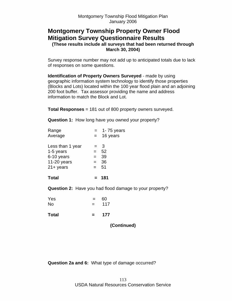
Montgomery Township Flood Mitigation Plan January 2006
USDA Natural Resources Conservation Service
113
Montgomery Township Property Owner Flood Mitigation Survey Questionnaire Results
(These results include all surveys that had been returned through March 30, 2004)
Survey response number may not add up to anticipated totals due to lack of responses on some questions. Identification of Property Owners Surveyed - made by using geographic information system technology to identify those properties (Blocks and Lots) located within the 100 year flood plain and an adjoining 200 foot buffer. Tax assessor providing the name and address information to match the Block and Lot. Total Responses = 181 out of 800 property owners surveyed. Question 1: How long have you owned your property? Range = 1- 75 years Average = 16 years Less than 1 year = 3 1-5 years = 52 6-10 years = 39 11-20 years = 36 21+ years = 51 Total = 181 Question 2: Have you had flood damage to your property? Yes = 60 No = 117 Total = 177
(Continued) Question 2a and 6: What type of damage occurred?
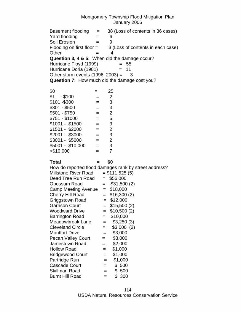
Montgomery Township Flood Mitigation Plan January 2006
USDA Natural Resources Conservation Service
114
Basement flooding = 38 (Loss of contents in 36 cases) Yard flooding = 6 Soil Erosion = 9 Flooding on first floor = 3 (Loss of contents in each case) Other = 4 Question 3, 4 & 5: When did the damage occur? Hurricane Floyd (1999) = 55 Hurricane Doria (1981) = 11 Other storm events (1996, 2003) = 3 Question 7: How much did the damage cost you? $0 = 25 $1 - $100 = 2 $101 -$300 = 3 $301 - $500 = 3 $501 - $750 = 2 $751 - $1000 = 5 $1001 - $1500 = 3 $1501 - $2000 = 2 $2001 - $3000 = 3 $3001 - $5000 = 2 $5001 - $10,000 = 3 >$10,000 = 7 Total = 60 How do reported flood damages rank by street address? Millstone River Road = $111,525 (5) Dead Tree Run Road = $56,000 Opossum Road = $31,500 (2) Camp Meeting Avenue = $18,000 Cherry Hill Road = $16,300 (2) Griggstown Road = $12,000 Garrison Court = $15,500 (2) Woodward Drive = $10,500 (2) Barrington Road = $10,000 Meadowbrook Lane = $3,250 (3) Cleveland Circle = $3,000 (2) Montfort Drive = $3,000 Pecan Valley Court = $3,000 Jamestown Road = $2,000 Hollow Road = $1,000 Bridgewood Court = $1,000 Partridge Run = $1,000 Cascade Court = $ 500 Skillman Road = $ 500 Burnt Hill Road = $ 300
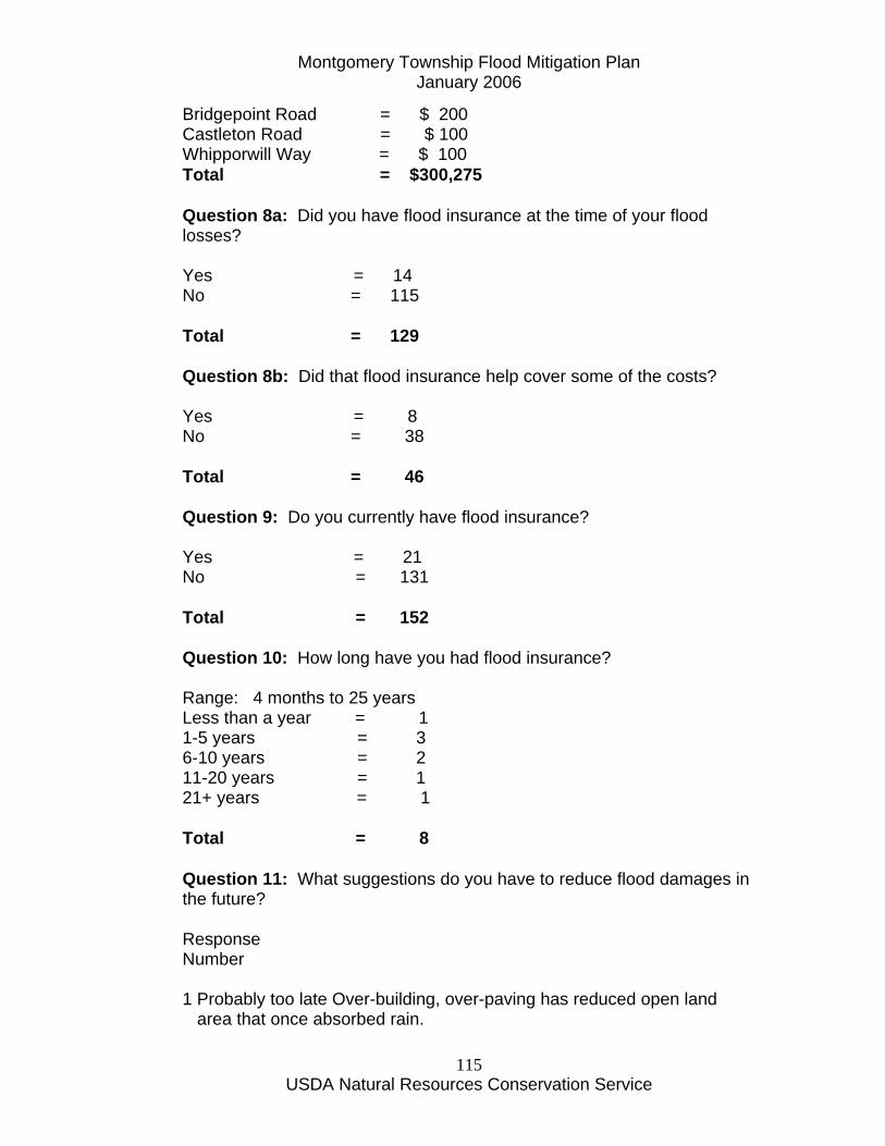
Montgomery Township Flood Mitigation Plan January 2006
USDA Natural Resources Conservation Service
115
Bridgepoint Road = $ 200 Castleton Road = $ 100 Whipporwill Way = $ 100 Total = $300,275 Question 8a: Did you have flood insurance at the time of your flood losses? Yes = 14 No = 115 Total = 129 Question 8b: Did that flood insurance help cover some of the costs? Yes = 8 No = 38 Total = 46 Question 9: Do you currently have flood insurance? Yes = 21 No = 131 Total = 152 Question 10: How long have you had flood insurance? Range: 4 months to 25 years Less than a year = 1 1-5 years = 3 6-10 years = 2 11-20 years = 1 21+ years = 1 Total = 8 Question 11: What suggestions do you have to reduce flood damages in the future? Response Number 1 Probably too late Over-building, over-paving has reduced open land area that once absorbed rain.
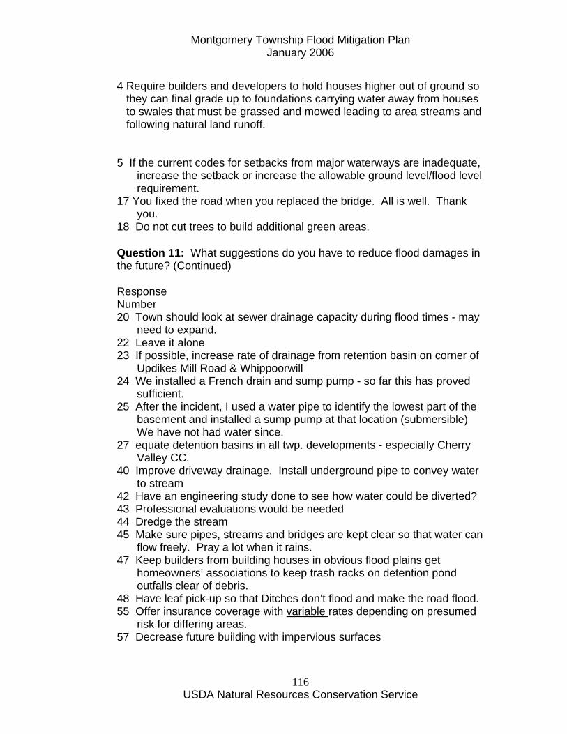
Montgomery Township Flood Mitigation Plan January 2006
USDA Natural Resources Conservation Service
116
4 Require builders and developers to hold houses higher out of ground so they can final grade up to foundations carrying water away from houses to swales that must be grassed and mowed leading to area streams and following natural land runoff. 5 If the current codes for setbacks from major waterways are inadequate,
increase the setback or increase the allowable ground level/flood level requirement.
17 You fixed the road when you replaced the bridge. All is well. Thank you.
18 Do not cut trees to build additional green areas.
Question 11: What suggestions do you have to reduce flood damages in the future? (Continued) Response Number 20 Town should look at sewer drainage capacity during flood times - may
need to expand. 22 Leave it alone 23 If possible, increase rate of drainage from retention basin on corner of
Updikes Mill Road & Whippoorwill 24 We installed a French drain and sump pump - so far this has proved
sufficient. 25 After the incident, I used a water pipe to identify the lowest part of the
basement and installed a sump pump at that location (submersible) We have not had water since.
27 equate detention basins in all twp. developments - especially Cherry Valley CC.
40 Improve driveway drainage. Install underground pipe to convey water to stream
42 Have an engineering study done to see how water could be diverted? 43 Professional evaluations would be needed 44 Dredge the stream 45 Make sure pipes, streams and bridges are kept clear so that water can
flow freely. Pray a lot when it rains. 47 Keep builders from building houses in obvious flood plains get
homeowners’ associations to keep trash racks on detention pond outfalls clear of debris.
48 Have leaf pick-up so that Ditches don’t flood and make the road flood. 55 Offer insurance coverage with variable rates depending on presumed
risk for differing areas. 57 Decrease future building with impervious surfaces
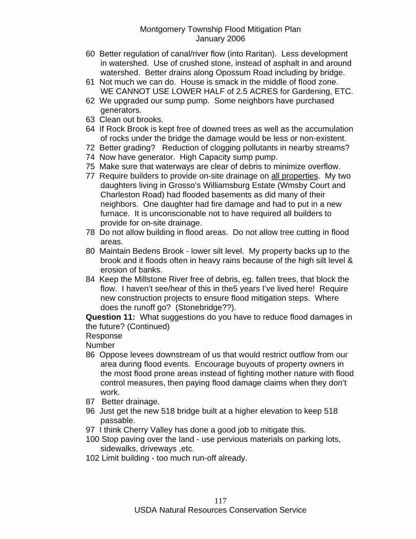
Montgomery Township Flood Mitigation Plan January 2006
USDA Natural Resources Conservation Service
117
60 Better regulation of canal/river flow (into Raritan). Less development in watershed. Use of crushed stone, instead of asphalt in and around watershed. Better drains along Opossum Road including by bridge.
61 Not much we can do. House is smack in the middle of flood zone. WE CANNOT USE LOWER HALF of 2.5 ACRES for Gardening, ETC.
62 We upgraded our sump pump. Some neighbors have purchased generators.
63 Clean out brooks. 64 If Rock Brook is kept free of downed trees as well as the accumulation
of rocks under the bridge the damage would be less or non-existent. 72 Better grading? Reduction of clogging pollutants in nearby streams? 74 Now have generator. High Capacity sump pump. 75 Make sure that waterways are clear of debris to minimize overflow. 77 Require builders to provide on-site drainage on all properties. My two
daughters living in Grosso’s Williamsburg Estate (Wmsby Court and Charleston Road) had flooded basements as did many of their neighbors. One daughter had fire damage and had to put in a new furnace. It is unconscionable not to have required all builders to provide for on-site drainage.
78 Do not allow building in flood areas. Do not allow tree cutting in flood areas.
80 Maintain Bedens Brook - lower silt level. My property backs up to the brook and it floods often in heavy rains because of the high silt level & erosion of banks.
84 Keep the Millstone River free of debris, eg. fallen trees, that block the flow. I haven’t see/hear of this in the5 years I’ve lived here! Require new construction projects to ensure flood mitigation steps. Where does the runoff go? (Stonebridge??).
Question 11: What suggestions do you have to reduce flood damages in the future? (Continued) Response Number 86 Oppose levees downstream of us that would restrict outflow from our
area during flood events. Encourage buyouts of property owners in the most flood prone areas instead of fighting mother nature with flood control measures, then paying flood damage claims when they don’t work.
87 Better drainage. 96 Just get the new 518 bridge built at a higher elevation to keep 518
passable. 97 I think Cherry Valley has done a good job to mitigate this. 100 Stop paving over the land - use pervious materials on parking lots,
sidewalks, driveways ,etc. 102 Limit building - too much run-off already.
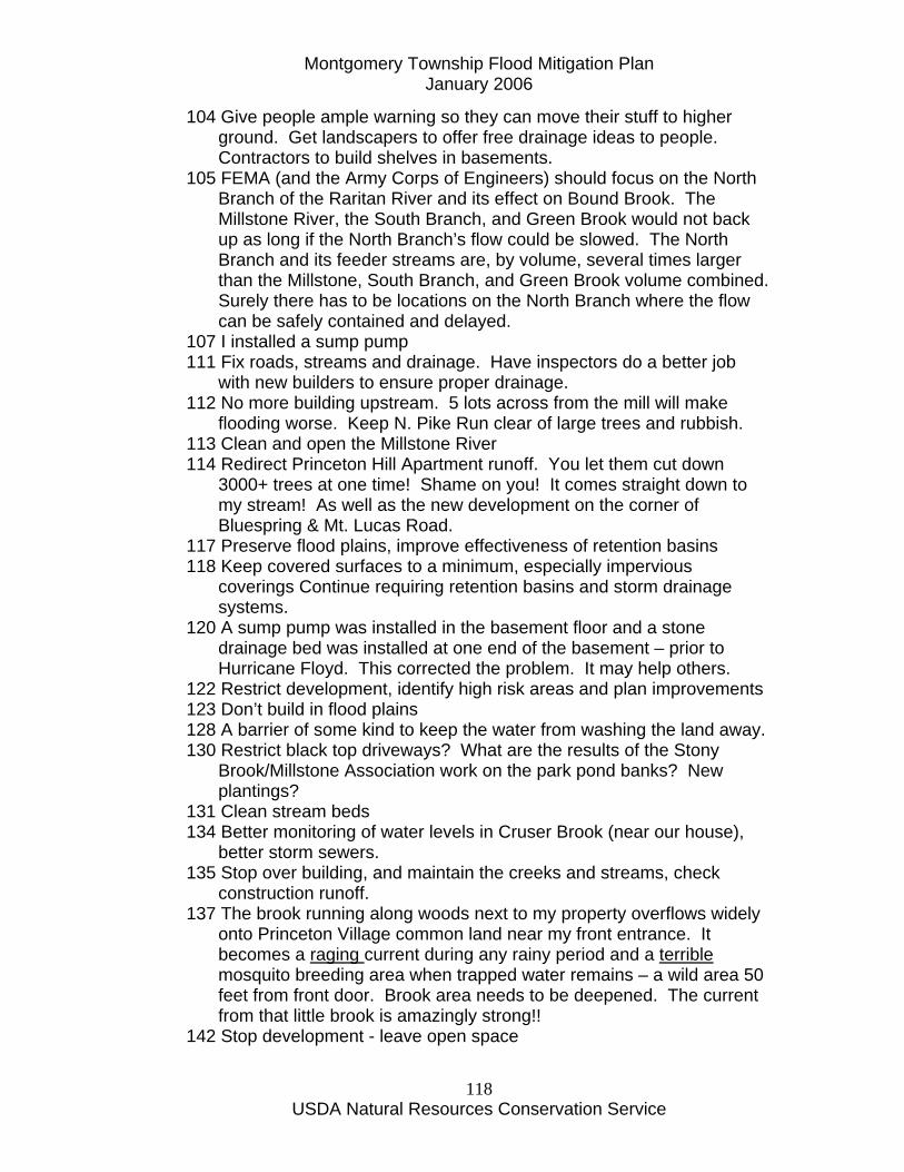
Montgomery Township Flood Mitigation Plan January 2006
USDA Natural Resources Conservation Service
118
104 Give people ample warning so they can move their stuff to higher ground. Get landscapers to offer free drainage ideas to people. Contractors to build shelves in basements.
105 FEMA (and the Army Corps of Engineers) should focus on the North Branch of the Raritan River and its effect on Bound Brook. The Millstone River, the South Branch, and Green Brook would not back up as long if the North Branch’s flow could be slowed. The North Branch and its feeder streams are, by volume, several times larger than the Millstone, South Branch, and Green Brook volume combined. Surely there has to be locations on the North Branch where the flow can be safely contained and delayed.
107 I installed a sump pump 111 Fix roads, streams and drainage. Have inspectors do a better job
with new builders to ensure proper drainage. 112 No more building upstream. 5 lots across from the mill will make
flooding worse. Keep N. Pike Run clear of large trees and rubbish. 113 Clean and open the Millstone River 114 Redirect Princeton Hill Apartment runoff. You let them cut down
3000+ trees at one time! Shame on you! It comes straight down to my stream! As well as the new development on the corner of Bluespring & Mt. Lucas Road.
117 Preserve flood plains, improve effectiveness of retention basins 118 Keep covered surfaces to a minimum, especially impervious
coverings Continue requiring retention basins and storm drainage systems.
120 A sump pump was installed in the basement floor and a stone drainage bed was installed at one end of the basement – prior to Hurricane Floyd. This corrected the problem. It may help others.
122 Restrict development, identify high risk areas and plan improvements 123 Don’t build in flood plains 128 A barrier of some kind to keep the water from washing the land away. 130 Restrict black top driveways? What are the results of the Stony
Brook/Millstone Association work on the park pond banks? New plantings?
131 Clean stream beds 134 Better monitoring of water levels in Cruser Brook (near our house),
better storm sewers. 135 Stop over building, and maintain the creeks and streams, check
construction runoff. 137 The brook running along woods next to my property overflows widely
onto Princeton Village common land near my front entrance. It becomes a raging current during any rainy period and a terrible mosquito breeding area when trapped water remains – a wild area 50 feet from front door. Brook area needs to be deepened. The current from that little brook is amazingly strong!!
142 Stop development - leave open space

Montgomery Township Flood Mitigation Plan January 2006
USDA Natural Resources Conservation Service
119
143 The hedgerow that separates our property and our neighbors that needs to be trenched or piped to flow the water away from our house.
145 Make the existing detention basins work as intended. For example, the basin at Bridgepoint and Oriole does not detain water even in major rain storms (personal observation).
Question 11: What suggestions do you have to reduce flood damages in the future? (Continued) Response Number 147 We do not know what your plans are, nor what the issues are! Public
meeting is necessary. 150 Sump pumps 152 Reduce water output from Court and Bridgepoint Rd that empties into
our front yard. Prevent Pike Brook from rising to overflow levels possibly downstream.
160 We put in a heavier duty pump and additional drains in front of yard 161 Try to make sure that vegetative wastes (leaves & brush) do not get
put into storm drains and ditches. 163 Maintain present drainage systems, such as storm sewer and the
drainage ditches that service storm sewers. I believe a plan should be mad to improve and upgrade the present storm sewer system, many neighborhoods are living with 50 year old systems that are outdated due to the growth and development of the township.
165 I do not feel that I have the experience or background knowledge necessary to answer this question – examples may have helped.
167 Stop the blacktopping of Montgomery! While it appears that the worst of the development excesses have ceased we have lost LOTS of permeable land leaving water no where to go except into the easily flooded Millstone River (and its’ tributaries). The various detention basins of the various developments are ineffective (I have never seen significant amount of water in them, even when nearby roads are flooded) It would seem that rigorous inspection of the efficacy of these basins in order and that necessary remediation be effected as quickly as possible.
168 1. Curtail development. 2 Make detention basins retention basins. Hire an area-wide flood
water administrator to release basins when appropriate. 3. Reject the Corps of Army Engineers proposal for building levees
to protect Manville only at the expense of the entire Millstone Valley. Restricting flow at mouth of River will be devastating to every one upstream.
4. Do not allow Princeton University in their development along the Route 1 Corridor to put any additional storm water into the Millstone.
Question 11: What suggestions do you have to reduce flood damages in the future? (Continued)

Montgomery Township Flood Mitigation Plan January 2006
USDA Natural Resources Conservation Service
120
Response Number 5. 18 years ago – Flooding was only after Bedens Brook emptied
into Millstone – now additional development upstream effects River at Rocky Hill and south
6. Flooding in the Millstone Valley is a 4 county affair – the riparian system needs to be looked at regionally – even though some of the area doesn’t meet cost benefit ratios.
173 Keep drains clear 174 Education, assemble brochure about appropriate stream side plants
(deer-proof & goose-proof, if that is possible). Trees, shrubs groundcovers???
175 More reservoirs need to be built in NJ to retain heavy rains and reduce runoff. Reservoirs would also reduce drought strain in dry years. Too much emphasis has been placed on efficient drainage and not enough on detention.
176 I think all the development in the area - much paving, roads, etc. have made flooding more frequent and likely.
178 Mandatory flood insurance, good storm water drains, a new flood SWAT team.
179 1. Prevent building within the 100 year flood zone. 2. Insure all homes have necessary sump pumps & emergency
backup systems (eg. electrical generators) 183 Require that houses renovated or rebuilt in flood plains be put up on
pilings as in the Florida Keys. Require that new paving (i.e. parking lots) be water permeable to reduce runoff.
Question 12: What incentives do you think that Montgomery Township, the Federal Emergency Management Agency (FEMA) and others should offer to reduce flood damages? Response Number 1 Who do you offer incentives to stop building? And what could you offer
them? 4 Never heard of agency (FEMA). You don’t need outside help. You
need to use common horse sense – It’s easy to channel water away from homes if done at building time. It doesn’t take an act of Congress. But it does require prior thought and planning. Sanitary sewers are needed. Better storm sewer and storm brook clean out on regular schedule.
18 Reduce government and provide free flood insurance to homeowners 25 Instruct residents to identify the lowest part of the basement and install
a submersible sump pump. Question 12: What incentives do you think that Montgomery Township, the Federal Emergency Management Agency (FEMA) and others should offer to reduce flood damages? (Continued)
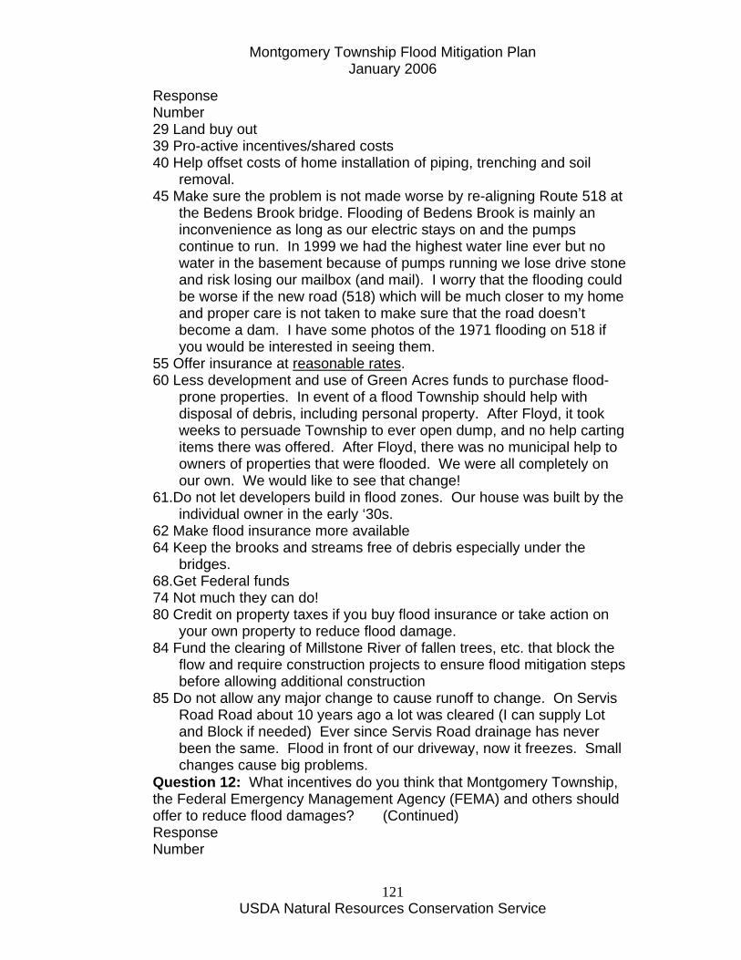
Montgomery Township Flood Mitigation Plan January 2006
USDA Natural Resources Conservation Service
121
Response Number 29 Land buy out 39 Pro-active incentives/shared costs 40 Help offset costs of home installation of piping, trenching and soil
removal. 45 Make sure the problem is not made worse by re-aligning Route 518 at
the Bedens Brook bridge. Flooding of Bedens Brook is mainly an inconvenience as long as our electric stays on and the pumps continue to run. In 1999 we had the highest water line ever but no water in the basement because of pumps running we lose drive stone and risk losing our mailbox (and mail). I worry that the flooding could be worse if the new road (518) which will be much closer to my home and proper care is not taken to make sure that the road doesn’t become a dam. I have some photos of the 1971 flooding on 518 if you would be interested in seeing them.
55 Offer insurance at reasonable rates. 60 Less development and use of Green Acres funds to purchase flood-
prone properties. In event of a flood Township should help with disposal of debris, including personal property. After Floyd, it took weeks to persuade Township to ever open dump, and no help carting items there was offered. After Floyd, there was no municipal help to owners of properties that were flooded. We were all completely on our own. We would like to see that change!
61.Do not let developers build in flood zones. Our house was built by the individual owner in the early ‘30s.
62 Make flood insurance more available 64 Keep the brooks and streams free of debris especially under the
bridges. 68.Get Federal funds 74 Not much they can do! 80 Credit on property taxes if you buy flood insurance or take action on
your own property to reduce flood damage. 84 Fund the clearing of Millstone River of fallen trees, etc. that block the
flow and require construction projects to ensure flood mitigation steps before allowing additional construction
85 Do not allow any major change to cause runoff to change. On Servis Road Road about 10 years ago a lot was cleared (I can supply Lot and Block if needed) Ever since Servis Road drainage has never been the same. Flood in front of our driveway, now it freezes. Small changes cause big problems.
Question 12: What incentives do you think that Montgomery Township, the Federal Emergency Management Agency (FEMA) and others should offer to reduce flood damages? (Continued) Response Number
Montgomery Township Flood Mitigation Plan January 2006
USDA Natural Resources Conservation Service
122
86 Oppose levees downstream of us that would restrict outflow from our
area during flood events, encourage buyouts of property owners in the most flood-prone areas instead of fighting mother nature with flood control measures, then paying flood damages claims when they don’t work.
87 Increased funding to municipalities that promote pre-emptive measures 104 Give people a tax break, or refund each year so they choose to not
claim flood damage, if contractors could get some tax breaks from the townships, they could provide services free (except for the cost of materials) to build shelves in basement to lift peoples stuff off the floor so there isn’t flood damage in bad floods. Also if landscapers could get similar breaks from the township, they could provide services to people so that drainage of property is maximized or maybe a land berm to keep creek water from flooding people’s properties, for example, with plants and trees to make it look nice.
113 Construction of the weir in Weston Area to accommodate Elizabethtown Water Company increased the flood hazard. Investigate!
114 Aren’t your incentives always money related? 117 Prevent construction of homes and other buildings in flood plains 118 Loss of electricity allows water to accumulate because pumps won’t
pump. Work with PSE&G regarding ways to keep electrical service during storms.
120 Make sure that developers do not restrict the flow of small streams. 122 Low interest property grading/improvement loans 123 Do not insure any new projects in flood plains, contract with lowland
owners to provide passive reservoirs. 128 Something to help the problem 134 Reimbursement for benches and shelving in basements so few items
are stored on the floor. Reduction (small) in taxes to pay for flood insurance.
141 Tax breaks on improvements to home that mitigate flood damage, eg. Sump pumps, waterproofing basements, property re-grading.
Question 12: What incentives do you think that Montgomery Township, the
Federal Emergency Management Agency (FEMA) and others should offer to reduce flood damages? (Continued)
143 Do a complete survey and review of potential areas to control proper drainage in areas of need.
145 In cases where a structure incurs repeated flood damage, it should be abandoned, demolished and the land left as flood plain.
150 $50 credit for sump pump purchase; subsidize purchase of sump pump through township program. Free sump pump inspections.
163 I need to know more about what incentive would be available.
Montgomery Township Flood Mitigation Plan January 2006
USDA Natural Resources Conservation Service
123
168 Make dollars available for regional planning for storm water management – now reviewed single development only.
174 Perhaps offer (at a discount?) appropriate plants that will hold streambank soils, as well as slow down flood water.
176 Could offer more incentives to mitigate damages. I was only allowed 20% of my FEMA loan for mitigation. I used that and a home equity loan to raise house five feed up from flood plains. Also, flood insurance is very expensive – mine went up for next year to $1,800. The government could do something about that.
178 Train local fire stations in flood management, train local volunteers in flood SWAT team procedures.
179 Tax rebates for installation of emergency backup generators, secondary sump pumps, French drain systems, etc.
183 Financial - lowest loans to people willing to raise their houses on pilings, reduced rates on flood insurance for raised houses.
Question 13: Additional comments? Response Number 1 In the last 30 plus years, the stream behind our house has bout doubled in
width, causing erosion and the loss of many trees along the stream. Is there any way to shore up the streambanks to reduce erosion?
Question 13: Additional comments? (Continued) Response Number 77 Why should the government pay out for National Flood Insurance or give
out grants to homeowners who live in flood-prone areas? No one should have been allowed to build in flood plains. Local and State building codes should have been allowed to build in flood plains. Local and State building codes should have prevented building from building anything in a flood plain in the first place. Allow builders to strip and clear-cut property to build to build subdivision is irresponsible. It creates flood conditions for homeowners living downhill from these areas. Furthermore there should be requirements regarding percent of impervious surfaces allowed. Homeowners later affected by clear cutting should be able to sue builders who caused the problem. Builders should be forced to buy insurance as well as pay into a fund to remedy harm done to homeowners so affected in the future. Why is the solution always a government bailout?
94 See attached FEMA Letter of Map Amendment (Removing structure from the Special Flood Hazard Area).
137 Princeton Villages refuses to address drainage problems - runs pipes the entire length of two buildings to dump into woods behind my townhouse
Montgomery Township Flood Mitigation Plan January 2006
USDA Natural Resources Conservation Service
124
which complicates raging waters from brook and enhances mosquito problem from previously flooded woodland area.
163 The property that borders the back of my lot is; the __________ consisting of 3 lots with a building and a 45,000 square foot paved parking lot. The parking lot is graded towards my property, the original site plan required a retention basin and drainage ditches to protect ________, _______ and _______. Property’s from the rain water runoff. That protection is virtually none existing due to neglect over the past 20 years. The ______, the second owner of the property was unaware of the original site plan requirements until we brought it to their attention about two years ago. The closest storm sewer is on Woodward Drive and it is down grade from the parking lot and my property (approx. 10 foot drop in grade). If we have a storm dumping one to two inches of water per hour, the parking lots runoff has to travel 325 feet across my property and my neighbor’s property in order to get to the storm sewer located on Woodward Drive. To make matters worse the point of output from the parking lot runoff is in direct line with output ends of my neighbor’s septic fields. ___________ is in the early stage of planning an expansion program of their facility and hopefully they can incorporate a permanent solution to the water runoff problem. Further to that the Township has been involved with the flooding of Woodward Drive this past winter. They cleared a root blockage in the underground storm sewer, and are studying a permanent fix for the root problem. In addition to that they are considering the possibility of improving the capacity of the storm sewer drainage ditch, which empties the storm sewers into the Pike Brook. The ditch has narrowed over the past 40-45 years and the volume of water has increased due to the parking lot problem, and to make matters worse the water company has diverted water that normally flows along their Main Pipeline, to the same Woodward Drive storm sewer. In the short term it would be my hope that the Township will improve the efficiency of our local storm sewer/drainage ditch, and __________ will resolve the water runoff from their property. We are looking forward to progress in the Flood Mitigation Plan and hopefully it will lead to a solution that would relieve, if not eliminate, our flooding.
174 Feel very strongly about private property rights and therefore????????/

Montgomery Township Flood Mitigation Plan January 2006
USDA Natural Resources Conservation Service
125

Montgomery Township Flood Mitigation Plan January 2006
USDA Natural Resources Conservation Service
126
Letter to Neighboring Municipalities, State and County Agencies

Montgomery Township Flood Mitigation Plan January 2006
USDA Natural Resources Conservation Service
127
Montgomery Township Flood Mitigation Plan January 2006
USDA Natural Resources Conservation Service
128
February 22, 2005 Mr. Ernie Hahn, Executive Director Delaware & Raritan Canal Commission P. O. Box 539 Stockton, New Jersey 08559
RE: Township of Montgomery Flood Mitigation Plan Dear Mr. Hahn: This is to advise you that the Township of Montgomery is in the process of developing a Flood Mitigation Plan funded by the grant from the Federal Emergency Management Agency (FEMA) through the State Office of Emergency Management. The Natural Resources Conservation Service is providing planning assistance to the Township to complete the Plan. We are notifying you so as not to duplicate or interfere with other flood management activities nearby. Please advise us of any activity, either proposed or in place, that you think may have an impact on a flood mitigation plan specific to Montgomery Township. We would appreciate a reply no later than Friday, March 11, 2005. Thank you very much. Sincerely, Louise Wilson, Mayor Township of Montgomery LW/kp cc: Donato Nieman, Township Administrator Lt. Robert Palmer, Emergency Management Coordinator
Greg Westfall, Natural Resources Conservation Service

Montgomery Township Flood Mitigation Plan January 2006
USDA Natural Resources Conservation Service
129

Montgomery Township Flood Mitigation Plan January 2006
USDA Natural Resources Conservation Service
130
Comments Received from Others

Montgomery Township Flood Mitigation Plan January 2006
USDA Natural Resources Conservation Service
131
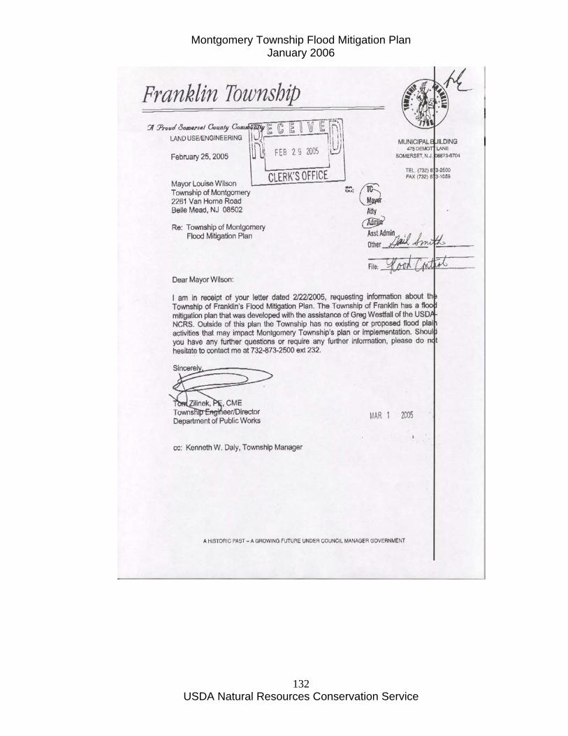
Montgomery Township Flood Mitigation Plan January 2006
USDA Natural Resources Conservation Service
132

Montgomery Township Flood Mitigation Plan January 2006
USDA Natural Resources Conservation Service
133
Montgomery Township Flood Mitigation Plan January 2006
USDA Natural Resources Conservation Service
134
Montgomery Township Flood Plain Ordinance

Montgomery Township Flood Mitigation Plan January 2006
USDA Natural Resources Conservation Service
135
Montgomery Township Flood Mitigation Plan January 2006
USDA Natural Resources Conservation Service
136
Montgomery Township Flood Plain Ordinance
16-6.4 Critical Areas. a. Basis for Establishing Critical Areas. The mapping of the critical areas within Montgomery Township is indicated on the map entitled Critical Areas, dated February, 1993, which is part of this chapter and may be supplemented from time to time. As noted on the map, the basis for the delineation of flood plain areas was the Flood Insurance Rate Maps prepared by the Federal Emergency Management Agency and dated April 1981; the basis for the delineation of steep slope areas was the U.S. Geological Survey Slope Maps, Rocky Hill and Monmouth Junction Quadrangles, 1975; and the basis for the mapping of wetlands was the National Wetlands Inventory, U.S. Department of the Interior, Rocky Hill and Monmouth Junction Quadrangles, November 5, 1975.
Regarding flood plain areas, it is recognized that more flood plain areas exist in the Township than those already mapped. Moreover, the New Jersey Department of Environmental Protection (NJDEP), Division of Water Resources, in accordance with the Flood Hazard Area Control Act (N.J.S.A. 58-16A-50 et seq.), has adopted N.J.A.C. 7:13 and has mapped the flood hazard areas in Montgomery Township. The NJDEP mapping shall take precedence.
Critical areas also include freshwater wetlands, wetlands transition areas, 100-year flood plains, topographic slopes fifteen (15%) percent or greater, and any land exhibiting either Croton or Bowmansville soils.
Additionally, while information depicted on the map has been prepared as accurately as possible; nevertheless, it must be understood that detailed information mapped at such a large scale may not represent the actual conditions on any particular parcel of land. Therefore, the information is not intended to take the place of specific on-site engineering data presented to and subjected to independent verification by the Township at the time applications are submitted for approval of a subdivision, site plan, construction permit, and/or any other application which considers construction permits, and/or any other application which considers the critical areas categories of information depicted on the map.
b. Purpose of Regulations for Flood Plain and Stream Corridor Areas.
The purpose of these regulations is:
1. To protect flood plains and stream corridors so that flood water may have a natural course to follow and so that the watercourse is not constricted or altered in a manner that will increase water velocities or create a dam.
Montgomery Township Flood Mitigation Plan January 2006
USDA Natural Resources Conservation Service
137
2. To allow water levels to rise without danger to persons, animals or property and cover larger land surfaces for the purposes of greater water percolation and recharge of the underground water supply.
3. To promote the development of a park like network throughout Montgomery Township along watercourses.
4. To permit only that development of flood prone areas and stream corridors within Montgomery Township which:
(a) Is appropriate in light of the probability of flood damage and the need to reduce flood losses;
(b) Represents an acceptable social and economic use of the land in relation to the hazards involved;
(c) Does not increase the danger to human, plant or animal life;
(d) Provides that no decreases in the amount of available storage for flood waters within the flood plain results from any development.
5. To prohibit any other types of development including, without limitation, the dumping of solid or hazardous waste, the construction of subsurface sewage disposal systems, the storage of any petroleum products, the addition or removal of fill and the altering of watercourses, temporary roadways and grading, and to retain areas adjacent to streams free from structures and other obstructions.
6. To protect property from the adverse effects of flooding, erosion, loss of vegetation, seepage, and downstream deposits of silt, gravel and stone, and to prevent burdensome costs to the public arising from such damage and its repair.
7. To protect other municipalities within the same watersheds from improper stream corridor development and the increased potential for flooding or for reduced stream flows in dry weather.
8. To prevent disturbance to the ecological balance between wildlife, plant and marine life, which are dependent upon watercourses, and their protective flood plains and slopes.
9. To maintain the quality of streams in the Township, and to the extent any streams are impaired, improve their quality.
10. To prevent the destruction of riparian areas and removal of riparian vegetation by development which can result in the deterioration of aquatic ecosystems and impairment of healthy streams and waterways.
c. Applicability and Interpretation of this Subsection.
1. This subsection regulates development in the following two (2) ways:
Montgomery Township Flood Mitigation Plan January 2006
USDA Natural Resources Conservation Service
138
(a) By protecting stream corridors from the type and intensity of development which would be destructive to their special environmental importance and harmful to the health and general welfare and to properties downstream; and
(b) By mitigating flood hazards within flood hazard areas pursuant to the requirements of the National Flood Insurance Program. These regulations are, in part, intended to satisfy federal requirements in order to make flood insurance available within Montgomery Township.
2. Except in limited cases, the stream corridor requirements of subsection 16-6.4 do not permit structures within the stream corridor as defined in paragraph d. below which, by that definition, includes flood hazard areas. The flood hazard mitigation requirements in subsection 16-6.4h. apply only in those limited cases where structures or substantial improvements to structures are permitted.
d. Definitions.
1. Appeal shall mean a request for the review of the Township Engineer's interpretation of any provision of this section or a request for a variance from the Planning Board.
2. Area of shallow flooding shall mean a designated AO or VO Zone on the Flood Insurance Rate Map (FIRM). The base flood depths range from one (1) to three (3) feet; a clearly defined channel does not exist; the path of flooding is unpredictable and indeterminate; and, velocity flow may be evident.
3. Area of special flood hazard shall mean land in the flood plain within the Township subject to a one (1%) percent or greater chance of flooding in any given year.
4. Base flood shall mean the flood having a one (1%) percent chance of being equaled or exceeded in any given year.
5. Basement shall mean the area of any building having its floor subgrade (below ground level) on all sides.
6. Breakaway wall shall mean a wall that is not part of the structural support of the building and is intended through its design and construction to collapse under specific lateral loading forces without causing damage to the elevated portion of the building or supporting foundation system.
7. Channel shall mean the bed and banks of the water courses located within the boundaries of the Township of Montgomery which convey the normal flow of said water courses most of the time.
8. Delineated stream shall mean a stream that has a delineated floodway officially adopted by NJDEP pursuant to N.J.A.C. 7:13.

Montgomery Township Flood Mitigation Plan January 2006
USDA Natural Resources Conservation Service
139
9. Design flood profile shall mean the elevations of the water surface of the floodway design flood and the flood hazard area design flood.
10. Development shall mean any man-made change to improved or unimproved real estate including, but not limited to, buildings or other structures, mining, dredging, filling, grading, paving, excavation or drilling operations.
11. Elevated building shall mean a non-basement building built to have the top of the elevated floor elevated above the ground level by means of piling, columns (posts and piers) or shear walls parallel to the flow of the water and adequately anchored so as not to impair the structural integrity of the building during a flood of up to the magnitude of the base flood. Elevated building also includes a building elevated by means of fill or solid foundation perimeter walls with openings sufficient to facilitate the unimpeded movement of flood waters.
12. Flood elevation determination shall mean the determination of the water surface elevations of the design flood, i.e., the flood level that has a one (1%) percent or greater chance of occurrence in any given year.
13. Flood fringe area shall mean the portion of the flood hazard area not designated as the floodway.
14. Flood hazard area shall mean the floodway and the flood fringe area of a delineated stream.
15. Flood hazard area design flood shall mean the 100-year storm in nondelineated areas and the 100-year storm plus twenty-five (25%) percent in delineated areas.
16. Flood Insurance Rate Map (FIRM) shall mean the official map on which the Federal Insurance Administration has delineated both the areas of special flood hazards and the risk premium zones applicable to the community.
17. Flood insurance study shall mean the official report in which the Federal Insurance Administration has provided flood profiles, as well as the Flood Boundary-Floodway Map and the water surface elevation of the base flood.
18. Flood or flooding shall mean general and temporary condition of partial or complete inundation of normally dry areas from:
(a) Inland or tidal waters; and
(b) The unusual and rapid accumulation of runoff of surface water from any source.
19. Flood plain shall mean the relatively flat area adjoining the channel of a natural stream which has been or may be hereafter covered by flood water.
Montgomery Township Flood Mitigation Plan January 2006
USDA Natural Resources Conservation Service
140
20. Flood plain management regulations shall mean State or local regulations, in any combination thereof, which provide standards for the purpose of flood damage prevention and reduction.
21. Floodway shall mean the channel of a natural stream and portions of the flood hazard area adjoining the channel which are reasonably required to carry and discharge the flood water or flood flow of any natural stream without accumulatively increasing the water surface elevation any more than two-tenths (.2) feet.
22. Lowest floor shall mean the lowest floor of the lowest enclosed area, including a basement. An unfinished or flood resistant enclosure, usable solely for the parking of vehicles, building access or storage in an area other than a basement is not considered a building's lowest floor, provided that such enclosure is not built so as to render the structure in violation of other applicable nonelevation design requirements.
23. Manufactured home shall mean a structure, transportable in one (1) or more sections which is built on a permanent chassis and is designed for use with or without a permanent foundation when connected to the required utilities. For the purposes of flood plain management the term "manufactured home" includes park trailers, travel trailers, and other similar vehicles placed on a site for greater than one hundred eighty (180) consecutive days. For insurance purposes the term "manufactured home" does not include park trailers, travel trailers or other similar vehicles.
24. Manufactured home park or manufactured home subdivisions shall mean a parcel (or contiguous parcels) of land divided into two (2) or more manufactured home lots for rent or sale.
25. New construction shall mean structures for which the start of construction commenced on or after the effective date of this section.
26. Start of construction shall mean and include substantial improvement and means the date the building permit was issued, provided the actual start of construction, repair, reconstruction, placement, or other improvement commenced within one hundred eighty (180) days of the permit date. The actual start means either the first placement of permanent construction of a structure on a site such as the pouring of a slab or footings, the installation of piles, the construction of columns, or any work beyond the stage of excavation, or the placement of a manufactured home on a foundation. Permanent construction does not include land preparation, such as cleaning, grading and filling, nor does it include excavation for a basement, footing, piers or foundations or the erection of temporary forms, nor does it include the installation on the property of accessory buildings, such as garages or sheds not occupied as dwelling units or nor part of the main structure.
Montgomery Township Flood Mitigation Plan January 2006
USDA Natural Resources Conservation Service
141
27. Stream shall mean a waterway depicted on the Montgomery Township Hydrography Map, dated May 18, 2001 as may be amended from time to time, on file in the office of the Township Clerk and Township Engineer.
28. Stream corridor shall mean and include the area within a floodway, flood plain, flood hazard area, buffer strips one hundred (100) feet from the top of the channel banks of the stream, and the area that extends one hundred (100) feet from the one hundred-year flood hazard line on both sides of the stream. If there is no one hundred-year flood hazard line delineated, the distance of one hundred (100) feet shall be measured outward from the top of the banks of the stream channel on both sides of the stream. If slopes greater than fifteen (15%) percent abut the outer boundary of the stream corridor, the area of such slopes shall also be included as the stream corridor. If the flood plain or flood hazard area extends for more than one hundred (100) feet from the top of the channel bank, said larger area shall be the stream corridor.
29. Structure shall mean for flood plain management purposes, a walled or roofed building, including without limitation, gas or liquid storage tanks, that is principally above ground. For insurance purposes, "structure" means a walled and roofed building, other than a gas or liquid storage tank, that is principally above ground and affixed to a permanent site. For the latter purpose, the term includes a building while in the course of construction, alteration or repair but does not include building materials or supplies intended for use in such construction, alteration or repair, unless such material or supplies are within an enclosed building on the premises.
30. Substantial improvement shall mean any repair, reconstruction or improvement of a structure, the cost of which equals or exceeds fifty (50%) percent of the assessed value of the structure on an equalized basis either:
(a) As determined before the improvement or repair is started; or
(b) As determined before the damage occurred, if the structure has been damaged and is being restored. For the purpose of this definition, "substantial improvement" is considered to occur when the first alteration of any wall, floor or other structural part of the floor commences, whether or not that alteration affects the external dimensions of the structure. The term does not, however, include either:
(1) Any project for improvement of a structure to comply with existing State or local health, sanitary or safety code specifications which is solely necessary to assure safe living conditions; or
(2) Any alteration of a structure listed on the National Historic Register of Historic Places or the State Inventory of Historic Places.
31. Variance shall mean a grant of relief by the Planning Board from the requirements of this section permitting construction in a manner otherwise
Montgomery Township Flood Mitigation Plan January 2006
USDA Natural Resources Conservation Service
142
prohibited by this section because the literal enforcement would result in unnecessary hardship.
e. Basis for Establishing the Areas of Special Flood Hazard. The areas of special flood hazard identified by the Federal Insurance Administration in its report entitled The Flood Insurance Study For The Township of Montgomery, New Jersey, dated October, 1980, with accompanying flood insurance rate maps and flood and boundary-floodway maps is hereby adopted by reference and declared to be part of this chapter to serve as the primary basis for establishing the areas of special flood hazard. The flood insurance study is on file with the Township Clerk. Other data available through Federal, State, County and local services and additional reports such as but not limited to the following, may be used to supplement the flood insurance study:
1. Soil Survey of Somerset County, New Jersey, U.S. Department of Agriculture, Soil Conservation Service, December, 1976.
2. Delineation of flood hazard areas, Raritan River Basin, as established for Bedens Brook, Rock Brook, Pike Run and Cruser Brook by N.J.A.C. 7:13-7.1(d), last amended.
3. United States, Department of the Army Corps of Engineers, Rocky Hill Quadrangle and Monmouth Junction Quadrangle maps, November 5, 1975.
4. Montgomery Township Hydrography Map, dated May 18, 2001, last amended.
f. Site Plan Review.
1. All proposals for any development within a flood plain or stream corridor area shall require site plan approval by the Planning Board in accordance with section 16-8 of this chapter; provided, however, that when a plan does not include the construction of permanent buildings or structures but, instead, includes such work as grading, landscaping, work associated with agricultural uses and similar uses, and where, upon the recommendation of the Consulting Engineer to the Planning Board or, in the absence of one, the Township Engineer, the proposed work is of such a minor nature that Planning Board review is not required, the need for site plan approval by the Planning Board may be waived by the Board. In any case, all other requirements of this section shall apply and before the work actually begins, the Consulting Engineer to the Planning Board or, in the absence of one, the Township Engineer shall have issued, in writing, his/her approval to proceed with the work.
2. When a proposal for development within a flood plain or stream corridor is made to the Township, initially the Consulting Engineer to the Planning Board or, in the absence of one, the Township Engineer shall review the proposal to:
(a) Determine that the requirements of this section have been satisfied;
Montgomery Township Flood Mitigation Plan January 2006
USDA Natural Resources Conservation Service
143
(b) Determine that all necessary approvals have been obtained from those Federal, State or other local governmental agencies from which prior approval is required;
(c) Determine if the proposed development is located in the floodway, and, if so, assure that the encroachment provisions pertaining to floodways are met; and
(d) Determine whether any plans for walls to be used to enclose space below the base flood level comply with applicable requirements.
After the review is completed, the Consulting Engineer to the Planning Board or, in the absence of one, the Township Engineer shall inform the Planning Board of his/her findings.
3. Fees shall be as provided for site plans in section 16-9 of this chapter and public notice of public hearings shall be given as stipulated for site plans in subsection 16-7.6d of this chapter. In addition to the applicable information required for preliminary site plan approval stipulated in subsection 16-8.4 of this chapter, the following additional information shall be provided:
(a) Proposed finished grade elevations at the corners of any structure or structures.
(b) Elevation in relation to mean sea level, of the lowest floor (including basement) of all structures, existing and proposed.
(c) Elevation in relation to mean sea level to which any structure, existing or proposed, has been or will be floodproofed.
(d) Certification by a registered professional engineer or architect that the floodproofing methods for any nonresidential structure meet the floodproofing criteria established by this section.
(e) Description of the extent to which any watercourse will be altered or relocated as a result of the proposed development. Where alteration or relocation of a watercourse is proposed, notification of the proposed alteration or relocation must be provided to adjacent municipalities and proof of such notification submitted to the Federal Insurance Administration.
(f) The extent of proposed or previous filling, cutting or regrading of the land, if any.
(g) The location, type and size of all existing and proposed erosion and siltation control measures, such as slope protection soil stabilization, sedimentation basins, sediment trap headwalls and aprons.
(h) Proof of stream encroachment lines (floodway) obtained from NJDEP. Where stream encroachment lines have not been established by NJDEP, the following rules shall be utilized to determine the floodway delineation:

Montgomery Township Flood Mitigation Plan January 2006
USDA Natural Resources Conservation Service
144
(1) Concerning hydrology methods that are acceptable are those outlined in Technical Manual For Stream Encroachment, August, 1984, Section 3.l published by the State of New Jersey, Division of Coastal Resources, Bureau of Flood Plain Management, and as amended.
(2) Concerning hydraulics:
i. Water surface profiles shall be computed using the Step-Backwater method of analysis;
ii. Computations shall begin at a suitable control point at least five hundred (500) feet downstream from a project;
iii. Normal depth computed using Manning equation may be used as the starting elevation if the channel is of uniform cross section and slope, and it can be demonstrated that flow is not affected by backwater caused by downstream obstructions;
iv. Water surface profiles shall be computed based upon existing topography, proposed structures, and changes of topography proposed by the applicant; and
v. Encroachment lines shall be set at or outside the floodway.
4. The applicant should be prepared to present evidence that the proposal:
(a) Has inherently low flood damage potential.
(b) Either acting alone or in combination with the existing or future uses will not obstruct flood flows or increase flood heights and/or velocities or reduce ground absorption or storage volume of storm water.
(c) Does not affect adversely the water carrying or storage capacity of the channel, floodway or flood fringe areas.
(d) Does not increase local runoff and erosion and provides proper drainage of the area to an existing adequate watercourse or drainage system.
(e) Does not unduly stress or degrade the natural environment of the flood plain or degrade the quality of surface water or the quality or quantity of ground waters.
(f) Does not require channel modification or relocation.
(g) Is set forth in this chapter as a permitted use.
(h) Is not a prohibited use in that portion of the floodway, flood plain or stream corridor where proposed to be located.
5. Where required by the Planning Board, the applicant shall furnish information relating to subsurface conditions based on percolation tests and soil
Montgomery Township Flood Mitigation Plan January 2006
USDA Natural Resources Conservation Service
145
borings or probes. Test borings or probes shall be performed by a licensed professional engineer and shall be in accordance with acceptable engineering standards and practices. Written notification of intention to conduct such tests shall be forwarded to and received by the Township Engineer at least two (2) working days prior to testing. A detailed report of the test shall be submitted to the Planning Board and the Consulting Engineer to the Planning Board, or in the absence of one, the Township Engineer for review.
6. When base flood elevation data has not been provided the Township, its agents, servants and employees shall obtain, review and reasonably utilize any base flood elevation and floodway data available from a Federal, State or other source to administer this chapter.
7. The reasons the use cannot be located totally outside the stream corridor area.
g. Uses in Floodways, Flood Fringe and Stream Corridor Areas.
1. Prohibited Uses. No person shall hereafter engage in, cause or permit other persons to engage in prohibited uses in the floodway, flood fringe, flood plain and stream corridor areas. All uses not specifically permitted by paragraphs g.2 and 3 of this subsection shall be prohibited.
2. Permitted Uses in Floodways. The following uses shall be permitted in floodways provided the requirements of paragraph g.2(e) of this subsection and paragraph h. of this subsection are satisfied:
(a) Channel improvements or changes may be permitted only in connection with stream improvements and stabilization, which improvements or changes have the approval of NJDEP, the Somerset County Planning Board and the Montgomery Township Planning Board.
(b) The accepted practices of soil husbandry and farming as well as recreational uses in the nature of parks, wildlife preserves, undeveloped common open space, picnic areas, boat landings and golf courses, provided a maintenance program to promote stabilization of stream banks is established.
(c) Installation, repairs or replacement of sanitary sewers and appurtenances, and other utility lines and appurtenances.
(d) Culverts, bridges, road or driveway crossings where no other locations are feasible.
(e) No encroachments, including fill, new construction, substantial improvements, or other development shall be permitted unless a technical evaluation demonstrates that encroachment shall not result in any increase in flood lands during the occurrence of a flood having a one (1%) percent chance of being equaled or exceeded in any given year. Any proposed use involving the removal of trees shall be undertaken in accordance with the approval of the
Montgomery Township Flood Mitigation Plan January 2006
USDA Natural Resources Conservation Service
146
Montgomery Township Planning Board. Material, equipment or vehicles related to and used in conjunction with a permitted use shall not be parked or stored in the floodway area.
(f) Stormwater management facilities.
3. Stream Corridor Areas. Stream corridors shall remain in their natural state, with no clearing or cutting of trees and brush (except for removal of dead vegetation and pruning for reasons of public safety), altering of watercourses, dumping of trash or debris, regrading or construction except for the following activities:
(a) Activities in stream corridors:
(1) Public parks;
(2) Game farms, fish hatcheries and fishing reserves, operated for the protection and propagation of wildlife, but excluding enclosed structures;
(3) Unpaved hiking, bicycle and bridle trails;
(4) Fishing areas;
(5) Reconstruction of a structure which pre-dates the adoption of this ordinance* in the event of damage or destruction by fire, storms, natural hazards, or other acts of God, provided that the reconstruction does not have a greater footprint or total area than that of the damaged structure and that no change in land use occurs; and further provided that the reconstruction shall be permitted only if no more than fifty (50%) percent of the structure is destroyed;
(6) Soil husbandry and farming, with the advice and assistance of Rutgers Cooperative Extension, provided that conservation practices as designed and approved by the New Jersey Department of Agriculture, the State Agriculture Development Committee, and the United States Department of Agriculture Natural Resources Conservation Service are implemented.
(b) Location of Activities on Tracts Partially Within Stream Corridors:
(1) All new lots in major and minor subdivisions and site plans shall be designed to provide sufficient areas outside of stream corridors to accommodate primary structures as well as any normal accessory uses appurtenant thereto.
(2) The Planning Board may allow an average stream corridor width of one hundred (100) feet from the one hundred-year flood line, thus allowing reasonable flexibility to accommodate site planning when necessitated by the size and shape of the tract and physical conditions thereon. The stream corridor width may be reduced to a minimum of fifty (50) feet from the one hundred-year flood line
Montgomery Township Flood Mitigation Plan January 2006
USDA Natural Resources Conservation Service
147
provided there is an increase at a two-to-one ratio in the width elsewhere on site and all other relevant permits, e.g., freshwater wetlands, are obtained.
(c) Activities Permitted in Stream Corridors when there is No Reasonable or Prudent Alternative:
The following are permitted in a stream corridor when subdivisions or site plans cannot be designed in the manner set forth in subparagraph 3(b) above, or, in the case of a preexisting lot for a one-family or two-family dwelling, when there is insufficient room outside the stream corridor for permitted accessory uses. In either case, there must be no other reasonable or prudent alternative to placement in the stream corridor:
(1) Recreational use, whether open to the public or restricted to private membership, such as parks, camps, picnic areas, golf courses (provided same are maintained in accordance with the most current Integrated Pest Management practices and standards recommended by Rutgers Cooperative Extension, or any successor entity), sports or boating clubs, not to include enclosed structures, but permitting piers, docks, foot bridges, floats or shelters usually found in developed outdoor recreational areas;
(2) Outlet installation of sewage treatment plants and sewage pumping stations and the expansion of existing sewage treatment facilities;
(3) Private or public water supply wells that have a sanitary seal, flood proofed water treatment facilities or pumping facilities;
(4) Dredging or grading when incidental to permitted structures or uses, including stream cleaning and stream rehabilitation work undertaken to prove hydraulics or to protect public health;
(5) Dams, culverts, bridges and roads provided that they cross the corridor directly as practical;
(6) Sanitary or storm sewers;
(7) Utility transmission lines installed during periods of low stream flow in accordance with soil erosion and sediment control practices and approved by the State Soil Conservation District in a manner which will not impede flows or cause ponding of water;
(8) Structures comprising part of a regional flood detention project;
(9) Detention or retention basins and related outfall facilities.
(d) Activities Permitted in Stream Corridors When Prohibiting Such Activities Would Cause Extreme Economic Hardship:
(1) New structures (other than those permitted as exceptions to paragraphs 3(a) and 3(b) above, including retaining walls, parking facilities and roads (but

Montgomery Township Flood Mitigation Plan January 2006
USDA Natural Resources Conservation Service
148
not those which are parallel to the stream) are permitted in a stream corridor only if:
(i) Upon a clear and convincing demonstration by the applicant that prohibiting such activity would result in extreme economic hardship or would conflict with a compelling public need, pursuant to the following standards:
[a] Prohibiting the activity would result in an extreme economic hardship, as distinguished from mere inconvenience, because of the particular physical surroundings, shape or topographical conditions of the property involved. The necessity of acquiring additional land to locate development outside the stream corridor shall not be considered an economic hardship unless the applicant can demonstrate that there is no adjacent land which is reasonably available; and
[b] An applicant shall be deemed to have established the existence of an extreme economic hardship only if the applicant demonstrates, based on the specific facts, that the subject property is not capable of yielding a reasonable economic return if its present use is continued or if it is developed as authorized by provisions of this subsection and that this inability to yield a reasonable economic returns result from unique circumstances peculiar to the subject property which:
Do not apply to or affect other property in the immediate vicinity;
Relate to or arise out of the characteristics of the subject property rather than the personal situations of the applicant; and
Are not the result of any action or inaction by the applicant or the owner or his predecessors in title.
[c] An applicant shall be deemed to have established compelling public need if the applicant demonstrates, based on specific facts, that:
The proposed project will serve as an essential public health or safety need;
The public health and safety require the proposed activity;
The proposed use is required to serve existing public health or safety need;
There is no alternative available to meet the established public health or safety need;
The activity will not be materially detrimental or injurious to other property or improvements in the area in which the subject property is located and will not endanger public safety; and
The exception granted is the minimum relief necessary to relieve the compelling public need.
Montgomery Township Flood Mitigation Plan January 2006
USDA Natural Resources Conservation Service
149
(ii) The stream corridor includes more than seventy-five (75%) percent of the tract.
(2) If such an exception is granted, the Planning Board may reduce the width of the stream corridor to no less than fifty (50) feet from the one hundred-year flood line, or if no one hundred-year flood line has been established, from the top of the banks of the stream channel.
(3) If such an exception is granted, the applicant shall rehabilitate an environmentally degraded stream corridor within or adjacent to the same tract at least equivalent in size to the stream corridor reduction permitted and if not possible, rehabilitate or expand a stream corridor of such size within a nearby tract and if available, within the same watershed. Rehabilitation shall include reforestation, stream bank stabilization and removal of debris. The area to be rehabilitated and the rehabilitation plan shall be acceptable to the Planning Board or the Zoning Officer, as the case may be.
h. Conditions Of Approval. The Planning Board may impose such conditions on permitted uses as it deems appropriate in order to promote the public safety, health and welfare to protect public and private property, wildlife and fisheries and to preserve and enhance the natural environment of the stream corridor. No certificate of occupancy shall be issued unless all conditions of approval have been complied with. In all flood hazard areas, the following conditions are specified in any case:
1. All new construction and substantial improvements shall be constructed with materials and utility equipment resistant to flood damage.
2. All new construction or substantial improvements shall be constructed by methods and practices that minimize flood damage.
3. All new and replacement water supply systems shall be designed to minimize or eliminate infiltration of flood waters into the system.
4. All new and replacement sanitary sewerage systems shall be designed to minimize or eliminate infiltration of flood waters into the system and discharges from the system into the flood waters.
5. On-site waste disposal systems shall be located to avoid impairment to them or contamination from them during flooding.
6. All new construction and substantial improvements shall be anchored to prevent flotation, collapse or lateral movement of the structure.
7. All manufactured homes shall be anchored to resist flotation, collapse or lateral movement. Methods of anchoring may include but are not limited to, the use of over the top or frame ties to ground anchors. This requirement is in addition to applicable State and local anchoring requirements for resisting wind forces.
Montgomery Township Flood Mitigation Plan January 2006
USDA Natural Resources Conservation Service
150
8. All subdivision proposals shall be consistent with the need to minimize flood damage.
9. All subdivision proposals shall have public utilities and facilities such as sewer, gas, electrical and water systems located and constructed to minimize flood damage.
10. All new construction shall have electrical, heating, ventilation, plumbing and air-conditioning equipment and other service facilities designed and/or located as to prevent water from entering or accumulating within the components during conditions of flooding.
11. All subdivision proposals shall have adequate drainage provided to reduce exposure to flood damage.
12. Appropriate and adequate controls on operations, sureties, deed restrictions and maintenance bonds shall be provided.
13. The construction of storm water detention and/or retention facilities, channel modifications, dikes, levees and other protective measures shall be required.
14. The installation of an adequate flood warning system shall be required.
15. The postponement of development until such a time as any necessary and required pre-construction protective measures are installed or implemented shall be required.
16. New construction or substantial improvement of any structure shall have the lowest habitable floor, including a cellar or basement, elevated to one (1) foot above the flood hazard area design flood elevation and a limit of disturbance shall be established a minimum of ten (10) feet from the stream corridor.
17. All new construction and substantial improvements with fully enclosed areas below the lowest floor that are subject to flooding shall be designed to automatically equalize hydrostatic flood forces on exterior walls, by allowing for the entry and exit of floodwater. Designs for meeting this requirement must either be certified by a registered professional engineer or architect and must meet or exceed the following minimum criteria: a minimum of two (2) openings having a total net area of not less than one (1) square inch for every square foot of enclosed area subject to flooding shall be provided. The bottom of all openings shall be no higher than one (1) foot above grade. Openings may be equipped with screens, louvers, or other coverings or devices provided that they permit the unimpeded gravity flow entry and exit of floodwater,
18. New construction or substantial improvement of any commercial, industrial or other nonresidential structure shall either have the lowest floor, including a cellar or basement, elevated to one (1) foot above the design flood elevation or, together with the attendant utility and sanitary facilities, be flood-
Montgomery Township Flood Mitigation Plan January 2006
USDA Natural Resources Conservation Service
151
proofed so that below the design flood level the structure is watertight with walls substantially impermeable to the passage of water and with structural components having the capability of resisting hydrostatic and hydrodynamic loads and effects of buoyancy. A licensed professional engineer or architect shall certify that the standards and methods of construction of this section are satisfied. Such certification shall be provided to the Planning Board. Any or all of the following floodproofing measures may be required:
(a) Installation of watertight doors, bulkheads and shutters, or similar devices.
(b) Reinforced walls to resist water pressure.
(c) Use of paints, membranes or mortars to reduce seepage of water through walls.
(d) Addition of weights to structures to resist flotation.
(e) Installation of pumps to lower water levels of structures.
(f) Pumping facilities or comparable measures for the subsurface drainage systems of the building to relieve external foundation wall and basement flood pressures. Over the sidewalk and under the sidewalk gravity or sump pump drains are not permitted. All such drains shall outlet into an existing adequate water course or drainage system.
(g) Construction that resists rupture or collapse caused by water pressure or floating debris.
(h) Installation of valves or controls on sanitary and storm drains which will permit the drains to be closed to prevent backup of sewerage or storm waters into the structure; gravity drainage of basements may be eliminated by mechanical devices.
(i) Location of all electrical equipment, circuits and installed electrical appliances in a manner which will assure they are not subject to inundation and flooding.
19. Where and when permitted, fill shall be no lower than one (1) foot above the flood hazard area design flood elevation and shall extend at such height for a distance of at least fifteen (15) feet beyond the limits of any structure erected thereon.
20. Where and when permitted, structures on fill shall be so built that the lowest floor is at a minimum of one (1) foot above the flood hazard design elevation.
21. All manufactured homes to be placed or substantially improved within an area of special flood hazard shall be elevated on a permanent foundation such that
Montgomery Township Flood Mitigation Plan January 2006
USDA Natural Resources Conservation Service
152
the finished floor elevation of the lowest floor is at or above the base flood elevation.
22. All necessary permits have been obtained from those Federal, State or local governmental agencies from which prior approval is required.
23. Adequate maintenance shall be provided within any altered or relocated portion of a watercourse so that the flood carrying capacity is not diminished.
i. Rehabilitation of Stream Areas. The applicant shall rehabilitate any stream corridor areas that may have been disturbed or degraded during construction. In addition, during construction the applicant shall take all reasonable measures to maintain the integrity of surrounding habitat and the existing ability of the stream corridor to buffer the stream.
j. Flood Insurance. Flood insurance in accordance with the Federal Insurance Agency shall be required for developments in the flood plain.
k. Warning and Disclaimer. The degree of flood protection required herein is considered reasonable for regulatory purposes and is based on scientific and engineering considerations. Larger floods can and will occur on rare occasions. Flood heights may be increased by man-made or natural causes. This chapter does not imply that land outside flood hazard areas will be free from flooding or flood damage. This chapter shall not create liability on the part of the Township of Montgomery or by any other officer or employee thereof for any flood damages that result from reliance on this chapter or any administrative decision lawfully made there under.
l. Flood Hazard Area Searches.
1. Official Designated to Make Flood Hazard Searches. The Township Committee shall, annually, designate an official of the Township to make and prepare flood hazard area searches. Such official shall thereafter by vested with the power to make certificates with respect to flood hazard areas on behalf of the Township.
2. Issuance of Certificates. The official appointed to make such searches shall issue certificates within a reasonable time after receipt of the following:
(a) A written request for a flood hazard area search containing a diagram or description showing the location and dimensions of the tract of land to be covered by the certificate, and the name of the owner of the tract of land; and
(b) The total fees as herein provided.
3. Fees for Certificates. The following fees shall be received prior to the issuance of any certificate:
Montgomery Township Flood Mitigation Plan January 2006
USDA Natural Resources Conservation Service
153
(a) Where the property described in the application is shown on the tax map as consisting of five (5) acres or less, a fee of five ($5.00) dollars.
(b) Where the property described in the application is shown on the tax map as consisting of more than five (5) acres but less than twenty (20) acres, a fee of ten ($10.00) dollars.
(c) Where the property described in the application is shown on the tax map as consisting of twenty (20) acres or more, a fee of twenty ($20.00) dollars.
m. Steep Slopes. The purpose of designating steep slopes as "critical areas" is to prevent soil erosion and storm water runoff resulting from development of such steep slope lands. Development throughout the Township shall occur only on the portion of a lot or tract outside the steep slope area, where feasible. "Development" shall include structures, roads, wells and sewage disposal systems.
n. Wetlands and Transition Areas. The purpose of designating wetlands and transition areas as critical areas is to assure that density calculations for various types of planned developments result in a unit construction that can be accommodated on the subject lands without encroaching upon the wetlands. The designation of wetlands and transition areas as a critical land factor is to signal the location of environmentally fragile lands which should be incorporated in open space plans or located within a portion of a lot which need not be physically developed. Further, Montgomery Township embraces the policy of the State of New Jersey as established by the Freshwater Wetlands Protection Act, N.J.S.A. 13:9B-1 et seq., that freshwater wetlands are a finite and valuable resource and that activities in or affecting wetlands should not destroy the natural wetland functions important to the public safety and general welfare. (Ord. #85-482, S 604; Ord. #88-601, SS 3, 4; Ord. #90-650, SS 1, 2; Ord. #01-1039, S 1) Suggested Changes to Existing Flood Damage Prevention Ordinance

Montgomery Township Flood Mitigation Plan January 2006
USDA Natural Resources Conservation Service
154

Montgomery Township Flood Mitigation Plan January 2006
USDA Natural Resources Conservation Service
155

Montgomery Township Flood Mitigation Plan January 2006
USDA Natural Resources Conservation Service
156
Suggested Changes to Existing Flood Damage Prevention Ordinance Section 16-6.4.d. Definitions Revise the following (with the additions shown underlined): “Development” means any man made change to improved or unimproved real estate, including but not limited to buildings or other structures, mining, dredging, filling, grading, paving, excavation or drilling operations or storage of equipment or materials located within the area of special flood hazard. “Flood Plain Management Regulations” means zoning ordinances, subdivision regulations, building codes, health regulations, special purpose ordinances (such as a flood plain ordinance, grading ordinance, erosion control ordinance) and other applications of police power. The term describes such State or local regulations, in any combination thereof, which provide standards for the purpose of flood damage prevention and reduction. “Historic Structure means any structure that is:
(a) Listed individually in the National Register of Historic Places (a listing maintained by the Department of the Interior) or preliminarily determined by the Secretary of the Interior as meeting the requirements for individual listing on the National Register;
(b) Certified or preliminarily determined by the Secretary of the Interior as contributing to the historical significance of a registered historic district preliminary determined by the Secretary to qualify as a registered historic district;
(c) Individually listed on a State inventory of historic places in States with historic preservation programs which have been approved by the Secretary of the Interior; or
(d) Individually listed on a local inventory of historic places in communities with historic preservation programs that have been certified either:
(1) By an approved State program as determined by the Secretary of the Interior; or
(2) Directly by the Secretary of the Interior in States without approved
programs. “Manufactured home” means a structure, transportable in one or more sections, which is built on a permanent chassis and is designed for use with or without a permanent foundation when attached to the required utilities. The term “manufactured home” does not include a “recreational vehicle.” “New manufactured home park or subdivision” means a manufactured home park or subdivision for which the construction of facilities for servicing the lots on

Montgomery Township Flood Mitigation Plan January 2006
USDA Natural Resources Conservation Service
157
which the manufactured homes are to be affixed (including at a minimum, the installation of utilities, the construction of streets, and either final site grading or the pouring of concrete pads) is completed on or after the effective date of the flood plain management regulations adopted by the municipality. “Recreational vehicle” means a vehicle which is (i) built on a single chassis; (ii) 400 square feet or less when measured at the longest horizontal projections; (iii) designed to be self-propelled or permanently towable by a light duty truck; and (iv) designed primarily not for use as a permanent dwelling but as temporary living quarters for recreational, camping, travel, or seasonal use. “Start of Construction” (for other than new construction or substantial improvements under the Coastal Barrier Resources Act (P.L. No. 97-348) includes substantial improvements and means the date the building permit was issued, provided the actual start of construction, repair, reconstruction, rehabilitation, addition, placement, or other improvement was within 180 days of the permit date. The actual start means either the first placement of permanent construction of a structure on a site such as the pouring of a slab or footings, the installation of piles, the construction of columns, or any work beyond the stage of excavation, or the placement of a manufactured home on a foundation. Permanent construction does not include land preparation, such as clearing, grading and filling nor does it include the installation of streets and/or walkways, nor does it include excavation for a basement, footings or piers, or foundations or the erection of temporary forms, nor does it include the installation on the property of accessory buildings, such as garages or sheds not occupied as dwelling units or not part of the main structure. For a substantial improvement, the actual start of construction means the first alteration of any wall, ceiling, floor or other structural part of a building, whether or not that alteration affects the external dimensions of the building. “Substantial Damage” means damage of any origin sustained by a structure whereby the cost of restoring the structure to it’s before damaged condition would equal or exceed 50 percent of the market value of the structure before the damage occurred. “Substantial Improvement” means any reconstruction, rehabilitation, addition, or other improvement of a structure, the cost of which exceeds 50 percent of the market value of the structure before the “start of construction” of the improvement. This term includes structures which have incurred “substantial damage”, regardless of the actual repair work performed. The term does not, however, include either: (1) Any project for improvement of a structure to correct existing violations of State or local health, sanitary or safety code specifications which have been identified by the

Montgomery Township Flood Mitigation Plan January 2006
USDA Natural Resources Conservation Service
158
local code enforcement officer and which are the minimum necessary to assure safe living conditions; or (2) Any alteration of a “historic structure”, provided that the alteration will not preclude the structure’s continued designation as a “historic structure.” Section 16-6.4.d.30(b)(2) Revise (b)(2) under “Substantial improvement” to the following: (2) Variances may be issued for the repair or rehabilitation of historic structures upon a determination that the proposed repair or rehabilitation will not preclude the structure’s continued designation as a historic structure and the variance is the minimum necessary to preserve the historic character and design of the structure. Section 16-6.4.f3(h)(1) Revise (h)(1) under Site Plan Review to include: Concerning hydrology methods that are acceptable are those outlined in Technical Manual for Stream Encroachment, August, 1984, Section 3.1 published by the State of New Jersey, Division of Coastal Resources, Bureau of Flood Plain Management, and as amended. Information to be obtained and maintained.

Montgomery Township Flood Mitigation Plan January 2006
USDA Natural Resources Conservation Service
159

Montgomery Township Flood Mitigation Plan January 2006
USDA Natural Resources Conservation Service
160
Preliminary Damage Assessment Report and Emergency Log for Hurricane Floyd in Montgomery Township
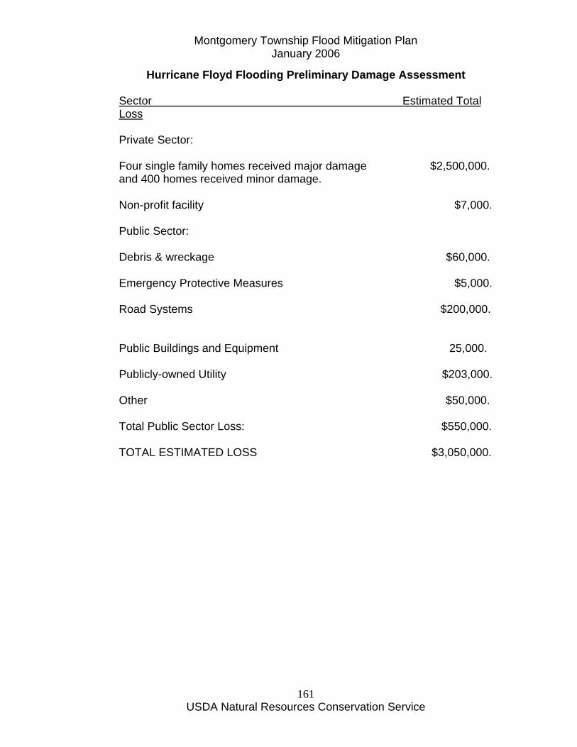
Montgomery Township Flood Mitigation Plan January 2006
USDA Natural Resources Conservation Service
161
Hurricane Floyd Flooding Preliminary Damage Assessment Sector Estimated Total Loss Private Sector: Four single family homes received major damage $2,500,000. and 400 homes received minor damage. Non-profit facility $7,000. Public Sector: Debris & wreckage $60,000. Emergency Protective Measures $5,000. Road Systems $200,000. Public Buildings and Equipment 25,000. Publicly-owned Utility $203,000. Other $50,000. Total Public Sector Loss: $550,000. TOTAL ESTIMATED LOSS $3,050,000.
Montgomery Township Flood Mitigation Plan January 2006
USDA Natural Resources Conservation Service
162
Community Rating System

Montgomery Township Flood Mitigation Plan January 2006
USDA Natural Resources Conservation Service
163
National Flood Insurance Program
Community Rating System
SUMMARY
http://training.fema.gov/EMIWeb/CRS/
Background: Since 1968 the National Flood Insurance Program (NFIP) has provided federally backed flood insurance to encourage communities to enact and enforce floodplain regulations. The program has been very successful in helping flood victims get back on their feet. There are over 2.2 million policies in force. Since 1978, 350,000 insurance losses have been paid out for a total of $2.5 billion. In order to be covered by a flood insurance policy, a property must be in a community that participates in the NFIP. To qualify, a community adopts and enforces a floodplain management ordinance to regulate proposed development in flood hazard areas. The objective of the ordinance is to ensure that such development will not aggravate existing flooding conditions and that new buildings will be protected from future flood damage. To date nearly 18,000 communities in the United States participate. The NFIP has been successful in requiring new buildings to be protected from damage by the 100-year flood. However, the program had few incentives for communities to do more than enforce the minimum regulatory standards. Flood insurance rates had been the same in all participating communities, even though some do much more than regulate construction of new buildings to the national standards. Until now the program did little to recognize or encourage community activities to reduce flood damages to existing buildings, to manage development in areas not mapped by the NFIP, to protect new buildings beyond the minimum NFIP protection level, to help insurance agents obtain flood data, or to help people obtain flood insurance. Because these activities can have a great impact on the insurance premium base, flood damages flood insurance claims, and federal disaster assistance payments, the Federal Insurance Administration (FIA) has implemented the Community Rating System (CRS). The Concept: Experience since the turn of the century (1900) has shown that fire insurance public protection class given to a community has been
Montgomery Township Flood Mitigation Plan January 2006
USDA Natural Resources Conservation Service
164
a very strong incentive to local officials to maintain or improve their fire protection programs. Local governing boards ensure that their fire alarm communications, water supply and distribution, and overall fire department facilities, including staffing, equipment, training and other items meet or exceed the insurance industry’s minimum criteria in order to maintain favorable fire insurance rate classes for their communities. In March 1987, the Federal Insurance Administrator established a Community Rating Task Force with members from FIA, insurance companies, and state and local floodplain managers. The Task Force established three goals for the CRS: “To encourage, by the use of flood insurance premium adjustments community and state activities beyond those required by the National Flood Insurance Program to:
Reduce flood losses, Facilitate accurate insurance rating, and Promote the awareness of flood insurance.”
The Task Force worked with the Association of State Floodplain Managers (ASFPM) and ISO/Commercial Risk Services, Inc. (ISO) to develop a rating Schedule and administrative procedures. ISO is a non-profit corporation subscribed to by more than 1300 insurance companies. Among other services, ISO develops and provides advisory fire insurance classification of community fire protection programs. The CRS is the product of three years of development, field testing, critiques and reviews with communities, public interest organizations and ASFPM’s technical advisors. The work has been reviewed by 400 professional floodplain managers, 50 public interest organizations, and 41 communities. However, the CRS will always be subject to change and improvement as more experience is gained in administering it and as more is learned about effective floodplain management techniques. Community Classification: Flood insurance premium credits are available in communities based on their CRS classification. There are ten classes with Class 1 having the greatest premium credit and Class 10 having no premium credit. A community’s CRS class is based on the number of credit points calculated for the activities that are undertaken to reduce flood losses, facilitate accurate insurance rating, and promote the awareness of flood insurance. A community is automatically in Class 10 unless it applies for CRS classification and it shows that the activities that it is implementing warrant

Montgomery Township Flood Mitigation Plan January 2006
USDA Natural Resources Conservation Service
165
a better class. The amount of premium credit for each class is published annually by FIA. The CRS rewards those communities that are doing more than the minimum NFIP requirements to their residents prevent or reduce flood losses. The system should also provide an incentive for communities to initiate new flood protection activities. COMMUNITY CLASSIFICATION POINTS There are 10 community classes in the Community Rating System. Class 1 communities have the largest premium credit; residents of Class 10 communities receive no premium credit. Communities that do not apply for CRS classification are Class 10 communities. The insurance premium credit is based on whether a property is in or out of the Special Flood Hazard Area (SFHA), i.e., the A and V Zones as shown on the community’s Flood Insurance Rate Map (FIRM). The premium credit for properties in the SFHA increases according to the community’s CRS class. The credit for properties outside the SFHA is lower for Class 1–8 communities because premiums in these areas are already relatively low and can be lowered further through the Preferred Risk Policy. Also, most activities undertaken to qualify for those classes are implemented only in the floodplain. Because areas designated as A99 and AR Zones already receive an insurance premium reduction, these zones get the same premium reduction as non-SFHA areas. A community’s classification is based on the community total points (cT) as calculated on activity worksheet AW-720. The qualifying community total points, CRS classes, and flood insurance premium credits are shown below: Credit Points (cT) CRS Class Premium Discount 4,500+ 1 45% 4,000–4,499 2 40% 3,500–3,999 3 35%
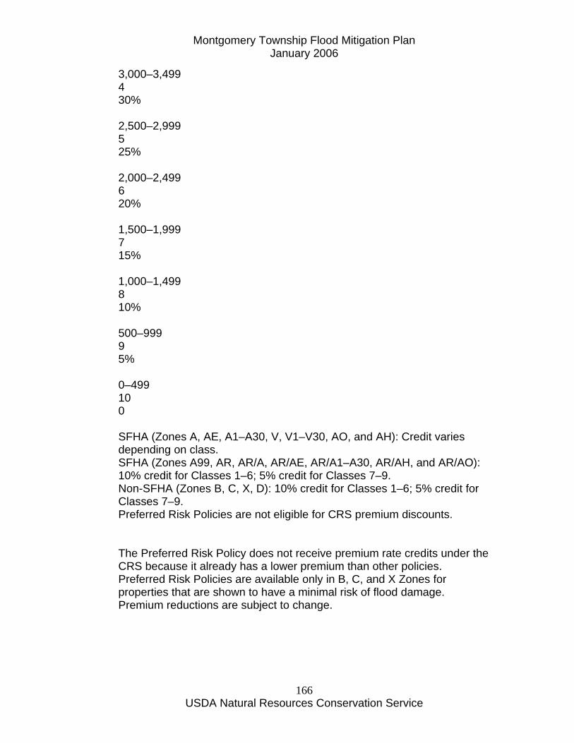
Montgomery Township Flood Mitigation Plan January 2006
USDA Natural Resources Conservation Service
166
3,000–3,499 4 30% 2,500–2,999 5 25% 2,000–2,499 6 20% 1,500–1,999 7 15% 1,000–1,499 8 10% 500–999 9 5% 0–499 10 0 SFHA (Zones A, AE, A1–A30, V, V1–V30, AO, and AH): Credit varies depending on class. SFHA (Zones A99, AR, AR/A, AR/AE, AR/A1–A30, AR/AH, and AR/AO): 10% credit for Classes 1–6; 5% credit for Classes 7–9. Non-SFHA (Zones B, C, X, D): 10% credit for Classes 1–6; 5% credit for Classes 7–9. Preferred Risk Policies are not eligible for CRS premium discounts. The Preferred Risk Policy does not receive premium rate credits under the CRS because it already has a lower premium than other policies. Preferred Risk Policies are available only in B, C, and X Zones for properties that are shown to have a minimal risk of flood damage. Premium reductions are subject to change.
Montgomery Township Flood Mitigation Plan January 2006
USDA Natural Resources Conservation Service
167
Operation: Community application for CRS classification is voluntary. Any community in full compliance with the rules and regulations of the NFIP may apply for a CRS classification. The applicant community submits documentation that it is implementing one or more of the activities recognized in the CRS Schedule. The Schedule identifies 18 creditable activities, organized under four categories in Sections 300-600: Public Information, Mapping and Regulations, Flood Damage Reduction, and Flood Preparedness. They are listed on the last page of this Summary. The Schedule assigns credit points based on how well an activity affects the three goals of the CRS. Communities are welcome to propose alternative approaches in their applications. Some of the activities may be implemented by the state or a regional district rather than at the local level. For example, some states have disclosure laws that may meet the credit criteria of Activity 340 - Flood Hazard Disclosure. In such cases, any community in those states or districts could receive credit points if the community applies for a CRS classification and if the state or district program is, in fact, being implemented in the community. The Regional Office of the Federal Emergency Management Agency (FEMA) and the State NFIP Coordinator review and comment on the application. FIA verifies the information and the community’s implementation of the activities. FIA sets the credit to be granted and notifies the community, the state, the insurance companies, and other appropriate parties. The community’s activities and performance are reviewed periodically. If it is not properly or fully implementing the credited activities, its credit points and possibly, its CRS classification, will be revised. A community may add or drop creditable activities each year. Credit criteria for each activity may also change as more experience is gained in implementing, observing and measuring the activities. Costs and Benefits: No fee is charged for a community to apply for classification or to participate in the CRS. Because there may be a cost to implement the creditable activities, some communities may be concerned whether the cost of initiating a new activity will be offset by the flood insurance premium credits. It is important to note that reduction in flood insurance rates is only one of the rewards communities receive from undertaking the activities credited under the Community Rating System. Others include increased public safety, reduction of damages to property and public infrastructure,
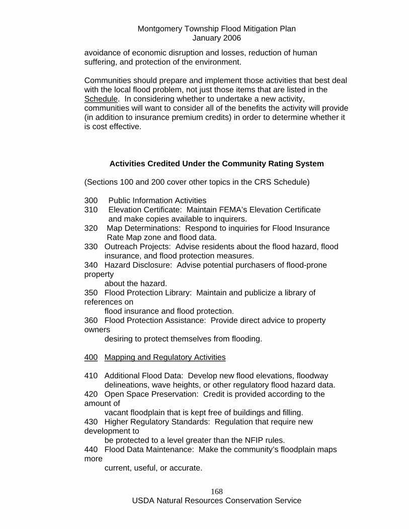
Montgomery Township Flood Mitigation Plan January 2006
USDA Natural Resources Conservation Service
168
avoidance of economic disruption and losses, reduction of human suffering, and protection of the environment. Communities should prepare and implement those activities that best deal with the local flood problem, not just those items that are listed in the Schedule. In considering whether to undertake a new activity, communities will want to consider all of the benefits the activity will provide (in addition to insurance premium credits) in order to determine whether it is cost effective.
Activities Credited Under the Community Rating System (Sections 100 and 200 cover other topics in the CRS Schedule) 300 Public Information Activities 310 Elevation Certificate: Maintain FEMA’s Elevation Certificate
and make copies available to inquirers. 320 Map Determinations: Respond to inquiries for Flood Insurance Rate Map zone and flood data. 330 Outreach Projects: Advise residents about the flood hazard, flood insurance, and flood protection measures. 340 Hazard Disclosure: Advise potential purchasers of flood-prone property about the hazard. 350 Flood Protection Library: Maintain and publicize a library of references on flood insurance and flood protection. 360 Flood Protection Assistance: Provide direct advice to property owners desiring to protect themselves from flooding. 400 Mapping and Regulatory Activities 410 Additional Flood Data: Develop new flood elevations, floodway delineations, wave heights, or other regulatory flood hazard data. 420 Open Space Preservation: Credit is provided according to the amount of vacant floodplain that is kept free of buildings and filling. 430 Higher Regulatory Standards: Regulation that require new development to be protected to a level greater than the NFIP rules. 440 Flood Data Maintenance: Make the community’s floodplain maps more current, useful, or accurate.
Montgomery Township Flood Mitigation Plan January 2006
USDA Natural Resources Conservation Service
169
450 Stormwater Management: Regulate new developments throughout the watershed to minimize their impact on surface drainage and runoff. 500 Flood Damage Reduction Activities 510 Repetitive Loss Projects: Develop and implement a plan to mitigate losses in repeatedly flooded areas. 520 Acquisition and Relocation: Purchase or relocate buildings and convert flood- prone properties to open space. 530 Retrofitting: Credit is provided according to how buildings have been retrofitted to protect them from flood damages. 540 Drainage System Maintenance: Conduct periodic inspections and maintain the capacities of the channels and retention basins. 600 Flood Preparedness Activities 610 Flood Warning Program: Provide early flood warnings to the general public and special facilities. 620 Levee Safety: Maintain levees that are not credited with providing base flood protection and emergency response plans for them. 630 Dam Safety: All communities in a state with an approved dam safety program receive credit.
Montgomery Township Flood Mitigation Plan January 2006
USDA Natural Resources Conservation Service
170
Flood Mitigation Funding Sources and Contact Information

Montgomery Township Flood Mitigation Plan January 2006
USDA Natural Resources Conservation Service
171
Montgomery Township Flood Mitigation Plan January 2006
USDA Natural Resources Conservation Service
172
Flood Mitigation Funding Sources and Contact Information FEMA Flood Mitigation Assistance Program (FMA) – financial assistance to cover up to 75 percent of the cost of elevation, relocation or buyout of eligible structures. Contact: Kathy Lear New Jersey Office of Emergency Management New Jersey State Police Box 7068 West Trenton, NJ 08628-0068 Phone: 609-538-6010 E-mail: [email protected] Green Acres Program http://www.state.nj.us/dep/greenacres/ Financial assistance to purchase property in environmental sensitive areas including flood plains. Green Acres protects environmentally sensitive open space, water resources and other significant natural and historic resources. Green Acres partners with, and provides grants and low interest loans to, qualifying county and municipal governments and nonprofit land conservancies that work to further these same goals. Contact: John Flynn, Adminstrator Green Acres Program Environmental Infrastructure Financing Program http://www.njeit.org/index2.html The NJ Environmental Infrastructure Financing Program (EIFP) is a partnership between NJDEP and the NJ Environmental Infrastructure Trust. The EIFP provides low-cost financing to municipal, county, and other local government units and water purveyors for the construction of wastewater, drinking water and stormwater/nonpoint source pollution management projects, including open space acquisition that provides a water quality benefit. Low interest loans that have a rate equal to ¼ the current market rate can be combined with Green Acres funding for land acquisition projects with a water quality benefit and used as a local match for Green Acres funding. Contact: Dennis Hart, Executive Director
Montgomery Township Flood Mitigation Plan January 2006
USDA Natural Resources Conservation Service
173
County/Municipal Open Space Partnership of Somerset County http://www.co.somerset.nj.us/_pdffiles/Policy%20and%20Procedures%20Manualcmb03.pdf The purpose of this partnership is to assist municipalities in Somerset County in providing adequate supply of land and structures for public recreation and conservation. A municipality may apply for funding for the acquisition of a structure, in conjunction with an eligible land acquisition when the improved property and structures are located within the 100 Year Flood Hazard Area as established by Federal Emergency Management Agency (FEMA) and are proposed for demolition to create or expand upon a public recreation opportunity and help advance a flood management initiative supported by FEMA funding or some other public funding source. The acquisition of such structures may be funded up to 50% of the cost of acquisition. Contact: Robert Bzik Somerset County Planning Board P.O. Box 3000 20 Grove Street Somerville New Jersey 08876 Phone 908-231-7021
Montgomery Township Flood Mitigation Plan January 2006
USDA Natural Resources Conservation Service
174
Resolution of Adoption of Flood Mitigation Plan
Montgomery Township Flood Mitigation Plan January 2006
USDA Natural Resources Conservation Service
175
TOWNSHIP OF MONTGOMERY SOMERSET COUNTY, NEW JERSEY
RES0LUTION #05-9-261 - ADOPTION OF FLOOD MITIGATION PLAN BE IT RESOLVED that the Montgomery Township Committee hereby adopts the Montgomery
Township Flood Mitigation Plan dated June, 2005.
CERTIFICATION
I HEREBY CERTIFY THE ABOVE TO BE A
TRUE COPY OF A RESOLUTION ADOPTED BY THE TOWNSHIP COMMITTEE OF THE TOWNSHIP OF
MONTGOMERY AT A MEETING HELD
SEPTEMBER 15, 2005
_ _
Township Clerk