for - miningdataonline.com · 17 wolverine coal project flowsheet 26-18 . revised technical report...
TRANSCRIPT

REVISEDTECHNICAL REPORT
ON THEWOLVERINE PROJECT
for
WESTERN CANADIAN COAL CORP.
MARCH 2006

REVISED TECHNICAL REPORT ON THE WOLVERINE PROJECT FOR WESTERN CANADIAN COAL CORP. MARCH 2006
1-1
ITEM 1 TITLE PAGE
Title of Report
Technical Report on the Wolverine Project
Project Location
The Wolverine Project is a metallurgical coal project under development in the Peace River
Coalfield of northeastern British Columbia, Canada. It is located approximately 725 km
northeast of Vancouver, and about 175 km northeast of the city of Prince George. The Project
is within the Peace River Regional District and Liard Mining Division of British Columbia about
20 km west of the town of Tumbler Ridge, British Columbia. The Project will be developed
adjacent to an existing CN Rail line that connects the Project with BC’s major coal export
terminals at Vancouver and Prince Rupert. In Item 26 of this Technical Report (TR), see Figure
1, General Location Map.
Author
The author of the report is Marston Canada Ltd. (Marston), a professional geological and mining
engineering services firm based in Calgary, Alberta, Canada and registered to practice
engineering under APEGGA Permit No. P-8327. Marston’s address is at 2431 – 37 Avenue NE,
Suite 430, Calgary, Alberta, Canada T2E 6Y7.
Effective Date of the Report
March 16, 2006
REVISED TECHNICAL REPORT ON THE WOLVERINE PROJECT FOR WESTERN CANADIAN COAL CORP. MARCH 2006
2-1
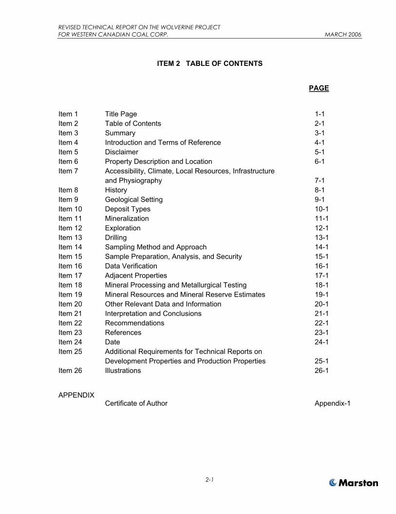
ITEM 2 TABLE OF CONTENTS
PAGE
Item 1 Title Page 1-1 Item 2 Table of Contents 2-1 Item 3 Summary 3-1 Item 4 Introduction and Terms of Reference 4-1 Item 5 Disclaimer 5-1 Item 6 Property Description and Location 6-1 Item 7 Accessibility, Climate, Local Resources, Infrastructure and Physiography 7-1 Item 8 History 8-1 Item 9 Geological Setting 9-1 Item 10 Deposit Types 10-1 Item 11 Mineralization 11-1 Item 12 Exploration 12-1 Item 13 Drilling 13-1 Item 14 Sampling Method and Approach 14-1 Item 15 Sample Preparation, Analysis, and Security 15-1 Item 16 Data Verification 16-1 Item 17 Adjacent Properties 17-1 Item 18 Mineral Processing and Metallurgical Testing 18-1 Item 19 Mineral Resources and Mineral Reserve Estimates 19-1 Item 20 Other Relevant Data and Information 20-1 Item 21 Interpretation and Conclusions 21-1 Item 22 Recommendations 22-1 Item 23 References 23-1 Item 24 Date 24-1 Item 25 Additional Requirements for Technical Reports on Development Properties and Production Properties 25-1 Item 26 Illustrations 26-1
APPENDIX Certificate of Author Appendix-1

REVISED TECHNICAL REPORT ON THE WOLVERINE PROJECT FOR WESTERN CANADIAN COAL CORP. MARCH 2006
2-2
LIST OF ILLUSTRATIONS
Figure Title Page
1 General Location Map 26-2 2 Wolverine Site Map 26-3 3 Coal Occurrences 26-4 4 Regional Geology 26-5 5 Perry Creek Area Stratigraphic Column 26-6 6 EB Area Stratigraphic Column 26-7 7 Perry Creek Geological Cross Sections 26-8 8 EB Geological Cross Sections 26-9 9 Wolverine Project Mine and Infrastructure 26-10 10 Perry Creek Resource Pit 26-11 11 EB Resource Pit 26-12 12 Perry Creek Area – Measured and Indicated Resources 26-13 13 EB Area – Indicated Resource Area 26-14 14 Perry Creek – Pit Status Map – End of Year 2018 26-15 15 EB – Pit Status Map – End of Year 2014 26-16 16 Surface Facilities Map – Perry Creek Area 26-17 17 Wolverine Coal Project Flowsheet 26-18

REVISED TECHNICAL REPORT ON THE WOLVERINE PROJECT FOR WESTERN CANADIAN COAL CORP. MARCH 2006
2-3
LIST OF TABLES
Table Title Page
3.1 Wolverine Project Estimated Coal Resources and Reserves 3-3 6.1 EB Area – Coal License Details 6-2 8.1 Summary of Exploration Activities – Perry Creek Area, 1971 –
2002 8-28.2 Summary Of Exploration Activities – EB Area 8-4
11.1 Seam thickness Summary – Perry Creek Area 11-1 11.1 Seam Thickness Summary – EB Area 11-2 12.1 Summary of Exploration Activities – Perry Creek Property, 2001
– 2004 12-112.2 Summary of Exploration Activities – EB Property, 2000 - 2002 12-2 13.1 Seam Thickness Summary – Wolverine Project 13-1 14.1 Perry Creek Area Drill Hole Locations 14-3 14.2 EB Area Drill Hole Locations 14-5 14.3 Perry Creek Area Drill Hole Quality Data (air dried basis) 14-6 14.4 EB Area Drill Hole Quality Data (air dried basis) 14-10 18.1 Perry Creek Area – Typical Clean Coal Quality (adb) 18-1 18.2 Perry Creek Area - Typical Clean Coal Thermal Rheology 18-1 18.3 EB Area – Typical Clean Coal Quality (adb) 18-2 18.4 EB Area – Typical Clean Coal Thermal Rheology 18-2 18.5 Wolverine Target Product Quality and Predicted Plant Yields 18-3 19.1 Coal Resource Categories – Moderate Geology Type 19-2 19.2 Coal Seam Criteria – Moderate Geology Type 19-2 19.3 Perry Creek Area – Estimated Measured Coal Resources 19-3 19.4 Coal Resource Categories – Complex Geology Type 19-4 19.5 Coal Seam Criteria – Complex Geology Type 19-4 19.6 EB Area – Estimated Indicated Coal Resources 19-5 19.7 Wolverine Project Estimated Coal Resources and Reserves 19-8 19.8 Saleable Coal Quality Specifications and Predicted Plant Yields 19-10 25.1 Wolverine Project Production Schedule 25-2 25.2 Target Specifications for Wolverine Mine Coals 25-3 25.3 Initial Wolverine Project Capital 25-6 25.4 Wolverine Production Cost Estimates 25-7 25.5 Estimated Annual Cash Flow Summary – Wolverine Project
Base Case 25-8
25.6 WCC Base Case Price Sensitivity 25-10 25.7 WCC Base Case Operating Cost Sensitivity 25-10 25.8 WCC Base Case Capex Sensitivity 25-10
REVISED TECHNICAL REPORT ON THE WOLVERINE PROJECT FOR WESTERN CANADIAN COAL CORPORATION MARCH 2006
3-1
ITEM 3 SUMMARY
Property Description, Location and Ownership
The Property consists of a coal lease in the Perry Creek Area and contiguous coal licenses in
the EB Area that WCC acquired originally in 2000 and 2001 that are located in the Peace River
Regional District of northeastern British Columbia, Canada. The Property is in the Inner
Foothills of the Canadian Rocky Mountains near the town of Tumbler Ridge, BC and about 725
km northeast of Vancouver, BC. The Property is readily accessible by provincial highway and
an all-weather forestry service road. See Item 26, Figure 1, General Location Map and Figure
2, Wolverine Site Map.
The coal resources in the Perry Creek and EB areas are part of the Peace River Coalfield. The
coal seams are contained in the Lower Cretaceous Gates Formation and were deposited in an
alluvial-deltaic environment about 145 million years ago. Gates Formation coals have been
mined extensively in the region, and the seams at Perry Creek and EB may be correlated with
the seams mined nearby. Regional tectonism from post-depositional mountain building have
folded the geological structures regionally and locally. At EB Area, significant reverse and thrust
faulting is interpreted in parts of the resource area. The local structures are of moderate and
complex geology types in the Perry Creek and EB areas, respectively, as defined by accepted
Canadian standards.
In the Perry Creek Area, the main coal seams in descending order are the E2, E3, F, G and J
seams with a cumulative average coal thickness of nearly 12.5 meters. The main seam of
interest is the relatively thick, basal J Seam, which includes about seven meters of coal in three
main plies. The remaining seams are generally from 1 to 2.5 meters in thickness.
In the EB Area the main coal seams are the D, C, and B seams. These three seams have a
total cumulative thickness of about 11.6 meters. The B Seam is the thickest and contains the
most coal resources in the Area. The B Seam is about 3 to 5.5 meters thick; the C and D
seams are about 3 to 4 meters thick.
REVISED TECHNICAL REPORT ON THE WOLVERINE PROJECT FOR WESTERN CANADIAN COAL CORPORATION MARCH 2006
3-2
Exploration Concept
Exploration activities in the Perry Creek and EB areas commenced in the early 1970s, and
occurred at various times during the late 1970s and 1980s, and by WCC after acquiring the
Property in 2001. The early work was primarily exploratory and for characterizing coal quality,
and included mapping and drilling of areas with exposed Gates Formation or the lower coal-
bearing Gething Formation rocks. Denison Mines Ltd. and Quintette Coal Ltd. drilled and cored
22 holes in the Perry Creek Area. Nichimen and Ranger Oil drilled 45 holes and mined seven
adits in the EB Area. In 2001 through 2004, WCC completed 68 additional holes at the Property
in areas deemed amenable to open pit or underground mining and completed several resource
estimates and feasibility studies for mine development.
In all programs, geophysical logs were collected for nearly all drill holes and core samples were
analyzed for coal quality characteristics. Bulk samples and composites of core samples were
used for washability test work for plant design and to predict clean coal quality. In addition,
during these programs, WCC collected bulk samples and conducted test work for coal
processing plant design.
Exploration for resource delineation has been completed at the Perry Creek and EB areas
within proposed open pit mining areas. Future exploration work in both open pit areas will be for
mine development and detailed planning.
Based on the exploration information collected to date, WCC requested Marston to prepare a
mine feasibility study (Study) for open pit mines to be developed in the Perry Creek and EB
areas and estimate resources and reserves based on the results of the study. The Study
includes all available work to date by WCC on geology, geological modeling, geotechnical
studies, process plant design and engineering and mine facilities and infrastructure studies.
Development and Operations
WCC is in the process of developing an open pit mining operation at the Perry Creek Area. The
operation is planned in accordance with the Study that was undertaken on WCC’s behalf by
Marston. The mine has been designed to produce up to 2.7 million tonnes of metallurgical coal
per year for sale in export markets. The coal will be transported by rail from a processing plant
REVISED TECHNICAL REPORT ON THE WOLVERINE PROJECT FOR WESTERN CANADIAN COAL CORPORATION MARCH 2006
3-3
and rail loadout at Perry Creek to Ridley Coal Terminal at Prince Rupert, BC or to the export
coal terminals at Vancouver, BC. Initial production will be from the Perry Creek location
commencing in 2006; however, WCC intends to open mining operations at the EB Area in 2009
to supplement Perry Creek coal production. Under Marston’s feasibility study, the pit at Perry
Creek is planned to produce coal from 2006 through the end of 2018; the EB Area pit is planned
to produce coal from 2009 through the end of 2014. To meet market specifications for saleable
metallurgical coal, all coal produced from the mines will be processed in a coal preparation plant
that is under construction at the Perry Creek Area.
Currently, WCC is seeking debt- and equity-based financing to support its development of the
Perry Creek site. Furthermore, actual capital development has started and is in the beginning
stages. Surface facilities and the preparation plant have been designed and contracts have
been let for their construction. Preliminary construction in the form of clearing various site,
earthwork and foundations is well underway.
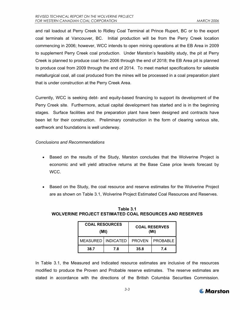
Conclusions and Recommendations
Based on the results of the Study, Marston concludes that the Wolverine Project is
economic and will yield attractive returns at the Base Case price levels forecast by
WCC.
Based on the Study, the coal resource and reserve estimates for the Wolverine Project
are as shown on Table 3.1, Wolverine Project Estimated Coal Resources and Reserves.
Table 3.1 WOLVERINE PROJECT ESTIMATED COAL RESOURCES AND RESERVES
COAL RESOURCES
(Mt)COAL RESERVES
(Mt)
MEASURED INDICATED PROVEN PROBABLE
38.7 7.8 35.8 7.4
In Table 3.1, the Measured and Indicated resource estimates are inclusive of the resources
modified to produce the Proven and Probable reserve estimates. The reserve estimates are
stated in accordance with the directions of the British Columbia Securities Commission.

REVISED TECHNICAL REPORT ON THE WOLVERINE PROJECT FOR WESTERN CANADIAN COAL CORPORATION MARCH 2006
3-4
Additional details regarding the estimated coal tonnage to be produced and sold from the
Project may be found in Items 18, 19, and 25.
For the Wolverine Project, the total estimated Proven and Probable reserves are 43.2 Mt. Perry Creek Area reserves amount to 35.8 Mt of Proven coal with an estimated
ash content of 30% on an air dried basis; EB Area reserves equal an estimated 7.4 Mt of
Probable reserves with an estimated ash content of 26% on an air dried basis.
The overall Project stripping ratio is projected to be 5.6 bcm per run-of-mine (ROM) tonne requiring the removal of 242.2 Mbcm of waste during the Project’s life. A total of 198.9 Mbcm of waste are scheduled for removal from the Perry Creek Pit
and 40.6 Mbcm of waste from the EB Pit. The waste total includes 2.7 Mbcm of topsoil
scheduled to be removed from waste dump areas and from the mine buildings, plant and
other infrastructure sites.
The estimated saleable coal quality of the Wolverine Project is shown on Table 3.2,
Saleable Coal Quality Specifications.
Table 3.2 SALEABLE COAL QUALITY SPECIFICATIONS
ProductQuality Specification
CLEAN COAL SPECIFICATIONS
WOLVERINE
CLEAN COAL SPECIFICATIONS
EBAsh (%, db) 7.5 ± 0.5 9.5 ± 0.5 Volatile Matter (%, db) 23.0 ± 0.5 23.0 Fixed Carbon (%, db) 79.0 ± 0.5 79.5 Sulfur (%, db) <0.55 <0.55 Free Swelling Index 7 to 8 6 to 7 ½
The EB Pit should be drilled to Measured status prior to commencing detailed pit
development planning. The current drilling is sufficient for the purposes of the Study that
underpins this Report; however, more detailed planning will require more data on the
coal seams and coal quality.

REVISED TECHNICAL REPORT ON THE WOLVERINE PROJECT FOR WESTERN CANADIAN COAL CORPORATION MARCH 2006
3-5
Future drilling programs in the Perry Creek Pit should be planned to collect large
diameter core samples from the upper seams for additional quality and washability test
work to optimize future processing plant performance and yield.

REVISED TECHNICAL REPORT ON THE WOLVERINE PROJECT FOR WESTERN CANADIAN COAL CORP. MARCH 2006
4-1
ITEM 4 INTRODUCTION AND TERMS OF REFERENCE
Introduction
Western Canadian Coal Corp. (WCC) is a Vancouver-based public company with shares traded
on the TSX Venture Exchange. WCC controls the Wolverine Group of properties that consist of
the Perry Creek, EB (also known as Mt. Spieker) and Hermann Areas. These areas contain
significant deposits of metallurgical coal. Extensive coal exploration and sampling programs
were carried out in the Perry Creek and EB Areas beginning in the early 1980s by previous
license owners and were continued by WCC in 2001 through 2004.
By 2002 the coal resources at Perry Creek were sufficiently defined to permit the preparation of
an initial feasibility study and NI 43-101 technical report for the Wolverine Project based on an
open pit, underground mine and preparation plant to be developed at the Perry Creek Area to
produce 1.6 million tonnes of metallurgical coal product per year. Subsequently, with the
increase in world coal prices, WCC determined that the Perry Creek open pit should be
significantly enlarged and a small open pit should be developed in the EB Area to provide
additional coal feed to a preparation plant to be built at Perry Creek. In addition, WCC
increased potential production from the Project to 2.7 million tons of coal per year. WCC plans
to utilize an existing CN Rail line adjacent to the Perry Creek Area to ship washed metallurgical
coal product in unit trains from Wolverine to existing BC coal export terminals at Prince Rupert
or Vancouver. There, the coal will be loaded onto ocean bulk carriers and transported to
customers in Japan, Korea and elsewhere in Asia.
Terms of Reference
WCC engaged Marston Canada Ltd. (Marston) to compile the available data and information
and produce an updated Wolverine Project feasibility study (Study) to produce up to 2.7 million
tonnes per year of coal from the resources in the Perry Creek and EB Areas. Marston was also
to produce this Technical Report (TR) to provide scientific and technical information developed
and described in the Study in accordance with National Instrument 43-101.

REVISED TECHNICAL REPORT ON THE WOLVERINE PROJECT FOR WESTERN CANADIAN COAL CORP. MARCH 2006
4-2
For the Study, Marston was to perform the following scope of work:
a) Review all available mapping and geological data.
b) Review all available prior work by others related to exploration and geology of the Perry
Creek and EB Areas.
c) Visit the Perry Creek and EB sites.
d) Review WCC’s Perry Creek and EB geologic models for use in resource and reserve
estimates and feasibility-level mine planning and cost estimating.
e) Determine economic open pit limits for the coal resources in each area.
f) Estimate mineral resources for each area in accordance with NI 43-101 requirements.
g) Develop feasibility level mine designs and production sequences from the Perry Creek
and EB Areas.
h) Review and describe the coal processing plant design and infrastructure plans and cost
estimates developed by others and compile this information as part of the Study.
i) Estimate initial and annual capital and annual production costs and develop an
economic model of the Project in constant 2005 dollars.
j) Estimate Proven and Probable Coal Reserves based on the Study and in accordance
with NI 43-101 requirements.
For the Study, the mining plans for the Perry Creek and EB Areas were to include only open pit
designs. Development and coal production from each pit was to be maximized each year
considering constraints due the timing of mining permits, equipment delivery and commissioning
schedules, pit designs and the maximum preparation plant capacity.
Purpose
The purpose of this TR is to provide scientific and technical information developed
independently by Marston under the direction of an independent Qualified Person and
concerning WCC’s Wolverine Project based on the results of the Wolverine Project Feasibility
Study. This TR is in accordance with the requirements of National Instrument 43-101,
Standards for Disclosure for Mineral Projects.

REVISED TECHNICAL REPORT ON THE WOLVERINE PROJECT FOR WESTERN CANADIAN COAL CORP. MARCH 2006
4-3
Sources of Information
To prepare the Study and this TR, Marston relied primarily on base information and exploration
and sampling data collected or generated by others and the references listed in Item 23 of this
TR. Key information sources are as follows:
Wolverine Project, Project Document, Volumes 1 to 9; by WCC, Cochrane Engineering
Ltd. (and others), May 2003.
Wolverine Coal Project, Perry Creek Feasibility Study, Document, Volumes 1 and 2, by
Norwest Corporation, January 2003.
WCC electronic data with respect to: drilling data, geology, coal reserves and mine
planning provided by WCC.
WCC Coal marketing and price forecast data in the form of indicative letters discussing
intent to purchase coal.
WCC information regarding rail and port charges in British Columbia.
Technical Report on the Wolverine Coal Project prepared for WCC by JHP Coal-Ex
Consulting Ltd. (Coal-Ex) and James Proc, P.Eng., with assistance from Daryl Thomas,
P.Eng (Cochrane Engineering Ltd.) and Kathleen Pomeroy, October 2003.
Discussions with key operating and technical personnel from WCC, including John
Hogg, Bill Burton, Kathleen Pomeroy, Gary Gould, David Lortie and Peter Cosgrove.
Field Involvement
Richard R. Marston, P.E. is the independent Qualified Person for this TR. He visited the Perry
Creek and EB Areas in June 2005 and observed current development activities and numerous
old drill hole sites, but he has not been involved in field exploration or related activities at the
Wolverine Project. He has experience in the general area having performed numerous geologic
modeling, reserve estimates and mine planning projects for Quintette Coal Ltd.’s nearby mining
operations from 1985 through 1987 and 1989 through 1990.
REVISED TECHNICAL REPORT ON THE WOLVERINE PROJECT FOR WESTERN CANADIAN COAL CORP. MARCH 2006
5-1
ITEM 5 DISCLAIMER
Marston has relied on the following persons at WCC for information related to coal licenses,
mining permits and other environmental information, and coal markets and price information.
a) David Lortie, Senior Geologist – Coal licenses and boundaries. This information was
relied upon to establish limits on mining, waste dump and infrastructure locations, and to
estimate production royalty/mineral tax costs. This disclaimer primarily applies to all
items in this TR with regards to Project location and Items 19 and 25 as to cost
estimates.
b) Kathleen Pomeroy, V.P. Environmental Affairs – Mining permit and environmental
information. The information on the status and outlook of the various mining permits
were relied upon to establish the places and timing of development and mining in the
Perry Creek and EB Areas. This disclaimer applies primarily to TR Items 3, 19, 20 and
25.
c) Peter Cosgrove, Wolverine Project Manager – Environmental permitting, specifically with
respect to mine surface and coal preparation facilities. This disclaimer applies primarily
to TR Items 19, 20 and 25.
d) Gary Gould, Senior Mine Engineer – Mine permitting requirements and progress in
relationship to the mine plan. This disclaimer applies primarily to TR Items 19 and 25.
e) Bill Burton, V.P. Operations – coal price data and market information. The coal price
forecasts and market outlook were relied upon as the basis for estimating the economics
of Wolverine Project, and hence Proven and Probable Reserves. This disclaimer
applies primarily to TR Items, 3, 19, and 25.
f) Fausto Taddei, CFO and Corporate Secretary – Certain terms and conditions of coal
storage and sales agreements. This disclaimer applies primarily to TR Item 25.

REVISED TECHNICAL REPORT ON THE WOLVERINE PROJECT FOR WESTERN CANADIAN COAL CORP. MARCH 2006
5-2
g) Paul Brent, Director, Commercial Development – coal and transportation contract
negotiations and pricing. This information was relied upon in developing the economic
model as part of determining delivered coal costs, coal pricing assumptions and the
terms and conditions under which coal is to be transported and sold. This disclaimer
applies primarily to TR Items 3, 19 and 25.

REVISED TECHNICAL REPORT ON THE WOLVERINE PROJECT FOR WESTERN CANADIAN COAL CORP. MARCH 2006
6-1
ITEM 6 PROPERTY DESCRIPTION AND LOCATION
Description and Location
The Property consists of the Perry Creek Area and the EB Area, which are held respectively
under a coal lease and several contiguous coal licenses with a total area of 6,106 hectares.
The Property is located in northeastern British Columbia, Canada approximately 175 km
northeast of the city of Prince George and near the town of Tumbler Ridge, British Columbia. In
Item 26 of this TR, see Figure 1, General Location Map. The Property is within the Peace River
Regional District and the Liard Mining Division and is located on NTS Map Sheets 93-P/03W
and 93-P/03E. The Perry Creek Coal Lease and EB Area coal licenses are held in the name of
Western Coal Corp., a subsidiary of WCC. Locations of the Property Boundary and the Perry
Creek and EB areas are shown in Figure 2, Wolverine Site Map.
Title
The Perry Creek Area contains 3,128 hectares located at latitude 55º 05' 00" N and longitude
121º 15’ 00" W. WCC holds the area under Perry Creek Coal Lease No. 414696 from the
Government of British Columbia, which encompasses the previous contiguous coal license
numbers: 383177, 383718, 383179, 379594, 379595, 379596, 379601, 391199, 391200,
405130, and 410304. Under the Perry Creek Coal Lease, WCC has the rights to use the
surface and develop and produce coal for 30 years.
Currently, a part of the area required for the WCC tailings pond and proposed Wolverine Forest
Service road realignment is outside of WCC’s Property boundary and held by Elk Valley Coal
under a coal license and by BC Rail. WCC has a BC License of Occupation covering the Elk
Valley Coal portion and a letter from Elk Valley Coal stating that it does not object to the area
being used for tailings disposal. For the remaining portion, WCC has had interim usage
agreements from BC Rail and is in final negotiations for a long-term use or leasing agreement.
The EB Area consists of 10 contiguous coal licenses that cover an area of 2,977 hectares. The
Area is located at latitude 55º 06' 00" N and longitude 121º 22’ 30" W. Details of the individual coal
licenses are summarized in Table 6.1, EB Area – Coal License Details. Under the coal licenses,

REVISED TECHNICAL REPORT ON THE WOLVERINE PROJECT FOR WESTERN CANADIAN COAL CORP. MARCH 2006
6-2
WCC has the rights to enter onto the licenses to conduct exploration and related activities for the
terms of the licenses.
Table 6.1 EB AREA – COAL LICENSE DETAILS
Coal License No. Area (ha.) Map Series Acquired Expiry Date 381711 297 93P-03W Oct. 2000 Oct. 2006 381712 297 93P-03W Oct. 2000 Oct. 2006 381713 297 93P-03W Oct. 2000 Oct. 2006 381714 297 93P-03W Oct. 2000 Oct. 2006 381715 297 93P-03E Oct. 2000 Oct. 2006 381716 296 93P-03E Oct. 2000 Oct. 2006 381717 296 93P-03E Oct. 2000 Oct. 2006 379597 300 93P-03W Aug. 2000 Aug. 2006 379598 300 93P-03W Aug. 2000 Aug. 2006 379600 300 93P-03W Aug. 2000 Aug. 2006
Legal Survey of Property
WCC has not indicated that the Property boundary has been surveyed. However, applications
for the lease and other legal documents that include Property descriptions have been accepted
by the government regulatory agencies.
Location
Based on the WCC data provided to Marston, all known mineralized zones, mineral resources,
reserves, mine workings, existing tailings ponds, waste deposits and important natural features
and improvements within and relative to the outside boundaries of the Property are shown in
Item 26 on Figure 2, Wolverine Site Map and Figure 3, Coal Occurrences.
Royalties and Other Encumbrances
The Perry Creek Coal Lease is a 30-year lease of coal mining rights and is subject to the normal
provisions of Crown coal leases in the Province of British Columbia, including specified lease
rentals and coal production royalties. In addition, WCC may be subject to an additional
overriding royalty of 1.0% of revenues on some or all coal sales. By a motion filed on March 23,

REVISED TECHNICAL REPORT ON THE WOLVERINE PROJECT FOR WESTERN CANADIAN COAL CORP. MARCH 2006
6-3
2005 with the Supreme Court of British Columbia, the company is contesting the validity of this
royalty agreement and has requested that the royalty be removed.
The EB coal licenses are subject to rentals and diligence work pursuant to provincial coal
regulations.
Portions of the Perry Creek and EB Areas are covered by petroleum and natural gas (PNG)
tenures. These tenures include both traditional oil and gas targets and coal bed methane
(CBM). Similar to other jurisdictions, British Columbia considers CBM to be natural gas.
Therefore, the BC Ministry of Energy and Mines considers CBM to be Crown property unless
freehold rights can be demonstrated. CBM can therefore be conveyed through provincial
petroleum and natural gas tenures under the Petroleum and Natural Gas Act.
The proposed Gates Formation coal resources identified at Perry Creek and EB are unlikely to
be economic sources of CBM due to their relatively shallow depth. Deeper Gething Formation
coal seams on the Property may have CBM development potential. However, exploration for
and development of CBM requires the agreement of the coal tenure holder (Energy and
Minerals Division Information Letter 99-05). In situations where agreement cannot be reached,
the government would impose a dispute resolution mechanism such as mediation or arbitration.
Environmental Liabilities
WCC is currently developing the Project in the Perry Creek Area subject to a mining permit.
Environmental liability for reclamation and other work to meet permit obligations is significant
and will grow as the Project develops and begins production. Readers should consult the
mining permit and related documents for the significant current and eventual environmental
liabilities to which the Property will be subject. The EB Area is currently inactive, and Marston is
not aware of any significant current environmental liabilities in the EB Area.
Permits
To Marston’s knowledge, WCC has obtained the necessary permits and approvals to develop
and commence production of 1.6 million tonnes per year from the Wolverine Project with mining
to commence initially in the Perry Creek Area. In May 2005 WCC submitted an application to
REVISED TECHNICAL REPORT ON THE WOLVERINE PROJECT FOR WESTERN CANADIAN COAL CORP. MARCH 2006
6-4
amend the EA Certificate and the Mine Permit to allow an increased production rate of 2.4
million tonnes per year. WCC anticipates that the mining permit revision will be issued without
significant problems or delays.
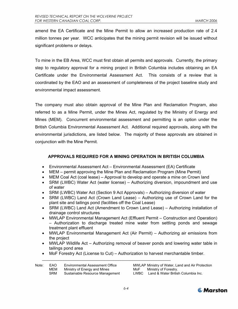
To mine in the EB Area, WCC must first obtain all permits and approvals. Currently, the primary
step to regulatory approval for a mining project in British Columbia includes obtaining an EA
Certificate under the Environmental Assessment Act. This consists of a review that is
coordinated by the EAO and an assessment of completeness of the project baseline study and
environmental impact assessment.
The company must also obtain approval of the Mine Plan and Reclamation Program, also
referred to as a Mine Permit, under the Mines Act, regulated by the Ministry of Energy and
Mines (MEM). Concurrent environmental assessment and permitting is an option under the
British Columbia Environmental Assessment Act. Additional required approvals, along with the
environmental jurisdictions, are listed below. The majority of these approvals are obtained in
conjunction with the Mine Permit.
APPROVALS REQUIRED FOR A MINING OPERATION IN BRITISH COLUMBIA
Environmental Assessment Act – Environmental Assessment (EA) Certificate MEM – permit approving the Mine Plan and Reclamation Program (Mine Permit) MEM Coal Act (coal lease) – Approval to develop and operate a mine on Crown land SRM (LWBC) Water Act (water license) – Authorizing diversion, impoundment and use
of water SRM (LWBC) Water Act (Section 9 Act Approvals) – Authorizing diversion of water SRM (LWBC) Land Act (Crown Land Lease) – Authorizing use of Crown Land for the
plant site and tailings pond (facilities off the Coal Lease) SRM (LWBC) Land Act (Amendment to Crown Land Lease) – Authorizing installation of
drainage control structures MWLAP Environmental Management Act (Effluent Permit – Construction and Operation)
– Authorization to discharge treated mine water from settling ponds and sewage treatment plant effluent
MWLAP Environmental Management Act (Air Permit) – Authorizing air emissions from the project
MWLAP Wildlife Act – Authorizing removal of beaver ponds and lowering water table in tailings pond area
MoF Forestry Act (License to Cut) – Authorization to harvest merchantable timber.______________________________________________________
Note: EAO Environmental Assessment Office MWLAP Ministry of Water, Land and Air Protection MEM Ministry of Energy and Mines MoF Ministry of Forestry. SRM Sustainable Resource Management LWBC Land & Water British Columbia Inc.

REVISED TECHNICAL REPORT ON THE WOLVERINE PROJECT FOR WESTERN CANADIAN COAL CORP. MARCH 2006
6-5
Application for approvals of a mining project in British Columbia can also trigger requirements
under the Canadian Environmental Assessment Act (CEAA), if approvals are required in areas
of federal jurisdiction. Federal agencies have determined that the Wolverine Project did not
trigger requirement for a federal approval and therefore did not require a federal comprehensive
project review. CEAA review for the Project is limited to a review of the explosives storage
facility.

REVISED TECHNICAL REPORT ON THE WOLVERINE PROJECT FOR WESTERN CANADIAN COAL CORP. MARCH 2006
7-1
ITEM 7 ACCESSIBILITY, CLIMATE, LOCAL RESOURCES, INFRASTRUCTURE AND PHYSIOGRAPHY
The Property is located in the Inner Foothills of the Canadian Rocky Mountains. The regional
topography is a belt of hills and low mountains dominated by a series of northwest to southeast
elongated ridges. The Perry Creek Area is located at elevations of 830 meters to 1,700 meters
on the northern and eastern slopes of Fortress Mountain (elev. 1,999 meters). The area
topography consists of moderately to steeply sloping ground that is all below the tree line. The
area is well timbered with poplar and minor amounts of birch along the lower slopes, and
lodgepole pine, spruce and fir at higher elevations. The highest point in the EB Area is Mt.
Spieker (elev. 1,935 meters) with moderately to steeply sloping ground that descends to an
elevation of about 1,675 meters. About half of the EB Area is above the tree line with alpine
vegetation including juniper, dwarf pine, moss and occasional grassy meadows. Lower
elevations are densely forested with spruce and pine.
The Property is readily accessible by road and rail. The all-weather, graveled Wolverine Forest
Service Road connects the Property year-round with BC Highway 29 between the towns of
Chetwynd and Tumbler Ridge, which is about 8 km from the Service Road entrance. The
Forest Service Road enters the Property at the southeastern end of the Perry Creek Area and
extends west to the Wolverine Project plant and office site. In Item 26 of this report, see Figure
2, Wolverine Site Mine. The EB Area is 10 km northwest of the Perry Creek Area and is
accessible via the Perry Creek Road, which intersects the Wolverine Forest Road near the
entrance to the Property. A CN Rail line is adjacent to the southern border of the Perry Creek
Area. This line joins CN’s main line at Prince George, B.C. 250 km to the southwest.
The Property is about 13 km from the town of Tumbler Ridge and about 85 km from the town of
Chetwynd by ground transportation via Highway 29 and the Wolverine Forest Service Road.
The area has a continental highland climate featuring short, warm summers and long, cold
winters. Average July and January temperatures reported for Tumbler Ridge are +21ºC and –
5ºC, respectively, although cooler temperatures may be expected in the higher altitudes at Perry
Creek and EB. During January to March, cold spell temperatures will decline to lows in the
range of –30ºC with periods of high winds on ridge tops. Tumbler Ridge averages 334 mm of
REVISED TECHNICAL REPORT ON THE WOLVERINE PROJECT FOR WESTERN CANADIAN COAL CORP. MARCH 2006
7-2
rain and 1.85 meters of snow per year, and snow pack persists from October to June. Mining
operations at Perry Creek and EB are planned for year-round.
WCC advised that it controls surface rights to access and mine the Perry Creek Area under a
valid BC coal lease. WCC also controls surface rights to access and explore the EB Area under
several contiguous BC coal licenses, see TR Item 6 for more detailed information.
Power, water, potential tailings storage areas, potential waste disposal areas, and potential
processing plant sites are or will be available at the Perry Creek Area. WCC plans to extend
power to the site from an existing BC Hydro 230 kV transmission line and substation located
12 km from the Perry Creek Area. The power line extension will be located next to the
Wolverine Forest Service Road. Water will be obtained from several deep wells in the Perry
Creek Area for processing and treated for potable use. Processing plant tailings will be stored
in the Perry Creek Area in an impoundment to be constructed near the plant. Mine waste
disposal will be in dumps constructed during mining and adjacent to the proposed open pits at
Perry Creek and EB. Highway haul trucks will transport coal mined from the EB Area on the
existing graveled Perry Creek Road approximately 17 km to the processing plant at Perry
Creek. Proposed open pits, dumps and infrastructure locations are shown in Item 26, see
Figure 9, Wolverine Project Mine and Infrastructure. The proposed processing plant site, rail
loading facility and other mine infrastructure to be constructed at Perry Creek is shown on
Figure 16, Surface Facilities Map – Perry Creek Area.
Mining personnel are available locally from the towns of Tumbler Ridge and Chetwynd, and
from nearby First Nations bands. Tumbler Ridge was constructed originally to support the now-
closed Bullmoose and Quintette coal mines. Tumbler Ridge has a population of about 2,500 to
3,000 people depending on the season and has infrastructure sufficient for a population of up to
6,000. Most mine support services are also available there. Chetwynd supports an estimated
regional population of 9,000 people.

REVISED TECHNICAL REPORT ON THE WOLVERINE PROJECT FOR WESTERN CANADIAN COAL CORP. MARCH 2006
8-1
ITEM 8 HISTORY
The prior ownership of the Property and ownership changes is as follows. The original coal
licenses for the Perry Creek Area were acquired by Denison Mines Ltd. (Denison) and assigned
to Quintette Coal Ltd., a joint venture company between Denison and an international
consortium of steel companies. Quintette referred to the Perry Creek Area as a part of its
Wolverine North exploration area and conducted exploration programs there during the 1980s.
Quintette developed large open pit coal mines southeast of the Perry Creek Area that operated
from 1983 through 2000. During 1989 – 1990, Quintette’s ownership changed as part of a
significant financial reorganization and subsequently Quintette allowed the coal licenses for the
Perry Creek Area to lapse. WCC acquired the Perry Creek licenses in 2000 and 2001.
The coal licenses for the EB Area were originally acquired in 1970 and 1971 by Brameda
Resources Ltd. (Brameda), a subsidiary of Teck Corporation (Teck). The licenses were part of
a block assembled that would eventually become the Bullmoose Mine. In 1975 the licenses
were optioned to Nichimen Resources Company. At that time, the property was known as East
Bullmoose and consisted of 36 coal licences covering an area of approximately 10,500
hectares. The name of the area was changed to Mt. Spieker in 1977 to avoid confusion with
Teck’s Bullmoose Mine. Ranger Oil Limited (Canada) took over as operator in 1978 and
conducted exploration until 1982. Ranger Oil was unsuccessful in attracting an experienced
mining company as a partner for development of the property, and the coal licences were turned
back to Teck/Brameda in the mid-1980s. The licenses lapsed during 1995 through 1998. WCC
acquired the licenses in 2000.
The type, amount, quantity and results of exploration and/or development work undertaken by
WCC and the previous owners of the Property is summarized in Table 8.1, Summary of
Exploration Activities – Perry Creek Area, 1971 – 2002. During the 1970s, Denison carried out
regional mapping and exploratory core and rotary drilling at its Quintette licenses including the
Perry Creek Area. Eight core holes were drilled at Perry Creek in 1971 and an additional three
holes were drilled in 1974. Denison also excavated two trenches to sample coal outcrops. In
1987 and 1988, Quintette performed an exploration program at Perry Creek that included drilling
and sampling of 11 core holes with a total drilled length of 3,917 meters. Various assessment

REVISED TECHNICAL REPORT ON THE WOLVERINE PROJECT FOR WESTERN CANADIAN COAL CORP. MARCH 2006
8-2
reports were completed on this fieldwork that contain details of the exploration activities, data
collected, geological interpretations, and coal quality parameters.
WCC has conducted extensive exploration and development work in the Perry Creek Area since
the summer of 2000. This work has included reconnaissance mapping, delineation rotary and
core drilling, bulk sampling using large diameter core holes, plus associated activities such as
geophysical logging, coal analyses and washability testing, surveying and access trail
construction and maintenance. To date, WCC has drilled 50 holes with over 4,550 meters of
total drilling length. Each hole was completed using a rotary drilling rig with coring capability,
and cores were recovered from designated coal seams in certain holes.
Table 8.1 SUMMARY OF EXPLORATION ACTIVITIES – PERRY CREEK AREA, 1971 – 2002
Year Owner DrillHoles
Depth (m)
HoleType (Size)
Geophys. Logs Trenches Bulk
SamplesBC EMPR
Assessment Report No.
1971 Denison 8 2,114 8 D (HQ+NQ) d,g,n,c 597
1974 Denison 3 611 3 D (HQ) d,g,n,c 2 (m) 606 1987 Quintette 5 260 5 R d,g,n,c 739
1988 Quintette 6 932 2 D (HQ),4 R d,g,n,c,r 746
2001 WCC 17 2,761 12 R,5 R/C d,g,n,c,r
2002 WCC 20 1,035 16 R, 4 R/C d,g,n,c,r 2 (m)
28 R/C (150 mm)
4.2 t
2003 WCC 3 282 3 R/C d,g,n,c,r 3 R/C
2004 WCC 10 475 10 R/C d,g,n,c,r 2 R/C (Comp.)
Totals 72 8,470 4
Notes: BCEMPR – BC Ministry of Energy, Mines & Petroleum Resources D – Diamond Drill Hole, R – Rotary Drill Hole, R/C – Rotary With Cored Sections, t – sample tonnes T(m) – Trench (mechanized) d,g,n,c,r. – density, gamma ray, neutron, caliper, resistivity
REVISED TECHNICAL REPORT ON THE WOLVERINE PROJECT FOR WESTERN CANADIAN COAL CORP. MARCH 2006
8-3
Geophysical logs were collected from all drill holes to determine strata characteristics and
identify coal zones. In most cases, a suite consisting of density, gamma ray, neutron, caliper,
resistivity and hole deviation logs was obtained. However, in drill holes with poor wall
conditions, logging was carried out through the drill rods and thus the types of geophysical logs
that could be obtained were limited in these holes. WCC also re-logged several holes from
previous programs. Dip meter logs were obtained from seven of the holes drilled in 2001 to
confirm structural geological interpretations.
In 2002 a portal site was excavated at an outcrop of the J Seam in preparation for a proposed
adit and bulk sample. For the purposes of Table 8.1, the portal excavation at the adit site is
indicated as a “trench” because the project was abandoned in favor of large diameter core
sampling, which was carried out in December 2002. For the bulk sampling program, 28 holes
were drilled in clusters of five to 11 holes at four different sites. In total, WCC recovered 270
meters of 150 mm-diameter cores were recovered from 1,009 total meters of drilling. From this
core, 4.2 tonnes of J Seam bulk sample was obtained with core recovery of 99%. Similar
programs were carried out in 2003 and 2004 to collect additional samples from the upper seams
– E2, E3, F and G as well as the J Seam.
Significant exploration work has also been conducted in the EB Area by WCC and the previous
owners. Teck performed preliminary reconnaissance mapping in the area in 1971. Mitsui
Mining Corp., acting on behalf of Nichimen and Brameda, conducted exploration on the property
from 1975 to 1976 and in 1977 on behalf of Nichimen and Ranger Oil. Ranger Oil continued
exploration in the EB Area from 1978 to 1982. WCC conducted a drilling program in the EB
Area in 2001.
The exploration activities to date in the EB Area are summarized in Table 8.2, Summary Of
Exploration Activities – EB Area, 1971-2001 on the next page.

REVISED TECHNICAL REPORT ON THE WOLVERINE PROJECT FOR WESTERN CANADIAN COAL CORP. MARCH 2006
8-4
Table 8.2 SUMMARY OF EXPLORATION ACTIVITIES – EB AREA, 1971 – 2001
Year Owner DrillHoles
Depth (m)
HoleType (Size)
Geophys. Logs Trenches Bulk
SamplesBC EMPR
Assessment Report No.
1975 Nichimen Brameda 3 876 D (NQ) d,g,n,c 2 (m) 552
1976 Nichimen Brameda 3 415 D (NQ) d,g,n,c 2 (m) 553
1977 Nichimen Ranger 9 1,611 D (NQ) d,g,n,c 555
1978 Ranger 18 3,963 D (HQ) d,g,n,c,r 24 (m+h) 3 A 556
1979 Ranger - 557
1980 Ranger 7 1,205 D (HQ) d,g,n,c,r 4 A (60 t) 558
1982 Ranger 5 319 D(HQ+AX) d,g,n,c,r 559
2001 WCC 21 2,244 18 R, 3 R/C d,g,n,c,r
Totals 66 10,633 28 7 (60t)
Notes: BCEMPR – BC Ministry of Energy, Mines & Petroleum Resources D – Diamond Drill Hole, R – Rotary Drill Hole, R/C – Rotary With Cored Sections (m) – Trench (mechanized), (h) – Trench (hand), A – Adit (t = tonnes). d,g,n,c,r. – density, gamma ray, neutron, calliper, resistivity geophysical logs.
In total, 10,633 meters of drilling has been performed in the EB Area. A total of 28 trenches
were excavated by hand, bulldozer and backhoe. Seven adits were constructed in the four
major coal seams identified in the EB Area for a total length of 365 meters. From three of these
adits, bulk samples totalling 60 tonnes of coal were removed for process testing.
Various geological assessment reports have been prepared and submitted to the BC
Environment of Energy, Mines and Petroleum. The main report on the geology and resources
was prepared in 1978. The results of the 1978 program were reportedly used as the basis for a
pre-feasibility mining study. However, this study is not in the public domain.
REVISED TECHNICAL REPORT ON THE WOLVERINE PROJECT FOR WESTERN CANADIAN COAL CORP. MARCH 2006
8-5
WCC’s subsequent exploration in the EB Area was directed towards in-fill drilling and providing
more coal quality data from core and bulk samples.
The results of the exploration work performed to date have been the discovery and delineation
of significant coal resources in the Perry Creek and EB Areas. In Perry Creek, five coal seams
were defined for mining: J, E2, E3, G and F; in EB, the coal resources exist in four coal seams:
A, B, C, and D. In addition, sufficient samples have been collected to determine that a saleable
metallurgical coal product may be produced from these coal resources. These results are
described more fully in other Items in this TR, see Items 3, 9 – 16, 18 and 19.
WCC has is currently developing an open pit mine, processing plant and related infrastructure in
the Perry Creek Area pursuant to a feasibility study described in this TR. As of the date of this
TR, WCC has completed environmental studies and obtained mining permits and significant
areas at Perry Creek have been cleared for the plant, mine facilities and other infrastructure and
the initial mine development areas. Construction has commenced on the plant, mine facilities,
other infrastructure and mining equipment. There was no previous mine development in the
Perry Creek Area or the EB Area.
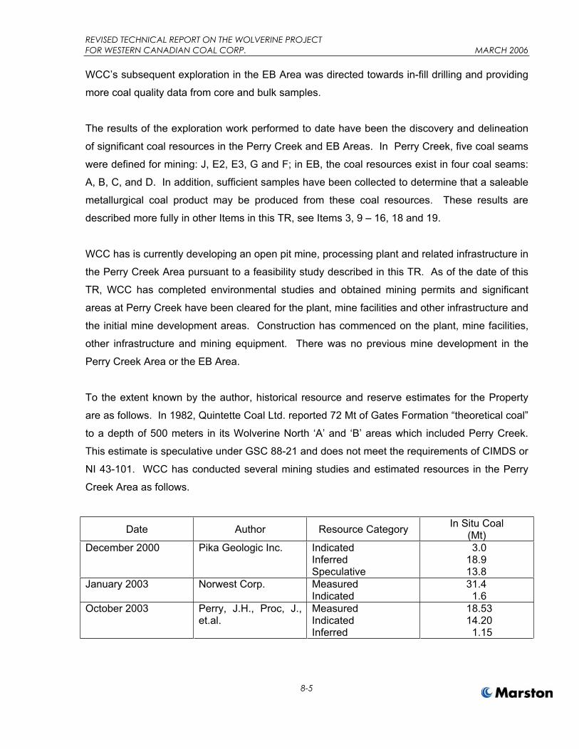
To the extent known by the author, historical resource and reserve estimates for the Property
are as follows. In 1982, Quintette Coal Ltd. reported 72 Mt of Gates Formation “theoretical coal”
to a depth of 500 meters in its Wolverine North ‘A’ and ‘B’ areas which included Perry Creek.
This estimate is speculative under GSC 88-21 and does not meet the requirements of CIMDS or
NI 43-101. WCC has conducted several mining studies and estimated resources in the Perry
Creek Area as follows.
Date Author Resource Category In Situ Coal (Mt)
December 2000 Pika Geologic Inc. Indicated InferredSpeculative
3.018.913.8
January 2003 Norwest Corp. MeasuredIndicated
31.41.6
October 2003 Perry, J.H., Proc, J., et.al.
MeasuredIndicatedInferred
18.5314.20
1.15
REVISED TECHNICAL REPORT ON THE WOLVERINE PROJECT FOR WESTERN CANADIAN COAL CORP. MARCH 2006
8-6
In the EB Area, Ranger Oil estimated coal resources of 19.3 Mt within its “E.B. 1 Pit” sub-area,
which covers a substantially similar area as the EB Area resources stated in this report. The
Ranger Oil estimate is stated to be coal within an open pit limit of 12 bank cubic meters of waste
per tonne of in situ coal. This estimate is Inferred or Speculative under GSC 88-21 and does
not meet the requirements of CIMDS or NI 43-101. WCC estimated coal resources for the EB
Area in 2003. See Perry, J.H and Proc, J. In the B, C and D seams, WCC estimated 16.6 Mt of
Indicated coal and 1.7 Mt of Inferred coal.
In the October 2003 Report, WCC also states reserves of 17.1 Mt of ROM coal and 8.1 Mt of
ROM coal from open pit mine plans in Perry Creek and EB, respectively. Although the figures
were based on a preliminary feasibility study, the estimates were not categorized as Proven or
Probable and therefore do not meet current CIMDS standards.
To the author’s knowledge, there has been no production from the Property.

REVISED TECHNICAL REPORT ON THE WOLVERINE PROJECT FOR WESTERN CANADIAN COAL CORP. MARCH 2006
9-1
ITEM 9 GEOLOGICAL SETTING
The regional geology of the area is typical of the Peace River Coalfield. Coal occurs within the
Lower Cretaceous Gething and Gates Formations, see Figure 4, Regional Geology. The
Gething Formation is part of the Bullhead Group and is exposed in the EB Area. Regionally, the
primary coal seams of interest are found in the Gates Formation, see Figure 5, Perry Creek
Area Stratigraphic Column, and Figure 6, EB Area Stratigraphic Column.
The Gates Formation sediments were deposited in an alluvial deltaic environment about 145
million years ago. Sedimentation is believed to have occurred from erosion of uplifted areas to
the west along the subsiding shoreline of an ancient lake to the east. Along this northeast-
southwest trending shore, low-lying areas became marshy and over time thick peat bogs
formed. These bogs subsided and were covered by later sedimentation. With pressure and
heat at depth, the peat layers became coal seams. Subsequent uplifting of the region brought
the seams to near surface in with crop lines exposed due to erosion. Gates Formation coals
have been mined extensively in the region. The seams at Perry Creek may be correlated with
seams mined at Quintette Coal to the southeast, and the seams at EB may be correlated with
seams mined at Bullmoose Mine to the northwest.
Similarly to other coalfields in the Rocky Mountain Foothills, the strata in the Perry Creek and
EB Areas were subjected to post-depositional faulting and folding. In the Peace River Coalfield,
this tectonism is generally associated with the mountain building of the Laramide Orogeny. In
general, compressive forces generated by uplifting to the west and acting in a northeast
direction caused repeated thrust faulting and folding generally striking in a northwest-southeast
direction. In the Peace River Coalfield, such thrust faults and folding typically result in coal
deposits with Moderate and Complex geology types. Geology types are as defined in Paper 88-
21 of the Geological Survey of Canada, entitled “A Standardized Coal Resource/Reserve
Reporting System for Canada” (GSC 88-21). On the Property, the Mesa Thrust Fault is the
predominant structural feature and it separates more complex structures that occur west of the
fault and in the EB Area from more moderate structures east of the fault and in the Perry Creek
Area, see Figure 4.
REVISED TECHNICAL REPORT ON THE WOLVERINE PROJECT FOR WESTERN CANADIAN COAL CORP. MARCH 2006
9-2
In the Perry Creek Area, the main coal seams in descending order are the E, F, G and J seams
with a cumulative average coal thickness of nearly 12.5 meters, see Figure 5. At Perry Creek
the geological structure of the open pit resource area is an open, asymmetrical, syncline that
lies between the Wolverine River and Perry Creek valleys. See Figure 7, Perry Creek
Geological Cross Sections. Fold plunge angles are generally gentle and range between 4° to
10° to the northwest and southeast. The dip increases rapidly on the northeastern limb to
approximately 25° to 30°. Across most of the southwest limb, dips are generally less than 15°
but steeper dips are encountered westwards, reaching approximately 25° to 30° towards the
crest of the Perry Creek anticline. The southwest limb of this anticline is interpreted to attain a
dip of up to 45° and is beyond the Perry Creek resource limits. Under GSC 88-21, the geology
type of the Perry Creek Area is Moderate.
In the EB Area, the four main coal seams are the D, C, B and A seams, with the D, C and B
seams of primary interest, see Figure 6, EB Area Stratigraphic Column. These three seams
have a total cumulative thickness of about 11.6 meters. The complex geology of the EB Area is
interpreted to include moderate, westerly-dipping strata within the southwestern and
northeastern portions of the area. Where the dips of these strata flatten, anticlinal and synclinal
axial zones are formed that plunge gently to the southeast. The shallow-dipping portion of the
flexure exhibit rolls with dips that range up to 13º. On the adjacent western and eastern limbs,
dips are interpreted to be 25º to 40º. See Figure 8, EB Geologic Cross Sections. Three major
faults are interpreted across the proposed EB Pit. The northwest-trending, westerly-dipping
faults are projected to have vertical displacements of up to 70 meters to 80 meters at the
southern edge of the proposed pit area. In drill holes, the main faults were indicated by
repeated coal seam strata and anomalous interburden thicknesses. In addition to these major
structures, coal seam thickening indicates that relatively minor faulting may also be present
locally.

REVISED TECHNICAL REPORT ON THE WOLVERINE PROJECT FOR WESTERN CANADIAN COAL CORP. MARCH 2006
10-1
ITEM 10 DEPOSIT TYPES
The mineral deposit type being investigated at the Wolverine Property is bituminous coal that
occurs in consistent seams of mineable thickness in sedimentary rock formations. The coal
seams were deposited in an alluvial deltaic environment and therefore vary somewhat in
thickness and ash content.
The rock formations on the Property are folded and faulted due to post-depositional tectonic
activity. The Perry Creek structure consists of a broad, open fold with a dip of less than 30
degrees and no evidence of significant faulting. The Perry Creek Area is therefore of Moderate
geology type under GSC 88-21. The EB Area is affected by several reverse faults that displace
steeply dipping fold limbs in several places. For this reason, the EB Area geology type is
Complex under GSC 88-21.
The geologic model being applied in the investigation is similar to any bedded sedimentary
deposit model. The coal seams are prevalent and continuous in the Gates Formation of rocks.
The Gates Formation occurs over a relative large region and the seams under investigation
were mined at large open pit mines nearby.
Surface mapping and aerial photography are used to define regional and local structures. Coal
seam outcrops and surface geology are also surveyed and mapped. Drill holes and
geophysical logging are used to verify and measure the thickness and characteristics of the
seams at depth. Core samples are primarily used to determine the coal quality of the deposits;
however, historical exploration work has also included bulk samples from adits.
Future development work at Perry Creek and EB will include additional drilling and sampling in
support of detailed mine planning and scheduling.

REVISED TECHNICAL REPORT ON THE WOLVERINE MINE PROJECT FOR WESTERN CANADIAN COAL CORP. MARCH 2006
11-1
ITEM 11 MINERALIZATION
The mineralized zones encountered on the Property are low- to medium-volatile bituminous coal
seams that with standard processing to remove impurities will yield coking coal suitable for use
in steel making.
In the Perry Creek Area, the mineralized zone that is the subject of this technical report occurs
within an area measuring approximately 3 km wide and 3.5 km along strike. Within this area,
four main coal seams have been identified as E Seam, F Seam, G Seam, and J Seam in
descending stratigraphic order. The seams are continuous over the area
The E Seam and J Seam are divided into multiple coal plies that are separated by rock partings,
see Figure 5. The E Seam contains up to seven thin coal and coaly-shale layers over a total
thickness of between six meters to seven meters. The E2 and E3 seam plies are of economic
significance and each ply may consist of one coal layer or several layers separated by thin rock
bands. The J Seam comprises the main coal resource in Perry Creek and consists of three
plies J1, J2 and J3. The ranges in thickness for each of these seams or plies are shown below
in Table 11.1.
Table 11.1 SEAM THICKNESS SUMMARY - PERRY CREEK AREA
THICKNESS (m) SEAM MINIMUM MAXIMUME2 0.2 2.0 E3 0.4 1.9 F 0.5 2.3 G 0.4 1.1 J1 0.7 2.1
J1/21 0.7 4.0 J2 1.3 7.8 J3 1.7 2.8
Note: 1) J1/2 data applies only to the southern portion of the deposit where the rock band separating J1 from J2 is less than 0.5 meters thick.

REVISED TECHNICAL REPORT ON THE WOLVERINE MINE PROJECT FOR WESTERN CANADIAN COAL CORP. MARCH 2006
11-2
In the EB Area, the B, C, and D seams are of primary interest. A relatively thin ply named the
C-2 occurs between the B and C Seams and the bottom A Seam have also been identified in
the Area but are not included as resources in this technical report. The primary seams are
continuous over the area except where displaced by three identified thrust faults, see Figure 8.
Table 11.2 shows the thickness range of each seam in the EB Area.
Table 11.2 SEAM THICKNESS SUMMARY - EB AREA
THICKNESS (m)SEAM
MINIMUM MAXIMUMD 2.9 4.1 C 3.1 5.3 B 3.2 5.6
The surrounding rock types are sedimentary units of the Gates Formation that are typically
sandstone, siltstone and shale. In the Perry Creek Area, conglomerate or conglomeratic beds
also occur, notably the Fortress Mountain unit in the overburden above the E 2 Seam, the
Wolverine Unit directly below the F Seam and a thick conglomerate channel separating the J2
and J3 seams over a portion of the area. The Fortress Mountain conglomeratic sandstone and
the J2/J3 conglomerate have been identified as potential acid generating materials and will
require suitable disposal in waste dumps surrounding basic rocks.
The Gates Formation coal deposits are geologically controlled by the size of the depositional
basin, the length, type and activity of the various depositional environments that formed the
Gates Formation, and post-depositional events such as uplift and compression, and erosion.
The coal seams are exposed at crop lines in both areas due to erosion, but are relatively
continuous over the exploration areas. Discontinuities are due primarily to geologic structures
such as faulting or changes in depositional environment that affected peat formation.
Environment of deposition also affects the in situ characteristics of the coal and is directly
related to the amount and composition of partings, which are rock bands within the seams. For
most seams on the Property, partings must be removed from the mined coal through processing
to produce a marketable product.
REVISED TECHNICAL REPORT ON THE WOLVERINE PROJECT FOR WESTERN CANADIAN COAL CORP. MARCH 2006
12-1
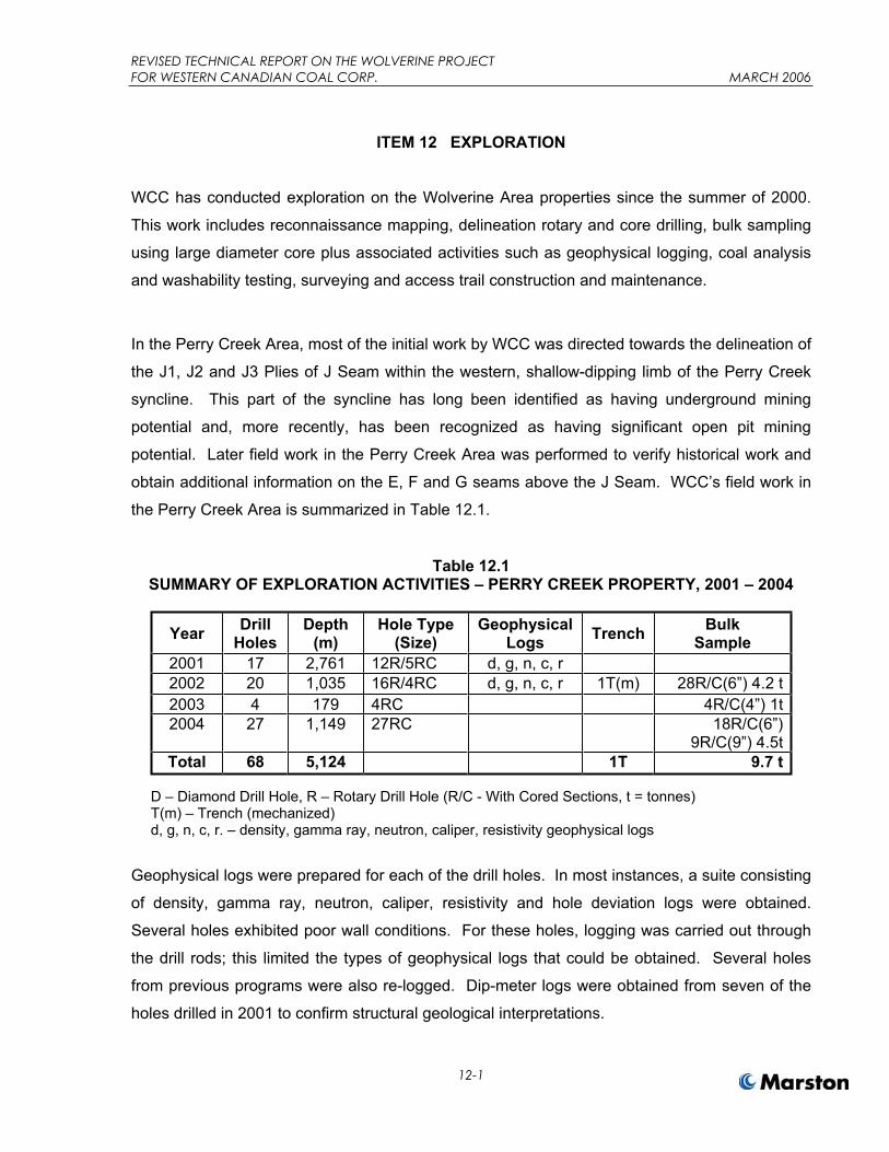
ITEM 12 EXPLORATION
WCC has conducted exploration on the Wolverine Area properties since the summer of 2000.
This work includes reconnaissance mapping, delineation rotary and core drilling, bulk sampling
using large diameter core plus associated activities such as geophysical logging, coal analysis
and washability testing, surveying and access trail construction and maintenance.
In the Perry Creek Area, most of the initial work by WCC was directed towards the delineation of
the J1, J2 and J3 Plies of J Seam within the western, shallow-dipping limb of the Perry Creek
syncline. This part of the syncline has long been identified as having underground mining
potential and, more recently, has been recognized as having significant open pit mining
potential. Later field work in the Perry Creek Area was performed to verify historical work and
obtain additional information on the E, F and G seams above the J Seam. WCC’s field work in
the Perry Creek Area is summarized in Table 12.1.
Table 12.1 SUMMARY OF EXPLORATION ACTIVITIES – PERRY CREEK PROPERTY, 2001 – 2004
Year DrillHoles
Depth(m)
Hole Type (Size)
Geophysical Logs Trench Bulk
Sample2001 17 2,761 12R/5RC d, g, n, c, r 2002 20 1,035 16R/4RC d, g, n, c, r 1T(m) 28R/C(6”) 4.2 t2003 4 179 4RC 4R/C(4”) 1t2004 27 1,149 27RC 18R/C(6”)
9R/C(9”) 4.5tTotal 68 5,124 1T 9.7 t
D – Diamond Drill Hole, R – Rotary Drill Hole (R/C - With Cored Sections, t = tonnes) T(m) – Trench (mechanized) d, g, n, c, r. – density, gamma ray, neutron, caliper, resistivity geophysical logs
Geophysical logs were prepared for each of the drill holes. In most instances, a suite consisting
of density, gamma ray, neutron, caliper, resistivity and hole deviation logs were obtained.
Several holes exhibited poor wall conditions. For these holes, logging was carried out through
the drill rods; this limited the types of geophysical logs that could be obtained. Several holes
from previous programs were also re-logged. Dip-meter logs were obtained from seven of the
holes drilled in 2001 to confirm structural geological interpretations.

REVISED TECHNICAL REPORT ON THE WOLVERINE PROJECT FOR WESTERN CANADIAN COAL CORP. MARCH 2006
12-2
Examination of database printouts, geophysical logs and a selection of descriptive core logs
confirm consistency in coal seam identification, correlation and thickness across the surface
resource area. The stratigraphy encountered at Perry Creek is consistent across the deposit,
with the exception of the conglomerate occurring between the J1 and J2 coal plies.
In the EB Area, in 2001 WCC completed a total of 2,244 meters of drilling and sampling. The
primary objective of this program was to improve confidence in the EB Area geology and coal
resource and to better evaluate the prospective strip ratio of a proposed open pit. WCC’s field
activities are summarized in Table 12.2
Table 12.2 SUMMARY OF EXPLORATION ACTIVITIES – EB PROPERTY, 2000 – 2002
YearDrill
HolesDepth
(m)Hole Type
(Size)Geophysical
Logs2001 21 2,244 18R/3R/C d, g, n, c, r
R – Rotary Drill Hole (R/C - With Cored Sections) d, g, n, c, r – density, gamma ray, neutron, caliper, resistivity geophysical logs.
Drilling was completed using a rotary drilling rig. Coring through designated coal seams was
carried out in three holes in the same manner as described above for Perry Creek. Cored
intervals typically ranged between 1 and 10 meters in length.
As result of this work, WCC verified the historical information indicating the existence of
significant coal resources in both areas and obtained additional information on the structure and
quality of the resources.
Based on the historical and WCC information significant coal resources were interpreted in the
Perry Creek and EB Areas.
WCC managed the exploration programs in both areas with drilling performed using local drilling
contractors familiar with drilling in western Canada coal fields.
REVISED TECHNICAL REPORT ON THE WOLVERINE PROJECT FOR WESTERN CANADIAN COAL CORP. MARCH 2006
12-3
Although Marston personnel did not observe WCC’s exploration work, the programs appear to
have been carried out in a professional manner and to reasonable standards appropriate for
delineation of coal resources. Marston’s Qualified Person visited the Perry Creek and EB Areas
and observed drill hole sites and other evidence of the historical and WCC exploration activities
at both areas. Marston discussed with WCC personnel WCC’s programs and field procedures
and found them to be reasonable.
Marston reviewed the base data collected from the WCC and earlier programs and the
associated geological reports. Based on the evidence available, Marston believes that the data
is reliable and adequate for the purposes of estimating resources and reserves. Seam
thickness measurements are based on geophysical logs and seam core samples; coal quality
measurements are based on core samples shipped to reputable laboratories experienced and
familiar with coal quality testing and standards. For these reasons, Marston believes that the
seam thickness and coal quality information provided and reviewed is reliable and certain.

REVISED TECHNICAL REPORT ON THE WOLVERINE PROJECT FOR WESTERN CANADIAN COAL CORP. MARCH 2006
13-1
ITEM 13 DRILLING
As described in Item 8, numerous drilling programs occurred on the Property during the 1970s
and 1980s. More recently, WCC drilled the Perry Creek and EB Areas after WCC acquired the
Property in late 2000.
Most of the drilling performed to date at the Property consisted of rotary diamond drilling with
core samples collected for the entire length of the hole or of selected seams. Some Quintette
holes were rotary drill holes without coring. In all cases, the drill holes were logged using
geophysical (density, gamma ray, neutron, caliper, resistivity) tools to obtain reliable seam
thickness measurements and strata characteristics. Core angles were measured of rock and
coal strata to obtain true thickness measurements of the seams. All core samples were sent to
independent laboratories for testing. In WCC’s 2003 and 2004 programs, large diameter core
samples were taken of the seams in Perry Creek from numerous holes drilled in clusters to
obtain bulk samples for process testing.
The extent of the drilling at the Property is shown on Figure 3, which shows all drill holes that
intersected coal. Drill holes with no coal are not shown. Drill hole density is highest in relatively
shallow areas of the Property that contain coal resources. Drill hole locations for the coal
resources are shown in Figure 12, Perry Creek Area Measured and Indicated Resources and
Figure 13, EB Area Indicated Resources. See also Figure 7, Perry Creek Geological Cross
Sections and Figure 8, EB Geological Cross Sections that show drill hole locations in section
and through the major coal seams of interest.
In summary, the drilling programs at the Property have delineated significant coal resources
contained in several seams. Based on the drilling, the coal seam true thicknesses are as
follows.
Table 13.1 SEAM THICKNESS SUMMARY – WOLVERINE PROJECT
TRUE THICKNESS (m) SEAM MINIMUM MAXIMUM
Perry Creek Area
E2 0.2 2.0

REVISED TECHNICAL REPORT ON THE WOLVERINE PROJECT FOR WESTERN CANADIAN COAL CORP. MARCH 2006
13-2
Table 13.1 (cont.) SEAM THICKNESS SUMMARY – WOLVERINE PROJECT
TRUE THICKNESS (m) SEAM MINIMUM MAXIMUM
Perry Creek Area
E3 0.4 1.9 F 0.5 2.3 G 0.4 1.1 J1 0.7 2.1
J1/21 0.7 4.0 J2 1.3 7.8 J3 1.7 2.8
EB Area
D 2.9 4.1 C 3.1 5.3 B 3.2 5.6
Note: 1) J1/2 data applies only to the southern portion of the deposit where the rock band separating J1 from J2 is less than 0.5 meters thick.
At Perry Creek, the Gates Formation rocks plunge to the southeast at about 4 degrees to 10
degrees as part of the Perry Creek Syncline. On the predominant southwest limb of the Perry
Creek Syncline, the coal seams dip at about 15 degrees and at about 30 degrees on the
northeast limb. In the EB Area, the Gates Formation rocks plunge relatively gently to the west.
Seam dips vary up to 13 degrees in the main area of the resource to steeper dips of 25 degrees
to 40 degrees on the limbs of the structure and between interpreted reverse faults.

REVISED TECHNICAL REPORT ON THE WOLVERINE PROJECT FOR WESTERN CANADIAN COAL CORP. MARCH 2006
14-1
ITEM 14 SAMPLING METHOD AND APPROACH
Sampling at the property has consisted primarily of core sampling from rotary diamond drill
holes. In nearly all drill holes, core samples were taken from the seams intersected, and in
some holes samples were taken of the surrounding rock that may form dilution during mining.
Bulk samples were collected from large diameter core holes clustered near each other. In the
EB Area, Ranger Oil also completed several adits into exposed coal seams and collected bulk
samples of each seam. Last, during field mapping, trenches were excavated on several coal
seam outcrops and channel samples were cut from the exposed seams.
The details of location, number, type, and nature of samples collected are shown on Table 14.1
for the Perry Creek Area and Tables 14.2 for the EB Area. In the Perry Creek Area, drill holes
for resources are generally spaced on section lines about 400 to 600 m apart with a typical
spacing of about 150 m to 200 m along each section line. Drill holes are more clustered along
crop lines where bulk samples were collected using large diameter core holes. In Item 26 of this
report, see Figure 12, Measured and Indicated Resources for drill hole locations in the Perry
Creek Area. In the EB Area, drill holes were located along section lines that were generally 175
m to 200 m apart with drill holes spaced 125 m to 325 m apart on section. Each section has at
least 3 and typically 4 or more drill holes. See Figure 13, EB Area Indicated Resource Area for
EB Area drill hole locations.
Because samples are prepared at independent laboratories from full core samples, core
recovery of less than 100% could materially impact the reliability of the results. As well,
selective sampling that omits or removes inseparable rock partings could also materially impact
the reliability of the results. In both cases, sample coal quality results could be biased.
Marston was not present during the sampling at the Property. However, based on a review of
the data and reports and discussions with WCC personnel, it appears from the information
provided that core recovery was reasonable and that sampling was performed by experienced
geologists following standard industry practice. For this reason, Marston believes that the
samples were representative and that sample bias is within laboratory and industry standards
for coal quality tests.

REVISED TECHNICAL REPORT ON THE WOLVERINE PROJECT FOR WESTERN CANADIAN COAL CORP. MARCH 2006
14-2
In general, samples were collected from nearly all coal seams identified in cores of 0.5 m and
greater. Within seams, sample intervals varied according to coal and non-coal plies. As well, in
some drill holes, samples were taken of rock above and below the coal seams to determine the
quality of potential out of seam dilution that would occur during mining. Bulk samples were full
seam samples including all coal and non-coal plies that would be mined. In general, the coal
seams at the Property are all of similar rank; i.e., low to medium volatile bituminous coal, but the
seams have significantly different ash contents and different parting intervals with high ash
content that must be mined with the coal. Typically, if sampled separately, these non-
removeable partings are included in sample composites for the purposes of estimating
resources and resource quality.
Lists of individual samples and composite bulk samples are shown on Table 14.3 for the Perry
creek Area and Table 14.4 for the EB Area.
Hole NAD 83 Northing NAD 83 Easting Elevation(m, amsl) Length (m) Hole Type
BS2002-1 6,105,313.2 612,043.7 952.4 38.9 6" COREBS2002-10 6,105,318.5 612,046.5 952.0 37.9 6" COREBS2002-11 6,105,319.7 612,047.8 951.9 38.2 6" COREBS2002-2 6,105,314.7 612,044.9 952.3 38.7 6" COREBS2002-3 6,105,315.8 612,046.0 952.2 38.4 6" COREBS2002-4 6,105,316.8 612,047.2 952.2 38.0 6" COREBS2002-5 6,105,318.5 612,048.5 951.9 38.0 6" COREBS2002-6 6,105,320.1 612,049.4 951.8 37.8 6" COREBS2002-7 6,105,315.3 612,041.9 952.6 38.2 6" COREBS2002-8 6,105,316.0 612,043.7 952.3 38.1 6" COREBS2002-9 6,105,317.3 612,044.8 952.1 38.5 6" COREBS2002-12 6,105,609.7 612,277.4 929.9 37.6 6" COREBS2002-13 6,105,604.1 612,273.4 929.9 36.4 6" COREBS2002-14 6,105,602.6 612,272.6 929.8 36.1 6" COREBS2002-15 6,105,600.7 612,271.8 929.8 36.0 6" COREBS2002-16 6,105,599.0 612,270.8 929.7 35.9 6" COREBS2002-17 6,105,597.3 612,269.7 929.6 35.9 6" COREBS2002-18 6,105,595.5 612,268.9 929.7 35.7 6" COREBS2002-19 6,105,551.4 612,231.7 934.7 35.7 6" COREBS2002-20 6,105,550.0 612,230.8 934.7 35.4 6" COREBS2002-21 6,105,548.3 612,229.9 934.5 35.3 6" COREBS2002-22 6,105,546.7 612,229.4 934.4 35.2 6" COREBS2002-23 6,105,544.5 612,228.2 934.4 34.9 6" COREBS2002-24 6,105,101.6 611,805.7 987.7 30.9 6" COREBS2002-25 6,105,104.0 611,807.4 987.5 31.5 6" COREBS2002-26 6,105,105.6 611,808.5 987.4 31.4 6" COREBS2002-27 6,105,106.9 611,809.8 987.2 31.5 6" COREBS2002-28 6,105,108.1 611,811.0 987.2 32.4 6" COREPRH01-10 6,105,044.6 611,244.1 1,169.1 124.0 ROTARYPRH01-11 6,105,697.0 611,992.3 979.3 104.0 ROTARYPRH01-12 6,105,618.8 611,787.1 1,015.1 116.6 ROTARYPRH01-13 6,105,507.6 611,185.3 1,165.4 159.4 ROTARYPRH01-14 6,106,550.1 611,276.5 1,117.5 188.9 ROTARYPRH01-15 6,105,374.0 610,877.3 1,270.2 190.0 ROTARY
PRH01-16C 6,106,385.6 611,145.7 1,121.3 209.0 CORE HQPRH01-17C 6,105,338.9 612,073.8 945.0 33.2 CORE HQPRH01-1C 6,105,706.7 611,307.8 1,126.3 162.5 CORE HQPRH01-2 6,106,005.5 611,583.3 1,063.5 196.3 ROTARY
PRH01-3C 6,105,549.4 612,268.4 925.7 272.1 CORE HQPRH01-4C 6,106,435.6 611,906.7 1,101.7 104.6 CORE HQPRH01-5 6,106,200.1 611,714.3 1,037.0 163.7 ROTARYPRH01-6 6,105,910.4 610,605.7 1,297.6 194.3 ROTARYPRH01-7 6,106,046.9 610,809.7 1,227.6 209.1 ROTARYPRH01-8 6,106,241.9 610,974.3 1,172.7 203.4 ROTARYPRH01-9 6,105,367.7 611,603.3 1,066.3 130.2 ROTARY
PRH02-01 6,105,465.2 612,255.4 920.9 16.2 ROTARYPRH02-02 6,105,451.0 612,273.9 919.0 13.1 ROTARYPRH02-03 6,105,274.5 612,150.0 923.7 10.4 ROTARYPRH02-04 6,105,311.9 612,113.6 928.5 15.9 ROTARYPRH02-05 6,105,586.6 612,419.4 912.1 19.2 ROTARYPRH02-06 6,105,553.6 612,446.6 910.6 16.1 ROTARYPRH02-07 6,105,629.6 612,363.2 917.5 31.4 ROTARY
PRH02-08C 6,105,477.4 612,228.9 927.2 24.4 COREPRH02-09 6,106,645.5 611,589.7 1,099.0 71.3 ROTARY
PRH02-10C 6,106,719.7 611,629.3 1,089.5 62.8 ROTARYPRH02-11 6,104,589.1 610,515.5 1,375.2 118.8 ROTARYPRH02-12 6,104,684.5 610,586.3 1,366.6 99.9 ROTARYPRH02-13 6,104,772.6 610,693.8 1,326.7 114.0 ROTARYPRH02-14 6,104,892.9 610,805.7 1,306.9 125.6 ROTARYPRH02-15 6,104,656.4 610,931.3 1,287.6 56.8 ROTARYPRH02-16 6,104,528.7 610,934.6 1,289.6 51.8 ROTARYPRH02-17 6,104,429.8 610,893.3 1,296.7 71.0 ROTARY
PRH02-18C 6,104,655.5 610,932.3 1,287.1 48.8 ROTARYPRH02-19 6,106,553.4 611,998.9 1,098.6 48.5 ROTARY
PRH02-20C 6,106,550.6 611,976.9 1,101.0 19.0 COREQPD88001 6,106,274.3 611,780.4 1,071.4 171.0 COREQPD88002 6,105,857.5 611,465.3 1,099.5 194.1 COREQPR87001 6,105,420.4 612,301.2 918.6 73.5 ROTARYQPR87002 6,105,188.7 611,953.5 954.5 60.5 ROTARYQPR87003 6,105,337.1 612,068.9 945.0 44.4 ROTARYQPR87004 6,105,483.0 612,211.1 930.3 37.9 ROTARY
REVISED TECHNICAL REPORT ON THE WOLVERINE PROJECT FOR WESTERN CANADIAN COAL CORP.MARCH 2006
PERRY CREEK AREA DRILL HOLE LOCATIONSTABLE 14.1
1 of 2

REVISED TECHNICAL REPORT ON THE WOLVERINE PROJECT FOR WESTERN CANADIAN COAL CORP.MARCH 2006
PERRY CREEK AREA DRILL HOLE LOCATIONSTABLE 14.1
QPR87005 6,105,655.3 612,326.4 923.5 43.3 ROTARYQPR88001 6,106,622.4 611,047.2 1,135.1 181.8 ROTARYQPR88002 6,106,511.4 611,452.6 1,101.5 171.3 ROTARYQPR88003 6,106,057.5 612,106.1 1,055.3 137.1 ROTARYQPR88004 6,106,741.1 611,401.0 1,092.3 70.8 ROTARYQWD7115 6,106,232.4 610,309.1 1,269.6 444.5 COREQWD7118 6,106,986.1 610,258.9 1,181.5 175.9 COREQWD7119 6,105,793.5 610,943.9 1,212.5 197.2 COREQWD7112 6,105,138.9 612,526.5 872.6 308.4 COREQWD7117 6,106,946.0 609,529.7 1,286.4 397.0 COREQWD7120 6,107,334.7 609,985.0 1,206.3 191.1 COREQWD7121 6,107,326.7 609,198.6 1,219.2 169.8 COREQWD7401 6,107,822.8 612,619.4 1,131.0 235.3 COREQWD7402 6,103,426.7 611,238.6 982.0 124.0 COREQWD7403 6,103,237.5 611,873.1 858.0 242.6 CORE
WDH1 6,104,225.2 611,398.2 953.5 230.0 COREBS2003-1 6,106,185.8 611,896.5 1,064.9 55.4 6" COREBS2003-6 6,106,185.8 611,896.5 1,064.9 36.0 6" CORE
PCBS2004-1 to 27 6,105,541.0 612,218.0 N/A 10 holes 9" CORE
2 of 2

Hole NAD 83 Northing NAD 83 Easting Elevation
(m, amsl) Azimuth Dip Length (m) Hole Type
ADIT-A1 6,107,514.8 601,871.0 1,608.0 166 0 63.0 ADITADIT-B1 6,107,730.8 602,254.0 1,625.5 316 0 74.5 ADITADIT-B3 6,107,537.8 601,816.1 1,624.7 0 0 26.0 ADITADIT-C1 6,107,766.2 602,122.1 1,665.9 345 0 63.0 ADITADIT-C2 6,107,596.8 601,816.1 1,664.7 338 0 32.0 ADITADIT-D1 6,107,678.3 601,775.6 1,689.8 345 0 34.0 ADITEB(MS)-1 6,108,224.1 601,744.7 1,767.7 0 -90 508.4 COREEB(MS)-13 6,107,711.1 601,186.2 1,686.5 0 -90 276.5 COREEB(MS)-5 6,106,669.6 601,566.4 1,534.5 0 -90 142.1 CORE NQEB(MS)-6 6,106,473.6 601,943.3 1,502.6 0 -90 157.3 CORE NQEB(MS)-9 6,107,988.4 602,113.2 1,708.9 0 -90 255.4 CORE
EB45 6,108,460.8 601,787.0 1,726.1 83 -89 100.9 ROTARYEB46 6,108,593.0 601,931.8 1,676.0 134 -89 52.6 ROTARYEB47 6,108,528.7 601,853.6 1,706.8 77 -89 40.5 ROTARYEB48 6,108,536.5 601,560.8 1,737.3 354 -90 125.9 ROTARYEB49 6,108,373.3 602,140.6 1,681.4 1 -89 31.3 ROTARYEB50 6,108,084.2 602,222.0 1,676.1 64 -88 65.1 ROTARYEB51 6,107,798.8 602,330.6 1,647.1 272 -88 43.1 ROTARYEB52 6,107,776.4 601,930.1 1,699.2 356 -88 98.3 ROTARYEB53 6,108,109.1 601,854.8 1,763.4 319 -89 147.5 ROTARYEB54 6,108,361.8 601,693.5 1,758.1 108 -90 130.9 ROTARYEB55 6,107,697.3 601,446.4 1,699.5 46 -88 153.5 ROTARYEB56 6,107,399.0 601,744.1 1,588.1 0 -90 9.0 ROTARYEB57 6,107,247.5 601,743.5 1,549.8 0 -90 15.0 ROTARY
EB58C 6,107,335.9 601,442.3 1,581.6 298 -90 132.9 COREEB59C 6,107,968.0 601,704.1 1,770.8 321 -90 176.3 COREEB60 6,106,967.8 601,566.1 1,550.9 108 -90 130.9 ROTARYEB61 6,106,913.2 601,751.7 1,530.7 359.8 -85 99.2 ROTARYEB62 6,108,172.9 601,507.3 1,811.5 169 -89 227.1 ROTARY
EB63C 6,108,266.8 601,633.6 1,778.5 315 -89 161.0 COREEB64 6,107,457.8 601,646.4 1,615.9 208 -89 105.3 ROTARYEB65 6,107,538.9 601,300.8 1,627.6 118 -88 197.9 ROTARYMS-16 6,107,675.8 600,645.3 1,689.9 0 -90 328.0 CORE NQMS-17 6,107,842.4 601,554.9 1,747.1 0 -90 161.0 CORE NQMS-18 6,108,036.6 601,365.6 1,827.4 0 -90 246.0 CORE NQMS-19 6,108,480.1 601,508.1 1,751.9 0 -90 161.0 CORE NQMS-21 6,107,710.3 601,693.8 1,702.3 0 -90 107.0 CORE NQMS-22 6,108,445.8 600,692.2 1,875.8 0 -90 430.0 CORE NQ
MS-25A 6,108,181.5 600,992.4 1,857.6 0 -90 386.0 CORE NQMS-27 6,108,230.3 600,289.4 1,806.7 0 -90 416.0 CORE NQMS-34 6,107,838.8 602,077.5 1,701.6 0 -90 103.1 CORE HQMS-35 6,107,222.2 601,565.9 1,560.6 0 -90 120.5 CORE HQMS-36 6,107,258.0 601,640.0 1,560.3 0 -90 160.3 CORE HQMS-37 6,108,239.7 602,059.1 1,716.1 0 -90 158.8 CORE HQMS-38 6,107,019.2 601,476.1 1,558.5 0 -90 137.9 CORE HQMS-40 6,107,652.5 601,803.9 1,679.3 0 -90 74.8 CORE HQ
ADIT-B2 6,109,402.7 600,151.1 1,731.7 150 0 42.0 ADITEB(MS)-10 6,109,798.9 600,819.9 1,675.6 0 -90 77.4 COREEB(MS)-11 6,110,500.5 601,456.9 1,760.7 0 -90 182.9 COREEB(MS)-12 6,111,272.8 601,741.4 1,722.4 0 -90 177.7 COREEB(MS)-14 6,107,402.2 602,764.1 1,462.1 0 -90 151.5 COREEB(MS)-15 6,109,567.4 603,218.5 1,821.9 0 -90 101.2 COREEB(MS)-2 6,107,417.5 599,496.5 1,553.5 0 -90 200.6 COREEB(MS)-3 6,107,393.0 598,746.4 1,359.7 0 -90 167.0 COREEB(MS)-4 6,107,025.6 603,178.0 1,443.7 0 -90 115.2 CORE NQEB(MS)-7 6,109,681.0 602,591.5 1,807.1 0 -90 276.1 COREEB(MS)-8 6,109,478.0 601,538.3 1,722.3 0 -90 112.2 COREMS-20A 6,110,208.2 601,873.4 1,904.8 0 -90 321.0 CORE NQMS-23 6,110,388.6 602,271.8 1,941.7 0 -90 70.0 CORE NQMS-24 6,110,196.6 602,523.4 1,944.9 0 -90 57.0 CORE NQMS-26 6,110,100.0 603,241.3 1,929.2 0 -90 49.0 CORE NQMS-28 6,109,645.8 598,925.2 1,750.1 0 -90 225.0 CORE NQMS-29 6,108,757.2 599,011.0 1,766.5 0 -90 310.0 CORE NQMS-30 6,109,390.2 598,443.2 1,560.8 0 -90 138.0 CORE NQMS-31 6,109,277.6 598,481.3 1,583.1 0 -90 187.5 CORE NQMS-32 6,109,796.0 598,762.3 1,666.0 0 -90 118.0 CORE NQMS-33 6,109,859.9 599,266.8 1,793.2 0 -90 252.0 CORE NQMS-39 6,108,891.9 605,087.0 1,831.2 0 -90 449.8 CORE HQMS-41 6,109,900.7 597,341.8 1,152.0 0 -90 37.7 CORE - AXTMS-42 6,109,334.5 597,238.7 1,181.0 0 -90 31.6 CORE - AXTMS-43 6,108,820.7 597,931.0 1,260.0 0 -90 79.0 CORE - HQMS-44 6,108,580.7 597,669.5 1,222.0 0 -90 87.5 CORE - HQMS-45 6,108,974.5 597,592.5 1,207.0 0 -90 83.6 CORE
REVISED TECHNICAL REPORT ON THE WOLVERINE PROJECT FOR WESTERN CANADIAN COAL CORP.MARCH 2006
EB AREA DRILL HOLE LOCATIONSTABLE 14.2
Sample Hole Seam Ash(%)
Vol.Matter
(%)
FreeCarbon
(%)
Moist.(%)
Sulfur(%)
Heat(kcal/kg) FSI HGI Specific
Gravity
C04-E2-1 BS2003-1 E2 37.2 16.9 45.4 0.62 0.58 3.0PC04-E2-a PCBS2004-23C E2 40.8 17.2 41.8 0.25 2.5
3001 QPD88001 E2 58.13002 QPD88001 E2 19.2C-104 QPD88002 E2 27.3 21.2 50.9 0.63 0.36 6.5
C04-E3-1 BS2003-1 E3 36.1 19.6 43.8 0.52 0.87 4.5PC04-E3-a PCBS2004-23C E3 48.8 16.1 34.9 0.27 6.0
3003 QPD88001 E3 19.3C-105 QPD88002 E3 44.1 16.6 38.4 0.89 0.49 3.5
C04-F-1 BS2003-1 F 22.6 21.5 55.1 0.72 0.61 1.0PC04-F-a PCBS2004-23C F 27.6 22.7 49.4 0.28 7.5
3004 QPD88001 F 18.3C-106 QPD88002 F 31.9 21.3 45.9 0.99 0.66 6.5
Comp. 15-1 QWD7115 F 32.1 22.3 45.2 0.43 0.69 5,493 5.5Comp. 17-1 QWD7117 F 24.1 23.1 52.6 0.28 1.05 6,194 4.5Comp. 18-1 QWD7118 F 32.8 21.8 45.0 0.4 0.51 5,577 5.0Comp. No. 1 QWD7119 F 19.4 24.9 54.9 0.84 0.52 7,623 6.5Comp. 20-1 QWD7120 F 42.5 18.5 38.6 0.46 0.74 4,704 4.0
C04-G-1 BS2003-6 G 10.2 23.6 65.8 0.46 1.11 8.5PC04-G-a PCBS2004-3C G 14.5 24.0 61.3 0.18 9.0
3005 QPD88001 G 8.43015 QPD88002 G 10.6Bulk BS2002-28 J 11.2 22.3 65.8 0.74 7.5
02452 PRH01-17C J1 12.9 21.1 65.7 0.31 0.53 5.08751 PRH02-08C J1 13.6 20.8 65.3 0.32 0.53 3.5C 999 PRH02-18C J1 16.3 21.5 61.6 0.55 0.31 1.41
C2003-1 PRH2003-1C J1 11.5 23.6 64.4 0.48 0.45 6.5 86 1.36C-101 QPD88001 J1 12.6 24.5 62.2 0.78 0.45 7.5C-107 QPD88002 J1 14.4 21.5 63.4 0.74 0.46 7.0 76.5
Comp. 15-2 QWD7115 J1 18.1 23.5 57.5 0.93 0.35 7,050 5.5Comp. No. 2 QWD7119 J1 23.0 19.9 56.4 0.72 0.3 6,327 5.0C04-J1/J2-1 BS2003-6 J1/J2 11.0 23.7 64.9 0.43 0.94 7.0
PC04-J1/J2-a PCBS2004-7C J1/J2 13.0 23.4 63.5 0.13 7.0BC2002-A BS2002-1 J1/J2 11.8 22.9 65.0 0.22 0.48 8.0C2002-1 BS2002-14 J1/J2 13.4 22.2 64.0 0.37 0.54 7.0
J1/J2 BS2002-2 J1/J2 9.4 23.4 67.0 0.21 8.0C2002-3 BS2002-21 J1/J2 14.0 22.8 62.9 0.39 0.52 7.0C2002-5 BS2002-26 J1/J2 12.6 21.8 65.2 0.42 0.42 7.0
J1/2 PRH01-3C J1/J2 11.3 22.2 66.1 0.4 0.48 7.0
REVISED TECHNICAL REPORT ON THE WOLVERINE PROJECT FOR WESTERN CANADIAN COAL CORP.MARCH 2006
PERRY CREEK AREA DRILL HOLE QUALITY DATA (air dried basis)TABLE 14.3
Page 1 of 4
Sample Hole Seam Ash(%)
Vol.Matter
(%)
FreeCarbon
(%)
Moist.(%)
Sulfur(%)
Heat(kcal/kg) FSI HGI Specific
Gravity
REVISED TECHNICAL REPORT ON THE WOLVERINE PROJECT FOR WESTERN CANADIAN COAL CORP.MARCH 2006
PERRY CREEK AREA DRILL HOLE QUALITY DATA (air dried basis)TABLE 14.3
8840 PRH02-01 J1/J2 37.0 1.41 1.58841 PRH02-01 J1/J2 14.7 0.49 7.08842 PRH02-01 J1/J2 12.7 0.43 5.08843 PRH02-01 J1/J2 10.8 0.45 5.08844 PRH02-01 J1/J2 17.1 0.44 7.58845 PRH02-01 J1/J2 6.4 0.4 8.08846 PRH02-01 J1/J2 37.0 0.43 6.58834 PRH02-02 J1/J2 6.8 1.54 3.58835 PRH02-02 J1/J2 9.6 1.53 2.08836 PRH02-02 J1/J2 81.1 1.47 1.08801 PRH02-04 J1/J2 13.3 1.58 1.08802 PRH02-04 J1/J2 8.5 1.38 3.08803 PRH02-04 J1/J2 8.0 1.49 3.58804 PRH02-04 J1/J2 7.5 1.39 1.58805 PRH02-04 J1/J2 6.8 1.38 8.58806 PRH02-04 J1/J2 22.1 1.34 7.58807 PRH02-04 J1/J2 5.3 1.36 7.08808 PRH02-04 J1/J2 17.6 1.33 8.08812 PRH02-05 J1/J2 14.0 1.49 4.58813 PRH02-05 J1/J2 16.0 0.49 2.08814 PRH02-05 J1/J2 9.6 0.51 8.58815 PRH02-05 J1/J2 6.8 0.53 7.08816 PRH02-05 J1/J2 67.8 0.54 1.08821 PRH02-07 J1/J2 11.4 0.39 7.08822 PRH02-07 J1/J2 60.4 1.54 1.08823 PRH02-07 J1/J2 9.6 1.36 5.08824 PRH02-07 J1/J2 5.6 1.31 7.58825 PRH02-07 J1/J2 4.0 1.4 5.58826 PRH02-07 J1/J2 81.3 1.41 1.0
02453 PRH01-17C J1FW 75.2 11.7 12.4 0.6 0.1704129 PRH02-18C J1FW 82.1 7.8 9.6 0.47 0.04 2.2616951 PRH01-3C J1HW 34.2 14.9 50.4 0.45 7.6702437 PRH01-16C J2 9.8 25.5 64.3 0.48 0.42 6.502454 PRH01-17C J2 17.7 20.3 61.5 0.53 0.38 3.502455 PRH01-17C J2 6.5 23.8 69.3 0.37 0.29 7.516960 PRH01-4C J2 5.3 26.3 68.0 0.41 0.49 7.08753 PRH02-08C J2 8.2 22.4 69.1 0.34 0.33 7.0C 995 PRH02-10C J2 4.7 26.8 67.9 0.61 0.63 1.29C 998 PRH02-18C J2 10.7 23.1 65.6 0.61 0.34 1.35
Page 2 of 4

Sample Hole Seam Ash(%)
Vol.Matter
(%)
FreeCarbon
(%)
Moist.(%)
Sulfur(%)
Heat(kcal/kg) FSI HGI Specific
Gravity
REVISED TECHNICAL REPORT ON THE WOLVERINE PROJECT FOR WESTERN CANADIAN COAL CORP.MARCH 2006
PERRY CREEK AREA DRILL HOLE QUALITY DATA (air dried basis)TABLE 14.3
04133 PRH02-18C J2 55.4 22.4 21.6 0.63 0.14 1.99C 997 PRH02-18C J2 8.1 24.2 67.0 0.64 0.32 1.34
C2003-2 PRH2003-1C J2 16.5 23.5 59.6 0.44 0.49 7.0 82 1.43C-102 QPD88001 J2 12.1 26.0 61.2 0.75 0.44 7.5 76.5C-108 QPD88002 J2 12.3 23.3 63.8 0.7 0.57 7.5 80
Comp. 15-3 QWD7115 J2 21.5 22.4 55.7 0.4 0.43 6,438 5.5Comp. 18-2 QWD7118 J2 11.0 24.6 64.0 0.39 0.52 7,790 6.5Comp. No. 3 QWD7119 J2 20.0 21.7 57.6 0.74 0.28 6,650 7.5
02456 PRH01-17C J2FW 85.5 6.2 7.7 0.6 0.1104145 PRH02-10C J2FW 24.5 22.2 52.6 0.68 0.57 1.4504146 PRH02-10C J2FW 88.4 6.3 4.6 0.75 0.12 2.4704136 PRH02-18C J2FW 91.2 5.8 2.5 0.56 0.09 2.548752 PRH02-08C J2P 27.8 18.5 53.3 0.36 0.52 7.03017 QPD88002 J2P 86.7
BC2002-B BS2002-1 J3 11.8 22.9 65.0 0.22 0.48 8.0C2002-2 BS2002-14 J3 9.7 22.0 67.9 0.41 0.5 7.0
BS-J3 BS2002-2 J3 9.7 20.8 69.3 0.26 6.5C2002-4 BS2002-21 J3 12.7 23.5 63.5 0.33 0.39 6.0C2002-6 BS2002-26 J3 9.4 22.1 68.2 0.33 0.31 7.5C04-J3-1 BS2003-6 J3 8.4 22.2 68.8 0.49 0.53 5.5
PC04-J3-a PCBS2004-7C J3 12.4 22.4 65.1 0.2 7.002438 PRH01-16C J3 8.0 23.0 68.6 0.44 0.31 5.502458 PRH01-17C J3 9.8 21.1 68.7 0.42 0.34 4.516957 PRH01-3C J3 17.9 18.4 63.2 0.5 0.44J3-1 PRH01-3C J3 9.1 22.1 68.4 0.42 0.45 7.0
16958 PRH01-3C J3 53.6 37.4 8.8 0.3 0.15J3-2 PRH01-3C J3 9.1 22.1 68.4 0.42 0.45 7.0
16961 PRH01-4C J3 8.6 24.4 66.6 0.45 0.3 7.08847 PRH02-01 J3 11.9 0.44 1.58848 PRH02-01 J3 7.9 0.45 3.58849 PRH02-01 J3 9.6 0.43 1.58850 PRH02-01 J3 5.0 0.4 5.08837 PRH02-02 J3 8.1 1.45 3.08838 PRH02-02 J3 10.1 1.42 2.58839 PRH02-02 J3 32.4 1.47 6.58830 PRH02-03 J3 22.4 2.06 1.58831 PRH02-03 J3 13.8 2.1 1.58832 PRH02-03 J3 5.6 1.46 7.08833 PRH02-03 J3 31.5 0.63 4.5
Page 3 of 4

Sample Hole Seam Ash(%)
Vol.Matter
(%)
FreeCarbon
(%)
Moist.(%)
Sulfur(%)
Heat(kcal/kg) FSI HGI Specific
Gravity
REVISED TECHNICAL REPORT ON THE WOLVERINE PROJECT FOR WESTERN CANADIAN COAL CORP.MARCH 2006
PERRY CREEK AREA DRILL HOLE QUALITY DATA (air dried basis)TABLE 14.3
8809 PRH02-04 J3 9.0 1.4 5.08810 PRH02-04 J3 9.0 1.38 1.08811 PRH02-04 J3 7.8 1.36 1.58817 PRH02-05 J3 16.7 0.45 2.08818 PRH02-05 J3 15.3 0.5 2.08819 PRH02-05 J3 27.4 0.45 1.58820 PRH02-06 J3 16.7 0.56 1.08827 PRH02-07 J3 12.0 1.36 2.08828 PRH02-07 J3 11.8 1.32 4.58829 PRH02-07 J3 77.3 1.26 1.08755 PRH02-08C J3 8.3 20.8 70.6 0.39 0.35 3.0C 994 PRH02-10C J3 8.1 22.8 68.6 0.6 0.46 1.34C 996 PRH02-18C J3 9.0 21.0 69.2 0.77 0.23 1.34
C2003-3 PRH2003-1C J3 13.1 21.3 65.1 0.47 0.3 5.0 79 1.38C-103 QPD88001 J3 13.1 26.3 60.0 0.66 0.3 7.0 80C-109 QPD88002 J3 10.0 21.4 67.9 0.73 0.32 7.0 74
Comp. 15-4 QWD7115 J3 14.6 25.3 59.6 0.45 0.25 7,206 3.5Comp. 17-2 QWD7117 J3 10.8 22.6 66.3 0.29 0.41 7,634 6.0Comp. 18-3 QWD7118 J3 9.9 23.4 66.2 0.52 0.26 7,762 5.5Comp. No. 4 QWD7119 J3 17.8 23.6 58.0 0.62 0.32 6,739 5.0Comp. 20-2 QWD7120 J3 14.4 20.7 64.5 0.41 0.35 7,334 5.0Comp. 21-1 QWD7121 J3 11.7 22.1 65.7 0.54 0.33 7,545 5.5
02475 PRH02-10C J3FW 69.9 11.4 18.1 0.56 0.18 2.0704141 PRH02-18C J3FW 89.8 7.2 2.5 0.52 0.03 2.4902457 PRH01-17C J3HW 79.5 8.5 11.5 0.59 0.2716956 PRH01-3C J3HW 82.2 6.9 10.1 0.79 0.2804147 PRH02-10C J3HW 90.4 6.2 2.7 0.71 0.2 2.5404137 PRH02-18C J3HW 91.2 6.0 2.2 0.58 0.1 2.56
Page 4 of 4

Sample Hole Seam Ash (%)VolatileMatter
(%)
FreeCarbon
(%)
InherentMoisture
(%)
Sulfur(%) FSI HGI Specific
Gravity
A bulk ADIT-A1 A 16.4 20.5 62.5 0.6 0.5 6.5A SEAM ADIT-A1 A 16.4 5.3 6.5
59M 0.260 ADIT-A1 A 25.6 19.6 54.2 0.6 0.4 4.0 1.51BC ADIT-A1 A 13.7 21.4 64.3 0.6 0.48 7.0 1.39
60M 0.52 BC ADIT-A1 A 11.7 21.5 66.0 0.8 0.57 5.5 1.3762M 0.39T ADIT-A1 A 18.7 20.3 60.1 0.9 0.47 5.0 1.4462M 0.41C ADIT-A1 A 18.3 20.3 60.8 0.6 0.49 5.5 1.4362M 0.49B ADIT-A1 A 13.7 21.1 64.5 0.7 0.49 4.5 1.463M 0.37T ADIT-A1 A 13.0 21.0 64.4 0.7 0.49 7.0 1.3963M 0.57T ADIT-A1 A 11.4 21.9 65.9 0.8 0.48 6.5 1.37
comp ADIT-A1 A 15.7 20.5 63.1 0.7 0.53 5.5 78 1.4ADIT_B1-A ADIT-B1 B 17.6 0.44 7.5ADIT_B1-B ADIT-B1 B 45.6 0.61 1.0ADIT_B1-C ADIT-B1 B 17.1 0.46 5.0ADIT_B1-D ADIT-B1 B 16.8 0.32 5.0ADIT_B1-E ADIT-B1 B 8.0 0.39 1.0ADIT-B2-A ADIT-B2 B 22.3 0.42 4.5ADIT-B2-B ADIT-B2 B 12.7 0.38 5.0ADIT-B2-C ADIT-B2 B 10.3 0.51 7.0ADIT-B2-D ADIT-B2 B 6.7 0.48 7.0ADIT-B2-E ADIT-B2 B 5.1 0.61 6.5ADIT-B2-F ADIT-B2 B 6.4 0.73 5.5
ADIT-B2-AA ADIT-B2 B 18.2 0.36 4.0ADIT-B2-BB ADIT-B2 B 22.9 0.51 3.5ADIT-B2-CC ADIT-B2 B 16.7 0.4 4.5ADIT-B2-DD ADIT-B2 B 9.4 0.36 6.0ADIT-B2-EE ADIT-B2 B 5.8 0.52 6.5ADIT-B2-FF ADIT-B2 B 5.3 0.67 8.0ADIT-B3-1 ADIT-B3 B 16.4 22.8 60.1 0.7 0.37 6.5 1.43ADIT-B3-2 ADIT-B3 B 30.9 18.8 48.9 1.4 0.42 3.0 1.57ADIT-B3-3 ADIT-B3 B 21.5 19.2 58.6 0.7 0.39 2.5 1.5ADIT-B3-4 ADIT-B3 B 11.3 23.1 64.6 1 0.44 4.5 1.41ADIT-B3-5 ADIT-B3 B 9.2 24.4 65.7 0.7 0.49 6.5 1.37ADIT-B3-6 ADIT-B3 B 6.8 24.7 67.5 1 0.49 7.5 1.34ADIT-B3-7 ADIT-B3 B 8.9 24.6 65.8 0.7 0.53 8.5 1.36comp-6444 ADIT-B3 B 22.4 0.36 3.5SAMPLE B ADIT-B3 B 15.0 3.7 6.0comp-6321 ADIT-B3 B 15.0 21.9 62.5 0.6 0.36 6.0comp-6508 ADIT-B3 B 15.4 21.9 61.9 0.8 0.4 6.5 83 1.4ADIT_C1-A ADIT-C1 C 15.3 0.63ADIT_C1-B ADIT-C1 C 55.7 0.31ADIT_C1-C ADIT-C1 C 20.6 0.39 1.0ADIT_C1-D ADIT-C1 C 66.4 0.3 1.0ADIT_C1-E ADIT-C1 C 9.8 0.6 7.5ADIT_C1-F ADIT-C1 C 21.0 0.68 0.5ADIT-C2-8 ADIT-C2 C 22.8 21.2 55.2 0.8 0.77 7.0 1.45ADIT-C2-7 ADIT-C2 C 11.8 24.7 62.6 0.9 0.53 8.5 1.36comp-6211 ADIT-C2 C 23.6 21.4 54.3 0.7 0.51 6.5 72 1.46comp-6318 ADIT-C2 C 32.2 5.5 4.0comp-6319 ADIT-C2 C 32.2 19.0 48.0 0.8 0.47 4.0
REVISED TECHNICAL REPORT ON THE WOLVERINE PROJECT FOR WESTERN CANADIAN COAL CORP.MARCH 2006
EB AREA DRILL HOLE QUALITY DATA (air dried basis)TABLE 14.4
Page 1 of 6

Sample Hole Seam Ash (%)VolatileMatter
(%)
FreeCarbon
(%)
InherentMoisture
(%)
Sulfur(%) FSI HGI Specific
Gravity
REVISED TECHNICAL REPORT ON THE WOLVERINE PROJECT FOR WESTERN CANADIAN COAL CORP.MARCH 2006
EB AREA DRILL HOLE QUALITY DATA (air dried basis)TABLE 14.4
ADIT-C2-6 ADIT-C2 C 8.9 24.3 65.7 1.1 0.44 7.5 1.34ADIT-C2-5 ADIT-C2 C 77.7 9.4 11.6 1.3 0.2 2.23ADIT-C2-4 ADIT-C2 C 14.2 22.8 62.3 0.7 0.49 4.5 1.4ADIT-C2-3 ADIT-C2 C 19.5 22.1 57.5 0.9 0.38 4.0 1.45ADIT-C2-2 ADIT-C2 C 37.3 19.2 42.6 0.9 0.46 2.0 1.63ADIT-C2-1 ADIT-C2 C 21.5 22.6 55.0 0.9 0.74 6.5 1.45
channel ADIT-D1 D 24.5 20.7 53.8 1 0.38 6.5 75 1.48ADIT-D1-6 ADIT-D1 D 13.1 22.4 63.5 1 0.4 7.0 1.38ADIT-D1-5 ADIT-D1 D 27.7 20.3 50.7 1.3 0.49 6.5 1.52ADIT-D1-4 ADIT-D1 D 40.5 18.2 39.6 1.7 0.29 3.0 1.66ADIT-D1-3 ADIT-D1 D 23.4 21.3 54.4 0.9 0.32 3.5 1.5ADIT-D1-2 ADIT-D1 D 18.3 22.8 58.0 0.9 0.34 3.5 1.45ADIT-D1-1 ADIT-D1 D 28.6 22.4 47.9 1.1 0.38 4.5 1.52
comp ADIT-D1 D 28.0 4.5BULK ADIT-D1 D 28.0 20.3 50.9 0.8 0.4 4.5
EB-1-01 EB(MS)-1 D 15.4EB-1-02 EB(MS)-1 D 17.2EB-1-03 EB(MS)-1 C 27.3EB-1-04 EB(MS)-1 C 24.1EB-1-05 EB(MS)-1 B 15.8EB-1-06 EB(MS)-1 A 12.3EB-13-D EB(MS)-13 D 35.2EB-13-C EB(MS)-13 C 28.2EB-13-B EB(MS)-13 B 14.1
Sample "C" EB(MS)-5 C 18.5 20.8 60.7 0.43 3.5Sample "B" EB(MS)-5 B 18.0 21.3 60.7 0.21 2.0
EB-5-A EB(MS)-5 A 11.9Sample "D" EB(MS)-6 D 27.8 22.8 49.4 0.31 5.0
EB-6-D EB(MS)-6 D 27.8 0.42 6.0EB-6-C EB(MS)-6 C 35.1EB-6-B EB(MS)-6 B 10.8EB-9-D EB(MS)-9 D 28.8EB-9-C EB(MS)-9 C 37.3EB-9-B EB(MS)-9 B 17.9EB-9-A EB(MS)-9 A 16.202413 EB59C DHW 70.6 10.4 18.2 0.85 0.7702411 EB59C D1 17.7 23.1 58.4 0.78 0.52 7.002410 EB59C DHW 76.3 9.7 12.8 1.14 0.0902412 EB59C D0 17.7 22.7 58.8 0.77 0.36 5.502419 EB59C CHW 87.1 8.8 3.3 0.77 0.1202417 EB59C C 38.6 17.3 43.4 0.7 0.37 1.002416 EB59C C 12.0 24.2 63.2 0.62 0.42 6.502415 EB59C C0P 86.4 6.7 6.1 0.81 0.2202418 EB59C C0 14.6 24.0 60.7 0.79 0.82 7.002421 EB59C B 27.8 19.9 51.7 0.53 0.26 2.502422 EB59C B 6.7 25.6 67.1 0.54 0.32 7.017001 EB59C BFW 87.2 8.6 3.8 0.47 0.0702423 EB59C A 19.8 19.1 60.6 0.48 0.37 3.5
MS-16-D MS-16 D 35.4 19.9 43.7 1 0.35 4.5 71.9 1.59 MS-16 D 19.5 21.8 58.0 0.7 0.46 4.5 1.49
Page 2 of 6
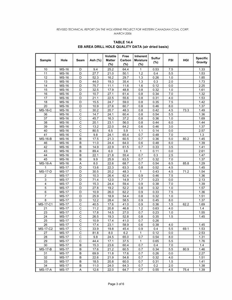
Sample Hole Seam Ash (%)VolatileMatter
(%)
FreeCarbon
(%)
InherentMoisture
(%)
Sulfur(%) FSI HGI Specific
Gravity
REVISED TECHNICAL REPORT ON THE WOLVERINE PROJECT FOR WESTERN CANADIAN COAL CORP.MARCH 2006
EB AREA DRILL HOLE QUALITY DATA (air dried basis)TABLE 14.4
10 MS-16 D 9.4 25.2 64.4 1 0.53 7.5 1.3311 MS-16 D 27.7 21.0 50.1 1.2 0.4 5.5 1.5312 MS-16 D 52.3 16.2 29.7 1.3 0.26 1.0 1.8513 MS-16 D 44.0 19.3 35.4 1.3 0.3 2.0 1.7314 MS-16 D 75.7 11.1 11.6 1.6 0.12 0.0 2.2515 MS-16 D 32.5 17.9 48.8 0.8 0.32 1.0 1.6116 MS-16 D 10.7 27.1 61.4 0.8 0.34 7.0 1.3217 MS-16 D 21.1 22.5 55.6 0.8 0.31 4.0 1.5318 MS-16 D 15.5 24.7 59.0 0.8 0.35 7.5 1.4220 MS-16 D 10.9 27.6 60.7 0.8 0.46 8.0 1.37
MS-16-C MS-16 C 30.2 20.7 48.3 0.8 0.42 4.5 73.3 1.4936 MS-16 C 14.7 24.1 60.4 0.8 0.54 5.5 1.3637 MS-16 C 45.7 16.3 37.2 0.8 0.36 1.0 1.6938 MS-16 C 20.1 23.1 56.0 0.8 0.44 6.0 1.4439 MS-16 C 13.2 22.0 64.2 0.6 0.46 3.0 1.3740 MS-16 C 80.5 6.5 5.9 1.1 0.14 0.0 2.5741 MS-16 C 9.8 24.1 65.4 0.7 0.48 7.0 1.3
MS-16-B MS-16 B 17.5 21.3 60.5 0.7 0.36 5.0 80.2 1.4546 MS-16 B 11.0 24.4 64.0 0.6 0.48 6.0 1.3942 MS-16 B 14.9 22.9 61.5 0.7 0.33 3.5 1.4143 MS-16 B 89.4 6.0 3.6 1 0.11 0.0 2.6144 MS-16 B 22.1 21.8 55.4 0.7 0.3 2.5 1.4745 MS-16 B 9.9 25.9 63.5 0.7 0.32 7.0 1.37
MS-16-A MS-16 A 8.0 22.6 68.7 0.7 0.54 6.5 85.8 1.291 MS-17 D 13.6 22.3 63.3 0.8 0.52 4.5 1.45
MS-17-D MS-17 D 30.5 20.2 48.3 1 0.43 4.5 71.2 1.542 MS-17 D 10.3 26.4 62.4 0.9 0.46 7.5 1.363 MS-17 D 71.4 12.0 14.9 1.7 0.23 0.0 2.134 MS-17 D 15.3 24.4 59.4 0.9 0.38 7.0 1.395 MS-17 D 27.8 19.2 52.2 0.8 0.32 1.0 1.576 MS-17 D 10.9 26.0 62.2 0.9 0.33 7.5 1.367 MS-17 D 25.9 18.9 54.4 0.8 0.32 1.0 1.518 MS-17 D 12.2 28.4 58.5 0.9 0.45 8.0 1.37
MS-17-C1 MS-17 C 40.5 17.6 41.0 0.9 0.36 1.5 62.2 1.6921 MS-17 C 11.2 20.8 46.8 1.2 0.63 4.0 1.423 MS-17 C 17.8 14.5 27.0 0.7 0.23 1.0 1.5524 MS-17 C 26.5 19.3 52.8 0.8 0.35 1.5 1.4525 MS-17 C 10.9 17.4 41.0 0.7 0.2626 MS-17 C 17.4 23.1 58.9 0.6 0.38 4.0 1.45
MS-17-C2 MS-17 C 33.9 19.8 45.4 0.9 0.4 5.5 69.1 1.5327 MS-17 C 81.8 8.0 6.2 1 0.12 0.0 2.5328 MS-17 C 9.8 24.5 65.0 0.7 0.54 8.0 1.3129 MS-17 C 44.4 17.1 37.5 1 0.65 5.5 1.7630 MS-17 B 15.3 23.6 60.4 0.7 0.4 7.0 1.4
MS-17-B MS-17 B 17.6 21.2 60.5 0.7 0.34 5.5 80.9 1.4631 MS-17 B 69.9 11.8 17.6 0.7 0.26 0.0 2.2732 MS-17 B 22.6 21.9 54.8 0.7 0.32 4.0 1.5133 MS-17 B 18.5 20.8 60.0 0.7 0.31 1.5 1.4134 MS-17 B 11.0 24.0 64.3 0.7 0.2 2.0 1.38
MS-17-A MS-17 A 12.6 22.0 64.7 0.7 0.55 4.5 75.4 1.39
Page 3 of 6

Sample Hole Seam Ash (%)VolatileMatter
(%)
FreeCarbon
(%)
InherentMoisture
(%)
Sulfur(%) FSI HGI Specific
Gravity
REVISED TECHNICAL REPORT ON THE WOLVERINE PROJECT FOR WESTERN CANADIAN COAL CORP.MARCH 2006
EB AREA DRILL HOLE QUALITY DATA (air dried basis)TABLE 14.4
66 MS-18 D1 16.4 22.4 60.0 1 0.61 5.5 1.44MS-18-D1-1 MS-18 D1 39.1 17.5 42.2 1.2 0.4 3.5 69.8 1.6MS-18-D1-2 MS-18 D1 44.0 18.0 36.8 1.2 0.4 1.0 68.4 1.63
67 MS-18 D1 73.0 12.0 13.1 1.9 0.19 0.0 2.3368 MS-18 D1 31.8 17.7 49.4 1.1 0.56 3.0 1.5769 MS-18 D1 30.9 19.9 47.9 1.3 0.46 4.5 1.5570 MS-18 D1 71.4 11.3 15.6 1.7 0.19 0.0 2.171 MS-18 D1 40.5 19.1 39.2 1.2 0.38 1.5 1.62
MS-18-D2 MS-18 D2 31.6 21.9 45.5 1 0.41 5.5 73.3 1.5872 MS-18 D2 16.0 24.8 58.2 1 0.51 6.5 1.3973 MS-18 D2 71.8 11.8 14.8 1.6 0.15 0.0 2.1974 MS-18 D2 16.3 23.5 59.3 0.9 0.41 5.5 1.475 MS-18 C 35.9 18.2 44.9 1 0.43 1.0 1.64
MS-18-C-1 MS-18 C 35.9 18.2 44.9 1 0.43 1.0 63.6 1.64MS-18-C-2 MS-18 C 29.4 20.9 48.8 0.9 0.47 5.5 1.57
76 MS-18 C 14.9 23.2 61.0 0.9 0.43 4.5 1.3877 MS-18 C 83.9 9.0 5.9 1.2 0.14 0.0 2.3578 MS-18 C 13.7 23.9 61.4 1 0.62 7.0 1.3379 MS-18 C 64.7 13.7 20.4 1.2 0.52 1.0 1.9
MS-18-B MS-18 B 18.8 23.1 57.3 0.8 0.46 5.5 84.4 1.4280 MS-18 B 27.0 19.9 52.1 1 0.48 4.5 1.4981 MS-18 B 10.9 23.8 64.1 1.2 0.37 4.0 1.3649 MS-19 D 18.2 22.2 58.8 0.8 0.65 5.5 1.49
MS-19-D MS-19 D 32.3 20.5 46.4 0.8 0.33 1.5 69.8 1.550 MS-19 D 84.9 7.8 6.3 1 0.14 0.0 2.4351 MS-19 D 15.3 24.7 59.4 0.6 0.52 7.0 1.3952 MS-19 C 9.3 24.4 65.4 0.9 0.82 7.5 1.37
MS-19-C1 MS-19 C 42.9 17.5 38.6 1 0.39 2.0 91.3 1.7MS-19-C2 MS-19 C 35.3 19.1 44.7 0.9 0.37 4.0 70.5 1.52
53 MS-19 C 61.9 13.4 22.9 1.8 0.38 1.0 1.8554 MS-19 C 39.9 17.4 41.9 0.8 0.57 1.0 1.6955 MS-19 C 50.5 16.0 32.6 0.9 0.34 1.0 1.756 MS-19 C 12.8 23.3 63.2 0.7 0.45 5.0 1.457 MS-19 C 87.4 7.1 4.4 1.1 0.12 0.0 2.2558 MS-19 C 9.0 23.5 66.7 0.8 0.48 6.5 1.3259 MS-19 C 36.7 17.1 45.3 0.9 0.42 3.0 1.6760 MS-19 C 6.7 26.6 65.9 0.8 0.65 9.0 1.2761 MS-19 C 56.3 14.0 28.7 1 0.46 2.5 1.7562 MS-19 B 23.0 20.2 55.8 1 0.5 3.0 1.44
MS-19-B MS-19 B 19.2 22.2 57.9 0.7 0.4 5.0 83 1.4763 MS-19 B 21.0 20.7 57.5 0.8 0.31 1.0 1.4464 MS-19 B 7.5 23.9 67.7 0.9 0.42 7.5 1.3165 MS-19 A 7.7 22.4 69.1 0.8 0.57 7.0 1.32
MS-19-A MS-19 A 7.7 22.4 69.1 0.8 0.57 7.0 84.4 1.3286 MS-21 D 16.3 23.0 59.5 1.2 0.53 7.5 1.36
MS-21-D MS-21 D 32.0 20.3 46.6 1.1 0.42 5.0 79.6 1.5587 MS-21 D 69.2 11.9 17.0 1.9 0.15 0.0 2.1588 MS-21 D 16.8 23.2 59.0 1 0.44 5.5 1.489 MS-21 D 26.2 19.1 53.8 0.9 0.44 1.0 1.5490 MS-21 D 12.3 25.2 61.5 1 0.47 6.0 1.43
Page 4 of 6

Sample Hole Seam Ash (%)VolatileMatter
(%)
FreeCarbon
(%)
InherentMoisture
(%)
Sulfur(%) FSI HGI Specific
Gravity
REVISED TECHNICAL REPORT ON THE WOLVERINE PROJECT FOR WESTERN CANADIAN COAL CORP.MARCH 2006
EB AREA DRILL HOLE QUALITY DATA (air dried basis)TABLE 14.4
91 MS-21 D 22.2 20.2 56.7 0.9 0.37 3.0 1.5392 MS-21 D 13.2 24.6 61.1 1.1 0.54 7.0 1.493 MS-21 C 41.0 17.9 39.7 1.4 0.5 4.5 1.54
MS-21-C1 MS-21 C 41.3 17.9 39.8 1 0.39 2.0 62.2 1.72MS-21-C2 MS-21 C 31.9 19.7 47.3 1.1 0.45 3.0 65 1.48
94 MS-21 C 37.2 14.6 26.5 1.7 0.39 1.0 1.7895 MS-21 C 41.7 16.5 40.8 1 0.32 1.0 1.796 MS-21 C 15.6 22.7 60.6 1.1 0.39 5.5 1.4197 MS-21 C 87.1 7.3 4.1 1.5 0.13 0.0 2.5598 MS-21 C 10.0 23.5 64.8 1.7 0.54 4.5 1.3599 MS-21 C 47.4 17.9 38.0 1.7 0.5 1.0 1.7100 MS-21 B 14.4 21.9 62.8 0.9 0.45 5.0 1.37
MS-21-B MS-21 B 16.6 23.3 59.3 0.8 0.31 5.5 78.8 1.44101 MS-21 B 34.9 16.0 48.5 0.6 0.31 1.0 1.6102 MS-21 B 18.6 21.8 58.3 1.3 0.3 4.0 1.43103 MS-21 B 16.7 21.8 60.5 0.31 2.5 1.46104 MS-21 B 7.0 25.4 66.6 1 0.36 5.5 1.32
MS-21-A MS-21 A 14.8 22.6 61.6 1 0.47 6.5 80.2 1.42113 MS-22 D 21.7 23.1 54.3 0.9 0.69 8.0 1.44114 MS-22 C 25.2 19.8 54.2 0.8 0.51 6.0 1.5115 MS-22 B 21.8 21.1 56.3 0.8 0.37 4.0 1.46
MS-22-B MS-22 B 13.7 23.2 62.4 0.7 0.43 4.5 87.8 1.39116 MS-22 B 8.3 23.8 67.1 0.8 0.41 7.5 1.32117 MS-22 B118 MS-22 B 6.0 23.9 69.3 0.8 0.47 6.5 1.31119 MS-22 A 12.3 22.0 65.1 0.6 0.62 4.0 1.34
MS-25A-D MS-25A D 38.9 19.0 41.1 1 0.36 3.5 66.4 1.63124 MS-25A D 46.4 15.4 37.2 1 0.35 2.0 1.7125 MS-25A D 25.0 2.47126 MS-25A D 25.0 22.3 51.9 0.8 0.46 5.0 1.49
MS-25A-B MS-25A B 15.0 22.6 61.7 0.7 0.47 5.5 98.2 1.39127 MS-25A B 23.0 23.0 53.3 0.7 0.46 4.5 1.49128 MS-25A B 10.9 24.2 64.2 0.7 0.42 7.0 1.37129 MS-25A B 5.8 24.4 69.1 0.7 0.47 7.0 1.32
MS-25A-C MS-25A A 9.8 22.5 66.8 0.9 0.68 7.0 82.3 1.36130 MS-25A A 9.8 22.5 66.8 0.9 0.68 7.0 82.3 1.36
MS-27-D MS-27 D 42.1 17.6 39.4 0.9 3.0134 MS-27 D 58.0 14.2 26.4 1.4 0.73 1.0 1.36135 MS-27 D 15.4 25.6 58.0 1 0.73 8.0 1.31136 MS-27 D 29.5 20.2 49.4 0.9 0.43 5.0 1.46137 MS-27 B 19.4 22.0 57.7 0.9 0.39 2.5 1.36
MS-27-B MS-27 B 13.1 22.4 63.9 0.6 0.32 4.0 81.6 1.37138 MS-27 B 18.5 21.2 59.0 0.9 0.36 2.5 1.35139 MS-27 B 7.2 25.7 66.2 0.9 0.27 7.5 1.26140 MS-27 A 12.6 22.5 64.1 0.8 0.49 6.5 1.31501 MS-34 D 12.5 21.7 64.6 1.2 0.53 4.0 1.38
MS-34-D MS-34 D 16.5 20.9 60.2 2.4 0.37 1.0 79 1.47502 MS-34 D 63.6 0.19 2.06503 MS-34 D 15.5 20.6 61.6 2.3 0.43 1.45504 MS-34 C 34.5 16.8 47.0 1.7 0.32 0.0 1.66
Page 5 of 6

Sample Hole Seam Ash (%)VolatileMatter
(%)
FreeCarbon
(%)
InherentMoisture
(%)
Sulfur(%) FSI HGI Specific
Gravity
REVISED TECHNICAL REPORT ON THE WOLVERINE PROJECT FOR WESTERN CANADIAN COAL CORP.MARCH 2006
EB AREA DRILL HOLE QUALITY DATA (air dried basis)TABLE 14.4
MS-34-C MS-34 C 30.4 18.2 50.3 1.1 0.44 1.5 75 1.55505 MS-34 C 17.3 21.1 60.8 0.8 0.41 4.0 1.42506 MS-34 C 89.7 0.11 2.58507 MS-34 C 21.0 19.4 58.9 0.7 0.44 5.0 1.47508 MS-34 C 14.8 22.4 61.9 0.9 0.58 7.0 1.39509 MS-34 C 58.1 0.42 1.9510 MS-34 B 15.3 20.9 62.8 1 0.4 2.0 1.43
MS-34-B MS-34 B 15.3 20.9 62.8 2.2 0.4 2.0 79 1.43512 MS-34 A 12.6 19.5 66.5 1.4 0.55 1.5 1.4
MS-34-A MS-34 A 12.4 19.2 65.4 3 0.54 1.5 77 1.4MS-35-B MS-35 B 12.2 23.3 64.1 0.4 0.38 5.5 78 1.39MS-35-A MS-35 A 15.3 21.5 62.8 0.4 0.48 6.5 77 1.41MS-37-D MS-37 D 24.6 21.0 53.7 0.7 0.44 7.0 75 1.49MS-37-B MS-37 B 13.1 22.2 64.3 0.4 0.38 7.0 90 1.4MS-37-A MS-37 A 11.1 21.3 67.2 0.4 0.73 5.0 80 1.36MS-38-D MS-38 D 21.9 22.0 55.4 0.7 0.55 6.5 71 1.44
337 MS-38 C 67.2 11.3 20.4 1.1 0.59 1.0 2.01MS-38-B MS-38 B 12.9 22.2 64.4 0.5 0.44 5.5 83 1.4MS-38-A MS-38 A 20.7 18.5 60.4 0.4 0.48 5.0 82 1.46MS-40-B MS-40 B 12.9 23.7 62.8 0.6 0.37 4.5 77 1.39MS-40-A MS-40 A 14.0 22.4 63.1 0.5 0.48 6.0 74 1.39
Page 6 of 6

REVISED TECHNICAL REPORT ON THE WOLVERINE PROJECT FOR WESTERN CANADIAN COAL CORP. MARCH 2006
15-1
ITEM 15 SAMPLE PREPARATION, ANALSYSIS, AND SECURITY
There is little information regarding sample preparation and security for most of the exploration
activities performed on the Perry Creek and EB properties. However, the work was rendered by
established and reputable mining companies at the time, and with respect to sample
preparation, it can reasonably be expected that samples taken during the various work
programs would have met then current industry standards. The standards are comparable to
those prevalent in the present and the results from sampling and quality are generally
considered reliable. Furthermore, the work performed more recently tends to confirm and
reinforce previous results lending confidence to all the work performed.
Since acquiring the property recently, WCC has sought to more fully define the coal quality
characteristics from each site. Specific holes were sampled individually and sent to the
laboratory as quickly as possible. Cores from the remaining holes were placed into a series of
Mini-Bulk bags, and at Perry Creek they were separated on the basis of whether or not they
were from J1/2 Ply or J3 Ply as well as on actual seam basis. In one drill hole (BS2002-28),
core was also recovered from G Seam. Selected roof and floor rock samples were also taken.
Drilling was conducted on a 24-hour basis. Core logging and sampling took place at the rig-site,
immediately after removal of the core from the core barrel. During the night shift, generalized
descriptions of the core were obtained while more detailed descriptions were carried out on core
obtained during the day shift. The samples were kept at each of the bulk sample sites until the
end of the program, at which point they were collected and shipped to Calgary.
The samples from Perry Creek and EB were tested over a period exceeding 30 years at a
variety of reputable labs and assay centers, including:
Cyclone Engineering and Sales in Edmonton, Alberta
Commercial Testing and Engineering in Vancouver, British Columbia
Warnock Hersey Professional Services in Calgary, Alberta
Birtley Coal and Minerals Testing in Calgary, Alberta
Loring Laboratories in Calgary, Alberta

REVISED TECHNICAL REPORT ON THE WOLVERINE PROJECT FOR WESTERN CANADIAN COAL CORP. MARCH 2006
15-2
WCC, Teck, QCL, and Mitsui are all professional and knowledgeable companies with
reasonable sampling, preparation, security and analytical practices consistent with those
recognized to be reasonable and appropriate in the mining industry. This opinion is based on:
(a) the materials reviewed and the data verification process conducted in the preparation of this
report; and (b) the use of testing facilities and laboratories by all the companies engaged in
exploration of this property that are recognized in Canada and internationally for coal analytical
work and high standards.
Marston reviewed geologic and sampling data but did not participate in any part of the
exploration or analysis programs. Based on this review, the companies who carried out the
programs and the laboratories used for the analytical work, Marston believes that the sampling,
sample preparation, security and analytical procedures were adequate and within industry
standards.

REVISED TECHNICAL REPORT ON THE WOLVERINE PROJECT FOR WESTERN CANADIAN COAL CORP. MARCH 2006
16-1
ITEM 16 DATA VERIFICATION
For the Study and this TR, Marston relied upon data supplied by WCC and the information
described and referenced in Items 5 and 23. The key WCC technical and scientific data to be
verified was topographic mapping, drill hole and sample locations, WCC’s geologic models, in
situ coal quality analyses, and coal washability results used for process plant design and to
predict saleable product yield.
For topographic mapping, WCC provided digital terrain models for the Perry Creek and EB
Areas as triangulated surfaces. For Perry Creek, WCC’s models were based on a LiDAR
survey with points at 1 m spacing by an independent aerial survey company. For the EB Area,
the model was based on publicly available data. WCC’s topography model for Perry Creek
compared well with the base LiDAR survey data and surveyed drill hole collar elevations. For
the EB Area, WCC’s digital model compared reasonably with drill hole collar elevations.
Marston verified the drill hole data by comparing copies of original driller’s logs on file at WCC
with the WCC electronic data files provided. The data logs and files were also compared with
geophysical logs for selected holes to verify seam location and apparent thickness. WCC’s
geological models of each coal seam and major rock units was compared with the drill hole
logs. The base drill hole data compared well with WCC’s geological models.
For the coal quality data, Marston compared WCC’s electronic data with copies of original
independent laboratory reports or summaries of such reports. Similarly, coal washability data
provided by WCC was compared with the independent laboratory reports. In all cases, the data
compared well. For the Study, Marston used this data to prepare in situ coal quality models of
the seams and to project product yield by seam for comparison to WCC’s assumptions.
Marston’s product yield projections compared well with WCC’s yield estimates.
Richard Marston, the Qualified Person for this TR, visited numerous drill hole sites in the Perry
Creek Area. The drill holes could be identified by tags or markings at each site or by reference
to survey locations and maps. At nearly every drill hole site, the hole could be located due to
casing exposed at the collar. In the EB Area, several older drill hole sites and the old
Nichimen/Ranger Oil camp were found. At the camp, many old core boxes remained and could

REVISED TECHNICAL REPORT ON THE WOLVERINE PROJECT FOR WESTERN CANADIAN COAL CORP. MARCH 2006
16-2
be associated with specific drill holes from attached metal ID tags. However, the boxes and
remaining cores had been discarded haphazardly and were in very poor condition. In the EB
Area, access to WCC’s drill sites was not possible due to snow melt causing very poor road
conditions at the time of the visit.
The primary limitation on the verification work described above is that it was not
contemporaneous with the actual field work; i.e., Marston was not present at the time that the
data was collected and reported. However, Marston found no reason to believe that the data as
presented was not collected in a reasonable manner and to reasonable industry standards.

REVISED TECHNICAL REPORT ON THE WOLVERINE PROJECT FOR WESTERN CANADIAN COAL CORP. MARCH 2006
17-1
ITEM 17 ADJACENT PROPERTIES
This report does not include information on adjacent properties.

REVISED TECHNICAL REPORT ON THE WOLVERINE PROJECT FOR WESTERN CANADIAN COAL CORP. MARCH 2006
18-1
ITEM 18 MINERAL PROCESSING AND METALLURGICAL TESTING
For process plant design and product yield estimates, WCC and previous owners commissioned
independent coal laboratories to perform standard washability testing on coal core samples and
bulk samples. See Items 14 and 15 of this TR for a discussion of sampling and testing. The
coal washability tests were performed following ASTM standards for coal testing. Based on this
work, a summary of typical metallurgical product coal quality values by coal seam in the Perry
Creek Area is shown on Table 18.1, Perry Creek Area – Typical Clean Coal Quality (adb) and
Table 18.2 – Perry Creek Area - Typical Clean Coal Thermal Rheology.
Table 18.1 PERRY CREEK AREA – TYPICAL CLEAN COAL QUALITY (adb)
Ply RM Ash VM FC S CV FSI HGI% % % % % kcal/kg
E2 0.74 10.51 23.37 65.38 0.40 7648 5 ½ 83E3 0.80 9.61 23.73 65.86 0.64 7736 7 87F 0.70 9.06 26.49 63.75 0.72 7799 6 ½ 84G 0.48 8.44 23.41 67.67 1.05 NA 7 ½ 91J1 0.77 8.64 22.46 68.13 0.41 7857 7 ½ 80J2 0.70 5.97 25.00 68.33 0.31 8220 8 82J3 0.59 6.74 23.13 69.54 0.27 8056 7 82
Table 18.2 PERRY CREEK - TYPICAL CLEAN COAL THERMAL RHEOLOGY
Max. Fluidity
Max. Fluidity
StartSoft.
FinalFluid Range
InitialDil.
Max. Dil.
Max Dil.
Max. Cont.
Seam FSI (ddpm) 0C 0C 0C 0C 0C 0C % % E2 5 ½ 129 462 419 490 71 439 473 51 25 E3 7 186 461 421 490 69 440 482 55 25 F 6 ½ 1246 456 407 491 83 425 482 140 25 G 7 ½ NA NA NA NA NA NA NA NA NA J1 7 ½ 218 463 418 492 74 442 478 64 24 J2 8 518 464 418 496 78 440 481 82 28 J1/2 8 277 466 428 499 71 NA NA NA NA J3 7 71 462 423 490 67 447 479 27 25
Abbreviations – “Soft.” – Softening; “Dil.” – Dilatation; “Cont.” - Contraction.

REVISED TECHNICAL REPORT ON THE WOLVERINE PROJECT FOR WESTERN CANADIAN COAL CORP. MARCH 2006
18-2
Based on this data, the Perry Creek seams have caking (swelling and plastic) properties, which
identify the coals as being of metallurgical quality. As tabulated, the FSI values of 5 1/2 to 8 are
very favourable for coking. Considering coal rank and type, the seams are moderate in fluidity
and plastic range. Maximum dilatation is also moderate.
In the EB Area, adit bulk samples were used to produce a clean coal product by pilot scale
washing of each seam. The clean coal products from the bulk samples were produced at an
independent laboratory’s pilot scale wash plant. A summary of the clean coal analyses from the
bulk sample tests is presented in Table 18.3, EB Area – Typical Clean Coal Quality (adb) and
Table 18.4, EB Area – Typical Clean Coal Thermal Rheology.
Table 18.3 EB AREA – TYPICAL CLEAN COAL QUALITY (adb)
Table 18.4 EB AREA – TYPICAL CLEAN COAL THERMAL RHEOLOGY
Max. Fluidity
Max.Fluidity
StartSoft.
FinalFluid Range
InitialDil.
Max.Dil.
MaxDil.
Max.Cont.
Seam FSI (ddpm) 0C 0C 0C 0C 0C 0C % % D 8 ½ 444 475 435 513 78 380 467 114 27 C 7 ½ 335 474 436 509 73 384 473 82 23 B 6 ½ 422 471 418 511 93 377 467 43 22
Abbreviations – “Soft.” – Softening; “Dil.” – Dilatation; “Cont.” - Contraction.
The coal thermal rheology values indicate that the EB Area seams have caking (swelling and
plastic) properties of metallurgical coals. As tabulated, the FSI values of 6½ to 8½ are favorable
for coking. Considering the coal rank and type, the seams are moderate in fluidity and plasticity
range. Maximum dilatation is also moderate.
Ply RM Ash VM FC S CV FSI HGI% % % % % kcal/kg
D 0.40 8.70 25.90 65.00 0.51 7838 8.5 77C 0.90 8.90 24.10 66.10 0.60 7793 7.5 77B 0.70 8.60 22.90 67.80 0.40 7822 6.5 78
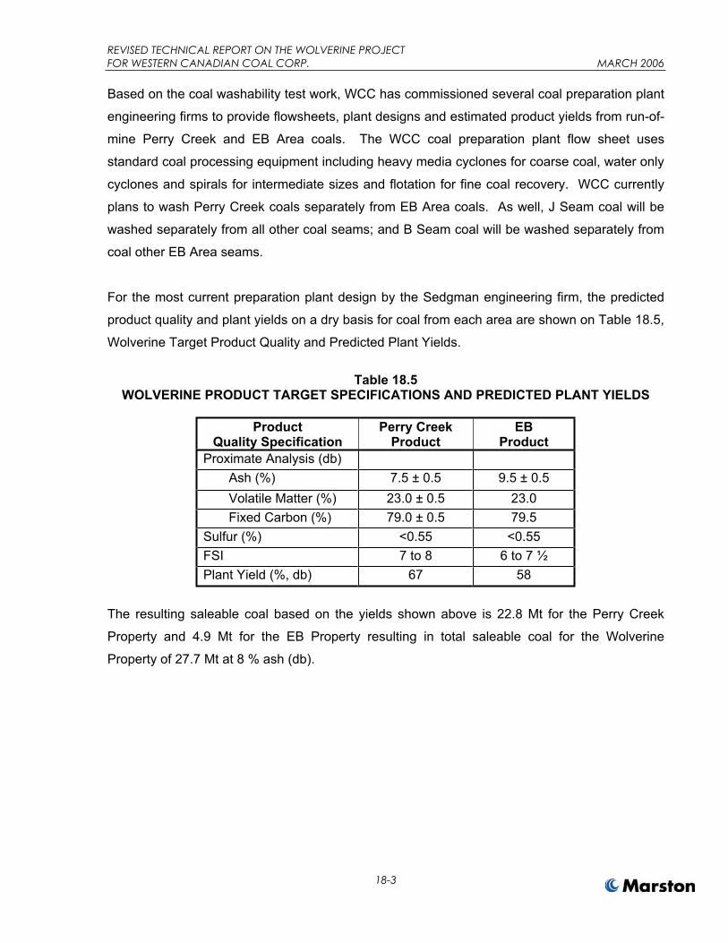
REVISED TECHNICAL REPORT ON THE WOLVERINE PROJECT FOR WESTERN CANADIAN COAL CORP. MARCH 2006
18-3
Based on the coal washability test work, WCC has commissioned several coal preparation plant
engineering firms to provide flowsheets, plant designs and estimated product yields from run-of-
mine Perry Creek and EB Area coals. The WCC coal preparation plant flow sheet uses
standard coal processing equipment including heavy media cyclones for coarse coal, water only
cyclones and spirals for intermediate sizes and flotation for fine coal recovery. WCC currently
plans to wash Perry Creek coals separately from EB Area coals. As well, J Seam coal will be
washed separately from all other coal seams; and B Seam coal will be washed separately from
coal other EB Area seams.
For the most current preparation plant design by the Sedgman engineering firm, the predicted
product quality and plant yields on a dry basis for coal from each area are shown on Table 18.5,
Wolverine Target Product Quality and Predicted Plant Yields.
Table 18.5 WOLVERINE PRODUCT TARGET SPECIFICATIONS AND PREDICTED PLANT YIELDS
ProductQuality Specification
Perry Creek Product
EBProduct
Proximate Analysis (db) Ash (%) 7.5 ± 0.5 9.5 ± 0.5 Volatile Matter (%) 23.0 ± 0.5 23.0 Fixed Carbon (%) 79.0 ± 0.5 79.5 Sulfur (%) <0.55 <0.55 FSI 7 to 8 6 to 7 ½ Plant Yield (%, db) 67 58
The resulting saleable coal based on the yields shown above is 22.8 Mt for the Perry Creek
Property and 4.9 Mt for the EB Property resulting in total saleable coal for the Wolverine
Property of 27.7 Mt at 8 % ash (db).

REVISED TECHNICAL REPORT ON THE WOLVERINE PROJECT FOR WESTERN CANADIAN COAL CORPORATION MARCH 2006
19-1
ITEM 19 MINERAL RESOURCES AND MINERAL RESERVE ESTIMATES
In accordance with NI 43-101, for estimating coal resources and reserves of the Wolverine
Project, Marston has applied the definitions of “Mineral Resource” and “Mineral Reserve” as set
forth in the CIM Definition Standards adopted November 14, 2004 (CIMDS) by the Canadian
Institute of Mining, Metallurgy and Petroleum Council.
Under CIMDS, a Mineral Resource is defined as “… a concentration of natural, solid, inorganic
or fossilized organic material in or on the Earth’s crust in such form and quantity and of such a
grade or quality that is has reasonable prospects for economic extraction. The location,
quantity, grade, geological characteristics and continuity of a Mineral Resource are known,
estimated or interpreted from specific geological evidence and knowledge.” Mineral Resources
are subdivided into classes of Measured, Indicated, and Inferred, with the level of confidence
reducing with each class respectively. Coal resources are always reported as in-situ tonnage
and are not adjusted for mining losses or mining recovery.
A Mineral Reserve is defined as “… the economically mineable part of a Measured or Indicated
Mineral Resource demonstrated by at least a Preliminary Feasibility Study. This Study must
include adequate information on mining, processing, metallurgical, economic and other relevant
factors that demonstrate, at the time of reporting, that economic extraction can be justified. A
Mineral Reserve includes diluting materials and allowances for losses that may occur when the
material is mined.” A Mineral Reserve is subdivided into two classes, Proven and Probable with
the level of confidence reducing with each class respectively. The CIMDS provides for a direct
relationship between Indicated Mineral Resources and Probable Mineral Reserves, and
between Measured Mineral Resources and Proven Mineral Reserves. Inferred Mineral
Resources cannot be combined or reported with other categories.
CIMDS also states it is acceptable to use GSC Paper 88-21 as a framework for the
development and categorization of coal resource estimates, but that the GSC Paper 88-21
categories should be converted to the equivalent CIMDS categories for public reporting.
Marston applied the GSC 88-21 parameters of deposit type, geology type, coal thickness,
overburden depth, distance from data point, and coal parting thickness to evaluate and classify

REVISED TECHNICAL REPORT ON THE WOLVERINE PROJECT FOR WESTERN CANADIAN COAL CORPORATION MARCH 2006
19-2
reserves at the Perry Creek and EB areas. Except as stated herein, Marston is not aware of
any modifying factors exogenous to mining engineering considerations (i.e. competing interests,
environmental concerns, socio-economic issues, legal issues, etc.) that would be of sufficient
magnitude to warrant excluding reserve tonnage below design limitations or reducing reserve
classification (confidence) levels from proven to probable or otherwise.
Resource Estimates – Perry Creek Area
For the Perry Creek Area, the coal seams are of Moderate geology type under GSC 88-21.
Therefore, Marston applied the criteria shown in Tables 19.1 and 19.2 to the Perry Creek coal
resource estimates.
Table 19.1 COAL RESOURCE CATEGORIES
ASSURANCE OF EXISTENCE CRITERIA FOR MODERATE GEOLOGY TYPE
CategoryDistance from
Nearest Datapoint(m)
Measured 0 to 450 Indicated 450 to 900 Inferred 900 to 2,400
Table 19.2 COAL SEAM CRITERIA – MODERATE GEOLOGY TYPE
Maximum rock parting thickness 0.3 m Minimum coal bed thickness 0.45 m Minimum aggregate seam thickness 0.5 m
Using WCC’s geological model as verified by Marston, Marston used a standard Lerch-
Grossman analysis to develop a conceptual pit design to a cutoff strip ratio limit of 18 bank
cubic metres (bcm) of waste per product tonne of coal. The resulting conceptual pit is shown on
Figure 10, Perry Creek Resource Pit. The distribution of drill holes within this pit is sufficient to
classify all of the coal resources within the pit as Measured, see Figure 12, Perry Creek Area
Measured and Indicated Resources.

REVISED TECHNICAL REPORT ON THE WOLVERINE PROJECT FOR WESTERN CANADIAN COAL CORPORATION MARCH 2006
19-3
For the Perry Creek conceptual pit design, Marston used the following criteria.
Overall Highwall Slope 37o to 52.5 o depending on pit area Footwall Slope Equal to dip of J3 Seam (typically 15 o to 25 o)
Based on the conceptual pit design for the Perry Creek Area, the resulting coal resource
estimates by seam are presented in Table 19.3, Perry Creek Area – Estimated Measured Coal
Resources.
Table 19.3 PERRY CREEK AREA – ESTIMATED MEASURED COAL RESOURCES
Seam Volume(Mbcm)
Sp.Gravity
Resources(Mt)
Ash Content (%, db)
E2 2.1 1.46 3.0 26.2 E3 2.1 1.61 3.4 39.6 F 3.4 1.40 4.8 20.3 G 2.0 1.30 2.6 9.1 J1 3.2 1.42 4.5 15.3
J1/J2 Parting 0.2 2.30 0.5 80.0 J2 8.5 1.38 11.8 12.3 J3 5.8 1.36 7.9 11.2
Oxidized Coal 0.2 1.39 0.3 17.0 Totals 27.5 1.41 38.7 17.6
The “J1/J2 Parting” is high ash material that is too thin to separate during mining. “Oxidized
Coal” is coal located near croplines or along fault zones that has been weathered to the extent
that it will not produce metallurgical coal. However, this coal may be sold at a lower price as a
thermal coal or used in the proposed coal dryer at the Perry Creek processing plant.
In Table 19.3, the Measured resource estimates are inclusive of the resources modified to
produce the Proven reserve estimates described in this TR.
Resource Estimates – EB Area
For the EB Area, Marston estimated coal resources also in accordance with GSC 88-21.
However, under GSC 88-21, the geology type of the EB Area coal deposit is Complex.
Therefore, the criteria shown in Table 19.4 and 19.5 have been applied to the EB Area resource
estimates.

REVISED TECHNICAL REPORT ON THE WOLVERINE PROJECT FOR WESTERN CANADIAN COAL CORPORATION MARCH 2006
19-4
Table 19.4 COAL RESOURCE CATEGORIES
ASSURANCE OF EXISTENCE CRITERIA FOR COMPLEX GEOLOGY TYPE
Category MaximumDatapoint
Spacing (m)
MaximumCross SectionSpacing (m)
Measured 200 150 Indicated 400 300 Inferred 800 600
Table 19.5 COAL SEAM CRITERIA – COMPLEX GEOLOGY TYPE
Maximum rock parting thickness 0.6 m Minimum coal bed thickness 0.6 m Minimum aggregate seam thickness 1.0 m
For the EB Area, using the WCC geological model as verified by Marston, Marston designed a
conceptual pit to a cutoff strip ratio of about 15 bcm of waste to one product tonne. The
reduced cutoff strip ratio for the EB conceptual pit reflects the added cost to haul run of mine
coal from the EB Area to the coal preparation plant at Perry Creek. However, the EB
conceptual pit was further constrained to the south by a gas pipeline which is believed to be
uneconomic to move. For this reason the resulting conceptual pit design in the EB Area was
reduced in size significantly and is shown in Item 26 of this TR on Figure 11, EB Resource Pit.
The EB conceptual pit design was based on the following criteria.
Overall Highwall Slope 52.5o
Footwall Slope Equal to dip of B Seam (slightly dipping to 25 o)
Within the EB conceptual pit design, the distribution of drill holes is sufficient to classify all of the
EB coal resources as Indicated under GSC 88-21, see Figure 13, EB Area – Indicated
Resource Area.
Based on the EB conceptual pit design and WCC’s geological model, the estimated Indicated
coal resources by seam for the EB Area are shown on Table 19.6, EB Area – Estimated
Indicated Coal Resources.

REVISED TECHNICAL REPORT ON THE WOLVERINE PROJECT FOR WESTERN CANADIAN COAL CORPORATION MARCH 2006
19-5
Table 19.6 EB AREA – ESTIMATED INDICATED COAL RESOURCES
Seam Volume(Mbcm)
Sp.Gravity
Resources(Mt)
Ash Content (%, db)
D 1.0 1.46 1.5 26.8 C 1.6 1.51 2.5 31.8 B 2.2 1.36 3.0 16.4
Oxidized Coal 0.5 1.43 0.8 23.9 Total 5.4 1.43 7.8 24.0
In Table 19.5, the Indicated resource estimates are inclusive of the resources modified to
produce the Probable reserve estimates described in this TR.
Coal Reserve Estimates
For the Study, WCC requested Marston to design ultimate pits for the Perry Creek and EB
Areas based on a forecast long-term average sales price of US$70 per product tonne or $87.50
per tonne at a foreign exchange rate of C$1.25 per US$1.00. Marston refined the conceptual pit
designs into final pit designs using Lerch-Grossman analyses and the following preliminary
production cost criteria.
Perry Creek Area
Waste Related Cost $ 3.49 per bcm
ROM Related Cost $ 6.25 per ROM tonne
Clean Coal Related Cost $ 24.30 per clean tonne
EB Area
Waste Related Cost $ 3.25 per bcm
ROM Related Cost $ 13.05 per ROM tonne
Clean Coal Related Cost $ 24.30 per clean tonne
For each area, Marston further refined the resulting Lerch-Grossman pits into final wall designs
considering access and other practical mining limitations.
Marston developed a production scheduling database consisting of logical mining benches and
blocks within the ultimate pit designs for the Study. The volumes of coal and waste in each
mining block were derived from the WCC geological model. In situ coal quality was derived for

REVISED TECHNICAL REPORT ON THE WOLVERINE PROJECT FOR WESTERN CANADIAN COAL CORPORATION MARCH 2006
19-6
each coal block based on the coal quality data by drill hole. The coal resource volumes and
tonnage estimates were then modified using the following mining criteria.
a) Mining bench height – 10 m
b) Minimum coal mining thickness – 0.6 m
c) Minimum removable parting thickness – 0.5 m
d) Out-of-seam dilution (OSD) – 15 cm to 40 cm per seam/waste contact depending on
seam dip and lithology of waste rock contacts
e) OSD quality - 80% ash with an in situ specific gravity of 2.3
f) Coal loss – 15 cm to 30 cm per seam/waste contact depending on seam dip and
lithology of waste rock contacts
g) Mining recovery – 90% of seams dipping at more than 10°
h) Product yield - Based on ROM ash, dry basis versus yield functions for each seam with
adjustments for fine coal circuit and thermal dryer additions.
Using the scheduling database, Marston developed a logical mining sequence and production
schedule to produce up to 2.7 Mtpy of metallurgical coal product from the run-of-mine coal
mined from the Perry Creek and EB areas. Both mines will be developed with conventional
open pit mining methods using hydraulic excavators and off-highway rear-dump haulage trucks
for waste and coal mining.
Mining is scheduled to begin in 2006 in the Perry Creek Area. The overall plan at Perry Creek
is to mine to the ultimate pit in phases to maximize early coal production at a relatively low strip
ratio with increasing strip ratios as later pit phases are mined. Production from Perry Creek is
maximized at 3.6 Mt per year (Mtpy) of ROM coal and decreases to 2.8 Mtpy in 2009, at which
point production starts from the EB Pit and grows to a rate of 1.2 Mtpy. The maximum design
capacity of the Wolverine coal processing plant is about 4 Mtpy, which is achieved when the EB
Pit is at full production.
The Wolverine Project mine plans and production schedule include: 35 million tonnes of run-of-
mine (ROM) coal and 198.9 million bcm of waste moved in the Perry Creek Pit from 2006 –
2018; 7 million tonnes of ROM coal and 40.6 million bcm of waste excavated in the EB Pit from
2009 – 2014; and 2.7 Mbcm of ex-pit topsoil removal from facilities and dump areas during
development. The final pits and waste dumps resulting from the mine plans are shown in Item

REVISED TECHNICAL REPORT ON THE WOLVERINE PROJECT FOR WESTERN CANADIAN COAL CORPORATION MARCH 2006
19-7
26, see Figure 14, Perry Creek Pit Status Map – End of Year 2018, and Figure 15, EB Pit Status
Map - End of 2014. As shown, the majority of the mine waste will be dumped outside of the pit
areas; however, a significant area of the EB Pit and parts of the Perry Creek Pit are available for
backfilling during the mine life.
As part of the Study, Marston estimated annual production costs for the life of the mines. Based
on the mining sequence and production schedule, Marston estimated annual work effort in
terms of equipment and labour hours required to achieve the annual waste volumes and coal
tonnages scheduled. Direct operating costs were then estimated based on the annual
equipment and labour hours and unit equipment and labour costs. All mine support and
maintenance, coal processing and loading, supervision and administration and other direct
mining costs were estimated annually. Indirect mining costs including permitting and bonding,
final reclamation and closure accrual, insurance, taxes, fees and similar costs were also
estimated annually.
Coal processing costs were based on a process flow sheet developed by Cochrane Engineering
of Vancouver, BC, which was subsequently modified by WCC’s EPC contractor, Sedgman of
Pittsburgh, Pennsylvania, USA. Cochrane and Sedgman are experienced coal preparation
plant engineering firms, and Marston also reviewed and verified the plant designs and
assumptions. The Wolverine processing plant flow sheet incorporates current preparation plant
design practices and state-of-the-art process equipment to selectively remove undesirable
mineral matter contained within the coal seam and the out-of-seam dilution that is mined along
with the coal and thus produce a saleable metallurgical coal product. The proposed plant
design capacity is 550 tonnes per hour. However, the plant design has included consideration
for expanding the plant feed capacity to 730 tonnes per hour with minimal modifications. The
Wolverine plant as built will be capable of producing 2.7 million clean tonnes per year with room
for extra equipment to support an expansion to 3.0 million clean tonnes per year. The coal
dump and plant site layout including the coal tailings pond, rail loading and mine facilities are
shown in Item 26, see Figure 16, Surface Facilities Map – Perry Creek Area. The major
facilities from mine to the train loadout are shown on Figure 17, Wolverine Coal Project
Flowsheet.
Marston developed a capital schedule with detailed initial capital estimates compiled from data
provided by WCC and its independent plant and facilities engineers and quotes for mining

REVISED TECHNICAL REPORT ON THE WOLVERINE PROJECT FOR WESTERN CANADIAN COAL CORPORATION MARCH 2006
19-8
equipment provided by equipment vendors. Marston also estimated replacement and major
rebuild capital required to maintain production for the life of the mines.
For the Study, Marston estimated annual offsite costs including transportation, port and
marketing costs based on information provided by WCC. All metallurgical coal product
produced at Wolverine is scheduled to be loaded onto unit trains and transported by rail to the
Ridley Terminal at Prince Rupert, BC. The Westshore Terminal at Roberts Bank, BC and the
Neptune Terminal in Vancouver, BC are also available if required.
WCC also provided a forecast of sales prices, which averaged US$70 per tonne over the life of
the mine plan with higher initial prices decreasing to lower prices in the middle and later years of
the plan. Based on these prices and the estimates of mining costs, Marston developed an
economic model for the Project of estimated annual after-tax cash flows. The income tax model
was based on current BC mineral tax, federal and provincial regulations.
Based on the after-tax annual cash flows, Marston estimated a significant positive net present
value for the Project at a discount factor of 11%. This discount factor represents the expected
return of a diversified investor seeking to invest in the metallurgical coal and steel industry. The
discount factor is estimated from a risk free interest rate plus a risk premium based on the
average beta of international coal and steel company stocks as compared to market average
returns.
Based on the Study and its economic results, the coal resource and reserve estimates for the
Wolverine Project are as shown on Table 19.7, Wolverine Project Estimated Coal Resources
and Reserves.
Table 19.7 WOLVERINE PROJECT ESTIMATED COAL RESOURCES AND RESERVES
COAL RESOURCES (Mt)
COAL RESERVES (Mt)
MEASURED INDICATED PROVEN PROBABLE
38.7 7.8 35.8 7.4
REVISED TECHNICAL REPORT ON THE WOLVERINE PROJECT FOR WESTERN CANADIAN COAL CORPORATION MARCH 2006
19-9
In Table 19.6, the Measured and Indicated resource estimates are inclusive of the resources
modified to produce the Proven and Probable reserve estimates.
For the Wolverine Project, the total estimated Proven and Probable reserves are 43.2 Mt. Perry Creek Area reserves amount to 35.8 Mt of Proven coal with an estimated
ash content of 30% on an air dried basis; EB Area reserves equal an estimated 7.4 Mt of
Probable reserves with an estimated ash content of 26% on an air dried basis.
The overall Project stripping ratio is projected to be 5.6 bcm per ROM tonne requiring the removal of 242.2 Mbcm of waste during the Project’s life. A total of
198.9 Mbcm of waste are scheduled for removal from the Perry Creek Pit and 40.6
Mbcm of waste from the EB Pit. The waste total includes 2.7 Mbcm of topsoil scheduled
to be removed from waste dump areas and from the mine buildings, plant and other
infrastructure sites.
Qualified Person
Marston Canada Ltd., the author of this Technical Report, is a Canada corporation and
professional engineering firm registered as such in Alberta, Canada. Marston Canada is an
affiliate of Marston & Marston, Inc., a professional mining engineering firm specializing in
geological sciences, resource and reserve estimates and mining feasibility studies. Marston
was formed in 1977 by professional mining engineers and currently consists of about nearly 60
full-time employees including certified professional geologists, registered professional mining,
civil and geological engineers, minerals economists and support staff.
Richard R. Marston, P.E. (Missouri), Marston Canada’s President is the Qualified Person
responsible for the preparation of this Report. He is a professional mining engineer registered
in Missouri, USA. He graduated from Queen’s University at Kingston, Ontario in 1981 with a
B.Sc. – Mining Engineering and has nearly 25 years of experience in coal mine geology,
geologic modeling and engineering, modeling, reserve estimating, mine design and planning.
He was assisted in the preparation of this report by employees of Marston Canada Ltd. and
Marston & Marston, Inc. including D. David Marston, P.E. (geology, resource and reserve

REVISED TECHNICAL REPORT ON THE WOLVERINE PROJECT FOR WESTERN CANADIAN COAL CORPORATION MARCH 2006
19-10
estimates), Rick Reeves (economic analyses, reporting), Ryan Ulansky (geological modeling
and mine planning) and Wally Schultz (coal processing and mine infrastructure review).
Coal Quality
The estimated saleable coal quality of the Wolverine Project saleable coal is shown on Table
19.8, Saleable Coal Quality Specifications.
Table 19.8 SALEABLE COAL QUALITY SPECIFICATIONS
AND PREDICTED PLANT YIELDS
ProductQuality Specification
Perry Creek Product
EBProduct
Proximate Analysis (db) Ash (%) 7.5 ± 0.5 9.5 ± 0.5 Volatile Matter (%) 23.0 ± 0.5 23.0 Fixed Carbon (%) 79.0 ± 0.5 79.5 Sulfur (%) <0.55 <0.55 FSI 7 to 8 6 to 7 ½ Plant Yield (%, db) 67 58
The resulting saleable coal based on the yields shown above is 22.8 Mt for the Perry Creek
Property and 4.9 Mt for the EB Property resulting in total saleable coal for the Wolverine
Property of 27.7 Mt at 8% ash (db).
Discussion on Material Affects of Issues on Mineral Resource Estimates
A basic assumption of this Report is that the estimated coal resources in the Perry Creek and
EB areas have a reasonable prospect for development under existing circumstances and
assuming a reasonable outlook for all issues that may materially affect the mineral resource
estimates.
Failure to achieve reasonable outcomes in the following areas could result in significant
changes to the resources and reserve estimates presented in this TR.

REVISED TECHNICAL REPORT ON THE WOLVERINE PROJECT FOR WESTERN CANADIAN COAL CORPORATION MARCH 2006
19-11
WCC must obtain customers and achieve current and forecast market prices for the
saleable coal reserves in the Perry Creek and EB Areas.
WCC must obtain adequate financing to complete development of the Perry Creek and
EB Areas substantially as planned in the Study.
WCC must obtain regulatory approvals and mining permit revisions to increase its
annual production rates and to mine and dispose of potential acid-generating waste
layers above significant areas of the J2 and J3 Seams.
WCC must obtain the necessary permits to develop the EB Area. The permitting
process will require extensive baseline work, permit applications and approvals
processing.

REVISED TECHNICAL REPORT ON THE WOLVERINE PROJECT FOR WESTERN CANADIAN COAL CORP. MARCH 2006
20-1
ITEM 20 OTHER REVELANT DATA AND INFORMATION
There is no other relevant data and information required to make this Technical Report
understandable and not misleading.

REVISED TECHNICAL REPORT ON THE WOLVERINE PROJECT FOR WESTERN CANADIAN COAL CORP. MARCH 2006
21-1
ITEM 21 INTERPRETATION AND CONCLUSIONS
Interpretation
The exploration data reviewed for the Perry Creek and EB areas are sufficient to construct a
reasonable interpretation of the geology of each area and to construct geologic and coal quality
models sufficient for this report. Marston reviewed the available studies and geological data on
file with WCC. The exploration and geological work in each area is thorough and conforms to
reasonable standards. Finally, the results of the exploration and its interpretation have been
consistent over time, lending confidence to the conclusions that have been reached. These
conclusions include:
Based on the data available and the geologic interpretation, Marston concludes that
the Perry Creek resource is of Moderate geology type. Moderate geology type is
described as structures with broad, open folds with bedding dips generally less than
30 degrees; minor faulting may be present but is uncommon, generally with
displacements of less than 10 meters, see Paper 88-21 of the Geological Survey of
Canada, entitled “A Standardized Coal Resource/Reserve Reporting System for
Canada” (GSC 88-21).
Based on the data available and the geologic interpretation, Marston concludes that
the EB coal resource is of Complex geology type due to the interpretation of
significant major fault structures in the area.
WCC’s geologic models for the Perry Creek and EB areas reasonably represent the
drill hole and other data provided and are a reasonable interpretation of that data.
The WCC models are sufficient for use as the basis of resource and reserve
estimates, and for feasibility study-level mine planning and cost estimates.
WCC’s projected coal preparation plant yields are reasonable for the Perry Creek
and EB coal seams. Marston’s conclusions are based on a review and analysis of
the available testing data and Marston’s previous experience at nearby coal mines.

REVISED TECHNICAL REPORT ON THE WOLVERINE PROJECT FOR WESTERN CANADIAN COAL CORP. MARCH 2006
21-2
Based on the spacing of the available geological data and the limits of the estimated resources,
Marston concludes that the estimated resources for the Perry Creek are Measured, and for the
EB Area the estimated resources are Indicated.
Conclusion
Based on the results of the Study, Marston concludes that the Wolverine Project is economic
and will yield attractive returns at the saleable coal price levels forecast by WCC. WCC’s
Wolverine Project contains estimated Proven and Probable reserves of over 43 Mt of coal.
REVISED TECHNICAL REPORT ON THE WOLVERINE PROJECT FOR WESTERN CANADIAN COAL CORP. MARCH 2006
22-1
ITEM 22 RECOMMENDATIONS
Based on the Study results described in this TR, Marston recommends that WCC continue
developing the Wolverine Project. Marston was not tasked with providing WCC a market
outlook or supply/demand projections with respect to Wolverine’s anticipated coal product.
However, the price expectations WCC is utilizing in its corporate and mine planning appear to
be reasonably consistent with price expectations used by other mine operators and market
participants. Project design and planning is well underway, with important and critical items
being addressed. Marston considers the Wolverine Project to be viable.
Marston recommends WCC undertake the following actions in the course of the project’s
development as part of optimizing Wolverine’s performance and economic returns. Future
drilling programs in the Perry Creek Pit should collect core samples from the upper seams for
additional quality and washability test work. Data for these seams is relatively sparse and
additional data may provide a better understanding of the seam characteristics to allow for
improved blending of coal products and product quality. This program should consist of five to
ten large diameter core holes distributed evenly over the pit area and coal quality and
washability testwork on the core samples from all holes. The cost of the program is likely to be
$250,000 to $500,000.
Prior to commencing detailed pit development planning, additional drilling should be completed
in the EB Area to upgrade the resource confidence to Measured. The current drilling is
sufficient for the purposes of the Study and this TR; however, more detailed planning will require
more data on the coal seams and coal quality. Also, the extensive geotechnical data for this pit
should be compiled, reviewed and analyzed to determine if pit wall configurations may be
improved in more detailed mine planning. This will require additional drill holes in the steeply
dipping and faulted areas of this deposit. The program is likely to require about 10 drill holes
and associated laboratory work at a total estimated cost of $300,000 to $500,000.
Based on the results of the Study, Marston believes that the character of the Property is of
sufficient merit to justify the programs recommended above.

REVISED TECHNICAL REPORT ON THE WOLVERINE PROJECT FOR WESTERN CANADIAN COAL CORP. MARCH 2006
23-1
ITEM 23 REFERENCES
References cited or used in the preparation of this Technical Report include:
Cochrane Process Flow Diagram, March 31, 2005; and Plant General Arrangement Drawings.
Cochrane Design, March 31, 2005; Criteria Document Appendix A, Washability Data.
Cochrane May 2004 Preparation Plant Report.
Environmental Assessment Office of BC, December 13, 2004, “Wolverine Coal Project - Assessment Report.”
Norwest Corporation, January 27, 2005, “Wolverine Coal Project: Permit - Level Geotechnical Designs for the Tailings Facility and Coarse Reject Pile.”
Norwest Corporation, May 2005, Wolverine Project “Project Document” Plant and Coal-handling Infrastructure.
Perry, J.H and Proc, J., “Technical Report on the Wolverine Coal Project on Behalf of Western Canadian Coal Corp., A report to satisfy the requirements of the Canadian Securities Administrators for National Instrument 43-101, Standards of Disclosure for Mineral Projects” : esp. re: sections 4 and 5, pp. 4-12 through 5-27–,” (Oct. 28, 2003).
Piteau Associates Engineering Ltd. and Western Canadian Coal, May 2003, “Wolverine Project, Project Document – Geotechnical, Perry Creek Pit.”
Piteau Associates Engineering Ltd., November 2004, “Wolverine Coal Project, Water Management Facilities Design Report – Plantsite and Perry Creek Open Pit and Waste Dump Areas.”
Piteau Associates Engineering Ltd. –Stewart, A. F., September 21, 2005: “Wolverine Project - Geotechnical Pit Slope Design Revisions for the Perry Creek Pit.”
Piteau Associates Engineering Ltd. – Hogarth, J.D. and Stewart, A.F., November 4, 2004: “Wolverine Project - Geotechnical Pit Slope Designs for Development of the Perry Creek Pit.”
Salman Partners, January 2005, “Western Canadian Coal”, (Power Point Presentation).
REVISED TECHNICAL REPORT ON THE WOLVERINE PROJECT FOR WESTERN CANADIAN COAL CORP. MARCH 2006
23-2
Western Canadian Coal, May 2003, “Wolverine Project, Project Document – Executive Summary.”
Western Canadian Coal, May, 2003, “Wolverine Project, Project Document – Environment & Regulatory.”
Western Canadian Coal, May 11, 2004, “Wolverine Coal Project – Additional Information Project.”
Western Canadian Coal, July 6, 2004, “Wolverine Coal Project, Environmental Assessment – Addendum Report.”
Western Canadian Coal, December 3, 2004, “Wolverine Coal Project – Application for a Mines Act Permit Approving the Mine Plan and Reclamation Program.”
Western Canadian Coal Wolverine Project Sedgman Proposal No. 2419.
Western Canadian Coal, February 2005, (Power Point Presentation).
Western Canadian Coal, Feb 24-25, 2005, “Public Information Meeting – Tumbler Ridge & Chetwynd”, (Power Point Presentation).

REVISED TECHNICAL REPORT ON THE WOLVERINE PROJECT FOR WESTERN CANADIAN COAL CORP. MARCH 2006
24-1
ITEM 24 DATE
The effective date of this report is March 15, 2006.

REVISED TECHNICAL REPORT ON THE WOLVERINE PROJECT FOR WESTERN CANADIAN COAL CORP. MARCH 2006
25-1
ITEM 25 ADDITIONAL REQUIREMENT FOR TECHNICAL REPORTS ON DEVELOPMENT PROPERTIES AND PRODUCTION
Mining Operations
The coal will be produced from two open pit coal mines to be developed in the Perry Creek and
EB areas of the Wolverine Property, see Figure 2, Wolverine Site Map. WCC has received
initial mining and environmental permits to begin operations at Perry Creek. All coal mined from
both areas will be transported by truck to a coal preparation plant located immediately
southwest of the Perry Creek Pit.
The mine plans and production schedules are based on pit shells that assume coal prices of
$87.50/tonne and complex is designed to produce up to 2.7 Mtpy of metallurgical coal product
from coal mined from the combined Perry Creek and EB areas. The planned operation would
be an open pit mine utilizing shovel and truck methods and equipment. The mine will use
standard open pit mining equipment that will be primarily diesel fuel-powered. The proposed
fleet includes hydraulic excavators for waste stripping and coal mining, rotary drills for waste
drilling and blasting, rear-dump off-highway mine trucks with 177-t payload capacities and
standard auxiliary equipment such as dozers, graders, fuel and lube trucks, maintenance trucks
and other items.
The resulting production schedule is shown on Table 25.1, Wolverine Project Production
Schedule. Coal production is scheduled to begin in the Perry Creek Area in the first half of 2006
and continue through the end of 2018. Production is scheduled to commence from the EB Pit in
2009 and continue through the end of 2014. During this period, the Wolverine Project is
scheduled to produce over 2.7 Mtpy of product coal. The average clean coal strip ratio varies
from about 5 bcm per product tonne to 10 bcm per product tonne with an average of 8.7 bcm
per tonne for the plan period.
Significant backfilling is planned for the Perry Creek Pit; however, room remains at the pit floor
to potentially develop portals to access and underground mine remaining coal resources, if coal
prices and economic circumstances at the end of open pit operations are favorable for this
course of action.

REVISED TECHNICAL REPORT ON THE WOLVERINE PROJECT FOR WESTERN CANADIAN COAL CORP. MARCH 2006
25-2
Table 25.1 WOLVERINE PRODUCTION FORECAST
Period 2006 H1 2006 H2 2007 2008 2009 Average 2010 - 2018
Waste (Kbcm) 5,319 6,753 16,540 17,260 25,706 18,958
ROM Coal (Kt) * 407 1,836 3,601 3,605 4,131 3,295
Clean Coal (Kt) 0 1,154 2,384 2,275 2,624 2,142 * Run of Mine Coal.
The mining equipment has been selected to carry out unit operations that are designed to
minimize coal loss and dilution. Coal wedge removal, contact cleaning and excavation is
planned to be performed with hydraulic backhoes operating in modes that are designed to
eliminate any blasting or dozing of the coal seams. Backhoe operating modes should change
as seam dips change to optimize coal recovery.
The Perry Creek Pit will require a total labor force of 245 people by 2008, which includes 40
supervisors and administrative staff. During the peak production years, the Perry Creek labor
force will fluctuate between 245 and 270 people depending on production rate, stripping ratios
and haulage distance. An additional 21 people will be required in 2008 to start the EB Pit, and
at peak production will require a total of 91 people including five supervisors and staff. The total
peak mine labor requirement during the plan period is 345 people when both mines are
operating.
Production from EB Pit will be hauled 17 km by contract haulage companies to the Perry Creek
preparation plant. The existing Perry Creek Road and forest service road network are well-
maintained due to natural gas and coalbed methane wells in the area.
Recoverability
All run of mine coal will be processed in the preparation plant. As with most coal preparation
plants, this will be a gravity based separation process that removes rock and non carbonaceous
material from run of mine coal. The preparation plant is designed to use standard coal washing
and thermal drying technology to produce a clean metallurgical coal product with an average of

REVISED TECHNICAL REPORT ON THE WOLVERINE PROJECT FOR WESTERN CANADIAN COAL CORP. MARCH 2006
25-3
7.9% ash on an air-dried basis and 8% total moisture. Final target product specifications will be
as shown in Table 25.2.
Table 25.2 TARGET SPECIFICATIONS FOR WOLVERINE MINE COALS
Coal Quality Parameter Perry Creek EB
Proximate Analysis (db)
Ash (%) 7.5 ± 0.5 9.5 ± 0.5
Volatile Matter (%) 23.0 ± 0.5 23.0
Fixed Carbon (%) 79.0 ± 0.5 79.5
Sulfur (%) <0.55 <0.55
FSI 7 to 8 6 to 7 ½
Coarse and fine (minor) tailings from the preparation plant will be transported to designated
storage areas on the mine site. Average projected clean coal yield from run of mine production
is 64.1%
The proposed processing method is standard and typical for beneficiating coal from non-coal.
See Item 18, Mineral Processing and Metallurgical Testing, for further information.
Markets for Wolverine Coal
At the Wolverine Project, WCC will primarily produce a medium volatile metallurgical coal for
coking as part of the steel making process. This is a premium product that generally commands
a price at the high end of coal price ranges. In addition, WCC will produce a minimal amount of
thermal coal. The split between the premium metallurgical product and thermal product is
expected to be 99% medium volatile metallurgical coal and 1% thermal coal.
The metallurgical coal will be sold to customers in Japan and other Asian Pacific Rim countries.
Prospective customers include Japanese steel manufacturers, Pohang Iron and Steel (POSCO)
and other prominent steel producers in the region. The thermal coal will be sold on the local
spot market and utilized to fuel the thermal dryer facility at Wolverine’s coal preparation plant.

REVISED TECHNICAL REPORT ON THE WOLVERINE PROJECT FOR WESTERN CANADIAN COAL CORP. MARCH 2006
25-4
The preparation plant is adjacent to an existing CN Rail line formerly owned and operated by
BC Rail to service the nearby Quintette and Bullmoose coal mines, which are now closed due to
reserve depletion. Clean coal from Wolverine will be loaded onto unit trains and transported
about 1,000 km to Ridley Terminal at Prince Rupert, British Columbia where it will be loaded
onto oceangoing bulk carriers. If required, Wolverine coal may also be transported to coal
loading terminals at Vancouver. Under these sales arrangements, WCC will retain ownership of
the coal product until it is loaded into the ocean going vessels at the port. WCC has agreed the
appropriate terms and conditions with the CN Railroad and the management of Ridley Terminal
with respect to transporting, storing and loading the coal for final shipment.
Western has established a marketing representative based in Australia to address the Asian
markets, and another representative in Pittsburgh, PA, USA to address the North American and
Atlantic market segments.
Contracts
WCC has one existing sales contract for its Dillon Mine, and it has been negotiating additional
sales agreements for production from Wolverine. In export markets, metallurgical coal is
typically sold under annual, and in some cases longer term contracts with generally annual
repricing mechanisms, contracts after commercial production has commenced.
Environmental Considerations
WCC currently has posted a reclamation bond in the amount of $365,000, which is applicable to
its Dillon Mine, the last installment of which was posted at the end of October 2005. WCC will
be required to post additional bonds as the Wolverine Project develops. Once operations have
begun, remediation and reclamation of the site will be required in accordance with federal and
provincial regulations. Required bonding amounts generally increase with disturbed area during
the course of mining operations and eventually bonded amounts are released as reclamation is
successfully completed.
WCC has undertaken comprehensive baseline studies and it received an Environmental
Assessment Certificate M04-01 in January 2005 from the provincial authorities. Due to the

REVISED TECHNICAL REPORT ON THE WOLVERINE PROJECT FOR WESTERN CANADIAN COAL CORP. MARCH 2006
25-5
planned increase in mine production from 1.6 to 2.4 Mtpy, WCC has applied for an amendment
to this Environmental Assessment Certificate, approval for this amendment is still pending. In
addition to the Environmental Assessment Certificate, Wolverine has received permit C-223
which approves the Wolverine mine and reclamation plans. As part of the process, WCC has
undertaken public and First Nations consultations. WCC expects all necessary permits and
amendments to be in place prior to scheduled mining operations at Wolverine.
Royalty and Tax Assumptions
Federal income taxes are calculated in accordance with the revised tax regulations, which are
being phased into effect in Canada, with full effectiveness scheduled for 2007. The new tax
code is substantially different from the previous code in that mining companies are no longer
allowed to claim a 25 percent deduction from taxable income utilizing a “resource allowance”;
however, mining companies now enjoy a lower corporate tax rate of 21 percent. The 4 percent
surcharge on federal income taxes is still applicable, which makes the overall tax rate for
Canadian mining companies 21.84% at the federal level. In another change from the previous
tax code, provincial royalties are now deductible for federal income tax purposes in Canada;
however, provincial taxes remain non-deductible. All these new tax code effects are
incorporated in the model. The provincial income tax rate in British Columbia is 12 percent.
Royalty costs reflect required payments to the province of British Columbia for the mining of
coal on Crown-owned lands. According to the November 2004 edition of the British Columbia
Ministry of Provincial Revenue “Mineral Tax Handbook,” provincial coal revenue liabilities
consist of a Net Current Proceeds (NCP) tax and a Net Revenue Tax (NRT). Based on
information contained in the “Mineral Tax Handbook,” NCP royalties were assessed as 2% of
annual net revenue with net revenue defined as total gross revenue less cash operating costs
exclusive of royalty payments. The NRT tax was calculated as 13% of profit in excess of a
“normal return on investment over the life of the mine.”
Mine Capital and Operating Cost Estimates
Marston prepared capital cost estimates for the mine equipment based on budget quotations
from mining equipment suppliers. Marston compiled all other capital cost estimates for
infrastructure and facilities from independent engineering firm, Westmar Consultants, Inc.

REVISED TECHNICAL REPORT ON THE WOLVERINE PROJECT FOR WESTERN CANADIAN COAL CORP. MARCH 2006
25-6
Westmar’s estimates are based on previous studies by other engineering firms including
Norwest Corp., Cochrane Engineering and Sandwell International Inc. and are considerably
detailed. In comparison with other projects of a similar nature, Westmar’s estimates are
reasonable and supported with sufficient detail for this Study. Sedgman will build the plant
under a turnkey contract for a fixed amount, which Marston believes to be adequate to construct
the planned facility. The estimated capital costs for the Perry Creek Mine are shown on Table
25.3, Initial Wolverine Project Capital.
TABLE 25.3 INITIAL WOLVERINE PROJECT CAPITAL
(Constant 2005$ x 1000)
CAPITAL BY PROJECT AREA 2006 H1 2006 H2 2007 2008 2009Mining Equipment $51,893 $20,105 $8,866 $17,783 $9,007Service & Support Equipment $9,007 $0 $0 $1,243 $736Mine Office, Facilities and Haulroads $59,139 $2,460 $1,380 $6,644 $0Preparation Plant & Tailings Pond $66,155 $0 $0 $0 $0Engineering, Construction Management $35,230 $0 $0 $7,151 $0Other Owner's Costs $12,962 $0 $0 $6,500 $0Contingency $29,882 $0 $0 $5,000 $0
TOTALS $265,125 $22,565 $10,617 $44,379 $9,867 Cumulative $265,125 $287,690 $298,307 $342,686 $352,553
CAPITAL BY PIT Total Perry Creek Pit $265,125 $22,565 $10,617 $2,782 $4,035Total EB Pit $0 $0 $0 $41,597 $5,832
TOTALS $265,125 $22,565 $10,617 $44,379 $9,867
Mine operating costs were estimated for the proposed mine plans based on estimated
equipment work effort, operating hours and labor hours required to accomplish the work
planned each year. Hourly equipment operating and labor costs were derived based on the
current costs of commodities, wages and overheads prevailing in 2005 in northeastern British
Columbia. Third party costs (including transportation, utilities, loading, sales, etc.) were all
provided by WCC and the amounts appear to be reasonabley representative of the market for
the services provided.
Annual Production FOR (Free On Rail at the train load out) and FOB (Free On Board at the
port) Cash Costs (including crown royalties) are shown in Table 25.4, Wolverine Production
Cost Estimates.

REVISED TECHNICAL REPORT ON THE WOLVERINE PROJECT FOR WESTERN CANADIAN COAL CORP. MARCH 2006
25-7
Table 25.4 WOLVERINE PRODUCTION COST ESTIMATES (C$/tonne)
Period 2006 H11 2006 H2 2007 2008 2009 Average
2006 - 2018
Cash Cost FOR 0.00 $36.69 $35.84 $35.24 $39.59 $36.29
Coal Transport and Sales 0.00 $23.54 $23.28 $22.92 $22.92 $23.69
Cash Cost FOB 0.00 $60.23 $59.12 $58.16 $62.51 $59.98 1Production costs in 2006 H1 are capitalized.
Economic Model and Sensitivity Analyses
Marston constructed an economic model of the Project to estimate internal rates of return and
net present values based on annual cash flows. Marston also developed a tax model based on
BC mineral tax regulations and BC provincial and federal income taxes. The Base Case
economic model is summarized on Table 25.5, Estimated Annual Cash Flow Summary –
Wolverine Project Base Case. As shown, 2006 is divided into half-years. The first half of 2006
includes funds already spent on mine development in 2005. Also, cash costs in non-production
years are also included in the capital expenditures line item. The model shown in Table 25.5
includes all proven and probable reserves projected to be mined utilizing the mine plan
developed by Marston in the Feasibility Study for a mine life of approximately 12½ years.
Revenues in Marston’s cash flow model are based on a price series that was provided by WCC
and reviewed by Marston. Marston was not tasked with providing WCC a market outlook or
supply/demand projections with respect to Wolverine’s anticipated coal product. However, the
price expectations WCC is utilizing in its corporate and mine planning appear to be reasonably
consistent with prices expectations being utilized by other mine operators and market.
The key outcomes of the financial analysis conducted by Marston are:
Under the Base Case price assumptions, the Wolverine Project has an estimated after-
tax internal rate of return of 15.7%.

ITEM
2006
H1
2006
H2
2007
2008
2009
2010
2011
2012
2013
2014
2015
2016
2017
2018
2019
2020
TOTA
L
TON
NE
S S
OLD
(kt)
-
1,
154
2,38
42,
275
2,62
42,
725
2,64
02,
716
2,71
62,
127
1,77
11,
763
1,76
61,
054
-
-
27,7
17
SALE
S PR
ICE
(C$/
t FO
B P
ort)
-
$1
43.9
8$1
17.6
6$8
2.37
$82.
16$8
2.33
$82.
36$8
2.32
$82.
34$8
2.49
$82.
51$8
2.56
$82.
56$8
2.56
-
-
$89.
86
RE
VE
NU
E (F
OR
MIN
E)
-
13
8,98
7
22
4,98
4
135,
237
15
5,47
5
159,
180
15
4,29
1
158,
622
15
8,64
5
124,
592
10
3,75
3
103,
365
10
3,56
9
61,8
18
-
-
1,
782,
519
TOTA
L C
AS
H C
OS
TS-
42,3
35
85
,447
80,1
76
10
3,90
4
100,
944
10
1,56
6
106,
851
10
5,07
3
77,8
19
73
,173
72,8
88
50
,684
24,1
53
-
-
1,
025,
014
Cas
h C
ost P
er T
onne
$0.0
0$3
6.69
$35.
84$3
5.24
$39.
59$3
7.04
$38.
46$3
9.34
$38.
69$3
6.58
$41.
32$4
1.34
$28.
69$2
2.91
$0.0
0$0
.00
$36.
29
EB
ITD
A (n
et o
f roy
altie
s)1
-
96
,652
139,
537
55
,061
51,5
71
58
,236
52,7
25
51
,771
53,5
72
46
,774
30,5
80
30
,477
52,8
85
37
,665
-
-
757,
505
EB
ITD
A p
er T
onne
$0.0
0$8
3.76
$58.
53$2
4.20
$19.
65$2
1.37
$19.
97$1
9.06
$19.
73$2
1.99
$17.
27$1
7.29
$29.
94$3
5.72
$0.0
0$0
.00
$29.
88
CA
PIT
AL
EX
PE
ND
.228
7,54
5
22
,565
10,6
17
44
,379
9,86
7
7,00
3
4,73
0
3,21
2
7,51
6
1,04
3
2,82
5
1,48
5
320
490
5,08
7
4,34
5
403,
596
Pre
-tax
Cas
h Fl
ow(2
87,5
45)
74
,088
128,
920
10
,682
41,7
04
51
,233
47,9
95
48
,559
46,0
55
45
,731
27,7
55
28
,992
52,5
65
37
,175
(5,0
87)
(4,3
45)
344,
477
Cum
ulat
ive
(287
,545
)
(213
,458
)
(84,
537)
(73,
856)
(32,
151)
19,0
82
67
,077
115,
636
16
1,69
1
207,
422
23
5,17
7
264,
169
31
6,73
4
353,
909
34
8,82
2
344,
477
Inco
me
Taxe
s (C
ash)
Fede
ral T
axes
-
-
-
-
2,71
2
10,2
85
9,
308
9,
393
10
,089
8,59
7
5,40
8
5,54
9
10,6
39
7,
525
-
-
79
,504
Pro
vinc
ial T
ax-
-
-
-
1,
490
5,
651
5,
114
5,
161
5,
544
4,
724
2,
971
3,
049
5,
845
4,
135
-
-
43
,684
TOTA
L IN
CO
ME
TA
X-
-
-
-
4,
202
15
,937
14,4
22
14
,554
15,6
33
13
,321
8,37
9
8,59
8
16,4
84
11
,659
-
-
123,
188
Afte
r-Ta
x C
ash
Flow
(287
,545
)
74,0
88
12
8,92
0
10,6
82
37
,503
35,2
96
33
,573
34,0
05
30
,422
32,4
10
19
,376
20,3
94
36
,081
25,5
15
(5
,087
)
(4
,345
)
22
1,28
9
Cum
ulat
ive
(287
,545
)
(213
,458
)
(84,
537)
(73,
856)
(36,
353)
(1,0
57)
32,5
17
66
,522
96,9
44
12
9,35
4
148,
730
16
9,12
5
205,
206
23
0,72
1
225,
635
22
1,28
91 C
ash
Cos
ts in
H1
2006
, 201
9 an
d 20
20 a
re ro
lled
up in
to th
e m
ine
cape
x., a
s co
mm
erci
al p
rodu
ctio
n co
mm
ence
s in
H2
2006
and
end
s in
201
8.2 C
apex
sho
wn
in 2
019
and
2020
repr
esen
ts m
ine
recl
amat
ion
expe
nditu
res.
(All
figur
es a
re in
C$0
00s
exce
pt a
s st
ated
)
REV
ISED
TEC
HNIC
AL
REPO
RT O
N T
HE W
OLV
ERIN
E PR
OJE
CT
FOR
WES
TERN
CA
NA
DIA
N C
OA
L C
ORP
.M
ARC
H 20
06
Tabl
e 25
.5ES
TIM
ATE
D C
ASH
FLO
W S
UM
MA
RY
- WO
LVER
INE
PRO
JEC
T B
ASE
CA
SE

REVISED TECHNICAL REPORT ON THE WOLVERINE PROJECT FOR WESTERN CANADIAN COAL CORP. MARCH 2006
25-9
Project payback occurs in approximately 5 years on a zero return basis.
Marston also developed sensitivity analyses for changes in coal prices, operating costs and
capital costs, which are shown on Tables 25.6 through 25.8, respectively.

Variation from Base Case Pricing Before Income Tax IRR After Income Tax IRR
-15.00% -0.7% -1.8%-10.00% 7.0% 4.7%-5.00% 13.8% 10.4%0.00% 20.2% 15.7%5.00% 26.3% 20.4%10.00% 32.2% 24.9%15.00% 38.0% 29.3%
Variation from Base Case Operating Cost Before Income Tax IRR After Income Tax IRR
-15.00% 27.1% 21.1%-10.00% 24.9% 19.3%-5.00% 22.6% 17.6%0.00% 20.2% 15.7%5.00% 17.7% 13.6%10.00% 15.1% 11.5%15.00% 12.4% 9.3%
Variation from Base Case Capex Before Income Tax IRR After Income Tax IRR
-15.00% 21.6% 16.8%-10.00% 21.2% 16.4%-5.00% 20.7% 16.0%0.00% 20.2% 15.7%5.00% 19.8% 15.3%10.00% 19.3% 14.9%15.00% 18.9% 14.5%
REVISED TECHNICAL REPORT ON THE WOLVERINE PROJECT FOR WESTERN CANADIAN COAL CORP.MARCH 2006
(All figures in 2005 C$ and 000s unless shown differently)
Table 25.8WCC BASE CASE SUMMARY OF ECONOMIC ANALYSES - CAPEX. SENSITIVITY
Table 25.7WCC BASE CASE SUMMARY OF ECONOMIC ANALYSES - COST SENSITIVITY
(All figures in 2005 C$ and 000s unless shown differently)
(All figures in 2005 C$ and 000s unless shown differently)
Table 25.6WCC BASE CASE SUMMARY OF ECONOMIC ANALYSES - PRICE SENSITIVITY

REVISED TECHNICAL REPORT ON THE WOLVERINE PROJECT FOR WESTERN CANADIAN COAL CORP. MARCH 2006
1
ITEM 26 ILLUSTRATIONS
Figure 1 General Location Map Figure 2 Wolverine Site Map Figure 3 Coal Occurrences Figure 4 Regional Geology Figure 5 Perry Creek Area Stratigraphic Column Figure 6 EB Area Stratigraphic Column Figure 7 Perry Creek Geological Cross Sections Figure 8 EB Geological Cross Sections Figure 9 Wolverine Project Mine and Infrastructure Figure 10 Perry Creek Resource Pit Figure 11 EB Resource Pit Figure 12 Perry Creek Area – Measured and Indicated Resources Figure 13 EB Area – Indicated Resource Area Figure 14 Perry Creek – Pit Status Map – End of Year 2018 Figure 15 EB – Pit Status Map – End of Year 2014 Figure 16 Surface Facilities Map – Perry Creek Area Figure 17 Wolverine Coal Project Flowsheet

Prin
ceR
uper
t
Eds
on
Gra
nde
Pra
irie
For
tS
t.Jo
hnP
eace
Riv
er
Prin
ceG
eo
rge
Rev
elst
oke
Cam
pbe
llR
iver
Ste
war
t
Van
couv
erN
anai
no
Dun
can
Gra
nde
Cac
he
LIN
EC
RE
EK
ELK
VIE
W CO
AL
MO
UN
TA
IN
CH
EV
IOT
CO
MP
LIA
NC
E
MO
UN
TK
LAP
PA
N
BU
RN
TR
IVE
R
Red
Dee
r
Cal
gary
Will
iam
sLa
ke
Daw
son
Cre
ek
Arm
stro
ng
Dru
mh
elle
r
PA
INT
EA
RT
H
SH
EE
RN
ES
S
GE
NE
SE
E
WH
ITE
WO
OD
LUS
CA
R
QU
INS
AM
QU
INT
ET
TE
BU
LLM
OO
SE
GR
EE
NH
ILLS
CO
AL
VA
LLE
Y
GR
AN
DE
CA
CH
E
WIL
LO
WC
RE
EK
FO
RD
ING
RIV
ER
OB
ED
MO
UN
TA
IN
ELC
O
SA
XO
N
TR
EN
D
SU
KU
NK
A
MT
.DU
KE
BE
LCO
UR
T
BIN
GA
YC
RE
EK
WO
LVE
RIN
E
Leg
end S
urfa
ceM
ine
Und
ergr
ound
Min
e
Clo
sed
orId
led
Min
e
Coa
l-Fire
dP
ower
Sta
tion
Coa
lTer
min
al
Und
evel
oped
Dep
osit
Cap
italC
ity
CN
Rai
lroad
CP
Rai
lroad
Oth
erR
ailro
ad
Co
alfi
eld
s
Ant
hrac
ite
Bitu
min
ous
Sub
bitu
min
ous
Lign
ite
PR
OJE
CT
AR
EA
CA
NA
DA
UN
ITE
DS
TA
TE
S
010
020
030
040
0
Kilo
met
ers
NO
.D
RA
WIN
GN
O.
DE
SC
RIP
TIO
NR
EF
ER
EN
CE
NU
MB
ER
RE
VD
AT
ED
ES
CR
IPT
ION
BY
CH
KD
AP
RV
D
Dra
wn
by:
Che
cked
by:
App
rove
dby
:
WC
CR
ef.N
o.
Con
sulta
ntN
o.
1428
74
Doc
umen
t:R
ev.
RE
VIS
ED
TE
CH
NIC
AL
RE
PO
RT
Wes
tern
Can
adia
nC
oal
JMP
,WJS
TLC
EH
M
Tec
hnic
alR
epo
rton
the
Wol
veri
neP
roje
ctfo
rW
est
ern
Ca
nadi
an
Coa
lCor
p.
FIG
UR
E1
MA
RC
H20
06
ww
ww
.mar
sto
n.c
om
GE
NE
RA
LLO
CA
TIO
NM
AP
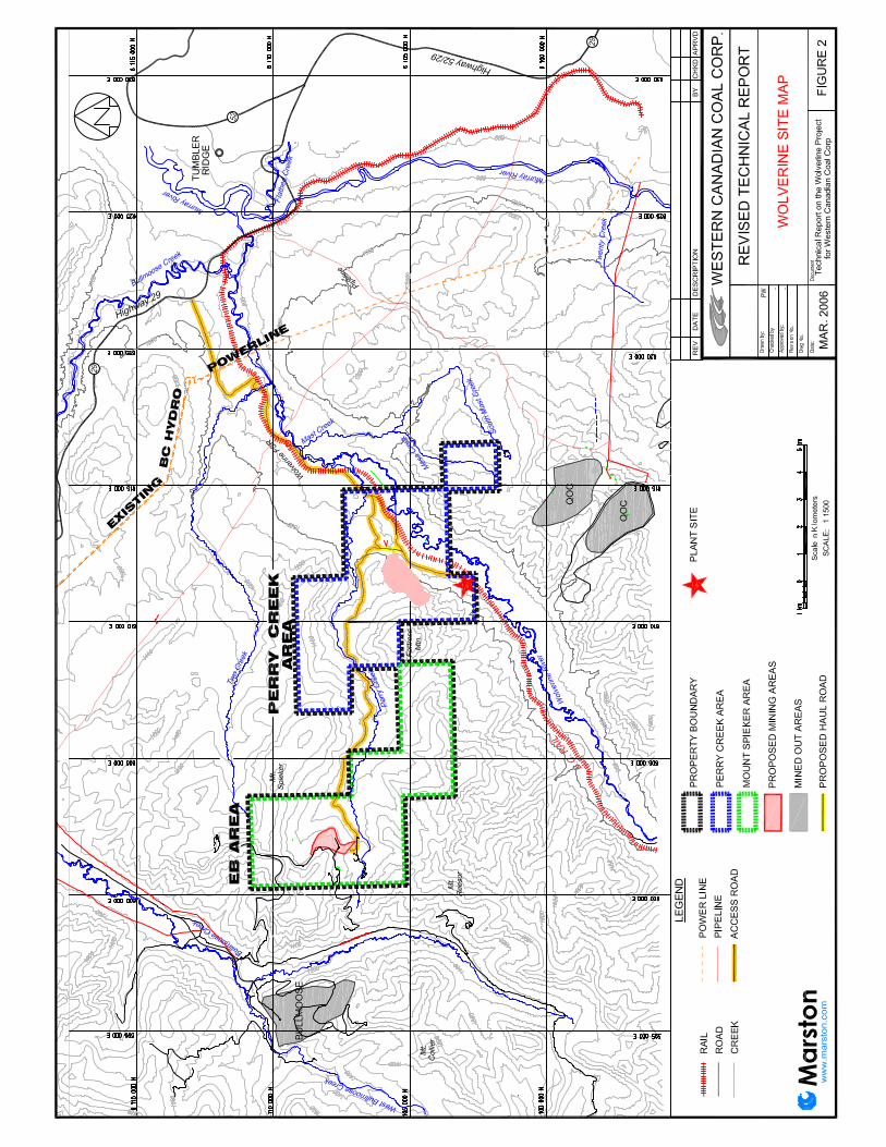


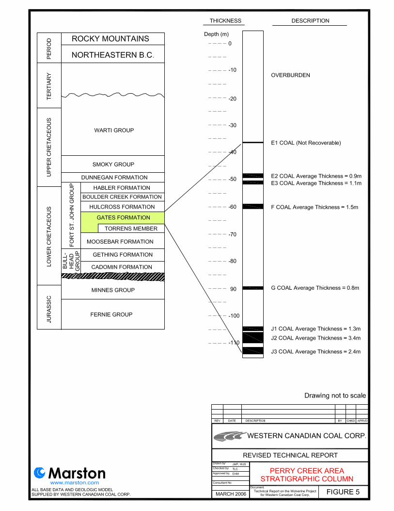
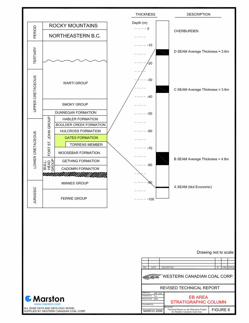

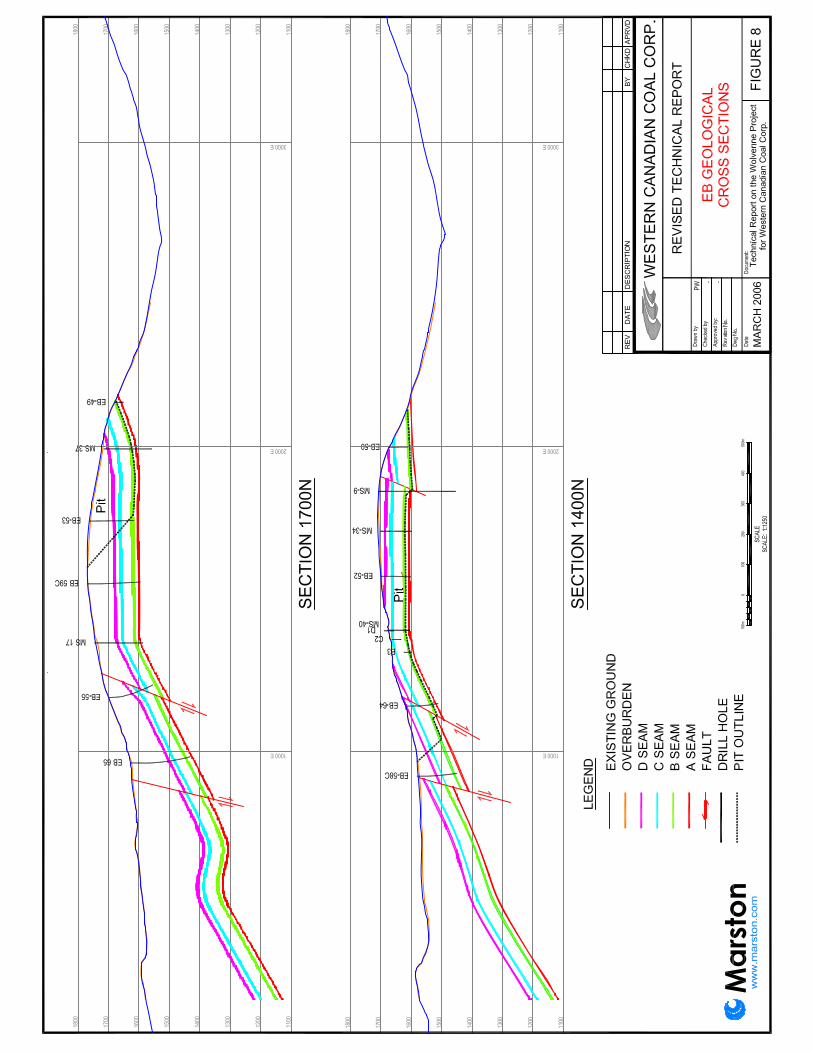


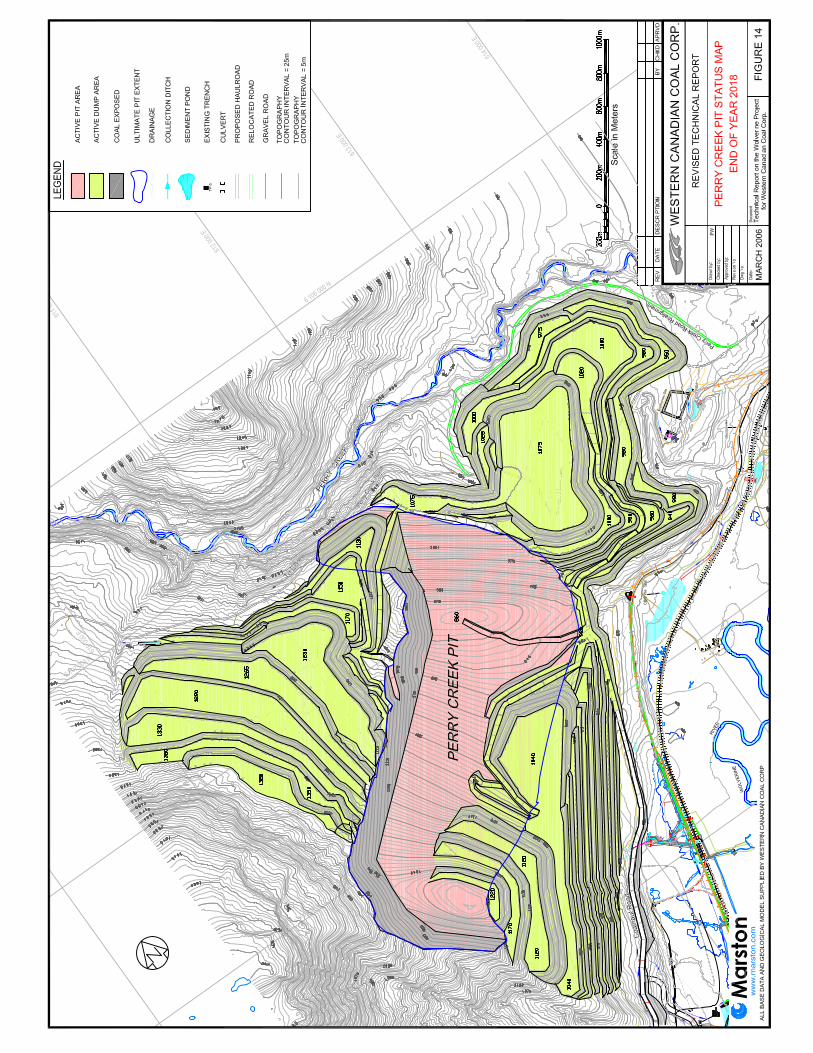

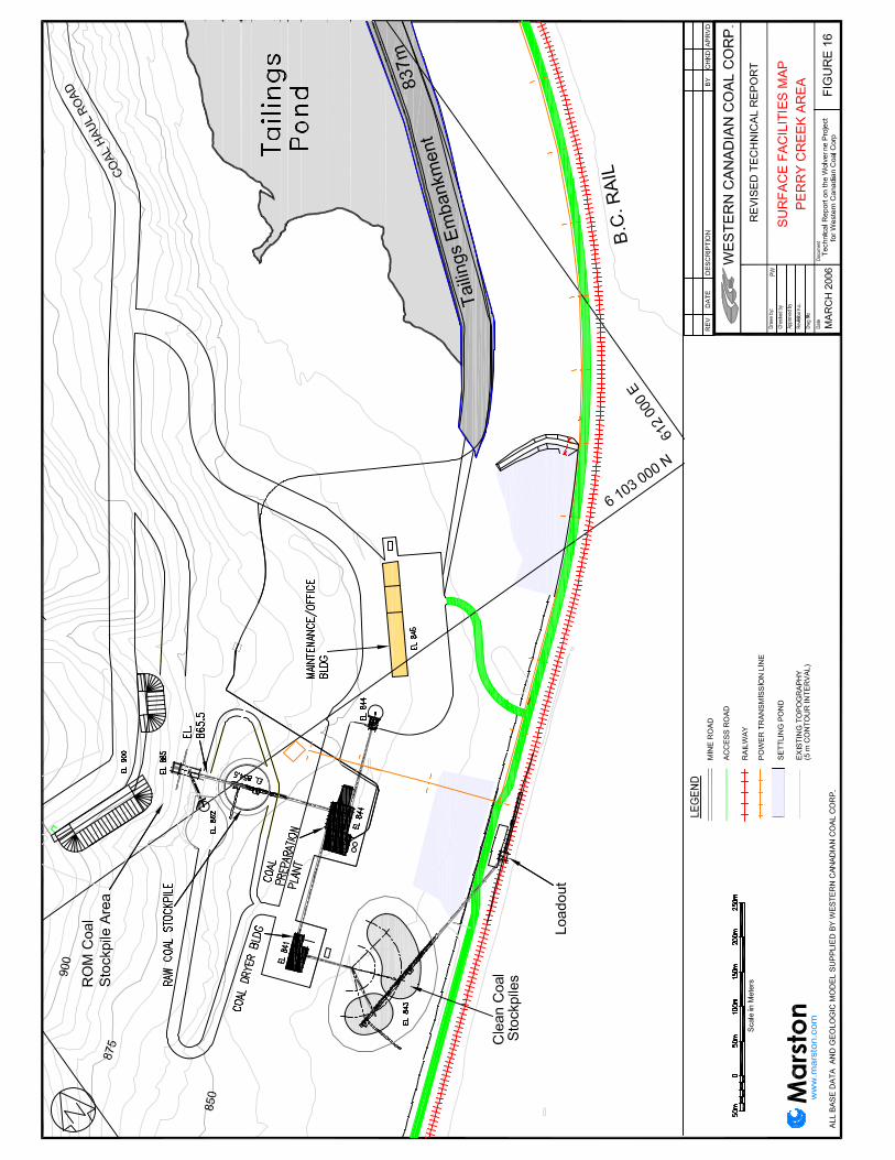


APPENDIX
Certificate of Author
REVISED TECHNICAL REPORT ON THE WOLVERINE PROJECT FOR WESTERN CANADIAN COAL CORP. MARCH 2006
Appendix-1
Richard R. Marston, P.E. President and Principal Consultant
Marston Canada, Ltd. 2723 – 37 Avenue NE Suite 122
Calgary, Alberta, Canada T1Y 5R8 TEL: 403.262.7436 FAX: 403.262.7439
Email: [email protected]
CERTIFICATE of AUTHOR
I, Richard R. Marston, P.E., do hereby certify that:
1. I am President and Principal Consultant of:
Marston Canada, Ltd. 2723 – 37 Avenue NE Suite 122
Calgary, Alberta, Canada T1Y 5R8
2. I graduated with a Bachelor of Applied Science - Mining Engineering, from Queen’s. University, Kingston, Ontario, in 1981. In addition I have a J.D. from Washington University, St. Louis, MO, 1989 and I am a member of the Missouri Bar, admitted 1989.
3. I am licensed as a professional engineer in Missouri, USA and member of the Society of Mining Engineer of A.I.M.E. and of the Canadian Institute of Mining, Metallurgy and Petroleum.
4. I have worked as a mining engineer for a total of 21 years since graduation from Queen’s University.
5. I have read the definition of “qualified person” as defined in National Instrument 43-101 (“NI 43-101”) and certify that by reason of my education, affiliation with a professional association (as defined in NI 43-101) and past relevant work experience, I fulfill the requirements to be a “qualified person” for the purposes of NI 43-101.
6. I am responsible for the preparation of Items 1 through 26 of the technical report entitled Technical Report on the Wolverine Project for Western Canadian Coal Corp. – December 2005 (the Technical Report) relating to the results of the feasibility study of the Wolverine Project for Western Canadian Coal Corp. I visited this Property for a day in June of this year and observed the existing development work and historical drill sites.
7. I have had no prior direct involvement with the Property that is the subject of the Technical Report.
8. I am not aware of any material fact or material change with respect to the subject matter of the Technical Report that is not reflected in the Technical Report, the omission to disclose which makes the Technical Report misleading.
REVISED TECHNICAL REPORT ON THE WOLVERINE PROJECT FOR WESTERN CANADIAN COAL CORP. MARCH 2006
Appendix-2
9. I am independent of the issuer applying all of the tests in section 1.5 of NI 43-101.
10. I have read NI 43-101 and Form 43-101F1, and the Technical Report has been prepared in compliance with that instrument and form.
11. I consent to filing of the Technical Report with any stock exchange and other regulatory authority and any publication by them for regulatory purposes, including electronic publication in the public company files on their websites accessible by the public, of the Technical Report.
Dated this 15th Day of March, 2006.
[Signed by Richard R. Marston, P.E.]__Signature of Qualified Person
_Richard R. Marston, P.E.Print name of Qualified Person