forest park active transportation plan · forest park active transportation plan acknowledgements...
TRANSCRIPT
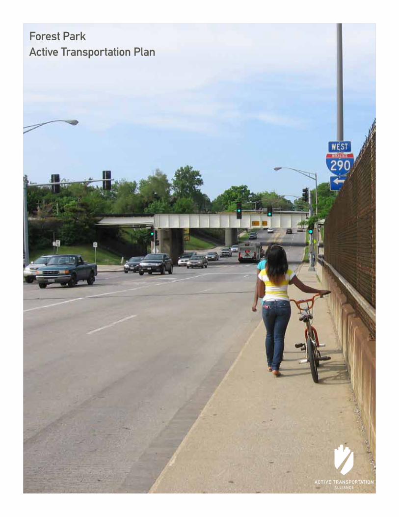
Forest ParkActive Transportation Plan

Forest ParkActive Transportation PlanPresented by Active Transportation Alliance, December 2011
Fore sT PArk Ac Tive Tr AnsPorTATion Pl An
Acknowledgements
About the consultants
The mission of Active Transportation Alliance is to make bicycling, walking, and public transit so safe, convenient, and fun that we will achieve a significant shift from environmentally harmful, sedentary travel to clean, active travel. We advocate for transportation that encourages and promotes safety, physical activity, health, recreation, social interaction, equity, environmental stewardship, and resource conservation.
We are both Chicagoland’s voice for better biking, walking, and transit and a premier consultancy. Our staff includes planning, policy, and education experts who developed many of the best practice programs and policies included in this plan. By partnering with us on this project, you not only get the best plan possible, you also support our mission to improve active transportation throughout the Chicagoland region.
The Active Transportation Alliance Project Team:
Heather Schady - Transportation PlannerPatrick Knapp - GIS PlannerRuth Myers - West Suburban CoordinatorShafaq Choudry - Community PlannerDan Persky - Director of Education & AdvocacyPaul Lippens - Senior Planner
Active Transportation Plan steering committee
This plan represents the combined vision and goals of the steering committee that guided its development as well as residents and other key stakeholders. Thank you to these residents and the members of the steering committee for donating their time to this project.
Anthony Calderone - Mayor, Village of Forest ParkElizabeth Axtell - Forest Park Chamber of CommerceEdward Brophy - Forest Park School District 91JoEllen Charlton - Village of Forest ParkChris Chin - Forest Park Police DepartmentSally Cody - ResidentJohn Doss - Village of Forest ParkKaren Dylewski - Forest Park Community CenterTim Gillian - Village AdministratorDouglas Gotham - Christopher Burke EngineeringMary Flanagan - ResidentChris Harris - CommissionerJohn Hosty - Traffic & Safety CommitteeTJ Janopaulos - Forest Park Fire DepartmentYoung Lee - Forest Park Police DepartmentTom Mannix - Streets & Public Improvement CommissionerJohn McNett - Oak Park Cycle ClubVanessa Moritz - Village of Forest ParkDenise Murray - Live Healthy Forest ParkDrew Peterson - ResidentMelinda Holmes Peterson - MHA JobsMike O'Connor - Village of Forest Park Finance AssistantLetitia Olmsted - Village Clerk's OfficeErin Parchert - Forest Park DistrictJessica Rinks - Forest Park Community GardenGina Thomas - Forest Park Community GardenMichelle Woehrle - Forest Park Community Garden
3e xecuTive summAry
contents
Acknowledgements
executive summary 4
1 introduction 7
1.1 A vision for livability 8
1.2 Goals of the Plan 9
1.3 Planning Process 9
1.4 Timeframe 10
2 Active Transportation network 11 11 2.1 network context 12
2.2 Place connections 14
2.3 Active intersections 19
2.4 Pedestrian improvements 24
2.5 Bicycle improvements 27
2.6 Transit improvements 33
3 Policy and Programming 35
3.1 municipal Policy recommendations 36
3.2 school Policy recommendations 39
3.3 Program recommendations 40
4 implementation 45
4.1 evaluation and oversight 46
4.2 implementation 47
4.3 The Planning Team 50
5 Appendices 51
5.1 Appendix A: Public engagment summary 52
5.2 Appendix B: existing conditions maps 53
5.3 Appendix c: Pedestrian and Bicycle Facilities Guidance 54
5.4 Appendix D: Funding resources 55
5.5 Appendix e: municipal Policy resources 57
5.6 Appendix F: Programming resources 59
Fore sT PArk Ac Tive Tr AnsPorTATion Pl An
executive summary
5e xecuTive summAry
executive summary
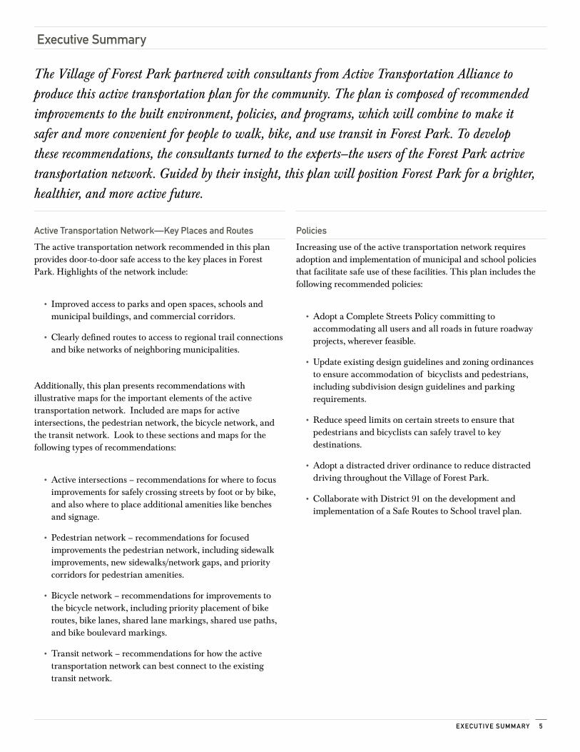
Active Transportation network—key Places and routes
The active transportation network recommended in this plan provides door-to-door safe access to the key places in Forest Park. Highlights of the network include:
• Improved access to parks and open spaces, schools and municipal buildings, and commercial corridors.
• Clearly defined routes to access to regional trail connections and bike networks of neighboring municipalities.
Additionally, this plan presents recommendations with illustrative maps for the important elements of the active transportation network. Included are maps for active intersections, the pedestrian network, the bicycle network, and the transit network. Look to these sections and maps for the following types of recommendations:
• Active intersections – recommendations for where to focus improvements for safely crossing streets by foot or by bike, and also where to place additional amenities like benches and signage.
• Pedestrian network – recommendations for focused improvements the pedestrian network, including sidewalk improvements, new sidewalks/network gaps, and priority corridors for pedestrian amenities.
• Bicycle network – recommendations for improvements to the bicycle network, including priority placement of bike routes, bike lanes, shared lane markings, shared use paths, and bike boulevard markings.
• Transit network – recommendations for how the active transportation network can best connect to the existing transit network.
Policies
Increasing use of the active transportation network requires adoption and implementation of municipal and school policies that facilitate safe use of these facilities. This plan includes the following recommended policies:
• Adopt a Complete Streets Policy committing to accommodating all users and all roads in future roadway projects, wherever feasible.
• Update existing design guidelines and zoning ordinances to ensure accommodation of bicyclists and pedestrians, including subdivision design guidelines and parking requirements.
• Reduce speed limits on certain streets to ensure that pedestrians and bicyclists can safely travel to key destinations.
• Adopt a distracted driver ordinance to reduce distracted driving throughout the Village of Forest Park.
• Collaborate with District 91 on the development and implementation of a Safe Routes to School travel plan.
The Village of Forest Park partnered with consultants from Active Transportation Alliance to produce this active transportation plan for the community. The plan is composed of recommended improvements to the built environment, policies, and programs, which will combine to make it safer and more convenient for people to walk, bike, and use transit in Forest Park. To develop these recommendations, the consultants turned to the experts—the users of the Forest Park actrive transportation network. Guided by their insight, this plan will position Forest Park for a brighter, healthier, and more active future.
Fore sT PArk Ac Tive Tr AnsPorTATion Pl An6
Programs
The plan provides guidance on the development of nationally recognized programs for education, encouragement, enforcement, and evaluation. These programs include:
• Community Education: Educate pedestrians and cyclists of all ages through a variety of methods, including:
• Bike/Ped Ambassador Program
• Bike maintenance and skills classes for youth and adults
• Community media campaigns
• Encouragement: Raise awareness of Forest Park’s new bike network and encourage active transportation use throughout the Village by:
• Creating and distributing maps that highlight Village destinations accessible by bike and foot
• Incorporating walking and biking into existing community events
• Promoting existing walking and biking groups
• Creating new events, such as a Bike and Dine, Shop by Foot and Bike, and Open Streets
• Enforcement: Emphasize the presence and vulnerability of pedestrians and bicyclists to boost awareness and create a safer environment:
• Continuing to hold targeted crosswalk enforcement events and publicizing pedestrian traffic laws before the event and results of the event after it happens
• School Zone Speeding Campaign
• Analyzing crash data as a basis for targeted enforcement campaigns
executive summary (continued)
implementation
The planning process does not end with the adoption of this plan. It will require years of implementation and the dedication of key stakeholders. In order to facilitate effective implementation, this plan includes:
• A comprehensive timeline for implementation
• Appendices listing resources for funding and implementing recommendations made in this plan
• Model policies and data used in the development of this plan are also included to facilitate effective implementaiton

introduction1.1 A vision for livability 8
1.2 Goals of the Plan 9
1.3 Planning Process 9
1.4 Timeframe 10
1
Fore sT PArk Ac Tive Tr AnsPorTATion Pl An8
The Village of Forest Park prides itself as an exceptional place to live, work, and do business. Grounded in a close-knit and active community, quality education, first-class dining, a large Park District, independently owned businesses, and service-oriented government. Forest Parks is located approximately 10 miles west of Chicago’s downtown creating an ideal urban and small town environment. The Village is more than 100 years old and has won several awards for revitalizing its Main Street which also serves as the main business district.
Situated along the Blue and Green CTA Lines, Forest Park is nestled in several pocket parks accompanied by the centrally located Harrison Park and Aquatic Center. The Village is within a few street and trail connections of incorporating LaHood’s livability standard as well.
This plan will help guide Forest Park across that “last mile” to 21st century livability standards—place-based economic development, active lifestyle options, and sensible environmental stewardship—just as much as it guides the community across last mile connections to the Illinois Prairie Path, Madison Street businesses and other key destinations identified by the public. Indeed, closing one gap helps to cross other.
The vision for Forest Park:
The Village of Forest Park will be a vibrant and healthy community with a safe, well lit, and complete bicycle and pedestrian network that links to schools, parks, and businesses. Walking and biking will be a viable means of transportation and a fun activity for people of all ages. People will be able to walk or bike to Madison Street Businesses, the Illinois Prairie Path, and conveniently access the Blue and Green Line Station transit service along Des Plaines Avenue and Harlem Avenue. The Village will utilize connections along the forest preserve trails and roadways to foster travel between neighboring communities like Oak Park, River Forest, and even the City of Chicago.
“Livability means being able to take your kids to school, go to work, see a doctor, drop by the grocery or post office, go out to dinner and a movie, and play with your kids at the park—all without having to get in your car.”
—Secretary Ray LaHood, US Department of Transportation
1.1 A vision for livability
This vision will help create a culture change that leads to more bicycling and walking, characterized by fun events like Bike and Dine, Shop by Bike, and Bike to Work. Bicycling and walking activities can bring neighborhoods and families together for fun and health. Achieving the vision for Forest Park will require a concerted effort to educate community members on walking and biking safety. Education and awareness will support infrastructure improvements such as bikeways, sidewalks, enhanced crosswalks, and bike parking, to allow the community to access any location by foot or bike and connect people to places.
9inTroDuc Tion
The Village of Forest Park Active Transportation Plan provides practical recommendations to support livability. These recommendations will help focus transportation investments on the places that matter to the community. The plan also communicates the Village of Forest Park priorities to regional and state transportation entities like the Illinois Department of Transportation (IDOT), Metra, Pace, and the Cook County Highways Department (CCHD).
The following goals guided the development of this plan:
Health and Safety
Build a walking, biking, and transit network that is accessible and safe for all ages and abilities to encourage a healthy and active lifestyle.
Active Transportation Infrastructure
Provide a comprehensive transportation network that prioritizes biking, walking, and transit use. Emphasize the creation of dedicated routes and amenities to foster active transportation.
Green Connections
Provide a comprehensive network that connects residents to parks, open space, and regional trails.
Economic Development
Encourage residents to shop at local businesses by improving biking, walking and transit accessibility at important places in the community.
People Connections
Support biking and walking in the community through education and encouragement programs for residents.
Institutional Connections
Adopt policies that encourage agency collaboration between schools, parks, the Village, and the private sector to make it safer and easier for residents to enjoy the active transportation network.
Forest Park residents were invited to a public open house on June 28, 2011, at the Howard Mohr Community Center. There, residents and stakeholders identified the network and laid the foundation for the recommendations in this plan. They have grounded this plan in the places important to them, connected by their preferred routes.
Members of the public unable to attend the open house were invited to fill out an online survey. More than 70 surveys were completed. Additional surveys were distributed to Forest Park’s senior community and business community.
A steering committee of stakeholders appointed by the Village of Forest Park guided the work of the consultants as they fashioned public input, field research, and data analysis into a prioritized list of infrastructure, policy, and program recommendations. The consultants appreciate their time, their insight, their unique and informative perspectives, and their patience with the planning process.
1.2 Goals of the Plan 1.3 Planning Process
open house par-ticipants work on their group’s recommenda-tions for the plan.
residents weigh in on walking and biking preferences at a com-munity open house event.
Fore sT PArk Ac Tive Tr AnsPorTATion Pl An10
Recommendations in this plan are divided into three categories: near-term, mid-term, and long-term. These categories should help the village coordinate these efforts with staffing plans and work plans.
1.4.1 near-term Priorities
network:
Near-term network recommendations are generally corridors and intersections that are currently walkable and bikeable but may be aided by some low-cost improvements, such as network signage or crossing improvements.
Policy and Programming:
Near-term projects should be completed in less than two years. These projects involve little to no start-up costs or long-term organization. Many education and encouragement initiatives are proposed for near-term implementation to build support for later projects. mid-term priorities
1.4.2 mid-term Priorities
network:
Mid-term network recommendations are corridors and intersections where current conditions could be easily improved—with a moderate construction budget—to become more walkable and bikeable. Examples include corridors with low average daily traffic (ADT) and ample width to add bike lanes or shared lane markings, and intersections that are currently signalized but could be improved by curb extensions, transit shelters, local sidewalk completion, and network amenities, such as benches and identity features.
Policy and Programming:
Although mid-term means completion is expected in three to five years, some projects require preliminary work in the near term. These projects may have initial start-up costs and coordination with community organizations. Mid-term projects generally involve more planning. 1
1.4.3 long-term Priorities.4.3 long-term priorities
network:
Long-term network recommendations are often complicated by jurisdictional issues or the balancing of regional network priorities. These recommendations may have other feasibility issues, such as high ADT or restricted road width or right-of-way.
Policy and Programming:
These projects, expected to begin implementation after five years, frequently depend on the completion of earlier projects and local support.
The Implementation section of this plan showcases a complete list of recommendations and suggested timing.
1.4.4 opportunistic implementation network:
While this plan offers a guide to prioritizing these recommendations as near-, mid-, or long-term priorities, the Village should actively seek out opportunities to coordinate implementation with private development and public projects. Private development can often trigger the need to improve the corridor frontage areas, and state and county construction and maintenance priorities can overlap with this plan’s recommendations. Implementing agencies should remain aware of these kinds of opportunities and seek to coordinate the implementation of this plan with parallel county and regional efforts. (See the appendices for funding and programmatic resources.)
1.4 Timeframe
Active Transportation network
2
2.1 network context 12
2.2 Place connections 14
2.3 Active intersections 19
2.4 Pedestrian improvements 24
2.5 Bicycle improvements 27
2.6 Transit improvements 33
Fore sT PArk Ac Tive Tr AnsPorTATion Pl An12
2..1.1 The network Defined
The Forest Park active transportation network is designed to facilitate safe, convenient, and fun biking and walking trips from homes to local destinations. From older adults choosing to age in place to youth seeking independence, and everyone in between, a complete active transportation network is designed to accommodate the many residents of Forest Park.
The consultants performed the necessary fieldwork, data gathering, and analysis with community stakeholders and Village staff guiding the work; however, the foundation for the network and its recommendations was developed by Forest Park biking and walking experts: the residents themselves. These recommendations provide a preliminary framework for the Village of Forest Park to make active transportation a viable choice for many daily trips.
The Village of Forest Park will implement many of these recommendations at the local level. Some, however, will require coordination with the Cook County Highway Department (CCHD) and the Illinois Department of Transportation (IDOT), as well as with neighboring municipalities. For these projects, the plan communicates the priorities of the Village and its residents to those agencies and the region.
2.1 network context
This section provides a full network map for all the recommendations. The following sections break down the network into five components:
1 Place Connections
2 Active Intersections
3 Pedestrian Improvements
4 Bicycle Improvements
5 Transit Improvements
13Ac Tive Tr AnsPorTATion ne T work
" Ã" Ã
" Ã
" Ã" Ã
" Ã" Ã
" Ã
" Ã
"c
n
n
n
n
nn
nn
"" "; "L
§̈ ¦I-29
0
Riv
er F
ores
t
May
woo
d
Nor
th R
iver
side
Oak Park Berwyn
HARLEM AVE
W 2
2ND
ST
DES PLAINES AVE
RO
OS
EVEL
T R
D
S 1ST AVE
RA
ND
OLP
H S
T
CIRCLE AVE
MA
DIS
ON
ST
AD
AM
S ST
HANNAH AVE
HA
RVA
RD
ST
DIX
ON
ST
JACK
SON
BLV
D
FILL
MO
RE
STHA
RR
ISO
N S
T
THOMAS AVE
DUNLOP AVELE
HM
ER S
T
FRA
NK
LIN
ST
LATHROP AVE
GR
EEN
SBU
RG
RD
IND
UST
RIA
L D
R
LEXI
NG
TON
ST
16TH
ST
14TH
ST
MARENGO AVE 15TH
ST
BELOIT AVE
TROOST AVE
VAN BUREN ST
BROW
N AVE
ELGIN AVE
13TH
ST
MO
NR
OE
ST
ROCKFORD AVE WA
SH
ING
TON
ST
WA
RR
EN S
T
MARENGO AVE
ELGIN AVE
HANNAH AVE
MARENGO AVE
THOMAS AVE
LATHROP AVE
HANNAH AVE
ELGIN AVE
Bic
ycle
& P
edes
tria
n N
etw
ork
Bic
ycle
Way
Pede
stri
an W
ay
Bic
ycle
& P
edes
tria
n W
ay
Futu
re M
ultiu
se T
rail
Exis
ting
Trai
l
Infr
astr
uctu
re
Hig
hway
Ram
p
Art
eria
l
Colle
ctor
Stre
et
Rai
lroa
d
'L' L
ine
Poin
ts o
f Int
eres
t
";Fo
rest
Par
k Ci
ty H
all
"LPo
lice
Stat
ion
" "Po
st O
ffice
" cLi
brar
y
" Ã'L
' Sta
tion
nSc
hool
Land
use W
ater
Park
Prep
ared
By:
Act
ive
Tran
spor
tatio
n A
llian
ce 1
1/10
/201
1D
ata
Sour
ce: A
ctiv
e Tr
ansp
orta
tion
Alli
ance
, Vill
age
of F
ores
t Par
k &
Nav
teq
00.
250.
50.
751 M
ile
-For
est P
ark-
Entir
e N
etw
ork
2.1.2 Full network map
2.1 network context
Fore sT PArk Ac Tive Tr AnsPorTATion Pl An14
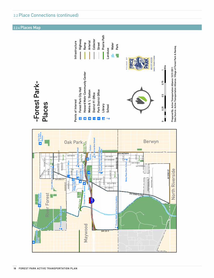
First-rate places to eat, learn, shop, and recreate anchor Forest Park’s high quality of life. The active transportation network and recommendations will help residents reach their favorite parks, trails, restaurants, shops, friends, schools, and jobs from their doorstep, without a car. Putting places first in the consideration of biking, walking, and transit improvements will help integrate sustainable, efficient, healthy living into community life.
The places outlined in this section of the plan are destinations and corridors within the Village of Forest Park that stakeholders identified as the most important to consider in the development of the active transportation network.
2.2.1 Parks and open spaces, schools, and municipalBuildings
oBjecTive: Build a network that encourages walking, biking, and transit trips to and from Forest Park’s open spaces and parks, schools, municipal buildings, and transit stations by installing route signage, improving crossings and intersections, and adding amenities.
DescriPTion: While Forest Park is the main recreational hub, the Village of Forest Park has a variety of parks and open spaces designed to bring community members of all ages together to play, socialize, and be physically active. The following parks and open spaces were prioritized by residents and the steering committee:
• Forest Park
• The Grove
• Community Garden
• Pocket Parks
Schools were another priority destination identified by stakeholders who participated in the development of this plan. In the fall of 2011, the Village of Forest Park and Forest Park School District 91 will partner to create a school travel plan that identifies engineering, education, encouragement, and enforcement priorities to improve conditions for student pedestrians and cyclists for all K-8 public schools. For specific recommendations, refer to the School Travel Plan. The active transportation plan does not provide recommendations for specific schools; rather, it offers basic recommendations that can be applied universally to the following schools:
• Betsy Ross Elementary School
• Field Stevenson Elementary School
• Grant White Elementary School
• Garfield Elementary School
• Forest Park Middle School
• Proviso East High School
• St. Bernadine School
• St. John's School
The following municipal buildings are key place connections addressed in this plan:
• Forest Park Village Hall
• Forest Park Public Library
• Howard Mohr Community Center
• Forest Park School District 91 Office
• Park District Building
The recommendations made in this plan help to improve connections for active transportation users to the Village’s parks and open spaces and other key destinations. The following best practices can be implemented to facilitate safer, more convenient access to Forest Park’s destinations:
Target: Near-term
Sign routes: Use directional signage to create awareness for recommended routes to parks and open spaces. Best practices for bicycle wayfinding signs are included in the 2009 Manual for Uniform Traffic Control Devices (MUTCD). Directional signage should include distance, direction, and destinations.
Target: Mid-term
Install bike parking: Install bike parking at all destinations to improve access for cyclists. At schools and municipal buildings, install bike parking in highly visible locations near building entrances. At larger parks and open spaces, such as Forest Park, racks should be scattered to accommodate each activity area. Use wave-shaped bike racks for more security and durability. Wherever possible, racks should be installed on concrete pads.
2.2 Place connections
15Ac Tive Tr AnsPorTATion ne T work
Improve crossings: In the near-term, stripe crosswalks at all entrances to parks and open spaces to create safer access for pedestrians. In the long-term, use stamped concrete crosswalks for increased visibility and beautification. Use crosswalks on Madison and Jackson as a model.
2.2.2 corridors
oBjecTive: Create a network that addresses the key barriers to active transportation in Forest Park by increasing connectivity and accessibility for cyclists, pedestrians, and transit users, regardless of their age or ability.
DescriPTion: The active transportation network includes significant arterial connections to ensure that residents of Forest Park are able to safely and conveniently travel to and from community destinations. The north and south sides of Forest Park are divided by the I-290 corridor. Only three north/south connections are available to any road user - Circle Avenue, Des Plaines Avenue, and Harlem Avenue - and all present major challenges for pedestrians, cyclists, and transit users due to difficult crossings, bridge overpasses, and narrow sidewalks. The Illinois Department of Transportation (IDOT) is in the early stages of a planning process to update the I-290 corridor, which may be an opportunity for local leaders to coordinate with IDOT to implement the recommendations offered in this plan. This plan addresses several options that may be available for improving connections on the Circle Avenue bridge. This plan also includes recommendations for the Village’s two main east-west connectors, Roosevelt Road and Madison Street.
Circle Avenue: Circle Avenue is recommended as the primary north-south bicycle and pedestrian connection in the Village to key destinations including: Madison Street shopping district, Station Park, Harlem Blue Line Station, Harlem Green Line Station, and Forest Park Middle School. Barriers to active transportation on Circle Avenue include:
• Intersections at Harrison, Lehmer, and Franklin/Belvidere
• Narrow sidewalks on the Circle Avenue bridge
• Lack of bike facilities on the Circle Avenue bridge
2.2 Place connections (continued)
stamped concrete crosswalks such as this one on Des Plaines Av-
enue in Forest Park serve the dual purpose of increasing visibility
of pedestrian crossings and beautifying streets.
Garfield elementary school is one of the many important destina-
tions for the community of Forest Park.
Fore sT PArk Ac Tive Tr AnsPorTATion Pl An16
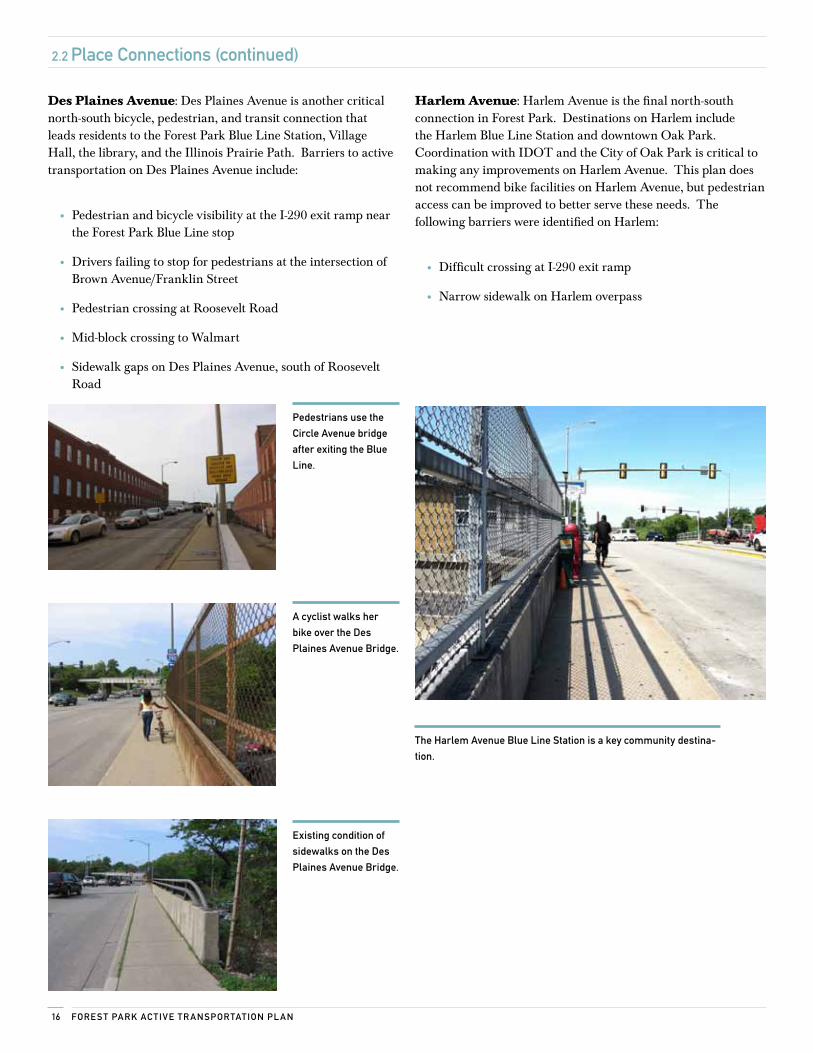
Des Plaines Avenue: Des Plaines Avenue is another critical north-south bicycle, pedestrian, and transit connection that leads residents to the Forest Park Blue Line Station, Village Hall, the library, and the Illinois Prairie Path. Barriers to active transportation on Des Plaines Avenue include:
• Pedestrian and bicycle visibility at the I-290 exit ramp near the Forest Park Blue Line stop
• Drivers failing to stop for pedestrians at the intersection of Brown Avenue/Franklin Street
• Pedestrian crossing at Roosevelt Road
• Mid-block crossing to Walmart
• Sidewalk gaps on Des Plaines Avenue, south of Roosevelt Road
2.2 Place connections (continued)
Pedestrians use the
circle Avenue bridge
after exiting the Blue
line.
A cyclist walks her
bike over the Des
Plaines Avenue Bridge.
existing condition of
sidewalks on the Des
Plaines Avenue Bridge.
Harlem Avenue: Harlem Avenue is the final north-south connection in Forest Park. Destinations on Harlem include the Harlem Blue Line Station and downtown Oak Park. Coordination with IDOT and the City of Oak Park is critical to making any improvements on Harlem Avenue. This plan does not recommend bike facilities on Harlem Avenue, but pedestrian access can be improved to better serve these needs. The following barriers were identified on Harlem:
• Difficult crossing at I-290 exit ramp
• Narrow sidewalk on Harlem overpass
The Harlem Avenue Blue line station is a key community destina-
tion.
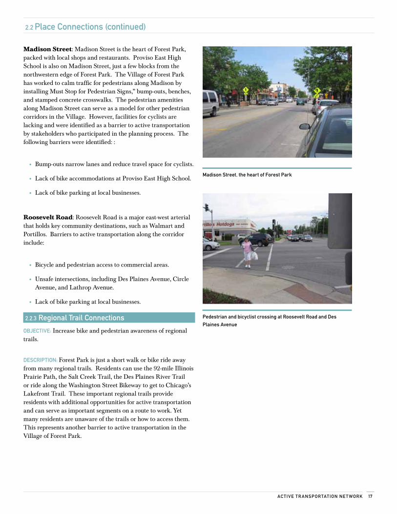
17Ac Tive Tr AnsPorTATion ne T work
2.2 Place connections (continued)
madison street, the heart of Forest Park
Pedestrian and bicyclist crossing at roosevelt road and Des
Plaines Avenue
Madison Street: Madison Street is the heart of Forest Park, packed with local shops and restaurants. Proviso East High School is also on Madison Street, just a few blocks from the northwestern edge of Forest Park. The Village of Forest Park has worked to calm traffic for pedestrians along Madison by installing Must Stop for Pedestrian Signs,” bump-outs, benches, and stamped concrete crosswalks. The pedestrian amenities along Madison Street can serve as a model for other pedestrian corridors in the Village. However, facilities for cyclists are lacking and were identified as a barrier to active transportation by stakeholders who participated in the planning process. The following barriers were identified: :
• Bump-outs narrow lanes and reduce travel space for cyclists.
• Lack of bike accommodations at Proviso East High School.
• Lack of bike parking at local businesses.
Roosevelt Road: Roosevelt Road is a major east-west arterial that holds key community destinations, such as Walmart and Portillos. Barriers to active transportation along the corridor include:
• Bicycle and pedestrian access to commercial areas.
• Unsafe intersections, including Des Plaines Avenue, Circle Avenue, and Lathrop Avenue.
• Lack of bike parking at local businesses.
2.2.3 regional Trail connections
oBjecTive: Increase bike and pedestrian awareness of regional trails.
DescriPTion: Forest Park is just a short walk or bike ride away from many regional trails. Residents can use the 92-mile Illinois Prairie Path, the Salt Creek Trail, the Des Plaines River Trail or ride along the Washington Street Bikeway to get to Chicago’s Lakefront Trail. These important regional trails provide residents with additional opportunities for active transportation and can serve as important segments on a route to work. Yet many residents are unaware of the trails or how to access them. This represents another barrier to active transportation in the Village of Forest Park.
Fore sT PArk Ac Tive Tr AnsPorTATion Pl An18
"" Á"" Á
"" Á
"" Á
"" Á
"" Á
"" Á
"" Á"" Á
"" Á
"" Á
"c
n
n
n
n
nn
nn
"̂
";
"" Ï
"n
§̈ ¦I-29
0
Fiel
d St
even
son
Elem
Sch
ool
Fore
st P
ark
Mid
dle
Scho
ol
Gra
nt-W
hite
Ele
m S
choo
l
Bet
sy R
oss
Elem
Sch
ool
St B
erna
rdin
e Sc
hool
Gar
field
Ele
m S
choo
l
Tot-
Lot
Tot-
Lot
Fore
st P
ark
Gar
den
Plo
ts
Dog
Par
kTo
t-Lo
t
Tot-
Lot
Tot-
Lot
The
Gro
ve
Fore
st P
ark
Fore
st P
ark
'L' S
tatio
n
Har
lem
'L' S
tatio
n
Har
lem
/Oak
Par
kTr
ain
Stat
ion
Prai
rie
Path
How
ard
Moh
rCo
mm
unity
Cen
ter
Libr
ary
Fore
st P
ark
Villa
ge H
all
Park
Dis
tric
t Offi
ce
Dis
tric
t 91
Offi
ce
Prov
iso
Mat
h an
d Sc
ienc
e A
cade
my
Prov
iso
East
Hig
h Sc
hool
Oak
Par
k'L
' & M
etra
Stat
ion
Riv
er F
ores
tM
etra
Sta
tion
May
woo
d M
etra
Stat
ion
Riv
er F
ores
t
May
woo
d
Nor
th R
iver
side
Oak Park Berwyn
HARLEM AVE
W 2
2ND
ST
DES PLAINES AVE
RO
OS
EVEL
T R
D
S 1ST AVE
CIRCLE AVE
MA
DIS
ON
ST
AD
AM
S ST
HANNAH AVE
HA
RVA
RD
ST
DIX
ON
ST
FILL
MO
RE
ST
DUNLOP AVE
FRA
NK
LIN
ST
LATHROP AVE
GR
EEN
SBU
RG
RD
IND
UST
RIA
L D
R
16TH
ST
14TH
ST
MARENGO AVE 15TH
ST
TROOST AVE
BROW
N AVE
ELGIN AVE13
TH S
T
MO
NR
OE
ST
POLK
ST
WA
SH
ING
TON
ST
WA
RR
EN S
T
HANNAH AVE
ELGIN AVEELGIN AVE
LATHROP AVE
WA
SH
ING
TON
ST
Poi
nts
of In
tere
st
";Fo
rest
Par
k Ci
ty H
all
"̂H
owar
d M
ohr
Com
mun
ity C
ente
r
"" ÁM
etra
& 'L
' Sta
tion
"nD
istr
ict 9
1 O
ffice
"" ÏPa
rk D
istr
ict O
ffice
" cLi
brar
y
nSc
hool
Infr
astr
uctu
re
Hig
hway
Ram
p
Art
eria
l
Colle
ctor
Stre
et
Prai
rie
Path
Land
use W
ater
Park
Prep
ared
By:
Act
ive
Tran
spor
tatio
n A
llian
ce 1
0/31
/201
1D
ata
Sour
ce: A
ctiv
e Tr
ansp
orta
tion
Alli
ance
, Vill
age
of F
ores
t Par
k &
Nav
teq
00.
250.
50.
751 M
ile
-For
est P
ark-
Plac
es
2.2 Place connections (continued)
2.2.4 Places map
19Ac Tive Tr AnsPorTATion ne T work
2.3 Active intersections
2.3.1 crossing improvements
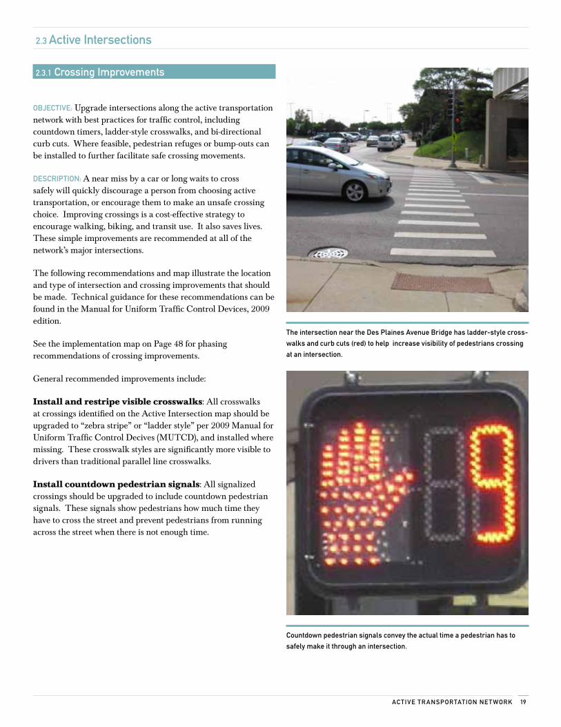
oBjecTive: Upgrade intersections along the active transportation network with best practices for traffic control, including countdown timers, ladder-style crosswalks, and bi-directional curb cuts. Where feasible, pedestrian refuges or bump-outs can be installed to further facilitate safe crossing movements.
DescriPTion: A near miss by a car or long waits to cross safely will quickly discourage a person from choosing active transportation, or encourage them to make an unsafe crossing choice. Improving crossings is a cost-effective strategy to encourage walking, biking, and transit use. It also saves lives. These simple improvements are recommended at all of the network’s major intersections.
The following recommendations and map illustrate the location and type of intersection and crossing improvements that should be made. Technical guidance for these recommendations can be found in the Manual for Uniform Traffic Control Devices, 2009 edition.
See the implementation map on Page 48 for phasing recommendations of crossing improvements.
General recommended improvements include:
Install and restripe visible crosswalks: All crosswalks at crossings identified on the Active Intersection map should be upgraded to “zebra stripe” or “ladder style” per 2009 Manual for Uniform Traffic Control Decives (MUTCD), and installed where missing. These crosswalk styles are significantly more visible to drivers than traditional parallel line crosswalks.
Install countdown pedestrian signals: All signalized crossings should be upgraded to include countdown pedestrian signals. These signals show pedestrians how much time they have to cross the street and prevent pedestrians from running across the street when there is not enough time.
countdown pedestrian signals convey the actual time a pedestrian has to
safely make it through an intersection.
The intersection near the Des Plaines Avenue Bridge has ladder-style cross-
walks and curb cuts (red) to help increase visibility of pedestrians crossing
at an intersection.
Fore sT PArk Ac Tive Tr AnsPorTATion Pl An20
2.3 Active intersections (continued)
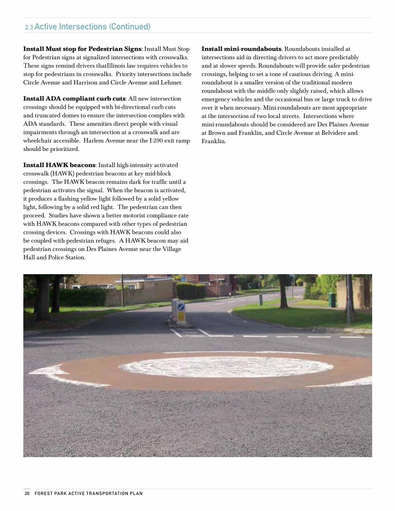
Install Must stop for Pedestrian Signs: Install Must Stop for Pedestrian signs at signalized intersections with crosswalks. These signs remind drivers thatIllinois law requires vehicles to stop for pedestrians in crosswalks. Priority intersections include Circle Avenue and Harrison and Circle Avenue and Lehmer.
Install ADA compliant curb cuts: All new intersection crossings should be equipped with bi-directional curb cuts and truncated domes to ensure the intersection complies with ADA standards. These amenities direct people with visual impairments through an intersection at a crosswalk and are wheelchair accessible. Harlem Avenue near the I-290 exit ramp should be prioritized.
Install HAWK beacons: Install high-intensity activated crosswalk (HAWK) pedestrian beacons at key mid-block crossings. The HAWK beacon remains dark for traffic until a pedestrian activates the signal. When the beacon is activated, it produces a flashing yellow light followed by a solid yellow light, following by a solid red light. The pedestrian can then proceed. Studies have shown a better motorist compliance rate with HAWK beacons compared with other types of pedestrian crossing devices. Crossings with HAWK beacons could also be coupled with pedestrian refuges. A HAWK beacon may aid pedestrian crossings on Des Plaines Avenue near the Village Hall and Police Station.
Install mini-roundabouts. Roundabouts installed at intersections aid in directing drivers to act more predictably and at slower speeds. Roundabouts will provide safer pedestrian crossings, helping to set a tone of cautious driving. A mini-roundabout is a smaller version of the traditional modern roundabout with the middle only slightly raised, which allows emergency vehicles and the occasional bus or large truck to drive over it when necessary. Mini-roundabouts are most appropriate at the intersection of two local streets. Intersections where mini-roundabouts should be considered are Des Plaines Avenue at Brown and Franklin, and Circle Avenue at Belvidere and Franklin.
21Ac Tive Tr AnsPorTATion ne T work
2.3 Active intersections (continued)
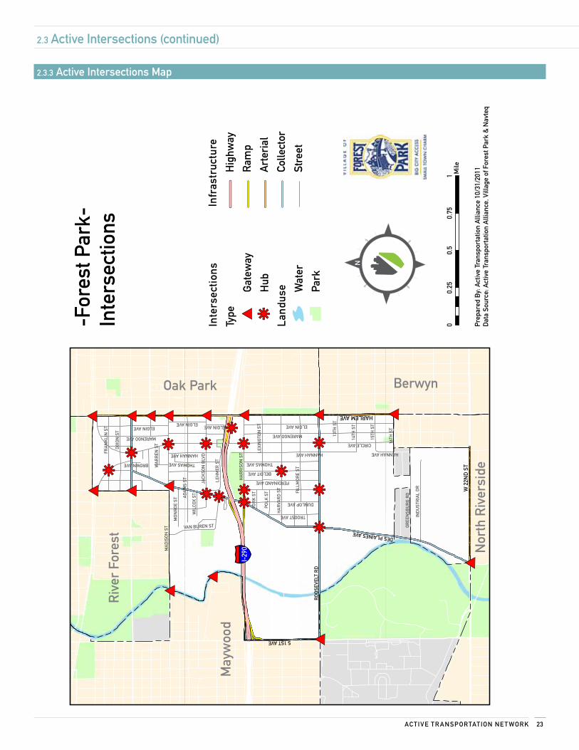
2.3.2 network connection PointsoBjecTive: Define key intersections as gateways to Forest Park or as central hubs of activity to help users connect between modes of transportation (such as from cycling to transit), and to guide this plan’s implementation.
DescriPTion: This plan recommends that gateway and hub intersections be developed as key network connection points. These intersections should be considered when evaluating proposals for transportation improvements and are an opportunity to tie transportation decisions to the surrounding land uses. Gateways and hubs are opportunities to implement traffic-calming measures, start or end on-street bike facilities, and change the posted speed or lane configuration. These intersections should be considered within the scope of redevelopment projects or corridor studies.
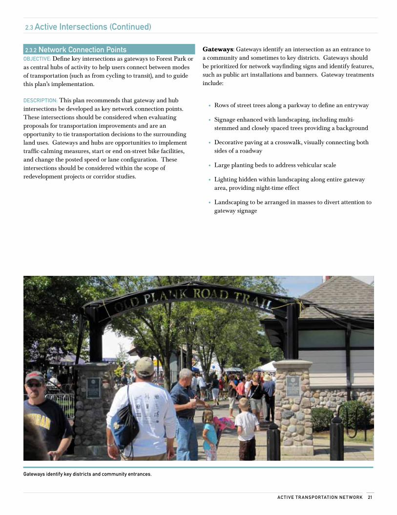
Gateways: Gateways identify an intersection as an entrance to a community and sometimes to key districts. Gateways should be prioritized for network wayfinding signs and identify features, such as public art installations and banners. Gateway treatments include:
• Rows of street trees along a parkway to define an entryway
• Signage enhanced with landscaping, including multi-stemmed and closely spaced trees providing a background
• Decorative paving at a crosswalk, visually connecting both sides of a roadway
• Large planting beds to address vehicular scale
• Lighting hidden within landscaping along entire gateway area, providing night-time effect
• Landscaping to be arranged in masses to divert attention to gateway signage
Gateways identify key districts and community entrances.
Fore sT PArk Ac Tive Tr AnsPorTATion Pl An22
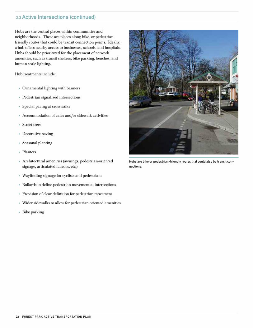
Hubs are the central places within communities and neighborhoods. These are places along bike- or pedestrian-friendly routes that could be transit connection points. Ideally, a hub offers nearby access to businesses, schools, and hospitals. Hubs should be prioritized for the placement of network amenities, such as transit shelters, bike parking, benches, and human-scale lighting.
Hub treatments include:
• Ornamental lighting with banners
• Pedestrian signalized intersections
• Special paving at crosswalks
• Accommodation of cafes and/or sidewalk activities
• Street trees
• Decorative paving
• Seasonal planting
• Planters
• Architectural amenities (awnings, pedestrian-oriented signage, articulated facades, etc.)
• Wayfinding signage for cyclists and pedestrians
• Bollards to define pedestrian movement at intersections
• Provision of clear definition for pedestrian movement
• Wider sidewalks to allow for pedestrian oriented amenities
• Bike parking
Hubs are bike or pedestrian-friendly routes that could also be transit con-
nections.
2.3 Active intersections (continued)
23Ac Tive Tr AnsPorTATion ne T work
#*
#*
#*#*#*#*#*#*#*#*#* #*
#*
#*#*
kj kjkj
kjkj
kj
kj
kj
kjkjkj
kj
kj
kj§̈ ¦I-
290
Riv
er F
ores
t
May
woo
d
Nor
th R
iver
side
Oak Park Berwyn
HARLEM AVE
W 2
2ND
ST
DES PLAINES AVE
RO
OS
EVEL
T R
D
S 1ST AVE
CIRCLE AVE
MA
DIS
ON
ST
AD
AM
S ST
HANNAH AVE
HA
RVA
RD
ST
DIX
ON
ST
JACK
SON
BLV
D
FILL
MO
RE
ST
HA
RR
ISO
N S
T
THOMAS AVE
DUNLOP AVE
LEH
MER
ST
FRA
NK
LIN
ST
GR
EEN
SBU
RG
RD
IND
UST
RIA
L D
R
LEXI
NG
TON
ST
16TH
ST
14TH
ST
MARENGO AVE 15TH
ST
BELOIT AVE
TROOST AVE
VAN BUREN ST
BROWN AVE
ELGIN AVE
13TH
ST
MO
NR
OE
ST
POLK
ST
YOR
K S
T
FERDINAND AVE
WIL
COX
ST
WA
RR
EN S
T
MARENGO AVE
HANNAH AVE
ELGIN AVE
HANNAH AVE
THOMAS AVE
ELGIN AVEELGIN AVE
Inte
rsec
tions
Type # *
Gat
eway
kjH
ub
Land
use W
ater
Park
Infr
astr
uctu
re
Hig
hway
Ram
p
Art
eria
l
Colle
ctor
Stre
et
Prep
ared
By:
Act
ive
Tran
spor
tatio
n A
llian
ce 1
0/31
/201
1D
ata
Sour
ce: A
ctiv
e Tr
ansp
orta
tion
Alli
ance
, Vill
age
of F
ores
t Par
k &
Nav
teq
00.
250.
50.
751 M
ile
-For
est P
ark-
Inte
rsec
tions
2.3 Active intersections (continued)
2.3.3 Active intersections map
Fore sT PArk Ac Tive Tr AnsPorTATion Pl An24
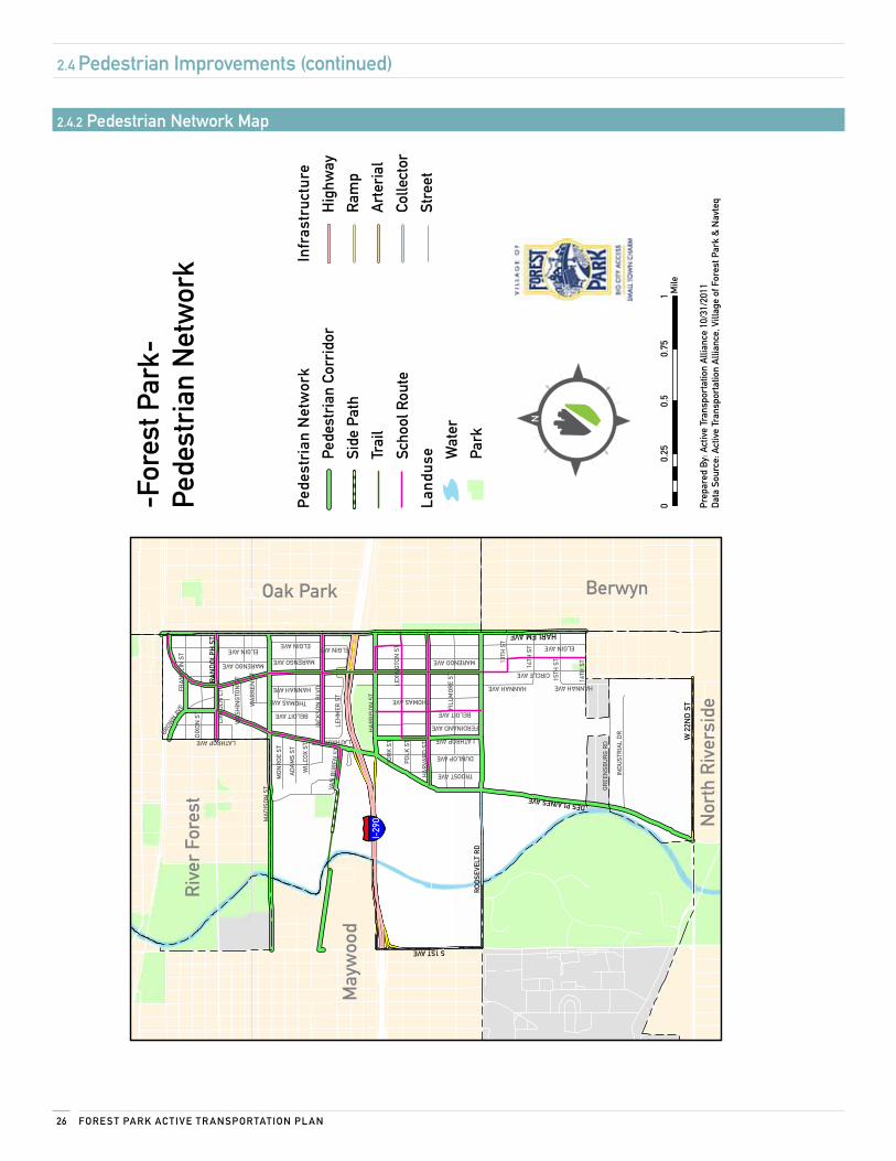
2.4 Pedestrian improvements
2.4.1 Pedestrian waysThe pedestrian network functions best when it is well connected and complete. Completing a network can easily be accomplished through elimination of sidewalk gaps, providing buffers for walkways along busy roads, wider sidewalks in areas with heavy pedestrian traffic, and signage to aid pedestrians in getting around.
The following recommendations and map on page 26 illustrate the location and type of pedestrian improvements that should be made.
Pedestrian network: residential streets
oBjecTive: Improve visibility of pedestrians to motorists, and increase public awareness of the key destinations throughout the network.
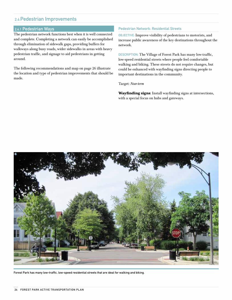
DescriPTion: The Village of Forest Park has many low-traffic, low-speed residential streets where people feel comfortable walking and biking. These streets do not require changes, but could be enhanced with wayfinding signs directing people to important destinations in the community.
Target: Near-term
Wayfinding signs: Install wayfinding signs at intersections, with a special focus on hubs and gateways.
Forest Park has many low-traffic, low-speed residential streets that are ideal for walking and biking.
25Ac Tive Tr AnsPorTATion ne T work
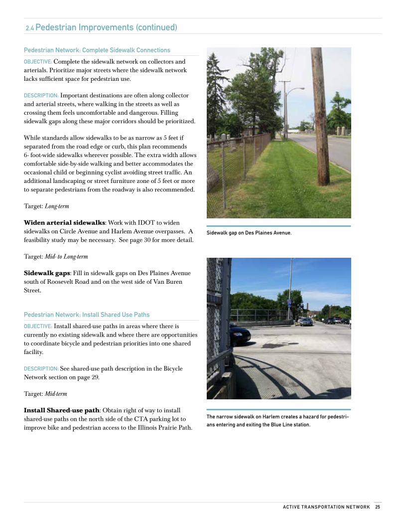
sidewalk gap on Des Plaines Avenue.
Pedestrian network: complete sidewalk connections
oBjecTive: Complete the sidewalk network on collectors and arterials. Prioritize major streets where the sidewalk network lacks sufficient space for pedestrian use.
DescriPTion: Important destinations are often along collector and arterial streets, where walking in the streets as well as crossing them feels uncomfortable and dangerous. Filling sidewalk gaps along these major corridors should be prioritized.
While standards allow sidewalks to be as narrow as 5 feet if separated from the road edge or curb, this plan recommends 6- foot-wide sidewalks wherever possible. The extra width allows comfortable side-by-side walking and better accommodates the occasional child or beginning cyclist avoiding street traffic. An additional landscaping or street furniture zone of 5 feet or more to separate pedestrians from the roadway is also recommended.
Target: Long-term
Widen arterial sidewalks: Work with IDOT to widen sidewalks on Circle Avenue and Harlem Avenue overpasses. A feasibility study may be necessary. See page 30 for more detail.
Target: Mid- to Long-term
Sidewalk gaps: Fill in sidewalk gaps on Des Plaines Avenue south of Roosevelt Road and on the west side of Van Buren Street.
Pedestrian network: install shared use Paths
oBjecTive: Install shared-use paths in areas where there is currently no existing sidewalk and where there are opportunities to coordinate bicycle and pedestrian priorities into one shared facility.
DescriPTion: See shared-use path description in the Bicycle Network section on page 29.
Target: Mid-term
Install Shared-use path: Obtain right of way to install shared-use paths on the north side of the CTA parking lot to improve bike and pedestrian access to the Illinois Prairie Path.
2.4 Pedestrian improvements (continued)
The narrow sidewalk on Harlem creates a hazard for pedestri-
ans entering and exiting the Blue line station.
Fore sT PArk Ac Tive Tr AnsPorTATion Pl An26
§̈ ¦I-29
0
Riv
er F
ores
t
May
woo
d
Nor
th R
iver
side
Oak Park Berwyn
HARLEM AVE
W 2
2ND
ST
DES PLAINES AVE
RO
OS
EVEL
T R
D
S 1ST AVER
AN
DO
LPH
ST
CIRCLE AVE
MA
DIS
ON
ST
AD
AM
S ST
HANNAH AVE
HA
RVA
RD
ST
DIX
ON
ST
JACK
SON
BLV
D
FILL
MO
RE
ST
HA
RR
ISO
N S
T THOMAS AVE
DUNLOP AVE
LEH
MER
ST
FRA
NK
LIN
ST
LATHROP AVE
GR
EEN
SBU
RG
RD
IND
UST
RIA
L D
R
LEXI
NG
TON
ST
16TH
ST
14TH
ST
MARENGO AVE
15TH
ST
BELOIT AVE
TROOST AVE
VAN
BU
REN
ST
BROW
N AVE
ELGIN AVE
13TH
ST
MO
NR
OE
ST
POLK
ST
YOR
K S
T
FERDINAND AVE
WIL
COX
ST
WA
SH
ING
TON
ST
WA
RR
EN S
T
LIN
COLN
CT
MARENGO AVE
ELGIN AVE
HANNAH AVE
MARENGO AVE
THOMAS AVE
LATHROP AVE
BELOIT AVE
HANNAH AVE
LATHROP AVE
ELGIN AVEELGIN AVE
Ped
estr
ian
Net
wor
k
Pede
stri
an C
orri
dor
Side
Pat
h
Trai
l
Scho
ol R
oute
Land
use W
ater
Park
Infr
astr
uctu
re
Hig
hway
Ram
p
Art
eria
l
Colle
ctor
Stre
et
Prep
ared
By:
Act
ive
Tran
spor
tatio
n A
llian
ce 1
0/31
/201
1D
ata
Sour
ce: A
ctiv
e Tr
ansp
orta
tion
Alli
ance
, Vill
age
of F
ores
t Par
k &
Nav
teq
00.
250.
50.
751 M
ile
-For
est P
ark-
Pede
stri
an N
etw
ork
2.4 Pedestrian improvements (continued)
2.4.2 Pedestrian network map
27Ac Tive Tr AnsPorTATion ne T work
2.5 Bicycle improvements
2.5.1 Bicycle waysThe bicycle network in Forest Park can be made up of neighborhood streets, bike routes, shared lanes, bike boulevards, trails, and paths. Constructing a complete and connected network will encourage biking in a safe and efficient manner throughout Forest Park.
Bike network: residential streets
oBjecTive: Build awareness among residents that bicycle routes begin at their front door.
DescriPTion: Forest Park has many low traffic residential streets where people feel comfortable walking or biking. Many of these streets have already been enhanced through streetscape improvements, such as benches, plantings and bump outs. Bike route signage can be added to help raise awareness of key community destinations accessible by bike or foot for residents and visitors of Forest Park.
Bike network: Designate Bike routes
oBjecTive: Create a near-term bike network for Forest Park by signing routes identified by local cyclists as being comfortable and having good connections.
DescriPTion: Many Forest Park streets are comfortable for cyclists who possess a moderate tolerance for traffic. These routes include streets with wide outside lanes and paved shoulders, as well as low-traffic residential streets. Many residents and most visitors are unaware of the city’s bike-friendly routes. Signing the network early on provides immediate value and encouragement to cyclists while raising all users’ awareness and acceptance of cycling within the city. The bikeway signs also do double duty, appreciated by drivers and pedestrians looking for specific destinations within the city.
Target: Near-term
Bike network: Designate Bike routes
oBjecTive: Install bike route signage on designated Forest Park bike routes. Specific recommendations are on page 32.
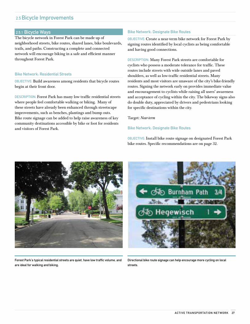
Forest Park’s typical residential streets are quiet, have low traffic volume, and
are ideal for walking and biking.Directional bike route signage can help encourage more cycling on local
streets.
Fore sT PArk Ac Tive Tr AnsPorTATion Pl An28
2.5 Bicycle improvements (continued)
Bike network: install shared lane markings
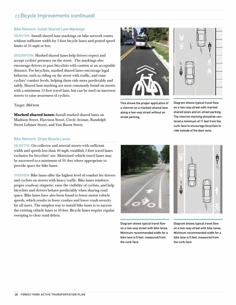
oBjecTive: Install shared lane markings on bike network routes without sufficient width for 5-foot bicycle lanes and posted speed limits of 35 mph or less.
DescriPTion: Marked shared lanes help drivers expect and accept cyclists' presence on the street. The markings also encourage drivers to pass bicyclists with caution at an acceptable distance. For bicyclists, marked shared lanes encourage legal behavior, such as riding on the street with traffic, and raise cyclists’ comfort levels, helping them ride more predictably and safely. Shared lane marking are most commonly found on streets with a minimum 13-foot travel lane, but can be used on narrower streets to raise awareness of cyclists.
Target: Mid-term
Marked shared lanes: Install marked shared lanes on Madison Street, Harrison Street, Circle Avenue, Randolph Street Lehmer Street, and Van Buren Street.
Bike network: stripe Bicycle lanes
oBjecTive: On collector and arterial streets with sufficient width and speeds less than 40 mph, establish 5-foot travel lanes exclusive for bicyclists’ use. Motorized vehicle travel lanes may be narrowed to a minimum of 10 -feet where appropriate to provide space for bike lanes.
overview: Bike lanes offer the highest level of comfort for drivers and cyclists on streets with heavy traffic. Bike lanes reinforce proper roadway etiquette, raise the visibility of cyclists, and help bicyclists and drivers behave predictably when sharing road space. Bike lanes have also been found to lower motor vehicle speeds, which results in fewer crashes and lower crash severity for all users. The simplest way to install bike lanes is to narrow the existing vehicle lanes to 10 feet. Bicycle lanes require regular sweeping to clear road debris.
This shows the proper application of
a chevron on a marked-shared lane
along a two-way street without on
street parking.
Diagram shows typical travel flow
on a two-way street with marked
shared lanes and on-street parking.
The chevron marking should be cen-
tered a minimum of 11 feet from the
curb-face to encourage bicyclists to
ride outside of the door zone.
Diagram shows typical travel flow
on a two-way street with bike lanes.
minimum recommended width for a
bike lane is 5 feet, measured from
the curb-face.
Diagram shows typical travel flow
on a two-way street with bike lanes.
minimum recommended width for a
bike lane is 5 feet, measured from
the curb-face.
29Ac Tive Tr AnsPorTATion ne T work
2.5 Bicycle improvements (continued)
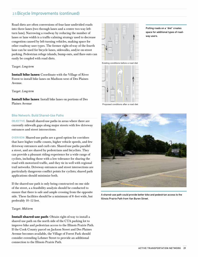
Road diets are often conversions of four-lane undivided roads into three lanes (two through lanes and a center two-way left- turn lane). Narrowing a roadway by reducing the number of lanes or lane width is a traffic-calming strategy used to decrease congestion caused by left-turning vehicles, making space for other roadway user types. The former right-of-way of the fourth lane can be used for bicycle lanes, sidewalks, and/or on-street parking. Pedestrian refuge islands, bump-outs, and flare-outs can easily be coupled with road diets.
Target: Long-term
Install bike lanes: Coordinate with the Village of River Forest to install bike lanes on Madison west of Des Plaines Avenue.
Target: Long-term
Install bike lanes: Install bike lanes on portions of Des Plaines Avenue
Bike network: Build shared-use Paths
oBjecTive: Install shared-use paths in areas where there are currently sidewalk gaps along major streets with few driveway entrances and street intersections.
overview: Shared-use paths are a good option for corridors that have higher traffic counts, higher vehicle speeds, and few driveway entrances and curb cuts. Shared-use paths parallel a street, and are shared by pedestrians and bicyclists. They can provide a pleasant riding experience for a wide range of cyclists, including those with a low tolerance for sharing the road with motorized traffic, and they tie in well with regional trail networks. Driveway entrances and street intersections are particularly dangerous conflict points for cyclists; shared path applications should minimize both.
If the shared-use path is only being constructed on one side of the street, a a feasibility analysis should be conducted to ensure that there is safe and ample crossing from the opposite side. These facilities should be a minimum of 8 -feet wide, but preferably 10–12 feet.
Target: Mid-term
Install shared-use path: Obtain right-of-way to install a shared use path on the north side of the CTA parking lot to improve bike and pedestrian access to the Illinois Prairie Path. If the Cook County parcel on Jackson Street and Des Plaines Avenue becomes available, the Village of Forest Park should consider extending Lehmer Street to provide an additional connection to the Illinois Prairie Path.
Existing conditions before a road diet
Proposed conditions after a road diet
A shared-use path could provide better bike and pedestrian access to the
illinois Prairie Path from van Buren street.
Putting roads on a “diet” creates
space for additional types of road-
way users.
Fore sT PArk Ac Tive Tr AnsPorTATion Pl An30
2.5 Bicycle improvements (continued)
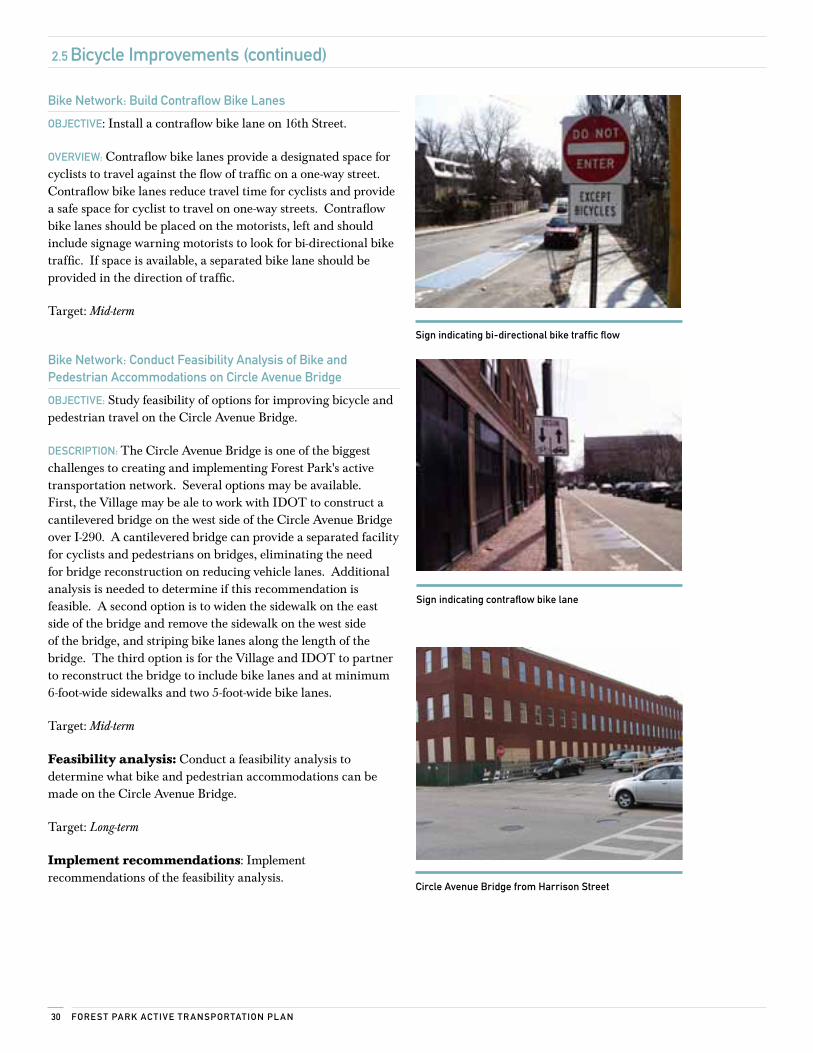
Bike network: Build contraflow Bike lanes
oBjecTive: Install a contraflow bike lane on 16th Street.
overview: Contraflow bike lanes provide a designated space for cyclists to travel against the flow of traffic on a one-way street. Contraflow bike lanes reduce travel time for cyclists and provide a safe space for cyclist to travel on one-way streets. Contraflow bike lanes should be placed on the motorists, left and should include signage warning motorists to look for bi-directional bike traffic. If space is available, a separated bike lane should be provided in the direction of traffic.
Target: Mid-term
Bike network: conduct Feasibility Analysis of Bike and Pedestrian Accommodations on circle Avenue Bridge
oBjecTive: Study feasibility of options for improving bicycle and pedestrian travel on the Circle Avenue Bridge.
DescriPTion: The Circle Avenue Bridge is one of the biggest challenges to creating and implementing Forest Park's active transportation network. Several options may be available. First, the Village may be ale to work with IDOT to construct a cantilevered bridge on the west side of the Circle Avenue Bridge over I-290. A cantilevered bridge can provide a separated facility for cyclists and pedestrians on bridges, eliminating the need for bridge reconstruction on reducing vehicle lanes. Additional analysis is needed to determine if this recommendation is feasible. A second option is to widen the sidewalk on the east side of the bridge and remove the sidewalk on the west side of the bridge, and striping bike lanes along the length of the bridge. The third option is for the Village and IDOT to partner to reconstruct the bridge to include bike lanes and at minimum 6-foot-wide sidewalks and two 5-foot-wide bike lanes.
Target: Mid-term
Feasibility analysis: Conduct a feasibility analysis to determine what bike and pedestrian accommodations can be made on the Circle Avenue Bridge.
Target: Long-term
Implement recommendations: Implement recommendations of the feasibility analysis.
sign indicating bi-directional bike traffic flow
sign indicating contraflow bike lane
circle Avenue Bridge from Harrison street
31Ac Tive Tr AnsPorTATion ne T work
2.5 Bicycle improvements (continued)
2.5.2 Bicycle AmenitiesThis is a list of low-cost improvements that should be made in the near term to encourage cycling, improve safety, and reduce crossing hazards.
Bicycle network signs
oBjecTive: Sign the Forest Park bicycle network using signs that display destination, direction, and distance.
DescriPTion: The 2009 MUTCD includes specifications for wayfinding signs. In the near term, the city should use the Bike Network map to guide which streets and major destinations to sign, focusing on existing routes that local cyclists identified as most comfortable for cycling. Sign the longer-term portions of the active transportation network as it develops. Regional trail connections, schools, parks, and municipal buildings should be indicated on signage, including the Illinois Prairie Path, Washington Street Bikeway, Des Plaines River Trail, and Salt Creek Trail.
Target: Near-term
Bicycle Parking
oBjecTive: Throughout the Village of Forest Park, install inverted-U or functionally similar bike parking racks at commercial retail areas, public buildings, and parks, and on public property near businesses and multi-unit residences.
DescriPTion: Racks should be located within clear view of the destination’s entranceway, preferably as close as the nearest motor vehicle parking space, and no more than 50 feet away from the entrance. If multiple racks are clustered in a visible and signed location, they can be sited up to 100-feet away from the entrance. If racks are placed further away than this, cyclists are likely to ignore the racks and look for a closer place to lock up. Staff should coordinate to identify appropriate locations for bike racks throughout the Village of Forest Park.
Bike parking installation should focus on the places identified in this plan, and at hubs (see map on page 23). By choosing racks with a unique color or shape at high-visibility locations, the racks can add character to a community.
Target: Mid-term
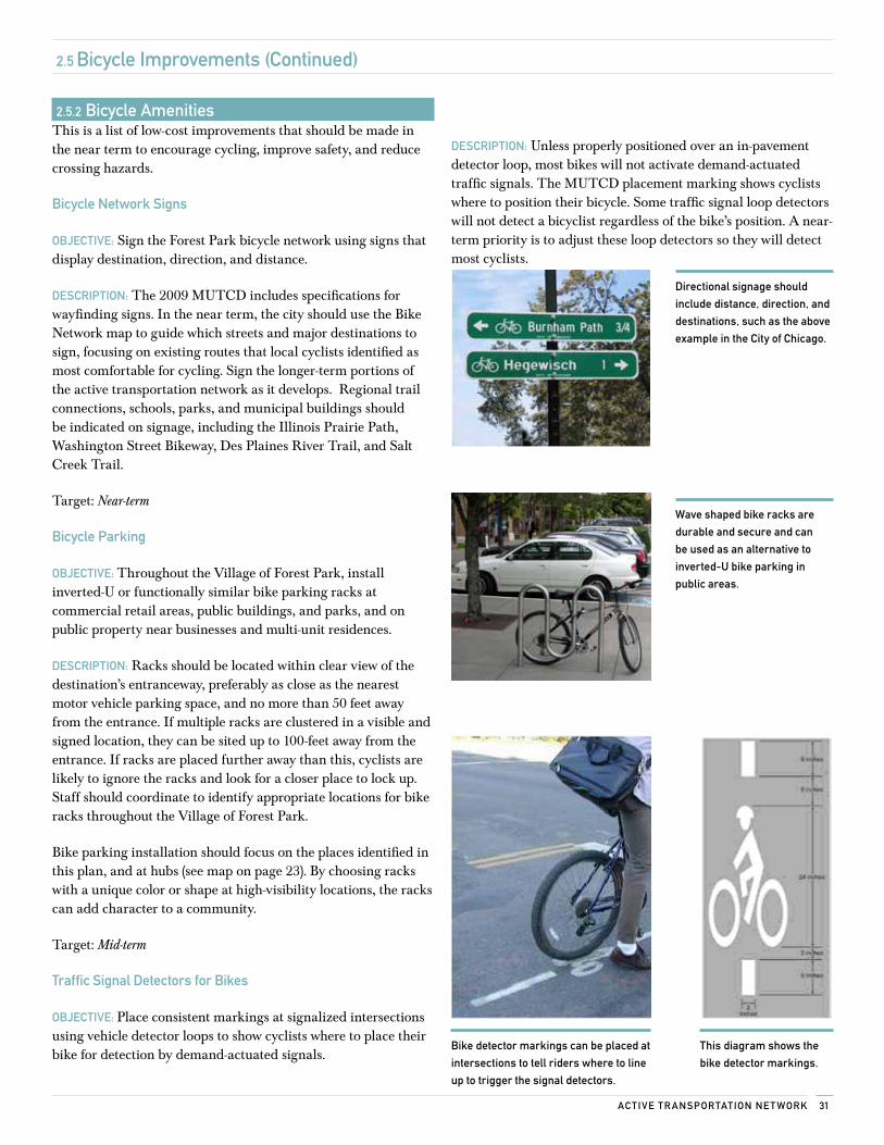
Traffic signal Detectors for Bikes
oBjecTive: Place consistent markings at signalized intersections using vehicle detector loops to show cyclists where to place their bike for detection by demand-actuated signals.
DescriPTion: Unless properly positioned over an in-pavement detector loop, most bikes will not activate demand-actuated traffic signals. The MUTCD placement marking shows cyclists where to position their bicycle. Some traffic signal loop detectors will not detect a bicyclist regardless of the bike’s position. A near-term priority is to adjust these loop detectors so they will detect most cyclists.
Directional signage should
include distance, direction, and
destinations, such as the above
example in the city of chicago.
wave shaped bike racks are
durable and secure and can
be used as an alternative to
inverted-u bike parking in
public areas.
Bike detector markings can be placed at
intersections to tell riders where to line
up to trigger the signal detectors.
This diagram shows the
bike detector markings.
Fore sT PArk Ac Tive Tr AnsPorTATion Pl An32
Riv
er F
ores
t
May
woo
d
Nor
th R
iver
side
Oak Park Berwyn
§̈ ¦I-29
0
HARLEM AVE
W 2
2ND
ST
DES PLAINES AVE
RO
OS
EVEL
T R
D
S 1ST AVE
RA
ND
OLP
H S
T
CIRCLE AVE
MA
DIS
ON
ST AD
AM
S ST
HANNAH AVEH
ARV
AR
D S
T
DIX
ON
ST
JACK
SON
BLV
D
FILL
MO
RE
STHA
RR
ISO
N S
T
THOMAS AVE
DUNLOP AVE
LEH
MER
ST
FRA
NK
LIN
ST
LATHROP AVE
GR
EEN
SBU
RG
RD
IND
UST
RIA
L D
R
LEXI
NG
TON
ST
16TH
ST
14TH
ST
MARENGO AVE 15TH
ST
BELOIT AVE
TROOST AVEVA
N B
UR
EN S
T
BROW
N AVE
ELGIN AVE
13TH
ST
MO
NR
OE
ST
ROCKFORD AVE
WIL
COX
ST
WA
SH
ING
TON
ST
WA
RR
EN S
T
MARENGO AVE
HANNAH AVE
MARENGO AVE
ELGIN AVE
THOMAS AVE
LATHROP AVE
HANNAH AVE
LATHROP AVE
ELGIN AVEELGIN AVE
Bic
ycle
Net
wor
k
Exis
ting M
ultiu
se T
rail
Rec
omm
ende
d
Bic
ycle
Rou
te
Bic
ycle
Lan
e
Shar
ed L
ane
Shar
ed L
ane/
Bic
ycle
Lan
e
Mul
tiuse
Tra
il
Infr
astr
uctu
re
Hig
hway
Ram
p
Art
eria
l
Colle
ctor
Stre
et
Land
Use W
ater
Park
Prep
ared
By:
Act
ive
Tran
spor
tatio
n A
llian
ce 1
0/31
/201
1D
ata
Sour
ce: A
ctiv
e Tr
ansp
orta
tion
Alli
ance
, Vill
age
of F
ores
t Par
k &
Nav
teq
00.
250.
50.
751 M
ile
-For
est P
ark-
Bic
ycle
Net
wor
k
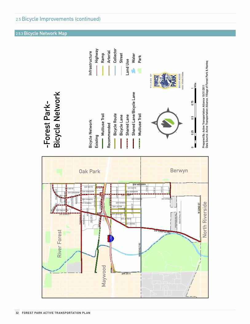
2.5 Bicycle improvements (continued)
2.5.3 Bicycle network map
33Ac Tive Tr AnsPorTATion ne T work
2.6 Transit improvements
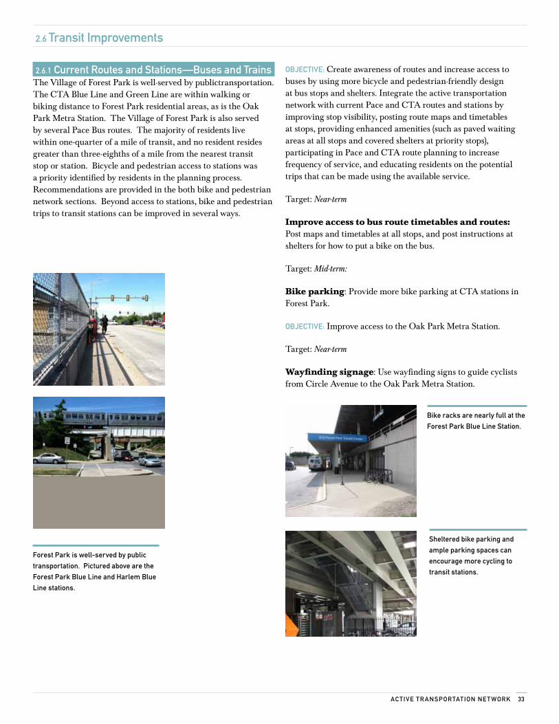
2.6.1 current routes and stations—Buses and TrainsThe Village of Forest Park is well-served by publictransportation. The CTA Blue Line and Green Line are within walking or biking distance to Forest Park residential areas, as is the Oak Park Metra Station. The Village of Forest Park is also served by several Pace Bus routes. The majority of residents live within one-quarter of a mile of transit, and no resident resides greater than three-eighths of a mile from the nearest transit stop or station. Bicycle and pedestrian access to stations was a priority identified by residents in the planning process. Recommendations are provided in the both bike and pedestrian network sections. Beyond access to stations, bike and pedestrian trips to transit stations can be improved in several ways.
oBjecTive: Create awareness of routes and increase access to buses by using more bicycle and pedestrian-friendly design at bus stops and shelters. Integrate the active transportation network with current Pace and CTA routes and stations by improving stop visibility, posting route maps and timetables at stops, providing enhanced amenities (such as paved waiting areas at all stops and covered shelters at priority stops), participating in Pace and CTA route planning to increase frequency of service, and educating residents on the potential trips that can be made using the available service.
Target: Near-term
Improve access to bus route timetables and routes: Post maps and timetables at all stops, and post instructions at shelters for how to put a bike on the bus.
Target: Mid-term:
Bike parking: Provide more bike parking at CTA stations in Forest Park.
oBjecTive: Improve access to the Oak Park Metra Station.
Target: Near-term
Wayfinding signage: Use wayfinding signs to guide cyclists from Circle Avenue to the Oak Park Metra Station.
Forest Park is well-served by public
transportation. Pictured above are the
Forest Park Blue line and Harlem Blue
line stations.
Bike racks are nearly full at the
Forest Park Blue line station.
sheltered bike parking and
ample parking spaces can
encourage more cycling to
transit stations.
Fore sT PArk Ac Tive Tr AnsPorTATion Pl An34
"Á"Á
"Á
"Á
"Á
"Á
"Á
"Á
"Á
"Á
"Á
"Á
"Á"Á
"Á
"Á
"Á
"Á
"Á"Á
"Á
"Á
§̈ ¦I-29
0
# 30
3 M
adis
on S
t - 1
9th
Ave
# 31
0 M
adis
on S
t - H
illsi
de#
317
Wes
tche
ster
# 32
0 M
adis
on S
t
# 32
2 Ce
rmak
Roa
d -
22nd
Str
eet
# 30
1 R
oose
velt
Roa
d#
308
Med
ical
Cen
ter
# 30
5 Ci
cero
- R
iver
For
est
# 75
7 N
orth
wes
t Con
nect
ion
# 74
7 D
uPag
e Co
nnec
tion
# 307 Harlem
# 307 Harlem
# 305 Cicero - River Forest
# 301 Roosevelt Road
# 308 Medical Center
Fore
st P
ark
'L' S
tatio
nH
arle
m 'L
' Sta
tion
# 32
0 M
adis
on S
t
# 30
3 M
adis
on S
t - 1
9th
Ave
# 30
5 Ci
cero
- R
iver
For
est
# 31
0 M
adis
on S
t - H
illsi
de#
317
Wes
tche
ster
# 31
8 W
est N
orth
Ave
# 75
7 N
W C
onne
ctio
n
$
# 32
0 M
adis
on S
t#
318
Wes
t Nor
th A
ve#
305
Cice
ro -
Riv
er F
ores
t
# 75
7 N
W C
onne
ctio
n
# 318 W N Ave.
# 305 C. - R. Forest
# 757 NW Conn.
# 307 Harlem
Oak
Par
k M
etra
Oak
Par
k 'L
'
Riv
er F
ores
t Met
raM
ayw
ood
Met
ra
Riv
er F
ores
t
May
woo
d
Nor
th R
iver
side
Oak Park Berwyn
HARLEM AVE
DES PLAINES AVE
RO
OS
EVEL
T R
D
S 1ST AVE
RA
ND
OLP
H S
T
CIRCLE AVE
MA
DIS
ON
ST
AD
AM
S ST
HANNAH AVE
HA
RVA
RD
ST
DIX
ON
ST
JACK
SON
BLV
D
FILL
MO
RE
ST
HA
RR
ISO
N S
T
THOMAS AVE
DUNLOP AVELE
HM
ER S
T
FRA
NK
LIN
ST
LATHROP AVE
GR
EEN
SBU
RG
RD
IND
UST
RIA
L D
R
LEXI
NG
TON
ST
16TH
ST
14TH
ST
MARENGO AVE
15TH
ST
BELOIT AVE
TROOST AVE
VAN
BU
REN
ST
ELGIN AVE
13TH
ST
MO
NR
OE
ST
HANNAH AVE
MARENGO AVE
LATHROP AVELATHROP AVE
ELGIN AVE
HANNAH AVE
ELGIN AVE
Trai
n S
tatio
n
" ÁM
etra
& 'L
' Sta
tion
CTA
Blu
e Li
ne
Gre
en L
ine
Pac
e
Bus
Rou
te
Met
ra
Met
ra R
oute
Infr
astr
uctu
re
Hig
hway
Ram
p
Art
eria
l
Colle
ctor
Stre
et
Land
use W
ater
Park
Prep
ared
By:
Act
ive
Tran
spor
tatio
n A
llian
ce 9
/26/
2011
Dat
a So
urce
: Act
ive
Tran
spor
tatio
n A
llian
ce, P
ace,
RTA
, Vill
age
of F
ores
t Par
k &
Nav
teq
00.
250.
50.
751 M
ile
-For
est P
ark-
Tran
sit N
etw
ork
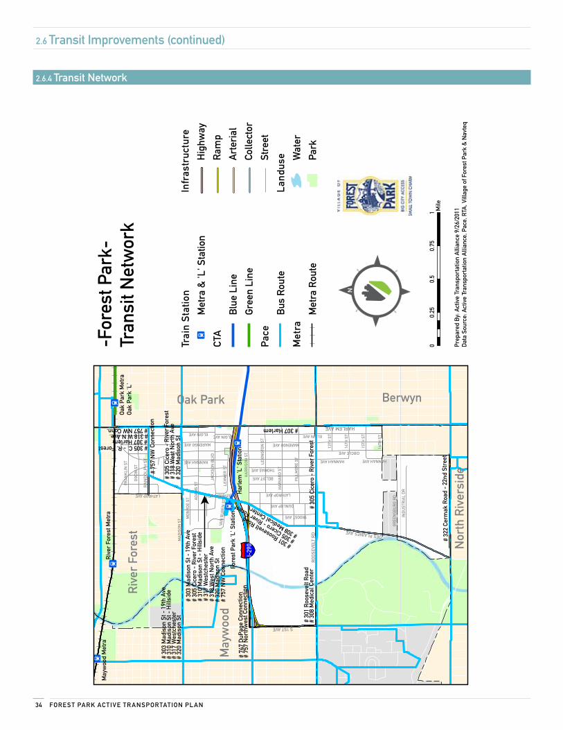
2.6 Transit improvements (continued)
2.6.4 Transit network
Policy and Programming
3
3.1 municipal Policy recommendations 36
3.2 school Policy recommendations 39
3.3 Program recommendations 40
Fore sT PArk Ac Tive Tr AnsPorTATion Pl An36
3.1 Policy and Programming
3.1 municipal Policy recommendationsThis section lays out policy recommendations that will help sustain Forest Park’s vision for active transportation. In addition to design and planning guidance, policy strategies can improve the transportation environment in ways that infrastructure cannot, by prioritizing safety through legislation and law enforcement.
3.1.1 implement a complete streets PolicyFollowing accepted best practices, the design recommendations throughout this plan are based on a Complete Streets philosophy. Complete streets are designed to enable safe access for all users of the transportation network regardless of age, ability, or travel mode. A complete street has no predefined facilities requirements, but is optimized within its surrounding context to promote safe, convenient active transportation options for the community.
Forest Park recently adopted a Complete Streets policy. The Village has commited to the accommodation of bicyclists, pedestrians, and transit users as well as motor vehicles in all new transportation construction and maintenance projects whenever appropriate.
Adopting a Complete Streets policy is the first step. The Village may require additional actions, such as updating its street design guidelines and training appropriate staff. These steps are outlined in the Village’s Complete Streets policy. See Appendix E for a list of resources on Complete Streets policies.
Target: Mid-term
Complete streets: Develop implementation guidelines and measures for executing the Village's complete streets policy.
3.1.2 subdivision Design GuidelinesForest Park’s current subdivision regulations include no requirement for on-street bicycle facilities. The Village would benefit from the continuation of its roadway system into any new subdivisions. The Village can ensure this continuity if the subdivision regulations are updated to include the new design standards for village roadways that are outlined in this plan.
Target: Mid-term
Subdivision guidelines: Update subdivision guidelines to include bicycle facilities.
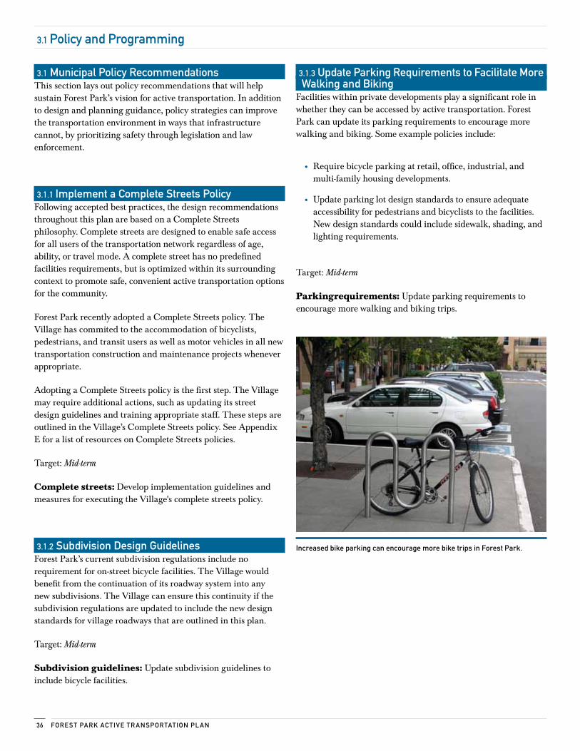
3.1.3 update Parking requirements to Facilitate more walking and Biking
Facilities within private developments play a significant role in whether they can be accessed by active transportation. Forest Park can update its parking requirements to encourage more walking and biking. Some example policies include:
• Require bicycle parking at retail, office, industrial, and multi-family housing developments.
• Update parking lot design standards to ensure adequate accessibility for pedestrians and bicyclists to the facilities. New design standards could include sidewalk, shading, and lighting requirements.
Target: Mid-term
Parkingrequirements: Update parking requirements to encourage more walking and biking trips.
increased bike parking can encourage more bike trips in Forest Park.
37Policy AnD ProGr AmminG
3.1 Policy and Programming (continued)
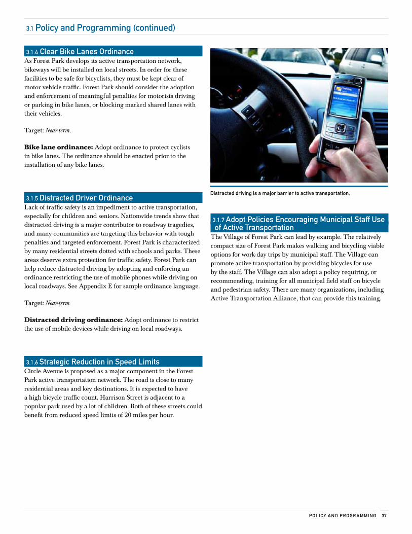
3.1.4 clear Bike lanes ordinanceAs Forest Park develops its active transportation network, bikeways will be installed on local streets. In order for these facilities to be safe for bicyclists, they must be kept clear of motor vehicle traffic. Forest Park should consider the adoption and enforcement of meaningful penalties for motorists driving or parking in bike lanes, or blocking marked shared lanes with their vehicles.
Target: Near-term.
Bike lane ordinance: Adopt ordinance to protect cyclists in bike lanes. The ordinance should be enacted prior to the installation of any bike lanes.
3.1.5 Distracted Driver ordinance Lack of traffic safety is an impediment to active transportation, especially for children and seniors. Nationwide trends show that distracted driving is a major contributor to roadway tragedies, and many communities are targeting this behavior with tough penalties and targeted enforcement. Forest Park is characterized by many residential streets dotted with schools and parks. These areas deserve extra protection for traffic safety. Forest Park can help reduce distracted driving by adopting and enforcing an ordinance restricting the use of mobile phones while driving on local roadways. See Appendix E for sample ordinance language.
Target: Near-term
Distracted driving ordinance: Adopt ordinance to restrict the use of mobile devices while driving on local roadways.
3.1.6 strategic reduction in speed limits Circle Avenue is proposed as a major component in the Forest Park active transportation network. The road is close to many residential areas and key destinations. It is expected to have a high bicycle traffic count. Harrison Street is adjacent to a popular park used by a lot of children. Both of these streets could benefit from reduced speed limits of 20 miles per hour.
Distracted driving is a major barrier to active transportation.
3.1.7 Adopt Policies encouraging municipal staff use of Active Transportation
The Village of Forest Park can lead by example. The relatively compact size of Forest Park makes walking and bicycling viable options for work-day trips by municipal staff. The Village can promote active transportation by providing bicycles for use by the staff. The Village can also adopt a policy requiring, or recommending, training for all municipal field staff on bicycle and pedestrian safety. There are many organizations, including Active Transportation Alliance, that can provide this training.
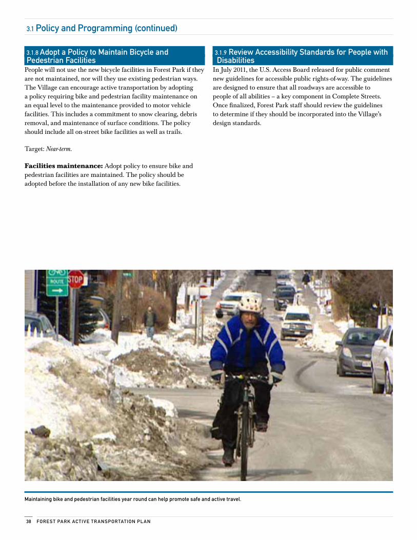
Fore sT PArk Ac Tive Tr AnsPorTATion Pl An38
3.1.8 Adopt a Policy to maintain Bicycle and Pedestrian Facilities
People will not use the new bicycle facilities in Forest Park if they are not maintained, nor will they use existing pedestrian ways. The Village can encourage active transportation by adopting a policy requiring bike and pedestrian facility maintenance on an equal level to the maintenance provided to motor vehicle facilities. This includes a commitment to snow clearing, debris removal, and maintenance of surface conditions. The policy should include all on-street bike facilities as well as trails.
Target: Near-term.
Facilities maintenance: Adopt policy to ensure bike and pedestrian facilities are maintained. The policy should be adopted before the installation of any new bike facilities.
3.1.9 review Accessibility standards for People with Disabilities
In July 2011, the U.S. Access Board released for public comment new guidelines for accessible public rights-of-way. The guidelines are designed to ensure that all roadways are accessible to people of all abilities – a key component in Complete Streets. Once finalized, Forest Park staff should review the guidelines to determine if they should be incorporated into the Village’s design standards.
maintaining bike and pedestrian facilities year round can help promote safe and active travel.
3.1 Policy and Programming (continued)
39Policy AnD ProGr AmminG
3.2 school Policy recommendations
Schools are a focus of this plan because more than 1,000 students live in Forest Park. The school policy recommendations in this plan hinge on the creation of a school and municipal partnership that works to develop institutional changes that support increased opportunities for walking and bicycling to school.
3.2.1 safe routes to school (srTs) DescriPTion: Safe Routes to School is a federally funded program that helps communities identify social and physical barriers to walking and bicycling to school. The program provides funding for education, encouragement, enforcement, and engineering projects aimed at making the trip to school safe, fun, and convenient for students in elementary and middle school. Safe Routes to School requires no local matching funds from communities.
In the fall of 2011, the Village of Forest Park and Forest Park School District 91 will partner to form a steering committee and develop a School Travel Plan for all K-8 schools in the district. The School Travel Plan will focus on education, encouragement, enforcement, and engineering solutions to improve the trip to and from school for bicyclists and pedestrians. A School Travel Plan is a pre-requisite for federal SRTS funding.
Target: Near-term
School travel plan: Develop school travel plans and apply for Safe Routes to School funding.
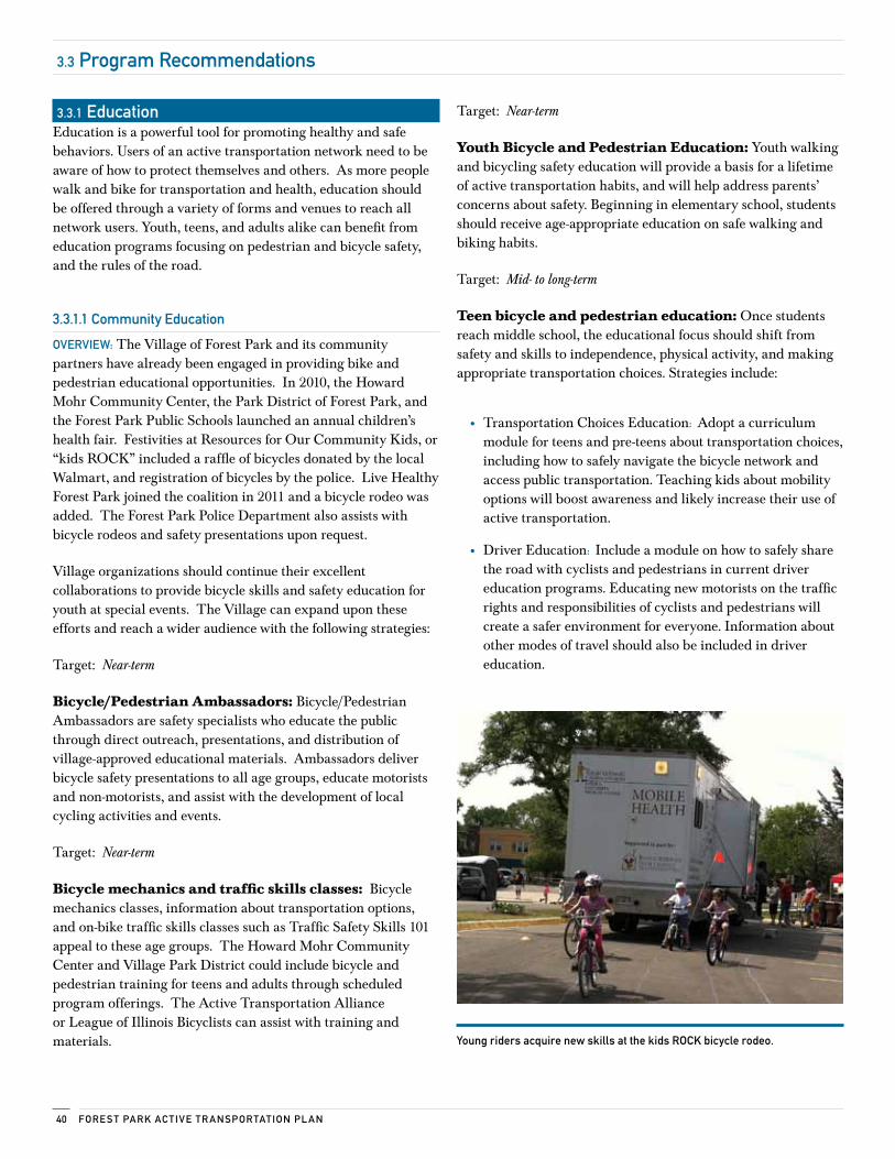
Fore sT PArk Ac Tive Tr AnsPorTATion Pl An40
3.3 Program recommendations
3.3.1 educationEducation is a powerful tool for promoting healthy and safe behaviors. Users of an active transportation network need to be aware of how to protect themselves and others. As more people walk and bike for transportation and health, education should be offered through a variety of forms and venues to reach all network users. Youth, teens, and adults alike can benefit from education programs focusing on pedestrian and bicycle safety, and the rules of the road.
3.3.1.1 community education
overview: The Village of Forest Park and its community partners have already been engaged in providing bike and pedestrian educational opportunities. In 2010, the Howard Mohr Community Center, the Park District of Forest Park, and the Forest Park Public Schools launched an annual children’s health fair. Festivities at Resources for Our Community Kids, or “kids ROCK” included a raffle of bicycles donated by the local Walmart, and registration of bicycles by the police. Live Healthy Forest Park joined the coalition in 2011 and a bicycle rodeo was added. The Forest Park Police Department also assists with bicycle rodeos and safety presentations upon request.
Village organizations should continue their excellent collaborations to provide bicycle skills and safety education for youth at special events. The Village can expand upon these efforts and reach a wider audience with the following strategies:
Target: Near-term
Bicycle/Pedestrian Ambassadors: Bicycle/Pedestrian Ambassadors are safety specialists who educate the public through direct outreach, presentations, and distribution of village-approved educational materials. Ambassadors deliver bicycle safety presentations to all age groups, educate motorists and non-motorists, and assist with the development of local cycling activities and events.
Target: Near-term
Bicycle mechanics and traffic skills classes: Bicycle mechanics classes, information about transportation options, and on-bike traffic skills classes such as Traffic Safety Skills 101 appeal to these age groups. The Howard Mohr Community Center and Village Park District could include bicycle and pedestrian training for teens and adults through scheduled program offerings. The Active Transportation Alliance or League of Illinois Bicyclists can assist with training and materials.
Target: Near-term
Youth Bicycle and Pedestrian Education: Youth walking and bicycling safety education will provide a basis for a lifetime of active transportation habits, and will help address parents’ concerns about safety. Beginning in elementary school, students should receive age-appropriate education on safe walking and biking habits.
Target: Mid- to long-term
Teen bicycle and pedestrian education: Once students reach middle school, the educational focus should shift from safety and skills to independence, physical activity, and making appropriate transportation choices. Strategies include:
• Transportation Choices Education: Adopt a curriculum module for teens and pre-teens about transportation choices, including how to safely navigate the bicycle network and access public transportation. Teaching kids about mobility options will boost awareness and likely increase their use of active transportation.
• Driver Education: Include a module on how to safely share the road with cyclists and pedestrians in current driver education programs. Educating new motorists on the traffic rights and responsibilities of cyclists and pedestrians will create a safer environment for everyone. Information about other modes of travel should also be included in driver education.
young riders acquire new skills at the kids rock bicycle rodeo.
41Policy AnD ProGr AmminG
3.3 Program recommendations (continued)
3.3.1.2 community media campaign
overview: Raising driver awareness was cited as a top priority by survey respondents for improving the walking environment in Forest Park.
Target: Near Term
Create a community media campaign: A community media campaign should be designed to educate all residents about bicycle and pedestrian safety. Topics identified as important community issues include:
• The Must Stop for Pedestrians law
• Sharing the road with bicycles
• School zone speeding
The media campaign can also convey how active transportation contributes to a healthy lifestyle. Forest Park can distribute both safety and health information through the following means:
• Use local media outlets such as www.forestpark.net, Your Village Newsletter, the Live Healthy Forest Park website and Facebook page, and the Forest Park Review to publish articles.
• Arrange for health and safety information to be reprinted and/or distributed by partner agencies, utility companies and the private sector.
• Distribute information to increase driver awareness of bicycle and pedestrian safety at the Mohr Community Center’s Rules of the Road Class. This class is designed to help motorists pass the driver's license renewal exam.
• Work with local doctors to distribute information on the health benefits of walking and cycling.
3.3.2 encouragement
3.3.2.1 community encouragement—information Access
overview: Knowledge about when and where to bike and walk safely, and how to access public transit, supports increased use of active transportation. Forest Park can get the word out about the active transportation network with the following strategies:
Target: Near-term
Youth and school: Partner with School District 91 to produce preferred walking and biking route maps, as well as child-friendly safety tips. The Village and School District can further promote walking and biking to school by hosting events, such as International Walk to School Day, that encourage the use of active transportation.
Target: Mid-term
Active transportation network map: Pedestrian and bicycle network maps can encourage use and patronage of the key places identified in this plan. Work with local volunteers or a contractor to produce and distribute a free active transportation network map that includes safe cycling and walking routes to key places and safety tips.
Target: Mid-term
Transit information: Increase use of public transit by distributing transit service information partner with the transit providers to display timetables and install transit vending machines in key places and promote the Regional Transportation Authority’s existing transit mapping service, www.goroo.com.
Target: Near-term
Live Healthy Forest Park Facebook page: Reach a large and diverse audience by posting regular updates about the active transportation plan on an easily accessible Facebook page. This site can also be used to promote local events and convey important safety information.
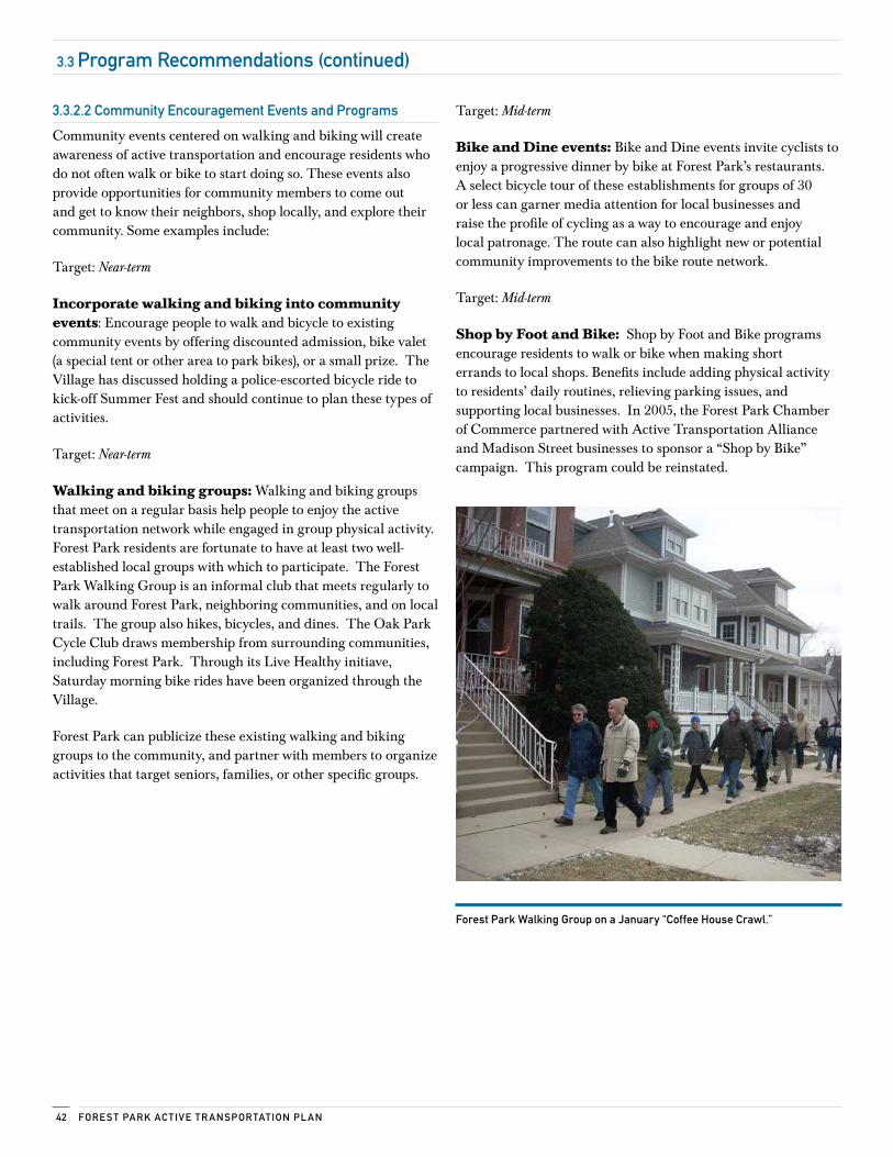
Fore sT PArk Ac Tive Tr AnsPorTATion Pl An42
3.3 Program recommendations (continued)
3.3.2.2 community encouragement events and Programs
Community events centered on walking and biking will create awareness of active transportation and encourage residents who do not often walk or bike to start doing so. These events also provide opportunities for community members to come out and get to know their neighbors, shop locally, and explore their community. Some examples include:
Target: Near-term
Incorporate walking and biking into community events: Encourage people to walk and bicycle to existing community events by offering discounted admission, bike valet (a special tent or other area to park bikes), or a small prize. The Village has discussed holding a police-escorted bicycle ride to kick-off Summer Fest and should continue to plan these types of activities.
Target: Near-term
Walking and biking groups: Walking and biking groups that meet on a regular basis help people to enjoy the active transportation network while engaged in group physical activity. Forest Park residents are fortunate to have at least two well-established local groups with which to participate. The Forest Park Walking Group is an informal club that meets regularly to walk around Forest Park, neighboring communities, and on local trails. The group also hikes, bicycles, and dines. The Oak Park Cycle Club draws membership from surrounding communities, including Forest Park. Through its Live Healthy initiave, Saturday morning bike rides have been organized through the Village.
Forest Park can publicize these existing walking and biking groups to the community, and partner with members to organize activities that target seniors, families, or other specific groups.
Target: Mid-term
Bike and Dine events: Bike and Dine events invite cyclists to enjoy a progressive dinner by bike at Forest Park’s restaurants. A select bicycle tour of these establishments for groups of 30 or less can garner media attention for local businesses and raise the profile of cycling as a way to encourage and enjoy local patronage. The route can also highlight new or potential community improvements to the bike route network.
Target: Mid-term
Shop by Foot and Bike: Shop by Foot and Bike programs encourage residents to walk or bike when making short errands to local shops. Benefits include adding physical activity to residents’ daily routines, relieving parking issues, and supporting local businesses. In 2005, the Forest Park Chamber of Commerce partnered with Active Transportation Alliance and Madison Street businesses to sponsor a “Shop by Bike” campaign. This program could be reinstated.
Forest Park walking Group on a january “coffee House crawl.”
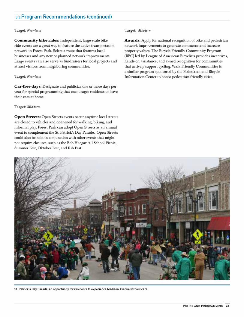
43Policy AnD ProGr AmminG
3.3 Program recommendations (continued)
Target: Near-term
Community bike rides: Independent, large-scale bike ride events are a great way to feature the active transportation network in Forest Park. Select a route that features local businesses and any new or planned network improvements. Large events can also serve as fundraisers for local projects and attract visitors from neighboring communities.
Target: Near-term
Car-free days: Designate and publicize one or more days per year for special programming that encourages residents to leave their cars at home.
Target: Mid-term
Open Streets: Open Streets events occur anytime local streets are closed to vehicles and openened for walking, biking, and informal play. Forest Park can adopt Open Streets as an annual event to complement the St. Patrick’s Day Parade. Open Streets could also be held in conjunction with other events that might not require closures, such as the Bob Haegar All School Picnic, Summer Fest, Oktober Fest, and Rib Fest.
Target: Mid-term
Awards: Apply for national recognition of bike and pedestrian network improvements to generate commerce and increase property values. The Bicycle Friendly Community Program (BFC) led by League of American Bicyclists provides incentives, hands-on assistance, and award recognition for communities that actively support cycling. Walk Friendly Communities is a similar program sponsored by the Pedestrian and Bicycle Information Center to honor pedestrian-friendly cities.
st. Patrick’s Day Parade, an opportunity for residents to experience madison Avenue without cars.
Fore sT PArk Ac Tive Tr AnsPorTATion Pl An44
3.3.3.2 Targeted enforcement efforts
overview: Targeted enforcement campaigns raise driver awareness about bicycle and pedestrian safety, and demonstrate the community's commitment to active transportation.
The Forest Park Police Department holds crosswalk stings, and tickets have been issued to motorists who violate the “must stop for pedestrians in crosswalk” law. A portable message sign has been used to publicize the number of tickets issued. The Forest Park Police Department should continue to hold targeted enforcement events for crosswalk violations as well as other types of infractions, such as speeding in school zones.
Target: Near-term
Targeted enforcement campaign: Continue to conduct targeted enforcement campaigns on traffic violations impacting bicycle and pedestrian safety.
3.3.3.3 Analysis of crash Data
overview: In 2011, the Forest Park Police Department began to analyze existing crash data to identify dangerous locations. In addition to informing future targeted enforcement campaigns, the data will be used to site traffic signage and direct community awareness efforts. Forest Park should continue to review crash data and enforcement efforts on an annual basis to ensure appropriate allocation of police resources.
Target: Near-term
Analyze crash data: Continue to analyze crash data as a basis for targeted enforcement campaigns and related initiatives.
3.3.3.4 Awards
overview: The Forest Park Police Department also participates in the Illinois Association of Chiefs of Police Illinois Traffic Safety Challenge. This program recognizes law enforcement agencies that are able to demonstrate exemplary traffic safety and enforcement programs. Departments are required to document their policies and procedures, officer training, traffic safety recognition programs, public information and education efforts, enforcement and crash data, and effectiveness information. Currently, the department focuses on speeding, impaired driving (DUI), and occupant protection. This program provides an opportunity for the department to gain recognition for bicycle and pedestrian enforcement efforts.
Target: Mid-term
Illinois Traffic Safety Challenge: Document progress on bicycle and pedestrian enforcement efforts by participating in the Illinois Association of Chiefs of Police Illinois Traffic Safety Challenge.
3.3 Program recommendations (continued)
implementation
4
4.1 evaluation and oversight 46
4.2 implementation 47
4.3 The Planning Team 50
Fore sT PArk Ac Tive Tr AnsPorTATion Pl An46
4.1 evaluation and oversight
A plan as comprehensive as this one requires vigorous oversight to ensure its effective implementation.
4.1.1 continue the Plan steering committee as a standing Bicycle and Pedestrian Task Force
The heart and soul of this plan came from local residents who participated in public engagement events hosted by the steering committee. These residents’ vision and goals are expressed throughout the recommendations of this plan. The Village of Forest Park can continue to benefit from the wisdom of these advocates by inviting them to join a standing bicycle and pedestrian task force.
The task force will monitor implementation of the plan, promote events celebrating active transportation in Forest Park, and encourage residents and visitors to use the improved active transportation network. The council would benefit from membership derived from the key stakeholders who served on the steering committee for this plan. Task force members might opt to engage in the following activities:
• Form partnerships with schools and community organizations to advance recommendations in this plan
• Set goals to increase safety and use of the active transportation network and monitor implementation of the plan
• Review and analyze crash data annually to identify and revise crossing priorities based on high crash area locations
• Lead the plan's implementation activities and take the lead on updating the plan every three to five years
• Make recommendations to the Forest Park Village Board on issues related to active transportation and the implementation of this plan.
4.1.2 Appoint a Bicycle and Pedestrian liaisonUsers of the active transportation network and the new Bicycle and Pedestrian task force would benefit from having access to a single municipal staff contact who serves as the Bicycle and Pedestrian Coordinator. This Village of Forest Park staff member would serve as a liaison to the task force, monitor implementation of the plan by municipal staff, and serve as a point of contact for residents and visitors. This person could also be charged with seeking funding for implementation of the plan and creating partnerships with like-minded governments in the region.
4.1.3 evaluate Plan implementationData analysis is imperative to measuring the impact of the active transportation plan. The findings of a good analysis can help to guide safety initiatives and the prioritization of future infrastructure projects, while supporting program funding efforts. The Bicycle and Pedestrian Coordinator should be charged with collecting baseline data and conducting an annual analysis to identify trends in the number of network users, and trends in the numbers, types, and locations of motor vehicle crashes involving pedestrians and bicyclists.
Many free and low-cost datasets are available to assist with evaluation. The Coordinator may want to use Bicycle Friendly Community data from League of American Bicyclists, traffic crash reports from the Illinois Department of Transportation, and the data compiled by the consultants for this plan. The National Center for Safe Routes to School offers a free student traffic count tool and free data analysis.
47imPlemenTATion
4.2 implementation
Throughout this plan, the consultants have provided recommendations for implementation of the various recommendations. The plan advocates for a comprehensive set of network, policy, program, enforcement, and evaluation improvements staggered over several years. The effective implementation of this plan will require leadership by Forest Park staff and residents. It will also require cooperation with neighboring municipalities, Cook County, and the Illinois Department of Transportation.
The use of the active transportation network will only increase if the plan’s recommendations for education, encouragement, and enforcement are implemented in a timely manner in conjunction with the improvements to the network. The following pages include a map showing recommended implementation priorities for the network and a timeline for policy and programming implementation.
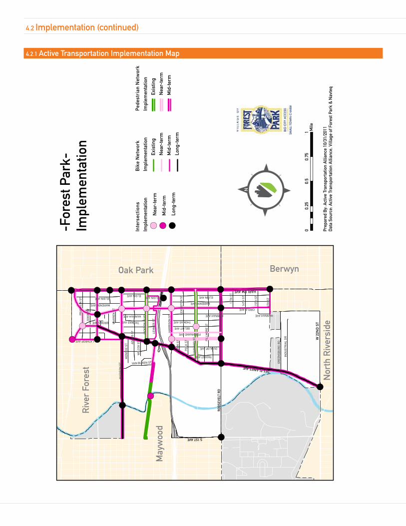
Fore sT PArk Ac Tive Tr AnsPorTATion Pl An
!(
!(
!(!(!(!(!(!(!(!(!( !(
!(
!(!(
!( !(!(
!(!(
!(
!(
!(
!(!(!(
!(
!(
!(
Har
lem
/Oak
Par
kTr
ain
Stat
ion
Riv
er F
ores
t
May
woo
d
Nor
th R
iver
side
Oak Park Berwyn
HARLEM AVE
W 2
2ND
ST
DES PLAINES AVE
RO
OS
EVEL
T R
D
S 1ST AVE
CIRCLE AVE
MA
DIS
ON
ST
AD
AM
S ST
HANNAH AVE
HA
RVA
RD
ST
DIX
ON
ST
JACK
SON
BLV
D
FILL
MO
RE
ST
HA
RR
ISO
N S
T
THOMAS AVE
DUNLOP AVE
LEH
MER
ST
FRA
NK
LIN
ST
LATHROP AVE
GR
EEN
SBU
RG
RD
IND
UST
RIA
L D
R
LEXI
NG
TON
ST
16TH
ST
14TH
ST
MARENGO AVE 15TH
ST
BELOIT AVE
TROOST AVE
VAN BUREN ST
BROWN AVE
ELGIN AVE13
TH S
T
MO
NR
OE
ST
POLK
ST
YOR
K S
T
FERDINAND AVE
WIL
COX
ST
WA
RR
EN S
T
MARENGO AVE
HANNAH AVE
ELGIN AVE
HANNAH AVE
THOMAS AVE
ELGIN AVEELGIN AVE
Inte
rsec
tions
Impl
emen
tatio
n
! (N
ear-
term
! (M
id-t
erm
! (Lo
ng-t
erm
Bik
e N
etw
ork
Impl
emen
tatio
n
Exis
ting
Nea
r-te
rm
Mid
-ter
m
Long
-ter
m
Ped
estr
ian
Net
wor
k
Impl
emen
tatio
n
Exis
ting
Nea
r-te
rm
Mid
-ter
m
Prep
ared
By:
Act
ive
Tran
spor
tatio
n A
llian
ce 1
0/31
/201
1D
ata
Sour
ce: A
ctiv
e Tr
ansp
orta
tion
Alli
ance
, Vill
age
of F
ores
t Par
k &
Nav
teq
00.
250.
50.
751 M
ile
-For
est P
ark-
Impl
emen
tatio
n
4.2.1 Active Transportation implementation map
4.2 implementation (continued)
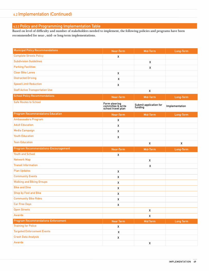
49imPlemenTATion
4.2 implementation (continued)
4.2.2 Policy and Programming implementation Table Based on level of difficulty and number of stakeholders needed to implement, the following policies and programs have been recommended for near-, mid- or long-term implementations.
municipal Policy recommendations near-Term mid-Term long-Term
complete streets Policy x
subdivision Guidelines x
Parking Facilities x
clear Bike lanes x
Distracted Driving x
speed limit reduction x
staff Active Transportation use x
school Policy recommendations near-Term mid-Term long-Term
safe routes to school Form steering committee & write school travel plan
submit application for funding implementation
Program recommendations education near-Term mid-Term long-Term
Ambassadors Program x
Adult education x
media campaign x
youth education x
Teen education x x
Program recommendations-encouragement near-Term mid-Term long-Term
youth and school x
network map x
Transit information x
Plan updates x
community events x
walking and Biking Groups x
Bike and Dine x
shop by Foot and Bike x
community Bike rides x
car Free Days x
open streets x
Awards x
Program recommendations-enforcement near Term mid Term long Term
Training for Police x
Targeted enforcement events x
crash Data Analysis x
Awards x
4.2 implementation (continued)
Fore sT PArk Ac Tive Tr AnsPorTATion Pl An50
4.3 The Planning Team
4.3.1 Active Transportation Plan steering committeeThis plan is represents the combined vision and goals of the steering committee that guided its development as well as residents and other key stakeholders. Thank you to these residents and the members of the steering committee for donating their time to this project.
Mike O'Connor - Forest Park Police DepartmentElizabeth Axtell - Forest Park Chamber of CommerceJoEllen Charlton - Village of Forest ParkChris Chin - Forest Park Police DeparmentSally Cody - ResidentJohn Doss - Village of Forest ParkKaren Dylewski - Forest Park Community CenterTim Gillian - Village AdministratorDouglas Gotham - Christopher Burke EngineeringChris Harris - CommissionerJohn Hosty - Traffic & Safety CommitteeTJ Janopaulos - Forest Park Fire DepartmentYoung Lee - Forest Park Police DepartmentTom Mannix - Streets & Public Improvement CommissionerJohn McNett - Oak Park Cycle ClubDenise Murray - Live Healthy Forest ParkDrew Peterson - ResidentMelinda Peterson - MHA JobsMike O'Connor - Forest Park Police DepartmentLeticia Olmsted - Village Clerk's OfficeErin Parchert - Forest Park District
4.3.2 About the consultantsThe mission of Active Transportation Alliance is to make cycling, walking, and public transit so safe, convenient, and fun that we will achieve a significant shift from environmentally harmful, sedentary travel to clean, active travel. We advocate for transportation that encourages and promotes safety, physical activity, health, recreation, social interaction, equity, environmental stewardship, and resource conservation.
We are both Chicagoland’s voice for better biking, walking, and transit and a premier consultancy. Our staff includes planning, policy, and education experts who developed many of the best practice programs and policies included in this plan. By partnering with us on this project, the Village of Forest Park has supported our mission to improve active transportation in Chicagoland. Staff who participated in the development of this plan include:
Shafaq Choudry – Community Planner
Patrick Knapp – Planner/GIS Specialist
Paul Lippens – Senior Planner
Dan Persky – Director of Education and Advocacy
Ruth Myers – Suburban Coordinator
Heather Schady – Transportation Planner/Safe Routes to School Manager
4.3.3 communities Putting Prevention to workThis plan was made possible through funding from the Department of Health and Human Services: Communities Putting Prevention to Work (CPPW) grant. CPPW is a joint project between the Cook County Department of Public Health and the Public Health Institute of Metropolitan Chicago.
Appendices
5
5.1 Appendix A: Public engagement summary 52
5.2 Appendix B: existing conditions map 53
5.3 Appendix c: Pedestrian and Bicycle Facilities Guidance 54
5.4 Appendix D: Funding resources 55
5.5 Appendix e: municipal Policy resources 57
5.6 Appendix F: Programming resources 59
Fore sT PArk Ac Tive Tr AnsPorTATion Pl An52
An extensive documentation of public engagement processes is included on the following pages of the digital version of this report. This documentation is not included in the print version.
• See Assembled PDF
5.1 Appendix A: Public engagement summary
53APPenDice s
5.2 Appendix B: existing conditions maps
A series of existing conditions maps is included on the following pages of the digital version of this report. These maps are not included in print version. Maps prepared include:
• Forest Park Street Info
• Bike and Pedestrian Crash Map
• Forest Park Jurisdiction
• Forest Park Land Use
• Forest Park Transit
• Forest Park Distance from Public Transi
• Street Widths and Stop Light Info
• Population Density
• Racial Distribution
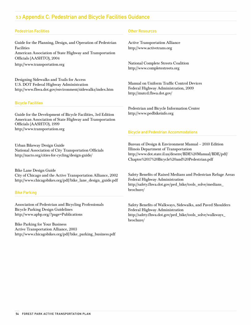
Fore sT PArk Ac Tive Tr AnsPorTATion Pl An54
5.3 Appendix c: Pedestrian and Bicycle Facilities Guidance
other resources
Active Transportation Alliancehttp://www.activetrans.org
National Complete Streets Coalitionhttp://www.completestreets.org
Manual on Uniform Traffic Control DevicesFederal Highway Administration, 2009http://mutcd.fhwa.dot.gov/
Pedestrian and Bicycle Information Center http://www.pedbikeinfo.org
Bicycle and Pedestrian Accommodations
Bureau of Design & Environment Manual – 2010 EditionIllinois Department of Transportationhttp://www.dot.state.il.us/desenv/BDE%20Manual/BDE/pdf/Chapter%2017%20Bicycle%20and%20Pedestrian.pdf
Safety Benefits of Raised Medians and Pedestrian Refuge AreasFederal Highway Administrationhttp://safety.fhwa.dot.gov/ped_bike/tools_solve/medians_brochure/
Safety Benefits of Walkways, Sidewalks, and Paved ShouldersFederal Highway Administrationhttp://safety.fhwa.dot.gov/ped_bike/tools_solve/walkways_brochure/
Pedestrian Facilities
Guide for the Planning, Design, and Operation of Pedestrian FacilitiesAmerican Association of State Highway and Transportation Officials (AASHTO), 2004
http://www.transportation.org
Designing Sidewalks and Trails for AccessU.S. DOT Federal Highway Administrationhttp://www.fhwa.dot.gov/environment/sidewalks/index.htm
Bicycle Facilities
Guide for the Development of Bicycle Facilities, 3rd EditionAmerican Association of State Highway and Transportation Officials (AASHTO), 1999 http://www.transportation.org
Urban Bikeway Design GuideNational Association of City Transportation Officialshttp://nacto.org/cities-for-cycling/design-guide/
Bike Lane Design GuideCity of Chicago and the Active Transportation Alliance, 2002 http://www.chicagobikes.org/pdf/bike_lane_design_guide.pdf
Bike Parking
Association of Pedestrian and Bicycling ProfessionalsBicycle Parking Design Guidelineshttp://www.apbp.org/?page=Publications
Bike Parking for Your BusinessActive Transportation Alliance, 2003http://www.chicagobikes.org/pdf/bike_parking_business.pdf
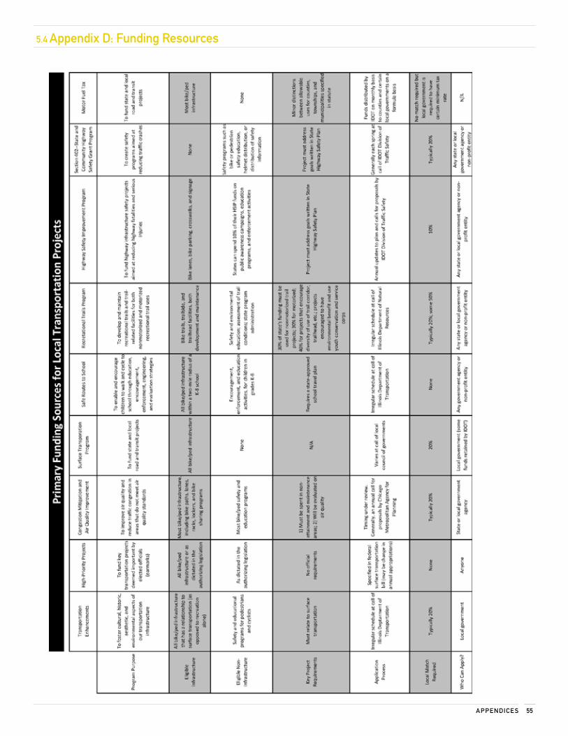
55APPenDice s
5.4 Appendix D: Funding resources
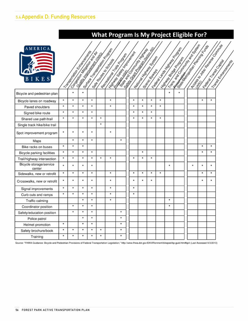
Fore sT PArk Ac Tive Tr AnsPorTATion Pl An56
5.4 Appendix D: Funding resources
57APPenDice s
5.5 Appendix e: municipal Policy resources
Appendix for 3.1.1 Adopt a Complete Streets Policy
COMPLETE STREETS POLICY RESOURCE GUIDE
PURPOSEThis document serves as a resource for municipal officials, planners, and engineers who are interested in adopting a Complete Streets policy in their community. The materials referenced below can assist with formulating policy and supporting initiatives with facts about complete streets. Resources are divided into two categories: policy and opinion/research.
POLICYMcCann, Barbara, and Suzanne Rynne. Complete Streets: Best Policy and Implementation Practices. (Chicago: American Planning Association, 2010).
This publication of the American Planning Association’s Planning Advisory Service includes case studies, model policies, and development strategies revolving around Complete Streets.
National Complete Streets Coalition.
www.completestreets.org
NCSC has a very informative website. Among others, the following NCSC documents can be considered a good “jumping off” point for those unfamiliar with Complete Streets policy and design.
“Complete Streets Policy Elements.” National Complete Streets Coalition.
http://www.completestreets.org/changing-policy/policy-elements/
Provides a framework by which Complete Streets policy can be designed and a basic outline of the elements of robust Complete Streets policy.
“Federal Policy Resources.” National Complete Streets Coalition.
http://www.completestreets.org/federal-policy/federal-policy-resources/
Knowing the trends in national policy concerning Complete Streets can help reinforce local policy initiatives. The NCSC website details past federal activity concerning Complete Streets, features legislative language, and has tips for getting the attention of lawmakers at the federal level.
RESEARCH
“Complete Streets Fact Sheets.” National Complete Streets Coalition.
http://www.completestreets.org/complete-streets-fundamentals/factsheets/
There are several topical fact sheets maintained by the NCSC on this site. The web version of each fact sheet contains several relevant statistics and principles along with links to supporting information. This is a great resource to help counter objections to Complete Streets on many different topics, including cost, safety, and transportation efficiency.
Gotschi, Thomas. “Costs and Benefits of Bicycling Investments in Portland, Oregon.” Journal of Physical Activity and Health 8 (2011): S49-S58.
This research article by Thomas Gotschi from the University of Zurich details the health, safety, and overall cost benefits associated with different levels of non-motorized transportation funding using Portland, OR as a study area. Though most of the report is highly technical, special attention should be paid to the abstract and conclusion for solid information on the benefits of funding non-motorized transportation systems.
Fore sT PArk Ac Tive Tr AnsPorTATion Pl An58
5.5 Appendix e: municipal Policy resources
3.1.6 Distracted Driver ordinance
Sample Distracted Driving Ordinance
Forest Park Municipal Code Title 6 Chapter 3 (new section) Use of electronic communication devices
A. Definitions:
1. For the purposes of this section, “electronic communication device” shall include but not be limited to mobile, cellular, analog wireless or digital telephones, personal digital assistants, or portable or mobile computers.
2. For the purposes of this section, “using an electronic communication device” shall include, but not be limited to, the following activities: (a) talking or listening to another person on the telephone; (b) composing, sending, reading, or listening to a text message or other electronic message; or (c) browsing the Internet via mobile, cellular, analog wireless, or digital telephone.
3. For the purposes of this section, “a hands-free device” is an internal software application, or an external device that allows the user to engage in a telephone call without touching the user's electronic communication device.
B. Except as otherwise provided in subsection (C) of this section, no person shall operate a motor vehicle while using an electronic communication device.
C. The provisions of this section shall not apply to:
1. Law enforcement officers and operators of emergency vehicles, when on duty and acting in their official capacities.
2. Persons using an electronic communication device with a hands-free device activated.
3. Persons using a telephone to call 911 telephone numbers or other emergency telephone numbers.
4. Persons using a telephone while maintaining a motor vehicle in a stationary parked position, and not in gear.
D. Any person who violates the requirements of this section shall be subject to a fine of one hundred dollars ($100.00), provided, however, that if a violation occurs at the time of a traffic crash, the driver shall be subject to an additional fine not to exceed five hundred dollars ($500.00).

59APPenDice s
5.6 Appendix F: Programming resources
Safe Routes to SchoolNational Center for Safe Routes to School: www.saferoutesinfo.org The National Center for Safe Routes to School (SRTS) assists communities in enabling and encouraging children in grades K–8 to walk and bike safely to school. The National Center has an informative website about the five E’s of SRTS (education, encouragement, enforcement, engineering, and evaluation), including case studies, resources, data collection, and trainings.
SRTS Guide: http://guide.saferoutesinfo.org/index.cfmThe Safe Routes to School Online Guide is a comprehensive manual designed to support the development of an SRTS program.
Illinois SRTS: http://www.dot.il.gov/saferoutes/SafeRoutesHome.aspx The Illinois SRTS program is run by the Illinois Department of Transportation. Illinois has awarded $11 million in federal funding for the program.
Walk to School DayInternational Walk to School Day in the USA: http://www.walktoschool.org/
The first Wednesday of October is International Walk to School Day. Children in over 40 countries participate. The website provides ideas and resources for planning an event.
International Walk to School: http://www.iwalktoschool.org/photos/index.htm The Official Website of International Walk to School features pictures, stories, best practices, downloads, resources, and who is walking around the world.
Bike and Dine Celebrate the fun and ease of getting around by bike while sampling from local eateries.
Shop by Foot or BikeShopping by foot or bike makes everything along your route more accessible. It encourages local shopping and fosters a sense of community. Local businesses can provide incentives for customers who arrive on foot or by bike.
Open Streets This event takes a large, continuous public space—your community’s streets—and opens it up to joggers and cyclists, adults and kids, residents and visitors to enjoy. Open Streets provides more space for healthy recreation.
Bike Rodeo A bike rodeo typically consists of a bicycle safety clinic featuring bike safety inspections, and a safety lecture about the rules of the road. This is followed by a ride on a miniature "chalk street" course set up in a parking lot where young cyclists are shown where and how to apply the rules. Optional activities include tune-ups, helmet fittings, prize drawings, and commercial activities such as booths set up by bike shops. The main focus of a bike rodeo is cycling safety for young cyclists, ages 5–14 or so.
Municipal Staff Cycle TrainingMunicipal staff using bicycles for community travel is often cheaper and more effective than automobile transportation. Staff gets up close to areas than cannot be viewed by a vehicle. The municipality should provide annual training for all staff.
Bicycle AmbassadorsBicycle Ambassadors educate and encourage the public to use their bicycles more and to do so safely. The ambassadors’ focus is to reach new groups, educate riders, and show how easy cycling can be in their community.
Walk and Bike Friendly RecognitionWalk and bike friendly communities have shown a commitment to improving walkability, bikeability, and pedestrian and cyclist safety through comprehensive programs, plans, and policies.
Walk Friendly Communities: http://www.walkfriendly.org/
Walk Friendly Communities receive national recognition for their efforts to improve safety, mobility, access, and comfort. This site includes the application, resources, and information about how to get started.
Bicycle Friendly Community: http://www.bikeleague.org/programs/bicyclefriendlyamerica/communities/getting_started.php
This site provides a step-by-step guide to turning your town into a Bicycle Friendly Community. The League of American Bicyclists provides resources, a bike friendly blueprint, and an explanation of how to apply for national Bicycle Friendly Community recognition.
Targeted EnforcementPolice inform motorist of Illinois laws with warnings and educational materials, ensuring drivers uphold their duties as motorists. Targeted enforcement improves awareness of traffic laws, increasing compliance, safety, and awareness of pedestrians and bicyclists on the road.