forest stewardship plan background document
TRANSCRIPT

October 5, 2016
FSP Background Document Page 1 of 45
LOUISIANA-PACIFIC CANADA LIMITED
PO Box 170, 800 - 9th Street North
Golden, BC
V0A 1H0
FOREST STEWARDSHIP PLAN
BACKGROUND DOCUMENT
Golden TSA
LP's FL A17645 and FL A82664
Shuswap Indian Band's FL A92559

October 5, 2016
FSP Background Document Page 2 of 45
TABLE OF CONTENTS
INTRODUCTION ............................................................................................................. 3
FOREST STEWARDSHIP PLAN ................................................................................... 3
FOREST DEVELOPMENT UNITS .................................................................................. 3
RECREATION ORDERS ................................................................................................ 3
HIGHER LEVEL PLANS ................................................................................................. 3
Table 1. KBHLP Objectives that do not pertain to this FSP ................................................................ 4
Kootenay Boundary Higher Level Plan Order ...................................................................................... 5
Refer to follow link for the higher level plan order details .................................................................... 5
OBJECTIVES SET BY GOVERNMENT FOR WILDLIFE ............................................... 9
Potential Habitat of Coeur d’Alene Salamander ................................................................................. 10
Information Concerning Wildlife Habitat for the Survival of Species at Risk in the Columbia Forest District ................................................................................................................................................. 11
Wildlife Habitat Required for the Winter Survival of Ungulate Species .............................................. 14
Information Concerning Wildlife Habitat for the Winter Survival of Ungulate Species ....................... 14
GAR Order – Mountain Caribou Winter Range. ................................................................................. 14
U-3-005 - Revelstoke Shuswap Planning Unit ................................................................................... 14
http://www.env.gov.bc.ca/wld/documents/uwr/u-3-005_order_09Dec09.pdf ..................................... 14
U-4-010 – Kinbasket Planning Unit .................................................................................................... 14
OBJECTIVES SET BY GOVERNMENT FOR WATER, FISH, WILDLIFE AND BIODIVERSITY WITHIN RIPARIAN AREAS ....................................................... 15
Section 47 - Stream Riparian Classes ............................................................................................... 15
Section 48 - Wetland Riparian Classes .............................................................................................. 16
Section 49 - Lake Riparian Classes ................................................................................................... 17
Section 50 - Restrictions in a Riparian Management Area ................................................................ 18
Section 51 - Restrictions in a Riparian Reserve Zone ....................................................................... 18
Table 2. Stream Basal Area Retention Table .................................................................................... 19
Table 3. Wetland Basal Area Retention Table .................................................................................. 20
Table 4. Lake Basal Area Retention Table ....................................................................................... 20
Section 53 - Temperature Sensitive Streams .................................................................................... 20
OBJECTIVES SET BY GOVERNMENT FOR WILDLIFE AND BIODIVERSITY – LANDSCAPE LEVEL ........................................................................................... 22
Spatial Deployment of KBHLP Biodiversity – ..................................................................................... 25
Caribou Objectives have been replaced by GAR Orders. Only the Biodiversity information is pertinent to the FSP............................................................................................................................ 25
OBJECTIVE SET BY GOVERNMENT FOR WILDLIFE AND BIODIVERSITY – STAND LEVEL ................................................................................................................... 40
OBJECTIVE SET BY GOVERNMENT FOR VISUAL QUALITY .................................. 40
OBJECTIVES IN RESPECT OF SENSITIVE WATERSHEDS ..................................... 41
OBJECTIVES IN RESPECT OF COMMUNITY WATERSHEDS .................................. 41
FISHERIES SENSITIVE WATERSHED OBJECTIVES ................................................ 41
STOCKING STANDARDS ............................................................................................ 42
Vole Damage to Plantations – Documentation/Study verifying Stocking Standard ........................... 42
Regeneration Delay Extension in Areas with Known Vole Populations ............................................. 43
Free Growing Assessment of Trees with a Visible Stem Wound ....................................................... 44
Armillaria ostoyae Root Disease ........................................................................................................ 45
DEFINITIONS ..................................................................................................................................... 45

October 5, 2016
FSP Background Document Page 3 of 45
INTRODUCTION
The preceding document is the Forest Stewardship Plan (FSP) for LP’s Forest Licenses (FL) A17645 and A82664 and Shuswap Indian Band’s FL A92559 (Non-Replaceable Forest License). The licenses held by Louisiana-Pacific Canada Limited (LP) entitle LP to harvest an annual volume of 263 466 m³ within the Golden Timber Supply Area (TSA) portion of the Selkirk Forest District. The license held by the Shuswap Indian Band entitles the Band to harvest 100000m3 over a five-year period within a defined area of LU G21 (Blaeberry). The FSP complies with the requirements for operational plans as described within the Forest and Range Practices Act (FRPA) and the Forest Planning and Practices Regulation (FPPR). The plan will be amended at various times through the course of the approval term by either major or minor amendments.
FOREST STEWARDSHIP PLAN
The FSP is a requirement of the Forest and Range Practices Act (FRPA). The plan is a “results” based, broad level plan that shows areas of potential forest development activities that may occur over a period of five years. The plan is approved for a five year term with no annual updates and may be extended for up to another five years, bringing the total term to ten years. Areas identified on the FSP for development are referred to as FDU’s and are described below. The FSP is a vehicle by which the holder of the FSP communicates results and /or strategies that will be used to achieve the resource management objectives set by government under FRPA in each FDU. The results and /or strategies that will be employed to achieve the objective are articulated for the FDU/s to which the results and/or strategy pertains.
FOREST DEVELOPMENT UNITS
FDU’s are areas where forest practices will occur over the term of this FSP. FDU’s have common sets of objectives, results and/or strategies. FDU’s in this FSP are located within the Selkirk Forest District.
FDU’s are shown on the FSP 1:50,000 scale maps. Within the FDU’s are approved CP and RP areas, and FRPA sec. 196(1) and 196(2) cutblocks and roads).
During the term of this FSP, LP may periodically declare areas through a FSP amendment for those cutblocks and roads that are substantially completed and can be measured against the results and/or strategies contained in this FSP. LP will deposit FSP amendments with the district manager, and those amendments will take effect immediately upon submission consistent with FPPR sec. 30(1) and (2).
RECREATION ORDERS
The District Manager has approved and put into effect several Orders to Establish Objectives for Recreation Sites and Trails. These orders are included as approved higher level plans. The areas are listed in Appendix D of the FSP document and indicated on the FSP (1:50,000 scale) maps. Any proposed blocks that fall within the areas identified by these plans will address the approved objectives.
HIGHER LEVEL PLANS
There are two hierarchical levels of planning, higher level plans and operational plans. Higher level plans establish the broader, strategic context for operational plans, providing objectives that determine the mix of forest resources to be managed in a given area. Higher level plans in this FSP include the Kootenay Boundary Higher Level Plan and Recreation Orders grandfathered from the FPC era. Operational plans include Forest Stewardship Plans and Site Plans. Where a higher level plan exists, operational plans must be consistent with that plan.

October 5, 2016
FSP Background Document Page 4 of 45
The Kootenay Boundary Higher Level Plan Order (KBHLPO) as approved on October 26, 2002. The Higher Level Plan Order was enacted pursuant to Sections 3(1), 3(2) and 9.1 of the FPC Act and subsequently transitioned to the Land Act via Section 93.8, and given authority under Section 1 of FRPA. The objectives in the KBHLPO are considered objectives set by government.
The FDUs identified in are required to be consistent with the KBHLPO. In accordance with section 5(1)(b)(ii) of FRPA, the objectives listed in Table 1 do not occur within the FDUs subject to this FSP and therefore do not pertain to this FSP, or are subject to 12(7) of FPPR and it is not practicable to specify a result or strategy for the objective.
Table 1. KBHLP Objectives that do not pertain to this FSP
Objective Number
Objective Rationale
3 Caribou Objective 3 no longer in effect. Replaced GAR orders #U-3-005 and #U-4-010.
8 Fire Maintained Ecosystem There are no areas identified as shrub-land, open range, open forest, or NDT 4 in the FDUs.
9 Visuals Objective 9 is no longer in effect. Established scenic areas are grand parented as objectives set by government under GAR 7 (1) and 7 (2)
10 Social and Economic Stability Consistent with FPPR sec. 12(7) LP is exempt from specifying results and/or strategies for this objective.

October 5, 2016
FSP Background Document Page 5 of 45
Kootenay Boundary Higher Level Plan Order Refer to follow link for the higher level plan order details
https://www.for.gov.bc.ca/tasb/slrp/lrmp/cranbrook/kootenay/pdf/KBHLPOrder0925.pdf

October 5, 2016
FSP Background Document Page 6 of 45
OBJECTIVES SET BY GOVERNMENT FOR SOILS
The objective set by government for soils is, without unduly reducing the supply of timber from British Columbia's forests, to conserve the productivity and the hydrologic function of soils.
For the objective for soils, LP adopts, as a result/strategy, Section 35 and 36 and consistent with 12(2) of the FPPR as those sections were on the date this FSP was submitted for approval.
Sections 35 and 36 of the FPPR are detailed below.
Section 35 - Soil Disturbance Limits
(1) In this section: "first agreement holder" means an agreement holder that is not a fibre
recovery tenure holder;
"roadside work area" means the area adjacent to a road where one or both of
the following are carried out:
(a) decking, processing or loading timber;
(b) piling or disposing of logging debris;
"sensitive soils" means soils that, because of their slope gradient, texture
class, moisture regime, or organic matter content have the following risk of
displacement, surface erosion or compaction:
(a) for the Interior, a very high hazard;
(b) for the Coast, a high or very high hazard.
(3) An agreement holder other than a holder of a minor tenure or a fibre supply license to cut, which
holder is carrying out timber harvesting, must not cause the amount of soil disturbance on the net area to
be reforested to exceed the following limits:
(a) if the standards unit is predominantly comprised of sensitive soils, 5% of the area covered by
the standards unit, excluding any area covered by a roadside work area;
(b) if the standards unit not is not predominantly comprised of sensitive soils, 10% of the area
covered by the standards unit, excluding any area covered by a roadside work area;
(c) 25% of the area covered by a roadside work area.
(4) An agreement holder may cause soil disturbance that exceeds the limits specified in subsection (3)
if the holder
(a) is removing infected stumps or salvaging windthrow and the additional disturbance is the
minimum necessary, or
(b) is constructing a temporary access structure and both of the following apply:
(i) the limit set out in subsection (3) (a) or (b), as applicable, is not exceeded by more than 5% of
the area covered by the standards unit, excluding the area covered by a roadside work area;
(ii) before the regeneration date, a sufficient amount of the area within the standards unit is
rehabilitated such that the agreement holder is in compliance with the limits set out in subsection
(3).

October 5, 2016
FSP Background Document Page 7 of 45
(4.1) Despite subsections (3) and (4), if a first agreement holder is authorized to carry out timber
harvesting in an area and a fibre recovery tenure holder is authorized to carry out timber
harvesting in an area that overlaps with the area of the first agreement holder, the agreement
holders must not cause the cumulative amount of soil disturbance from all primary forest
activities carried out on the area of overlap to exceed 25% of that area.
(4.2) Subsection (4.1) does not apply in respect of any area of overlap occupied by a permanent
access structure.
(5) The minister may require an agreement holder to rehabilitate an area of compacted soil if all of the
following apply:
(a) the area of compacted soil
(i) was created by activities of the holder,
(ii) is within the net area to be reforested, and
(iii) is a minimum of 1 ha in size;
(b) the holder has not exceeded the limits described in subsection (3) or the holders have not
exceeded the limit described in subsection (4.1), as applicable;
(c) rehabilitation would, in the opinion of the minister,
(i) materially improve the productivity and the hydrologic function of the soil within the area, and
(ii) not create an unacceptable risk of further damage or harm to, or impairment of, forest
resource values related to one or more of the subjects listed in section 149 (1) of the Act.
(6) An agreement holder who rehabilitates an area under subsection (4) or (5) must
(a) remove or redistribute woody materials that are exposed on the surface of the area and are
concentrating subsurface moisture, to the extent necessary to limit the concentration of
subsurface moisture on the area,
(b) de-compact compacted soils, and
(c) return displaced surface soils, retrievable side-cast and berm materials.
(7) If an agreement holder rehabilitates an area under subsection (4) or (5) and erosion of exposed
soil from the area would cause sediment to enter a stream, wetland or lake, or a material
adverse effect in relation to one or more of the subjects listed in section 149 (1) of the Act, the
agreement holder, unless placing debris or revegetation would not materially reduce the
likelihood of erosion, must
(a) place woody debris on the exposed soils, or
(b) revegetate the exposed mineral soils.
Permanent access structure limits
36 (1) An agreement holder must ensure that the area in a cutblock that is occupied by
permanent access structures built by the holder or used by the holder does not exceed
7% of the cutblock, unless
(a) there is no other practicable option on that cutblock, having regard to

October 5, 2016
FSP Background Document Page 8 of 45
(i) the size, topography and engineering constraints of the cutblock,
(ii) in the case of a road, the safety of road users, or
(iii) the requirement in selection harvesting systems for excavated or bladed trails or
other logging trails, or
(b) additional permanent access structures are necessary to provide access beyond the
cutblock.
(2) If an agreement holder exceeds the limit for permanent access structures described in
subsection (1) for either of the reasons set out in that subsection, the holder must
ensure that the limit is exceeded as little as practicable.
(3) An agreement holder may rehabilitate an area occupied by permanent access
structures in accordance with the results or strategies specified in the forest
stewardship plan or by
(a) removing or redistributing woody materials that are exposed on the surface
of the area and are concentrating subsurface moisture, as necessary to limit the
concentration of subsurface moisture on the area,
(b) de-compacting compacted soils, and
(c) returning displaced surface soils, retrievable side-cast and berm materials.
(4) If an agreement holder rehabilitates an area under subsection (3) (a) and erosion of
exposed soil from the area would cause sediment to enter a stream, wetland or
lake, or a material adverse effect in relation to one or more of the subjects listed in
section 149 (1) of the Act, the agreement holder, unless placing debris or
revegetation would not materially reduce the likelihood of erosion, must
(a) place woody debris on the exposed soils, or
(b) revegetate the exposed mineral soils.
OBJECTIVES SET BY GOVERNMENT FOR TIMBER The objectives set by government for timber are to
(a) maintain or enhance an economically valuable supply of commercial timber from British Columbia's forests,
(b) ensure that delivered wood costs, generally, after taking into account the effect on them of the relevant provisions of this regulation and of the Act, are competitive in relation to equivalent costs in relation to regulated primary forest activities in other jurisdictions, and
(c) ensure that the provisions of this regulation and of the Act that pertain to primary forest activities do not unduly constrain the ability of a holder of an agreement under the Forest Act to exercise the holder's rights under the agreement.
The FSP is not required to outline a result or strategy for this objective.

October 5, 2016
FSP Background Document Page 9 of 45
OBJECTIVES SET BY GOVERNMENT FOR WILDLIFE
(1) The objective set by government for wildlife is, without unduly reducing the supply of timber from British Columbia's forests, to conserve sufficient wildlife habitat in terms of amount of area, distribution of areas and attributes of those areas, for
(a) the survival of species at risk,
(b) the survival of regionally important wildlife, and
(c) the winter survival of specified ungulate species.
(2) In respect of section 7 of the Forest Planning and Practices Regulation and the notice entitled “Indicators of the Amount, Distribution, and Attributes of Wildlife Habitat Required for the Survival of Species at Risk in the Columbia Forest District”, issued in December 2004:
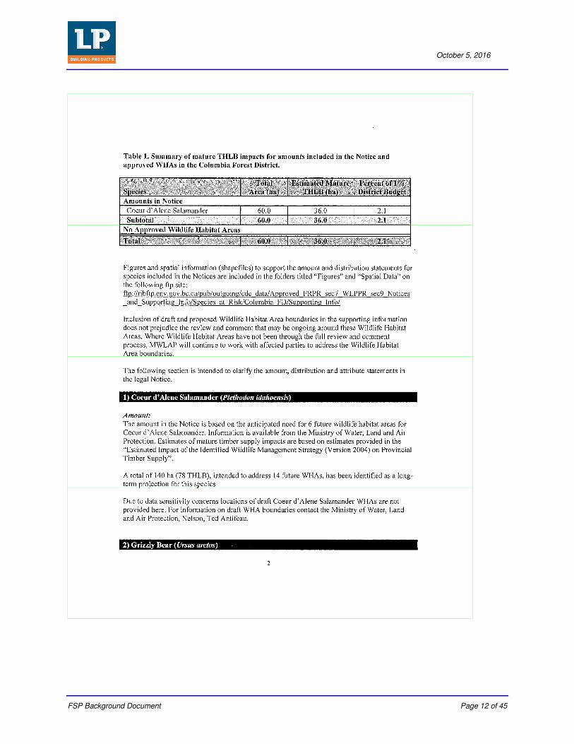
(a) the areas identified on the map “Potential Habitat of Coeur d’Alene Salamander” indicate the potential distribution of the Coeur d’Alene Salamander. Because there is no overlap between potential habitat and the FDUs in this FSP, LP will not be addressing this notice in the text of the FSP document,
(b) LP is exempt to the extent that the Wildlife Habitat Areas # 4-011, 4-014 to 4-017, 4-019 to 4-028, 4-036 and 4-043 addresses the amount included for Coeur d’Alene Salamander in the Notice for the Selkirk Forest District, and
(c) the Wildlife Habitat Areas identified in the GAR Order are outside of the FDUs.

October 5, 2016
FSP Background Document Page 10 of 45
Potential Habitat of Coeur d’Alene Salamander

October 5, 2016
FSP Background Document Page 11 of 45
Information Concerning Wildlife Habitat for the Survival of Species at Risk in the Columbia Forest District
October 5, 2016
FSP Background Document Page 12 of 45

October 5, 2016
FSP Background Document Page 13 of 45

October 5, 2016
FSP Background Document Page 14 of 45
Wildlife Habitat Required for the Winter Survival of Ungulate Species http://www.env.gov.bc.ca/esd/distdata/ecosystems/frpa/Approved_FRPR_sec7_WLPPR_sec9_Notices_and_Supporting_Info/UWR/Timber_Supply_Areas/Golden_TSA/Notice/GoldenTSA_UWR.pdf Information Concerning Wildlife Habitat for the Winter Survival of Ungulate Species http://www.env.gov.bc.ca/esd/distdata/ecosystems/frpa/Approved_FRPR_sec7_WLPPR_sec9_Notices_and_Supporting_Info/UWR/Timber_Supply_Areas/Golden_TSA/Supporting_Info/Docs/Supporting_info_GoldenTSA_UWR.pdf GAR Order – Mountain Caribou Winter Range. U-3-005 - Revelstoke Shuswap Planning Unit
http://www.env.gov.bc.ca/wld/documents/uwr/u-3-005_order_09Dec09.pdf U-4-010 – Kinbasket Planning Unit
http://www.env.gov.bc.ca/wld/documents/uwr/u-4-010_order_09Dec09.pdf

October 5, 2016
FSP Background Document Page 15 of 45
OBJECTIVES SET BY GOVERNMENT FOR WATER, FISH, WILDLIFE AND BIODIVERSITY WITHIN RIPARIAN AREAS
The objective set by government for water, fish, wildlife and biodiversity within riparian areas is, without unduly reducing the supply of timber from British Columbia's forests, to conserve, at the landscape level, the water quality, fish habitat, wildlife habitat and biodiversity associated with those riparian areas.
In relation to the objective set by government for water, fish, wildlife and biodiversity set out in section 8 of the Forest Planning and Practices Regulation, the results or strategies that apply to the areas of primary forest activity in each FDU are, the requirements of section 47 to 51 and 53 of the Forest Planning and Practices.
Section 47 - Stream Riparian Classes
(1) In this section, "active flood plain" means the level area with alluvial soils, adjacent to streams, that is flooded by stream water on a periodic basis and is at the same elevation as areas showing evidence of
(a) flood channels free of terrestrial vegetation, (b) rafted debris or fluvial sediments, recently deposited on the surface of the forest floor or
suspended on trees or vegetation, or (c) recent scarring of trees by material moved by flood waters.
(2) A stream that is a fish stream or is located in a community watershed has the following riparian class:
(a) S1A, if the stream averages, over a one km length, either a stream width or an active flood plain width of 100 m or greater;
(b) S1B, if the stream width is greater than 20 m but the stream does not have a riparian class of S1A;
(c) S2, if the stream width is not less than 5 m but not more than 20 m; (d) S3, if the stream width is not less than 1.5 m but is less than 5 m; (e) S4, if the stream width is less than 1.5 m.
(3) A stream that is not a fish stream and is located outside of a community watershed has the following riparian class:
(a) S5, if the stream width is greater than 3 m; (b) S6, if the stream width is 3 m or less.
(4) Subject to subsections (5) or (6), for each riparian class of stream, the minimum riparian management area width, riparian reserve zone width and riparian management zone width, on each side of the stream, are as follows:
Riparian Class
Riparian Management Area (metres)
Riparian Reserve Zone (metres)
Riparian Management Zone (metres)
S1-A 100 0 100
S1-B 70 50 20
S2 50 30 20
S3 40 20 20
S4 30 0 30

October 5, 2016
FSP Background Document Page 16 of 45
Riparian Class
Riparian Management Area (metres)
Riparian Reserve Zone (metres)
Riparian Management Zone (metres)
S5 30 0 30
S6 20 0 20
(5) If the width of the active flood plain of a stream exceeds the specified width for the riparian management zone, the width of the riparian management zone is the outer edge of the active flood plain.
(6) The minister may specify a riparian reserve zone for a stream with a riparian class of S1-A if the minister considers that a riparian reserve zone is required.
(7) The riparian reserve zone for a stream begins at the edge of the stream channel bank and extends to the width described in subsection (4) or (6).
(8) The riparian management zone for a stream begins at
(a) the outer edge of the riparian reserve zone, or (b) if there is no riparian reserve zone, the edge of the stream channel bank, and extends to the width described in subsection (4) or (5).
Section 48 - Wetland Riparian Classes
(1) Wetlands have the following riparian classes:
(a) W1, if the wetland is greater than 5 ha in size; (b) W2, if the wetland is not less than 1 ha and not more than 5 ha in size and is in one of the
following biogeoclimatic zones or subzones: (i) Ponderosa Pine; (ii) Bunch Grass; (iii) Interior Douglas-fir, very dry hot, very dry warm or very dry mild; (iv) Coastal Douglas-fir; (v) Coastal Western Hemlock, very dry maritime, dry maritime or dry submaritime;
(c) W3, if the wetland is not less than 1 ha and not more than 5 ha in size and is in a biogeoclimatic zone or subzone other than one referred to in paragraph (b);
(d) W4, if the wetland is (i) not less than 0.25 ha and less than 1 ha in size and is in a biogeoclimatic zone or
subzone referred to in paragraph (b) (i), (ii) or (iii), or (ii) not less than 0.5 ha and less than 1 ha in size and is in a biogeoclimatic zone or
subzone referred to in paragraph (b) (iv) or (v).
(2) Despite subsection (1), an area is to be treated as a single wetland with a riparian class of W5 if
(a) the area contains (i) two or more W1 wetlands located within 100 m of each other, (ii) a W1 wetland and one or more non-W1 wetlands, all of which are within 80 m of
each other, or (iii) two or more non-W1 wetlands located within 60 m of each other, and
(b) the combined size of the wetlands, excluding the upland areas, is 5 ha or larger. (3) Subject to subsections (4) and (5), for each riparian class of wetland, the minimum riparian
management area width, riparian reserve zone width and riparian management zone width for the wetland are as follows:

October 5, 2016
FSP Background Document Page 17 of 45
Riparian Class
Riparian Management Area (metres)
Riparian Reserve Zone (metres)
Riparian Management Zone (metres)
W1 50 10 40
W2 30 10 20
W3 30 0 30
W4 30 0 30
W5 50 10 40
(4) No riparian reserve zone or riparian management zone extends onto any enclosed upland areas in a W1 wetland if the wetland is
(a) located in a boreal, subboreal or hyper-maritime climate, and (b) greater than 1 000 ha in size.
(5) If the minister considers it necessary for a riparian reserve zone or riparian management zone to extend onto an enclosed upland area, the minister may require either or both of the following:
(a) a riparian reserve zone of a width of 10 m or less; (b) a riparian management zone of a width of 40 m or less.
(6) The riparian reserve zone for a wetland begins at the edge of the wetland and extends to the width described in subsection (3) or (5).
(7) The riparian management zone for a wetland begins at
(a) the outer edge of the riparian reserve zone, or (b) if there is no riparian reserve zone, the edge of the wetland, and extends to the width described in subsection (3) or (5).
Section 49 - Lake Riparian Classes
(1) Lakes have the following riparian classes:
(a) L1-A, if the lake is 1 000 ha or greater in size; (b) L1-B, if
(i) the lake is greater than 5 ha but less than 1 000 ha in size, or (ii) the minister designates the lake as L1-B;
(c) L2, if the lake is not less than 1 ha and not more than 5 ha in size and is located in a biogeoclimatic zones or subzone that is (i) Ponderosa Pine, (ii) Bunch Grass, (iii) Interior Douglas-fir, very dry hot, very dry warm or very dry mild, (iv) Coastal Douglas-fir, or (v) Coastal Western Hemlock, very dry maritime, dry maritime or dry submaritime;
(d) L3, if the lake is not less than 1 ha and not more than 5 ha in size and is in a biogeoclimatic zone or subzone other than one referred to in paragraph (c);
(e) L4, if the lake is (i) not less than 0.25 ha and not more than 1 ha in size and is in a biogeoclimatic
zone or subzone referred to in paragraph (c) (i), (ii) or (iii), or
(ii) not less than 0.5 ha and not more than 1 ha in size and is in a biogeoclimatic zone or subzone referred to in paragraph (c) (iv) or (v).

October 5, 2016
FSP Background Document Page 18 of 45
(2) Subject to subsection (3), for each riparian class of lake, the minimum riparian management area width, riparian reserve zone width and riparian management zone width are as follows:
Riparian Class
Riparian Management Area (metres)
Riparian Reserve Zone (metres)
Riparian Management Zone (metres)
L1-A 0 0 0
L1-B 10 10 0
L2 30 10 20
L3 30 0 30
L4 30 0 30
(3) If the minister considers it necessary, the minister may specify a riparian management area and a riparian reserve zone for a lake with a riparian class of L1-A.
(4) The riparian reserve zone for a lake begins at the edge of the lake and extends to the width described in subsection (2) or (3).
(5) The riparian management zone for a lake begins at (a) the outer edge of the riparian reserve zone, or (b) if there is no riparian reserve zone, the edge of the lake, and extends to the width described in subsection (2) or (3).
Section 50 - Restrictions in a Riparian Management Area
(1) A person must not construct a road in a riparian management area, unless one of the following applies: (a) locating the road outside the riparian management area would create a higher risk of
sediment delivery to the stream, wetland or lake to which the riparian management area applies;
(b) there is no other practicable option for locating the road; (c) the road is required as part of a stream crossing.
(2) If a road is constructed within a riparian management area, a person must not carry out road maintenance activities beyond the clearing width of the road, except as necessary to maintain a stream crossing.
(3) A person who is authorized in respect of a road must not remove gravel or other fill from within a riparian management area in the process of constructing, maintaining or deactivating a road, unless: (a) the gravel or fill is within a road prism, (b) the gravel or fill is at a stream crossing, or (c) there is no other practicable option.
Section 51 - Restrictions in a Riparian Reserve Zone
(1) An agreement holder must not cut, modify or remove trees in a riparian reserve zone, except for the following purposes:
(a) felling or modifying a tree that is a safety hazard, if there is no other practicable option for addressing the safety hazard;
(b) topping or pruning a tree that is not wind firm; (c) constructing a stream crossing; (d) creating a corridor for full suspension yarding;

October 5, 2016
FSP Background Document Page 19 of 45
(e) creating guyline tiebacks; (f) carrying out a sanitation treatment; (g) felling or modifying a tree that has been windthrown or has been damaged by fire, insects,
disease or other causes, if the felling or modifying will not have a material adverse impact on the riparian reserve zone;
(h) felling or modifying a tree under an occupant licence to cut, master licence to cut or free use permit issued in respect of an area that is subject to a license, permit, or other form of tenure issued under the Land Act, Coal Act, Geothermal Resources Act, Mines Act, Mineral Tenure Act, Mining Right of Way Act, Petroleum and Natural Gas Act or Pipeline Act, if the felling or modification is for a purpose expressly authorized under that licence, permit or tenure;
(i) felling or modifying a tree for the purpose of establishing or maintaining an interpretative forest site, recreation site, recreation facility or recreation trail.
(2) An agreement holder who fells, tops, prunes or modifies a tree under subsection (1) may remove the tree only if the removal will not have a material adverse effect on the riparian reserve zone.
(3) An agreement holder must not carry out the following silviculture treatments in a riparian reserve zone:
(a) grazing or broadcast herbicide applications for the purpose of brushing; (b) mechanized site preparation or broadcast burning for the purpose of site preparation; (c) spacing or thinning.
Section 52 - Restrictions in a riparian management zone
(2) An authorized person who cuts, modifies or removes trees in a riparian management zone for an S4, S5 or S6 stream that has trees that contribute significantly to the maintenance of stream bank or channel stability must retain enough trees adjacent to the stream to maintain the stream bank or channel stability, if the stream
(a) is a direct tributary to an S1, S2 or S3 stream,
(b) flows directly into the ocean, at a point near to or where one or more of the following is located: (i) a herring spawning area; (ii) a shellfish bed; (iii) a saltwater marsh area; (iv) an aquaculture site; (v) a juvenile salmonid rearing area or an adult salmon holding area, or
Table 2. Stream Basal Area Retention Table
Stream Classification
Riparian Management Zone Requirements and Basal Area Retention Strategies
Fish Bearing Streams
Non-Fish Bearing Streams
Channel Width (m)
RMZ Width (m)
Windthrow Hazard
% Basal Area Retention
S1-A >100 100 All ≥20
S1-B >20 20 All ≥20
S2 5-20 20 All ≥20
S3 1.5-5 20 All ≥20
S4 < 1.5 30 High
Medium-Low ≥0
≥10
S5 >3 30 High
Medium-Low ≥0
≥10
S6 ≤3 20 All ≥0

October 5, 2016
FSP Background Document Page 20 of 45
Table 3. Wetland Basal Area Retention Table
Wetland Classification
Riparian Management Zone Requirements and Basal Area Retention Strategies
Riparian Class Size (ha)
RMZ Width (m)
Windthrow Hazard
% Basal Area Retention
W1 >5 40 All ≥10
W3 1-5 30 All ≥10
W5 Wetland complex1
40 All ≥10
Table 4. Lake Basal Area Retention Table
Lake Classification
Lake Management Zone Requirements and Basal Area Retention Strategies
Riparian Class Size (ha)
RMZ Width (m)
Windthrow Hazard
% Basal Area Retention
L1-A > 1000 0 All NA
L1-B 5-1000 0 All NA
L3 1-5 30 All ≥10
1Wetland complexes are two or more adjacent wetlands totaling five hectares or more with overlapping RMA’s.
Section 53 - Temperature Sensitive Streams
An authorized person who fells, modifies or removes trees in a riparian management area adjacent to a temperature sensitive stream, or a stream that is a direct tributary to a temperature sensitive stream, must retain either or both of the following in an amount sufficient to prevent the temperature of the temperature sensitive stream from increasing to an extent that would have a material adverse impact on fish:
(a) streamside trees whose crowns provide shade to the stream; (b) understory vegetation that provides shade to the stream.
Stream crossings
55 (1) An authorized person who builds a stream crossing as part of a road, a temporary access structure or permanent access structure must locate, build and use the crossing in a manner that
(a) protects the stream channel and stream bank immediately above and below the stream crossing, and
(b) mitigates disturbance to the stream channel and stream bank at the crossing.
(2) An authorized person who builds a stream crossing as part of a temporary access structure must remove the crossing when it is no longer required by the person.

October 5, 2016
FSP Background Document Page 21 of 45
Fish passage
56 (1) An authorized person who carries out a primary forest activity must ensure that the primary forest activity does not have a material adverse effect on fish passage in a fish stream.
(2) An authorized person who maintains a fish stream crossing built after June 15, 1995, must ensure that the crossing does not have a material adverse effect on fish passage.
(3) Despite subsections (1) and (2), an authorized person may temporarily allow a material adverse effect on fish passage to construct, maintain or deactivate a road, including a stream crossing, if
(a) fish are not migrating or spawning, and
(b) the source of the material adverse effect is removed immediately on completion of the construction, maintenance or deactivation.
Protection of fish and fish habitat
57 An authorized person who carries out a primary forest activity must conduct the primary forest activity at a time and in a manner that is unlikely to harm fish or destroy, damage or harmfully alter fish habitat.
Use of livestock in riparian areas
58 An agreement holder who uses livestock for site preparation or brush control for the purpose of carrying out a silviculture treatment must not
(a) construct a livestock corral
(i) in a riparian management area,
(ii) on an area that drains directly into a fish stream or a fish-bearing wetland or lake, or
(iii) on an area in a community watershed that drains directly into a potable water source, or
(b) use the livestock in a riparian management area that is in a community watershed.
Division 4 — Watersheds
Protecting water quality
59 An authorized person who carries out a primary forest activity must ensure that the primary forest activity does not cause material that is harmful to human health to be deposited in, or transported to, water that is diverted for human consumption by a licensed waterworks.
Licensed waterworks
60 (1) An authorized person who carries out a primary forest activity must ensure that the primary forest activity does not damage a licensed waterworks.

October 5, 2016
FSP Background Document Page 22 of 45
OBJECTIVES SET BY GOVERNMENT FOR WILDLIFE AND BIODIVERSITY – LANDSCAPE LEVEL
The objective set by government for wildlife and biodiversity at the landscape level is, without unduly reducing the supply of timber from British Columbia's forests and to the extent practicable, to design areas on which timber harvesting is to be carried out that resemble, both spatially and temporally, the patterns of natural disturbance that occur within the landscape.
In relation to the objective set by government for wildlife and biodiversity set out in Section 9 of the Forest Planning and Practices Regulation, LP adopts as the results or strategies Section 64 and 65 of the FPPR.
Section 64 (1) If an agreement holder other than a holder of a minor tenure harvests timber in a cutblock, the holder must ensure that the size of the net area to be reforested for the cutblock does not exceed
(a) 40 hectares for areas located in the Kootenay Boundary Forest Region, South Coast Forest Region, Thompson Okanagan Forest Region or West Coast Forest Region, as established by the Administrative Boundaries Regulation, and
(b) 60 hectares for areas located in the Cariboo Forest Region, Northeast Forest Region, Omineca Forest Region or Skeena Forest Region, as established by the Administrative Boundaries Regulation.
(2) Subsection (1) does not apply to an agreement holder where
(a) timber harvesting
(i) is being carried out on the cutblock
(A) to recover timber damaged by fire, insect infestation, wind or other similar events, or
(B) for sanitation treatments, or
(ii) is designed to be consistent with the structural characteristics and the temporal and spatial distribution of an opening that would result from a natural disturbance, and
(b) the holder ensures, to the extent practicable, that the structural characteristics of the cutblock after timber harvesting has been substantially completed resemble an opening that would result from a natural disturbance.
(3) Subsection (1) does not apply if the timber harvesting that is being carried out on the cutblock retains 40% or more of basal area of the stand that was on the cutblock before timber harvesting.
(4) Subsection (1) does not apply if no point within the net area to be reforested is
(a) more than two tree lengths from either
(i) the cutblock boundary, or
(ii) a group of trees reserved from harvesting that is greater than or equal to 0.25 ha in size, or
(b) more than one tree length from a group of trees reserved from timber harvesting that is less than 0.25 ha in size.

October 5, 2016
FSP Background Document Page 23 of 45
Harvesting adjacent to another cutblock
Section 65 (1) In this section:
"adjacent" means an area that is sufficiently close to a cutblock that, due to its location, could directly impact on, or be impacted by, a forest practice carried out within the cutblock;
"existing cutblock" means a cutblock that was previously harvested under an agreement other than a minor tenure;
"new cutblock" means a cutblock on which harvesting has not yet started and that is adjacent to an existing cutblock;
"non-conforming portion" means an area within an existing cutblock on which the stocking and height requirements of subsection (3) have not been met.
(2) An agreement holder other than a holder of a minor tenure must not harvest timber on a new cutblock, unless
(a) all existing cutblocks that are adjacent to the new cutblock meet the requirements set out in subsection (3), or
(b) the combined area of the new cutblock and any non-conforming portions that are immediately adjacent to the new cutblock does not exceed the requirements relating to cutblock size set out in section 64 (1) [maximum cutblock size].
(3) For the purpose of subsection (2) (a), an existing cutblock must meet the criteria set out in one of the following paragraphs:
(a) at least 75% of the net area to be reforested of the existing cutblock is stocked such that the average height of the tallest 10% of the trees on the area is a minimum of 3 m and
(i) is stocked in accordance with the applicable stocking standards, as described under section 16 [stocking standards],
(ii) if the area is on the Coast, other than the Nass timber supply area, is stocked with at least 500 trees/ha of a commercially valuable species that are at least 1.3 m in height, or
(iii) if the area is in the Interior or in the Nass timber supply area, is stocked with at least 700 trees/ha of a commercially valuable species that are at least 1.3 m in height;
(b) the part of the net area to be reforested of the existing cutblock that is closest to the new cutblock
(i) must be at least half of the net area to be reforested,
(ii) is stocked such that the average height of the tallest 10% of the trees on the area is a minimum of 3 m, and
(iii) is stocked
(A) in accordance with the applicable stocking standards for that cutblock, as described under section 16,
(B) if the area is on the Coast, other than the Nass timber supply area, with at least 500 trees/ha of a commercially valuable species that are at least 1.3 m in height, or
(C) if the area is in the Interior or in the Nass timber supply area, with at least 700 trees/ha of a commercially valuable species that are at least 1.3 m in height.
(4) Subsection (2) does not apply if section 64 (2), (3) or (4) apply to the new cutblock.

October 5, 2016
FSP Background Document Page 24 of 45
MAPS
Eleven maps of 1:50,000 scale provide all the necessary information. The map identifies the features required by
the FPPR (Section 14), where applicable, in effect on the date of submission of this FSP.
Scale 1:50,000 FPPR Requirements displayed on map:
♦ FDU’s North and South
♦ Ungulate Winter Range: Caribou and Section 7 UWR
♦ Wildlife Habitat Areas: None
♦ Fisheries sensitive watershed: None
♦ Scenic Areas: Visual Polygons
♦ L1 Lakes: Several throughout each FDU
♦ Community watersheds: None
♦ Areas where timber harvesting is prohibited by enactment: Parks, KHMR
♦ Cutting Permits
♦ Road Permit roads

October 5, 2016
FSP Background Document Page 25 of 45
Spatial Deployment of KBHLP Biodiversity – Caribou Objectives have been replaced by GAR Orders. Only the Biodiversity information is pertinent to the FSP.

October 5, 2016
FSP Background Document Page 26 of 45

October 5, 2016
FSP Background Document Page 27 of 45
October 5, 2016
FSP Background Document Page 28 of 45

October 5, 2016
FSP Background Document Page 29 of 45

October 5, 2016
FSP Background Document Page 30 of 45

October 5, 2016
FSP Background Document Page 31 of 45

October 5, 2016
FSP Background Document Page 32 of 45

October 5, 2016
FSP Background Document Page 33 of 45

October 5, 2016
FSP Background Document Page 34 of 45

October 5, 2016
FSP Background Document Page 35 of 45

October 5, 2016
FSP Background Document Page 36 of 45

October 5, 2016
FSP Background Document Page 37 of 45

October 5, 2016
FSP Background Document Page 38 of 45
October 5, 2016
FSP Background Document Page 39 of 45

October 5, 2016
FSP Background Document Page 40 of 45
OBJECTIVE SET BY GOVERNMENT FOR VISUAL QUALITY
The objectives set by government for visual quality are enacted by the Government Actions Regulation Sections 7 (1) and 7 (2) and read as follows:
LP will be guided by the definitions of the VQO classes found in FPPR section 1.1, and MFLNRO documents related to visual design. The Visual Impact Assessment Guidebook can be found at the following website http://www.for.gov.bc.ca/TASB/LEGSREGS/FPC/FPCGUIDE/visual/Httoc.htm.

October 5, 2016
FSP Background Document Page 41 of 45
OBJECTIVE SET BY GOVERNMENT FOR CULTURAL HERITAGE RESOURCES
The objective set by government for cultural heritage resources is to conserve, or, if necessary, protect cultural heritage resources that are
(a) the focus of a traditional use by an aboriginal people that is of continuing importance to that people, and
(b) not regulated under the Heritage Conservation Act.
OBJECTIVES IN RESPECT OF SENSITIVE WATERSHEDS
No Sensitive Watersheds have been established under the Government Actions Regulation or grand-parented under section 180 and 181 of the Forest and Range Practices Act that apply to the FDUs of this forest stewardship plan.
OBJECTIVES IN RESPECT OF COMMUNITY WATERSHEDS
No Community Watersheds have been established under the Government Actions Regulation or grand-parented under section 180 and 181 of the Forest and Range Practices Act that apply to the FDUs of this forest stewardship plan.
FISHERIES SENSITIVE WATERSHED OBJECTIVES
No fisheries sensitive watersheds have been established under the Government Actions Regulation or grand-parented under section 180 and 181 of the Forest and Range Practices Act that apply to the FDUs of this forest stewardship plan.

October 5, 2016
FSP Background Document Page 42 of 45
Stocking Standards Background Information Vole Damage to Plantations – Documentation/Study verifying Stocking Standard
THE UNIVERSITY OF BRITISH COLUMBIA
Department of Forest Sciences Faculty of Forestry 3rd Floor, Forest Sciences Centre 3041 – 2424 Main Mall Vancouver, B.C. Canada V6T 1Z4 Tel: (604) 822-2507 Fax: (604) 822-9102
January 25, 2010. Mr. Scott King, Louisiana-Pacific Canada Ltd., P.O. Box 170, Golden, BC V0A 1H0 Dear Scott: Re: Vole damage to planted trees in Glenogle, Roth, and Palliser Drainages This letter confirms our various discussions and study results outlining the high populations of voles (primarily the long-tailed vole, Microtus longicaudus) in the Glenogle, Roth, and Palliser drainages east of Golden. At 3-4 years post-clearcut harvesting is a critical time for population buildups of voles and subsequent damage to plantation trees. Clearcuts and their associated vegetative development provide conditions for high populations of voles. Thus, during the period 2000 to 2007 in Glenogle and Roth Creeks, and now (2009-2010) in Palliser Creek, vole numbers reached levels high enough to drive plantations to NSR status, thereby requiring re-planting of units. Voles prefer to feed on lodgepole pine and Douglas-fir seedlings. Spruce, larch, and subalpine fir, in that descending order, are less preferred food sources. Thus, where appropriate, these alternate species could be planted and should be less damaged than lodgepole pine or Douglas-fir. I hope this outline provides sufficient information on feeding damage to planted trees and some options for regeneration. Please let me know if I may be of further assistance. Yours sincerely,
Thomas P. Sullivan Professor E-mail: [email protected]

October 5, 2016
FSP Background Document Page 43 of 45
Regeneration Delay Extension in Areas with Known Vole Populations
Situations and circumstances where these clauses are intended to apply: These clauses are intended to be used within LP’s operating area within drainages where there are high populations of voles causing significant damage to cut block plantations.
The area outlined below has been identified by a qualified Small Mammal Researcher Dr. Tom Sullivan as having a high population build-up of voles. Drainages may be deemed to be added should they be identified by a professional as having a high population build-up of voles. A letter providing their professional opinion will be retained on file.
Within Landscape Unit G26, in the ICHmk1, ICHmw1 and MSdk the regeneration delay can be extended up to 7 years after the commencement of harvest.
SUPPORTING DOCUMENTATION:
VOLE POPULATIONS AND TIMING OF PLANTING CUTOVER SITES
Voles of the genus Microtus are considered one of the major mammalian pests in coniferous tree plantations in the Golden TSA. Two species of Microtus, the long-tailed vole and the meadow vole, are implicated as major consumers of tree seedlings. A third species, the heather vole, is also present in these small mammal communities but exists at low abundance. Voles will feed on tree seedlings and saplings, with highest damage during winter months of peak years in abundance. These rodents feed on bark, vascular tissues, and sometimes roots of tree. This damage results in direct mortality from girdling and clipping of tree stems or reduced growth of surviving trees which have sub-lethal injuries. The fertilization regime of nursery-raised seedlings enhances their palatability and nutrition, thereby predisposing them to preferential feeding over wildlings that arise from natural regeneration. Voles also feed preferentially on particular tree species: Lodgepole pine, Douglas-fir, and spruce.
How many voles need to occur in a given plantation to create a serious damage problem? A risk rating for feeding damage to trees, based on an index-line or grid survey of voles, is derived from the significant positive relationship between percentage tree mortality and abundance of Microtus voles.
Number of voles per ha Risk of damage to trees: < 7 Low
7 – 34 Moderate 35 – 88 High
> 88 Very High
To determine when voles will be a problem, vole populations were monitored on sampling grids for six years (2004-2009) at Roth Creek and Glenogle Creek, since the time of harvesting, to follow how these rodents respond to successional change and reach densities capable of serious feeding damage to newly planted trees. Over 29 trapping periods, the long-tailed vole was the most abundant microtine with a total of 625 individuals captured (96.7% of total Microtus), followed by 21 meadow voles, 113 red-backed voles, and 104 heather voles. Populations of long-tailed voles were low in the first year after harvest with mean numbers < 5/ha. Mean numbers in the second post-harvest year reached 15/ha and had a strong annual cycle with up to 43 animals/ha in September. Annual maximum densities of 49-84 voles/ha were recorded in 2006, which seemed to be the peak populations on the three grids. However, in the fourth year (2007) since harvesting, numbers of long-tailed voles declined, particularly on grids D and F, while grid E remained high reaching an annual maximum of 82/ha. This decline deepened in 2008 and reached extirpation on two of three grids in 2009.
Feeding damage is associated with: 1) High populations of voles, 2) Early successional habitats after harvesting, and

October 5, 2016
FSP Background Document Page 44 of 45
3) Trees planted shortly after harvesting.
What to do? If planting of cutover sites does not have to be done immediately after harvest, to avoid competing vegetation, or for other reasons, then: 1) Delay planting until at least the 4th or 5th year after clearcutting, 2) Plant fast growing species Pl and larch > Douglas fir > spruce, 3) Use larger stock, and higher densities, where possible.
Thomas P. Sullivan, Ph.D. Director and Research Scientist Applied Mammal Research Institute Summerland, BC E-mail: [email protected] Website: www.appliedmammal.com
Free Growing Assessment of Trees with a Visible Stem Wound
This clause is intended to be used within LP’s operating area where there is an obligation to establish a free growing stand, the type of Free Growing Damage being assessed is a wound, the tree is at least 15 years old and greater than 4 meters in height.
SUPPORTING DOCUMENTATION: Barnes, V.G. Jr., and R.M. Engeman. 1995. Black bear damage to lodgepole pine in central Oregon. Northwestern Naturalist. 76:127-129.
Miller, Richard E.; Anderson, Harry W.; Reukema, Donald L.; Max, Timothy A. 2007. Growth of bear damaged trees in a mixed plantation of Douglas-fir and red alder. Res. Pap. PNW-RP-571. Portland, OR: U.S. Department of Agriculture, Forest Service, Pacific Northwest Research Station. 29 p.
Radwan, M.A. 1969. Chemical composition of the sapwood of four tree species in relation to feeding by the black bear. Forest Science. 15: 11-16.
Shea, K.R. 1967. Effect of artificial root and bole injuries on diameter increment of Douglas-fir.
Weyerhaeuser For. Pap. 11. Centralia, WA: Weyerhaeuser Company. 11 p
IMPACT OF PARTIAL GIRDLING BY MAMMALS ON TREE GROWTH AND SURVIVAL:
Several species of mammals feed on the bark and vascular tissues of coniferous trees. Species include voles of the genus Microtus, snowshoe hares, red squirrels, porcupines, and bears (both black and brown). Regardless of the pest species, removal of bark and vascular tissues likely has the same impact on tree growth and survival. The impact of this feeding damage, by hares and squirrels, on tree growth and wood quality in young lodgepole pine concluded that severe partial girdling (50-99%) of stem circumference suppressed diameter and height growth of small-diameter (4.1-6.0 cm) trees, but had no effect on larger stems (6.1-8.0 cm). In some situations, diameter increment increased significantly with degree of partial girdling. This trend may be related to animals preferentially feeding on more vigorous stems.
For bear damage to coniferous trees, nearly all reports concluded that vigorous stems are preferred over those growing in dense stands or on poor sites. Severe partial girdling (> 50%) of larger stems by bears and porcupines seems to be the level where impacts on growth and survival may be highest.
Thus, a 50% partial girdling level would seem reasonable as a cut-off for acceptable trees in free-growing surveys. Other damaging agents such as Warren’s root collar weevil and Atropellis canker that affect stem circumference in terms of partial girdling suggested that 60% likely resulted in a significant reduction in diameter and height growth of lodgepole pine. Please see other references in the publications below (attached as pdfs).

October 5, 2016
FSP Background Document Page 45 of 45
Sullivan, T.P. 1993. Feeding damage by bears in managed forests of western hemlock – western red cedar in midcoastal British Columbia. Can. J. For. Res. 23: 49-54.
Sullivan, T.P., H. Coates, L.A. Jozsa, and P.K. Diggle. 1993. Influence of feeding damage by small mammals on tree growth and wood quality in young lodgepole pine. Can. J. For. Res. 23: 799-809.
Thomas P. Sullivan, Ph.D. Director and Research Scientist Applied Mammal Research Institute Summerland, BC E-mail: [email protected] Website: www.appliedmammal.com
Armillaria ostoyae Root Disease
Brushing deciduous species is not recommended on DRA sites as brushed stumps increase the inoculum on site and contribute to the spread of DRA.
SUPPORTING DOCUMENTATION:
Cleary, M., B. van der Kamp, and D. Morrison. 2008. British Columbia’s southern interior forests: Armillaria root disease stand establishment decision aid. BC Journal of Ecosystems and Management 9(2):60–65.
Retention of windrows and slash piles This clause is intended to be used throughout LP’s A17645 and A82664 Forest Licenses. SUPPORTING DOCUMENTATION: Gyug, L.W. 1994. Wildlife use of logging debris piles in clearcuts. Final Report. B.C. Ministry of Environment. Penticton, B.C. 45 p. Klenner, W. and T.P. Sullivan. 2003. Partial and clearcut harvesting of high-elevation spruce-fir forests: Implications for small mammal communities. Canadian Journal of Forest Research 33: 2283-2296. Lisgo K.A., F.L. Bunnell, and A.S. Harestad. 2002. Summer and fall use of logging residue piles by female short-tailed weasels. USDA For. Serv. Gen. Tech. Rep. PSW-GTR-181. Pp. 319-330. Sullivan, T.P. and D.S. Sullivan. 2001. Influence of variable retention harvests on forest ecosystems: II. Diversity and population dynamics of small mammals. Journal of Applied Ecology 38: 1234-1252. Sullivan, T.P., D.S. Sullivan, and P.M.F. Lindgren. 2008. Influence of variable retention harvests on forest ecosystems: Plant and mammal responses up to 8 years post-harvest. Forest Ecology Management 254: 239-254. Sullivan, T.P., D.S. Sullivan, P.M.F. Lindgren, D.B. Ransome, J.G. Bull, and C. Ristea. 2011. Bioenergy or biodiversity? Woody habitat structures and maintenance of red-backed voles on clearcuts. Submitted to a scientific journal. Sullivan, T.P., D.S. Sullivan, P.M.F. Lindgren, and D.B. Ransome. 2011. Conservation implications of woody debris as habitat structures on clearcuts: Abundance and diversity responses of mammals. Submitted to a scientific journal. Sullivan, T.P. and D.S. Sullivan. 2011. Woody debris, voles, and trees: Influence of habitat structures (piles and windrows) on long-tailed vole populations and feeding damage. Submitted to a scientific journal.