fort knox jlus executive committeeltadd.org/pdf/jlus-2008.pdf · fort knox, kentucky joint land use...
TRANSCRIPT
Fort Knox, Kentucky
JOINT LAND USE STUDY (JLUS)
2008 Update
Prepared for:
FORT KNOX JLUS EXECUTIVE COMMITTEE
June, 2008
This manual was prepared under contract from Lincoln Trail Area Development District, Elizabethtown, Kentucky, with financial support provided by the Office of Economic
Adjustment, Department of Defense. The content reflects the views of Lincoln Trail Area Development District and does not necessarily reflect the views of the Office of Economic
Adjustment
TABLE OF CONTENTS Page
SECTION I: Description of Joint Land Use Study 1 Purpose 1 Scope 2 Organization 2 Study Methodology 3 SECTION II: Study Area Profile 5 Study Area Boundaries 5 Physical Setting and Population 5 Study Area Land Use 6 Physical Features 10 Utility Services Infrastructure 19 Transportation 24 Mission Encroachment 32 Noise/Vibrations 37 Compatible Land Use Buffer Zone 39 SECTION III: Land Use and Mission Compatibility Plan 58 Impact Analysis 58 Goals and Objectives 63 SECTION IV: Implementation Schedule 67 List of Appendices Appendix A-Kentucky Transportation Cabinet Six-Year Highway Plan Appendix B-Summary of State and Federal Economic Development Incentive and Assistance Programs Appendix C-Maps
Section I Description of Joint Land Use Study
SECTION I
DESCRIPTION OF JOINT LAND USE STUDY
PURPOSE Fort Knox is a compelling economic, historic, and cultural presence in our tri-county region. It is a certified Kentucky City covering approximately 170.4 square miles; the seventh largest community in Kentucky. Fort Knox was occupied by American Soldiers as early as the civil War, and the government considered the site for a military post in 1903. Congress allocated $1.6 million to purchase 40,000 acres in 1918 and construction of facilities began in July of that year. The installation is named after Henry Knox, our nation’s first Secretary of War. The U.S. Treasury Department started construction of the U.S. Bullion Depository in 1936; the facility received its first shipments of our nation’s gold reserves in January of 1937. The Patton Museum was established in 1949. It contains the history of the U.S. Army armor and cavalry. Military activity in Kentucky and our tri-county area is a major source of employment. It represents sales for Kentucky companies, and tax revenues for our local units of government and the Commonwealth. Bullitt, Hardin and Meade Counties worked hard to prevent the downsizing or closing of the Installation during the 2005 round of BRAC. Their determination to make the transitions associated with the training mission changes at Fort Knox, as a result of the 2005 BRAC decision, as well as their desire to demonstrate their ongoing support of Fort Knox now and well into the future, is demonstrated in the goals and objectives of the 2008 updated Joint Land Use Study (JLUS).
The Joint Land Use Study (JLUS) is a collaborative land use planning effort involving the Fort Knox Military Installation and adjacent local governments in Bullitt, Hardin and Meade Counties. The study evaluates the planning rationale necessary to support and encourage compatible land use development surrounding the installation. Its
1
Section I Description of Joint Land Use Study
purpose is to provide land use support to sustain and provide flexibility to the military missions on Fort Knox, while guiding the long-term land use needs of the neighboring counties and communities. SCOPE The scope of this JLUS is divided into three major tasks: Task 1. Impact Analysis: Impact analysis provides an in-depth review of existing and proposed land use patterns: drainage, as it affects land use designations; mission encroachment, particularly noise; transportation improvements, existing and proposed routes; and, noise/vibration as presented in the Fort Knox Installation Compatible Use Zone (ICUZ) Study Update, June, 1992. Task 2. Land Use and Mission Compatibility: The Land Use and Mission Compatibility Plan examines the Task 1 findings to identify conflicts in land use and provide alternative land use solutions: to project the impact on growth potential for adjacent areas; and to project the impact of the military missions on the surrounding jurisdictions. Task 3. Implementation: Implementation lists a series of actions and proposals for adoption by local jurisdictions to resolve land use conflicts and move toward a compatible land use plan for the Installation and adjacent counties and communities therein. While this report makes certain recommendations, it must be kept in mind that each participating jurisdiction must decide which JLUS recommendations are best suited to their particular needs. Implementation will follow the final recommendations at the discretion of the elected officials in each jurisdiction and the military command at Fort Knox. ORGANIZATION The Fort Knox JLUS was organized and carried out in the following manner. A JLUS Executive Committee was established consisting of the chief elected official of each affected local unit of government; a representative of the Commanding General at Fort Knox; and the
2
Section I Description of Joint Land Use Study
Executive Directors of the Kentuckiana Regional Planning and Development Agency (KIPDA) and the Lincoln Trail Area Development District (LTADD). The twelve-member executive committee established a JLUS Technical Committee that was responsible for planning, coordination, and technical review of the planning process. This committee consists of the planning commission representatives and professional staffs of the agencies and jurisdictions involved. The LTADD serves as the project administrator and legal grantee for funds from the Office of Economic Adjustment, U.S. Department of Defense. The JLUS Executive Committee, through the project administrator, engaged CGI-International, Inc., a private planning consulting firm to assist in the preparation of technical studies, analysis and report preparation. CGI-International, Inc. in turn, established a team with sub-consultants specializing in infrastructure analysis, engineering and public participation and input. STUDY METHODOLOGY The flow of work activities that lead to this report’s findings and recommendations are listed below: Task 1. Impact Analysis
a. Land use—existing and future b. Drainage—surface impact c. Mission Encroachment—training activities d. Transportation—existing and proposed e. Noise/Vibration—ICUZ Study Update
Task 2. Land Use Mission Compatibility Plan
a. Findings from Impact Analysis b. Goals and objectives c. Alternative land use solutions d. Impact from growth potential e. Impact of military mission
3
Section I Description of Joint Land Use Study
4
Task 3. Implementation Schedule a. Schedule for implementing the plan recommendations
listed by appropriate local government. Technical review of the planning studies and impact analysis, was undertaken by the JLUS Technical Committee, with each member providing the technical expertise on their particular jurisdiction. The citizen input process consisted primarily of placing monthly news articles in various local news publications and radio station broadcasts. The articles and news media coverage kept the communities aware of the study progress and solicited comments. In addition, two sets of public input meetings were held. Meetings in each of the three counties were held during the early phase of the Impact Analysis and later to present the alternative recommendations for each county. Upon completing the JLUS Report, an area-wide public hearing was held, to present final recommendations, and solicit citizen comments on the report’s recommendations.
Section II Study Area Profile
SECTION II
STUDY AREA PROFILE
STUDY AREA BOUNDARIES The larger JLUS study area consists of the three counties adjacent to Fort Knox. Meade, Hardin and Bullitt Counties all realize some degree of impact due to their proximity to the Installation. However, in an attempt to fulfill the purpose of the JLUS, which is to encourage compatible development, the primary study area was drawn to include only those areas likely to experience the greatest impact. (See Map A). The primary study area boundary was established by evaluating a number of factors:
• The area identified in the Fort Knox ICUZ Study Update, June, 1992, by noise contour
• The groundwater drainage fields; and • The existing and proposed infrastructure serving the
installation and environs.
This primary study area was the major focus of the planning effort. However, broader analysis was conducted to insure that the recommendations made were consistent with the larger area-wide regional pattern of development. PHYSICAL SETTING AND POPULATION The Fort Knox Military Installation is located on the Ohio River approximately 30 miles south of Louisville, Kentucky. The Reservation consists of 109,069 acres located in parts of three counties, Meade, Hardin and Bullitt. (See Map B.) The following communities are adjacent to the installation: Shepherdsville is northeast of the boundary along I-65; Bardstown Junction and Clermont lie east of the reservation along KY 61 and KY 245, respectively. Both Colesburg and the City of Lebanon Junction are located to the southeast of the Reservation. Elizabethtown is located approximately 12 miles south of Fort Knox along with the communities of Rineyville and Cecilia.
5

Section II Study Area Profile
Radcliff lies between Elizabethtown and the Reservation and Vine Grove is southwest of Radcliff. The City of Muldraugh, in Meade County, is completely surrounded by the northwestern sector of the Reservation, along US 31W/US 60. Directly north of Fort Knox is the Hardin County Community of West Point. The Meade County communities of Flaherty and Garrett are located to the west of the Reservation; Brandenburg is northwest of Fort Knox. Population data for the JLUS area is provided in Appendix D. STUDY AREA LAND USE Historic Overview of Fort Knox Since 1918, the Fort Knox military reservation has served as an important and integral training component for active duty and reserve Army troops. Known as “The Home of Armor,” Fort Knox can date its training role back as early as 1862, when the 6th Michigan Infantry constructed defensive fortifications adjacent to the current reservation. The area saw both Union and Confederate troop activity during the Civil War. In the early 1900’s, the Army conducted large-scale maneuvers in the vicinity of what is now the main traffic circle on post. Congress was studying the feasibility of developing an installation in the general area when the United States became involved in World War I. In January 1918, 10,000 acres were leased and four artillery-training centers were established. That summer, $1.6 million was allocated by the Congress to acquire 40,000 acres and initiate construction of the training facilities. With the signing of the Armistice, Fort Knox saw a lessening of its importance as a regular Army training facility. Needing large land areas with varied terrain, the “Mechanized Cavalry Brigade” was relocated to Fort Knox in 1931. The first element of the Armored Force was developed and tested here. Congress designated Fort Knox as a permanent facility in January of 1932. Shortly thereafter, the U.S. Treasury Department selected a location on Fort Knox as the site of the gold depository. In 1936, the U.S. Bullion Depository was completed and ready to accept gold shipments.
6
Section II Study Area Profile
During the early 1940’s, Fort Knox saw significant growth both in area and facilities. Total acreage was expanded to 106,861 acres and the number of buildings increased to 3,280 from 64. This was all due to Fort Knox’s role in developing and training armed forces. Currently, the U.S. Army Armor Center at Fort Knox carries out its mission of training over 25,000 soldiers annually. The post is now comprised of 108,955 acres, and has a daytime population of over 40,000 military and civilian personnel. The installation services over 100,000 persons, including active Army, retirees, families, and reserve personnel. The development of the installation was designed so that the cantonment area was located in the western portion of the post. The developed area of the installation is a small percentage of the total area. A little under 8,000 acres are improved or semi-improved with the remaining acreage left natural for training. The training areas include constructed ranges that are designed for an array of weapons from handguns to combined armor and air maneuvers. The major ranges are located along the southern boundary of the installation firing in a northerly direction into designated artillery impact areas. According to the Army Compatible Use Buffer Proposal, “Fort Knox has 6, 280 acres of land for cantonment, 63,164 acres of range and training lands, and 39,460 acres of impact areas. There are 10 firing ranges used for the M1 Abrams Main Battle Tank and Bradley Fighting Vehicle firing and familiarization training. The Installation maintains 16 rifle ranges and 11 other small arms ranges. Other ranges and training facilities include facilities for the Multiple Launch Rocket System (MLRS), machine gun, artillery and mortar firing points, pistol ranges, light anti-tank weapons-sub caliber, demolition training, grenade practice and qualification, MK19 40mm grenade machine gun, light anti-tank weapon (LAW), Naval gun systems training, Army aviation familiarization firing, combat Engineer Qualification Lanes, and Army Aviation and Air Force gunnery.” “Support facilities at Fort Knox include a total of 10,511,279 square feet of structures that provide space for offices, maintenance shops, post office, dining facilities, barracks, chapels, and gymnasiums.
7
Section II Study Area Profile
Surface transportation routes within the installation contain 180 miles of paved roads, 78.3 miles of unpaved (gravel) roads and 12 miles of railroad tracks. Motor pool hardstand areas cover 89.51 acres.” “Firing ranges are located around the border of Range Areas that encompass approximately 53,211 acres. Range areas contain the impact area for munitions. Rounds from the various weapons systems are fired toward the central interior of the installation into the portions of Range Areas designated Impact Areas. Firing ranges provide training and qualification firing for individual and crew-served weapons systems as well as anti-tank weapons, demolitions, helicopter and aerial gunnery, tank firing and hand grenades.” “Fort Knox’s facilities, training areas and firing ranges are utilized 365 days a year by soldiers assigned to Fort Knox as well as active component Army units from other installations and U.S. Navy, and Marine units.” Surrounding Land Development Land surrounding the Fort Knox Reservation has not been extensively developed. An exception is the western boundary adjacent to the cantonment area; the City of Radcliff has grown and developed in that direction in response to the Fort Knox market. This development consists of residential and commercial areas and is the most significant development that has occurred adjacent to the installation. It must be noted that the City of Muldraugh is completely surrounded by the Post and was established on land previously owned by the Installation and then disposed of. The balance of the land adjacent to the Installation is sparsely developed, agricultural, or forested areas. Much of this land, on the eastern boundary in Bullitt County, has not been developed because of the challenging topography and lack of public infrastructure. Bullitt County has experienced tremendous growth over the past thirty-five years, but still remains largely rural. Over half of the County’s 192,000 acres are used for agriculture or are vacant. Fort Knox and Bernheim Forest utilize 18 percent of the land in Bullitt County. Development has been concentrated around the cities of
8
Section II Study Area Profile
Shepherdsville, Mt. Washington, and Hillview. Shepherdsville, with a population of 8,334 in 2000, lies on the fringe of the Fort Knox primary study area. The Bullitt County City of Lebanon Junction is located within 1.8 miles (3,000 meters) of the eastern boundary of Fort Knox. Land is used predominantly for agriculture and has a limited number of residential structures. In 2000, the population of Lebanon Junction was 1,801. Hardin County is located due south of the reservation. Development of land directly adjacent to the Fort Knox southern boundary is extremely limited. Due to the physical features of the land and lack of public infrastructure, development is confined to a scattering of residential structures. A cluster of housing exists in the Colesburg area. Rineyville is a growing unincorporated community at the intersection of KY 1600 and KY 220. Land development intensifies significantly around Elizabethtown. The most significant development found adjacent to the installation is along the southwestern boundary in the cities of Radcliff and Vine Grove. The development is primarily residential and commercial aligned along 31W and Highway Route 313. Residential development in close proximity to the Reservation boundary is limited. Due west of Fort Knox, in Meade County, there is very little development. The area has a large number of sinkholes that have inhibited development. There is scattered housing, but very little clustering. Otter Creek Park lies along the northwestern boundary of Fort Knox. Owned by the City of Louisville, the facility is composed of approximately 2,427 acres of land. The terrain is very rugged and hilly. Louisville operates the park that has facilities for picnicking, swimming, camping, fishing, riding, hiking and cave exploring. Rental lodges and a nature center are additional amenities of the park.
9
Section II Study Area Profile
PHYSICAL FEATURES Physiography The study area lies in three physiographic regions: Knobs, Muldraugh Hill and the Pennyroyal. These physiographic regions are part of the Blue Grass Plateau to the east, and the Mississippi Plateau to the west. These physiographic regions contain a diversity of topographic features. The major features include: (1) the Knobs region, along the north and eastern boundary of the Fort Knox Military Reservation, is characterized by high broad ridges and very steep hillsides; (2) the flood plain region and stream terraces of the Ohio, Salt, and Rolling Fork Rivers; and (3) the Muldraughs Hill region parallels the western side of the Salt River and its tributary, the Rolling Fork River. This region is characterized by high ridges, steep rolling hills and the narrow valleys of Mill Creek and Cedar Creek; and (4) the Pennyroyal sinkhole plain bordered by the Muldraughs Hill region to the east and the Dripping Springs escarpment to the west. Here, the topography is predominantly undulating. Geology The stratigraphic column and formations for west-central Kentucky are shown on Figure B. The study area is underlain by plane-bedded sedimentary rocks, of the Mississippian Age. The geologic map units in the study area are shown on Map C and Map C-1. Alluvium and glacial deposits of the Quaternary Age exist in the flood plain of the Ohio, Salt and Rolling Fork Rivers. The base of the Knobs, in the northern and eastern parts of the study area, consists of the Borden Formation of the Mississippian Age. This formation ranges in thickness from 250 to 470 feet and has two members. The upper part is the Muldraugh member, consisting of siltstone, dolomite and limestone. The lower part consists of shale. Immediately above the Borden Formation is a 20 to 70 foot thick seam known as Harrodsburg Limestone. This seam is overlain by Salem
10
Section II Study Area Profile
Limestone. It is about 80 to 140 feet thick, and exposed on the highest ridges of the Muldraugh Hill physiographic region. The St. Louis Limestone and St. Genevieve Limestone, with a combined total thickness of more than 175 feet, underlie most of the remainder of the study area in Hardin and Meade Counties. Karst topography is associated mainly with the St. Louis and St. Genevieve Limestone. Soil Description Map Units and Topography The soil description map units on Map D show broad areas that have a distinctive pattern of soils, relief, and drainage with a unique natural landscape. The map, because of its small scale, cannot be used for selecting a specific site for development. However, it can be used to compare the suitability of large areas for general land uses. Study Area Map Units: Nolin-Otwell-Sensabaugh This map unit is in the northwest part of Bullitt County along Knob Creek and Pond Creek and just north of the Fort Knox Installation boundary. It is a narrow, irregularly shaped area that is level to sloping flood plains and stream terraces that extend to adjacent hillsides. The hazard of frequent flooding on the flood plains and occasional flooding on the low stream terraces is the main limitation for urban development in this area. Carmon-Crider Most of this map unit is in the Fort Knox Military Reservation and consists of two irregularly shaped areas in northwest and southwest Bullitt County. Most of the ridge tops are located along the reservation boundary. The landscape is long, with steep and very steep hillsides, broad, gently sloping to moderately steep ridge tops and shoulder slopes, above deep valleys. Two Creeks, Cedar Point Branch and Woodland Creek, along with intermittent streams, are in this map unit.
11

Section II Study Area Profile
The shoulder slopes on these map units, north and east of the Reservation boundary, are poorly suited for urban development because of the steepness of the slopes. The most noticeable structures on this map unit are scattered farmsteads; however, a few small communities and some scattered housing tracts do exist. McCary-Markland-Nolin Over half of this map unit is in the Fort Knox Military Reservation in the west-central part of Bullitt County along its boundary with Hardin County. The landscape consists primarily of extensive slack water flats extending from the Salt and Rolling Fork Rivers, and broken only by the knobs. The stream terraces are nearly level except for areas near the streams where the bottom of the drainage ways are about 40 feet below the terrace flats. Many intermittent streams and creeks cross these flats and flow into the Salt and Rolling Fork Rivers. This map unit contains several small commercial lakes used for recreational purposes. This map unit is poorly suited for urban development. Most of the acreage outside of the eastern boundary of the Military Reservation is in farmland with limited development because of soil wetness and the hazard of flooding. The communities of Shepherdsville, Bardstown Junction, Lebanon Junction, and Colesburg, as well as several scattered housing tracts, are all in or near the edges of this map unit. Although situated on higher ground, they are all subject to flooding from the backwaters of the Ohio River. Trappist-Lenberg-Carpenter This map unit in north-central and southeastern Bullitt County is characterized by conical shaped knobs connected by long, narrow ridges and steep to very steep hillsides and ridge tops. These ridges and knobs are dissected by the upper reaches of Crooked Creek and Cain Run. A few small communities and scattered housing developments are the major structures in this map unit and are generally located either along the stream terraces, which are subject to flooding, or on ridge tops. In general, the total area is too steep for urban development.
12
Section II Study Area Profile
Caneyville-Crider This landscape in south-central Bullitt County east of the Military Reservation is broad, gently sloping to sloping ridge tops suited to urban development. However, this area covers a small portion of the study area and is divided by Interstate 65. Carmon-Caneyville-Lenberg This map unit consists of narrow ridges and valleys. The southern portion of this map unit is located along the southeast boundary of the Military Reservation. The northern part of this map unit is in the Fort Knox Military Reservation. Valley floors are commonly 400 feet or more below the ridge tops. The side slopes of the valley are moderately steep-to steep, with foot slopes subject to slides. Mill Creek and Cedar Creek are in this map unit. The potential for urban development is limited because of the steep slopes. Crider-Ventrees-Nicholson This map unit occupies a major portion of the JLUS study area covering the communities of Elizabethtown, Vine Grove, Radcliff, and Muldraugh, as well as the cantonment area. The landscape consists of nearly level to rolling, hilly, and steep slopes on broad uplands that are dissected in most parts by small streams. Along the northern part of this map unit Mill Creek flanks the eastern portion, while Otter Creek flanks the western portion. In the southern part of this map unit, near the City of Elizabethtown, broad uplands are dissected by many small streams that flow southwest toward Nolin Valley Creek. Parts of this map unit are karst, with drainage ways flowing through sink hole depressions into underground streams. Karst valleys are common, increasing in quantity toward the northern portion of this map unit. This map unit is suitable for many uses. In addition to the cities, there are many communities, and areas that have built up along roads. This
13
Section II Study Area Profile
area is also used extensively for farming. Sinkholes associated with the karst topography are the main limitations for urban development. Sondra-Gatton-Riney Seven separate areas make up this map unit that consists of undulating to rolling, hilly uplands dissected by streams. The ridge tops and upper parts of the side slopes are gently sloping making this map unit a good candidate for residential and industrial development. Cridon-Pembroke-Cumberland This map unit consists of gently sloping landscape on karst uplands. Most of the surface runoff collects in small sinkholes, which dot the landscape and drain into underground streams. Karst valleys and sinking creeks are common. Many of the depressions form ponds for brief periods in rainy seasons, while others are permanent ponds. Surface water is removed by small streams that dissect the landscape. This map unit is primarily farmland with housing along roadways. This association has the potential for more urban development. Caneyville-Hagerstown This map unit consists of hilly karst uplands with moderately steep to gently sloping topography. Karst valleys and sinking creeks are common. Most surface water collects in the sinkholes that dot the landscape. This map area is limited for farming and urban development because of the rough topography. Frondorf-Sadler Ramsey This map unit consists of broad ridge tops with narrow valley walls. Sandstone bedrock forms narrow bands or escarpments on the steep hillsides. This map area is predominantly formed on the broad ridge tops. The potential for urban development is limited due to the steepness of the slopes.
14
Section II Study Area Profile
Crider-Bakers-Caneyville The most distinctive topographic feature of this map unit is the series of small hills and alternating depressions in the landscape. The slopes are irregular and range from gently sloping to moderately steep. Higher elevations are capped with sandstone. Underground drainage is predominant in this map unit as surface water is removed by the numerous sinkholes that dot the entire area. Where the sinkholes meet the ground water table, permanent ponds occur. Others generally only form ponds during rainy seasons. This map unit is primarily farmland with housing along roadways. This association has the potential for more urban development. Drainage The study area is located in two hydrologic regions as shown on the Surface Drainage Map, (Map E). The City of Elizabethtown is in the Valley Creek/Green River hydrologic region, whereas the remainder, and a majority of the study area, is in the Salt River hydrologic region. Flood plains of the Ohio River extend along the northern boundaries of Meade and Hardin Counties and along the northeastern boundary of Bullitt County. Tributaries to the Ohio River include the Salt River and its major tributaries, the Rolling Fork River, Otter Creek, and Doe Run. A small area south of the City of West Point, in northern Hardin County, is also drained by the Ohio River. Surface drainage is predominant along the north, east and southern boundaries of the Fort Knox Military Reservation where the area is dissected by streams in many places. The remaining area along the western boundary is in an area of karst topography where subterranean drainage is predominant. Bullitt County and the northeastern boundary of Hardin County is drained mostly by the Salt and Rolling Fork Rivers and their tributaries. These stream channels are mostly meandering, and flood
15
Section II Study Area Profile
when rainfall is heavy. These streams can also receive backwater from the Ohio River during high floods. During heavy rains the stream channels overflow and spread over the flood plain. Occasionally, high floods cause serious damage to property located in the flood plain. Floods have reoccurred in the communities of Shepherdsville, Bardstown Junction, Lebanon Junction and Colesburg. The community of Shepherdsville is drained by the Salt River and its tributaries. Floyd’s Fork, Gravel Creek, Buffalo Run, Long Lick Creek and Woodland Creek are major tributaries of the Salt River near Shepherdsville. These stream valleys open into an area of broad slack water stream terraces interrupted only by the knobs. The Rolling Fork River drains the community of Lebanon Junction and is also a broad area of slack water stream terraces. The drainage area of the Rolling Fork River at mile 12.3, near Lebanon Junction, has a drainage area of 1,375 square miles. Tributaries of the Rolling Fork River include Crooked Creek and its tributaries; Mud Run, Cain Run, Wilson Creek, which forms the boundary between Bullitt and Nelson Counties, and Younger Creek which flows northeast from Elizabethtown toward the Rolling Fork. The community of Colesburg is drained by Clear Creek. It flows northeast along Interstate 65, past Colesburg, and discharges into the Rolling Fork River, upstream from Lebanon Junction. Clear Creek is also a broad area of slack water stream terraces and is subject to flooding outside the stream channel. The southern part of the study area, extending from Elizabethtown west toward Rineyville and south, is part of the Green River Hydrologic Region. The Valley Creek Watershed drains the Elizabethtown Community and its streams contain retention structures that minimize stream overflow and flood damage in the Elizabethtown area. North of Elizabethtown and along the southern boundary of the Fort Knox Military Reservation is an area where the topography is characterized by high ridges and narrow valleys, with narrow flood plains. This area is drained by Cedar Creek, which empties into the Rolling Fork River, and Mill Creek, which empties into the Salt River. Cedar Creek begins approximately 1 mile south of Highway 434, about 5 miles north of Elizabethtown. After a river crossing at Highway 434, it flows directly northward into the military reservation and discharges
16
Section II Study Area Profile
into the Rolling Fork River. Mill Creek begins slightly south of where Cedar Creek begins flowing west. It then turns north, crosses Highway 434, flows into the military reservation and discharges into the Salt River. The northwestern portion of Hardin County and northeastern portion of Meade County is drained by Otter Creek and its tributary, Bushy Fork. Otter Creek begins 1 mile east of Rineyville and flows northwest along the west side of Vine Grove before entering Meade County. The landscape in this karst area is dotted with sink-like depressions. Sinkholes are depressions that can provide a direct path for surface runoff to drain to the subsurface. They usually are caused by the collapse of rocks above openings that have been enlarged by circulating ground water in carbonate bedrock. Sinkholes also can develop in thick unconsolidated sediments when the sediments are washing into enlarged crevices in the underlying bedrock. In Meade and Hardin Counties, sinkholes are abundant to absent, but are generally more numerous than those shown on the 7-1/2 minute quadrangle maps. The 20-foot contour interval prevents the mapping of sinkholes less than 20 feet deep, unless the contour intercepts the sinkhole. Sinkholes are circular to irregular in outline, but frequently have a long dimension that trends northwest or northeast, similar to the joint pattern. Groups of sinkholes tend to show similar alignment. Alignment of sinkholes suggests solution action of ground water along joints. Sinkholes in Meade and Hardin Counties can be divided into five types based on their relation to surface runoff and the water table: (1) Relatively shallow depressions that are dry except for brief periods following precipitation. These are well above the water table and do not have well-developed swallet or drain; (2) Small to medium sized sinkholes that hold water for long periods of time, are fairly deep, and may intercept the water table. The water levels in the pond may reflect changes in the position of the water table if it is interconnected. This type of sinkhole is relatively uncommon; (3) Sinkholes that are above the water table and have a well-developed swallet that forms the drainage point for a sinking stream. These sinkholes vary in size and usually have flow into them, except in extended dry periods.
17
Section II Study Area Profile
18
Normally, all stream flow drains into a swallet. However, heavy rains may cause stream flow to exceed the capacity of the swallet, flood, and sometimes, overflow the sinkhole; (4) Large, irregular-shaped sinkholes that are dry, except after precipitation, have incised stream channels that terminate in one or more well-developed swallets. These sinkholes have stream channels that cut 15 feet or more into the unconsolidated sediment in the bottom of the sinkhole. The drain characteristics of this type of sinkhole are similar to those with sinking streams. That is, rapid runoff can exceed the drain capacity of the swallets, flood the sinkholes, and eventually overflow into the adjacent area. Unless the swallet becomes plugged, drainage continues until the sinkhole is dry; and, (5) a rare and unusual type of sinkhole is a collapsed sinkhole or “karst window,” with a stream flowing across its floor. In this case, a spring or stream emerges at the upper end of each sinkhole, flows across the sinkhole and drains into a swallet at the lower end of the sinkhole.
Section II Study Area Profile
UTILITY SERVICES INFRASTRUCTURE Public Water Supply A major portion of the dwelling units in the study area, receive water from public water systems or private water companies. The remaining units receive water from individual wells or other sources such as creeks and springs, or cisterns. Development, in general, is affected by the availability of a supply of water. Large, unincorporated areas of each county are without a public water supply resulting in a concentration of residential, commercial and industrial land development in incorporated areas served by a supply of public water. Building activities will continue in areas where public water exists, or has easy access to a water line extension. Some cities operate municipal water systems by purchasing water from other water districts. Portions of some cities are served by more than one municipal water system. In total, the study area is served by ten public water systems. Information concerning the public water supply in the study area is as follows: Serving Shepherdsville -Louisville Water Company Source -Louisville Water Company Average Daily Consumption -131,000,000 gallons Peak Daily Consumption -240,000,000 gallons Storage Capacity -90,000,000 gallons Serving Lebanon Junction -Lebanon Junction Water Works Source -City of Bradstown Average Daily Consumption -194,567 gallons Peak Daily Consumption -N/A Storage Capacity -N/A Serving Elizabethtown -Elizabethtown Water and Gas Dept. Source -6 wells, 2 springs, Freeman Lake Average Daily Consumption -5,580,000 Peak Daily Consumption -6,200,000 Storage Capacity -3,112,000 Water Pressure -60 psi
19
Section II Study Area Profile
Serving Hardin County -Hardin County Water District No. 1 (except Elizabethtown, Vine Grove, And Upton) Source -Pirtle Springs Average Daily Consumption -1,973,850 gallons Peak Daily Consumption -3,000,000 gallons Storage Capacity -2,750,000 gallons Serving Radcliff -Hardin County Water District No.1 Source -Pirtle Springs Average Daily Consumption -1,900,000 gallons Peak Daily Consumption -2,700,000 gallons Storage Capacity -4,200,000 gallons Serving Vine Grove -City of Vine Grove Municipal Water Source -Hardin No.1 Average Daily Consumption -210,475 gallons Peak Daily Consumption -349,000 gallons Storage Capacity -403,000 gallons Water Pressure -40 to 130 psi Serving West Point -West Point Water & Sewer Source -Wells Average Daily Consumption -90,000 gallons Peak Daily Consumption -190,000 gallons Storage Capacity -340,000 gallons Serving Rural Hardin County -Hardin County Water District No.2 Source -White Mills Spring Average Daily Consumption -5,167,695 gallons Total Storage Capacity -6,538,000 gallons Serving Brandenburg -Brandenburg Water Works Source -Wells Average Daily Consumption -550,000 gallons Peak Daily Consumption -650,000 gallons Storage Capacity -1,300,000 gallons Water Pressure -39 to 93 psi
20
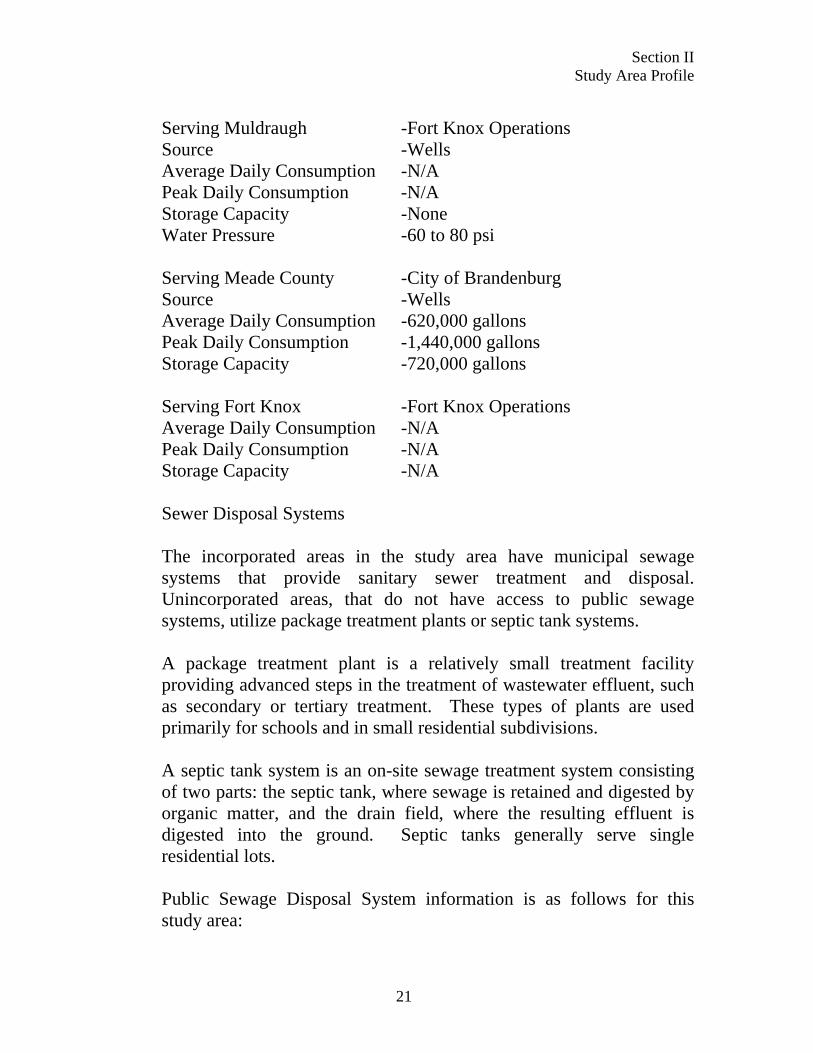
Section II Study Area Profile
Serving Muldraugh -Fort Knox Operations Source -Wells Average Daily Consumption -N/A Peak Daily Consumption -N/A Storage Capacity -None Water Pressure -60 to 80 psi Serving Meade County -City of Brandenburg Source -Wells Average Daily Consumption -620,000 gallons Peak Daily Consumption -1,440,000 gallons Storage Capacity -720,000 gallons Serving Fort Knox -Fort Knox Operations Average Daily Consumption -N/A Peak Daily Consumption -N/A Storage Capacity -N/A Sewer Disposal Systems The incorporated areas in the study area have municipal sewage systems that provide sanitary sewer treatment and disposal. Unincorporated areas, that do not have access to public sewage systems, utilize package treatment plants or septic tank systems. A package treatment plant is a relatively small treatment facility providing advanced steps in the treatment of wastewater effluent, such as secondary or tertiary treatment. These types of plants are used primarily for schools and in small residential subdivisions. A septic tank system is an on-site sewage treatment system consisting of two parts: the septic tank, where sewage is retained and digested by organic matter, and the drain field, where the resulting effluent is digested into the ground. Septic tanks generally serve single residential lots. Public Sewage Disposal System information is as follows for this study area:
21
Section II Study Area Profile
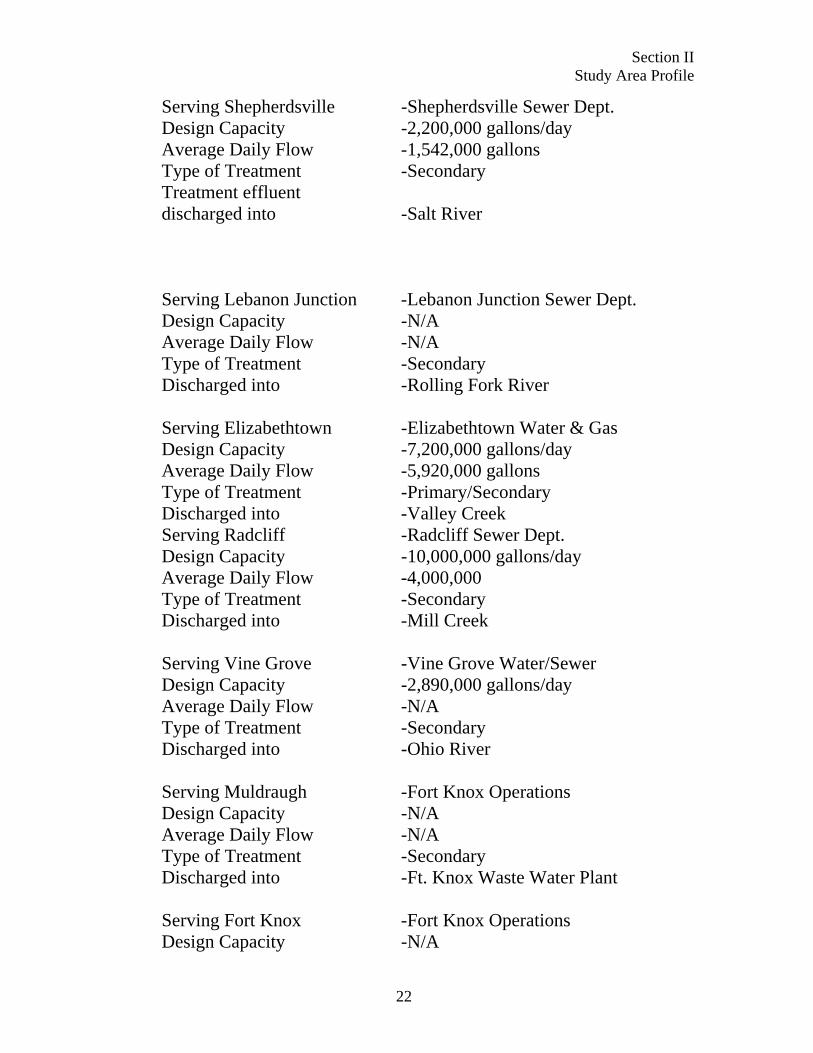
Serving Shepherdsville -Shepherdsville Sewer Dept. Design Capacity -2,200,000 gallons/day Average Daily Flow -1,542,000 gallons Type of Treatment -Secondary Treatment effluent discharged into -Salt River Serving Lebanon Junction -Lebanon Junction Sewer Dept. Design Capacity -N/A Average Daily Flow -N/A Type of Treatment -Secondary Discharged into -Rolling Fork River Serving Elizabethtown -Elizabethtown Water & Gas Design Capacity -7,200,000 gallons/day Average Daily Flow -5,920,000 gallons Type of Treatment -Primary/Secondary Discharged into -Valley Creek Serving Radcliff -Radcliff Sewer Dept. Design Capacity -10,000,000 gallons/day Average Daily Flow -4,000,000 Type of Treatment -Secondary Discharged into -Mill Creek Serving Vine Grove -Vine Grove Water/Sewer Design Capacity -2,890,000 gallons/day Average Daily Flow -N/A Type of Treatment -Secondary Discharged into -Ohio River Serving Muldraugh -Fort Knox Operations Design Capacity -N/A Average Daily Flow -N/A Type of Treatment -Secondary Discharged into -Ft. Knox Waste Water Plant Serving Fort Knox -Fort Knox Operations Design Capacity -N/A
22
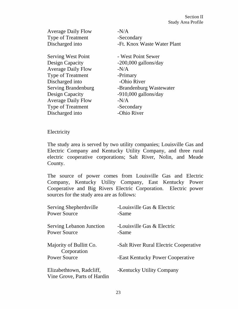
Section II Study Area Profile
Average Daily Flow -N/A Type of Treatment -Secondary Discharged into -Ft. Knox Waste Water Plant Serving West Point - West Point Sewer Design Capacity -200,000 gallons/day Average Daily Flow -N/A Type of Treatment -Primary Discharged into -Ohio River Serving Brandenburg -Brandenburg Wastewater Design Capacity -910,000 gallons/day Average Daily Flow -N/A Type of Treatment -Secondary Discharged into -Ohio River Electricity The study area is served by two utility companies; Louisville Gas and Electric Company and Kentucky Utility Company, and three rural electric cooperative corporations; Salt River, Nolin, and Meade County. The source of power comes from Louisville Gas and Electric Company, Kentucky Utility Company, East Kentucky Power Cooperative and Big Rivers Electric Corporation. Electric power sources for the study area are as follows: Serving Shepherdsville -Louisville Gas & Electric Power Source -Same Serving Lebanon Junction -Louisville Gas & Electric Power Source -Same Majority of Bullitt Co. -Salt River Rural Electric Cooperative Corporation Power Source -East Kentucky Power Cooperative Elizabethtown, Radcliff, -Kentucky Utility Company Vine Grove, Parts of Hardin
23
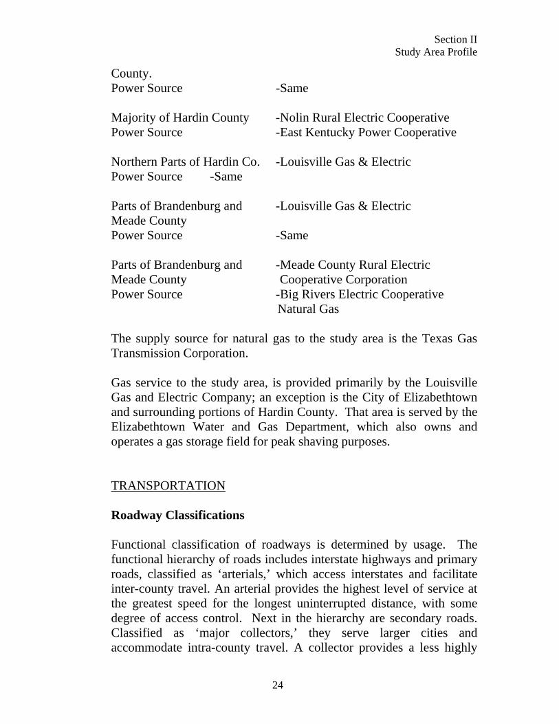
Section II Study Area Profile
County. Power Source -Same Majority of Hardin County -Nolin Rural Electric Cooperative Power Source -East Kentucky Power Cooperative Northern Parts of Hardin Co. -Louisville Gas & Electric Power Source -Same Parts of Brandenburg and -Louisville Gas & Electric Meade County Power Source -Same Parts of Brandenburg and -Meade County Rural Electric Meade County Cooperative Corporation Power Source -Big Rivers Electric Cooperative Natural Gas The supply source for natural gas to the study area is the Texas Gas Transmission Corporation. Gas service to the study area, is provided primarily by the Louisville Gas and Electric Company; an exception is the City of Elizabethtown and surrounding portions of Hardin County. That area is served by the Elizabethtown Water and Gas Department, which also owns and operates a gas storage field for peak shaving purposes. TRANSPORTATION Roadway Classifications Functional classification of roadways is determined by usage. The functional hierarchy of roads includes interstate highways and primary roads, classified as ‘arterials,’ which access interstates and facilitate inter-county travel. An arterial provides the highest level of service at the greatest speed for the longest uninterrupted distance, with some degree of access control. Next in the hierarchy are secondary roads. Classified as ‘major collectors,’ they serve larger cities and accommodate intra-county travel. A collector provides a less highly
24
Section II Study Area Profile
developed level of service at lower speeds for shorter distances, by collecting traffic from local roads and connecting them with arterials. At the bottom of the hierarchy are local roads or ‘minor collectors.’ They bring all areas of a county within reasonable proximity of a collector road. Functional classification dictates standards for construction and maintenance and is a factor in determining funding for improvements. Interstates and arterial highways are part of the Federal-aid Primary System, while major collectors are part of the Federal-aid Secondary System. Minor collectors are a component of the State Rural Secondary System. Major Roadways Major roadways, in the study area, are represented on Map F. Interstate 65 services the entire study area and is the most heavily traveled roadway in the region. Interstate 65 carries approximately 65,000 vehicles per day in Hardin County and nearly 100,000 vehicles per day in Bullitt County near the Jefferson County line. Statistics from the Kentucky Transportation Cabinet show that 42% of the traffic on I-65 is trucks. Bullitt County is served by Interstate Highway 65. Bullitt County is also served by the ‘AAA’ rated trucking routes of Kentucky Route 44 and Kentucky Route 61. Route 44, a major collector, connects the City of West Point in Hardin County, with Shepherdsville in Bullitt County, along the northern boundary of the Fort Knox Military Reservation. Interstate 65 and Kentucky Route 61 run north and south along the eastern boundary of Fort Knox. Interstate 65 is accessible at two points in Shepherdsville; KY 44 and KY 480, at KY 245 in Bardstown Junction, and KY 61 in Lebanon Junction. Elizabethtown is the transportation hub of Hardin County. It is served by Interstate 65, The Bluegrass Parkway, Western Kentucky Parkway, U.S. 31 W, Kentucky 61 and U.S. 62; all are ‘AAA’ rated truck routes. U.S. 31 W is a major arterial route that provides four-lane access to Vine Grove, Radcliff, Muldraugh and West Point from Elizabethtown. U.S. 31 W provides direct access to Fort Knox via its three gates at Wilson Road, Bullion Boulevard, and Brandenburg Station. U.S. 31
25
Section II Study Area Profile
W also provides access to Louisville, which is 32 miles north of Radcliff, where Interstate 65, Interstate 64, Interstate 71, and several major U.S. and Kentucky Highways converge. Kentucky Route 434, a collector route, runs along the southern boundary of Fort Knox and connects Lebanon Junction and Colesburg with Vine Grove and Radcliff. ‘AAA’ rated truck routes serving Meade County are Kentucky Route 448 and U.S. Highway 60. Interstate 64 runs through Indiana, 19 miles north of Brandenburg. Access to Interstate 65, the Bluegrass Parkway and Western Kentucky Parkway is available in Elizabethtown, 34 miles southeast of Brandenburg. A collector road, Highway Route 1638 connects Brandenburg with Fort Knox. Highway Routes 448 and 144 connect Brandenburg to Vine Grove and Radcliff. Highway Route 313 runs perpendicular to Interstate 65 and U.S. 31 W. It intersects with I65 and U.S. 31W. Highway 313 ends in Vine Grove where it intersects with KY 1500. Kentucky Route 313 is of particular interest to Fort Knox. It runs along the southern boundary of the Installation and, in some areas, bisects it. This roadway provides an important connection between Radcliff and Vine Grove and Interstate 65. However, there are major concerns about development along KY 313 and encroachment that impacts military training and maneuvers. The proposed extension of KY 313 from KY 1500 to Brandenburg would provide an important connection from I-65 to U.S.-60. Fort Knox Highway Network The Fort Knox Military Reservation is serviced by US 31W. It is a divided highway that ranges from four to six lanes and serves as the critical infrastructure link in the Radcliff-Fort Knox area’s transportation system. Interchange ramps along US 31W provide access to and egress from the military post. In addition to US 31W, other key roads are identified on Map F. Nine signalized intersections are also labeled. Multiple roadways within the study area provide access to Fort Knox. Brandenburg Station Road is a rural, two-lane road that terminates to the east at the Fort Knox Military Post; to the west, it provides access to military training
26
Section II Study Area Profile
grounds that are restricted to the public. South of Brandenburg Station Road, Chaffee Avenue also provides access to Fort Knox, but is limited to traffic exiting from post onto US 31W. Bullion Boulevard provides full access to post at the road’s eastern termini. To the west, Bullion Boulevard serves traffic for rural southern Meade County. Farther south in Radcliff, there are multiple key roads that serve the traffic demand for this part of the study area. Lincoln Trail Boulevard (KY 1815) is one of the main east-west routes inside the Radcliff city limits. This roadway connects with the Joe Prather Highway (KY 313). Two key north-south roads are also located in this area; North Wilson Road and the Logsdon Parkway (KY 1646). Logsdon Parkway travels through Radcliff and terminates to the north at Bullion Boulevard. North Wilson Road is a two-land road located east of KY 1646. A section of the road closely follows the alignment of US 31W, with less than 100 feet separating the two roads in certain locations. North Wilson Road terminates to the south at West Lincoln Trail Boulevard, but extends north beyond the Fort Knox boundary. Knox Boulevard and Redmar Boulevard are parallel roads that run east and west along the northern edge of Radcliff and connect US 31W to North Wilson Road. Knox Boulevard is zoned primarily for commercial development, while Redmar Boulevard is a residential street. Fort Knox Ingress and Egress Points Three gates currently serve as ingress and egress points to Fort Knox. They are the Brandenburg Station road Gate, Chaffee Gate at Bullion Boulevard, and the Wilson Road Gate. A fourth gate, the Chaffee Avenue Gate, once provided full access to the post before the gate at Bullion Boulevard was reconstructed. Now, it only serves as an exit from the post. Checkpoints are stationed at each gate for security purposes. Frequent delays occur at these checkpoints, since identification is required before entry onto post is permitted. Peak hour traffic volumes at the gates vary significantly as daily activities and events on Fort Knox fluctuate. The following discussion describes the existing characteristics at each gate approach. The northern most gate is at the Brandenburg Station Road interchange with US 31W. The road leading to this gate is a two-land road that crosses a railroad bridge. At the gate, the road widens to four lanes to facilitate two commercial vehicle checkpoints as well as two regular
27
Section II Study Area Profile
vehicle checkpoint lanes. All commercial traffic must enter Fort Knox through this gate. The second gate, Chaffee Gate at Bullion Boulevard, has been recently reconstructed and is accessed from US 31W at the Bullion Boulevard interchange. This gate facilitates the largest capacity of all gates, with two inbound and two outbound lanes from US 31W to its entrance. Approximately 600 feet from the gate, the two inbound lanes widen to four checkpoint lanes. Located closest to Radcliff, the Wilson Road Gate is the southern most gate into Fort Knox. Traffic entering and exiting this gate utilize North Wilson Road. The approach to this gate has one inbound and one outbound lane. Four checkpoints lanes exist at this gate. It is important to note that not all checkpoint lanes are open at all times of each day. From field observation, it was noted that all checkpoint lanes are open only during times of peak congestion. However, for peak period analysis throughout this study, it was assumed that all checkpoint lanes for all gates would be open.
Roadway Improvements All State roads, within each county, are maintained by the Kentucky Transportation Cabinet. Improvements to state, rural, secondary routes are done with the consent of County Government. There is no formal mechanism to solicit local input concerning improvements to other state routes. The Kentucky Transportation Cabinet schedules highway transportation projects, considered for the near future, in the “Six Year Highway Plan.” The Six-Year Plan is updated, by the Kentucky Transportation Cabinet, every two years. It includes improvements to several major roadways that have an impact on Fort Knox and the surrounding communities. These projects must be included in the Radcliff/Elizabethtown Metropolitan Planning Organization (MPO) Transportation Improvement Program (TIP).
28
Section II Study Area Profile
Projects proposed beyond the “Six Year Plan,” are identified in the “Long Range Plan;” these are also maintained by the MPO. For the most part, these plans identify components of construction such as rehabilitation, major widening, relocation, safety, and bridge replacement. The proposed projects for the study area counties, along with a description and funding information are presented in tabular form in Appendix A. Major improvements that impact Fort Knox include the extension of KY 313 from Vine Grove to Brandenburg, the Elizabethtown to Radcliff Connector (E2RC), the widening of Wilson Road from the gate at Fort Knox to U.S. 31 W, and the extension of Ring Road (KY 3005) from U.S. 62 to the Western Kentucky Parkway. Improvements impacting Radcliff and the Fort Knox area are outlined below:
BRAC Related Transportation Priorities
29
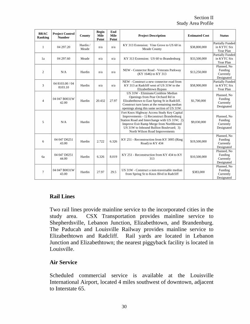
Section II Study Area Profile
BRAC Ranking
Project Control Number
County Begin Mile Point
End Mile Point
Project Description Estimated Cost Status
1 04 297.20 Hardin / Meade n/a n/a KY 313 Extension: Vine Grove to US 60 in
Meade County $38,800,000 Partially Funded
in KYTC Six Year Plan
1a 04 297.60 Meade n/a n/a KY 313 Extension: US 60 to Brandenburg $33,500,000 Partially Funded
in KYTC Six Year Plan
2 N/A Hardin n/a n/a NEW - Connector Road - Veterans Parkway (KY 1646) to KY 313 $13,250,000
Planned, No Funding Currently
Designated
3 04 8103.00 / 04 8103.10 Hardin n/a n/a
NEW - Construct a new connector road from KY 313 at Radcliff west of US 31W to the
Elizabethtown Bypass $58,900,000
Partially Funded in KYTC Six
Year Plan
4 04 047 B0031W 42.00 Hardin 20.432 27.97
US 31W - Eliminate/Combine Median Openings from Pear Orchard Rd in
Elizabethtown to East Spring St in Radcliff. Construct turn lanes at the remaining median openings along this same section of US 31W.
$1,700,000
Planned, No Funding Currently
Designated
5 N/A Hardin
Fort Knox Highway Access Study Key Capital Improvements - 1) Reconstruct Brandenburg
Station Road and Interchange with US 31W; 2) Improve Exit Ramp Merge from Northbound US 31W to Inbound Bullion Boulevard; 3)
North Wilson Road Improvements
$9,030,000
Planned, No Funding Currently
Designated
6 04 047 D0251 43.00 Hardin 2.722 6.326 KY 251 - Reconstruction from KY 3005 (Ring
Road) to KY 434 $19,500,000
Planned, No Funding Currently
Designated
6a 04 047 D0251 44.00 Hardin 6.326 8.019 KY 251 - Reconstruction from KY 434 to KY
313 $10,500,000
Planned, No Funding Currently
Designated
7 04 047 B0031W 43.00 Hardin 27.97 29.5 US 31W - Construct a non-traversable median
from Spring St to Knox Blvd in Radcliff $383,000
Planned, No Funding Currently
Designated
Rail Lines Two rail lines provide mainline service to the incorporated cities in the study area. CSX Transportation provides mainline service to Shepherdsville, Lebanon Junction, Elizabethtown, and Brandenburg. The Paducah and Louisville Railway provides mainline service to Elizabethtown and Radcliff. Rail yards are located in Lebanon Junction and Elizabethtown; the nearest piggyback facility is located in Louisville. Air Service Scheduled commercial service is available at the Louisville International Airport, located 4 miles southwest of downtown, adjacent to Interstate 65.
30
Section II Study Area Profile
31
Addington Field is located 4 miles west of Elizabethtown and has a lighted, paved runway that is 100’ by 6001’ long. It averages 34 operations a day; 52% is general transient aviation, 37% local general aviation, 8% is air taxi service, and 2% is military aviation. Currently, 56 aircraft are based at Addington Field; 47 single engine planes, 8 multi-engine aircraft, and 1 helicopter. The Elizabethtown Airport Board is currently exploring the option of providing commercial air service at Addington Field. Godman Army Airfield is located on Fort Knox and is used exclusively for military aviation missions.
Water Facilities The Ohio River is the nearest navigable waterway in the study area. It forms the northern boundary of Meade and Hardin Counties, and the northwestern boundary of Bullitt County, separating them from Indiana. A navigational channel is maintained on the Ohio River. Recently, the Meade County Riverport Authority was established to develop a port complex near Brandenburg. While a master plan is developed, no construction has taken place at the time of this study. The Louisville and Jefferson County Riverport Authority is located near Louisville approximately 32 miles northeast of Radcliff and 20 miles north of Shepherdsville. Designed as a Foreign Trade Zone, it offers facilities for cargo transfer and storage and barge fleetings, as well as complete U.S. Customs services for exports and imports.
Section II Study Area Profile
MISSION ENCROACHMENT Peacetime Master Plan There are a number of future mission changes currently under way at Fort Knox. The changes are primarily the result of the Base Realignment and Closure (BRAC) law and the Integrated Global Presence Basing Strategy (IGPBS), 2006-2011. IGPBS actions are the result of the restructuring of Army presence and bases in Europe and other parts of the world and the subsequent relocation of those forces to other foreign bases and installations in the continental United States (CONSUS). As a result of BRAC 2005 and IGPBS, Fort Knox will receive several new missions over the next four years. Current missions will continue, as new arriving units add their own battle space training requirements. Fort Knox will gradually transition from a U.S. Army Training and Doctrine Command (TRADOC) installation to a U.S. Army Forces Command (FORSCOM) installation with multi-mission organizations located on the installation. The BRAC, IGPBS, and Grow the Army initiatives will require the installation to support new and challenging training requirements. Some of the new and expanded missions are as follows:
• Infantry Brigade Combat Team (IBCT) • 19th Engineer Battalion • 91st Horizontal Engineer Company • 538th Concrete Section • The Army Cadet Command • The Army Human Resources Command (will
become Human Resources Center of Excellence) • Army Ohio Valley Veterinary Command • 3rd Sustainment Command • 11th Theater Aviation Command • 70th Divisional Functional Training (USAR) • Det 1/10th Air Support Operations Squadron
(USAF) • 502nd Multi-role Bridge Company
32
Section II Study Area Profile
• 84th Training Command (USAR) • Army Accessions Command • 100th Division Institutional Training (USAR)
The new and expanded mission changes will utilize some of the following:
• Unmanned Aviation Vehicles (UAV) operations will increase.
• Increased demand for airspace to accommodate fixed wing and rotary wing aircraft operations.
• Upgrading of existing range to accommodate increased attack helicopter firing.
• Operation of robotic vehicles and specialized robotic systems will be integrated into training.
• Combined arms training will be expanded. • New and expanded training support for convoy
training, night operations, IED situations, training in projective based environment, technical and tactical employment of less than lethal technologies, AAR facilities, RF jamming operations, as well as numerous other oversight and support training operations.
These changes will result in an increase in personnel and training events and maximize use of the current training landscape at Fort Knox. These mission changes are the impetus behind the Army’s new Army Compatible Use Buffer Proposal (ACUB).
Mission Changes Fort Knox is a U.S. Army Garrison under the Southeast Region of the Installation Management Agency (IMA). Fort Knox houses the U.S. Army Armor Center that has the primary mission of training soldiers for the Armor Force. The mission at Fort Knox is to forge the Army’s mounted combat force. The mounted soldier is started and sustained at Fort Knox.
33
Section II Study Area Profile
The Army Compatible Use Buffer Proposal states: “the Fort Knox training areas and ranges are used by a multitude of units. Fort Knox is home to the 16th Cavalry Regiment, 1st Armor Training Brigade, NCO Academy, 1-160 Special Operations Aviation Regiment (SOAR), 1-327 Infantry, 2-327 Infantry, 3-327 Infantry, 5th Group Special Forces (Fort Campbell), 7th Group Special Forces (Puerto Rico), Special Boat Unit (SBU) 22 (Navy-New Orleans), Seal Team 4/NSWDG2 (VA Beach), 278th Armor Cavalry Regiment (Tennessee National Guard), Kentucky Nation Guard, MATES, Department of Treasury and other Federal Agencies and law enforcement personnel (city, county, state).” “The summer training period (summer surge) sees a large influx of training units and use increases dramatically during periods of troop mobilization.” “In addition to the list of regular users, there are approximately 50 addition units that utilize the training facilities on a less frequent basis.” “The mission activities at Fort Knox include: the U.S. Army Armor School Advanced Officer Basic Course (AOBC), Tank gunnery, Mounted Tactical Training (MTT), Scout Platoon Leader’s Course, USAF & Army Aerial gunnery, 1st Armored Training Brigade Basic Combat Training (BCT), Tank and Cavalry Crewman Training, Heavy Equipment Mechanical Training, Heavy Vehicle Recovery and Evacuation, Field Artillery Exercises, RA/Guard/Reserves, U.S. Military Academy, Mounted Tactical Training (MTT), National Guard & Reserve (Brigade thru Platoon size elements), Mounted/Dismounted tactical training, Tank gunnery, BFV gunnery (Bradley), MTT, Marine Corps Reserve Tank Gunnery, ROTC Basic Camp (heavy users) with small arms ranges, bivouac/maneuvers, amphibious training, river gunnery, boat recovery, MOUT training, and testing the LAV/Stryker.”
“The various types of training that are conducted at Fort Knox are part of what make the installation so unique. The training activities include basic combat training, heavy force training and maneuver, aerial gunnery, and amphibious operations in the training complex and the
34
Section II Study Area Profile
eastern corridor battle space. The installation strives to support and sustain the ability to support the wide range of Army missions.” “With the Base Realignment and Closure (BRAC) law and Integrated Global Presence Basing Strategy (IGPBS), 2006-2011 will require the installation to support new and challenging training requirements. These moves to Fort Knox will include EN, MP, and CSS units from Europe and Korea, an Infantry Brigade Combat Team (IBCT), 19th En BN, 11th TAC, Det 1/10th ASOC, F Co 3rd BN SARG, USAR 100th (IT) Division HQs, 84th ARRTC, 3rd ESC, relocation of Accessions Command and Army Cadet Command and the combined Human Resources Command (HRC). Following BRAC 05, the profile of the training base supported by the Fort Knox battle space training areas changed drastically, The Armor School, although to relocate to Fort Benning as part of the “Maneuver Center”, is projected to continue training school programs of instruction (POI) at Fort Knox through 2011. During this time frame the resident training density will be expanded to include two FORSCOM deployable units, the 19th Engineers, currently staffed and conducting deployment training, and an IBCT that stood-up the unit colors Sept. 2006 and began to fill, with full staff and associated training loads realized between Sept. 2006 and FY 08. Additionally, various HR headquarters and subordinate organizations will also move to Ft. Knox. The new arriving units will provide their own unique battle space training requirements.” “The training density from special operations units focused on using the urban training facilities, shoot house, urban assault course and the urban environments (Anaconda, Red Wing & Zussman), and consumable urban environments constructed on Wilcox and Yano Ranges and in training Area 2 is expected to remain and increase.” “Some of the new and expanded mission requirements include: * Unmanned Aviation Vehicles (UAV) operations will increase throughout the training complex, as will demands for airspace use for fixed wing and rotary wing aircraft operation. Increased coordination and oversight from Range Operations and Godman Army Airfield will be required to de-conflict and control UAV and manned aircraft operations. * Operation of robotic vehicles and specialized robotic systems (i.e. EOD support robotic systems) will become integrated with training
35
Section II Study Area Profile
and require additional coordination and oversight. Combined arms training, including SOF elements training in conjunction with ground combat units will be expanded to meet the needs of resident and non-resident training densities. * New & expanded training support demands: - Convoy training, including convoy live fire, and QRF response (air and ground) to convoy operations. This will include night operations, under night vision devices, on major training
complex roads. - IED situations ingrained into all tactical ground training events. - Technical and tactical employment of less than lethal
technologies (mounted and dismounted). - Training in a projectile based environment (paintball and SESAMS). - Requirement for AAR facilities to support rapid playback of portable video products to support rapid event AAR will be
realized in most major training areas, all urban environments and major ranges including Cedar Creek Platoon Live Fire, Kennedy Squad Live Fire, Wilcox DMPTR, and Yano MPRC.
- Roll on - Roll off support for all modernized range facilities and those maneuver areas with AAR capture and display capabilities will be expanded to ensure training throughput and standards are achieved. - RF jamming operations is expected to be included into major training events.
- Oversight, incident response, security support and user assistance support will increase due to the increase in ground operations training in close proximity to the reservation boundary, rapid turn around on training area and range clearances, and increased demand for isolating training areas from non event associated traffic. 24/7 range operations and field staff support will become the norm with increased service demand generated by support of the Armor School, resident deployable units and non-resident SOF and main force units.
The increase of personnel, the increase of additional unit training events, and the additional demands on the training landscape maximize the importance of the ACUB program for Fort Knox training capabilities.”
36
Section II Study Area Profile
NOISE/VIBRATIONS The following summary of the Installation Compatible Use Zone (ICUZ) Study Update, Fort Knox dated June, 1992, prepared by Howard K. Bell, consulting Engineers, Inc., is presented to give the reader an overview of the ICUZ. The reader is encouraged to read the original document for a more detailed analysis of the work.
The purpose of the ICUZ Study Update was to identify noise affected areas. Subsequent to identification, local governments, the general public and the military can then work in concert to minimize noise-sensitive developments in the subject areas, thereby protecting both the interests of the public and the missions of Fort Knox. The primary tool for limiting noise-sensitive development is through effective land use planning on the part of local jurisdictions.
The findings of the Study indicate that development along the boundary of the installation has been continuous since the establishment of Fort Knox. This development was studied relative to noise contours for Fort Knox prepared by the U.S. Army Environmental Hygiene Agency, Bio-Acoustics Division. Results of the analysis indicate the following:
Zone II noise contours (normally unacceptable for noise sensitive development) for blast noise extends off the installation along the eastern and southeastern boundary. This area contains a combination of rural agricultural lands and residential areas which are incompatible by definition. Further more, potential exists for additional incompatible development along the southeastern boundary in the general area of the City of Lebanon Junction. Zone III noise contours (unacceptable for noise-sensitive development) are contained entirely within the installation boundaries.
37
Section II Study Area Profile
38
The data used for developing the contours included the projected impact from the Yano Range. The study urges the continual monitoring of activity on the installation and measuring the effect on noise contours. Maps G-1, G-2 and G-3 identify noise contours.
The ICUZ Study Update made the following major recommendations:
1. Fort Knox should coordinate with adjacent jurisdictions to maintain compatible land uses around the installation. 2. Adjacent jurisdictions should incorporate the installation
noise contours in their land use plans and development controls. These contours would then be used to disapprove land uses that would be incompatible with installation noise levels. Those jurisdictions without such development controls are urged to consider such techniques to both avoid conflicts and to enhance land use planning in the Fort Knox area.
3. Additional residential and other noise-sensitive uses immediately along the installation boundary should be strongly discouraged in favor of uses that are compatible with the Zone II noise contour environment.
Section II Study Area Profile
COMPATIBLE LAND USE BUFFER ZONE Description of Purpose and Need for Action The Army Compatible Use Buffer Proposal was prepared in anticipation of goal and mission changes at Fort Knox as a result of BRAC 2005. The study concludes: “Because of the increasing urbanization of the surrounding communities and counties, Fort Knox is concerned about the potential development of adjacent privately-owned lands that have historically served as noise and/or over-flight area buffers for the Installation. Local growth, especially along its eastern and southern boundaries, has greatly increased over the past 10-15 years. As a result, adjacent property owners and local developers are expressing greater interest in developing the privately owned farms and other undeveloped areas located between Fort Knox and the surrounding communities. If these areas are developed, it would result in high-density, residential subdivisions and ‘light-intensive’ commercial developments adjacent to Installation ranges, training areas, and airfield, which could adversely impact training, maneuver, and deployment capabilities.” “After evaluating several other alternatives, Fort Knox believes that the only long-term solution to prevent incompatible development on these lands is through the acquisition of real estate interests by the Army or some other entity (with similar interests). Given this fact, the ACUB program is viewed as a viable option to protect installation training capabilities from urban encroachment and also preserve the natural character of the surrounding areas, but without the time, controversy or ongoing maintenance requirements of fee-simple Army acquisition.” Population Growth and Residential and Commercial Development: A Threat to Long-Term Viability The Army Compatible Use Buffer Proposal (ACUB), goes on to state: “When Fort Knox was first procured and constructed, it was located approximately fourteen miles north of Elizabethtown, Kentucky and eight miles east of the community of Vine Grove, Kentucky in largely undeveloped areas. The City of Radcliff, Kentucky, adjoining Fort Knox, was not founded until the 1950s. With few neighbors, virtually
39
Section II Study Area Profile
no one noticed the facility’s training operations, safety concerns were minimal, and conflicts with neighbors over noise or other disturbances were almost nonexistent. During the past seventy years, significant development has occurred along the southwestern edge of Fort Knox, specifically along U.S. Highway 31-W, a 4-lane (north-south) route that runs through the Installation’s western boundary. This growth has intensified to the point that the installation cantonment is now considered part of an urbanized area. As a result, the surrounding community of Radcliff and northern Hardin County are starting to expand toward installation ranges and training areas, increasing local pressure to develop the off-post properties that have historically served as ‘buffers’ between Fort Knox and the surrounding communities. The areas located adjacent to the Fort Knox cantonment have grown from small rural communities to become the 4th fastest growing area in Kentucky. The area was identified in the latest census business reports for the State of Kentucky as ranked 4th in growth just behind the large urban centers in the State. This trend is expected to continue well into the foreseeable future. Local growth has been fueled by the presence of Fort Knox (i.e. military retirees, ex-soldiers, etc.), the area’s low cost of living, and recent suburban growth in the Elizabethtown-Radcliff-Hardin County Metropolitan Planning Organization.” “Urban encroachment threatens the mission of Fort Knox to provide realistic military training to the soldiers of the United States Army.” “The Fort Knox Trend Analysis, Encroachment Study by ERDC/CERL provides Fort Knox with data on potential conflicts between the Army and the growing civilian community that surrounds this Installation.” “This project used GIS (geographic information system) map layers in an analysis of historic land use and growth in the region. These GSI layers were then used again as input to the Land Evolution and Assessment Model-Land Use Change (LEAM-LUC) model to project urban growth around Fort Knox into the future. Historical land use maps, current and future highway system plans, and municipal zoning information all contributed to forecasting residential and commercial development. The historic trend has been a growth rate of roughly 2% per decade in the region surrounding Fort Knox. In 1972, the percent of urban development here was 1.37%. That figure grew to 6.54% in 2001 and will continue to rise as more and more of the area becomes
40
Section II Study Area Profile
attractive to people to build there. A closer analysis revealed that areas within a one-mile buffer of the Installation show a similar growth pattern (6.4% of this buffer was urban in 2001). When a 5-mile buffer is drawn around the Installation, the picture improves slightly, with only 4.4% of this area showing urban land use. The prospect for the future however, is that civilian encroachment around Fort Knox will only continue. This study did not take into consideration the BRAC move to Fort Knox and the resulting demand for housing and services in the surrounding counties and communities. Certainly with the affects of the BRAC actions and the additional 5000 plus personnel coming into the area, the potential demand for local housing has already begun to stimulate the local home building market, and makes civilian encroachment around the Installation a much larger threat.” “Model simulations indicate that the areas south and west of Fort Knox are those at the greatest risk for urban encroachment, although there is substantial urban sprawl emanating from Louisville to the northeast. Unless addressed directly and mitigated through a comprehensive and effective ACUB program, population growth in the jurisdictions surrounding Fort Knox will lead to increased conflicts between the facility and its neighbors, restrictions to training, and ultimately, a significant reduction in training capability.” “The Army can avoid potential conflicts involving incompatible land use practices by examining their long-term range plan and implementing alternatives discussed below. Repositioning certain training assets away from the southern portion of the Installation is not feasible to decrease the potential for noise complaints from future residential neighborhoods. The better alternative would be to use those areas identified as a starting point to develop potential opportunities for conservation agreements between Fort Knox and the surrounding land holders.” “The community partner along with a number of private land owners and Non-Governmental Organizations (NGOs) like the Nature Conservancy, and The Conservation Fund have an interest in preserving areas of native forest and wetlands in northern Hardin County KY. Land purchases (where feasible) or conservation agreements between Fort Knox and these land holders would provide
41
Section II Study Area Profile
buffer zones, along the perimeter of the Installation, where development would be excluded.” Encroachment – Current and Anticipated Training Restrictions The study further states: “Urban growth threatens the training mission and, if left unchecked, will continue to have an even greater affect on range availability and types of training conducted. Due to the rural setting of the Installation, training activities have not been significantly limited. Training operations have been conducted 24-hours a day with minimal restrictions; however, it is indicated that future urban growth will further impact training capabilities on Installation airfields, maneuver areas, and training ranges. This will result in less realistic training, and reduced operating hours at training areas, aircraft operations, and firing ranges. To prevent this from occurring, compatible use buffers are needed around the Installation training area perimeter to protect existing firing ranges and flight routes. Specifically, these buffers are needed to alleviate the training concerns identified below. Operational noise and vibrations generated by military aircraft and weapons firing are significant concerns because of the impact upon areas outside the Reservation boundary. The entire Installation training area is used during times of multiple training exercises.” “These periods create extreme noise and training traffic around the edges of the Installation. Although these periods of intense disturbance and resulting complaints frequently concern training periods of short duration, public complaints are registered with the Installation.” “At the present time, the overall number of complaints received by the Installation each year is minimal; however, repeated complaints could result in pressure to curtail certain training near sensitive areas. Currently, there is low-density development within the Installation’s designated (annualized) high noise zones or within its ‘zone of influence,’ which is periodically exposed to high noise levels. However, if current growth trends continue, there will be more noise sensitive users (such as residential dwellings) developed within these areas and the potential for additional noise complaints and potential training curtailment could pose a serious threat to the Fort Knox
42
Section II Study Area Profile
mission. Given this situation, protective buffers are being sought within designated high-noise areas so that the Installation can continue to operate its flight corridors and firing ranges at current levels.” “Ambient lighting is also a significant concern. Illumination associated with residential and commercial developments (street lights, signs, etc.) can interfere with night vision goggles and adversely impact the ability of assigned units to conduct this type of training. Urban density around the Installation is another concern that could impact the ability to continue training at current levels. Consequently, protective buffers are being sought within these areas in order to allow the Installation to continue utilizing its existing training corridors, complexes, and ranges, and continue other training. Strong local community support and many years of being a ‘good neighbor’ have helped limit the number of complaints. But, as population increases, it will become more difficult to continue to be a ‘good neighbor’ and relations with local communities will become strained. The ability to meet training requirements will diminish. As such, there is a short window of opportunity available for the Army to implement this ACUB proposal and enable Fort Knox to continue as a major Army Installation for DoD, without significant training restrictions.” Encroachment – Conservation Impacts “While direct conflicts associated with encroaching development around Fort Knox pose the most immediate and tangible threat to training activity and capacity at Fort Knox, it is important to note that environmental degradation associated with land development outside the fence line can lead to additional training restrictions inside the fence line. Fort Knox is home to two listed threatened and endangered species: the Gray Bat (Myotis Grisescens) and the Indiana Bat (Myotis Sodalis). In addition to the two listed species, there are another four species with documented habitats on the Installation, that are considered rare and a concern to the State. However, the only current training restriction or limitation imposed, because of these species, is the requirement that units coordinate any tree removal or action affecting bats and their habitats with Installation environmental personnel. Fort Knox training areas also contain unique terrain features.”
43
Section II Study Area Profile
“Currently, restrictions associated with threatened, endangered, and State identified species are relatively small and manageable within the operational objectives of Fort Knox. However, additional listings, or further declines in the relative viability of identified species because of habitat loss due to land fragmentation outside the facility, could produce serious internal encroachment issues resulting from enforcement of regulations imposed by the Endangered Species Act and other federal and state laws. By taking proactive measures, Fort Knox has the opportunity to help preserve the ecological integrity of the area inside the fence as part of a larger, regional effort to protect critical habitat for threatened and endangered species. Fort Knox can thereby avoid becoming an isolated enclave of biodiversity, similar to other military installations in more densely developed areas.” ACUB Proposed Action The Army Compatible Use Buffer Proposal presented the following action plan. “To address the encroachment threats as outlined above and to take advantage of the opportunity to partner with interested conservation groups, Fort Knox proposes to formalize and implement a comprehensive Army Compatible Use Buffer Program to prevent incompatible development on land adjacent to, or within close proximity of, the Installation. Implementation of the plan will not only prevent encroachment which would disrupt, limit, or diminish training capabilities and flexibility, but would also protect key natural habitats, ecological systems, and all associated flora and fauna.” “The core component of implementing the proposed ACUB Program is the acquisition of conservation easements from willing landowners. The conservation easements would prohibit incompatible development in perpetuity, while keeping the fee interest in land, in private ownership and allow the land to be used for traditional purposes such as farming and forestry. In conjunction with the ACUB efforts, local planning units may also consider other compatible uses.” “With the authority provided in Section 2811, of the National Defense Authorization Act of 2003 (codified at 10 United States Code Sec. 2684a), Fort Knox proposes to enter into a Cooperative Agreement with the Lincoln Tail Area Development District (LTADD) and other partners, to direct the goals, implementation, and administration of the
44
Section II Study Area Profile
ACUB partnership. These partners would work directly with willing landowners to secure the conservation easements on their properties, and be responsible for recording, monitoring, managing, and enforcing easements. Fort Knox and its primary partner LTADD, will prioritize areas surrounding the Installation for conservation easement acquisition under the ACUB Program. The selection criteria for prioritizing areas for acquisition will be to prevent the urbanization of agricultural and natural areas surrounding the Installation perimeter that would adversely impact realistic Installation training.” “Criteria for selecting ACUB priority areas are as follows:
1. Properties located within designated (annualized) high noise zones, where residents will be exposed to unacceptable levels of training noise.
2. Properties located under and/or adjacent to designated Installation flight corridors that are critical to training combined arms, joint forces.
3. Properties located within the Installation’s zone of influence, a 1-mile+ radius of the current Fort Knox perimeter, where residents may be periodically exposed to unacceptable peak levels of training noise.
4. Properties located within the Installation’s “light-sensitive” area, ambient lighting can adversely affect NVD training operations and prohibit realistic combat conditions training.
5. Properties with high conservation value relative to Installation partners.
Please note that slight adjustments to specific boundaries and priorities may be made, as necessary, to accommodate changes in ACUB Partnership acquisition opportunities, changes in the Fort Knox Mission, or similar unforeseen events.” ACUB Priority #1 According to the Army Compatible Use Buffer Proposal, “ACUB priority #1 is the protection of the Installation’s Eastern Corridor Battle Space, MOUT, Wilcox Digital Training Range, and the YANO Multi-Purpose Range Complex-Heavy, located along the eastern perimeter of Fort Knox. The Eastern Corridor Battle Space is vital to the Installation’s ability to operate as a Battle Space supporting Multi
45
Section II Study Area Profile
Service, multi platform Joint Operations, while Eastern Corridor Battle Space is the Installations primary area for Combined and Joint Arms Training. Yano Range (located at the southern facility of the eastern Battle Space) has been identified in the Army Master Plan (AMRP) as the site of choice to MCA, for upgrading the existing capability to a DMPRC-A; also known as a Digital Aviation Gunnery Range (DÅGR). This project is of most importance to FORSCOM, as well as the Reserve Aviation, to meet the challenges of the training required with digitally enhanced Combat Platforms. Encroachment of ambient light onto the Installation, as well as noise encroachment off the Installation, will prohibit the use of the necessary Military Operation Airspace (MOA), and Corridor Operation Airspace (COA), that facilitates the use of Battle Space in a holistic, realistic, and safe manner. This area is a significant Army asset. As such, protection of this area is a critical component in supporting the mission readiness of assigned units and the continued viability of Fort Knox as a high value military installation. To protect Installation capabilities, an ACUB is being proposed adjacent to the eastern boundary. In a recent report on light pollution threats to military training and threatened and endangered species (TES) management, (Lozar 2004), an alternative was suggested to use nighttime satellite imagery to show where lights are. (Elvidge 2005). This imagery has the potential to assist Fort Knox in monitoring civilian encroachment around the Installation’s perimeter, and may also be helpful in assessing light pollution emanating from urban areas off post. Civilian light pollution has the potential to affect night training exercises at Fort Knox, particularly in the Eastern Corridor Battle Space installation areas at the eastern boundary.” ACUB Priority #2 “The southern portion of the Fort Knox Installation contains the majority of the heavy training range complexes. There is pressure to develop land on either side of Highway 313 and Highway 434, along the southern area adjoining Fort Knox, into areas of dense, single family housing. Current Hardin County Planning is in compliance with the former Joint Land Use Study (JLUS) and designates this area as the 313 Corridor, and restricts development to 10 acres or more. Pressure from developers and other political interests make it highly unlikely that the area will remain a low growth area. The Fort Knox
46
Section II Study Area Profile
Trend Analysis, Encroachment Study Model simulations indicate that the areas south and west of Fort Knox are those at greatest risk for urban encroachment. The Army can best avoid potential conflicts involving encroachment threats by pro-actively avoiding future land use conflicts through the ACUB process. Because of the fixed assets in this area of Fort Knox, repositioning training areas away from the southern portion of the Installation is not a feasible option. The alternative solution is to address the areas identified as those expected to see increased residential development, before they become a problem. Yano Range, undergoing an upgrade from its current capability to a DMPRC-A, or Digital Aviation Gunnery Range (DAGR), will require an aviation holding pattern to support the battle space. Light pollution encroachment onto the Post, as well as noise encroachment from the Installation, will prohibit the use of the necessary Military Operation Airspace (MOA), and Corridor Operation Airspace (COA) that facilitate use of the Battle Space in a holistic, realistic, and safe manner.” “Historic trends have shown a growth rate of roughly 2% per decade in the region surrounding Fort Knox. In 1972, the percent of urban development was 1.37%. That figure grew to 6.54% in 2001, and will continue to rise as more and more of the area becomes attractive to people for development. Closer analysis revealed that areas, within a one-mile buffer of the Installation, show a similar growth pattern; 6.4% of this buffer was urban in 2001. The prospect for the future indicates that civilian encroachment around Fort Knox will continue.” ACUB Priority #3 The ACUB proposal identifies; “Areas west of the Installation comprise ACUB Priority #3; it is the buffer zone that makes up the Installation’s ‘zone of influence’, a one-mile+ area (in width) that surrounds the training area perimeter in Meade County, Kentucky. The area is 7,565 acres and consists primarily of wooded areas, developed farmland, and some limited strip development along local roads. The proposed buffer meets ACUB criteria and is intended to control incompatible development outside of the training areas. Completion of Highway 313 through Meade County will stimulate growth in this area. This buffer would allow for increased utilization
47
Section II Study Area Profile
of the (on-post) maneuver areas located near the Installation boundary. ACUB #3 was given priority status for three (3) reasons:
a. This area is currently threatened by strip residential development along local roads adjacent to the Fort Knox training maneuver areas, especially along U.S. Highway 60, near the Meade/Hardin County line. Completion of a major highway in the next 2 years will greatly stimulate development. While development within this area is sporadic and lower density, the rural nature of the area and inexpensive land costs are beginning to attract residents who are unaccustomed to the level of training activity (and associated noise and dust levels) occurring at the Installation. This has already resulted in a requirement for dust suppression near several adjacent (off-post) properties as well as the highway route through the area, to abate residential complaints and highway safety issues. Unless action is taken to mitigate this threat, it is estimated that local development will start to severely encroach upon this area in 3-5 years.
b. The proposed buffer would allow for the continued utilization of a primary aviation flight route along the Installation perimeter. The area identified is part of a corridor that is utilized to train advanced maneuver tactics with armor and infantry units, both mounted and dismounted.
c. The proposed buffer would facilitate more intense utilization of the training land located near the post boundary. Currently, the Installation has to limit some types of training activities near the perimeter because of concerns about receiving local complaints about noise, dust, etc. The designated buffer would allow the Installation to conduct more intensive training activities in these areas.”
ACUB Priority #4 The ACUB proposal says that: “The 6,889 acre area in Bullitt County, that comprises the Fort Knox Northern Training Complex, is ACUB Priority #4. The acreage is the access and approach area to the northern and eastern Corridor Battle Space; it is vital to the Installation’s ability to operate
48
Section II Study Area Profile
49
as a Battle Space, supporting Multi Service, multi platform Joint Operations. The area is identified for drop zones in support of the joint operation training at the MOUT site and battle space corridor. The area consists primarily of woods, undeveloped farmland and limited strip development along local roads. It is comprised of numerous properties with many small property owners. This proposed buffer was ranked as the fourth Installation priority because the area does not have the same level of near-term encroachment threats as the other ACUB priority areas do at this time. It is estimated that local development will start to severely encroach upon portions of the area within 8 to 10 years, when local roadways are scheduled for expansion and widening to accommodate additional growth for northwestern Bullitt County. However, there is strong interest in preserving the rural character of the area, since it is used by assigned dismounted units for routine training and base camps in the MOUT site area. The area is also a habitat for several endangered species, including Gray and Indian bats. ACUB Priority #4 was listed as a priority for two (2) reasons:
a. The forested area, between Hwy 44 and the Installation boundary, is a high priority forest conservation area. The forests are significant habitats for Gray and Indiana bats and other bird species prioritized on the endangered species list.
b. Acquiring buffers within this area would allow the Installation to continue to conduct dismounted training, over flights, air operations in support of ground maneuvers, and preserve aviation corridors for operations conducted at the MOUT Site and the eastern battle space. It will also facilitate continued utilization of other types of low impact training within this area.”
Section II Study Area Profile
4.0 ALTERNATIVE ACTIONS Alternative 1 – No Action “The first alternative would be to take no direct action, i.e. do not design and implement an ACUB program around Fort Knox. If this alternative is chosen, the most likely outcome will be continued population growth in the counties surrounding Fort Knox, with no regard given to the impact on the Installation’s continued operations. If development encroaches into the identified buffer zones around Fort Knox, it will eventually result in loss of training and range capabilities. Permanent encroachment issues, a more fragmented land base, and higher land prices would mean that opportunities for starting an ACUB program, to address problems after the fact, will be severely limited. The No Action Alternative is not considered a viable option.” Alternative 2 – Participation in Local Planning and Land Use Policy Efforts “With this alternative, Fort Knox would rely strictly on local land use controls, such as zoning and subdivision regulations. Fort Knox has an active Joint Land Use Study (JLUS) Partnership comprised of each jurisdiction in the surrounding tri-county MPO region, and does receive regulatory support from the City of Radcliff and Hardin County, Kentucky. The private lands identified for ACUB consideration are primarily located within unincorporated areas. All counties surrounding Fort Knox have existing zoning/land use controls. However, these jurisdictions are not able to provide the level of protection needed to sustain Installation training capabilities. In addition, local land use controls are subject to change, due to political considerations and other factors that could ultimately result in an outcome similar to No Action. Therefore, this not considered a viable option.” Alternative 3 – Develop and Pursue an ACUB Project “Using this preferred Alternative, Fort Knox would execute the ACUB strategy outlined in this proposal. The Fort Knox ACUB project will address the use and development of real property in the vicinity of the Fort Knox Military Installation for the purpose of
50
Section II Study Area Profile
limiting any development or use of property that would be incompatible with the mission of the Installation. The ACUB project will also address preserving natural habitats located on private property, in a manner that is in accordance with environmental requirements, but would eliminate current or anticipated environmental restrictions that would impede or interfere with current or future military training, testing, and operations at Fort Knox.” “The ACUB process will protect Fort Knox training assets from potential encroachment threats and allow the Army/Department of Defense (DoD) to sustain the training and deployment capabilities of a high value military installation. Fort Knox, with its primary partner Lincoln Tail Area Development District, will work to execute the Installation’s ACUB strategy.” FUNDING “Funding for this project is requested in accordance with Section 2811, of the Bob Stump National Defense Authorization Act. Fort Knox will work with its partners to secure additional funds and donations of lands and easements to match and leverage funds appropriated through DoD for the ACUB program. It is anticipated that partners will be able to secure these alternative funds from non-DoD federal sources such as grants and/or appropriations, state funds, mitigation dollars, donated conservation easements or land values, and private fundraising efforts. Based on estimated per acre easement acquisition costs, and assuming a minimum 25% match from participating partners, the Army’s total cost would be approximately $56.1 million for the needed 35,992 acres.
“The Installation’s initial funding request for the ACUB proposal was $5.6 million. However, because the Partnership is just getting underway, LTADD and other partners may not have all of their matching funds in place for initial transactions. It should also be noted that while ACUB priority areas #1 and #2 would provide a significant training benefit to Fort Knox and the Army, these priority areas may be too costly (in comparison to their conservation value) for Installation partners to provide a 25% match. Consequently, the share of Army funding needed may have to exceed 75% for ACUB priorities #1 and #2. Fort Knox is prepared to move forward very
51
Section II Study Area Profile
quickly with its conservation partners to acquire high-priority properties immediately. While property owners have not been directly approached by Fort Knox or LTADD, some of the targeted ACUB properties may be currently available to purchase. Therefore, it is imperative that initial DA/DoD financial support for this program be sufficient to conserve the very valuable properties that are most vulnerable to imminent development.” “As soon as the Statement of Work is completed and funds are made available, our primary partners will work with local property owners to acquire the conservation easements identified in high priority ACUB areas.” POTENTIAL ISSUES OF CONCERN 1) Public Relations: “Senior leaders from Fort Knox actively seek
opportunities to speak at key community events, serve on leadership boards or committees, and educate the public about the Installation’s mission, capabilities and limitations. An example of the Installation’s involvement in surrounding communities is regular briefings for community leaders by senior leadership.”
“Fort Knox leaders participate through membership on Chambers of Commerce in Elizabethtown-Hardin County, Northern Hardin County, Vine Grove, and Bullitt County. Fort Knox also holds positions on the Elizabethtown-Radcliff Metropolitan Planning Organization, Lincoln Trail Area Development District Board of Directors, as well as the Fort Knox Community JLUS Partnership. The Installation believes the surrounding communities will actively support its ACUB efforts. In 2005, local and regional stakeholders adopted a business plan that identified Fort Knox as the prime economic engine for the region. With a goal of protecting the long-term viability of the Installation’s mission, they developed strategies to ensure regional support. The region has created the One Knox Program, to support the Installation’s mission and to address other issues that impact both the military and its community neighbors.” “Several surrounding jurisdictions had previously stated a desire to preserve rural areas adjacent to the Installation perimeter; the ACUB proposal is consistent with rural preservation plans. Acquiring easements is compatible with
52
Section II Study Area Profile
the countywide growth plans of both Hardin and Meade Counties, which identifies Installation buffer zones as low-density growth areas. Fort Knox has met with and briefed local leadership about the ACUB program and will work closely with local officials on the program. It will be important to communicate with members of each community on a regular basis, especially local government officials, to keep them apprised of the ACUB effort and, when possible, to include them in the work.”
2) Partnership: “The Installations primary partner will be Lincoln
Trail Area Development District (LTADD). Sustaining the Fort Knox Army mission is a prime objective of LTADD. LTADD has strong planning management credentials, numerous local/state/regional contacts, and would be capable of developing the partnerships necessary for good stewardship of any land acquired through the ACUB program. LTADD has already commenced discussion with Fort Knox and other communities and counties about ACUB. They have the ability and experience to work directly with the U.S. Forest Service, U.S. Fish & Wildlife Dept., Kentucky Division of Conservation, and the Nature Conservancy on this effort. LTADD has an excellent working relationship with these potential partners and has worked with them on a number of projects involving ecosystem planning, restoration, and conservation. They assist these agencies with land planning acquisition, community outreach, and other services.”
“LTADD also has experience working with the Army. They led the Joint Land Use Study (JLUS) and worked with the Army Corps of Engineers on local government projects; they are currently working with Fort Knox on many BRAC issues. LTADD can pursue grant opportunities, and their excellent reputation, expertise, and ability to bring key stakeholder agencies to the table, make them a good primary partner for Fort Knox. LTADD will develop additional agency partnerships to facilitate a comprehensive effort in accomplishing the Army Compatible Use Buffer Program for Fort Knox. Other potential partners are identified in the following sections. The Installation’s cooperative agreement proposal will include provisions for Army acquisition of interest in real estate, if such acquisition would meet DA/DoD objective and support the interests of the partnerships.”
53
Section II Study Area Profile
3) Other Potential Partners:
Bernheim Arboretum and Research Forest (Bernheim) “Bernheim is a non-profit private organization located east of Fort Knox on the eastern side of Interstate-65 in Bullitt County. Nationally recognized, Bernheim’s 14,000 acres include an arboretum, gardens, lakes, a nature center, large expanses of scenic natural land, 30 miles of hiking trails, and a 12,000 acre research forest. Bernheim Arboretum and Research Forest connects people with nature by:
• Providing ample opportunities for personal experiences with the outdoors.
• Fostering curiosity and learning with imaginative, inter-disciplinary, outdoor oriented horticultural and natural history programs and exhibits, as well as nature inspired art and cultural activities.
• Increasing understanding of the natural world through progressive, interdisciplinary research in horticulture, natural areas management, and habitat restoration.”
The Nature Conservancy (TNC) “The Nature Conservancy’s mission is to preserve the plants, animals, and natural communities that represent the diversity of life, by protecting the lands and water necessary for survival.” “TNC has developed a strategic, science-based planning process called Conservation-By-Design. It helps identify the highest-priority areas that, if preserved, promise to ensure long-term biodiversity, and allows TNC to achieve meaningful and lasting conservation results. TNC has five priority conservation initiatives that address threats to conservation; they focus on fire, climate change, freshwater, marine, and invasive species.” “TNC recognizes that they cannot buy or single-handedly protect all necessary areas, and focuses on forging partnerships with communities, businesses, governments, and indigenous people to preserve our lands and water for future generations.”
54
Section II Study Area Profile
Kentucky State Nature Preserves Commission (KSNPC) “Created in 1976, the Kentucky State Nature Preserves Commission (KSNPC) is directed by five citizens appointed by the governor. KSNPS’s mission is to protect Kentucky’s natural heritage by, (1) identifying, acquiring, and managing natural areas that represent the best known occurrences of rare native species, natural communities, and significant natural features in a statewide nature preserves system, (2) working with others to protect biological diversity, and (3) educating Kentuckians about the value and purpose of nature preserves and biodiversity conservation.” “KSNPC serves other agencies by providing biological inventory data, and services designed to meet compliance requirements. KSNPC’s staff botanists, zoologists, ecologists, land managers, and data managers work with others to protect our natural heritage and educate Kentuckians about its importance. The commission is conducting a systematic inventory of Kentucky’s natural areas using aerial photo interpretation, aerial surveys, and on-ground visits to natural areas, with landowner permission. This inventory process has documented the loss of many natural areas, but has also enabled staff to work with many landowners to achieve permanent protection for high-quality sites. KSNPC works closely with private conservation organizations and with other natural resource agencies, to promote a high quality, biological diversity protection and management effort for Kentucky. KSNPC receives land acquisition money from the Kentucky Heritage Land Conservation Fund. The Kentucky Nature License Plate and the Nature and Wildlife Fund (Kentucky’s State income tax refund check off program), both support KSNPC activities. Operating funds are provided by the State’s general fund and from many grants and contracts with other agencies.” Kentucky Heritage Land Conservation Fund (HLCF) “The Kentucky Heritage Land Conservation Fund Act passed in the 1994 Kentucky General Assembly. It is Kentucky’s largest and most significant source of funding for land acquisition for greenspace, State and local parks, preserves, and wildlife areas. The HLCF was established to provide funding for:
1. Natural areas that possess unique features such as habitat for rare and endangered species.
2. Areas important to migratory birds.
55
Section II Study Area Profile
3. Areas that perform important natural functions and are subject to alteration or loss.
4. Areas identified for preservation in their natural state for public use, outdoor recreation and education.
HLCF funding sources include: un-mined minerals tax, environmental fines, nature license plates, and interest income.” PROBABILITY OF SUCCESS “Success with the ACUB program depends on the availability of funding and the willingness of owners to sell conservation easements on property identified for protection. While the Installation’s primary partner has a number of years experience working throughout the surrounding area, affected landowners have not been formally interviewed to determine their interest in selling a conservation easement. It is possible that not enough landowners will be willing to sell, making achievement of meaningful land protection targets in the buffer zone difficult. However, based on the partners’ land acquisition experience and availability of funds, it is usually possible to find willing sellers.” TIMELINE April 2006 – Site visit from HQDA/SERO/AEC SAV Team to discuss ACUB program and energize efforts between potential partners and Fort Knox. April/May 2006 - Fort Knox ACUB Team formed and priority areas identified.May 2006 – Initial meeting between the Lincoln Trail Area Development District (LTADD) and Fort Knox representatives to discuss partnering opportunities and other potential partners. June 2006 – Draft ACUB Proposal and submit for SERO/FORSCOM/AEC review, and Fort Knox Army Compatible Use Buffer (ACUB) proposal submitted for HQDA/DoD consideration. June 2006 – Memorandum of Agreement developed between LTADD and Fort Knox. June 2006 – Follow-up PLI discussions between LTADD and Fort Knox to develop agreements to address potential TES & encroachment issues. Fall 2007/Winter 2008 – Pending HQDA approval, Fort Knox and LTADD will hold a joint outreach meeting with other potential partners and identified stakeholders.
56
Section II Study Area Profile
57
August 2006 – Develop Statement of Work and cooperative agreement with partners. Summer 2008 – Landowner outreach and project development in ACUB Priority Areas. Fall 2008 – Initiate first ACUB easement acquisition, contingent upon HQDA funding. COMPLIANCE WITH NEPA “The Environmental Policy Act of 1969 (NEPA) requires that the potential environmental effects associated with federal actions be considered and documented. Certain actions have been allowed to meet Categorical Exclusions (CATEXs) under NEPA. After reviewing the NEPA Screening Criteria for CATEXs, this action would qualify for the CATEX in 32 CFR Part 651, Appendix B (f) (1), which applies to real estate transactions, and specifically state that “Grants or acquisitions of leases, licenses, easements and permits for use of real property or facilities in which there is no significant change in land or facility use” can be categorically excluded. A record of Environmental Consideration (REC) has bee completed and signed.”
Section III Land Use and Mission Compatibility Plan
SECTION III
LAND USE AND MISSION COMPATIBILITY PLAN
IMPACT ANALYSIS Land Use The pattern of land development adjacent to the Fort Knox Reservation is generally sparse. The only significant development, adjacent to the Reservation, is found along the western boundary with Hardin County, around the communities of Radcliff and Vine Grove. Both Cities have good infrastructure and physiographic features that have facilitated residential and commercial development in response to the Fort Knox market. With one exception, these communities are sufficiently distanced from the Zone II Noise Contour of Fort Knox that they are not negatively affected. Maps G1-G3 show an unincorporated area in Hardin County, with sparse residential development, that is affected by the Zone II Contour. Any further development in this area should be prohibited. The balance of the land adjacent to Fort Knox on the south and east is used primarily for agriculture or is forested. Located southeast of the Reservation, the City of Lebanon Junction has the largest concentration of residential development within the Zone II noise contour as illustrated in Maps G1-G3. Because the area is prone to flooding, most development is substandard. Recent flood control improvements only protect the area to a sixty-year flood level. Additional residential development in this area should be discouraged or prohibited. Land from Lebanon Junction north is used for agriculture, or is forested, with scattered residential units. The area is characterized by flooding, limited infrastructure, and steeply sloping terrain that has precluded all kinds of development.
58
Section III Land Use and Mission Compatibility Plan
The area due north of the Fort Knox Installation has limited residential development scattered throughout a forested area. The terrain has steep slopes, limited infrastructure, and is dissected by numerous streams; all factors that will strictly limit significant development. Physiographic Features The degree and type of development in the JLUS area, is governed largely by its physiographic features. Physiographic characteristics have influenced all development to date, and will continue to be a dominant factor in all future development. Geology, soil types, terrain, and drainage courses either facilitate or prohibit patterns of development. Obvious physiographic features that limit growth and development are steep ridge tops, valleys, slopes, flood prone drainage ways, and karst topography. Physiographic features that encourage and support growth are gentle or shallow sloping uplands and ridge tops. Maps C, C1, and D illustrate development constraints/opportunities based on the physical features presented in Section II of this report. Drainage Future development in flood prone areas should be severely limited due to the potential risk. The Salt and Rolling Fork Rivers are subject to backwater flooding from the Ohio River to an elevation of 450.5’, in a 100-year flood. Many of the tributaries to these rivers are in the slack water flats that extend from the Salt and Rolling Fork Rivers, and are subject to areas of extreme soil wetness as well as flooding. The City of Lebanon Junction completed an extended levy system in 2005 that will protect the City against flooding from a 60-year storm intensity. Only one drainage impact from the military reservation has been revealed in the public input workshops and interviews. The City of Muldraugh, which is entirely surrounded by the Fort Knox Military Reservation, indicated periodic flooding along a small creek flowing through the city, caused by runoff from the reservation and the limited
59
Section III Land Use and Mission Compatibility Plan
drain capacity of the sinkhole swallet which captures the stream on the northern end of the city. Solution to this drainage problem should be studied and resolved between the city and the Army.
Slope Ground slope is an important component of topography to consider; it affects both the use and maintenance of land. Steep slopes have a negative impact on development, making it more expensive to build structures and roads. Steep slopes increase the cost of installing utilities, thus limiting the ability to provide economical infrastructure services. The JLUS area significantly impacted by challenging topography are located along the north, east, and southeastern portions of the military reservation and the land adjacent to it. Karst Topography Sinkholes are a common hazard along the southern and western part of the study area. Sinkhole formation results in flooding, water pollution, and structural damage. Geologic features that pose hazards to building foundations include: pinnacles, slots and chimney like openings in rock; weak and compressible soils in cone-shaped depressions over collapsed domes and cavities; and, open sinkholes from soil or rock collapse, and soil erosion. Solutions for dealing with these geologic features include: avoiding development in areas with concentrated hazards; correcting features by filling them in or collapsing them; bridging over small features; reinforcing the rock; bypassing shallow hazards with deep foundations and; minimizing the activation of the hazard forming processes. Engineering design to control or overcome geologic hazards requires extensive and intensive geotechnical data, and must consider hazards that cannot be readily detected. All designs should include measures to correct or mitigate existing defects and minimize activation of old defects or creation of new ones. Most of Meade County and portions of Hardin County contain karst topography. There is some risk inherent to building in such areas; however, the risk can be diminished with knowledge and the ability to control mechanisms that produce defects.
60
Section III Land Use and Mission Compatibility Plan
Several municipal water systems use ground water as their water supply source. In karst areas, where the principal aquifers are carbonate rocks, the ground water is susceptible to dehydration from the effects of urban growth such as runoff, sewer and septic system leakage, and toxic spills associated with highway traffic. Decisions about development of land should consider the potential impact on the quality and quantity of ground water resources. Infrastructure and Transportation Development thrives in areas served by good public water, sewer, and transportation systems. Capacity and limitations to basic infrastructure are directly related to the physical environment. Existing and proposed transportation networks are influenced by future development trends that are, in turn, governed by the physiographic features of the land. State Route 313, from Interstate 65 to Vine Grove has been completed and accommodates traffic from Fort Knox, Radcliff and Vine Grove without travel through Elizabethtown. This route has created development in Vine Grove, Radcliff, and the area north of Elizabethtown. Mission Encroachment Peacetime master plan for Fort Knox has been reviewed to identify any projected changes on post that might have a direct effect on land adjacent to the reservation. The plan identifies a number of mission changes as a result of the 2005 Base Realignment and Closure decision (BRAC) and the Integrated Global Presence Basing Strategy (IGPBS) 2006-2011. Together, BRAC, IGPBS, and the Grow the Army Initiatives will require the installation to support new and challenging training requirements while accommodating current training missions. This will maximize use of the facility as it gradually transitions from a U.S.
61
Section III Land Use and Mission Compatibility Plan
62
Army Training and Doctrine Command (TRADCO) installation to a U.S. Army Forces Command (FORSCOM) installation. Training and range areas comprise the vast majority of all installation lands. These facilities are critical to keep Fort Knox capable of training the modern soldier. Toward this end, a program of range modernization has been designed and initiated. These changes will result in an increase of personnel and training events. These mission changes are the impetus behind the Army’s new Army Compatible Use Buffer Proposal (ACUB).
GOALS AND OBJECTIVES The following goals and objectives for the Land Use and Mission Compatibility Plan element of the Fort Knox Joint Land Use Study (JLUS) are presented to establish the basic framework for the plan. The goals recognize the important role Fort Knox plays in the basic economy of the region, specifically the JLUS study area, and the need to prepare a plan that fosters both the healthy growth of the jurisdictions adjacent to Fort Knox and the capacity of Fort Knox to fulfill its military mission. The plan contemplates a series of land use changes in the communities that are in the JLUS Study Area that can take advantage of their proximity to Fort Knox and minimize the negative effect of that closeness. As a result of Base Realignment and Closure (BRAC), the Integrated Global Presence Basing Strategy (IGPBS), and the Grow the Army initiatives, many changes are taking place at Fort Knox and new uses for the Installation have been identified. These changes will bring with them the opportunity for increased regional economic growth as well as many new challenges. Noise and transportation issues will increase as new missions are implemented and a larger Army workforce arrives. Local roads will be taxed with an increased traffic load; a concern shared by local communities and Fort Knox alike. Mission changes will result in an increase of convoys and air traffic into and out of Fort Knox. The goals encourage the continued use of Fort Knox as a leading Army Installation with improvements as necessary to maintain this position. Care and effort should be taken to ensure that future improvements and activities on the post do not significantly increase any adverse effects on the external environment. Lands adjacent to the Fort Knox boundary should be recognized by the appropriate jurisdiction as areas requiring special development controls to prohibit incompatible uses that would not flourish in the environment. To ensure the above, as well as the other goals and objectives, each jurisdiction adjacent to Fort Knox should continually monitor their comprehensive land use plans and/or development proposals to discourage developments that would be incompatible with the missions of Fort Knox. In addition, there should be periodic coordinating land use meetings between the various jurisdictions and the Fort Knox command.
63
2008 Goals and Objectives GOAL 1: Develop and foster regionalism throughout the Fort Knox Area. Objective 1 – Identify potential partnerships among all JLUS
jurisdictions to support Fort Knox Missions and promote local prosperity and quality of life.
Objective 2 – Maintain open lines of communication among all
JLUS jurisdictions and Fort Knox to facilitate support of the installation and implementation of the Joint Land Use Study and the Army’s Compatible Land Use Buffer (ACUB) program.
Objective 3 – Be proactive in all planning efforts that support
the missions at Fort Knox and its ability to remain a competitive and viable Army installation.
Objective 4 – Recognizing Fort Knox as a major economic
engine of the region, establish an education committee tasked with regular public relations and dissemination of public interest information.
Objective 5 – Identify the JLUS executive committee and its
association with the Area Development District (ADD) as a single point of contact for all information and issues concerning Fort Knox and those jurisdictions contiguous with it.
GOAL 2: Develop and foster regional Compatible Land Use. Objective 1 – Develop an ongoing campaign to educate the
general public on the importance of supporting Fort Knox and the mission changes affecting the installation and local area; especially as it concerns land use.
Objective 2 – Encourage local jurisdictions to develop or
modify zoning and/or other development regulations to recognize areas affected by noise, light, and other encroachment issues in an effort to prohibit incompatible land uses.
64
Objective 3 – Identify and inventory existing incompatible land
uses. Objective 4 – Incorporate ACUB program into a plan to ensure
compatible land use. Objective 5 – Recommend that building practices should be
implemented to incorporate noise reduction measures as a part of construction activities including remodeling, expansion and/or rebuilding in areas affected by noise.
Objective 6 – Maintain a Fort Knox oversight/clearinghouse
process to review proposed development that may pose incompatibility issues with the installation and surrounding jurisdictions.
Objective 7 – Develop local and regional building standards for
outside lighting in support of the new aviation and night training missions at Fort Knox.
GOAL 3: Foster regional economic prosperity and quality of life. Objective 1 – Work with local chambers of commerce to recruit
quality cultural, business, and retail concerns to the area that meet the changing demographic needs of both Fort Knox and the region.
Objective 2 – Incorporate regional SWOT (Strengths,
Weaknesses, Opportunities, and Threats) analysis into the planning process. This would include, but not be limited to, job market opportunities, recreational facilities, retail offerings, leisure and entertainment facilities, housing, transportation, infrastructure, schools, medical facilities, and public services.
Objective 3 – Encourage the formation of a regional committee
to inventory and market sites off-post for use by non-military contractors and subcontractors.
65
66
Objective 4 – Use goals and objectives to be proactive in positioning the region as an asset to Fort Knox, its viability, and its competitive advantage for future rounds of BRAC.
GOAL 4: Support Regional Transportation Planning. Objective 1 – Evaluate the feasibility of regional public
transportation. (Could be local, federal, private partnership.) Objective 2 - Evaluate regional road system as it facilitates
mission changes at Fort Knox. Objective 3 – Evaluate and Consider impact of air space as it is
affected by mission changes at Fort Knox. Objective 4 – Evaluate and Consider Ohio River access and its
use for water transportation. Objective 5 – Evaluate existing and potential development
along major roadways to mitigate congestion issues.
Section IV JLUS Implementation Schedule
SECTION IV
IMPLEMENTATION SCHEDULE
The updated Joint Land Use Study implementation schedule consists of actions to be taken by the Joint Land Use Study Executive Committee, Technical Committee, and Fort Knox, based on the goals and objectives developed as a result of the document update. The Schedule is divided into four sections that reflect the goals adopted into the updated JLUS. Beneath each section, is a list of activities that will be undertaken by the committees and/or Fort Knox. The time frames for action are divided into three categories: short-term, 0-12 months; mid-range, 1-3 years; and long-range, 4 or more years. The JLUS Technical Committee has agreed to meet on a quarterly basis to evaluate the work and progress made on accomplishing the goals of this study. The activities on the schedule are pro-active and dynamic in nature. They are designed to facilitate the changes occurring at Fort Knox, as a result of the 2005 BRAC decision, that affect the entire region. In addition, they reflect the desire of the region to preserve the longevity and viability of Fort Knox, promote regional economic development, and improve the quality of life for all area residents. They are also intended to position Fort Knox as a vital and competitive military installation capable of accomplishing the Army’s training missions now and well into the future. The updated JLUS goals, objectives, and implementation schedule were designed to facilitate a comprehensive and cooperative effort between Fort Knox and all of its contiguous neighbors to achieve open communications, compatible land use, and mutually beneficial partnerships for the entire region.
67
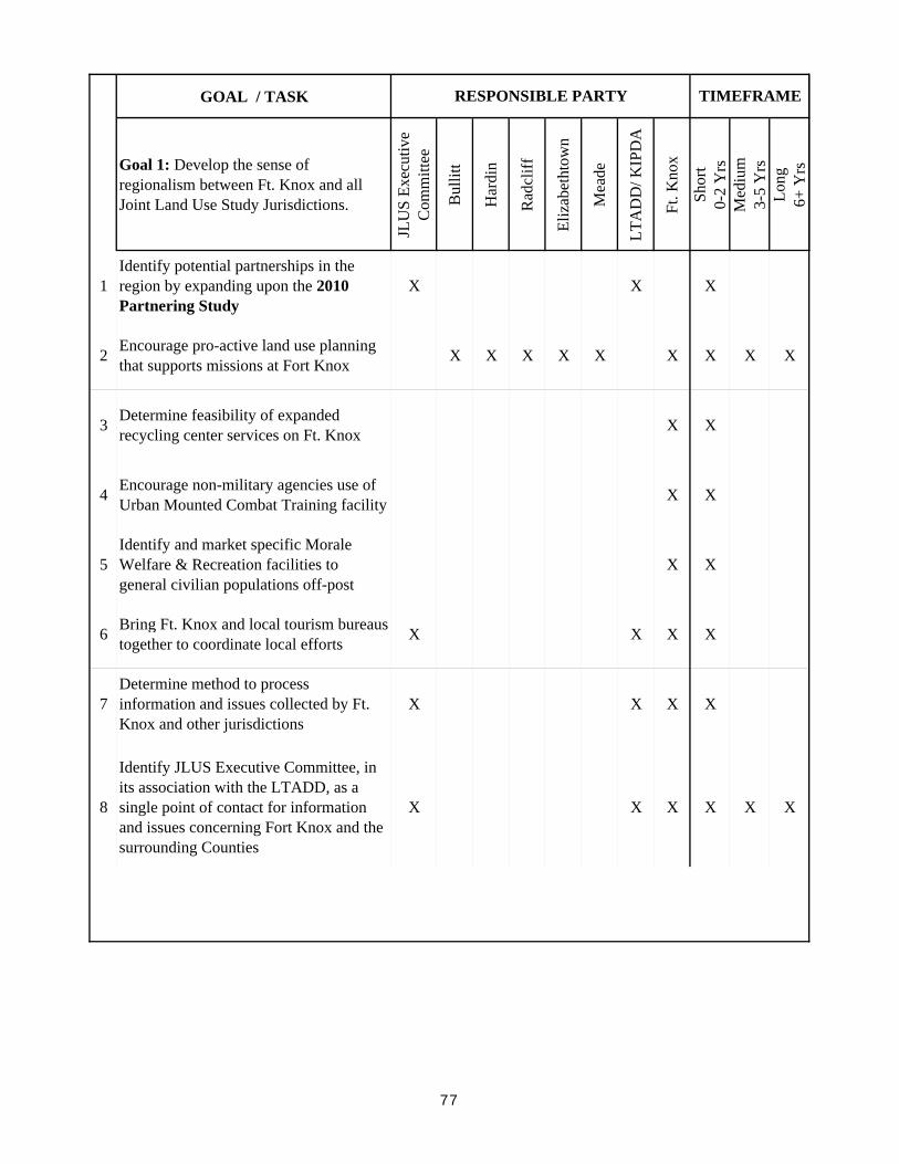
GOAL / TASK
Goal 1: Develop the sense of regionalism between Ft. Knox and all Joint Land Use Study Jurisdictions.
JLU
S Ex
ecut
ive
Com
mitt
ee
Bul
litt
Har
din
Rad
cliff
Eliz
abet
htow
n
Mea
de
LTA
DD
/ KIP
DA
Ft. K
nox
Shor
t
0-
2 Y
rsM
ediu
m
3-
5 Y
rsLo
ng
6+ Y
rs
1Identify potential partnerships in the region by expanding upon the 2010 Partnering Study
X X X
2 Encourage pro-active land use planning that supports missions at Fort Knox X X X X X X X X X
3 Determine feasibility of expanded recycling center services on Ft. Knox X X
4 Encourage non-military agencies use of Urban Mounted Combat Training facility X X
5Identify and market specific Morale Welfare & Recreation facilities to general civilian populations off-post
X X
6 Bring Ft. Knox and local tourism bureaus together to coordinate local efforts X X X X
7Determine method to process information and issues collected by Ft. Knox and other jurisdictions
X X X X
8
Identify JLUS Executive Committee, in its association with the LTADD, as a single point of contact for information and issues concerning Fort Knox and the surrounding Counties
X X X X X X
TIMEFRAMERESPONSIBLE PARTY
77
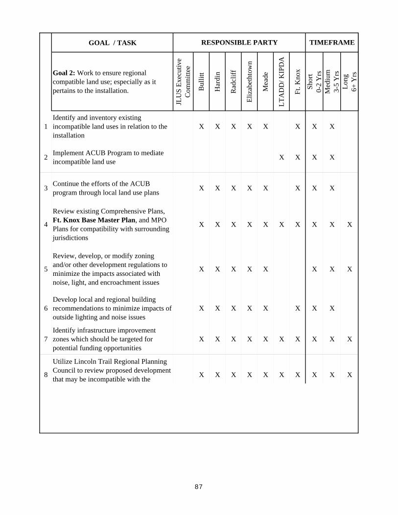
GOAL / TASK TIMEFRAMERESPONSIBLE PARTY
Goal 2: Work to ensure regional compatible land use; especially as it pertains to the installation.
JLU
S Ex
ecut
ive
Com
mitt
ee
Bul
litt
Har
din
Rad
cliff
Eliz
abet
htow
n
Mea
de
LTA
DD
/ KIP
DA
Ft. K
nox
Shor
t
0-
2 Y
rsM
ediu
m
3-
5 Y
rsLo
ng
6+ Y
rs
1Identify and inventory existing incompatible land uses in relation to the installation
X X X X X X X X
2 Implement ACUB Program to mediate incompatible land use X X X X
3 Continue the efforts of the ACUB program through local land use plans X X X X X X X X
4
Review existing Comprehensive Plans, Ft. Knox Base Master Plan, and MPO Plans for compatibility with surrounding jurisdictions
X X X X X X X X X X
5
Review, develop, or modify zoning and/or other development regulations to minimize the impacts associated with noise, light, and encroachment issues
X X X X X X X X
6Develop local and regional building recommendations to minimize impacts of outside lighting and noise issues
X X X X X X X X
7Identify infrastructure improvement zones which should be targeted for potential funding opportunities
X X X X X X X X X X
8
Utilize Lincoln Trail Regional Planning Council to review proposed development that may be incompatible with the X X X X X X X X X X
87
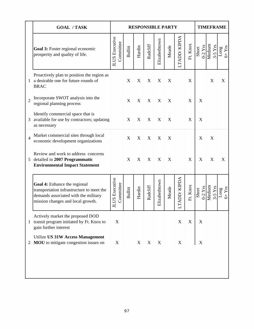
GOAL / TASK TIMEFRAMERESPONSIBLE PARTY
Goal 3: Foster regional economic prosperity and quality of life.
JLU
S Ex
ecut
ive
Com
mitt
ee
Bul
litt
Har
din
Rad
cliff
Eliz
abet
htow
n
Mea
de
LTA
DD
/ KIP
DA
Ft. K
nox
Shor
t
0-
2 Y
rsM
ediu
m
3-
5 Y
rsLo
ng
6+
Yrs
1Proactively plan to position the region as a desirable one for future rounds of BRAC
X X X X X X X X
2 Incorporate SWOT analysis into the regional planning process X X X X X X X
3Identify commercial space that is available for use by contractors; updating as necessary
X X X X X X X
4 Market commercial sites through local economic development organizations X X X X X X X
5Review and work to address concerns detailed in 2007 Programmatic Environmental Impact Statement
X X X X X X X X X
Goal 4: Enhance the regional transportation infrastructure to meet the demands associated with the military mission changes and local growth.
JLU
S Ex
ecut
ive
Com
mitt
ee
Bul
litt
Har
din
Rad
cliff
Eliz
abet
htow
n
Mea
de
LTA
DD
/ KIP
DA
Ft. K
nox
Shor
t
0-
2 Y
rsM
ediu
m
3-
5 Y
rsLo
ng
6+
Yrs
1Actively market the proposed DOD transit program initiated by Ft. Knox to gain further interest
X X X X
2Utilize US 31W Access Management MOU to mitigate congestion issues on X X X X X X
97

GOAL / TASK TIMEFRAMERESPONSIBLE PARTY
4Work with the Meade Co. Riverport Authority to establish river port access for the installation
X X X
107