f:\pdf geography\book-1\e-jha-5
TRANSCRIPT
MODULE - 2
79
The work of running water and underground waterChanging face of the
Earth
Notes
GEOGRAPHY
In the previous lesson we have learnt that the ultimate result of gradation is toreduce the uneven surface of the earth to a smooth and level surface. These agentsproduce various relief features over the course of time. Amongst all the agents ofgradation, the work of running water (rivers) is by far the most extensive. In thislesson we will study how running water and underground water act as agents ofgradation and help in the formation of different relief features.
OBJECTIVES
After studying this lesson, you will be able to :
explain the three functions of running water viz erosion, transportation anddeposition, in the different parts of the river’s course;
explain with the help of diagrams the formation of various erosional anddepositional features produced by the action of running water;
explain the cause of fluctuating water table from place to place and seasonto season;
explain with the help of diagrams the formation of various relief featuresformed by underground water;
distinguish between (i) stalactites and stalagmites, (ii) wells and artesian wells,(iii) springs and geysers.
5.1 THE THREE FUNCTIONS OF A RIVER
Running water or a river affects the land in three different ways. These are knownas the three functions of a river. They are (i) erosion (ii) transportation and (iii)deposition. Throughout its course a river displays all the three activities to someextent.
5
THE WORK OF RUNNINGWATER AND UNDERGROUND
WATER

MODULE - 2
80
The work of running water and underground water
Notes
Changing face of theEarth
GEOGRAPHY
(1) EROSION
Erosion occurs when overland flow moves soil particles downslope. Weatheringand erosion supply this rock material which is the load of the river. This load actsas the grinding tool. It thus helps in cutting the bottom and sides of the river bed,resulting in deepening and widening of the river channel.
Both the cutting and removal of rock debris by the river is called river erosion. Thework of river erosion is accomplished in four different ways, all of which operatetogether. These four ways are:
(a) Corrasion or Abrasion
As the rock particles bounce, scrape and drag along the bottom and sides of theriver, they break off additional rock fragments. This form of erosion is calledcorrasion. This is the mechanical grinding of the rivers against the banks and bedof the river. Corrasion takes place in two different ways :
(i) Lateral Corrasion: This is sideways erosion which widens the river valley.(ii) Vertical Corrasion : This is the downward erosion which deepens the
river valley.
(b) Corrosion or Solutions
This is the chemical or solvent action of water on soluble or partly soluble rockswith which the river water comes in contact. For example, limestone or calciumcarbonate, when it comes in contact with water, it is easily dissolved and removedin solution.
(c) Hydraulic Action
This is the mechanical loosening and sweeping away of material by the sheer forceof river water itself. No load or material is involved in this process. Some of thewater splashes against the river banks and enters into cracks and crevices. Thisundermines the soft rocks with which it comes in contact. It picks up the loosefragments from its bank and bed and transports them away.
(d) Attrition
This is the wear and tear of the transported materials themselves when they rolland collide with one another. In the process the coarser boulders are brokendown into smaller pieces. The angular edges are smoothened and rounded toform pebbles.
(2) TRANSPORTATION
River carries rock particles from one place to another. This activity is known astransportation of load by a river. The load is transported in four ways.

MODULE - 2
81
The work of running water and underground waterChanging face of the
Earth
Notes
GEOGRAPHY
(a) TractionThe heavier and larger rock fragments like gravel, pebbles etc. are forced by theflow of river to roll along its bed. These fragments can be seen rolling, slipping,bumping and being dragged. This process is known as traction and the load iscalled traction load.(b) SaltationSome of the fragments of the rocks move along the bed of a stream by jumping orbouncing continuously. This process is called saltation.(c) SuspensionThe holding-up of small particles like sand, silt and mud by the water as the streamflows is called suspension.(d) SolutionSome parts of rock fragments are dissolved in the river water and are thus trans-ported (See fig.5.1)
Fig. 5.1 Traction, Saltation and Suspension
The river transports its load in four ways viz. traction, saltation, suspensionand solution.
The transporting power of a river mainly depends upon its velocity, volumeand size of particles.
(3) DEPOSITION
When the stream comes down from hills to plain area, its slope becomes gentle.This reduces the energy of the stream. The decrease in energy hampers transpor-tation; as a result part of its load starts settling down. This activity is known asdeposition. Deposition takes place either due to decrease in slope or due to fall inthe volume or velocity of river water. Deposition takes place usually in plains andlow lying areas. When the river joins a lake or sea, the whole of its load is depos-ited.

MODULE - 2
82
The work of running water and underground water
Notes
Changing face of theEarth
GEOGRAPHY
Deposition takes place either due to decrease in slope or decrease in vol-ume or velocity of water.
INTEXT QUESTIONS 5.1
1. Which are the three functions of a river?(i)________________(ii) _________________(iii) ________________
2. What name is given to the rock material carried away by a river?_______________________________________________________
3. Name the four ways in which river erosion takes place.(i) ________________(ii) ________________(iii) ________________(iv) ______________
4. Name four ways in which a river transports its load.(i) ________________(ii) ________________(iii) ________________(iv) ______________
5. Name two conditions which favour the deposition of river load.(i) ________________________(ii) __________________________
6. Name the areas where deposition takes place.
_______________________________________________________
5.2 DEVELOPMENT OF A RIVER VALLEY
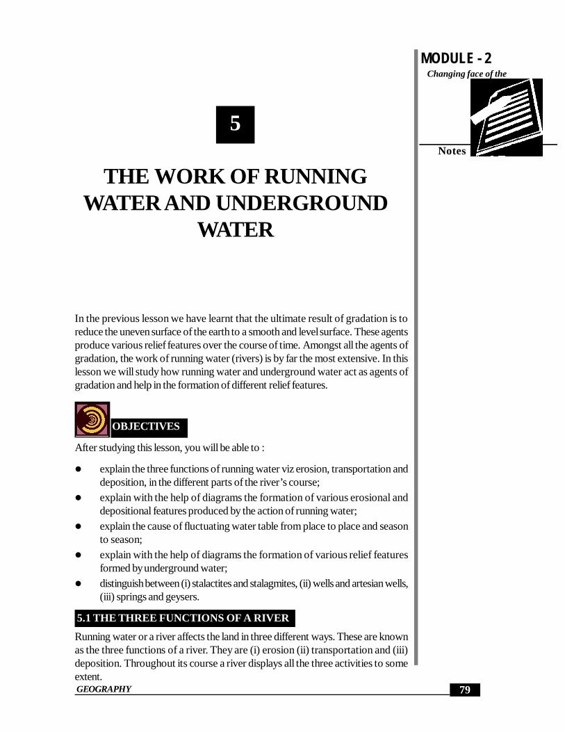
The erosional and depositional land features produced and modified by the actionof running water may be better understood if we note the stages through which astream passes from its source to its mouth. The source of a river may lie in amountainous region and the mouth may meet the sea or lake. The whole pathfollowed by a river is called its course or its valley.
The course of a river is divided into three sections:
(i) The upper course or the stage of youth(ii) The middle course or the stage of maturity(iii) The lower course or the stage of old age. (See Fig. 5.2)
Upper, middle and lower are the three courses into which a river valley isdivided.
(i) THE UPPER COURSE
The upper or mountain course begins from source of the river in hilly or moun-tainous areas. The river tumbles down the steep slopes and as a result its velocity
MODULE - 2
83
The work of running water and underground waterChanging face of the
Earth
Notes
GEOGRAPHY
and eroding power are at their maximum. Consequently valley deepening assumesits greatest importance at this stage. Normally, weathering also plays its part onthe new surfaces exposed along the banks of the stream. The weathered rockmaterial is carried into the stream partly through the action of gravity and partly byrain water flowing into the river. Weathering helps in widening a valley at the topgiving it a typical ‘V’ shaped cross section. Such valleys are known as ‘V’ shapedvalleys.
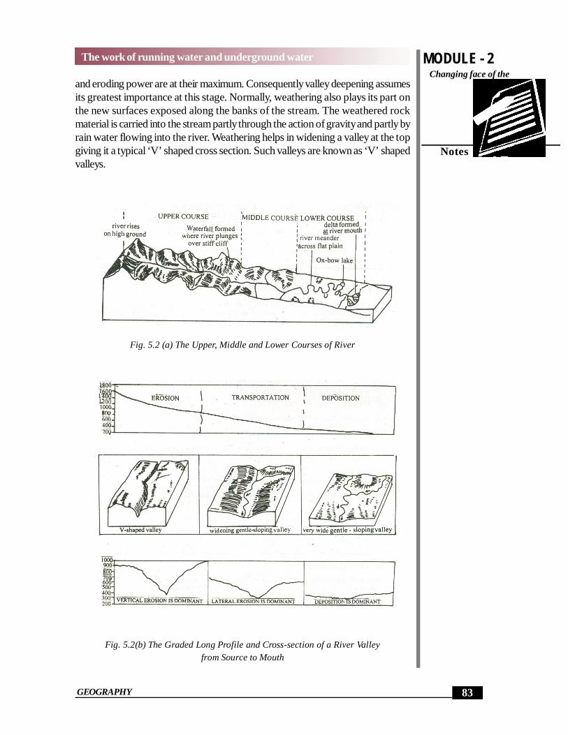
Fig. 5.2 (a) The Upper, Middle and Lower Courses of River
Fig. 5.2(b) The Graded Long Profile and Cross-section of a River Valleyfrom Source to Mouth

MODULE - 2
84
The work of running water and underground water
Notes
Changing face of theEarth
GEOGRAPHY
If the bed rock is hard and resistant, the widening of the valley at its top may nottake place and the down cutting process of a vigorous river may lead to the formationof a gorge i.e. a river valley with almost vertical sides.
In India, deep gorges have been cut by the Brahmaputra and the Indus in theHimalayas. Deep gorges also develop in limestone regions and in rocks lying indry climates. The narrow and very deep gorge or the canyon with vertical walls isalso known as ‘I’ shaped valley. A canyon is ‘very deep gorge with steep sidesrunning for hundreds of kilometers, e.g. Grand Canyon of the river Colorado inU.S.A. Some of the more outstanding features that are developed in the uppercourse of a river include rapids, cataracts, cascades and waterfalls.
The land features carved by a river in its upper course are gorges, canyons,‘V’ shaped valleys, rapids, cataracts, and waterfalls.
(ii) THE MIDDLE COURSE
In the middle course, lateral corrasion tends to replace vertical corrasion. Activeerosion of the banks widens the ‘V’ shaped valley. The volume of water increaseswith the confluence of many tributaries and this increases the river’s load. Thuswork of the river is predominantly transportation with some deposition. Riverswhich sweep down from steep mountain valleys to a comparatively level landdrop their-loads of coarse sand and gravels as there is sudden decrease in veloc-ity. The load deposited generally assumes a fan like shape, hence it is called analluvial fan. (See Fig. 5.3)
Fig. 5.3 Alluvial Fans
Sometimes several fans made by neighbouring streams often unite to form a con-tinuous plain known as a piedmont alluvial plain, so called because it lies at thefoot of the mountain.
In this section even minor obstacles force a river to swing in loops to go round theobstacles. These loops are called meanders, a term derived from the windingRiver Meanderes in Turkey.

MODULE - 2
85
The work of running water and underground waterChanging face of the
Earth
Notes
GEOGRAPHY
Some of the land features formed by a river in its middle course are alluvialfans, and meanders.
(iii) THE LOWER COURSE
The river moving downstream across a broad, level plain is heavy with debrisbrought down from the upper and middle courses. Vertical corrasion has almostceased, the lateral corrasion still goes on to erode its banks further. The work ofthe river is mainly deposition, building up its bed and forming an extensive floodplain. Many tributaries join the river and the volume of water increases, coarsematerials are dropped and the fine silt is carried down towards the mouth of theriver. Large sheets of material are deposited on the level bed and the river splitsinto a maze of channels. Such a stream is called a braided stream (See Fig. 5.4)
Fig. 5.4 Braided Stream
During annual floods large quantities of sediments are spread over the low lyingadjacent areas. A layer of sediments is thus deposited during each flood graduallybuilding up a fertile flood plain. A raised ridge of coarse material is formed alongeach bank of the river. Such ridges are called levees. (See Fig. 5.5)
Fig. 5.5 Flood Plain and Levees
In the lower course of the river, meanders become much more pronounced. Theouter bank or concave bank is so rapidly eroded that the meander becomes al-most a complete circle. A time comes when the river cuts through the narrow neck

MODULE - 2
86
The work of running water and underground water
Notes
Changing face of theEarth
GEOGRAPHY
of the loop. The meander, now cut of from the main stream, takes the form of anoxbow lake (See Fig. 5.6).
Fig. 5.6 Stages in the Formation of a Oxbow lake
This lake gradually, turning into swamps disappears in course of time. Numeroussuch partially or fully filled oxbow lakes are marked at short distance from thepresent course of river like the Ganga.
Upon entering a lake or a sea, the river deposits all the load at its mouth giving riseto the formation of a delta (See Fig. 5.7). Delta is a triangular relief features withits apex pointing up stream and is marked as a fan-shaped area of fine alluvium.The Greek letter () pronounced delta closely resembles the triangular delta ofthe river Nile. Some deltas are extremely large. The Ganga-Brahmaputra Delta isthe largest delta in the world.
Fig. 5.7 Formation of a Delta

MODULE - 2
87
The work of running water and underground waterChanging face of the
Earth
Notes
GEOGRAPHY
The following conditions favour the formation of deltas:
(1) active vertical and lateral erosion in the upper course of the river to supplylarge amount of sediments;
(2) tideless, sheltered coast;(3) shallow sea, adjoining the delta and(4) no strong current at the river mouth which may wash away the sediments.
Due to the obstruction caused by the deposited alluvium, the river discharge itswater through several channels which are called distributaries. Some rivers emp-tying into sea have no deltas but instead they have the shape of a gradually widen-ing mouth cutting deep inland. Such a mouth is called estuary. The formation ofestuaries is due to the scouring action of tides and currents. But in most of thecases the original cause is the subsidence of the earth’s crust in the area of theoutlet. The two west flowing rivers of India, the Narmada and the Tapi do notform deltas. They form estuaries when they join the Arabian Sea.
In the lower course land features produced by river are meanders, floodplains, braided steam, oxbow lakes, deltas and estuaries.
INTEXT QUESTIONS 5.2
1. Fill in the blanks:(a) The course of river from its source to mouth has been divided into
three parts.These are (i)_____________ (ii)___________ (iii)_____________
(b) A narrow and steep sides valley is called a _________________.2. Fill in the blanks
(a) The winding sections or loops of a stream are known as ___________.(b) The load deposited by a river at the foot of a mountain while descend-
ing from it, is called ____________.3. How is a piedmont alluvial plain formed?4. Fill in the blanks
(a) The meander completely cut off from the main river takes the form ofa lake which is known as________________________________.
(b) A number of branches of the main river carrying water to the sea arecalled _________________________________________.
(c) A triangular shaped land feature made by a river at its month is called_____________________________________________.
(d) Instead of deltas, rivers Narmada and Tapi form _______________.

MODULE - 2
88
The work of running water and underground water
Notes
Changing face of theEarth
GEOGRAPHY
5.3 UNDERGROUND WATER
Seepage and water-holding capacity of the rock depend upon its space. If therock is porous like sandstone, it will allow water to easily pass through it. Suchrocks are called permeable rocks. On the other ‘hand, if the rocks are not porousand do not allow water to pass through them, they are called impermeable rocks.However, if there are any cracks or joints in such rocks, water may pass throughthem.
The part of rain or snow- melt water which accumulates in the rocks afterseeping through the surface is called underground water.
The rocks through which water can pass easily are called permeable rocks,and the rocks through which water cannot pass through are called imper-meable rocks.
Although the amount of underground water varies from one place to another, itsrole in shaping the surface features of the earth is quite important. Most of its workis confined to subsurface areas though it plays an important role on surface also.
5.4 WATER TABLE
The water table marks the upper surface of the saturated zone of the groundwater, where pores are completely full of water. The zones or horizons of perme-able and porous rocks which are fully filled with water are called the zones ofsaturation. The upper level of this zone, below which the rocks are completelysaturated with water is called the underground water level or the water table.
The rocks containing underground water are called aquifers. The underground horizon of porous and permeable rocks which is filled
with water is called zone of saturation. The level of underground water, below which the rocks are fully filled with
water is called water table.
5.5 TYPES OF WATER TABLE
The level of the ground water table always fluctuates. It is never the same in anyarea. The level of the water table is controlled by the nature of land surface,variation in the amount of rainfall and the character of the underlying rocks. Watertable is generally higher in areas of high precipitation and also in areas borderingrivers and lakes. Water-table changes according to seasons. It is higher in rainyseason and lower during summers. On the basis of the variability, the water-tableis of two type: (a) The permanent water table and (b) The temporary water table.
(a) Permanent Water Table
When the water table is stable or static and never falls below a particular level, it

MODULE - 2
89
The work of running water and underground waterChanging face of the
Earth
Notes
GEOGRAPHY
is called the permanent water-table. It is not affected by seasonal change. Wellsdug upto this depth provide water in all seasons. They are perennial wells.
Fig. 5.8 Water Table
(b) Temporary Water Table
This is also known as seasonal water table. The level at which the water-table isnot stable, keeps changing with season is called temporary water table. It meansthat during the wet season, the water table will be higher than it is during the dryseason. It is the water table of the wet season that is temporary. Wells dug uptothis level are not perennial. They dry up during the summer season. (See Fig. 5.8).You might have seen wells drying up during the summer season and becomingfilled with water during the rainy season. It is because such wells are dug upto thetemporary water-table.
Nature of land surface, variations in amount of rainfall and the nature ofrocks affect the underground water table of any area.
The level below which the water table never falls is called the permanentwater table.
The water table which changes with seasons is called the temporary or sea-sonal water table.
INTEXT QUESTIONS 5.3
1. Fill in the blanks with the appropriate word given in the bracket against eachstatement.(a) The water which accumulates in the rocks after seeping through the
surface is called____________________(underground water, wa-ter-table)
(b) The rocks filled with underground water are called______________(Zones of Saturation, acquifers)
2. Name two types of water- table.(a)_____________________________(b) _____________________
MODULE - 2
90
The work of running water and underground water
Notes
Changing face of theEarth
GEOGRAPHY
3. Name three factors affecting water-table.(a)____________________(b) ______________(c) ______________
5.5 WELLS, TUBEWELLS & ARTESIAN WELLS
You must have seen wells and tubewells. They are man made holes dug into theearth’s surface through which underground water is drawn for drinking purposeand for irrigation. They are either bored mechanically as in the (case of tubewells)or are dug by man (as in the case of wells) to reach a permanent water table.
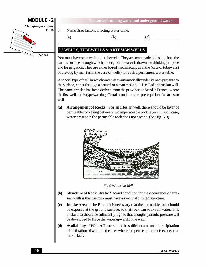
A special type of well in which water rises automatically under its own pressure tothe surface, either through a natural or a man made hole is called an artesian well.The name artesian has been derived from the province of Artoi in France, wherethe first well of this type was dug. Certain conditions are prerequisite of an artesianwell.
(a) Arrangement of Rocks : For an artesian well, there should be layer ofpermeable rock lying between two impermeable rock layers. In such case,water present in the permeable rock does not escape. (See fig. 5.9)
Fig 5.9 Artesian Well
(b) Structure of Rock Strata: Second condition for the occurrence of arte-sian wells is that the rock must have a synclinal or tilted structure.
(c) Intake Area of the Rock: It is necessary that the permeable rock shouldbe exposed at the ground surface, so that rock can soak rainwater. Thisintake area should be sufficiently high so that enough hydraulic pressure willbe developed to force the water upward in the well.
(d) Availability of Water: There should be sufficient amount of precipitationof infiltration of water in the area where the permeable rock is exposed atthe surface.

MODULE - 2
91
The work of running water and underground waterChanging face of the
Earth
Notes
GEOGRAPHY
A man-made hole on the earth’s surface through which underground wateris obtained is called a well.
A well in which water flows out automatically under its own pressure iscalled an artesian well.
The necessary conditions required for occurence of artesian wells are -arrangement of rocks, structure of rock strata, high intake area of the per-meable rocks and availability of water.
5.6 SPRINGS & GEYSERS
Springs are surface outflow of ground water through an opening in a rock underhydraulic pressure. In such cases the aquifer is either exposed at the surface or itunderlies an impermeable rocks. The amount of water in the aquifer dependsupon the amount of rainfall in that area, landform characteristic and the size of theaquifer. (See fig. 5.10)
Fig. 5.10 Formation of Spring
(a) Hot Spring
Sometimes the water that flows out of the spring is hot. Such springs are called hotsprings. They generally occurs in areas of active or recent vulcanism. In volcanicregions the underground water gets heated up by coming in contact with hot rocksor steam. Hot springs are found in many parts of India, especially in the Himalayain Jammu and Kashmir and Himachal Pradesh. They also occur in Uttarakhand,Jharkhand, Haryana and Assam. Manikaran in Kulu Valley, Tatapani near Shimla,Jwalamukhi in Kangra, Sohna in Haryana, Rajgir and Sitakund in Jharkhand andBadrinath in Uttarakhand have hot springs.
(b) Geyser
Springs emitting hot water and steam in forms of fountains or jets at regular inter-
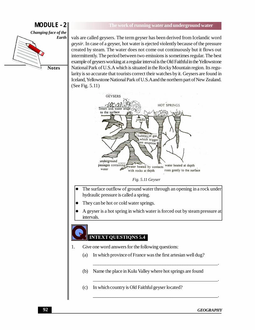
MODULE - 2
92
The work of running water and underground water
Notes
Changing face of theEarth
GEOGRAPHY
vals are called geysers. The term geyser has been derived from Icelandic wordgeysir. In case of a geyser, hot water is ejected violently because of the pressurecreated by steam. The water does not come out continuously but it flows outintermittently. The period between two emissions is sometimes regular. The bestexample of geysers working at a regular interval is the Old Faithful in the YellowstoneNational Park of U.S.A which is situated in the Rocky Mountain region. Its regu-larity is so accurate that tourists correct their watches by it. Geysers are found inIceland, Yellowstone National Park of U.S.A and the northern part of New Zealand.(See Fig. 5.11)
Fig. 5.11 Geyser
The surface outflow of ground water through an opening in a rock underhydraulic pressure is called a spring.
They can be hot or cold water springs. A geyser is a hot spring in which water is forced out by steam pressure at
intervals.
INTEXT QUESTIQNS 5.4
1. Give one word answers for the following questions:(a) In which province of France was the first artesian well dug?
__________________________________________________.(b) Name the place in Kulu Valley where hot springs are found
__________________________________________________.(c) In which country is Old Faithful geyser located?
__________________________________________________.

MODULE - 2
93
The work of running water and underground waterChanging face of the
Earth
Notes
GEOGRAPHY
(d) What should be the shape of the rock strata for occurrence of theartesian wells?
__________________________________________________.
5.7 LANDFORMS PRODUCED BY UNDERGROUND WATER
Underground water is also an agent of gradation like surface water. It also doesthe work of erosion, transportation and deposition, which results in formation of anumber of picturesque topographical features. Topographical features formed byunderground water can be seen particularly, in an highland composed of limestoneon a large scale. This distinctive topography formed due to the action of under-ground water in limestone region is known as Karst topography. ‘Karst’ wordcomes from the Karst region of Adriatic Sea coast in Croatia (Yugosalvia) wheresuch formations are noticeable. This region is made up of limestone rocks, whereunderground water is the most active agent of gradation.
The distinctive topography formed by underground water in limestone re-gion is called Karst topography
Mechanical weathering and solution of limestone in water help the erosionalwork of underground water.
The topographical features created by the work of underground water on lime-stone are of two types.
(a) Topographical features formed on the surface, like sink holes and swallowholes.
(b) Topographical features formed underground like caverns, stalactites andstalgmites.
(i) Sink Holes
A sinkhole is a surface depression in a region of limestone or chalk terrain. Somesinkholes are filled with soil washed from nearby hillsides, while others are steep-sided, dugholes. They develop where the limestone is more susceptible to solu-tion, weathering or where an underground cover near the surface has collapsed.(ii) Swallow Holes
They are cylindrical in shape lying underneath the sinkholes at some depth. Inlimestone regions, the surface streams often enter the sinkholes and then disap-pear underground through swallow holes. It is so, because these holes are con-nected to the underground caverns on their other side.

MODULE - 2
94
The work of running water and underground water
Notes
Changing face of theEarth
GEOGRAPHY
Fig. 5.12 A Sinkholes on the Surface of Limestone RockB-Swallo Holes at the bottom of a Funnel Shaped Sinkhole
(iii) Caverns
Caverns are interconnected subterranean cavities in bedrock formed by the cor-rosions action of circulating underground water on limestone. They are found nearDehradun in Uttarakhand and in Almora in Kumaon Himalayas. The caves ofKotamsar in the tribal district of Bastar in Chhattisgarh are famous caverns ofIndia.
The funnel-shaped depressions in limestone regions are called sink holes. Cyclindrical shape tubes lying underneath the sink holes are called swallow
holes. Underground caves formed due to solvent action of underground water in
limestone region are called caverns.
(iv) Stalactites and Stalagmites
They are the major depositional features formed in the caverns in limestone re-gions. The water containing limestone in solution, seeps through the roofs of thecaverns in the form of a continuous chain of drops. A portion of the water drop-ping from the ceiling gets evaporated and a small deposit of limestone is left behindon the roof. This process continues and deposit of limestone grows downwardslike pillars. These beautiful forms are called stalactites.
Fig. 5.13 Stalactites and Stalagmites

MODULE - 2
95
The work of running water and underground waterChanging face of the
Earth
Notes
GEOGRAPHY
When the remain in portion of the water dropping from the roof of the cavern fallson the floor, a part of it is again evaporated and a small deposit of limestone is leftbehind. This deposit grows upward from the floor of the cavern. These type ofdepositional features are called stalagmites. As the process grows, both stalactiteand stalagmite often join together to form vertical columns in the caverns.
Solid conical depositional features hanging from the cavern’s roofs are calledstalactites.
Broad conical pillars developing on the floor of the caverns in limestoneregions are called stalagmites.
INTEXT QUESTIONS 5.5
1. Answer following questions in one or two words:a. Name the cavern located in Chhattisgarh.
______________________________________.b. In which country is “Karst” region located.
______________________________________.c. Name three regions of the world where hot spring and geysers are
found(i)________________(ii)________________(iii)_____________
d. Name two topographical features formed on the surface through theactivity of underground water.
(i)_________________________(ii)____________________
Fig. 5.14 : Limestone Landscape

MODULE - 2
96
The work of running water and underground water
Notes
Changing face of theEarth
GEOGRAPHY
WHAT YOU HAVE LEARNT
Among the agents of gradation, the running water is most effective and important.
A river has three fold action- (a) erosion (b) transportation (c) deposition. Therock material carried by river water is called its load. The ability of a river to moverock material depends upon- (a) the speed of water (b) the volume of water (c)the land structure and (d) the size, shape and weight of load. The work of rivererosion is accomplished in four different ways-corrasion, corrosion, hydraulic ac-tion and attrition. The river transports its load in four different ways-by traction,saltation, suspension and solution. The deposition starts in plains and low lyingareas. The whole path followed by a river is called its course. The course of a riveris divided into three sections-(1) the upper course (2) the middle course (3) thelower course. The upper course lies in mountain. Here vertical cutting is moreimportant. The land features produced are gorges, canyons, rapids, waterfalls.The middle course lies at the junction of mountain and plains. Here the work ofriver is mainly transportation with some deposition. The land feature produced ismeander. The lower course lies in the plain area. Here the work of river is mainlydeposition. The land features produced are ox-bow lakes, braided streams, allu-vial and flood plains, delta and estuary.
The water which percolates inside the earth is called underground water. Theupper limit of underground water is called water-table. The level of water table isnot uniform but it varies seasonally. Consequently the water-table is of two typespermanent water table and temporary water table. Underground water comes tothe surface through wells, tubewells and springs. Wells and tubewells are manmadeholes dug into the earth surface through which water is obtained. In addition tothese ordinary wells, there is a special type of well in which water flows out auto-matically under hydraulic pressure. They are called artesian wells. Surface outpourof ground water that from rock opening under its own pressure is called a spring.Sometimes the water flows out of springs is hot, such springs are called hot springs.When the hot springs emits water in the form of a fountain, they are called geysers.Geysers are found mainly in Iceland, Yellowstone National Park, USA and NewZealand.
Underground water does the work of erosion, transportation and deposition whichresult in number of topographical features. The major depositional features madeby underground water are stalactites and stalagmites, which develop in the cav-erns.
TERMINAL QUESTIONS
1. Answer briefly the following questions :(a) In what different ways does a river transport its load?

MODULE - 2
97
The work of running water and underground waterChanging face of the
Earth
Notes
GEOGRAPHY
(b) List out factors which affect (1) energy of a stream and (2) carryingcapacity of streams.
(c) In what different ways is the work of river erosion accomplished?
2. Distinguish between the following pairs:(a) estuary and deltas (b) flood plain and braided stream
3. The following landforms have been formed by rivers. Group them undererosional and depositional features.Gorge, V -shaped valley, meander, flood plain, alluvial fan, and canyon.
4. Explain the formation of the following with suitable diagrams:(a) Oxbow lake (b) Delta
5. Explain systematically the work of river as an agent of gradation at each ofthe three stages of its course.
6. Answer the following questions in brief:(a) Explain the meaning of the term underground water.(b) How do streams in limestone regions suddently disappear?(c) Why is construction of rails and roads difficult in areas of sinkholes.(d) Permanent watertable and temporary watertable.(e) Sinkhole and swallow hole. (f) Stalactite and stalagmite.(g) Permeable rocks and impermeable rocks. (h) Hot spring and geyser.
7. What is meant by ‘Karst’ topography? Name any five topographical fea-tures of karst topography and explaion any two of these with the help ofdiagrams.
ANSWERS TO INTEXT QUESTIONS
5.1
1. (i) Erosion (ii) Transportation (iii) deposition2. Load3. (i) Corrasion (ii) Corrosion (iii) Hydraulic action (iv) Attrition.
4. (i) Traction (ii) Saltation (iii) Suspension (iv) Solution.5 (i) decrease in slope or in velocity of water (ii) decrease in volume of water.
6. Plains, low laying areas, lakes and seas.
5.2
1. (a) (i) upper (ii) middle (iii) lower course. (b) Gorge

MODULE - 2
98
The work of running water and underground water
Notes
Changing face of theEarth
GEOGRAPHY
2. (a) Meanders (b) Alluvial fan
3. By deposition of load at the foot of mountains.
4. (a) Oxbow lake (b) Distributaries (c) Delta (d) Estuaries.
5.3
1. (a) Underground water (b) Acquifers,2. (a) Permanent water table (b) Temporary water-table.3. (a) Nature of surface (b) Rainfall (c) Nature of rocks.
5.4
1. (a) Arto region (b) Manikaran (c) U.S.A. (d) Synclinal or titled.
5.5
(a.) Kotamsar b. Croatia (Yugoslavia) c. (i) Iceland (ii) Yellowstone NationalPark, USA (iii) New Zealand
d. (a) Sinkholes (b) Swallow holes.
HINTS TO TERMINAL QUESTIONS
1. (a) The river transports its load in four ways by traction, by saltation, bysuspension and by solution.
(b) (i) Slope, velocity, structure of river bed. (ii) Velocity, volume and sizeof particles.
(c) The work of river erosion is accomplished by corrasion, corrosion,hydraulic action and attrition.
2. (a) Estuary- The funnel shaped mouth of river, where tides flow in and outand where fresh water and sea water mix. They are formed by drown-ing of coastal lowlands by a relative rise of sea level.
Delta - A more or less triangular and level tract of alluvium formed atthe mouth of river and traversed by the distributaries of the river.
(b) Flood Plain - A plain bordering a river formed as a result of sedimentsdeposited by a river and is generally liable to flooding.Braided stream - A river that gets divided into a network of intercon-nected channels, forming bars and sand island in between.
3. Work of Erosion - Gorge, ‘V’ shaped valley, Meander, Canyon.
Work of Deposition- Meander, Flood plain, Alluvial Fan.
4. (a) Ox-Bow lake- The meanders develop in the middle course of theriver. In course of time the strip of land between two loops becomes

MODULE - 2
99
The work of running water and underground waterChanging face of the
Earth
Notes
GEOGRAPHY
narrower and narrower till the river cuts through this strip and takes astraight course. The former loop or meander is left behind completelycut off from the main channel forming an Ox-bow lake.
(b) Delta- A more or less triangular and level tract of alluvium formed atthe mouth of river and traversed by the distributaries of the river.
5. River is the most important agent of gradation. The river has three stages. Itremains busy doing the work of gradation in the three stages,Upper Stage:- Gorge, waterfall, canyons are formed.Middle Stage: Meanders, alluvial fans are formed.Lower Stage:- Flood plains, braided stream, ox-bow lake, delta and estu-ary, are formed by the river.
6. (a) Underground water is that part of the rainwater which percolatesthrough the ground and accumulates below the surface, is called un-derground water.
(b) A large number of sinkholes and swallow holes are found in limestoneregions. The water of the streams enters these openings and the sur-face flow becomes underground. In this manner the streams in thelimestone regions become underground.
(c) Construction of roads and railways is difficult in regions having a largenumber of sink holes and swallow holes due to which the level of theground sinks in such regions.
(d) Permanent water table: This is the level of the water under the sur-face below which the water-table never falls. This water-table is notaffected by seasonal change. Wells dug upto this depth are never dry.(See fig. 5.8)
Temporary water-table: In some regions the water-table is not per-manent and it keeps changing with seasons. The water-table changingwith seasons is called temporary water-table. Wells dug upto this depthbecome dry during the dry season.
(e) Sink holes: These are funnel-shaped openings in the limestone re-gion. Their depth varies from 3 to 9 metres and the diameter of themouth is more than one metre. (See Fig 5.12) Construction of roadsand railways is difficult in areas having a large number of sink holes.
Swallow holes: They are cylincdrical tube-like openings which areconnected to the lower part of the sink hole. Rivers of the limestoneregions become underground through swallow holes.
(f) Stalactite: A portion of the water dropping from the ceiling getsevapourated and a small deposit of limestone is left behind on the roof.This process continues and deposit of lime stone grows downwardslike pillars. These beautiful forms are called stalactites.

MODULE - 2
100
The work of running water and underground water
Notes
Changing face of theEarth
GEOGRAPHY
Stalagmites: When the remaining portion of the water dropping fromthe roofs of the cavern falls on the floor a part of it is again evaporatedand a small deposit of limestone is left behind. This deposit growsupward from the floor of the cavern. These type of depositional fea-tures are called stalagmites.
(g) Permeable rock: The rock through which water can percolate arecalled permeable rocks. Impermeable rocks: The rocks through whichwater cannot percolate are called impermeable rocks.
(h) Hot springs: The springs emitting hot or warm water are called hotsprings. These springs are found in areas of present or past volcanicactivity. In such regions the underground water gets heated up by com-ing in contact with hot rocks or steam.
Geysers: Hot springs emitting hot water and steam at almost regularintervals are called geysers. The water in geysers is ejected with forceas in case of a fountain.
7. For Karst topography see following figures 5.12, 5.13 and 5.14
(i) Sinkholes (ii) Swallow holes (iii) Caverns (v) Stalactites (iv) Stalag-mites.
See description of these figures in Section 5.8.