fremont county, colorado
TRANSCRIPT
SUBDIVISION REGULATIONS
OF
FREMONT COUNTY, COLORADO
ADOPTED MARCH 14, 2000 WITH AN EFFECTIVE DATE OF MARCH 14, 2000
BY RESOLUTION #15, SERIES OF 2000
1st Amendment – Resolution No. 21, Series of 2005 May 24, 2005
2nd Amendment – Resolution No. 28, Series of 2006 April 11, 2006
3rd Amendment – Resolution No. 53, Series of 2009 November 24, 2009
4th Amendment – Resolution No. 36, Series of 2012 September 25, 2012
5th Amendment – Resolution No. 39, Series of 2012 November 26, 2012
6th Amendment – Resolution No. 15, Series of 2013 March 12, 2013
7th Amendment – Resolution No. 26, Series of 2013 June 25, 2013
8th Amendment – Resolution No. 49, Series of 2013 January 2, 2014
9th Amendment – Resolution No. 7, Series of 2014 January 28, 2014
10th Amendment – Resolution No. 14, Series of 2014 April 8, 2014
11th Amendment - Resolution No. 8, Series of 2020 January 14, 2020
FFrreemmoonntt CCoouunnttyy DDeeppaarrttmmeenntt ooff PPllaannnniinngg aanndd ZZoonniinngg
615 Macon Avenue, Room 210
Cañon City, Colorado 81212
Telephone: (719) 276-7360
www.fremontco.com

i
TABLE OF CONTENTS
I. GENERAL PROVISIONS
A. TITLE ....................................................................................................................................... I-1
B. SHORT TITLE ........................................................................................................................ I-1
C. AUTHORITY & JURISDICTION ......................................................................................... I-1
D. STATEMENT OF PURPOSES .............................................................................................. I-1
E. ENFORCEMENT & PENALTIES ......................................................................................... I-2
F. RELATIONSHIP OF SUBDIVISION REGULATIONS &
OTHER LAND-USE REGULATIONS ................................................................................. I-3
G. ACCEPTANCE OF DEDICATIONS TO THE PUBLIC ...................................................... I-4
H. SEVERABILITY CLAUSE .................................................................................................... I-4
I. RULES OF CONSTRUCTION .............................................................................................. I-4
J. APPLICATION MEETINGS .................................................................................................. I-5
K. AMENDMENT TO CONTINGENCIES OF APPROVAL................................................... I-6
L. VALIDITY OF APPLICATIONS .......................................................................................... I-7
II. DEFINITIONS ........................................................................................................................... II-1
III. SKETCH PLAN APPLICATION
A. SUBMISSION ...................................................................................................................... III-1
B. REVIEW OF SKETCH PLAN APPLICATION ................................................................. III-1
C. EFFECTS OF APPROVAL ................................................................................................. III-5
D. DENIAL OF A SKETCH PLAN APPLICATION ............................................................. III-5
IV. SKETCH PLAN REQUIREMENTS
A. REQUIRED COPIES ........................................................................................................... IV-1
B. SKETCH PLAN DRAWING REQUIREMENTS .............................................................. IV-1
C. REQUIRED REPORTS, STUDIES & NOTIFICATIONS................................................. IV-2
D. RELATIONSHIP TO DESIGN STANDARDS .................................................................. IV-3
V. PRELIMINARY PLAN APPLICATION
A. SUBMISSION ....................................................................................................................... V-1
B. DISTRIBUTION OF THE PRELIMINARY PLAN ............................................................ V-1
C. REVIEW OF THE PRELIMINARY PLAN APPLICATION ............................................. V-3
D. EFFECTS OF APPROVAL .................................................................................................. V-7
E. DENIAL OF A PRELIMINARY PLAN APPLICATION .................................................. V-8
ii
VI. PRELIMINARY PLAN REQUIREMENTS
A. CONFORMANCE WITH THE SKETCH PLAN............................................................... VI-1
B. REQUIRED COPIES ........................................................................................................... VI-1
C. PRELIMINARY PLAN DRAWING REQUIREMENTS .................................................. VI-1
D. ONSITE WASTEWATER TREATMENT SYSTEM MAP & REPORT ......................... VI-3
E. PUBLIC SANITARY SEWER SYSTEM REPORT .......................................................... VI-4
F. WATER RESOURCES REPORT FOR INDIVIDUAL WATER SYSTEMS .................. VI-5
G. WATER RESOURCES REPORT FOR A PUBLIC WATER SUPPLY SYSTEM .......... VI-6
H. DRAINAGE PLAN AND REPORT ................................................................................... VI-6
I. EROSION CONTROL MAP AND REPORT ..................................................................... VI-6
J. GEOLOGIC HAZARD MAP AND REPORT .................................................................... VI-7
K. GEOLOGY RESOURCE REPORT .................................................................................... VI-8
L. POTENTIAL MINERAL RESOURCE AREAS MAP AND REPORT ............................ VI-8
M. WILDFIRE HAZARD MAP AND REPORT ..................................................................... VI-8
N. WILDLIFE HABITAT MAP AND REPORT .................................................................... VI-9
O. SOILS BOUNDARY MAP AND REPORT ....................................................................... VI-9
P. DRAINAGE FEATURES, STREAMS, WATER COURSES, LAKES,
TOPOGRAPHY & VEGETATION REPORT .................................................................... VI-9
Q. POTENTIAL RADIATION HAZARD REPORT ............................................................ VI-10
R. FIRE PROTECTION REPORT AND MAP ..................................................................... VI-10
S. ROADWAY IMPACT ANALYSIS .................................................................................. VI-10
T. CONDOMINIUM OR TOWNHOUSE DRAWING ........................................................ VI-10
U. ADDITIONAL INFORMATION REQUIRED ................................................................ VI-10
V. NOTIFICATION / PUBLICATION .................................................................................. VI-11
W. RELATIONSHIP TO DESIGN STANDARDS ................................................................ VI-12
VII. FINAL PLAT APPLICATION
A. SUBMISSION .................................................................................................................... VII-1
B. REVIEW OF THE FINAL PLAT APPLICATION ......................................................... VII-1
C. RECORDING OF THE FINAL PLAT .............................................................................. VII-3
D. EFFECTS OF APPROVAL ............................................................................................... VII-3
E. DENIAL OF A FINAL PLAT APPLICATION ............................................................... VII-4
VIII. FINAL PLAT REQUIREMENTS
A. CONFORMANCE WITH THE PRELIMINARY PLAN ............................................... VIII-1
B. REQUIRED COPIES ........................................................................................................ VIII-1
C. FINAL PLAT DRAWING REQUIREMENTS................................................................ VIII-1
D. CONDOMINIUM OR TOWNHOUSE PLATS............................................................... VIII-6
E. GENERAL INFORMATION ........................................................................................... VIII-6
F. NOTIFICATION / PUBLICATION ................................................................................. VIII-7

iii
G. RELATIONSHIP TO DESIGN STANDARDS ............................................................... VIII-8
H. ADDITIONAL REQUIREMENTS........................................ .......................................... VIII-8
IX. SITE SPECIFIC DEVELOPMENT PLAN (PROVISIONS FOR REVIEW AND
APPROVAL OF A SITE SPECIFIC DEVELOPMENT PLAN)
A. SITE SPECIFIC DEVELOPMENT PLAN ......................................................................... IX-1
B. STANDARDS AND CONDITIONS FOR APPROVAL ................................................... IX-1
C. POST APPROVAL ACTIONS ............................................................................................ IX-2
D. AMENDMENTS TO SITE SPECIFIC DEVELOPMENT PLAN ..................................... IX-2
X. UTILITIES & IMPROVEMENTS
A. GENERAL REQUIREMENTS ............................................................................................ X-1
B. INDEPENDENT REVIEW ................................................................................................... X-1
C. ROAD DESIGNATION AND DAMAGE ........................................................................... X-1
XI. GUARANTEE OF PUBLIC IMPROVEMENTS
A. GUARANTEES .................................................................................................................... XI-1
B. USE OF GUARANTEES, RETURN THEREOF ............................................................... XI-1
XII. MINOR SUBDIVISION APPLICATION
A. SUBMISSION .................................................................................................................... XII-1
B. REVIEW OF MINOR SUBDIVISION APPLICATION.................................................. XII-1
C. EFFECTS OF APPROVAL ............................................................................................... XII-5
D. DENIAL OF A MINOR SUBDIVISION APPLICATION .............................................. XII-5
XIII. MINOR SUBDIVISION REQUIRMENTS
A. REQUIRED COPIES ........................................................................................................ XIII-1
B. MINOR SUBDIVISION PLAT DRAWING REQUIREMENTS ................................... XIII-1
C. CONDOMINIUM OR TOWNHOUSE PLATS............................................................... XIII-5
D. GENERAL INFORMATION ........................................................................................... XIII-6
E. ADDITIONAL REQUIREMENTS .................................................................................. XIII-9
F. RELATION TO DESIGN STANDARDS ...................................................................... XIII-10
G. RECORDING .................................................................................................................. XIII-10
XIV. VACATION OF INTERIOR LOT LINE & UTILITY / DRAINAGE EASEMENTS
A. SUBMISSION ................................................................................................................... XIV-1
B. REVIEW ............................................................................................................................ XIV-1
C. REQUIRED COPIES ........................................................................................................ XIV-1
iv
D. FINAL PLAT DRAWING REQUIREMENTS................................................................ XIV-2
E. SUBMITTAL REQUIREMENTS .................................................................................... XIV-5
F. ADDITIONAL REQUIREMENTS .................................................................................. XIV-6
XV. LOT LINE OR BOUNDARY ADJUSTMENT
A. SUBMISSION .................................................................................................................... XV-1
B. REVIEW OF THE LOT LINE OR BOUNDARY ADJUSTMENT ................................ XV-1
C. REQUIRED COPIES ......................................................................................................... XV-1
D. METES & BOUNDS REQUIREMENTS ......................................................................... XV-2
E. PLATTED PROPERTY DRAWING REQUIREMENTS ................................................ XV-2
F. SUBMITTAL REQUIREMENTS ..................................................................................... XV-7
G. RELATIONSHIP TO DESIGN STANDARDS ................................................................ XV-7
XVI. VACATION OF RECORDED PUBLIC RIGHT-OF-WAY APPLICATION
A. SUBMISSION ................................................................................................................... XVI-1
B. REVIEW OF PUBLIC RIGHT-OF-WAY VACATION APPLICATION ..................... XVI-1
C. EFFECTS OF APPROVAL .............................................................................................. XVI-5
D. DENIAL OF A VACATION OF RECORDED PUBLIC RIGHT-OF-WAY APP ........ XVI-6
E. REQUIRED COPIES ........................................................................................................ XVI-6
F. DRAWING REQUIREMENTS ........................................................................................ XVI-6
G. MINIMUM SUBMITTAL REQUIREMENTS ................................................................ XVI-7
H. NOTICE REQUIREMENTS ............................................................................................ XVI-7
I. ADDITIONAL REQUIREMENTS ................................................................................. XVI-8
XVII. CORRECTION PLAT
A. SUBMISSION ................................................................................................................. XVII-1
B. REVIEW OF THE CORRECTION PLAT APPLICATION ......................................... XVII-1
C. RECORDING OF THE CORRECTION PLAT ............................................................. XVII-1
XVIII. CORRECTION PLAT DRAWING REQUIREMENTS
A. REQUIRED COPIES ..................................................................................................... XVIII-1
B. CORRECTION PLAT DRAWING REQUIREMENTS .............................................. XVIII-1
C. SURVEYOR’S AFFIDAVIT ......................................................................................... XVIII-1
XIX. EXEMPTIONS & PLANNED UNIT DEVELOPMENT (PUD)
A. EXEMPTIONS .................................................................................................................. XIX-1
B. PLANNED UNIT DEVELOPMENT (P.U.D.) ................................................................ XIX-1
XX. FEES ....................................................................................................................................... XX-1
v
XXI. GENERAL DEDICATIONS, SCHOOLS & PARK SITES
A. DEDICATED LAND ........................................................................................................ XXI-1
B. REQUIRED ROAD DEDICATIONS .............................................................................. XXI-1
C. PARK DEDICATIONS ..................................................................................................... XXI-1
D. SCHOOL DEDICATIONS ............................................................................................... XXI-3
E. IMPACT STATEMENT ................................................................................................... XXI-4
F. OTHER REQUIRED DEDICATIONS ............................................................................ XXI-4
G. CASH-IN-LIEU ................................................................................................................. XXI-5
H. COMBINATION OF DEDICATION AND CASH-IN-LIEU ......................................... XXI-5
I. RELEASE OF LAND OR CASH ..................................................................................... XXI-5
XXII. PLANNED UNIT DEVELOPMENTS (P.U.D.)
A. PURPOSE AND INTENT............................................................................................... XXII-1
B. USES ALLOWED ........................................................................................................... XXII-1
C. STANDARDS FOR APPROVAL .................................................................................. XXII-1
D. PROCEDURES AND REQUIREMENTS ..................................................................... XXII-2
E. SKETCH PLAN SUBMITTAL ...................................................................................... XXII-2
F. SKETCH PLAN - ACTION BY COMMISSION .......................................................... XXII-2
G. PRELIMINARY DEVELOPMENT PLAN - APPLICATION ..................................... XXII-2
H. PRELIMINARY DEVELOPMENT PLAN - MAPS ..................................................... XXII-2
I. PRELIMINARY DEVELOPMENT PLAN - WRITTEN STATEMENT .................... XXII-3
J. PRELIMINARY DEVELOPMENT PLAN - REPORT BY COMMISSION .............. XXII-4
K. PRELIMINARY DEVELOPMENT PLAN - BOARD ACTION ................................. XXII-4
L. ZONING MAP NOTATION .......................................................................................... XXII-4
M. PRELIMINARY SUBDIVISION AND IMPROVEMENTS PLAN ............................ XXII-4
N. FINAL DEVELOPMENT PLAN - NO BUILDING PERMIT ..................................... XXII-4
O. FAILURE TO APPLY FOR FINAL DEVELOPMENT PLAN - REVOCATION ...... XXII-5
P. FINAL DEVELOPMENT PLAN - APPLICATION ..................................................... XXII-5
Q. FINAL DEVELOPMENT PLAN - INFORMATION TO BE SUBMITTED .............. XXII-5
R. FINAL DEVELOPMENT PLAN - ACTION BY COMMISSION & BOARD ........... XXII-6
S. SPECIAL PROCEDURE FOR DEVELOPMENT STAGES ........................................ XXII-6
T. CONFORMANCE WITH SUBDIVISION REGULATIONS ...................................... XXII-6
U. CONSISTENCY WITH THE MASTER PLAN ............................................................ XXII-6
V. FEES FOR P.U.D. APPLICATION ................................................................................ XXII-6
XXIII. GENERAL REQUIREMENTS
A. DRAINAGE PLAN AND REPORT ............................................................................. XXIII-1
B. ROADWAY IMPACT ANALYSIS .............................................................................. XXIII-7

vi
APPENDIX 1
I. DESIGN STANDARDS
A. GENERAL STANDARDS ............................................................................................ App 1-1
B. LOT STANDARDS ........................................................................................................ App 1-1
C. ACCESS STANDARDS ................................................................................................ App 1-2
D. STREET DESIGN STANDARDS ................................................................................. App 1-3
E. STREET DESIGN CRITERIA-URBAN STREETS .................................................. App 1-12
F. STREET DESIGN CRITERIA-RURAL STREETS ................................................... App 1-20
G. CITY OF CAÑON CITY 3-MILE FRINGE AREA ................................................... App 1-26
H. OTHER DESIGN STANDARDS ................................................................................ App 1-31
I. INTERSECTION DESIGN REQUIREMENTS. ....................................................... .App 1-31
J. CURVES IN STREETS. ............................................................................................. .App 1-32
K. SITE DISTANCE... ...................................................................................................... App 1-32
L. STREET GRADES. ..................................................................................................... .App 1-32
M. STREET ALIGNMENT. ............................................................................................. .App 1-32
II. GENERAL DESIGN CRITERIA FOR UTILITIES
A. GENERAL REQUIREMENTS .................................................................................... App 1-33
B. EXISTING UTILITIES ................................................................................................. App 1-33
C. STANDARDS ............................................................................................................... App 1-33
III. GENERAL DESIGN CRITERIA – DRAINAGE
A. DESCRIPTION .............................................................................................................. App 1-37
B. GENERAL PROVISIONS ............................................................................................ App 1-37
C. HYDROLOGY ............................................................................................................... App 1-37
D. STREET FLOWS........................................................................................................... App 1-38
E. DETENTION BASINS .................................................................................................. App 1-38
F. CULVERT & CHANNEL DESIGN ............................................................................. App 1-38
G. ENGINEERING SPECIFICATIONS ........................................................................... App 1-39
H. STREET PLAN & PROFILE REGULATIONS .......................................................... App 1-39
I. SEWAGE DISPOSAL STANDARDS ........................................................................... App 1-42
J. EASEMENTS .................................................................................................................. App 1-42
K. OPEN SPACE ................................................................................................................ App 1-43

vii
APPENDIX 2
I. ENGINEERING SPECIFICATIONS FOR STREETS - GENERAL
A. SCOPE ............................................................................................................................ App 2-1
B. PROVISIONS ................................................................................................................. App 2-1
C. AUTHORITY OF COUNTY OFFICIAL ...................................................................... App 2-1
D. CONTRACTOR'S RESPONSIBILITY ......................................................................... App 2-2
E. PERMITS ........................................................................................................................ App 2-2
F. INSURANCE & WARRANTY REQUIREMENTS .................................................... App 2-2
G. NOTICE BEFORE BEGINNING OF WORK .............................................................. App 2-2
H. TRAFFIC CONTROL .................................................................................................... App 2-3
I. SAFETY .......................................................................................................................... App 2-3
J. PROTECTION OF EXISTING FACILITIES ............................................................... App 2-3
K. RESPONSIBILITY FOR REPAIR ................................................................................ App 2-3
L. SANITARY CONVENIENCES .................................................................................... App 2-3
M. CLEANUP ...................................................................................................................... App 2-3
N. CERTIFICATION OF MATERIALS AND INSTALLATION ................................... App 2-4
O. CERTIFICATE OF COMPLIANCE AND ACCEPTANCE OF CONSTRUCTION . App 2-4
II. GRADING AND SUB-GRADE PREPARATION
A. GRADING AND SUB-GRADE .................................................................................... App 2-5
B. EXCAVATIONS ............................................................................................................ App 2-5
C. CONSTRUCTION OF EMBANKMENTS ................................................................... App 2-5
D. EXCESS EXCAVATION .............................................................................................. App 2-5
E. EQUIPMENT OPERATED ON STREETS .................................................................. App 2-5
F. PROTECTION OF EXISTING IMPROVEMENTS .................................................... App 2-5
G. CLEARING AND GRUBBING .................................................................................... App 2-5
H. BLADING AND SHAPING .......................................................................................... App 2-5
I. COUNTY APPROVAL PROCEDURES ...................................................................... App 2-6
III. SUB-BASE MATERIAL AND PROCEDURES
A. DESCRIPTION............................................................................................................... App 2-7
B. THICKNESS ................................................................................................................... App 2-7
C. MATERIALS .................................................................................................................. App 2-7
D. CONSTRUCTION METHODS ..................................................................................... App 2-7
E. COMPACTION .............................................................................................................. App 2-7
F. COMPACTION TEST FAILURE ................................................................................. App 2-7
G. FROZEN CONDITIONS ............................................................................................... App 2-7
H. CERTIFICATION OF MATERIALS ............................................................................ App 2-8
I. COUNTY APPROVAL PROCEDURES ...................................................................... App 2-8
viii
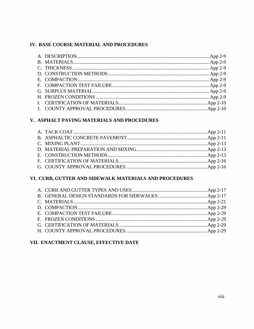
IV. BASE COURSE MATERIAL AND PROCEDURES
A. DESCRIPTION............................................................................................................... App 2-9
B. MATERIALS .................................................................................................................. App 2-9
C. THICKNESS ................................................................................................................... App 2-9
D. CONSTRUCTION METHODS ..................................................................................... App 2-9
E. COMPACTION .............................................................................................................. App 2-9
F. COMPACTION TEST FAILURE ................................................................................. App 2-9
G. SURPLUS MATERIAL ................................................................................................. App 2-9
H. FROZEN CONDITIONS ............................................................................................... App 2-9
I. CERTIFICATION OF MATERIALS .......................................................................... App 2-10
J. COUNTY APPROVAL PROCEDURES .................................................................... App 2-10
V. ASPHALT PAVING MATERIALS AND PROCEDURES
A. TACK COAT ................................................................................................................ App 2-11
B. ASPHALTIC CONCRETE PAVEMENT ................................................................... App 2-11
C. MIXING PLANT .......................................................................................................... App 2-13
D. MATERIAL PREPARATION AND MIXING ........................................................... App 2-13
E. CONSTRUCTION METHODS ................................................................................... App 2-13
F. CERTIFICATION OF MATERIALS .......................................................................... App 2-16
G. COUNTY APPROVAL PROCEDURES .................................................................... App 2-16
VI. CURB, GUTTER AND SIDEWALK MATERIALS AND PROCEDURES
A. CURB AND GUTTER TYPES AND USES ............................................................... App 2-17
B. GENERAL DESIGN STANDARDS FOR SIDEWALKS ......................................... App 2-17
C. MATERIALS ................................................................................................................ App 2-21
D. COMPACTION ............................................................................................................ App 2-29
E. COMPACTION TEST FAILURE ............................................................................... App 2-29
F. FROZEN CONDITIONS ............................................................................................. App 2-29
G. CERTIFICATION OF MATERIALS .......................................................................... App 2-29
H. COUNTY APPROVAL PROCEDURES .................................................................... App 2-29
VII. ENACTMENT CLAUSE, EFFECTIVE DATE
General Provisions Section I – Page 1
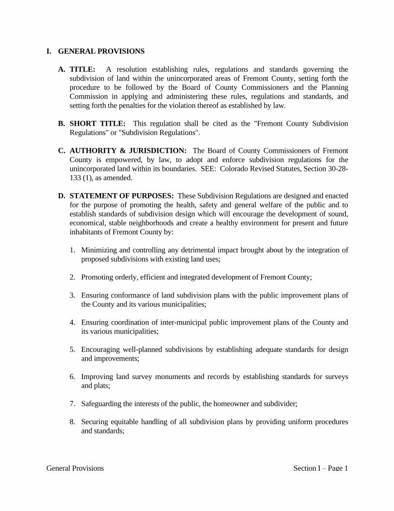
I. GENERAL PROVISIONS
A. TITLE: A resolution establishing rules, regulations and standards governing the
subdivision of land within the unincorporated areas of Fremont County, setting forth the
procedure to be followed by the Board of County Commissioners and the Planning
Commission in applying and administering these rules, regulations and standards, and
setting forth the penalties for the violation thereof as established by law.
B. SHORT TITLE: This regulation shall be cited as the "Fremont County Subdivision
Regulations" or "Subdivision Regulations".
C. AUTHORITY & JURISDICTION: The Board of County Commissioners of Fremont
County is empowered, by law, to adopt and enforce subdivision regulations for the
unincorporated land within its boundaries. SEE: Colorado Revised Statutes, Section 30-28-
133 (1), as amended.
D. STATEMENT OF PURPOSES: These Subdivision Regulations are designed and enacted
for the purpose of promoting the health, safety and general welfare of the public and to
establish standards of subdivision design which will encourage the development of sound,
economical, stable neighborhoods and create a healthy environment for present and future
inhabitants of Fremont County by:
1. Minimizing and controlling any detrimental impact brought about by the integration of
proposed subdivisions with existing land uses;
2. Promoting orderly, efficient and integrated development of Fremont County;
3. Ensuring conformance of land subdivision plans with the public improvement plans of
the County and its various municipalities;
4. Ensuring coordination of inter-municipal public improvement plans of the County and
its various municipalities;
5. Encouraging well-planned subdivisions by establishing adequate standards for design
and improvements;
6. Improving land survey monuments and records by establishing standards for surveys
and plats;
7. Safeguarding the interests of the public, the homeowner and subdivider;
8. Securing equitable handling of all subdivision plans by providing uniform procedures
and standards;
General Provisions Section I – Page 2
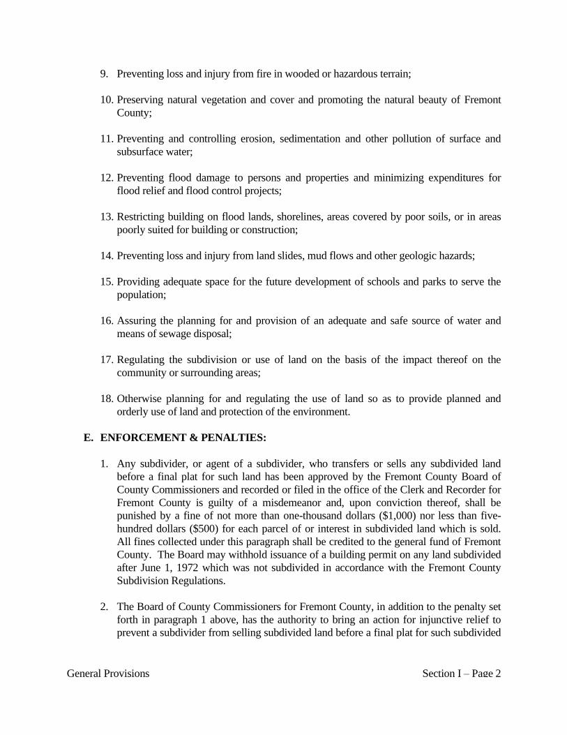
9. Preventing loss and injury from fire in wooded or hazardous terrain;
10. Preserving natural vegetation and cover and promoting the natural beauty of Fremont
County;
11. Preventing and controlling erosion, sedimentation and other pollution of surface and
subsurface water;
12. Preventing flood damage to persons and properties and minimizing expenditures for
flood relief and flood control projects;
13. Restricting building on flood lands, shorelines, areas covered by poor soils, or in areas
poorly suited for building or construction;
14. Preventing loss and injury from land slides, mud flows and other geologic hazards;
15. Providing adequate space for the future development of schools and parks to serve the
population;
16. Assuring the planning for and provision of an adequate and safe source of water and
means of sewage disposal;
17. Regulating the subdivision or use of land on the basis of the impact thereof on the
community or surrounding areas;
18. Otherwise planning for and regulating the use of land so as to provide planned and
orderly use of land and protection of the environment.
E. ENFORCEMENT & PENALTIES:
1. Any subdivider, or agent of a subdivider, who transfers or sells any subdivided land
before a final plat for such land has been approved by the Fremont County Board of
County Commissioners and recorded or filed in the office of the Clerk and Recorder for
Fremont County is guilty of a misdemeanor and, upon conviction thereof, shall be
punished by a fine of not more than one-thousand dollars ($1,000) nor less than five-
hundred dollars ($500) for each parcel of or interest in subdivided land which is sold.
All fines collected under this paragraph shall be credited to the general fund of Fremont
County. The Board may withhold issuance of a building permit on any land subdivided
after June 1, 1972 which was not subdivided in accordance with the Fremont County
Subdivision Regulations.
2. The Board of County Commissioners for Fremont County, in addition to the penalty set
forth in paragraph 1 above, has the authority to bring an action for injunctive relief to
prevent a subdivider from selling subdivided land before a final plat for such subdivided
General Provisions Section I – Page 3
land has been approved by the Board of County Commissioners and recorded or filed in
the office of the Clerk and Recorder for Fremont County. The provisions of this
paragraph shall also apply to the agents of a subdivider. SEE: C.R.S., Section 30-28-
110 (4) (b).
F. RELATIONSHIP OF SUBDIVISION REGULATIONS & OTHER LAND-USE
REGULATIONS:
1. Subdivision of land, within the unincorporated areas of Fremont County, and as defined
by these Subdivision Regulations, shall be governed by the provisions of these
Subdivision Regulations.
2. Land being subdivided shall conform with the master plan, zoning resolution for
Fremont County and other resolutions and regulations in effect in Fremont County. In
the absence of such plans and/or resolution, these regulations are not to be construed as a
substitute for such plans and/or resolutions.
3. When the standards or provisions of these Subdivision Regulations conflict with
standards or provisions of other rules, regulations, resolutions or laws governing the
same subject matter, then the standard or provision applying the strictest conditions for
lawful compliance shall apply.
4. No building permit shall be issued, for a building or structure within a subdivision until
the pending subdivision has been approved and recorded in accordance with these
Subdivision Regulations.
5. A lot which was created by a Fremont County approved subdivision plat shall not be
allowed to be converted back to a metes and bounds legal description.
6. Except as provided in paragraph 4 of this sub-section F, nothing in these Subdivision
Regulations shall be construed to prevent a subdivider or his agent from applying for a
variance or other relief from existing rules, regulations, resolutions or laws, if such
application is a necessary condition for approval of the subdivision by the Planning
Commission or Board of County Commissioners.
7. As a condition for approval of any application for subdivision or exemption under these
regulations the Board of County Commissioners may require the applicant to initiate an
application to rezone the property. Such application shall be heard on its own merits and
in conformance with the provisions of the Fremont County Zoning Resolution, and the
denial thereof by the Board of County Commissioners shall not thereafter affect the right
of the applicant to subdivide in accordance with these regulations and any other
applicable regulations.
8. Any subdivision adjacent to any Agricultural Forestry, Agricultural Farming &
General Provisions Section I – Page 4
Ranching or Agricultural Living Zone District shall be required to provide fencing
which will restrict domestic livestock from entering the subdivision. A fencing plan
shall be submitted at the time of application and the fencing requirement shall meet the
standards established by the Colorado fence law or by the Bureau of Land Management.
The Board may impose additional standards for fencing if the physical conditions of the
property present unique circumstances that indicate that the minimum standards may not
be adequate to restrict domestic livestock from entering the subdivision.
9. The Department will send a representative to the site to determine if the property is in
compliance with applicable regulations. If it is determined that the property is not in
compliance with applicable regulations, the pending application will not be recorded
until the property is brought into compliance.
G. ACCEPTANCE OF DEDICATIONS TO THE PUBLIC:
1. Approval of a subdivision, exemption, replat or vacation request shall not be deemed an
acceptance for maintenance of the proposed dedication by the Board of County
Commissioners. Such acceptance, if any, shall be given by the specific documented
action of the Board of County Commissioners.
2. If a subdivision is to result in the creation of private streets, as approved by the Board,
instead of dedication of the streets to the public, the Department is hereby authorized to
make necessary alterations to the Dedication statement of the required “Subdivision Plat
language”.
3. If a public utility requests additional width for easements, other than the minimum
requirements, for a subdivision, exemption, replat or vacation request, the Department is
authorized to make necessary alterations to the Easement Statement, of the required
Subdivision Plat language, if the developer is in agreement. If the Developer does not
agree with the additional easement width, the item will be scheduled on the next
appropriate Board meeting for their final decision.
H. SEVERABILITY CLAUSE: If an article, section, sub-section, sentence, clause or phrase
of these Subdivision Regulations is for any reason held to be invalid or unconstitutional, the
same shall not affect the validity of these regulations as a whole or any part or provision
thereof, other than the part so adjudged to be invalid or unconstitutional.
I. RULES OF CONSTRUCTION:
1. The particular controls the general.
2. The word "shall" is always mandatory and not discretionary. The word "may" is
permissive.

General Provisions Section I – Page 5
3. Words in the present tense include the future unless the context clearly indicates the
contrary.
4. Words used in the singular number include the plural, and words used in the plural
number include the singular unless the context clearly indicates the contrary.
5. Any definition used in the applicable statutes, regulations or rules of the State of
Colorado or the United States may be used in these Subdivision Regulations; and if the
aforesaid definitions conflict with the definitions herein by virtue of subsequent
amendment, then the aforesaid definitions shall control.
J. APPLICATION MEETINGS:
1. The Department will meet with the applicant to discuss the proposed application at a
pre-submittal meeting if requested by the applicant. The applicant will be required to
provide some information (i.e. zoning verification, current and proposed use, proposed
water and sanitation source, proof of access, etc.) prior to the meeting in order for the
Department to prepare for the meeting and determine what staff members should attend
the meeting. The applicant will be provided with handouts and information pertinent to
the application.
a. If the water source for the use is proposed to be from a municipal or independent
water district then the applicant shall provide evidence that said district has been
contacted and that water services can be provided for the use(s) proposed along with
the district’s conditions for service.
b. If the sanitation source for the use is proposed to be from a municipal or independent
sanitation district then the applicant shall provide evidence that said district has been
contacted and that sanitation services can be provided for the use(s) proposed along
with the district’s conditions for service.
c. If access to the subject property is proposed to be directly to a roadway controlled by
or through an intersection within the jurisdiction of the Colorado Department of
Transportation (CDOT) the applicant shall provide evidence that CDOT has been
contacted and that access can be provided for the use(s) proposed along with the
CDOT conditions of approval.
d. As per Section XVII of this Regulation, the applicant shall have the right to request
an exemption if it can be demonstrated that because of peculiar physical conditions
pertaining to his land, the literal enforcement of one or more of these regulations is
impractical or will exact undue hardship. The Board may permit an exemption as
may be reasonable and within the general purpose and intent of the rules,
regulations, and standards established by these regulations.
General Provisions Section I – Page 6
2. The Department will meet with the applicant after the applicant has received the
Department’s Submittal Deficiency and Comment letter for the application, if requested
by the applicant. The applicant will be required to provide a brief list of questions
regarding the application to enable the Department to determine what staff members
should attend the meeting.
3. The Department will meet with the applicant after the Department has provided the
applicant with the Department review, if requested by the applicant. The applicant will
be required to provide a brief list of questions regarding the application to enable the
Department to determine what staff members should attend the meeting.
4. The Department will meet with the applicant after the Planning Commission meeting to
discuss recommendations of the Commission, if requested by the applicant. The
applicant will be required to provide a brief list of questions to enable the Department to
determine what staff members should attend the meeting.
5. The Department will meet with the applicant after the Board of County Commissioners
meeting, to discuss requirements of the Board, if requested by the applicant. The
applicant will be required to provide a brief list of questions to enable the Department to
determine what staff members should attend the meeting.
K. AMENDMENT TO CONTINGENCIES OF APPROVAL: If an application has been
approved by the Board with contingencies but it is found prior to recording that one or
more of the contingencies of approval cannot or should not be met or that the
contingencies should be altered, the applicant may apply for an amendment to the
contingencies of approval.
1. The applicant shall provide documented justification as to why the specific
contingency(s) should be removed or altered along with the required fee to the
Department.
2. If the contingency proposed to be removed or altered was recommended by the
Commission and then approved by the Board, the proposal to remove or alter the
contingency shall be reviewed by the Commission, at a regular meeting, prior to
being heard by the Board.
3. If the original application was of a category that required notice, a proposal to amend
a contingency shall require the same level of notice at the applicant’s expense.
4. The Department will schedule the request on the agenda of the next regular meeting
of either the Commission or Board as may be appropriate allowing time for the
required notice, if applicable.
5. There will be a fee charged for this process as set by resolution of the Board.
General Provisions Section I – Page 7
L. VALIDITY OF APPLICATIONS: All information provided in an application and
supporting documents shall be valid and true to the best of the applicant’s knowledge and
belief. If any portion of the application, at any stage of review, is found to be
misrepresented, misleading, inaccurate, invalid or false then the application shall be
rendered null and void.
1. Further in such circumstances any approvals granted shall be rescinded and any
approved plats shall be invalid.
2. There will not be a refund of application fees or additional review fees for any
application determined to be null and void, rescinded approvals or invalidated plats.
3. A complete new application and fees will be required for any application determined to
be null and void.
Definitions Section II – Page 1
II. DEFINITIONS
A. ACCESS: The ability, both physical and legal, to enter a site from a public roadway and
exit a site onto a public roadway by motorized vehicle.
B. ALIQUOT DESCRIPTION: A method of describing property that uses equal proportions
of a unit description. Most common in areas where townships (groupings of 36 sections)
and sections (1 square mile) are used to locate property. In most circumstances aliquot
descriptions are considered a type of metes & bounds description of land. The exact size,
dimensions and locations of aliquot described property cannot be determined without a field
survey of the property.
C. APPLICANT: The applicant is the person, persons or entity who is responsible for
organization and submittal of an application. The applicant may be the owner of property of
which the application consists or a documented representative of the owner authorized to
speak and make commitment for the owner with regard to all aspects of the application
process.
D. BLOCK: An area of land within a subdivision, normally consisting of one or more lots,
which area is bounded entirely by exterior property boundaries, streets, highways, or public
ways, except alleys.
E. BOARD: The Fremont County Board of County Commissioners.
F. BUILDING ENVELOPE: Area of a property designated by plat or deed restriction that
indicate where building and or structure improvements can be located.
G. CEMETERY: Land used for the interment of the dead, including funeral home,
columbariums, crematoriums, mausoleums, and mortuaries, when operated in conjunction
with and located on the same premises as the cemetery. Usually divided into plots, lots and
or spaces for ownership purposes.
H. COMMISSION: The Fremont County Planning Commission.
I. CONDOMINIUM: A structure of two or more units, the interior spaces of which are
individually owned; the balance of the property (both land and building) is owned in
common by the owners of the individual units.
J. COUNTY ENGINEER: The County Engineer for Fremont County, Colorado, provided
that the Board of County Commissioners have appointed a person to such a position. In the
event that no such person shall have been appointed, the term "County Engineer" shall refer
to that person retained by the County, at the expense of the applicant and or subdivider, for
review of submissions under these Subdivision Regulations requiring engineering expertise.
Definitions Section II – Page 2
K. DEDICATION: The turning over by an owner or developer of private land or a right-of-
use of the private land for public use, for such use by the governmental agency having
jurisdiction over the public function for which it will be used.
L. DEPARTMENT: The Fremont County Department of Planning & Zoning.
M. DESIGN STANDARDS OR DESIGN REQUIREMENTS: All requirements and
regulations relating to design and layout of subdivisions as set forth in these Subdivision
Regulations.
N. DISPOSITION: A contract of sale resulting in the transfer of equitable title to an interest
in subdivided land; an option to purchase an interest in subdivided land; a lease or an
assignment of interest in subdivided land; or any other conveyance of an interest in
subdivided land which is not made pursuant to one of the foregoing.
O. DOUBLE FRONTAGE LOTS: Lots which front on one public street and back on
another.
P. EASEMENT: An interest in land owned by another person, consisting in the right to use or
control the land, or an area above or below it, for a specific limited purpose, such as utilities,
drainage, or access.
Q. EXEMPTION: A process that does not require the property owner to apply for
preliminary and final plat applications in order to subdivide land or change the boundaries of
the land. Such processes are Minor Subdivision, Lot Line Adjustment, Boundary Line
Adjustment, Vacation of Interior Lot Line, Correction Plats, etcetera.
R. FINAL PLAT: A map and supporting materials of certain described land prepared in
accordance with these Subdivision Regulations as an instrument for recording of real estate
interests with the County Clerk & Recorder for Fremont County.
S. FLOOD PLAIN or FLOOD-PRONE AREA: Any land area susceptible to being
inundated as the result of a flood, including the area of land over which floodwater would
flow from the spillway of a reservoir.
T. GEOLOGIC HAZARDS: A geologic phenomenon which is so adverse to past, current, or
foreseeable land-use or construction as to constitute a significant hazard to public health and
safety or to property. The term includes but is not limited to avalanches, landslides, rock
falls, mudflows and unstable or potentially unstable slopes, seismic effects radioactivity and
ground subsidence.
U. HEALTH DEPARTMENT: The Fremont County Department of Environmental Health,
or, in appropriate circumstances, the Colorado Department of Public Health and
Environment.

Definitions Section II – Page 3
V. LOT: A portion of a subdivision or other parcel of platted land, intended as a unit for the
transfer of ownership, for development or for other purposes.
W. LOT, PARCEL OR TRACT SIZE: The total acreage of the property not including any
portion of the property used for a public road.
X. METES & BOUNDS DESCRIPTION: A written description of property that starts at a
beginning point and most commonly uses bearings and distances to describe the perimeter
of the property culminating at the point of beginning. In most circumstances aliquot
descriptions are considered the same as a metes & bounds description.
Y. MUNICIPALITY: An incorporated city or town.
Z. OFF-STREET PARKING SPACE: The space required to park one passenger vehicle
off-street (refer to Off-street Parking Requirements, Fremont County Zoning Resolution).
AA.OUTLOT: An area of land on a plat which is to be used for a specific purpose other than a
residential or commercial building site, the purpose of which is restricted to and stated on
the plat.
BB.PARCEL: A lot or contiguous group of lots in single ownership or under single control,
usually considered a unit for the purposes of development.
CC.PERMANENT MONUMENT: Any structures of masonry and/or metal permanently
placed in or on the ground, expressly for surveying reference.
DD.PHASING: A method of development where the total development will be completed in
cohesive stages that will allow full function of the completed stage while allowing for future
organized development of the remaining stages of the development.
EE.PLANNED UNIT DEVELOPMENT: (P.U.D.) A form of development usually
characterized by a unified site design for a number of housing units, clustered buildings, and
providing common open space, density increases and a mix of building types and land uses.
FF. PLAT RESTRICTION: A restriction or statement placed on a final plat that is unique to
the land depicted by the final plat; usually items that make the property owner aware of the
unique situation or a restriction placed on the development of the property through the
platting process to guard the health, safety and welfare of the property residents and
surrounding neighborhoods.
GG.PLATTED LAND: Land that has gone though a subdivision or exemption process that
resulted with final plat being recorded for perpetuity in the land records of the jurisdiction
where the property is located; usually resulting in the property being referenced by the
Definitions Section II – Page 4
subdivision name, blocks, lots, outlots, rights-of-way and easements depicted by the final
plat.
HH.PRELIMINARY PLAN: The map of a proposed subdivision and specified supporting
materials of a proposed subdivision, drawn and submitted in accordance with the
requirements of these Subdivision Regulations, to permit the evaluation of the proposed
subdivision prior to detailed engineering and design for drainage and construction plans.
II. PRIVATE ROAD OR STREET: A right-of-way that is owned, constructed and
maintained by an individual owner, a homeowners association or the like, that provides
access from a public roadway to a property.
JJ. RIGHT-OF-WAY: A person’s legal right, established by usage, contract or deed, to pass
through property owned by another.
KK.ROADWAY: That portion of a highway, street, road or alley right-of-way designed for
vehicular traffic.
LL. SITE SPECIFIC DEVELOPMENT PLAN: A recorded final plat and supporting
documents, which includes but is not limited to financial guarantees, (Escrow Agreement)
and Subdivision Improvement Agreement. In the case of phasing, the site specific
development plan shall be considered to be a copy of the preliminary plan and all supporting
documents, which were approved by the Fremont County Board of County Commissioners.
MM. SKETCH PLAN: A map and supporting information of a proposed subdivision, drawn
and submitted in accordance with these Subdivision Regulations to evaluate feasibility and
design characteristics at an early stage in the planning of a subdivision.
NN. STREET: A public right-of-way which provides vehicular and pedestrian access to
adjacent properties. For the purpose of these Subdivision Regulations, streets shall be
classified as defined below:
1. Highway: A major regional highway including an expressway, freeway, or intersection
highway designed to carry vehicular traffic over long distances, with limited access,
generally at one (1) mile intervals.
2. Arterial: Arterial are streets that carry relatively high-speed, through traffic designed to
accommodate traffic moving considerable distances within an area; and traffic moving
into and out of an area. These types of streets are designed to move traffic rather than to
accommodate specific land use.
3. Collectors: Collector streets gather traffic from local or residential streets and carry it to
the arterial street system. Collector streets, serving neighborhood activities such as
schools and parks, should be designed to serve minor traffic generating activities
Definitions Section II – Page 5
without carrying through traffic. Adequate space for two lanes of moving traffic should
be available at all times.
4. Local Street: Local or residential streets are those streets with the primary function of
providing access to abutting properties. Through traffic movements are usually
discouraged on local streets.
5. Alley: A minor way which is used primarily for utility and vehicular service access to
the rear or side of properties otherwise abutting on a street that provides a permanently
reserved but secondary means of public access not intended for general traffic
circulation.
6. Cul-de-Sac: A short, dead-end local street terminating in a vehicular turn-around area.
7. Service Road: A street or road paralleling and abutting a highway which provides
access to a highway for adjacent property that lacks direct access to a highway.
8. Stub Street: A street or road extending from within a subdivision and terminating at
the subdivision boundary with no permanent vehicular turn around. Stub streets are
provided to permit adjacent undeveloped parcels of land to be developed later with an
adjacent connecting street system and are not intended to be used as access for lots
within the subdivision, unless a turnaround is provided.
OO. STREET RIGHT-OF-WAY: That portion of land dedicated to public use for street and
utility purposes and accepted by the County.
PP. SUBDIVIDER: Any person, firm, partnership, joint venture, association or corporation or
combination of the same who shall participate as owner, promoter, developer or sales agent
in the planning, platting development, promotion, sale or lease of a subdivision.
QQ. SUBDIVISION OR SUBDIVIDED LAND:
1. "Subdivision" or "Subdivided Land" means any parcel or land in the County which is to
be used for condominiums, apartments, or any other multiple-dwelling units, unless such
land when previously subdivided was accompanied by a filing which complied with the
provisions of these Subdivision Regulations with substantially the same density, or
which is divided into two or more parcels, separate interests, or interests in common,
unless exempted under paragraph 2, 3, or 4 of this sub-section. As used in this sub-
section, "interests" includes any and all interests in the surface of land, but excludes any
and all subsurface interests.
2. The terms "Subdivision" and "Subdivided Land", as defined in paragraph 1 of this sub-
section shall not apply to any division of land which creates parcels of land each of
which comprises thirty-five (35) or more acres of land and none of which is intended for
Definitions Section II – Page 6
use by multiple owners.
3. Unless the method of disposition is adopted for the purpose of evading these
Subdivision Regulations, the terms "Subdivision" and "Subdivided Land," as defined in
paragraph 1 of this sub-section shall not apply to any division of land:
a. Which creates parcels of land, such as that the land area of each of the parcels, when
divided by the number of interests in any such parcel, results in thirty-five (35) or
more acres per interest.
b. Which could be created by any court in this state pursuant to the law of eminent
domain, or by operation of law, or by order of any court in this state if the Board in
which the property is situated is given timely notice of any such pending action by
the court and given the opportunity to join as a party interest in such proceeding for
the purpose of raising the issue of evasion of these Subdivision Regulations prior to
the entry of the court order and if the Board does not file an appropriate pleading
within twenty (20) days after receipt of such notice by the court, then such action
may proceed before the court.
c. Which is created by a lien, mortgage, deed of trust, or any other security instrument.
d. Which is created by a security or unit of interest in any investment trust regulated
under the laws of this state or any other interest in an investment entity.
e. Which creates cemetery lots.
f. Which creates an interest in oil, gas, minerals, or water which is severed from the
surface ownership of real property.
g. Which is created by the acquisition of an interest in land in the name of a husband
and wife or other persons in joint tenancy or as tenants in common, and any such
interests shall be deemed for purposes of this subsection as only one interest.
h. Which is created by the combination of contiguous parcels of land into one larger
parcel. If the resulting parcel is less than thirty-five (35) acres in land area, only one
interest in said land shall be allowed. If the resulting parcel is greater than thirty-five
(35) acres in land area, such land area, divided by the number of interests in the
resulting parcel, must result in thirty-five (35) or more acres per interest. Easements
and rights-of-way shall not be considered interests for purposes of this subparagraph.
i. Which is created by a contract concerning the sale of land which is contingent upon
the purchaser's obtaining approval to subdivide, pursuant to this article and any
applicable county regulations, the land which he is to acquire pursuant to the
contract.
Definitions Section II – Page 7
j. Which is created by a roadway controlled and maintained by a State or local
government entity, a railroad right-of-way in current use or the Arkansas River. No
parcel shall be created, which is divided by a roadway, which is controlled and
maintained by a State or local government entity, a railroad right-of-way in current
use or the Arkansas River unless each parcel conforms to the existing zoning district.
k. Which creates a multi business, a multi industrial use, or a mini storage facility, on a
single property and housed within a single structure that has received approval of a
Commercial Development Plan as per the Fremont County Zoning Resolution as
amended. The separate allowed uses within the structure may be rented or leased as
individual units; however, no portion of the structure may be sold, without
compliance with applicable Subdivision Regulations.
l. Which is a single property containing separate structures that function as a single use
on the property.
m. Which is created as an Assisted Living Residence, Bed & Breakfast, Boarding &
Rooming House, Campground, Child Care Center, Correctional Facility, Dormitory,
Emergency Shelter, Farm & Ranch Hand Quarters, Flea Market, Group Home,
Hospital, Hotel, Manufactured Home Park, Motel, Nursing Home, Parking Lot or
Garage, Recreation Camp, Travel Trailer Park or the like that have a single
ownership interest where individual use by multiple users maybe short or long term,
but not permanent.
4. The Board may, pursuant to rules and regulations of resolution, exempt from this
definition of the terms "Subdivision" and "Subdivided Land" any division of land if the
Board determines that such division is not within the purposes of these Subdivision
Regulations.
RR. SUBDIVISION IMPROVEMENTS: All facilities placed, constructed or erected by a
subdivider within a subdivision to permit and facilitate the use of lots for residential,
business or industrial purposes.
SS. SUBDIVISION IMPROVEMENTS AGREEMENT: An escrow fund, in the amount
acceptable by the Board, for the actual cost of construction of such public improvements as
are required by County Subdivision regulations within the subdivision. If escrow fund is
renewed for a period to exceed one (1) year, the Board shall require a new engineer's
estimate or contractor's estimate to determine amount to be held in escrow. Waiver or
modification of the improvement security arrangement may be granted by the Board in it's
sole discretion upon showing of good cause by the applicant.
TT. TOWNHOUSE: A single structure that contains single-family dwellings in a row of at
least two (2) such dwelling units in which each unit has its own front and rear access to the
Definitions Section II – Page 8
outside. No unit may be located over another unit and each unit is separated from any other
unit by one or more common fire resistant walls and is individually owned; with the balance
of the property (land and building) being owned in common by the owners of the individual
units within the single structure.
UU. TRACT: A lot or parcel or a contiguous group of lots in a single ownership or in single
control which is intended as a unit for the transfer of ownership or for the purposes of
development.
VV. VARIANCE: Official authorization to depart from a subdivision requirement.
WW.VESTED PROPERTY RIGHT: A right to undertake and complete the development
and use of the property under the terms and conditions of approval of a site specific
development plan.
XX. WILDFIRE: An uncontrolled fire burning in vegetation, structures or other
improvements.
YY. WILDFIRE HAZARD: A wildfire phenomenon which is so adverse to past, current or
foreseeable construction of land-use as to constitute a significant hazard to public health and
safety or to property.
Sketch Plan Application Section III – Page 1
III. SKETCH PLAN APPLICATION
A. SUBMISSION:
1. A Sketch Plan application shall be submitted if the proposed subdivision is:
a. to be developed in phases, or;
b. to contain multiple filings, or;
c. to contain multiple land uses.
2. A Sketch Plan application may be submitted if the applicant wants to evaluate feasibility
and design characteristics at an early stage of a proposed subdivision.
3. The applicant shall submit the Sketch Plan application and required accompanying
materials, including an application fee, to the Department.
a. The applicant shall submit a Sketch Plan application on a form obtained from the
Department.
b. The application shall be delivered, in person, to a Department representative.
1) The Department representative will accept the application submittal only if all
minimum submittal requirements have been met and presented at the time of
submission.
4. The initial Sketch Plan application shall be submitted to the Department a minimum of
twenty-four (24) working days prior to the date of the regularly scheduled Commission
meeting at which it is to be considered.
B. REVIEW OF SKETCH PLAN APPLICATION:
1. The Department will conduct a preliminary review of the application to determine the
adequacy of the application for Commission review.
2. The applicant will be notified of the results of the Department review via a Department
Deficiency and Comment Letter.
a. If there are deficiencies in the application that would make the application
unacceptable for review by the Commission, the Department will provide the
applicant with a time frame in which to address the deficiencies in order for the
Department to place the application on the desired agenda of the Commission.
Sketch Plan Application Section III – Page 2
b. The applicant will be notified of how many revised copies of the application and
accompanying materials shall be provided to the Department for distribution in the
deficiency and comment letter.
3. If there are no deficiencies or deficiencies are addressed within the time frame, the
Department will provide the applicant and Commission with a review of the application
taking into consideration regulatory requirements and place the application on the
appropriate agenda of the Commission.
4. If the deficiencies are not addressed or if acceptable reasoning is not provided as to why
the application should be placed on the Commission agenda without addressing the
deficiencies within the established time frame, the Department will not place the
application on the Commission agenda for review.
a. As per Board Resolution No. 68, Series of 2006: A full application fee will be
charged to the applicant, if all deficiencies as per the initial application review letter
are not adequately addressed.
1) Each subsequent deficiency review letter will result in another full application
fee.
a) All such fees shall be paid along with the deficiency submittal, prior to any
further review of the application.
5. The Commission shall consider the application and Department comments at a public
meeting.
a. The applicant shall attend the Commission meeting at which the application is
scheduled to be reviewed.
1) Failure of the applicant to attend the meeting will result in tabling of the
application review by the Commission.
2) Failure of the applicant to attend the meeting to which review of the application
was tabled will be considered a withdrawal of the application by the applicant.
Fees will not be refunded.
b. The applicant may offer comments, evidence and testimony concerning the
application.
c. The Commission may hear comments and receive evidence or testimony from
interested persons, but shall not hold formal public hearings, unless expressly
authorized by law, or upon request of the Board.
Sketch Plan Application Section III – Page 3
6. The Commission may recommend approval or denial of the application to the Board.
The Commission may include comments and or suggestions with its recommendation.
7. The Commission may continue review of the application to the next regular meeting of
the Commission to receive more comments, to enable further study of information and
input received at the meeting, or to request that the applicant provide additional
information regarding the application. No such continuance shall exceed thirty (30)
days or by the next regularly scheduled Commission meeting.
a. The applicant, prior to a motion by the Commission, may request an extended time
before continued review by the Commission, if the applicant wants to provide
additional information in support of the application. Such continuance request shall
not exceed ninety (90) days and must coincide with a regular Commission meeting
date.
8. If the applicant presents a significantly different proposal at the Commission meeting
than was submitted in the application to the Department, the Commission shall continue
the application to the next regular meeting of the Commission and request a Department
review of the proposal.
a. The Department may require an additional review fee if deemed appropriate.
9. The Department shall mail to the applicant, the Commission’s recommendations,
comments and suggestions within five (5) working days after the meeting at which the
Commission’s review of the application was finalized. Said mailing shall contain the
date and time of the regular Board meeting at which the Board will review the
application.
10. Following the review and recommendation of the Commission, the Department shall
place the application on the agenda of the Board, within twenty (20) days after
completion of action by the Planning Commission, for Board review.
a. The applicant may ask for additional time before the Board meeting, if such time is
needed to accommodate the recommendations, comments or suggestions of the
Commission.
1) A request for additional time shall be made, in writing, to the Department which
is authorized to grant the request on behalf of the Board.
2) Any such extension request shall not exceed ninety (90) days from the date the
Commission review was completed.
3) The extension of time for Board review must coincide with a regular Board
meeting date.
Sketch Plan Application Section III – Page 4
4) The applicant shall provide to the Department copies of information and or
documentation to be submitted for Board review to accommodate the
recommendations, comments or suggestions regarding the application by the
Commission a minimum of ten (10) working days prior to the scheduled Board
meeting at which the application is to be reviewed.
5) In such circumstances the Board, at its discretion, may require further review of
the application by the Commission.
6) No significant changes in an application shall be proposed after review by the
Board unless such changes are made to accommodate recommendations,
comments or suggestions of the Commission.
a) If significant changes are needed due to change of area conditions or
circumstances beyond control of the applicant, then further review by the
Commission shall be required prior to review of the application by the
Board.
11. The Board shall take into consideration the application, Commission recommendations,
comments, and suggestions, minutes from the Commission meeting and Department
review at the scheduled Board meeting.
a. The applicant shall attend the Board meeting at which the application is scheduled to
be reviewed.
1) Failure of the applicant to attend the Board meeting will result in tabling of the
application review.
2) Failure of the applicant to attend the Board meeting to which review of the
application was tabled will result in a withdrawal of the application and fees will
not be refunded.
b. The applicant may offer comments, evidence and testimony concerning the
application.
c. The Board may hear comments and receive evidence or testimony from interested
persons.
12. The Board may continue review of the application to the next regular meeting of the
Board to receive more comments, enable further study of information and input received
at the meeting or to request that the applicant provide additional information regarding
the application. No such continuance shall exceed thirty (30) days.

Sketch Plan Application Section III – Page 5
a. The applicant, prior to a motion by the Board, may request an extended time before
continued review by the Board, if the applicant wants to provide additional
information in support of the application. Such continuance request shall not exceed
ninety (90) days and must coincide with a regular Board meeting date.
13. The Board shall approve or deny the application within thirty (30) days after the
conclusion of the Board meeting or the date to which it was continued.
14. The Department shall mail to the applicant, the Board’s decision within five (5) working
days after the meeting at which the Board’s review of the application was finalized.
C. EFFECTS OF APPROVAL: Final approval of a Sketch Plan by the Board will allow the
applicant to make application for a Preliminary Plan. Such application shall be made within
twelve (12) months of the initial Sketch Plan approval or prior to expiration of any granted
extensions.
1. Extensions – The Board may extend the time period for submittal of the Preliminary
Plan application upon documented showing of good cause.
a. No extensions may be granted unless a written request, detailing the reasons and
justification for extension, and required fee is submitted to the Department a
minimum of ten (10) working days prior to the expiration of the initial twelve (12)
month period or previous extension granted.
b. The Department shall schedule the request for extension for the next regular Board
meeting at which time the Board will consider the request.
c. Without explicit justification warranting a longer time frame, extensions shall not be
granted for more than twelve (12) months from the date of Board approval or
previous extension.
1) If extens
2) ion(s) are requested further review by the Commission may be required.
D. DENIAL OF A SKETCH PLAN APPLICATION: A denial of a Sketch Plan application
by the Board will result in closure of the application file by the Department and application
fees shall not be refunded. Without evidence of a significant change of area conditions or a
significant change in the proposed application, an application for Sketch Plan cannot be
resubmitted for the same property within two (2) years of the date of denial by the Board.

Sketch Plan Requirements Section IV – Page 1
IV. SKETCH PLAN REQUIREMENTS
A. REQUIRED COPIES:
The applicant shall submit at least four (4) copies of the Sketch Plan drawing on a minimum
sheet size of eleven (11) inches by seventeen (17) inches or to a maximum size of twenty-
four (24) inches by thirty-six (36) inches. A minimum of four (4) copies of all other
documents to meet submittal requirements shall be provided with the initial application.
The applicant will be notified as to how many additional revised copies of the entire
application will be required within the Department “Submittal Deficiency and Comment
letter”.
B. SKETCH PLAN DRAWING REQUIREMENTS:
1. The scale of the drawing shall be consistent and of adequate size to enable all
information to be easily interpreted and read.
2. In the case of multiple sheets, a key map showing the relationship of the individual
sheets shall be provided on each sheet.
3. No subdivision, street or road in the County shall bear the same name or substantially
similar name as another subdivision, street or road, unless adjoining and using
consecutive filing numbers. The Department shall have the authority to require
applicant to change the proposed name if such name is substantially similar to the name
of an existing subdivision, street or road in the County.
4. The total acreage, to the nearest one-half (½) acre, contained within the subject
property.
5. The approximate acreage and/or square footage for each proposed lot, as may be
appropriate.
6. Name and address of the person, firm or organization preparing the Sketch Plan.
7. The date of preparation of the drawing and revision dates to the submitted drawing.
8. North arrow.
9. Written and graphic scale.
10. Vicinity map locating the proposed subdivision in relation to the surrounding area,
streets, major natural features, etcetera.
11. A lot and street layout indicating general dimensions with a note specifying the type
of roadway surfacing proposed.
Sketch Plan Requirements Section IV – Page 2
12. The total number of lots proposed.
13. The approximate acreage and lineal footage proposed to be devoted to roadways.
14. The approximate acreage proposed to be devoted to parks and / or open space.
15. The number of proposed phases and or filings, the approximate acreage of each phase
and or filing, and schedule of proposed phasing (if applicable).
16. The type of multiple land uses proposed and the approximate acreage of each proposed
land use (if applicable).
17. The drawing shall contain a percentage table showing the percentage of land proposed to
be devoted to each use, including roadways.
C. REQUIRED REPORTS, STUDIES AND NOTIFICATIONS:
1. Type of water system proposed.
2. Type of sewage disposal system proposed.
3. Drainage features, streams, lakes, topography and vegetation affecting the proposed
subdivision or a statement that none exist.
4. Geologic hazards of the area which may affect the land use and evaluating the impact of
such on the proposed subdivision or a statement as to why no geologic hazard(s) exist.
5. Evaluate the potential radiation hazard to the proposed future land use, or a statement as
to why no radiation hazard(s) exist.
6. Identify potential wildfire hazard as related to the proposed future land use, or provide a
statement as to why no wildfire hazard exist.
7. Identify potential wildlife impacts as to the proposed future land use.
8. Soil types and their boundaries, as shown on soil survey maps prepared by the United
States Department of Agriculture, National Resources Conservation Service, and also a
table of interpretations for the soil types shown on the soil survey map or other more
specific soils studies and interpretations for the subject property.
9. A copy of the Federal Emergency Management Agency’s Flood Insurance Rate Map for
the area shall be provided and shall show the site location along with the FEMA
interpretation of the flood hazard that may affect the subject property.
Sketch Plan Requirements Section IV – Page 3
10. The proposed subdivision boundary shall be located on a copy of a United States
Geological Survey Map or other information source acceptable to the Department, at a
size large enough to determine topography of the site, if topography is not included on
the sketch plan drawing.
11. Identify previous surface and underground mining activities for the subject property.
12. Identify the potential for mining activities on the subject property.
13. Documentation to verify ownership of mineral interest for the subject property as shown
by the real estate records of the county, which include the records of the county assessor,
and “requests for notification” filed by a mineral estate owner in the records of the
county clerk and recorder.
14. If the mineral interest for the subject property has been severed from the surface
ownership, then not less that thirty (30) days before the date of the scheduled
Commission meeting, the applicant shall send notice, by certified mail, return receipt
requested or by a nationally recognized overnight courier to the mineral interest
owner(s), as shown in the county records identified in subparagraph 13 above.
D. RELATIONSHIP TO DESIGN STANDARDS: The Design Standards set forth at
Appendix 1 of these Subdivision Regulations shall govern review of Sketch Plan
applications submitted under these Subdivision Regulations.
Preliminary Plan Application Section V – Page 1
V. PRELIMINARY PLAN APPLICATION
A. SUBMISSION: A Preliminary Plan application shall be submitted if:
1. Four (4) or more lots are created from any parent parcel, tract or lot which has not been
previously divided by exemption, minor or major subdivision;
OR
2. The total number of lots created by a previous division of the parent tract or parcel by
exemption, minor or major subdivision, plus the total number of proposed lots results in
the creation of four (4) or more lots.
3. The applicant shall submit Preliminary Plan application, materials and required
supporting documents, including an application fee, to the Department, prior to the
submission of a Final Plat application.
a. The applicant shall submit the Preliminary Plan application on a form provided by
the Department.
b. The application submittal shall be delivered in person, to a Department
representative. The Department representative will accept the application submittal
only if all minimum submittal requirements have been met and presented at the time
of submission.
4. The Preliminary Plan application and accompanying materials and required supporting
documents shall be submitted to the Department no less than seventy-five (75) days
prior to the date of the regularly scheduled Commission meeting at which they are to be
considered.
B. DISTRIBUTION OF THE PRELIMINARY PLAN: No later than eight (8) working
days after receipt of complete Preliminary Plan application, required materials and
supporting documents, the Department shall distribute copies, of the same for review,
comment, suggestions and recommendations to the following:
1. Appropriate school district(s).
2. Each county or municipality within a two (2) mile radius of any portion of the proposed
subdivision.
3. Any affected utility, local improvement and service district, or ditch company.
4. The Colorado State Forest Service, when applicable.
Preliminary Plan Application Section V – Page 2
5. Other Planning Commissions with jurisdiction over the area.
6. The Soil Conservation District Board within the county for explicit review and
recommendations regarding soil suitability, floodwater problems, and watershed
protection. Such referral shall be made even though all or part of a proposed subdivision
is not located within the boundaries of a conservation district.
7. The Colorado Department of Health, when applicable, for review of the on-lot sewage
disposal reports for review of the adequacy of existing or proposed sewage treatment
works to handle the estimated effluent, and for a report on the water quality of the
proposed water supply to serve the subdivision. The Colorado Department of Health to
which the plan is referred may require the applicant to submit additional engineering or
geological reports or data and to conduct a study of the economic feasibility of a sewage
treatment works prior to making its recommendations. No Preliminary Plan shall
receive the approval of the Board unless the Colorado Department of Health, to which
the plan is referred, has made a favorable recommendation regarding the proposed
method of sewage disposal.
8. The State Engineer for an opinion regarding material injury likely to occur to decreed
water rights by virtue of diversion of water necessary or to be used to supply the
proposed subdivision and regarding adequacy of proposed water supply to meet
requirements of the proposed subdivision. If the State Engineer finds such injury or
finds inadequacy, he shall express such finding in an opinion in writing to the Board,
stating the reason for the finding, including, but not limited to, the amount of additional
or exchange water that may be required to prevent such injury. In the event the
subdivision is approved notwithstanding the State Engineer's opinion, the applicant shall
furnish to all potential purchasers, a copy of the State Engineer's opinion; except that the
applicant need not supply the potential purchaser with a copy of such a synopsis if, in
the opinion of the Board, the applicant has corrected the injury or inadequacy set forth in
the State Engineer's finding.
a. A municipality or quasi-municipality, upon receiving the Preliminary Plan
designating said municipality or quasi-municipality as the source of water for a
proposed subdivision, shall file, with the Board and the State Engineer, a statement
documenting the amount of water which can be supplied by said municipality or
quasi-municipality to the proposed subdivision without causing injury to existing
water rights. The State Engineer shall file with the Board written comments on the
report. If, in the judgment of the State Engineer the report is insufficient to issue an
opinion, the State Engineer shall notify the Board, indicating the deficiencies.
9. The Colorado Geological Survey for an evaluation of those geological factors which
would have a significant impact on the proposed use of the land.
Preliminary Plan Application Section V – Page 3
10. The Fire Protection District with jurisdiction over the area.
11. The Colorado Department of Transportation.
12. The recreation district with jurisdiction over the area. Notification of the district will be
required within a three (3) mile radius of any municipal boundary, that contains a
recreation district and within a one (1) mile radius of the recreation district boundaries, if
there is no municipality within the area.
13. Any department, agency or entity as deemed necessary, by the Department.
C. REVIEW OF THE PRELIMINARY PLAN APPLICATION:
1. The Department will conduct a preliminary review of the application to determine the
adequacy of the application for Commission review.
2. The applicant will be notified of the results of the Department review via a Department
Deficiency and Comment Letter.
a. If there are deficiencies in the application that would make the application
unacceptable for review by the Commission, the Department will provide the
applicant with a time frame in which to address the deficiencies in order for the
Department to place the application on the agenda of the Commission.
b. The applicant will be notified of how many revised copies of the application and
accompanying materials shall be provided to the Department for distribution in the
deficiency and comment letter.
3. If there are no deficiencies or deficiencies are addressed within the time frame, the
Department will provide the applicant and Commission with a review of the application,
taking into consideration regulatory requirements, and place the application on the
agenda of the Commission.
4. If the deficiencies are not addressed or if acceptable reasoning is not provided as to why
the application should be placed on the Commission agenda without addressing the
deficiencies within the established time frame, the Department will not place the
application on the Commission agenda for review.
a. As per Board Resolution No. 68, Series of 2006: A full application fee will be
charged to the applicant, if all deficiencies as per the initial application review letter
are not adequately addressed.
Preliminary Plan Application Section V – Page 4
b. Each subsequent deficiency review letter will result in another full application fee.
c. All such fees shall be paid along with the deficiency submittal, prior to any further
review of the application.
5. The agencies notified pursuant to Section V., B. shall make recommendations within
twenty-one (21) days after the mailing of such plans by the County unless a necessary
extension of not more than thirty (30) days has been consented to by the applicant and
the Board. The failure of any agency to respond within twenty one (21) days or within
the period of an extension may, for the purpose of the meeting on the Preliminary Plan,
be deemed an approval of such plan; except that, where such plan involves twenty (20)
or more dwelling units, a school district shall be required to submit within said time
limit specific recommendations with respect to the adequacy of school sites and the
adequacy of school structures.
6. In the event of an adverse recommendation from one (1) or more of the entities, the
Department shall provide a copy to the applicant of such adverse recommendation prior
to the meeting of the Commission at which the Preliminary Plan will be considered. In
the event that the Department omits or is unable to provide the applicant with such
notice prior to the meeting of the Commission, the Commission shall proceed with a
review of the Preliminary Plan and will not disapprove the subdivision on account of
said adverse recommendation unless it finds that correction of the condition leading to
the adverse recommendation is impossible.
7. The Commission shall consider the application and Department comments at a public
meeting.
a. The applicant shall attend the Commission meeting at which the application is
scheduled to be reviewed.
(1) Failure of the applicant to attend the meeting will result in tabling of the
application review by the Commission.
(2) Failure of the applicant to attend the meeting to which review of the application
was tabled will be considered a withdrawal of the application by the applicant.
Fees will not be refunded.
b. The applicant may offer comments, evidence and testimony concerning the
application.
c. The Commission may hear comments and receive evidence or testimony from
interested persons, but shall not hold formal public hearings, unless expressly
authorized by law, or upon request of the Board.
Preliminary Plan Application Section V – Page 5
8. The Commission may recommend approval, approval with contingencies or denial of
the application to the Board. The Commission may include comments and / or
suggestions with its recommendation.
9. The Commission may continue review of the application to the next regular meeting of
the Commission to receive more comments, to enable further study of information and
input received at the meeting, or to request that the applicant provide additional
information regarding the application. Any continuance shall be no later than the next
regularly scheduled Commission meeting.
a. The applicant, prior to a motion by the Commission, may request an extension of
time before continued review by the Commission, if the applicant wants to provide
additional information in support of the application. Such extension request shall
not exceed ninety (90) days and must coincide with a regular Commission meeting
date.
10. If the applicant presents a significantly different proposal at the Commission meeting
than was submitted in the application to the Department, the Commission shall continue
the application to the next regular meeting of the Commission and request a Department
review of the proposal. The Department may require an additional review fee if deemed
appropriate.
11. The Department shall mail to the applicant, the Commission’s recommendations,
comments and suggestions within five (5) working days after the meeting at which the
Commission’s review of the application was finalized. Said mailing shall contain the
date and time of the regular Board meeting at which the Board will review the
application.
12. The Department shall place the application on the agenda of the Board, within thirty-five
(35) days after completion of action by the Planning Commission.
a. The applicant may ask for an extension of time before the Board considers the
application, if such time is needed to accommodate the recommendations, comments
or suggestions of the Commission.
(1) A request for additional time shall be made, in writing, to the Department which
is authorized to grant the request on behalf of the Board.
(2) Any such extension request shall not exceed ninety (90) days from the date the
Commission review was completed.
(3) The extension of time for Board review must coincide with a regular Board
Preliminary Plan Application Section V – Page 6
meeting date.
(4) No later than ten (10) working days prior to the Board meeting at which the
application is to be reviewed, the applicant shall provide to the Department
copies of information and or documentation to be submitted for Board review.
(5) The Board, at its discretion, may require further review of the application by the
Commission.
(6) No significant changes to an application shall be proposed after review by the
Commission unless such changes are made to accommodate recommendations,
comments or suggestions of the Commission.
(a) If significant changes are needed due to change of area conditions or
circumstances beyond control of the applicant, then further review by the
Commission shall be required prior to review of the application by the
Board.
13. The Board shall take into consideration the application, Commission recommendations,
comments, and suggestions, minutes from the Commission meeting and Department
review at the Board meeting.
a. The applicant shall attend the Board meeting at which the application is scheduled to
be reviewed.
(1) Failure of the applicant to attend the Board meeting will result in tabling of the
application.
(2) Failure of the applicant to attend the Board meeting to which review of the
application was tabled will be considered a withdrawal of the application and
fees will not be refunded.
b. The applicant may offer comments, evidence and testimony concerning the
application.
c. The Board may hear comments and receive evidence or testimony from interested
persons.
14. The Board may continue review of the application to the next regular meeting of the
Board to receive more comments, enable further study of information and input received
at the meeting or to request that the applicant provide additional information regarding
the application. No such continuance shall exceed thirty (30) days.
Preliminary Plan Application Section V – Page 7
a. The applicant, prior to a motion by the Board, may request an extended time before
continued consideration by the Board, if the applicant wants to provide additional
information in support of the application. Such continuance request shall not exceed
ninety (90) days and the application must be set on a regular Board meeting date.
15. The Board shall approve, deny, or approve the application with contingencies within
thirty (30) days after the conclusion of the Board meeting or after the date to which it
was continued.
16. The Department shall mail to the applicant the Board’s decision within five (5) working
days after the meeting at which the Board’s review of the application was finalized.
D. EFFECTS OF APPROVAL: Final approval of a Preliminary Plan by the Board will
allow the applicant to make application for a Final Plat. Such application shall be made
within eighteen (18) months of the Preliminary Plan approval or prior to expiration of any
granted extensions unless a Vested Property Right Development Plan has been approved as
per these regulations. (Section IX).
1. Contingencies - If Preliminary Plan Application was approved with contingencies, all
contingencies shall be submitted to the Department within eighteen (18) months of the
date of approval by the Board. Preliminary Plan Contingencies may be addressed in the
Final Plat application. If the contingency items are not submitted by the deadline, the
Preliminary Plan approval shall be deemed expired and a new application will be
required (including fees) to proceed with the project.
2. Extensions - The Board may extend the time period for submittal of contingency items
or extension of approval of the Preliminary Plan upon documented showing of good
cause. If extension(s) are requested, further review by the Commission may be required.
a. No extensions may be granted unless a written request, detailing the reasons and
justification for extension, and required fee is submitted to the Department no less
than ten (10) working days prior to the expiration of the initial eighteen (18) month
period or previous extension granted.
b. The Department shall schedule the request for extension for the next regular Board
meeting at which time the Board will consider the request.
c. In absence of justification warranting a longer time frame, extensions shall not be
granted for more than eighteen (18) months from the date of Board approval or
previous extension.
E. DENIAL OF A PRELIMINARY PLAN APPLICATION: A denial of a Preliminary
Plan application by the Board will result in closure of the application file by the Department.
Preliminary Plan Application Section V – Page 8
Without evidence of a significant change of area conditions or a significant change in the
proposed application, an application for Preliminary Plan will not be accepted for the same
property within two (2) years of the date of denial by the Board.
Preliminary Plan Requirements Section VI – Page 1
VI. PRELIMINARY PLAN REQUIREMENTS
A. CONFORMANCE WITH THE SKETCH PLAN:
If a Sketch Plan application was required, the Preliminary Plan application shall conform in
all major aspects to the Sketch Plan as previously reviewed by the Commission and
approved by the Board, and shall incorporate all modifications required in the Sketch Plan
approval. The Commission can review and the Board can approve a Preliminary Plan
application which has been modified to reflect improvements in design or changes that have
occurred in its natural surroundings and environment since the time of Sketch Plan review
and approval.
B. REQUIRED COPIES:
The applicant or his representative shall submit at least six (6), twenty-four (24) inch by
thirty-six (36) inch copies of the preliminary plan drawing and six (6) reduced copies, (8
1/2" x 11" or 11" x 17") of the Preliminary Plan drawing, and six (6) copies of all other
required documents with the initial application. The applicant will be notified if additional
copies will be required within the Department “Comment and Submittal Deficiency letter”.
C. PRELIMINARY PLAN DRAWING REQUIREMENTS:
1. The scale of the drawing shall be consistent and of adequate size to enable all
information to be easily interpreted and read.
2. In the case of multiple sheets, a key map showing the relationship of the individual
sheets to each other shall be provided on each sheet.
3. No subdivision, street or road in the county shall bear the same name or substantially
similar name as another subdivision, street or road unless adjoining and using
consecutive filing numbers. The Department shall have the authority to require
applicant to change the proposed name if such name is substantially similar to the name
of an existing subdivision, street or road in the County.
4. The sub-title of the drawing shall read: A portion of the (aliquot description) Section,
Township, Range, Fremont County, Colorado or A Vacation and Re-plat of (Lot(s),
Block(s) of [Name of Subdivision]), Fremont County, Colorado, as appropriate,
dependent on whether or not the property being subdivided is un-platted or platted
property.
5. The total acreage contained within the subdivision being platted.
6. The acreage and/or square footage for each proposed lot.
7. Name and address of the person, firm or organization preparing the drawing.

Preliminary Plan Requirements Section VI – Page 2
8. The date of preparation of the drawing and revision dates to the submitted drawing.
9. A North arrow.
10. A written and graphic scale.
11. Vicinity map locating the proposed subdivision in relation to the surrounding area,
streets and major natural features.
12. The proposed lot layout, including lot numbers, the total number of lots proposed,
bearings and dimensions.
13. The length and bearings for the exterior boundary lines of the proposed subdivision.
14. Any proposed phasing shall be indicated by location and number of phases.
15. The location, width, and name of all streets.
16. The location, width, length and identification label for all other public ways, easements
and rights-of-way that traverse or adjoin the subject property.
17. The acreage and lineal footage proposed to be devoted to roadways.
18. The location and an identification label for all section lines that traverse the subject
property.
19. The location and an identification label for all Municipal and County boundaries
adjacent to, or within the subject property.
20. The location and an identification label for all district boundaries, including but not
limited to, sewer, water, school, recreation, conservation and fire or a note on the
drawing indicating that the proposed subdivision lies entirely within a certain district.
21. The existing contours at two (2) foot intervals for predominant ground slopes within the
tract between level and five (5) percent grade. In cases of predominantly level
topography throughout a subdivision, one (1) foot interval contours are required.
22. The name of adjacent subdivisions.
23. The name of adjacent property owners.
24. The current and proposed zoning of the subject property.
Preliminary Plan Requirements Section VI – Page 3
25. The existing zoning for all adjacent properties.
26. The location and size, by dimension, and an identification label of all existing structures
to remain on the property after subdivision.
27. The location of all existing sewer lines, water lines, public utilities, live streams, existing
water bodies, water courses, drainage ditches, septic systems, natural features, and all
structures.
28. All legally described easements in the title insurance commitment or policy shall be
located or if not applicable, a written statement to that effect shall be provided.
29. Sites to be reserved or dedicated for parks, playgrounds, schools or other public uses,
other than easements shall be shown as outlots and shall be labeled with a statement as
to the designated use.
30. The total number of proposed off-street parking spaces, excluding those associated with
single-family residential development.
31. The total number of proposed lots shall be noted, including lot numbers per phase, if
applicable.
32. The overall densities shall be noted.
D. ONSITE WASTEWATER TREATMENT SYSTEM MAP & REPORT:
1. The Preliminary Plan General Design Map shall be used as the base map for the Onsite
Wastewater Treatment System Map; in addition, the Onsite Wastewater Treatment
System Map shall include at a minimum the following:
a. Location, by dimension, of all percolation test holes and all soil analysis holes.
2. A report, signed and sealed by a Colorado Professional Engineer, shall be provided that
addresses the following:
a. Soil conditions, slope of the terrain, underground water table, subsurface rock and
limitation on site location of the system.
b. Conditions which may cause deleterious effects to water and sewer systems in the
area, such as runoff or irrigation.
c. The availability of a public sewage system and feasibility of inclusion into the
Preliminary Plan Requirements Section VI – Page 4
system.
d. Distance to the nearest public sewer main.
e. The proximity of water wells, lakes, streams, irrigation ditches and other water
courses in the area being subdivided.
f. Soils profile analysis and percolation tests data to comply with the following:
(1) The percolation tests and soil core analysis must be made randomly over twenty-
five (25) percent of the proposed lots.
(2) Each percolation test shall consist of a minimum of three (3) holes, four (4) to
twelve (12) inches in diameter, eighteen (18) to forty-eight (48) inches in depth,
spaced uniformly in an area of not less the one-thousand-two-hundred (1,200)
square feet. The percolation test holes shall be filled with water to a depth of
fourteen (14) inches or more, a minimum of eight (8) hours, but not more than
twenty-four (24) hours, prior to conducting the percolation test, and refilled with
water if necessary to a depth of at least fourteen (14) inches prior to the final
measurement. The time will be measured for the water to drop one (1) inch
within the lower six (6) inches of the percolation test hole. The percolation rate
shall be reported in minutes per inch of drop. The percolation rate shall be the
average rate of the percolation tests after the rate has stabilized in all test holes.
(3) One (1) soil profile hole shall be drilled or dug to provide observation of the soil
profile in each of the areas in which the percolation tests are performed. The soil
profile hole shall be a minimum of eight (8) feet in depth unless groundwater or
bedrock is encountered. The soil profile hole should be prepared in such a way
as to provide identification of the soil type and condition to a depth, four (4) feet
below the bottom of an anticipated soil absorption septic system.
g. A narrative summary of the conditions of the land to be subdivided which shall
include any precautions to developers and residents, construction constraints and
special problems foreseen by the investigating engineer.
E. PUBLIC SANITARY SEWER SYSTEM REPORT: The report shall contain the
following:
1. An estimate of the population and quantity of effluent to be treated.
2. The location of the wastewater treatment plant or the location of connection(s) with an
existing system and explanation of the effects on the existing system.
Preliminary Plan Requirements Section VI – Page 5
3. A letter of commitment for the acceptance of maintenance of the system from a
municipality, district or sanitation company.
F. WATER RESOURCES REPORT FOR INDIVIDUAL WATER SYSTEMS: The
report shall provide adequate evidence that the water supply is sufficient in terms of quality,
quantity, dependability and shall ensure an adequate supply of water for the type of
subdivision proposed. Such evidence shall include, but shall not be limited to:
1. The expected water requirements of the subdivision now and at full development,
including various water uses to be permitted.
2. The estimated consumptive use of water by the subdivision.
3. The source of water for the subdivision and the dependability of this source.
4. Evidence of ownership or right of acquisition of, or use of existing and proposed water
rights.
5. Historic use and estimated yield of claimed water rights.
6. Amenability of existing rights to a change in use.
7. The dependability of claimed water rights for use as a subdivision water supply.
8. An evaluation of the potential for material injury to existing water rights as a result of
the subdivision including the cumulative effect of on-lot exempt domestic wells.
9. A plan augmentation or plan of exchange whereby any material injury to existing water
rights is prevented.
10. Evidence that public or private water owners can and will supply water to the proposed
subdivision stating the amount of water available for use within the subdivision and the
feasibility of extending service to that area.
11. Evidence concerning the potability of the proposed water supply for the subdivision.
12. A completed "WATER SUPPLY INFORMATION SUMMARY" form, as provided by
the Office of the State Engineer of the State of Colorado.
13. Additional Requirements:
a. The probability of success of wells or on-site supply systems through the proposed
subdivision.

Preliminary Plan Requirements Section VI – Page 6
b. The expected long-term yield of such wells or systems.
c. The expected depth to usable water.
d. The expected quality of the anticipated water.
e. Any expected significant problems of long-term supply, pollution or long-term
maintenance of such wells or systems.
G. WATER RESOURCES REPORT FOR A PUBLIC WATER SUPPLY SYSTEM:
The report shall provide adequate evidence that water can and will be supplied to the
proposed subdivision and shall include at a minimum the following:
1. The amount of water to be made available for use within the proposed subdivision.
2. The feasibility of extending service to the proposed subdivision.
3. The source of water for the municipality or water district and the dependability of this
source.
4. Present water supply requirements of the municipality or water district, including annual
and seasonal demands.
5. Future water supply commitments which the municipality or water district has entered
into.
6. Estimated consumptive use of water by the municipality or water district.
7. Evidence of ownership or right of acquisition of water rights.
8. The dependability of claimed water rights for use as a municipal or district water supply.
9. A completed "WATER SUPPLY INFORMATION SUMMARY" form, as provided by
the Office of the State Engineer of the State of Colorado.
H. DRAINAGE PLAN AND REPORT: Required as per Section XXI A. of this regulation.
I. EROSION CONTROL MAP AND REPORT:
1. The Preliminary Plan General Design Map shall be used as the base map for the Erosion
Control Map, in addition, the Erosion Control Map shall include at a minimum the
following:

Preliminary Plan Requirements Section VI – Page 7
a. The existing and proposed detention structures, trees and bushes used for slope
protection or wind barriers, significant cuts and fills and other structures or major
land disturbances.
2. The report shall be prepared by an expert familiar with local erosion and sedimentation
hazards and the soils in Fremont County. The following items shall be submitted; if any
of these items are addressed in other reports, refer to these reports appropriately:
a. Identification of all hazards, existing or created by development of the land, which
require isolation or removal, such as high water tables, floodplains, geologic
hazards, erosion areas and highly erosive soils, deflation basins, etc.
b. A Conservation Plan, based on the careful use of soil, water and plan resources, to
include:
(1) Consideration of climate and topography in the design of lots, roads, grading,
building sites, recreation areas and other land uses.
(2) Provisions for roughening the surface soil or applying other temporary measures
to control wind erosion on denuded areas.
(3) Measures to control water erosion and sedimentation, such as de-silting basins
and how required maintenance will be performed.
J. GEOLOGIC HAZARD MAP AND REPORT:
1. The Preliminary Plan General Design Map shall be used as the base map for the
Geologic Hazard Map, which shall include at a minimum the following:
a. A map indicating the type of geologic hazard and its location within the proposed
subdivision. A copy of the geologic hazards map is available for public review in
the Department.
2. If the proposed subdivision does not contain a geologic hazard, a geologic report
prepared by a professional engineer or geologist shall be provided which states that the
proposed subdivision is not located within or effected by a geologic hazard area. A
report, prepared by a professional engineer or geologist, shall be provided if the
proposed subdivision is located within or effected by a geologic hazard area and shall
include the following:
a. Identification of the geologic hazard.
Preliminary Plan Requirements Section VI – Page 8
b. Recommendations concerning mitigation of the hazard.
K. GEOLOGY RESOURCE REPORT: Applicant shall submit a Geology Resources
Report prepared by a professional geologist or Colorado registered engineer, as defined by
applicable state law. This report shall contain the following information:
1. Location and size of subject area and its general setting with respect to major geographic
and geologic features.
2. Source of geologic mapping upon which the report is based and date when the source
map or tests were made.
3. The geologic characteristics of the area significantly affecting the proposed land use and
determining the impact of such characteristics on the proposed subdivision.
L. POTENTIAL MINERAL RESOURCE AREAS MAP AND REPORT:
1. The Preliminary Plan General Design Map shall be used as the base map for the Mineral
Resource Area Map, which shall indicate the type of mineral resource and its location
within the proposed subdivision. A copy of the Mineral Resource Area Maps of the
County are available for review in the Department.
2. If the proposed subdivision does not contain a Mineral Resource, a report shall be
prepared by a Colorado Professional Engineer or geologist stating that the proposed
subdivision is not located within a mineral resource area. If the proposed subdivision
contains a Mineral Resource, a report prepared by a Colorado professional engineer or
geologist shall be provided evidencing that the proposed subdivision meets the
following criteria:
a. The potential health and safety hazards are reasonably mitigated, if applicable.
b. The development will exceed the value of the minerals under the development.
c. Man made changes shall not initiate or intensify hazardous conditions within a
mineral resource area.
M. WILDFIRE HAZARD MAP AND REPORT:
1. The Preliminary Plan General Design Map shall be used as the base map for the
Wildfire Hazard Map, which shall indicate the wildfire rating, slope and vegetation and
their location within the proposed subdivision. A copy of the Wildfire Rating, Slope and
Vegetation Maps of the County are available for review in the Department.

Preliminary Plan Requirements Section VI – Page 9
2. A report regarding the susceptibility of the proposed site to a wildfire hazard shall be
submitted. The report shall include at a minimum the following:
a. A letter from the Colorado State Forest Service stating that the property does not lie
within a wildfire hazard area.
b. Recommended methods of mitigating the identified wildfire hazards if property lies
within a wildfire hazard area.
N. WILDLIFE HABITAT MAP AND REPORT:
1. The Preliminary Plan General Design Map shall be used as the base map for the Wildlife
Habitat Map, which shall indicate the type and location of wildlife habitats within the
proposed subdivision. A copy of the Wildlife Habitat Maps of the County are available
for review in the Department.
2. A wildlife impact report shall be provided based on information obtained from the
Colorado Division of Wildlife, if the proposed subdivision is located within a wildlife
impact area as delineated on maps developed by the Colorado Division of Wildlife. If
the proposed subdivision does not lie within a wildlife habitat a letter shall be provided
stating such.
O. SOILS BOUNDARY MAP AND REPORT:
1. The Preliminary Plan General Design Map shall be used as the base map for the Soils
Boundary Map, which shall indicate the soil types and their boundaries as shown on
"Soil Survey of Fremont County Area, Colorado" as prepared by the U.S.D.A. Natural
Resources Conservation Service within the proposed subdivision.
2. A report concerning soil types and tables of interpretations for the soil types as prepared
by the U.S.D.A. Natural Resources Conservation Service shall be submitted.
P. DRAINAGE FEATURES, STREAMS, WATER COURSES, LAKES,
TOPOGRAPHY, & VEGETATION REPORT: Applicant shall submit a report
concerning lakes, streams, significant topographical features and vegetation. The report
shall include the following:
1. Narrative description of lakes, streams, or other water courses, topographical features
and vegetation and their constraints for development.
2. Recommended methods of mitigation if applicable.
Q. POTENTIAL RADIATION HAZARD REPORT: Applicant shall submit a report
Preliminary Plan Requirements Section VI – Page 10
concerning areas of potential radiation hazard to the proposed future land use and
evaluations of these potential radiation hazards. If no potential radiation hazard area exists,
then the report should note it.
R. FIRE PROTECTION REPORT AND MAP: Applicant shall submit a report and/or map
addressing proposed method of fire protection and location of proposed fire hydrants or
other means of fire protection for the proposed subdivision, if the subdivision is not located
within a Fire Protection District. If the subdivision is located within a fire protection district,
the fire protection form, provided by the Department and completed by the District, shall be
included with the application.
S. ROADWAY IMPACT ANALYSIS: Required as per Section XXI B. of this regulation
T. CONDOMINIUM OR TOWNHOUSE DRAWING: If the development is a
condominium or townhouse project, in addition to the general design, the drawing submitted
with the preliminary plan application shall show the location (footprint) of the building with
respect to property boundaries and shall show the general floor plan of the building and
units. The drawing shall:
1. Be signed by the developer/owner.
2. Depict the perimeter boundaries and set forth the legal description of the parcel of land
submitted to condominium ownership.
3. Show the location of all improvements situated upon the parcel.
4. Contain sufficient vertical and horizontal cross-section drawings of improvements to
allow individual air space units to be separately identified in three dimensional space
(Condominiums only).
5. Show the elevations of the floors of the units in relation to a United States Geological
Survey benchmark (Condominiums only).
6. Identify the individual air space units by number or other appropriate designation
(Condominiums only).
7. Identify the general common elements and limited common elements in reasonably
sufficient detail and in a manner that does not conflict with the description or definition
of those elements in the condominium declarations.
U. ADDITIONAL INFORMATION REQUIRED: At least one (1) original of the following
information shall be submitted, along with the specified number of copies:
Preliminary Plan Requirements Section VI – Page 11
1. A title insurance commitment or policy with an effective date within thirty (30) days of
submittal which shall set forth the names of all owners of property included in the
subdivision plat, and shall include a list of all mortgages, judgments, liens, easements,
contracts, agreements, and other interests of record in the County, which affect the
property covered by such subdivision plat.
2. The substance of all covenants, grants of easements or restrictions to be imposed upon
the use of land, buildings and structures.
3. Function, ownership and manner of maintenance of common open space reserved or
dedicated for public or private use.
4. Estimated construction cost and proposed method of financing for the construction of
streets and related facilities, such as, water distribution system, sewage collection
system, storm drainage facilities and such other utilities as may be required of the
developer by the Board.
5. Documentation evidencing proof of access to public rights-of-way shall be provided
when each proposed lot does not have direct access.
6. A list of property owners within five-hundred (500) feet of the subject parcel(s) and
mineral interest owner(s) of the subject property as shown by the real estate records of
the county, which include the records of the County Assessor, and “requests for
notification” filed by a mineral estate owner in the records of the County Clerk and
Recorder, and such owners’ current mailing address.
7. Such other and additional information as required by the Department, the Commission
or the Board.
V. NOTIFICATION / PUBLICATION:
1. Mailing by United States Postal Service (USPS) certified mail, return receipt (labeled to
identify the application) requested to the Department at least fourteen (14) days prior to
the Commission meeting date, to all property owners within five-hundred (500) feet of
the boundaries of the subject property and any additional notifications as may be
required by the Commission.
a. The applicant shall provide the Department with USPS mailing receipts evidencing
the date the notice packets were mailed.
(1) The mailing shall include the following:
(a) A notice form with information relevant to the public meeting completed by

Preliminary Plan Requirements Section VI – Page 12
the Department and mailing information to be completed by the applicant.
(b) A copy or a readable reduced copy of the preliminary plan drawing.
(c) A vicinity map locating the subject property in relation to the surrounding
area, streets and major features.
2. If the mineral interest for the subject property has been severed from the surface
ownership, then not less than thirty (30) days before the date of the scheduled
Commission meeting, the applicant shall send notice, by certified mail, return receipt
requested or by a nationally recognized overnight courier to the mineral interest
owner(s), as shown in the county records identified in subparagraph U.6 above.
3. A notice of the public meeting for each meeting before the Commission or Board shall
be published once by the Department, at the expense of the applicant, at least fourteen
(14) days prior to the Commission meeting date in a newspaper of general circulation in
Fremont County. Such notice shall indicate the time, place of the meeting and shall
provide the purpose of the said meeting, the address and telephone number of the
Department where materials relating to the proposal and where a complete legal
description of the subdivision may be reviewed prior to the meeting, the names of
landowner and applicant, the total number of proposed lots, the general location
description, which shall consist of Section, Township, Range, together with a road or
street address or by road mileage from a known point or intersection.
W. RELATIONSHIP TO DESIGN STANDARDS: The Design Standards set forth at
Appendix 1 of these Subdivision Regulations shall govern review of Preliminary Plan
applications submitted under these Subdivision Regulations.
Final Plat Application Section VII – Page 1
VII. FINAL PLAT APPLICATION
A. SUBMISSION: A Final Plat may be submitted for all or a portion of an area (if
phasing was approved with the Preliminary Plan) within an approved Preliminary Plan.
1. The Final Plat shall conform to the approved Preliminary Plan.
2. The applicant shall submit the Final Plat application, materials and required supporting
documents, including an application fee, to the Department.
a. The applicant shall submit the Final Plat application on a form provided by the
Department.
b. The application shall be delivered, in person, to a Department representative. The
Department representative will accept the application submittal only if all minimum
submittal requirements have been met and presented at the time of submission.
3. The initial Final Plat application and accompanying materials and required supporting
documents shall be submitted to the Department no less than twenty-four (24) working
days prior to the date of the regularly scheduled Board meeting at which it is to be
considered.
B. REVIEW OF THE FINAL PLAT APPLICATION:
1. The Department will conduct a preliminary review of the application to determine the
adequacy of the application for Board consideration.
2. The applicant will be notified of the results of the Department review via a Department
Deficiency and Comment Letter.
a. If there are deficiencies in the application that would make the application
unacceptable for consideration by the Board, the Department will provide the
applicant with a time frame in which to address the deficiencies in order for the
Department to place the application on the agenda of the Board.
b. The applicant will be notified of how many revised copies of the application and
accompanying materials shall be provided to the Department for distribution in the
deficiency and comment letter.
3. If the deficiencies are not addressed or acceptable reasoning provided as to why the
application should be placed on the Board agenda without addressing the deficiencies
within the established time frame the Department will not place the application on the
Board agenda.
Final Plat Application Section VII – Page 2
a. In accordance with Resolution No. 68, Series of 2006: A full application fee will be
charged to the applicant, if all deficiencies in the initial application review letter are
not adequately addressed.
b. Each subsequent deficiency review letter will result in another full application fee.
c. All such fees shall be paid along with the deficiency submittal, prior to any further
review of the application.
4. If there are no deficiencies or deficiencies are addressed within the time frame, the
Department will provide the applicant and Board with a review of the application taking
into consideration regulatory requirements and place the application on the appropriate
agenda of the Board.
5. The Board shall take into consideration the application, approved preliminary plan
application and Department review at the Board meeting.
a. The applicant shall attend the Board meeting at which the application is scheduled to
be reviewed.
1) Failure of the applicant to attend the meeting will result in tabling of the
application.
2) Failure of the applicant to attend the Board meeting to which review of the
application was tabled will be considered a withdrawal of the application and
fees will not be refunded.
b. The applicant may offer comments, evidence and testimony concerning the
application.
c. The Board may hear comments and receive evidence or testimony from interested
persons.
6. The Board may continue review of the application to the next regular meeting of the
Board to receive more comments, enable further study of information and input received
at the meeting or to request that the applicant provide additional information regarding
the application. No such continuance shall exceed thirty (30) days.
a. The applicant, prior to a motion by the Board, may request an extension of time
before continued consideration by the Board, if the applicant wants to provide
additional information in support of the application. Such continuance request shall
not exceed ninety (90) days and the application must be set on a regular Board
Final Plat Application Section VII – Page 3
meeting date.
7. The Board shall approve, deny, or approve the application with contingencies within
thirty (30) days after the conclusion of the Board meeting or after the date to which it
was continued.
8. If the applicant presents a significantly different proposal at the Board meeting than was
submitted in the application to the Department, the Board shall continue the application
to a meeting date determined by the Board and request a Department review of the
proposal. The Department may require an additional review fee if deemed appropriate.
9. The Department shall mail to the applicant, the Board’s decision within five (5) working
days after the meeting at which the Board’s review of the application was finalized.
C. RECORDING OF THE FINAL PLAT: The Department shall record the final plat with
the Clerk & Recorder for Fremont County within five (5) working days after submission and
Department approval of all contingency items.
D. EFFECTS OF APPROVAL: Final approval of the Final Plat, by the Board will allow the
applicant up to twelve (12) months from the date of approval to submit any contingencies
prior to recording the final plat.
1. Contingencies - If the Final Plat was approved with contingencies all contingencies shall
be submitted within twelve (12) months of the date of approval by the Board. If the
contingency items are not submitted by the deadline, the final plat approval shall be
deemed expired and a new application will be required (including fees).
2. Extensions - The Board may extend the time period for submittal of contingency items
upon documented showing of good cause. If extension(s) are requested further review
by the Board may be required.
a. No extensions may be granted unless a written request, detailing the reasons and
justification for extension, and required fee is submitted to the Department a
minimum of ten (10) working days prior to the expiration of the initial twelve (12)
month period or previous extension granted.
b. The Department shall schedule the request for extension for the next regular Board
meeting at which time the Board will consider the request.
c. In absence of justification warranting a longer time frame, extensions shall not be
granted for more than twelve (12) months from the date of Board approval or
previous extension.
Final Plat Application Section VII – Page 4
d. Whenever a Final Plat is submitted for less than the entire area covered by the
Preliminary Plan, approval of the Preliminary Plan for the remaining unplatted area
shall be extended for an additional eighteen (18) months.
E. DENIAL OF A FINAL PLAT APPLICATION: A denial of a Final Plat application by
the Board will result in closure of the application file by the Department. Without evidence
of a significant change of area conditions or a significant change in the proposed application,
an application for Final Plat will not be accepted for the same property within two (2) years
of the date of denial by the Board.
Final Plat Requirements Section VIII – Page 1
VIII. FINAL PLAT REQUIREMENTS
A. CONFORMANCE WITH THE PRELIMINARY PLAN: The Final Plat shall conform
in all major aspects to the Preliminary Plan as previously reviewed by the Commission and
approved by the Board and shall incorporate all modifications required in the Preliminary
Plan approval. The Board, however, may approve a Final Plat which has been modified to
reflect improvements in design or changes that have occurred in its natural surroundings and
environment since the time of the Preliminary Plan review and approval.
B. REQUIRED COPIES:
The applicant or his representative shall submit at least six (6), twenty-four (24) inch by
thirty-six (36) inch copies of the final plat drawing and six (6) reduced copies, (8 1/2" x 11"
or 11" x 17") of the final plat drawing, and at least six (6) copies of all other required
documents shall be provided with the initial application. The applicant will be notified if
additional copies will be required within the Department “Comment and Submittal
Deficiency letter”.
C. FINAL PLAT DRAWING REQUIREMENTS:
1. The Final Plat shall be drawn to a scale not less than one (1) inch to one-hundred
(100) feet, unless approval of another scale is granted by the Department prior to
submission of the application.
2. In the case of multiple sheets, a key map showing the relationship of the individual
sheets to each other shall be provided on each sheet.
3. No subdivision, street or road in the County shall bear the same name or substantially
similar name as another subdivision, street or road unless adjoining and using
consecutive filing numbers or if the street or road is a continuation of an existing street
or road. The Department shall have the authority to require the applicant to change the
proposed name if such name is substantially similar to the name of an existing
subdivision, street or road in the County.
4. The sub-title of the Final Plat shall read: A portion of the (aliquot description)
Section, Township, Range, Fremont County, Colorado or A Vacation and Re-plat of
(Lot(s), Block(s) of [Name of Subdivision]), Fremont County, Colorado, as
appropriate, dependent on whether or not the property being subdivided is un-platted
or platted property.
5. A note table with each note being individually labeled.
6. A legend table with each symbol and line pattern being identified.
Final Plat Requirements Section VIII – Page 2
7. The total acreage and the total number of lots contained within the subdivision being
platted.
8. The acreage and/or square footage for each proposed lot.
9. The proposed lot and block layout, including lot and block numbers which shall be
consecutively numbered.
10. Name and address of the person, firm or organization preparing the Final Plat.
11. The date of preparation of the Final Plat and revision dates to the submitted final plat.
12. A north arrow.
13. A written and graphic scale.
14. Vicinity map locating the proposed subdivision in relation to the surrounding area,
streets and major natural features.
15. All appropriate survey information on the plat shall show lengths to hundredths of a
foot, and angles and bearings shall be shown to seconds of a degree.
16. A survey tie from the proposed subdivision boundary to an aliquot survey monument.
17. A statement identifying the basis of bearing for the proposed subdivision survey.
18. The length and bearings for the exterior boundary lines of the proposed subdivision. For
bearings and lengths for interior lot lines where the bearings and lengths are the same as
the exterior lot lines, labeling is not required.
19. All bearings and dimensions for irregularly shaped lots shall be provided for each lot.
20. For proposed curved boundaries and all curves on the plat, sufficient data shall be given
to enable the re-establishment of the curves on the ground. This curve data shall be
shown in a table and shall include the following:
a. Radius of curve.
b. Central angle.
c. Tangent.
d. Arc length.
Final Plat Requirements Section VIII – Page 3
e. Notation of non-tangent curves.
21. Any non-radial lot lines or boundary lines shall be labeled.
22. All survey monuments set and found, in preparation of the final plat, shall be indicated
on the final plat as to location and type of monument, in a legend table.
23. Any “Reference Monument” and or “Witness Corner” shall be appropriately labeled
on the plat.
24. At a minimum, the name, centerline bearing, distance and curve information along
with width information shall be provided for all proposed and existing roadway
rights-of-way that traverse or adjoin the subject property.
25. The acreage and lineal footage proposed to be devoted to roadways.
26. The location, width, length and identification label for all other public ways, easements
and rights-of-way that traverse or adjoin the subject property.
27. All proposed easements shall be designated as to use, bearings and dimensions, or
indicated by appropriate statements.
28. All legally described easements in the title insurance commitment or policy shall be
located or if not applicable, a written statement to that effect shall be provided.
29. Excepted parcels marked "Not included in this subdivision" or "Not included in this
plat," as appropriate.
30. All existing easements shall be shown on the plat, labeled or noted as to its use, size
and location. In addition, all survey information and any recording information shall
be provided. Any existing easement or right-of-way to be vacated, which is within
the County’s authority or ownership may be vacated by a note on the final plat. Any
existing easement not within the County’s authority or ownership, shall be vacated or
released by the appropriate authority or owner(s), and documentation shall be
provided noting such.
31. The 100 year floodplain line shall be shown as per the FEMA FIRM map.
32. The Final Plat shall show building setback lines for all stem or flag lots or irregularly
shaped lots that do not have the minimum lot width, as required by the Zone District
of the property at the property frontage. Said building setback line shall be shown by
a thin dashed line and shall be labeled as such. In addition, dimensions shall be
Final Plat Requirements Section VIII – Page 4
provided along the side lot lines, which are adequate to locate the building setback
lines.
33. Sites to be reserved or dedicated for open space, parks, playgrounds, schools or other
public uses, other than easements shall be shown as outlots and shall be labeled with a
statement as to the designated use.
34. Required Subdivision Plat Language: In addition to the other requirements contained
within this Section, any final subdivision plat submitted for approval shall contain the
following:
a. EXECUTIONS: The final plat shall contain the following statements:
(1) KNOW ALL MEN BY THESE PRESENTS that (owner name(s)) are the
owners of the following described land:
(2) TO WIT (legal description)
(3) DEDICATION (to be followed by notary statement) (I, We), (printed name of
owner(s)), being the owner(s) of the above described land being platted and/or
subdivided in Fremont County, Colorado, under the name of (complete name of
development in capital letters), have laid out, platted and/or subdivided the same
as shown on this plat and do hereby dedicate to the public at large the streets,
alleys, roads and other public areas as shown heron and hereby dedicate those
portions of land labeled as easements for the installation and maintenance of
public utilities as shown hereon. The sole right to assign use or vacate is vested
with the Board of County Commissioners.
In witness whereof (printed name of the owner) has (or have) subscribed (his,
her or their) name(s) this __________ day of _______________ , A.D. 20 ___.
By (s) ______________________________(Owner(s))
(4) NOTARY STATEMENT
The foregoing instrument was acknowledged before me this ____day of
_____________, A.D. 20___, by (printed name of owner(s): if by natural
persons here, insert name; if by person acting in a representative official
capacity, interest capacity; if by officers of a corporation, then insert the title of
said officer and the name of the corporation).
My commission expires ____________________________________________.
My address is ____________________________________________________
Witness my hand and official seal._______________________________ (seal)
Notary Public

Final Plat Requirements Section VIII – Page 5
(5) REGISTERED LAND SURVEYOR'S CERTIFICATE
I (registered land surveyor's name) a registered land surveyor in the State of
Colorado do hereby certify that this plat has been prepared under my direction in
accordance with the Colorado Revised Statutes, as amended, and that this plat
does accurately show the described tract of land and the subdivision thereof, to
the best of my knowledge and belief. I further certify that any portion(s) of this
property which do lie within the designated flood hazard area as shown on the
F.E.M.A. F.I.R.M. maps are accurately shown hereon.
_________________________________________ Date: ________________
Signature Registration #
(6) ACKNOWLEDGEMENT AND ACCEPTANCE OF PLAT
The undersigned Chairman of the Board of County Commissioners of Fremont
County, Colorado, hereby certifies that the plat was approved and all roads,
streets (excepting private streets) and easements are hereby accepted provided,
however, that such acceptance shall not in any way be considered as an
acceptance for maintenance purposes. Maintenance of, or snow removal from
said road or streets shall be only upon a separate resolution of the Board of
County Commissioners.
____________________________________________________________
Chairman, Fremont County Board of County Commissioners Date
(7) EASEMENT STATEMENT
Easements for public purposes, including utilities, are as indicated on the plat,
with the sole responsibility for maintenance being vested with the adjacent
property owners except as otherwise noted, all interior lot lines are subject to a
five (5) foot easement on both sides of lot lines. Exterior subdivision boundary
is subject to a ten (10) foot easement.
(8) COUNTY CLERK AND RECORDERS STATEMENT
STATE OF COLORADO }
COUNTY OF FREMONT }
This plat was filed for record in the office of the County Clerk and Recorder of
Fremont County, Colorado, at ______.M., on the _____ day of ___________, 20
___, A.D. under reception number ________________.
_______________________________________
Fremont County Clerk & Recorder
Final Plat Requirements Section VIII – Page 6
D. CONDOMINIUM OR TOWNHOUSE PLATS: If the development is a condominium or
townhouse, in addition to the general design, the plat submitted with the final plat applica-
tion shall show the location (footprint) of the building(s) with respect to property boundaries
and shall show the general floor plan of the buildings and units. The Plat shall:
1. Show the location of all proposed improvements to be situated upon the parcel.
2. Contain sufficient vertical and horizontal cross-section drawings of improvements to
allow individual air space units to be separately identified in three dimensional space
(Condominiums only).
3. Show the elevations of the floors of the units in relation to a United States Geological
Survey benchmark (Condominiums only).
4. Identify the individual air space units by number or other appropriate designation
(Condominiums only).
5. Identify the general common elements and limited common elements in reasonably
sufficient detail and in a manner that does not conflict with the description or definition
of those elements in the condominium or townhouse declarations.
6. Final copy of covenants, grants of easements or restrictions to be imposed upon the use
of the land, buildings, and structures.
7. Final copy of function, ownership and manner of maintenance of common open space
reserved or dedicated for public or private use.
E. GENERAL INFORMATION:
1. Subdivision Improvements Agreement (See Section XI.).
2. Fees in lieu of land or land to be dedicated for schools and parks shall be provided (See
Section XIX.).
3. Copies of deed restriction, including those required by the Board, to govern the future
use of each lot and any common land with regard to the future construction of water or
sewer systems, re-subdivision and other potential changes which might significantly
alter the subdivision as approved by the Board with regard to the criteria and standards
of these regulations.
4. A highway access permit from the Colorado Department of Transportation shall be
submitted when a new street intersects with a State Highway or access is to be from a
State Highway.
Final Plat Requirements Section VIII – Page 7
5. Where a portion of any existing easement is contiguous to a proposed easement or right-
of-way of a new subdivision, proof of the dedication of the existing easement or right-
of-way acceptable to the Board must be submitted.
6. Street Plans and Profiles, certified by a Colorado Professional Engineer, shall be
submitted showing alignments, existing centerline elevations, final centerline grades of
all streets, roads, highways, and alleys serving the area. Refer to Appendices I and II.
7. If applicable, water and sewer pipe profiles (top & bottom), certified by a Colorado
Professional Engineer, shall be included in the road plans and profiles, with manholes,
cleanouts, hydrants, and other required information.
8. Construction Plans, if any structures (bridges, culverts, channelization, detention ponds
or structures of a similar nature) are required within the areas to be platted, certified by
a Colorado Professional Engineer, shall be submitted.
9. A title insurance commitment or policy with an effective date within thirty (30) days of
the application submittal which shall set forth the names of all owners of property
included in the proposed subdivision plat, and shall include a list of all mortgages,
judgments, liens, easements, contracts, agreements, and other interests of record in the
County, which affect the property covered by such subdivision plat. An updated title
insurance commitment or policy shall be required prior to recording of the subdivision
plat, if said recording date is more than sixty (60) days from the effective date of the title
insurance commitment or policy. An updated title insurance commitment or policy may
necessitate further requirements of the applicant prior to recording of the subdivision
plat.
10. A list of property owners within five-hundred (500) feet of the subject parcel(s) and
mineral interest owner(s) of the subject property as shown by the real estate records of
the county, which include the records of the County Assessor, and “requests for
notification” filed by a mineral estate owner in the records of the County Clerk and
Recorder, and such owners’ current mailing address.
11. Such other and additional information as required by the Department or the Board.
F. NOTIFICATION / PUBLICATION:
1. Notify by United States Postal Service (USPS) certified mail, return receipt (labeled to
identify the application) addressed to the Department at least fourteen (14) days prior to
the Board meeting date, to all property owners within five-hundred (500) feet of the
boundaries of the subject property, unless otherwise specified by the Planning
Commission during the review of the Preliminary Plan application.
Final Plat Requirements Section VIII – Page 8
a. The applicant shall provide the Department with USPS mailing receipts evidencing
the date the notice packets were mailed.
1) The mailing list shall include the following:
a) A notice form with information relevant to the public meeting completed by
the Department and mailing information to be completed by the applicant.
b) A copy or a readable reduced copy of the Final Plat drawing.
c) A vicinity map locating the subject property in relation to the surrounding
area, streets and major natural features.
2. If the mineral interest for the subject property has been severed from the surface
ownership, not less than thirty (30) days before the date of the scheduled Board meeting,
the applicant shall send notice, by certified mail, return receipt requested or by a
nationally recognized overnight courier to the mineral interest owner(s), as shown in the
county records identified in subparagraph E. 10 above.
3. A notice of the public meeting for the Board shall be published once by the Department,
at the expense of the applicant, at least fourteen (14) days prior to the Board meeting
date in a newspaper of general circulation in Fremont County. Such notice shall indicate
the time, place of the meeting and shall provide the purpose of the said meeting, the
address and telephone number of the Department where materials relating to the
proposal and where a complete legal description of the subdivision may be reviewed
prior to the meeting, the names of landowner and applicant, the total number of
proposed lots, the general location description, which shall consist of Section,
Township, Range, together with a road or street address or by road mileage from a
known point or intersection.
G. RELATIONSHIP TO DESIGN STANDARDS: The Design Standards set forth at
Appendix 1 of these Subdivision Regulations shall govern review of Final Plat applications
submitted under these Subdivision Regulations.
H. ADDITIONAL REQUIREMENTS:
1. The following information shall be provided, by the applicant, after final approval by the
Board and prior to recording of the final plat.
a. Information as required on a form provided by the Department for the issuance of all
property addresses.
Final Plat Requirements Section VIII – Page 9
b. Closure sheets for each lot and the boundary of the proposed subdivision shall be
provided prior to the recording of the final plat.
c. An approved driveway access permit for any streets that intersect a County right-of-
way or State Highway right-of-way.
d. A detailed utility plan showing the proposed location of all utility and irrigation im-
provement locations, horizontal and vertical, as proposed by the developer for all
subdivisions. The plan shall include the signatures of all utility providers, indicating
their approval of such plan.
e. Quit Claim deed with a deed restriction addressing the maintenance of any drainage
facilities, easements, rights-of-way etcetera, required, such deed to be recorded at the
time of recording of the final plat, recording fees for the same will be the expense of
the applicant.
f. Upon approval by the Board a mylar drawing and two (2) polyester copies shall be
provided for recording upon submittal of all contingencies.
g. Executed Ratification, Consent and Release Forms will be required for any
mortgages, deeds of trust, liens or the like, and shall be provided prior to recording
of the final plat.
h. A Tax Certificate issued by the Fremont County Treasurer indicating that all ad-
valorem taxes for the subject property for all years prior to the year in which the
final plat is to be recorded have been paid. If taxes have not been paid, the final plat
will not be recorded.
2. Upon receipt of the recording information of the final plat, two (2) full size copies of the
final plat with all recording information shall be provided to the Department by the
applicant.
Site Specific Development Plan Section IX – Page 1
IX. SITE SPECIFIC DEVELOPMENT PLAN (Provisions for review and approval of a Site
Specific Development Plan)
A. SITE SPECIFIC DEVELOPMENT PLAN:
1. A vested property right in a site specific development plan may be established only upon
application by owner and approval by the Board after review by the Commission of a
Site Specific Development Plan. If the landowner does not request a vested property
right by submission of a Site Specific Development Plan and/or if approval is not
granted by the Board, a vested right shall not have been created through approval of any
other applications.
2. A Site Specific Development Plan approval shall remain vested for a period of three (3)
years.
3. Site Specific Development Plan shall be approved only after review by the Commission
and approval of a proposal by the Board and Commission and after recording of the final
plat and the supporting documents, which include financial guarantees and Subdivision
Improvement Agreement.
4. The provisions of C.R.S. 24-68-101, et. seq. shall apply and govern approval of site
specific development plans.
B. STANDARDS AND CONDITIONS FOR APPROVAL:
1. A Site Specific Development Plan shall be approved only if the Board finds that the Site
Specific Development Plan meets the following standards and conditions:
a. Meets the requirements for approval pursuant to Sections III., IV., V., VI., VII. and
VIII. of this regulation.
b. The development complies with all applicable codes, regulations and other permit
requirements in effect at the time of approval.
2. The Board may continue (no such continuance shall exceed thirty (30) days), approve,
conditionally approve or deny a request for Site Specific Development Plan. A
conditional approval may impose such terms and conditions as are necessary to protect
the public health, safety and welfare. Failure to abide by such terms and conditions shall
result in forfeiture of vested property rights and shall void the Site Specific Development
Plan.
3. The Board approval shall take the form of a resolution which shall reference the
application and development agreement.
Site Specific Development Plan Section IX – Page 2
C. POST APPROVAL ACTIONS:
1. No later than fourteen (14) days after the Board approves and signs the resolution of
approval, a notice shall be published in a local newspaper of general circulation. Said
notice shall advise the general public that a Site Specific Development Plan has been
approved and that a vested property right has been created pursuant to this article.
2. At the time the notice is published, the Planning Director shall certify the record of, and
file for, Site Specific Development Plan. The original file and record shall remain in the
Department files.
D. AMENDMENTS TO SITE SPECIFIC DEVELOPMENT PLAN: No modification of
the Site Specific Development Plan shall be permitted except upon a finding, following
review and public meetings held in accordance with Sections V. and VII. of these
regulations, that the modification is consistent with the standards of Sections VI. and VIII.
of these regulations.
Utilities & Improvements Section X – Page 1
X. UTILITIES & IMPROVEMENTS
A. GENERAL REQUIREMENTS: The following improvements shall be constructed as
stipulated in the Subdivision Improvement Agreement in a manner consistent with sound
construction and local practice, and as approved by the Board. Where specific requirements
are spelled out in other sections of these regulations, they shall apply (See Appendix 1 and
Appendix 2).
1. Road grading and surfacing.
2. Curbs & gutters, if required.
3. Sidewalks, if required.
4. Sanitary sewer laterals and mains where required.
5. Storm sewers or storm drainage system, if required.
6. Water distribution system.
7. Street signs and stop signs, if required, at all street intersections.
8. Fire protection facilities.
9. Repair of Construction traffic damage to County Roads as Required in Sub-part C. of
this Section X.
10. Fencing which will restrict domestic livestock from entering the subdivision as per
Section I.,F.,7.
11. Other improvements may be required by the Board.
B. INDEPENDENT REVIEW: At the option of the Board, an independent engineering firm
or other independent professionals may be retained, at the expense of the developer, for
review of improvement plans, compliance with all applicable regulations or any necessary
field investigations, and the design of the particular improvements.
C. ROAD DESIGNATION AND DAMAGE:
1. Prior to commencing construction of subdivision improvements as set forth in Sub-part
A., 1. through A., 8. and A., 10. (hereinafter "improvements"), the Applicant shall
submit a statement or map which specifically designates the County Roads (route) that
will be traveled by the contractor, subcontractor and independent contractor vehicles and
Utilities & Improvements Section X – Page 2
heavy equipment during construction of improvements for the purpose of transporting
materials, equipment, employees and contractors to the site where improvements are
being constructed.
2. Upon receipt of the designation of roads and prior to commencement of construction of
improvements, the County shall conduct a pre-construction physical inspection of the
route designated and prepare an inspection report that sets forth a general description of
the type and condition of each road to be used, and a specific description of location,
nature and extent of existing road damage for each road on the route designated by the
Applicant. The Applicant may want to submit a similar report, prepared at the
Applicant's expense, which shall be reviewed and commented upon by the County
Official conducting the pre-construction inspection.
3. The Applicant shall notify the County when construction of subdivision improvements
has been completed. The County shall conduct a physical inspection of the route
designated and prepare a post-construction inspection report that sets forth any
variations between the post-construction physical condition of the road and the pre-
construction inspection report. The County shall make every effort to conduct the post-
construction inspection within three (3) working days following completion of
construction and to have the pre-construction and post-construction inspections
conducted by the same person. The Applicant may submit a similar report, prepared at
the Applicant's expense, which shall be reviewed and commented upon by the County
Official conducting the post-construction inspection.
4. Upon completion of the post-construction report, all reports shall be reviewed by a
person designated by the Board to determine the amount of damage caused during
construction and the estimated cost of repairing such damage. The Applicant may pro-
vide for a similar review, conducted at the Applicant's expense. The pre-construction
and post-construction reports, and the review and damage reports shall be submitted to
the Board. If the inspection reports and the review indicate that no additional damage
has been caused to the roads on the route during the period of construction, no further
action shall be taken by the County.
5. If the inspection reports and the review indicate that damage may have been caused to
the roads on the route during the period of construction, the Board shall set a date and
time to consider and review the reports and determine an amount to be assessed against
the Applicant for repair of damage to the route used during construction of improve-
ments. The Applicant shall be notified of such date and time at least fourteen (14) days
in advance. If the Applicant submits a written request for waiver of the fourteen (14)
days notification period, the Board may conduct its review and assessment on an earlier
date. The Applicant shall be entitled to appear before the Board and provide
information to the Board to assist the Board in arriving at an assessment amount. No
assessment shall be made against the Applicant for any damage to roads on the route
Utilities & Improvements Section X – Page 3
that the Board finds could not be reasonably related to the use of the roads in connection
with construction of subdivision improvements. Determination of the assessment
amount shall constitute final action by the Board.
6. Non-payment of the assessment shall constitute a failure to comply with the Subdivision
Regulations by the Applicant.
7. The Applicant shall have thirty (30) days from the date of imposition of the assessment
in which to pay the assessment. If the Applicant has posted security funds in
conjunction with a subdivision improvements agreement, such funds shall not be
released until the assessment has been paid in full. If the Applicant has posted security
funds in excess of the amount of road assessment, the excess amount may be released to
the Applicant. If the Applicant fails to pay the assessment to the County within thirty
(30) days, the security funds held shall be forfeited to the County to be applied toward
the assessment. If the County has not yet recorded the subdivision plat , non-payment of
the assessment may result in the denial of the recording of the subdivision plat. If the
Applicant fails to pay the assessment within thirty (30) days and there are inadequate
security funds to pay the assessment, the County shall be entitled to obtain judgment
against the Applicant for the unpaid assessment amount. The County shall be entitled to
recover as part of the judgment, costs and expenses incurred in obtaining and collecting
the judgment, including reasonable attorney fees.
8. The Applicant may request the Board to consider alternative arrangements for payment
of the assessment including, but not limited to payment arrangements extending beyond
the thirty (30) day limit and performance of repair work by the Applicant. Such
arrangements shall include provisions relating to the recording of the plat, if not
recorded, and release of any security funds. The Board retains complete discretion to
approve or disapprove such alternative arrangements.
9. It shall be the duty of the Applicant to ensure that only the designated route is traveled
by all contractor, subcontractor and independent contractor vehicles and heavy
equipment used during construction of improvements for the purpose of transporting
materials, equipment, employees and contractors to the site where improvements are
being constructed. Failure to use the designated route during construction of
improvements shall be deemed a failure to comply with the Subdivision Regulations for
Fremont County and may result in denial of recording of the subdivision plat, imposition
of a fee in an amount necessary to repair damaged roads used or forfeiture of all, or a
portion, of the security funds posted by the Applicant pursuant to a Subdivision
Improvements Agreement.
10. Before the Applicant is denied the recording of the subdivision plat, or subjected to
forfeiture of all or a portion of the security funds for failure to ensure use of the
designated route, the Applicant shall be entitled to a hearing before the Board. The
Utilities & Improvements Section X – Page 4
Applicant shall be provided notice of date and time of the hearing at least fourteen (14)
days in advance. If the Applicant submits a written request for waiver of the fourteen
(14) day notification period, the Board may conduct its hearing on an earlier date. At
the hearing, the Board may consider evidence (including statements, testimony and
documents) submitted relating to the issue of whether the Applicant or the Applicant's
contractors, subcontractors, independent contractors, employees, agents or
representatives, failed to use the designated route as set forth herein, and the estimated
damage caused by such failure. If the Board finds that the designated route was not used
as the sole means of accessing the site where the subdivision improvements were being
constructed, then it shall determine the penalty to be imposed, based upon the estimated
damage caused by such failure. Denial of the recording of the plat or total forfeiture of
the security funds may be imposed if the evidence indicates that the estimated damage to
roads not on the designated route cannot be determined with a reasonable degree of
certainty. The determination of the Board at the conclusion of the hearing shall
constitute final action of the Board.

Guarantee of Public Improvements Section XI - 1
XI. GUARANTEE OF PUBLIC IMPROVEMENTS
A. GUARANTEES: No final plat shall be approved or recorded until the subdivider has
submitted and the Board has approved one or a combination of the following:
1. A subdivision improvements agreement (provided by the Department) guaranteeing
construction of any required public improvements shown in the final plat documents
together with an escrow fund or other security arrangement as may be approved by the
Board, in the amount acceptable by the Board, for the actual cost of construction of such
public improvements as are required by County Subdivision regulations within the
subdivision. If escrow fund is renewed for a period to exceed one (1) year, the Board
shall require a new engineer's estimate or contractor's estimate to determine amount to
be held in escrow. Waiver or modification of the improvement security arrangement
may be granted by the Board in its sole discretion upon showing of good cause by the
applicant.
2. Other agreements or contracts setting forth the plan, method, and parties responsible for
the construction of any required public improvements in accordance with design and
time specifications.
B. USE OF GUARANTEES, RETURN THEREOF: As improvements are completed, the
subdivider may apply to the Board for a release of part or all of the improvement security
fund deposited with said Board. Upon inspection and approval, the Board may release said
improvement security fund. If the Board determines that any of such improvements are not
constructed in substantial compliance with required specifications, it shall furnish the
subdivider a list of specific deficiencies and shall be entitled to withhold the improvement
security fund sufficient to ensure such substantial compliance. If the Board determines that
the subdivider does not intend to construct any or all of the improvements in accordance
with all of the specifications, the Board may withdraw and employ from the deposit of
improvement security funds such funds as may be necessary to arrange for construction of
the improvement or improvements in accordance with the specifications.
Minor Subdivision Application Section XII – Page 1
XII. MINOR SUBDIVISION APPLICATION
A. SUBMISSION: A Minor Subdivision application shall be submitted if:
1. Three (3) or fewer lots are to be created from any parent parcel or tract, (a one-time
exemption), which has not previously been granted an exemption, or platted as a minor
or major subdivision. The division of a tract into three (3) or fewer lots is not a
subdivision for purposes of these Subdivision Regulations (Sketch Plan and Preliminary
Plan not required) unless the Board determines that the proposed division of land is
contrary to the intent of these Subdivision Regulations. No parent parcel or tract shall
be divided into more than three (3) lots through a subdivision exemption process.
Creation of four or more lots from any single parcel or tract shall require submission of a
Sketch Plan, Preliminary Plan and Final Plat.
2. The applicant shall submit the Minor Subdivision application, materials and required
supporting documents, including an application fee, to the Department. The applicant
shall use the forms provided by the Department and shall deliver the application packet
to a Department representative. The application packet shall be accepted only if all
minimum submittal requirements have been met.
3. The Minor Subdivision application and accompanying materials and required supporting
documents shall be submitted to the Department no less than twenty-four (24) working
days prior to the date of the regularly scheduled Commission meeting at which they are
to be considered.
B. REVIEW OF MINOR SUBDIVISION APPLICATION:
1. The Department will conduct a preliminary review of the application to determine the
adequacy of the application for Commission review.
2. The Department will notify the applicant of the results of the Department review
through a Department Deficiency and Comment Letter.
a. If there are deficiencies in the application that would make the application
unacceptable for review by the Commission, the Department will provide the
applicant with a time frame in which to address the deficiencies to enable the
Department to place the application on the agenda of the Commission.
b. The applicant will be notified in the deficiency and comment letter of the number of
revised copies of the application and accompanying materials to be provided to the
Department for distribution.
3. If there are no deficiencies, or deficiencies are addressed within the applicable time
Minor Subdivision Application Section XII – Page 2
frame, the Department will provide the applicant and Commission with a review of the
application, and schedule the application on the agenda of the Commission.
4. If the deficiencies are not addressed or acceptable reasoning is not provided to justify
scheduling on the Commission agenda without addressing the deficiencies, the
Department will not place the application on the Commission agenda for review.
a. In accordance with Board Resolution No. 68, Series of 2006: A full application fee
will be charged to the applicant, if all deficiencies in the initial application review
letter are not adequately addressed.
b. Each subsequent deficiency review letter will result in another full application fee.
c. All such fees shall be paid along with the deficiency submittal, prior to any further
review of the application.
5. The Commission shall consider the application and Department comments at a public
meeting.
a. The applicant shall attend the Commission meeting at which the application is
scheduled to be reviewed.
(1) Failure of the applicant to attend the meeting will result in tabling of the
application review by the Commission.
(2) Failure of the applicant to attend the meeting to which review of the application
was tabled will be considered a withdrawal of the application by the applicant.
Fees will not be refunded.
b. The applicant may offer comments, evidence and testimony concerning the
application.
c. The Commission may hear comments and receive evidence or testimony from
interested persons, but shall not hold formal public hearings, unless expressly
authorized by law, or upon request of the Board.
6. The Commission may recommend approval, approval with contingencies or denial of
the application to the Board. The Commission may include comments and / or
suggestions with its recommendation.
7. The Commission may continue review of the application to the next regular meeting of
the Commission to receive more comments, to enable further study of information and
input received at the meeting, or to request that the applicant provide additional
Minor Subdivision Application Section XII – Page 3
information regarding the application. Any continuance shall be no later than the next
regularly scheduled Commission meeting.
a. The applicant, prior to a motion by the Commission, may request an extension of
time to allow for submission of additional information in support of the application.
Such extension shall not exceed ninety (90) days and must coincide with a regular
Commission meeting date.
8. If the applicant presents a significantly different proposal at the Commission meeting
than was submitted in the application to the Department, the Commission shall continue
the application to the next regular meeting of the Commission and request a Department
review of the proposal. The Department may require an additional review fee if deemed
appropriate.
9. The Department shall mail the Commission’s recommendations, comments and
suggestions to the applicant within five (5) working days after the meeting at which the
Commission’s review of the application was finalized. Said mailing shall contain the
date and time of the regular Board meeting when the Board will review the application.
10. The Department shall place the application on the agenda of the Board, for a meeting to
be held within thirty-five (35) days after completion of action by the Planning
Commission.
a. The applicant may ask for an extension of time before the Board considers the
application, to accommodate the recommendations, comments or suggestions of the
Commission.
(1) A request for additional time shall be made, in writing, to the Department which
is authorized to grant the request on behalf of the Board.
(2) Any such extension request shall not exceed ninety (90) days from the date the
Commission review was completed.
(3) The extension of time for Board review must coincide with a regular Board
meeting date.
(4) No later than ten (10) working days prior to the Board meeting at which the
application is to be reviewed, the applicant shall provide to the Department
copies of any additional information and or documentation for Board review.
(5) The Board, at its discretion, may require further review of the application by the
Commission.

Minor Subdivision Application Section XII – Page 4
(6) No significant changes to an application shall be proposed after review by the
Commission unless such changes are made to accommodate recommendations,
comments or suggestions of the Commission. If significant changes are needed
due to change of area conditions or circumstances beyond control of the
applicant, then further review by the Commission shall be required prior to
review of the application by the Board.
11. At the Board meeting, the Board shall consider the application, Commission
recommendations, comments, and suggestions, minutes from the Commission meeting
and Department review.
a. The applicant shall attend the Board meeting at which the application is scheduled to
be reviewed.
(1) Failure of the applicant to attend the Board meeting will result in tabling of the
application.
(2) Failure of the applicant to attend the Board meeting to which review of the
application was tabled will be considered a withdrawal of the application and
fees will not be refunded.
b. The applicant may offer comments, evidence and testimony concerning the
application.
c. The Board may hear comments and receive evidence or testimony from interested
persons.
12. The Board may continue review of the application to the next regular meeting of the
Board to receive more comments, enable further study of information and input received
at the meeting or to request that the applicant provide additional information regarding
the application. No such continuance shall exceed thirty (30) days.
a. The applicant, prior to a motion by the Board, may request an extension of time to
allow for submission of additional information in support of the application. Such
continuance shall not exceed ninety (90) days and must coincide with a regular
Board meeting date.
13. The Board shall approve, deny, or approve the application with contingencies within
thirty (30) days after the conclusion of the Board meeting or the date to which it was
continued.
14. The Department shall mail the Board’s decision to the applicant within five (5) working
days after the meeting at which the Board’s review of the application was finalized.
Minor Subdivision Application Section XII – Page 5
C. EFFECTS OF APPROVAL: Final approval of a Minor Subdivision by the Board will
provide the applicant up to six (6) months from the date of approval to submit all
contingencies prior to the recording of the Minor Subdivision Plat.
1. Contingencies - If the Minor Subdivision Application was approved with contingencies,
all contingencies shall be submitted to the Department within six (6) months of the date
of approval by the Board. If the contingency items are not submitted by the deadline,
the Minor Subdivision approval shall be deemed expired and a new application will be
required, including fees.
2. Extensions - The Board may extend the time period for submittal of contingency items
upon documented showing of good cause. If extension(s) are requested, further review
by the Commission may be required.
a. No extensions may be granted unless a written request, detailing the reasons and
justification for extension, and required fee is submitted to the Department no less
than ten (10) working days prior to the expiration of the initial six (6) month
contingency submittal period or previous extension period.
(1) The Department may administratively grant a one-time, six (6) month extension,
(if all other contingency items have been provided and are satisfactory) to allow
the applicant to obtain an executed Ratification, Consent & Release. No fee will
be required.
b. The Department shall schedule the request for extension for the next regular Board
meeting at which time the Board will consider the request.
c. In absence of justification warranting a longer time frame, no extensions shall be
granted for more than six (6) months at a time.
D. DENIAL OF A MINOR SUBDIVISION APPLICATION: A denial of a Minor
Subdivision application by the Board will result in closure of the application file by the
Department. Without evidence of a significant change of area conditions or a significant
change in the proposed application, an application for Minor Subdivision will not be
accepted for the same property within two (2) years of the date of denial by the Board.
Minor Subdivision Requirements Section XIII – Page 1
XIII. MINOR SUBDIVISION REQUIREMENTS
A. REQUIRED COPIES:
The applicant or his representative shall submit at least six (6) twenty-four (24) inch by
thirty-six (36) inch copies of the plat and six (6) reduced copies, (8 1/2" x 11" or 11" x 17")
of the plat and at least six (6) copies of all other required documents shall be provided with
the initial application. The applicant will be notified as to how many additional copies will
be required within the Department “Comment and Submittal Deficiency letter”.
B. MINOR SUBDIVISION PLAT DRAWING REQUIREMENTS:
1. The Plat shall be drawn to a scale not less than one (1) inch to one-hundred (100) feet,
unless approval of another scale is granted by the Department, prior to submission of
the application.
2. In the case of multiple sheets, a key map showing the relationship of the individual
sheets to each other shall be provided on each sheet.
3. No subdivision, street or road in the County shall bear the same name or substantially
similar name as another subdivision, street or road unless adjoining and using
consecutive filing numbers or if the street or road is a continuation of an existing
street or road or cul-de-sac street accessed from the primary roadway, (i.e. Court,
Place, etc.). The Department shall have the authority to require the applicant to
change the proposed name if such name is substantially similar to the name of an
existing subdivision, street or road in the County.
4. The sub-title of the Plat shall read: A portion of the (aliquot description) Section,
Township, Range, Fremont County, Colorado or A Vacation and Re-plat of (Lot(s),
Block(s) of [Name of Subdivision]), Fremont County, Colorado, as appropriate,
dependent on whether or not the property being subdivided is un-platted or platted
property.
5. A note table with each note being individually labeled.
6. A legend table with each symbol and line pattern being identified.
7. The total acreage and the total number of lots contained within the subdivision being
platted.
8. The acreage and/or square footage for each proposed lot.
9. The proposed lot and block layout, including lot and block numbers which shall be
consecutively numbered.
Minor Subdivision Requirements Section XIII – Page 2
10. Name and address of the person, firm or organization preparing the Plat.
11. The date of preparation of the Plat and revision dates to the submitted plat.
12. A north arrow.
13. A written and graphic scale.
14. Vicinity map locating the proposed subdivision in relation to the surrounding area,
streets and major natural features.
15. All appropriate survey information on the plat shall show lengths to hundredths of a
foot, and angles and bearings shall be shown to seconds of a degree.
16. A survey tie from the proposed subdivision boundary to an aliquot survey monument.
17. A statement identifying the basis of bearing for the proposed subdivision survey.
18. The length and bearings for the exterior boundary lines of the proposed subdivision.
For bearings and lengths for interior lot lines where the bearings and lengths are the
same as the exterior lot lines, labeling is not required.
19. All bearings and dimensions for irregularly shaped lots shall be provided for each lot.
20. For proposed curved boundaries and all curves on the plat, sufficient data shall be
given to enable the re-establishment of the curves on the ground. This curve data
shall be shown in a table and shall include the following:
a. Radius of curve.
b. Central angle.
c. Tangent.
d. Arc length.
e. Notation of non-tangent curves.
21. Any non-radial lot lines or boundary lines shall be labeled.
22. All survey monuments set and found, in preparation of the plat, shall be indicated on
the plat as to location and type of monument, in a legend table.
Minor Subdivision Requirements Section XIII – Page 3
23. Any “Reference Monument” and or “Witness Corner” shall be appropriately labeled
on the plat.
24. At a minimum, the name, centerline bearing, distance and curve information along
with width information shall be provided for all proposed and existing roadway
rights-of-way that traverse or adjoin the subject property.
25. The acreage and lineal footage proposed to be devoted to roadways.
26. The location, width, length and identification label for all other public ways,
easements and rights-of-way that traverse or adjoin the subject property
27. All proposed easements shall be designated as to use, bearings and dimensions or
indicated by appropriate statements.
28. All legally described easements in the title insurance commitment or policy shall be
located or if not applicable, a written statement to that effect.
29. Excepted parcels shown on the plat shall be marked "Not included in this subdivision"
or "Not included in this plat", as appropriate.
30. All existing easements shall be shown on the plat, labeled or noted as to its use, size
and location. In addition, all survey information and any recording information shall
be provided. Any existing easement or right-of-way to be vacated, which is within
the County’s authority or ownership may be vacated by a note on the plat. Any
existing easement not within the County’s authority or ownership, shall be vacated or
released by the appropriate authority or owner(s), and documentation shall be
provided noting such.
31. The 100 year floodplain line shall be shown as per the FEMA FIRM map.
32. The Plat shall show building setback lines for all stem or flag lots or irregularly
shaped lots that do not have the minimum lot width, as required by the Zone District
of the property at the property frontage. Said building setback line shall be shown by
a thin dashed line and shall be labeled as such. In addition, dimensions shall be
provided along the side lot lines, which are adequate to locate the building setback
lines.
33. Sites to be reserved or dedicated for open space, parks, playgrounds, schools or other
public uses, other than easements shall be shown as outlots and shall be labeled with a
statement as to the designated use.
Minor Subdivision Requirements Section XIII – Page 4
34. Required Subdivision Plat Language: In addition to the other requirements contained
within this Section, any subdivision plat submitted for approval shall contain the
following: (It should be noted that due to circumstances of a particular property it may
be necessary for the Department to make alterations to the required Plat language.)
a. EXECUTIONS: The plat shall contain the following statements:
(1) KNOW ALL MEN BY THESE PRESENTS that (owner name(s)) are the
owners of the following described land:
(2) TO WIT (legal description)
(3) DEDICATION (to be followed by notary statement) (I, We), (printed name of
owner (s)), being the owner(s) of the above described land being platted and/or
subdivided in Fremont County, Colorado, under the name of (complete name of
development in capital letters), have laid out, platted and/or subdivided the same
as shown on this plat and do hereby dedicate to the public at large the streets,
alleys, roads and other public areas as shown hereon and hereby dedicate those
portions of land labeled as easements for the installation and maintenance of
public utilities as shown hereon. The sole right to assign use or vacate is vested
with the Board of County Commissioners.
In witness whereof (printed name of the owner) has (or have) subscribed (his,
her or their) name(s) this ______ day of ______________, A.D. 20___.
By ______________________ (Owner(s))
(4) NOTARY STATEMENT
The foregoing instrument was acknowledged before me this _____ day of
____________ A.D. 20____, by (printed name of owner(s): if by natural
persons here, insert name; if by person acting in a representative official ca-
pacity, insert capacity; if by officers of a corporation, then insert the title of said
officer and the name of the corporation).
My commission expires ___________________________________.
My address is ___________________________________________
Witness my hand and official seal.___________________________(seal)
Notary Public
(5) REGISTERED LAND SURVEYOR'S CERTIFICATE
I (registered land surveyor's name) a registered land surveyor in the State of
Colorado do hereby certify that this plat has been prepared under my direction in
accordance with the Colorado Revised Statues, as amended, and that this plat
Minor Subdivision Requirements Section XIII – Page 5
does accurately show the described tract of land and the subdivision thereof, to
the best of my knowledge and belief. I further certify that any portion(s) of this
property which do lie within the designated flood hazard area as shown on the
F.E.M.A. F.I.R.M. maps are accurately shown hereon.
________________________________________ Date: ________________
Signature Registration #
(6) ACKNOWLEDGEMENT AND ACCEPTANCE OF PLAT
The undersigned Chairman of the Board of County Commissioners of Fremont
County, Colorado hereby certifies that the plat was approved and all roads,
streets and easements are hereby accepted provided, however, that such
acceptance shall not in any way be considered as an acceptance for maintenance
purposes. Maintenance of, or snow removal from said road or streets shall be
only upon a separate resolution of the Board of County Commissioners.
________________________________________________________________
Chairman, Fremont County Board of County Commissioners Date
(7) EASEMENT STATEMENT
Easements for public purposes, including utilities, are as indicated on the plat,
with the sole responsibility for maintenance being vested with the adjacent
property owners except as otherwise noted, all interior lot lines are subject to a
five (5) foot easement on both sides of lot lines. Exterior subdivision boundary
is subject to a ten (10) foot easement.
(8) COUNTY CLERK AND RECORDERS STATEMENT
STATE OF COLORADO }
COUNTY OF FREMONT }
This plat was filed for record in the office of the County Clerk and Recorder of
Fremont County, Colorado, at _____.M., on the ____day of _______, 20___,
A.D. under reception number _______________.
_______________________________
Fremont County Clerk & Recorder
35. Any plat statement or restrictions as may be required by the Board.
C. CONDOMINIUM OR TOWNHOUSE PLATS: If the development is a condominium or
townhouse, in addition to the general design, the plat submitted with the Minor Subdivision
application shall show the location and footprint of the building(s) with respect to property
boundaries and shall show the general floor plan of the building(s) and units. The Plat shall:
Minor Subdivision Requirements Section XIII – Page 6
1. Show the location of all proposed improvements to be situated upon the parcel.
2. Contain sufficient vertical and horizontal cross-section drawings of improvements to
allow individual air space units to be separately identified in three dimensional space.
(Condominiums only)
3. Show the elevations of the floors of the units in relation to a United States Geological
Survey benchmark. (Condominiums only)
4. Identify the individual air space units by number or other appropriate designation.
(Condominiums only)
5. Identify the general common elements and limited common elements in reasonably
sufficient detail and in a manner that does not conflict with the description or definition
of those elements in the condominium or townhouse declarations.
6. Final copy of covenants, grants of easements or restrictions to be imposed upon the use
of the land, buildings, and structures.
7. Final copy of function, ownership and manner of maintenance of common open space
reserved or dedicated for public or private use.
D. GENERAL INFORMATION: The following information shall be submitted with the
application, unless otherwise stated.
1. A title insurance commitment or policy with an effective date within thirty (30) days of
the application submittal which shall set forth the names of all owners of property
included in the proposed plat, and shall include a list of all mortgages, judgments, liens,
easements, contracts, agreements, and other interests of record in the County, which
affect the property covered by such plat.
a. An updated title insurance commitment or policy shall be required prior to recording
of the subdivision plat, if said recording date is more than sixty (60) days from the
effective date of the title insurance commitment or policy. An updated title
insurance commitment or policy may necessitate further requirements of the
applicant, prior to recording the plat.
b. If the land records of Fremont County show that there are other interests in the
property being platted (i.e. mortgages, judgments, liens, easements, contracts,
agreements, etc.) the persons or entities that control those interests must through
documentation (i.e. Ratification, Consent and Release forms, signed approval on the
plat, etc.) express agreement, discharge interests from any land being dedicated to
public purposes and grant permission for the property to be subdivided as proposed

Minor Subdivision Requirements Section XIII – Page 7
by the application, or release their interest in the property prior to recording the plat.
This may be a contingency item if approval is granted by the Board.
2. A Tax Certificate issued by the Fremont County Treasurer indicating that all ad valorem
taxes for the subject property for all years prior to the year in which the plat is to be
recorded have been paid.
3. A copy of the plat shall locate, by providing dimensions from property lines, and, size
by dimension, all improvements (i.e. roads, driveways, sewer lines, water lines, septic
systems, wells, structures, buildings, irrigation ditches, public utilities, water retention
structures etc.), natural physical features (i.e. soil type boundaries, bluffs, cliffs, debris
fans, water courses, live streams, dry gulches, drainages etc.) and easements and rights-
of-way described in the title commitment or policy or any of the same known to exist
without being of record, which effect or traverse the property.
a. If no improvements are housed on the property, no easements or rights-of-way
traverse or effect the property or no natural physical features are contained on the
property, a statement to that effect, regarding each item, by the project surveyor shall
be provided.
4. Proof of water, which may be a letter from a public water district indicating that the
proposed lots can be provided water service, or a letter or a copy of a well permit from
the Colorado Division of Water Resources, indicating that well permits will be issued
for each lot.
5. Proof of sewer, which may be a letter from a public sanitation district, indicating that
each parcel can and will be served with sewer service; or at least one (1) Onsite
Wastewater Treatment System report containing the following information:
a. A copy of the plat which adequately depicts the required information, to the
Department. The drawing may be reduced (8 ½” X 11” or 11” X 17”) provided all
of the required information is readable. The drawing shall contain:
(1) The location, by dimension, of all percolation test holes and all soil analysis
holes.
b. A report, signed and sealed by a Colorado Professional Engineer that addresses the
following:
(1) Soil conditions, slope of terrain, underground water table, subsurface.
(2) Conditions which may cause deleterious effects to water and sewer systems in
the area, such as runoff or irrigation.
Minor Subdivision Requirements Section XIII – Page 8
(3) The availability of a public sewage system and feasibility of inclusion into the
system.
(4) Distance to the nearest public sewer line.
(5) The proximity of water wells, lakes, streams, irrigation ditches and other water
courses in the area.
(6) Soils profile analysis and percolation tests data complying with the following:
(a) Each percolation test shall consist of a minimum of three (3) holes, four (4)
to twelve (12) inches in diameter, eighteen (18) to forty eight (48) inches in
depth, spaced uniformly in an area of not less than one thousand two
hundred (1,200) square feet. The percolation test holes shall be filled with
water to a depth of fourteen (14) inches or more, a minimum of eight (8)
hours, but not more than twenty four (24) hours, prior to conducting the
percolation test, and refilled with water if necessary to a depth of at least
fourteen (14) inches prior to the final measurement. The time will be
measured for the water to drop one (1) inch within the lower six (6) inches of
the percolation test hole. The percolation rate shall be reported in minutes
per inch of drop. The percolation rate shall be the average rate of the
percolation tests after the rate has stabilized in all test holes.
(b) One (1) soil profile hole shall be drilled or dug to provide observation of the
soil profile in each of the areas in which the percolation tests are performed.
The soil profile hole shall be a minimum of eight (8) feet in depth unless
groundwater or bedrock is encountered. The soil profile hole should be
prepared in such a way as to provide identification of the soil type and
condition to a depth, four (4) feet below the bottom of an anticipated soil
absorption septic system.
c. A narrative summary of the conditions of the land to be subdivided which include
any precautions to developers and residents, construction constraints and special
problems foreseen by the investigating engineer.
6. Proof of access to a public right-of-way for each lot proposed.
7. Topographic and soils information, sufficient showing the usability of the proposed
lot(s) for the purpose intended.
8. DRAINAGE PLAN AND REPORT required as per Section XXII A. of this regulation.
Minor Subdivision Requirements Section XIII – Page 9
9. A fire protection plan addressing proposed method of fire protection, location of fire
hydrants or other means of fire protection if the subdivision is not located within a Fire
Protection District. If the subdivision is located within a Fire Protection District, the fire
protection form, provided by the Department and completed by the District, shall be
provided with the application.
10. Evidence (certified mail return receipt) that any ditch company which has a right of
easement, serves or traverses the proposed subdivision, has been notified of this
application. The form of the letter for notification will be provided by the Department.
A copy of the proposed subdivision and a vicinity map shall be enclosed with the
notification letter.
11. Evidence (certified mail return receipt) that any Recreation District, within a three (3)
mile radius of any municipal boundary, containing a recreation district or within a one
(1) mile radius of the recreation district boundaries, if there is no municipality within the
area that has been notified of this application. The form of the letter for notification will
be provided by the Department. A copy of the proposed subdivision plat and a vicinity
map shall be enclosed with the notification letter.
12. A list of property owners within five-hundred (500) feet of the subject parcel(s) and
mineral interest owner(s) of the subject property as shown by the real estate records of
the county, which include the records of the County Assessor, and “requests for
notification” filed by a mineral estate owner in the records of the County Clerk and
Recorder, and such owners’ current mailing address.
13. If the mineral interest for the subject property has been severed from the surface
ownership, then not less than thirty (30) days before the date of the scheduled
Commission meeting, the applicant shall send notice, by certified mail, return receipt
requested or by a nationally recognized overnight courier to the mineral interest
owner(s), as shown in the county records.
14. Proof (certified mail return receipt) that all individuals and entities having any rights or
record easements and all applicable utility companies were notified of this application
on a form letter provided by the Department.
E. ADDITIONAL REQUIREMENTS: In addition to the foregoing minimum requirements,
the applicant may be required to furnish additional information as required elsewhere in
these regulations, where such is necessary for proper consideration of the application, as
determined by the Commission or the Board. At a minimum the following information shall
be provided, by the applicant, after final approval by the Board and prior to recording of the
minor subdivision plat:
1. Information as required on a form provided by the Department for the issuance of all
Minor Subdivision Requirements Section XIII – Page 10
property addresses.
2. Closure sheets for each lot and the boundary of the proposed subdivision shall be
provided prior to the recording of the plat.
3. An approved driveway access permit for any streets that intersect a County right-of-way
or State Highway.
4. A detailed utility plan showing the proposed location of all utility and irrigation im-
provement locations, horizontal and vertical, as proposed by the developer, for all
subdivisions where a new road, street or right-of-way is proposed. The plan shall
include the signatures of all utility providers, indicating their approval of such plan.
5. An executed Quit-Claim Deed with a deed restriction addressing the maintenance of any
drainage facilities, easements, rights-of-way etcetera, required, such deed to be recorded
at the time of recording of the plat, recording fees for the same will be the expense of the
applicant.
6. Upon approval by the Board a mylar and two (2) polyester copies shall be provided for
recording upon submittal of all contingencies.
7. Any additional information as required by the Department or the Board.
F. RELATION TO DESIGN STANDARDS: The Design Standards set forth at Appendix 1
of these Subdivision Regulations shall govern review of Minor Subdivision applications
submitted under Section XII of the Subdivision Regulations.
G. RECORDING: The Department shall record the Plat and any other necessary documents
with the Clerk & Recorder of Fremont County within five (5) working days after
Department approval of all submitted Board required contingencies.
Vacation of Interior Lot Line & Utility / Drainage Easements Section XIV – Page 1
XIV. VACATION OF INTERIOR LOT LINE & UTILITY / DRAINAGE EASEMENTS:
Vacations of platted interior lot lines and/or platted utility/drainage easements may be
completed through an administrative process with the Department, where the proposed vacation
does not substantially modify the originally platted subdivision, except:
Vacations which would violate or require a waiver of any provision of the County's
Subdivision and Zoning Regulations or violate any condition or requirement of the
subdivision's final plat which created the lot(s).
Vacations in which a portion of the lot as platted has been severed from the balance of
the lot (such vacations require the vacation by plat process or lot line adjustment).
In no case shall a vacation of a platted easement for utilities or drainage purposes be
approved by administrative procedures if any individual or entity using the easement in
question or holding rights to use refuses or fails to agree, in writing, to the proposed
vacation.
If one of the above conditions exist, the application shall be referred to the Commission and
Board for action in accordance with Section XII., C.
A. SUBMISSION: Applicants shall submit the application and accompanying materials to the
Board by delivering the same to the Department.
B. REVIEW:
1. The review by the Department shall be completed within thirty (30) working days of
receipt of a complete application. Final approval will not be granted until all deficiencies
are adequately submitted. Upon submittal of all deficiencies and necessary documents
and the same are approved by the Department the final plat shall be recorded within five
(5) working days.
2. Application shall be considered withdrawn if not completed within six (6) months after
date of Department deficiency letter or Department approval.
C. REQUIRED COPIES:
The applicant or his representative shall submit at least three (3) twenty-four (24) inch by
thirty-six (36) inch copies of the final plat and three (3) reduced copies (8 1/2" x 11" or 11"
x 17") of the final plat and at least three (3) copies of all other required documents shall be
provided with the initial application. The applicant will be notified as to how many
additional copies will be required within the Department “Comment and Submittal
Deficiency letter”.

Vacation of Interior Lot Line & Utility / Drainage Easements Section XIV – Page 2
D. FINAL PLAT DRAWING REQUIREMENTS:
1. The Final Plat shall be drawn to a scale not less than one (1) inch to one-hundred
(100) feet, unless approval of such is granted prior to submission by the Department.
2. In the case of multiple sheets, a key map showing the relationship of the individual
sheets shall be provided on each sheet.
3. Name or title of plat shall read: "Name" Interior Lot Line Vacation.
4. Subtitle shall read: "A Vacation of Interior Lot Line(s) for Lot(s) & Block(s) number of
the original subdivision name", Fremont County, Colorado.
5. No subdivision in the County shall bear the same name or substantially similar name
as another subdivision unless adjoining and using consecutive filing numbers. The
Department shall have the authority to require the applicant to change the proposed
name if such name is substantially similar to the name of an existing subdivision in
the County.
6. The total acreage contained within the area being platted.
7. Name and address of the person, firm or organization preparing the Final Plat.
8. The date of preparation of the Final Plat and all revision dates to the submitted final
plat.
9. A north point.
10. A written and graphic scale of the drawing.
11. A vicinity map adequately labeled to locate the subject property in relation to streets
located in the general area.
12. Acreage and/or square footage for each proposed lot.
13. All appropriate survey information on the plat shall show lengths to hundredths of a
foot, and angles and bearings shall be shown to seconds of a degree.
14. A survey tie from the subject property boundary to an aliquot survey monument.
15. A statement identifying the basis of bearing for the subject property survey.
16. Bearings and lengths for all lot lines and perimeter subdivision boundaries, except
that bearings and lengths need not be given for interior lot lines where the bearings
Vacation of Interior Lot Line & Utility / Drainage Easements Section XIV – Page 3
and lengths are the same as the exterior lot lines.
17. All bearings and dimensions for irregularly shaped lots shall be indicated for each lot.
18. For proposed curved boundaries and all curves on the plat, sufficient data shall be
given to enable the re-establishment of the curves on the ground. This curve data
shall include the following:
a. Radius of curve.
b. Central angle.
c. Tangent.
d. Arc length.
e. Notation of non-tangent curves.
19. Any non-radial lot lines or boundary lines shall be noted.
20. All survey monuments set and found, in preparation of the final plat; shall be
indicated on the final plat as to location and type of monument, by note or label.
21. Any “Reference Monument” and or “Witness Corner” shall be appropriately noted on
the plat.
22. The location, width and name of all streets that is adjacent to the subject property.
23. The interior lot lines to be vacated shall be shown by tightly dashed lines and either
labeled on the plat drawing or the line symbol used identified in the plat legend.
24. All proposed easements shall be designated as to use, bearings, dimensions or
indicated by appropriate statements.
25. Excepted parcels marked "Not included in this plat".
26. All existing easements shall be vacated prior to submittal or shall be shown on the
plat, labeled or noted as to it’s use, size and location. In addition, all survey
information and any recording information for all easements shall be provided.
27. All blocks and all lots within each block shall be consecutively numbered.
28. The Final Plat shall show building setback lines for all stem or flag lots or irregularly
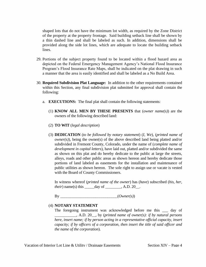
Vacation of Interior Lot Line & Utility / Drainage Easements Section XIV – Page 4
shaped lots that do not have the minimum lot width, as required by the Zone District
of the property at the property frontage. Said building setback line shall be shown by
a thin dashed line and shall be labeled as such. In addition, dimensions shall be
provided along the side lot lines, which are adequate to locate the building setback
lines.
29. Portions of the subject property found to be located within a flood hazard area as
depicted on the Federal Emergency Management Agency’s National Flood Insurance
Program’s Flood Insurance Rate Maps, shall be indicated on the plat drawing in such
a manner that the area is easily identified and shall be labeled as a No Build Area.
30. Required Subdivision Plat Language: In addition to the other requirements contained
within this Section, any final subdivision plat submitted for approval shall contain the
following:
a. EXECUTIONS: The final plat shall contain the following statements:
(1) KNOW ALL MEN BY THESE PRESENTS that (owner name(s)) are the
owners of the following described land:
(2) TO WIT (legal description)
(3) DEDICATION (to be followed by notary statement) (I, We), (printed name of
owner(s)), being the owner(s) of the above described land being platted and/or
subdivided in Fremont County, Colorado, under the name of (complete name of
development in capital letters), have laid out, platted and/or subdivided the same
as shown on this plat and do hereby dedicate to the public at large the streets,
alleys, roads and other public areas as shown hereon and hereby dedicate those
portions of land labeled as easements for the installation and maintenance of
public utilities as shown hereon. The sole right to assign use or vacate is vested
with the Board of County Commissioners.
In witness whereof (printed name of the owner) has (have) subscribed (his, her,
their) name(s) this _____day of ________, A.D. 20__.
By _____________________________(Owner(s))
(4) NOTARY STATEMENT
The foregoing instrument was acknowledged before me this ___ day of
___________, A.D. 20__, by (printed name of owner(s): if by natural persons
here, insert name; if by person acting in a representative official capacity, insert
capacity; if by officers of a corporation, then insert the title of said officer and
the name of the corporation).

Vacation of Interior Lot Line & Utility / Drainage Easements Section XIV – Page 5
My commission expires ___________________________________.
My address is____________________________________________
Witness my hand and official seal.______________________(seal)
Notary Public
(5) REGISTERED LAND SURVEYOR'S CERTIFICATE
I, (registered land surveyor's name) a registered land surveyor in the State of
Colorado do hereby certify that this plat has been prepared under my direction in
accordance with the Colorado Revised Statutes, as amended, and that this plat
does accurately show the described tract of land and the subdivision thereof, to
the best of my knowledge and belief. I further certify that any portion(s) of this
property which do lie within the designated flood hazard area as shown on the
F.E.M.A. F.I.R.M. maps are accurately shown hereon.
_________________________________________ Date: ________________
(6) ACKNOWLEDGEMENT AND ACCEPTANCE OF PLAT
This is certify that the plat is approved and accepted as per review by the Plan-
ning Director, dated this ______day of __________, 20___.
________________________________________________
Chairman, Fremont County Board of County Commissioners
(7) EASEMENT STATEMENT
Easements for public purposes, including utilities, are as indicated on the plat,
with the sole responsibility for maintenance being vested with the adjacent
property owners except as otherwise noted, all interior lot lines are subject to a
five (5) foot utility easement on both sides of lot lines. Exterior subdivision
boundary not fronting public way is subject to a ten (10) foot utility easement.
(8) COUNTY CLERK AND RECORDERS STATEMENT
STATE OF COLORADO }
COUNTY OF FREMONT }
This plat was filed for record in the office of the County Clerk and Recorder of
Fremont County, Colorado, at ________ ___.M., on the _______day of
___________, A.D. under reception number ________________.
________________________________________
Fremont County Clerk & Recorder
E. SUBMITTAL REQUIREMENTS:
1. Copy of current deed of record.
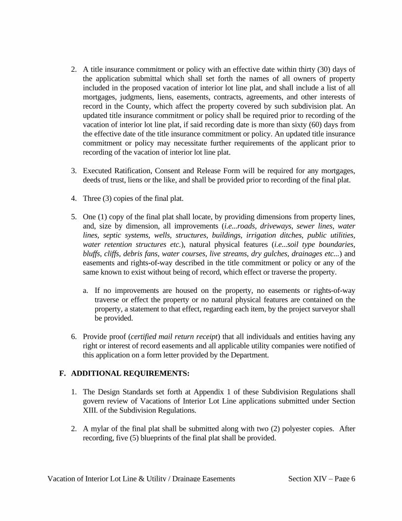
Vacation of Interior Lot Line & Utility / Drainage Easements Section XIV – Page 6
2. A title insurance commitment or policy with an effective date within thirty (30) days of
the application submittal which shall set forth the names of all owners of property
included in the proposed vacation of interior lot line plat, and shall include a list of all
mortgages, judgments, liens, easements, contracts, agreements, and other interests of
record in the County, which affect the property covered by such subdivision plat. An
updated title insurance commitment or policy shall be required prior to recording of the
vacation of interior lot line plat, if said recording date is more than sixty (60) days from
the effective date of the title insurance commitment or policy. An updated title insurance
commitment or policy may necessitate further requirements of the applicant prior to
recording of the vacation of interior lot line plat.
3. Executed Ratification, Consent and Release Form will be required for any mortgages,
deeds of trust, liens or the like, and shall be provided prior to recording of the final plat.
4. Three (3) copies of the final plat.
5. One (1) copy of the final plat shall locate, by providing dimensions from property lines,
and, size by dimension, all improvements (i.e...roads, driveways, sewer lines, water
lines, septic systems, wells, structures, buildings, irrigation ditches, public utilities,
water retention structures etc.), natural physical features (i.e...soil type boundaries,
bluffs, cliffs, debris fans, water courses, live streams, dry gulches, drainages etc...) and
easements and rights-of-way described in the title commitment or policy or any of the
same known to exist without being of record, which effect or traverse the property.
a. If no improvements are housed on the property, no easements or rights-of-way
traverse or effect the property or no natural physical features are contained on the
property, a statement to that effect, regarding each item, by the project surveyor shall
be provided.
6. Provide proof (certified mail return receipt) that all individuals and entities having any
right or interest of record easements and all applicable utility companies were notified of
this application on a form letter provided by the Department.
F. ADDITIONAL REQUIREMENTS:
1. The Design Standards set forth at Appendix 1 of these Subdivision Regulations shall
govern review of Vacations of Interior Lot Line applications submitted under Section
XIII. of the Subdivision Regulations.
2. A mylar of the final plat shall be submitted along with two (2) polyester copies. After
recording, five (5) blueprints of the final plat shall be provided.
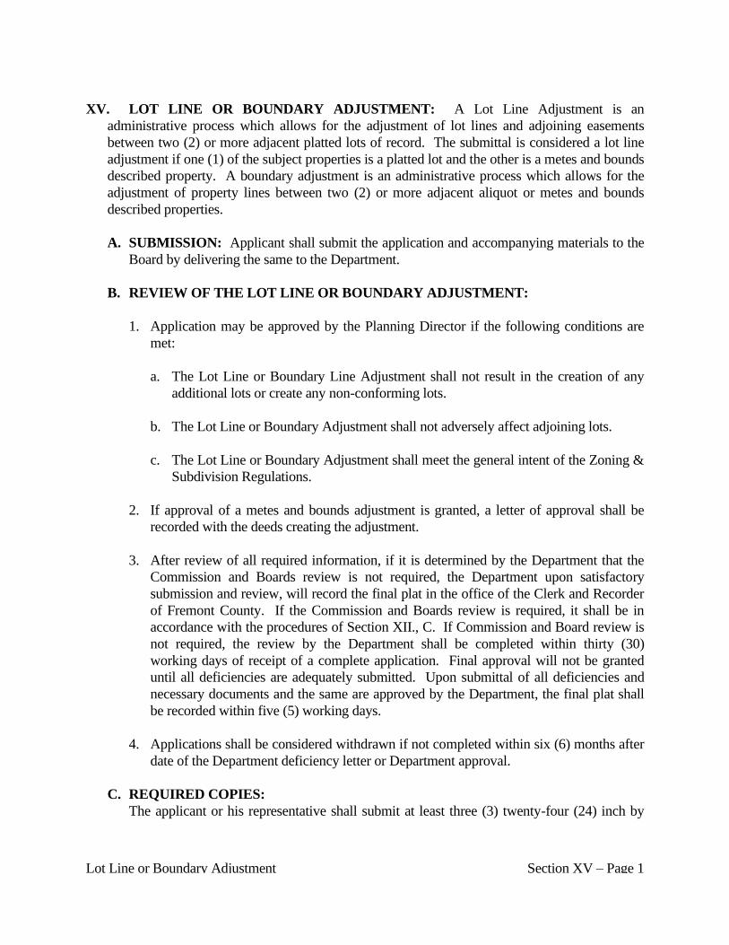
Lot Line or Boundary Adjustment Section XV – Page 1
XV. LOT LINE OR BOUNDARY ADJUSTMENT: A Lot Line Adjustment is an
administrative process which allows for the adjustment of lot lines and adjoining easements
between two (2) or more adjacent platted lots of record. The submittal is considered a lot line
adjustment if one (1) of the subject properties is a platted lot and the other is a metes and bounds
described property. A boundary adjustment is an administrative process which allows for the
adjustment of property lines between two (2) or more adjacent aliquot or metes and bounds
described properties.
A. SUBMISSION: Applicant shall submit the application and accompanying materials to the
Board by delivering the same to the Department.
B. REVIEW OF THE LOT LINE OR BOUNDARY ADJUSTMENT:
1. Application may be approved by the Planning Director if the following conditions are
met:
a. The Lot Line or Boundary Line Adjustment shall not result in the creation of any
additional lots or create any non-conforming lots.
b. The Lot Line or Boundary Adjustment shall not adversely affect adjoining lots.
c. The Lot Line or Boundary Adjustment shall meet the general intent of the Zoning &
Subdivision Regulations.
2. If approval of a metes and bounds adjustment is granted, a letter of approval shall be
recorded with the deeds creating the adjustment.
3. After review of all required information, if it is determined by the Department that the
Commission and Boards review is not required, the Department upon satisfactory
submission and review, will record the final plat in the office of the Clerk and Recorder
of Fremont County. If the Commission and Boards review is required, it shall be in
accordance with the procedures of Section XII., C. If Commission and Board review is
not required, the review by the Department shall be completed within thirty (30)
working days of receipt of a complete application. Final approval will not be granted
until all deficiencies are adequately submitted. Upon submittal of all deficiencies and
necessary documents and the same are approved by the Department, the final plat shall
be recorded within five (5) working days.
4. Applications shall be considered withdrawn if not completed within six (6) months after
date of the Department deficiency letter or Department approval.
C. REQUIRED COPIES:
The applicant or his representative shall submit at least three (3) twenty-four (24) inch by
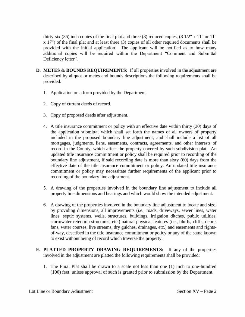
Lot Line or Boundary Adjustment Section XV – Page 2
thirty-six (36) inch copies of the final plat and three (3) reduced copies, (8 1/2" x 11" or 11"
x 17") of the final plat and at least three (3) copies of all other required documents shall be
provided with the initial application. The applicant will be notified as to how many
additional copies will be required within the Department “Comment and Submittal
Deficiency letter”.
D. METES & BOUNDS REQUIREMENTS: If all properties involved in the adjustment are
described by aliquot or metes and bounds descriptions the following requirements shall be
provided:
1. Application on a form provided by the Department.
2. Copy of current deeds of record.
3. Copy of proposed deeds after adjustment.
4. A title insurance commitment or policy with an effective date within thirty (30) days of
the application submittal which shall set forth the names of all owners of property
included in the proposed boundary line adjustment, and shall include a list of all
mortgages, judgments, liens, easements, contracts, agreements, and other interests of
record in the County, which affect the property covered by such subdivision plat. An
updated title insurance commitment or policy shall be required prior to recording of the
boundary line adjustment, if said recording date is more than sixty (60) days from the
effective date of the title insurance commitment or policy. An updated title insurance
commitment or policy may necessitate further requirements of the applicant prior to
recording of the boundary line adjustment.
5. A drawing of the properties involved in the boundary line adjustment to include all
property line dimensions and bearings and which would show the intended adjustment.
6. A drawing of the properties involved in the boundary line adjustment to locate and size,
by providing dimensions, all improvements (i.e., roads, driveways, sewer lines, water
lines, septic systems, wells, structures, buildings, irrigation ditches, public utilities,
stormwater retention structures, etc.) natural physical features (i.e., bluffs, cliffs, debris
fans, water courses, live streams, dry gulches, drainages, etc.) and easements and rights-
of-way, described in the title insurance commitment or policy or any of the same known
to exist without being of record which traverse the property.
E. PLATTED PROPERTY DRAWING REQUIREMENTS: If any of the properties
involved in the adjustment are platted the following requirements shall be provided:
1. The Final Plat shall be drawn to a scale not less than one (1) inch to one-hundred
(100) feet, unless approval of such is granted prior to submission by the Department.

Lot Line or Boundary Adjustment Section XV – Page 3
2. In the case of multiple sheets, a key map showing the relationship of the individual
sheets shall be provided on each sheet.
3. Name or title of plat shall read: "Name" Lot Line Adjustment.
4. The subtitle shall read: "A Lot Line Adjustment of Name, Lot and Block number(s) of
the original subdivision," Fremont County, Colorado and/or A portion of the (aliquot
description) Section, Township, Range, Principal Meridian, Fremont County,
Colorado and/or A Vacation and Re-plat of (Lot(s), Block(s) of [Name of
Subdivision]), Fremont County, Colorado", as appropriate, dependent on whether or
not the properties being adjusted are un-platted or platted property.
5. No subdivision in the County shall bear the same name or substantially similar name
as another subdivision unless adjoining and using consecutive filing numbers. The
Department shall have the authority to require the applicant to change the proposed
name if such name is substantially similar to the name of an existing subdivision in
the County.
6. The total acreage contained within the area being platted.
7. Name and address of the person, firm or organization preparing the Final Plat.
8. The date of preparation of the Final Plat and all revision dates to the submitted final
plat.
9. A north point.
10. A written and graphic scale of the drawing.
11. A vicinity map adequately labeled to locate the subject property in relation to streets
located in the general area.
12. Acreage and/or square footage for each proposed lot.
13. All appropriate survey information on the plat shall show lengths to hundredths of a
foot, and angles and bearings shall be shown to seconds of a degree.
14. A survey tie from the subject property boundary to an aliquot survey monument.
15. A statement identifying the basis of bearing for the subject property survey.
16. Bearings and lengths for all lot lines and perimeter subdivision boundaries, except
Lot Line or Boundary Adjustment Section XV – Page 4
that bearings and lengths need not be given for interior lot lines where the bearings
and lengths are the same as the exterior lot lines.
17. All bearings and dimensions for irregularly shaped lots shall be indicated for each lot.
18. For proposed curved boundaries and all curves on the plat, sufficient data shall be
given to enable the re-establishment of the curves on the ground. This curve data
shall include the following:
a. Radius of curve.
b. Central angle.
c. Tangent.
d. Arc length.
e. Notation of non-tangent curves.
19. Any non-radial lot lines or boundary lines shall be noted.
20. All survey monuments set and found, in preparation of the final plat; shall be
indicated on the final plat as to location and type of monument, by note or label.
21. Any “Reference Monument” and or “Witness Corner” shall be appropriately noted on
the plat.
22. The location, width and name of all streets that are adjacent to the subject property.
23. The lot lines to be adjusted shall be shown by tightly dashed lines and either labeled
on the plat drawing or the line symbol used identified in the plat legend.
24. All proposed easements shall be designated as to use, bearings and dimensions or
indicated by appropriate statements.
25. Excepted parcels marked "Not included in this plat.”
26. All existing easements shall be vacated prior to submittal or shall be shown on the
plat, labeled or noted as to its use, size and location. In addition, all survey
information and any recording information for all easements shall be provided.
27. All blocks and all lots within each block shall be consecutively numbered.
Lot Line or Boundary Adjustment Section XV – Page 5
28. The Final Plat shall show building setback lines for all stem or flag lots or irregularly
shaped lots that do not have the minimum lot width, as required by the Zone District
of the property at the property frontage. Said building setback line shall be shown by
a thin dashed line and shall be labeled as such. In addition, dimensions shall be
provided along the side lot lines, which are adequate to locate the building setback
lines.
29. Portions of the subject properties found to be located within a flood hazard area as
depicted on the Federal Emergency Management Agency’s National Flood Insurance
Program’s Flood Insurance Rate Maps, shall be indicated on the plat drawing in such
a manner that the area is easily identified and shall be labeled as a No Build Area.
30. Required Subdivision Plat Language: In addition to the other requirements contained
within this Section, any final subdivision plat submitted for approval shall contain the
following:
a. EXECUTIONS: The final plat shall contain the following statements:
(1) KNOW ALL MEN BY THESE PRESENTS that (owner name(s)) are the
owners of the following described land:
(2) TO WIT (legal description)
(3) DEDICATION (to be followed by notary statement) (I, We), (printed name of
owner(s)), being the owner(s) of the above described land being platted and/or
subdivided in Fremont County, Colorado, under the name of (complete name of
development in capital letters), have laid out, platted and/or subdivided the same
as shown on this plat and do hereby dedicate to the public at large the streets,
alleys, roads and other public areas as shown hereon and hereby dedicate those
portions of land labeled as easements for the installation and maintenance of
public utilities as shown hereon. The sole right to assign use or vacate is vested
with the Board of County Commissioners.
In witness whereof, (printed name of the owner) has (have) subscribed (his, her,
their) name(s) this ______ day of ______, A.D. 20__.
By_____________________(Owner(s))
(4) NOTARY STATEMENT
The foregoing instrument was acknowledged before me this ___ day of
_____________, A.D. 20__, by (printed name of owner(s): if by natural persons
here, insert name; if by person acting in a representative official capacity, insert
capacity; if by officers of a corporation, then insert the title of said officer and
Lot Line or Boundary Adjustment Section XV – Page 6
the name of the corporation).
My commission expires _______________________________.
My address is _______________________________________
Witness my hand and official seal.________________(seal)
Notary Public
(5) REGISTERED LAND SURVEYOR'S CERTIFICATE
I (registered land surveyor's name) a registered land surveyor in the State of
Colorado do hereby certify that this plat has been prepared under my direction in
accordance with the Colorado Revised Statutes, as amended, and that this plat
does accurately show the described tract of land and the subdivision thereof, to
the best of my knowledge and belief. I further certify that any portion(s) of this
property which do lie within the designated flood hazard area as shown on the
F.E.M.A. F.I.R.M. maps are accurately shown hereon.
_________________________________________ Date: ________________
(6) ACKNOWLEDGEMENT AND ACCEPTANCE OF PLAT
This is to certify that the plat is approved and accepted as per review by the
Planning Director, dated this ____ day of ______, 20__.
________________________________________________
Chairman, Fremont County Board of County Commissioners
(7) EASEMENT STATEMENT
Easements for public purposes, including utilities, are as indicated on the plat,
with the sole responsibility for maintenance being vested with the adjacent
property owners except as otherwise noted, all interior lot lines are subject to a
five (5) foot utility easement on both sides of lot lines. Exterior subdivision
boundary not fronting public way is subject to a ten (10) foot utility easement.
(8) COUNTY CLERK AND RECORDERS STATEMENT
STATE OF COLORADO }
COUNTY OF FREMONT }
This plat was filed for record in the office of the County Clerk and Recorder of
Fremont County, Colorado, at ______.M., on the _____ day of _____________,
20__, A.D. under reception no. ____________.
__________________________________
Fremont County Clerk & Recorder

Lot Line or Boundary Adjustment Section XV – Page 7
F. SUBMITTAL REQUIREMENTS:
1. Application on a form provided by the Department.
2. Copy of current deed of record.
3. A title insurance commitment or policy with an effective date within thirty (30) days of
the application submittal which shall set forth the names of all owners of property
included in the proposed lot line adjustment plat, and shall include a list of all
mortgages, judgments, liens, easements, contracts, agreements, and other interests of
record in the County, which affect the property covered by such lot line adjustment plat.
An updated title insurance commitment or policy shall be required prior to recording of
the lot line adjustment plat, if said recording date is more than sixty (60) days from the
effective date of the title insurance commitment or policy. An updated title insurance
commitment or policy may necessitate further requirements of the applicant prior to
recording of the lot line adjustment plat.
4. Executed Ratification, Consent and Release Form will be required for any mortgages,
deeds of trust, liens or the like, and shall be provided prior to recording of the final plat.
5. Three (3) copies of the final plat.
6. One (1) copy of the final plat shall locate, by providing dimensions from property lines,
and, size by dimension, all improvements (ie...roads, driveways, sewer lines, water
lines, septic systems, wells, structures, buildings, irrigation ditches, public utilities,
water retention structures etc.), natural physical features (ie...soil type boundaries,
bluffs, cliffs, debris fans, water courses, live streams, dry gulches, drainages etc...) and
easements and rights-of-way described in the title commitment or policy or any of the
same known to exist without being of record, which effect or traverse the property.
a. If no improvements are housed on the property, no easements or rights-of-way
traverse or effect the property or no natural physical features are contained on the
property, a statement to that effect, regarding each item, by the project surveyor shall
be provided.
7. Proof (certified mail return receipt) that all individuals and entities having any rights or
record easements and all applicable utility companies were notified of this application
on a form letter provided by the Department.
G. RELATIONSHIP TO DESIGN STANDARDS:
The Design Standards set forth at Appendix 1 of these Subdivision Regulations shall govern
review of boundary or lot line adjustment applications submitted under these Subdivision
Regulations.
Vacation of Recorded Public Right-of-Way Application Section XVI – Page 1
XVI. VACATION OF RECORDED PUBLIC RIGHT-OF-WAY APPLICATION
A. SUBMISSION: An application for a vacation of a public right-of-way (including alleys) is
required to vacate any portion of any platted or designated public street, alley, lane,
parkway, avenue, road, or other public way, whether or not it has been used as such. No
platted or deeded roadway or part thereof or unplatted or undefined roadway which exists by
right of usage shall be vacated so as to leave any land adjoining said roadway without an
established public road or private-access easement connecting said land with another
established public road.
1. The applicant shall submit the Vacation of Public Right-of-Way application, materials,
drawings and required supporting documents, including an application fee, to the
Department.
2. The applicant shall submit the Vacation of Public Right-of-Way application on a form
provided by the Department.
3. The application submittal shall be delivered in person, to a Department representative.
The Department representative will accept the application submittal only if all minimum
submittal requirements have been met and presented at the time of submission.
4. The Vacation of Public Right-of-Way application and accompanying materials,
drawings and required supporting documents shall be submitted to the Department no
less than twenty-four (24) working days prior to the date of the regularly scheduled
Commission meeting at which they are to be considered.
B. REVIEW OF PUBLIC RIGHT-OF-WAY VACATION APPLICATION:
1. The Department will conduct a preliminary review of the application to determine the
adequacy of the application for Commission review.
2. The applicant will be notified of the results of the Department review through a
Department Deficiency and Comment Letter.
a. If there are deficiencies in the application that would make the application
unacceptable for review by the Commission, the Department will provide the
applicant with a time frame in which to address the deficiencies in order for the
Department to place the application on the agenda of the Commission.
b. The applicant will be notified in the deficiency and comment letter of the number of
revised copies of the application and accompanying materials to be provided to the
Department for distribution.
Vacation of Recorded Public Right-of-Way Application Section XVI – Page 2
3. If there are no deficiencies or deficiencies are addressed within the time frame, the
Department will provide the applicant and Commission with a review of the application,
and schedule the application on the agenda of the Commission.
4. If the deficiencies are not addressed or if acceptable reasoning is not provided to justify
scheduling on the Commission agenda without addressing the deficiencies within the
established time frame, the Department will not place the application on the
Commission agenda for consideration.
a. In accordance with Board Resolution No. 68, Series of 2006: A second full
application fee will be charged to the applicant, if all deficiencies in the initial
application review letter are not adequately addressed.
b. Each subsequent deficiency review letter will result in the charging of another full
application fee.
c. All such fees shall be paid along with the deficiency submittal, prior to any further
review of the application.
5. The Commission shall consider the application and Department comments at a public
meeting.
a. The applicant shall attend the Commission meeting at which the application is
scheduled to be considered.
1) Failure of the applicant to attend the meeting will result in tabling of the
application review by the Commission.
2) Failure of the applicant to attend the meeting to which review of the application
was tabled will be considered a withdrawal of the application by the applicant.
Fees will not be refunded.
b. The applicant may offer comments, evidence and testimony concerning the
application.
c. The Commission may hear comments and receive evidence or testimony from
interested persons, but shall not hold formal public hearings, unless expressly
authorized by law, or upon request of the Board.
6. The Commission may recommend approval, approval with contingencies or denial of
the application to the Board. The Commission may include comments and / or
suggestions with its recommendation.
Vacation of Recorded Public Right-of-Way Application Section XVI – Page 3
7. The Commission may continue consideration of the application to the next regular
meeting of the Commission to receive more comments, to enable further study of
information and input received at the meeting, or to request that the applicant provide
additional information regarding the application. Any continuance shall be no later than
the next regularly scheduled Commission meeting.
a. The applicant, prior to a motion by the Commission, may request an extension of
time before continued consideration by the Commission, to allow for submission of
additional information in support of the application. Such extension request shall
not exceed ninety (90) days and must coincide with a regular Commission meeting
date.
8. If the applicant presents a significantly different proposal at the Commission meeting
than was submitted in the application to the Department, the Commission shall continue
the application to the next regular meeting of the Commission and request a Department
review of the proposal. The Department may require an additional review fee if deemed
appropriate.
9. The Department shall mail the Commission’s recommendations, comments and
suggestions to the applicant within five (5) working days after the meeting at which the
Commission’s review of the application was finalized. Said mailing shall contain the
date and time of the regular Board meeting at which the Board will review the
application.
10. The Department shall place the application on the agenda of the Board, to be heard at a
meeting to be held within thirty-five (35) days after completion of action by the
Planning Commission.
a. The applicant may ask for an extension of time before the Board considers the
application, to accommodate the recommendations, comments or suggestions of the
Commission.
1) A request for additional time shall be made, in writing, to the Department which
is authorized to grant the request on behalf of the Board.
2) Any such extension request shall not exceed ninety (90) days from the date the
Commission consideration was completed.
3) The extension of time for Board consideration must coincide with a regular
Board meeting date.
4) No later than ten (10) working days prior to the Board meeting at which the
application is to be considered, the applicant shall provide to the Department
Vacation of Recorded Public Right-of-Way Application Section XVI – Page 4
copies of any additional information and or documentation to be submitted for
Board consideration.
5) The Board, at its discretion, may require further consideration of the application
by the Commission.
6) No significant changes to an application shall be proposed after formal action by
the Commission unless such changes are made to accommodate
recommendations, comments or suggestions of the Commission.
a) If significant changes are needed due to change of area conditions or
circumstances beyond control of the applicant, then further consideration by
the Commission shall be required prior to consideration of the application by
the Board.
11. At the Board meeting, the Board shall take into consideration the application,
Commission recommendations, comments, and suggestions, minutes from the
Commission meeting and Department review.
a. The applicant shall attend the Board meeting at which the application is scheduled to
be heard.
1) Failure of the applicant to attend the Board meeting will result in tabling of the
application.
2) Failure of the applicant to attend the Board meeting to which hearing of the
application was tabled will be considered a withdrawal of the application and
fees will not be refunded.
b. The applicant may offer comments, evidence and testimony concerning the
application.
c. The Board may hear comments and receive evidence or testimony from interested
persons.
12. The Board may continue consideration of the application to the next regular
meeting of the Board to receive more comments, enable further study of information and
input received at the meeting or to request that the applicant provide additional
information regarding the application. No such continuance shall exceed thirty (30)
days.
a. The applicant, prior to a motion by the Board, may request an extension of time
before continued consideration by the Board, to allow for submission of additional

Vacation of Recorded Public Right-of-Way Application Section XVI – Page 5
information in support of the application. Such continuance shall not exceed ninety
(90) days and must coincide with a regular Board meeting date.
13. The Board shall approve, deny, or approve the application with contingencies within
thirty (30) days after the conclusion of the Board meeting or the date to which it was
continued. If the application is approved such approval shall be by resolution which is
to be approved by the Board.
14. The Department shall mail to the applicant the Board’s decision within five (5) working
days after the meeting at which formal action by the Board occurred.
C. EFFECTS OF APPROVAL:
Final approval of a Vacation of a Public Right-of-Way by the Board will provide the
applicant up to six (6) months from the date of approval to submit all contingencies prior to
the recording of the Vacation of the Public Right-of-Way Resolution.
1. Contingencies - If the Vacation of a Public Right-of-Way was approved with
contingencies, all contingencies shall be submitted to the Department within six (6)
months of the date of approval by the Board. If the contingency items are not submitted
by the deadline, the Vacation of a Public Right-of-Way approval shall be deemed
expired and a new application will be required, including fees.
2. Extensions - The Board may extend the time period for submittal of contingency items
or extension of approval of the Vacation of a Public Right-of-Way upon documented
showing of good cause. If extension(s) are requested, further consideration by the
Commission may be required.
a. No extensions may be granted unless a written request, detailing the reasons and
justification for extension, and required fee is submitted to the Department no less
than ten (10) working days prior to the expiration of the initial six (6) month period
or previous extension granted.
b. The Department shall schedule the request for extension for the next regular Board
meeting at which time the Board will consider the request.
c. In absence of justification warranting a longer time frame, no extensions shall be
granted for more than six (6) months from the date of Board approval or previous
extension.
3. Once all contingencies have been met by the applicant and accepted by the Department
the Board Resolution enacting the vacation and all appropriate accompanying
documents and materials shall be recorded by the Department in the Fremont County
Clerk and Recorders Office, in the land records of Fremont County.

Vacation of Recorded Public Right-of-Way Application Section XVI – Page 6
D. DENIAL OF A VACATION OF RECORDED PUBLIC RIGHT-OF-WAY
APPLICATION:
A denial of a Vacation of Recorded Public Right-of-Way application by the Board will
result in closure of the application file by the Department. Without evidence of a significant
change of area conditions or a significant change in the proposed application, an application
for Vacation of Recorded Public Right-of-Way will not be accepted for the same right-of-
way within two (2) years of the date of denial by the Board.
E. REQUIRED COPIES:
The applicant or his representative shall submit at least six (6) twenty-four (24) inch by
thirty-six (36) inch or six (6) eighteen (18) inch by twenty-four (24) inch copies of the
drawing and six (6) reduced copies, (8 1/2" x 11" or 11" x 17") of the drawing. In addition
at least six (6) copies of all other required documents shall be provided with the initial
application. The applicant will be notified as to how many additional copies will be
required within the Department “Comment and Submittal Deficiency letter”.
F. DRAWING REQUIREMENTS:
1. The drawing shall be drawn to a scale not less than one (1) inch to one-hundred (100)
feet unless approval of another scale is granted by the Department prior to submission of
the application.
2. In the case of multiple sheets, a key map showing the relationship of the individual
sheets to each other shall be provided on each sheet.
3. Title of the drawing shall be "A vacation of (name of right-of-way and/or description)".
4. The drawing subtitle shall include specific references to the original plat, location of the
vacation and the extent of the vacation.
5. A note table with each note being individually labeled.
6. A legend table with each symbol and line pattern being identified.
7. Complete legal description and acreage of right-of-way to be vacated.
8. Public right-of-way to be vacated shall be illustrated by cross hatching or other method
approved by the Department. In addition, the right-of-way to be vacated should be
noted on the drawing.
9. The area to be vacated shall include all dimensions, etcetera.
Vacation of Recorded Public Right-of-Way Application Section XVI – Page 7
10. Date, north point and a written graphic scale.
11. Vicinity map to locate the proposed vacation.
12. All lots adjoining the area to be vacated.
13. The drawing shall indicate by statement or note how title to the vacated right-of-way
will be vested upon vacation.
G. MINIMUM SUBMITTAL REQUIREMENTS:
1. A completed application on a form provided by the Department.
2. A drawing in compliance with this section shall be provided.
3. A submittal fee as established by resolution of the Board shall be provided.
4. Copies of the application and drawing as required by this section shall be provided.
5. A list of adjoining property owners and current mailing addresses as shown by the real
estate records of the County Assessor.
H. NOTICE REQUIREMENTS:
1. Mailing by United States Postal Service (USPS) certified mail, return receipt to the
Department (labeled to identify the application) requested at least fourteen (14) days
prior to the Commission meeting date, the applicant shall notify all property owners
adjacent to the right-of-way, and any additional notifications as may be required by the
Planning Commission, of the meeting date of the Planning Commission and Board. The
Board meeting date shall be the second Board monthly meeting.
a. The applicant shall provide the Department with USPS receipts evidencing the date
the notice packets were mailed.
1) The mailing shall include the following:
a) A notice form provided by the Department which is to be completed by the
applicant.
b) A copy or a readable reduced copy of the vacation of public right-of-way
drawing.
c) A vicinity map locating the subject property in relation to the surrounding
Vacation of Recorded Public Right-of-Way Application Section XVI – Page 8
area, streets and major features.
2. Proof (certified mail return receipt) that all individuals and entities having any right of
record easements and all applicable utility companies were notified of this application,
in a form letter provided by the Department.
3. Posting of a notice sign, at least three feet by four feet (3’X4’) in size with each letter at
least two (2) inches in height, containing the specific matter of the meeting, the date,
time, location of the meeting, the authority (Commission and Board) considering the
vacation of public right-of-way and the contact information for the Department where
additional information may be obtained.
a. The sign shall be posted continuously on the subject property for at least fourteen
(14) days prior to the Planning Commission meeting date of the application.
b. The applicant shall be responsible for maintenance of the sign to insure its
continuous display.
c. The sign shall be placed no further than fifteen (15) feet from the public right-of-
way to be vacated in a clear and unobstructed view.
d. Where more than one (1) property is involved an additional sign may be required.
e. If the right-of-way to be vacated is in current use, at a minimum, there shall be a sign
posted at both ends of the right-of-way proposed to be vacated.
f. All posting shall be placed upon the right-of-way as determined by the Department,
prior to the Planning Commission meeting and by the Commission prior to the
Board meeting.
I. ADDITIONAL REQUIREMENTS:
When a right-of-way is vacated the land contained in the right-of-way will be divided in
accordance with Colorado State Statutes. Title to these portions of vacated rights-of-way
shall be combined with the property abutting the vacated roadway and shall not be
considered separate parcels for purposes of subdivision and conveyance.
1. If a right-of-way has been vacated prior to September 9, 1994, it is required that the
portion of the street that was vacated be included in the deed of record for ownership
of the adjacent property.
2. If a right-of-way has been vacated after September 9, 1994, it shall comply with
current regulations which require a boundary or lot line adjustment and the deed of
record for the lot or parcel shall include the vacated right-of-way.

Vacation of Recorded Public Right-of-Way Application Section XVI – Page 9
Correction Plat Section XVII – Page 1
XVII. CORRECTION PLAT
A. SUBMISSION: Without a hearing or compliance with the submission, referral or review
requirements of these Subdivision Regulations, the Department may approve a Correction
Plat, if the sole purpose of such correction plat is to correct one or more technical errors in
an approved plat and where such correction plat is consistent with an approved preliminary
plan or with a plat recorded in compliance with these regulations. The Correction Plat shall
be captioned as such and shall describe the error(s) to be corrected. If the technical error(s)
meet the description of any errors under section 38-51-111(2), C.R.S., (including any
subsequent amendments), a surveyor’s affidavit of correction, as defined in section 38-51-
102, C.R.S., shall be prepared in lieu of a correction plat.
1. The applicant shall submit the Correction Plat application on a form provided by the
Department, including an application fee, to the Department.
a. The application shall be delivered, in person, to a Department representative. The
Department representative will accept the application submittal only if all
minimum submittal requirements have been met and presented at the time of
submission.
B. REVIEW OF THE CORRECTION PLAT APPLICATION:
1. The Department will conduct a preliminary review of the application to determine the
adequacy of the application within eight (8) working days from the date of complete
submission of the application.
2. The applicant will be notified of the results of the Department review via a Department
Deficiency and Comment Letter. If there are deficiencies in the application the
Department will provide the applicant with a time frame in which to address the
deficiencies.
3. If there are no deficiencies or deficiencies are addressed within the time frame, and
approval is granted the Department will provide the applicant with an approval letter.
4. Upon approval the applicant will be required to provide the required Mylar drawing and
two (2) polyester copies of the final correction plat.
5. Applications shall be considered withdrawn if not completed within six (6) months after
the Department approval.
C. RECORDING OF THE CORRECTION PLAT: Upon approval of the Correction Plat
by the Department, and upon receipt of the mylar drawing and two (2) polyester copies the
correction plat shall be recorded in the office of the Fremont County Clerk & Recorder.
Correction Plat Drawing Requirements Section XVIII – Page 1
XVIII. CORRECTION PLAT DRAWING REQUIREMENTS:
A. REQUIRED COPIES:
The applicant or his representative shall submit at least three (3) twenty-four (24) inch by
thirty-six (36) inch copies of the correction plat drawing or three (3) copies of the surveyor’s
affidavit.
B. CORRECTION PLAT DRAWING REQUIREMENTS:
1. The title shall read: “Correction Plat for (title of existing plat) to correct (describe the
error(s) to be corrected). (If the description of the error(s) is too lengthy to describe in
the title, a not describing the error(s) is acceptable.)
2. All other language, notes, representations, etcetera, of the existing plat shall not be
changed other than the language related to the error(s) to be corrected.
C. SURVEYOR’S AFFIDAVIT
1. The surveyor’s affidavit shall describe the error(s) to be corrected in accordance with
current Colorado Revised Statutes.
Exemptions & Planned Unit Development (PUD) Section XIX – Page 1
XIX. EXEMPTIONS & PLANNED UNIT DEVELOPMENT (PUD):
A. EXEMPTIONS: The Board shall have the power to grant exemptions from the
requirements of the Subdivision Regulations provided that the following criteria or
factors are found to exist:
1. Such relief may be granted only if there is no substantial detriment to the public good;
2. Such relief may be granted only if it will not substantially impair the intent and
purpose of the regulation;
3. The property owner shall clearly demonstrate that peculiar, exceptional physical
conditions or topography of the property, or the particular physical surroundings
make the literal enforcement of one (1) or more of the regulations is impractical,
create exceptional, particular and undue hardship upon the owner, as distinguished
from a mere inconvenience or a desire to make more money.
B. PLANNED UNIT DEVELOPMENT (P.U.D.): The Commission and the Board may
modify the design standards contained in Appendix 1 of these regulations for application to
proposals for Planned Unit Development provided that the overall design is consistent with
the purposes of such standards. Please refer to Section XX.

Fees Section XX – Page 1
XX. FEES
A. A schedule of fees, which shall be non-refundable, for procedures and other action under
these Subdivision Regulations shall be approved by the Board and shall be kept at the
Department. Copies of said schedule will be available to the public on request.
General Dedications, Schools & Park Sites Section XXI – Page 1
XXI. GENERAL DEDICATIONS, SCHOOLS & PARK SITES: For all subdivisions that are
not approved through the exemption process, upon consideration of the Fremont County Master
Plan, and the particular type of development proposed within the subdivision and in surrounding
area, the Board, after review by the Commission, may require the applicant to petition for
annexation into the appropriate district and the dedication of sites and land areas with a
character, size, topography, access, and location suitable for public use for roadways, and other
rights-of-way, flood channels, parks, including recreation areas, scenic areas, and trails, schools
and other public purposes which the Board may deem necessary to serve the proposed
subdivision and the future residents thereof. In lieu of a dedication of sites and land areas, the
Board, after review by the Commission, may require payment of a sum of money not exceeding
the full market value of such sites and land areas. Dedications may be considered above and
beyond the requirement for Planned Unit Developments. In addition, the board may require the
filing of a petition for inclusion within the appropriate recreation or park district.
A. DEDICATED LAND: All land to be dedicated as required by this section and these
Regulations, shall be designated on the Final Plat as outlots and these outlots shall not be
building lots. Such outlots shall be deeded to Fremont County at the time of recordation of
the Final Plat. Title insurance acceptable to Fremont County provided by a title insurance
company authorized to do business in the State of Colorado and a certificate of
representations and warranties concerning title and usability of the property shall be required
at the time of recording of Final Plat. Disposition of the outlots shall be shown on the Final
Plat.
B. REQUIRED ROAD DEDICATIONS: Notwithstanding, any other provision of this
Section or any other provision of these Regulations, the following shall be required for all
final plat and exemptions as conditions of approval by the Commission and the Board:
1. All roads, streets, alleys or other public traffic ways located within the subject property,
the benefit of which is to the current or future residents of the subject property, shall be
dedicated as public rights-of-way unless specifically approved as private rights-of-way
and so designated on the plat.
C. PARK DEDICATIONS: Notwithstanding, any other provision of this Section or any other
provision of these Regulations, the following may be required for subdivisions as conditions
of approval by the Commission and the Board:
1. It is the intent of Fremont County to provide park facilities for hiking, horseback riding,
etc., at a standard of twenty-five (25) acres per one-thousand (1,000) occupants for
residential areas and/or up to three (3) percent of the total land utilized for commercial,
industrial or other non-residential area. As a condition of approval, there shall be
provided park facilities that match the anticipated demand of the proposed subdivision at
the above standard.

General Dedications, Schools & Park Sites Section XXI – Page 2
2. CRITERIA FOR PARK DEDICATIONS: In determining which land areas are
appropriate for dedication as parks, the Commission and Board shall consider the
following criteria:
a. The placement of park lands in such a manner as to assist in enhancing the
environment; and in preserving community integrity in the most practical, attractive
manner possible.
b. The assurance of the continuity of open space links, trails, and other major
components of the recreation system.
c. The assurance that areas set aside for park lands have been examined for compliance
with all regional plans, particularly the Fremont County policies and development
statement, if any, for open spaces.
d. The assessment of the suitability of proposed land dedications for park, recreation
and open space needs.
e. The examination of the size, shape, topography, geology, presence and condition of
ground cover and timber, condition of soil, drainage, location, access and availability
of water to lands proposed for park, recreation and open space uses.
f. The assurance of the protection of natural and historical features, scenic vistas,
watersheds, timber and wildlife.
g. Park lands that are intended to be used for trail rights-of-way (linear parks for
pedestrian, equestrian or bicycle use), shall conform to the following criteria:
(1) The land may be either set aside as a dedicated easement or as a deeded outlot.
(2) The minimum width for such trail easement or outlot shall be based on the
particular reasonable needs of the trail, it's location, the surrounding terrain and
the projected usage but in no instance shall be less than twelve (12) feet in width
and in all cases the easement shall be of adequate width to handle the proposed
uses.
(3) There shall be adequate provisions for public access to the trail easement within
the subject property.
(4) The trail easement may overlap and include property previously included in
other easements such as ditch, canal or utility, public open space or other ease-
ment provided no easement compromises the functional use of any other
easement.
General Dedications, Schools & Park Sites Section XXI – Page 3
(5) If Fremont County, a municipality or other entity does not construct the trail
within three (3) years of its dedication, then the owners of the property may peti-
tion the Board for a vacation of the trail easement for the portion of the easement
which adjoins his or her property.
h. Park land may be considered as part of the land set aside for open space or
preservation as provided for in P.U.D.'s.
i. The Board shall not require a dedication of land for park or trail in the absence of an
impact statement showing justification for and necessity of a dedication of land prior
to purposes submitted to the Board by the appropriate park and recreation district.
The statement shall include, but not be limited to the following factors:
(1) Estimate of the anticipated growth in the new development area.
(2) Cost of the facility required to serve the new development.
(3) Determination of the area that will benefit from construction of the new facility.
If existing developed areas will benefit significantly through improved services
or direct access to improved facilities, the total benefits should be allocated
between new and existing areas.
(4) Estimate of the portion of the costs of new facilities attributable to the need to
serve new development divided by the estimated number of new residents or the
amount of anticipated new development to arrive at a preliminary "per resident,"
"per housing unit," or "per square foot" charge.
(5) If any current taxes or mandatory charges levied on the new development are
being used to pay for the same type of facility for which the dedication or fee is
being required, adjustment of the preliminary charge to "credit" the new
development with the money already being contributed to similar facilities in the
county.
D. SCHOOL DEDICATIONS: Notwithstanding, any other provision of this Section or any
other provision of these Regulations, as conditions of approval by the Commission and
Board, the following may be required for subdivisions:
1. Dedication requirements shall not exceed seven-hundred-fifty (750) square feet of land
per dwelling unit for single family residences and five-hundred (500) square feet of land
area per dwelling unit for multi-family residences or other reasonable criteria approved
by the specific school district and passed by Resolution of the Board.
General Dedications, Schools & Park Sites Section XXI – Page 4
2. When, after recommendation of the appropriate school district, dedication of all or
portions of required school lands is not deemed feasible or in the public interest, the
school district may recommend to the Board one of the following options:
a. Guarantee of future land dedication when dedication of all or portions of required
school lands is not deemed feasible or in the public interest in a particular phase of
development. The developer must submit a letter guaranteeing future dedication of
land for school sites to the appropriate school district.
b. Cash-in-lieu of land in accordance with this Section.
E. IMPACT STATEMENT: The Board shall not require a dedication of land for school
purposes in the absence of an impact statement showing justification for and necessity of a
dedication of land prior to purposes submitted to the Board by the appropriate school
district. The statement shall include, but not be limited to the following factors:
1. Estimate of the anticipated growth in the new development area.
2. Cost of the facility required to serve the new development.
3. Determination of the area that will benefit from construction of the new facility. If
existing developed areas will benefit significantly through improved services or direct
access to improved facilities, the total benefits should be allocated between new and
existing areas.
4. Estimate of the portion of the costs of new facilities attributable to the need to serve new
development divided by the estimated number of new residents or the amount of
anticipated new development to arrive at a preliminary "per resident, " "per housing
unit", or "per square foot" charge.
5. If any current taxes or mandatory charges levied on the new development are being used
to pay for the same type of facility for which the dedication or fee is being required,
adjustment of the preliminary charge to "credit" the new development with the money
already being contributed to similar facilities in the County demonstrate a direct benefit
to the residents of the proposed subdivision.
F. OTHER REQUIRED DEDICATIONS: Notwithstanding, any other provisions of this
Section or any other provision of these Regulations, as conditions of approval by the
Commission and the Board, the following shall be required for subdivisions and
exemptions:
1. Dedication of easements for drainageways, drainage basins, floodway areas, etc. as
required by the Board.

General Dedications, Schools & Park Sites Section XXI – Page 5
2. Dedication of utility easements so as to provide adequate areas for the provisions of
those utilities.
3. Dedication or reservation of suitable lands for sites for fire stations or other public safety
facilities as may be reasonably required by the Board to protect the health, safety and
welfare of the future residents of the proposal.
G. CASH-IN-LIEU: In those cases where the dedications of land are in such locations,
configurations or sizes that the property required to be dedicated is unacceptable to the
Board, the applicant, at the option of the Board, after advice from the potential receiving
body, may be required to pay Fremont County or the appropriate governmental or quasi-
governmental entity cash-in-lieu of land dedication. Such payment shall be based on the
anticipated market value, based on completion of proposed platting, of the entire property as
it may exist in a raw/undeveloped state. A proportionate amount of this value shall be
assigned to any parcels or properties requested by Fremont County for public use. If
required, property values shall be established by appraisal, provided in the first instance by
the applicant, and accepted by the Board. Minimum payment for cash-in-lieu of land
dedication shall be five-hundred dollars ($500) for any required dedication. The Board shall
determine whether the payments shall be placed in designated Fremont County maintained
interest bearing escrow accounts, with Fremont County as escrow agent or whether the
payments shall be given directly to the appropriate entity.
H. COMBINATION OF DEDICATION AND CASH-IN-LIEU: In those cases where
portions of the sites and land areas to be dedicated are in such locations, configurations or
sizes to render dedication of those portions of the sites and land areas unacceptable to the
Board, the applicant, at the option of the Board, shall be required to dedicate to Fremont
County or the appropriate governmental or quasi-governmental entity those sites and land
areas which will meet the needs of the County and in accordance with Section XIX., G.,
cash-in-lieu of the dedication of the unacceptable portions of the sites and land areas. The
value of the combination of both the land dedication and the cash-in-lieu of land shall not
exceed the full market value of the total required dedication of sites and land areas. Full
market value shall be established in accordance with the provisions of Section XIX., G.
I. RELEASE OF LAND OR CASH:
1. After final approval of a subdivision plat and receipt of dedications of sites and land
areas or payments in lieu thereof required pursuant to this section, the Board shall give
written notification to the appropriate school districts and/or park district and appropriate
local government entities. When the Board is acting as escrow agent, the appropriate
governmental or quasi-governmental entity shall request and shall demonstrate to the
Board a need for moneys for a use authorized by this section. When the Board votes to
allocate moneys for subject project, such moneys shall immediately be transferred to the
General Dedications, Schools & Park Sites Section XXI – Page 6
appropriate school district, park district or local government entity.
2. Changes to uses specified by a plat be accomplished through a Replat. Outlots may be
attached to abutting property or may be transferred to another owner as approved by the
Board through the Replat review. Such replat shall include Sketch Plan as described by
these regulations.
3. Funds may be released by the Board to the appropriate school district, park district or
local government entity upon request, if the Board finds that the proposed use of the
fund is compatible with the intent of the cash-in-lieu payment or sale of the land.

Planned Unit Developments (P.U.D.) Section XXII – Page 1
XXII. PLANNED UNIT DEVELOPMENTS (P.U.D.)
A. PURPOSE AND INTENT: It is the Boards intent in allowing for the establishment of
planned unit developments to:
1. Encourage innovations in residential, commercial, industrial, recreational and resort
development by allowing for mixed land uses, variations in development densities, and
variety in the type, design and layout of buildings.
2. Provide a means of designing development so it relates to, and preserves to the extent
practical, the natural features of the site and avoids areas having development
constraints.
3. Provide a means for clustering development and allowing for the preservation of open
space, more effective land utilization, and more cost effective and efficient extensions of
infrastructure.
B. USES ALLOWED: Uses allowed by right, Special Review Use or by Conditional Use
Permit in the zoning district in which the proposed P.U.D. is located.
C. STANDARDS FOR APPROVAL: A P.U.D. may include variations in lot area, lot width,
yard and building height requirements and off-street parking provisions if the following
features exist:
1. The tract or parcel of land involved is either in one ownership or the subject of an
application filed jointly by the owners of all property included.
2. The development includes common open space preserved in its natural character for
public and/or private use and enjoyment. A homeowner's or other association must be
established to perpetually maintain the open space for the mutual benefit of the owners
or residents of the P.U.D. The ownership of the Common Open Space will be
determined by the Board on a case by case basis, depending upon the perceived
community benefit. The provision of recreation opportunities, landscaping, preservation
and/or enhancement of natural features, view corridors and environmentally sensitive
areas are some of the goals for the common open space.
3. The project is designed to provide variety and diversity, so that maximum long-range
benefit may be gained and the unique features of the development or site preserved and
enhanced.
4. The project is in harmony with the surrounding neighborhood.
5. The overall density of the P.U.D. does not exceed the normal requirements of the zoning
district in which the P.U.D. is located.

Planned Unit Developments (P.U.D.) Section XXII – Page 2
D. PROCEDURES AND REQUIREMENTS: A proposal for a P.U.D. shall be submitted
consistent with the procedures and requirements of this section.
E. SKETCH PLAN SUBMITTAL: An applicant shall make application for the approval of
a P.U.D. by first submitting a sketch plan for the planned unit development to the
Commission. The sketch plan shall include maps and a written statement and shall show
enough of the area surrounding the proposed P.U.D. to indicate the relationship of the
P.U.D. to adjacent uses, both existing and proposed. The sketch plan submission shall
include the following information along with at least three (3) copies of the sketch plan
which conforms to the Drawing Requirements of the Sketch Plan Requirements, Section
IV., and three (3) reduced copies (8 1/2" x 11" or 11" x 17") of the sketch plan:
1. A description of the type of development and land uses surrounding the proposed site.
2. Accessibility of the site.
3. Density of the development.
4. General statement of expected financing.
5. Plan showing the general locations of roads, parking, building, and any proposed
amenities.
6. Area of ground coverage for buildings, parking and street or roads.
F. SKETCH PLAN - ACTION BY COMMISSION: The Commission shall review the
sketch plan, and inform the applicant of any special and/or additional information which will
be required under the Preliminary Development Plan stage. The presentation of the sketch
plan should be considered a pre-application conference with the Commission. Any
recommendations to the applicant shall be done by formal action.
G. PRELIMINARY DEVELOPMENT PLAN - APPLICATION: The applicant, after
submitting the sketch plan to the Commission and receiving the Commission's
recommendations, shall submit to the Commission by delivering same to the Department,
the required information for a preliminary development plan.
H. PRELIMINARY DEVELOPMENT PLAN - MAPS: The preliminary development plan
shall contain the following minimum information along with at least three (3) copies of the
preliminary plan which conforms to the Drawing Requirements of the Preliminary Plan
Requirements, Section VI., and three (3) reduced (8 1/2" x 11" or 11" x 17") copies of the
preliminary plan. At least three (3) copies of all other documents shall be provided with the
initial application. The applicant will be notified as to how many additional copies will be
required with the Department "Comment and Submittal Deficiency letter". The Preliminary
Plan Map shall contain the following:

Planned Unit Developments (P.U.D.) Section XXII – Page 3
1. The existing topographic character of the land.
2. Existing land uses and zoning districts.
3. Proposed land uses and the approximate location of buildings and other structures and
lots.
4. The density and type of dwellings to be included in the planned unit development
project.
5. An approximate indication of the circulation and parking systems.
6. Probable locations for common open space, parks and playgrounds.
7. Adjacent streets and proposed points of access.
8. Location and description of any existing utilities or easements in the area encompassed
by the development.
9. Proposed landscaping.
I. PRELIMINARY DEVELOPMENT PLAN - WRITTEN STATEMENT: Three (3)
copies of the written statement to accompany the preliminary development plan. The
applicant will be notified as to how many additional copies will be required with the
Department "Comment and Submittal Deficiency letter". The Preliminary Plan shall
contain the following information:
1. An explanation of the proposed character of the P.U.D. and of the manner in which it
has been designed.
2. A statement of the present ownership of all the land included within the P.U.D.
3. The expected schedule of completion.
4. Utility information, especially concerning water supply and distribution, and sewage
collection and treatment.
5. The effect the proposed development will have on schools, fire and police services, etc..
6. An economic feasibility report or market analysis.
7. The substance of proposed covenants, grants of easement and other restrictions to be
imposed upon the use of the land, including common open areas, buildings and other
structures within the development.
Planned Unit Developments (P.U.D.) Section XXII – Page 4
8. A general statement of the anticipated legal treatment of common ownership and
maintenance of such areas.
9. A statement of proposed benefits to the community to be derived from the project.
10. The names and current mailing address(es) of all owners of property within five-
hundred (500) feet of the subject property, such as, those property owners who are
required to receive written notice of the hearing from the applicant. For condominium
projects, the number of individual condominium units and the address of the
condominium association shall be submitted in lieu of the names and current mailing
addresses of its condominium unit owners.
J. PRELIMINARY DEVELOPMENT PLAN - REPORT BY THE COMMISSION: The
Commission shall recommend that the plan be continued (no continuance shall exceed thirty
(30) days), approved, disapproved or approved with modifications. In its report, the
Commission shall give the reasons for its recommendations and shall indicate the extent to
which the P.U.D. complies with each of the standards governing the approval of planned
unit development.
K. PRELIMINARY DEVELOPMENT PLAN - BOARD ACTION: The Commission
shall forward a recommendation on a proposed Preliminary Development Plan or a
proposed Amendment to a Preliminary Development Plan to the Board. The Board shall
review the proposed Plan or Amended Plan in a Public Meeting. The Board shall continue
(no continuance shall exceed thirty (30) days), approve, disapprove or approve with
modifications.
L. ZONING MAP NOTATION: If the preliminary development is approved, the Board
shall authorize a notation on the appropriate zoning map to indicate that a preliminary
development plan has been approved. The Board shall not authorize a notation on the
zoning map until the applicant has filed with the Board a written consent to the plan.
M. PRELIMINARY SUBDIVISION AND IMPROVEMENTS PLAN: After approval of
the preliminary development plan and notation on the zoning map, a P.U.D., which also
constitutes a subdivision as defined by Fremont County Subdivision Regulations, shall
proceed to meet all requirements of said Regulations for the preliminary subdivision plan
and the improvements plan. The preliminary subdivision plan and improvements plan shall
be submitted prior to receiving final P.U.D. approval.
N. FINAL DEVELOPMENT PLAN - NO BUILDING PERMIT: No building permit may
be issued on land within the proposed P.U.D. until final plans for the development have
been approved by the Commission and Board under the procedures provided in the
following paragraphs.
Planned Unit Developments (P.U.D.) Section XXII – Page 5
O. FAILURE TO APPLY FOR FINAL DEVELOPMENT PLAN - REVOCATION: If
the applicant fails to apply for final development plan approval for any reason, the
preliminary development plan approval shall be deemed to be revoked.
P. FINAL DEVELOPMENT PLAN - APPLICATION: The applicant shall submit a final
development plan to the Commission, by delivering same to the Department, within twelve
(12) months following the approval of the preliminary development plan by the Board.
Failure to submit the final development plan within this time, or to arrange an extension
through the Commission shall be grounds for revocation. If the final development plan
includes the filing of a plat, the requirements for a final plat, as described in the Fremont
County Subdivision Regulations, must be followed.
Q. FINAL DEVELOPMENT PLAN - INFORMATION TO BE SUBMITTED: At least
three (3) copies of the final plat, which conforms to the drawing requirements of the Final
Plat Requirements Section VIII., and three (3) reduced copies (8 1/2" x 11" or 11" x 17") of
the final plat. At least three (3) copies of all other documents shall be provided with the
initial application. The applicant will be notified as to how many additional copies will be
required with the Department "Comment and Submittal Deficiency letter". The Final
Development Plan shall contain the following:
1. A map showing the circulation system, off-street parking areas, loading areas and major
points of access.
2. A final plat which conforms to the drawing requirements of the Final Plat Requirements
Section VIII., and three (3) reduced copies which include a comprehensive plan for all
utility services, including storm drainage.
3. Areas, if any, which are proposed to be conveyed, dedicated or reserved for common
open space, parks, parkways, playgrounds, school sites, public buildings and similar
public and semi-public uses.
4. A site plan showing the location of all buildings, structures and improvements, and indi-
cating the parking, loading and open areas around buildings and structures. The site
plan shall be in sufficient detail to enable the Commission to evaluate the architectural,
landscaping and design features of the planned unit development. At its discretion, the
Commission may require preliminary elevation and perspective drawings of proposed
structures and improvements.
5. A development schedule indicating the approximate date when construction of the total
project or stages of the project can be expected to begin and to be completed. This shall
include a written statement of how the project improvements shall be financed.
6. Any agreements, provisions or covenants which govern the use, maintenance and
continued protection of the P.U.D. and any of its common open spaces, including an
Planned Unit Developments (P.U.D.) Section XXII – Page 6
agreement binding successors who may take over completion of a project to conditions
of the final development plan as approved by the Commission.
7. Any other information which the Commission determines to be needed because of any
topographic, circulation, traffic, design, location, or other aspects of the proposed P.U.D.
R. FINAL DEVELOPMENT PLAN - ACTION BY COMMISSION AND BOARD:
After submittal by the applicant of the final development plan, the Commission and Board
shall approve the final development plan if it is in substantial compliance with the
preliminary development plan, and if it conforms to all other standards applicable to planned
unit developments, whether or not considered when the preliminary development plan was
approved.
S. SPECIAL PROCEDURE FOR DEVELOPMENT STAGES: If development of a
proposed P.U.D. is scheduled to be staged over several years, the following procedure may
be used.
1. The applicant shall obtain preliminary P.U.D., preliminary subdivision, and final P.U.D.
approvals on the entire development in accordance with zoning and subdivision
regulations.
2. A staged development plan may be submitted concurrently with the final P.U.D., which
includes a schedule for submitting final subdivision plans on the various stages of the
P.U.D. With approval from the Commission and Board, the staged development plan
may be adopted, thus relieving the applicant from the normal timetable of having all
final subdivision plans submitted within eighteen (18) months after preliminary
subdivision approval.
T. CONFORMANCE WITH SUBDIVISION REGULATIONS: Whenever there shall be
in effect Fremont County Subdivision Regulations, the area proposed as a P.U.D. shall be
subject to the requirements for review and approval under such regulations. Such
subdivision review procedures may be carried out concurrently with Preliminary and Final
Review of the P.U.D. as outlined in this section.
U. CONSISTENCY WITH THE MASTER PLAN: No planned unit development shall be
approved unless the final development plan is found to be consistent with current goals and
objectives of the Master Plan for Fremont County.
V. FEES FOR P.U.D. APPLICATION: Fees to help defray the cost of processing and
administering this section shall be paid by the P.U.D. applicant upon submission of plans for
review. The amount of fees due shall be as indicated on the current Schedule of Planning
Fees adopted by the Board.
1. If major changes to either the approved preliminary or final P.U.D. plan are proposed by
Planned Unit Developments (P.U.D.) Section XXII – Page 7
the applicant, an amended P.U.D. plan shall be submitted to the Commission and shall
be subject to the public hearing requirements and review fees of this section.
General Requirements Section XXIII – Page 1
XXIII. GENERAL REQUIREMENTS:
A. DRAINAGE PLAN AND REPORT: The owner, applicant and / or developer shall
provide a drainage plan and report that shall include necessary drainage facilities to
control the surface water entering into the site, within the site, and exiting the site. The
drainage plan and report shall contain and address at a minimum the following:
1. The drainage plan and report shall be prepared, signed, and sealed by a professional
engineer licensed to practice in the State of Colorado, unless otherwise authorized in
this section.
2. The Peak flow exiting the developed site for the ten (10) year and one-hundred (100)
year storm events shall not exceed the respective historic (undeveloped) peak flow of
the same storm event.
a. The Board may require such drainage facilities as necessary to retain or detain any
flows of surface runoff over and above the historic flows during a storm event.
b. Off-site upstream and on-site storm water runoff shall be considered in the design
of all storm water facilities. The storm water facilities within the site shall be
designed large enough to handle potential storm water runoff from the entire
upstream drainage area and on-site runoff.
c. Any drainage facility designed to detain storm water shall not release storm water
at a rate higher than the historic flows.
d. Any drainage facility designed to retain storm water, such as by creating a pond
without a permanently open drain, shall obtain written approval from the Colorado
State Engineer’s Office prior to submitting the drainage plan and report to Fremont
County.
3. Where a public storm sewer is available, the applicant shall connect to the storm sewer
facilities, unless there are no outlets within five hundred (500) feet. If there are no
outlets within five hundred (500) feet, other acceptable provisions shall be made for
the disposal of storm water runoff over historic flows. Written approval from the
owner of the storm sewer must be obtained. Such written approval must include
assurance from the storm sewer owner that the system has adequate capacity to handle
the proposed flow.
4. The Board may require the owner, applicant and/or developer to carry away by pipe or
open ditch, or to retain or detain, any spring or surface water that may exist previous to
or as a result of the proposals in the application.
General Requirements Section XXIII – Page 2
5. Any drainage that has been designated by the Federal Emergency Management
Agency (F.E.M.A.) as a one-hundred (100) year floodplain shall be analyzed for
impact in accordance with F.E.M.A. regulations. The one-hundred (100) year
floodplain line should be noted on the final plan.
a. A copy of the F.E.M.A. Flood Insurance Rate Map of the general area of the
subject property shall be provided with the site location indicated on it.
7. All improvements and drainage facilities shall be designed to convey runoff from the
one-hundred (100) year design frequency six (6) hour duration storm, without damage to
permanent facilities and structures.
a. Site and lot grading shall be accomplished in such a way that surface
drainage from rainstorms, snow melt, or groundwater is directed away from
buildings and is controlled in a manner that eliminates or minimizes impact on
adjacent properties.
b. Refer to the County adopted building code for minimum slopes surrounding
structures.
7. All improvements and drainage facilities shall be designed to convey runoff from the
ten (10) year design frequency storm, without damage to permanent facilities and
structures, and without inundation of facilities or ponding water outside of the
boundaries of designed drainage channels and drainage piping.
8. All improvements and drainage facilities shall be designed using the precipitation
values provided by the U.S. Department of Commerce National Oceanographic and
Atmospheric Administration (NOAA) Precipitation Frequency Atlas, or approved
equivalent.
9. All drainageways, watercourses, channels, or streams that traverse the site shall be
designated as a drainage easement or drainage right-of-way. The easement or right-of-
way shall conform to the width of construction plus sufficient additional width to
facilitate maintenance and replacement or the width of the drainageway, watercourse,
channel, irrigation ditch or stream, whichever is adequate.
a. The maintenance of all drainage facilities, easements, rights-of-way, etcetera shall
be addressed.
b. Fremont County will not accept or assume maintenance of any of these items.
10. Hydraulic methods used:
General Requirements Section XXIII – Page 3
a. For areas less than twenty (20) acres, the Rationale Method or Modified Rational
Method shall be used;
b. For areas greater than twenty (20) acres, the U.S.D.A. Natural Resources
Conservation Service publication “Technical Release 55” (TR-55), published in
June, 1986, or successor publication, shall be used unless otherwise justified by a
Colorado Registered Professional Engineer.
11. The site drainage map shall contain at a minimum the following:
a. A drainage basin map that indicates the subject property site location shall be
provided.
b. Appropriate title;
c. The perimeter boundary of the subject property;
d. North Arrow;
e. Indication of scale;
f. The location of any irrigation ditches, natural water courses or dry gulches;
g. The location and size, by dimension, of any improvements currently on the
property that are proposed to remain after development;
h. The location and size, by dimension, of any proposed improvements on the
property;
i. The location and size, by dimension, of any existing drainage easements contained
on the property;
j. The location and size, by dimension, of any existing drainage structures located on
the property;
k. The location and size, by dimension, of any proposed drainage easements on the
property;
l. The location and size, by dimension, of any proposed drainage structures on the
property;
m. The location of any off-site upstream drainage entering the property;
General Requirements Section XXIII – Page 4
n. A clear numerical indication of the quantity of storm water flow entering the
property, in cubic feet per second, at the appropriate site entry locations for the ten
(10) year and one-hundred (100) year design frequency storms;
o. The direction of on-site drainage flows (grading plan) that indicates location and
directions of flow patterns of storm water flow by means of arrows and elevation
contour lines that direct flows to existing or proposed stormwater management
features;
p. The cumulative on-site drainage volumes including clear numerical indications of
the quantity of storm water flow at key locations on the property, in cubic feet per
second, for the ten (10) year and one-hundred (100) year design frequency storms;
q. The location, surface area in acres or square feet, the volume in cubic feet, and the
inlet, discharge, and spillway flow rate in cubic feet per second for each detention
or retention facility for the ten (10) year and one-hundred (100) year design
frequency storms;
r. The slope, size, type of pipe, details of the pipe inlet and outlet, orifice size and
location, and rip-rap or headwall details for all detention facilities;
s. A clear numerical indication of the quantity of storm water flow leaving the
property, in cubic feet per second, at the appropriate site discharge locations for
the ten (10) year and one-hundred (100) year design frequency storms;
12. The project or site drainage report shall contain at a minimum the following:
a. General Information – Provide general project description, names of adjacent
subdivisions or developments, area affected by the development in acres, types of
soil and ground cover correlated to National Resources Conservation Service
(NRCS) types, description of major drainage ways that impact or are impacted by
the development, existing utilities that may impact or may be impacted by
proposed drainage facilities, general topography, erosion characteristics, F.E.M.A.
floodplain, and obstructions.
b. Major Drainage Basins and Sub-basins – Discuss major basin and sub-basin
drainage characteristics that affect the proposed development.
c. Upstream Drainage Conditions – Discuss upstream drainage patterns and their
impact on the proposed development. Provide detailed hydrologic analysis using
both the ten (10) year design frequency storm and the one-hundred (100) year
design frequency. Conclusions must include a clear numerical indication of the
quantity of storm water flow entering the property, in cubic feet per second, at the

General Requirements Section XXIII – Page 5
appropriate site entry locations for the ten (10) year and one-hundred (100) year
design frequency storms.
d. On-site Drainage Considerations – Discuss existing and proposed drainage
patterns within the development site, and how upstream drainage entering the site
will be conveyed through the site. Demonstrate through detailed hydrologic and
hydraulic analysis that sufficient right-of-way or easement is provided to convey
all drainage through the development. Provide detailed engineering calculations
and copies of all design charts, tables and figures used in the design of streets,
inlets, culverts, storm sewers, channels, detention and retention facilities, and other
facilities to be constructed in the development. Discuss maintenance and
maintenance responsibilities for drainage facilities, including right-of-way and
easement requirements. Discuss floodplain management and channel erosion
issues.
e. Detention and Retention Facilities – Discuss the location, surface area in acres or
square feet, the volume in cubic feet, and the inlet, discharge, and spillway flow
rate in cubic feet per second for each detention or retention facility for the ten (10)
year and one-hundred (100) year design frequency storms. Discuss the slope, size,
type of pipe, details of the pipe inlet and outlet, orifice size and location, and rip-
rap or headwall requirements for all detention and retention facilities.
f. Downstream Drainage Considerations – Identify locations and peak flow rates of
drainage leaving the site, and discuss their impact on downstream facilities and
properties. Provide recommended mitigation measures needed to adequately
protect downstream receiving facilities. Include a clear numerical indication of the
quantity of storm water flow leaving the property, in cubic feet per second, at the
appropriate site discharge locations for the ten (10) year and one-hundred (100)
year design frequency storms.
g. Conclusions and Recommendations – Provide a clear synopsis of significant
drainage facility requirements, including lengths and sizes of pipelines and
channels, location and volume of detention and retention facilities, and flow rates
of storm water entering and leaving the property. Clearly state the historical flow
rate in cubic feet per second at each site discharge point. Computer generated
printouts provided with the drainage report must be accompanied by clearly
identified descriptions of procedures, data input values, data sources, relationship
of printout sheets to drainage basins, and applicability of answers provided.
13. Waivers and Deferment of Drainage Plan and Report Requirements – Waiver from
requirements of Section XXIII may be authorized by the Board for development
applications for projects that will require future Commercial Development Plans to be
submitted and/or minor subdivision applications. If waiver is granted, requirements of
General Requirements Section XXIII – Page 6
Sections XXIII will be deferred until submittal of the Commercial Development Plan.
If justified, the Board may agree to defer the requirements of Section XXIII until
submittal of the building permit application.
15. Any proposed drainage facilities and / or structures shall be designed by a professional
engineer licensed to practice in the State of Colorado, and such design plans
submitted, unless otherwise authorized in this section.
a. The location, placement and construction shall be in accordance with and
approved by the engineer who designed the drainage facilities and / or structures.
b. A written final inspection report by the design engineer (or design engineer’s
firm) shall be provided upon completion of the site drainage facilities
accompanied by as built drawings.
16. All drainage plans and reports shall be reviewed and approved by the Fremont County
Engineer.
17. The County Engineer, the Department, the Commission or the Board may require any
other information necessary to adequately assess the impacts of drainage by the
proposed development.
B. ROADWAY IMPACT ANALYSIS: A detailed roadway impact analysis (on a form
obtained from the Department) prepared by a professional engineer licensed to work in
Colorado, unless all vehicular traffic enters and exits the site onto a Federal or State
Highway where the Colorado Department of Transportation has issued an access permit
for the specified use, which at a minimum shall address the following:
1. Estimated average daily traffic to be generated by the proposed use(s), using the
Institute of Transportation Engineers, Trip Generation Handbook, Second or
Subsequent Editions, and the Trip Generation Manuals, Volume 1, 2 & 3 or
Subsequent Editions;
2. Identify any hazardous conditions such as any unacceptable lines of sight from all
accesses and/or driveways, entering or exiting the property, etc.;
3. Average daily traffic and maximum capacity for all roads which will be used as
access from the property to the nearest arterial, collector or state highway;
4. Whether the roads, which serve the development currently, has the capacity to
handle the additional estimated average daily traffic. If the roads do not have the
capacity to handle the additional estimated traffic, recommendations shall be made
General Requirements Section XXIII – Page 7
for improvements which will increase the capacity of the roads and which will
mitigate any hazardous conditions, inadequate lines of sight, and other
circumstances of concern or other items noted in the analysis. In addition, the
analysis shall address how the increased traffic will change the level of required
maintenance and make recommendations addressing potential impacts to the
maintenance requirements for the County. All improvements will be required to be
completed and accepted by the County prior to recording of the appropriate final
approval documents.
Appendix 1 – Page 1
APPENDIX 1
I. DESIGN STANDARDS: Except where modified by the Commission or the Board, each
subdivision and the plat thereof shall be in conformity with these Subdivision Regulations, all
adopted plans and policies, the Zoning Resolution and all other resolutions and regulations in
effect in Fremont County.
A. GENERAL STANDARDS:
1. The design and development of subdivisions shall preserve, insofar as is possible, the
natural terrain, natural drainage, wildlife habitats, mineral resource areas, existing
topsoil and trees.
2. Land subject to hazardous conditions such as land slides, mud flows, avalanche, rock
falls, mine subsidence, shallow water table, floods and polluted or non-potable water
and wildfire hazards shall be mitigated.
B. LOT STANDARDS:
1. No single lot shall be divided by a municipal or county boundary line.
2. A lot shall not be divided by a road, alley or other lot.
3. Wedge shaped lots: In case of wedge shaped lots, no lot width shall be less than the
permitted width of the existing or proposed zone district. The building setback line shall
be located, by dimensions, at a point where the minimum lot width complies with the
required lot width and required setback as per the zone district. The setback shall be
from the closest property line.
4. Front on public street: All residential lots in subdivisions shall front on a public street.
5. Frontage on major highways: Where a residential subdivision abuts a major highway,
service roads shall be required.
6. Double frontage lots: Double frontage lots shall be accessed from only one (1) street or
right-of-way.
7. Corner lots shall have enough width to permit appropriate building sites with an
orientation from both streets, unless access is limited to only one of the streets.
8. Each lot shall have access to a public dedicated street in the continuous integrated
network of county, city, state and federal roadways.
Appendix 1 – Page 2
9. The side lines of all lots, as far as practicable, shall be at right angles to the street which
the lot faces or approximately radial to the center of curvature, if such street is curved.
Side lines of lots shall be approximately radial to the center of curvature of the cul-de-
sac on which the lot faces. If non-radial it shall be indicated.
10. Wherever possible, the depth of lots should not be greater than twice its width.
11. Each lot shall have an adequate building area in relation to zoning regulations, taking
into consideration, poor soils, high water tables, flooding possibilities, or other limiting
hazards to building.
12. Flag lot:
a. A cul-de-sac shall be platted in lieu of two or more abutting stems.
b. Minimum width for a flag lot stem shall be twenty-five (25) feet.
c. The maximum length of the stem is as follows:
(1) Lot size of seven-thousand-five-hundred (7,500) square feet to one-half (½) acre,
two-hundred (200) feet stem length.
(2) Lot size greater than one-half (½) acre to one (1) acre, three-hundred (300) feet
stem length.
(3) Lot size greater than one (1) acre, five-hundred (500) feet stem length.
d. The flag stem shall not be computed as part of the minimum lot area requirements
nor shall it be considered as the front setback for the particular zone district (i.e. the
lot shall meet zone requirements exclusive of the flag stem). Where irregular or
wedge shaped stems are platted, the building setback line shall be used to define the
length of the stem. The building setback line shall be located, by dimensions, at a
point where the minimum lot width is in compliance with the lot width and setback
as required by the particular zone district. The setback shall be from the closest
property line.
C. ACCESS STANDARDS:
1. Public Right-Of-Way Dedication: All lots created by a subdivision shall have lot
frontage along a public roadway unless exempted by conditions set forth in the Design
Criteria for private roads.
2. Private Roads: The use of private roads is limited and permitted only upon approval by

Appendix 1 – Page 3
the Board. Private roads will be considered as access only when the following
conditions exist:
a. There is an existing easement from a public right-of-way.
b. The distance from a public right-of-way creates a situation which makes the
dedication of a public right-of-way impractical and non-feasible.
3. Street Improvements:
a. The type of improvements required, i.e. curb, gutter, sidewalks, paved streets or
graveled streets, shall be determined by the Board.
b. Any lots, parcels, tracts, etc. which are created by subdivision in accordance with
Fremont County Regulations, which are accessed from a previously platted right-of-
way or a proposed platted right-of-way, shall be required to have a roadway located
in such right-of-way built to current Fremont County specifications unless access is
to be gained from an existing County maintained roadway. If construction is
required it shall be along the entire frontage from which the property is accessed. If
a proposed lot, tract or parcel is to be accessed by a stem, but the bulk of the lot is
adjacent to an undeveloped right-of-way and the frontage along the undeveloped
right-of-way is longer than the proposed stem is wide, then the adjacent right-of-way
shall also be developed to current County roadway construction specifications.
D. STREET DESIGN STANDARDS: Unless otherwise specified by the Board, the
following minimum design standards shall apply:
1. Standards for Highways:
a. Function: Major highways permit rapid and relatively unimpeded movement of
traffic through and around the communities.
b. Right-of-way widths: Two-hundred (200) feet to three-hundred (300) feet, with
additional right-of-way for frontage road(s) if required.
c. Roadway widths: Fifty-two (52) to seventy-six (76) feet.
d. Roadway surface: Paved or other approved hard surface.
e. Number of moving lanes: Four (4) to eight (8) lanes.
f. Maximum grade: Three (3) percent.
g. Travel lane width: Twelve (12) feet minimum
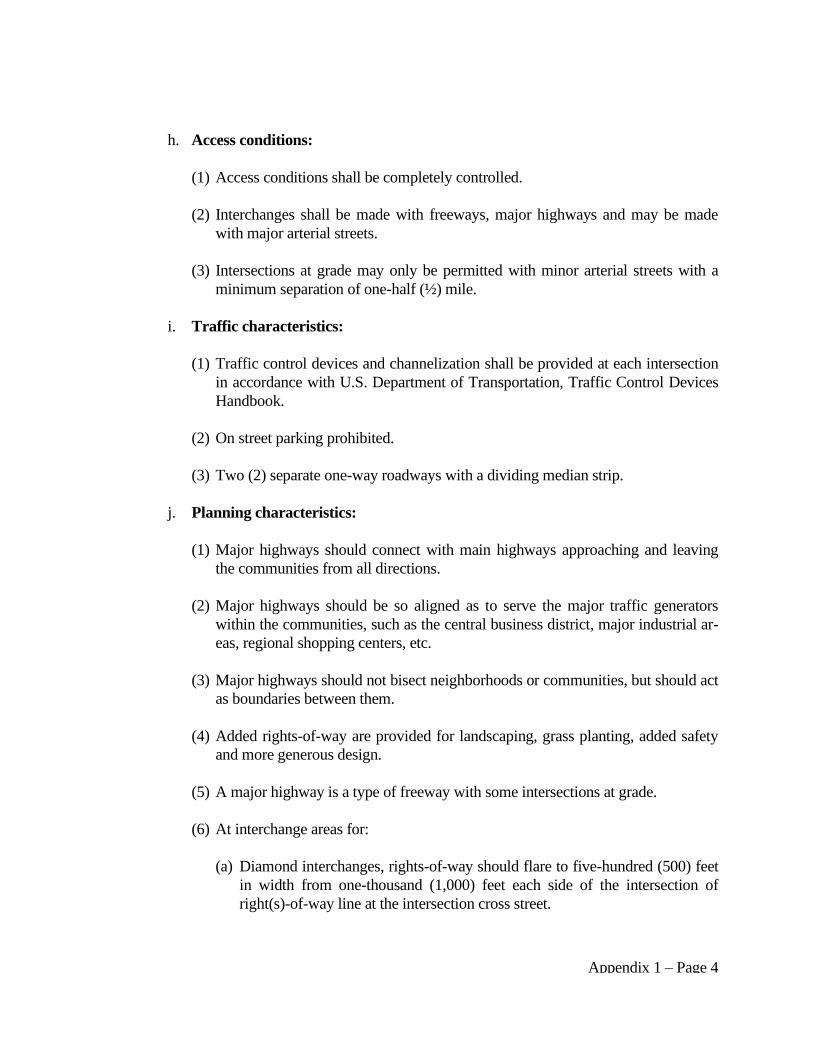
Appendix 1 – Page 4
h. Access conditions:
(1) Access conditions shall be completely controlled.
(2) Interchanges shall be made with freeways, major highways and may be made
with major arterial streets.
(3) Intersections at grade may only be permitted with minor arterial streets with a
minimum separation of one-half (½) mile.
i. Traffic characteristics:
(1) Traffic control devices and channelization shall be provided at each intersection
in accordance with U.S. Department of Transportation, Traffic Control Devices
Handbook.
(2) On street parking prohibited.
(3) Two (2) separate one-way roadways with a dividing median strip.
j. Planning characteristics:
(1) Major highways should connect with main highways approaching and leaving
the communities from all directions.
(2) Major highways should be so aligned as to serve the major traffic generators
within the communities, such as the central business district, major industrial ar-
eas, regional shopping centers, etc.
(3) Major highways should not bisect neighborhoods or communities, but should act
as boundaries between them.
(4) Added rights-of-way are provided for landscaping, grass planting, added safety
and more generous design.
(5) A major highway is a type of freeway with some intersections at grade.
(6) At interchange areas for:
(a) Diamond interchanges, rights-of-way should flare to five-hundred (500) feet
in width from one-thousand (1,000) feet each side of the intersection of
right(s)-of-way line at the intersection cross street.
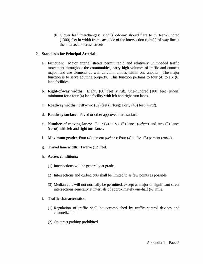
Appendix 1 – Page 5
(b) Clover leaf interchanges: right(s)-of-way should flare to thirteen-hundred
(1300) feet in width from each side of the intersection right(s)-of-way line at
the intersection cross-streets.
2. Standards for Principal Arterial:
a. Function: Major arterial streets permit rapid and relatively unimpeded traffic
movement throughout the communities, carry high volumes of traffic and connect
major land use elements as well as communities within one another. The major
function is to serve abutting property. This function pertains to four (4) to six (6)
lane facilities.
b. Right-of-way widths: Eighty (80) feet (rural), One-hundred (100) feet (urban)
minimum for a four (4) lane facility with left and right turn lanes.
c. Roadway widths: Fifty-two (52) feet (urban); Forty (40) feet (rural).
d. Roadway surface: Paved or other approved hard surface.
e. Number of moving lanes: Four (4) to six (6) lanes (urban) and two (2) lanes
(rural) with left and right turn lanes.
f. Maximum grade: Four (4) percent (urban); Four (4) to five (5) percent (rural).
g. Travel lane width: Twelve (12) feet.
h. Access conditions:
(1) Intersections will be generally at grade.
(2) Intersections and curbed cuts shall be limited to as few points as possible.
(3) Median cuts will not normally be permitted, except as major or significant street
intersections generally at intervals of approximately one-half (½) mile.
i. Traffic characteristics:
(1) Regulation of traffic shall be accomplished by traffic control devices and
channelization.
(2) On-street parking prohibited.
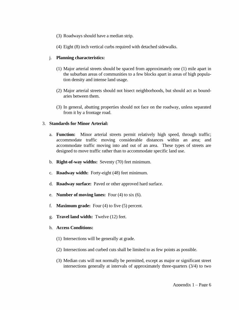
Appendix 1 – Page 6
(3) Roadways should have a median strip.
(4) Eight (8) inch vertical curbs required with detached sidewalks.
j. Planning characteristics:
(1) Major arterial streets should be spaced from approximately one (1) mile apart in
the suburban areas of communities to a few blocks apart in areas of high popula-
tion density and intense land usage.
(2) Major arterial streets should not bisect neighborhoods, but should act as bound-
aries between them.
(3) In general, abutting properties should not face on the roadway, unless separated
from it by a frontage road.
3. Standards for Minor Arterial:
a. Function: Minor arterial streets permit relatively high speed, through traffic;
accommodate traffic moving considerable distances within an area; and
accommodate traffic moving into and out of an area. These types of streets are
designed to move traffic rather than to accommodate specific land use.
b. Right-of-way widths: Seventy (70) feet minimum.
c. Roadway width: Forty-eight (48) feet minimum.
d. Roadway surface: Paved or other approved hard surface.
e. Number of moving lanes: Four (4) to six (6).
f. Maximum grade: Four (4) to five (5) percent.
g. Travel land width: Twelve (12) feet.
h. Access Conditions:
(1) Intersections will be generally at grade.
(2) Intersections and curbed cuts shall be limited to as few points as possible.
(3) Median cuts will not normally be permitted, except as major or significant street
intersections generally at intervals of approximately three-quarters (3/4) to two

Appendix 1 – Page 7
(2) miles.
i. Traffic characteristics:
(1) Regulation of traffic shall be accomplished by traffic control devices and
channelization.
(2) On-street parking prohibited.
(3) Eight (8) inch vertical curbs required with detached sidewalks.
j. Planning characteristics:
(1) Minor arterial streets should be spaced from approximately one (1) mile apart in
the suburban areas of communities to a few blocks apart in areas of high popula-
tion density and intense land usage.
(2) Minor arterial streets should not bisect neighborhoods, but should act as bound-
aries between them.
(3) In general, abutting properties should not face on the roadway, unless separated
from it by a frontage road.
4. Standards for Collector Streets:
a. Functions:
(1) Collector streets shall collect and distribute traffic between arterial and local
streets.
(2) Collector streets serve as a main collector within communities, linking one
neighborhood with another or one industrial district with another.
(3) All traffic carried by collector streets should have an origin or destination within
the community.
b. Right-of-way widths: Sixty (60) feet minimum.
c. Roadway width: Forty (40) feet minimum (rural). Forty-four (44) feet minimum
(urban).
d. Roadway surface: Paved or other approved hard surface.
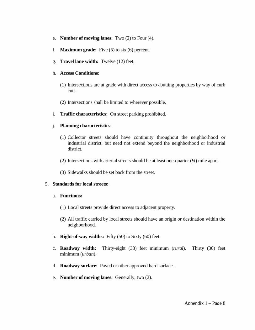
Appendix 1 – Page 8
e. Number of moving lanes: Two (2) to Four (4).
f. Maximum grade: Five (5) to six (6) percent.
g. Travel lane width: Twelve (12) feet.
h. Access Conditions:
(1) Intersections are at grade with direct access to abutting properties by way of curb
cuts.
(2) Intersections shall be limited to wherever possible.
i. Traffic characteristics: On street parking prohibited.
j. Planning characteristics:
(1) Collector streets should have continuity throughout the neighborhood or
industrial district, but need not extend beyond the neighborhood or industrial
district.
(2) Intersections with arterial streets should be at least one-quarter (¼) mile apart.
(3) Sidewalks should be set back from the street.
5. Standards for local streets:
a. Functions:
(1) Local streets provide direct access to adjacent property.
(2) All traffic carried by local streets should have an origin or destination within the
neighborhood.
b. Right-of-way widths: Fifty (50) to Sixty (60) feet.
c. Roadway width: Thirty-eight (38) feet minimum (rural). Thirty (30) feet
minimum (urban).
d. Roadway surface: Paved or other approved hard surface.
e. Number of moving lanes: Generally, two (2).

Appendix 1 – Page 9
f. Maximum grade: Six (6) to eight (8) percent.
g. Travel lane width: Twelve (12) feet.
h. Access Conditions: Intersections at grade with direct access to abutting properties.
i. Traffic characteristics: On street parking is allowed on both sides of the street
unless otherwise specified.
j. Planning characteristics:
(1) Local streets should be designated to discourage thorough traffic from moving
through those areas.
(2) These streets should intersect arterial street as infrequently as possible and only
in reasonable locations.
6. Standard for Cul-de-Sac Streets:
a. Function: Cul-de-sac(s) are designed to provide direct access to abutting residential
properties.
b. Right-of-way widths: Fifty (50) feet for cul-de-sacs serving less than ten (10) lots;
sixty (60) feet for cul-de-sacs serving ten (10) or more lots; the minimum turn
around radius is fifty (50) feet. For industrial developments eighty (80) feet with a
minimum turn around radius of seventy (70) feet.
c. Roadway width: Thirty eight (38) feet. Forty five (45) feet for cul-de-sac radius.
d. Roadway surface: Shall be determined by the Board.
e. Number of moving lanes: Two (2) lanes.
f. Travel lane width: Twelve (12) feet.
g. Access Conditions: Direct access to residential properties is by way of curbed cuts
or by drive-over (ramp type) curbs.
h. Traffic characteristics:
(1) On street parking is allowed on both sides of the street unless otherwise
specified.
Appendix 1 – Page 10
(2) Intersections are at grade.
i. Planning characteristics:
(1) Cul-de-sac(s) should not intersect major arterial streets or minor arterial streets.
(2) Cul-de-sac(s) shall not be longer than seven-hundred and fifty (750) feet in rural
areas.
7. Standards for Frontage or Service Roads:
a. Function: Frontage roads are designed to provide access to land uses adjacent to
major arterial streets, major highways and freeways.
b. Right-of-way widths: Sixty (60) feet.
c. Roadway width: Thirty-eight (38) feet.
d. Roadway surface: Paved or other approved hard surface.
e. Number of moving lanes: Two (2) lanes.
f. Travel lane width: Twelve (12) feet.
g. Access Conditions: Direct access to residential properties is by way of curbed cuts
or by drive-over (ramp type) curbs.
h. Traffic characteristics:
(1) On street parking is allowed on the sides of the streets adjacent to residential
properties.
(2) Intersections are at grade.
i. Planning characteristics:
(1) Frontage road intersections should be at least two-hundred (200) feet away from
the major arterial street and the feeder street intersection.
(2) No sidewalks should be installed between major arterial streets and frontage
roads.
(3) Sidewalks may be installed adjacent to the curb on the residential side of the
Appendix 1 – Page 11
street.
(4) The planter strip area between the frontage road and the major arterial street
shall be landscaped.
8. Standards for Alleys: (If permitted by the Board)
a. Function: Provide access to abutting property at rear lot line.
b. Right-of-way widths: Sixteen (16) feet.
c. Access Conditions: Provide access to abutting property at rear lot lines.
d. Traffic Characteristics: Normally, alleys should intersect at perpendicular angles
with streets. No parking shall be permitted.
e. Planning Characteristics: Alleys should not dead end. Normally, alleys should
intersect with arterial streets.
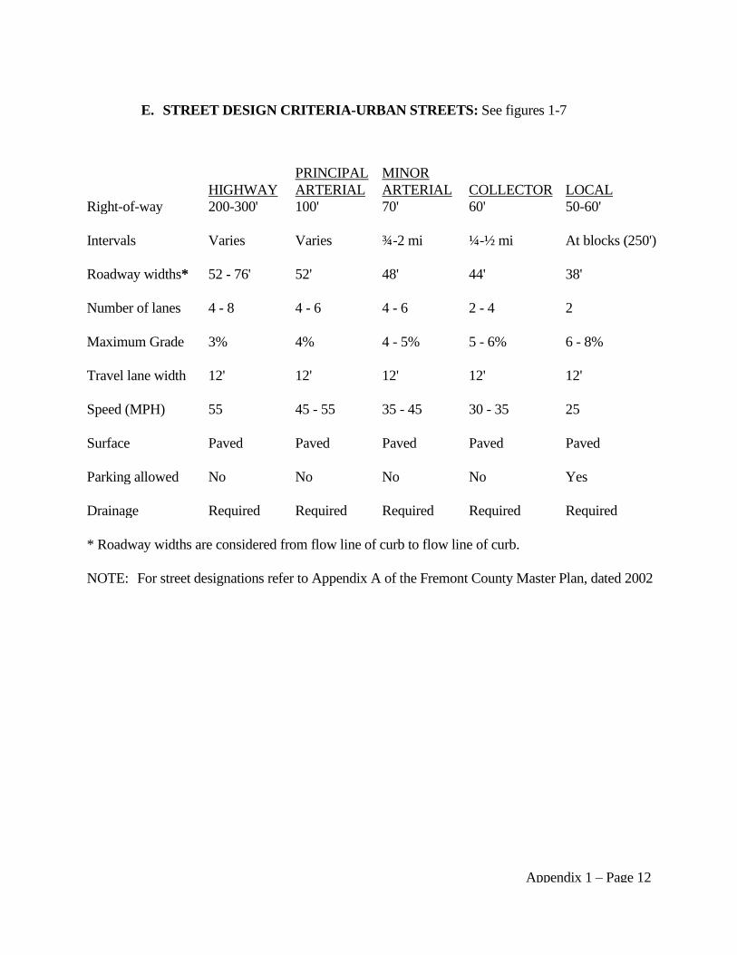
Appendix 1 – Page 12
E. STREET DESIGN CRITERIA-URBAN STREETS: See figures 1-7
* Roadway widths are considered from flow line of curb to flow line of curb.
NOTE: For street designations refer to Appendix A of the Fremont County Master Plan, dated 2002
HIGHWAY
PRINCIPAL
ARTERIAL
MINOR
ARTERIAL
COLLECTOR
LOCAL
Right-of-way 200-300' 100' 70' 60' 50-60'
Intervals Varies Varies ¾-2 mi ¼-½ mi At blocks (250')
Roadway widths* 52 - 76' 52' 48' 44' 38'
Number of lanes 4 - 8 4 - 6 4 - 6 2 - 4 2
Maximum Grade 3% 4% 4 - 5% 5 - 6% 6 - 8%
Travel lane width 12' 12' 12' 12' 12'
Speed (MPH) 55 45 - 55 35 - 45 30 - 35 25
Surface Paved Paved Paved Paved Paved
Parking allowed No No No No Yes
Drainage Required Required Required Required Required
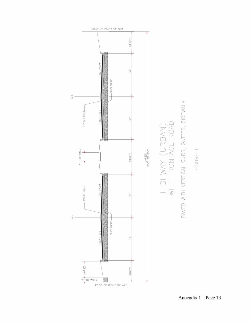
Appendix 1 – Page 13
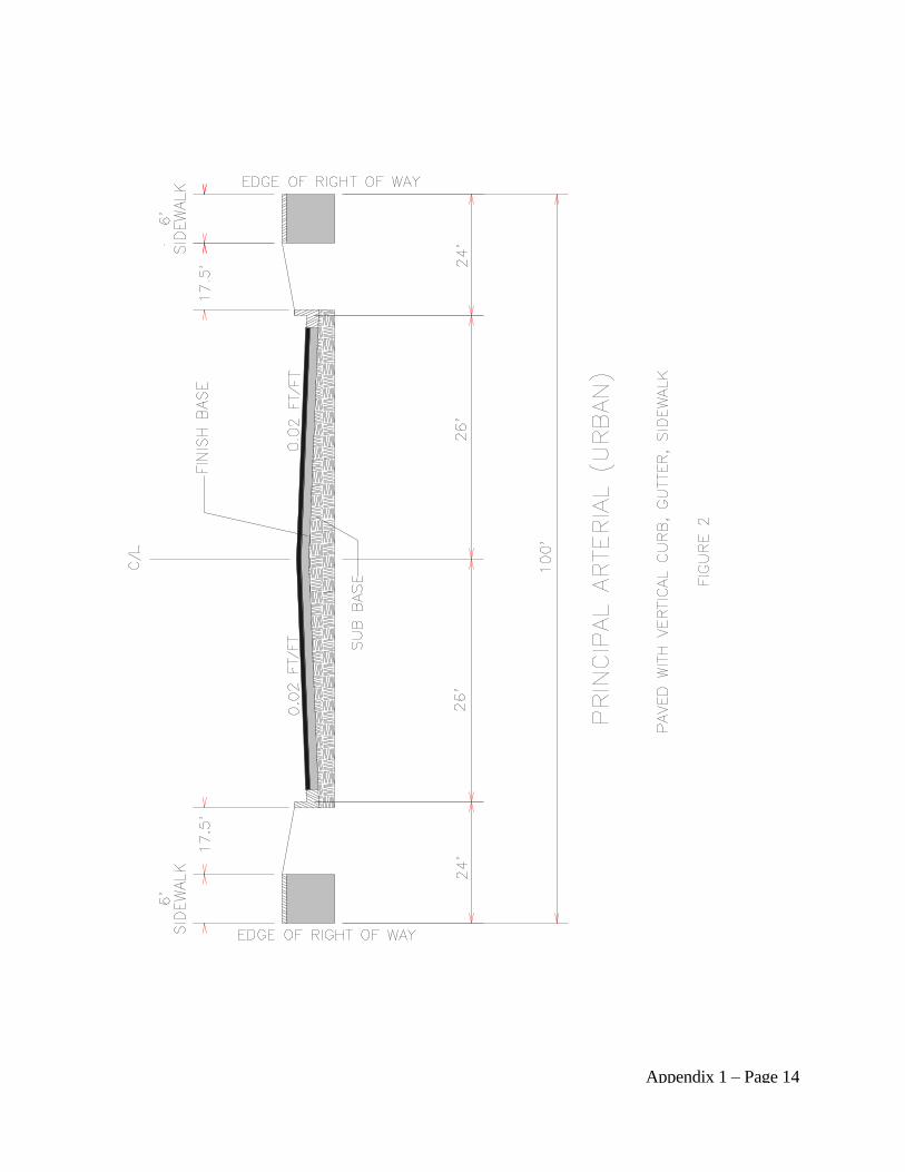
Appendix 1 – Page 14
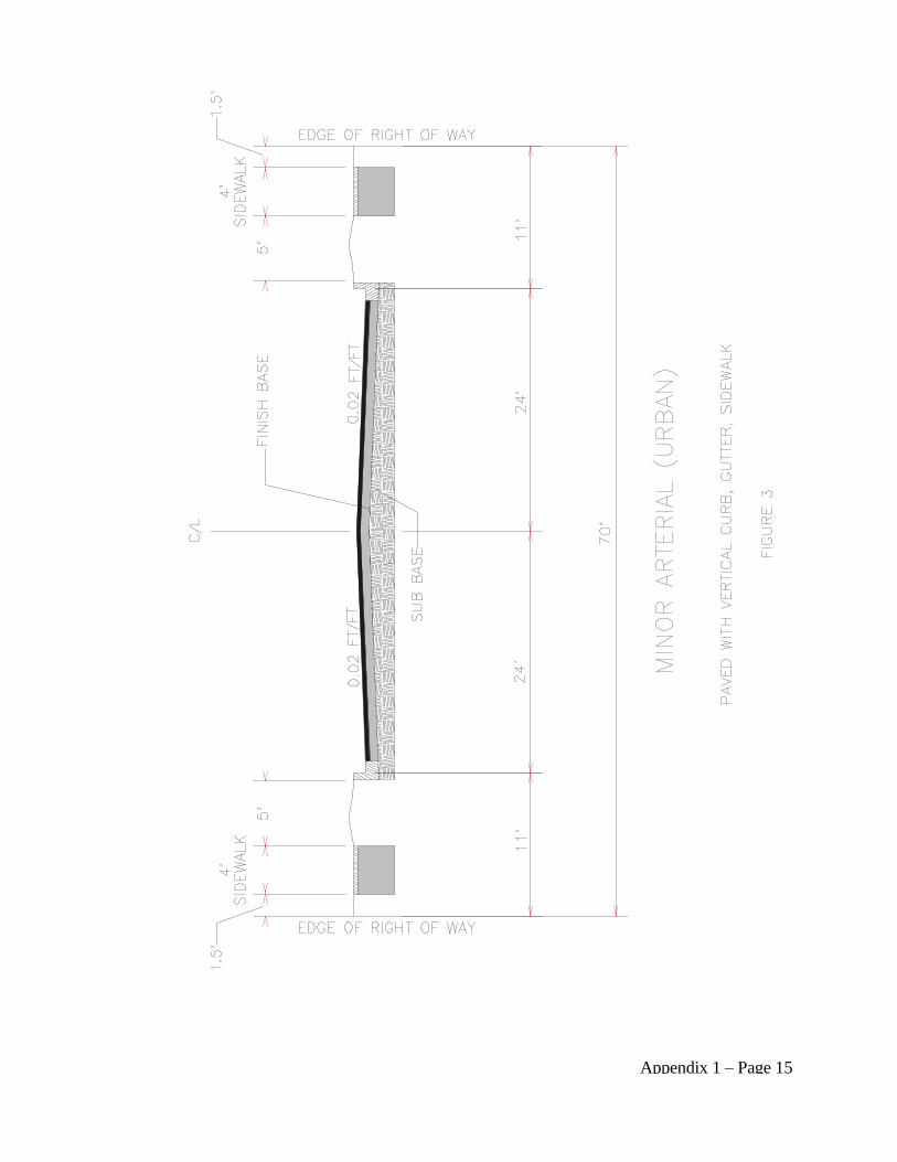
Appendix 1 – Page 15
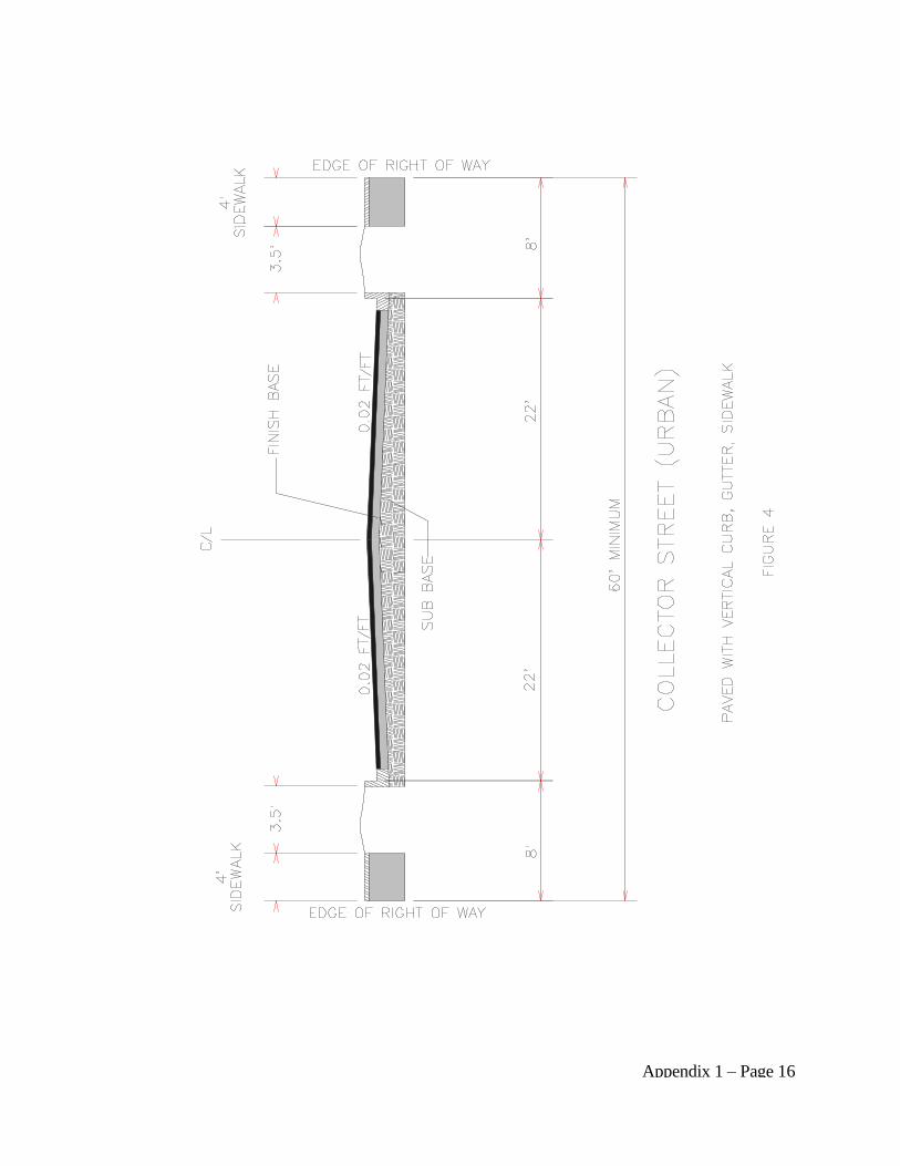
Appendix 1 – Page 16

Appendix 1 – Page 17
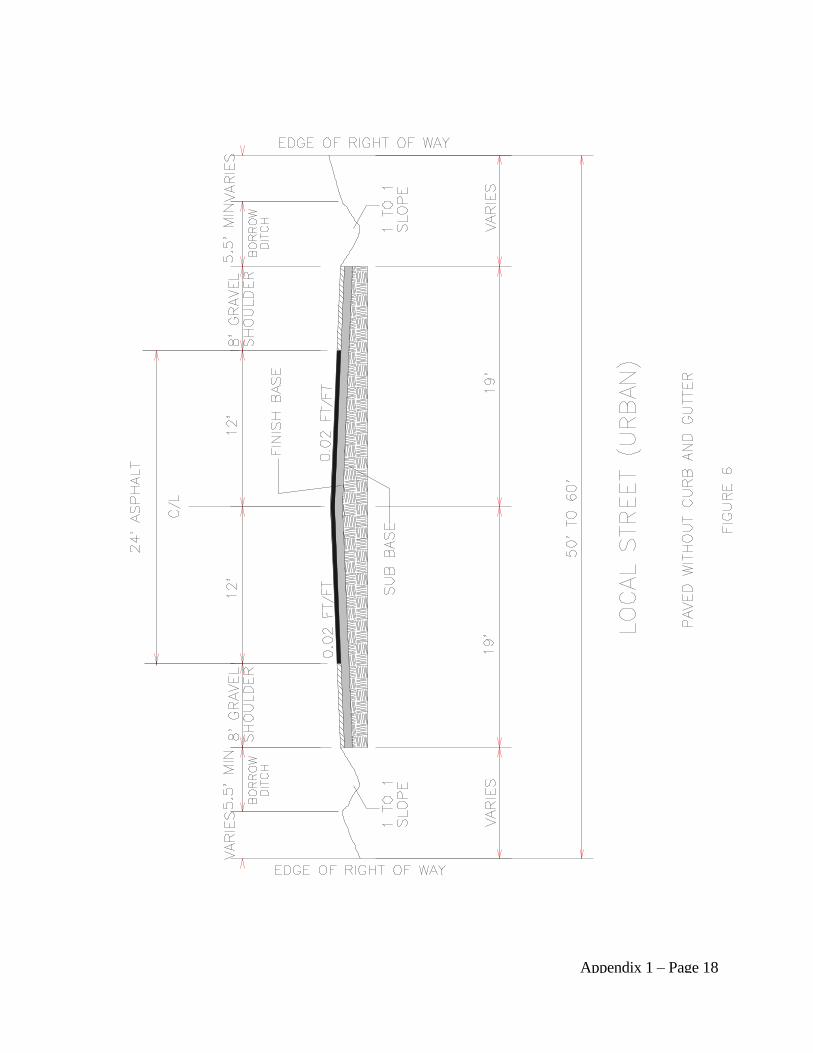
Appendix 1 – Page 18
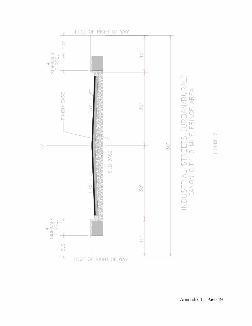
Appendix 1 – Page 19
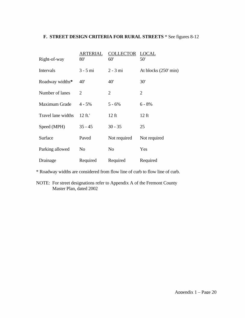
Appendix 1 – Page 20
F. STREET DESIGN CRITERIA FOR RURAL STREETS * See figures 8-12
ARTERIAL COLLECTOR LOCAL
Right-of-way 80' 60' 50'
Intervals 3 - 5 mi 2 - 3 mi At blocks (250' min)
Roadway widths* 40' 40' 30'
Number of lanes 2 2 2
Maximum Grade 4 - 5% 5 - 6% 6 - 8%
Travel lane widths 12 ft.' 12 ft 12 ft
Speed (MPH) 35 - 45 30 - 35 25
Surface Paved Not required Not required
Parking allowed No No Yes
Drainage Required Required Required
* Roadway widths are considered from flow line of curb to flow line of curb.
NOTE: For street designations refer to Appendix A of the Fremont County
Master Plan, dated 2002

Appendix 1 – Page 21
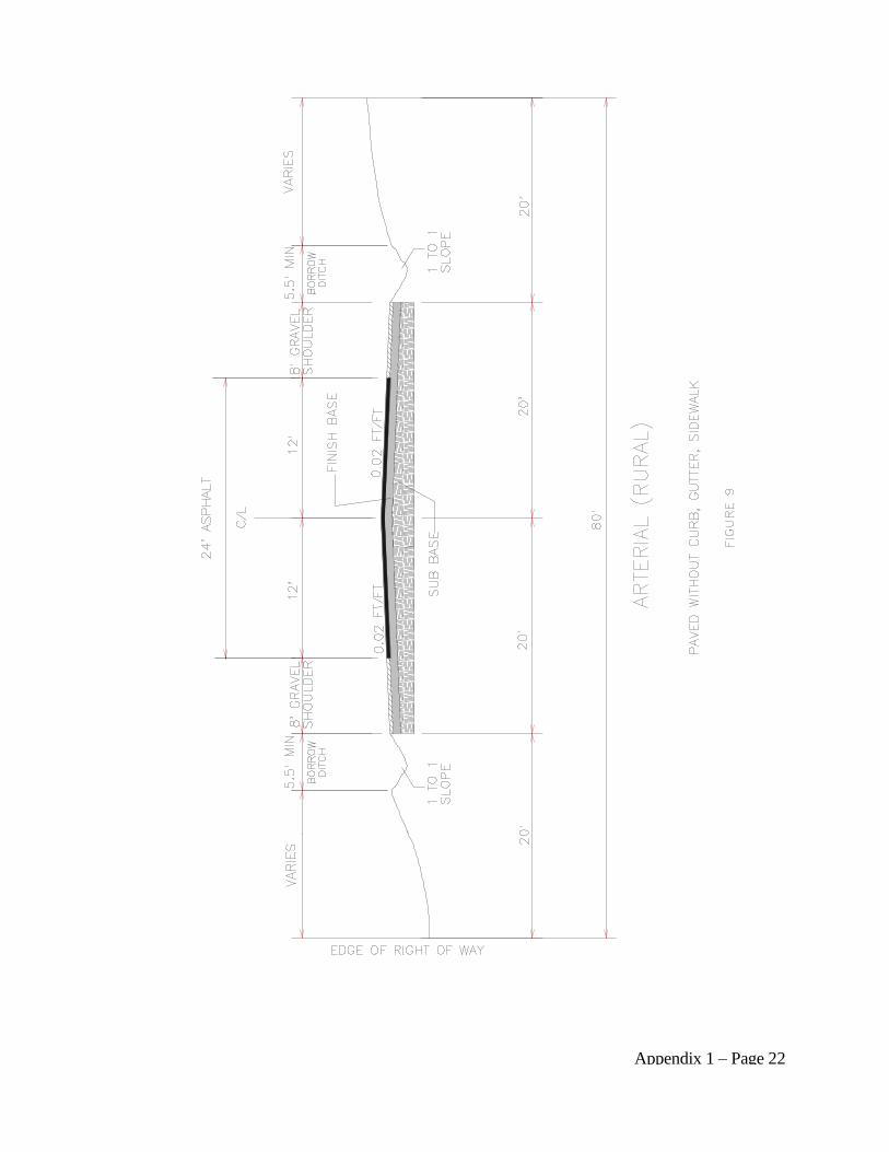
Appendix 1 – Page 22

Appendix 1 – Page 23
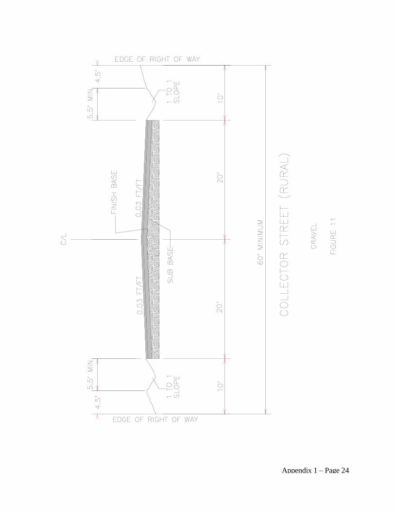
Appendix 1 – Page 24
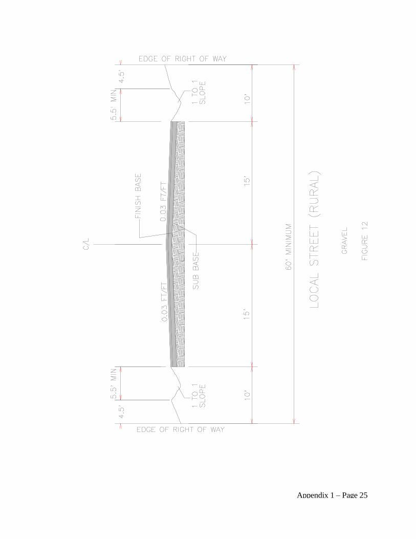
Appendix 1 – Page 25
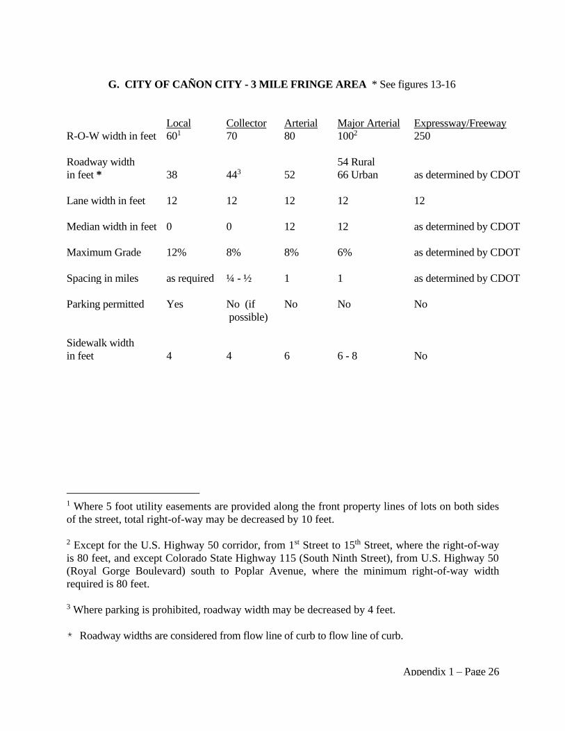
Appendix 1 – Page 26
G. CITY OF CAÑON CITY - 3 MILE FRINGE AREA * See figures 13-16
Local Collector Arterial Major Arterial Expressway/Freeway
R-O-W width in feet 601 70 80 1002 250
Roadway width
in feet *
38
443
52
54 Rural
66 Urban
as determined by CDOT
Lane width in feet 12 12 12 12 12
Median width in feet 0 0 12 12 as determined by CDOT
Maximum Grade 12% 8% 8% 6% as determined by CDOT
Spacing in miles as required ¼ - ½ 1 1 as determined by CDOT
Parking permitted Yes No (if
possible)
No No No
Sidewalk width
in feet
4
4
6
6 - 8
No
1 Where 5 foot utility easements are provided along the front property lines of lots on both sides
of the street, total right-of-way may be decreased by 10 feet.
2 Except for the U.S. Highway 50 corridor, from 1st Street to 15th Street, where the right-of-way
is 80 feet, and except Colorado State Highway 115 (South Ninth Street), from U.S. Highway 50
(Royal Gorge Boulevard) south to Poplar Avenue, where the minimum right-of-way width
required is 80 feet.
3 Where parking is prohibited, roadway width may be decreased by 4 feet.
* Roadway widths are considered from flow line of curb to flow line of curb.
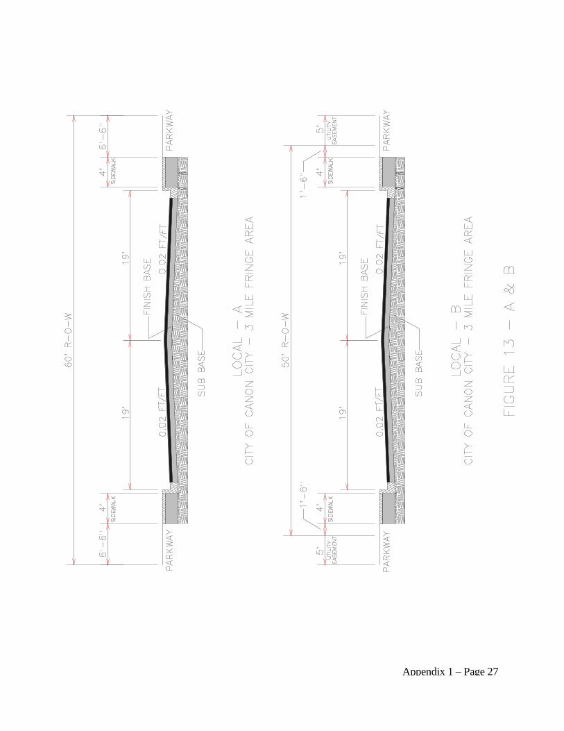
Appendix 1 – Page 27
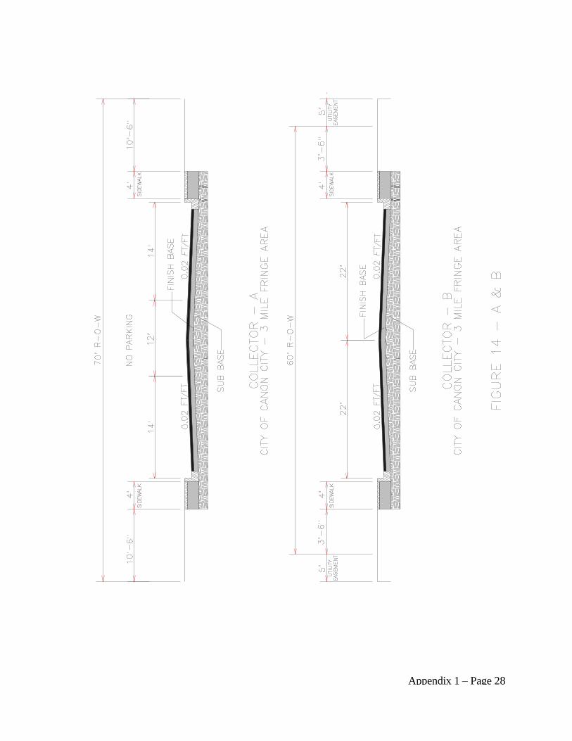
Appendix 1 – Page 28
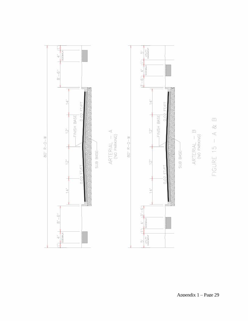
Appendix 1 – Page 29
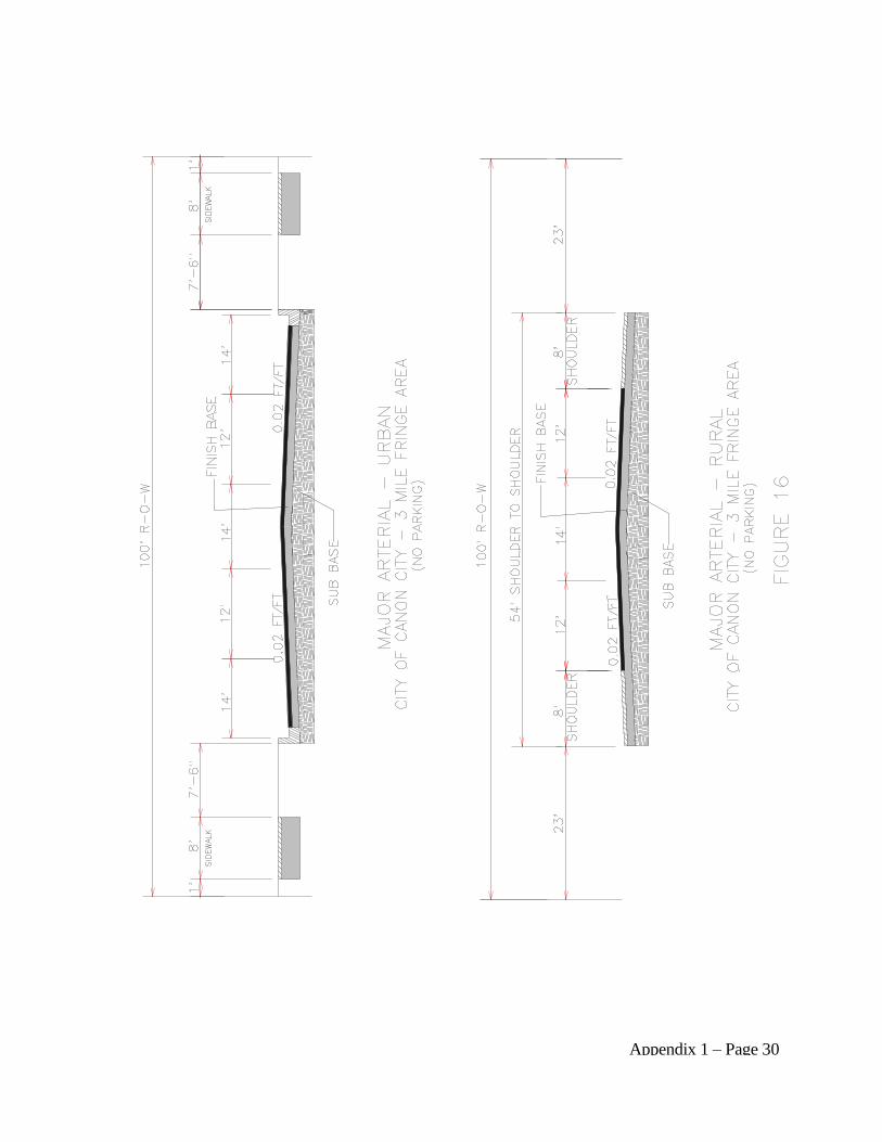
Appendix 1 – Page 30
Appendix 1 – Page 31
H. OTHER DESIGN STANDARDS: The following is a list of design standards which
should be considered prior to plan submittal.
1. All streets shall be aligned to join with planned or existing streets.
2. All streets shall be designed to bear a logical relationship to the topography of the land.
3. Intersections of streets shall be at right angles unless otherwise approved by the County
Official.
4. Cul-de-sacs shall be permitted only if they are not more than seven-hundred and fifty
(750) feet in length in rural areas and have a turn around at the end thereof with a radius
of the right-of-way of at least fifty (50) feet for each cul-de-sac. Surface drainage on a
cul-de-sac shall be adequately addressed.
5. Except as provided above for cul-de-sacs, no dead-end streets shall be permitted except
in cases where such streets are designed to connect with future streets on adjacent land
in which case a temporary turn around easement at the end thereof with a diameter of at
least eighty (80) feet must be provided. Such turn around easement shall not be required
if no lots in the subdivision are dependent on such street for access.
6. In the event residential lots in a subdivision are adjacent to a principal or minor arterial
street, no access to individual lots from such arterial street shall be permitted unless
approved by County Official.
I. INTERSECTION DESIGN REQUIREMENTS:
1. Curb Radius: Curb radii shall not be less than ten (10) feet.
2. Grade at intersections: In no case shall grades exceed four (4) percent for a distance of
at least one-hundred (100) feet from all intersections.
3. Site Distance: The intersection site distance shall be:
(a) Arterial Streets: Four-hundred (400) feet minimum.
(b) Collector Streets: Three-hundred (300) feet minimum.
(c) Residential Streets: Two-hundred (200) feet minimum.
4. General: Intersecting streets shall meet at a ninety (90) degree angle.
Appendix 1 – Page 32
J. CURVES IN STREETS:
1. Radii of curvature: The minimum radii of curvature for streets on the center line shall
be:
(a) Arterial Streets: Six-hundred (600) feet minimum.
(b) Collector Streets: Four-hundred (400) feet minimum.
(c) Residential Streets: Two-hundred (200) feet minimum.
2. Reverse Curves: Between reverse curves on collector and arterial streets there shall be
a tangent of at least one-hundred (100) feet long.
3. Vertical Curves: All changes in grade for arterial and collector streets shall be
connected by vertical curve of a minimum length equal to twenty (20) times the
algebraic difference in the rates of grade; the length of curve for all other streets shall be
ten (10) times the algebraic difference in rates of grade, but in no case less than one-
hundred (100) feet.
4. Superelevation: Superelevation may be required on collector and arterial roadways.
The superelevation shall be a maximum of six-hundredths (0.06) foot with minimum
transition length of one-hundred and fifty (150) feet. When superelevation is necessary,
supporting data will be supplied to the County Official for approval.
K. SITE DISTANCE: Clear visibility, measured along the centerline, shall be provided for at
least six-hundred (600) feet on arterial streets and collectors, four-hundred (400) feet on all
other streets.
L. STREET GRADES: For adequate drainage, the minimum street grade shall not be less
than five-tenths (5/10) of one (1) percent. Minimum down grade for cross section shall be
two-hundredths (0.02) foot per foot on the normal cross section template. Unusual cross
sections or grades different from these standards shall have the approval of the County
Official.
1. Street grades shall not exceed:
(a) Arterial and Collector Streets Six percent (6%)
(b) All other streets Eight percent (8%)
M. STREET ALIGNMENT: Where appropriate to the design, proposed streets shall be
Appendix 1 – Page 33
continuous and in alignment with existing planned or platted streets with which they are to
connect. The centerlines of streets not in alignment shall be offset by a minimum of one-
hundred and thirty-five (135) feet unless otherwise approved by the Board.
II. GENERAL DESIGN CRITERIA FOR UTILITIES: See figures 17 & 18
A. GENERAL REQUIREMENTS:
1. Every attempt shall be made to coordinate all possible utility installations. Utility main
lines and service lines to all lots, tracts, or parcels of land shall be placed prior to
construction of roadway.
2. Once the roadway construction is completed to its finality, utility placement under hard
surface of roads shall not disturb the roadway surfaces for a minimum of five (5) years
except for an emergency. Jacking or tunneling under the surface will be mandatory for
new utility placement in hard surfaced (paved) roadways.
3. Each utility company must coordinate with the other utility companies in the location of
its utility, i.e. the companies should mutually ascertain the most satisfactory location of
their utility in the utility corridor.
4. The installation of utilities in dedicated rights-of-way in new subdivisions will be
exempt from requiring a permit, but such installations will require a placement plan to
be submitted to the County for its review and approval. The County regulates the
placement of utilities in public rights-of-way by the permit procedure.
B. EXISTING UTILITIES: Of necessity, existing utilities must be maintained, repaired,
and/or relocated to accommodate demands of the user. The utility companies will not be
prohibited from performing such functions as are required to maintain, repair, or relocate
existing utilities, i.e. main lines and service lines. Any such costs will be the responsibility
of the developer.
C. STANDARDS: Industry codes used by the utility companies for design and installation of
their facilities are generally acceptable to the County. The minimum depths and overhead
clearance for utility services in Fremont County public right-of-way shall be as follows:
1. Water lines: Forty (40) inches minimum
2. Sanitary and Storm Sewer: Minimum depth determined by Engineer
3. Gas lines: Forty-eight (48) inches minimum
4. Electric Power: Forty (40) inches minimum
Appendix 1 – Page 34
5. Telephone: Forty (40) inches minimum
6. Cable TV: Forty (40) inches minimum
7. Overhead utilities: Nineteen (19) feet from center of roadway
8. Fiber Optic (with 1 inch tracer wire above the line): Forty-eight (48) inches minimum
Note: All Gas, Telephone, Power, Cable TV lines shall be located on the west side
of the street for all north-south oriented streets and on the south side of the
street for all east-west oriented streets.
9. Electrical (overhead): Poles for suspending electrical lines must be placed within a
corridor in the public rights-of-way, being three (3) feet in width, and adjacent to the
right-of-way lines. At no time shall the guy wire anchors extend beyond the three (3)
foot corridor, toward the travel lane. If anchorage is necessary on a line perpendicular to
the alignment of road such anchorage may necessitate an anchor pole and guy lines on
the opposite side of the road. A nineteen (19) foot minimum clearance for overhead
lines, crossing County roads is mandated by needs of the County to operate its
equipment.
10. Cable Television: Cable Television suppliers will be granted the same privileges as the
public utility companies, to make their installation within pubic rights-of-way and such
installations are to comply with the foregoing mandates to the electrical and telephone
installations.
11. Damages Caused by Utility Installations: Any damage to existing installations caused
by the installation of utilities, i.e., culverts damaged or cut, sidewalks cut or undermined,
fencing cut or damaged, vegetation destroyed, road surface, hard surface cut or
undermined, etc., shall be repaired or replaced at the sole expense of the utility company
or contractor making the installation.
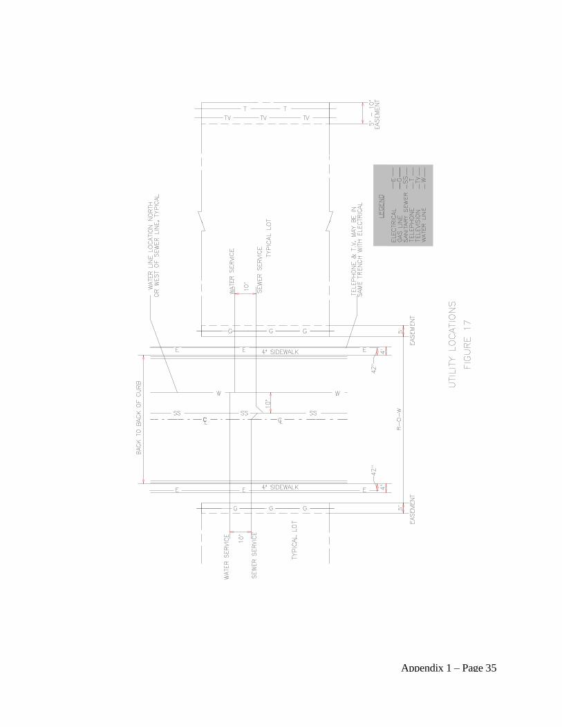
Appendix 1 – Page 35
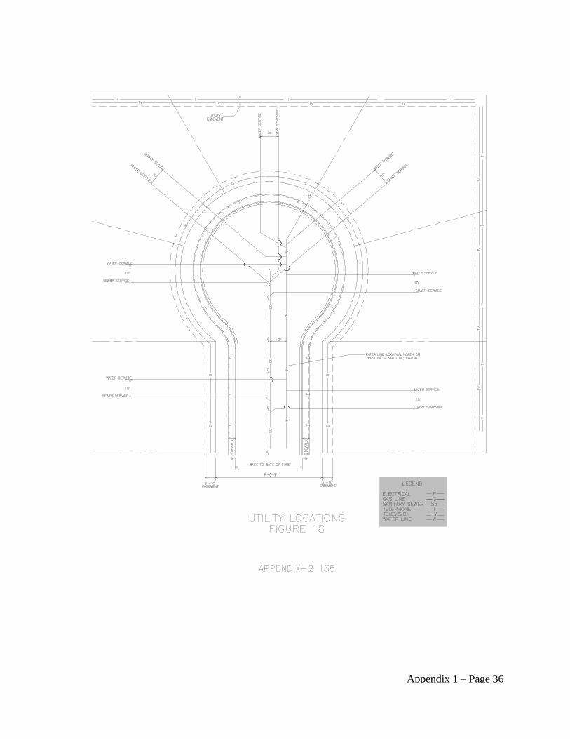
Appendix 1 – Page 36
Appendix 1 – Page 37
III. GENERAL DESIGN CRITERIA - DRAINAGE:
A. DESCRIPTION: Proper drainage is critical in road design. Protection of the road, adjacent
upstream land, and downstream lands depend upon property drainage design.
1. All roads that encroach on flood plains, large bodies of water, or streams must be
designed to permit conveyance of the basic flood without significant damage to the road,
the stream, the body of water, or other property.
2. Surface drainage involves removal of water, from either rain or melting snow, that falls
directly on the roadbed, and the interception and removal of water coming to the road
from adjacent development.
B. GENERAL PROVISIONS:
1. Smaller sizes must be approved by the County Official.
2. Minimum recommended cover over a culvert is twelve (12) inches or one-half the
culvert diameter, whichever is greater.
3. The County may require carrying away by pipe or open ditch any surface water because
of the new road construction. Such a drainage facility shall be located within the right-
of-way or in a perpetual easement.
4. Drainage Plans will be required at the discretion of the County Official.
C. HYDROLOGY: A drainage system for the area shall be designed by a professional
engineer licensed to practice in the State of Colorado and qualified to perform such work.
The drainage plan shall include:
1. All existing drainage features and proposed drainage facilities and structures together
with computations supporting the size shown.
2. Computations taking into consideration all drainage areas affecting the proposed site.
3. Location and computations for all outfall points.
4. A local basin map or location map of the area.
5. A detailed map of the drainage in the area under study.
6. The minimum criteria for sizing of drainage facilities in Fremont County shall be in
accordance with the drainage requirements of the Fremont County Subdivision

Appendix 1 – Page 38
Regulations.
a. The one-hundred (100) year storm for all facilities which will carry five-hundred
(500) cubic feet per second or more as calculated on the one-hundred (100) year
storm criteria. The fifty (50) year storm criteria shall be used for all other facilities.
b. The six-hour frequency storm for a fifty (50) year event or the twenty-four-hour
frequency storm for a one-hundred (100) year event shall be used depending on
which one yields the greater runoff.
c. For areas less than twenty (20) acres, the Rationale Method shall be used; For areas
greater than twenty (20) acres, the U.S.D.A. - Natural Resource Conservation
Service publication "Procedures for determining Peak Flows in Colorado, March
1977" or successor publication, shall be used.
D. STREET FLOWS: The primary use of streets is for the movement of traffic. However,
streets shall have limited use as a waterway for storm runoff with flow capacities in
quantities as approved by the County Official.
E. DETENTION BASINS: Detention basins or other devices should be used to maintain
historical runoff amount where possible. Maintenance of these facilities must be addressed
by the developer and approved by the County Official to avoid public nuisances and health
hazards. Care must be taken to design and construct all such facilities in accordance with
applicable Federal, State and local regulations. The engineer shall incorporate methods to
control flows which exceed historical runoff amounts.
F. CULVERT AND CHANNEL DESIGN:
1. Culverts: A culvert may be defined as a covered channel of comparatively short length
installed to drain water through roadway embankments. The general criteria for design
shall be:
a. The culvert shall be properly designed to take care of the water at all flows.
Capacity shall be determined by a Professional Engineer stating method used.
b. Inlets shall be designed to minimize entrance and friction losses.
c. Outlets shall be designed to avoid sedimentation and erosion of the downstream
channel. Outlet control devices may be required where excessively high discharge
velocities occur.
d. A minimum of twelve (12”) inch diameter culvert, unless a larger diameter is
required by the County Inspector, which will accommodate the historical drainage
Appendix 1 – Page 39
flow. The County may require a drainage study to determine the diameter of the
culvert. The drainage study shall comply with the current requirements of the
Fremont County Subdivision Regulations.
e. All culverts shall be designed for HS-20 loading with the appropriate embankment
considerations.
f. If an adjacent roadside ditch is to be crossed, it shall be provided with a corrugated
metal galvanized pipe (CMP) culvert with a minimum diameter of twelve (12)
inches, and a minimum length of twenty-four (24) feet to be installed no later than at
time of commencement of site work on lot; culverts must have suitable head walls or
rip rapped inlet and outlet ends which are not to exceed the elevation of the road
grade; and installation of above are subject to County approval.
g. For commercial, industrial or multiple uses, the minimum length of the culvert shall
be thirty-(30) feet.
2. Channel Design: Capacity of channel shall be determined by a Colorado Registered
Professional Engineer by using Manning's Equation or other appropriate methods.
G. ENGINEERING SPECIFICATIONS: All engineering specifications for streets,
roadways, curb and gutter, sidewalks and other public ways, constructed under these
Subdivision Regulations, shall be governed by the Fremont County Engineering
Specifications for Streets found at Appendix 2.
H. STREET PLAN AND PROFILE REGULATIONS - GENERAL: No construction of
streets shall be commenced (unless waived by the Board) within a County right-of-way
without an approved set of street plans and profiles as prepared by a Colorado Registered
Professional Engineer.
1. Plan Requirements: A set of prints or plans shall be submitted to the County Official
for approval. Should circumstances warrant changes from approved plans or
specifications, the proposed revision must be submitted and approval must be obtained
from the County Official, copies to be given to the contractor, developer and developer's
engineer. It shall be the responsibility of the Developer's engineer to provide the County
Official with a set of "as-built" prints at the completion of the project.
2. Plan Detail: The following items shall be provided in the construction plans:
a. General:
(1) Title Block (lower right hand corner preferred).
Appendix 1 – Page 40
(2) Scale.
(3) Date of original drawing and the date of any revisions made to the drawing.
(4) Name of Professional Engineer or firm.
(5) Colorado Registered Professional Engineer's seal and signature.
(6) Drawing Number(s).
(7) Statement: All work shall be constructed to the Fremont County Engineering
Specifications for streets. In addition an approval statement by the County
Official and date of approval shall be provided.
b. Plan:
(1) North Arrow.
(1) Property Lines: Indicate lots to be served by solid line; other property lines
dotted.
(2) Ownership or Subdivision Information.
(3) Street names.
(4) Elevations as follows:
(a) Points of vertical curve.
(b) Points of vertical tangent.
(c) Points on vertical curve and curve tangents at the one-hundred (100) foot and
the fifty (50) foot stationing locations or greater as required.
(d) Points of horizontal curve.
(e) Points of horizontal tangent.
(f) Every fifty (50) foot station.
(g) At grade breaks.
(h) Flow lines for curb and gutter.
Appendix 1 – Page 41
(i) Centerline grade, if no curb and gutter.
(5) Proposed property lines.
(6) Dimensions for street cross section as follows:
(a) Flow line to flow line.
(b) Back of walk to back of walk.
(c) Right-of-way width.
(7) Stationing for the following:
(a) Points of curve (horizontal and vertical).
(b) Points of tangent.
(c) Centerline intersection of street.
(d) Curb radii, grade breaks, points of intersection, vertical curves.
(e) Culverts and drainage structures.
(f) Horizontal alignment information including curve data (3 pieces of
information).
(g) Design connecting proposed to existing conditions.
(h) Type of curb, gutter and sidewalk.
(i) Valley pans and other drainage structures.
c. Profile:
(1) Existing ground.
(2) Proposed design grade.
(3) Stationing for the following:
(a) Points of curve.

Appendix 1 – Page 42
(b) Points of tangent.
(c) Points of vertical curve (required where change in grade exceeds two (2)
percent).
(d) Points of vertical tangent.
(e) Vertical tangent intersection.
(f) Center line intersection of streets.
(g) Vertical curves required where change in grade exceeds two (2) percent.
Vertical curves shall be one-hundred (100) foot length minimum.
(h) Culverts and drainage structures.
(4) Design grades:
(a) No Street shall exceed eight (8) percent grade unless approved by the County
Official.
(b) No Street shall be designed flat.
(5) Vertical curve information as follows:
(a) Beginning and ending grades.
(b) Length of curve.
(c) Point of vertical intersection.
I. SEWAGE DISPOSAL STANDARDS: Sewage disposal systems shall be designed and
constructed in compliance with applicable State, Federal and County laws and/or
regulations.
J. EASEMENTS:
1. Public Utility Easements: A minimum public utility easement of no less than five (5)
feet shall be provided on all side lot lines and ten (10) feet on all exterior property lines
not fronting a public way. In event that a public utility agency deems it necessary to
increase the width of an easement or require an additional easement, it will be the
responsibility of the subdivider to provide the required easement.
Appendix 1 – Page 43
2. Drainage easements: If a subdivision is traversed by a watercourse, drainage way or
channel, then a storm water easement or drainage right-of-way shall conform to the lines
of such watercourse and shall be of such width or construction, or both, as may be
necessary to provide adequate storm water drainage and for access to and maintenance,
thereof. Drainage areas generally should be left in a natural state unless channelization
is recommended by a Colorado Registered Professional Engineer. The drainage system
shall be designed:
a. To permit the unimpeded flow of natural watercourses.
b. To accommodate potential runoff from drainage areas upstream from the
development.
c. To provide adequate protection of development downstream by detaining storm
runoff caused by the development of the subdivision, so that peak flows downstream
are not increased.
3. Trail and Park Easements: If requested by a park or recreation district the Board may
require a trail or park easement. If an easement is required, it shall be deeded to the
appropriate Park and Recreation District.
K. OPEN SPACE: If open space is to be provided, it shall be platted as an outlot, shall be
noted as such on the plat and shall be maintained by the owners, or a homeowners
association or other means acceptable to the Board.
Appendix 2 – Page 1
APPENDIX 2
I. ENGINEERING SPECIFICATIONS - GENERAL
A. SCOPE: The purpose of these Engineering Specifications is to provide quality and
consistency of construction and installation of streets, curbs, gutters, sidewalks, driveways,
curb cuts, and any other improvements located in or under public rights-of-way.
B. PROVISIONS:
1. Definitions & Abbreviations: Wherever the following words, phrases or abbreviations
appear in these specifications they shall have the following meaning:
a. AASHO: American Association of State Highway Officials
b. ASA: American Standards Association
c. ASTM: American Society for Testing and Materials
d. Contractor: a person, partnership or corporation who will perform the
construction.
e. County: The County of Fremont.
f. County Regulations: The official adopted regulations of Fremont County,
Colorado.
g. County Official: The authorized representative acting on behalf of the County.
2. Wherever the words, "as directed", "as required", "as permitted" or words of like
meaning are used, it shall be understood that the direction, requirements or permission
of the County is intended. Similarly, the words "approved", "acceptable", "satisfactory"
shall refer to approval by the County Official.
3. Whenever references are made to standard specifications, methods of testing materials,
codes, practices and requirements it shall be understood that the latest revision of said
references shall govern unless a specific revision is stated. Whenever any of the
following abbreviations appear they shall have the following meaning:
C. AUTHORITY OF COUNTY OFFICIAL: The County Official shall have the authority
on behalf of the County to ascertain that all construction of facilities are equal to or better
than the minimum construction requirements set forth in these specifications. The County
Official shall have the additional authority to assign an inspector to check all work,
Appendix 2 – Page 2
including all materials to be incorporated in the work, excavation, bedding, back-fill and all
construction methods and practice.
D. CONTRACTOR'S RESPONSIBILITY: It shall be the responsibility of the contractor to
read and fully comply with all the provisions of these specifications.
E. PERMITS: Permit Required - No person, firm or corporation shall contract streets,
sidewalks, curbs, gutters, driveways, curb cuts or other improvements within a public right-
of-way without obtaining a permit from the County Official.
F. INSURANCE & WARRANTY REQUIREMENTS: The Contractor shall provide the
minimum coverage as outlined below:
1. Liability Insurance policy:
a. with explosion coverage, if required;
b. collapse and underground coverage.
2. Such policy shall be for the protection of the County from all suits, actions or claims of
any type for injuries or damages allegedly sustained by any person or property as a
result of the operations or completed operations of the work.
3. Such policy shall specifically cover the acts and operations of any subcontractor's
employees or agents.
4. Special Districts, Utilities governed by State Public Utilities Commission and
municipalities by obtaining a permit do agree to accept liabilities for their work in public
rights-of-way.
5. In addition to the insurance requirements above, the contractor personally, by applying
for and obtaining a permit, agrees to be liable to the County for any expenses incurred
by the County because of the contractor's acts of omissions relating to the work, and the
contractor shall hold the County harmless from any claims of anyone else arising from
or relating to the work.
6. In accordance with Colorado Revised Statutes, the owner of any utility assumes
responsibility for maintenance of said utility corridor in perpetuity.
G. NOTICE BEFORE BEGINNING OF WORK: The Contractor shall notify the County
Official at least twenty-four (24) hours before beginning any construction. If for any reason
work should stop on a project during any stage of construction for a period of more than
twenty-four (24) hours, it shall be the responsibility of the contractor to notify the County
Appendix 2 – Page 3
Official at least twenty-four (24) hours, prior to any resumption of work on the project. If
the contractor intends to work shifts, double shifts or hours other than the normal work day
of County personnel, he shall notify the County Official at least twenty-four (24) hours prior
to such extension, except in the event of an emergency.
H. TRAFFIC CONTROL: The Contractor shall be required to provide adequate construction
signing, flagmen, barricades, etc., to warn vehicular and pedestrian traffic of work in
progress and divert traffic as may be required during the course of construction. All signing
shall be subject to the approval of the County Official and shall be in accordance with
applicable regulations. Portions of streets shall be allowed to be closed to traffic for
construction; however, the Contractor shall make every attempt to keep the time of closure
of such streets to a minimum. It shall be the responsibility of the contractor to notify the
respective Fire and Police Departments, Sheriff's Office, etc., twenty-four (24) hours prior to
the closure of any street.
I. SAFETY: Precaution shall be exercised at all times for the protection of persons (including
employees) and property. The safety provision of applicable laws, and building and
construction codes shall be observed. Machinery, equipment, and all hazards shall be
guarded or eliminated in accordance with the safety provisions of the Manual of Accident
Prevention in Construction, published by the Associated General Contractors of America.
J. PROTECTION OF EXISTING FACILITIES: The Contractor shall notify all utility
companies and interested parties prior to commencement of work in order to insure there is
no interruption of service during construction. The Contractor shall be liable for all
damages to existing structures and shall hold the County harmless from any liability or
expense for injuries, damages, or repairs to such facilities.
K. RESPONSIBILITY FOR REPAIR: Should any utility be damaged in the construction
operations, the Contractor shall immediately notify the owner of such utility, and unless
authorized by the owner of the utility, the Contractor shall not attempt to make repairs. In
the event that during construction it is determined that any underground utility conduit,
including sewers, water mains, gas mains and drainage structures, and any above ground
utility facilities are required to be relocated, the Contractor shall notify the utility owner in
advance of his approach to such utility so arrangements with the utility owners can be
completed without delay of work.
L. SANITARY CONVENIENCES: The Contractor shall provide and maintain suitable
sanitary facilities for use of those employed without committing any public nuisance. All
toilet facilities shall comply with all applicable regulations and are subject to the approval of
the Environmental Health Department.
M. CLEANUP: The Contractor shall at all times keep the site free from accumulations of
waste materials or rubbish caused by his employees or work, and at the completion of the
Appendix 2 – Page 4
work, he shall remove all his rubbish from and about the site and all his tools, equipment,
and surplus materials and shall leave the site clean and ready for use.
N. CERTIFICATION OF MATERIALS AND INSTALLATION: It shall be the
responsibility of the excavation contractor, concrete contractor and asphalt contractor to
certify to the County that the materials are in accordance with the provisions of this
appendix:
1. Section II Grading & Sub-grading Preparation
2. Section III Sub-base Material and Procedures
3. Section IV Base Course Material and Procedures
4. Section V Asphalt Paving Materials and Procedures
5. Section VI Curb, Gutter and Sidewalk Materials and Procedures
O. CERTIFICATE OF COMPLIANCE AND ACCEPTANCE OF CONSTRUCTION:
Upon receipt of a certificate of compliance for each stage of construction, i.e. grading and
sub-grade preparation, sub-base, base, asphalt, curb & gutter and sidewalk from a Colorado
Registered Professional Engineer the County Official shall issue a "Certificate of
Compliance" upon satisfactory construction and the streets will be accepted for full
maintenance by the County.

Appendix 2 – Page 5
II. GRADING AND SUB-GRADE PREPARATION
A. GRADING AND SUB-GRADE: The grading shall consist of all grading above or below
sub-grade elevation, of whatever nature, required to bring the street to proper sub-grade
elevation, including necessary excavation for curb, sidewalk and alley returns, construction
of embankments, excavation and proper sloping of all cuts, fills, removal of unnecessary
structures, clearing and grubbing of a right-of-way, and other work incidental thereto.
B. EXCAVATIONS: All excavations shall be made to sub-grade elevations and shall
correspond to the lines and grades established by the profiles. Material below sub-grade
elevation in cuts shall not be loosened by plowing or other methods during the progress of
work except with the approval of the County Official. In the event excavation extends below
sub-grade elevation, the excavated material shall be replaced with suitable material and shall
be thoroughly compacted to a depth of six (6) inches in accordance with Section V-E.
C. CONSTRUCTION OF EMBANKMENTS: Embankments shall be constructed to sub-
grade elevation and shall be thoroughly compacted to a depth of six (6) inches. The
Modified Proctor Method (AASHO Designation T99-49) will be used as a guide to obtain
ninety (90) percent density.
D. EXCESS EXCAVATION: Excavated material that is not required for the construction of
embankments or the back filling of excavations, from which unsuitable material has been
removed, shall be disposed of by the Contractor.
E. EQUIPMENT OPERATED ON STREETS: Only equipment with pneumatic tires shall
be permitted to operate on any paved street surface and the Contractor shall be responsible
for any damage to street surfaces resulting in any manner from the operations.
F. PROTECTION OF EXISTING IMPROVEMENTS: The Contractor shall at all times
take proper precautions for the protection of, and replacement or restoration of, driveway
culverts, street intersection culverts or aprons, irrigation crossing, mail boxes, driveway
approaches and all other public and private installations that may be encountered during
construction. Written approval of completed replacement or restoration work may be
required by the County Official.
G. CLEARING AND GRUBBING: The clearing of the entire right-of-way will be the
responsibility of the Contractor. This clearing operation will include all removal of
obstructions to sight distances, appearance and construction as deemed necessary by the
County Official. Grubbing constitutes the excavation and removal of all deleterious
materials and the proper disposal thereof.
H. BLADING AND SHAPING: In areas where base course surfacing has been placed
previously under contract or otherwise, blading and shaping of the base course will be
Appendix 2 – Page 6
required to permit completion of the paving work. The blading and shaping shall conform
to slopes, dimensions and other details of the established typical roadway sections and
profiles, lines and grades. Where necessary, excess base course material shall be removed
or otherwise disposed of by the Contractor.
I. COUNTY APPROVAL PROCEDURES: The County Official will approve the grading
and sub-grade preparation upon receipt of a certification by a Colorado Registered
Professional Engineer that the grading and sub-grade is in compliance with the County
approved street plans and profiles and with the engineering specifications.
Appendix 2 – Page 7
III. SUB-BASE MATERIAL AND PROCEDURES
A. DESCRIPTION: The construction of sub-base shall consist of furnishing and placing
approved sub-base material to form a stable foundation on which to construct base course, in
conformity with the lines, grades and typical cross sections.
B. THICKNESS: Thickness of sub-base material shall be determined through a HVEEM soil
test, soil analysis, or other approved method, however, a minimum eight (8) inches of sub-
base shall be required if the Engineer does not recommend the HVEEM soil test, soil
analysis. Basis for design shall be provided to the County Official at time of submittal of
the final street plans and profiles. All design costs will be at the expense of the developer.
C. MATERIALS: A Class V material or six (6) inch minus as per State Road and Bridge
Specifications shall be used for the sub-base.
D. CONSTRUCTION METHODS: Sub-base material shall be placed to the depth as per
design analyses. Each layer of material shall be placed and spread so that after compaction
it will conform to width and crown of the typical cross sections. The wetting of sub-base
layers shall be done with sprinkling equipment of a type which insures uniform and
controlled distribution of the water. All wetting shall be done by uniformly sprinkling each
layer of material being placed only that amount of water to obtain maximum density of the
material. Travel may be allowed over sub-base to assist in compaction of the material.
Mixing and blading of the sub-base material on the street will be required if the material as
spotted is non-uniform. However, blading will be held to a minimum in order to avoid the
floating of the heavier rock particles to the surface.
E. COMPACTION: In general, when using a pit run type sub-base material, the rubber tired
roller shall be used for initial compaction followed by a flat wheeled roller for final
compaction. Wetting and compacting of sub-base materials shall continue until a minimum
field density of ninety-five (95) percent is obtained. The number of compaction tests and
locations shall be determined by a Colorado Registered Professional Engineer. The results
of the compaction tests shall be provided to the County Official upon engineer's
certification. Compaction tests will be at the expense of the developer or contractor.
F. COMPACTION TEST FAILURE: If the required state of compaction is not obtained, it
shall be the responsibility of the Contractor to re-compact the material as specified above.
In cases where there is repeated failure to achieve the required state of compaction the
County Official may require that the back-fill be removed and re-compacted in six (6) inch
lifts.
G. FROZEN CONDITIONS: No base course shall be placed on a frozen or spongy sub-base
and no base course shall be placed or rolled while in a frozen condition.
Appendix 2 – Page 8
H. CERTIFICATION OF MATERIALS: The Contractor shall provide the County Official
with a written certification from supplier that the sub-base material used is in accordance
with the requirements of V-C. The County Official in absence of a written certification may
require that samples of the materials be delivered to an approved testing laboratory for
testing to insure compliance with these specifications, at the expense of the Contractor or
Developer.
I. COUNTY APPROVAL PROCEDURES: The County Official will approve the sub-base
installation upon receipt of a certification by a Colorado Registered Professional Engineer
that the sub-base was installed in accordance with the engineering specifications.
Appendix 2 – Page 9
IV. BASE COURSE MATERIAL AND PROCEDURES
A. DESCRIPTION: This item shall consist of a foundation course composed of crushed
gravel or crushed stone and filler, constructed on the prepared sub-base in accordance with
these specifications and in conformity with the lines, grades, and typical cross section as
approved by the County Official.
B. MATERIALS: A Class VI material as per State Road and Bridge Specifications shall be
used for the base course.
C. THICKNESS: Thickness of the base material may be determined by the design analysis,
however a minimum of four (4) inches of compacted material will be required. The Proctor
Method Modified (A.A.S.H.T.O designation T-99-49) will be used as a guide to obtain
ninety-five (95) percent density.
D. CONSTRUCTION METHODS: Each layer of material shall be placed and spread so that
after compaction it will conform to the width and crown of the typical cross sections. The
wetting of base course layers shall be done with sprinkling equipment of a type which
insures a uniform and controlled distribution of the water. All wetting shall be done by
uniformly sprinkling each layer of material being placed with only that amount of water to
obtain maximum density of the material. Travel may be allowed over base course to assist
in compaction of the material. Mixing and blading of the base course material on the street
will be required if the material as spotted is non-uniform. However, blading will be held to
a minimum in order to avoid the floating of the heavier rock particles to the surface.
Concurrently with the wetting operation the material shall be uniformly compacted by
rolling.
E. COMPACTION: Materials shall be compacted to ninety-five (95) percent of the
maximum density at optimum moisture. The number of compaction tests and locations
shall be determined by a Colorado Registered Professional Engineer. The results of the
compaction tests shall be provided to the County Official upon engineer’s certification.
Compaction tests will be at the expense of the developer or contractor.
F. COMPACTION TEST FAILURE: If the required state of compaction is not obtained, it
shall be the responsibility of the contractor to re-compact the material as specified above. In
cases where there is repeated failure to achieve the required state of compaction the County
Official may require that the back-fill be removed and re-compacted in six (6) inch lifts.
G. SURPLUS MATERIAL: Any surplus base course material deposited upon the concrete
curb and gutter during the construction of the base course shall be removed prior to any
further construction operations.
H. FROZEN CONDITIONS: No base course shall be placed on a frozen or spongy sub-base

Appendix 2 – Page 10
and no base course shall be placed or rolled while in a frozen condition.
I. CERTIFICATION OF MATERIALS: The Contractor shall provide the County Official
with a written certification from the supplier that the base course material used is in
accordance with the requirements of VI-B. The County Official in the absence of a written
certification may require that samples of the materials be delivered to an approved testing
laboratory for testing to insure compliance with these specifications at the expense of the
Contractor or Developer.
J. COUNTY APPROVAL PROCEDURES: The County Official will approve the base
materials and installation upon receipt of a certification from a Colorado Registered
Professional Engineer that the installation was in accordance with the engineering
specifications.
Appendix 2 – Page 11
V. ASPHALT PAVING MATERIALS AND PROCEDURES
A. TACK COAT:
1. Description: Tack coats are required on all pavement overlays or on all pavements
being constructed in two (2) or more courses. Such tack coats will be placed between
two (2) courses i.e., on the previous course.
2. Surface Preparation: Before applying the tack coat, surfaces shall be thoroughly
cleaned of all dirt and other debris to insure adequate bond between tack surface and
asphaltic mat.
3. Liquid Asphalt: The liquid asphalt used for tack coat shall be an emulsified asphalt
grade CSS-1 or CSS-1h or SS1 or SS 1h. Other emulsified asphalt may be used upon
written permission of the Engineer.
4. Placing: The rate of applications shall be one-tenth (0.1) gallons per square yard and
provide a uniform and even coating of the surface. The surface shall be allowed to cure
to permit drying and setting of the tack coat prior to the paving operation.
B. ASPHALTIC CONCRETE PAVEMENT:
1. Description: Asphaltic concrete pavement shall consist of asphalt cement uniformly
mixed with well graded aggregate and laid upon the prepared surface along the lines and
to the thickness as shown on the approved plans.
2. Materials: Asphalt Cement - The asphalt cement for pavement mixture shall be AC10
or AC20 and shall conform to the requirements of AASHTO-M226, or as revised and it
shall contain anti-strip at a five-tenths percent (0.5%) rate. The asphalt cement content
shall be six (6) percent to seven (7) percent by weight of the mixture, dependent upon
the requirements of the job mix formula. The asphaltic cement shall be homogenous,
free from water and show no tendency to foam when heated to three-hundred and forty-
seven (347) degrees Fahrenheit. The spot test shall be negative for all grades when
conducted with a napthaxylene solvent containing not more than ten (10) percent xylene
by volume.
Asphalt cement shall not be heated during the process of its manufacture, storage or
during construction to a temperature so as to cause the formation of carbonized particles.
At no time shall the temperature in storage be more than ten (10) degrees Fahrenheit
below the actual flash point of the asphalt cement, nor shall the temperature of the
asphalt cement to be raised above three-hundred and seventy-five (375) degrees Fahr-
enheit after loading in a tank for transportation from the refinery to the purchaser.
Appendix 2 – Page 12
3. Aggregate: The coarse and fine aggregates for the mixture shall be graded and
combined in such proportions that the resulting composite blend meets the grading
requirements of the job mix formula. The following graduation table is for identification
of material for bidding purposes only:
SIEVE
DESIGNATION
GRADATION I
% PASSING
GRADATION II
% PASSING
GRADATION III
% PASSING
3/4" 100 100 ---
1/2" 70 - 95 --- 100
3/8" 68 - 88 --- ---
No. 4 40 - 70 38 - 72 45 - 78
No. 8 28 - 58 25 - 58 30 - 60
No. 50 9 - 32 --- ---
No. 100 --- --- ---
No. 200 3 - 12 3 - 12 3 - 12
Coarse aggregate (material retained on the No. 8 sieve) shall have not more than forty-
five (45) percent wear per the "Los Angeles Abrasion Test". Fine aggregate (material
passing the No. 8 sieve) shall have a maximum loss of twelve (12) percent at five (5)
cycles in a sodium sulfate solution by the "Soundness of Aggregates Test".
The aggregate shall be free from vegetable material, clay and deleterious substances.
Fifty (50) percent by weight of the combined coarse aggregate shall consist of crushed
pieces having one or more fractured faces.
Mineral filler shall conform to the requirements of ASTM D242.
4. Asphalt-Aggregate Mixtures: (Job mix formula)
The Contractor shall furnish to the County Official a mix design from an approved
testing laboratory of the asphaltic concrete he proposes to use. The job mix formula
shall be within the range as shown in the table above with allowable tolerances.
Marshall Stability 1200 Min.
Marshall Flow (1/100th inch) 8 Min. - 16 Max.
Swell (Hveem), inches 0.03
Percent Air Voids 3 Min. - 5 Max.
Percent Voids filled w/ bitumen 75-85
Wet/Dry Stability Ratio 75 Min.
Tolerances for the job-mix formula shall be as follows:
Appendix 2 – Page 13
Aggregate Passing No. 4 and larger sieves ± 7%
Aggregate Passing No. 8 through No. 100 sieves ± 5%
Aggregate Passing No. 200 sieve ± 3%
Asphalt Cement ± 0.3%
5. Testing: All samples and tests shall be made in accordance with approved ASTM
procedures. All costs of providing samples and tests herein are the responsibility of the
Contractor.
C. MIXING PLANT: The requirements of this section shall be the same as Section
"Bituminous Mixing Plant" of the Standard Specifications for Road and Bridge
Construction, by the Colorado State Highway Department 1991 edition. For plant
inspection, the County Official or approved laboratory shall have full right to enter at any
time and conduct necessary tests to insure compliance with these specifications.
D. MATERIAL PREPARATION AND MIXING: The asphalt cement shall be heated at
the paving plant to a temperature at which it can be applied uniformly to the aggregate. The
aggregates shall be dried and heated to the required temperature. Immediately after heating
and drying the aggregates shall be screened and stored in two or more bins ready for mixing
with asphalt cement.
The dried aggregates shall be combined in the mixer in the amounts necessary to satisfy the
job-mix formula. The asphalt cement shall be measured and introduced into the mixer in an
amount specified by the job-mix formula.
The asphalt cement and the aggregate shall be introduced into the mixer within thirty-five
(35) degrees Fahrenheit of each other. The mixing temperature shall be greater than two-
hundred and twenty-five (225) degrees Fahrenheit and less than three-hundred and twenty-
five (325) degrees Fahrenheit. The temperature of the mixture delivered to the paving
machine shall not be less than two-hundred and twenty-five (225) degrees Fahrenheit.
After the required amounts of asphalt cement and aggregate have been introduced into the
mixer the materials shall be mixed until a complete and uniform coating of the particles and
thorough distribution of the asphalt cement throughout the aggregate is secured.
E. CONSTRUCTION METHODS:
1. Hauling Equipment: Trucks used for hauling the asphaltic concrete mixture shall be
equipped with tight, clean, smooth metal beds. When directed by the County Official,
the beds shall be coated with an oil or other approved material to prevent the mixture
from adhering to the beds, also each load shall be covered with canvas or other suitable
material of sufficient size to protect it from weather conditions.

Appendix 2 – Page 14
2. Paving Machines: Unless otherwise permitted by the Engineer, the mixture shall be
spread by means of a self-propelled paver, with an activated screed or strike-off
assembly and capable of spreading and finishing the asphaltic concrete mixture to the
line, grade and crown as shown on the plans.
The paver shall be equipped with a receiving hopper having sufficient capacity for a
uniform spreading operation. The hopper shall be equipped with a distributing system
to place the mixture uniformly in front of the screed. The mixture shall be dumped in
the center of the hoppers, and care exercised to avoid over loading and spilling over of
the mixture onto the base.
The screed or strike-off assembly shall be capable of being operated at the necessary
forward speeds for satisfactory placement. The operation of the paver shall be such to
attain continuous paving.
3. Rollers: Rollers shall be steel wheeled and/or pneumatic tire type and be in good
condition, capable of reversing without backlash. They shall weigh not less than eight
(8) tons. All rollers shall have a water system capable of keeping the wheels properly
moistened to prevent adhesion of the mixture to the wheels.
4. Paving Surface: After the pavement base has been prepared, it shall be made ready for
paving by clearing any loose material off and applying a prime coat as specified in
Section V., A., 4. of these specifications. The rate of application of the prime coat shall
be three-tenth (0.3) gallons per square yard. Edges of all contact surfaces such as curb
and gutter, manholes, crosspans and other structures shall be coated with the prime coat
material as herein described before paving. When more than one lift is required, a tack
coat shall be used between courses of pavement in accordance with Section VII., B. of
these specifications.
5. Asphaltic Pavement Thickness: A minimum of thickness of three (3) compacted
inches of asphalt mat shall be required unless a greater thickness is required by the
design engineer. The construction of pavement of roadways will be as follows:
a. Three (3) inches compacted thickness mat will be done in one course;
b. All asphalt mats of over three (3) compacted inches will be done in courses as
mutually agreed to by the developer and the County Official.
6. Spreading, Finishing and Compaction: The mixture shall be laid upon the approved
base surface, spread, and struck off to the grade and elevation required. Pavers shall be
used to distribute the mixture over the entire surface except where hand placing is
necessary.
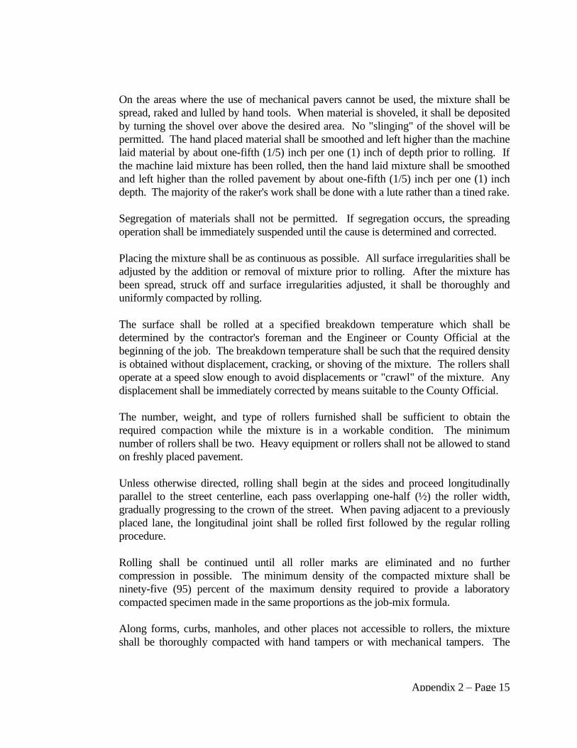
Appendix 2 – Page 15
On the areas where the use of mechanical pavers cannot be used, the mixture shall be
spread, raked and lulled by hand tools. When material is shoveled, it shall be deposited
by turning the shovel over above the desired area. No "slinging" of the shovel will be
permitted. The hand placed material shall be smoothed and left higher than the machine
laid material by about one-fifth (1/5) inch per one (1) inch of depth prior to rolling. If
the machine laid mixture has been rolled, then the hand laid mixture shall be smoothed
and left higher than the rolled pavement by about one-fifth (1/5) inch per one (1) inch
depth. The majority of the raker's work shall be done with a lute rather than a tined rake.
Segregation of materials shall not be permitted. If segregation occurs, the spreading
operation shall be immediately suspended until the cause is determined and corrected.
Placing the mixture shall be as continuous as possible. All surface irregularities shall be
adjusted by the addition or removal of mixture prior to rolling. After the mixture has
been spread, struck off and surface irregularities adjusted, it shall be thoroughly and
uniformly compacted by rolling.
The surface shall be rolled at a specified breakdown temperature which shall be
determined by the contractor's foreman and the Engineer or County Official at the
beginning of the job. The breakdown temperature shall be such that the required density
is obtained without displacement, cracking, or shoving of the mixture. The rollers shall
operate at a speed slow enough to avoid displacements or "crawl" of the mixture. Any
displacement shall be immediately corrected by means suitable to the County Official.
The number, weight, and type of rollers furnished shall be sufficient to obtain the
required compaction while the mixture is in a workable condition. The minimum
number of rollers shall be two. Heavy equipment or rollers shall not be allowed to stand
on freshly placed pavement.
Unless otherwise directed, rolling shall begin at the sides and proceed longitudinally
parallel to the street centerline, each pass overlapping one-half (½) the roller width,
gradually progressing to the crown of the street. When paving adjacent to a previously
placed lane, the longitudinal joint shall be rolled first followed by the regular rolling
procedure.
Rolling shall be continued until all roller marks are eliminated and no further
compression in possible. The minimum density of the compacted mixture shall be
ninety-five (95) percent of the maximum density required to provide a laboratory
compacted specimen made in the same proportions as the job-mix formula.
Along forms, curbs, manholes, and other places not accessible to rollers, the mixture
shall be thoroughly compacted with hand tampers or with mechanical tampers. The
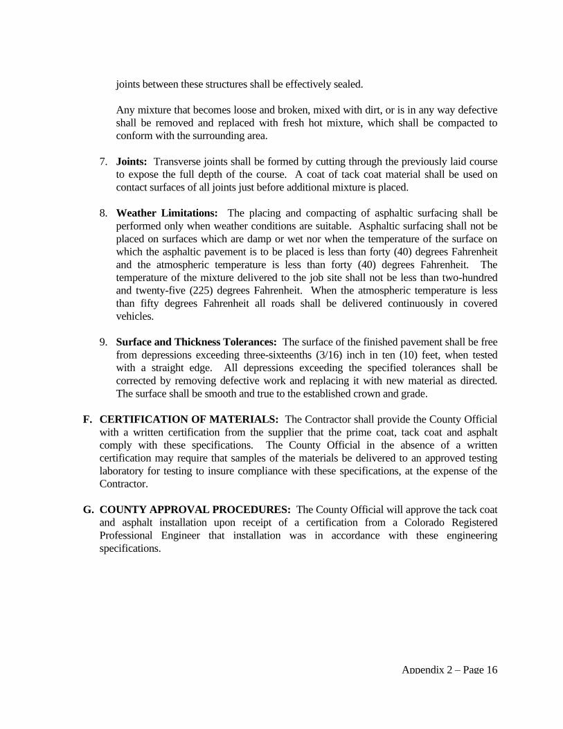
Appendix 2 – Page 16
joints between these structures shall be effectively sealed.
Any mixture that becomes loose and broken, mixed with dirt, or is in any way defective
shall be removed and replaced with fresh hot mixture, which shall be compacted to
conform with the surrounding area.
7. Joints: Transverse joints shall be formed by cutting through the previously laid course
to expose the full depth of the course. A coat of tack coat material shall be used on
contact surfaces of all joints just before additional mixture is placed.
8. Weather Limitations: The placing and compacting of asphaltic surfacing shall be
performed only when weather conditions are suitable. Asphaltic surfacing shall not be
placed on surfaces which are damp or wet nor when the temperature of the surface on
which the asphaltic pavement is to be placed is less than forty (40) degrees Fahrenheit
and the atmospheric temperature is less than forty (40) degrees Fahrenheit. The
temperature of the mixture delivered to the job site shall not be less than two-hundred
and twenty-five (225) degrees Fahrenheit. When the atmospheric temperature is less
than fifty degrees Fahrenheit all roads shall be delivered continuously in covered
vehicles.
9. Surface and Thickness Tolerances: The surface of the finished pavement shall be free
from depressions exceeding three-sixteenths (3/16) inch in ten (10) feet, when tested
with a straight edge. All depressions exceeding the specified tolerances shall be
corrected by removing defective work and replacing it with new material as directed.
The surface shall be smooth and true to the established crown and grade.
F. CERTIFICATION OF MATERIALS: The Contractor shall provide the County Official
with a written certification from the supplier that the prime coat, tack coat and asphalt
comply with these specifications. The County Official in the absence of a written
certification may require that samples of the materials be delivered to an approved testing
laboratory for testing to insure compliance with these specifications, at the expense of the
Contractor.
G. COUNTY APPROVAL PROCEDURES: The County Official will approve the tack coat
and asphalt installation upon receipt of a certification from a Colorado Registered
Professional Engineer that installation was in accordance with these engineering
specifications.
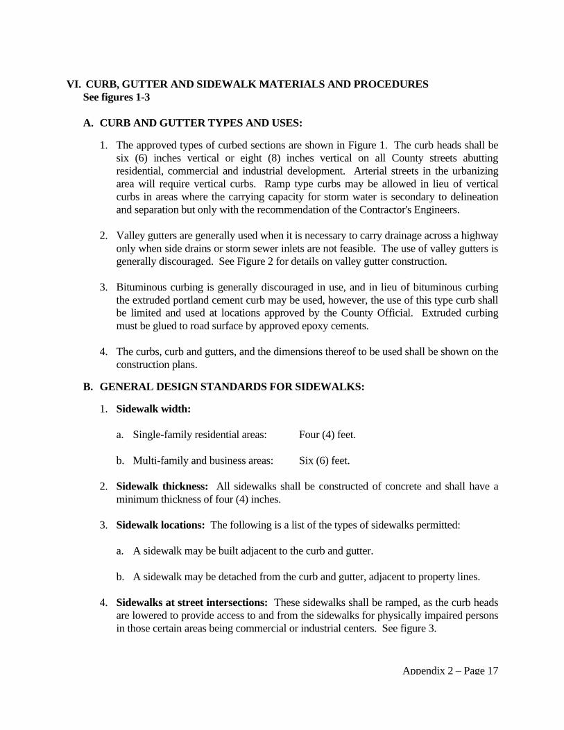
Appendix 2 – Page 17
VI. CURB, GUTTER AND SIDEWALK MATERIALS AND PROCEDURES
See figures 1-3
A. CURB AND GUTTER TYPES AND USES:
1. The approved types of curbed sections are shown in Figure 1. The curb heads shall be
six (6) inches vertical or eight (8) inches vertical on all County streets abutting
residential, commercial and industrial development. Arterial streets in the urbanizing
area will require vertical curbs. Ramp type curbs may be allowed in lieu of vertical
curbs in areas where the carrying capacity for storm water is secondary to delineation
and separation but only with the recommendation of the Contractor's Engineers.
2. Valley gutters are generally used when it is necessary to carry drainage across a highway
only when side drains or storm sewer inlets are not feasible. The use of valley gutters is
generally discouraged. See Figure 2 for details on valley gutter construction.
3. Bituminous curbing is generally discouraged in use, and in lieu of bituminous curbing
the extruded portland cement curb may be used, however, the use of this type curb shall
be limited and used at locations approved by the County Official. Extruded curbing
must be glued to road surface by approved epoxy cements.
4. The curbs, curb and gutters, and the dimensions thereof to be used shall be shown on the
construction plans.
B. GENERAL DESIGN STANDARDS FOR SIDEWALKS:
1. Sidewalk width:
a. Single-family residential areas: Four (4) feet.
b. Multi-family and business areas: Six (6) feet.
2. Sidewalk thickness: All sidewalks shall be constructed of concrete and shall have a
minimum thickness of four (4) inches.
3. Sidewalk locations: The following is a list of the types of sidewalks permitted:
a. A sidewalk may be built adjacent to the curb and gutter.
b. A sidewalk may be detached from the curb and gutter, adjacent to property lines.
4. Sidewalks at street intersections: These sidewalks shall be ramped, as the curb heads
are lowered to provide access to and from the sidewalks for physically impaired persons
in those certain areas being commercial or industrial centers. See figure 3.

Appendix 2 – Page 18
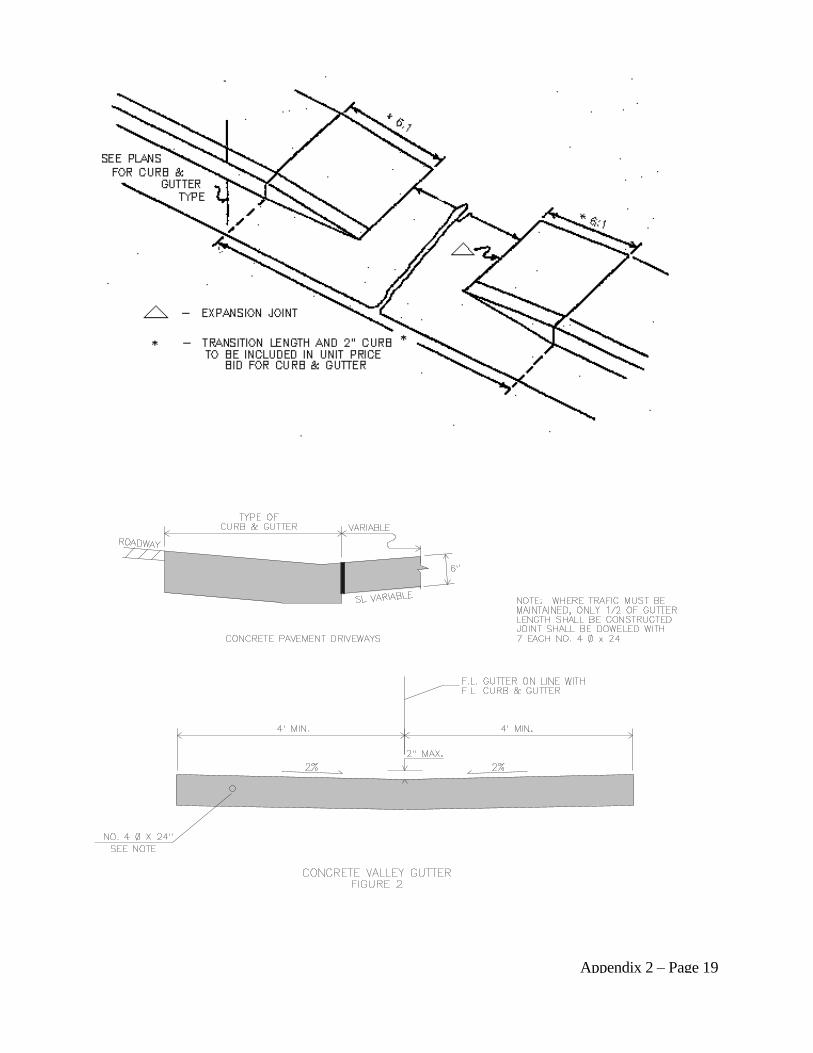
Appendix 2 – Page 19
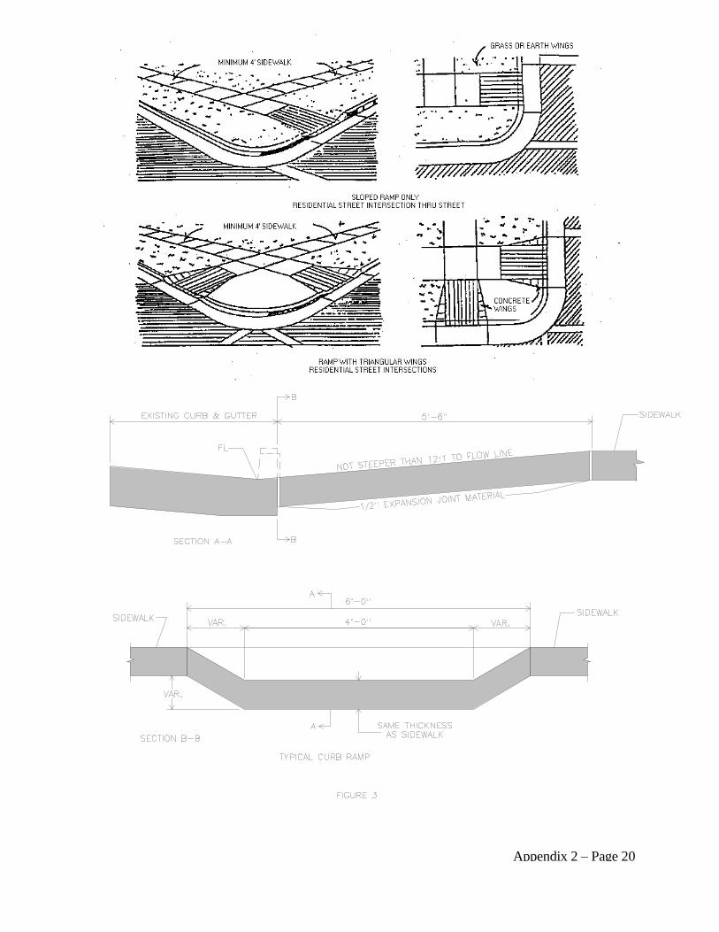
Appendix 2 – Page 20
Appendix 2 – Page 21
C. MATERIALS:
1. Base Material: Base material shall consist of sand and hard, durable fragments of rock
together with filler material which when combined with the balance of the surfacing
material will conform with the mechanical analysis and other requirements of these
specifications. Fifty (50) percent or more by weight shall not pass a #4 sieve and shall
have at least one fractured face. The material shall be a well graded mixture containing
sufficient soil mortar, crusher dust or other proper binding material which, when placed
and compacted on, the sub-base will result in a firm, dense, stable surface. Material
shall be free from vegetable matter, lumps and balls of clay, ice or other deleterious
matter.
a. The material shall be uniformly graded coarse to fine and meet the following
requirements:
SIEVE SIZE PERCENT PASSING
3/4" 100%
No. 4 30 - 65%
No. 8 25 - 55%
No. 200 3 - 12%
Material shall have a liquid limit of not more than thirty (30) and a plasticity index
of not more than six (6). Tests for Liquid Limit and Plasticity Index shall be in
accordance with AASHTO Standard Test T-89 and T-90 respectively.
b. Construction Methods: Base coarse material will be placed to the thickness shown
on construction plans, but not less than seven (7) inches, as prepared under the
direction of a Professional Engineer. All base and sub-base will be compacted to a
minimum density of ninety-five (95) percent. No base or sub-base shall be placed
on frozen or spongy ground or rolled or compacted while in a frozen condition.
2. Concrete: All concrete shall be Portland Cement conforming to the most current
provisions of ASTM C-150 "Standard Specification for Portland Cement".
a. Curb and Gutter: The minimum cement content shall be six (6) sacks per cubic
yard of concrete. Total water content to the concrete should not exceed six (6)
gallons of water per one-hundred (100) pounds of concrete. Slump shall be not less
than one (1) inch nor more than four (4) inches. Slump shall be determined in
accordance with the most current provisions of ASTM C-143 "Standard Test
Method for Slump of Portland Cement Concrete". Minimum thirty (30) day
compressive strength shall be three-thousand (3,000) pounds per square foot.
b. Sidewalks: The minimum concrete content shall be five and one-half (5 ½) sacks
Appendix 2 – Page 22
per cubic yard of concrete. Slump shall be not less than one (1) inch nor more than
four (4) inches. Slump shall be determined in accordance with ASTM C-143 as
noted above.
3. Aggregates: Concrete aggregates shall conform to the most current "Specification for
Concrete Aggregates", ASTM C-33. Aggregate shall not contain more than two (2)
percent soft particles. When tested according to ASTM Standard C-136, the aggregates
shall conform to the following gradations:
SIEVE SIZE
% PASSING COURSE
AGGREGATE
% PASSING FINE
AGGREGATE
3/4" 100% ---
1/2" 90 - 100% ---
3/8" 40 - 70% 100%
No. 4 0 - 15% 95 - 100%
No. 8 0 - 5% ---
No. 16 --- 45 - 80%
No. 50 --- 10 - 30%
No. 100 --- 2 - 10%
Concrete aggregates shall consist of sand and gravel, gravel, crushed stone or limestone.
The particles shall be clean, hard, durable and of uniform quality free from any injurious
materials.
4. Water: Water used in mixing concrete shall be potable, clean and free from injurious
amounts of oils, acids, alkalis, salts, organic materials or other substances that may be
deleterious to concrete or steel.
5. Reinforcing Steel:
a. Deformed and Plain Billet - Steel Bars for Concrete Reinforcement AASHTO M-31.
b. Fabricated Steel Bar or Rod Mats for Concrete Reinforcement AASHTO M-54.
c. Welded Steel Wire Fabric for Concrete Reinforcement AASHTO M-55.
Bars conforming to AASHTO M-31 shall be furnished in Grade 40 unless otherwise
designated. In AASHTO M-54 bars conforming to AASHTO 47 will not be
permitted.
6. Admixtures: Air entraining mixtures shall conform to the most recent requirements of
AASHTO M-154. Air entraining Portland cement if used shall conform to
"Specifications for Air Entraining Portland Cement, ASTM C-175". Contractors may,
Appendix 2 – Page 23
at their option, use a water-reducing admixture conforming to "Specification for
Chemical Admixture for Concrete, ASTM C-494". Fly ash or other pozzolans used as
admixtures shall conform to "Specifications for Fly Ash and Raw or Calconed Natural
Pozzolans for Use in Portland Cement Concrete ASTM C-618". Due to increased
shrinkage and susceptibility to sulfate attack, Calcium Chloride will not be permitted.
7. Air Content: All concrete shall be air entrained with a minimum air content or five (5)
percent and a maximum of seven (7) percent. The air content shall be measured by
"Test for Air Content of Freshly Mixed Concrete by the Pressure Method" (ASTM C-
231), "Test for Air Content of Freshly Mixed Concrete by the Volumetric Method"
(ASTM C-173) or "Test for Weight for Cubic Feet, Yield and Air Content Gravimetric
of Concrete" (ASTM C-138). Cement and aggregates shall be stored in such a manner
as to prevent deterioration or the intrusion of foreign material.
8. Mixing of Concrete: All concrete shall be mixed until there is a uniform distribution of
the materials and shall be discharged completely before the mixer is recharged.
Concrete may be mixed at the site of the work, in a central mix plant, or in truck mixers.
The mixer shall be of an approved type and capacity. Mixing time shall be measured
from the time all materials, except water, are in the drum. Concrete shall be mixed and
delivered in accordance with the requirements of "Standard Specifications for Ready
Mixed Concrete", ASTM C-94, with the following exceptions:
a. When mixed at the site of the work or in a central mixing plant, the mixing time
shall not be less than fifty (50) seconds nor more than ninety (90) seconds. Four (4)
seconds shall be added to the specified mixing time if timing starts the instant the
skip reaches its maximum raised position. Mixing time ends when the discharge
chute opens. Transfer time is multiple drum mixers is included in mixing time. The
contents of an individual mixer drum shall be removed before a succeeding batch is
emptied therein. The time elapsing from the time water is added to the mix (or
cement comes in contact with the aggregate) until the concrete is deposited in place
at the site of the work shall not exceed forty-five (45) minutes when the concrete is
hauled in non-agitating trucks, nor ninety (90) minutes, when hauling in truck
mixers or truck agitators.
b. Transit mixed concrete shall conform with one of the following, in addition to the
requirements of ASTM C-94:
(1) Concrete mixed completely in a truck mixer may be partially mixed at the
batching plant or while in transit, however, the final fifty (50) mixing revolutions
shall occur at the delivery site before discharge of the concrete.
(2) The Contractor will be permitted to partially mix concrete in a stationary central
mixing plant with mixing brought to completion in a truck mixer (known as
Appendix 2 – Page 24
shrink mixing). For shrink mixed concrete the mixing time in the stationary
mixer may be reduced to a minimum of thirty (30) seconds. Mixing shall be
completed in a truck mixer by not less than twenty (20) revolutions of the drum
at mixing speed, at the delivery site.
9. Placing of Concrete:
a. General: Concrete shall not be placed until forms and reinforcing steel (if needed)
have been checked and approved. Before depositing concrete, debris shall be
removed from the space to be occupied by the concrete. Concrete shall be deposited
on a dry surface, free from ice or other deleterious material. Concrete shall be
handled from the mixer or in the case of ready mixed concrete, from the transporting
vehicle to the place of final deposit as rapidly as practicable by methods which shall
prevent the separation or loss of the ingredients. Under no circumstances shall
concrete that was partially hardened be deposited. Concrete shall be deposited in the
forms as nearly as practicable to its final position to avoid rehandling. During and
immediately after depositing, all concrete shall be thoroughly compacted and
worked around all reinforcements and embediments and into corners of the forms
freeing any trapped air or water. Concrete shall be compacted with suitable
mechanical vibrators operating within the concrete. They shall be capable of
transmitting vibrations to the concrete at frequencies of not less than four-thousand
and five-hundred (4,500) impulses per minute. Vibration shall be of sufficient
duration to accomplish compaction, but shall not be prolonged to the point where
segregation begins.
b. Chutes and Troughs: Concrete shall be placed so as to avoid segregation of
materials and the displacement of reinforcement. Concrete shall not be pumped
through aluminum alloy pipe. Concrete shall not be dropped for more than eight (8)
feet unless confined by closed chutes or pipes. All chutes, troughs and pipes shall be
kept clean and free of hardened concrete.
c. Cold Weather Concrete: When it is necessary to place concrete at or below an
atmospheric temperature of thirty-five (35) degrees Fahrenheit, the water, aggregates
or both shall be heated and suitable enclosures and heating devices provided. In
freezing whether, suitable means shall be provided for maintaining the concrete at a
temperature above fifty (50) degrees Fahrenheit for a period of at least seventy-two
(72) hours. Before concrete is placed, the form will be checked for frost or ice, and
after the concrete is placed it shall be protected on all exposed sides by:
(1) Three (3) inches of straw covered with plastic;
(2) Insulated blankets, or other means as approved by the County Official.
Appendix 2 – Page 25
10. Forms: Forms shall conform to the shape, lines and dimensions and depth as needed
for the work to be done. Forms shall be constructed of wood, metal or other material
approved by the County Official and shall conform to the following requirements:
a. Wood forms: Shall be of such a cross section and strength and so secured as to
resist the pressure of the concrete when placed without springing or settling. When
any form has been disturbed or any grade has become unstable, the forms shall be
reset and rechecked. Flexible forms of proper radius shall be used for curves of one-
hundred (100) feet or less. Straight wood forms shall have a minimum thickness of
one and five-eights (1 & 5/8) inch.
b. Metal forms: Shall be a type where all bolts and rivet heads shall be counter sunk.
Clamps, pins and other connecting devices shall be designed to hold the forms
rigidly together and to allow removal of the form without injury to the concrete.
Metal forms which do not line up properly shall not be used. Metal forms shall be
free from rust, grease and other materials.
c. Slip forms: As an alternative to using fixed forms, a slip form paver may be used
providing it has first been approved by the County Official prior to beginning of
construction.
d. Surface treatment: All metal forms shall be treated with oil prior to placement of
concrete. Wood forms shall be thoroughly moistened with water immediately
before the placing of concrete. Forms for members with exposed surfaces shall be
treated with an approved oil before reinforcement shall be removed.
e. Removal of forms: Forms shall be removed in a manner to insure safety of the
structure. In no case shall the forms be removed before the concrete attains
sufficient strength.
f. Reuse of forms: The shape, strength, rigidity, water tightness and smoothness of
reused forms shall be maintained at all times. Unsatisfactory forms shall not be
used.
g. Test strength: The minimum acceptable compressive strengths as determined by
ASTM C-39 shall be:
AGE MINIMUM STRENGTH
Curb and Gutter 7 days 2800 psi
28 days 3000 psi
Sidewalk 28 days 3000 psi
11. Finishing Concrete Surfaces: Unless otherwise authorized, the surface of the concrete
Appendix 2 – Page 26
shall be finished immediately after form removal. All irregular projections shall be
removed from all surfaces except those which will not be exposed. Cavities produced
by the form ties, honeycomb spots, broken corners or edges, and other defects shall be
thoroughly cleaned, moistened with water and carefully pointed and trued with a mortar
consisting of cement and fine aggregate and the surface left sound, smooth and even in
color. Mortar used in pointing shall be not more than thirty (30) minutes old.
The finish for horizontal surfaces shall be achieved by placing an excess of material in
the form and removing and striking off the excess with a template, forcing the aggregate
below the mortar surface. Creation of concave surfaces will be avoided. Before the
finish has set, the surface cement film shall be removed with a fine brush or broom in
order to have a fine grained, smooth but sanded texture.
12. Curing Concrete: Immediately after forms have been removed, all concrete shall be
cured as specified herein. The minimum curing period shall be one-hundred and twenty
(120) hours. During hot weather all surfaces from which the forms have been removed
and all unformed surfaces shall be kept moist by wet curing for a least twenty-four (24)
hours. At the end of twenty-four (24) hours wet curing period, the surfaces may be
treated with a curing compound.
One of the following methods shall be adopted in normal weather (temperature above
fifty (50) degrees Fahrenheit) conditions:
a. Water method: All surfaces other than slabs shall be protected from the sun and
the whole structure shall be kept wet for a period of at least five (5) days. Curbs,
walls, handrails and other surfaces requiring a rubbing finish may have the covering
temporarily removed for finishing, but the covering must be restored as soon as
possible. All concrete slabs shall be covered as soon as possible with suitable
material so that concrete is kept thoroughly wet for at least five (5) days.
b. Membrane forming curing compound: All surfaces shall be given the required
surface finish prior to application of the curing compound. During the finishing
period, the concrete shall be protected by the water method of curing.
Type 2 curing compound may be used on concrete surfaces. Curing compound shall
not be used on construction joints.
The rate of application of curing compound shall not be more than three-hundred
(300) square feet per gallon. All concrete cured by this method shall receive two (2)
applications of the curing compound. The first coat shall be applied immediately
after stripping of forms and acceptance of the concrete finish. If the surface is dry,
the concrete shall be thoroughly wet with water and the curing compound applied
just as the surface fill of water disappears. The second application shall be applied
Appendix 2 – Page 27
after the first application has set. During curing operations, any unsprayed surfaces
shall be kept wet with water.
The coating shall be protected against marring for a period of at least ten (10) days
after application. Any coating marred, or otherwise disturbed shall be given an
additional coating. When using a curing compound, the compound shall be
thoroughly mixed within an hour before use.
If the use of curing compound results in a streaked or blotchy appearance, the
method shall be stopped and water curing applied until the cause of the defective
appearance is corrected.
c. Form method: Concrete shall be protected by forms for at least seven (7) days.
Forms shall be kept moist, when necessary, during the curing period.
d. Cold weather requirements: During cold weather, means shall be provided for
maintaining the concrete at a temperature of at least fifty (50) degrees Fahrenheit for
at least three (3) days after placing. As long as forms remain in place, surfaces
adjacent to the forms are adequately cured in cold weather. For unformed surfaces,
steam curing is preferable. If a curing compound is used, it should not be applied
until the use of steam has been discontinued. When dry heating is used, the concrete
shall be covered with an approved impervious material or curing compound. Water
curing shall not be used.
Following removal of temperature protection no positive measures to prevent
excessive evaporation are required as long as the air temperature remains below fifty
(50) degrees Fahrenheit. However, if the relative humidity at fifty (50) degrees
Fahrenheit is below forty (40) percent or at forty (40) degrees Fahrenheit below sixty
(60) percent a curing compound shall be used (water curing is acceptable if no
freezing is expected). When temperatures above fifty (50) degrees Fahrenheit occur
during more than half of any twenty-four (24) hour period, normal curing practice
shall apply.
e. Curing materials: Shall conform to the following requirement as specified:
(1) Burlap cloth made from Jute or Kenaf AASHTO M183.
(2) Liquid Membrane - Forming Compounds for Curing Concrete AASHTO
M148.
(3) Sheet Materials for Curing Concrete AASHTO M171.
(4) Straw used for curing shall consist of threshed straw or oats, barley, wheat or
Appendix 2 – Page 28
rye. Clean field or marsh hay may be substituted for straw when approved by
the County Official. Old straw which breaks in the spreading process will not be
accepted.
13. Expansion Joints: Non-extruding pre-molded expansion joint material of one-half (½)
inch thickness shall be placed at least once every one-hundred (100) feet, at the junction
of new concrete with existing concrete or existing structures at the tangent parts of all
alley and intersection returns. Masonite, Cellotex, or other substitutes will not be
accepted unless approved by the County Official prior to construction.
14. Contraction Joints: Cross pans, curb and gutter and driveways shall be divided into
sections of length by contraction joints. A contraction joint formed by division plates
shall be used in such a manner so the cross pan, or curb and gutter will be divided into
uniform sections of ten (10) feet except where shorter sections are necessary for closures
but no section shall be less than four (4) feet in length. The plates shall be one-eighth
(1/8) inch thick, fit neatly into the forms and be set perpendicular to the surface of the
concrete and shall project through the curb head no more than one-third (1/3) of the
depth of the gutter slab. The shape of the divider plate shall conform to the curb and
gutter section with the exception that the lower two-thirds (2/3) of the divider plate shall
be removed. This joint may be constructed by other methods that would obtain the same
desired results if recommended by the Contractor's Engineer.
15. Backfilling: Curb and gutter having fill sections shall have a two (2) foot berm
constructed against the back of the curb and sloped to the existing round at a two (2) to
one (1) slope. In cut sections the backfill shall be brought to the top of the curb so as to
fill the area excavated during construction. The ground between the back of the curb or
sidewalk line and property line shall be sloped not steeper than two (2) to one (1) and
blended into existing lawn or ground surface. Upon completion of any curb and gutter,
the site of the same shall be left in a neat and workmanlike manner. No backfilling will
be permitted until the concrete has cured for a period of seven (7) days.
16. Driveway Installation: All driveways abutting curb and gutter, curb, gutter and
sidewalk combination, drive over curb and gutter, cross pan or any cross gutter shall
have a strip of non extruding expansion joint material one-half (½) inch thick, con-
forming to the cross-sections of the drive placed between the driveway and the sidewalk,
curb, or cross gutter so as to provide for the concrete driveway or cross pans. Base
under curb and gutter, cross pans, or sidewalks shall conform to requirements as set
forth in Section VI B., 1. Base under driveways shall be prepared using suitable
material that when tamped or rolled shall be smooth and firm and to the desired depth
below finish grade. This material when tested shall meet ninety-five (95) percent
minimum compaction. Minimum driveway thickness shall be six (6) inches and six by
six (6X6) wire welded fabric will be used for reinforcement. Figures 2 and 3.
Appendix 2 – Page 29
D. COMPACTION: Materials shall be compacted to ninety-five (95) percent of the
maximum density at optimum moisture. The number of compaction tests and locations
shall be determined by a Colorado Registered Professional Engineer. The results of the
compaction tests shall be provided to the County Official upon engineer’s certification.
Compaction tests will be at the expense of the Contractor or Developer.
E. COMPACTION TEST FAILURE: If the required state of compaction is not obtained, it
shall be the responsibility of the Contractor to re-compact the material as specified above.
In cases where there is repeated failure to achieve the required state of compaction the
County Official may require that the backfill be removed and re-compacted.
F. FROZEN CONDITIONS: No base course shall be placed on a frozen or spongy sub-base
and no base course shall be placed or rolled while in a frozen condition.
G. CERTIFICATION OF MATERIALS: The Contractor shall provide the County Official
with a written certification from the supplier that the materials used in the curb, gutter and
sidewalks are in accordance with these engineering specifications. The County Official in
the absence of a written certification may require that samples of the materials be delivered
to an approved testing laboratory for testing to insure compliance with these specifications at
the expense of the Contractor or Developer.
H. COUNTY APPROVAL PROCEDURES: The County will approve the installation of
curb, gutter and sidewalks upon receipt of certification from a Colorado Registered
Professional Engineer that the curb, gutter and sidewalks were installed in accordance with
the engineering specifications.
Enactment Clause
VII. ENACTMENT CLAUSE, EFFECTIVE DATE:
1. Upon approval and adoption by the County Commissioners of Fremont County, a
certified copy of these Subdivision Regulations shall be filed, according to the law, in the
office of the County Clerk and Recorder of Fremont County, Colorado.
2. These Subdivision Regulations shall become of full force and effect as of the date of its
adoption, this being:
The ______ day of ____________________________, 2000.
_________________________________________________
Chairman, Board of County Commissioners
_________________________________________________
Attest - Fremont County Clerk and Recorder