freshwater ecological walk down verification as …
TRANSCRIPT

Reg No. 2019/432634/07 VAT Reg No. TBC PO Box 751779 Gardenview 2047 Tel: 011 616 7893 Fax: 086 724 3132 Email: [email protected] www.sasenvironmental.co.za
FRESHWATER ECOLOGICAL WALK DOWN VERIFICATION
AS PART OF THE ENVIRONMENTAL AUTHORISATION
AMENDMENT PROCESS FOR THE PROPOSED 86 MW OYA
WIND ENERGY FACILITY (WEF) AND ASSOCIATED
INFRASTRUCTURE BETWEEN SUTHERLAND AND
MATJIESFONTEIN IN THE WESTERN AND NORTHERN
CAPE PROVINCES
Prepared for
Oya Energy (Pty) Ltd
November 2020
Prepared by: FEN Consulting (Pty) Ltd Report author: C. du Preez (Pr. Sci. Nat) Report reviewers: K. Marais (Pr. Sci. Nat) S. van Staden (Pr. Sci. Nat) Report reference: FEN 21-0053 Date: November 2020
FEN 21-0053 November 2020
ii
TABLE OF CONTENTS
TABLE OF CONTENTS ......................................................................................................................... ii LIST OF TABLES .................................................................................................................................. iii LIST OF FIGURES ................................................................................................................................ iii GLOSSARY OF TERMS ....................................................................................................................... iv ACRONYMS ........................................................................................................................................... v 1 INTRODUCTION ............................................................................................................................. 1
Background ..................................................................................................................................... 1 Assumptions and Limitations ........................................................................................................... 1
2 PROJECT DESCRIPTION .............................................................................................................. 2 3 SITE WALK DOWN TERMS OF REFERENCE ............................................................................. 5 4 RESULTS: SITE WALK-DOWN ..................................................................................................... 5 5 LEGISLATIVE REQUIREMENTS AND SENSITIVITY MAPPING ............................................... 14 6 IMPACT STATEMENT .................................................................................................................. 32 7 EMPr INPUT .................................................................................................................................. 32 8 CONCLUSION .............................................................................................................................. 38 9 REFERENCES .............................................................................................................................. 38 APPENDIX A: Indemnity and Terms of Use of this Report ............................................................. 39 APPENDIX B: Legislative Requirements .......................................................................................... 40 APPENDIX D: Details, Expertise and Curriculum Vitae of Specialists .......................................... 42

FEN 21-0053 November 2020
iii
LIST OF TABLES
Table 1: Details of the Oya WEF infrastructure directly traversing watercourses. ......................... 6 Table 2: Articles of Legislation and the relevant zones of regulation applicable to each
article. ............................................................................................................................. 15 Table 3: Recommended layout changes ...................................................................................... 23 Table 4: Summary of required mitigation measures to be included as part of the EMPr for the
various development activities associated with the Oya WEF development. ................ 33
LIST OF FIGURES
Figure 1: Digital satellite image depicting the proposed Oya WEF and the investigation area in relation to its surroundings. .............................................................................................. 3
Figure 2: Location of the proposed Oya WEF and the investigation area depicted on a 1:50 000 topographical map in relation to surrounding areas. ........................................................ 4
Figure 3: An overview map depicting the locality of the delineated watercourses associated with the proposed OyaWEF . ................................................................................................... 8
Figure 4: The locality of the delineated watercourses of the Windheuwels River system associated with the proposed access road and construction camp. ................................ 9
Figure 5: The locality of the delineated watercourses of the Kleinpoorts, Brak and Windheuwels River systems associated with the proposed internal roads, turbines and crane pads. 10
Figure 6: The locality of the delineated watercourses of the Brak an Ongeluks River systems associated with the proposed internal roads, turbines and crane pads. ........................ 11
Figure 7: The locality of the delineated watercourses of the Jakkelshok and Ongeluks River systems associated with the proposed internal roads, turbines and crane pads. .......... 12
Figure 8: The locality of the delineated watercourses of the Ongeluks River and Jakkalshok River systems associated with the proposed internal roads, turbines and crane pads. 13
Figure 9: The conceptual presentation of the zones of regulation in terms of GN509 of 2016 as it relates to the NWA and NEMA in relation to the delineated watercourses that form part of the Windheuwels River system along the proposed access road and construction camp........................................................................................................... 17
Figure 10: The conceptual presentation of the zones of regulation in terms of GN509 of 2016 as it relates to the NWA and NEMA in relation to the delineated watercourses that form part of the Kleinpoorts River system............................................................................... 18
Figure 11: The conceptual presentation of the zones of regulation in terms of GN509 of 2016 as it relates to the NWA and NEMA in relation to the delineated watercourses that form part of the Brak River system. ........................................................................................ 19
Figure 12: The conceptual presentation of the zones of regulation in terms of GN509 of 2016 as it relates to the NWA and NEMA in relation to the delineated watercourses that form part of the Jakkelshok and Ongeluks River systems...................................................... 20
Figure 13: The conceptual presentation of the zones of regulation in terms of GN509 of 2016 as it relates to the NWA and NEMA in relation to the delineated watercourses that form part of the Jakkalshok and Ongeluks River systems...................................................... 21

FEN 21-0053 November 2020
iv
GLOSSARY OF TERMS
Alien vegetation: Plants that do not occur naturally within the area but have been introduced either intentionally or unintentionally. Vegetation species that originate from outside of the borders of the biome -usually international in origin.
Biodiversity:
The number and variety of living organisms on earth, the millions of plants, animals and micro-organisms, the genes they contain, the evolutionary history and potential they encompass and the ecosystems, ecological processes and landscape of which they are integral parts.
Buffer: A strip of land surrounding a wetland or riparian area in which activities are controlled or restricted, in order to reduce the impact of adjacent land uses on the wetland or riparian area.
Delineation (of a wetland): To determine the boundary of a wetland based on soil, vegetation and/or hydrological indicators.
Ecoregion: An ecoregion is a "recurring pattern of ecosystems associated with characteristic combinations of soil and landform that characterise that region”.
Episodic drainage lines Highly flashy systems that flow or flood only in response to extreme rainfall events, usually high in their catchments. May not flow in a five-year period or may flow only once in several years.
Facultative species: Species usually found in wetlands (76%-99% of occurrences) but occasionally found in non-wetland areas
Hydromorphic soil: A soil that in its undrained condition is saturated or flooded long enough to develop anaerobic conditions favouring the growth and regeneration of hydrophytic vegetation (vegetation adapted to living in anaerobic soils).
Indigenous vegetation: Vegetation occurring naturally within a defined area.
Perennial: Flows all year round.
RDL (Red Data listed) species:
Organisms that fall into the Extinct in the Wild (EW), critically endangered (CR), Endangered (EN), Vulnerable (VU) categories of ecological status.
Temporary zone of wetness:
The outer zone of a wetland characterised by saturation within 50cm of the surface for less than three months of the year.
Vernal Pool Also called vernal ponds or ephemeral pools, are temporary pools of water that provide habitat for distinctive aquatic plants and animals that are adapted to the very short inundation periods of these pools.
Watercourse:
In terms of the definition contained within the National Water Act, 1998 (Act No. 36 of 1998) a watercourse means:
• A river or spring;
• A natural channel which water flows regularly or intermittently;
• A wetland, dam or lake into which, or from which, water flows; and
• Any collection of water which the Minister may, by notice in the Gazette, declare to be a watercourse;
• and a reference to a watercourse includes, where relevant, its bed and banks.
Wetland Vegetation (WetVeg) type:
Broad groupings of wetland vegetation, reflecting differences in regional context, such as geology, climate, and soils, which may in turn have an influence on the ecological characteristics and functioning of wetlands.

FEN 21-0053 November 2020
v
ACRONYMS
°C Degrees Celsius
AC Alternating Current
BA Basic Assessment
BAR Basic Assessment Report
BGIS Biodiversity Geographic Information Systems
CBA Critical Biodiversity Area
DC Direct Current
DEFF Department of Environment, Forestry and Fisheries
DWA Department of Water Affairs
DWAF Department of Water Affairs and Forestry
DWS Department of Water and Sanitation
EA Environmental Authorisation
EAP Environmental Assessment Practitioner
EIA Environmental Impact Assessment
EIS Ecological Importance and Sensitivity
EMC Ecological Management Class
EMP Environmental Management Program
ESA Ecological Support Area
FEN Freshwater Ecologist Network
GA General Authorisation
GIS Geographic Information System
GN Government Notice
GPS Global Positioning System
HGM Hydrogeomorphic
kV Kilovolt
m Meter
MAP Mean Annual Precipitation
MC Management Classes
NEMA The National Environmental Management Act, 1998 (Act No. 107 of 1998)
NFEPA National Freshwater Ecosystem Priority Areas
NWA National Water Act, 1998 (Act No. 36 of 1998)
NWCS National Wetland Classification System
O&M Operation and Maintenance
PES Present Ecological State
REC Recommended Ecological Category
REDZ Renewable Energy Zones
REIPPPP Renewable Energy Independent Power Producer Procurement Program (REIPPPP)
SACNASP South African Council for Natural Scientific Professions
SANBI South African National Biodiversity Institute
SARERD South African Renewable Energy Resource Database
SQR Sub-quaternary catchment reach
subWMA Sub-Water Management Area
WetVeg Groups Wetland Vegetation Groups
WMA Water Management Areas
WULA Water Use Licence Application
WRC Water Research Commission
ZOR Zone of Regulation

FEN 21-0053 November 2020
1
1 INTRODUCTION
Background
Freshwater Ecologist Network (FEN) Consulting (Pty) Ltd was appointed to conduct a specialist
freshwater ‘site walkdown’ micro-sighting as part of the Environmental Authorisation Part 2 Amendment
process in order to split the authorised Kudusberg Wind Energy Facility (WEF) into two separate WEF
projects, namely the Kudusberg WEF and the Oya WEF. This report focussed specifically on reporting
the outcome of the Oya WEF site walkdown as per condition 29 of the Kudusberg WEF EA1. Please
refer to Section 2 for the project description.
A freshwater ecological assessment for the authorised Kudusberg WEF was undertaken in 2018 by
BlueScience (Pty) Ltd2, at which time all watercourses associated with the Kudusberg WEF were
delineated and assessed to ascertain the Present Ecological State (PES) and Ecological Importance
and Sensitivity (EIS). FEN Consulting (Pty) Ltd was subsequently appointed to compile an updated
freshwater ecological study (FEN Consulting, October 2020), with specific mention of the application of
the Department of Water and Sanitation (DWS) Risk Assessment Matrix as promulgated in Government
Notice 509 as published in the Government Gazette 40229 of 2016 as it relates to the National Water
Act, 1998 (Act No. 36 of 1998), to comply with the requirements specialist studies as per Annexure D6
of the National Water Act, 1998 (Act No. 36 of 1998) (NWA) to inform the WUA process.
The data contained in both of the abovementioned reports was utilised to supplement the observations
made during the site walkdown undertaken in October 2020, to identify any areas of potential concern,
increased sensitivity including potential ‘no-go’ areas, ascertain the necessity for approvals and/or
permits required and to determine whether the layout for the northern section of the authorised WEF
(also referred to as the Oya WEF) which is being proposed as part of the amendment can be approved
by the Department of Environment, Forestry and Fisheries (DEFF) or whether any changes are required
to the proposed layout (due to presence of sensitive / “no-go” areas and/ or any other special features).
It is a further aim of this study to ascertain whether the amended layout will result in additional potential
impacts and whether there is a requirement for additional mitigation measures to be implemented by
the proponent.
Assumptions and Limitations
➢ The site walkdown undertaken on the 22nd to the 24th of October focussed on the proposed layout
of the Oya WEF only. Please refer to the full freshwater specialist assessment report undertaken
by FEN Consulting in October 2020 (FEN 21-0045) which details the specific assessed ecological
integrity of the watercourses associated with the proposed authorised WEF development. The FEN
Consulting (2020) report was used to inform the locality of identified watercourses relative to the
proposed authorised WEF development;
➢ The coordinates for the proposed direct infrastructure crossing points (as described in Section 5)
will be provided to the proponent additional to this verification report (in .kml format);
➢ Due to the landscape in some areas being rugged and very undeveloped, some reaches of the
identified watercourses were inaccessible. Therefore, verification points for watercourses were
located at points as close to the watercourse to be verified as possible and, where necessary the
conditions at the exact point required were inferred or extrapolated;
1 Condition 29 of Kudusberg EA [DEFF Ref: 14/12/16/3/3/1/1976/AM1 – Page 15 of EA (page 17 of full document)]: the final placement of turbines must follow a micro siting procedure involving a walk-through and identification of any sensitive areas by ecological, avifaunal, bat, surface water and heritage specialists. 2 BlueScience. 2018. Freshwater Specialist Study: Basic Assessment for the proposed development of the 325 MW Kudusberg Wind Energy Facility and associated infrastructure, between Matjiesfontein and Sutherland in the Western and Northern Cape Provinces

FEN 21-0053 November 2020
2
➢ Due to the majority of the watercourses being ephemeral within the region, very few areas were
encountered that displayed more than one watercourse characteristic as defined by the DWAF
(2008) method (such as containing alluvial or inundated soils, or hosts riparian vegetation adapted
to saturated conditions). As a result, identification of the outer boundary of the temporary
watercourse zones and marginal riparian zones proved difficult in some areas and, in particular, in
the areas where watercourse conditions and riparian zones are marginal, and therefore
delineations were augmented with the use of digital satellite imagery. Nevertheless, the
watercourse delineations as presented in this report are regarded as a best estimate of the
watercourse boundaries based on the site conditions present at the time of assessment and the
results obtained are considered sufficiently accurate to allow informed planning and decision
making to take place;
➢ Global Positioning System (GPS) technology is inherently somewhat inaccurate and some
inaccuracies due to the use of handheld GPS instrumentation may occur. However, the
delineations as provided in this report are deemed accurate enough to fulfil the environmental
authorisation requirements as well as the implementation of the mitigation measures provided;
➢ Watercourses and terrestrial zones create transitional areas where an ecotone is formed as
vegetation species change from terrestrial to obligate/facultative species. Within this transition
zone, some variation of opinion on the watercourse boundaries may occur. However, if the DWAF
(2008) method is followed, all assessors should get largely similar results; and
➢ With ecology being dynamic and complex, certain aspects (some of which may be important) may
have been overlooked. However, it is expected that the watercourses have been accurately
assessed and considered, based on the field observations and the consideration of existing studies
and monitoring data in terms of riparian and wetland ecology.
2 PROJECT DESCRIPTION
Kudusberg Wind Farm (Pty) Ltd (hereafter referred to as “Kudusberg Wind Farm”) was issued with an
Environmental Authorisation (EA) for the proposed construction of the 325 MW Kudusberg Wind Energy
Facility (WEF) and associated infrastructure, between Matjiesfontein and Sutherland in the Western
and Northern Cape Provinces. The EA was granted on 25 March 2019 (DEFF Reference No.:
14/12/16/3/3/1/1976 and subsequently amended on 04 April 2019 to correct a minor naming error
(14/12/16/3/3/1/1976/AM1). Kudusberg Wind Farm is now proposing to submit a Part 2 EA Amendment
Application to split the authorised Kudusberg WEF (14/12/16/3/3/1/1976/AM1) into two (2) separate
smaller WEF projects, namely the Kudusberg WEF and Oya WEF, which will result in a number of
technical and administrative changes detailed below in Table 1. The split is being proposed to allow the
projects to be suitable for numerous opportunities such as either the Renewable Energy Independent
Power Producer Procurement Programme (REIPPPP), Risk Mitigation Independent Power Producer
Procurement Programme (RMIPPPP), other government run procurement programmes that may arise
or for sale to private entities, if enabled and/or required in the drive for energy security in South Africa.
Following the split, the northern section of the authorised WEF will become the Oya WEF, while the
southern section of the authorised WEF will remain known as the Kudusberg WEF (authorised under
14/12/16/3/3/1/1976/AM1) (Table 1). In addition to the split, the final layout for the Oya WEF is being
submitted which has been informed by detailed specialist walk-throughs and on-site micro-siting as per
condition 29 of the Kudusberg EA3
Furthermore, the approved EMPr authorised as part of the Kudusberg EA is being amended to each
WEF and to incorporate the final layout for the Oya WEF, management plans and the walk-throughs.
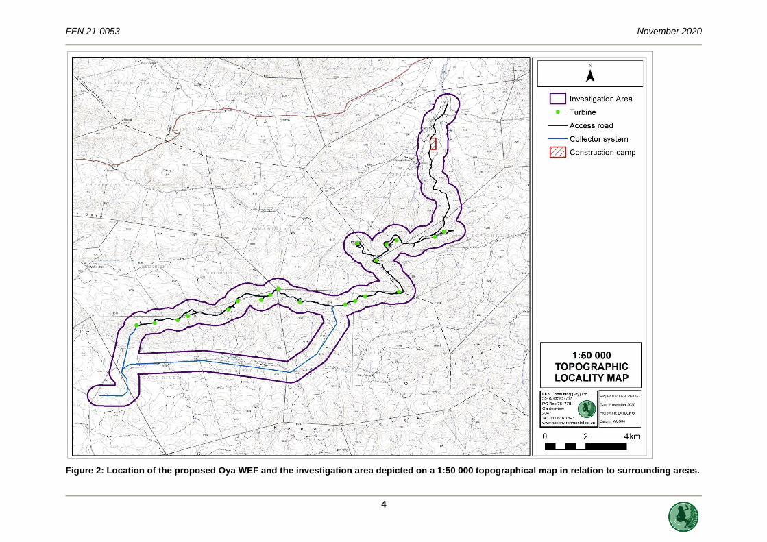
The locality of the proposed Oya WEF and associated surface infrastructure is provided in Figure 1 and
2 below.
3 Condition 29 of Kudusberg EA [DEFF Ref: 14/12/16/3/3/1/1976/AM1 – Page 15 of EA (page 17 of full document)]: the final placement of turbines must follow a micro siting procedure involving a walk-through and identification of any sensitive areas by ecological, avifaunal, bat, surface water and heritage specialists.

FEN 21-0053 November 2020
3
Figure 1: Digital satellite image depicting the proposed Oya WEF and the investigation area in relation to its surroundings.
FEN 21-0053 November 2020
4
Figure 2: Location of the proposed Oya WEF and the investigation area depicted on a 1:50 000 topographical map in relation to surrounding areas.

FEN 21-0053 November 2020
5
3 SITE WALK DOWN TERMS OF REFERENCE
As per the specialist Terms of Reference (ToR) as provided by the proponents, this verification report
includes the following
➢ A single site visit was undertaken in October 2020 to verify the location of proposed
infrastructure associated with the Oya WEF in relation to the watercourses previously identified
and delineated by BlueScience (Pty) Ltd, 2018 and as reported by FEN Consulting (2020).
Turbine positions, internal road and cable crossings, substation inverters and/or transformer
sites and connection routes to the distribution / transmission network (as provided by the
proponent and depicted as per Figure 1 and 2) were investigated on foot to confirm the
occurrence of sensitive watercourse habitat. The findings of the detailed walk-through,
identifying any potential areas of concern / fatal flaws and/or sensitive / “no-go” areas as
provided in Section 5 and 6;
➢ An assessment of the impacts related to the proposed project split (including any other changes
from the authorised specifications, if any). The impact statement is provided in Section 6;
➢ Recommend whether any buffer zones will be required, along with the extent of these buffer
zones. The recommended buffer zones/regulated zones are depicted in Section 5;
➢ Recommend whether any approvals and/or permits are required from the relevant authorities;
Recommend whether any changes to the proposed layout are required, due to the presence of
sensitive / “no-go” areas. The recommended legislative process to follow is presented in
Section 5;
➢ The identification of changes or additions to mitigation measures required to avoid, manage or
mitigate the impacts associated with the proposed project split (if any) and an indication of any
additional mitigation measures / recommendations for inclusion in the EMPr or specific
conditions to be included in the Amended EA (should this be granted by the DEFF). Section 7
presents the recommend mitigation measures to be included in the EMPr; and
➢ Section 8 provides a reasoned opinion as to whether the proposed layout for the northern
section of the authorised WEF (i.e. Oya WEF) should be approved by the DEFF as part of the
Amended EA.
4 RESULTS: SITE WALK-DOWN
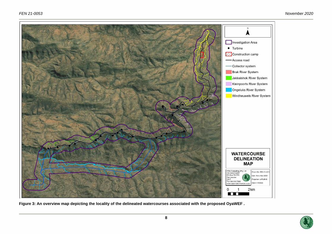
The proposed Oya WEF relative to the delineated and assessed FEN Consulting (2020) watercourses
is presented in Figures 7 to 12. As per FEN Consulting (2020), the proposed Oya WEF is located largely
on the higher-lying Oliviersberg and Koedoesberg Mountains between Matjiesfontein and Sutherland.
The proposed wind turbines are to be placed on mountain ridges that are mostly east-west orientated
and form the watershed between the headwater drainage features of the Ongeluks River, Jakkelshok
River (a tributary of the Ongeluks River), Brak River and Windheuwels River. These river systems flow
in a general westerly direction, with the exception of the Windheuwels and Kleinpoorts Rivers flowing
in a northerly direction. The watercourses identified within the investigation area can best be described
as headwater episodic4 drainage lines (EDLs) without riparian vegetation which flow into larger
ephemeral tributaries located outside the investigation area. Additionally, a small vernal pool is located
atop the mountain ridge, between Turbine 9 and 10.
The site walk down undertaken in October 2020 specifically focused on the watercourse areas proposed
to be directly traversed by the infrastructure associated with the proposed Oya WEF. Additionally, the
delineated extent of the watercourses and its ecological integrity was verified. It can be confirmed that
4 “Highly flashy systems that flow or flood only in response to extreme rainfall events, usually high in their catchments. May not flow in a five-year period or may flow only once in several years.” (Uys and O’Keeffe, 1997, in Rossouw et. al, 2006).

FEN 21-0053 November 2020
6
the ecological description of the watercourses as per FEN Consulting (2020) is accurate and
representative of the verified watercourses.
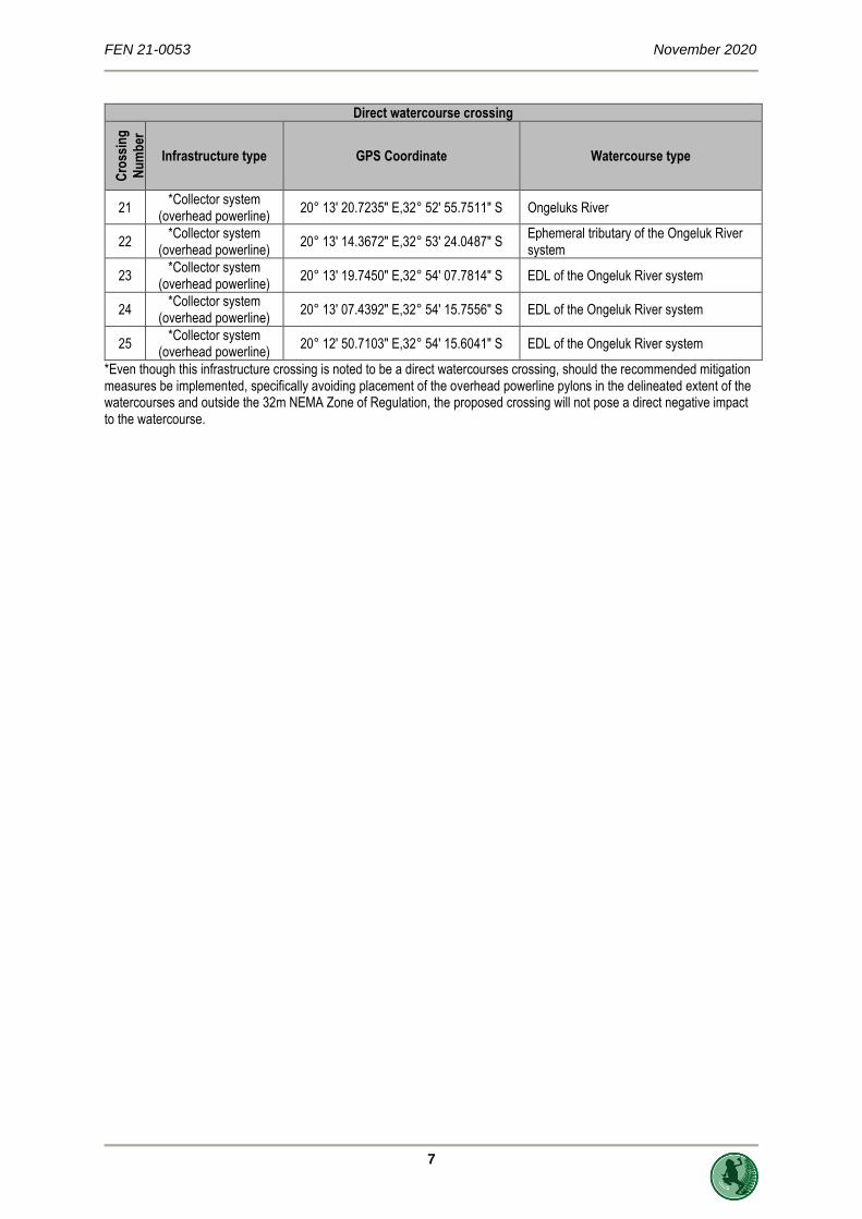
The following table provides the details of the infrastructure directly traversing watercourses (25 total
watercourse crossings). Portions of the proposed access road and collector system (both underground
cables and overhead powerlines) are located within the 32 m regulated zone of watercourses as it
relates to the National Environmental Management Act, 1998 (Act No. 107 of 1998), however no
turbines or associated crane pads are located in this regulated zone. Portions of the proposed access
road and collector system (both underground cables and overhead powerlines), the construction camp
and only Turbine 5 (and associated crane pad) is located in the 100 m regulated zone of a watercourse
in accordance with Government Notice 509 as published in the Government Gazette 40229 of 2016 as
it relates to the National Water Act, 1998 (Act No. 36 of 1998) (NWA) (refer to Section 5 more details
pertaining to the regulated zones). Due to the scale of the maps presented in Figure 3 to 8, the crossing
points as listed below is not presented specifically on the maps.
Table 1: Details of the Oya WEF infrastructure directly traversing watercourses.
Direct watercourse crossing
Cro
ssin
g
Nu
mb
er
Infrastructure type GPS Coordinate Watercourse type
1 Access Road 20° 21' 44.7500" E,32° 46' 38.3000" S Ephemeral tributary of the Windheuwels River system.
2 Access Road 20° 21' 37.8932" E,32° 46' 52.6746" S Ephemeral tributary of the Windheuwels River system.
3 Access Road 20° 21' 21.0183" E,32° 48' 02.2949" S EDL of the Windheuwels River system.
4 Access Road 20° 21' 20.2705" E,32° 48' 15.5304" S EDL of the Windheuwels River system.
5 Access Road 20° 21' 28.6850" E,32° 48' 35.7565" S EDL of the Windheuwels River system.
6 Access Road 20° 21' 39.9911" E,32° 49' 47.8165" S EDL of the Windheuwels River system.
7 Access Road
Collector system (underground cabling)
20° 20' 34.4442" E,32° 50' 13.7634" S EDL of the Windheuwels River system.
8 Access Road 20° 15' 56.5055" E,32° 51' 59.0001" S EDL of the Jakkalshok River system
9 *Collector system
(overhead powerline) 20° 18' 43.5469" E,32° 52' 32.9241" S EDL of the Ongeluk River system
10 *Collector system
(overhead powerline) 20° 17' 48.2025" E,32° 53' 31.8805" S
Ephemeral tributary of the Ongeluk River system
11 *Collector system
(overhead powerline) 20° 17' 41.8398" E,32° 53' 36.2092" S Ongeluks River
12 *Collector system
(overhead powerline) 20° 17' 26.1014" E,32° 53' 37.2630" S EDL of the Ongeluk River system
13 *Collector system
(overhead powerline) 20° 16' 54.9127" E,32° 53' 32.6411" S EDL of the Ongeluk River system
14 *Collector system
(overhead powerline) 20° 16' 26.6533" E,32° 53' 28.7712" S EDL of the Ongeluk River system
15 *Collector system
(overhead powerline) 20° 16' 09.5814" E,32° 53' 26.6251" S EDL of the Ongeluk River system
16 *Collector system
(overhead powerline) 20° 15' 28.1160" E,32° 53' 21.4230" S EDL of the Ongeluk River system
17 *Collector system
(overhead powerline) 20° 14' 21.6895" E,32° 53' 23.3635" S
Ephemeral tributary of the Ongeluk River system
18 *Collector system
(overhead powerline) 20° 14' 07.4716" E,32° 53' 24.0620" S EDL of the Ongeluk River system
19 *Collector system
(overhead powerline) 20° 13' 39.8827" E,32° 53' 25.2515" S
Ephemeral tributary of the Ongeluk River system
20 *Collector system
(overhead powerline) 20° 13' 18.2952" E,32° 53' 29.4073" S
Ephemeral tributary of the Ongeluk River system
FEN 21-0053 November 2020
7
Direct watercourse crossing C
ross
ing
Nu
mb
er
Infrastructure type GPS Coordinate Watercourse type
21 *Collector system
(overhead powerline) 20° 13' 20.7235" E,32° 52' 55.7511" S Ongeluks River
22 *Collector system
(overhead powerline) 20° 13' 14.3672" E,32° 53' 24.0487" S
Ephemeral tributary of the Ongeluk River system
23 *Collector system
(overhead powerline) 20° 13' 19.7450" E,32° 54' 07.7814" S EDL of the Ongeluk River system
24 *Collector system
(overhead powerline) 20° 13' 07.4392" E,32° 54' 15.7556" S EDL of the Ongeluk River system
25 *Collector system
(overhead powerline) 20° 12' 50.7103" E,32° 54' 15.6041" S EDL of the Ongeluk River system
*Even though this infrastructure crossing is noted to be a direct watercourses crossing, should the recommended mitigation measures be implemented, specifically avoiding placement of the overhead powerline pylons in the delineated extent of the watercourses and outside the 32m NEMA Zone of Regulation, the proposed crossing will not pose a direct negative impact to the watercourse.
FEN 21-0053 November 2020
8
Figure 3: An overview map depicting the locality of the delineated watercourses associated with the proposed OyaWEF .

FEN 21-0053 November 2020
9
Figure 4: The locality of the delineated watercourses of the Windheuwels River system associated with the proposed access road and construction camp.

FEN 21-0053 November 2020
10
Figure 5: The locality of the delineated watercourses of the Kleinpoorts, Brak and Windheuwels River systems associated with the proposed internal roads,
turbines and crane pads.

FEN 21-0053 November 2020
11
Figure 6: The locality of the delineated watercourses of the Brak an Ongeluks River systems associated with the proposed internal roads, turbines and crane pads.

FEN 21-0053 November 2020
12
Figure 7: The locality of the delineated watercourses of the Jakkelshok and Ongeluks River systems associated with the proposed internal roads, turbines and crane pads.

FEN 21-0053 November 2020
13
Figure 8: The locality of the delineated watercourses of the Ongeluks River and Jakkalshok River systems associated with the proposed internal roads, turbines and crane pads.

FEN 21-0053 November 2020
14
5 LEGISLATIVE REQUIREMENTS AND SENSITIVITY
MAPPING
The following legislative requirements were considered during the assessment. A detailed description
of these legislative requirements is presented in Appendix B of this report:
➢ The Constitution of the Republic of South Africa, 19965;
➢ The National Environmental Management Act, 1998 (Act No. 107 of 1998) (NEMA);
➢ The National Water Act, 1998 (Act No. 36 of 1998) (NWA); and
➢ Government Notice 509 as published in the Government Gazette 40229 of 2016 as it relates
to the National Water Act, 1998 (Act No. 36 of 1998).
It is important to note that in terms of the definition of a watercourse as per the NWA (See Appendix
B), all of the natural watercourses associated with the proposed Oya WEF (including the ephemeral
rivers and tributaries with riparian vegetation and the episodic drainage lines with no riparian vegetation)
will be regulated by Section 21(c) and (i) of the NWA as well as the applicable zones of regulation. All
the natural watercourses will thus require further authorisation from the Department of Environment,
Forest and Fisheries (DEFF)) and the Department of Water and Sanitation (DWS). This report aids in
providing relevant information for these authorisation processes.
According to Macfarlane et al. (2015) the definition of a buffer zone is variable, depending on the
purpose of the buffer zone, however in summary, it is considered to be “a strip of land with a use,
function or zoning specifically designed to protect one area of land against impacts from another”. Buffer
zones are considered important to provide protection of basic ecosystem processes (in this case, the
protection of aquatic and wetland ecological services), reduce impacts on watercourses arising from
upstream activities (e.g. by removing or filtering sediment and pollutants), provision of habitat for aquatic
and wetland species as well as for certain terrestrial species, and a range of ancillary societal benefits
(Macfarlane et. al, 2015). It should be noted, however that buffer zones are not considered to be
effective mitigation against impacts such as hydrological changes arising from stream flow reduction,
impoundments or abstraction, nor are they considered to be effective in the management of point-
source discharges or contamination of groundwater, both of which require site-specific mitigation
measures (Macfarlane et. al, 2015).
The definition and motivation for a regulated zone of activity for the protection of the assessed
watercourses can be summarised in Table 2 that follows.
5 Since 1996, the Constitution has been amended by seventeen amendments acts. The Constitution is formally entitled the ‘Constitution of the Republic of South Africa, 19996”. It was previously also numbered as if it were an Act of Parliament – Act No. 108 of 1996 – but since the passage of the Citation of Constitutional Laws Act, neither it nor the acts amending it are allocated act numbers.

FEN 21-0053 November 2020
15
Table 2: Articles of Legislation and the relevant zones of regulation applicable to each article.
Regulatory authorisation required
Zone of applicability
Water Use License Application in terms of the National Water Act, 1998 (Act No. 36 of 1998). Department of Water and Sanitation (DWS)
Government Notice 509 as published in the Government Gazette 40229 of 2016 as it relates to the National Water Act, 1998 (Act No. 36 of 1998) In accordance with GN509 of 2016 as it relates to the National Water Act, 1998 (Act No. 36 of 1998), a regulated area of a watercourse in terms of water uses as listed in Section 21c and 21i is defined as:
• the outer edge of the 1 in 100-year flood line and/or delineated riparian habitat, whichever is the greatest distance, measured from the middle of the watercourse of a river, spring, natural channel, lake or dam;
• in the absence of a determined 1 in 100-year flood line or riparian area the area within 100 m from the edge of a watercourse where the edge of the watercourse is the first identifiable annual bank fill flood bench; or
• a 500m radius from the delineated boundary (extent) of any wetland or pan in terms of this regulation.
Listed activities in terms of the National Environmental Management Act, 1998 (Act No. 107 of 1998) EIA Regulations (2014), as amended. Department of Environment, Forestry and Fisheries
Activities of Listing Notice 1 (GN 327) of the National Environmental Management Act, 1998 (Act No.107 of 1998) EIA regulations, 2014 (as amended) Activity 12: The development of: (xii) Infrastructure or structures with a physical footprint of 100 square meters or more; Where such development occurs— a) Within a watercourse; b) In front of a development setback; or c) If no development setback has been adopted, within 32 meters of a watercourse,
measured from the edge of a watercourse. Activity 19:
The infilling or depositing of any material of more than 10 cubic metres into, or the dredging, excavation, removal or moving of soil, sand, shells, shell grit, pebbles or rock of more than 10 cubic metres from – (a) a watercourse
Activities of Listing Notice 3 (GN 985) of the National Environmental Management Act, 1998 (Act No.107 of 1998) EIA regulations, 2014 (as amended)
Activity 14: The development of – (ii) infrastructure or structures with a physical footprint of 10 square metres or more; Where such development occurs- a) Within a watercourse; b) In front of a development setback; or c) If no development setback has been adopted, within 32 meters of a watercourse,
measured from the edge of a watercourse Activity 23: The expansion of – (ii) infrastructure or structures with a physical footprint of 10 square metres or more; Where such development occurs- a) Within a watercourse; b) In front of a development setback; or c) If no development setback has been adopted, within 32 meters of a watercourse,
measured from the edge of a watercourse Activity 48: “The expansion of (i)infrastructure or structures where the physical footprint is expanded by 100 square metres or more;

FEN 21-0053 November 2020
16
Regulatory authorisation required
Zone of applicability
Where such expansion occurs- a) Within a watercourse; b) In front of a development setback; or c) If no development setback has been adopted, within 32 meters of a watercourse,
measured from the edge of a watercourse
A 32 m Zone of Regulation (ZoR) in accordance with the National Environmental Management Act,
1998 (Act No. 107 of 1998) and in the absence of a defined 1 in 100 year flood line, a 100 m Zone of
Regulation in accordance with Government Notice 509 as published in the Government Gazette 40229
of 2016 as it relates to the NWA were applied to the ephemeral river and tributaries with riparian
vegetation and the episodic drainage lines with no riparian vegetation associated with the proposed
Oya WEF (Figures 9 to 13). The 1:100 year floodline for the larger Ongeluks River and Windheuwels
Rivers has been modelled (NatureStamp, 2020). Thus, the modelled floodline for these specific reaches
of the watercourse were considered as part of this assessment. All surface infrastructure components
will be located outside the 1:100 year floodline of these specific watercourse reaches, however it is
acknowledged that linear infrastructures (overhead power line and road crossings) will be located below
or traversing through the 1:100 year floodline.
The following aspects must be considered for the required approvals and/or permits by the relevant
authorities:
➢ The watercourses are considered to be ‘no-go’ areas for building infrastructure components.
Linear infrastructure (such as roads and underground cables) should only be planned within
these areas if it is absolutely unavoidable to circumnavigate these watercourses. Considering
the topographical aspect of the project site, this not considered entirely feasible. Additionally,
no powerline pylons may be constructed in these watercourses;
➢ Infrastructure may be located within the 32 m regulated area of a watercourse as stipulated by
the National Environmental Management Act, 1998 (Act No. 107 of 1998) and 100 m GN 509
regulated area in accordance with Government Notice 509 as published in the Government
Gazette 40229 of 2016 as it relates to the NWA provided that the relevant authorisations are
obtained. Development within these areas could take place but should be avoided, if possible,
to avoid triggering Section 21 (c) and (i) water uses (exception for specified activities as per
Appendix D2 of GN 509 of 2016 as it relates to the National Water Act, 1998 (Act No. 36 of
1998)).
Based on the considerations provided above and the proposed Oya WEF layout, the following is
recommended:
➢ As part of the Part 2 EA Amendment Application to DEFF, all (additional) watercourse crossings
and infrastructure within 32 m of a watercourse must be authorised. Based on the outcome of
the risk assessment as presented by FEN Consulting (2020) the proposed WEF development
is not considered to be a fatal flaw and pose a Low risk significance. As such, it is the opinion
of the freshwater specialist that the proposed WEF development and its layout be authorised;
➢ Since proposed Oya WEF infrastructure components are located within the GN 509 regulated
zone of a watercourse as it relates to the National Water Act, 1998 (Act No. 36 of 1998), FEN
Consulting (2020) applied the DWS Risk Assessment to ascertain the potential risks the
proposed WEF development poses to the identified watercourses. The outcome of the DWS
Risk Assessment indicate that a Low risk significance is expected should the recommended
mitigation measures be applied. Water Use Authorisation (WUA) for the proposed Oya WEF is
required, however based on the outcome of the DWS Risk Assessment, WUA by means of
General Authorisation can be applied for.

FEN 21-0053 November 2020
17
Figure 9: The conceptual presentation of the zones of regulation in terms of GN509 of 2016 as it relates to the NWA and NEMA in relation to the
delineated watercourses that form part of the Windheuwels River system along the proposed access road and construction camp.

FEN 21-0045 November 2020
18
Figure 10: The conceptual presentation of the zones of regulation in terms of GN509 of 2016 as it relates to the NWA and NEMA in relation to the delineated watercourses that form part of the Kleinpoorts River system.

FEN 21-0045 November 2020
19
Figure 11: The conceptual presentation of the zones of regulation in terms of GN509 of 2016 as it relates to the NWA and NEMA in relation to the delineated watercourses that form part of the Brak River system.

FEN 21-0045 November 2020
20
Figure 12: The conceptual presentation of the zones of regulation in terms of GN509 of 2016 as it relates to the NWA and NEMA in relation to the delineated watercourses that form part of the Jakkelshok and Ongeluks River systems.

FEN 21-0045 November 2020
21
Figure 13: The conceptual presentation of the zones of regulation in terms of GN509 of 2016 as it relates to the NWA and NEMA in relation to the delineated watercourses that form part of the Jakkalshok and Ongeluks River systems.

FEN 21-0053 November 2020
22
Base on the layout of the proposed Oya WEF and considering the locality of the watercourses, in order
to limit the infrastructure components within the watercourses and the 32m NEMA and 100m GN509
zones of regulation, the table below presents recommended amendments the WEF layout. These
amendments are not considered critical for the protection of watercourses (as the risk assessment
determined a Low Risk significance for linear infrastructure within the watercourses), but are suggested
as best practice and to further reduce impacts on the receiving natural environment as a whole. It is
acknowledged that the recommended layout changes only considered watercourses and its associated
regulated zones, and that these layout changes may be limited by other ecological and socio-cultural
sensitivities or topographical constraints.

FEN 21-0053 November 2020
23
Table 3: Recommended layout changes
Infrastructure component
Issue Mitigation Measure Suggested locality (GPS Coordinate)
Construction camp
Located within the 100 m GN509 Zone of Regulation
• Locate construction camp outside the 100m GN 509 Zone of Regulation, by redesigning construction camp boundaries
• Apply stormwater mitigation measures as stipulated in the stormwater management and erosion control plan (NatureStamp, 2020)
Shift construction camp northern boundary approximately 170 m south and amend construction camp footprint.

FEN 21-0053 November 2020
24
Infrastructure component
Issue Mitigation Measure Suggested locality (GPS Coordinate)
Access road at crossing point 5
Access road traversing a watercourse at 32°48'35.76"S 20°21'28.69"E
Position access road outside the 32m NEMA Zone of Regulation, by shifting the road approximately 45m east.
32°48'35.59"S 20°21'30.49"E
Access road towards Turbine 20
Located within the 100 m GN509 Zone of Regulation at 32°49'56.09"S 20°21'30.81"E
Position access road outside the 100m GN 509 Zone of Regulation, by shifting road approximately 34 m south east.
32°49'56.83"S 20°21'31.73"E

FEN 21-0053 November 2020
25
Infrastructure component
Issue Mitigation Measure Suggested locality (GPS Coordinate)
Access road towards Turbine 20
Located within the 100 m GN509 Zone of Regulation at 32°49'53.08"S 20°21'44.08"E
Locate access road outside the 100m GN 509 Zone of Regulation, by shifting road turning circle east of Turbine 6 although it is clear that the biodiversity impact of this option is likely to be unacceptable.
32°49'53.84"S 20°22'6.51"E
Access road west of Turbine 19
Located within the 32 m NEMA Zone of Regulation at 32°50'3.21"S 20°21'9.37"E
Position access road outside the 32m NEMA and 100m GN 509 Zone of Regulation, by shifting the road approximately 77m south, although it is clear that the topography may not be suitable for this proposed amendment.
32°50'5.72"S 20°21'10.64"E
Access road and underground collector system at turbine 18
1. Located within the 100 m GN509 Zone of Regulation at 32°50'6.05"S 20°20'19.03"E
Position access road and underground collector system outside the 100m GN 509 Zone of Regulation, by shifting the access road and collector system approximately 41 m south east
32°50'6.92"S 20°20'20.62"E
2. Located within the delineated edge of an EDL. (crossing point 7) at 32°50'13.76"S 20°20'34.44"E
Position access road and underground collector system outside the watercourse 32m NEMA and 100m GN 509 Zone of Regulation, by shifting the road approximately 115m south west.
32°50'15.82"S 20°20'31.16"E

FEN 21-0053 November 2020
26
Access road and underground collector system at turbine 17
Located within the 100 m GN509 Zone of Regulation at 32°50'24.32"S 20°20'11.96"E
Position access road and underground collector system outside the 100m GN 509 Zone of Regulation, by shifting the access road and collector system approximately 66m east.
32°50'24.82"S 20°20'14.63"E
FEN 21-0053 November 2020
27
Infrastructure component
Issue Mitigation Measure Suggested locality (GPS Coordinate)
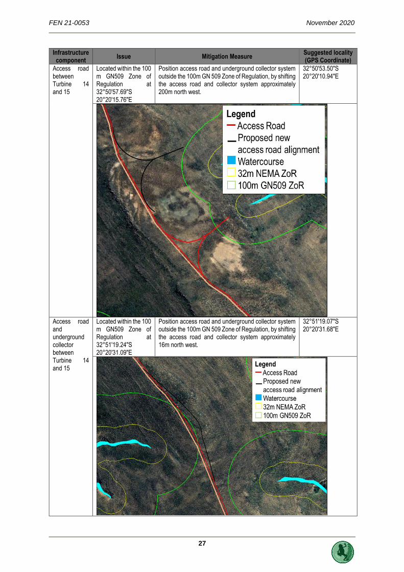
Access road between Turbine 14 and 15
Located within the 100 m GN509 Zone of Regulation at 32°50'57.69"S 20°20'15.76"E
Position access road and underground collector system outside the 100m GN 509 Zone of Regulation, by shifting the access road and collector system approximately 200m north west.
32°50'53.50"S 20°20'10.94"E
Access road and underground collector between Turbine 14 and 15
Located within the 100 m GN509 Zone of Regulation at 32°51'19.24"S 20°20'31.09"E
Position access road and underground collector system outside the 100m GN 509 Zone of Regulation, by shifting the access road and collector system approximately 16m north west.
32°51'19.07"S 20°20'31.68"E

FEN 21-0053 November 2020
28
Infrastructure component
Issue Mitigation Measure Suggested locality (GPS Coordinate)
Access road and underground collector at Turbine 13
Located within the 100 m GN509 Zone of Regulation at 32°51'32.49"S 20°19'53.07"E
Position access road and underground collector system outside the 100m GN 509 Zone of Regulation, by shifting the access road and collector system approximately 47m south east
32°51'33.42"S 20°19'54.48"E
Access road and underground collector between Turbine 10 and 11
Located within the 100 m GN509 Zone of Regulation at: 1. 32°51'53.67"S 20°18'42.44"E 2. 32°51'57.52"S 20°18'44.36"E
1. Position access road and underground collector system outside the 100m GN 509 Zone of Regulation, by shifting the access road and collector system approximately 27m north. 2. Position collector system outside the 100m GN 509 Zone of Regulation, by shifting collector system approximately 17m east.
1. 32°51'52.99"S 20°18'42.73"E 2. 32°51'57.86"S 20°18'45.01"E

FEN 21-0053 November 2020
29
Infrastructure component
Issue Mitigation Measure Suggested locality (GPS Coordinate)
Access road and underground collector at Turbine 10
Located within the 100 m GN509 Zone of Regulation at 32°51'45.90"S 20°18'2.95"E
Position access road and underground collector system outside the 100m GN 509 Zone of Regulation, by shifting the access road and collector system approximately 15m south.
32°51'46.33"S 20°18'2.74"E
Access road and underground collector at Turbine 10
Located within the 100 m GN509 Zone of Regulation at 32°51'41.30"S 20°17'45.94"E
Position access road and underground collector system outside the 100m GN 509 Zone of Regulation, by shifting the access road and collector system approximately 50m north.
32°51'40.26"S 20°17'47.21"E
FEN 21-0053 November 2020
30
Infrastructure component
Issue Mitigation Measure Suggested locality (GPS Coordinate)
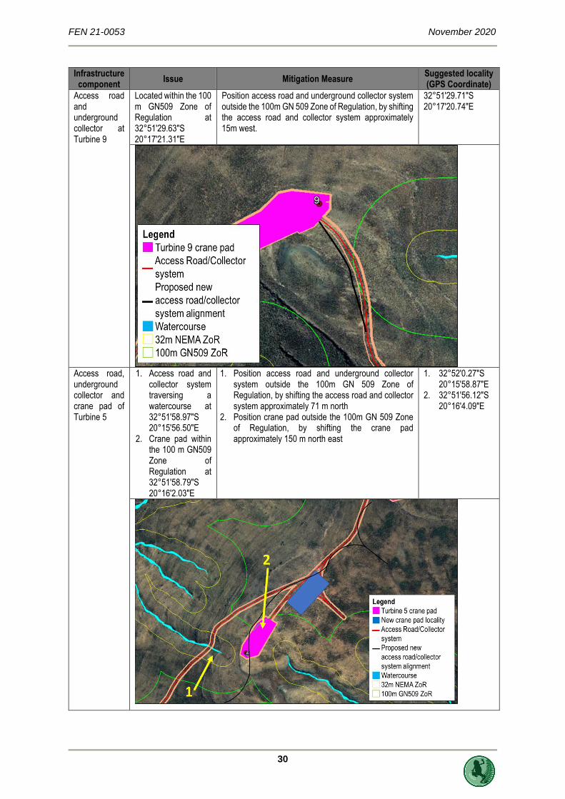
Access road and underground collector at Turbine 9
Located within the 100 m GN509 Zone of Regulation at 32°51'29.63"S 20°17'21.31"E
Position access road and underground collector system outside the 100m GN 509 Zone of Regulation, by shifting the access road and collector system approximately 15m west.
32°51'29.71"S 20°17'20.74"E
Access road, underground collector and crane pad of Turbine 5
1. Access road and collector system traversing a watercourse at 32°51'58.97"S 20°15'56.50"E
2. Crane pad within the 100 m GN509 Zone of Regulation at 32°51'58.79"S 20°16'2.03"E
1. Position access road and underground collector system outside the 100m GN 509 Zone of Regulation, by shifting the access road and collector system approximately 71 m north
2. Position crane pad outside the 100m GN 509 Zone of Regulation, by shifting the crane pad approximately 150 m north east
1. 32°52'0.27"S 20°15'58.87"E
2. 32°51'56.12"S 20°16'4.09"E

FEN 21-0053 November 2020
31
Infrastructure component
Issue Mitigation Measure Suggested locality (GPS Coordinate)
Access road and underground collector at Turbine 4
Located within the 100 m GN509 Zone of Regulation at 32°52'4.10"S 20°14'54.04"E
Locate access road and underground collector system outside the 100m GN 509 Zone of Regulation, by shifting the access road and collector system approximately 34m south east.
32°52'4.86"S 20°14'54.93"E
Access road and underground collector at Turbine 2
Located within the 100 m GN509 Zone of Regulation at 32°52'19.79"S 20°14'0.88"E
Position access road and underground collector system outside the 100m GN 509 Zone of Regulation, by shifting the access road and collector system approximately 20m south east.
32°52'20.00"S 20°14'1.53"E

FEN 21-0053 November 2020
32
6 IMPACT STATEMENT
Based on the proposed Oya WEF when compared to the original Kudusberg WEF project (as reported
upon in FEN Consulting, 2020) as summarised in Table 1, the proposed project split is not considered
to pose any change in impact/risk significance to the identified and assessed watercourses. As such,
no advantages or disadvantages (when considering the authorised specifications, versus the proposed
specifications – Table 1) can be identified from a freshwater ecological perspective. It is noted that the
proposed project split will entail application for authorisation for each WEF development separately,
however the specialist freshwater ecological assessment of FEN Consulting (2020) is considered
sufficient to inform this process, and no additional studies is considered to be required.
7 EMPr INPUT
The following table provides a summary of the mitigation measures as provided by FEN Consulting
(2020) for the proposed Oya WEF layout. These mitigation measures, as reported by FEN Consulting
(2020) are considered sufficient to mitigate any potential impacts that may arise from the proposed
WEF development. These mitigation measure must be included in the EMPr as part of the Part 2 EA
Amendment Application to DEFF.
FEN 21-0053 November 2020
33
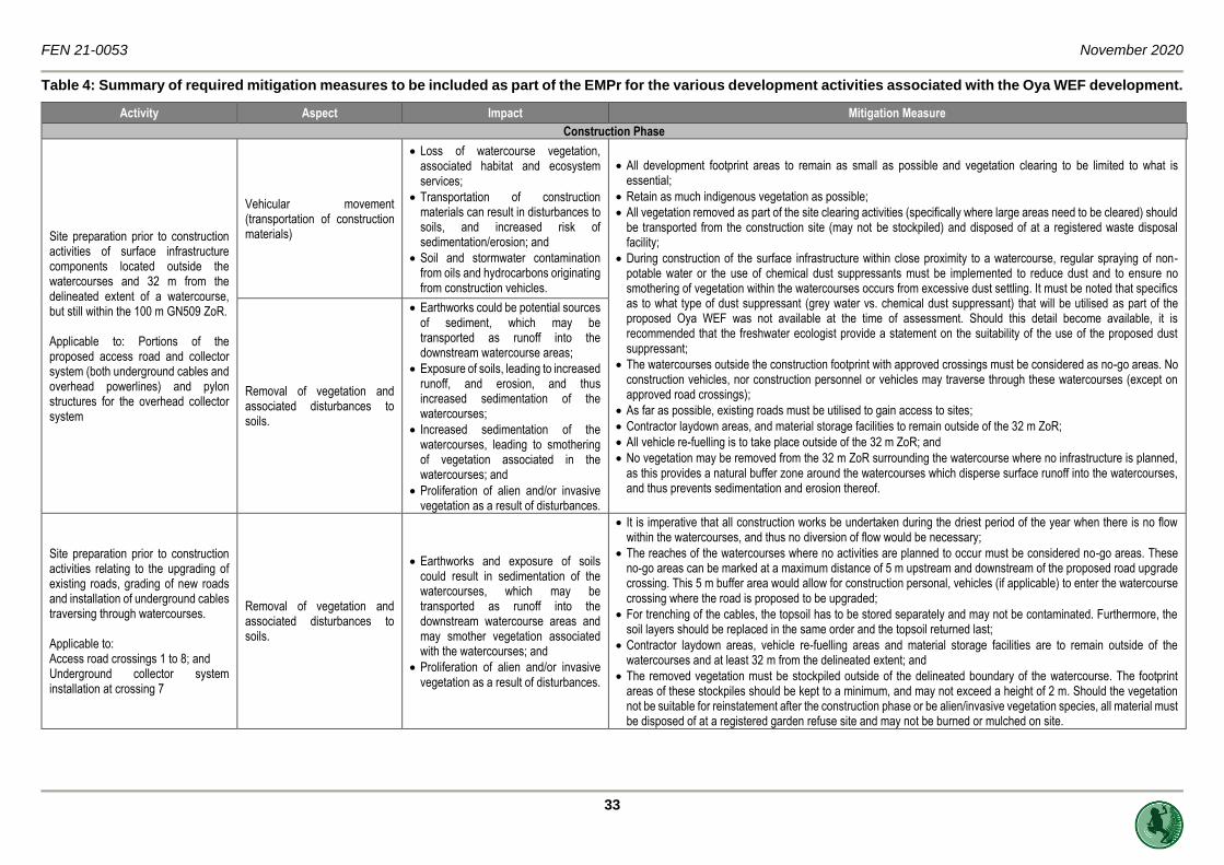
Table 4: Summary of required mitigation measures to be included as part of the EMPr for the various development activities associated with the Oya WEF development.
Activity Aspect Impact Mitigation Measure
Construction Phase
Site preparation prior to construction activities of surface infrastructure components located outside the watercourses and 32 m from the delineated extent of a watercourse, but still within the 100 m GN509 ZoR. Applicable to: Portions of the proposed access road and collector system (both underground cables and overhead powerlines) and pylon structures for the overhead collector system
Vehicular movement (transportation of construction materials)
• Loss of watercourse vegetation, associated habitat and ecosystem services;
• Transportation of construction materials can result in disturbances to soils, and increased risk of sedimentation/erosion; and
• Soil and stormwater contamination from oils and hydrocarbons originating from construction vehicles.
• All development footprint areas to remain as small as possible and vegetation clearing to be limited to what is essential;
• Retain as much indigenous vegetation as possible;
• All vegetation removed as part of the site clearing activities (specifically where large areas need to be cleared) should be transported from the construction site (may not be stockpiled) and disposed of at a registered waste disposal facility;
• During construction of the surface infrastructure within close proximity to a watercourse, regular spraying of non-potable water or the use of chemical dust suppressants must be implemented to reduce dust and to ensure no smothering of vegetation within the watercourses occurs from excessive dust settling. It must be noted that specifics as to what type of dust suppressant (grey water vs. chemical dust suppressant) that will be utilised as part of the proposed Oya WEF was not available at the time of assessment. Should this detail become available, it is recommended that the freshwater ecologist provide a statement on the suitability of the use of the proposed dust suppressant;
• The watercourses outside the construction footprint with approved crossings must be considered as no-go areas. No construction vehicles, nor construction personnel or vehicles may traverse through these watercourses (except on approved road crossings);
• As far as possible, existing roads must be utilised to gain access to sites;
• Contractor laydown areas, and material storage facilities to remain outside of the 32 m ZoR;
• All vehicle re-fuelling is to take place outside of the 32 m ZoR; and
• No vegetation may be removed from the 32 m ZoR surrounding the watercourse where no infrastructure is planned, as this provides a natural buffer zone around the watercourses which disperse surface runoff into the watercourses, and thus prevents sedimentation and erosion thereof.
Removal of vegetation and associated disturbances to soils.
• Earthworks could be potential sources of sediment, which may be transported as runoff into the downstream watercourse areas;
• Exposure of soils, leading to increased runoff, and erosion, and thus increased sedimentation of the watercourses;
• Increased sedimentation of the watercourses, leading to smothering of vegetation associated in the watercourses; and
• Proliferation of alien and/or invasive vegetation as a result of disturbances.
Site preparation prior to construction activities relating to the upgrading of existing roads, grading of new roads and installation of underground cables traversing through watercourses. Applicable to: Access road crossings 1 to 8; and Underground collector system installation at crossing 7
Removal of vegetation and associated disturbances to soils.
• Earthworks and exposure of soils could result in sedimentation of the watercourses, which may be transported as runoff into the downstream watercourse areas and may smother vegetation associated with the watercourses; and
• Proliferation of alien and/or invasive vegetation as a result of disturbances.
• It is imperative that all construction works be undertaken during the driest period of the year when there is no flow within the watercourses, and thus no diversion of flow would be necessary;
• The reaches of the watercourses where no activities are planned to occur must be considered no-go areas. These no-go areas can be marked at a maximum distance of 5 m upstream and downstream of the proposed road upgrade crossing. This 5 m buffer area would allow for construction personal, vehicles (if applicable) to enter the watercourse crossing where the road is proposed to be upgraded;
• For trenching of the cables, the topsoil has to be stored separately and may not be contaminated. Furthermore, the soil layers should be replaced in the same order and the topsoil returned last;
• Contractor laydown areas, vehicle re-fuelling areas and material storage facilities are to remain outside of the watercourses and at least 32 m from the delineated extent; and
• The removed vegetation must be stockpiled outside of the delineated boundary of the watercourse. The footprint areas of these stockpiles should be kept to a minimum, and may not exceed a height of 2 m. Should the vegetation not be suitable for reinstatement after the construction phase or be alien/invasive vegetation species, all material must be disposed of at a registered garden refuse site and may not be burned or mulched on site.

FEN 21-0045 November 2020
34
Activity Aspect Impact Mitigation Measure
Construction of surface infrastructure outside of the watercourses and 32 m from the delineated extent of a watercourse, but still within the 100 m GN509 ZoR. Applicable to the construction camp located 32 m east of a watercourse and pylon structures for the overhead collector system
• Removal of vegetation and topsoil and associated stockpiling;
• Ground-breaking and earthworks relating to foundations and trenches;
• Mixing and casting of concrete for construction purposes;
• Backfilling of excavated and disturbed areas; and
• Miscellaneous activities by construction personnel.
• Disturbances of soils leading to increased alien vegetation proliferation within the terrestrial buffer zone surrounding the watercourses, with the potential to affect the watercourse habitat;
• Altered runoff patterns within the local catchment of the watercourses, potentially leading to increased erosion and sedimentation of the watercourses;
• Potential impacts on the water quality of surface water runoff (when present) which may potentially enter the watercourses and contamination of soils due to concrete casting; and
• Potential of backfill material entering the watercourses, increasing the sediment loads therein.
With regards to ground-breaking activities at least 32 m from the delineated extent of a watercourse, but within the 100 m GN509 ZoR:
• During excavation activities, the topsoil and vegetation should be stockpiled separately from other material outside of the 32 m NEMA ZoR;
• Excavated materials should not be contaminated, and it should be ensured that the minimum surface area is taken up by any stockpiled materials. The mixture of the lower and upper layers of the excavated soil should be kept to a minimum, so as for later use as backfill material after construction has commenced;
• All exposed soils must be protected from wind using tarpaulins for the duration of the construction phase to prevent potential erosion and sedimentation of the watercourses;
• Suitable drainage should be insured along the crane pads, in order to ensure that water does not pond on the crane pad or drain in a concentrated manner into the watercourses. This must be considered as part of the stormwater management plan and be overseen by a freshwater ecologist;
• Construction of the proposed surface infrastructure may result in disturbance to the natural buffer zone surrounding the watercourses which may result in the reduction of surface roughness. This can be mitigated by ensuring that no concentrated runoff from the surface infrastructure construction areas enter the watercourses by installing silt traps or placing haybales down gradient of the construction footprint (until suitable basal vegetation cover has been restored) to ensure no sediment laden or concentrated runoff generates from the construction footprint; and
• It is highly recommended that an alien vegetation management plan be compiled during the planning phase and implemented concurrently with the commencement of construction.
With regards to concrete mixing on site:
• No mixed concrete may be deposited outside of the designated construction footprint;
• Protective equipment should be provided, onto which any mixed concrete can be deposited while it awaits placing; and
• Concrete spilt outside of the demarcated area must be promptly removed and taken to a suitably licensed waste disposal site.
With regards to backfilling of excavated areas:
• Stockpiled material should be used as backfill material;
• All excavated areas should be backfilled to the natural ground level with excavated material; and
• Soil must be suitably compacted, and all construction material must be removed from the site upon the completion of construction or used in the rehabilitation process.
Rehabilitation of the construction footprint areas:
• All footprint areas which have been compacted should be ripped and revegetated within indigenous vegetation as soon as the construction activities have been completed. This will prevent soil erosion and the creation of gullies within the operational area; and
• The operational area should regularly be inspected for alien and invasive vegetation species which might have established due to the construction activity related disturbances.

FEN 21-0045 November 2020
35
Activity Aspect Impact Mitigation Measure
Upgrading of existing road crossings and trenching through the watercourses.
• Compaction of soil in the existing road crossing footprint to increase the width of the roads; and
• Importation of materials to construct the roads.
• Earthworks could be potential sources of sediment, which may be transported as runoff into the downstream reach of the watercourse; and
• Proliferation of alien and/or invasive vegetation as a result of disturbances.
• During the upgrading of existing internal roads and associate cable installation that may potentially traverse watercourses, a buffer of no more than 5 m on either side of the road crossing footprint through the watercourses may be impacted. This area must be cordoned off, and no vehicles or personnel are permitted outside of the authorised construction area;
• Material to be used (gravel – if applicable) as part of the upgrading of the existing roads must be stockpiled outside the 32 m NEMA ZoR of the watercourses to prevent sedimentation thereof and to avoid any other vegetation being impacted by the construction activities. These stockpiles may not exceed a height of 2 m and should be protected from wind using tarpaulins;
• Any remaining soils following the completion of backfilling of the trenches are to be spread out thinly in an area within the watercourses to aid in the natural reclamation process;
• After upgrading of roads traversing watercourses, the area surrounding the road must be revegetated with suitable indigenous vegetation to prevent the establishment of alien vegetation species and to prevent erosion from occurring;
• It is highly recommended that an alien vegetation management plan be compiled during the planning phase and implemented concurrently with the commencement of construction; and
• All existing alien and invasive vegetation should be removed. All material must be disposed of at a registered garden refuse site and may not be burned or mulched on site.
Construction of new road crossings and trenches through watercourses Applicable to: Access road crossings 1 to 8; and Underground collector system installation at crossing 7
• Removal of vegetation and topsoil and associated stockpiling;
• Ground-breaking and earthworks relating to foundations and trenches;
• Compaction of soil in the road crossing footprint area;
• Importation of materials to construct the roads;
• Backfilling of excavated and disturbed areas; and
• Miscellaneous activities by construction personnel.
• Disturbances of soils leading to increased alien vegetation proliferation within the watercourses, thus impacting on the watercourse habitat;
• Altered runoff patterns within the watercourses, potentially leading to increased erosion and sedimentation of the watercourses; and
• Potential of imported materials to entering the watercourses, increasing the sediment loads therein.
• The design of the new road crossings should ensure that no erosion occurs, specifically along the embankments of the watercourse. As such, vegetation must be established in the construction footprint immediately after the construction of the road/ installation of cables is complete;
• New road crossings must intersect the watercourse at a right angle (perpendicular) to minimise disturbance to the watercourse;
• No road crossing designs were available at the time of this assessment. However, it is strongly advised that suitably sized culverts be installed within all road crossings and vehicles should not be allowed to cross within the riverbed. This will ensure hydrological connectivity is maintained and no hydrocarbons are not washed into the downstream watercourses from potential vehicle spills. Should road crossing designs become available, it is advised that it be revised by a freshwater ecologist;
• During the construction of roads and associate cable installation that may potentially traverse watercourses, a buffer of no more than 5 m on either side of the proposed road crossing footprint through the watercourses may be impacted. This area must be cordoned off, and no vehicles or personnel are permitted outside of the authorised construction area;
• Soils excavated from the cable trench must be stockpiled immediately upstream of the trench. Once the cable is installed the trench must be infilled with the removed material and suitably compacted to avoid any erosion and preferential flow paths from forming; and
• Any remaining soils following the completion of backfilling of the trenches are to be spread out thinly in an area within the watercourses to aid in the natural reclamation process.

FEN 21-0045 November 2020
36
Activity Aspect Impact Mitigation Measure
Operational Phase
Operation and maintenance of the surface infrastructure outside the 32 m from the delineated extent of a watercourse, but still within the 100 m GN509 ZoR. Applicable to watercourse road crossings, pylon localities and the construction camp.
• Potential indiscriminate movement of maintenance vehicles within the watercourses or within close proximity to the watercourses; and
• Increased risk of sedimentation and/or hydrocarbons entering the watercourses via stormwater runoff from the surface infrastructure (such as from crane pads and the construction camp)
• Disturbance to soils and ongoing erosion as a result of periodic maintenance activities; and
• Altered water quality (if surface water is present) as a result of increased availability of pollutants.
• No indiscriminate movement of construction equipment through the watercourses may be permitted during standard operational activities or maintenance activities. Use must be made of the existing watercourse crossings only;
• Unnecessary disturbances surrounding the perimeter of the surface infrastructure must be avoided;
• Vehicles used in the development site must be regularly washed (on a non-permeable surface or off-site) to avoid the dispersal of seeds on any alien or invasive species into the watercourses;
• Ensure that routine inspections and monitoring of any instream infrastructure are undertaken to monitor any build-up of debris that will impact on structure integrity or lead to erosion and sedimentation. Furthermore, monitoring to determine the establishment of indigenous vegetation and the presence of any alien or invasive plant species;
• The surface infrastructure areas must be inspected to ensure that no concentrated runoff from these areas form erosion gullies leading to erosion and sedimentation of receiving watercourses. Should these impacts be noted, these gullies/preferential flow paths must be infilled with in situ material and appropriately stabilised and/or revegetated; and
• Monitoring for the establishment for alien and invasive vegetation species must be undertaken, specifically at the road crossings and surface infrastructures. Should alien and invasive plant species be identified, they must be removed and disposed of as per an alien and invasive species control plan and the area must be revegetated with suitable indigenous vegetation.
Operation and maintenance of roads (new and existing) traversing watercourses. Applicable to: Access road crossings 1 to 8
• Concentrated runoff entering the watercourses; and
• Disturbance to the vegetation within and surrounding the watercourses.
• Concentrated runoff from the road crossings leading to erosion and subsequent sedimentation of the watercourses (increase in the sediment load) and turbulent flows when surface water is present;
• Higher flood peaks into the watercourses due to reduced surface roughness in the watercourses.
• Routine maintenance of the roads must be undertaken to ensure that no concentration of flow and subsequent erosion occurs due to the road crossings/instream infrastructure. Such maintenance activities must specifically be undertaken after high rainfall events;
• Stormwater runoff from the road crossings should be monitored (by the Operation and Maintenance (O&M) Manager), to ensure it does not result in erosion of the watercourses. Stormwater should be allowed to diffusely spread across the landscape, by ensuring adequate surface roughness in the watercourse (through vegetation and rocky areas);
• Maintenance vehicles must make use of dedicated access roads and no indiscriminate movement in the watercourses may be permitted;
• During periodic maintenance activities of the roads/surface infrastructure, monitoring for erosion should be undertaken; and
• Should erosion be observed, caused by the road crossings/instream infrastructure, the area must be rehabilitated by infilling the erosion gully and revegetation thereof with suitable indigenous vegetation. Use can also be made of rocks collected from the surrounding area to infill any area prone to erosion, as a natural dispersal mechanism.
Decommissioning Phase
Removal of all surface infrastructure from the project area.
• Movement of construction vehicles and personnel; and
• Disturbance to the buffer zone surrounding the watercourses.
• Disturbance of soil and vegetation that established within the operational area.
• No indiscriminate movement of construction equipment in the watercourses and buffer zones surrounding the watercourses may be permitted. Use must be made of the existing roads during the decommissioning phase;
• All surface infrastructure must be decommissioned. All materials must be removed from the watercourses (where applicable) and may temporarily be stockpiled outside the 32 m NEMA ZoR, where after is must be removed from site and disposed of at a registered disposal facility;
• High flood peaks from the decommissioning footprint areas can be mitigated by ensuring that no concentrated runoff from the surface infrastructure area and subsequent cleared area enters the watercourses. The velocity of surface water flow from these areas must be reduced by ensuring that the vegetation in the buffer area surrounding the watercourses are intact or by the strategic placement of silt traps of haybales as a means to obstruct flow but still allow flow to percolate at a reduced velocity and encourages a diffuse flow pattern. In this regard it is recommended

FEN 21-0045 November 2020
37
Activity Aspect Impact Mitigation Measure
at an alien and invasive plant species management plan be implemented during the construction and operational phases to specifically prevent the spread of any such species into the sensitive ecological areas;
• Areas where surface infrastructure have been decommissioned and removed must be suitably compacted/ripped and revegetated to ensure that no erosion occurs which may contribute to the sediment load of the watercourses;
• Should erosion gullies be noted, these areas must be rehabilitated by infilling them with suitable soil and ensuring the area is vegetated. The increased surface roughness will discourage concentrated flow paths to develop and ensure diffuse flow patterns;
• Should road crossings be decommissioned, road footprint areas within the watercourse must be levelled to the same level and shape as that of the upstream and downstream reaches. This will ensure a continuous bed level and prevent any concentration of surface flow from occurring;
• Watercourse embankments must be suitably rehabilitated (shaped end revegetated) to prevent any erosion from occurring;
• All bare areas in the project area, specifically where vegetation was initially cleared for surface infrastructure components) must be ripped and be revegetated within suitable indigenous vegetation species;
• Follow up revegetation should take place in areas where initial revegetation is not successful;
• It is recommended that a Watercourse Rehabilitation and Management Plan must be compiled and implemented. Implementation must be overseen by a suitably qualified Environmental Site Officer (ESO) and the ESO must sign off the rehabilitation before the relevant contractors leave site; and
• Post-closure monitoring of the watercourses (for a period of 3 years), with specific mention of the invasion of alien vegetation species) is recommended to be undertaken.

FEN 21-0053 November 2020
38
8 CONCLUSION
Based on the findings site walk down undertaken in October 2020 which focused on identifying any
watercourses that may be directly traversed by the proposed infrastructure of the proposed Oya WEF,
twenty five (25) direct watercourse crossings were identified. Eight (8) of these crossings is attributed to
access road crossings and the remainder to overhead powerline crossings. Provided the recommended
mitigation measure be applied, the proposed Oya WEF layout is considered acceptable from a
freshwater ecological perspective and should be granted EA. It is noted that the proposed project split
will entail application for authorisation for each WEF development separately, however the specialist
freshwater ecological assessment of FEN Consulting (2020) is considered sufficient to inform this
process, and no additional studies is considered to be required.
9 REFERENCES
BlueScience. 2018. Freshwater Specialist Study: Basic Assessment for the proposed development of
the 325 MW Kudusberg Wind Energy Facility and associated infrastructure, between Matjiesfontein
and Sutherland in the Western and Northern Cape Provinces.
Department of Water Affairs and Forestry 2008 Updated Manual for the Identification and Delineation
of Wetlands and Riparian Areas. Report no. X. Stream Flow Reduction Activities, Department of
Water Affairs and Forestry, Pretoria, South Africa.
Department of Water Affairs, 1999. South Africa Version 1.0 of Resource Directed Measures for
Protection of Water Resources [Appendix W3].
FEN Consulting. 2020. Freshwater Ecological Assessment as part of the water use authorisation
process for the proposed 325 Mw Kudusberg Wind Energy Facility (WEF) And Associated
Infrastructure Between Sutherland And Matjiesfontein In the Western and Northern Cape
Provinces.
Job, N. 2009. Application of the Department of Water Affairs and Forestry (DWAF) wetland delineation
method to wetland soils of the Western Cape.
The South African National Biodiversity Institute - Biodiversity GIS (BGIS) [online]. Retrieved
2015/04/10 URL: http://bgis.sanbi.org.

FEN 21-0053 November 2020
39
APPENDIX A: Indemnity and Terms of Use of this Report
The findings, results, observations, conclusions and recommendations given in this report are based on the author’s best scientific and professional knowledge as well as available information. The report is based on survey and assessment techniques which are limited by time and budgetary constraints relevant to the type and level of investigation undertaken and FEN CC and its staff reserve the right to modify aspects of the report including the recommendations if and when new information may become available from ongoing research or further work in this field or pertaining to this investigation.
Although FEN CC exercises due care and diligence in rendering services and preparing documents, FEN CC accepts no liability and the client, by receiving this document, indemnifies FEN CC and its directors, managers, agents and employees against all actions, claims, demands, losses, liabilities, costs, damages and expenses arising from or in connection with services rendered, directly or indirectly by FEN CC and by the use of the information contained in this document.
This report must not be altered or added to without the prior written consent of the author. This also refers to electronic copies of this report which are supplied for the purposes of inclusion as part of other reports, including main reports. Similarly, any recommendations, statements or conclusions drawn from or based on this report must make reference to this report. If these form part of a main report relating to this investigation or report, this report must be included in its entirety as an appendix or separate section to the main report.

FEN 21-0053 November 2020
40
APPENDIX B: Legislative Requirements
The Constitution of the Republic of South Africa,
19966
The environment and the health and well-being of people are safeguarded under the Constitution of the Republic of South Africa, 1996 by way of section 24. Section 24(a) guarantees a right to an environment that is not harmful to human health or well-being and to environmental protection for the benefit of present and future generations. Section 24(b) directs the state to take reasonable legislative and other measures to prevent pollution, promote conservation, and secure the ecologically sustainable development and use of natural resources (including water and mineral resources) while promoting justifiable economic and social development. Section 27 guarantees every person the right of access to sufficient water, and the state is obliged to take reasonable legislative and other measures within its available resources to achieve the progressive normalization of this right. Section 27 is defined as a socio-economic right and not an environmental right. However, read with section 24 it requires of the state to ensure that water is conserved and protected and that sufficient access to the resource is provided. Water regulation in South Africa places a great emphasis on protecting the resource and on providing access to water for everyone.
National Environmental Management Act, 1998 (Act No. 107 of 1998)
The National Environmental Management Act, 1998 (Act No. 107 of 1998) and the associated Regulations as amended in 2017, states that prior to any development taking place within a wetland or riparian area, an environmental authorisation process needs to be followed. This could follow either the Basic Assessment Report (BAR) process or the Environmental Impact Assessment (EIA) process depending on the scale of the impact. Provincial regulations must also be considered.
The National Environmental Management: Biodiversity Act, 2004 (Act No. 10 of 2004)
The objectives of this act are (within the framework of the National Environmental Management Act) to provide for: ➢ the management and conservation of biological diversity within the Republic of South Africa and of the
components of such diversity; ➢ the use of indigenous biological resources in a sustainable manner; ➢ the fair and equitable sharing among stakeholders of benefits arising from bio prospecting involving
indigenous biological resources; ➢ to give effect to ‘ratified international agreements’ relating to biodiversity which are binding to the Republic; ➢ to provide for co-operative governance in biodiversity management and conservation; and ➢ to provide for a South African National Biodiversity Institute to assist in achieving the objectives of this Act. This act alludes to the fact that management of biodiversity must take place to ensure that the biodiversity of surrounding areas is not negatively impacted upon, by any activity being undertaken, in order to ensure the fair and equitable sharing among stakeholders of benefits arising from indigenous biological resources. Furthermore, a person may not carry out a restricted activity involving either: a) a specimen of a listed threatened or protected species; b) specimen of an alien species; or c) a specimen of a listed invasive species without a permit. Permits for the above may only be issued after an assessment of risks and potential impacts on biodiversity is carried out. Before issuing a permit, the issuing authority may in writing require the applicant to furnish it, at the applicant’s expense, with such independent risk assessment or expert evidence as the issuing authority may determine. The Minister may also prohibit the carrying out of any activity, which may negatively impact on the survival of a listed threatened or protected species or prohibit the carrying out of such activity without a permit. Provision is made for appeals against the decision to issue/refuse/cancel a permit or conditions thereof.
National Environmental Management: Biodiversity Act, 2004 (Act No. 10 of 2004) (Alien and Invasive Species Regulations, 2014)
NEMBA is administered by the Department of Environmental Affairs and aims to provide for the management and conservation of South Africa’s biodiversity within the framework of the NEMA. In terms of alien and invasive species. This act in terms of alien and invasive species aim to: ➢ Prevent the unauthorized introduction and spread of alien and invasive species to ecosystems and habitats
where they do not naturally occur, ➢ Manage and control alien and invasive species, to prevent or minimize harm to the environment and
biodiversity; and ➢ Eradicate alien species and invasive species from ecosystems and habitats where they may harm such
ecosystems or habitats. Alien species are defined, in terms of the National Environmental Management: Biodiversity Act, 2004 (Act No. 10 of 2004) as: (a) a species that is not an indigenous species; or
6 Since 1996, the Constitution has been amended by seventeen amendments acts. The Constitution is formally entitled the ‘Constitution of the Republic of South Africa, 19996”. It was previously also numbered as if it were an Act of Parliament – Act No. 108 of 1996 – but since the passage of the Citation of Constitutional Laws Act, neither it nor the acts amending it are allocated act numbers.
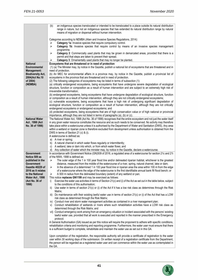
FEN 21-0053 November 2020
41
(b) an indigenous species translocated or intended to be translocated to a place outside its natural distribution range in nature, but not an indigenous species that has extended its natural distribution range by natural means of migration or dispersal without human intervention.
Categories according to NEMBA (Alien and Invasive Species Regulations, 2014): ➢ Category 1a: Invasive species that require compulsory control. ➢ Category 1b: Invasive species that require control by means of an invasive species management
programme. ➢ Category 2: Commercially used plants that may be grown in demarcated areas, provided that there is a
permit and that steps are taken to prevent their spread. ➢ Category 3: Ornamentally used plants that may no longer be planted.
National Environmental Management: Biodiversity Act, 2004(Act No.10 of 2004) (NEMBA)
Ecosystems that are threatened or in need of protection (1) (a) The Minister may, by notice in the Gazette, publish a national list of ecosystems that are threatened and in need of protection. (b) An MEC for environmental affairs in a province may, by notice in the Gazette, publish a provincial list of ecosystems in the province that are threatened and in need of protection. (2) The following categories of ecosystems may be listed in terms of subsection (1): (a) critically endangered ecosystems, being ecosystems that have undergone severe degradation of ecological structure, function or composition as a result of human intervention and are subject to an extremely high risk of irreversible transformation; (b) endangered ecosystems, being ecosystems that have undergone degradation of ecological structure, function or composition as a result of human intervention, although they are not critically endangered ecosystems; (c) vulnerable ecosystems, being ecosystems that have a high risk of undergoing significant degradation of ecological structure, function or composition as a result of human intervention, although they are not critically endangered ecosystems or endangered ecosystems; and (d) protected ecosystems, being ecosystems that are of high conservation value or of high national or provincial importance, although they are not listed in terms of paragraphs (a), (b) or (c).
National Water Act , 1998 (Act No. 36 of 1998)
The National Water Act, 1998 (Act No. 36 of 1998) recognises that the entire ecosystem and not just the water itself in any given water resource constitutes the resource and as such needs to be conserved. No activity may therefore take place within a watercourse unless it is authorised by the Department of Water and Sanitation (DWS). Any area within a wetland or riparian zone is therefore excluded from development unless authorisation is obtained from the DWS in terms of Section 21 (c) & (i). A watercourse is defined as: a) A river or spring; b) A natural channel in which water flows regularly or intermittently; c) A wetland, lake or dam into which, or from which water flows; and d) Any collection of water which the minister may, by notice in the Gazette, declare a watercourse.
Government Notice 509 as published in the Government Gazette 40229 of 2016 as it relates to the National Water Act , 1998 (Act No. 36 of 1998)
In accordance with Government Notice (GN)509 of 2016, a regulated area of a watercourse for section 21c and 21i of the NWA, 1998 is defined as: ➢ The outer edge of the 1 in 100 year flood line and/or delineated riparian habitat, whichever is the greatest
distance, measured from the middle of the watercourse of a river, spring, natural channel, lake or dam; ➢ In the absence of a determined 1 in 100 year flood line or riparian area the area within 100 m from the edge
of a watercourse where the edge of the watercourse is the first identifiable annual bank fill flood bench; or ➢ A 500 m radius from the delineated boundary (extent) of any wetland or pan. This notice replaces GN1199 and may be exercised as follows: i) Exercise the water use activities in terms of Section 21(c) and (i) of the Act as set out in the table below, subject
to the conditions of this authorisation; ii) Use water in terms of section 21(c) or (i) of the Act if it has a low risk class as determines through the Risk
Matrix; iii) Do maintenance with their existing lawful water use in terms of section 21(c) or (i) of the Act that has a LOW
risk class as determined through the Risk Matrix; iv) Conduct river and storm water management activities as contained in a river management plan; v) Conduct rehabilitation of wetlands or rivers where such rehabilitation activities have a LOW risk class as
determined through the Risk Matrix; and vi) Conduct emergency work arising from an emergency situation or incident associated with the persons’ existing
lawful water use, provided that all work is executed and reported in the manner prescribed in the Emergency protocol.
A General Authorisation (GA) issued as per this notice will require the proponent to adhere with specific conditions, rehabilitation criteria and monitoring and reporting programme. Furthermore, the water user must ensure that there is a sufficient budget to complete, rehabilitate and maintain the water use as set out in this GA. Upon completion of the registration, the responsible authority will provide a certificate of registration to the water user within 30 working days of the submission. On written receipt of a registration certificate from the Department, the person will be regarded as a registered water user and can commence within the water use as contemplated in the GA.
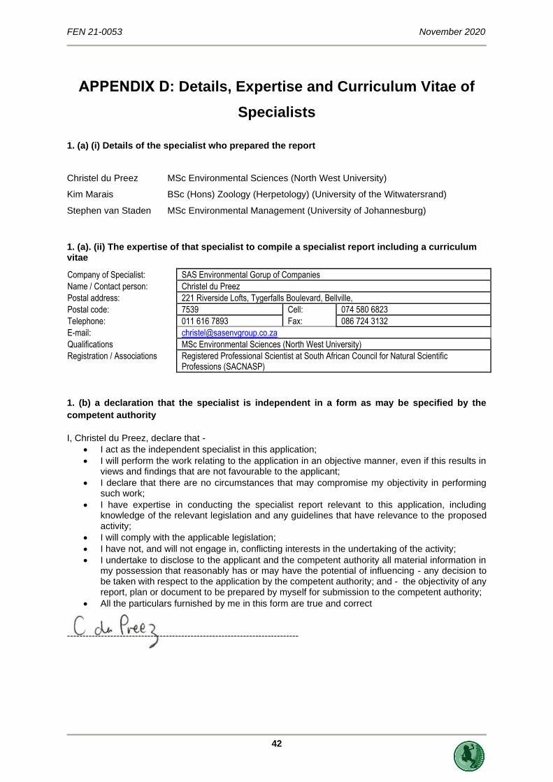
FEN 21-0053 November 2020
42
APPENDIX D: Details, Expertise and Curriculum Vitae of
Specialists
1. (a) (i) Details of the specialist who prepared the report
Christel du Preez MSc Environmental Sciences (North West University)
Kim Marais BSc (Hons) Zoology (Herpetology) (University of the Witwatersrand)
Stephen van Staden MSc Environmental Management (University of Johannesburg)
1. (a). (ii) The expertise of that specialist to compile a specialist report including a curriculum vitae
Company of Specialist: SAS Environmental Gorup of Companies
Name / Contact person: Christel du Preez
Postal address: 221 Riverside Lofts, Tygerfalls Boulevard, Bellville,
Postal code: 7539 Cell: 074 580 6823
Telephone: 011 616 7893 Fax: 086 724 3132
E-mail: [email protected]
Qualifications MSc Environmental Sciences (North West University)
Registration / Associations Registered Professional Scientist at South African Council for Natural Scientific Professions (SACNASP)
1. (b) a declaration that the specialist is independent in a form as may be specified by the
competent authority
I, Christel du Preez, declare that -
• I act as the independent specialist in this application;
• I will perform the work relating to the application in an objective manner, even if this results in views and findings that are not favourable to the applicant;
• I declare that there are no circumstances that may compromise my objectivity in performing such work;
• I have expertise in conducting the specialist report relevant to this application, including knowledge of the relevant legislation and any guidelines that have relevance to the proposed activity;
• I will comply with the applicable legislation;
• I have not, and will not engage in, conflicting interests in the undertaking of the activity;
• I undertake to disclose to the applicant and the competent authority all material information in my possession that reasonably has or may have the potential of influencing - any decision to be taken with respect to the application by the competent authority; and - the objectivity of any report, plan or document to be prepared by myself for submission to the competent authority;
• All the particulars furnished by me in this form are true and correct ---------------------------------------------------------------------------
FEN 21-0053 November 2020
43
1. (b) a declaration that the specialist is independent in a form as may be specified by the
competent authority
I, Kim Marais, declare that -
• I act as the independent specialist in this application;
• I will perform the work relating to the application in an objective manner, even if this results in views and findings that are not favourable to the applicant;
• I declare that there are no circumstances that may compromise my objectivity in performing such work;
• I have expertise in conducting the specialist report relevant to this application, including knowledge of the relevant legislation and any guidelines that have relevance to the proposed activity;
• I will comply with the applicable legislation;
• I have not, and will not engage in, conflicting interests in the undertaking of the activity;
• I undertake to disclose to the applicant and the competent authority all material information in my possession that reasonably has or may have the potential of influencing - any decision to be taken with respect to the application by the competent authority; and - the objectivity of any report, plan or document to be prepared by myself for submission to the competent authority;
• All the particulars furnished by me in this form are true and correct ---------------------------------------------------------------------------

FEN 21-0053 November 2020
44
SAS ENVIRONMENTAL GROUP OF COMPANIES –
SPECIALIST CONSULTANT INFORMATION
CURRICULUM VITAE OF CHRISTEL DU PREEZ
PERSONAL DETAILS
Position in Company Senior Scientist (Watercourse ecology)
Joined SAS Environmental Group of Companies 2016
MEMBERSHIP IN PROFESSIONAL SOCIETIES
Professional member of the South African Council for Natural Scientific Professions (SACNASP)
(SACNASP – Reg No. 120240/19)
Member of the Western Cape Wetland Forum (WCF)
Member of the Gauteng Wetland Forum (GWF)
EDUCATION
Qualifications
MSc Environmental Sciences (North West University) 2017
BSc Hons Environmental Sciences (North West University) 2012
BSc Environmental and Biological Sciences (North West University) 2011
Short Courses
Wetland and Aquatic plant Identification presented by Carin van Ginkel (Crispis Environmental) 2019
Wetland Management: Introduction and Delineation presented by the Centre of Environmental
Management University of the Free State
2018
Tools for Wetland Assessment presented by Prof. F. Ellery and Rhodes University 2017
Basic Principles of ecological rehabilitation and mine closure presented by the Centre for
Environmental Management North West University
2015
AREAS OF WORK EXPERIENCE
South Africa – Gauteng, Mpumalanga, Limpopo, Western Cape, Northern Cape, Eastern Cape
KEY SPECIALIST DISCIPLINES
Freshwater Assessments
• Desktop Freshwater Delineation
• Freshwater Verification Assessment
• Freshwater (wetland / riparian) Delineation and Assessment
• Freshwater Eco Service and Status Determination
• Rehabilitation Assessment / Planning
• Maintenance and Management Plans
• Plant species and Landscape Plan
• Freshwater Offset Plan

FEN 21-0053 November 2020
45
SAS ENVIRONMENTAL GROUP OF COMPANIES –
SPECIALIST CONSULTANT INFORMATION
CURRICULUM VITAE OF KIM MARAIS PERSONAL DETAILS
Position in Company Senior Scientist (Water Resource Manager)
Joined SAS Environmental Group of Companies 2015
MEMBERSHIP IN PROFESSIONAL SOCIETIES
Professional member of the South African Council for Natural Scientific Professions
(SACNASP – Reg No. 117137/17)
Member of the Western Cape Wetland Forum (WCWF)
EDUCATION
Qualifications
BSc (Hons) Zoology (University of the Witwatersrand) 2012
BSc (Zoology and Conservation) (University of the Witwatersrand) 2011
Short Courses
Aquatic and Wetland Plant Identification (Cripsis Environment) 2019
Tools for Wetland Assessment (Rhodes University) 2018
Certificate in Environmental Law for Environmental Managers (CEM) 2014
Certificate for Introduction to Environmental Management (CEM) 2013
KEY SPECIALIST DISCIPLINES
Biodiversity Assessments
• Biodiversity Action Plans (BAP)
• Alien and Invasive Control Plans (AICP)
• Faunal Eco Scans
• Faunal Impact Assessments
Freshwater Assessments
• Desktop Freshwater Delineation
• Freshwater Verification Assessment
• Freshwater (wetland / riparian) Delineation and Assessment
• Freshwater Eco Service and Status Determination
• Rehabilitation Assessment / Planning
• Watercourse Maintenance and Management Plans
• Freshwater Offset Plan
Aquatic Ecological Assessment and Water Quality Studies
• Riparian Vegetation Integrity (VEGRAI)
• Water quality Monitoring
• Riverine Rehabilitation Plans
Legislative Requirements, Processes and Assessments
• Water Use Applications (Water Use Licence Applications / General Authorisations)
• Water Use Audits
• Freshwater Resource Management and Monitoring as part of EMPR and WUL conditions
• Public Participation processes

FEN 21-0053 November 2020
46
SAS ENVIRONMENTAL GROUP OF COMPANIES
SPECIALIST CONSULTANT INFORMATION –
CURRICULUM VITAE OF STEPHEN VAN STADEN
PERSONAL DETAILS
Position in Company Managing Member, Group CEO, Water Resource Discipline Lead,
Ecologist, Aquatic Ecologist
Date of Birth 13 July 1979
Nationality South African
Languages English, Afrikaans
Joined SEGC 2003 (year of establishment)
Other Business Trustee of the Serenity Property Trust
MEMBERSHIP IN PROFESSIONAL SOCIETIES
Registered Professional Scientist at South African Council for Natural Scientific Professions (SACNASP)
Accredited River Health Practitioner by the South African River Health Program (RHP)
Member of the South African Soil Surveyors Association (SASSO) Member of the Gauteng Wetland Forum
Member of the Gauteng Wetland Forum;
Member of International Association of Impact Assessors (IAIA) South Africa;
Member of the Land Rehabilitation Society of South Africa (LaRSSA)
EDUCATION
Qualifications
MSc Environmental Management (University of Johannesburg) 2003
BSc (Hons) Zoology (Aquatic Ecology) (University of Johannesburg) 2001
BSc (Zoology, Geography and Environmental Management) (University of Johannesburg) 2000
Short Courses
Integrated Water Resource Management, the National Water Act, and Water Use Authorisations,
focusing on WULAs and IWWMPs
2017
Tools for Wetland Assessment (Rhodes University) 2017
Legal liability training course (Legricon Pty Ltd) 2018
Hazard identification and risk assessment training course (Legricon Pty Ltd) 2018
Wetland Management: Introduction and Delineation (WLID1502S) (University of the Free State) 2018
Hydropedology and Wetland Functioning (TerraSoil Science and Water Business Academy) 2018

FEN 21-0053 November 2020
47
CORE FIELDS OF EXPERTISE Legislative Requirements, Processes and Assessments
• Water Use Applications (Water Use Licence Applications / General Authorisations)
• Environmental and Water Use Audits
• Freshwater Resource Management and Monitoring as part of EMPR and WUL conditions
Freshwater Assessments
• Freshwater (wetland / riparian) Delineation and Assessment
• Freshwater Eco Service and Status Determination
• Rehabilitation Assessment / Planning
• Maintenance and Management Plans
• Plant Species and Landscape Plans
• Freshwater Offset Plans
• Hydropedological Assessment
• Pit Closure Analysis
Aquatic Ecological Assessment and Water Quality Studies
• Habitat Assessment Indices (IHAS, HRC, IHIA & RHAM)
• Aquatic Macro-Invertebrates (SASS5 & MIRAI)
• Fish Assemblage Integrity Index (FRAI)
• Fish Health Assessments
• Riparian Vegetation Integrity (VEGRAI)
• Toxicological Analysis
• Water quality Monitoring
• Screening Test
• Riverine Rehabilitation Plans
Biodiversity Assessments
• Floral Assessments
• Biodiversity Actions Plan (BAP)
• Biodiversity Management Plan (BMP)
• Alien and Invasive Control Plan (AICP)
• Ecological Scan
• Terrestrial Monitoring
• Biodiversity Offset Plan
Soil and Land Capability Assessment
• Soil and Land Capability Assessment
• Hydropedological Assessment
Visual Impact Assessment
• Visual Baseline and Impact Assessments
• Visual Impact Peer Review Assessments