geography mark scheme for june 2013
TRANSCRIPT

Oxford Cambridge and RSA Examinations
GCE
Geography Advanced GCE
Unit F764: Geographical Skills
Mark Scheme for June 2013
OCR (Oxford Cambridge and RSA) is a leading UK awarding body, providing a wide range of qualifications to meet the needs of candidates of all ages and abilities. OCR qualifications include AS/A Levels, Diplomas, GCSEs, Cambridge Nationals, Cambridge Technicals, Functional Skills, Key Skills, Entry Level qualifications, NVQs and vocational qualifications in areas such as IT, business, languages, teaching/training, administration and secretarial skills. It is also responsible for developing new specifications to meet national requirements and the needs of students and teachers. OCR is a not-for-profit organisation; any surplus made is invested back into the establishment to help towards the development of qualifications and support, which keep pace with the changing needs of today’s society. This mark scheme is published as an aid to teachers and students, to indicate the requirements of the examination. It shows the basis on which marks were awarded by examiners. It does not indicate the details of the discussions which took place at an examiners’ meeting before marking commenced. All examiners are instructed that alternative correct answers and unexpected approaches in candidates’ scripts must be given marks that fairly reflect the relevant knowledge and skills demonstrated. Mark schemes should be read in conjunction with the published question papers and the report on the examination. OCR will not enter into any discussion or correspondence in connection with this mark scheme. © OCR 2013
F764/01 Mark Scheme June 2013
1
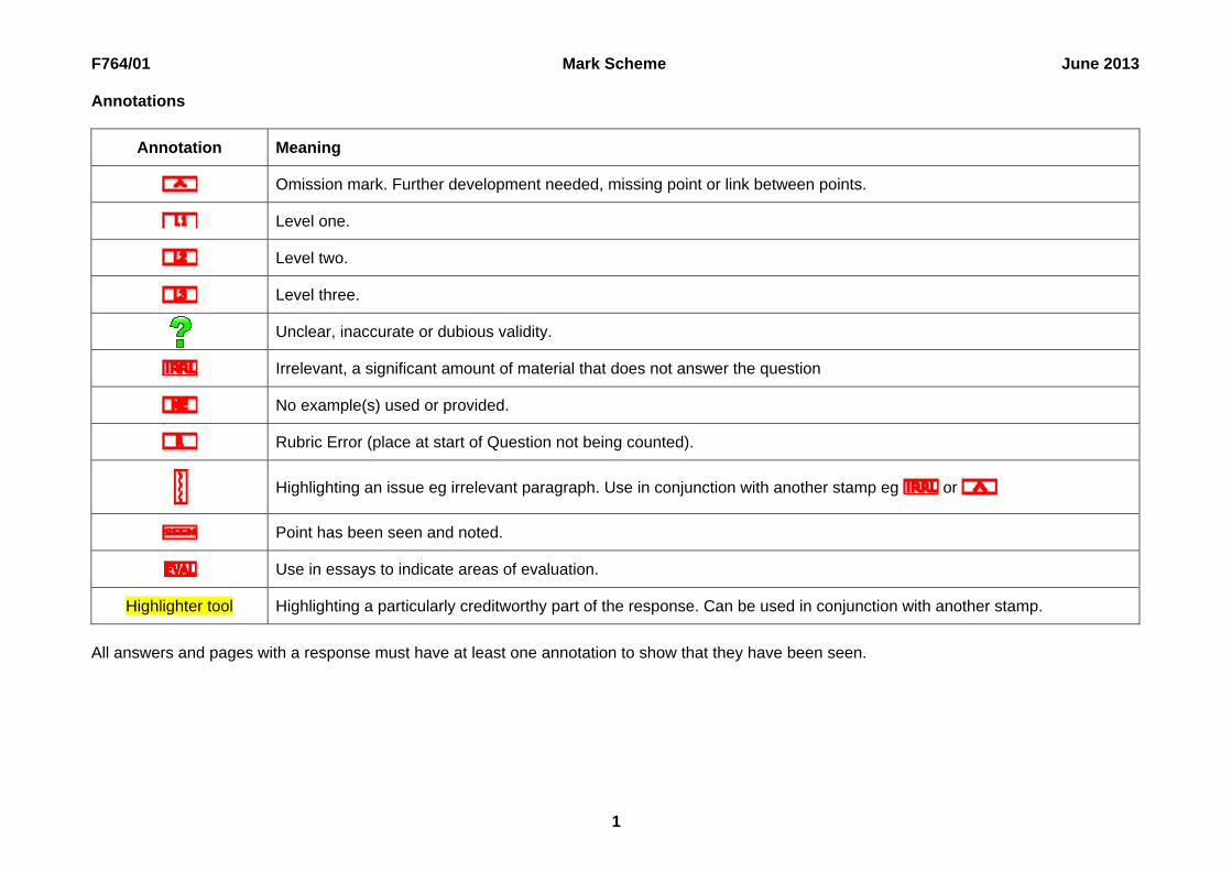
Annotations
Annotation Meaning
Omission mark. Further development needed, missing point or link between points.
Level one.
Level two.
Level three.
Unclear, inaccurate or dubious validity.
Irrelevant, a significant amount of material that does not answer the question
No example(s) used or provided.
Rubric Error (place at start of Question not being counted).
Highlighting an issue eg irrelevant paragraph. Use in conjunction with another stamp eg or
Point has been seen and noted.
Use in essays to indicate areas of evaluation.
Highlighter tool Highlighting a particularly creditworthy part of the response. Can be used in conjunction with another stamp.
All answers and pages with a response must have at least one annotation to show that they have been seen.

F764/01 Mark Scheme June 2013
2
Question Answer Marks Guidance
Content Levels of response 1 (a) (i) Candidates should recognise that the plan
has some plus points: clear stages which are sequential feedback loops. But it also: lacks analysis stage no time allocation no evaluation/improvements stage needs to identify a question present data should be before described
data.
5 Level 2 (4–5 marks) Candidates comment in detail on both positive and negative features of the effectiveness of the plan for a geographical investigation. Good reference to Fig. 1. Level 1 (0–3 marks) Candidates offer a limited or one sided evaluation of the plans effectiveness. Limited, if any, reference made to Fig. 1.
F764/01 Mark Scheme June 2013
3
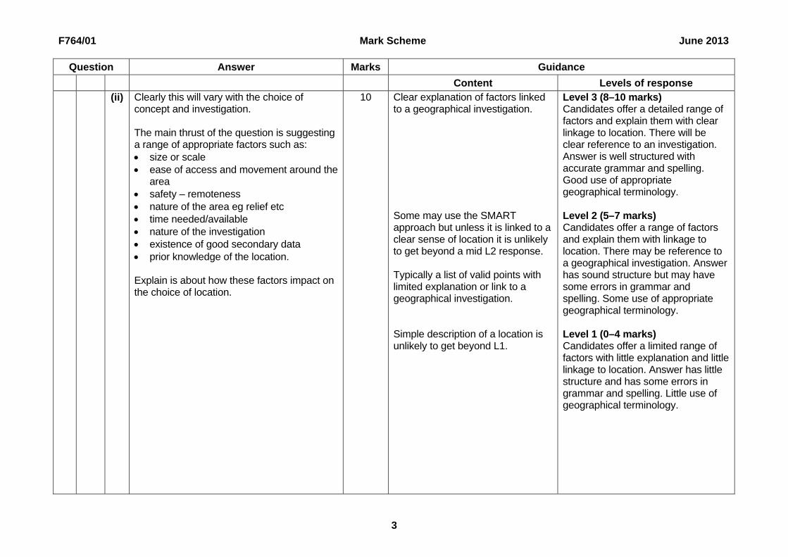
Question Answer Marks Guidance
Content Levels of response (ii) Clearly this will vary with the choice of
concept and investigation. The main thrust of the question is suggesting a range of appropriate factors such as: size or scale ease of access and movement around the
area safety – remoteness nature of the area eg relief etc time needed/available nature of the investigation existence of good secondary data prior knowledge of the location. Explain is about how these factors impact on the choice of location.
10 Clear explanation of factors linked to a geographical investigation. Some may use the SMART approach but unless it is linked to a clear sense of location it is unlikely to get beyond a mid L2 response. Typically a list of valid points with limited explanation or link to a geographical investigation. Simple description of a location is unlikely to get beyond L1.
Level 3 (8–10 marks) Candidates offer a detailed range of factors and explain them with clear linkage to location. There will be clear reference to an investigation. Answer is well structured with accurate grammar and spelling. Good use of appropriate geographical terminology. Level 2 (5–7 marks) Candidates offer a range of factors and explain them with linkage to location. There may be reference to a geographical investigation. Answer has sound structure but may have some errors in grammar and spelling. Some use of appropriate geographical terminology. Level 1 (0–4 marks) Candidates offer a limited range of factors with little explanation and little linkage to location. Answer has little structure and has some errors in grammar and spelling. Little use of geographical terminology.

F764/01 Mark Scheme June 2013
4
Question Answer Marks Guidance
Content Levels of response (b) Value will probably look at the advantages
and disadvantages eg it helps focus the investigation v they may be incorrect.
More effective answers will look at value of a hypothesis to test within the scientific approach to research.
Answers could be very practical or philosophical.
The answer can be a generic one on hypotheses or it could be answered referring to their own investigation.
Nul v alternative hypotheses can be credited if linked to statistical tests.
5 Value may well be seen in terms of advantages and disadvantages.
Level 2 (4–5 marks) Candidates give a clear and detailed outline of the value of creating a hypothesis. Some exemplification can be expected at this level. Level 1 (0–3 marks) Candidates give a limited or vague outline of value.
2 (a) (i) This a low level aerial photograph which gives lots of details about that area at that moment in time: traffic/parking vegetation, crops and gardens extensions and garden ponds not visible
from ground level building condition – environmental quality
aspects ephemeral characteristics eg weather shows functions.
But – it is an instant in time and covers just a few streets. Also shadows hide detail. Photos can’t show exact data and/or many of the socio-economic characteristics of an area. Also direction is not shown.
5 Generic evaluation of photographs then max L1.
Level 2 (4–5 marks) Candidates offer detailed evaluation of the photograph as a way of showing characteristics of an area with some reference to its limitations. Clear reference made to Fig. 2. Level 1 (0–3 marks) Candidates give limited or inaccurate evaluation of the photograph as a way of showing characteristics of an area with little, if any, reference to its limitations. Limited reference made to Fig. 2.

F764/01 Mark Scheme June 2013
5
Question Answer Marks Guidance
Content Levels of response (ii) This invites the candidates to compare OS
maps or other maps eg land use with the photograph (Fig. 2) in what they can tell you about the characteristics of the area. Advantages: exact distances, areas etc as has scale wider context of area precise directions as has north arrow exact date exact heights, relief etc gives place names, building uses etc gives rights of way etc. Disadvantages: can’t show seasonal changes can’t show mobile features such as traffic can’t show small scale features eg
swimming pool doesn’t show people or quality of the
environment dated unclear on rural land use. Or candidates may look at a range of area characteristics in turn and how well they are shown on a map. Or look at the value of maps at different stages of the investigation process. Choropleth etc maps are acceptable in this context. Some focus on value of using maps as opposed to something else – eg photo.
10 Needs to be clearly linked to a geographical investigation in ‘this’ area to get into L3. Linked to either a geographical investigation(s) OR the area shown in the photograph. List type answer largely generic.
Level 3 (8–10 marks) Candidates clearly outline a range of advantages and/or disadvantages of maps. Clear focus on the value. Clear reference to the area in Fig. 2 and a geographical investigation. Answer is well structured with accurate grammar and spelling. Good use of appropriate geographical terminology. Level 2 (5–7 marks) Candidates outline a range of advantages and/or disadvantages of maps – these may be unbalanced. Some reference to the area in Fig. 2 and/or a geographical investigation. Answer has sound structure but may have some errors in grammar and spelling. Some use of appropriate geographical terminology. Level 1 (0–4 marks) Candidates offer a limited range of advantages and/or disadvantages of a single map. Answer has little structure and has some errors in grammar and spelling. Little use of geographical terminology.

F764/01 Mark Scheme June 2013
6
Question Answer Marks Guidance
Content Levels of response (b) Pragmatic sampling is when you sample
where you can so it may: ensure safety ensure access save time or fit a schedule ensure some data is collected. Explanation may focus on why other sampling approaches (type, unit, number of points etc) are not possible in certain circumstances. Researchers may not plan this type of sampling but may be forced to use it by circumstances. Why is this particularly likely in geographical investigations – it reflects the physical/economic/social/political conditions in the real world.
5 Level 2 (4–5 marks) Candidates explain in detail why pragmatic sampling is often resorted to for practical reasons in a geographical investigation. Clear understanding shown of the term. Level 1 (0–3 marks) Candidates give a limited or superficial explanation of pragmatic sampling with little, if any, linkage to investigations.
3 (a) (i) This is about the limitations rather than a full evaluation. Points could cover aspects of: the use or appropriateness of the best fit
line dependent v independent variable no values on the axis scatter of points unreliable as small sample/few points. An alternative approach might be to question whether a linear graph is appropriate to show house prices with distance from the CBD – a map might be more appropriate.
5 Only credit limitations. Level 2 (4–5 marks) Candidates give detailed comments on the limitations of the scatter graph in showing variations in house prices. Clear reference to Fig. 3. Level 1 (0–3 marks) Candidates give vague or limited comments on the limitations of the scatter graph in showing variations in house prices. Limited reference to Fig. 3.

F764/01 Mark Scheme June 2013
7
Question Answer Marks Guidance
Content Levels of response (ii) There is a limited range of choices as
relationship should be a trigger term – candidates should know Spearman’s, and some may offer Pearsons. They are not expected to know the formula. Description includes a number of stages: set hypothesis, create a table (ranking of data), apply formula, use confidence levels. Accept alternative statistical method eg mean & SD if well described but they should be statistical. Low level answers may miss relationship and focus on dispersion. Justification is key and could refer to: ease of calculating suitability for the type of data what the outcomes tell you accuracy/reliability.
10 L3 probably distinguished from L2 on range and depth of justification. Needs to be clearly linked to the data (ie Fig. 3) to get into L3. Either well described (at least two of the descriptive stages) but limited justification or well justified with limited description. No attempt at justification and only one descriptive stage described or some partly described.
Level 3 (8–10 marks) Candidates clearly describe and justify in detail an appropriate way of testing for correlation of the data shown in Fig. 3. Answer is well structured with accurate grammar and spelling. Good use of appropriate geographical terminology. Level 2 (5–7 marks) Candidates describe and justify an appropriate way of testing for correlation of the data shown in Fig. 3. Answer has sound structure but may have some errors in grammar and spelling. Some use of appropriate geographical terminology. Level 1 (0–4 marks) Candidates offer limited description and limited, if any, justification of an appropriate way of testing for correlation of the data shown in Fig. 3. Answer has little structure and has some errors in grammar and spelling. Little use of geographical terminology.

F764/01 Mark Scheme June 2013
8
Question Answer Marks Guidance
Content Levels of response (b) Candidates can approach this in two
different ways: a) by looking at the limitations of primary
data collection per se b) by criticising or outlining the limitations of
using questionnaires to collect primary data.
A combination of both approaches is probably the most effective and may cover: sampling issues eg size, timing how questionnaires are used eg posted questionnaire design and types of
questions a poorly constructed questionnaire the public’s resistance to them due to
time, intrusion etc. The stress is on unreliable – reliability is a technical term with an exact meaning. So in what sense are they unreliable? This may be an indicator of a high level candidate.
5 Level 2 (4–5 marks) Candidates explain at least two detailed reasons for why questionnaires are unreliable with clear focus on primary data collection in an investigation. Level 1 (0–3 marks) Candidates offer limited explanations why questionnaires are unreliable. Much will be vague or largely descriptive with limited focus on primary data collection in an investigation.

F764/01 Mark Scheme June 2013
9
Question Answer Marks Guidance
Content Levels of response 4 This requires an evaluation of the methods
they used to present their data so will vary considerably between candidates but the emphasis is less on the techniques used and more on their effectiveness at presenting their data. Maps and photos are acceptable techniques if annotated. Evaluation is the key with some attempt at identifying the strengths and weaknesses of the techniques used. They should be evaluated against something – their ability to represent the data in a meaningful and informative way. If no titled investigation stated then max Level 1. If little connection between their title and the strategy (ie largely generic) then max low Level 2. Credit detailed evidence of an individual investigation. Do not accept evaluation of data collection methods or data analysis. Material on how to improve techniques gains no credit.
20 It is the tightness of focus on accuracy and effectiveness and detailed linkage to their investigation that will distinguish higher level responses. Answer based on a detailed evaluation of a single technique is max L2. Level 2 responses will probably outline the advantages and disadvantages of the methods/techniques rather than evaluate them in terms of their investigation. Largely descriptive of the techniques.
Level 3 (16–20 marks) Candidates evaluate in detail the extent to which the techniques they used to present the data worked in their named investigation. Detailed reference to investigation. Answer is well structured with accurate grammar and spelling. Good use of appropriate geographical terminology. Level 2 (10–15 marks) Candidates evaluate the extent to which the techniques they used to present the data worked in their named investigation. Some reference to investigation. Answer has sound structure but may have some errors in grammar and spelling. Some use of appropriate geographical terminology. Level 1 (0–9 marks) Candidates offer limited, if any, evaluation of the extent to which the techniques they used to present the data worked in their named investigation. Much is descriptive of the data presentation. Answer has little structure and has some errors in grammar and spelling. Little use of geographical terminology.
F764/01 Mark Scheme June 2013
10
Question Answer Marks Guidance
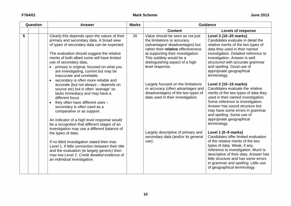
Content Levels of response 5 Clearly this depends upon the nature of their
primary and secondary data. A broad view of types of secondary data can be expected. The evaluation should suggest the relative merits of both albeit some will have limited use of secondary data. primary is original, focused on what you
are investigating, current but may be inaccurate and unreliable
secondary is often more reliable and accurate (but not always – depends on source etc) but is often ‘average’ so lacks immediacy and may have a different focus
they often have different uses – secondary is often used as a comparative or as support.
An indicator of a high level response would be a recognition that different stages of an investigation may use a different balance of the types of data. If no titled investigation stated then max Level 1. If little connection between their title and the evaluation (ie largely generic) then max low Level 2. Credit detailed evidence of an individual investigation.
20 Value should be seen as not just the limitations or accuracy (advantages/ disadvantages) but rather their relative effectiveness at supporting their investigation. This subtlety would be a distinguishing aspect of a high level response. Largely focused on the limitations or accuracy (often advantages and disadvantages) of the two types of data used in their investigation. Largely descriptive of primary and secondary data (and/or its general use).
Level 3 (16–20 marks) Candidates evaluate in detail the relative merits of the two types of data they used in their named investigation. Detailed reference to investigation. Answer is well structured with accurate grammar and spelling. Good use of appropriate geographical terminology. Level 2 (10–15 marks) Candidates evaluate the relative merits of the two types of data they used in their named investigation. Some reference to investigation. Answer has sound structure but may have some errors in grammar and spelling. Some use of appropriate geographical terminology. Level 1 (0–9 marks) Candidates offer limited evaluation of the relative merits of the two types of data. Weak, if any, reference to investigation. Much is descriptive of their data. Answer has little structure and has some errors in grammar and spelling. Little use of geographical terminology.
Oxford Cambridge and RSA Examinations is a Company Limited by Guarantee Registered in England Registered Office; 1 Hills Road, Cambridge, CB1 2EU Registered Company Number: 3484466 OCR is an exempt Charity OCR (Oxford Cambridge and RSA Examinations) Head office Telephone: 01223 552552 Facsimile: 01223 552553 © OCR 2013
OCR (Oxford Cambridge and RSA Examinations) 1 Hills Road Cambridge CB1 2EU OCR Customer Contact Centre Education and Learning Telephone: 01223 553998 Facsimile: 01223 552627 Email: [email protected] www.ocr.org.uk For staff training purposes and as part of our quality assurance programme your call may be recorded or monitored