geol sur howry creek gold prospect - ontario
TRANSCRIPT

4iie4NEees2 0027 CURTIN 010
Geological Survey
for the
Howry Creek Gold Prospect
Art Elliott Exploration',
Ontario, Canada.
Claims: C574040580809858080995808100 S59386855938715593872
David R. Jamieson B.Se. Waterloo Dec.15, 1986.
'23

y/* -iJ - ^-,^^i v.tftJOJT**J * B F**'^-}^ l V*j y 1^ ^f Q j 7 j 7 A l TfrA^tf
L - - i- -^d""*^; ? r s jlJp
'•"•';; '' ^ i/ifTIN TWP.

INTRODUCTIONArt El liott Explorations holds a group of fourteen contiguous claims in Curtin and Roosevelt townships, District of Sudbury, Northeastern Ontario, locally known as the Howry Creek Prospect. The present claims cover the old pits, trenches, a flooded 70'shaft, and a 428' adit, as well as approximately one and a half miles of possible east and west extensions of known gold mineralization. The prospect is toward the east end of an east- west gold-bearing zone striking for approximately 12 miles.
Most development work is thought to have been done between 1911 and 1921, on gold bearing, arsenopyrite ric!. quartz veins,in sheared and altered metasediments of the Gowganda Formation. Diamond drilling probably took place at the same time but results of this work is unknown to the author. Within the last ten years Art Elliott Explorations has been involved in extensive geophysical and geological surveys to determine the gold and possibly platinum metals potential of this area. The author was requested to geologically map 7 contiguous claims in Curtin and Roosevelt townships, as well as present ideas on the properties ocomomic potential and possible ties for further exploration and development. The following report and map record the work done and the results obtained.PROPERTY. LOCATION AND ACCESS
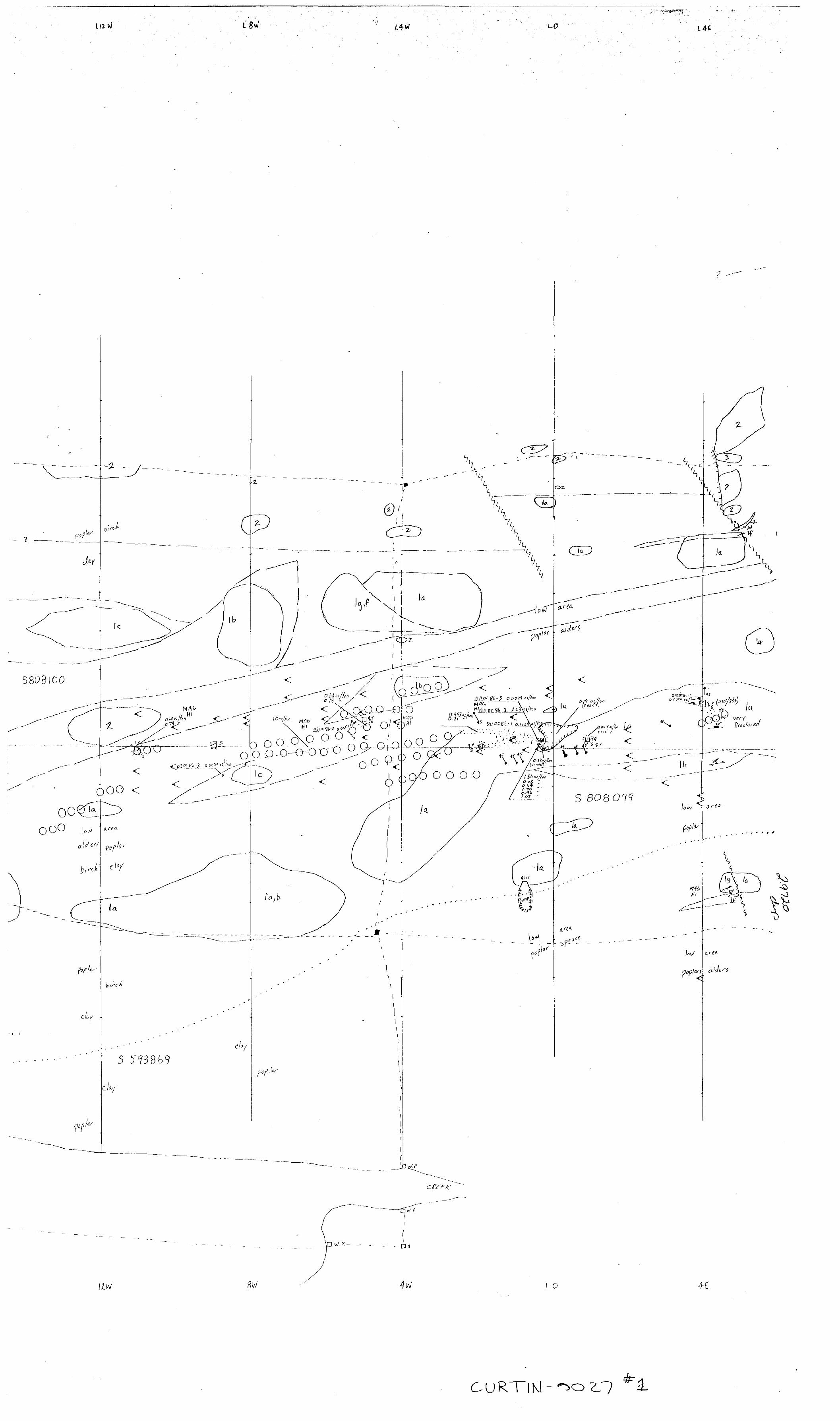
The present work was carried out on seven claims in western Roosevelt and eastern Curtin townships, just north of Killarney Provincial Park, approximately 18km. southeast, of Espanola, Ontario at 46 degrees 15 minutes N latitude, 81 degrees 58minute W longitude. Claims S574640, S808098, S808099, S808100, S593868, S593871,and S593872 wore covered by this geological survey.
The property is accessed easily by travelling south from Espanola on provincial highway H G to Willisville road, then east about J km. to the Whitefish River. From here travel is by boat east along Charlton Lake and Howry Creek approximately 10 kms. to the south-west, corner of the claim group. Several foot trails lead to the north-east, passing the adit opening just south and west of the shaft area.GEOLOGICAL SURVEY DETAILSGeologic mapping was carried out along cut. line spaced 400 feet apart or closer t'ind chained every SO foot. Outcrop location hot worn linos, along wi'h outcrop trend and sizo was deteminod by pace and compass. The work was carried out; between October 2 and .12, 1986 by tho au t hoi. The enclosed map war. done at a scale of l inch - 100 feet. A total of 4.f) l i no-mi J es were surveyed.REGIONAL GEOLOGY
Tho geology of t ne Espano l a-Wr. i t ef i sh Falls Area has been reported by Card (1976), and summarized by Winters(l 985):"The
property is located in the Southern Province of the Canadian Shield with all the rock types being of Middle Precambrian age. The metasedimentary units of the Cobalt and Quirk Lake Groups of the Huronion Supergroup have been folded into a series of east- west trending anticlines and synclines. The Elliott Exploration property is underlain by the Gowganda Formation of the Cobalt Group on the northern limb of the La Cloche Syncline with the Lorrain Formation which overlies the Gowganda Formation to the south, occupying the axial region of the syncline. These two formations which strike east-west and dip vertically to steeply south, are separated by the Charlton Lake fault through Charlton Lake, Howry Creek and Murray Lake. The Gowganda formation is underlain by the Serpent and Espanola Formations of the Quirk Lake Group, A Nipissing diabase sill up to 300m thick intrudes the Gowganda Formation approximately 600m north of the Charlton Lake Fault-Lorrain Formation contact.There are three directions of faulting in the region; east-west, northeast and northwest. The east-west faults are generally parallel to the stratigraphy and show movements of several hundreds of meters. Both the northeasterly and northwester l y trending faults show right-lateral offsets."
PROPERTY GEOLOGYThe seven claims mapped in eastern Curtin and western Roosevelt townships are underlain by Gowganda Formation metasediments of the Cobalt Group of the Huronian Supergroup, except for a small area in the south-west corner of the claim group which is under lain by the Charlton Lake Fault and the Lorrain Formation. Gene ra l ]y, the rock units strike 70 to 90 degrees and dip steeply. The Gowganda sediments graded from a pink quartzite to greywacke to laminated and massive argillite units, both across arid along strike. Distinct units were usually hundreds of feet thick and fairly continuous along strike. Minor beds of polymictic para conglomerate were mapped, with greywacke to argillite matrix and rounded granitic and sedimentary c lasts. These units tended to be discoi t. inuour- arrl associated with breccia zones containing angular quartzite and laminated argillite fragments. In the north-west claim along the baseline, bedding between greywacke and quart? i te on the scale of a few feet was noticed arid it is conjectured that the breccia is a result of stresses on these t.h inn l y bedded units. Pieces of competent quartz i te beds can be soon in a foliated greywacke matrix which has "flowed" around thorn. This same reaction to stress ic evident on the entire property. The cleanest pink quartzitrs ate often sect) britt, ly fractured into small angular pieces while the greywackes show strain in tno form of moderate to strong foliations.
The Nipissing diabase is a continuous, intrusive unit which has two branches. The main branch is to the north and is generally conformable to stratigraphy and up to 1000 feet thick. The second dike cuts the sedimentary stratigraphy at a low angle in a north east direction. It resembles the main branch in overall texture and mineralogy and is approximately 200 feet thick. Near contacts with the sediments, especially argillaceous sediments, the diabase may show finer grain size or a coarse grained texture which has globular feldspars and very well developed amphiboles. These phases appear more gabbroic or even dioritic and could be due to contamination by sedimentary fragments during the intru sive event. Quartzite fragments containing octahedral pyrite crystals occurs in a quartz stockwork within the diabase on L8E, 6+50N. This appears to be near a diabase/sedimentary contact and indicates some alteration and brecciation occurred during the intrusion of this diabase dike.
Several north-west trending faults with approximately 200 feet of right lateral displacement have been interpreted from sharp offsets in diabase and sedimentary units. Breccia zones could be considered fault-like structures as juxtaposition of different sedimentary units can be seen across these zones (L4W north of BL and L4E south of BL). However, further detailed mapping is needed to determine the significance of these breccia zones.
Several faults east of L16E can be interpreted from EM data presented by Walker Exploration Ltd. Filtered and contoured in- phase VLF-EM data as well as Elliott's plotted SP data show left lateral displacement of two prominent conductors at L22E and L36E. The SP anomalies parallel the EM conductor patterns, but. plot 50-100 feet to the south. Outcrop is sparse ir. the area and is inconclusive as to displacement of rock units. Therefore the faults have been included on the map without showing displacement of rock units.
ECONOMIC GEOLOGYThe Gowganda Formation in the Mongowin and Curtin townships area hosts a number of gold prospects and former producing mines. The Bousquet Mine produced 4,672 ozs. of gold and 196 ozs. of silver between 1936 and 1938. The gold bearing quartz veins occur at a d i abase/quartz ite contact, with mineralization consisting of arsenopyrite, pyrite, chalcopyrite, and occasional visible gold (Rickaby,1935; Phemister,l 939). The McMillan Mine operated periodically from 1934 to 1937 and produced 2,817 ozs. of gold and 84 ozs. of silver. The gold occurs in quartz veins in quartzite and schistose argillite (Moore,l 929). Arsenopyrite pyrrhotite and chalcopyrite were all found to carry gold values. General ly, high and occasional ly spectacular gold grades have
been encountered at most of the areas prospects, but are across narrow widths, usually confined to the quartz veins or stringers. The quartz veins commonly occur within east-west shears or faults in quartzite and argillite (Card, 1976).
The main zone of the Howry Creek Prospect is similiar to other gold deposits of this area. Quartz veins generally trending east-west occur within highly fractured quartzite or sheared greywacke/argi l l ite. High gold values are associated with strong arsenopyrite mineralization with minor pyrite, and chalcopyrite occurring as well. In the shaft area of the Howry Creek prospect there are at least two strongly mineralized quartz veins trending approximately 100 degrees, dipping 75 and 85 degrees. Arsenopyrite is abundant and tends to occur in three ways.
1) as coarse grained disseminations and aggregations in grey quartz with a greasy lustre; a grab sample of this material containing 201 asp. and 5?, py. assayed 0.132 oz.Au/ton; veins 12" to 16" wide.
2) a s massive seams and pods a few inches wide, usually near or beside quartz veins; a grab sample of this massive asp. assayed 2.03 oz.Au/ton.
3) as coarse grained, euhedral crystals up to 1 0^ o f altered quartzite adjacent quartz vein; grab sample assayed 0.003 oz.Au/ton.
An extensive ore dump surrounds the shaft and trenches. Previous grab samples of arsenopyrite rich material often yielded assays > 0.5 ozs.Au/ton. Representative, coned samples of dump material yielded assays of 0.19 and 0.32 ozs.Au/ton.
A possible ore zone extends west from the shaft area approx imate l y 1100 feet.. Arsenopyrite mineralization is exposed in trenches near the baseline at L5W and L11W., with SP and EM anomalies indicating possible continuity of the mineralization between these points (see map). Weak mineralization is exposed in trenches up to 500 feet east of the shaft area, with assays yielding low gold values.
Away from the shaft area, near L16E 13+50N , two pits expose a quartz vein and massive pyrite occurrence. The vein strikes at approximately 140 degrees and dips approximately 45 degrees N.E. and appears to lie along some sort of fault structure, as interpreted from the geology. Coarse grained, massive pyrite forms a zone 8 inches wide adjacent to the quartz vein. A grab

sample of loose material assayed 0.154 ozs.Au/ton. Assays across narrow sections of quartz and sulphide rich material on both sides of the ma3sive pyrite yielded low but anomolous values for gold and silver.
At line 28E 3 + 50N a pit exposes a number of narrow quartz veins in sheared, chloritized greywacke. Previous samples yielded assays of 0.108 and 0.14 ozs.Au/ton. The authors grab of weakly mineralized greywacke yielded slightly less than 300 ppb. gold.
RECOMMENDATIONSArt Elliott Explorations has expressed a desire to attempt the extraction of gold from the dump material and high grade in-situ material. A small scale mill design is being completed, with the metallurgical properties of the ore appearing to be relatively simple. The first exploration priority is to establish a proven tonnage of in-situ material of high enough grade to make the operation profitable. The following program is recommended:
1) Stripping to expose outcrop adjacent to known mineralization and outcrop beneath strong SP anomalies and chip and channel sampling of any new mineralization.
- 3 men for 30 days @ 375.007day each $6750- food and accomodation for 3 men @ $25.00/day each S2250- Wajax high pressure pump rental inc. hose l month 31000- Supervision by Art Elliott Exploration (expenses) S 750- Transportation expenses $ 300- Assays S 600
TOTAL 311650
2) Diamond drilling to determine the extent of mineralization beneath surface showings. Holes probably should not exceed 50 feet in length and should be collared within 10 to 20 feet of surface showings until the nature of the zone is better understood. Immediate targets would be the adjacent to the pits at lines HW and 5W. If results were encouraging, 25 foot step-outs east and west would be needed to prove up reserves. A 6 hole, 300 foot drilling program using Winkie tools is recommended. Costs will depend on various factors such as distance from water and hardness of formations, but total costs should not exceed S20.007foot.

300 feet of diamond drilling @ $20.00/foot $6000logging and splitting of core S 70030 assays @ $15.00/assay $ 450
TOTAL $7150
The second priority is the quartz vein, massive pyrite zone on line 16E 13+50N. Further sampling is needed, and diamond drilling would be cost effective in evaluating this showing. Three holes 50 feet in length collared along strike at approximately 100 foot intervals and centred on the sampled pit are recommended.
150 feet diamond drilling @ $20.00/foot $3000logging and splitting of core 3 450assays S 300
TOTAL $3750
The third priority is the altered, sheared greywacke outcrop on L28E 3+40N. Stripping and sampling are recommended, as well as detailed prospecting in both directions along strike.
3 men for 10 days @ S75.007day S2250food and accomodation @ $25,00/mar/day $ 750Wajax pump rental S 350assays $ 500
TOTAL $3550
SUMMARYThe Howry Creek Prospect is currently controlled by Art Elliott Exploration and is located in Curtin and Roosevelt townships, District, of Sudbury. The property is underlain by Gowganda Formation metasediment^ and Nipissing diabase, both of Middle Precambrian age and part of the Southern Province of the Canadian Shield. Gold is associated with arsenopyrite c'nd to a lesser degree, pyrite, in quartz veins. The setting is s i mi liar to other gold deposits in an east-west regional gold bearing zone stretching for approximately 12 miles. Massive arsenopyrite is common on the ore dumps arid in trenchs and runs up to 2 ozAu/ton. Plans to extract the gold from high grade material in the shaft, arr-a are underway, a nd exploration priority is given to finding more ore grade material in this area. Recommendations are for stripping and sampling near areas of known mineralization and in areas which have high SP anomalies. Diamond drilling is

recommended to test the depth dimension of any ore grade surface showings.
There are a number of showings on the property which need more work to determine their potential. Detailed prospecting of the entire property, based on the findings of previous work, would likely produce more areas of interest. In the author's opinion this property shows excellent potential for hosting a mineable gold deposit at current gold prices (US3400Xoz.).
Respectfully submitted,
David R. Jamieson December 15, 1986
B. Se,

David R. Jamieson R.R.#2 Cavan, Ont, LOA ICO
PERSONNEL
11 days of field work
6 days of report preparation

,^-
REFERENCES
Card, K.D., 1976 Geology of the Espanola-Whitefish Falls Area, District of Sudbury, Ontario; Ontario Department of Mines, GR 131.
Elliott, A.T. 1985 Review of Exploration to Date, Howry Creek Gold Prospect; unpublished.
Walker, A.J., 1981 Magnetic and VLF-EM Surveys, Dungarvon Resources Limited, Howry Creek Gold Prospect, Roosevelt Twp., Sudbury District Ontario; unpublished.
Winter, L.D.S., 1985 Geological Survey for Art Elliott Explorations, Roosevelt Twp. property, Ontario; unpublished.
10
CERTIFICATE OF QUALIFICATION
I, David Ross Jamieson do hereby certify:
That I am a geologist and reside at R.R.#2 Cavan, Ontario;
That I graduated from the University of Waterloo with a Bachelor of Science in Earth Sciences in 1984;
That I have practiced geology continuously since 1984;
That my report on the Howry Creek Prospect is based on a review of literature on the property and surrounding area and on fieldwork carried out by me.
David R. Jamieson B.Se. December 15, 1986
11


::::-C
Xi
M"i
/pn
, s
j ,s a
-•C
7/
)-M(
.XrW
^
i)g vm
m\j
"i i''(
i*-'
M~
' .
.Vl'C
\D/A
o
l^^L
xAL
^^A
S

^m^-f^-oJiS^^-Sv'vMiniittTor-Morihern Development
. . -^j-.r- *n0 Mines '/Ontario ' s
(Geopiiysical, Geological, Geochemical and Expenditun
Mining Act
I'd.ut t ype oi fin''H number o( mm nq tininv, tmvfl*.-. excerili ipac* on ih.t form, Bloch t he Only days credits CAleulMtrJ in th* "Expendilufes" teciion may be entertr, in i n* "Expend. Dayi C'," columns Do not use thaded *rets below.
T y p* ol SufvtvU)
Claim Moioer(i) ^^
AflOrju
Survey Company
Nome ano Anctrest ol Author (of Geo Technical report)
yf/f,^ cfitfftH etrr LO ACredits Requested ppr Each Claim in Columns at riqhtSMC..I Prov.s.or., l 0. 8phytlM1 0*y, p..
For first survey:
Enter JO flays. (Thisincludes line Cutting) Magnetometer
For each additional survey Rad.ometr.cusing the same i/rirl
' OtherEnter ?0 days dor each)
Geological A//]
, G.ochom,c,
M* n D' Vi ' G*opny,,cai ' l̂™'
Complete reverse side and enter toiai(s) here ' m
- Maqnetometpr
- Other
j Geological
1 :1 Geochemicali
Airoorne Creaits Davs per
Note; Speciiii O'ovisiois Electromagnetic erect u cto not appiv ~ ————— to Airborne Surveys \ Magnetomncr
! Radiometric
Exoenditufss tex.luoes power stripping)Tvce o? Wo'* Pe"o meo
P* MO"r"C C -1 0'1 "'vs '
^^^ "fotai EAueno.tii't1 ! Oiivv CieiM!,
S * 1 5 -Initruct'on*
Choice. Ente' numof ot ^ays i:fpoits r*'*' ciatm si-ifii* let: in tO'urrins at ntjht,
tl\t J R tCO' i^G l Hold o^ p f. Agent ib-pnaluT 1
township or Area
0#7 tftc yty' (b'Dale o' Survey (liom A T{
•2 .16 96 \ /Z.Civ | Mo. Vi. j Dnv
/CO
T,Coipecioi'l Lictnc* No. S* f 1 ~J ? //
) /" 0 / s *^ 1 t-S ' (0 o 1 / /vO
)l . jTotal Milts ot Itnt Cut
/6 c* i *J V*| Mo j Vr. . "' O
Mmuio Claims Traversed (List m numencal sequence)'.'•nmg Cl.urn
Pipli* Numbf
j ffijZJo**? *^f 0 \s C^ f O
S 86JF0f?S 9(gSOOs 3-95 Btf sS •tftf?/S SJ3#?2
t xpenci Davs Cr.
——————
^
^
/••,..
W
S*
Foi Office Use Onlv
Mining ClaimPreli" Numoer
' -s* ^B" '
f * -^
*' !
! P *i Days C-
r ,
rTotal number o* mmii.fi claims covered by this f report o' work. f
^T "Co"" /i/y; riTHvl'l^A X CiTil At .TOveci os "eco.oi-ci iB'an;h Director
y (l ^Certification Ventyinn Report of Work
l hercoy ccft'lv that l tiave a personal and miirrvnc knowipd:)? 01 the i.irti SIM fo'ifi m thr Report ot Work, annexed heieto, hsvmg performed the Or witnessfcl same during .inrt/oi alter its completion nno the innexpu icport is true
Name and Pone 1 Acuireii o' Prrsort Ce'tiiv'i"g
Djit '

* fl.lt,iH
1
WeW3V """"*nrw Technical Assessment nU . llg) !^?*v'topm'nl Work Credit! 2.9720
'- \ .•y.
" ' - :.';'•' :
V
fj
j. '
!: ujf ' ['
!' : ' : 'i!"
bfi L.
':s-
f.,p .
'
Date Mlnlns) Heoortferli fleport of
February 4. 1987 " 0' 87-14
R*cord*d Holder
ARTHUR T. ELL I0nTownship or Area
CURTIN i ROOSEVELT TOWNSHIPSType of survey end number of
Assessment days credit per claimGeophysical
Elaetronugnnli; rtjiyt
MagnetorMUr H.yt
RirllnfTvftrlr . ,. I MI , , . ^yf
|nrinr*H pnl*rir.tlnn , . . , rt* y i
Oth*' , ,, . d*y
Section 77 (19) See "Mining Claims Assessed" column
Geological 40 ^^
Geochemical d.yt
Man days f] Airborne Q
Special provision Q Ground (X)
Q Credits have been reduced because of partial coverage of claims.
P] Credits have been reduced because of corrections to work dates and figures of applicant.
Mining Claims Assessed
S 593870 808098 to 100 inclusive 593871-72
Special credits under section 77 (16) for the following mining claims
20 DAYS GEOLOGICAL
S 593868
No credits have bean allowed for the following mining claimsf~j not sufficiently covered by the survey [ | insufficient technical data filed
v

JUft
w
l**
OntarioMinistry ofNorthern Developmentard Mines
February 20, 1987 Your File: 87-14 Our File: 2.9720
Mining RecorderMinistry of Northern Development and Mines199 Larch StreetSudbury, OntarioP3E 5P9
Dear Sir:
RE: Notice of Intent dated February 4, 1987 Geological Survey on Mining Claims S 593868, et al, in Curtin and Roosevelt Townships
The assessment work credits, as listed with the above-mentioned Notice of Intent, have been approved as of the above date.
Please inform the recorded holder of these mining claims and so indicate on your records.
Yours sincerely,
J1C. Srpith, A/ManagerMi)wrtf Lands SectionMineral Development and Lands BranchMines and Minerals Division
Whitney Block, Room 6610 Queen's Park Toronto, Ontario M7A 1W3
Telephone: (416) 965-4888
DK/mccc: i Arthur T. Elliott
438 High StreetLondon, OntarioN6C 4L5
Mr. G.H. FergusonMining S Lands CommissionerToronto, Ontario
End.
Dave Jamieson R.R.#2Cavan, Ontario LOA ICO
Resident Geologist Sudbury, Ontario

SEE ACCOMPANYING MAP® IDENTIFIED AS
CUKTlM-OOZT? -tt—J—j—
—————————————————————————————————————————-J l
ft- LOCATED IN THE MAP CHANNEL IN THEFOLLOWING SEQUENCE
(X)
91-

Li L8W /.4V
4A1
JZN
BEAWR POM D
300 O P-Q
22 VJ I5W
l iD
41l04NE0eSS 0027 CURTIN 200

Hot
o o
S 5 138/0
ooo
O O 0/-0 O
- 'd o o o
MURRAV LAKfc"
AST.g 5
CURTIN TWP ROOSEVELT TWP
O 400 ft.
OWRV
Curtii
MIDDLE PRECAMBRIAN
Intrusive contact
Intrusive contact
41 ita4NE0eiS2 ees7 CURTIN
Geology and drafting by: .
David R Jamieson B. Se.
uzW L46
o o o o
LO
A•c!

18 M
/fc
/4M
1Z
o 3
<
ooo-o
O C) oO.j4 ,,A
MURRAY LAKE:
10 M
Vf//i'?
S N
a. r
4 M
oo H
N
AST.
400 ft.
MIDDLE PRECAMBRIAN
Intrusive contact
Intrusive contactG O W G A N D A
F M
HOWRY CREEK GOLD PROSPECT
ART ELLIOTT EXPLORATION
Curtin and Roosevelt Townships, Ont.
1c
GEOLOGY
Granite
Diabase, gabbro
Quartzite
Protoquartzite
Greywacke
ocated
1d
1f
Argillite
Paraconglomerate
Breccia
i-*-
Geology and drafting by: .
— . . ,. _ , ,
70'
^. ^. Oct. 86
CURTIN-
locofed
SYMBOLSInterpreted contact
Picket line Claim l lne ' Posts
Park boundry
Interpreted faultOutcrop, assays (A^
< EMCrossover
OOO SPAnomaly
^ Swamp
f Drill hole
Rt, sulphides, quart z /ein Blasted area
Scarp
Foliation
Bedding
Jointing