geologic and seismic technical background report city of
TRANSCRIPT
Geotechnical Engineering ● Engineering Geology
Geologic and Seismic Technical Background Report City of West Hollywood General Plan Update
West Hollywood, Los Angeles County, California
Prepared for: City of West Hollywood 8300 Santa Monica Boulevard
West Hollywood, CA 90069
Prepared by: KFM GeoScience 1360 Valley Vista Drive Diamond Bar, California 91765
March 15, 2010 Project No. cWH 08-14E
ITEM 2.RR. EXHIBIT A

City of West Hollywood Project No. cWH 08-14E Seismic Technical Background Report March 15, 2010
- i - KFM GeoScience
TABLE OF CONTENTS Page
1. INTRODUCTION .................................................................................................................. 1
1.1. OVERVIEW ........................................................................................................................ 1 1.2. GEOLOGIC AND SEISMIC HAZARD PLANNING CONSIDERATIONS....................................... 2
2. SETTING................................................................................................................................ 3
2.1. PHYSIOGRAPHIC SETTING.................................................................................................. 3 2.2. GEOLOGIC SETTING........................................................................................................... 3 2.3. GEO-TECTONIC SETTING................................................................................................... 5 2.4. GROUNDWATER CONDITIONS............................................................................................ 6
3. SEISMIC CONDITIONS ....................................................................................................... 6
3.1. FAULTS ............................................................................................................................. 7 3.2. EARTHQUAKES AND HISTORIC SEISMICITY ....................................................................... 8
4. SEISMIC HAZARDS............................................................................................................. 8
4.1. OVERVIEW ........................................................................................................................ 8 4.2. PRIMARY SEISMIC HAZARDS............................................................................................. 9
4.2.1. Surface Fault Rupture..........................................................................................................................9 4.2.2. Ground Shaking.................................................................................................................................10 4.2.3. Peak Ground Acceleration.................................................................................................................11 4.2.4. Modified Mercalli Intensity Scale .....................................................................................................11 4.2.5. CBC Design Spectra..........................................................................................................................12
4.3. SECONDARY SEISMIC HAZARDS...................................................................................... 13 4.3.1. Liquefaction ......................................................................................................................................13 4.3.2. Seismically Induced Settlement ........................................................................................................13 4.3.3. Lateral Spread....................................................................................................................................14 4.3.4. Earthquake Induced Landslides.........................................................................................................14
5. GEOLOGIC AND SOILS HAZARDS ................................................................................ 14
5.1. OVERVIEW ...................................................................................................................... 14 5.2. SLOPE INSTABILITY......................................................................................................... 15 5.3. EXPANSIVE SOILS............................................................................................................ 15 5.4. COLLAPSIBLE SOILS ........................................................................................................ 16 5.5. GROUND SUBSIDENCE..................................................................................................... 16
6. SELECTED REFERENCES ................................................................................................ 17

City of West Hollywood Project No. cWH 08-14E Seismic Technical Background Report March 15, 2010
- ii - KFM GeoScience
TABLE OF CONTENTS (cont’d)
Tables Table 1 – Summary of Fault Rupture Hazard Studies (1997 to 2009) Table 2 – Characteristics of Faults Considered Significant to Seismic Shaking Hazard Table 3 – Summary of Historic Earthquakes with Magnitudes Greater than 5.0 and Epicentral
Distances Less Than 100 KM Table 4 – Modified Mercalli Intensity Scale Figures Figure 1 – Geology Map Figure 2 – Regional Fault and Seismicity Map Figure 3 – Seismic Hazards Zones Map Figure 4 – City Fault Location and Precaution Zone Map Figure 5 – Peak Ground Acceleration Map Figure 6 – Guidelines for 2007 California Building Code, Governing Spectral Accelerations for
Seismic Design Response Spectrum per 2007 CBC

City of West Hollywood Project No. cWH 08-14E Seismic Technical Background Report March 15, 2010
1 KFM GeoScience
1. INTRODUCTION
1.1. Overview In order to comply with State Guidelines for General Plan Documents and for Environmental Impact Reports (EIRs) and to provide a sound and consistent understanding of the geotechnical issues effecting land use planning decisions in the City of West Hollywood (the City), it is necessary to look at a broad range of potential geologic, soils, and seismic related hazards. This document is a technical background report designed to support the City planning staff with the preparation of the Safety Element of the City of West Hollywood General Plan. As such, it contains current information on the geologic and seismic conditions within and around the City, which could potentially affect the City and its residents in the event of a major earthquake in Southern California. The potential seismically-induced effects include:
• Ground shaking (strong earthquake ground motions) • Surface fault rupture (both primary and subsidiary) • Liquefaction and dynamic settlement • Co-seismic uplift and folding • Earthquake-induced landslides • Ground lurching and cracking
The potential geologic and soils hazards to the City include:
• Compressible, collapsible, or expansive soils • Landslides and slope instability • Groundwater conditions • Subsidence • Flooding from dam failure • Flooding from tsunami and seiche
Within the City of West Hollywood, the seismic hazards which present the greatest threat to property and public safety are surface fault rupture, ground shaking, and liquefaction and related ground failure phenomena. The technical issues outlined above should be taken into account as the City fills in and re-develops. Existing building codes and land use requirements generally can address most of the hazards present in the geologic setting of the City. As additional, more accurate, geology, soils, and seismic information have been developed since the previous Geologic-Seismic Report was prepared for the City (dated January, 2002) for inclusion in the General Plan, it is possible to better define the various hazard areas and to consider them in future development. Sources of the information used to compile this technical report include regional geologic reports and maps (including the Seismic Hazard Reports prepared by the California Geological Survey) and site-specific fault rupture hazard studies (summarized herein in Table 1) and geotechnical and engineering geology reports that have been submitted to the City for new developments.

City of West Hollywood Project No. cWH 08-14E Seismic Technical Background Report March 15, 2010
2 KFM GeoScience
1.2. Geologic and Seismic Hazard Planning Considerations For planning purposes, geologic and seismic hazards are significant considerations in the selection of development locations, affect the process through which a safe project is developed, and define the various studies necessary to design a project to mitigate these two broad types of natural hazards. The Safety Element of the General Plan provides guidance to accomplish these steps and information useful to initiate the development planning process. Geologic hazards can typically be evaluated by careful direct observation and testing to determine the extent of the hazard(s) and by subsequent development of remediation or avoidance strategies. Geologic hazards typically include potentially unstable slopes, landslides, mudflows, erodible soils, expansive and compressible soils, and shallow groundwater. Seismic hazards result from the primary effects of an earthquake (strong ground shaking and surface fault rupture) and the secondary effects caused by the earthquake shaking (liquefaction, seismically-induced settlement, landslides, ground fissures, etc.) Laws, regulations, and codes are established by the State and local agencies to help ensure that proper precautions are taken during project planning and in advance of development to minimize unreasonable levels of property damage, injuries, or fatalities. The primary applicable regulatory measures include:
• The 1972 Alquist–Priolo Special Studies Zones Act • The 1970 California Environmental Quality Act • The 1990 Seismic Hazards Mapping Act • The 1999 Natural Hazards Disclosure Act • The 2007 California Building Code
In addition to these broad regulatory guidelines, there are also technical guidelines developed by the State (California Geological Survey, CGS) and the County of Los Angeles to assist technical professionals in preparation of geotechnical and geologic reports. Examples of such guideline documents include:
• CGS Note 44 – Recommended Guidelines for Preparing Engineering Geologic Reports, 1986 [currently under revision];
• CGS Note 49 – Guidelines for Evaluating the Hazard of Surface Fault Rupture, 1998 • CGS Special Publication 117 – Guidelines for Evaluating and Mitigating Seismic
Hazards in California, 2008; • County of Los Angeles, Department of Public Works – Manual for Preparation of
Geotechnical Reports. In addition, the Southern California Earthquake Center at the University of Southern California has prepared recommended procedures for analyzing and mitigating both liquefaction and landslides to complement Special Publication 117. These recommended procedure documents include:

City of West Hollywood Project No. cWH 08-14E Seismic Technical Background Report March 15, 2010
3 KFM GeoScience
• Recommended Procedures for Implementation of DMG Special Publication 117 - Guidelines For Analyzing and Mitigating Liquefaction Hazards in California, dated March 1999;
• Recommended Procedures for Implementation of DMG Special Publication 117 - Guidelines for Analyzing and Mitigating Landslide Hazards in California, dated February 2002.
In summary, the potential for geologic and seismic hazards must be considered in all phases of the development process. Building codes and general plan documents provide regulations, specifications, and strategies to address most hazard conditions, provided the studies are performed to recognize the hazards and to define the potential severity and mechanisms. 2. SETTING Taken together, geologic and seismic hazard conditions in the City of West Hollywood are similar to most cities in southern California. The following sections provide descriptions of the key geologic and seismic conditions which may impact the City. 2.1. Physiographic Setting The City is located along the northern boundary of the Los Angeles Basin, at the base of the Hollywood Hills, which are part of the broader reaching Santa Monica Mountains. The City is situated on an alluvial fan complex shed from the southern flank of the Santa Monica Mountains. The northern portion of the City spans the southern base of the Santa Monica Mountains, which are composed of igneous and meta-sedimentary rock materials. The Santa Monica Mountains are located along the southern boundary of the Transverse Ranges Geomorphic Province which is dominated by east-west trending north over south thrust faults. The Santa Monica-Hollywood-Raymond Fault Zone represents the northern structural boundary between the Santa Monica Mountains and the Los Angeles Basin to the south. The southern portions of the City are within the northern portions of the Hollywood Basin, a small sedimentary depression (<1 km thick) that abuts the Santa Monica–Hollywood Fault Zone on the north (Hildenbrand et. al., 2001). The geometry of the Hollywood Basin is poorly known. The City is approximately 3 miles long in a west-east direction and 0.5 to 1.3 miles wide in a north-south direction. The topography within the City is relatively flat and subdued, and slopes gently towards the south except at the extreme northern margin of the City, which is at the base of the mountains. The maximum elevation is about 550 feet near Larabee Street in the north part of the City and the minimum elevation is about 170 feet near San Vicente Boulevard in the south part. The average downslope gradient from north to south, not including the base of the mountains, is about 6 percent in the northern third of the City and about 2 percent in the remaining southern portion of the City. 2.2. Geologic Setting Key aspects of the geologic conditions that contribute to geologic hazards in the City include: the general physiography of the landforms, the geologic materials underlying the City, the geologic

City of West Hollywood Project No. cWH 08-14E Seismic Technical Background Report March 15, 2010
4 KFM GeoScience
structure of the bedrock, and groundwater conditions. In developing the geologic characterization of the City, original geologic mapping by Dibblee (1991a and 1991b) was reviewed to help understand the distribution of geologic materials underlying the City. The Geology Map, Figure 1, is based on the Quaternary Geologic Map of the Hollywood and Beverly Hills Quadrangles presented in the Seismic Hazard Evaluation of the Hollywood Quadrangle (CDMG, 1998a) and the Beverly Hills Quadrangle (CDMG, 1998b). The principal geologic materials exposed within the City include limited areas of undocumented fills, alluvial sediments, and granitic and metamorphic bedrock, as described by Dibblee (1991a and 1991b). Minor accumulations of undocumented fill, ranging in thickness from a few feet to up to about 20 feet, are common at sites along the Sunset Boulevard corridor. The undocumented fills generally consist of mixtures of sand, silt, and clay typically derived from local sources. Identification and mitigation of areas of undocumented fills during site investigations and construction is critical for satisfactory performance of structures to be built over the fill. A majority of the City is located on alluvial soils derived from materials shed from the adjacent Santa Monica Mountain range. The alluvial sediments occur in deposits that are vertically and horizontally cut into each other as a result of periods of stream erosion and subsequent alluvial deposition. The alluvial soils consist of a mixture of sand, silt, clay, and gravels that are punctuated with a series of buried and stacked relic soils. The buried soils are generally conspicuous as reddish brown in color and typically are clay-enriched due to extended exposure at the ground surface. The alluvium and sequences of stacked and buried soils are thickest along southern City boundary and gradually thin toward the north. The alluvial soils are typically coarser-grained (sandier) near the base of the hills and become finer-grained (silty and clayey) in the southern portion of the City. A finding from several of the fault rupture hazard investigations performed in the City, as summarized in Table 1, is the presence of a relatively thin veneer of beach sand and smooth rounded gravel and cobbles overlying a gently sloping bedrock surface near the north side of the City, and close to Sunset Boulevard. The presence of marine deposits over the smooth bedrock surface was recognized in studies by William Lettis & Associates (WLA, 1998: Map reference 7) and by Law/Crandall (2001; Map reference 13). The Consultants interpreted these findings to represent evidence of an old marine shoreline and buried wave-cut platform abraded into the underlying bedrock. Further, WLA (1998) interprets the marine wave-cut platform as the cause of the aligned base of the Hollywood Hills rather than the trace of the Hollywood Fault. As shown on Figure 1, the northernmost portions of the City are underlain by bedrock consisting of intrusive igneous rocks (typically quartz diorite) and meta-sedimentary rocks (typically slate). The quartz diorite is generally weathered and weak in the upper few feet of exposures and becomes very hard with depth. Planes of weakness within the quartz diorite are typically oriented to the north-northwest and dip towards northeast which is generally favorable in terms of slope stability. No significant landslides have been mapped in the slopes along the north side of the City (Los Angeles County Seismic Safety Element, 1990, Plate 5). Prior to development, a marsh existed within the alluvial plain currently incorporated as part of the City. The withdrawal of groundwater via pumping in the 1920’s from this area contributed to

City of West Hollywood Project No. cWH 08-14E Seismic Technical Background Report March 15, 2010
5 KFM GeoScience
the drying of the marsh. Organic rich sediments containing soft clays were likely deposited in this area while the marsh was present. The approximate historical extent of the marsh is shown on Figure 1 and Figure 3. 2.3. Geo-Tectonic Setting The City is located in a highly active seismic region of southern California. Earthquakes occur when zones of weakness, or faults, in the Earth’s crust move past one another in an abrupt sudden way. Figure 2 shows the City relative to the mapped active and potentially active faults in southern California. The earthquake activity in the region stems from the relative movement of two major crustal plates: the Pacific and the North American Plates. The Pacific Plate, which includes the southwestern portion of California, including the Los Angeles Basin, is moving to the northwest relative to the North American Plate, which consists of the vast majority of the North American Continent. The San Andreas Fault, which lies about 35 miles northeast of the City, forms the boundary between the two plates. While the San Andreas Fault accommodates much of the relative motion between the two plates, a significant amount of strain is accumulating along other faults in Southern California. For example, the Transverse Ranges, which include the Santa Monica Mountains, the Verdugo Hills, and the San Gabriel Mountains, formed as a result of localized tectonic compression centered north of Los Angeles. These mountains are currently experiencing uplift, primarily due to the release of strain during earthquakes. The most significant geo-tectonic structures in the City are the Hollywood and Santa Monica Faults which trend generally east-west. Episodic tectonic activity began on these structures in middle Miocene time and has continued into the Quaternary period. The most hazardous fault to the City is the Hollywood Fault, a reverse fault that is deeply buried, concealed by dense urbanization, and directly underlies portions of the City. The approximately 15-km-long Hollywood Fault is the eastern segment of the larger Santa Monica-Hollywood Fault System that represents the boundary between the northern Los Angeles Basin and the Santa Monica Mountains (Dolan and others, 1997; Figure 2). An apparent left en echelon offset of the Hollywood and Santa Monica Faults west of the City suggests that the northwest-trending Newport-Inglewood Fault segments the Santa Monica-Hollywood Fault System west of the City (Crook and others, 1983; Wright, 1991; Dolan and Sieh, 1992). The Hollywood Fault, which traverses the cities of Beverly Hills, West Hollywood and Hollywood, is responsible for uplift of the Hollywood Hills. For this reason, most geologists prior to the 1990’s characterized the Hollywood Fault as predominantly a northward-dipping reverse fault. In the City of West Hollywood, active deposition of numerous small alluvial fans at the mountain front and a lack of fan incision has been interpreted to be the result of late Quaternary uplift of the Santa Monica Mountains along the Hollywood Fault (Dolan and others, 1997; Dolan and Sieh, 1992; Crook and others, 1983). The fault dips steeply to the north and has juxtaposed pre-Tertiary granitic and metamorphic, and Tertiary sedimentary rocks over younger sedimentary deposits of the northern Los Angeles basin. A state-sponsored fault evaluation has not been conducted to define an Earthquake Fault Zone (formerly known as Alquist-Priolo special studies zone) along this fault due to the dense urbanization.

City of West Hollywood Project No. cWH 08-14E Seismic Technical Background Report March 15, 2010
6 KFM GeoScience
2.4. Groundwater Conditions The depth to groundwater varies considerably across the City, and historically has changed significantly because of groundwater pumping and urbanization impacts. The historic high groundwater level in the City is generally represented in a study by Mendenhall (1905). In the 20th century, groundwater levels in the City dropped significantly although groundwater levels appear to have been rising more recently. The most recent comprehensive evaluation of shallow groundwater elevations in the City was performed by California Division of Mines and Geology (CDMG, which has been renamed the California Geological Survey [CGS]) as part of the Seismic Hazards Mapping Act for the Hollywood and Beverly Hills Quadrangles. The historic high depth to groundwater contours from the CDMG Seismic Hazard Evaluation of the Hollywood and Beverly Hills Quadrangles (CDMG, 1998a and 1998b) are shown on Figure 3. As summarized in Table 1- Summary of Fault Rupture Hazard Studies, groundwater is generally encountered in borings at depths ranging from 10 to 20 feet to deeper than 245 feet. Groundwater is commonly found to be higher on the north side of the Hollywood Fault than on the south side of the fault because the fault acts as a barrier within the alluvial sediments to groundwater flow towards the south. Examples of this condition were found in fault studies performed at 1414 Harper Ave. (Schell, 1998; Map reference 11) and at 8430 Sunset Blvd. (Law/Crandall, 2001; Map reference 13) where groundwater was encountered at 20 to 26 feet on the north side of the fault and was not encountered to significant depths on the south side of the fault. In addition, a confined water bearing zone was encountered at 8703 West Knoll Drive (Earth Consultants International, 2003; Map reference 18) where groundwater was initially encountered at depths of about 7 to 10 feet at the time of drilling but eventually rose to within 1 foot of the ground surface. 3. SEISMIC CONDITIONS The seismic conditions of the City are controlled by the active tectonics of the southern California area and by the presence of nearby active faults. Fault-generated earthquake ground shaking from nearby significant faults is a critical consideration due to its widespread effects and to the potential for severe damage resulting in economic losses and the possible injury or even death to persons in the City. The City is located in a highly active seismic region of southern California. Earthquakes can cause damage to property directly by ground displacement from fault rupture and strong ground shaking or indirectly as strong ground shaking causes ground failures such as landslides, liquefaction, or lateral spread). Figure 2 shows the City relative to the mapped active and potentially active faults in southern California. Our understanding of the potential earthquake related risks to the City have improved greatly in the past two decades. Previously, the San Andreas Fault was thought to present the largest earthquake hazard to the City because of its’ relatively short recurrence interval and potential for large magnitude earthquakes. A greater risk is posed to the City from the smaller and more proximal faults such as the Hollywood Fault zone. The Hollywood Fault zone is characterized as

City of West Hollywood Project No. cWH 08-14E Seismic Technical Background Report March 15, 2010
7 KFM GeoScience
being active, but a state sponsored fault evaluation report has not been conducted to define an Alquist-Priolo (fault rupture) special studies zone along this fault. 3.1. Faults Faults are characterized as generally planar discontinuities or fractures along which there has been displacement of the sides relative to one another and parallel to the fracture. Numerous regional and several local faults with long histories and many episodes of displacement are capable of producing severe earthquakes, i.e., greater than magnitude 6.0, that could affect the City. “Active” faults and “potentially active” faults, as defined by the California Geological Survey (CGS), must be considered as geologic structures capable of producing surface fault rupture. Active faults are defined as demonstrating displacement of Holocene-age materials (i.e. less than 11,000 years old) and/or documented historic seismicity. Potentially active faults are defined as demonstrating displacement of Pleistocene-age materials (i.e. 11,000 to 1.6 million years ago.) The Hollywood Fault has not produced any damaging earthquakes during the historical period and has had relatively minor microseismic activity. If the entire 15 km long Hollywood Fault ruptured by itself, it could produce a moment magnitude Mw ~6.6 earthquake (Dolan and others, 1997). However, if the fault ruptured together with other faults to the west (Santa Monica, Malibu Coast) or to the east (Raymond), then earthquakes much larger than Mw ~6.6 could result. Assuming a minimum slip rate of 0.35 mm/yr for the Hollywood Fault, Dolan and others (1997) estimate a recurrence interval of approximately 4,000 years for a Mw6.6 event. Although the timing of the most recent rupture of the Hollywood Fault is currently poorly constrained, trench and borehole data suggest that the last rupture occurred approximately 7,000 years ago (Dolan and others, 1997). Since adoption of a fault precaution zone around the Hollywood Fault by the City, 28 site-specific fault studies have been performed for proposed projects in the City. These reports are summarized in Table 1 and the locations shown on Figure 4. Several of the studies have identified faults within the Hollywood Fault system that offset Holocene-aged sediments, and are therefore considered active. Figure 4 also shows the interpreted locations of the main Hollywood Fault as well as the subsidiary faults that have been shown to be active. Based on fault studies performed in the City, the Hollywood Fault has been interpreted to have a strong lateral component of displacement. The linear trace of the Hollywood Fault and steep dips found in exposures and borings (65 to 90 degrees) suggest that motion along the fault may be largely strike-slip (Dolan and others, 1997 and Law/Crandall, 2001). Other westerly trending faults in the Transverse Ranges exhibit a left-lateral component of slip such as the San Fernando, Raymond, and Malibu Coast Faults. Thus, the orientation of the Hollywood Fault suggests that the horizontal component of slip also should be left-lateral. Based on a comparison between geodetic and geologic data, Walls and others (1998) suggested that this fault is one of several faults that accommodate left-lateral slip along the northern margin of the Los Angeles basin, allowing for the relative westward translation of the Santa Monica Mountains. The Hollywood Fault and other significant nearby and regional faults are shown on Figure 2 and listed in Table 2, along with pertinent geo-seismic characteristic. The faults that are considered

City of West Hollywood Project No. cWH 08-14E Seismic Technical Background Report March 15, 2010
8 KFM GeoScience
to most influence the seismic exposure of the City include the Hollywood Fault, Santa Monica Fault, Newport-Inglewood Fault , and the Upper Elysian Blind Thrust faults. The earthquake ground shaking hazards are discussed below. 3.2. Earthquakes and Historic Seismicity Earthquakes generally occur on known, mapped faults such as those described above and summarized in Table 2 – Characteristics of Major Faults within 60-Kilometers of City of West Hollywood. Numerous regional and several local faults with long histories and many episodes of displacement are capable of producing severe earthquakes, greater than magnitude 6.0, that could affect the City. Reliable instrumental seismic records suitable for accurately locating the sources of earthquakes have only been available since 1932. Earthquakes that occurred during the previous 150 years of habitation of the greater Los Angeles area are documented only by subjective personal accounts and some limited experimental instrumental data. Therefore, the location of earthquakes prior to 1932 is very subjective and poorly constrained. Figure 2 – Regional Fault and Seismicity Map, shows the location of significant faults along with the locations of historic earthquakes with magnitudes of 5 or greater. No historic large earthquakes have occurred in or very near the City. Overall the instrumental recorded seismicity of the northern Los Angeles Basin is relatively low. However, the City has experienced significant ground shaking from 6 earthquake events since 1933. These include:
• 1933 Long Beach earthquake (M6.4) attributed to the Newport-Inglewood Fault, • 1971 San Fernando earthquake (M6.6) attributed to the San Fernando fault zone, • 1987 Whittier Narrows earthquake (M5.9) attributed to the east-striking Puente Hills
blind thrust fault (Hauksson and Jones, 1989; Shaw and Shearer, 1999), • 1988 Pasadena earthquake (M5.0) on the Raymond fault (Jones et al, 1990), • 1994 Northridge earthquake (M6.7) on the Northridge Hill blind thrust, • 2001 West Hollywood earthquake (M4.2) attributed to the Newport-Inglewood fault near
Beverly Hills (Hauksson et al, 2001). Historic earthquakes that have occurred within a 100 kilometer radius of the City are also listed in Table 3. It is notable that most of the historic earthquakes listed on Table 2 and Table 3 represent relatively small events when compared to the “upper bound” earthquakes attributed to a given fault in the literature. 4. SEISMIC HAZARDS 4.1. Overview For the seismic component of the Safety Element of the General Plan, the minimum list of potential seismic hazards that must be considered is:
• Primary o Surface fault rupture o Ground shaking (strong earthquake ground motions)

City of West Hollywood Project No. cWH 08-14E Seismic Technical Background Report March 15, 2010
9 KFM GeoScience
• Secondary
o Liquefaction o Lateral spread o Seismically induced settlement o Seismically induced landslides
Flooding from earthquake-induced dam failure dam failure is not expected in the City because there are no significant surface impoundments upstream of the City. Tsunami hazards from seismically induced sea waves are not expected in the City due to its elevation and distance from the Pacific Ocean. Similarly, there are no significant impounded water bodies within or adjacent to the City that are subject to seiche hazards. The following subsections discuss the potential seismic hazards that could affect the City. 4.2. Primary Seismic Hazards
4.2.1. Surface Fault Rupture Ground surface rupture is a serious threat to structures and infrastructure that span active faults. Ground surface rupture has historically occurred in southern California and topographic relief and paleo-earthquake studies in the City suggests that the Hollywood fault has produced ground surface rupture in the past. Within the City, the Hollywood Fault is considered capable of producing surface fault rupture during future earthquake events. Rupture of the Hollywood Fault could result in as much as about 1.5 feet of lateral offset and 3 feet of thrust offset near the point of nucleation. It is, however, believed that an earthquake on the Hollywood Fault would nucleate a few miles underground, and that the rupture would have to propagate to the surface through varying thicknesses of overlying poorly consolidated alluvial sediments (overburden). The actual surface rupture that would accompany offset of the Hollywood Fault may be substantially less and vary considerably at different locations in the City; some areas may exhibit no offset, whereas other areas may experience offset that approaches the above listed values. Surface rupture of the Hollywood Fault would not be anticipated in areas where the fault is overlain by more than about 200 feet of previously unfaulted overburden deposits. Figure 4 shows the approximate trace of the Hollywood Fault projecting south of Sunset Boulevard through the City. The location of the fault is based on information from a variety of sources, including: site specific fault studies performed in the City (refer to Table 1 and Figure 4), subsurface borings, groundwater barriers, and abrupt breaks in surface topography. Given that the most recent rupture of the Hollywood fault in the West Hollywood area probably occurred about 7,000 years ago, surface evidence in the form of scarps that may have formed at that time have been degraded or buried by more recent sedimentation, and paved or built over by development. The City has defined two fault precaution zones for future development as shown on Figure 4. The first precaution zone, FP-1, comprises a region approximately 200 feet north and 500 feet

City of West Hollywood Project No. cWH 08-14E Seismic Technical Background Report March 15, 2010
10 KFM GeoScience
south of the interpreted main Hollywood Fault location. A wider precaution zone is prescribed to the south of the fault because of the greater uncertainty in the location and width of the fault zone due to the thick cover of alluvial sediments. New development in the FP-1 zone is required to conduct a fault location investigation, to verify that the main trace or a recently active splay of the fault does not project through critical site structures or facilities. The second zone, FP-2, comprises a region approximately 200 feet south of the FP-1 zone. For properties in this zone, the fault rupture hazard is considered to be significant, but considerably less than for properties in the FP-1 zone. Furthermore, geologic study of the potential for fault rupture may not be practical for properties within zone FP-2 because of the significant thickness of alluvium overlying rock. New development in the FP-2 zone will require either a fault location investigation, to verify that the main trace or a recently active splay of the fault does not project through critical site structures or facilities, or default provisions for a strengthened foundation system. Structures or habitable buildings must be a minimum of 50 feet from the fault, measured between the closest portion of the fault to the closest edge of the structure or building foundation. Figure 4 also shows the approximate surface trace of the Santa Monica Fault, located near the southwest portion of the City. The fault trace indicated on Figure 4 represents the surface projection of the fault, which is believed buried beneath at least 1,000 feet of overburden in this area. The Santa Monica fault is not considered a significant ground surface rupture hazard east of Beverly Hills (Dolan, 2000). As a result of the thickness of sediments and lack of surface expression of the fault, no fault precaution zone within the City is recommended at this time for the Santa Monica Fault.
4.2.2. Ground Shaking The Hollywood Fault and a number of the regional faults, as shown on Figure 2 and described in Table 2, are the main contributors to the seismic exposure of the City and the surrounding region. Updated maximum magnitude estimates and other parameters for these faults are available from the California Geological Survey (e.g., Wills et al, 2008). The effect of an earthquake originating on any given source fault will depend primarily on the earthquake magnitude (amount of energy released) and upon the hypocentral distance from the City. In general, the more distant the source fault is from the effected area and the smaller the magnitude of the potential earthquake, the smaller the expected ground shaking effect. The effects of an earthquake and the severity of ground shaking are often quantified as a fraction of gravitational acceleration (g). Therefore, ground motion expressed as 0.5g is equivalent to 50 percent of the force of gravity. Based on Table 2, the faults considered to present the most adverse ground shaking affects to the City for their estimated maximum earthquakes would be:
• The Hollywood Fault, • Santa Monica Fault, • Elysian Park Fault,

City of West Hollywood Project No. cWH 08-14E Seismic Technical Background Report March 15, 2010
11 KFM GeoScience
• Newport Inglewood fault.
4.2.3. Peak Ground Acceleration
The peak ground acceleration (PGA) is a quantitative measure of the severity of ground shaking. During an earthquake, the PGA is typically measured in three orthogonal directions, two horizontal (PHGA) and one vertical (PVGA) by a seismometer. The maximum of the two horizontal components is noted as the Maximum Horizontal Acceleration (MHA). PGA is expressed in units of “g,” (a fraction or percentage of gravitational acceleration) Ground accelerations can be evaluated for a given location using information about nearby seismic source faults, the distance to a source fault, and an attenuation relationship. An attenuation relationship provides an estimate of the propagation of the ground shaking as a function of the seismic event, seismic source type, i.e., fault, the distance from the seismic event, and the soil conditions at the investigated site. A seismic event can be characterized deterministically or probabilistically. In probabilistic formulation, the event affecting a site is derived from contributions from multiple seismic sources and is characterized by related statistical probability of occurrence within a given time period or by a recurrence interval. In deterministic formulation, the event is defined by a sole seismic source. In geotechnical engineering a probabilistic seismic event with a 10 percent probability of occurrence in 50 years, e.g., 475-year recurrence period is often considered for evaluation of slope stability, seismically induced settlement, lateral earth forces, and liquefaction susceptibility. Both deterministic and probabilistic estimates of future ground motion parameters may be considered for proposed projects in the City, however the recent trend in geotechnical applications leans more towards the probabilistic approach. The recommended PHGA with 10 percent probability of exceedance in 50 years (i.e. 475 year return period) for key locations along and within the City perimeter are shown on Figure 5. The PHGA were herein determined using the USGS deaggregation website http://eqint.cr.usgs.gov/deaggint/2008/ utilizing the new generation attenuation models (NGA) and 2008 USGS/CGS California Fault Model as described by Petersen et al. (2008). The presented PHGA are based on generalized soil profiles within the City limits. For the shallow bedrock near the base of the mountains along the northern edge of the City the soil profile within the upper 100 feet was characterized by shear wave velocity of 500 m/sec; for the regions with the deepening alluvium adjacent to the mountains the shear wave velocity of 375 m/sec was utilized, and for the deep alluvium in the majority of the City the shear wave velocity of 250 m/sec was selected. As shown on Figure 5, the estimated peak ground accelerations range from 0.55g for sites along the north side of the City to 0.50g for sites situated in the alluvial basin along the south side of the City. For sites located in between the shown locations, the design values may be linearly interpolated.
4.2.4. Modified Mercalli Intensity Scale
The Modified Mercalli Intensity (MMI) scale, provided in Table 4, is based on actual observations of earthquake effects at specific points. While an earthquake can have only one magnitude, it can have numerous intensities depending on the distance from the earthquake and

City of West Hollywood Project No. cWH 08-14E Seismic Technical Background Report March 15, 2010
12 KFM GeoScience
specific site conditions and topography. The intensity is highest near the epicenter, and it gradually decreases with increasing distance from the epicenter. However, because intensity is so dependent on the ground and structural conditions of a particular area, it may vary considerably at two points that are equidistant from an epicenter. The MMI scale characterizes observations and damage in 12 levels. As indicated on Table 4, the higher the number, the greater the damage. Modified Mercalli Intensity (MMI) corresponding to the PGA values presented on Figure 5 will generally be VIII. For comparison, the estimated MMI experienced in the City from the ground shaking associated with the 1994 Northridge earthquake was IX.
4.2.5. CBC Design Spectra
Section 1613 of the 2007 California Building Code (2007 CBC), as amended by Los Angeles County, provides guidelines for the development of a standardized horizontal response spectrum for seismic design of structures and building. For hospitals, other critical facilities, and state-owned or leased property, Section 1613A of the 2007 CBC applies. This spectrum is considered to be a minimum design basis. The hazard level associated with a CBC design corresponds to a Maximum Considered Earthquake (MCE) ground motion. MCE is defined in high seismicity regions near known faults, i.e., California, as a maximum seismic event on nearby source (deterministic earthquake) attenuated by the median ground motion attenuation relations increased by 50 percent In moderate and high seismicity regions, MCE is defined as an event having a 2 percent probability of exceedance within a 50 year period. (return period 2500 years) (FEMA 450 - NEHRP Recommended Provisions, 2003). Selection of a CBC design response spectrum involves identifying the following:
• Locating the site on spectral accelerations maps for short periods (Ss) and 1-second
period (S1) published in the 2007 CBC, Figures 1613.5 (3) and (4).
Given that the Hollywood and Santa Monica Faults are within 2 km of any site in the City, the design response spectra is dominated by these two faults and only relative minor variations in the governing spectral acceleration values exist.
• Site classification (site class) according the site soil profile as per Section 1613.5.
The spectral values obtained in the previous step are developed for Site Class D. Consequently, the values must be modified depending on the actual site conditions. The site profile types within the City include soft rock, i.e., Site Class C, at the base of the mountains and deep stiff soil, Site Class D, in the majority of the City. Some sites on granitic rock may be classified as rock or hard rock, i.e., Site Class B or C, respectively. The designers must carefully evaluate the soil profile type based on the average blowcounts (SPT N-value), undrained strength of the soil, or shear wave velocity in the upper 100 ft. to designate the appropriate CBC site Class.
Based on the above, for structures for which the 2007 CBC seismic design response spectrum is applicable, and site-specific ground motion procedure is not used. Figure 6 provides guidelines for the selection of appropriate governing spectral accelerations for various portions of the City.

City of West Hollywood Project No. cWH 08-14E Seismic Technical Background Report March 15, 2010
13 KFM GeoScience
4.3. Secondary Seismic Hazards
4.3.1. Liquefaction Liquefaction and liquefaction-induced settlement of saturated soils can be caused by moderate to strong ground shaking during earthquakes. Research and historical data indicate that saturated or near saturated loose, relatively clean granular soils are susceptible to liquefaction, whereas the stability of most cohesive soils consisting of clayey silt, silty clay and clay is not adversely affected by ground shaking. When liquefaction occurs, the materials experience a substantial loss of shear strength and behave like a viscous liquid. Liquefaction can cause structural distress or failure due to excessive settlement, a loss of bearing capacity in the foundation soils, and the potential buoyancy effects on buried structures, such as pipelines or vaults. There are 3 conditions that need to be present for liquefaction to occur and they are all present within the City limits. First, strong ground shaking of relatively long duration, as from a magnitude M6 or greater earthquake is typically required. Such an earthquake can be expected to affect the City as a result of an earthquake on any of the nearby active faults in the area. The second condition, loose or poorly consolidated youthful sediments consisting primarily of silty sand and sand, occurs in much of the alluvial plain emanating from Laurel Canyon as shown on Figure 3. The third condition, water-saturated sediments within about 50 feet of the ground surface, is also known to exist under the alluvial plain within the City. The areas within the City considered to be susceptible to liquefaction during strong earthquake ground shaking are delineated on Figure 3 – Seismic Hazard Zone Map. The liquefaction zones indicated on Figure 3 were derived from the CGS Seismic Hazard Zone maps for the Hollywood and Beverly Hills Quadrangles. Details of the required investigation, analysis and reporting requirements to evaluate the potential for liquefaction and potential mitigation are provided in SP-117 and Recommended Procedures.
4.3.2. Seismically Induced Settlement Loose sands tend to densify when subjected to earthquake shaking. Subsurface densification is manifested at the ground surface in the form of settlement. Both dry and saturated sands can experience seismically-induced settlement. Dry sand densifies rapidly, usually by the end of an earthquake. Saturated sands require minutes or hours to densify after an earthquake. Earthquake-induced settlement can cause distress to structures supported on shallow foundations and/or create downdrag on pile foundations. Seismically-induced settlements are a potential hazard for most sites within the City. Therefore, this hazard should be evaluated for all properties, for saturated and unsaturated soil profiles, in the City.

City of West Hollywood Project No. cWH 08-14E Seismic Technical Background Report March 15, 2010
14 KFM GeoScience
4.3.3. Lateral Spread Lateral spread refers to lateral displacement of surficial blocks of sediment as a result of liquefaction in the underlying layer. If the underlying layer liquefies, gravitational forces plus inertial forces from an earthquake may cause a mass of material to move downslope or toward a free face slope. Given the presence of sloping ground conditions throughout much of the City, lateral spread may prove to be a significant hazard for sites in the northern portion of the City. Lateral spread should be evaluated in cases where the potential for liquefaction is considered to be moderate or higher (Youd et. al., 2002).
4.3.4. Earthquake Induced Landslides According to the CGS, landslides triggered by strong earthquake ground shaking have historically been a cause of significant earthquake-induced damage. The State of California Seismic Hazard Mapping Program delineates the approximate areas considered susceptible to earthquake-induced landslides and other modes of slope failure (e.g., rockfalls in the northeast portion of the City). The areas considered most susceptible to earthquake-induced landslide are on moderately to steeply inclined slopes and on or adjacent to existing landslide deposits, especially if the underlying materials consist of loose soil or weak, fractured bedrock. Figure 3 - Seismic Hazard Zone Map highlights areas identified by the CGS as exhibiting a potential for earthquake-induced landsliding in light blue. Such areas in the City are limited to the northwest portion of the City near Larrabee Street and Horn Avenue. The methodology used by the CGS to produce the mapping shown on Figure 3 considered the estimated level of earthquake ground-shaking, generalized geologic material strength characteristics, and the slope gradient. For the evaluation of the Hollywood Quadrangle, the CGS selected a design earthquake strong-motion record with a modal magnitude of M6.4 to M6.9, modal distance of 2.5 to 6.4 kilometers, and a peak ground acceleration of 0.43 to 0.59g. The delineated areas aren’t necessarily inherently unstable, but the maps provide a basis for the requirement to further investigate these hillside areas when planning for new development. There is no available data to suggest that any landslides in the City have been triggered by past earthquakes, therefore the basis for the mapping of potential earthquake-induced landslide areas is the slope gradient and material underlying the slope. 5. GEOLOGIC AND SOILS HAZARDS 5.1. Overview For the geologic component of the Safety Element the minimum list of potential hazards that should be considered include:
• Slope Instability (landslides and mudslides) • Expansive Soils • Collapsible Soils • Ground Subsidence

City of West Hollywood Project No. cWH 08-14E Seismic Technical Background Report March 15, 2010
15 KFM GeoScience
Subsidence due to groundwater withdrawal is possible due substantial pumping; however, there are no major aquifers within the City of West Hollywood that are used for potable water, nor are any production wells reported in the City by the Metropolitan Water District (2007). 5.2. Slope Instability Slope instability or landsliding can occur under static (non-earthquake) conditions due to moisture influx, erosion or loss of toe support, and other factors. The potential for landslides and shallow mudslides is a potential geologic hazard in the hilly portions of the City, north of Sunset Boulevard. No pre-existing landslides have been mapped in the City by the CGS or by Los Angeles County in the Seismic Safety Element (Leighton and Assoc. 1990). The available data suggests that the slopes at, or potentially affecting, the northern margin of the City are relatively stable. One of the most common forms of slope instability in southern California are debris flows or mudslides, which are shallow landslides of water-saturated soil and rock fragments that travel downslope as a muddy slurry. Debris flows commonly form after heavy rainfall onto relatively steep slopes underlain by colluvial soils and weak weathered bedrock. Damaging debris flows can occur during intense rainfall, and particularly when runoff is concentrated by misdirected drainage from road, large paved areas, or blocked or damaged drainage swales. Hillsides left denuded by brushfires are very susceptible to debris flows during heavy rainstorms. According to the USGS Landslide Fact Sheet (2005), hillsides in southern California generally become susceptible to debris flows after 10 inches of seasonal rainfall has accumulated. Subsequent intense rainfall totaling more than 2 inches in 4 to 6 hours can typically trigger debris flows. Although the likelihood of debris flows begins to decline after several days of dry weather, deeper-seated bedrock landslides can be initiated weeks or months following a period of prolonged rainfall as the precipitation percolates into the rockmass. Mudslides are considered to be a significant hazard to properties at the base of undeveloped or unimproved slopes in the Santa Monica Mountains. Within the City, this hazard, then, is confined to only a few properties, all located north of Sunset Boulevard. 5.3. Expansive Soils Fine-grained native soils, bedrock, and man-placed fill soils, consisting predominantly of silt and clay, may contain clay minerals that are susceptible to expansion upon addition of water and contraction under drying conditions. Certain clay minerals with high plasticity have higher potential for expansion. These materials can affect performance of foundations, slabs, and exterior improvements to properties. Expansive materials may exist in various areas of the City. Clay-rich soils are more prevalent in the southern part of the City, south of Santa Monica Boulevard. Current provisions in building codes are considered to be suitable for design at sites with expansive soils. Therefore, designs should include proper characterization of the hazard through soils investigations and follow building codes and local experience. In some cases, the expansive soil may need to be

City of West Hollywood Project No. cWH 08-14E Seismic Technical Background Report March 15, 2010
16 KFM GeoScience
overexcavated and recompacted wet of optimum moisture content to mitigate the expansive potential. 5.4. Collapsible Soils Collapsible soils are characterized as typically young, loose deposits that have the potential for significant abrupt volumetric change when wetted. An increase in surface water infiltration such as from heavy irrigation or prolonged rainfall or from a rise in the groundwater, combined with the weight of a structure, can initiate settlement. These materials typically affect foundations, slabs, and exterior improvements to properties. Collapsible soils are known to exist within the City. However, the severity of this hazard in the City is only considered to be low to moderate. Current provisions in building codes are considered to be suitable for design at sites with collapsible expansive soils. Therefore, designs should include proper characterization of the hazard through soils investigations and follow building codes and local experience. In some cases, the collapsible soil may need to be overexcavated and recompacted to mitigate the collapse hazard. 5.5. Ground Subsidence Ground subsidence is typically associated with regional changes in ground surface elevation associated with seismic warping, lowering of groundwater through pumping, and removal of oil and natural gas through pumping. Seismic warping or uplift is occurring beneath the City based on global geodetic data. However, these movements are distributed over large areas and, as a consequence, rarely produce damage. Given the recent trend for water conservation and controlled groundwater pumping and the consequent rise in groundwater, the hazard for ground subsidence from groundwater lowering is expected to be very low. The nearest oil fields to the City are the Salt Lake and Beverly Hills/Cheviot fields. Only marginal activity currently exists within the Salt Lake field, located along the southern margin of the City along Beverly Boulevard. Water injection and flooding operations as part of secondary recovery are believed to have largely mitigated subsidence hazard in the City.

City of West Hollywood Project No. cWH 08-14E Seismic Technical Background Report March 15, 2010
17 KFM GeoScience
6. SELECTED REFERENCES Blake, Thomas, 2000, EQSEARCH, Computer program for calculating the site to historical
earthquakes epicenters and horizontal ground accelerations experienced. California Division of Mines and Geology, 2000, Digital Images of Official Maps of Alquist-
Priolo earthquake Fault Zones of California, Southern Region, CD 2000-003. California Division of Mines and Geology, 1999a, Seismic Hazard Zone Map of the Hollywood
7.5’ Quadrangle. California Division of Mines and Geology, 1999b, Seismic Hazard Zone Map of the Beverly
Hills 7.5’ Quadrangle. California Division of Mines and Geology, 1998a, Seismic Hazard Evaluation of the Hollywood
7.5’ Quadrangle, Los Angeles County, California, DMG Open-File Report 98-17. California Division of Mines and Geology, 1998b, Seismic Hazard Evaluation of the Beverly
Hills 7.5’ Quadrangle, Los Angeles County, California, DMG Open-File Report 98-14. California Geological Survey, 2008, Guidelines for Evaluating and Mitigating Seismic Hazards
in California. CGS Special Publication 117 California Geological Survey, 2002, Guidelines for Evaluating the Hazard of Surface Fault
Rupture: DMG Note 49. Cao, T., Bryant, W.A., Rowshandel, B., Branum, B., and Wills, C.J., 2003, The Revised 2002
California Probabilistic Seismic Hazard Maps, June 2003. California Geological Survey paper.
CBC, 2007, California Building Code, International Conference of Building Officials (ICBO;
www.icbo.org) Crook, R., Proctor, R. J., and Lindvall, C. E., 1983, Seismicity of the Santa Monica and
Hollywood Faults Determined by Trenching: Final Technical Report, U.S. Geological Survey Contract No. 14-08-0001-10523.
Dibblee, T.F., Jr., 1982, Geology of the Santa Monica Mountains and Simi Hills, Southern
California in Geology and Mineral Wealth of the California Transverse Ranges Fife, D.L., and Minch, J.A., editors, South Coast Geological Society, pp. 94-130.
Dibblee, T.W., Jr., 1991a, Geologic Map of the Hollywood and Burbank (South 1/2)
Quadrangles, Los Angeles County, California, The Dibblee Geological Foundation,

City of West Hollywood Project No. cWH 08-14E Seismic Technical Background Report March 15, 2010
18 KFM GeoScience
DF-30. Dibblee, T.W., Jr., 1991b, Geologic Map of the Beverly Hills and Van Nuys (South 1/2)
Quadrangles, Los Angeles County, California, The Dibblee Geological Foundation, DF-31.
Dolan, J., Sieh, K., and Rockwell, T., 2000, Late Quaternary Activity and Seismic Potential of
the Santa Monica Fault System, Los Angeles basin, California; Geological Society of America Bulletin, v. 112, no. 10, pp. 1559-1581.
Dolan, J. F., Stevens, D., and Rockwell, T., 2000, Paleoseismic evidence for an early- to mid-
Holocene age of the most recent surface rupture on the Hollywood fault, Los Angeles, California, Bulletin of the Seismological Society of America, v. 90, pp. 334-344.
Dolan, J., Sieh, K., Rockwell, T., Guptill, P., Miller, G., 1997, Active tectonics, paleoseismology
and seismic hazards associated with the Hollywood fault, northern Los Angeles basin, California, Geological Society of America Bulletin, v. 109, no. 12, pp. 1595-1616.
Dolan, J. F., and Sieh, K. E., 1992, Structural style and tectonic geomorphology of the Northern
Los Angeles Basin: Seismic hazards and kinematics of recent fault movement, Proceedings of the 35th Annual Meeting, Association of Engineering Geologists, pp. 621-622.
Hauksson, E., Hutton, K., and Jones, L., 2001, Magnitude 4.2 Earthquake near West Hollywood,
CA, Sunday September 9, 2001 at 4:59:17 PM (PDT). Hauksson, E., 1994, The 1991 Sierra Madre Earthquake Sequence in Southern California:
Seismological and Tectonic Analysis: Seismological Society of America Bulletin, v. 84, pp. 1058-1074.
Hauksson, E. and Jones, L.M., 1991, The 1988 and 1990 Upland earthquakes: Left-lateral
Faulting adjacent to the central Transverse Ranges: Journal of Geophysical Research, v. 96, pp. 8143-8165.
Hauksson, E. and Jones, L.M., 1989, The 1987 Whittier Narrows earthquake sequence in Los
Angeles, southern California: Seismological and Tectonic Analysis: Journal of Geophysical Research, v. 94, pp. 9569-9589.
Jennings, C.W., 1994, Fault Activity Map of California and Adjacent Areas; California Division
of Mines and Geology; California Geologic Data Map Series, Map No. 6 Jones, L.M., Sieh, K., Hauksson, E., and Hutton, L.K., 1990, The 3 December 1988 Pasadena,
California earthquake: Evidence for strike-slip motion on the Raymond fault: Seismological Society of America Bulletin, v. 80, pp. 474-482.

City of West Hollywood Project No. cWH 08-14E Seismic Technical Background Report March 15, 2010
19 KFM GeoScience
Leighton and Associates, 1990, Hazard Reduction in Los Angeles County, Technical Appendix
to the Safety Element of the Los Angeles County General Plan. Department of Regional Planning, County of Los Angeles, 2 v.
Mendenhall, W.C., 1905, Development of Underground Waters in the western Coastal Plain
Region of Southern California: U.S. Geological Survey Water-Supply and Irrigation Paper No. 139, 105 p.
Metropolitan Water District of Southern California (MWD), 2007. Groundwater Assessment
Study, Chapter IV - Groundwater Basin reports, Los Angeles Coastal Plain Basins –Hollywood Basin. Pages IV-6-1 to 6-9.
Petersen, M., Frankel, A., Harmsen, S., Mueller, C., Haller, K., Wheeler, R., Wesson, R., Zeng,
Y., Boyd, O., Perkins, D., Luco, N., Field, E., Wills, C., and Rukstales, K., 2008, Documentation for the 2008 Update of the United States National Seismic Hazard Maps, U.S. Geological Survey Open-File Report 2008-1128, 60 p.
Shaw, J.H., and Shearer, P.H., 1999, An elusive blind-thrust fault beneath metropolitan Los
Angeles: Science, v. 283, pp. 1516-1518. Southern California Earthquake Center (SCEC), 2002, Recommended Procedures for
Implementation of DMG Special Publication 117 Guidelines for Analyzing and Mitigating Landslide Hazards in California: by Blake, T., Hollingsworth, R., and Stewart, J. (editors), 110 p.
Southern California Earthquake Center (SCEC), 1999, Recommended Procedures for
Implementation of DMG Special Publication 117 Guidelines for Analyzing and Mitigating Liquefaction Hazards in California, 63 p.
Wald, D.J., Quitoriano, V., Heaton, T., and Kanamori, H., 1999, Relationships between Peak
Ground Acceleration, Peak Ground Velocity, and Modified Mercalli Intensity in California: Earthquake Spectra, Journal of the Earthquake Engineering Research Institute (EERI), Vol. 15, No. 3, pp. 557-564.
Walls, C., Rockwell, T., Mueller, K., Bock, Y., Williams, S., Pfanner, J., and Fang, P., 1998,
Escape Tectonics I in the Los Angeles Metropolitan Region and Implications for Seismic Risk: Nature Vol. 394, pp. 356-360.
Wills, C., Weldon, R., and Bryant, W., 2008, California Fault Parameters for the National
Seismic Hazard Maps and Working Group on California Earthquake Probabilities, Appendix A in the Uniform California Earthquake Rupture Forecast, version 2 (UCERF 2): U.S. Geological Survey Open File Report 2007-1437A, and California Geological Survey Special Report 203A, 48 p.
Wright, T.L., 1991, Structural geology and tectonic evolution of the Los Angeles basin,

City of West Hollywood Project No. cWH 08-14E Seismic Technical Background Report March 15, 2010
20 KFM GeoScience
California, in Biddle, K.T., ed., Active Margin Basins, AAPG Memoir 52, pp. 35-134. Yerkes, R.F., and Graham, S.E., 1997, Preliminary Geologic Map of the Hollywood 7.5’
Quadrangle, Southern California: U.S. Geological Survey Open File Report 97-432. Yerkes, R.F., McCulloh, T.H., Schoellhammer, J.E., and Vedder, J.G., 1965, Geology of the Los
Angeles Basin – An Introduction: U.S. Geological Survey Professional Paper 420-A. Youd, T.L., Hansen, C.M., and Bartlett, S.F., 2002, Revised Multilinear Regression Equations
for Prediction of Lateral Spread Displacement: Journal of Geotechnical and Geoenvironmental Engineering, December 2002, pp. 1007- 1017.

This page intentionally left blank

Table 1Summary of Fault Rupture Hazard Studies (1997 to 2009)
City of West Hollywood
Map Reference
No.Site Address
Report Date
Consultant Faults EncounteredDepth to
GroundwaterNo. of Probes Report Citation
1 8569 Sunset Blvd. Jun. 1997,Dec. 1997
Byers None Encountered
Not Encountered(reported at 56 to 60 feet in nearby
wells)
7 H.S.A.2 slant under Sunset Blvd.
J. Byers Group, 1997. "Geologic and Soils Engineering Exploration, Proposed Retail/Commercial Building, Portion of Lot 3, Tract 2662, 8569 Sunset Boulevard, West Hollywood, California ". Consultant report prepared for Plaza Development, Dated June 16, 1997, 23 pages.
J. Byers Group, 1997. "Addendum Geologic and Soils Engineering Report, Proposed Retail/Commercial Building, Portion of Lot 3, Tract 2662, 8569 Sunset Boulevard, West Hollywood, California ". Consultant report prepared for Plaza Development, Dated December 29, 1997, 10 pages.
2 8410 Sunset Blvd. Dec. 1997 AESFault across southern portion of
property (active)30 to 43 feet
5 H.S.A.1 B.A.
Applied Earth Science, 1997. "Geological Fault Study, Proposed Commercial/Residential Building, 8410 Sunset Boulevard, West Hollywood, California ". Consultant Report Prepared for Plaza Development, Dated December 18, 1997, 16 pages.
3 8305 Sunset Blvd. 34819 ECI/AES Minor shears, no active faults Not available 11 H.S.A.Earth Consultants International, 1999. "Fault Investigation for the Property Located at 8305 Sunset Boulevard in the City of West Hollywood, Los Angeles County, California ". Consultants report prepared for Venice Investments.
4
SE corner of Sunset and La Cienega Blvd.
(Petersen Bldg.)
Jan 98, Mar. 98
Harza/WLA2 northern strands (inactive) and a southern fault (fault 1, potentially
active)30 to 85 feet
18 H.S.A. 2 B.A.
Harza, 1998. "Fault Rupture Hazard Investigation, Proposed After Sunset Project, Southeast corner of Sunset and La Cienega Boulevards, West Hollywood, California ". Consultant report prepared for Griffin Reality LLC, Dated January 28, 1998, 30 pages.
William Lettis & Assoc., 1998. "Supplemental Fault Rupture Hazard Investigation, After SunsetProject, SE Corner of Sunset and La Cienega Blvds., West Hollywood, California ". Consultants report prepared for Griffin Realty II, LLC. dated March 2, 1998, 4 pages.
5 8950 Sunset Blvd. Mar. 98 AES None Encountered 24 to 41 feet9 H.S.A.1 in Sunset1 in Hilldale
Applied Earth Science, 1998. "Geological Fault Study, Proposed Commercial Building, 8950-8970 Sunset Boulevard, West Hollywood, California ". Consultant Report Prepared forOlympic Holding, Dated March 23, 1998, 8 pages.
68430 Sunset Blvd.(House of Blues)
Jan. 1999(superseded by
ref. 13)Jeff Johnson
Fault Interpreted based on stratigraphy and groundwater
discordance
25 feet, N side,100 feet, S side
of site1 H.S.A.
Jeffrey A. Johnson, Inc., 1999. "Fault Location Investigation, Proposed Parking Structure House of Blues, 8430 Sunset Blvd. West Hollywood, California ". Consultants report prepared for the House of Blues, dated January 31, 1999, 25 pages.
7
SW Corner of Sunset & Alta
Loma(Sunset Millenium)
Oct. 1998 WLA2 fault strands (determined to be
inactive)21 to 72 feet
50 H.S.A.5 B.A.
William Lettis & Assoc., Inc., 1998. "Fault Rupture Hazard Investigation for the Sunset Millenium, West Hollywood, California ". Consultant report prepared for Maefield Development, Dated October 7, 1998, 28 pages.
89016-9034 Sunset
Blvd. Feb. 1999 WLA None Encountered 24 to 43 feet
12 H.S.A.12 CPT
William Lettis & Assoc., Inc., 1999. "Fault Rupture Hazard Investigation for the Proposed Sunset Place Project Site, Sunset Boulevard between Doheny and Hammond Street, West Hollywood, California . Consultant report prepared for Griffin Reality II, LLC, Dated February 17, 1999, 18 pages.

Table 1Summary of Fault Rupture Hazard Studies (1997 to 2009)
City of West Hollywood
Map Reference
No.Site Address
Report Date
Consultant Faults EncounteredDepth to
GroundwaterNo. of Probes Report Citation
91200 Alta Loma(Sunset Marquis
Hotel) Aug. 1999 ECI
1 Fault Bisects study. Found inactive on site trends towards (fault 1)
28 to 107 feet13 H.S.A.2 B.A.
Earth Consultants International, 1999. "Fault Rupture Hazard Investigation of the Sunset Marquis Hotel Expansion Project ". Consultant report prepared for Raleigh Enterprises, Dated August 1999, 40 pages .
101016, 1018, and
1020 Hilldale Ave. July 1998
Advanced Geotechniqu
esNone Encountered 15 to 18 feet 5 H.S.A.
Advanced Geotechniques, 1998. "Geological Fault Study Proposed Residential Buildings, 1016, 1018, and 1020 Hilldale Avenue, West Hollywood, California ". Consultant report prepared for Harvard Investment Group, Inc., Dated July 8, 1998, 11 pages.
111011, 1404, and 1414 Harper Ave.
Oct. 1998 Bruce Schell1 Fault across northern portion of
Sunset Blvd.
26 feet (N side of fault),
No groundwater to 245 feet on S
side of fault
5 H.S.A.,2 Mud Rotary
Bruce A. Schell, 1998. "Surface Fault Rupture Investigation, 1404 & 1414 Harper Avenue, City of West Hollywood, Los Angeles County, California ". Consultant report prepared for Lefevre Corporation, Dated October 22, 1998, 22 pages.
128626 Holloway Dr.
(Pacific Hills School)
April 2000,Aug. 2000
GeoSystemsContinuous alluvial stratigraphy
No Fault Encountered13 to 32 feet 10 H.S.A.
GeoSystems, 2000. "Fault Rupture Hazard Investigation for Proposed 4-Story Classroom Building with Basement, 8626 Holloway Drive, West Hollywood, California ". Consultant report prepared for Pacific Hills School, dated April 6, 2000.
GeoSystems, 2000. "Response to City of West Hollywood Geotechnical, Geology, and Seismic Review Sheet dated April 26, 2000 for for Pacific Hills School, 8626 Holloway Drive, West Hollywood, California ". Consultants report prepared for Pacific Hills School, dated August 18, 2000, 5 pages.
13 8430 Sunset Blvd. June 2001Law/
Crandall
2 northern strands (inactive) and 50 foot wide southern zone of faults
(active) 2-3 ft vert. sep. on marine platform, sediments overlying date
to ~9ka
20 to 41 feet on N side of fault,
no water encountered on
south side of fault
25 H.S.A.
Law/Crandall, 2001. "Report of Fault Rupture Hazard Investigation, Proposed Sunset / Olive Mixed Use Development, West Hollywood, California ". Consultant report prepared for Gold Mountain Enterprises, LLC, dated June 26, 2001, 48 pages.
148788 Shoreham
Drive 'May 2001 ECI None Encountered 51 to 56 feet 7 H.S.A.
Earth Consultants International, 2001. "Report, Study of the Potiential for Surface Fault Rupture at the Property on 8788 Shoreham Drive in the City of West Hollywood, Los Angeles County, California". Consultant report prepared for Mr. Kleinman, dated May 1, 2001, 17 pages.
151146 N Hacienda
PlaceAug. 2001
Subsurface Designs
None Encountered 66 to 78 feet 5 H.S.A.
Subsurface Designs, Inc., 2001. "Fault Rupture Hazard Investigation, Proposed Condominium Complex, 1146 North Hacienda, West Hollywood, California ". Consultant report prepared for Mr. Benezry, dated August 27, 2001, 7 pages.
16
8480, 8490 Sunset Blvd.
(Sunset Millenium, East Parcel)
Aug 2000 WLASupplemental Investigation to Log
#4. Fault 1 considered to be inactive. (See log # 19)
35 to 47 feet 10 H.S.A.(Supplemental)
William Lettis & Assoc., Inc., 2000. "Fault Rupture Hazard Investigation of Fault 1, East Parcel of Sunset Millenium Project, City of West Hollywood, California ". Consultant report prepared for Latham & Watkins, dated August 22, 2000, 17 pages.

Table 1Summary of Fault Rupture Hazard Studies (1997 to 2009)
City of West Hollywood
Map Reference
No.Site Address
Report Date
Consultant Faults EncounteredDepth to
GroundwaterNo. of Probes Report Citation
171433-1437
Havenhurst Dr.Oct. 2001 ECI None Encountered Not Encountered 5 H.S.A.
Earth Consultants International, 2001. "Fault Investigation for the Property at 1433-37 Havenhurst Drive, in the City of West Hollywood, Los Angeles County, California". Consultant report prepared for West Hollywood Community Housing Corporation, dated October 19, 2001
Supplemental report submitted January 31, 2002, 3 pages.
188703 West Knoll
Dr. June 03 ECI None Encountered
approx. 1 foot(possible confined
conditions)2 H.S.A.
Earth Consultants International, 2003. "Report, Study of the Potiential for Surface Fault Rupture in the Southern Portion, Plus 50 feet South of a Proposed Development at 8703 West Knoll Drive in the City of West Hollywood, Los Angeles County, California". Consultant report prepared for Mr. Shooshani, dated June 4, 2003, 26 pages.
19
8480, 8490 Sunset Blvd.
(Sunset Millenium, East Parcel)
Apr. 2004 WLASupplemental Investigation to Log #4 and Log #16. Fault 1 found to
be active. 41 to 45 feet 3 B.A.
(supplemental)
William Lettis & Assoc., Inc., 2004. "Summary of Fault Rupture Hazard Investigations of Fault 1, East Parcel of Sunset Millenium Project (Petersen Property), City of West Hollywood, California ". Consultant report prepared for Sunset Millenium, LLC, dated April 16, 2004, 17 pages.
201136-42 La
Cienega Blvd. 'May 2004 Fugro None Encountered Not Encountered
11 CPTS2 H.S.A.(supplemental)
Fugro West, Inc., 2004. "Fault Rupture Hazard Study of 1136 and 1142 La Cienega Blvd., West Hollywood, California ". Consultant report prepared for Mr. Habibi, Dated May 17, 2004, 4 pages.
Fugro West, Inc., 2005. "Response to 2nd Review Letter, Fault Rupture Hazard Study of 1136 and 1142 La Cienega Blvd., West Hollywood, California ". Consultant Report Prepared for Mr. Fudenberg, Dated February 25, 2005, 6 pages.
211152 North La Cienega Blvd.
Nov. 2004Land Phase,
Inc.None Encountered Not Encountered
2 H.S.A.5 CPTs
Land Phase Inc., 2004. "Results of Fault Rupture Hazard Study, Hollywood Fault Zone, Proposed 8-unit Condominium Building, 1152 North La Cienega Blvd., West Hollywood, California ". Consultant report prepared For Mr. Niami, dated November 10, 2004, 23 pages.
22a1019 San Vicente
Blvd. Aug. 2004 Fugro None Encountered 13 to 20 feet
2 H.S.A.9 CPTs
Fugro West, Inc, 2004. "Report of Fault Rupture Hazard Study, 1019 San Vicente Blvd., West Hollywood, California ". Consultant report prepared for Mr. Fudenberg, dated August 11, 2004, 5 pages.
22b1019 San Vicente
Blvd. Dec. 2004 MACTEC None Encountered 23 to 33 feet 4 H.S.A.
(supplemental)
MACTEC, 2004. "Report of Fault Rupture Hazard Investigation, Proposed Residential Development, 1019 San VicenteBlvd., West Hollywood, California ". Consultant report prepared for San Vicente LLP, Inc., dated December 7, 2004, 15 pages.
23 1137 Hacienda Pl. Nov. 2004 Fugro None Encountered 81 feet1 H.S.A.,5 CPTs
Fugro West, Inc, 2004. "Report of Fault Rupture Hazard Study, 1137 Hacienda Pl., West Hollywood, California" . Consultant report prepared for YOR Apparel, LLC, dated September 20, 2004, 7 pages.

Table 1Summary of Fault Rupture Hazard Studies (1997 to 2009)
City of West Hollywood
Map Reference
No.Site Address
Report Date
Consultant Faults EncounteredDepth to
GroundwaterNo. of Probes Report Citation
248265 Fountain
Ave.Mar. 2006 Fugro None Encountered Not Encountered
2 H.S.A.18 CPTs
Fugro West, Inc., 2006. "Report of Fault Rupture Hazard Study, 8265 Fountain Avenue, West Hollywood, California " Consultant report prepared for Copa, LLC, dated March 1, 2006, 7 pages.
Fugro West, Inc., 2006. "Addendum to Fault Rupture Hazard Study Report Issued March 1, 2006, 8265 Fountain Avenue, West Hollywood, California " Consultant report prepared for Copa, LLC, dated April 21, 2006, 5 pages.
251351 Havenhurst
Dr. Feb. 2005 Fugro None Encountered Not Encountered
1 H.S.A.13 CPTs
Fugro West, Inc., 2005. "Report of Fault Rupture Hazard Study, 1351 Havenhurst Dr., West Hollywood, California" . Consultant report prepared for Havenhurst LLC, dated February 15, 2005, 6 pages.
269040 & 9056 Sunset Blvd.
June 2007April 1999
WLA/ECINone Encountered
(Used findings from Log #8)N.A.
WLA used data from Log #8
ECI 3 H.SA.
William Lettis & Assoc., Inc., 2007. "Findings for the Fault Rupture Hazard Issues at 9040 & 9056 Sunset Boulevard, West Hollywood ". Consultant report prepared for Weintraub Financial Services, dated June 25, 2007, 2 pages.
Earth Consultants International, 1999. "Fault Investigation for the Property at 9056 West Sunset Boulevard, City of West Hollywood, Los Angeles County, California". Consultant report prepared for Mr. Saparzadeh, dated April 19, 1999.
278600 W. Sunset
Blvd. Aug. 2007 WLA Flt 3N, 2, & 3S (inactive) 46 to 65 Feet
7 H.S.A.10 CPTs
William Lettis & Assoc., Inc., 2007. "Fault Rupture Hazard Investigation, Sunset Plaza Project, 8600 W. Sunset Boulevard, West Hollywood, California" . Consultant report prepared for Montgomery Management Company, Dated August 23, 2007, 13 pages.
28 8801 Sunset Blvd. Feb. 2009 VB&B None Encountered 19 to 28 feet5 H.S.A.11 CPTs
Van Beveren & Butelo, 2009. "Report of Geologic Fault Hazard Investigation, Proposed Office Building and Subterranean Parking, 8801 Sunset Boulevard, West Hollywood, California ". Consultant report prepared for Centrum Properties, dated February 24, 2009, 13 pages.

TAB
LE 2
C
HA
RA
CTE
RIS
TIC
S O
F FA
ULT
S C
ON
SID
ERED
SIG
NIF
ICA
NT
TO
SEIS
MIC
SH
AK
ING
HA
ZAR
D
Faul
t/Fau
lt Se
gmen
t Nam
e Fa
ult S
tyle
(1)
App
roxi
mat
e C
lose
st D
ista
nce
to
City
(2) (k
m)
Not
able
His
toric
Ea
rthq
uake
Sur
face
W
ave
Mag
nitu
de,
Ms
(yr.)
Estim
ated
“U
pper
B
ound
” M
omen
t M
agni
tude
, Mw
(3)*
Estim
ated
Slip
Rat
e (m
illim
eter
s pe
r ye
ar)
Sant
a M
onic
a Sy
stem
H
olly
woo
d S
anta
Mon
ica
Blin
d Th
rust
M
alib
u C
oast
O
BL
OB
L TH
O
BL
0 0.5
15
23
-- 5
(197
9, 1
989)
-- --
6.
7 6.
4 –
6.8
7.1
6.7
1 0.
5 –
1 0.
5 –
1 0.
3 N
ewpo
rt-In
glew
ood
Syst
em
Ingl
ewoo
d S
egm
ent
RL
5.
0
4.9
(192
0)
7.
2
0.5
– 1
Pera
lta H
ills
Syst
em
Las
Cie
nega
s R
8.
6 --
6.
7
Elys
ian
Park
Thr
ust
Los
Ang
eles
Seg
men
t
TH
11
--
6.7
0.
6 –
1 Ve
rdug
o-Ea
gle
Roc
k Sy
stem
R
14
--
6.9
0.5
Whi
ttier
-Els
inor
e Sy
stem
W
est L
A B
lind
Thru
st
Eas
t LA
Blin
d Th
rust
TH
TH
14
22
-- --
6.
8 7.
0 2.
5
Puen
te H
ills
Thru
st
Los
Ang
eles
Seg
men
t
TH
15
--
7.0
0.
7 R
aym
ond
OB
L 15
~6
(185
5)
6.8
0.5
– 1.
5
Nor
thrid
ge H
ills
R
18
--
6.6
0.5
– 1.
5
Sier
ra M
adre
Sys
tem
D
unsm
ore
San
Fer
nand
o M
issi
on H
ills
Sie
rra
Mad
re
R
R
R
R
20
21
23
27
-- 6.
4 (1
971)
--
5.8
(199
1)
7.2
6.7
6.2
7.2
1 –
2
Oak
Rid
ge S
yste
m
Nor
thrid
ge B
lind
Thru
st
TH
25
6.7
(199
4)
6.
9 3.
5 - 6
Palo
s Ve
rdes
-Cor
onad
o B
ank
Syst
em
San
ta M
onic
a B
ay to
LA
Har
bor
O
BL
25
3.
9 (1
972)
7.3
3 Sa
n G
abrie
l (W
este
rn P
art)
RL
26
-- 7.
3 1
Ana
capa
-Dum
e O
BL
33
5.0
(197
9)
7.2
3
San
And
reas
Sys
tem
M
ojav
e S
egm
ent
RL
57
~8
(185
7)(3
)
6.8
– 8.
0 va
ries
by s
egm
ent
22 -
36
N
otes
: (1
) Fa
ult S
tyle
s: R
L =
Rig
ht L
ater
al; R
= R
ever
se; T
H =
Thr
ust;
OB
L =
Obl
ique
(2
) C
lose
st d
ista
nce
as d
efin
ed b
y A
brah
amso
n an
d S
ilva
(199
7)
(3
) A
s re
porte
d by
Dol
an e
t al.
(199
5), R
ubin
et a
l. (1
998)
and
Sha
w a
nd S
hear
er (1
999)
, Pet
erse
n et
al.
(200
8), W
ills
et a
l. (2
008)
.
*
R
epor
ted
valu
e co
uld
be la
rger
if ru
ptur
e is
sim
ulta
neou
s w
ith a
djac
ent f
ault.

TABLE 3 SUMMARY OF HISTORIC EARTHQUAKES WITH MAGNITUDES
GREATER THAN 5.0 AND EPICENTRAL DISTANCES OF LESS THAN 100 KM
Date Earthquake
(Fault Name where Known) Latitude
(ºN) Longitude
(ºW) Magnitude Epicentral
Distance (km)
Jan. 17, 1994 Northridge (Northridge Blind Thrust) 34.21 118.54 6.7 20
July 11, 1855 Pasadena area (Raymond?) 34.1 118.1 ~6 ~21
Oct. 1, 1987 Whittier-Narrows (Puente Hills Blind Thrust) 34.06 118.08 5.9 27
Aug. 31, 1930 Santa Monica Bay 33.95 118.63 5.2 27
Jan. 19, 1989 Malibu 33.92 118.63 5.2 29
Jan. 1, 1979 Malibu 33.94 118.68 5.1 32
Nov. 14, 1941 San Pedro area (Newport-Inglewood?) 33.78 118.25 5.4 35
Feb. 9, 1971 San Fernando (San Fernando) 34.41 118.40 6.6 36
June 28, 1991 Sierra Madre (Sierra Madre) 34.26 118.00 5.8 39
Feb. 21, 1973 Point Mugu (Anacapa) 34.06 119.04 5.9 60
Feb. 28, 1990 Upland (San Jose) 34.14 117.7 5.4 62
Sept. 12, 1970 Lytle Creek 34.27 117.54 5.4 79
July 22, 1899 Cajon Pass 34.25 117.5 ~5.7 ~80
Sept. 4, 1981 North of Sta. Barbara Is. 33.66 119.09 5.9 82
Oct. 23, 1916 Tejon Pass 34.90 118.90 6.0 89
May 15, 1910 Lake Elsinore area (Elsinore) 33.7 117.4 6.0 99
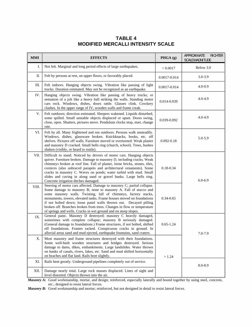
TABLE 4
MODIFIED MERCALLI INTENSITY SCALE
MMI EFFECTS PHGA (g) APPROXIMATE RICHTER SCALE MAGNITUDE
I. Not felt. Marginal and long period effects of large earthquakes. < 0.0017 Below 3.0
II. Felt by persons at rest, on upper floors, or favorably placed. 0.0017-0.014 3.0-3.9
III. Felt indoors. Hanging objects swing. Vibration like passing of light trucks. Duration estimated. May not be recognized as an earthquake. 0.0017-0.014 4.0-0.9
IV. Hanging objects swing. Vibration like passing of heavy trucks; or sensation of a jolt like a heavy ball striking the walls. Standing motor cars rock. Windows, dishes, doors rattle. Glasses clink. Crockery clashes. In the upper range of IV, wooden walls and frame creak.
0.014-0.039 4.0-4.9
V. Felt outdoors; direction estimated. Sleepers wakened. Liquids disturbed, some spilled. Small unstable objects displaced or upset. Doors swing, close, open. Shutters, pictures move. Pendulum clocks stop, start, change rate.
0.039-0.092 4.0-4.9
VI. Felt by all. Many frightened and run outdoors. Persons walk unsteadily. Windows, dishes, glassware broken. Knickknacks, books, etc. off shelves. Pictures off walls. Furniture moved or overturned. Weak plaster and masonry D cracked. Small bells ring (church, school). Trees, bushes shaken (visibly, or heard to rustle).
0.092-0.18 5.0-5.9
VII. Difficult to stand. Noticed by drivers of motor cars. Hanging objects quiver. Furniture broken. Damage to masonry D, including cracks. Weak chimneys broken at roof line. Fall of plaster, loose bricks, stones, tiles, cornices (also unbraced parapets and architectural ornaments). Some cracks in masonry C. Waves on ponds; water turbid with mud. Small slides and caving in along sand or gravel banks. Large bells ring. Concrete irrigation ditches damaged.
0.18-0.34
VIII. Steering of motor cars affected. Damage to masonry C; partial collapse. Some damage to masonry B; none to masonry A. Fall of stucco and some masonry walls. Twisting, fall of chimneys, factory stacks, monuments, towers, elevated tanks. Frame houses moved on foundations if not bolted down; loose panel walls thrown out. Decayed pilling broken off. Branches broken from trees. Changes in flow or temperature of springs and wells. Cracks in wet ground and on steep slopes.
0.34-0.65
6.0-6.9
IX. General panic. Masonry D destroyed; masonry C heavily damaged, sometimes with complete collapse; masonry B seriously damaged. (General damage to foundations.) Frame structures, if not bolted, shifted off foundations. Frames racked. Conspicuous cracks in ground. In alluvial areas sand and mud ejected, earthquake fountains, sand craters.
0.65-1.24
X. Most masonry and frame structures destroyed with their foundations. Some well-built wooden structures and bridges destroyed. Serious damage to dams, dikes, embankments. Large landslides. Water thrown on banks of canals, rivers, lakes, etc. Sand and mud shifted horizontally on beaches and flat land. Rails bent slightly.
7.0-7.9
XI. Rails bent greatly. Underground pipelines completely out of service.
XII. Damage nearly total. Large rock masses displaced. Lines of sight and level distorted. Objects thrown into the air.
> 1.24
8.0-8.9
Masonry A: Good workmanship, mortar, and design; reinforced, especially laterally and bound together by using steel, concrete, etc.; designed to resist lateral forces.
Masonry B: Good workmanship and mortar; reinforced, but not designed in detail to resist lateral forces.

Masonry C: Ordinary workmanship and mortar; no extreme weaknesses like failing to tie in at corners, but neither reinforced nor designed against horizontal forces.
Masonry D: Weak materials, such as adobe; poor mortar; low standards of workmanship; weak horizontally.
Source: http://earthquake.usgs.gov/earthquakes/


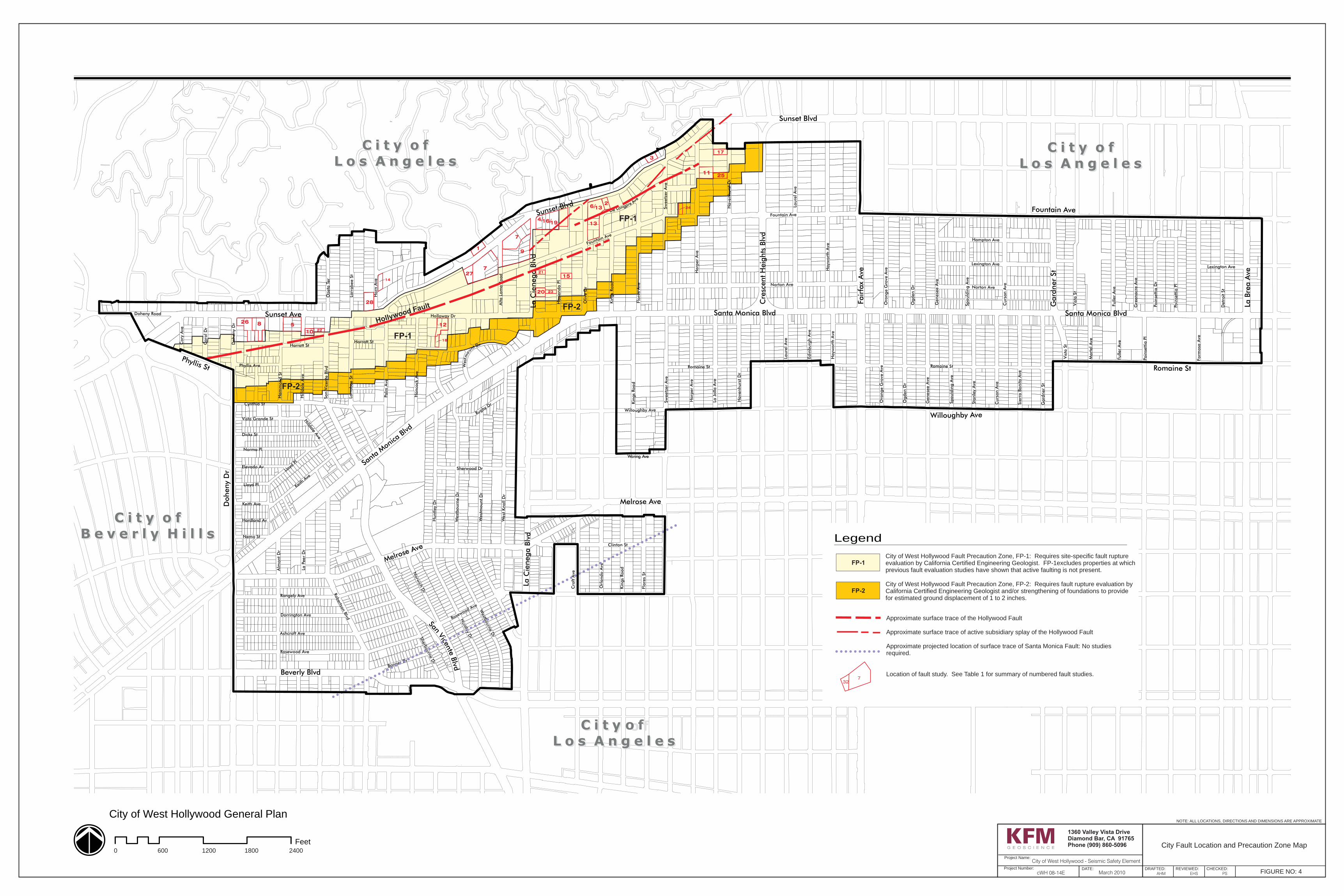
Fountain Ave
West
bou
rne D
r
Lau
rel A
ve
West
mount
Dr
Harp
er
Ave
Doh
eny
Dr
Palm
Ave
Olive
Dr
Hayw
ort
h A
ve
Clinton St
Have
nhu
rst
Dr
We
st K
noll D
r
Rangely Ave
Holloway Dr
Hu
ntley
Dr
Vis
ta S
t
Flo
res
Ave
Ogden
Dr Norton Ave
Flo
res
St
Dicks St
Norma Pl
Detr
oit S
t
Ashcroft Ave
Fuller
Ave
Rosewood Ave
Sherb
ourn
e Dr
Gard
ner
St
Hampton Ave
Cu
rson A
v e
Oze
ta T
er
Han
coc k
Ave
Willoughby Ave
Cro
ft A
ve
St a
nle
y A
ve
Lexington Ave
L a J
ol la A
ve
Keith
Ave
Genese
e A
ve
Form
osa
Ave
Orl
ando
Ave
Dorrington Ave
Ham
mon
d S
t
Ho
rn A
ve
Kin
gs
Road
Norw
ich D
r
Larr
abee S
t
Bonner Dr
Rugby Dr
Poi n
sett
ia P
l
Poin
sett
ia D
r
Car o
l D
r
La P
eer
Dr
Ora
ng
e G
rove A
ve
Haci
en
da P
l
Gre
enacr
e A
ve
Elevado Av
Alta L
om
a R
oad
Mart
el A
ve
Vista Grande St
Lloyd Pl
Nemo St
Co
r y A
ve
Alm
ont
Dr
Phyllis Ave
Doheny Road
Edin
bu
rgh A
ve
Hilld
al e
Av e
Sie
rra B
onita A
ve
Huntley D
r
Keith Ave
Genese
e A
ve
Fuller
Ave
Kin
gs
Road
Kin
gs
Roa
d
Laure
l A
ve
Romaine St
Sw
eetz
er
Ave
Spauld
ing A
ve
Rosewood Ave
Robertso
n B
lvd
Larr
abee S
t
Harratt St
Hilldale A
ve
Lloyd
Pl
Ora
nge G
rove
Ave
Cynthia St
San V
icen
te B
lvd
Norton Ave
Romaine St
Harp
er
Ave
Ogden D
r
Hayw
or t
h A
ve
Sw
eetz
er
Ave
Have
nhu
rst
Dr
Poin
sett
ia P
l
Harratt St
Hardland Av
West
mo
unt Dr
Sherwood Dr
De Longpre A
ve
Curs
on A
ve
Lexington Ave
Westb
ourn
e Dr
Fountain Ave
C i t y o fC i t y o f
B e v e r l y H i l l sB e v e r l y H i l l s
C i t y o fC i t y o f
L o s A n g e l e sL o s A n g e l e sC i t y o fC i t y o f
L o s A n g e l e sL o s A n g e l e s
C i t y o fC i t y o f
L o s A n g e l e sL o s A n g e l e s
Vis
ta S
t
Spauld
ing A
ve
Waring Ave
Fountain Ave
Beverly Blvd
Sunset Blvd
La B
rea A
ve
Cre
scent H
eig
hts
Blv
d
Fair
fax
Ave
Willoughby Ave
Santa Monica Blvd
Romaine St
Gard
ner
St
Melrose AveDoheny
Dr
Sunset Ave Santa Monica Blvd
Sunset Blvd
Santa
Monica
Blvd
La C
ienega B
l vd
Melrose Ave
La C
ienega B
lvd
San Vicen
te Blvd
Ph llis Sty
Feet
City of West Hollywood General Plan
DATE:
1360 Valley Vista DriveDiamond Bar, CA 91765Phone (909) 860-5096 City Fault Location and Precaution Zone Map
Project Name:
Project Number:FIGURE NO: 4
NOTE: ALL LOCATIONS, DIRECTIONS AND DIMENSIONS ARE APPROXIMATE
March 2010cWH 08-14E
City of West Hollywood - Seismic Safety Element
DRAFTED: REVIEWED: CHECKED:AHM EHS PS
0 24001200600 1800
Hollywood Fault
8 522
28
12
19
18
24
7
2
26
10
17
14
3
6/13
4/
7
27
1
16/
9
20
21
23
15
1125
13
732
City of West Hollywood Fault Precaution Zone, FP-1: Requires site-specific fault rupture evaluation by California Certified Engineering Geologist. FP-1excludes properties at whichprevious fault evaluation studies have shown that active faulting is not present.
Approximate surface trace of the Hollywood Fault
Location of fault study. See Table 1 for summary of numbered fault studies.
Legend
Approximate projected location of surface trace of Santa Monica Fault: No studiesrequired.
Approximate surface trace of active subsidiary splay of the Hollywood Fault
FP-1
FP-2City of West Hollywood Fault Precaution Zone, FP-2: Requires fault rupture evaluation by California Certified Engineering Geologist and/or strengthening of foundations to providefor estimated ground displacement of 1 to 2 inches.
FP-2
FP-2
FP-1
FP-1

