geological and thermal aspects of geothermal...
TRANSCRIPT

Geological and Thermal Aspects of Geothermal Exploration
Compiled by: Peter Kiranga Mbia
Erica Alexis Massey
Ai Hamada
Felix Mutugi Mwarania
Teacher: Andri Stefánsson and Sigrún Hreinsdóttir,
JAR601M Geothermal Energy
Submitted February 15, 2013

1
Abstract
The earth's crust overlays an intense heat whose source is radioactive decay, planetary accretion
or major heat producing isotopes in the earth. The average geothermal gradient in the earth's
crust is about 25°C/km. Geology, among other geo-scientific disciplines plays a key role in
geothermal exploration. Geological maps generated from the exploration work act as a guide for
more scientific work in a geothermal field. This paper provides the geological aspects involved
in geothermal exploration and exploitation.
Introduction
Geological processes conducive to providing accessible geothermal energy require permeability,
a fluid source and heat. Exploration of this resource involves a process of collaboration of
structural geologists, geophysics, geochemistry and other professionals in science, energy and
engineering. The Earth’s crust overlays a heat source resulting from radioactive decay and the
primordial heat, also known as secular cooling, from the formation of the Earth is 4.7 x 10 13
W
(0.1 W/m2). The Earth’s heat is conducted near the surface and convected at greater depths
within the mantle towards the surface, referred to as the geotherm. The geothermal gradient on
average is 25°C/km at the surface, resulting in temperatures ~ 4000°C at the Earth’s core at
depth of ~ 6500 km. Geological signs of potential geothermal heat are high-temperature volcanic
belts, sedimentary basins, crystalline basements, deep fluid systems from crustal circulation, hot
springs and hot dry rock. These signs are localized and reflect unique tectonic setups in each
country.
Structurally, the geologic setting often includes faults, fractures, fissure swarms, grabens and
rifting for effective permeability of hot fluid. Geophysical factors are considered such as
magnetic or gravity anomalies on the Earth’s surface to pinpoint ultimate locations for
accessibility to the geothermal system. Erosion, deposition and isostacy due to continental uplift
following ice age must be considered in a complete geological analysis for geothermal
exploitation.
Geologic Settings
Volcanoes, sedimentary basins, crystalline basements and subduction zones are settings in which
geothermal heat is conducted. The geology of a site can be scored, as follows, on how well it
rates as indicators for potential geothermal, five being almost a surety of shallower higher-
temperature systems (Kimball 2010):
2
Table 1 Geological Scoring Table (Kimball 2010)
Geothermal
Rating
Geological Setting
0 No data (unknown)
1 Sedimentary rocks, Mesozoic and older intrusives, Metamorphic and Ultramafic
rocks, and Oligocene and older volcanic rocks
2 Cenozoic and younger intrusive, Miocene volcanic rocks
3 Sedimentary basins, Pliocene volcanic
4 Pleistocene volcanic rocks
5 Holocene volcanic rocks
Mapping & Data
Geoscience requires mapping ultimate drill hole locations based on geothermal potential with the
geothermal analysis and location of hot and cold springs, geochemistry of rocks, heat flow,
temperature gradients. Knowledge within data bases are necessary for geothermometry data, i.e.
isotopic water geochemistry (He-isotopes), geophysics, geology, crustal dynamics (i.e. thickness,
fault types and ages, strain and stress models), volcanic geochemistry and radiometric ages,
seismic networks, hydrogeology, GPS and InSAR studies, airborne electromagnetic, mineral
alterations and structural geology.
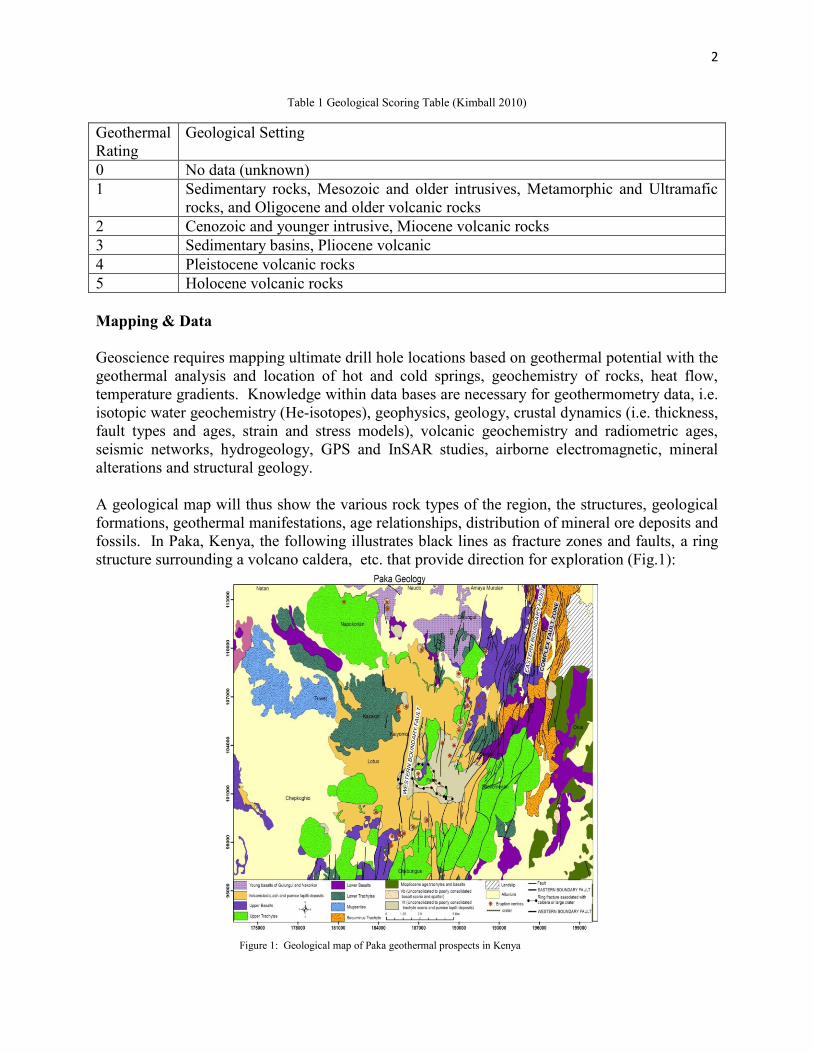
A geological map will thus show the various rock types of the region, the structures, geological
formations, geothermal manifestations, age relationships, distribution of mineral ore deposits and
fossils. In Paka, Kenya, the following illustrates black lines as fracture zones and faults, a ring
structure surrounding a volcano caldera, etc. that provide direction for exploration (Fig.1):
Figure 1: Geological map of Paka geothermal prospects in Kenya
3
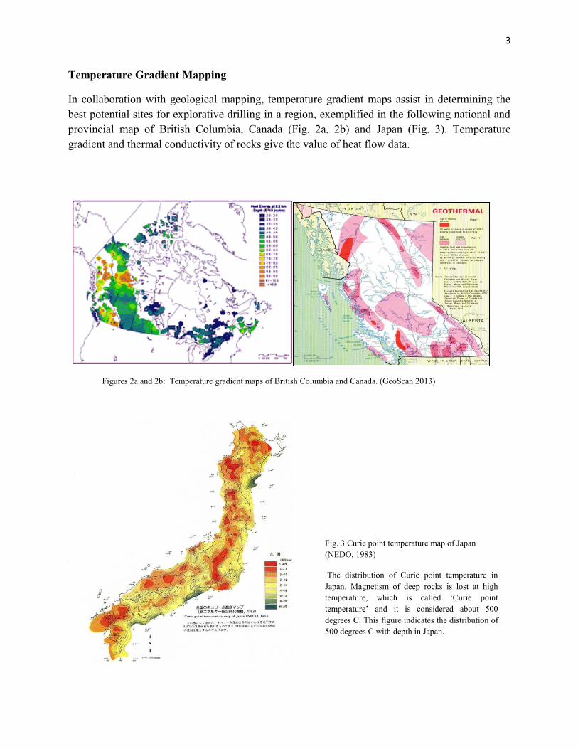
Temperature Gradient Mapping
In collaboration with geological mapping, temperature gradient maps assist in determining the
best potential sites for explorative drilling in a region, exemplified in the following national and
provincial map of British Columbia, Canada (Fig. 2a, 2b) and Japan (Fig. 3). Temperature
gradient and thermal conductivity of rocks give the value of heat flow data.
Figures 2a and 2b: Temperature gradient maps of British Columbia and Canada. (GeoScan 2013)
Fig. 3 Curie point temperature map of Japan
(NEDO, 1983)
The distribution of Curie point temperature in
Japan. Magnetism of deep rocks is lost at high
temperature, which is called ‘Curie point
temperature’ and it is considered about 500
degrees C. This figure indicates the distribution of
500 degrees C with depth in Japan.
4
Hydrothermal Alteration
Hydrothermal alteration is a change in the mineralogy as a result of interaction of the rock with
hot water fluids, called “hydrothermal fluids”. The fluids carry metals in solution, either from a
nearby igneous source, or from leaching out of some nearby rocks. Hydrothermal fluids cause
hydrothermal alteration of rocks by passing hot water fluids through the rocks and changing their
composition by adding or removing or redistributing components. The source of hydrothermal
fluids can be from near surface normally called meteoric water, magmatic as a result of magma
degasing or as a product of metamorphic rocks dehydration reaction which takes place during the
metamorphic events. The excess water circulates through the surrounding rocks and may
scavenge and transport metals to sites where they can be precipitated as ore minerals.
Hydrothermal fluids also circulate along fractures and faults. A formation, which has a well-
developed fracture system, may serve as an excellent host rock. Veins form where the fluids flow
through larger, open space fractures and precipitate mineralization along the walls of the
fracture, eventually filling it completely. The common secondary minerals within Olkaria
geothermal system include calc-silicates, clays, oxides, silica minerals, Zeolites pyrite, fluorite,
calcite and albite. The occurrences of these minerals have been used to predict reservoir
characteristics in terms of temperature distribution, fluid chemistry, permeability, and the
evolutionary stage of the system. The occurrence of secondary minerals at Olkaria, noted in
Table 2, closely follows the stability fields determined for secondary mineralization in
hydrothermal systems (e.g. Browne, 1978).
Table 2: Primary and Secondary Minerals
Primary minerals Secondary mineral products
Volcanic glass, quartz, amorphous
silica.
Zeolites, quartz, clays, calcite
Olivine Clay minerals
Pyroxene, amphibole Illite, pyrite, calcite, clays
Plagioclase Albite, epidote
Fe-Ti oxide Pyrite
Hydrothermal alteration and temperature
Hydrothermal minerals have been routinely used to determine the temperature distribution in the
field and assist in reservoir hydrological modeling. The most important mineral geothermometers
are the clays and epidote. The clay minerals are particularly important in mapping the thermal
fluctuations of the geothermal system as they adapt quickly to new thermal conditions. The
commonly useful clay minerals include Smectite, interlayered Smectite-illite and illite. Smectite
occur in the upper cooler zones where temperatures are less than 150⁰ C.
Illite is the second most common secondary mineral after chlorite in Olkaria field and occurs
almost exclusively in the geothermal reservoir where temperatures are more than 200⁰ C. Illite is
often associated with chlorite, epidote, quartz, albite, and minor calcite (Omenda 1997).

5
Hydrothermal alteration and permeability
A common indication of high permeability in Olkaria is the presence of strong bleaching of the
reservoir rocks in fractured zones. Bleaching is due to both alteration of mafic minerals and
deposition of silica. The alteration is often accompanied by minor calcite, epidote, and chlorite.
Regions of enhanced permeability are also indicated by an abundance of the bladed type of
calcite, but this is commonly only in the upper part of the reservoir where boiling occurs
(Omenda 1997) Calcite deposited from deeper hydrothermal fluids usually occupies veins.
Hydrothermal alteration and fluid chemistry
Acid alteration is accompanied by intense hydrogen metasomatism, base cation leaching and
sulphate metasomatism (Hemley and Jones, 1964). In general acid-altered rocks are composed of
residual elements: aluminium, titanium, iron, silica, some potassium, and calcium, with most of
the base cations in the originals rock being leached away. Potassium is relatively immobile
compared to other base cations; it occurs in alunite at low pH and high sulphate activity, and
illite at higher temperatures, higher pH and high silica activity (Hemley et al 1967). In a neutral
pH suite, less hydrolysis occurs and cations are less mobile. Alteration here largely involves the
reshuffling of elements in the original rock into secondary minerals, and since replacement is
often incomplete, primary chemical trends are usually retained.
Rig site during drilling of geothermal wells
Cuttings from geothermal wells are normally sampled after every 2 m interval, but in cases
where the sample was too little and unrepresentative, up to 4 m depth interval is sampled.
Preliminary analysis of the cuttings and cores are normally done at the rig site by use of a
binocular microscope and specimen samples which are representative of all the rock units
penetrated are selected for detailed laboratory analysis of hydrothermal alteration minerals and
fluid inclusion studies. For exploration drilling a few cores can be cut, but for appraisal and
production drilling, cores are rarely cut as the stratigraphy and the formations are well
understood and also the fact that it costs more to cut a core.
Field sampling during geological surface exploration
In the field, hydrothermally altered samples are found where there are active or extinct
hydrothermal activities. Hydrothermal minerals such as quartz, sulphur, zeolites, silica and clays
are deposited at the vents where hydrothermal fluids leak on the surface. The sample here is
scooped, and detailed descriptions are made including the sampling location. The sample is then
stored in the sample bags for further laboratory analyses.
Measured, hydrothermal alteration and fluid inclusion temperatures
In any geothermal system, there is always some uncertainty whether observed minerals
distribution and zonation reflect current formation temperatures or are related to some previous
thermal events or regimes. In the Greater Olkaria geothermal area as in other geothermal fields

6
throughout the world, hydrothermal alteration minerals are important indicators of subsurface
thermal changes.
Factors affecting hydrothermal alteration
Factors that influence the distribution and kind of mineral assemblages present in hydrothermal
systems include permeability, rock and water composition, temperature, pressure and duration of
hydrothermal alteration (Browne and Ellis, 1970). These factors are largely independent, but the
effects of one or more of the factors can exert a dominant influence in the location and extent of
hydrothermal alteration.
1. Permeability of the rocks controls the access of thermal fluids, which cause
hydrothermal alteration of the rocks and precipitation of secondary minerals in open
spaces. Rocks, which have very restricted permeability or are completely impervious
to fluid, will be only slightly altered. Crystallinity of the host rock is of importance
because glass is more easily altered than crystalline rock.
2. Fluid, usually meteoric, sea water or groundwater.
3. Temperature is the most significant factor in hydrothermal alteration because most of
the chemical reactions require elevated temperatures and also minerals are
thermodynamically stable at high temperatures.
Analytical Methods
Several analytical methods are performed at different times to identify different parameters
useful for subsurface status interpretation, further details included in Appendix II, including
surface and rig site sampling:
1. Binocular analysis of the cuttings, cores or field samples are done using the binocular
microscope.
2. Fluid inclusions are small portions of fluid, which are trapped in a solid crystal as it grew
or recrystallized.
3. Electron microprobes analysis permits the non-destructive, major and trace element
analysis of small areas (~4μm diameter) of solid materials in situ.
Alteration Types
There are several alteration types depending on nature of geothermal fluid, original rock physical
status, duration and the type of mineral affected. The main alteration mineral types, some of
which are as follows, summarized further in Appendix I:
1. Propylitic: chlorite, epidote, actinolite and temolite.
2. Sericitic: sericite.
3. Potassic: biotite, k-feldspar, adularia
4. Albitic: albite
5. Silicification: quartz
6. Carbonization: carbonate minerals

7
7. Argillic: clay minerals
8. Zeolitic: zeolite minerals
9. Oxidation: oxide minerals
Conclusion
Geothermal geological analysis combined with geophysical logging techniques, fluid inclusion
geothermometry, completion tests, and standard formation temperature tests (SFTT), discharge
fluid chemistry, stratigraphy and structural geology provide an excellent understanding of the
nature of a geothermal system. Geothermal geology can assist in the following during
geothermal exploration and exploitation:
1. Setting the production casing during drilling especially in exploration wells.
2. Understanding the reservoir by modeling the inflow, upflow and the outflow zones of the
geothermal system/field.
3. Nature of the reservoir and know whether temporal changes in have occurred in the past.
4. Fluids chemistry so as to predict future problems in the wells/fields such as casing
corrosion, acid inflow, cold-water incursion and scaling tendencies.
5. Explore new geothermal fields next to appraised or existing production wells.
The study of geology and temperature gradients are important aspects of geothermal
development and exploration. Just because a region deems viable for geothermal energy does
not guarantee success, as obstacles exist such as protected national parks, costs for deep drilling,
land tenure issues, regulatory concerns and environmental concerns.
Team work
This paper was compiled by Peter Mbia, Felix Mwarania, Erica Massey and Ai Hamada as a
group work assignment. No field work- research was done but the authors searched information
from the existing data internet search and compiled it after three sitting discussions and
presentation of each person’s findings. Following initial writing of the group, each person
contributed perspectives from their own countries with its unique geology or thermal gradient
regimes to add our backgrounds to the flavor of our research. Peter and Felix are from Kenya,
Erica from B.C., Canada and Ai is from Japan. All of the findings were compiled and adopted
by the team as a true copy of their findings. Therefore, all members are equally responsible for
the detailed work. Thank you for good teamwork.
Acknowledgements
Erica would like to thank Krista Jensen, of Natural Resources Canada for their recent research.
Ai would like to thank the Japanese Geothermal Research Academic Conference group for
English articles.

8
References
Arnorsson, S., Gunnlaugsson, E., and Svarvarson, H., 1983: The chemistry of geothermal waters
in Iceland III. Chemical geothermometry in geothermal investigations. Geochim. Cosmochim.
Acta, 46, 1513-1532.
Bargar, K.E., and Beeson, M. H., 1984: Hydrothermal alteration in research drill hole Y-2 Lower
Geyser Basin, Yellowstone National Park, Wyoming, USA. Geological Survey Professional
paper 1054-B, 24 pp.
Bird, D. K., Schiffman, P., Elders, W. A., Williams, A. E. and McDowell, S. D., (1984): Calc-
silicate mineralization in active geothermal systems. Economic geology, Vol. 79, 671-695.
Browne, P.R.L., 1978: Hydrothermal alteration in active geothermal fields. Annual Review Earth
and Planetary Sciences 6, 229–250.
Browne, P. R. L., 1984: Lectures in geothermal geology and petrology. UNU G.T.P., Iceland,
report 2, 37-38.
Burgess, W.G. 1989. Geothermal energy. Geology Today 5(3):88–92.=Fournier et al, R. O and
Eckel, C. E., 1902: The preparation of a geologic map. Journal of Geology, 10-1, 59-66
Furgerson R. B., 1972: Electrical Resistivity Survey of the Olkaria project, Kenya. East African
Power & Lighting Co. Ltd. Geothermal Exploration Project report.
GeoScan. Temperature gradient map of Canada.
http://countysustainability.ca/indexEnergyGEOTHERMAL.html. Accessed Feb. 13, 2013.
Grim, R. E., 1968: Clay mineralogy: San Francisco, McGraw-Hill Book Co., 596 pp.
Kimball, Sarah. (2010). Favourability map of British Columbia Geothermal Resources
Lagat, J. K., 1999: Borehole geology of well OW-903, Olkaria Domes area. KenGen internal
report.
Lagat, J.K., 2012. Hydrothermal alteration minerology in Geothermal fields with a case example
from Olkaria Domes Geothermal field, Kenya.
Mungania, J., (992: Preliminary field report on geology of Olkaria volcanic complex with
emphasis on Domes area field investigations. Kenya Power Company internal report.
Omenda, P.A., 1998a: The geology and structural controls of the Olkaria geothermal system,
Kenya. Geothermics, Vol. 27, 55-74.
Potter, R. W. II, 1982: A revised and expanded silica (quartz) geothermometer. Geothermal
Resource Council Bulletin, 11-10, 3-13.
Reyes, A. G., 1990: Petrology of Philippine geothermal system and the application of alteration
mineralogy to their assessment. Journal of Volcanology and Geothermal Research 43, 279-
304.
Roedder, E., 1984: Fluid Inclusions. Rev. Mineral. 12. Mineral. Soc. Am., Washington, DC.
Ryder, A.J.D. 1986: Geological Report of Well OW-701 Olkaria Geothermal Field, Kenya.
Kenya Power Company report, prepared by GENZL.
Schiffman, P., Elders, W.A., Williams, A.E., McDowell, S.D., and Bird, D.K., 1984: Active
metasomatism in the Cerro Prieto geothermal system, Baja California, Mexico: a telescoped
lowpressure, low-temperature metamorphic facies series: Geology, vol. 12, 12-15.
The possibility of geothermal energy development in Japan (AIST, 2008)
http://www.meti.go.jp/committee/materials2/downloadfiles/g81201a05j.pdf Accessed 13 Feb,
2013.

9
APPENDIX I: Alteration Types
Propylitic: (Chlorite, epidote, actinolite and tremolite) Propylitic alteration turns rocks green,
because the new minerals formed are green. They usually form from the decomposition of Fe-
Mg-bearing minerals, such as biotite, amphibole or pyroxene, although they can also replace
feldspar. Propylitic alteration occurs at high temperatures. Propylitic alteration will generally
form in a distal setting relative to other alteration types.
Sericitic: (Sericite) Sericitic alteration alters the rock to the mineral sericite, which is a very fine
grained white mica. It typically forms by the decomposition of feldspars, so it replaces feldspar.
Sericitic alteration implies low pH (acidic) conditions.
Potassic: (Biotite, k-feldspar, adularia) Potassic alteration is a relatively high temperature type of
alteration, which results from potassium enrichment. This style of alteration can form before
complete crystallization of magma, as evidenced by the typically sinuous and rather
discontinuous vein patterns. Potassic alteration can occur in deeper plutonic environments, where
orthoclase will be formed, or in shallow, volcanic environments where adularia is formed.
Albitic: (Albite) Albitic alteration forms albite, or sodic plagioclase. Its presence is usually an
indication of Na enrichment. This type of alteration is also a relatively high temperature type of
alteration. The white mica paragonite (Na-rich) is also formed sometimes. Albite is precipitated
in vugs and fractures at >280ºC.
Silicification: (Quartz) Silicification is the addition of secondary silica (SiO2). Silicification is
one of the most common types of alteration, and it occurs in many different styles. One of the
most common styles is called “silica flooding”, which results from replacement of the rock with
microcrystalline quartz (chalcedony). Greater porosity of a rock will facilitate this process.
Another common style of
silicification is the formation of close-spaced fractures in a network, or “stockworks”, which are
filled with quartz. Silica flooding and/or stockworks are sometimes present in the wall rock
along the amargins of quartz veins.
Carbonatization: (Carbonate minerals) Carbonitization is a general term for the addition of any
type of carbonate mineral. The most common are calcite, ankerite and dolomite. Carbonatization
is also usually associated with the addition of other minerals, some of which include talc,
chlorite, sericite and albite.
Alunite is a potassium aluminum sulfate mineral, which tends to form massive ledges in some
areas.
The presence of alunite suggests high SO4 gas contents were present, which is thought to result
from the oxidation of sulfide minerals.
Argillic: (Clay minerals) Argillic alteration is that which introduces any one of a wide variety of
clay minerals including kaolinite, smectite and illite. Argillic alteration is generally a low
temperature event, and, some may occur in atmospheric conditions. The earliest signs of argillic
alteration include the bleaching out of feldspars. This consists of kaolinite + quartz + hematite +
limonite, feldspars leached and altered to sericite. The presence of this assemblage suggests low

10
pH (highly acidic) conditions and temperatures of <220ºC. At higher temperatures, the mineral
pyrophyllite (white mica) forms in place of kaolinite.
Zeolitic: (Zeolite minerals) Zeolitic alteration is often associated with volcanic environments, but
it can occur at considerable distances from these. In volcanic environments, the zeolite minerals
replace the glass matrix. Zeolite minerals are low temperature minerals, so they are generally
formed during the waning stages of volcanic activity, in near-surface environments. Zeolitization
occurs at over <220ºC.
Serpentinization and Talc Alteration: (Serpentine, Talc) Serpentinization forms serpentine,
which recognized softness, waxy, greenish appearance, and often massive habit. This type of
alteration is only common when the host rocks are mafic to ultramafic in composition. These
types of rocks have relatively higher iron and magnesium contents. Serpentine is a relatively low
temperature mineral. Talc alteration indicates a higher concentration of magnesium was available
during crystallization.
Oxidation: (Oxide minerals) Oxidation is simply the formation of any type of oxide mineral. The
most common ones to form are hematite and limonite (iron oxides), but many different types can
form, depending on the metals, which are present. Oxides form most easily in the surface or near
surface environment, where oxygen from the atmosphere is more readily available. The
temperature range for oxidation is variable. It can occur at surface or atmospheric conditions, or
it can occur as a result of having low to moderate fluid temperatures.

11
APPENDIX II – Analytical & Sampling Methods
Analysis & Sampling at rig site during geothermal wells drilling
Cuttings from geothermal wells are normally sampled after every 2 m interval, but in cases where the
sample was too little and unrepresentative, up to 4 m depth interval is sampled. Preliminary analysis of
the cuttings and cores are normally done at the rig site by use of a binocular microscope and specimen
samples which are representative of all the rock units penetrated are selected for detailed laboratory
analysis of hydrothermal alteration minerals and fluid inclusion studies. For exploration drilling a few
cores can be cut, but for appraisal and production drilling, cores are rarely cut as the stratigraphy and the
formations are well understood and also the fact that it costs more to cut a core.
Field sampling during geological surface exploration
In the field, hydrothermally altered samples are found where there are active or extinct hydrothermal
activities. Hydrothermal minerals such as quartz, sulphur, zeolites, silica and clays are deposited at the
vents where hydrothermal fluids leak on the surface. The sample here is scooped, and detailed
descriptions are made including the sampling location. The sample is then stored in the sample bags for
further laboratory analyses.
Analytical Methods
Several analytical methods are performed at different times to identify different parameters useful for
subsurface status interpretation.
Binocular analysis of the cuttings, cores or field samples are done using the binocular microscope. More
detailed analysis of representative samples from all the lithological units encountered in the well/field are
selected and thin sections are prepared for petrographic studies. The thin sections are analyzed using the
petrographic microscope. The petrographic microscope is used to confirm the rock type(s) and the
alteration minerals, additional alteration minerals not observed by the binocular microscope, and to study
the mineralogical evolution of the alteration minerals. X-ray Diffractometer is used to qualitatively or
quantitatively identify individual minerals e.g. clays and zeolites. Samples are selected from all the
lithological units and analyzed for clays. Crystals of the mineral to be identified e.g. zeolites; carbonate,
clays and sulphides are picked from the rock samples and ground by using an automatic milling machine.
Fluid inclusions are small portions of fluid, which are trapped in a solid crystal as it grew or
recrystallized. The fluids are thus samples of the original brine from which the crystal grew or a later fluid
which bathed the crystal during crystallization. Primary fluid inclusions are concentrated along the first-
order growth discontinuities or occur as isolated inclusions distributed within the crystals. Secondary
fluid inclusions are trapped along healed cracks. If the crystal cools, the liquid will contract at a faster rate
than the solid and a vapor bubble will form (Roedder, 1984). At ambient temperatures, all types of
inclusions contain a liquid aqueous solution and a gas bubble. This bubble forming process could be
reversed to determine the temperature of mineral formation or temperature of homogenization (Th). The
inclusion is heated until the fluid homogenizes in a single phase (i.e. bubble disappears) and the Th is
measured.
Electron microprobes analysis permits the non-destructive, major and trace element analysis of small
areas (~4μm diameter) of solid materials in situ. Thin sections, which contain the minerals that are
required for to be analyzed in abundance e.g. epidote, are prepared for analysis.