geology and coal resources of little susitna - alaska...
TRANSCRIPT

Geology and Coal Resources of the Little Susitna District Matanuska Coal Field Alaska By FARRELC F. BARNES aid DANIEL SOKOL
M I N E R A L R E S O U R C E S O F A L A S K A
G E O L O G I C A L S U R V E Y B U L L E T I N 1058-13
The results of su bsurfme exfilorattbn for c o d ia the western part of the Matmuska .Valley
.
UNITED STATES GOVERNMENT PRINTING OFFICE, WASHINGTON t 1959

UNITED STATES DEPARTMENT OF THB INTERIOR
FRED A. SEATOMI W f u q
GWLOGICAL SURVEY
Thoman 8. Nolan, Mrectar

Cod.-,,-----,--*----,---------*-----------------*-*-*----*-*-,--- ChmAer and &ributton ,,,,,,,----------- --------- -- ---- ----- S u b a ~ a m exploration,, a,,,,,-1MB-- -1- - -+ - ..- 1-11111 ---- - --- -----
Equipment and method@, , ,,-,---,,----,,,,,- ,,-,----- -, --- Interpretation of results ,,,,,-,--------- - - tt a a tat -- , --a-
&tails of ma1 loaalitres, ,, ,,- ,---------------- ---,,dm-,,,,,,,,,
Locdity .............................................. Locality 2,,,,,,,,,,,-,,,,,-,-,,,-------a--------+-d---------. Locality 3,-,,,,,,,-,-,-,-----,--------------------,----,-, Zo~ality4-,,-,,,----,-,-,,,-------,-+-,--~-----,--------- Zocality 5,,,,4,-,,,,,,,,,,-----+-,---------+4---,-+--,--, Houatonarea,,,,,,-,-,----.-,---------------,,,,,,,-,,,,,
Summary of coal rerwurees ---,--, ,,,,--- ---- ---+-,---- ----------- References c i t d ,-,-,,,,,,,,-------------------------------,---,,-
PLAT. 7. ~ I & c map of the Little Susifna dlstri* Matanusb aani B s l d ~ Alaska.
8. Map and mtlons of c o d locality 4. 9. Grapbic lop of pwm-auger drill holes in tba Little Bugitnn M c L
10. Map and sections of coal locelity 2. 11. Map and sections of coal locality 3.
Fmmm 36. Index map of muth-cenhl Alaska, showing locetion of the Pam Littla Guaitns district, ,,, ,,, , ,,,- -, , - ,- , - , - --- , - -- - - , 122
87. Sketch map and CTWS section of coal locality 1 ,,,,,,-,-,-,, 127 38. Elections of coal beds in tbe Little Switna district ,,,,,,,,,-, 129


MINERAL RESOURCES OF A U K A
GEOLOGY AND COAL RESOURCES OF THE LXTCLE SUSITNA DISTRICT, MATAMUSKA COAL FIELD,
ALASKA
By F~RRELL F. BARNES and DANIEL SOKOL
The M e Busltna district a$ the Makmnslm coal fleld lies along the narthern border of the lower MatannsBa Valley in ~wthentral Alaska. The Alaska Bailmad at the west end of the district, and graveled mads l ~ d h g to f$r muth, east, and west edges, make the dlatrict a~4b accesaibla
T h m bedrock formations are known in the diiltrict, The oldat Is mfca schist, probably Precambrian, that waa found in a mall area; the swnd is the Arkom Ridge f o r m tlon, mnsisting mainly of arkmic sandstone of probable Cretaceous age; and the young& is an unnamed formation, probably Eocene in age, mnHstIng of sandstone, siltstone, and claystone and IaeIudiug s e v d beda of mbbitumhou~ m a t Except for r few outcrops along the larger stream% the dlstrlct fs entirely mantled by nnconsolidated Quaternmy dewits of gb- cia1 ~ n d alluvial or-.
The coal-bearing strata generally dip gently southward but are Iceally folded an8 f a n l a They contain seveml beds of aubbitumhous coal, mostly leas than 3 f#t thick but including I impure bed at least 9 feet th ick Burface map ging In 1852 inaicatw3 Ulat 4 localities, In addition ta the H a o n area where coal has been mind intermittently since 1917, contain 1 or more beds of pot#- tlal ~trippfng -1. Exploration of these 4 localitfa with a bnlldmer and power anger in 1953 and 1954 indicated that the coal generally Is too thin or Impare to enmurage mine development under present conditions. In the Houston a m , diamond drilling bg the United Btates Bureau of Mines in l96l and 1952 showed Wt the upper 1,200 feet of the coal-Wring formation cont~ins no more than 2 beds with .as much as 3 feet of -1. and that these thLn abruptly away Prom the onkcmp.
TNTROXIOCTCON
The Little Snsitna, district, as defined in this report, is an a m of coal-bearing rocks ranging from 1 to 2 miles in width that d n d s for a h t 22 miles along the north ~ i d e of the lower (west) end of the Matanaska Valley in south-central Alaska (fig. 86). The as- trict is bounded on the north by the south front of tth Tab-
121

tA-bdm map m~ mutb-cmtml ll..h- Ihmln~ l m t l o n of the Wttla Baaltnr dlrtrlct
Momkina, on the sonth and east by the Little Sdtna River, and on the west by the broad Susitna River fowland. (See pl. ?.)
Thia report iB h a i d on pdiminary surf- mapping in tha snm- rner of 1952 and on s u k f a c e explomtion with a bulldozer power- auger unit in the summers of 1953 and 1954. In 1952 F. F. Bamm was a s ~ l i a k ? by AIfred Oeetreieh, gwlogist, and Lawis Ladwig and Richard PackI field miatants. Fmm July 2 to August 31,1058, F. F.
Bssnes and Daniel SokoI were assisted by W. T. Addock and R. E. Ibwlsnd, f i d s a a i h $ and by a bddozer opemtor-mechanic. F m June 23 to July 27, 1954, Barnes and Sokol were a s s i d by A. E. Burford snd W. 8. Hopkuls, geologish, and an operator- mechanic.
Prior fo the prefsent invatiption v e q little w n ~ ]mown of & plom of the d i d c 4 exmpt that it is larply c o m d with alluvial and glmial deposits, and that coal-bearing rocks had been mported at three widely mparatd localities. The pqmse of the sarfw map- ping was to deternine the character, structure, and extant of the coal- baring & mid to ael& lthe moat promKqg areas for mom detailed study. On the basia of this preliminary mapping four a m were mlectad for further investigation by subsarfw methods. Dohiled m s p , ahowing the topopphy ~ f l d Imtian of tremchee and drill holm in each area, were propared and tied in with the lmd-smy net by plmebble methods.
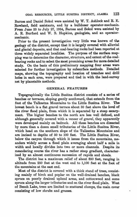
Tqqpphimlly the Little Susitna district c w i h of a miem of h c h m or hrmq sloping gently southward, that mtmdrr from the foot of the Tdkwtna Mountains to the Little Suaitna River. The lowed bench is a flat gravel terrace about 30 feet abve the 1ml of the river flood plain, from which it ia 8eparaM by a steep mm~rp- mmt. T h e higher benches to the north are lw well defined, and although p e m l l y covered with a veneer of g r a d , t h v apparently were developed mainly on bedrock All these benches are diss~cted by mom than a dozen mall tributaries of the Little Snsiha River, which h d on the southern dope of the Ta lb tna Mountains and sre incimd b depths of 50 to 100 fmt, The Little Susitna River, below the myon through which it imas from the mountains, me- andem widely acm a flood plain averaging abut half a mile in width md 1mUy dividm into two or mere charmela. Dqih ita meandering course the river hm a ather steep gradient, charrrcter- ized by m dm& continnow s o m i o n of rapih and ahoak
The district has a maximam relief of tabout 850 feeE, ran& in altitude from 250 feat aL the me& end to 1,100 feet at the foot of the mountains at the east end,
Most of the district is mvered with rr thick stand of treea, mmi& ing mainly of birch and poplar on the well-drained bench% black qmce on poorly dmined upland BIWIS, md cottonwood and soms ~pruca dong the larger tributaria esd on the river flood plain. Weat of Bench Lake, trees are limited to scat- clumps, the main cover consisting of low shrnbs and p ~ . -

Althoagh tho lower Matanuska Vdey is near tidewah, it is so far from the open ocean that its c b t e is more typical of interior Almh than of the coast. The snmmers m mild, and the wintars are severe. b w temperatureg are odtan accompanied by strong down- valley win& The tempwrstnres may rise well above 80°F in grim-
mer and drop below -30°F in winter, but these extremes are exmp tional. The amrap mum1 precipitation is about 16 inches. August and September are the wettest months, each with an werage midall of alm& 3 hchea.
The east end of the Little Susitna district is d b l e by graveled mads from Palmer and Wailla, each about 10 miles distant. The west and of the district may be mmhd by a. road from W d a to Houston and by the main Zine of The Alaska RaiIrod. A road to the Little Sueitna River at a pint about due north of Wasilla was under construction in 1956. The only rods within the district, aside from the highway to Houston, are the necess roads built during this investigation, which extend for about B miles along the north side of the river below the mouth of Coal Creek.
On the Gaais of warn and widely s c a t t e d ontcrops, t h m bedrock farmntianfi were recognized in or near the Little Susitnn, district. The oldest bedrock is a quartz-mien schist, probably Precambrian, which is exposed in a narmn gorge of Deception Greek about 5 milea due north of H&n (PI. 7). The second formation, which u n d e r h the mountain slopes that form the north bounday of the district, consists of weU-indurated cangIomemte, arkosic sandstone, and shale that, at least localIy, have been considerably affwtad by d d e metamorphism. These rocks a m evidently the westward extmsion of a sequence of arkme, shale, and conglomerate that is typically exposed in hrkose Ridge, east of the Little Susitm River, and that has been nmed tha Arkom Edge formation (Barnes and Bape, 1956, p. 10). Although t h e s ~ mks were originally assigned an Eoaene age on the basis of a few plant fmsils, Inter eGdenca in- dimtm that they probably are Cretaceous in .age. In the ares betwean the mountain front ~tnd the Little Susitna
R i m the M m k consists mostly, if not entirely, of poorly to mod- erately indurated sediments comprising mainly h e to ma= pebbIy sandstone, siltstone, and claystone, but including x few ma1 beds rang- ing fmm a few inches to at least 9 fwt in thickness. Siabiltbrity in lithology and degree of induration to coal-bring rocks of Ter- tiary age farther east in the Matanmka Vrrlley indicah that t h w mih are probably of TePt iq a p also. Thair total thicknw is not

known, but it is at last 1,5200 feet at the west end of the district, ns indicated by diamond drilling near IIouston.
A BOO-foot sequence of moderately indurated pebble mng1.omemt.e and sandstone, probably also of Tertiary a@, is exposed in the 80ut.h- ern part of th0 f i a e Susitna canyon, but its relation to the coal- bearing & of the district has not been dsfinitdy establi~ed. The mngIorneratic sequence dips 80°-350 S., and therefore would appear to underlie the neamt known coal-bearing m k s about a mile down- dream. On the other hand, tha cong1omeraCe in the Little Susitna canyon ap- to be identical lithologically with the Wishbane forma- tion of Tertiary which, in the Wishbone Hill district a few miles Eo the east, overlies coaI-bearing rocks of Tertiary age (Banes and Payne, 1956, p. 18). T h w apprtfen t relntiona suggest the possibility that the coal of the LittIe Susitna district belongs to a younger se- quence, sepmted from the coal-bearing m k s of the Wishbone Hi11 district by the formation, This cunclnsion is supported by the relatively lower rank of tho coal and the lesser degree of indura- tion and deformation of the coal-bearing & of the Little Susitna district; however, more informntion is needed to either establish or disprove the identity of the conglomerates in the two districts, and to determine the stratigraphic reIation of the conglomerate and the mI-bearing rocks of the Little Susitna, district. On the geologic map (pl, 1) the conglomeratio h d s are incIuded with the coal-bearing wh.
The contact between the coal-bring formation and older rock8 was not found in the Little Susitna district. In the Little Sugitna canyon, conglomerate of Tertiary a p is expsed within a few hundred feet of highly disturbed nrkcwic strata of Cretaceous( & $ age, but the struc- turd relations and bpographic expression indicate that they are sepa- ratad by n m ~ j o r fault. N& of the canyon the contnct is concealed bneath Quaternary d e p i t s , and its position can only be approxi- mated between widely spmd exposum of the Arkose Ridge formation to the north and cud-bearing rocks to the south.
Three general types of unconsolidated deposits of Quaternary age am shown on plate 7. Glacial deposits, including both moraine and outwash, mantls the lowland south of the river nnd all but the lowest terrace north of the river. Gravel beds cover the lowest terrace on each side of the Et t l s Susitna River, and alluvial deposits form the fld plsin of the river.
BTRVCTURE
The structure of the coal-bearing rockg in most of the Little Susitaa district a p a m to be characterized by a rnoderata to gentla southerly

126 MINERAL RESOURCES OF ALASKA
dip, r nd lhd by J'iht folding. T h e eteepest dips, 30°3.150 S., were mwured in the conglomerratic beds at the mouth of the Little Susitna canyon and in coal-bearing beds at localities 4 and 5 (pl. 7). Horizon- tal beds wem mapped at two places in mc. 4, T. 18 N., R. 1 E. Gentle syncha1 folds am expmd in the west b d of the Little Susitna River nt locality 1 and in the eastern part of sec. 8, T. 18 N., R. 1 E. (pl. 7). Coal beds at the Houston ship mine, at tha w& end of the distri6 dip about 4 O NW. As the dip at the nearest exposum to the east, at l d t y 5, is 1 4 O SE., a nori:l1~&&ward-tmndiig anticlinal axis may be inferred to pags norhh of locality 5 and south of the strip mine.
Comparatively few faults were obaemed in the Little Susitna dis- trict, which may bbe due mom to scarcity of ontcmps than to lack of faulting. The major fault that is inferred btween the rocks of Tertiary age and those of Crebmus( 8 ) age in the Little Susitne canyon is in Ihe with, and probably represents the wwward continu- ation of, the Castle Mountain fault (Barnes and Payne, 1056, p. 91, which e x h d s for many miles along the north side of the Matanuska Valley. Sheared zones md slickensides in the Arkow Ridge foma- tion at meral points near the base of the mountain front indicate that the Castle Mounhin frtult probably extends at least, as far west as locality 3. Fadher weat the mountain frant swings to the north- west, and the bedrock of the lowland and adjacent mountain slopes is completely mantled by glacial deposits. The only evidenw of major faulting west of locality 6 is a low fault scarp that can be traced on aerial photographs for several mmiles across the lowland southwest of Hornton. This fault, which has displaced the youngest glacial deposits, tmds easbnortheastward and passes about a mile south of Houston station, where it disappears under the alluvium of the Little Susitna River. Although this fault Lies sonth of the expected position of the Castle Mountain(?) fault and ppesumably cuts the -1-bearing formation, it may nevertheless represent ra- newed movement along the same zone of weakness.
A fault with a displacement of abut 10 feet was inferred at local- ity 1 to account for the difference in the altitudes of a coal bed in the outcrop and in drill hole X (fig. 37, mtioa A-A') . A major 2 ault was exposed by tranchbg at l d t y 4 (pl. 8). This fault trends north&wnrd and dips steeply to the southeast. A thick goage zone a d the drag of M d i n g indicate that the southeast side was down- thrown at least several tens of feeL Although no surfm e x p d m of this fault is apparent either in the field or on the aerial photo- p p h a , Ib position mid trend indicnta h t it mq be at least related to the fault aouth of Houston. A fault zone with rs northerly trend and m h o w n displacement wait aIso.expe& in the northeast end of the Houston strip pit,

L' TO PALMER 10 MI.
EXPLANATION A s
Strike and dip of beds @DH 1 789
Power-auger drill hole S M n g dtitwd8 iTb feet
.,----------- CJ m Access road U)
500 0 lo00 2000 Feet I t l l i l I 1 5 r'
M
2 * 800'
Coal-bearing formation 8 750. 5
SECTION ALONG LINE A-A'
Showing probable relations of coal Ma in outcrop and d d l holes 1,2, and 4
100 0 I? 200 Feet I I I I l l 1 , I i
Brauaa 9 7 . 4 a t r h mrp .nd ma rectlon of ma1 l&@ 1, W t t h lnaltna dhtrict, Yatannaka coal Bad, A l d u .

COAL
The h m occurrences of coal in Ule Little S d t n a district are shown on plab 7, which also shows the probable minimum extent of the cod-hring formation as inferred from outcrops and float in stram 'beds. Although cual was obwrved in place at only six widely scattered localities, it is po&ble, in view of the e n d scarcity of outcmps and the mom widespread occurrence of coal float, that ma1 beds are more abundant and extensive than the few exposures would wem to indicate.
The ma1 appamntIy has about the m e genaral cbmatex at all the outcrops. Each bed includes both bright and dull coal, and aU the bads examined include one or more claystone partings or bon;~ layers. The ranalpw in the table below indicate that the cml of this district is subbituminous B in rank, amrding to current standards of cla&mtion ( h e r . h. Testing IlilahBrid, 1939). The sam- ples from the strip mine were mIIected by R, R. May and F. F, Barnas in September 1950; the outcrop sample was collected 4 Barnea in July 1952. Sectioas of the beds from which the samples were taken am shown in figure 38.
Analpea of w d fm the S w h a did&, Mdmueka mal jEeEd, Alaska
[AnQwa by W. 13. Bawaa of M h w , PiWburgh, Pa]
No. --
tmd*
So-ACE EXPLORATION
mQmkLEIm .Am BmTmOIYB
The equipment wed for mbsurface work conskta of a small crawler tractor equipped with power auger, and also with a hydraulically operated bdldozer Made that ~ t t n be set at m angle for sidehill cutting dmhg road-building and trenchiig operations. A heavy ded or

COAL REBOURCES, LITTLE t3W8l'l'NA DISTRTm, Am- 129
1 2 3 5 6
EXPLANATION i-
Coal
El Bony coal
Bone I9
h a t o n e oonmtlons
- - Clay or
Rack and coal l e m
cl Conded intemal
1. C a I kd &I Imlity I, ia mst b k oILittlt S ~ s i m m River
2. Cud btd 1 rr I d t y 1 i n pmrpm tuanrl ol Conl Crtck meWf milt m b n m t h
3. C o a l btd 2 at IOCPIY~~ 2. ia l C S I pit .. Cml W e k onrhall m ~ l r m b w c mLh
4. Coal hed 6 at lornliry 2, is butldo.rr cut r m r mar& of Coal C m k
5, Cosl btd 41 Ioolirp 3, 3s m t bnnk d t m k 6. Cwl btd at locd~rg 4. in rmst L a k of m e t 7. Cod bcd in H w s r m stdp mint, nclr OM Era. )one.
ruancl %. Coal bcd in Houamn strip mist, I,MO k t norrhcaar
of o l d Emn Jones nrnntl
Froom 8%-Swtlona of mal bedn ln the Little Snflltna dlstrlct
i4gedevil," towed by the trachr, was used trmqmrt fuel, lnbrimnia, tools, and anger sections between drilling s i k and a h to move camp. A quarter-ton jeep equipped with externion body was zrsed for trans- porting snppliea over the rough aecass roads to the camp and driIling sitas.
The driUing equipment used cunsista of a 4.5-inch spiral auger equipped with a drilling head fitted with 6 replamable teeth. The auger consids of Lfoot sections joined by special hexagonal couplings that make possible rapid addition or remsvaI of sections and also permit reversing: the rotation of the auger t~ free E stuck bit. The maximum depth drilled in the Little Susitna district was 55 feet, but much greater depths can be reached under favorable mnditiom.
The following general pmdure was used in exploring a given area. The initial drilling site was chosen as near as possible Eo a ma]. out- crop, where the expected depth to the coal muld be readily &aM, and the thickness and character of the coal bed B.S determined from the drill cuttings could be checked by cornparim with the exposed

e o n . hgging of the drill holes requires almost con&& examina- tion of the drill cuttings as they merge from the top of the hole k n s e the auger is a sontinnous-sampling device. Two men were assigned to operate the drill-an operator-mechanic to handle the controls, and a geologist to log the hole and assist in adding and removing auger &ions. M i n g was continued wherever possible though the low- est known coal bed within range of the auger, but in many holes the drill wm stopped either by hard m-, mainly concretions, or by &icky mt claystone that would bind the auger and pmvant its rota- tion, At many points boulders were found in the o~erburden, but in some h o b , particularly at 1octrIities 1 and 2 (pl. 7), it was posible to form rths drill past by applying heavy p m u m with the hydraulic feed. 11 a boulder was too large to be forced aside, the drill was moved a short distance and a new hole started. The aase and speed with which this type of drill can km m d and a new hole started ia one of its chief a d v a n t e At Iocalitia 3 snd 4 the overburden con- tained mch a high proportion of mbbles and baldera that it m a im- pokble ta reach bedrock at any point without h t stripping away most of the overburden with the bulldozar.
The loeation of drilI holes was based on the position of ooal be& aa inferred from their attitude in nearby outcrops and modified by mults of previously drilled hales The objective was to outline areas under- lain by potential stripping coal and to obtain as much information as possible on the thickness and quality of the ooal and the depth of overburden. For detailed information on the cod it was necessary to rely on either natural w twtificial 8 x p o s u ~ and as natural ex- pmres w m maroe, the bulldozer was extremely wful in exposing cosl beds at hvorable 1ocaIities aa well as for exploration where ex- &va boulders in the overburden made drilling impossible,
The purpose of drilling is to determine the geologic structure and lithology when insufficient surface information is available. The ides1 drii would furnish, quickly and inexpensi~ely, a complste and ac- m t e record of the thickness and character of the successive typea of material penetrated. Core drilling obtains relatively complete and m m t e information abut the rocks penetrated, but it ia slow and costly. With an auger-type drill, exactnese of detail ia sacrificed for speed and economy of operation; consequently, neither the thickness nor the character of the beds can ba determined with a high degree of W W -
Perhaps the most difficult problem fn this type of drilling is the determination of the depth at which the drill head p m from one
tgpe of materid to another. The difficulty a r i ~ from the fact that by the time the cuttings from a particular depth have been bronght to the surface, the drill head haa advanced beyond the depth at which thecuttings originated, thus introducing an error in the reconled depth to the bed repmented by the cuttings. The interval of rock that has bean drilled while the cuttings are traveling to the surfam, here called the lag interval, varies directly with the rate of drilling and the depth of the hole and inversely with the rate at which the cutting move up the auger. Although the drilling rate and the hole depth can be measured, the rate of movement of the cuttings is less wily determined. In uniform material the rate of movement is fairly con- stant and the distance the drill ndvnncas while the cuttings m ria- ing to the surface can ba mtimated with reasonable accuracy. How- ever, uniformity rarely obtains, and variations in the character of the pensbated materid-particular1 y the moisturn content-greatly affect the rate of movement of the cuttings. &lntively dry cuttings move at a fairly rapid and uniform rate, wherens moist cuttings, particu- larly of clayey material, may adhem to the rangar and may even block it. The tag in-1 in most holes mnst be; estimated by taking into account such fwtom as the depth of tha hole and the rate and constancy of the riw of cuttings from the hole. In genernl, the lag interval varies from 10 to 20 percent of the depth of the drill head, and the value u d will depend on the absewer's judgment of the rats at which the cuttings are moving to the sarfaca In some holea the passnge of the drill from one bed to another can be dstwtd by a change in the "feel" of the anger, from which the depth to the mntact can La ~10981 y determined. Unfortunately, few of the coal beds drilled in the Little Snsitna district differ saciently in hardness from the enclos- ing rock to be detected by " f e d n
A second problem involved in this type of drilling is determining tha lithologic cllarncter of individual beds, particularly the quality of the con1 beds. Because of mixing find mntamjnntjon of the c n t tings as they mom up the auger, accurate details of a bed mrely can be obtained from them. For example, it is dif5coH to determine whether a mixture of coal and rock f ra,pents rep-ts cuttings from a relatively clean coal bed .rPith rnnteriaI from the roaf and floor mixed with it, or from a dirty bed with mveral rmk partings, For this r&mn trenching is s dmirable snpplernent ta drilling wherever pmctimble so that coal beds cnn be exposed for d e t d d measurements md sampling. , The power auger seams best ndnptd primariry to oatlining areas bfApoEentia1 skipping ma1 and determining the thickness of over.- b&dm and secondarily to obtaiing approximate information - on
the ch~~mter and thicknm of conceded coal beds. Although the equipment is reported by the manufacturers to be capable of drilling to depth of st least 100 feet, the value of the results obtained decreases rapidly with depth because of an increase in &0 1% interval and d e p of contamination. Auger drilling is a valuable snpplement to gurfam mapping and trenching, particullsrly in areas where the coal beds are largely concealed and lie at compamtively shallow depth. In the Little Smitna district, the maximum depth at which reliabIe data could be obtained wrts about 30 feet.
1 5 0 a d m I
h l i t y 1 (fig, 87) is at fithe least end of the Little Susitnlt diatrict in the unaurveyed part of T. 19 N., R. X E., in what wmld be. the NWl/p. aea 34. There the only known cod in the eastern part of the district is exposed in the m t bank of the Little Sunitna River at this IocaliQ, where a 3-foot bed (fig. 38, section 1) has a strike of N. 45" E. and a dip of loo NW.
It was impassible to determine if more coal is present below the gougy zone at its basa A short distance upstream from this locality the coat-baring strata flatten and then riae gradually northward to form IG entle ggnclinal fold, but not far enough to re-expoae the coal bed in the river blud The attitude of the beds indicates that the coal might underlie at relatively shallaw depth a low tsrraca that extends wastward h r n locality 1, To check this possibility 4 auger holes, ranging in depth from 28 to 44 feet, were drilled along the edge of tha bmm, and 2 mom hales wen drilled at pints 1,000 and 1,600 feet northwest of the cod ontcmp.
Drill hale 1, which was located as c l m as +ble to the cad out- crop, p d thmgh 3.5 fegt of m l y material at a depth of 29.6 feet (pl. 9) or abont 10 feet lower than tha projected position of the ma1 in the outcrop. This dimdance in position, together with the p m n c e of shearing planes in the coal and rock of the outcrop, led to the conc1nsion that a fault, with the west aide downthrown 10 feet, pa= between the outcrop and drill hole 1 (fig, 57, mtion A-A').
Drill holes 2 and 3 were drilled near the edge of the t a m sbuth- m t of driU bole 1, but h t h were stopped by wet clay bef om reaching the &foot coal led. Drill hole 2 pmed through about 18 inches of coal at a depth of 8.8 feet ; no coal was found in drill hole 8. In sn attempt to check the position of the 3-foot bed, drill hole 4 wm put down 60 feet muthwwt of drill hole 1. This hole passed through 2 thin ccully layers within 15 feet of the ~urfam but W ~ B continued to 36.5 feet m i t h t reaching the Moot bed.

. The probable dationa of the coal beds and drill holes I to 4 are ghom in section A-A 7 fig. 37), which was drawn parallel to the strike of the beds exposed in the river bIuff. The 3-foot bed lies about 40 feet below the surf ace of the t e r n in the plane of the section and at even greater depth farther northwest.
Drill Roles 6 and 8 (fig. 37) wsre put down to detmnine if fie 3-foot bed might rim to the n o r t h e on the nmth limb of the syncline in- dicated by the revem1 in dip of the beds exposed in the river bank They were drilled to depths of 88 and 36 fmt, respactively, without finding coal (pl. 9). Swampy conditions prevented further explora- tion on the north limb,
mc- a
h a l i t g 2 is near a small stream known locally as C o a l C W on land formerly held by Emil Stadler and James H&6 under a clod-
prospmting permit, in secs. 9 and 16, T. 11 N., R. 1 W. (pl. ?). The original discovery was made in 1917 by John Bartholf (Chrishnsan, A, written mmmunicatioa, 191'r), who dmve a short prospect tunnel near the mouth of the creak and produced some ma1 for usa at gold m i n ~ in the Willow Creek district, in t h e Talkeetna Mountaim a few miles to the north. In the present investigation 26 drill holes, mging in depth from 18
ta 55 feet, were put down to check the extent and depth of coal beds expomd in mttered outcrops, prospact pits, bulldozer trenches, and short tlxnnela along the lower hdf-mile of the creek. fiocations and graphic logs of the drill hole sm shown on plates 9 and 10.
Cornlation of drill boles and surface data indicaks that the Coal Creek ares is underlain by at 1- 6 coal beds, =?ging in avenge thickness from 2 to 4 feet and including mu& bony materiaL The beds in the northern part of the area have a general southerly dip rang- ing f m 13' to 20" and decreasing southward. Farther south, near tho mouth of the creek, the dip as revealed by s single outmop is 10° SW. For convenience in referenm, the principal -1 bds in the northern part of the area m designated beds I to 5, in asc~ndjng order. Although a muthw&ward-dipping coal bed nmr the mouth of the creek is separated from those to the north by a wide mered inhrvaI of rock, it was assumed to overlie them and was designated bgd 6.
The coal boundaries, where the coal is cut oft at the bedrock sur- fam, are & o m on plate 10. On the relatively flat nplanda on either side of the creek valley the ma1 boundarias are concealed by 10 feet or more of surficial deposits. As the beds dip southward at a steepor angle than the land surfaca, the depth of overburden increases with tho distance from the boundary (pl. 10, section E-E') .

Bed 1 ia exposed in the cmek bed ahd in a short p m p t tunnd s h u t half a mile abm the mouth af Coal Greek, where it stailree due east and dips 18' S, A mction rneasumd in the tunnel is &own in figure 88. To check t h ~ and depth of tbis bed below the &t uplands bordering the c d valley, 12 drill holes were put down west of the creek and 6 were drilled on the east side (pt 10). In these holm bed 1 was traced along a strike length of 1,300 lee$ at depths ranging from 10 to 48 feet "rhe bed was represented in the drill holes by coaly layere ranging from. 1.6 to 9 feet in total thicheas (pl. 9). A ~ectiorr parallel to the general strike of bed 1 is shown m plrrte 10 (wtion B-B' ) .
Bad 9, wtimlLted to lie a h t 60 feet above bed 1, had been opened in a short tmml md in several tsst pita along the sonth side of the meek vallay a shark distance downstmtm from the prospect twme1, .ma bed was found at a depth of 8 feet in drill hole 8 (pL 9). A set- tion messured in the l a r p t ti& pit is shown in figare 38 (swtion 3). At this point the bed strikas due east and dips 20" S. The log of drill hole 8 shows a total thicknem of about 10 feet of
m l y mrrterial ranging from waly claygtone at the top ta clean coal 3 the base. This similarity to the m e h swtion indicates that, st M I o w depths, the auger givm a fairly accurate 4 of the clurrachr and thichm of penetrated ma1 beds. A &ion along the general strike of bad 2 is shorn on plata 10 (section 0-0').
Bed 3 lies .between 100 and 150 feet s b v e Id 2 and is p t l y ex- posed in rm outcrop in the creek ;bed, in prcwpsct pits on both ; s i d ~ of the creek valley, a d in drill hole 17. The M inclndgs at 1- 2 feet of dean ood in the oatcrup and is nppesentd by a 5 - f d -1 J
layer in the drill hole; so i t probably ie beheen 3 and 6 feet thick. Bed 4, which is abmt 25 feet h v e bed 3 in drill hole 17, was partly
e x p o d -in a deep h U d m r trench 'by the permitteas. Drill hole 7, which was W e d in the bottom of the trench, cut through about 5 feet of cualy material, of which the upper 3.3 fest was judged to be ma1 md the reminder b be h. Bed 4 is probably mppasented by malg Iayem 3.5 and 4.5 faet lthick, m q e c t i ~ ~ l y , in driIl holes 16 and 17. Bed ti was found only in drill hde 17, where it lies abut 90 feet
above !bed 4. The drill cuttings indicrika .th& the -bed contains about 2 fget of relatively clean coal. A a m s section dong the strike of the beds thruvgh driU, hole I? is shown on p l ~ b 10 (seation D-Zl') ,
Bed 6 is expod in an ontcmp and a short t m a l near the mouth of Cod Creek, and its eroded lower part was found heath eurficial deposits in dril l hole 30. To get a mom complete section the bed was opnnecl with the bdIdozer in a sidehill cut (fig, 38, mtim 4). The

bedEl hem &rib N. M0 W. and dip lo0 SW. Tb dimtigraphic inter- val between beds 6 4 6 mnld not be determined murately h u s e of h k of outcrops in the intervening area, hut it is probably at least 100 feet,
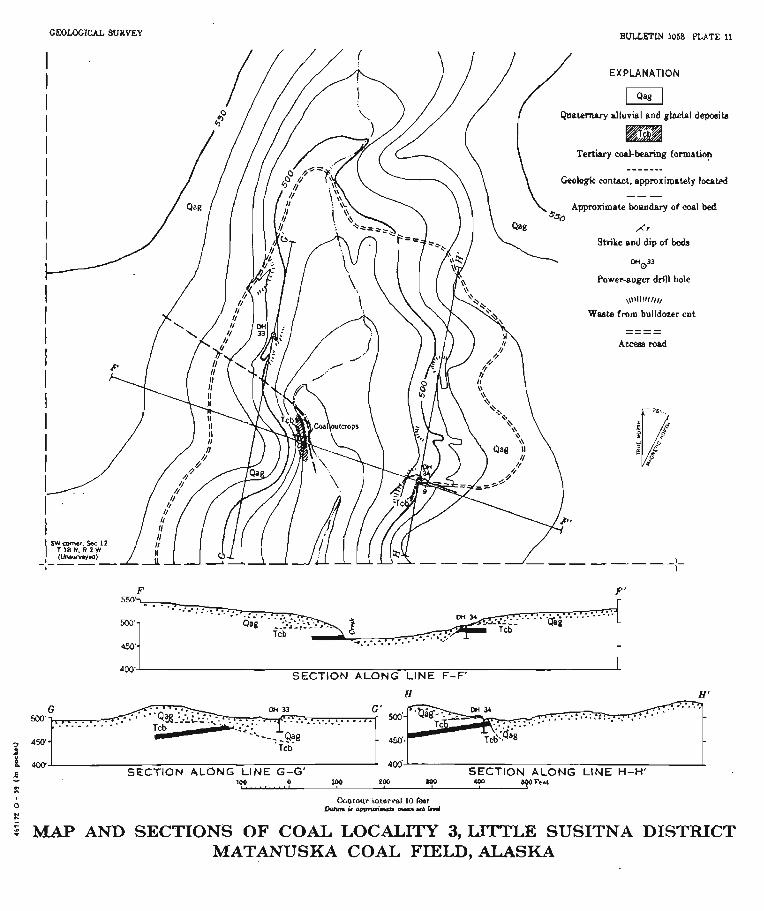
LOCALITY 8
h 1 h y 8 is on ~nsurveyed land abnt s mile north of the Little Susitna River and a mile west of the w& Gbundarg of sac. 7, T. 18 N., R. 1 W. The thickest coal bed fonnd in the district is qmed for abut 100 f& in the west bsnk of one of the larger tributariq where section 5 (fig. 88) was measured At &his point Ithe beds s t d m N. 80" W, and dip 7" S.
Trenching was &art& on the we& side of the vnlley, up &he dip from the ouhmp, to dehrmlne the extent of the b d and to further investigate the quality of the coal. A cut was bulldozed down the d bluff of the creek about 300 feet north of the o&mp in the hope of intewing .tha coal bed near the surface of the upland west of the crack. However, trenching showed that grave1 exton& well Mow the projwbd p i t i o n of the -1 bed, indicating that the coal has been erded at this paint A second cut was made h u t 150 feet north of the outcrop, and drill bole 33 was drilld to a depth of 25 feet from ththa lowest point in the cut without reaching Bedrock. The cut and drill hole together cut throngh about 15 f& of gravel and sand and 1.8 feet of clay. As the bottom of the drill hole w a ~ more thsn 50 feet blow the top of the bluff it was concluded that no coal ia present. within stripping depth on the we& side of the creek at localitg 3.
Operations were then shiftad Q the e& side of the cmk, whem maly wash had been found in a shallow test pit in the bluff oppmite the -1 outcmp in the creak ;bank. At this location a bulldozer cut expod a thin mdy layer; and drill hole ,34 (pl. 91, in the floor of the cu4 penetrated an 11-foot bed of coal and hone that is probably the same .as the bed exposed west of the creek. Trenching on tha p r o j d tram of the bed at poi& 100 and 200 feet n o d of drill hole 34 exposed 15 to 22 feet of p v d without maching bedrock. Tha cut at drill hole 34 was then deepened, and lthe -1 was not unly extremely dirty but curt off ta few feet north of the drill hole at a stmply dipping mntact with hu1dery glacial clay, as shown in ~ ~ A ~ o I I H-H' (pl, 11). This evidence md the findings on the west side of the c m k indicated that .the -1 at l d i t y 4 has k n a d d sway north of fi line passing just n o ~ h of driU hole 34 and the out- crop, and that south of the line It is probably too deep and hm poor in quality Ito be $ ~ ~ n a r n i ~ l l y strip mined.

4 is on msumqed land abut a quark of a mila north of the Little Susiba River and 2 mil- w& of &e west boundary of ffi 18, Tm I& N, R. 1 W. There a 10-foot section of coal-bearing r d m was uncovered in the mst wall of a small gully after its presence wlb~ m~ealed by abundant cud float in the c& bed. Section 6 (fig. 38) was measurad a t this exposure, The M s strike N. 70° E. and dip 32O SE. The character of tha ooal bed and its wr2w relations suggested that some of it might b min~ble by stripping. In order ta determine if stripping were feasible, bulldozing and drilling were started on the slope above the coal exposure. The mml . are shown on the map and cross sections on plate 8. The first cut, about 100 feet np the projected trim of the 4 bed
from the outcrop, exposed sandstone and cIaptone with vertical dips and slickensided faces at its lower or west end, D d l hole 35 was put down in moderately dipping beds at the east end of this cut and passed through 13.2 feet of sandstone and fine sandy siltstone without finding ma]. A trench to the east of the h t cut exposed more thm 5 feet of glacial till but did not reach bedrmk. SidehiIl cuts above the trench revealed cody pocketa in the lower part of the till, immedistely above the bedrock, but no c o d was found in plm.
Vertical dips, slickensidea, and the absence of coal in dm bole 85 indicate that the coal has been displaced by faulting. "1Che northward gteRpening of dips at t h ~ outmop and in the cuts mggests drag, which in turn indim- that the southern block was downtbwn Cross sections J J ' and K-H' ( pl. 81, through the outcrop and drill hole 35, ahow the probable mlations of the coal and the fault On the WE& side of the crreek mIley, mrfltce pmspedhg for the
western extension of the coal bed revealed abundant m1y wash. A sidehilI cut was made along the base of the slope to q x m the ma1 and obtain mom information on the stracture. lmfmd of coal in place, tha cut revealed a fault marked by a 30-foot wne of gouge and b m i - a M Wmk, including sn abandanca of coaly material. On the north the fault has a eharp boundary with claystone of the ml-bearing for- mation ; to the south it p d e s into undistarbd bedrock though a wries of mall slips. This fadt zone is evident1 y the m e as the one found east of the creek. The probable structm and position of the ma1 west of the creek ~m sl~omn in section I-I' (p9.8). According to this inhrpmtation, the mI m both sides of the cmk has been re- moved by erosion north of the fault and liw at too p t a depth for strip mining sonth of the fault.

h I i t g 5 is near the center of 2: 18 N., R. $2 W. (unmlmeyed), on f i e second m a l l stream east of knch Lake (pl. 7 ) . At one exposure a 10-foot section of interbedded clnystone and sandshne includes a I-foot coaIy layer, of which the lower half ie bright clem coal. The beds strike N. 5 5 O E, and dip 14@ SE. A short distance downstream & 20-fmt section of ssndstone and siltstone, including a few thin wnly layers and plant fragments, is exposed in a ateep blub. These beds strike N. 75" E. and dip 3 5 O SE. As they are about on the strike of the beds at localitg 4 and have a similar nbnormally deep muthest dip, it ia possible that they have been disturbed by the same south- westward-trending fault as obrped at locality 4.
The only coal production of the Little Snsitna district, aside from the small a m o a t mined by B d 0 1 f at locality 2, has come fmm both underground and surface developments at the west end of &B district near Ilonston. Coal in this m a was first rspoz2ed in 1917, when it was discovered by a grading crew in a milroad cut nersr the Little Susitns River. Between 1917 and 1920 several short hmneb were opened in the low Mndfs along the north& side of The Alaska Rail- road between Houston station and the river. Ona tunnel near the station is reported to have produced at least 10,000 tons of coal from R 3.5-foot bed (Jones, personal cummunication, 1943). Ln 1937 a tunnel waa opened by Eann Jones abont a quarter of a rn3e north- wwt of Houston station. This tunnel was driven about 500 feet, and eome cmrl wan p d u a h In 1W tha Houston CoaI Co. began the development of a sfxip
mine on a relatively flat-lying double coal bed, hemin did the Houston bed, that hnd been traced by test pita and h a n d a l l boringa for more than half a mile northeastward from the Evan Jon= tunnel. Strip mining was dona intermittently until 1954 and then suspended, largely because of increased thickn~ss of overburden as mining pro- grmed down the dip of the beds, which averages 4" NW. The gen- eral charactm and thickness of the coal in the strip pit rare shown in figure 38 (sections 'l and 8). In 1951 and f 952 the U. 5. Bnreaa of Mines drilled 3 diamond-drill
holm in th8 vicinity of the Houston mine (PI. 7). Drill hole 1, near the &rip pi4 renched the Houston bed at a depth of 97 feet, w e d through a bed clantaking 3.7 feet of clan coal at a depth of 297 fmt, and was stopped at a depth of 482 feet without hding more mal.
Drill hole 2, about 1,000 feet northwest of the southwest end of the strip pit, reached the Houston bed at a depth of 175 feet, where it

m&ht of 2 bnchq esch abont 1.5 feet thick, sapmated by 5 feet of daystone. '35s hole was stopped at a depth of 1,142 feet after p x h g thcmgh several cmly layers, only one of which, at a depth of 983 feet,mnhined asmnch as 2.5 feetof w l .
Drill hole 3, about 3,000 fa& northwsst of drill hole 9, passed through 386 feet of c o a l - k i n g strata, including 3 bony coal 'Ibeds w h less than 2 feet thick. T h e probable equivalenit of the noustan bed, m h e d at a depth of 233 feet, consistsl of an upper 3.4-fmt bed of cwrly claptons and a lower 1-fmt bed of bony coal geparshd by 6 feet of claystme. Tenhtive correlation indieaha that drill hob 3 passed amugh about 80 feat of strata that overlie those in driII hole 8, giving a known thickam of the cod-baring formstion of more than 1,200 feet.
Availnble dsta indicate that in the No-n area the upper 1,900 feet of the m l - M n g formation contains no more than 2 beds with as much M 3 feet of coal, and that these beds thin abruptly to the northmt.
OF C O A L aElJOaaCElj
The' p- of this investigation wrts to determine the presenm or a b c e of minabable deposits of coal in an area of cod-bearing ~ocka near transporhtion and within a relative1;p short distance of Anchor-
nT one of the principal m ~ ~ k e t S for Alaskm coal. Although only a fe of the awn were studied in detail, all the h w n coal oc- currenoes were included, and their wide distribution rnakas them fairly mprwmtstive of the di&rict, T h e results of the investigation indi- cate that all the coal beds probably are either too thin or impnre im enmurage development, at least under present conditions. The beds am too thin for mudergsound mining md are not f~vvorrtly ~ituated for st* mining, except possibly in narrow b1b near the o u b p s of some of the beds on G a l Creek (lm. 2). Although some of the beds prob- ably could be developed on a small scale for lacal use, it is doubtful that the reserves in any part of tha district are snficiemt to warrant the opening of a large mmmemia1 mine.
REFERENCE& CITED
Amertan Bocietg for Tedwr Materials, lm, BtaniEanl mwdfleationa tor ctaesf- ficatlon of d a by rank : ASTM Rtandarda, pt. 3. p. 14.
Barnes, F. F., and Pame, T. G., 1958, The Wishbone HI11 d W & Matanaslt* coal field, &ash : 0. 8. QeoL Sarve~r BaZL 1016,88 p

GM)LOQICkL SURVEY B U W 1068 PZATE 8
I SECTION ALONG LlNE 1-1'
w- I SECTION ALONG LlNE J-J'
2 SECTION ALONG LlNE K-K'
EXPLANATION
p q Qunternnry ~ I ) ~ d a l ~ n d ~1ncid depoelts Strlke m d dip of be&
OHO3'
Tertiary &-bearing fonnnibn Power-auger drUI hole ----+-
&4,hl.b&, Geologic contact rppmxfmately loe~ied
W.ste from bulldotar cut
A c c m mad
- C * . MAP AND SECTIONS OF COAL LOCALJTY 4
LITTLE SUSITNA DISTRICT, MATANUSKA COAL FIELD, ALASKA

G E O L O G ~ C ~ SURTEY B W W 1063 PLATE 9 LOCALITY 1
1; LOCALITY 2 A --
3 LOCALITY 3 LOCALITY 1 -- EXPLANATION 1 1 - h SURFIQAL DEPOSITS 8EDROCU
OH 21 OH 22 D!4 23 Dn 24 DM 26: DDH 26 0H 27 DM a DH 29 DH 30 DH 31 DH 32 DH 33 DH 34 DH 35 r O
Gravel m
Coaglomeratc a - M Saad Sandstone
13-_[ Bcdl Silt
8 d 1 Silbtane
- 40 @
, . Clay Claptone j lrrl m i h l fmgments Coal and bony awl - w
scat €3 m rr reei Bedmck surface Bone nnd d j cbystone
NOTE. Mix4 crdacpco of Wmck m)+ layer, and s<rfirid depouita q"lity are ahown br appro- priate rombin*atio~ of OH i~rnboh Drill hale
GRAPHIC LOG OF POWER-AUGER DRILL HOLES IN THE LITTLE SUSITNA DISTRICT MATANUSKA COAL FIELD. ALASKA

BULLGTlN 1068 PLATE 10
690
500 SECTION ALONG LINE C-C'
SECTION ALONG LlNE D-V
MAP AND SECTIONS OF COAL LOCALITY 2, LITTLE SUSITNA DISTRICT MA~ANusKA COAL FIELD , ALASKA
Pawe~ougex d d l bole Caa)mddsmpro j rc ta i~m&~IDd~mdiPkbp lawoJ
s&ti#i
GEOUXICAL SURVEY BWLLmLN 1058 PLATE 11
~Co' SECTION ALONG LlNE F-F'
H 8'
2 450- Y Teb
I m' SECTION A L ~ N G LINE G-G' SECTlON ALONG LINE H-H' 5 189 0 166 tM) PO 4m of0 Ft.t
L
"
5 MAP AND SECTIONS OF COAL LOCALITY 3, UTTUl SUSlTNA DISTRICT MATANUSHA COAL FIELD, ALASKA