geology of idaho - idaho fish and game | idaho fish … · 2015-10-22 · geology of idaho page 1...
TRANSCRIPT

Geology of Idaho Page 1
Geology of Idaho
Table of Contents Basic Geology with Idaho Examples ....................................................................................................... 3
Introduction to Idaho Geology .............................................................................................................. 3
Minerals ................................................................................................................................................... 4
Rocks ....................................................................................................................................................... 6
Igneous Rocks ........................................................................................................................................ 7
Sedimentary Rocks .............................................................................................................................. 13
Metamorphic Rocks ............................................................................................................................. 15
Structural Geology ............................................................................................................................... 18
Plate Tectonics ..................................................................................................................................... 20
Origin of Mountains .............................................................................................................................. 23
Weathering and Soils ........................................................................................................................... 24
Surface Water ....................................................................................................................................... 40
Ground Water ....................................................................................................................................... 41
Mass Movement ................................................................................................................................... 45
Caves in Idaho ...................................................................................................................................... 48
Glaciation ............................................................................................................................................... 49
Geologic Provinces, Terranes, Structures and Events....................................................................... 54
Belt Supergroup .................................................................................................................................... 54
Accreted Terrane in Western Idaho .................................................................................................. 56
Idaho Batholith ...................................................................................................................................... 57
Tertiary Plutons of the Batholith ......................................................................................................... 59
Challis Volcanism ................................................................................................................................. 60
Owyhee Mountains and Plateau ........................................................................................................ 61
Columbia River Basalt Group ............................................................................................................. 62
Snake River Plain ................................................................................................................................. 64
Track of the Yellowstone Hotspot ...................................................................................................... 66
Western Snake River Plain ................................................................................................................. 66
Eastern Snake River Plain .................................................................................................................. 72

Geology of Idaho Page 2
Pre-Cenozoic Sedimentary Rocks of Eastern Idaho ...................................................................... 79
Idaho-Wyoming Thrust Belt ................................................................................................................ 80
Basin and Range Province ................................................................................................................. 82
Bonneville Flood ................................................................................................................................... 84
The Spokane/Missoula Flood ............................................................................................................. 87
Geologic Attractions ................................................................................................................................. 91
Hells Canyon ......................................................................................................................................... 91
Boise Valley Terraces .......................................................................................................................... 92
Bruneau Sand Dunes .......................................................................................................................... 93
Silent City of Rocks .............................................................................................................................. 94
The Gooding City of Rocks ................................................................................................................. 96
Big Wood River ..................................................................................................................................... 98
The Great Rift ..................................................................................................................................... 100
Craters of the Moon ........................................................................................................................... 102
Hagerman Fauna ............................................................................................................................... 106
Menan Buttes ...................................................................................................................................... 107
Hot Springs of Idaho .......................................................................................................................... 108
Borah Peak Earthquake .................................................................................................................... 111
The Stanley Basin .............................................................................................................................. 114
Malm Gulch ......................................................................................................................................... 117
Geology of Idaho Page 3
Basic Geology with Idaho Examples Introduction to Idaho Geology
Geology is the science which deals with the origin, structure and history of the Earth. This
also includes the study of past life as recorded in the rocks. In geologically recent times,
Idaho has experienced major earthquakes, catastrophic floods, the Pleistocene Ice Age and
volcanic eruptions. Idaho is one of the few states with excellent examples of almost every type
of geologic landform, structure, rock type and mineral deposit. Idaho's oldest rocks are more
than 2500 million years old and contain a record of all the events that transpired during that
vast period of geologic time.
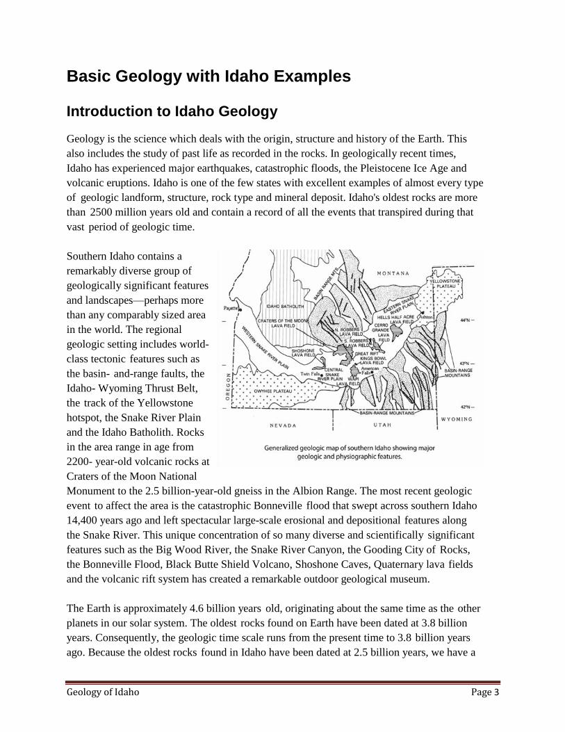
Southern Idaho contains a
remarkably diverse group of
geologically significant features
and landscapes—perhaps more
than any comparably sized area
in the world. The regional
geologic setting includes world-
class tectonic features such as
the basin- and-range faults, the
Idaho- Wyoming Thrust Belt,
the track of the Yellowstone
hotspot, the Snake River Plain
and the Idaho Batholith. Rocks
in the area range in age from
2200- year-old volcanic rocks at
Craters of the Moon National
Monument to the 2.5 billion-year-old gneiss in the Albion Range. The most recent geologic
event to affect the area is the catastrophic Bonneville flood that swept across southern Idaho
14,400 years ago and left spectacular large-scale erosional and depositional features along
the Snake River. This unique concentration of so many diverse and scientifically significant
features such as the Big Wood River, the Snake River Canyon, the Gooding City of Rocks,
the Bonneville Flood, Black Butte Shield Volcano, Shoshone Caves, Quaternary lava fields
and the volcanic rift system has created a remarkable outdoor geological museum.
The Earth is approximately 4.6 billion years old, originating about the same time as the other
planets in our solar system. The oldest rocks found on Earth have been dated at 3.8 billion
years. Consequently, the geologic time scale runs from the present time to 3.8 billion years
ago. Because the oldest rocks found in Idaho have been dated at 2.5 billion years, we have a
Geology of Idaho Page 4
record of events in Idaho for a large part
of the geologic time scale.
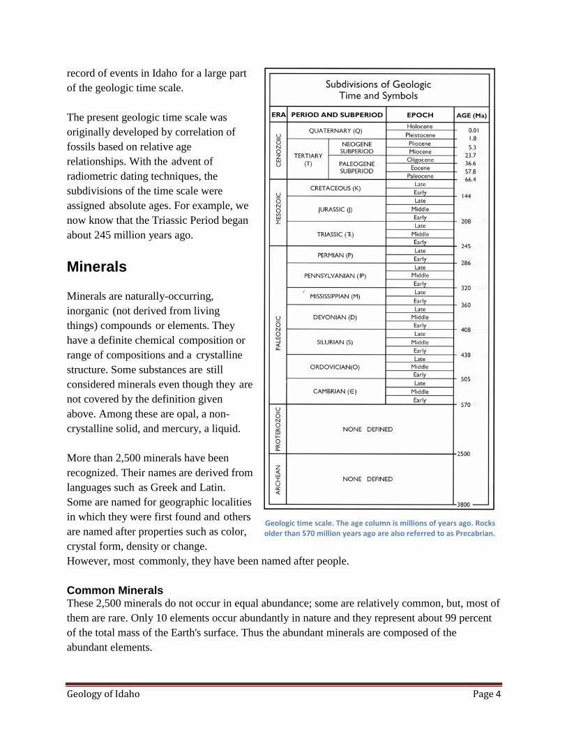
The present geologic time scale was
originally developed by correlation of
fossils based on relative age
relationships. With the advent of
radiometric dating techniques, the
subdivisions of the time scale were
assigned absolute ages. For example, we
now know that the Triassic Period began
about 245 million years ago.
Minerals
Minerals are naturally-occurring,
inorganic (not derived from living
things) compounds or elements. They
have a definite chemical composition or
range of compositions and a crystalline
structure. Some substances are still
considered minerals even though they are
not covered by the definition given
above. Among these are opal, a non-
crystalline solid, and mercury, a liquid.
More than 2,500 minerals have been
recognized. Their names are derived from
languages such as Greek and Latin.
Some are named for geographic localities
in which they were first found and others
are named after properties such as color,
crystal form, density or change.
However, most commonly, they have been named after people.
Common Minerals These 2,500 minerals do not occur in equal abundance; some are relatively common, but, most of
them are rare. Only 10 elements occur abundantly in nature and they represent about 99 percent
of the total mass of the Earth's surface. Thus the abundant minerals are composed of the
abundant elements.
Geologic time scale. The age column is millions of years ago. Rocks older than 570 million years ago are also referred to as Precabrian.

Geology of Idaho Page 5
Rock-Forming Minerals Rocks are aggregates of one or more minerals. For example, limestone is composed primarily of
the mineral calcite. Granite typically contains three minerals: feldspar, quartz and mica. Certain
minerals are so common in rocks they are called the rock-forming minerals. The minerals listed
below make up most of the Earth and are so few in number that most beginning amateur
prospectors or mineral collectors should be able to identify them. The important rock-forming
minerals include quartz, potassium feldspar (orthoclase), plagioclase feldspar, muscovite mica,
biotite mica, hornblende, augite, olivine, garnet, chlorite and clay. With the exception of olivine,
all of the rock-forming minerals are common in Idaho.
Crystals When crystalline minerals grow
without interference, they have
smooth, flat crystal faces that are
related directly to the internal
atomic structure of the mineral.
Each mineral is assigned to one of
six crystal systems. These systems
are based on the number, position
and relative lengths of the crystal
axes.
Crystal axes are imaginary lines
extending through the center of the
crystal. The six crystal systems
include isometric or cubic,
tetragonal, hexagonal,
orthorhombic, monoclinic and
triclinic.
Any given mineral crystal will grow in such a manner so as to form certain typical shapes or
crystal habits. Crystal habits are used to identify minerals because they indicate the forms or
combination of forms a mineral is likely to have. Cubic, columnar, and tabular are examples of
crystal habits.
Mineral Identification After a little practice the common rock-forming minerals can be identified on sight. However,
some may require an examination of the various chemical and physical properties. The properties
most useful in mineral identification include hardness, streak, color, specific gravity, fracture,
cleavage, luster and shape or form. Some of the more important rock-forming minerals are
discussed below.
Geologist inspecting large feldspar crystal of pegmatite dike. The pegmatite dike is about 4 feet thick and was intruded into to granitic rock.
Silent City of Rocks, Idaho.

Geology of Idaho Page 6
The feldspar group constitutes the most important group of the rock-forming minerals. They are
so abundant that they make up 60 percent of the Earth's crust. Feldspars are common in igneous,
metamorphic and sedimentary rock.
Orthoclase is the common potash (potassium) feldspar. It is transparent to translucent
with colors of white, gray, yellow, pink, or colorless.
Plagioclase feldspars are common in igneous rocks and some metamorphic rocks. Colors
are white, yellow and gray. In much of the Idaho Batholith, plagioclase tends to be
chalky white in color.
Quartz is the second most common mineral and is widely distributed. Pure quartz is
composed of silicon dioxide. It forms six-sided crystals with pyramidal ends. Colors
include white, colorless, rose, purple, yellow, and smoky gray. Among the common
crystalline varieties of quartz are amethyst (purple), milky quartz, rose quartz and smoky
quartz. Very fine-grained varieties include agate, chalcedony, chert, flint and jasper.
Some sedimentary rocks such as sandstone and quartzite are composed almost entirely of
quartz.
Mica has a perfect basal cleavage (also called micaceous cleavage) . Micas are one of the
easiest minerals to identify because they consist of stacks of sheets or books of easily-
parted plates.
Muscovite and biotite are the most common micas. Muscovite is the white, transparent
mica and is most common in granites, and pegmatites. Biotite is the black mica and is
common in both igneous and metamorphic rocks.
The mineral calcite is composed of calcium carbonate. Calcite occurs primarily in
sedimentary rocks and some metamorphic rocks such as marble. Calcite is the most
abundant constituent of limestone. Many of the limestone formations in eastern Idaho
consist of more than 90 percent calcite. Calcite has the property of reacting with cold
dilute hydrochloric acid by effervescing or fizzing. Dolomite is calcium magnesium
carbonate and reacts only mildly with acid.
Rocks
Rocks are naturally-formed, consolidated material composed of grains of one or more minerals.
Geologists categorize rocks into three categories depending on their origin: igneous, sedimentary
and metamorphic.

Geology of Idaho Page 7
Igneous rocks are formed from solidification of molten material. Sedimentary rocks are formed
by the accumulation of fragmental material derived from preexisting rocks of any origin as well
as the accumulation of organic material or precipitated material. Metamorphic rocks occur as a
result of high pressure, high temperature and the chemical activity of fluids changing the texture
and (or) mineralogy of preexisting rocks.
Igneous Rocks
Magma
Igneous rocks are those rocks that have
solidified from an original molten
state. Temperatures within the Earth
are so hot that many rocks and
minerals are able to exist in a molten
condition called magma. This molten
rock exists deep below the Earth's
surface in large pools called magma
chambers. Many magmas or portions
of magmas are lighter than the
surrounding rock and tend to rise
toward
the surface of the crust; also, the
high pressure at depth facilitates the
upward movement of magma. Molten materials that extrude through the surface of the Earth are
called eruptive, extrusive or volcanic rocks. Those magmas that crystallize and solidify at depth,
never reaching the Earth's surface before consolidation, are called intrusives or plutonic rocks. Of
course after consolidation, plutonic rocks may be exposed at the Earth's surface by the process of
erosion. The Idaho Batholith was emplaced as a number of overlapping plutons. These plutons
consolidated into rock which was subsequently exposed by erosional processes.
The crystal size of igneous rocks is very diagnostic of their origin. Volcanic or extrusive rocks
have a very small average grain size which is generally too small to discern with the naked eye.
Extrusive rock has a very high component of glass because it was quickly frozen from the molten
stage before crystals had time to grow. The more deeply-buried plutons cool more slowly and
develop a coarse texture composed of large crystals. Therefore, large mineral crystals of more
than one inch in diameter indicate formation at a depth of 6 to 12 miles.

Geology of Idaho Page 8
Mafic and Felsic Magmas Magmas are thought to be
generated in the outer 60 to 1 80
miles of the Earth where
temperatures are hot enough to
cause melting. Magmas rich in
magnesium, iron and calcium are
called mafic. Those rich in
sodium, potassium and silicon are
called felsic. Those that are
transitional between mafic and
felsic are called intermediate.
Felsic magmas are generated
mostly within the continental
crustal regions where the source of
parent rocks are abundant;
whereas, mafic magmas may be
derived from parent materials rich
in magnesium, iron and calcium which occur beneath the crust. Mafic magmas, coming from a
deep hot source, are about 1,200 degrees centigrade when they reach the Earth's surface; felsic
magmas are much cooler—about 700 degrees centigrade upon reaching the Earth's surface.
Origin of Basalt Most basalt originates at spreading centers such as the mid-oceanic ridge system and stationary
mantle plumes. Basalt magma originates from partial melting of mantle material. The fluid
magma rises through fissures formed by tensional forces of two diverging plates.
Origin of Andesite and Granite Intermediate and felsic magma in Idaho are believed to have originated where a cool slab of
oceanic lithosphere of basalt and overlying sedimentary rock descended beneath the continental
crust of the western United States. The descending plate of lithosphere becomes hotter with
increasing depth. Water trapped in the descending plate also lowers the melting temperature so
that partial melting of basalt takes place. While the basaltic magma rises through the overriding
continental crust, the magma absorbs some of the more silica rich rocks to become intermediate
in composition. Also, the very hot basaltic magma chambers in the continental crust could melt
the surrounding felsic rocks and create granitic magmas.
Emplacement of Magma
Bodies of intrusive rocks exist in almost every shape and size. Regardless of shape or size, they
all come under the general term pluton. Most of them appear to be emplaced in the surrounding
country rocks (host rocks) by the process of forceful injection. By forceful injection, the body is
Large rectangular orthoclase feldspar phenocrysts in a groundmass of smaller crystals. South of Stanley, Idaho.

Geology of Idaho Page 9
intruded along zones of weakness, such as fractures, by pushing apart the surrounding rock. A
pluton is also emplaced by melting rock around it and prying out blocks of the country rock. The
surface between the pluton and the country rock is the intrusive contact. Magma is also aided in
its upward movement because it is generally less dense than the surrounding rock. When the
magma stops moving it begins to crystallize. Those plutons that reach shallow to intermediate
depths tend to be porphyritic, that is, large crystals are contained in a finer crystalline groundm
ass.
Types of Plutons Dikes are small tabular plutons which cut across layering in the host rocks. Dikes may range
from one inch to tens of feet thick. They are much longer than wide and can commonly be traced
a mile or more. Dikes are generally intruded along fractures and tend to have the composition of
pegmatite, aplite (white, sugar-textured dikes) and basalt. In almost every roadcut through the
Idaho Batholith of central Idaho, aplitic and pegmatitic dikes can be seen. Sills are also tabular
bodies of the same approximate size and shape range as dikes. However, sills are concordant or
parallel to the layers of the surrounding host or country rock.
The largest plutons consist of granite and diorite and are found in the cores of mountain ranges.
The Idaho Batholith is a good example. A batholith is defined as a pluton with a surface
exposure in excess of 40 square miles. If the exposure is less than that, the pluton is called a
stock. It is commonly believed that buried batholiths underlie large areas of widespread silicic
volcanics in Idaho. Many of the large batholiths such as the Idaho Batholith are known to be a
composite of many granitic plutons.
Pegmatites Pegmatite bodies have a relatively
larger grain size than the
surrounding igneous rocks.
Individual crystals are known to
reach more than 30 feet in length. A
pegmatite may have the
composition of a granite, diorite or
gabbro. All three types are exposed
in the large granitic plutons of
Idaho. However, granitic
pegmatites are by far the most
common. In practically every
exposure of granitic rock in the
state, there are one or more granitic
pegmatite dikes exposed. Although
most of these pegmatites do not
Outcrop of quartzite has many sills parallel to the layering of the rock. The large dike cuts across both the layering of the rock and the sills; therefore,
the dike is younger than the sills.

Geology of Idaho Page 10
exceed 10 feet in thickness; an uncommonly large pegmatite more than 300 feet along its
smallest dimension is exposed in the City of Rocks near the town of Oakley. The extremely large
crystal size (generally 2 to 8 inches), is attributed to both slow cooling and low liquid viscosity.
Pegmatites represent the last portion of a pluton to crystallize. These residual fluids are much
richer in certain elements than the original magma. High amounts of silica and ions of elements
that are necessary to crystallize sodium plagioclase and potassium feldspar must be abundant in
the fluids. The fluids are also rich in certain elements that could not be used in the crystal
structure of the previously crystallized minerals. Water is also very abundant which promotes
slower cooling and a lower temperature of crystallization. Many pegmatites were intruded along
existing fractures.
Most Idaho pegmatites are composed of orthoclase feldspar, quartz and muscovite. Careful
inspection will also reveal small red garnets, black tourmaline and bluish-green aquamarine.
Aquamarine is generally only found in the tertiary plutons.
Common Igneous Rocks Igneous rocks are classified on the basis of their texture and composition. Although more than
several hundred names have been given to igneous rocks, only a few major rock types are
discussed below:
Granite is the most common
coarse-textured rock. It is
formed at great depths
within the Earth and has
crystals ranging from
microscopic to more than
one inch in size. Granite
typically contains quartz,
feldspar, mica and
hornblende. Granites are
generally light in color and may have a salt and pepper appearance. The feldspar may
cause it to be white, gray, pink or yellowish brown. Most of the large bodies of plutonic
rocks in Idaho have typical granitic texture and composition. Potassium feldspar and
plagioclase feldspar make up most of the rock, though quartz may represent up to 25
percent of the bulk composition. The black minerals are commonly hornblende and
biotite mica. Muscovite is also common in some granite.
Gabbro is a dark, coarse-grained igneous rock. It is generally composed of plagioclase
feldspar and augite. Gabbro is generally dark green or dark gray in color. Idaho has
relatively little gabbro compared to granite.
Geology of Idaho Page 11
Pumice is lava that solidified while gases were released from it. It is essentially a frozen
volcanic froth. Because of the abundance of gas cavities, pumice is so light in weight that
it can float in water. Pumice is generally light gray or tan and has the same chemical
composition as obsidian, rhyolite and granite.
Diorite is a coarse- to fine-grained plutonic rock and has a mineral composition that
places it midway between granite and gabbro. It has little quartz or potassium feldspar.
Diorite tends to be a gray rock due to the high amounts of plagioclase feldspar and iron-
rich minerals.
Andesite is much finer grained than diorite but has the same mineral composition.
Andesites are more common than rhyolites, but less common than basalts.
Rhyolite is a volcanic rock with the same composition as granite. The major difference is
its fine-grain size or glassy texture. Rhyolite is generally light colored and may be gray,
white, tan or various shades of red. It has a characteristic streaked texture called flow
banding. Flow banding is caused by slow flowage of highly viscous lava.
Obsidian forms when magma of a rhyolitic composition cools so fast that crystallization
of the minerals is not possible. Thus volcanic glass is essentially a frozen liquid. It is a
lustrous, glassy black or reddish-black rock. Obsidian has a conchoidal fracture giving it
very sharp edges.
Because of this property, it was commonly used to make tools and weapons by early
Americans.
Basalt is the fine-grained compositional equivalent of gabbro. It is by far the most
abundant volcanic rock. For example, the volume of basalt in the Columbia Plateau is
estimated to be 74,000 cubic miles. Basalt is normally coal black to dark gray when not
weathered. Common constituent minerals include pyroxene, calcic plagioclase and
olivine. Basalt commonly has small cavities called vesicles. Basalt flows are
characterized by columnar jointing which causes polygonal vertical columns that look
like giant fence posts stacked on end. Most of the large basalt flows are extruded from
large fissures in the Earth's crust. Basalts are very common throughout Idaho, especially
western and southern Idaho.
Porphyritic Texture Some fine-grained rocks such as basalt, rhyolite, and andesite have a mixed texture of large and
small grains. This texture is called porphyritic and is characterized by large crystals called
phenocrysts surrounded by a groundmass (background) of smaller crystals.

Geology of Idaho Page 12
Pyroclastic Rocks In addition to the fluid lava extruded from a volcano, a great amount of lava is blown out the
vent by violent gas explosions. All material driven out explosively is called pyroclastic. Large
fragments such as spindle-shaped volcanic bombs fall near the vent. However, the dust-size
fragments called ash are carried hundreds of miles by prevailing winds. Volcanic ash is
composed of fragments of volcanic glass and small crystals. When air-fall ash deposits
consolidate, they are called ash-fall tuffs. Excellent examples of most of these volcanic products
can be observed at Craters of the Moon National Monument.
One type of pyroclastic rock very common in southern and east-central Idaho is the welded ash-
flow tuff deposit. This material consists of a very hot mixture of fragments of pumice, cinders,
crystals and glass shards, many of which are more than one inch in size. They blow out of the
vent, collapse, and move rapidly down slope somewhat like a lava flow, but riding on a cushion
of hot gases. When the deposit settles and comes together, the angular fragments are so hot they
weld together. Unlike rhyolite flows, a single ash flow tuff unit may extend up to 100 miles.
These tuffs make distinctive rim formers above the lake-bed deposits in the Snake River Plain.
Volcanic Cones Volcanoes are vents in the Earth's crust through which molten rock and other volcanic products
are extruded. There are three types of volcanic cones: cinder cones, shield volcanoes (lava
domes), and composite cones (stratovolcanoes). All three types are common in southern Idaho.
Cinder cones are formed entirely of pyroclastic material, mostly of cinders. These cones
consist of a succession of steeply-inclined layers of reddened scoriaceous cinders around
a central crater. They are generally less than 1,000 feet in height and are susceptible to
erosion because there is generally nothing holding the mass together. This type of cone
has the steepest flanks of the three types of volcanic cones. Hundreds of cinder cones are
distributed throughout the Snake River Plain, generally aligned along fractures in the
crust. These cones add much relief to the otherwise featureless plain.
Shield volcanoes are built almost entirely of basaltic lava flows. They have gently-
rounded profiles with a circular outline. This type of cone is the most stable and least
susceptible to erosion.
Composite or stratovolcanoes are composed of alternating sheets of lava and pyroclastic
material. The alternating pyroclastic layers and lava layers indicate that the pyroclastic
material was produced during periods of explosive activity, whereas the lava eruptions
occurred at times of quiescence.
Calderas are nearly circular basin-shaped depressions in the upper part of volcanoes.
Geology of Idaho Page 13
They are much larger than volcanic craters and are generally more than 6 miles in
diameter. Most of those in Idaho are thought to have formed by collapse caused by the
sudden withdrawal of supporting lava. Such calderas are common in southern and east-
central Idaho.
Sedimentary Rocks
Sedimentary rocks are derived from preexisting igneous, sedimentary and metamorphic rocks.
These rocks contain many clues as to their origin and the conditions that existed while they
formed. Sedimentary rocks make up 75 percent of the rocks at the Earth's surface but only 5
percent of the outer 10 miles of the Earth. Sediment, as distinguished from sedimentary rock, is a
collective name for loose, solid particles and is generally derived from weathering and erosion of
preexisting rock. After formation, sediments are transported by rivers, ocean waves, glaciers,
wind or landslides to a basin and deposited. Lithification is the process of converting loose
sediment into sedimentary rock and includes the processes of cementation, compaction and
crystallization.
Sedimentary rock is formed by lithification of sediments, precipitation from solution and
consolidation of the remains of plants or animals. Coal is an example of sedimentary rock
formed from the compression of plant remains.
Rounding of Rock Particles Rounding occurs during the transportation process by one or more of the erosional agents.
Current and wave action in water are particularly effective in causing particles to hit and scrape
against one another or a rock surface. The larger the particle the less distance it needs to travel to
become rounded. For example, the boulders of the melon gravel deposited by the Bonneville
flood were rounded after 3 to 6 miles of transportation. By contrast, a grain of sand may require
hundreds of miles of transportation to become rounded.
Deposition of Sediment Sorting of sediment by size is also
effectively accomplished by
moving water. A river sorts
sediment by first depositing
cobbles, then pebbles, sand, silt and
clay. The larger the size of
sediment, the greater the river's
energy necessary to transport it.
Deposition is the term used to
describe the settling of transported Sandstone deposited during the Pliocene in ancestral Lake Idaho. Table
Rock, northeast of Boise, Idaho

Geology of Idaho Page 14
sediment.
Lithification of Clastic Rock
Clastic or detrital sedimentary rock is composed of fragments of preexisting rock. The grains are
generally rounded and sorted during the transportation process. Clastic sediment is generally
lithified by cementation. Cementation occurs when material is chemically precipitated in the
open spaces of the sediment so as to bind the grains together into a hard rock. Common cements
include calcite, silica and iron oxides. A matrix of finer-grained sediments may also partly fill the
pore space.
Common Types of Sedimentary Rock
Conglomerate is the
coarsest-grained
sedimentary rock formed by
the cementation of gravel-
sized sediments. The gravel
is generally rounded;
however, it probably did not
travel very far.
Conglomerates are
generally deposited by a
river.
Sandstone is a medium-grained sedimentary rock formed by the cementation of sand-
sized sediments, with silt and clay forming the matrix. The material may be deposited by
rivers, wind, waves or ocean currents.
Shale is a fine-grained sedimentary rock composed of clay- and silt-sized fragments.
Shale is noted for its thin laminations parallel to the bedding. Compaction is very
important in the lithification of shales. Before compaction, the sediment may contain up
to 80 percent water in the pore spaces.
Chemical Sedimentary Rocks are formed by material precipitated from solution.
Examples include rock salt, gypsum and limestone.
Organic Sedimentary Rocks consist mostly of the remains of plants and animals. Coal is
an organic rock formed from compressed plant remains. Idaho has a few coal deposits but
none exists in commercial quantities.
Geology of Idaho Page 15
Limestone is a sedimentary rock composed of mostly calcite. Some limestones are
chemical precipitates and other limestones consist mostly of grains of calcite or shells of
marine invertebrates. The calcite grains in limestone recrystallize readily so as to form
new and larger crystals.
Sedimentary Structures Sedimentary structures in sedimentary rock are formed either during the deposition process or
shortly after deposition. One of the most important structures is bedding. An important principle
of geology holds that sedimentary rocks are deposited in horizontal layers. The bedding plane is
the nearly flat surface separating two beds of rock. Bedding planes originate by a change in grain
size, a change in grain composition or a pause in deposition during the depositional process.
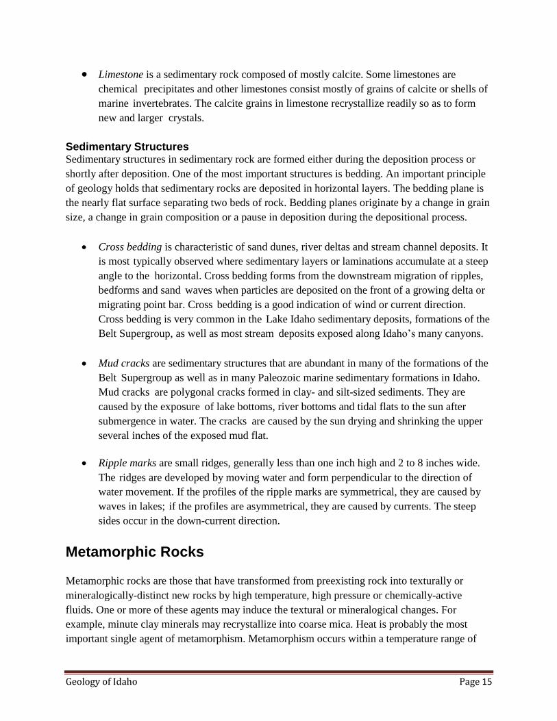
Cross bedding is characteristic of sand dunes, river deltas and stream channel deposits. It
is most typically observed where sedimentary layers or laminations accumulate at a steep
angle to the horizontal. Cross bedding forms from the downstream migration of ripples,
bedforms and sand waves when particles are deposited on the front of a growing delta or
migrating point bar. Cross bedding is a good indication of wind or current direction.
Cross bedding is very common in the Lake Idaho sedimentary deposits, formations of the
Belt Supergroup, as well as most stream deposits exposed along Idaho’s many canyons.
Mud cracks are sedimentary structures that are abundant in many of the formations of the
Belt Supergroup as well as in many Paleozoic marine sedimentary formations in Idaho.
Mud cracks are polygonal cracks formed in clay- and silt-sized sediments. They are
caused by the exposure of lake bottoms, river bottoms and tidal flats to the sun after
submergence in water. The cracks are caused by the sun drying and shrinking the upper
several inches of the exposed mud flat.
Ripple marks are small ridges, generally less than one inch high and 2 to 8 inches wide.
The ridges are developed by moving water and form perpendicular to the direction of
water movement. If the profiles of the ripple marks are symmetrical, they are caused by
waves in lakes; if the profiles are asymmetrical, they are caused by currents. The steep
sides occur in the down-current direction.
Metamorphic Rocks
Metamorphic rocks are those that have transformed from preexisting rock into texturally or
mineralogically-distinct new rocks by high temperature, high pressure or chemically-active
fluids. One or more of these agents may induce the textural or mineralogical changes. For
example, minute clay minerals may recrystallize into coarse mica. Heat is probably the most
important single agent of metamorphism. Metamorphism occurs within a temperature range of

Geology of Idaho Page 16
100 to 800 degrees centigrade. Heat
weakens bonds and accelerates the
rate of chemical reactions. Two
common sources of heat include
friction from movement and
intrusion of plutons. Pressure
changes are caused primarily by the
weight of overlying rock. Where
there are more than 30,000 feet of
overlying rock, pressures of more
than 40,000 psi will cause rocks to
flow as a plastic. Pressure may also
be caused by plate collision and the
forceful intrusion of plutons.
Chemically-active fluids (hot water
solutions) associated with magma
may react with surrounding rocks
to cause chemical change. Directed
pressure is pressure applied unequally on the surface of a body and may be applied by
compression or shearing. Directed pressure changes the texture of a metamorphic rock by forcing
the elongate and platy minerals to become parallel to each other. Foliation is the parallel
alignment of textural and structural features of a rock. Mica is the most common mineral to be
aligned by directed pressure.
Types of Metamorphism
There are two types of metamorphism: contact metamorphism and regional metamorphism.
Contact metamorphism is the name given when country rock is intruded by a pluton (body of
magma). Changes to the surrounding rocks occur as a result of penetration by the magmatic
fluids and heat from the intrusion. Contact metamorphism may greatly alter the texture of the
rock by forming new and larger crystals. In contact metamorphism, directed pressure is not
involved so the metamorphosed rocks are not foliated.
Regional Metamorphism Most metamorphic rocks in Idaho are caused by regional metamorphism. This type of
metamorphism is caused by high temperature and directed pressure. These rocks are typically
formed in the cores of mountain ranges, but may be later exposed at the surface by erosion.
Typical rock types include foliated (layered) rocks such as slates, phyllites, schists and gneisses.
Steeply dipping angular outcrop of quartzite in eastern Idaho.

Geology of Idaho Page 17
Common Metamorphic Rocks
Marble is a coarse-grained
rock consisting of
interlocking calcite crystals.
Limestone recrystallizes
during metamorphism into
marble.
Quartzite forms by
recrystallization of quartz-
rich sandstone in response
to heat and pressure. As the grains of quartz grow, the boundaries become tight and
interlocking. All pore space is squeezed out; and when the rock is broken, it breaks across
the grains rather than around the grains. Quartzite is the most durable construction
mineral. Although both marble and quartzite may be white to light gray, they may be
readily distinguished because marble fizzes on contact with dilute hydrochloric acid,
whereas quartzite does not. Also, marble can be scratched with a knife, whereas quartzite
cannot.
Slate is a low-grade metamorphic equivalent of shale. It is a fine-grained rock that splits
easily along flat, parallel planes. Shale, the parent rock, is composed of submicroscopic,
platy clay minerals. These clay minerals are realigned by metamorphism so as to create a
slaty cleavage. In slate, the individual minerals are too small to be visible with the naked
eye.
Phyllite is formed by further
increase in temperature and
pressure on a slate. The
mica grains in- crease
slightly in size but are still
microscopic. The planes of
parting have surfaces lined
with fine-grained mica that
give the rock a silky sheen.
Schist is characterized by
coarse-grained minerals
with parallel alignment.
These platy minerals,
Strongly foliated (layered) gneiss with alternating layers of feldspar and biotite mica. West of Shoup, Idaho.
Geology of Idaho Page 18
generally micas, are visible to the naked eye. Schist is a high-grade, metamorphic rock
and may consist entirely of coarse, platy minerals.
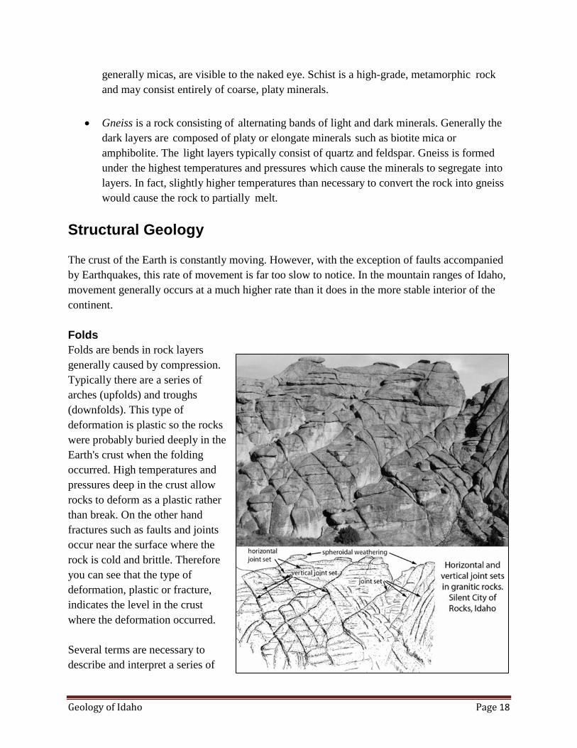
Gneiss is a rock consisting of alternating bands of light and dark minerals. Generally the
dark layers are composed of platy or elongate minerals such as biotite mica or
amphibolite. The light layers typically consist of quartz and feldspar. Gneiss is formed
under the highest temperatures and pressures which cause the minerals to segregate into
layers. In fact, slightly higher temperatures than necessary to convert the rock into gneiss
would cause the rock to partially melt.
Structural Geology
The crust of the Earth is constantly moving. However, with the exception of faults accompanied
by Earthquakes, this rate of movement is far too slow to notice. In the mountain ranges of Idaho,
movement generally occurs at a much higher rate than it does in the more stable interior of the
continent.
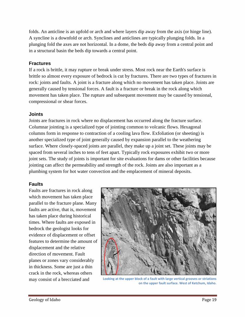
Folds
Folds are bends in rock layers
generally caused by compression.
Typically there are a series of
arches (upfolds) and troughs
(downfolds). This type of
deformation is plastic so the rocks
were probably buried deeply in the
Earth's crust when the folding
occurred. High temperatures and
pressures deep in the crust allow
rocks to deform as a plastic rather
than break. On the other hand
fractures such as faults and joints
occur near the surface where the
rock is cold and brittle. Therefore
you can see that the type of
deformation, plastic or fracture,
indicates the level in the crust
where the deformation occurred.
Several terms are necessary to
describe and interpret a series of
Geology of Idaho Page 19
folds. An anticline is an upfold or arch and where layers dip away from the axis (or hinge line).
A syncline is a downfold or arch. Synclines and anticlines are typically plunging folds. In a
plunging fold the axes are not horizontal. In a dome, the beds dip away from a central point and
in a structural basin the beds dip towards a central point.
Fractures
If a rock is brittle, it may rupture or break under stress. Most rock near the Earth's surface is
brittle so almost every exposure of bedrock is cut by fractures. There are two types of fractures in
rock: joints and faults. A joint is a fracture along which no movement has taken place. Joints are
generally caused by tensional forces. A fault is a fracture or break in the rock along which
movement has taken place. The rupture and subsequent movement may be caused by tensional,
compressional or shear forces.
Joints
Joints are fractures in rock where no displacement has occurred along the fracture surface.
Columnar jointing is a specialized type of jointing common to volcanic flows. Hexagonal
columns form in response to contraction of a cooling lava flow. Exfoliation (or sheeting) is
another specialized type of joint generally caused by expansion parallel to the weathering
surface. Where closely-spaced joints are parallel, they make up a joint set. These joints may be
spaced from several inches to tens of feet apart. Typically rock exposures exhibit two or more
joint sets. The study of joints is important for site evaluations for dams or other facilities because
jointing can affect the permeability and strength of the rock. Joints are also important as a
plumbing system for hot water convection and the emplacement of mineral deposits.
Faults
Faults are fractures in rock along
which movement has taken place
parallel to the fracture plane. Many
faults are active, that is, movement
has taken place during historical
times. Where faults are exposed in
bedrock the geologist looks for
evidence of displacement or offset
features to determine the amount of
displacement and the relative
direction of movement. Fault
planes or zones vary considerably
in thickness. Some are just a thin
crack in the rock, whereas others
may consist of a brecciated and Looking at the upper block of a fault with large vertical grooves or striations on the upper fault surface. West of Ketchum, Idaho.

Geology of Idaho Page 20
sheared zone up to 1,000 feet wide. Faults also range in length from several feet or less to
hundreds of miles. For example the San Andreas fault extends about 620 miles through western
California, slowly moving Los Angeles toward San Francisco. The current rate of movement
averages about one inch per year so it will take about 25 million years to make Los Angeles a
western suburb of San Francisco. During the 1906 Earthquake that devastated much of San
Francisco, bedrock along the fault was displaced as much as 15 feet. The three major types of
faults include normal or gravity faults, reverse or thrust faults, and strike-slip or transcurrent
faults.
A normal fault is one along which the hanging wall has moved down relative to the
footwall. The fault plane of normal faults typically dips at an angle of 60 degrees from
the horizontal. The normal fault is the most common type of fault that you can expect to
see in the field. The largest and most impressive group of normal faults are those that
form the fault blocks that make up the Basin and Range Province of eastern Idaho.
Normal faults are caused by rupture in response to tensional forces. Because the rock is
pulled apart rather than pushed together, the broken area has much space available for ore
solutions to move in and precipitate. Most lode or vein deposits are formed in normal
fault zones.
In a reverse fault, the hanging wall moves up relative to the footwall. The fault plane is
typically inclined 30 degrees from the horizontal, but may vary significantly from this.
Reverse faults are not as common as gravity or normal faults.
A thrust fault is a type of reverse fault that is characterized by a low angle of inclination
of the fault plane. In fact the fault plane is commonly horizontal or subhorizontal. Both
reverse and thrust faults are caused by rupture in response to compressional forces.
Eastern Idaho has many exceptional examples of large thrust faults where the upper plate
has moved from west to east tens of miles placing older rocks over younger rocks.
A strike-slip fault is one along which the movement has been parallel to the strike of the
fault plane and is caused by rupture in response to shear forces. If an observer looks
along the strike of a left-lateral, strike-slip fault, the relative movement has been such that
the left-hand side has moved towards the observer. Along a right-lateral, strike-slip fault,
the block on the right has moved towards the observer.
Plate Tectonics
The theory of plate tectonics has revolutionized the thinking of geologists. This is a unifying
theory that explains many seemingly unrelated geologic processes. Plate tectonics was first
seriously proposed as a theory in the early 1960s although the related idea of continental drift
Geology of Idaho Page 21
was proposed much earlier.
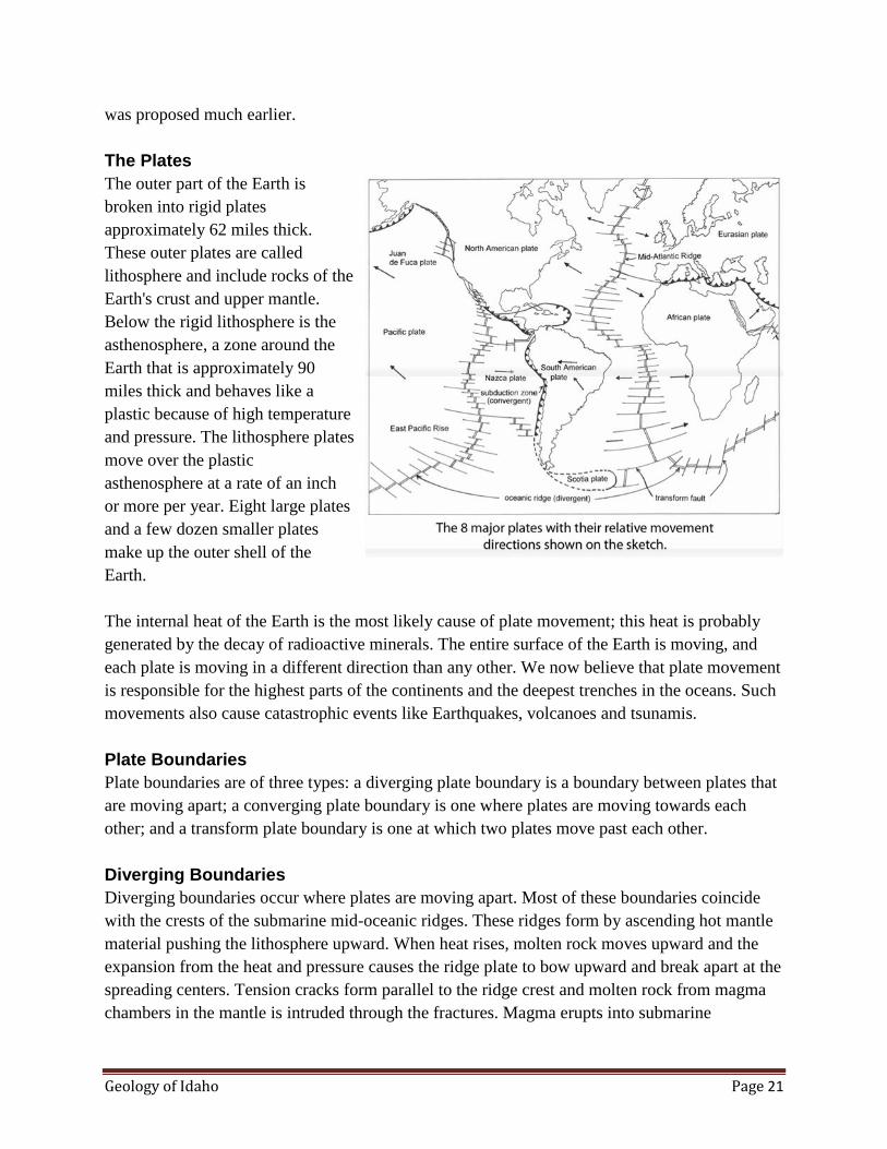
The Plates
The outer part of the Earth is
broken into rigid plates
approximately 62 miles thick.
These outer plates are called
lithosphere and include rocks of the
Earth's crust and upper mantle.
Below the rigid lithosphere is the
asthenosphere, a zone around the
Earth that is approximately 90
miles thick and behaves like a
plastic because of high temperature
and pressure. The lithosphere plates
move over the plastic
asthenosphere at a rate of an inch
or more per year. Eight large plates
and a few dozen smaller plates
make up the outer shell of the
Earth.
The internal heat of the Earth is the most likely cause of plate movement; this heat is probably
generated by the decay of radioactive minerals. The entire surface of the Earth is moving, and
each plate is moving in a different direction than any other. We now believe that plate movement
is responsible for the highest parts of the continents and the deepest trenches in the oceans. Such
movements also cause catastrophic events like Earthquakes, volcanoes and tsunamis.
Plate Boundaries
Plate boundaries are of three types: a diverging plate boundary is a boundary between plates that
are moving apart; a converging plate boundary is one where plates are moving towards each
other; and a transform plate boundary is one at which two plates move past each other.
Diverging Boundaries
Diverging boundaries occur where plates are moving apart. Most of these boundaries coincide
with the crests of the submarine mid-oceanic ridges. These ridges form by ascending hot mantle
material pushing the lithosphere upward. When heat rises, molten rock moves upward and the
expansion from the heat and pressure causes the ridge plate to bow upward and break apart at the
spreading centers. Tension cracks form parallel to the ridge crest and molten rock from magma
chambers in the mantle is intruded through the fractures. Magma erupts into submarine

Geology of Idaho Page 22
volcanoes and some of it solidifies in the fissure. New crust forms in rifts at the spreading
centers. As new magma is extruded, it accretes to both sides of the plates as they are pushed or
pulled apart. As the plates continue to pull apart, new tension fractures form and fill with
magma. This cycle repeats itself again and again.
Transform Boundaries
The transform boundary occurs where two plates slide past one another. The San Andreas Fault
is one of the best known land exposures of a transform boundary.
Converging Boundary
A converging boundary, where
plates move toward each other, is
responsible for the origin of most
of Idaho's igneous rock as well as
most of the major structural
features of the state. Where one
plate is covered by oceanic crust
and the other by continental crust,
the less dense continental plate will
override the denser oceanic plate.
The older the oceanic plate, the
colder and more dense it is. Where
two plates collide, the dense plate is subducted below the younger and less dense plate margin.
At this boundary, a subduction zone forms where the oceanic plate descends into the mantle
beneath an overriding plate. As the oceanic plate descends deeper into the Earth it is heated
progressively hotter. Also the friction caused by the two plates grinding past each other leads to
greater temperatures.
At the subduction zones, submarine trenches form, representing the deepest parts of the ocean
basins. Earthquakes continuously occur at the plate margins where the overriding plate is
grinding and abrading the subducted layer. The subducted plate causes Earthquakes all along its
downward path as it slowly moves into the Earth's mantle. By measuring the depth and position
of the Earthquakes, geologists are able to determine almost exactly the position and orientation
of the subducting plate.
Generation of Magma, Volcanoes and Batholiths
When the plate reaches a certain depth, heat and pressure melt the lighter minerals within it. This
light molten rock or magma coalesces at depth and floats upward through the more dense rock
towards the surface of the Earth. Where these globs of molten rock break through the oceanic
crust, they form chains of volcanic islands. The Aleutian Islands are a well-known example.
Cross section of the aesthenosphere and the lithosphere showing three types of plate boundaries: (1) a divergent-plate boundary at the mid-oceanic ridge; (2) an oceanic-oceanic convergent plate boundary on the left side; and
(3) and oceanic-continental convergent plate boundary on the right side

Geology of Idaho Page 23
The portion of the magma that manages to break through the surface and forms volcanoes is
classified as volcanic or extrusive rock. The portion that does not break through the Earth's
surface, but instead solidifies within the Earth's crust, is classified as intrusive igneous or
plutonic rock.
Where an oceanic plate is subducted below a continent, it partially melts and the rising globs of
magma melt and absorb portions of the silica-rich, low specific gravity continental rocks. Where
magma manages to break through the continental crust, the extrusive products are much more
siliceous than their oceanic counterparts.
Mantle Plumes
Mantle plumes are believed to form where convection currents in the Earth's mantle cause
narrow columns of hot mantle rock to rise and spread radially outward. One of the most
convincing theories for the origin of the Snake River Plain proposes that a hot mantle plume left
a track across the plain from west to east and was the source for most of the volcanism in the
Snake River Plain. The hot mantle plume is stationary and the overriding lithospheric plate
moves slowly in a west-southwest direction. This hot mantle plume is now thought to underlie
the caldera at Yellowstone Park. Many of the volcanic islands of the Pacific Ocean may have
originated from a mantle plume. The best known examples are the Hawaiian Islands.
Origin of Mountains
Mountains are the most conspicuous landforms in Idaho. Any isolated mass of rock may be
called a mountain because no minimum height or shape is required. Mountains may be formed
by volcanoes, by erosional processes and by structural processes such as faulting and folding.
Volcanic Mountains
There are many volcanic mountains in southern Idaho, particularly within the Snake River Plain
Province. These mountains generally consist of individual cones of cinder and extrusive igneous
rock. The volcanic material was extruded through a central vent in the Earth's crust and piled up
on the surface to form a cone. In Idaho, volcanic mountains tend to be smaller than other types of
mountains, generally less than 1,000 feet high. Most of the volcanic mountains are more properly
referred to as hills (a mountain is generally defined as projecting more than 1,000 feet above the
surface; if the cone does not reach that height, it should be referred to as a hill). Volcanic hills or
mountains also tend to be isolated and erratically distributed, although they are commonly
aligned along rifts or fissures such as the Great Rift of the Snake River Plain. They are generally
dome to conical shaped and are symmetrical in plain view. As a general rule, volcanic mountains
consisting mostly of cinders and tuffaceous material are the most susceptible to erosion of all
mountains.

Geology of Idaho Page 24
Erosional Mountains
Erosional mountains are found in regions of crustal uplift such as the central Idaho uplands. They
are characterized by steep gorges, precipitous slopes and youthful streams. Idaho's erosional
mountains have primarily been carved by glaciers and running water and are the result of
hundreds of thousands of years of erosion in the intervening valleys.
Structural Mountains
Structural mountains were created by structural activity such as folding and faulting. The Basin
and Range Province of eastern Idaho is an outstanding example of mountains created by faulting.
In the Basin and Range Province, large elongate blocks of the Earth's crust were moved up
relative to the intermontane valleys along large normal faults. Once the ranges were moved up,
erosional processes of primarily water and ice shaped the mountains into their present form.
Weathering and Soils
Weathering causes the
disintegration of rock near the
surface of the Earth. Plant and
animal life, atmosphere, and water
are the major causes of weathering.
Weathering breaks down and
loosens the surface minerals of
rock so they can be transported
away by agents of erosion such as
water, wind, and ice. There are two
types of weathering: mechanical
and chemical.
Mechanical Weathering
Mechanical weathering is the
disintegration of rock into smaller
and smaller fragments. Frost action
is an effective form of mechanical
weathering. When water trickles
down into fractures and pores of
rock and then freezes, its volume
increases by almost 10 percent.
This causes outward pressure of
about 30,000 pounds per square
inch at -7.6 Fahrenheit. Frost Weathering of joint blocks and stages in development of corestones. The
corners and edges of the granite blocks are attacked more readily by weathering along joints, and rounded corestones result.

Geology of Idaho Page 25
action causes rocks to be broken apart into angular fragments. Idaho's extreme temperature range
in the high country causes frost action to be a very important form of weathering.
Exfoliation is a form of mechanical weathering in which curved plates of rock are stripped from
rock below. This results in exfoliation domes or dome-like hills and rounded boulders.
Exfoliation domes occur along planes of parting called joints, which are curved more or less
parallel to the surface. These joints are several inches apart near the surface but increase in
distance to several feet apart with depth. One after another these layers are spalled off resulting
in rounded or dome-shaped rock forms. Most people believe exfoliation is caused by instability
as a result of drastically reduced pressure at the Earth's surface allowing the rock to expand.
Exfoliation domes are best developed in granitic rock. Yosemite National Park has exceptional
examples of exfoliation domes. Idaho has good examples in the Silent City of Rocks near Oakley
as well as in many parts of the granitic Idaho Batholith. In fact, these characteristic rounded
forms make granitic rock exposures easy to identify.
Another type of exfoliation occurs
where boulders are spheroidally
weathered. These boulders are
rounded by concentric shells of
rock spalling off, similar to the
way shells may be removed from
an onion. The outer shells are
formed by chemical weathering of
certain minerals to a product with
a greater volume than the original
material. For example, feldspar in
granite is converted to clay which
occupies a larger volume. Igneous
rocks are very susceptible to
mechanical weathering.
Chemical Weathering
Chemical weathering transforms
the original material into a
substance with a different
composition and different physical
characteristics. The new substance
is typically much softer and more
susceptible to agents of erosion
Geology of Idaho Page 26
than the original material. The rate of chemical weathering is greatly accelerated by the presence
of warm temperatures and moisture. Also, some minerals are more vulnerable to chemical
weathering than others. For example, feldspar is far more reactive than quartz.
Differential weathering occurs when some parts of a rock weather at different rates than others.
Excellent examples of differential weathering occur in the Idavada silicic volcanic rocks in the
Snake River Plains. Balanced Rock and the Gooding City of Rocks are outstanding examples of
differential weathering where hard layers alternate with soft layers
Features of Soil
Soil forms a porous mantle on the Earth’s surface and acts as a reservoir for accumulating and
storing water from snow and rain. When the water is released, it is done at a slow, steady
dependable rate to charge streams and rivers. Soils are not only crucial for sustaining plant
growth, but also are important for flood control.
The field study of soils is necessary in order to learn the potential and limitations of soil at a
given site. A soil survey will give basic information about soil resources essential for land-use
planning as it relates to development of undeveloped lands or conversion of land to new uses.
This information will indicate the limitations and potential of a soil for recreation, planning,
grading, erosion control, and suitable vegetation. For agriculture uses, soil information will aid in
determining the appropriate irrigation system, including the length of run, water application rate,
soil deficiencies, soil amendment requirements, leaching potential, drainage requirements, and
proper field practices for maintaining optimum plant growth. Soil surveys also give information
on sources of topsoil, and sand and gravel resources. Information on the engineering
performance of soils is crucial to the construction industry. For example, engineers need to know
how well a particular soil will support a building, the kinds of subgrades required for streets and
roads, and whether onsite waste disposal systems will function properly.
Soil: a Definition. The term soil has different meanings to different people, depending on the
context of its use. Most commonly, it is the natural medium for the growth of plants, regardless
of whether it has discernible soil horizons. Soil is defined by the Department of Agriculture as a
natural body comprised of solids (minerals and organic matter), liquid, and gases that occurs on
the land surface, occupies space, and is characterized by one or both of the following: horizons,
or layers, that are distinguishable from the initial materials as a result of additions, losses,
transfers, and transformations of energy and matter or the ability to support rooted plants in a
natural environment. Soil consists of the horizons near the Earth’s surface that, in contrast to the
underlying parent material, have been altered through time by climate, relief, and living
organisms. Many properties of soil change with the seasons, including the pH, soluble salts,
carbon-nitrogen ratio, biological activity, numbers of organisms, temperature, and moisture.
Geology of Idaho Page 27
In the development of soil, the decomposed parent material (rock or alluvium) differentiates
vertically with depth into layers or horizons. The soil profile is a vertical section from the surface
of the soil through all horizons into the fresh parent material. The amount of time necessary to
develop the profile depends on the weathering processes and the parent rock. These horizons are
developed by the following processes:
1. Organic material accumulates at the surface.
2. Parent material is leached so that one or more minerals and/or weathering products are
removed. Leaching is the removal of materials in solution by water percolating through
the soil.
3. Organic material, including humus, accumulates in the upper portions of the soil profile.
Humus is the dark-colored, fairly stable portion of the organic material that remains after
the accumulated plant and animal residues decompose.
4. The weathering products accumulate in the lower part of the soil profile through the
process of leaching and eluviation. Eluviation is the removal of soil material in
suspension from upper layers (the zone of eluviation). Illuviation is the deposition of
colloidal-size soil material moved from an upper horizon to a lower horizon in the soil
profile (the zone of illuviation).
A soil horizon is a layer, approximately parallel to the surface of the soil, distinguishable from
adjacent layers by a distinctive set of properties produced by soil-forming processes. The term
layer, rather than horizon, is used if all the properties are believed to be inherited from the parent
material or no judgment is made as to whether the layer is genetic.
The solum (plural, sola) of a soil consists of a set of horizons that are related through the same
cycle of pedogenic processes. In terms of soil horizons, a solum consists of A, E, and B horizons
and their transitional horizons and some O horizons. The solum of a soil presently at the surface
includes all horizons now forming. Solum and soils are not synonymous. Some soils include
layers that are not affected by soil formation; however, these layers are not part of the solum.
Residium is a term used when the properties of the soil indicate that it has been derived from the
underlying rock and there is no evidence that it was transported into place. For example, if the
rock fragment distribution decreases in quantity with depth, the material has likely been
transported downslope as colluvial material. Also, if the rock fragments in the soil are of a
different lithology than the underlying bedrock, they most likely would have been transported
downslope. Movement of soil downslope is an important process in mass wasting; even where
slopes are gentle, significant downslope soil movement can take place.

Geology of Idaho Page 28
Soils consist of solids, liquids and gases. The solid component includes both small mineral and
organic particles. It also has a large interconnected pore space shared by both water and air. The
water and air ratios change constantly due to the loss of water by plants, evaporation and,
recharge by rain and irrigation. Mineral particles, which are derived from the weathering of rock,
are typically represented by 3 sizes:
Sand 0.05 - 2.0 mm
Silt 0.002 - 0.05 mm
Clay < 0.002 mm
The relative amounts of sand, silt and clay determine the texture of the soil and its ability to
transfer air and water. The organic component of soil results from the decomposition of plant
material. Humus is a dark-colored material formed from the decomposition of plant and animal
residues. It is composed of altered organic compounds formed from plants as well as additional
compounds formed by organisms involved in the decay process. Clay and humus particles
typically have a negative charge which allows them to absorb cations (positively charged ions)
from solutions. Water takes nutrients in solution from minerals and organic material and
transfers the nutrients to the plant roots.
Soil Formation Factors
There are five factors that influence soil development: parent material, climate, living matter,
topography, and time. These factors operate both independently and interdependently.
Parent Material. Parent material is the original geologic material that has been
transformed into soil. Parent materials can be bedrock (residuum) such as granite,
sandstone, limestone, or basalt. Other parent materials may be transported deposits
carried to the site of deposition by water, ice or wind. Examples of transported
materials include loess, dune sand, glacial till, volcanic ash, and lake deposits. The
texture and mineralogy of the parent material have a large bearing on the
relationships to the other factors. Texture has a large role in determining porosity and
permeability for water flow and storage which in turn influences plant growth,
organic material accumulation, weathering, and leaching. The mineralogy determines
the weathering rate and weathering products in a given environment. For example,
carbonate-bearing material weathers rapidly from leaching, while siliceous material
such as quartz weathers very slowly. Soils may closely resemble parent material if
there has been a lack of time such as may be the case with glacial deposits, sand
dunes, and other alluvial deposits.
Climate and Soil Formation. Climate affects soil most directly through temperature
and precipitation. The amount of water entering the soil plays a large role in the
growth of plants. Also, water facilitates a great many chemical and physical processes
Geology of Idaho Page 29
that enhance weathering. With sufficient water, the rate of mineral weathering
increases with temperature. The tropical regions which are both warm and wet are
subject to intense weathering. However, high temperature causes rapid decay and
disappearance of organic residues from the soil. High precipitation or irrigation also
causes leaching, the removal of soil materials, including chemicals and nutrients by
water flowing through the soil.
Living Material. Plants supply a protective cover that retards erosion and enhances
infiltration of water into the soil. Plants are the primary sources of organic material in
the soil. Plant roots help break apart rocks, mix soil materials, form soil structure,
absorb nutrients and ultimately provide residues. Root channels also provide access
for water and air movement through the soil. Many organism, including rodents,
earthworms, and insects assist decomposition through burrowing and mixing. Mixing
by animals transports raw plant debris from the soil surface down into the topsoil.
Microscopic organisms are important for organic material decay and humus
formation. They also release nitrogen from proteins in the organic material. Nitrogen
is an essential nutrient that plants need in large quantities. Microorganisms and the
humus they produce act as a glue to hold soil particles together in clumps or
aggregates. Well-aggregated soil facilitates the movement of air and water to plant
roots.
Topography. Topography causes localized changes in such factors as parent material,
moisture, and temperature. Topography influences soil formation by controlling
runoff and the effectiveness of precipitation. Topography also determines to a
significant degree the climate. The direction and the steepness of the slope also
determine how effectively the sun can warm the soil and cause evaporation. Soils on
north-facing slopes tend to be cooler and wetter than soils on south-facing slopes. The
drier and warmer south-facing slopes generally produce less vegetation and therefore
have lower organic matter content and are more subject to erosion. Areas of low relief
can retain much more precipitation than can areas on steep slopes. Steep slopes are
also susceptible to mass movement and creep which limit soil development.
Time. Many soils are thousands and even tens of thousands of years old. The soil-
forming factors discussed above contribute the total environment for soil formation.
They establish the types of changes and the rate of change. There is a great difference
in the rate and kinds of reactions, depending on the environment of formation. Of all
the soil-forming processes, weathering occurs at the slowest rate. For example,
decomposition of siliceous material may take tens of thousands if not hundreds of
thousands of years. Of course, in warm moist climates, weathering occurs at a much
more rapid rate. Soils tend to have the same color, texture, and chemical composition
as their parent materials. The older the soil, the less impact parent material has on soil

Geology of Idaho Page 30
characteristics. As soils age, many original minerals are destroyed and many new
ones are formed. Soils tend to become more leached, more clayey, and more acid
with increasing time.
Soil Formation Processes
Properties contributed by the parent material are called inherited; acquired properties are created
by chemical and physical changes to the parent material. Acquired properties, include a new
texture, color, or structure. Soil-forming processes include a combination of physical, chemical,
and biological reactions:
Mineral weathering and clay development. Coarse grains are broken down to clay-
size particles. This process is most significant in warm, wet climates such as in the
tropics. Clay soils may be very deep. Also, most climates enhance leaching or
removal of soluble materials by water migrating downward. This causes tropical soils
to be infertile.
Accumulation of organic material. Organic material is formed by the decay of plant
residue. Trees contribute residues with leaves, needles and twigs. Microorganisms
that live in the soil feed on fresh organic matter and change it into humus.
Ion Exchange. Ions from the soil solution displace ions absorbed to clay and humus.
This process is less important in arid regions.
Translocation occurs where a component of the soil is moved to a different level by
water. In most cases this process involves the eluviation or movement of a component
near surface to redeposition or illuviation, in the horizon below it. Water moving
through the soil transports very fine clay particles from one horizon to another, or
from place to place within a horizon. When the water stops moving, the clay particles
are deposited on the surface of the soil aggregates. These coatings of clay particles
are called clay skins, which have a distinctive dark, waxy appearance. Lime and
gypsum are commonly translocated this way in arid regions. In low rainfall areas,
leaching is typically incomplete. Water moves down through the soil profile,
dissolving soluble minerals on the way. But because there is insufficient water to
move the minerals completely through the soil profile, when the water stops moving
due to surface evaporation or plant use, the salts are precipitated. The most common
deposits of this type are the well know caliche layers found throughout southern
Idaho. When these layers become cemented with lime and/or silica, they form
hardpans or duripans. Upward translocation may occur in places where there is a high
water table for extended periods of time. Evaporation at the surface causes water to
move upward continually so that salts are dissolved on the way up through the profile
and are precipitated as the water evaporates.

Geology of Idaho Page 31
Structure formation occurs where physical changes separate a cohesive soil into an
aggregate of various shapes and sizes. Expanding plant roots or ice crystals may
break up the cohesive layer, or shrinkage of the mass may leave dessication cracks.
Mixing of soil is most commonly accomplished by burrowing insects and worms.
Precipitation may add about 5 pounds of nitrogen every year to each acre of soil.
When soils are very wet, nitrogen can be changed to a gas and lost to the atmosphere.
Precipitation can be acid and facilitate leaching and chemical changes. Precipitation
also causes soils to erode and rivers to flood.
Features that Affect Soil Quality
Organisms in Soil. Many organisms including plants and animals and microscopic
organisms live within soil. Many are beneficial such as combining carbon and other
nutrients into organic compounds, and others facilitate decomposition of plant and
animal residues. Also, the physical condition of soil is enhanced by the burrowing
and mixing by rodents, insects, and worms. However, some organisms, such as
parasites, are not beneficial. Viruses are also undesirable because they cause diseases.
The causes of diseases in plants include bacteria, fungi, actinomycetes and viruses.
Decay and erosion both diminish the organic material in soils. This reduction must be
offset by continuous replenishment of fresh residues. Unfortunately, in most soils, the
loss of organic material through erosion and decay is not balanced by the addition of
organic material in residues.
Aeration of Soil. The aeration of soil is the process by which air in the soil is
replaced by air from the atmosphere. The most common cause of poor aeration is
waterlogged soils with no air access.
Water. Water is crucial for all biological, chemical and physical processes in soil.
Because it is also essential for plant growth, a very important function of soils is to
store and convey water to the plant roots. The rate of water flow through soil is
determined by the gradient of the potential and the hydraulic conductivity of the soil.
The conductivity of water through soil depends on the texture and the saturation of
the soil. The rate of water flow through soils is highest if the soils are coarse textured
and the pores are filled with water. However, if the soils are unsaturated, fine-textured
soils are the best conductors of water.
Available water is the water stored in the soils for use by plants. Available water,
which depends on soil depth and texture, is estimated by the difference in the amount

Geology of Idaho Page 32
of water a soil holds at field capacity (the most water a soil can store after wetted and
drained until drainage ceases) and the permanent wilting point. Coarse-textured soils
hold the least amount of water in available form, medium-textured soils store the
most amount of water, and fine-textured soils store an intermediate amount of water.
Soil Erosion. Soil erosion is caused by wind or water. Examples are agricultural
practices that leave soil exposed are overgrazing, tilling, and logging. Factors that
determine the extent of rainfall erosion include climate, soil, slope, nature of the crop,
and any erosion control measure that is used. The surface soil, which is generally the
soil material lost, is the most productive portion of the soil. The less productive soils
are typically more susceptible to erosion; so, the more a soil is eroded, the more
susceptible it becomes to erosion. Wind erosion factors include soil, soil surface
roughness, climate, the type and extent of plant cover, and the field width.
Nutrient Deficiencies. Nutrient deficiencies in plants are identified by symptoms such
as off- colored or poorly developed leaves (may be chlorosis), stunting, deformed
fruit and cracking of stems. Nitrogen, phosphorous, and potassium are required by
plants in large amounts. Plants rely on soil to furnish the minerals; however, soils are
typically deficient in certain minerals. Nitrogen and phosphorous are stored in organic
material. Nitrogen is accumulated through fixation, and both phosphorous and
potassium are derived from minerals. Availability of nutrients depends on total
content, rate of release (low solubility of inorganic phosphorous and the micro-
nutrient cations keeps them available to plants), and potential for leaching.
Acid Soils. Where soils have excess acidity, plants are susceptible to the toxic effects
from elements such as aluminum and manganese. Furthermore, acidity limits the
availability of certain nutrients and interferes with important biological processes.
Acidity may be reduced by liming the ground with crushed limestone or products
derived from it. The lime supplies hydroxyl ions that neutralize the acids and raise the
pH of the soils. The reaction time can be reduced by using finely ground lime and
mixing it with the soil.
Saline Soils. Where soils have excess soluble salts, these salts compete with plants for
available water. The situation normally occurs in dry climates where drainage is
inadequate. If the salts are compounds of sodium, they may contribute towards the
accumulation of exchangeable sodium, and sodic soils are caused by excess
exchangeable sodium. Sodic soils tend to have poor tilth because of the lack of
structure and they may also have a high pH which may restrict the access of nutrients
for plants. The best way to improve sodic soils is reduction by leaching with
amendments containing soluble calcium which will displace exchangeable sodium.

Geology of Idaho Page 33
Classifications of Soil Horizons
Three kinds of symbols are used in various combinations to designate horizons and layers. These
are capital letters, lower case letters, and Arabic numerals. Capital letters are used to designate
the master horizons and layers; lower case letters are used as suffixes to indicate specific
characteristics of master horizons and layers; and Arabic numerals are used both as suffixes to
indicate vertical subdivisions within a horizon or layer and as prefixes to indicate discontinuities.
Soil profiles consist of the master horizons and layers O, A, E, B, C and R; each of these is
subdivided into categories that are distinguished by important properties. Most horizons and
layers are given a single capital letter symbol; however, some require two. The classification of
horizons is set forth below and was adopted by the Soil Survey in October 1981 and revised in
1993 by the Soil Survey Division Staff.
Horizon and Layer Descriptions
The horizon and layer descriptions taken directly from the Soil Survey Division Staff (1993)
unless otherwise noted:
O horizons or layers: Layers dominated by organic material. Some are saturated with
water for long periods or were once saturated but are now artificially drained; others
have never been saturated.
Some O layers consist of undecomposed or partially decomposed litter, such as
leaves, needles, twigs, moss, and lichens, that has been deposited on the surface; they
may be on top of either mineral or organic soils. The mineral fraction of such material
is only a small percentage of the volume of the material and generally is much less
than half of the weight. Some soils consist entirely of material designated as O
horizons or layers. An O layer may be on the surface of a mineral soil or at any depth
beneath the surface, if it is buried.
A horizons: Mineral horizons that formed at the surface or below an O horizon, that
exhibit obliteration of all or much of the original rock structure, and that show one or
more of the following: (1) an accumulation of humified organic matter intimately
mixed with the mineral fraction and not dominated by properties characteristic of E or
B horizons or (2) properties resulting from cultivation, pasturing, or similar kinds of
disturbance.
E horizons: Mineral horizons in which the main feature is loss of silicate clay, iron,
aluminum, or some combination of these, leaving a concentration of sand and silt
particles. These horizons exhibit obliteration of all or much of the original rock
structure.

Geology of Idaho Page 34
An E horizon is usually, but not necessarily, lighter in color than an underlying B
horizon. In some soils the color is that of the sand and silt particles, but in many soils
coatings of iron oxides or other compounds mask the color of the primary particles.
An E horizon is most commonly differentiated from an overlying A horizon by its
lighter color. It generally has less organic matter than the A horizon.
The E horizon typically has a light gray or whitish color because nearly all the iron
and organic matter has been removed. It is present only in areas of relatively high
precipitation. It generally occurs immediately beneath an O or an A horizon or
immediately above a very slowly permeable horizon.
B horizons: Horizons that formed below an A, E, or O horizon and are dominated by
obliteration of all or much of the following: (1) illuvial concentration of silicate clay,
iron, aluminum, humus, carbonates, gypsum, or silica, alone or in combination; (2)
evidence of removal of carbonates; (3) residual concentration of sesquioxides; (4)
coatings of sesquioxides that make the horizon conspicuously lower in value, higher
in chroma, or redder in hue than overlying and underlying horizons without apparent
illuviation of iron; (5) alteration that forms silicate clay or liberates oxides or both and
that forms granular blocky, or prismatic structure if volume changes accompany
changes in moisture content; or (6) brittleness.
In some soils, the B horizon has the brightest yellowish-brown or reddish-brown
color. In others, it has the most pronounced blocky or prismatic structure. Many B
horizons have more clay than any other horizons in the profile and show evidence of
clay skins.
C horizons: Horizons or layers, excluding hard bedrock, that are little affected by
pedogenic processes and lack properties of O, A, E, or B horizons. The material of C
layers may be either like or unlike that from which the solum presumably formed.
The C horizon may have been modified even if there is no evidence of pedogenesis.
Included as C layers are sediment, saprolite, unconsolidated bedrock, and other
geologic materials that are commonly uncemented and exhibit low or moderate
excavation difficulty. Layers that have accumulations of silica, carbonates, or gypsum
or more soluble salts are included in C horizons, even if indurated.
Any material that can be dug with a shovel but has not changed appreciably by soil
forming processes is considered a C horizon.
R layers: Hard Bedrock. Granite, basalt, quartzite, sandstone and limestone are
examples of bedrock.

Geology of Idaho Page 35
Soil Texture
Texture is the relative proportion of different particle sizes, similar to the property of sorting
used by geologists. Geologists, engineers, and soil scientists all use separate systems of particle
size classification, although the size categories are very similar. The term fine earth refers to the
finer sizes of the soil which are smaller than 2 mm in diameter. Material more than 2 mm in
diameter includes rock fragments which are broken down into pebbles, cobbles, stones, and
boulders, depending on diameter.
Particle-Size Classification by the USDA of Material < 2 mm in Diameter:
Size Fraction (Coarse Fragments) Diameter
Boulder Above 600 mm
Stones 250 - 600 mm
Cobbles 75 - 250 mm
Gravels 2 - 75 mm
The USDA uses the following size separates for the <2 mm material (Soil Survey Division,
1993):
Soil Separates
Very Coarse Sand 2.0-1.0 mm
Coarse Sand 1.0-0.5 mm
Medium Sand 0.5-0.25 mm
Fine Sand 0.25-0.10
Very Fine Sand 0.10-0.05 mm
Silt 0.05-0.002 mm
Clay <0.002 mm
To be called soil, the USDA says a deposit of mineral matter should contain at least 10 percent
sand, silt or clay. The large sizes impair the ability of the soil to provide water and nutrients to
plants and present obstacles to cultivation.
Particle Shape and Size. Both particle shape and particle size determine the pore

Geology of Idaho Page 36
spaces and permeability of the soil. Particle shape also determines the cohesive and
adhesive properties. These properties express the force with which the mass of soil
clings to itself (cohesion) or to other objects (adhesion). Flat surfaces in parallel have
the strongest contact. These properties are measured by the firmness of clods when
dry or the plasticity when wet.
Sand Properties. Sand grains are large enough to be seen with the unaided eye and
felt individually when rubbed between fingers. Sand grains, because of size and
roughness, make only minimum contact with other grains. Also, sand is not sticky,
does not form stable aggregates, and is permeable to air and water.
Silt. Individual particles of silt cannot be seen or felt between the fingers. Silt is more
cohesive and adhesive than sand, but still contributes little to stable aggregate
formation in soil.
Clay. Clay is so small that the individual particles can only be seen under an electron
microscope. Although clay is typically sticky and plastic when wet, some clay
minerals express these qualities better than others. Expanding clays are characterized
by their ability to swell when wet and shrink when dry, commonly forming large
cracks.
Soil Texture is the weight
proportion of the separates for
particles less than 2 mm as
determined from a laboratory
particle-size distribution. The field
texture, which is determined by
feel, is referred to as apparent
because it is not an estimate of the
results of a laboratory operation.
Sand particles feel gritty and can be
seen individually without
magnification; they have a smooth
feel to the fingers when dry or wet.
In some places, clay soils are
sticky; and in others they are not.
Where soils are dominated by
montmorillonite clays, they feel
different from soils that contain
similar amounts of micaceous or

Geology of Idaho Page 37
kaolinitic clay.
The texture classes are sand, loamy sands, sandy loams, loam, silt loam, silt, sandy clay loam,
clay loam, silty clay loam, sandy clay, silty clay, and clay. Subclasses of sand are subdivided into
coarse sand, sand, fine sand, and very fine sand. Subclasses of loamy sands and sandy loams that
are based on sand size are named similarly.
Field Determination of Texture
The particle size distribution of material less than 2 mm in diameter is determined in the field by
feel. The distribution of mineral particles of a soil is an important property that influences many
other properties. In the field the various particle size classes can be estimated by moistening the
soil to maximum plasticity and working it with the fingers to eliminate any aggregation effects. It
is possible to determine the relative proportions of sand, silt, and clay in soil in the field almost
as accurately as can be accomplished in a laboratory. The sand fractions are gritty, the silt
fractions are smooth, and the clay fractions are plastic and sticky.
Soil Structure
Structure is the shape formed when individual particles cluster together into aggregates called
peds. Soil structure refers to units composed of primary particles where the cohesion within units
is greater than the adhesion among units. Under stress, the soil mass tends to rupture along
predetermined planes or zones which form the boundary of the units. The term “structural unit”
applies to any repetitive soil body that is commonly bounded by planes or zones of weakness that
are not an apparent result of compositional differences. A structural unit that is the consequence
of soil development is called a ped. The surfaces of peds persist through cycles of wetting and
drying in place.
Soils devoid of structure are referred to as structureless. In structureless layers or horizons, no
units are visible in place after the soil has been gently disturbed, such as by tapping a spade
containing a slice of soil against a hard surface or dropping a large fragment on the ground.
When structureless soils are ruptured, soil fragments, single grains, or both result. In soils that
have structure, the units are described in terms of shape, size, and grade (distinctness).
Soil structure refers to the way that primary soil particles aggregate into specific structural units
called peds. Therefore, when the soil is wet and the peds are swollen, the aggregates fit tightly
together. Prismatic structure may be caused by slow, prolonged shrinkage of the soil, with cracks
formed perpendicular to the drying surface. Blocky structures may be caused from rapid
shrinkage of clay-rich soil while drying. Platy structures may be caused by very rapid drying
with formation of cracks parallel to the surface of drying.
Certain soil structures are typical for different parts of the soil profile. For example, surface soil
Geology of Idaho Page 38
is generally characterized by granular structures. Structure formation is normally less developed
with depth and the peds tend to be the larger prisms or blocky shapes. Structureless horizons
generally form below the zone disturbed by fluctuating moisture conditions or roots.
Shape
Five basic shapes of structural units are recognized in soils:
Platy: The units are flat and platelike. They are generally oriented horizontally.
Lenticular platy structure has a shape that is thickest in the middle and thins towards
the edges.
Prismatic: The individual units are bounded by flat to rounded vertical faces. Units
are distinctly longer vertically, and the faces are typically casts or molds of adjoining
units. Vertices are angular or sub-rounded; the tops of the prism are somewhat
indistinct and normally flat.
Columnar: The units are similar to prisms and are bounded by flat or slightly rounded
vertical faces. The tops of columns, in contrast to those of prisms, are very distinct
and normally rounded.
Blocky: The units are blocklike or polyhedral. They are bounded by flat or slightly
rounded surfaces that are casts of the faces of surrounding peds. Typically, blocky
structural units are nearly equidimensional but grade to prisms and to plates.
Granular: The units are approximately spherical or polyhedral and are bounded by
curved or very irregular faces that are not casts of adjoining peds.
Soil Consistency
The consistency of a soil depends on the degree and kind of cohesion and adhesion, or from a
negative sense, the resistance to deformation or rupture. The evaluation of soil consistency relies
on three moisture contents which include (1) consistency when wet is determined at slightly
above field capacity; soil material is pressed between the thumb and finger and its degree of
stickiness is determined; (2) consistency when moist is determined at a moisture content between
air dry and field capacity; consistency is characterized by tendency to break into smaller particles
rather than into powder; it has the ability to cohere again if pressed together; and (3) the
consistency of dry soil materials is characterized by brittleness, rigidity and a tendency to deform
to a powder or to fragments with sharp edges; it also lacks the ability to cohere if pressed
together again.
Soil Porosity
Soil porosity depends on the shape, size, and abundance of cracks, passages and other soil
Geology of Idaho Page 39
cavities. Six criteria may be used to describe soil pores: size, abundance, shape, distribution,
continuity, and orientation; however, in field descriptions, porosity is expressed by abundance,
size and shape. Pore sizes are described by the following diameter classes: micro (less than 0.075
mm), very fine (0.075-1 mm), fine (1-2 mm), medium (2-5 mm), and coarse (over 5 mm). Soils
with a pore diameter of more than 0.075 mm will generally drain freely. Interstitial soil pores are
strongly influenced by soil moisture. In the case where peds fit together, the interstitial pores are
larger when the soil is dry, but when the peds swell because of increasing moisture, the
interstitial pore volume may be reduced very significantly. Where peds are spheroidal and do not
fit together, the size of the interstitial pores is less dependent on the moisture content of the soil.
Soil Color
Soil color is an important characteristic for the classification and study of soil, and is useful for
soil identification when combined with other soil characteristics such as structure. Humus, the
most stable component of organic matter, is the most common coloring agent in topsoil. Soil
color can indicate the extent of mineral weathering, the existence of organic material and the
state of aeration. The red, yellow, and brown colors are caused by the secondary iron oxides and
the black oxides are manganese oxides. Organic material darkens soils, particularly under
grasslands where a few percent organic material may turn the soil very dark. In water-saturated
soils with poor aeration, iron and manganese assume reduced forms and cause the soil to have
the grayish or bluish colorations of gleying. Light-colored layers may be caused from leaching of
iron minerals from the mineral matrix.
The parent materials are important contributors to soil color, particularly in young soils where
soils tend to have the color of the parent rock. Mafic rocks, which are rich in iron, commonly
produce red or brown soils.
Mottling in soils may be recorded by describing the color of the matrix and the colors of the
principal mottles as well as the mottling pattern. Mottles, which may be gray, reddish brown, and
yellow, are typically present in poorly drained soils where the water table fluctuates. The amount
of gray tends to increase in wetter organic soils. Mottle patterns should be described according to
their contrast, size and abundance.
Soil Classification
Soil classification is the systematic organization of soils into groups or categories on the basis of
their properties and characteristics. Subdivisions of these groups are accomplished on the basis
of specific property differences. There are six categories in the United States:
Orders (10)
Suborders (29)
Great Groups

Geology of Idaho Page 40
Subgroups
Families
Soil Series
Soil Sampling and the Pedon
Soil properties cannot be determined from sampling the surface. Soil is a three dimensional body
that requires the study of its horizons or layers. Sampling of soils is complicated by the fact that
a soil is typically is variable, both vertically and horizontally. The concept of a pedon was
developed to make possible a clear basis for soil descriptions and the selection of soil samples.
Where describing and sampling soil, the pedon has the smallest volume possible for representing
the nature and arrangement of soil horizons and variability in the properties that are preserved in
samples. Like a unit cell, the pedon has three dimensions with a minimal horizontal area
arbitrarily set at 1m2 but ranges to 10 m2, depending on soil variability. The lower limit of a
pedon is the typically transitional interface between soil and nonsoil. It is important that the
lateral dimensions are sufficiently large to represent the nature of the horizons and their
variability. The polypedon may be defined as a set of contiguous pedons.
Surface Water
Running water is the most powerful agent of erosion. Continents are eroded primarily by running
water at an average rate of 1 inch every 750 years. The velocity of a stream increases as its
gradient increases, but velocity is also influenced by factors such as degree of turbulence,
position within the river, the course of the stream, the shape of the channel and the stream load.
River Cycles
Stages in the cycle of river erosion are labeled as youth, maturity and old age. Each stage has
certain characteristics that are not necessarily related to age in years—only phases in
development. Typically, rivers tend to have old-age-type development at their mouths and
youthful development at their upper reaches. So the three stages may grade imperceptibly from
one to another and also from one end of the stream to the other.
The youthful stage is characterized by rapid down cutting, high stream gradient, steep-sided
valleys with narrow bottoms and waterfalls. The mature stage is characterized by a longer,
smoother profile and no waterfalls or rapids.
Gradient is normally expressed as the number of feet a stream descends each mile of flow. In
general, a stream's gradient decreases from its headwaters toward its mouth, resulting in a
longitudinal profile concave towards the sky.
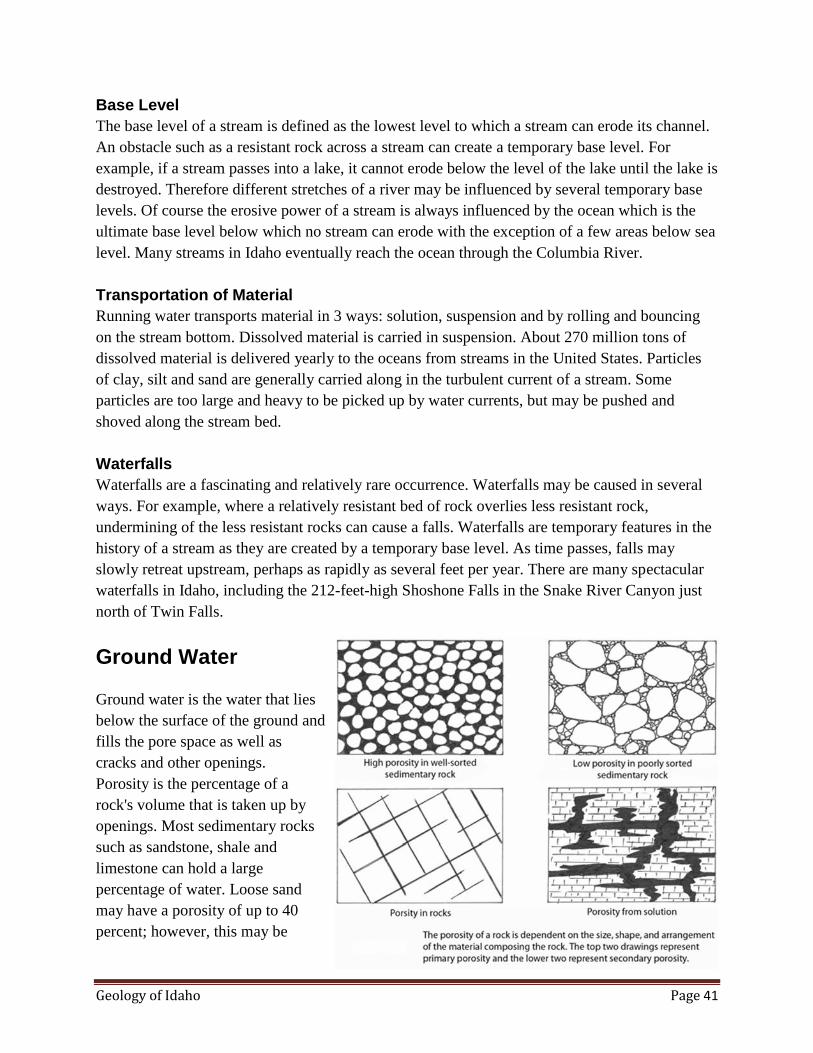
Geology of Idaho Page 41
Base Level
The base level of a stream is defined as the lowest level to which a stream can erode its channel.
An obstacle such as a resistant rock across a stream can create a temporary base level. For
example, if a stream passes into a lake, it cannot erode below the level of the lake until the lake is
destroyed. Therefore different stretches of a river may be influenced by several temporary base
levels. Of course the erosive power of a stream is always influenced by the ocean which is the
ultimate base level below which no stream can erode with the exception of a few areas below sea
level. Many streams in Idaho eventually reach the ocean through the Columbia River.
Transportation of Material
Running water transports material in 3 ways: solution, suspension and by rolling and bouncing
on the stream bottom. Dissolved material is carried in suspension. About 270 million tons of
dissolved material is delivered yearly to the oceans from streams in the United States. Particles
of clay, silt and sand are generally carried along in the turbulent current of a stream. Some
particles are too large and heavy to be picked up by water currents, but may be pushed and
shoved along the stream bed.
Waterfalls
Waterfalls are a fascinating and relatively rare occurrence. Waterfalls may be caused in several
ways. For example, where a relatively resistant bed of rock overlies less resistant rock,
undermining of the less resistant rocks can cause a falls. Waterfalls are temporary features in the
history of a stream as they are created by a temporary base level. As time passes, falls may
slowly retreat upstream, perhaps as rapidly as several feet per year. There are many spectacular
waterfalls in Idaho, including the 212-feet-high Shoshone Falls in the Snake River Canyon just
north of Twin Falls.
Ground Water
Ground water is the water that lies
below the surface of the ground and
fills the pore space as well as
cracks and other openings.
Porosity is the percentage of a
rock's volume that is taken up by
openings. Most sedimentary rocks
such as sandstone, shale and
limestone can hold a large
percentage of water. Loose sand
may have a porosity of up to 40
percent; however, this may be
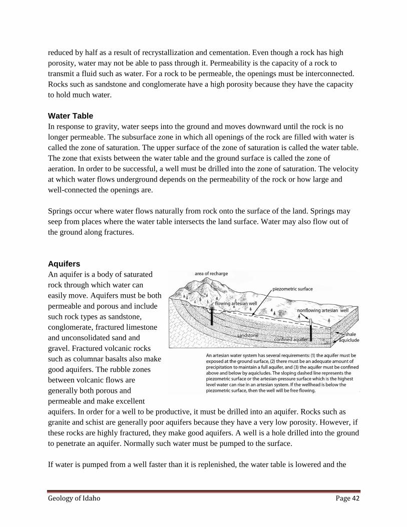
Geology of Idaho Page 42
38
reduced by half as a result of recrystallization and cementation. Even though a rock has high
porosity, water may not be able to pass through it. Permeability is the capacity of a rock to
transmit a fluid such as water. For a rock to be permeable, the openings must be interconnected.
Rocks such as sandstone and conglomerate have a high porosity because they have the capacity
to hold much water.
Water Table
In response to gravity, water seeps into the ground and moves downward until the rock is no
longer permeable. The subsurface zone in which all openings of the rock are filled with water is
called the zone of saturation. The upper surface of the zone of saturation is called the water table.
The zone that exists between the water table and the ground surface is called the zone of
aeration. In order to be successful, a well must be drilled into the zone of saturation. The velocity
at which water flows underground depends on the permeability of the rock or how large and
well-connected the openings are.
Springs occur where water flows naturally from rock onto the surface of the land. Springs may
seep from places where the water table intersects the land surface. Water may also flow out of
the ground along fractures.
Aquifers
An aquifer is a body of saturated
rock through which water can
easily move. Aquifers must be both
permeable and porous and include
such rock types as sandstone,
conglomerate, fractured limestone
and unconsolidated sand and
gravel. Fractured volcanic rocks
such as columnar basalts also make
good aquifers. The rubble zones
between volcanic flows are
generally both porous and
permeable and make excellent
aquifers. In order for a well to be productive, it must be drilled into an aquifer. Rocks such as
granite and schist are generally poor aquifers because they have a very low porosity. However, if
these rocks are highly fractured, they make good aquifers. A well is a hole drilled into the ground
to penetrate an aquifer. Normally such water must be pumped to the surface.
If water is pumped from a well faster than it is replenished, the water table is lowered and the
Geology of Idaho Page 43
well may go dry. When water is pumped from a well, the water table is generally lowered into a
cone of depression at the well. Ground water normally flows down the slope of the water table
towards the well.
Snake River Plains Aquifer
Size. The Snake River Plain aquifer underlies most of the Snake River Plain or about
10,000 square miles. The upper surface of the aquifer (water table) ranges from about
200 feet to about 1,000 feet below the ground surface; however, in most places the
aquifer is no deeper than 450 feet. In the eastern Snake River Plain the water table
slopes to the southwest at gradients ranging from 1 m/km to 6 m/km. Consequently,
the gravity and weight of the water in the basalt layers north of the river drives the
water emerging from Thousand Springs. The aquifer steepens at the west end of the
eastern plain, possible because the underlying basalt aquifer thins.
The aquifer is immense and contains vast quantities of water. The storage capacity
may be equal to several hundred times the annual flow of the Snake River.
Approximately 8 million acre-feet of water are moved in and out of the aquifer every
year.
Composition. The aquifer consists primarily of flat-lying Pleistocene basalt flows
with interbedded sedimentary rocks of both fluvial and lacustrine sources. Rhyolite,
which has low permeability, underlies the basalt and forms most of the base of the
aquifer throughout the plain. The rhyolite may be much less permeable than the basalt
because fractures tend to filled by chemical precipitates. Basalt lava flows have
permeable rubble and vesicular or breccia zones at both the tops and bottoms of
flows. Water can also move vertically through vertical cooling fractures in the basalt
flows. Sedimentary interbeds consisting of sand, silt, clay and ash also offer
permeable strata between basalt flows.
The aquifer is a water-saturated zone that overlies impermeable rocks such as the
silicic volcanics. The upper surface of the aquifer (water table) varies substantially on
the recharge rate from precipitation and irrigation.
Source of the Water. The aquifer is fed by precipitation from drainage areas in the
northern mountains covering approximately 35,000 square miles. The water running
off the large drainage basins such as the Big and Little Lost River and Birch Creek,
all sink into the permeable lavas at the northeast end of the plain and enter the
aquifer. Only the Big Wood River and the Henry's Fork of the Snake manage to cross
the northern Snake River Plain and make it to the Snake River; all others seep entirely
into the lava and disappear into the aquifer. Approximately 3 million acres of

Geology of Idaho Page 44
agricultural land on the Snake River Plain are irrigated, of which 1 million acres are
irrigated from wells tapping the aquifer.
Pollution of the Aquifer. Pollution of the Snake River Plain aquifer by localized
sources such as fertilizer, potato processing plants, feedlots and the Idaho National
Engineering Laboratory (INEL) is a problem in certain areas but does not at this time
present a serious overall threat to the aquifer. These pollution sources are localized
and because of the immense size of the aquifer, depth to the water table and lack of
precipitation over the aquifer, the pollution that enters the aquifer is diluted.
Approximately 15 million cubic feet of radioactive waste is stored at the INEL over
the aquifer. An elaborate monitoring system has been established and many detailed
studies have been made of the geologic and hydrologic characteristics of the aquifer
and the related rocks and structures. According to data from monitoring wells, there
has not been significant deterioration of the Snake river Plain aquifer from storage of
radioactive wastes. Samples of water from the Thousand Springs area indicate only
natural background levels of radiation.
Thousand Springs
The Thousands Springs area is
situated on the north side of the
Snake River Canyon between Bliss
and Twin Falls. Between Milner
Dam and King Hill, the Snake
River has cut a canyon several
hundred feet deep for a distance of
almost 90 miles. The north wall of
the canyon intercepts the Snake
River Plain aquifer where many
spectacular springs pour out of the
truncated pillow basalts and other
permeable zones. This area
embraces 11 of the 65 springs in
the United States that produce
more than 72,400 acre-feet of
water annually. Unfortunately, many of the most spectacular springs are on private lands and are
conveyed through flumes and pipelines rather than gushing out of the aquifer and down the
canyon wall. Until the early part of this century when the water was developed for power and
irrigation, the springs were a spectacular scenic feature with springs pouring from outlets along
the canyon forming an almost continuous wall of water over the north side of the canyon for
hundreds of yards.
Large springs at Thousand Springs, Idaho. The water discharges from pillow basalts and flows down over the edge of a flow on the north wall of the
Snake River Canyon. The height of the falls is approximately 180 feet. When this photo was taken by I.C. Russell in 1901, the springs poured from outlets
along the canyon wall forming a continuous wall of water for hundreds of meters. This view is no longer in existence because much of the water id
diverted for commercial uses as it emerges from the springs.

Geology of Idaho Page 45
The aquifer is a major source for the Snake River. Between April and October, most of the Snake
River water above twin Falls is diverted for irrigation. Consequently, almost all the water in the
Snake River downstream from Twin Falls originates from springs emerging from the Snake
River Plain aquifer.
The origin of Thousand Springs occurred from a unique sequence of geologic events and
processes. Periodically, lava flows originating from sources on the north side of the Snake River
canyon flowed south and dammed the canyon forming a large lake. Once the lake was formed,
lava continued to flow into the lake. When basalt lava flows into a lake, the lava tends to separate
into discrete ellipsoidal pillow lavas that are highly shattered or fractured from rapid cooling.
These pillow lavas have a very high porosity and permeability. However, the first lava which
entered the canyon and formed the dam is neither very permeable nor porous so it confines the
flow of water to the pillow basalt aquifer on its west end.
When the canyon was filled by pillow basalts, the Snake River was forced to the south to cut a
new channel in the older Tertiary basalts and sediments where the old pillow-basalt-filled
channel is exposed at the north wall of the canyon. The springs must pass over the upper edge of
the Tertiary basalt which acts as a sill by maintaining the water table to the top of the lowest
edge of the Tertiary basalt.
Mass Movement
Mass movement is the movement
of surface material caused by
gravity. Landslides and rockfalls
are examples of very sudden
movements of this type. Of course,
geological agents such as water,
wind, and ice all work with gravity
to cause a leveling of land.
Water aids in the down-slope
movement of surface material in
several ways. Water adds weight to
the soil; it fills pore spaces of slope
material and it exerts pressure
which tends to push apart
individual grains. This decreases

Geology of Idaho Page 46
the resistance of the material to movement. Landslide is a general term that is commonly broken
down into the more specialized terms such as slump, rockslide, debris slide, mudflow, and
earthflow.
Slump
A slump is a downward and outward movement of rock or unconsolidated material moving as a
unit or series of units. Large blocks of material move suddenly downward and outward along a
curved plane.
Rockslide
Rockslides are the most catastrophic type of landslide. They involve a sudden rapid slide of
bedrock along planes of weakness. Rockslides are very common in the over-steepened canyons
and drainages of Idaho, particularly in those areas like the Salmon River Canyon where more
than 5,000 feet of elevation may exist between the ridge tops and the canyon bottoms.
Debris Flow
A debris flow is a mass of transported saturated rock particles of all sizes. This type of landslide
is caused by a sudden flood of water from a cloudburst in semi-arid country or a sudden thaw.
The flood waters carry the soil and rocks from a large slope area and transport them down a
gulch or canyon. Then the water and debris move down the canyon and spread out as an alluvial
fan on the gentle slopes below. Mudflows are very common in the semi-arid areas of
southwestern Idaho as well as high-relief areas of central Idaho.
Talus
A talus slope is developed by an accumulation of rock fragments at the foot of a cliff or ridge.
Rock fragments break loose from the cliff above, roll down the slope and pile up in a heap of
rock rubble. Individual talus forms as a half-cone with the apex pointing upwards. In most cases
a series of half cones coalesce around the base of a mountain.
Horseshoe Bend Hill Slide Area
Landslides are a very common occurrence on the Horseshoe Bend Hill area between Boise and
Horseshoe Bend. From the highway you can easily see earthflows of less than one year old as
well as those much older. The more recent flows show fresh brown crescentric cracks where the
fresh Earth is exposed. The older flows are more difficult to identify because vegetation has
grown over the scarp areas. Most of the slides occur during the spring when the ground surface is
saturated with water. Placement of this major north-south highway over an active slide area has
resulted in a section of highway constantly deformed and broken by the slowly-moving land
surface.
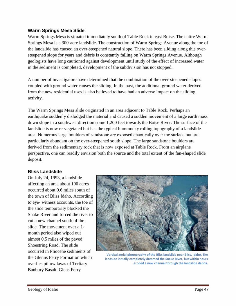
Geology of Idaho Page 47
Warm Springs Mesa Slide
Warm Springs Mesa is situated immediately south of Table Rock in east Boise. The entire Warm
Springs Mesa is a 300-acre landslide. The construction of Warm Springs Avenue along the toe of
the landslide has caused an over-steepened natural slope. There has been sliding along this over-
steepened slope for years and debris is constantly falling on Warm Springs Avenue. Although
geologists have long cautioned against development until study of the effect of increased water
in the sediment is completed, development of the subdivision has not stopped.
A number of investigators have determined that the combination of the over-steepened slopes
coupled with ground water causes the sliding. In the past, the additional ground water derived
from the new residential uses is also believed to have had an adverse impact on the sliding
activity.
The Warm Springs Mesa slide originated in an area adjacent to Table Rock. Perhaps an
earthquake suddenly dislodged the material and caused a sudden movement of a large earth mass
down slope in a southwest direction some 1,200 feet towards the Boise River. The surface of the
landslide is now re-vegetated but has the typical hummocky rolling topography of a landslide
area. Numerous large boulders of sandstone are exposed chaotically over the surface but are
particularly abundant on the over-steepened south slope. The large sandstone boulders are
derived from the sedimentary rock that is now exposed at Table Rock. From an airplane
perspective, one can readily envision both the source and the total extent of the fan-shaped slide
deposit.
Bliss Landslide
On July 24, 1993, a landslide
affecting an area about 100 acres
occurred about 0.6 miles south of
the town of Bliss Idaho. According
to eye- witness accounts, the toe of
the slide temporarily blocked the
Snake River and forced the river to
cut a new channel south of the
slide. The movement over a 1-
month period also wiped out
almost 0.5 miles of the paved
Shoestring Road. The slide
occurred in Pliocene sediments of
the Glenns Ferry Formation which
overlies pillow lavas of Tertiary
Banbury Basalt. Glens Ferry
Vertical aerial photography of the Bliss landslide near Bliss, Idaho. The landside initially completely dammed the Snake River, but within hours
eroded a new channel through the landslide debris.
Geology of Idaho Page 48
sediments that make up the disrupted slide material are lacustrine clays of the Yahoo Clay. The
Yahoo Clay was deposited when the McKinney Basalt dammed up the Snake River and formed a
lake approximately 70,000 years ago.
Outstanding textbook examples of most of the features typically associated with landslides can
easily be observed at the Bliss Landslide. These features include rotated slump blocks,
hummocky surface at the earthflow portion near the toe, tension cracks, grabens, water ponds,
staircase topography and a large head scarp. The passage of time has subdued many of these
classic features and made it more difficult to recognize them.
Other Idaho Landslides
Landslides are a common sight in the mountainous areas of Idaho. Once you know what to look
for, they can be readily identified by the presence of a rupture in the vegetative cover exposing
fresh earth or by a hummocky lower surface.
Caves in Idaho
Caves in Idaho generally fall into one of three types: corrosion caves, solution caves and lava
caves. Corrosion caves are formed by erosive action of water, waves or currents on a relatively
soft rock. These caves generally occur at the edge of a river or lake.
Corrosion Caves
Corrosion caves are generally shallow and not as impressive as lava caves or solution caves.
Archeologists, however, have found that early Americans commonly camped in small corrosion
caves while hunting or fishing in the vicinity of water bodies. Rock shelters are also formed by
erosion recessing the lower rocks in a cliff and leaving an overhanging rock shelter. Many of
these rock shelters have yielded valuable information on the culture and migration patterns of
early Idahoans.
Solution Caves
Solution caves are formed by slightly acidic ground water circulating through fractures in
limestone. This water is capable of dissolving great quantities of solid rock. As time passes, the
openings become larger and larger until they may be large enough for a man to pass through.
Cone-shaped forms called stalactites are deposited by underground water. Stalactites are
composed of calcium carbonate and look like icicles hanging from cave roofs. Stalagmites are
similar in composition and origin to stalactites but are formed from ground water dripping on the
cave floor. The best examples of solution caves are found in the Paleozoic carbonate rocks in
eastern Idaho.

Geology of Idaho Page 49
Lava Caves
Lava caves, also known as lava tubes, form in the central portion of a lava flow. Immediately
after the flow is extruded, the outer margins of the flow cool and freeze in place, including the
bottom, sides and top. Although the outer margin of the flow has solidified into basaltic rock, the
central core is still molten and continues to flow towards the flow front. When the source of lava
is cut off, the lava flows out the end of the tube and leaves a cave. These caves are typically
10 to 20 feet in diameter. They are characterized by both stalactites and stalagmites formed by
lava dripping off the roof of the tube. Basalt flows on the Snake River Plain have many excellent
examples of these caves. Many such caves arc found where a thin portion of the roof collapses
and leaves a precarious entrance to the cave.
Glaciation
Ice Age
The term ice age is used here to
refer to a period of relatively cold
temperatures, throughout Earth
history. These cold periods may
last anywhere from a few million
years to tens of millions of years.
Typically, these ice ages are
characterized by cold glacial stages
alternating with warmer interglacial
stages. Glacial stages within an ice
age generally have a duration
measured in thousands or tens of
thousands of years. The Pleistocene ice age has run for the last 2 to 3 million years and the last
glacial stage had its greatest expansion 21,000 to 17,000 years ago, but started 115,000 years ago
and ended about 10,000 years ago.
The Pleistocene ice age had a large role in shaping the landforms in the Boise valley and the
mountains to the northeast and southwest of the plain. Evidence of this ice age is now
widespread throughout the high country of Idaho. Most of the high country of Idaho, including
areas over 5000 feet in elevation, has been modified by alpine glaciation.
Climate and Glaciation. The Pleistocene climate was probably semiarid like the present climate;
however, as the mountains were glaciated, the western Snake River Plain was cooler with longer
periods of snow accumulation, and large runoff during the spring snowmelt. Patterned ground is
common on the higher terraces and uplands in the Boise Valley. These features are thought to be
caused by intense freeze and thaw cycles.
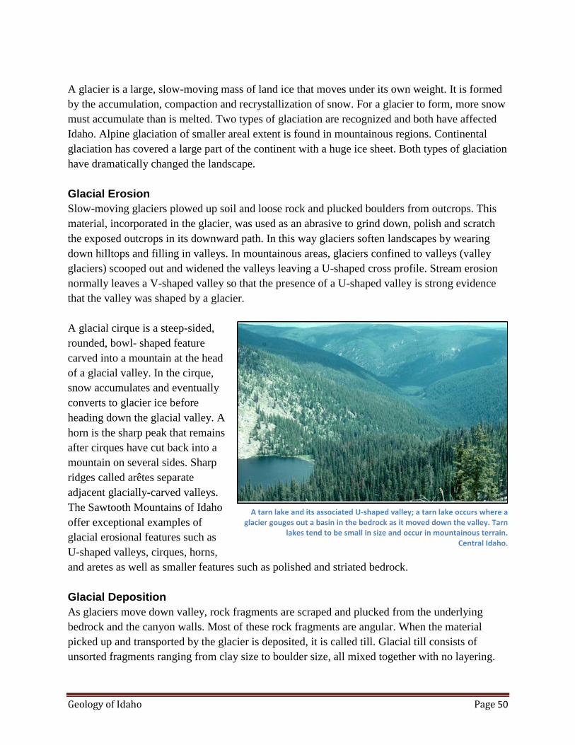
Geology of Idaho Page 50
A glacier is a large, slow-moving mass of land ice that moves under its own weight. It is formed
by the accumulation, compaction and recrystallization of snow. For a glacier to form, more snow
must accumulate than is melted. Two types of glaciation are recognized and both have affected
Idaho. Alpine glaciation of smaller areal extent is found in mountainous regions. Continental
glaciation has covered a large part of the continent with a huge ice sheet. Both types of glaciation
have dramatically changed the landscape.
Glacial Erosion
Slow-moving glaciers plowed up soil and loose rock and plucked boulders from outcrops. This
material, incorporated in the glacier, was used as an abrasive to grind down, polish and scratch
the exposed outcrops in its downward path. In this way glaciers soften landscapes by wearing
down hilltops and filling in valleys. In mountainous areas, glaciers confined to valleys (valley
glaciers) scooped out and widened the valleys leaving a U-shaped cross profile. Stream erosion
normally leaves a V-shaped valley so that the presence of a U-shaped valley is strong evidence
that the valley was shaped by a glacier.
A glacial cirque is a steep-sided,
rounded, bowl- shaped feature
carved into a mountain at the head
of a glacial valley. In the cirque,
snow accumulates and eventually
converts to glacier ice before
heading down the glacial valley. A
horn is the sharp peak that remains
after cirques have cut back into a
mountain on several sides. Sharp
ridges called arêtes separate
adjacent glacially-carved valleys.
The Sawtooth Mountains of Idaho
offer exceptional examples of
glacial erosional features such as
U-shaped valleys, cirques, horns,
and aretes as well as smaller features such as polished and striated bedrock.
Glacial Deposition
As glaciers move down valley, rock fragments are scraped and plucked from the underlying
bedrock and the canyon walls. Most of these rock fragments are angular. When the material
picked up and transported by the glacier is deposited, it is called till. Glacial till consists of
unsorted fragments ranging from clay size to boulder size, all mixed together with no layering.
A tarn lake and its associated U-shaped valley; a tarn lake occurs where a glacier gouges out a basin in the bedrock as it moved down the valley. Tarn
lakes tend to be small in size and occur in mountainous terrain. Central Idaho.

Geology of Idaho Page 51
Glaciers can easily carry any size rock fragment including boulders as large as a house. An
erratic is a huge, ice-transported boulder that is not related to bedrock in the vicinity.
A moraine is a body of till
deposited by a glacier. Ridge-like
piles of ice left at the sides of a
glacier are called lateral moraines.
Medial moraines are developed
where two glaciers come together
and their lateral moraines merge
and continue down glacier as a
single long ridge of till. An end
moraine is piled up along the front
edge of ice at the down-slope
terminus of a glacier. Valley
glaciers tend to leave an end
moraine with the shape of a
crescent ridge. Redfish Lake near
Stanley is a glacial lake. The lake
occupies a U-shaped, glacially-
carved valley and the water is
contained on the sides by lateral
moraines and on the north end near
the lodge by a terminal moraine.
Streams that drain glaciers are
heavily loaded with sediment,
especially during the summer
months. These outwash streams
form a braided pattern and their
deposits are layered as are all
stream deposits. Thus, outwash
deposits can be distinguished from
till which is unsorted.
Pleistocene Ice Age in Idaho
Glaciation began in the northern hemisphere more than two million years ago. However it was
not until about 100,000 years ago that glaciers formed in southern British Columbia began
moving southward following major south-trending valleys.
Poorly sorted glacial till exposed in a road cut near Stanley, Idaho.

Geology of Idaho Page 52
Central and northern Idaho were exposed to glaciation during Early and Late Pleistocene time.
Northern Idaho was first covered by a continental ice sheet, and later carved by mountain
glaciation. Evidence of Pleistocene glaciation can be seen in mountainous areas at elevations as
low as 5,000 feet above sea level.
In northern Idaho, the continental ice sheet moved from the Canadian ice fields towards the south
into northern Idaho. This ice sheet probably extended no further south than the north end of
Coeur d'Alene Lake. The continental ice sheet, originating in the Canadian ice fields, invaded
northern Idaho repeatedly. Slow advances were followed by retreat as the climate warmed or
cooled. During the melting phases, deposits of sand and gravel accumulated at the margins of the
ice lobe. These deposits are commonly called recessional moraines. The grinding of the moving
ice sheet left scratched, grooved and polished surfaces on much of the bedrock in northern Idaho.
During maximum glaciation, the ice was thick enough to pass over the highest peaks of the
Selkirk and Cabinet Ranges at elevations of more than 6,000 feet. This required an ice sheet to
be more than 4,500 feet thick in the vicinity of Sandpoint. The ice may have been more than
2,000 feet thick at the southern end of Lake Pend Oreille during maximum glaciation.
Alpine Glaciation in Idaho
From 7,000 to 25,000 years ago, alpine glaciation was widespread in the higher elevations of the
state. At least two periods of major glaciation are evident in Idaho. The last stage of alpine
glaciation occurred about 4,000 years ago. This glacial action was relatively minor as glaciers
existed only in the highest mountains of the State. During interglacials, meltwater rivers
deposited vast amounts of sand and gravel in the mountain valleys, at the margins of ranges, and
the Boise valley. Evidence of Pleistocene glaciation can be seen in mountainous areas at
elevations as low as 5,000 feet above sea level in Idaho.
Glacial Lakes and Floods
Large quantities of glacial meltwater had a dramatic effect on the landscape. Much rock debris
was transported by water and deposited in valleys. Many floods were caused by glacial ice
impounding water and then bursting. Huge catastrophic floods were caused in such a manner and
drastically eroded the landscape.
During and immediately following the ice age, the streams of Idaho carried much more water
than they do now. Larger streams and rivers could transport a much greater sediment load,
mostly of glacial debris. At this time, the abundance of water caused large lakes to form in
closed basins. One of the largest of these lakes was ancient Lake Bonneville, once covering more
than 20,000 square miles with a maximum depth of more than 1,000 feet. The Great Salt Lake is
a remnant of this lake.
Geology of Idaho Page 53
Ancient glacial Lake Missoula was created by an ice lobe forming a dam near the
Idaho-Montana border. By melting or erosion this dam was suddenly removed and great floods
were released throughout the northwest. Glacial debris left by the retreat of the great glaciers
dammed streams and formed many modern lakes in Northern Idaho, including Hayden, Spirit
and Twin Lakes. Pend Oreille Lake was formed in a similar fashion by glaciers eroding the lake
basin and glacial debris damming the south end.
Loess of Eastern Idaho
Loess is homogeneous, unstratified, predominately silt-sized material transported to the site of
deposition by wind. It is very porous and can maintain a very steep slope. Approximately 30
percent of the United States is mantled with loess including much of the Snake River Plain. In
fact loess represents most of the soil found on Pleistocene basalt flows in the Snake River Plain.
Loess generally mantles the landforms with a deposit of equal thickness over ridges and valley
bottoms much like a snow fall. However, later erosion by both wind and water tend to transport
the loess to topographically low areas. Field evidence will always show that loess is not derived
from the underlying soil or rock.
Russell (1902) first mentioned the fine, yellowish white silts and their similarity with the loesses
of China and the Mississippi Valley. He noted that these windblown silts were not derived from
the underlying lava flows but were transported in by wind. Almost all the soils of southeast
Idaho were at least modified by additions of loess, even though primarily derived from the other
sources. Loess soils are characterized by uniform grain size and a good capacity for moisture
holding.
Most of the basalt of the Snake River Plain has a loessal cover more than 3-feet thick. However,
Holocene basalt has an almost complete lack of loess. The Pleistocene-age deposits on the older
basalts have a variable thickness. The swales may have thickness of up to 100-feet thick while
the pressure ridges and plateaus may have loess less than a meter thick.
When loess deposits reside on basalt flows, which are topographically high relative to
surrounding areas, it is good evidence that all the loess is windblown silt rather than including or
consisting of decomposed rock below or contaminated by fluvial sediments. The effect of loess
deposition on land forms, particularly the rough hummocky surface of basalt flows is to smooth
the surface by filling in the low areas but also mantling the high areas. During Holocene time
(last 10,000 years) there was very little deposition.

Geology of Idaho Page 54
Geologic Provinces, Terranes, Structures and Events
Belt Supergroup
The Belt Supergroup sediments
were deposited in an intracratonic
basin between 1450 and 1250
million years ago. However, there
is some possibility that the Belt
Supergroup could have been
deposited as recently as 900
million years ago. These
sedimentary rocks crop out over
vast areas of northern Idaho,
western Montana, eastern
Washington, and western Canada.
They reach thicknesses of 50,000
feet near the Washington-Idaho
line.
The sand grains deposited in the basin originated in a land mass that rifted away. The portion that
rifted to the southwest away from the North American craton is possibly Australia. To
accommodate the thick sequence of sedimentary strata, the Belt basin may have subsided as
much as 10 miles over a 200-
million-year period.
Much of the Belt Supergroup was tectonically moved eastward along thrust faults during
Mesozoic time. The western portion of these rocks was intruded and metamorphosed by the
Idaho Batholith.
Most of the Belt sedimentation appears to be of continental or lacustrine (lake) origin rather than
marine. The Prichard Formation of the lower Belt consists of
turbidites and deltaic sediments. The Ravalli and Missoula Groups consist mostly of fluvial strata
which were deposited on broad, unchanneled sand and mud flats. The middle Belt carbonate
consists of fine-grained carbonate and terrigenous clastic mud deposited in alternating siliclastic
(sandy) and carbonate cycles.
Major Stratigraphic Divisions
Belt rocks are separated into four major stratigraphic Divisions: the Missoula Group with 30,000
feet of strata; the Helena-Wallace Formations with 10,000 feet of strata; the Ravalli Group with
Ripple Marks in Precambrian Belt Supergroup sedimentary rocks. Ripple marks are suggestive of a shallow water origin. Glacier National Park.
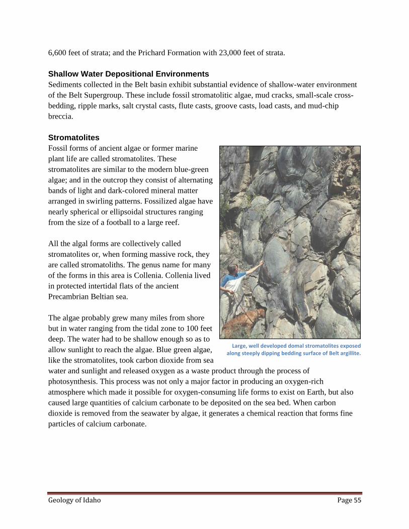
Geology of Idaho Page 55
6,600 feet of strata; and the Prichard Formation with 23,000 feet of strata.
Shallow Water Depositional Environments
Sediments collected in the Belt basin exhibit substantial evidence of shallow-water environment
of the Belt Supergroup. These include fossil stromatolitic algae, mud cracks, small-scale cross-
bedding, ripple marks, salt crystal casts, flute casts, groove casts, load casts, and mud-chip
breccia.
Stromatolites
Fossil forms of ancient algae or former marine
plant life are called stromatolites. These
stromatolites are similar to the modern blue-green
algae; and in the outcrop they consist of alternating
bands of light and dark-colored mineral matter
arranged in swirling patterns. Fossilized algae have
nearly spherical or ellipsoidal structures ranging
from the size of a football to a large reef.
All the algal forms are collectively called
stromatolites or, when forming massive rock, they
are called stromatoliths. The genus name for many
of the forms in this area is Collenia. Collenia lived
in protected intertidal flats of the ancient
Precambrian Beltian sea.
The algae probably grew many miles from shore
but in water ranging from the tidal zone to 100 feet
deep. The water had to be shallow enough so as to
allow sunlight to reach the algae. Blue green algae,
like the stromatolites, took carbon dioxide from sea
water and sunlight and released oxygen as a waste product through the process of
photosynthesis. This process was not only a major factor in producing an oxygen-rich
atmosphere which made it possible for oxygen-consuming life forms to exist on Earth, but also
caused large quantities of calcium carbonate to be deposited on the sea bed. When carbon
dioxide is removed from the seawater by algae, it generates a chemical reaction that forms fine
particles of calcium carbonate.
Large, well developed domal stromatolites exposed along steeply dipping bedding surface of Belt argillite.
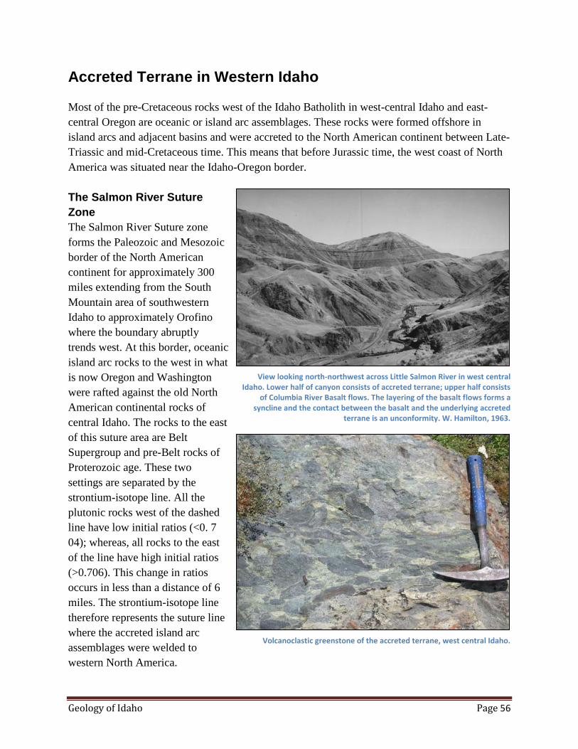
Geology of Idaho Page 56
Accreted Terrane in Western Idaho
Most of the pre-Cretaceous rocks west of the Idaho Batholith in west-central Idaho and east-
central Oregon are oceanic or island arc assemblages. These rocks were formed offshore in
island arcs and adjacent basins and were accreted to the North American continent between Late-
Triassic and mid-Cretaceous time. This means that before Jurassic time, the west coast of North
America was situated near the Idaho-Oregon border.
The Salmon River Suture
Zone
The Salmon River Suture zone
forms the Paleozoic and Mesozoic
border of the North American
continent for approximately 300
miles extending from the South
Mountain area of southwestern
Idaho to approximately Orofino
where the boundary abruptly
trends west. At this border, oceanic
island arc rocks to the west in what
is now Oregon and Washington
were rafted against the old North
American continental rocks of
central Idaho. The rocks to the east
of this suture area are Belt
Supergroup and pre-Belt rocks of
Proterozoic age. These two
settings are separated by the
strontium-isotope line. All the
plutonic rocks west of the dashed
line have low initial ratios (<0. 7
04); whereas, all rocks to the east
of the line have high initial ratios
(>0.706). This change in ratios
occurs in less than a distance of 6
miles. The strontium-isotope line
therefore represents the suture line
where the accreted island arc
assemblages were welded to
western North America.
View looking north-northwest across Little Salmon River in west central Idaho. Lower half of canyon consists of accreted terrane; upper half consists
of Columbia River Basalt flows. The layering of the basalt flows forms a syncline and the contact between the basalt and the underlying accreted
terrane is an unconformity. W. Hamilton, 1963.
Volcanoclastic greenstone of the accreted terrane, west central Idaho.

Geology of Idaho Page 57
Accreted Terranes
The Blue Mountain province of northeastern Oregon and western Idaho on the eastern side of the
Salmon River Suture zone consists of 4 east-west-trending terranes. These terranes from north to
south include (1) the Wallowa Terrane (a volcanic arc active from Late Paleozoic to Late
Triassic time), (2) Baker Terrane (partly mélange or deformed material in the subduction zone as
the terrane was accreted eastward beneath the Olds Ferry volcanic arc), (3) the Izee Terrane
(intra-arc and fore-arc basin deposits), and (4) the Olds Ferry Terrane (a west-facing, intra-ocean
volcanic island arc active from the Middle Triassic to Middle Jurassic time).
Deformation and Time of Accretion
The accreted terrane was deformed in the Late Triassic and again in the Late Jurassic. The Late
Triassic deformation occurred following deposition of most of the volcanic rock units. The time
of the accretion is estimated to have occurred between 95 and 120 million years ago.
Deformation and metamorphism of the Riggins Group at the contact with continental rocks
occurred at that time. However, the accretion process probably occurred over a period of time
ranging between Late Triassic and mid-Cretaceous. During this time and for a period afterwards,
the Idaho Batholith was formed by
magmas generated from subduction
of the eastward-moving plate.
Idaho Batholith
The Idaho Batholith is a composite
mass of granitic plutons covering
approximately 15,400 square miles
in central Idaho. The outer
perimeter of the batholith is
irregular and 200 miles long in the
north-south direction and in plain
view it has an hour glass shape. It
is approximately averages about 75
miles wide in an east-west
direction.
Age of Batholith
Armstrong and others (1977) called
the northern part of the hourglass
the "Bitterroot" lobe and the
southern part the "Atlanta" lobe. He
also proposed that most of the

Geology of Idaho Page 58
southern lobe was emplaced 75 to 100 million years ago (Late Cretaceous); the northern lobe
was emplaced 70 to 80 million years ago. Armstrong (1977) further noted that older plutons of
Jurassic age occur on the northwest side of the Bitterroot lobe and many Eocene plutons have
intruded the eastern side of the Atlanta lobe of the batholith. On the western side of the batholith,
there are more mafic plutons (quartz diorities or tonalites) than to the east.
Radiometric dates and field relationships, where plutons of the batholith cut older rocks, restrict
the age of the Idaho Batholith to an interval between 180 million years ago (Late Triassic) to 45
million years ago (Eocene); however, the dominant interval of emplacement was Early to Middle
Cretaceous. There is a general west-to-east decrease in age for plutons of the batholith.
Bitterroot Lobe
Hornblende-biotite tonalite and quartz diorite plutons were emplaced at mesozonal levels in the
western and northwestern margin of the Bitterroot lobe. Later, during Paleocene time, plutons of
foliated granodiorite were intruded. These plutons of sedimentary-type granites are chemically
similar and represent most of the bitterroot million years ago.
Dike Rocks in the Batholith
Pegmatite and aplite dikes were
formed during the late stages of
each plutonic intrusion. The
mineralogy of the dikes is similar
to the enclosing intrusive. In some
cases, pegmatite dikes cut aplite
dikes and in other cases the reverse
is true. These dikes appear to be
concentrated near Eocene plutons
and occur in the northeast-
trending, trans-Challis fracture
zone.
The Bitterroot lobe of the Idaho
Batholith contains numerous mafic
dikes which make up about 20
percent of the total rock. These
tabular dikes average about 8 feet thick and trend east-northeast.
Field Identification of Granitic Rocks
Granitic outcrops of the Idaho Batholith are easily recognizable in the field.
Under close inspection, granite has a salt and pepper appearance with the dark minerals of biotite
Granitic batholith on right intruded into quartzite. The contact is discordant (cuts across the layering in the quartzite).

Geology of Idaho Page 59
mica and hornblende and light minerals of plagioclase and quartz. The constituent minerals are
up to an inch or more in diameter and can readily be identified without a hand lens. Of course,
many minor accessory minerals are too small to be identified with the unaided eye.
Weathered outcrops of granite have a distinctive appearance and can in some cases be identified
at a mile or more distance. Coloration tends to be very light gray to very light tan, and in some
places chalk white due to leaching by hot water. Outcrops are generally smooth and rounded due
in part to surface weathering by granular disintegration and in some cases exfoliation where layer
after layer is removed from the surface. Most exposures are cut by one or more sets of fractures
which may give the outcrop a blocky appearance. Granite and basalt are among the easiest rocks
in Idaho to identify.
Tertiary Plutons of the Batholith
Approximately 20 percent of the Idaho Batholith is composed of granitic rocks younger than the
Mesozoic. The largest Tertiary-age plutons are batholith in size and are crudely aligned along a
north-trending belt in the east-central part of the batholith. These plutons have long been known
to be Tertiary age, if not Eocene, because they cut or intrude older rocks including the Idaho
Batholith. Some of the plutons even cut Challis volcanic rocks.
More than 40 plutons of Tertiary age (42 to 46 million years old) have been identified in or near
the Idaho Batholith. These intrusions range in size from dikes or small stocks to batholiths. The
small stocks and dikes may be apophyses (narrow upper portion) of larger batholith-sized
plutons at depth.
Pluton Characteristics
The Tertiary granites have a pink color caused by pink potassium feldspar, whereas rocks of the
Idaho batholith tend to be gray. The composition range is fairly narrow ranging from quartz
monzonite to granite. Miarolitic (gas) cavities are characteristic of the Tertiary plutons. These
gas cavities indicate a shallow level (epizonal) of emplacement. The Tertiary plutons may have
been emplaced within 3 to 4 miles of the surface, whereas the Idaho batholith may have been
emplaced more than 6 miles from the surface. Euhedral crystals (well-formed crystal faces) of
smoky quartz and feldspar commonly occur in the miarolitic cavities.
The Tertiary granitic rocks contain twice as much uranium and thorium than is found in the
Mesozoic batholith. Because of this difference, a gamma ray spectrometer can be used to map
the contacts between the Tertiary plutons and the surrounding batholith.
Some of the large plutons such as Bighorn Craigs, Sawtooth and Casto Batholiths have a well-
developed vertical jointing. This jointing causes a very distinctive and easily recognizable ragged
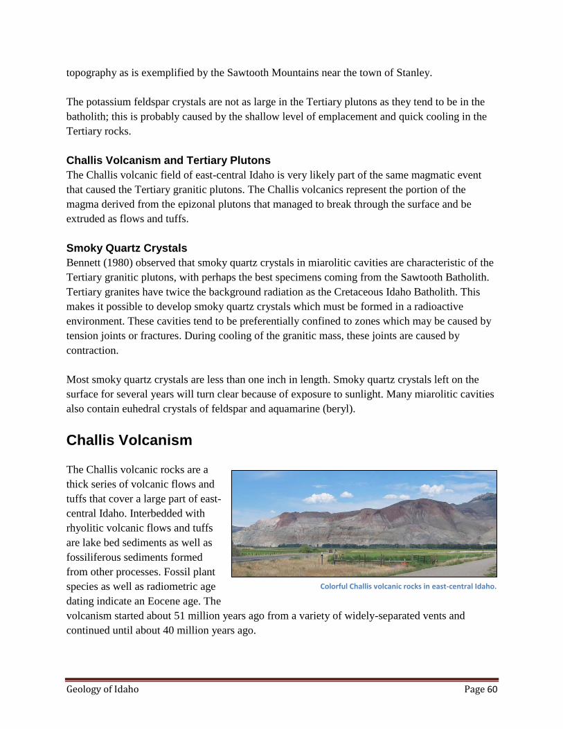
Geology of Idaho Page 60
topography as is exemplified by the Sawtooth Mountains near the town of Stanley.
The potassium feldspar crystals are not as large in the Tertiary plutons as they tend to be in the
batholith; this is probably caused by the shallow level of emplacement and quick cooling in the
Tertiary rocks.
Challis Volcanism and Tertiary Plutons
The Challis volcanic field of east-central Idaho is very likely part of the same magmatic event
that caused the Tertiary granitic plutons. The Challis volcanics represent the portion of the
magma derived from the epizonal plutons that managed to break through the surface and be
extruded as flows and tuffs.
Smoky Quartz Crystals
Bennett (1980) observed that smoky quartz crystals in miarolitic cavities are characteristic of the
Tertiary granitic plutons, with perhaps the best specimens coming from the Sawtooth Batholith.
Tertiary granites have twice the background radiation as the Cretaceous Idaho Batholith. This
makes it possible to develop smoky quartz crystals which must be formed in a radioactive
environment. These cavities tend to be preferentially confined to zones which may be caused by
tension joints or fractures. During cooling of the granitic mass, these joints are caused by
contraction.
Most smoky quartz crystals are less than one inch in length. Smoky quartz crystals left on the
surface for several years will turn clear because of exposure to sunlight. Many miarolitic cavities
also contain euhedral crystals of feldspar and aquamarine (beryl).
Challis Volcanism
The Challis volcanic rocks are a
thick series of volcanic flows and
tuffs that cover a large part of east-
central Idaho. Interbedded with
rhyolitic volcanic flows and tuffs
are lake bed sediments as well as
fossiliferous sediments formed
from other processes. Fossil plant
species as well as radiometric age
dating indicate an Eocene age. The
volcanism started about 51 million years ago from a variety of widely-separated vents and
continued until about 40 million years ago.
Colorful Challis volcanic rocks in east-central Idaho.
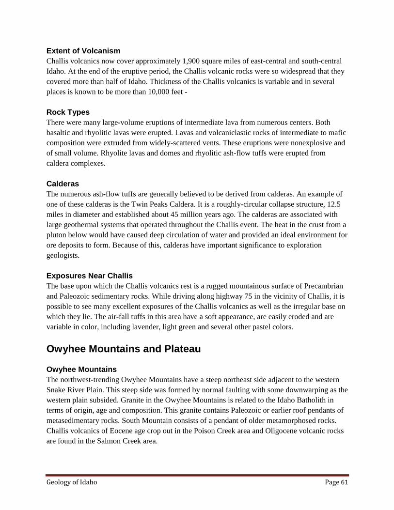
Geology of Idaho Page 61
Extent of Volcanism
Challis volcanics now cover approximately 1,900 square miles of east-central and south-central
Idaho. At the end of the eruptive period, the Challis volcanic rocks were so widespread that they
covered more than half of Idaho. Thickness of the Challis volcanics is variable and in several
places is known to be more than 10,000 feet -
Rock Types
There were many large-volume eruptions of intermediate lava from numerous centers. Both
basaltic and rhyolitic lavas were erupted. Lavas and volcaniclastic rocks of intermediate to mafic
composition were extruded from widely-scattered vents. These eruptions were nonexplosive and
of small volume. Rhyolite lavas and domes and rhyolitic ash-flow tuffs were erupted from
caldera complexes.
Calderas
The numerous ash-flow tuffs are generally believed to be derived from calderas. An example of
one of these calderas is the Twin Peaks Caldera. It is a roughly-circular collapse structure, 12.5
miles in diameter and established about 45 million years ago. The calderas are associated with
large geothermal systems that operated throughout the Challis event. The heat in the crust from a
pluton below would have caused deep circulation of water and provided an ideal environment for
ore deposits to form. Because of this, calderas have important significance to exploration
geologists.
Exposures Near Challis
The base upon which the Challis volcanics rest is a rugged mountainous surface of Precambrian
and Paleozoic sedimentary rocks. While driving along highway 75 in the vicinity of Challis, it is
possible to see many excellent exposures of the Challis volcanics as well as the irregular base on
which they lie. The air-fall tuffs in this area have a soft appearance, are easily eroded and are
variable in color, including lavender, light green and several other pastel colors.
Owyhee Mountains and Plateau
Owyhee Mountains
The northwest-trending Owyhee Mountains have a steep northeast side adjacent to the western
Snake River Plain. This steep side was formed by normal faulting with some downwarping as the
western plain subsided. Granite in the Owyhee Mountains is related to the Idaho Batholith in
terms of origin, age and composition. This granite contains Paleozoic or earlier roof pendants of
metasedimentary rocks. South Mountain consists of a pendant of older metamorphosed rocks.
Challis volcanics of Eocene age crop out in the Poison Creek area and Oligocene volcanic rocks
are found in the Salmon Creek area.

Geology of Idaho Page 62
The highest Owyhee Mountains exceed 8,000 feet and during the last glacial period these
mountains were extensively glaciated. Glacial cirques, U-shaped valleys, and moraine deposits
are common.
The Owyhee Plateau
The Bruneau-Jarbidge low plateau
is a rhyolite eruptive center that
was active about
12.5 to 8 million years ago. When
it settled into a broad basin, huge
volumes of rhyolite lava filled the
basin. Later, fluid basalt was
erupted in the basin and
significantly smoothed the
topography.
The Owyhee-Humboldt plateau
was the site of an earlier eruptive center which was active about 14 million years ago. This basin
was also covered and smoothed with flows of basalt. The canyons of the Owyhee, Bruneau, and
Jarbidge Rivers cut about 1,000 feet through many layers of volcanic rocks.
Bruneau-Jarbidge Eruptive Center
Volcanic flows, exposed by the canyon of the Bruneau River, were erupted from the Bruneau-
jarbidge eruptive center. This eruptive center is about 59 miles long and lies southeast of the
scenic Bruneau Canyon. Numerous ash flows, lava flows and basalt flows were erupted during
Miocene and Pliocene time. The Banbury Basalt was erupted from shield volcanoes and filled in
the low areas. The Cougar Point Tuff consists of densely-welded, ash-flow tuffs and younger
rhyolite flows about 10 to 12 million years old. Altogether there are nine or more of these welded
tuff cooling units which filled a large basin. The eruptive center was named by Bonnichsen after
the Bruneau and Jarbidge Rivers which have cut canyons in the area. The canyons expose both
silicic and basalt flows.
Columbia River Basalt Group
The Columbia River Basalt Group covers an area of approximately 77,000 square miles in
Oregon, Washington and western Idaho. It forms the largest Cenozoic basalt field in North
America and has an estimated total volume of approximately 90,000 cubic miles. Radiometric
age determinations indicate that the group was extruded during a period from 17 to 6 million
years ago. About 99 percent of the volume was erupted during a 3.5 million year period from 17
to 13.5 million years ago.
Deeply incised Owyhee River on the Owyhee Plateau, southwest Idaho.
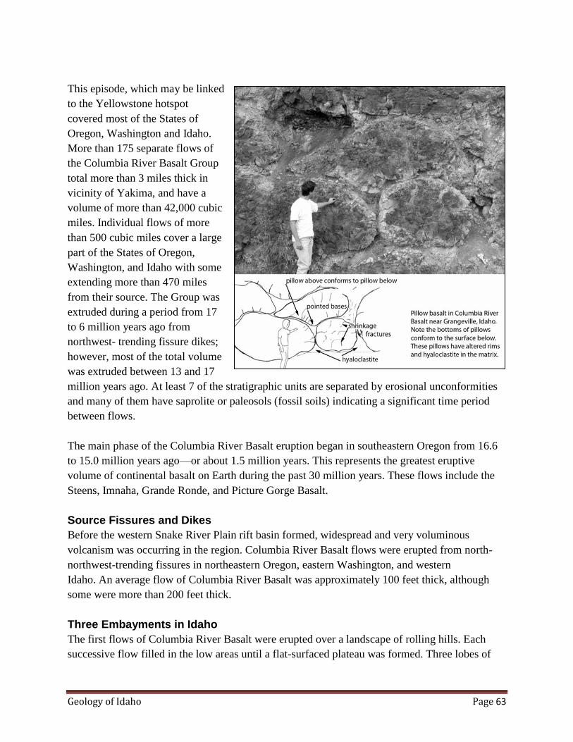
Geology of Idaho Page 63
This episode, which may be linked
to the Yellowstone hotspot
covered most of the States of
Oregon, Washington and Idaho.
More than 175 separate flows of
the Columbia River Basalt Group
total more than 3 miles thick in
vicinity of Yakima, and have a
volume of more than 42,000 cubic
miles. Individual flows of more
than 500 cubic miles cover a large
part of the States of Oregon,
Washington, and Idaho with some
extending more than 470 miles
from their source. The Group was
extruded during a period from 17
to 6 million years ago from
northwest- trending fissure dikes;
however, most of the total volume
was extruded between 13 and 17
million years ago. At least 7 of the stratigraphic units are separated by erosional unconformities
and many of them have saprolite or paleosols (fossil soils) indicating a significant time period
between flows.
The main phase of the Columbia River Basalt eruption began in southeastern Oregon from 16.6
to 15.0 million years ago—or about 1.5 million years. This represents the greatest eruptive
volume of continental basalt on Earth during the past 30 million years. These flows include the
Steens, Imnaha, Grande Ronde, and Picture Gorge Basalt.
Source Fissures and Dikes
Before the western Snake River Plain rift basin formed, widespread and very voluminous
volcanism was occurring in the region. Columbia River Basalt flows were erupted from north-
northwest-trending fissures in northeastern Oregon, eastern Washington, and western
Idaho. An average flow of Columbia River Basalt was approximately 100 feet thick, although
some were more than 200 feet thick.
Three Embayments in Idaho
The first flows of Columbia River Basalt were erupted over a landscape of rolling hills. Each
successive flow filled in the low areas until a flat-surfaced plateau was formed. Three lobes of

Geology of Idaho Page 64
Columbia River Basalt extended eastward into Idaho from the Columbia Plateau covering
topographically low areas: the Weiser embayment, the Clearwater embayment, and the St.
Maries embayment. Individual flows and sequences of flows can be traced for many miles. They
can be recognized on the basis of a variety of chemical, petrological, stratigraphic, and magnetic
polarity criteria. The average thickness of the flows ranges from 50 to 100 feet but some are
more than 400 feet thick in basins.
The eastern plateau has been uplifted almost 6,600 feet allowing deep erosion by the Snake,
Salmon, Clearwater and other rivers. Consequently the entire section is revealed in several
localities of west-central Idaho.
According to Wood and Clemens (2002), there is a thick layer of basalt lava situated beneath the
sediments in the western Snake River Plain. They observed that the deepest drill hole in the plain
near Meridian penetrated 0.7 km of lacustrine sediment and a thick section of basalt and
tuffaceous material. This basalt is geochemically within the range of Columbia River basalts,
particularly those that erupted 14 million years ago in eastern Oregon and is similar to the basalt
in the Weiser embayment. On the basis of borehole data, they estimated that 6500 feet of
interbedded basalts and tuffaceous sediments underlie the Idaho Group sediments.
It seems likely that the isostatic adjustment caused by the emplacement of such a thick sequence
of basalt would have contributed to the depression of the western Snake River Plain. For the
same reason, the adjacent land (just beyond) around the basalt flows would have experienced
uplift.
Snake River Plain
The Snake River Plain is a prominent depression across southern Idaho extending 400 miles in
an east-west direction. It is arc shaped with the concave side to the north. The width ranges from
50 to 125 miles with the widest part in the east. This physiographic province was originally
referred to as the Snake River Valley or the Snake River Basin. However, in 1902 T. C. Russell
re-designated the province the Snake River Plains. Later the name was changed to Snake River
Plain to convey a sense of uniformity throughout the province.
The subsurface of the plain is known because of thousands of water wells and several deep
exploration wells for geothermal resources and oil and gas. Geophysical surveys have also
yielded much information on the subsurface.
The Snake River Plain originated and evolved during the last 17 million years. Although at first
glance, the Plain appears to be a homogenous feature, the western plain is quite different from
the eastern plain in terms of structure, lithology and age. The western Plain trends northwest-

Geology of Idaho Page 65
southeast and the eastern plain trends southwest-northeast. Generally, the relief of both the
western and eastern Plain is low with some relief provided by a scattered cinder mounds and
shield volcanoes. The western Snake River Plain is a structural basin formed by large gravity
faults at both the northeast and southwest boundaries; the eastern Plain is a downwarp with no
solid evidence of boundary faults.
The Snake River
Most of the streams in southern Idaho flow into the Snake River and then down the Columbia
River and into the Pacific ocean. To the south of eastern Idaho is the Great Basin, an area of
internal drainage covering western Utah, extreme southern Idaho and eastern Nevada. The
ultimate base level for the Great Basin is the Great Salt Lake. No stream from the Great Basin
reaches the ocean.
The Snake River starts its journey across the plain in the vicinity of Jackson Hole, Wyoming and
follows the southern edge of the Quaternary basalt flows. The reason for this is the basalt is
topographically higher than the adjacent Snake River. This phenomenon is characteristic for
streams and rivers in the Snake River Plain. Many of them, such as the Big Wood River, were
moved by the spread of lava flows and tend to conform to the margins of the flows.
The Snake River did not always have its headwaters in Wyoming. As the North American plate
slowly moved southwesterly over the fixed hot spot, the topography over the hot spot uplifted to
a high plateau. When the movement of the North American plate placed the fixed hot spot under
what is now the central Snake River Plain about 10 million years ago, the central Snake River
Plain was a high volcanic plateau. This high plateau moved progressively to the northeast across
the eastern Snake River Plain where it is now situated at Yellowstone. As the surface land on
what is now the Snake River Plain subsided from cooling behind the northeast-moving plateau,
the drainage systems in the Snake River Plain were rerouted. Instead of streams flowing radially
off of the advancing plateau, the drainage assumed its present westward flow (Link and Phoenix,
1994).
The term "Lake Idaho" or "Idaho Lake" is applied to the lake responsible for the lacustrine
sediments that are Pliocene or more recent in the western Snake river Plain. Lake Idaho was
probably not a continuous lake with a constant shoreline but was modified greatly through the
last 10 million years from volcanic action and available glacial melt water.
The biogeographic evidence, which is based on divergent speciation of Pliocene molluscan
faunas in southern Idaho and Utah, indicates that a drainage divide existed between the western
and eastern Snake River Plain. Before the Quaternary, streams from southeastern Idaho drained
into the Bonneville basin. Only during the Quaternary did the Snake River and its tributaries in
southeastern Idaho become connected to southwestern Idaho and the Columbia to form a single

Geology of Idaho Page 66
drainage basin.
Capture of the Western Snake River Plain Drainage
In 1898, Lindgren first recognized that sediment-filling of the western Snake River Plain basin
was followed by river entrenchment. Wheeler and Cook (1954) proposed that the drainage of the
western Snake River Plain was captured near the Oxbow of the Snake River in Hells Canyon.
They suggested that the Snake River eroded south and captured Lake Idaho. The Draining of
Lake Idaho put so much water through Hells Canyon that it eroded a channel deeper than the
Salmon River. As a result, the Salmon River became a tributary of the Snake.
Track of the Yellowstone Hotspot
The Yellowstone hot spot left a
430-mile-long, northeastward-
trending track consisting of time-
transgressive caldera-forming
volcanism. This silicic volcanism
appears to have started about 17
million years ago in a north-central
Nevada, and then progressively
moved in an east-northeast
direction across northeast Nevada,
southeast Oregon and southern
Idaho. The time-transgressive
silicic volcanism is explained by
the west-southwest movement of a
60-mile-thick lithosphere (the
North American plate) over a
stationary thermal mantle plume or hotspot at the rate of 1 inch per year. The rhyolitic rocks are
progressively younger towards the east starting with dates of 11.3 million years old at the
Bruneau Jarbidge eruptive center to about 4.3 million years old at the east end of the Snake River
Plain. The most recent rocks on the topographically high Yellowstone Plateau were erupted as
recently as 0.6 million years ago. The Basin and Range Province, the Columbia River Basalt, and
the western Snake River Plain all originated about 17 million years ago and may be linked to the
Yellowstone hot spot.
Western Snake River Plain
The western Snake River Plain is 30 to 43 miles wide and trends northwest. It is a fault-bounded
basin with both the land surface and the rock layers dipping towards the axis of the plain.

Geology of Idaho Page 67
The basin is filled by interbedded volcanic rocks and lakebed sediments of Tertiary and
Quaternary age.
Northwest-Southeast-
Trending Faults.
Lindgren (1898b and Russell
(1902) first proposed that high-
angle faults caused the escarpment
along the northern side of the
western Snake River Plain. Later,
Malde (1959) came up with
compelling evidence for a
boundary faults on the northeast
side of the western plain.
Subsequently, a number of
investigators have published
evidence of normal faults
displaced down toward the center
of the plain on both the northeast side and the southwest side of the western Snake River Plain.
The vertical displacement along the northern faults is up to 9,000 feet with deformation
beginning in the Miocene and continuing into the Pleistocene.
The deep wells drilled in the western plain show interbedded basalt and sediment. One well
located about 43 miles south of Boise passed 11,150 feet of alternating sediment and volcanic
rocks before it terminated in granite. This granite may be a southern extension of the Idaho
batholith.
Geophysical surveys used to interpret the Snake River Plain include gravity surveys, magnetic
surveys, seismic refraction profiles, thermal gradient measurements, and heat-flow
measurements. There is a gravity high over the plain. This gravity high coincides well with the
topographic low. The gravity high anomaly over the western plain is interpreted as indicating a
thin upper crust. Seismic refraction data also support this interpretation. Seismic refraction
profiles indicate that the total crust under the plain is more than 25 miles thick; however, the
upper crust is thin under the axis of the plain. Heat-flow measurements indicate a high heat flow
anomaly along the margins of the plain and a relatively low heat flow in the central part of the
plain.
Huge Rhyolite Lava Flows and Pyroclastic Deposits
Most of the rocks southwest of the western Snake River Plain consist of rhyolite lava flows and
pyroclastic deposits. There are rhyolite lava flows along the Owyhee front and along the Boise
Large lithohysal (air) cavities in the interior of the Jump Creek ryholite lava flow near Jump Creek Falls, southwestern Idaho.
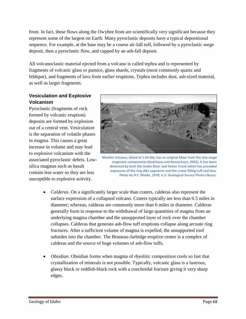
Geology of Idaho Page 68
front. In fact, these flows along the Owyhee front are scientifically very significant because they
represent some of the largest on Earth. Many pyroclastic deposits have a typical depositional
sequence. For example, at the base may be a coarse air-fall tuff, followed by a pyroclastic surge
deposit, then a pyroclastic flow, and capped by an ash-fall deposit.
All volcanoclastic material ejected from a volcano is called tephra and is represented by
fragments of volcanic glass or pumice, glass shards, crystals (most commonly quartz and
feldspar), and fragments of lava from earlier eruptions. Tephra includes dust, ash-sized material,
as well as larger fragments.
Vesiculation and Explosive
Volcanism
Pyroclastic (fragments of rock
formed by volcanic eruption)
deposits are formed by explosion
out of a central vent. Vesiculation
is the separation of volatile phases
in magma. This causes a great
increase in volume and may lead
to explosive volcanism with the
associated pyroclastic debris. Low-
silica magmas such as basalt
contain less water so they are less
susceptible to explosive activity.
Calderas. On a significantly larger scale than craters, calderas also represent the
surface expression of a collapsed volcano. Craters typically are less than 0.5 miles in
diameter; whereas, calderas are commonly more than 6 miles in diameter. Calderas
generally form in response to the withdrawal of large quantities of magma from an
underlying magma chamber and the unsupported layer of rock over the chamber
collapses. Calderas that generate ash-flow tuff eruptions collapse along arcuate ring
fractures. After a sufficient volume of magma is expelled, the unsupported roof
subsides into the chamber. The Bruneau-Jarbidge eruptive center is a complex of
calderas and the source of huge volumes of ash-flow tuffs.
Obsidian. Obsidian forms when magma of rhyolitic composition cools so fast that
crystallization of minerals is not possible. Typically, volcanic glass is a lustrous,
glassy black or reddish-black rock with a conchoidal fracture giving it very sharp
edges.
Montini Volcano, dated at 1.64 Ma, has an original Maar from the late-stage magmatic components (Godchaux and Bonnichsen, 2002). It has been
dissected by both the Snake River and Sinker Creek which has provided exposures of the ring dike segments and the crater-filling tuff and lava.
Photo by H.E. Malde, 1978; U.S. Geological Survey Photo Library.
Geology of Idaho Page 69
Jasper and Other Secondary Deposits. Secondary silica, in the form of opal,
chalcedony, or jasper, were deposited in fractures, gas cavities, spherulite shrinkage
cavities, between breccia fragments, and other pore spaces in the rhyolite flows.
These silica deposits formed after the lava was formed, but before it cooled, by hot
water leaching silica from the rhyolite mass and precipitating it in the higher portions
of the flow where the rock was cooler. The Bruneau jasper deposit is a high quality,
commercial-grade picture jasper of red, brown, and tan colors. Most of this jasper
occurs as jasper-filled spherulite shrinkage cavities and as fracture filling.
Eruptive Centers
The Owyhee-Humboldt, Bruneau-Jarbidge, and Twin Falls eruptive centers were successively
formed between 14 and 8 million years ago. Each eruptive center is a large structural basin filled
primarily with volcanic rocks and miner younger sedimentary rocks. In a few places faults are
exposed that indicate downward displacement (subsidence) of the basin interiors. The eruptive
centers are like calderas but much larger; they were probably formed by several overlapping
calderas—all aligned along the axis of the Snake River Plain.
Rhyolitic volcanism in the western Snake River Plain began along the southwestern margin of
the rift starting at about 11.7 Ma. Between 12 and 10 Ma, there was an enormous volume of
high-temperature ignimbrites and large rhyolite lava flows erupted in southwestern Idaho. The
Bruneau-Jarbidge area experienced the most voluminous eruptions in Earth history. Buried under
the Bruneau-Jarbidge eruptive center is a caldera complex. When these calderas collapsed, the
huge rhyolitic eruptions occurred.
Old Basalt 9.5 to 7 Ma
During two periods, basalt erupted 9-7 million years ago and 2.2-0.4 million years ago in Lake
Idaho in the western Snake River Plain. Depending on the presence of water, eruptions ranged
from effusive to very explosive. Eruptions yielded subaerial (surface) flows, pillow deltas, water-
affected basalt, fragmental basalt deposits and basaltic tuffs. Most of the basalt was erupted
during the 9-7 million-year period and, for the most part, was erupted in deep water. The most
recent volcanism in the western Snake River Plain has produced small shield volcanoes,
subaerial flows, and cinder cones.
The changing lake level through time resulted in a great variety of basalt eruptions and products.
Shoreline features of this paleolake are still preserved at approximately 3800 feet for the high-
stand elevations.
Summary of Historical Views on Lake Idaho
The first geologists to explore and report on the geology of the central and western Snake River
Plain recognized the sediments represented a large Tertiary lake. Cope noted the similarities of
Geology of Idaho Page 70
the fossil fish in the Lakebed sediments to those found in Lake Bonneville and Lake Lahontan.
He named the ancient water body Lake Idaho. Later geologic studies by Russell (1902) and
Lindgren and Drake (1904) further established that a large lake once existed in the western Plain.
General Characteristics of Lake Deposits
Lakes generally form in a landlocked basin or impoundments that eventually fill up, but may
subside as new sediments are added. Depending on the size of the lake, deposits may range from
less than a meter to thousands of meters thick. Lakes form a series of deposits that are
concentrically zoned from coarse sandstones at the outer margins and grading to mudstones at
the center. Also, because lakes gradually fill over time, the sequence will also show an upwards
coarsening of grain size from laminated shales at the bottom to cross-bedded sandstones at the
top. Evidence of a lacustrine environment of deposition include freshwater fossils, especially
plant material in fine-grained laminated sediments, oscillation ripples instead of current ripples,
and a lack of tidal structures.
Evidence of Early Large Lake
Godchaux and Bonnichsen (2002) point out that when the early rhyolite eruption occurred along
the southwest side of the plain between 11.7 and 11.0 Ma, a lake already existed. They observed
that the distal parts of many of the rhyolitic lava flows had interacted with large amounts of
surface water, presumably, the earliest time of Lake Idaho. They also noted that most of the early
rhyolitic basaltic volcanics in the Snake River Plain had interacted in some fashion with a lake.
This indicates that, although the level fluctuated, a large lake existed for a long time.
While the lake existed, basaltic volcanism yielded water-affected basalt, pillows, and tuff cones.
After the lake drained but the ground was still saturated with water (high ground water table), the
basalt volcanism became explosive and many maars and tuff rings were formed. When the
ground dried out like the present, the volcanism became effusive and shield and cinder cones and
subaerial lava flows were formed. Finally, stream dissection coupled with the final stage of
volcanism produced lavas that flowed into rivers and stream channels, dammed the rivers, and
developed small temporary lakes.
Western Snake River Plain: An Outstanding Area to Study Hydrovolcanic Rocks. Based on years
of field mapping in the western Snake River Plain, Godchaux and Bonnichsen have reported on a
wide variety of hydrovolcanic forms and features in this remarkable area. The western Snake
River Plain graben has been the site of Lake Idaho, more or less continuously, from about 12 to 2
million years ago. Large-volume silicic eruptions occurred between 12 and 11 million years ago.
Rhyolite-water interactions produced near vent breccias, subaerial phreatomagmatic tuffs, and
silicified massive breccias. They suggest that the western Snake River Plain is one of the best
places in the world to study the wide variety of volcanic forms that are produced when magma
and lava interact with surface water because of its relative youthfulness and excellent exposures,

Geology of Idaho Page 71
and the fact that the lake is now drained.
Evidence of Basaltic Volcanism for a Permanent Lake Idaho
Jenks and Bonnichsen (1989) propose that the Lake Idaho shorelines can be defined on the basis
of the basalt-water interaction. The best evidence of the ancestral shoreline is the elevation and
geographic position where basalt flows pouring into the lake were first affected by water. The
3800-foot elevation contour represents the highest stand of the lake shoreline. The 3800-foot
elevation contour also represents a "major regional topographic break" where it delineates many
Tertiary lacustrine basins in western Idaho and eastern Oregon.
The Bruneau and Jarbidge Rivers, as well as other streams that emptied into ancestral Lake
Idaho, have cut their canyons after the final draining of the lake waters. The widespread gravel
layers that overlie the lacustrine sedimentary rocks were deposited from the draining of the
ancestral Bruneau River, Salmon Falls Creek, Clover Creek and Sheep Creek into the basin as
the lake receded for the final time. These gravels were deposited by braided streams before the
downcutting of the canyons occurred and before the final recession of the lake.
Basin-Fill Sedimentary Rocks
The consensus of most geologists working in the western Snake River Plain is that the sediments
are primarily of lacustrine origin. There is a particularly diverse depositional environments along
the basin margins with floodplain and fluvial deposits common. At the Boise Front, the
lithologies, textures, and environments of deposition were controlled by the granitic mountains to
the north and the Boise River which drained thousands of square miles of mountainous country
for several million years.
Idaho Group Sedimentary Rocks
The sedimentary rocks of the
Idaho Group in the northern part of
the western Snake River Plain do
not correlate well with the Chalk
Hills and Glenns Ferry Formations
in the southern part of the Snake
River Plain. Consequently, Idaho
Group rocks near the Boise Front
were named Pierce Gulch and
Terteling Springs Formations.
Most of the Glenns Ferry Idaho
Group deposits are lacustrine and
along the basin margins they are Pliocene Lake Idaho sediments near Hagerman, Idaho.
Geology of Idaho Page 72
influenced by the type of sediments readily available from the highlands. For example, along the
Boise Front, the composition textures and depositional environments were controlled by the
large granitic source to the north resulting in typical lake margin environments.
Gravel Cap: Tenmile and Tuana Gravel
Tuana Gravel. The Tuana Gravel lies on the south side of the Snake River in the
vicinity of King Hill on benches approximately 800 feet above the Snake River. The
distribution of these gravels indicates that they are remnants of alluvial fans formed
by the ancestral drainage of Salmon Falls Creek on the East and the Bruneau River to
the west. The dissected toes of these fans are 50 to 80 feet below the estimated
spillover level of Lake Idaho at the head of Hells Canyon.
Tenmile Gravel. The Tenmile Gravel, situated in a number of patches south and
southwest of Bois, has an elevation of 2500 feet for its most western deposits; at this
point the gravel is about 350 feet above the Snake River. The gravels deposited by
high-energy braided streams ended the basin-filling sequence. Once the basin of the
western Snake River Plain was filled, perhaps between 1.6 and 1.7 Ma, the major
rivers that flowed into the plain began prograding coarse-grained, braided stream
channel deposits across the broad, flat surface of the plain. The deposition of the
Tenmile Gravel, which overlies lacustrine and flood-plain deposits, indicates an
increase in stream discharge and bed load. This was probably caused by higher
runoffs of snowmelt and the advance and retreat of glacial ice during the Pleistocene
ice age.
Eastern Snake River Plain
The eastern Snake River Plain is a volcanic province with thick sequences of rhyolite flows
capped by undissected basalt flows. The basalt overlaps sedimentary deposits of the western
Snake River Plain. The eastern plain is 55 to 60 miles wide and has a length of 210 miles. The
elevation rises from almost 3280 feet at Hagerman to almost 6560 feet north of Ashton Although
Paleozoic rocks both north and south of the Snake River Plain have similar stratigraphy and
structure, there is no evidence that these rocks continue across or underlie the plain.
Downwarp
The eastern Snake River Plain is a downwarp rather than defined by boundary faults. No solid
evidence for boundary faults exists. Both ash-flow tuffs and Miocene to Pliocene-age
sedimentary rocks dip toward the axis of the plain. Rhyolite rocks in the Snake River Plain are
generally thought to originate from a hot spot located in the mantle below the southwestward-
moving North American Plate

Geology of Idaho Page 73
Exploratory wells at the INEL indicate the rhyolitic rocks are at least 2 miles thick and seismic
surveys indicate that the base of these rocks could be at least 3.5 miles deep. Subsurface plutons,
which were the source for the immense ash-flow eruptions may be situated between 2 and 5
miles below the surface. Also, gravity anomalies may indicate blocks of Paleozoic carbonate
rocks between the caldera.
The rhyolitic rocks are progressively younger towards the east starting with dates of 11.3 million
years at Bruneau Jarbidge eruptive center to about 4.3 million years at the east end of the Snake
River Plain. Of course, the most recent rocks on the topographically high Yellowstone Plateau
occurred as recently as 0.6 million years ago.
Caldera Complexes
The Island Park and Yellowstone caldera complexes are situated northeast of the eastern plain.
The Rexburg caldera complex on the eastern plain has been identified and the existence of many
others has been inferred. Silicic volcanic rocks and associated intrusive bodies apparently
underlie most of the eastern plain. Rhyolite is far more abundant than basalt in the eastern
plain—only a thin veneer of basalt overlies a thick sequence of rhyolitic ash and flow tuffs. It is
very likely that many source calderas for rhyolite are buried below the basalts.
Heise Volcanic Field
Ash-flow tuffs of the Heise volcanic field cover 13,500 square miles and ash from the eruptions
was distributed over much of the western United States. The three flows of the field, the
Blacktail Tuff (6.6 my), the Walcott Tuff (6 my), and the Kilgore Tuff (4.3 my) were extruded
from three calderas.
Island Park Caldera
The Island Park Caldera may be the largest symmetrical caldera in the world. Rhyolite was
erupted during the initial collapse period. Then basalt and rhyolite were alternately erupted from
vents along the caldera floor. Finally basalt was erupted. The tuffs, flows and fault scarps that
make up the morphology of the caldera are so young that they have been modified very little by
erosion. There were three basic phases in the evolution of the caldera: growth of the volcano,
extrusion of magma, and collapse.
The Island Park Caldera is an elliptical collapse structure 18 to 23 miles in diameter and is
situated in the center of a rhyolite shield. The western semicircle of the scarp is exposed, and the
eastern semicircle is buried under flows of rhyolite. Both basaltic and rhyolitic lava are believed
to have originated from a single magma chamber below the caldera.
The rim crest of the southwestern side of the caldera stands about 1200 feet above the plain south
Geology of Idaho Page 74
of the caldera. The most abundant rock type composing the caldera is flow tuff, followed by ash
falls and lava flows. The central portion of the caldera collapsed along a semicircular zone of
faults 18 miles in diameter at the western half of the caldera.
Island Park-Yellowstone Plateau
The Island Park Yellowstone plateau area has experienced catastrophic eruptions of 70 to 600
cubic miles of ash-flow tuff. The Huckleberry Ridge Tuff eruption was the largest and formed
about 2.1 million years ago. The Mesa Falls Tuff had a volume of 70 cubic miles. About 600,000
years ago the last eruption occurred from the Yellowstone Caldera and covered 250,000 square
miles.
Yellowstone National Park embraces 1400 square miles and has an average elevation of 7,000
feet. The Yellowstone Caldera is the world's largest thermal area and has outstanding examples
of hot springs, geysers, and mudpots. The caldera is oval shaped, about 45 miles long and 25
miles wide. The Yellowstone Plateau is seismically very active; 15,000 quakes measuring greater
than 2 on the Richter scale were recorded between 1973 and 1988. In 1959 the 7.5 Hebgen Lake
Earthquake originated on a fault 10 miles west of Yellowstone Park. The Yellowstone plume or
hotspot has produced about 1,000 cubic miles of rhyolitic ash during the last 2 million years.
Yellowstone has about 10,000 hot springs and several hundred geysers. These form when rain
and snow melt and migrate to a depth of about a mile through permeable gravels and fractures in
the volcanic rock. After heating, the hot steam and water move upland along fractures. Geysers
are a type of hot spring that intermittently erupt hot water or steam. They require special
conditions such as (1) a source of heat from magma or very hot rocks, (2) abundant water, (3) a
permeable fault or fracture system, (4) near-surface underground storage area for water and
steam, and (5) a small surface opening to force steam or water out under pressure. Upper Geyser
Basin of Yellowstone National Park has the greatest concentration of active geysers in the world.
Snake River Group
The Snake River Group includes most of the basalt flows in the Snake River Plains that were
extruded during the Pliocene to Holocene epochs. The youngest flows are no more than a few
thousand years old and the oldest are about four million years old. Approximately 8,000 square
miles of southern Idaho are covered by basalt flows and interbedded sediments of the Snake
River Group.
Geophysical studies and drill holes indicate that the plain may be underlain by basalts as much as
five miles thick. However 5,000 feet may be an average thickness. Because only the upper 1500
feet were sampled by drill hole, it is possible that some of the basalts not reached by the drill
hole are flows of the Columbia River Group.

Geology of Idaho Page 75
The Snake River Basalts tend to be extruded from central vents rather than fissures. In the Snake
River Plain there are numerous small shield volcanoes 200 to 400 feet high. On a clear day, from
almost any place on the Snake River Plain, one can see low hills on the horizon that are either
cinder cones or shield volcanoes of basalt. At Craters of the Moon National Monument, very
recent flows and volcanic structures can be examined.
There are eight Holocene basaltic lava fields in the eastern Snake River Plain which are closely
related to the volcanic rift zones: (1) Shoshone, (2) Craters of the Moon, (3) Wapi, (4) King's
Bowl, (5) North Robbers, (6) South Robbers, (7) Cerro Grande, and (8) Hells Half Acre.
Although the older surfaces are covered with loess, in general the surface features are unchanged
from emplacement.
Quaternary Basalt
Quaternary basalt eruptions on the plain generally occurred after the plate passed over the hot
spot. Potassium-argon dates are generally less than 2.0 million years ago. Geophysical studies
(resistivity) suggest that the basalt of the eastern Snake River Plain is generally less than 1-mile
thick. As expected, overall the basalt thins towards the edge of the plain and is thickest near the
axis. Drilling information on the west side of the eastern Snake River Plain indicates that the
basalt thins to the west, and accordingly, so does the water table. Sources of basalt or the vents
tend to be concentrated along the axis of the eastern Snake River Plain, forming a subdued
medial ridge. Basalt vents are also concentrated along the volcanic rift zones that tend to be
aligned at right angles along the rift.
Volcanic Rift Zones
There are at least 8 rift zones in the eastern Snake River Plain that have contributed basalt to the
plain. During the Holocene, basaltic eruptions were scattered across the entire eastern plain.
Volcanic rift zones may be extension of range-front faults to the north of the plain. The extension
indicated by the rift zones may also be related to the basin and range structures both north and
south. However, these volcanic rifts
may also indicate thermal
contraction.
Basaltic Lava Flows
Most basalt flows in the Snake
River Plains are pahoehoe basalts
that were emplaced as compound
flows. Compound flows are a
sequence of thin individual cooling
units ranging from less than 3 feet
to more than 30 feet thick. The
Geology of Idaho Page 76
surface is hummocky with local relief, typically less than 30 feet. Common features are tumuli,
pressure plateaus, pressure ridges, flow ridges and collapse depressions. These features are
caused by the way in which flows advance through a series of budding pahoehoe toes. Low areas
and swales are filled with wind-blown sediments so that now, on the surface of older flows, only
the higher ridges are visible. Aa flows are not as extensive as pahoehoe flows and can best be
seen at Craters of the Moon. Basaltic lava is extruded on the Snake River Plain in three ways:
flows from a central vent forming low shields, fissure flows and tube-fed flows.
Low Shields
Low shields are characterized by a small size and low profile. They have slope angles of 0.5
degrees and average 10 miles across and less than 1.6 cubic miles of lava. An excellent example
is the Wapi lava field. This field covers 116 square miles with compound lava flows of
pahoehoe. It is characterized by features such as lava toes, collapse depressions, flow ridges and
pressure ridges, but lacks lava tubes. The Wapi lavas have a carbon 14 date of 2,270 years. Many
of the low shields have pit craters at the summit and many craters show evidence of collapse.
Shields tend to be aligned along rifts or fissures.
Fissure Flows
Fissure vents are associated with rift zones. The youngest fissure flows on the Snake River Plain
are located at Kings Bowl and the Craters of the Moon National Monument. Craters of the Moon
covers 580 square miles whereas Kings Bowl covers about 1 square mile. Flow thickness is
generally less than 5 feet although ponding or lava lakes may cause thicker layers. Point source
eruptions along a fissure are common. For example, spatter cones and cinder cones at Craters of
the Moon are examples of point source eruptions.
Lava Tube Flows
Lava tubes and channels originating from fissures and low shields are a very major conveyance
for the emplacement of lava. These tubes are commonly more than 12 miles long and range from
2 to 30 feet across.
Cinder cones are not as common in the eastern plain as the western plain. They are generally
found along the rift zones.
Shield Volcanoes
Shield volcanoes cause most of the basaltic landforms on the central and eastern Snake River
Plain and represent most of the total volume of basalt. There may be 8,000 shield volcanoes on
the eastern Snake River Plain. Lava may flow as much as 80 miles from the source vent and may
cover an area up to 145 square miles. Shield volcanoes have very gentle slopes on the flanks of 1
to 2 degrees with an overall height of 150 to 450 feet above their base. The lower flanks tend to
be covered by overlapping flows from adjacent volcanoes. The volcanic eruptions have been
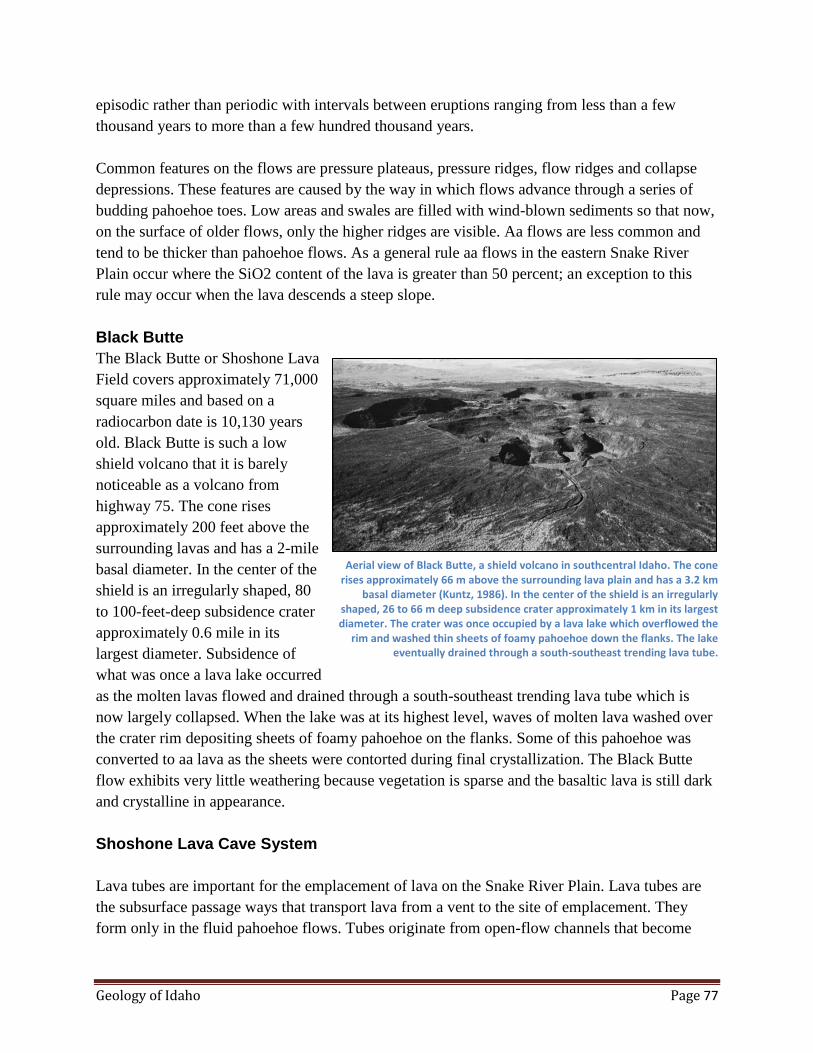
Geology of Idaho Page 77
episodic rather than periodic with intervals between eruptions ranging from less than a few
thousand years to more than a few hundred thousand years.
Common features on the flows are pressure plateaus, pressure ridges, flow ridges and collapse
depressions. These features are caused by the way in which flows advance through a series of
budding pahoehoe toes. Low areas and swales are filled with wind-blown sediments so that now,
on the surface of older flows, only the higher ridges are visible. Aa flows are less common and
tend to be thicker than pahoehoe flows. As a general rule aa flows in the eastern Snake River
Plain occur where the SiO2 content of the lava is greater than 50 percent; an exception to this
rule may occur when the lava descends a steep slope.
Black Butte
The Black Butte or Shoshone Lava
Field covers approximately 71,000
square miles and based on a
radiocarbon date is 10,130 years
old. Black Butte is such a low
shield volcano that it is barely
noticeable as a volcano from
highway 75. The cone rises
approximately 200 feet above the
surrounding lavas and has a 2-mile
basal diameter. In the center of the
shield is an irregularly shaped, 80
to 100-feet-deep subsidence crater
approximately 0.6 mile in its
largest diameter. Subsidence of
what was once a lava lake occurred
as the molten lavas flowed and drained through a south-southeast trending lava tube which is
now largely collapsed. When the lake was at its highest level, waves of molten lava washed over
the crater rim depositing sheets of foamy pahoehoe on the flanks. Some of this pahoehoe was
converted to aa lava as the sheets were contorted during final crystallization. The Black Butte
flow exhibits very little weathering because vegetation is sparse and the basaltic lava is still dark
and crystalline in appearance.
Shoshone Lava Cave System
Lava tubes are important for the emplacement of lava on the Snake River Plain. Lava tubes are
the subsurface passage ways that transport lava from a vent to the site of emplacement. They
form only in the fluid pahoehoe flows. Tubes originate from open-flow channels that become
Aerial view of Black Butte, a shield volcano in southcentral Idaho. The cone rises approximately 66 m above the surrounding lava plain and has a 3.2 km
basal diameter (Kuntz, 1986). In the center of the shield is an irregularly shaped, 26 to 66 m deep subsidence crater approximately 1 km in its largest diameter. The crater was once occupied by a lava lake which overflowed the
rim and washed thin sheets of foamy pahoehoe down the flanks. The lake eventually drained through a south-southeast trending lava tube.
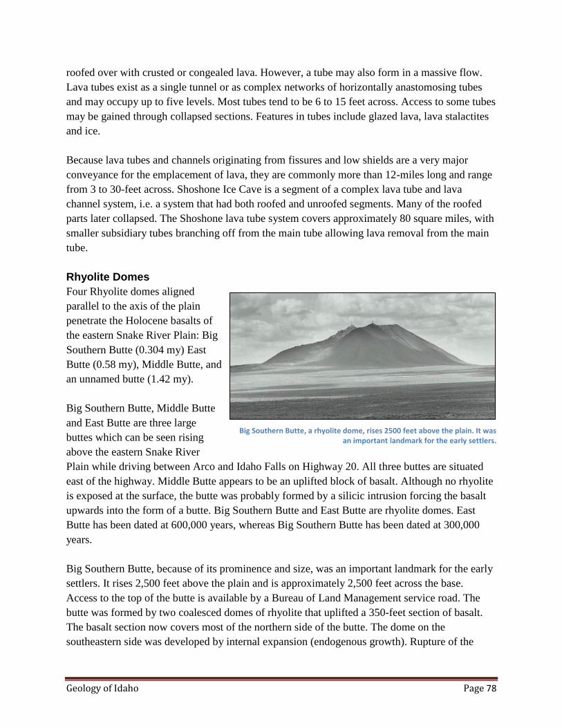
Geology of Idaho Page 78
roofed over with crusted or congealed lava. However, a tube may also form in a massive flow.
Lava tubes exist as a single tunnel or as complex networks of horizontally anastomosing tubes
and may occupy up to five levels. Most tubes tend to be 6 to 15 feet across. Access to some tubes
may be gained through collapsed sections. Features in tubes include glazed lava, lava stalactites
and ice.
Because lava tubes and channels originating from fissures and low shields are a very major
conveyance for the emplacement of lava, they are commonly more than 12-miles long and range
from 3 to 30-feet across. Shoshone Ice Cave is a segment of a complex lava tube and lava
channel system, i.e. a system that had both roofed and unroofed segments. Many of the roofed
parts later collapsed. The Shoshone lava tube system covers approximately 80 square miles, with
smaller subsidiary tubes branching off from the main tube allowing lava removal from the main
tube.
Rhyolite Domes
Four Rhyolite domes aligned
parallel to the axis of the plain
penetrate the Holocene basalts of
the eastern Snake River Plain: Big
Southern Butte (0.304 my) East
Butte (0.58 my), Middle Butte, and
an unnamed butte (1.42 my).
Big Southern Butte, Middle Butte
and East Butte are three large
buttes which can be seen rising
above the eastern Snake River
Plain while driving between Arco and Idaho Falls on Highway 20. All three buttes are situated
east of the highway. Middle Butte appears to be an uplifted block of basalt. Although no rhyolite
is exposed at the surface, the butte was probably formed by a silicic intrusion forcing the basalt
upwards into the form of a butte. Big Southern Butte and East Butte are rhyolite domes. East
Butte has been dated at 600,000 years, whereas Big Southern Butte has been dated at 300,000
years.
Big Southern Butte, because of its prominence and size, was an important landmark for the early
settlers. It rises 2,500 feet above the plain and is approximately 2,500 feet across the base.
Access to the top of the butte is available by a Bureau of Land Management service road. The
butte was formed by two coalesced domes of rhyolite that uplifted a 350-feet section of basalt.
The basalt section now covers most of the northern side of the butte. The dome on the
southeastern side was developed by internal expansion (endogenous growth). Rupture of the
Big Southern Butte, a rhyolite dome, rises 2500 feet above the plain. It was an important landmark for the early settlers.
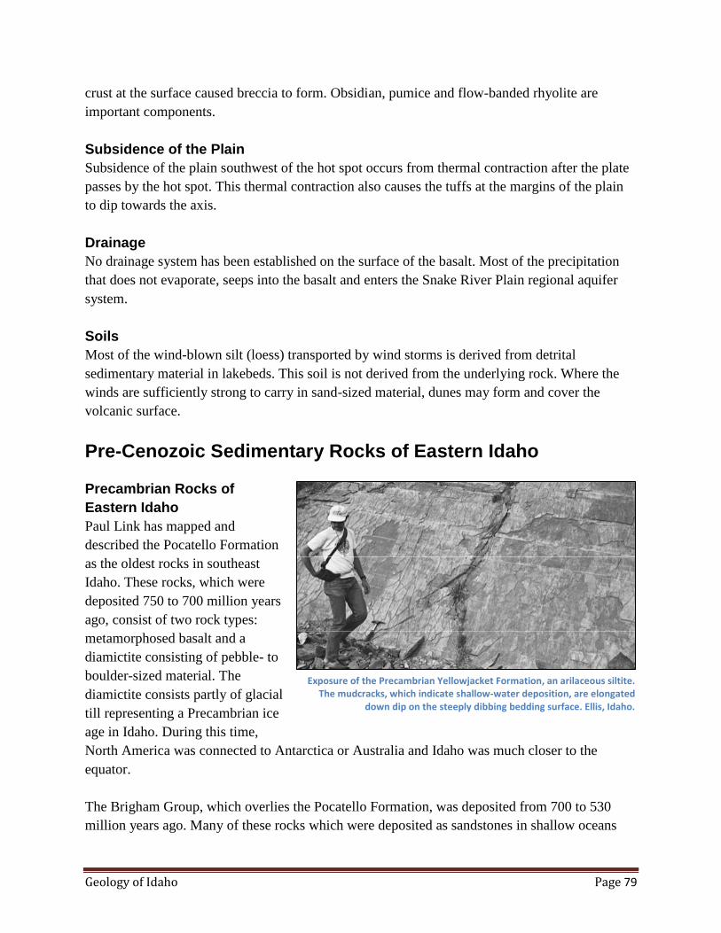
Geology of Idaho Page 79
crust at the surface caused breccia to form. Obsidian, pumice and flow-banded rhyolite are
important components.
Subsidence of the Plain
Subsidence of the plain southwest of the hot spot occurs from thermal contraction after the plate
passes by the hot spot. This thermal contraction also causes the tuffs at the margins of the plain
to dip towards the axis.
Drainage
No drainage system has been established on the surface of the basalt. Most of the precipitation
that does not evaporate, seeps into the basalt and enters the Snake River Plain regional aquifer
system.
Soils
Most of the wind-blown silt (loess) transported by wind storms is derived from detrital
sedimentary material in lakebeds. This soil is not derived from the underlying rock. Where the
winds are sufficiently strong to carry in sand-sized material, dunes may form and cover the
volcanic surface.
Pre-Cenozoic Sedimentary Rocks of Eastern Idaho
Precambrian Rocks of
Eastern Idaho
Paul Link has mapped and
described the Pocatello Formation
as the oldest rocks in southeast
Idaho. These rocks, which were
deposited 750 to 700 million years
ago, consist of two rock types:
metamorphosed basalt and a
diamictite consisting of pebble- to
boulder-sized material. The
diamictite consists partly of glacial
till representing a Precambrian ice
age in Idaho. During this time,
North America was connected to Antarctica or Australia and Idaho was much closer to the
equator.
The Brigham Group, which overlies the Pocatello Formation, was deposited from 700 to 530
million years ago. Many of these rocks which were deposited as sandstones in shallow oceans
Exposure of the Precambrian Yellowjacket Formation, an arilaceous siltite. The mudcracks, which indicate shallow-water deposition, are elongated
down dip on the steeply dibbing bedding surface. Ellis, Idaho.

Geology of Idaho Page 80
have since been metamorphosed
into quartzite.
Paleozoic Rocks of Eastern
Idaho
After the Brigham Group, a thick
sequence of limestones was
deposited on broad carbonate
platforms in the warm shallow seas
along the continental margin of
western North America. These
Paleozoic limestones contain a
variety of invertebrate fossils such
as Bryozoans, corals, mollusks,
trilobites, and brachiopods. Thin
units of fine- grained sandstone are interbedded within the Paleozoic limestone. Some of the
limestone has been altered to dolomite.
Paleozoic Rocks of East-Central Idaho
In the Pioneer, Boulder, and Smoky Mountains near Sun Valley there are thick sequences of
black shales and argillites known as the Devonian Milligen Formation. More than 15,000 feet of
Mississippian conglomerates and sandstones of the Copper Basin Formation were deposited in a
deep-sea fan environment. These rocks are primarily exposed in the Southern Pioneer
Mountains. Over in the Wood River area, the Milligan Formation is overlain by thick calcareous
siltstones and sandstones of the Upper Pennsylvanian and Permian Sun Valley Group. These
sediments were deposited in deep water west of a carbonate bank.
Mesozoic Rocks of Eastern Idaho
Mesozoic-age rocks in southeast Idaho include thick sequences of limestones, sandstones, and
shales. These sediments were deposited in shallow basins caused by the weight of the advancing
thrust sheets.
Idaho-Wyoming Thrust Belt
The Idaho-Wyoming Thrust Belt is located in southeastern Idaho, western Wyoming and north-
central Utah. This thrust belt is a small part of a much larger, geologically-complex Overthrust
Belt that extends 2200 miles from Alaska into Central America. The belt is a part of the
extensive north south-trending North American Cordillera Mountain Range which originated by
intense cast-west compressional deformation spanning more than 200 million years. Many
Steeply dipping beds of the resistant Nugget Sandstone Formation east of Bear Lake in eastern Idaho. These rocks were formed from Jurassic sand
dunes.
Geology of Idaho Page 81
different thrust sheets comprise the belt. These sheets were typically transported eastward for
distances of 10 to 20 miles. Total displacements may exceed 70 miles and total shortening was
about 70 percent.
Cause of Thrusting
During the accretion process, the eastward-moving Pacific Plate was subducting or descending
along a deep oceanic trench beneath the western continental margin of North America. This
subducting plate caused the formation of numerous magma bodies to move upwards into the
continental crust and form the great Sierra Nevada and Idaho Batholiths. Possibly in response to
the upward intrusion of these large granitic masses, the Overthrust Belt formed to the east. The
thrusting was driven by gravity and resulted from crustal thickening caused by emplacement of
the batholith. This uplift of the Idaho Batholith was accompanied by the development of folds
and thrust faults as well as possible gravitational gliding off the highlands.
Date of Thrusting
The Paleozoic and Mesozoic sediments were strongly folded and thrusted eastward beginning
during Late Jurassic (about 120 million years ago) in the west and ending as late as Eocene time
(52 million years ago) in the east. This 70 million year period of compressive tectonics was
followed by normal or extensional faulting of the Basin and Range within the Overthrust Belt.
Therefore, the ages of foreland thrusting are determined to be youngest in the east and oldest in
the west.
Sevier Orogeny
The period of intensive Late Jurassic to Eocene compressive thrust faulting and folding in the
Cordilleran Overthrust Belt has been designated the Sevier Orogeny. During this period, huge
masses of rock were ruptured into thrust sheets 20 to 50 miles wide, several miles thick and
hundreds of miles long. Eastward horizontal movement on the individual thrust sheets is
measured in tens of miles.
The Sevier Orogenic Belt is a narrow north-south zone of structural disturbance that runs through
western Montana, eastern Idaho, Wyoming, Utah and Nevada. This belt consists of large-scale
thrust faults and folds with vergence to the east. These thrust faults and folds have resulted in
significant shortening of about 70 percent that was initiated in Late Jurassic time and continued
through the beginning of the Tertiary.
On the basis of fossil distribution found in the earliest conglomerate deposited during the
orogeny within the thrust belt, the initial thrust movement may not be older than 119 million
years. The rapid increase in subsidence of sedimentary sequence within and east of the thrust belt
is believed to have been caused by the initiation of faulting in the thrust belt.
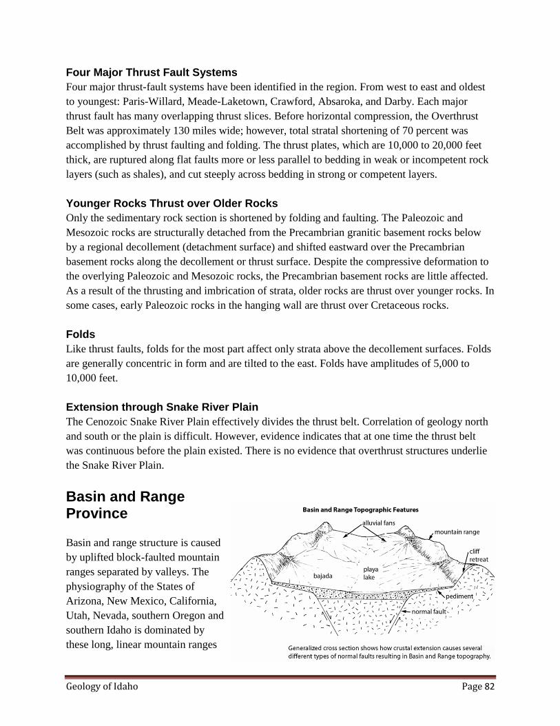
Geology of Idaho Page 82
Four Major Thrust Fault Systems
Four major thrust-fault systems have been identified in the region. From west to east and oldest
to youngest: Paris-Willard, Meade-Laketown, Crawford, Absaroka, and Darby. Each major
thrust fault has many overlapping thrust slices. Before horizontal compression, the Overthrust
Belt was approximately 130 miles wide; however, total stratal shortening of 70 percent was
accomplished by thrust faulting and folding. The thrust plates, which are 10,000 to 20,000 feet
thick, are ruptured along flat faults more or less parallel to bedding in weak or incompetent rock
layers (such as shales), and cut steeply across bedding in strong or competent layers.
Younger Rocks Thrust over Older Rocks
Only the sedimentary rock section is shortened by folding and faulting. The Paleozoic and
Mesozoic rocks are structurally detached from the Precambrian granitic basement rocks below
by a regional decollement (detachment surface) and shifted eastward over the Precambrian
basement rocks along the decollement or thrust surface. Despite the compressive deformation to
the overlying Paleozoic and Mesozoic rocks, the Precambrian basement rocks are little affected.
As a result of the thrusting and imbrication of strata, older rocks are thrust over younger rocks. In
some cases, early Paleozoic rocks in the hanging wall are thrust over Cretaceous rocks.
Folds
Like thrust faults, folds for the most part affect only strata above the decollement surfaces. Folds
are generally concentric in form and are tilted to the east. Folds have amplitudes of 5,000 to
10,000 feet.
Extension through Snake River Plain
The Cenozoic Snake River Plain effectively divides the thrust belt. Correlation of geology north
and south or the plain is difficult. However, evidence indicates that at one time the thrust belt
was continuous before the plain existed. There is no evidence that overthrust structures underlie
the Snake River Plain.
Basin and Range Province
Basin and range structure is caused
by uplifted block-faulted mountain
ranges separated by valleys. The
physiography of the States of
Arizona, New Mexico, California,
Utah, Nevada, southern Oregon and
southern Idaho is dominated by
these long, linear mountain ranges

Geology of Idaho Page 83
and intervening valleys. The valleys and mountains are separated by high-angle extension faults.
The valley elevations range from 4,200 to 5,200 feet, whereas the mountain crests range from
6,500 to 11,800 feet.
The Basin and Range Province is characterized by mountain ranges separated by flat valley
floors. Each range is bounded by large faults along which the range has moved upwards relative
to the adjoining basins or valleys. In other words the topography is strongly controlled by
faulting.
Bajada
Heavy rains promote rapid erosion along the steep mountain fronts. Loose rock and sediment are
washed down narrow stream channels and are deposited as alluvial fans at the base of the ranges.
The water from the stream may flow to the valley bottom and form a playa lake. Playa lakes are
shallow and temporary, lasting only several days after a storm. Continued deposition of alluvial
fans at the base of a mountain may form a bajada. A bajada is a broad, gently-sloping
depositional surface formed by the coalescing of alluvial fans. A bajada may have a gently
rolling surface caused by the merged cone-shaped fans.
Pediment
A gently-sloping, flat erosional surface at the foot of the mountain is called a pediment. This
surface is generally covered with a veneer of gravel. The pediment surface develops uphill from
a bajada as the mountain front retreats. As you might suspect, it is difficult to distinguish a
pediment surface from a bajada surface because both have the same slope and gravel cover.
However, the pediment is an erosional surface, whereas the bajada is a depositional surface and
may be hundreds of feet thick.
Normal Faults
There is a complex system of normal faults in the Basin and Range that controls the topography.
The mountains are 9 to 12 miles across and they alternate with alluviated valleys of
approximately the same width. The ranges or linear mountain blocks are formed by vertical
movements along faults on one or both sides of the block. Faults are also distributed throughout
the ranges and valleys.
The mountains (horsts) and valleys (grabens) are bounded on both sides by normal faults. The
mountain ranges tilt from a few degrees to more than 30 degrees. On the east side of the
province, tilting tends to be towards the east; whereas, on the west side, tilting tends to be
towards the west.
Valley fill ranges from about 500 feet to more than 9,800 feet thick. The structural relief between
bedrock in the valleys to the crest of the adjacent mountains ranges from 6,500 to 16,000 feet.

Geology of Idaho Page 84
Therefore, the faults have up to three miles of vertical displacement.
The ranges may be tilted by asymmetric grabens, rotation of blocks along downward flattening
faults (listric faults), and rotation of buoyant blocks.
Crustal Extension
The normal faults of the Basin and Range are indicative of extension normal to the fault lines.
The amount of extension depends on whether the faults flatten at depth or continue at the dip of
60 degrees. If the faults do not flatten and continue down to where brittle rupture is replaced by
laminar flow, the extension would only be about 10 percent. But if the faults flatten downward,
extension might be as much as 50 percent of the present width. Tilting of Tertiary welded tuffs
and lake bed sediments that were horizontal to sub-horizontal before faulting require rotation
tilting by the faulting. This can only be explained by flattening downward of major faults.
The crust of the southern Basin and Range terrane is about 15 miles thick; whereas, the crust of
the Colorado Plateau is about 25 to 28 miles thick. This thin crust may be a function of the
amount of extension in the Basin and Range region. Therefore, on this basis, approximately 40
percent of the present southern Basin and Range may represent extension. Using the same
approach, 30 percent of the present width of the northern Basin and Range may represent
extension.
Further evidence of crustal extension includes high surface heat flow, voluminous magmatism,
low velocity of seismic waves in the upper mantle, and high attenuation of seismic waves in the
upper mantle. In the northern Basin and Range, the structures continue across the Snake River
Plain but not the Idaho Batholith.
Age of the Basin and Range
The late Cenozoic structure that formed the Basin and Range Province began about 17 million
years ago. About 10 million years ago the present topography was formed.
Relative Vertical Displacement
Gravity studies in the Lemhi Birch Creek Trench indicate a structural relief of about 13,100 feet
from the crest of the Lemhi Range to the base of the Tertiary fill in the valley bottoms.
Therefore, the relative vertical displacement along the steep reverse faults is about 13,100 feet.
Bonneville Flood
Lake Bonneville, a late Pleistocene lake, was the precursor of the Great Salt Lake. The shorelines
of this ancient lake can be seen on the higher slopes of the Wasatch Mountains, more than 1060
feet above the present level of the Great Salt Lake. Before the catastrophic Bonneville flood,

Geology of Idaho Page 85
Lake Bonneville covered an area
of more than 19,691 square miles.
Approximately 14,400 years ago
Lake Bonneville suddenly
discharged an immense volume of
water to the north. This flood is
thought to be caused by capture of
the Bear River which greatly
increased the supply of water to
the Bonneville Basin. The release
of water from Lake Bonneville
was apparently initiated by sudden
erosion of unconsolidated material
on the northern shoreline near Red
Rock Pass. These flood waters flowed over Red Rock Pass in southeastern Idaho and continued
westward across the Snake River Plain generally following the path of the present Snake River.
Most of the important depositional and erosional features of the Bonneville Flood were
developed in a few days; however, the Snake River sustained a high rate of flow for more than a
year.
Gilbert (1878) discovered the
evidence for the flood during field
study of Pleistocene Lake
Bonneville between 1876 and
1879. He recognized many of the
catastrophic effects of the flood
between Red Rock Pass and
Pocatello, including erosional
features 400 feet above the Marsh
Creek flood plain. Although this
enormous flood was first described
in the literature by Gilbert in 1878,
Harold Malde (1968) of the U.S.
Geological Survey published the
first detailed account of the effects
of the flood on the Snake River
Plain. The name "Bonneville Flood" first appeared in the literature in 1965.
Looking east at an enormous pothole enlarged by the Bonneville Flood. The flood also excavated a large amount of basalt north and west of the pothole.
The pothole is situated at the foot of Shoshone Falls.
Looking northeast at alcoves along the north rim of the Snake River Canyon. Note the scabland on the rim where the flood overflowed the canyon and
swept across the Rupert channel, poured back into the canyon, and formed the alcoves by cataract retreat.

Geology of Idaho Page 86
Colossal Erosion near Twin Falls
Partly because of the reentry of the upland channel, the Snake River Canyon in the vicinity of
Twin Falls experienced the most exceptional bedrock erosion of any place on the Snake River
canyon. This highly eroded canyon segment is more than a mile wide in places, 500-feet deep,
and more than 10-miles long. The most extraordinary features are the huge spillway alcoves on
the north rim of the canyon where the water from the overflow channel reentered the canyon. A
series of large northwest-trending alcoves on the north rim are approximately parallel to the
Rupert channel. These alcoves and the associated scabland on the north rim represent a 10 mile-
wide spillway. Other remarkable features include the "underfit" Shoshone Falls. One fourth to
one-third of a cubic mile of basalt was ripped from the canyon in the Twin Falls area and carried
downstream.
The Shoshone Falls are a remarkable erosional remnant of the Bonneville Food. The falls, as
well as all the associated spectacular erosional features in the 16 km-segment of the Snake River
canyon, were created by the eight-week-long flood. Although the falls are a spectacular 212-
feet-high feature, they are framed by diverse, large scale flood-caused features such as cataracts,
spillway alcoves, and scabland. These features apparently occur at the convergence of two
channels of the Bonneville flood—the Rupert channel and the Snake River channel. This 10-
mile-long segment of the north rim also offers the most spectacular erosional effects of the flood
and is somewhat analogous in origin and form to the Dry Falls cataract complex in central
Washington. The largest alcoves, from east to west, are Box Canyon, Devils Corral, and Blue
Lakes Alcove. Blue Lakes Alcove and Devils Corral are enormous features, almost one mile in
length and more than a quarter mile in width.
On the south rim of the canyon, two large south-southeast-trending alcoves and a ragged rim
offer evidence that the overflow waters also reentered the Snake River over the south rim. The
erosion and the development of these alcoves on the north and south rim did not occur by water
cascading over the rims because the canyon was undoubtedly full during most of the erosion.
Most of the erosion must have been accomplished by extraordinary currents in flood waters more
than 500-feet deep.
Scabland
J. Harlan Bretz coined the word "scabland" to describe the stripped basalt surface in southeastern
Washington. The term, now well established in the geological literature refers to not only the
bare basalt which had the loess swept off by the flood, but it also covers a variety of gigantic
erosional features associated with the flood such as anastomosing channels, coulees, dry falls and
empty-rock basins. Similar features, both in size and form, exist along the path of the Bonneville
Flood, especially where the flood overflowed the canyon in the vicinity of Twin Falls. All loess
has been stripped of the basalt surface along the flood path. If you have the opportunity to fly
along the Snake River Canyon following the flood path you can clearly see that there is no
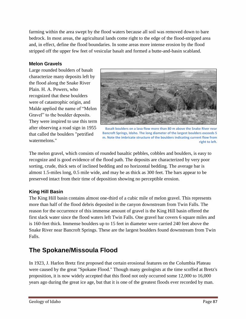
Geology of Idaho Page 87
farming within the area swept by the flood waters because all soil was removed down to bare
bedrock. In most areas, the agricultural lands come right to the edge of the flood-stripped area
and, in effect, define the flood boundaries. In some areas more intense erosion by the flood
stripped off the upper few feet of vesicular basalt and formed a butte-and-basin scabland.
Melon Gravels
Large rounded boulders of basalt
characterize many deposits left by
the flood along the Snake River
Plain. H. A. Powers, who
recognized that these boulders
were of catastrophic origin, and
Malde applied the name of “Melon
Gravel” to the boulder deposits.
They were inspired to use this term
after observing a road sign in 1955
that called the boulders "petrified
watermelons."
The melon gravel, which consists of rounded basaltic pebbles, cobbles and boulders, is easy to
recognize and is good evidence of the flood path. The deposits are characterized by very poor
sorting, crude, thick sets of inclined bedding and no horizontal bedding. The average bar is
almost 1.5-miles long, 0.5 mile wide, and may be as thick as 300 feet. The bars appear to be
preserved intact from their time of deposition showing no perceptible erosion.
King Hill Basin
The King Hill basin contains almost one-third of a cubic mile of melon gravel. This represents
more than half of the flood debris deposited in the canyon downstream from Twin Falls. The
reason for the occurrence of this immense amount of gravel is the King Hill basin offered the
first slack water since the flood waters left Twin Falls. One gravel bar covers 6 square miles and
is 160-feet thick. Immense boulders up to 15 feet in diameter were carried 240 feet above the
Snake River near Bancroft Springs. These are the largest boulders found downstream from Twin
Falls.
The Spokane/Missoula Flood
In 1923, J. Harlon Bretz first proposed that certain erosional features on the Columbia Plateau
were caused by the great "Spokane Flood." Though many geologists at the time scoffed at Bretz's
proposition, it is now widely accepted that this flood not only occurred some 12,000 to 16,000
years ago during the great ice age, but that it is one of the greatest floods ever recorded by man.
Basalt boulders on a lava flow more than 80 m above the Snake River near Bancroft Springs, Idaho. The long diameter of the largest boulders exceeds 5 m. Note the imbricate structure of the boulders indicating current flow from
right to left.

Geology of Idaho Page 88
Bretz's involvement with the Spokane Flood was initiated in 1923 with his first published paper
on the subject which appeared in the Journal of Geology and culminated with a final publication
in the same journal in 1969—his many publications on the subject spanned a remarkable 46
years.
The area called the "channeled scablands" is an oval-shaped area of about 15,000 square miles in
southeastern Washington. The bedrock of this area is composed of the extensive flows of the
Columbia River Basalt erupted during the Miocene Epoch, between 30 million and 10 million
years ago. This area has low relief, is situated at an elevation of 2,500 feet, and is surrounded by
mountains. After the last flow of lava, a blanket of wind-blown silt or loess accumulated on the
lava field. Where these silts still exist west of Moscow, they make up the very fertile soils of the
Palouse country of southeastern Washington. This mantle of loess ranges in thickness from less
than a foot to several hundred feet and forms many low hills.
The story of the Spokane Flood began about 100,000 years ago when continental glaciers were
moving southwest from the great ice fields in British Columbia. The Purcell lobe of the ice sheet
moved southward into the Purcell Trench and plugged the Clark Fork Valley. The ice dammed
the water of the Clark Fork River near the place where it runs into the Pend Oreille Lake. The
impounded water filled many tributary valleys to the east and formed the largest lake in the
Pacific Northwest during the great ice age.
Glacial Lake Missoula
Glacial Lake Missoula in western Montana covered approximately 3,000 square miles and had
an estimated 500 cubic miles of water. The lake was about 2,000 feet deep near the ice dam and
about 950 feet deep at Missoula. Prominent wave-cut shorelines of glacial Lake Missoula can be
easily observed on Sentinal Mountain from the city of Missoula. Wave-cut shorelines are
generally not well developed indicating the lake did not remain at any one level for a long time.
The successive terraces indicate a gradual filling of the lake. Meltwater from both alpine glaciers
and the continental ice sheet fed the lake and raised the lake level.
Release of Flood Waters
When the lake level reached the top of the ice dam it is probable that little time passed before the
entire dam was breached. An overflowing stream rapidly cut down through the ice and increased
the volume of water and the size of the channel. The ice dam could have been breached and the
dam destroyed within a day or two of the first overflow.
When the flood waters were suddenly released, the immense amount of water ran south and
southwest out of the mouth of the Clark Fork Valley, through Pend Oreille Lake across
Rathdrum Prairie, and down the Spokane Valley. Current velocities are calculated to have
reached 45 miles per hour in the narrow parts of the Clark Fork Canyon. Calculations also

Geology of Idaho Page 89
indicate that the maximum rate of flow was 9.5 cubic miles per hour or 386 million cubic feet
per second. This rate of flow represents about 10 times the combined flow of all rivers of the
world.
Giant Ripple Marks
Giant ripple marks can now be
found in many places swept by
flood waters. These ripple marks
are so large that their pattern and
shape cannot be detected on the
ground; however, aerial
photography, which has provided
convincing evidence of many
flood-caused erosional features,
also helped identify the giant
ripple marks. The best examples of
these ripple marks can be seen on
the south side of Markle Pass just
north of Perma, Montana. These
ripple marks cover a 6-square-mile
area and have a relief of 20 to 30
feet. The individual ridges are approximately 2 miles long and 200 to 300 feet apart. Compare
these immense features with standard ripple marks one might see in a stream bed or lake shore
with ridges measuring less than 1 inch high and separated by several inches.
Channeled Scablands
The large oval-shaped area in southeastern Washington carved by the flood is essentially a large,
flat lava field mantled by loess and slightly tilted to the southwest. When the flood moved over
the lava field, the huge volume of turbulent water stripped away several hundred feet of loess
down to bedrock and carried off blocks of basalt the size of a truck.
The flood carved immense erosional features in the surface of the plain. Canyons more than 200-
feet deep and running for many miles were ripped out of the basalt. Plunge pools, cataracts and
many other unusual erosional features formed during the flood.
Most of the flood water swept over the lava field in three major rivers: the eastern-most river was
up to 20 miles wide and 600 feet deep; the middle channel was approximately 14 miles wide;
and the western most and largest river carved the Grand Coulee which measured 50 miles long
and 900 feet deep. The Grand Coulee was eroded by a process called cataract retreat. In this
process water runs over a cliff into a plunge pool where the turbulent swirling water erodes the
Oblique aerial view of giant ripple marks with barn and cottonwood trees for scale (photograph by P. Weiss, 1970; U.S. Geological Survey
Photographic Library).
Geology of Idaho Page 90
rock at the base of the falls and undercuts the rock on the upstream side. This undercutting
causes the overhanging wall to cave and collapse thus moving the falls and plunge pool
continuously upstream.
Jointing in the basalt greatly enhanced the ability of the flood waters to pluck and remove the
basalt. Therefore, as erosion progressed upstream, a series of falls and plunge pools were
developed along the way. Dry Falls was the last falls to form at the end of the flood.
Through Columbia River Gorge to Willamette Valley
All water from this lake was forced to pass through the Wallula Gap and then westward down
the Columbia River Gorge to the Willamette Valley. In the Willamette Valley, remnants of the
flood waters formed a lake 400 feet deep. When the lake level quickly dropped, large ice bergs
rafted from Lake Missoula were emplaced on the shoreline. When the ice melted, boulders were
deposited which can still be seen on this ancestral shoreline.
The Spokane Flood covered 550 miles in its traverse across three states. An estimated 500 cubic
miles of water was released from glacial Lake Missoula; the water then crossed northern Idaho
on its journey to the Willamette Valley in Western Oregon. Duration of the flood, starting when
water was first released from Lake Missoula to the time streams in the flood path returned to
normal, is estimated to have been about four weeks.
Proposal for Numerous Floods
Waitt and Johnston (1985) have proposed that glacial Lake Missoula periodically discharged
numerous colossal jokulhlaups (glacier-outburst floods). They published detailed evidence
demonstrating that the erosional and depositional features of the Columbia Plateau were not
caused by a single flood but rather 40, or more, huge floods. In fact, their evidence suggests that
the number may be close to 100 floods. On the basis of radiometric dates of ash deposits and
shell material interbedded with the rhythymites, it is estimated that Lake Missoula existed for
2,000 to 2,500 years between 15,300 and 12,700 years B.P. (before present).
Mechanism for Flood
Waitt and Johnston (1985) also gave a convincing explanation as to how each flood occurred.
Lake water did not rise to a level allowing it to spill over or around the ice dam. Before the water
reached such a level, the ice dam became buoyant and the glacier bed at the seal broke, causing
underflow from the lake below the glacial dam. Subglacial tunnels expanded rapidly and a short
time later catastrophic discharge occurred. Calculation of the water budget for glacial Lake
Missoula indicates that the lake filled every 30 to 70 years.
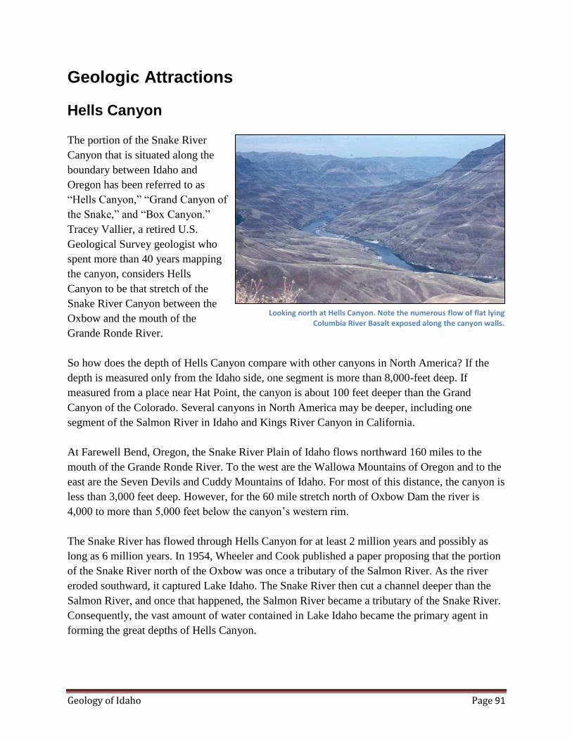
Geology of Idaho Page 91
Geologic Attractions
Hells Canyon
The portion of the Snake River
Canyon that is situated along the
boundary between Idaho and
Oregon has been referred to as
“Hells Canyon,” “Grand Canyon of
the Snake,” and “Box Canyon.”
Tracey Vallier, a retired U.S.
Geological Survey geologist who
spent more than 40 years mapping
the canyon, considers Hells
Canyon to be that stretch of the
Snake River Canyon between the
Oxbow and the mouth of the
Grande Ronde River.
So how does the depth of Hells Canyon compare with other canyons in North America? If the
depth is measured only from the Idaho side, one segment is more than 8,000-feet deep. If
measured from a place near Hat Point, the canyon is about 100 feet deeper than the Grand
Canyon of the Colorado. Several canyons in North America may be deeper, including one
segment of the Salmon River in Idaho and Kings River Canyon in California.
At Farewell Bend, Oregon, the Snake River Plain of Idaho flows northward 160 miles to the
mouth of the Grande Ronde River. To the west are the Wallowa Mountains of Oregon and to the
east are the Seven Devils and Cuddy Mountains of Idaho. For most of this distance, the canyon is
less than 3,000 feet deep. However, for the 60 mile stretch north of Oxbow Dam the river is
4,000 to more than 5,000 feet below the canyon’s western rim.
The Snake River has flowed through Hells Canyon for at least 2 million years and possibly as
long as 6 million years. In 1954, Wheeler and Cook published a paper proposing that the portion
of the Snake River north of the Oxbow was once a tributary of the Salmon River. As the river
eroded southward, it captured Lake Idaho. The Snake River then cut a channel deeper than the
Salmon River, and once that happened, the Salmon River became a tributary of the Snake River.
Consequently, the vast amount of water contained in Lake Idaho became the primary agent in
forming the great depths of Hells Canyon.
Looking north at Hells Canyon. Note the numerous flow of flat lying Columbia River Basalt exposed along the canyon walls.
Geology of Idaho Page 92
Rocks Exposed in Hells Canyon
The dark rocks, exposed along the lower walls of the canyon, are the old chain of volcanic
islands (island arc) that accreted against the continent 93 to 120 million years ago. Gray
limestone was deposited on the submerged platform while there was no volcanism. Granitic
plutons are exposed, particularly in the Wallowa and Seven Devils Mountains. The youngest
rocks exposed in the upper walls of the canyon are the Columbia River Basalt flows. These flows
filled in the topography and built a plateau between 17 and 6 million years ago. Because the
youngest flows are 6 million years old, we know Hells Canyon cannot be older than the age of
the youngest flows.
Boise Valley Terraces
Boise Valley Terraces
Curt Othberg (1994) has described the development of Boise Valley’s outstanding record of
well-preserved terraces during most of the Pleistocene Epoch. Eight well-developed terraces
record successively lower and younger river-cut surfaces covered with several meters of coarse
gravel deposits; they were formed by braided-channel deposition during periods of high river
runoff. The downcutting resulting in each river-cut terrace was followed by deposition of the
gravels. The record of successive terrace development is best preserved southwest of Boise
where the sequence in order of decreasing age is the Tenmile terrace, the Amity terrace, the
Fivemile Creek surface, the Lucky Peak surface, the Gowen terrace, the Sunrise terrace, the
Whitney terrace, the Boise terrace and the bottomland of the Boise River. The terraces formed in
response to climate changes instead of base level changes. Most compelling of this evidence is
that in the development of each terrace an erosive event is followed by a depositional event and
there appears to be periodicity to the terrace sequence.
The succession of terraces in the Boise Valley were developed throughout the Pleistocene and
the age of terrace sequence is based on the following evidence: (1) Boise Valley basalt flows are
dated between 100 ka and 1.6 million years based on potassium/argon and argon-40/argon-39;
magnetic polarities; (3) degree of soil development; and (4) stratigraphic relationships. This
terrace development may have started after the capture and diversion of the Snake River drainage
(ancestral Lake Idaho) through Hells Canyon sometime between 1.67 and 1.87 million years ago.
Rapid downcutting by the rivers in the western Snake River Plain interspersed with periods of
coarse gravel deposition led to the sequence of terrace development. The terraces in the Boise
Valley may correlate with certain glaciations in the northwestern United States.
Pleistocene alluvial fans were deposited in the Boise Valley during cool periods of mountain
glaciation when much greater runoff from snow melt made it possible for large amounts of
gravels to be transported out of the mountains. The Boise River originates in and drains a large
area in the Sawtooth and Smoky Mountains of central Idaho. These uplands were extensively

Geology of Idaho Page 93
shaped by alpine glaciation throughout most of the Pleistocene. In the vicinity of Boise, the river
is incised about 500 feet, with a well-defined sequence of terraces south of the westward-flowing
Boise River. The Tenmile Gravel represents the basin-filling sedimentation in the Snake River
Plain of a late Pliocene climate change. Shortly before the capture of the drainage of the Snake
River through Hells Canyon, there was a significant change in the depositional environment in
the Snake River Plain. This change may have been caused by a climate change.
Boise Valley Starts to Form
After deposition of the Tuana and Tenmile Gravels, the Boise River, as well as all rivers entering
the western Plain, began an incision or canyon cutting phase indicating a lowering of base level.
The Tenmile terrace was developed shortly after the beginning of the Pleistocene ice age; and
since we are still within this ice age, all the terraces were developed during the Pleistocene and
were directly affected by it. Because the drainage basin of the Boise River covers a vast glaciated
area in the Sawtooth and Smoky Mountains, flows of the Boise River during periods of glacial
melting may have been more than 10 times greater than historical flows. These high river flows,
in response to changing climates during the Pleistocene, combined with the downcutting
episodes of the Boise River, made the terrace development possible. So, each terrace is
characterized by downcutting succeeded by deposition of coarse gravels over the newly formed
terrace. The terrace deposits are similar from terrace to terrace and consist of poorly sorted
pebble to cobble gravel in a matrix of coarse sand. Grain size decreases downstream and the
sedimentary structures are indicative of high-energy braided-stream deposits.
Bruneau Sand Dunes
When wind loses its velocity and its ability to transport the sand it has carried from the surface, it
deposits it on the ground. Sand deposits tend to assume recognizable shapes. Wind forms sand
grains into mounds and ridges called dunes, ranging from a few feet to hundreds of feet in
height. Some dunes migrate slowly in the direction of the wind. A sand dune acts as a barrier to
the wind by creating a wind shadow. This disruption of the flow of air may cause the continued
deposition of sand. A cross section or profile of a dune in the direction of blowing wind shows a
gentle slope facing the wind and a steep slope to the leeward. A wind shadow exists in front of
the leeward slope which causes the wind velocity to decrease. The wind blows the sand grains up
the gentle slope and deposits them on the steep leeward slope.
Bruneau Sand Dunes
The Bruneau Sand Dunes State Park, established in 1970, is located about 8 miles east-northeast
of Bruneau and about 18 miles south of Mountain Home. Camping facilities are available and a
lake on the north side of the large sand dune may be used for boating and fishing.
Although there are many small dunes in the area, two large, light-gray overlapping sand dunes
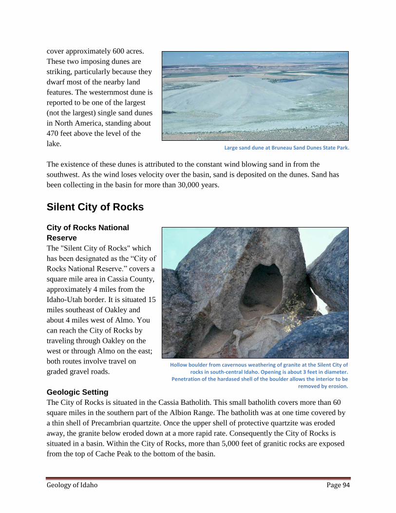
Geology of Idaho Page 94
cover approximately 600 acres.
These two imposing dunes are
striking, particularly because they
dwarf most of the nearby land
features. The westernmost dune is
reported to be one of the largest
(not the largest) single sand dunes
in North America, standing about
470 feet above the level of the
lake.
The existence of these dunes is attributed to the constant wind blowing sand in from the
southwest. As the wind loses velocity over the basin, sand is deposited on the dunes. Sand has
been collecting in the basin for more than 30,000 years.
Silent City of Rocks
City of Rocks National
Reserve
The "Silent City of Rocks" which
has been designated as the “City of
Rocks National Reserve.” covers a
square mile area in Cassia County,
approximately 4 miles from the
Idaho-Utah border. It is situated 15
miles southeast of Oakley and
about 4 miles west of Almo. You
can reach the City of Rocks by
traveling through Oakley on the
west or through Almo on the east;
both routes involve travel on
graded gravel roads.
Geologic Setting
The City of Rocks is situated in the Cassia Batholith. This small batholith covers more than 60
square miles in the southern part of the Albion Range. The batholith was at one time covered by
a thin shell of Precambrian quartzite. Once the upper shell of protective quartzite was eroded
away, the granite below eroded down at a more rapid rate. Consequently the City of Rocks is
situated in a basin. Within the City of Rocks, more than 5,000 feet of granitic rocks are exposed
from the top of Cache Peak to the bottom of the basin.
Large sand dune at Bruneau Sand Dunes State Park.
Hollow boulder from cavernous weathering of granite at the Silent City of rocks in south-central Idaho. Opening is about 3 feet in diameter.
Penetration of the hardased shell of the boulder allows the interior to be removed by erosion.

Geology of Idaho Page 95
Pegmatite Dikes
Scattered pegmatite dikes, which have the composition and texture of coarse-grained granite,
may be observed throughout the City of Rocks. Pegmatite ranges from thin seams to lenticular
bodies up to 50 feet across and several hundred feet long. One exceptionally large pegmatite
crops out in the City of Rocks. This pegmatite may be one of the largest to be found in Idaho
with exposed dimensions of 200 to 300 feet wide and 400 to 500 feet long. Large masses of
orthoclase feldspar, quartz and muscovite are well exposed over two rounded knolls that expose
the pegmatite. Some of the masses of quartz and feldspar are tens of feet in diameter. Masses of
muscovite display radiating crystals. Smoky quartz and miarolitic cavities are common.
Numerous small workings over this large pegmatite show evidence of past interest and activity.
Weathering
Although Jointing controls the general form of outcrops in the City of Rocks, weathering is the
agent responsible for creating the bizarre and fantastic shapes that characterize the area. On the
surface of the outcrops, weathering occurs by granular disintegration. In other words, one layer
of crystals after another is successively removed from the surface. This leaves the newly exposed
surface in a smooth and rounded condition with no sharp or ragged edges or corners. The detrital
material weathers from the granite and is carried by wind and water to low areas among the
prominent forms. The grains of quartz, feldspar and mica at the surface of outcrops are friable
and easily disintegrated with hand tools.
Chemical weathering occurs by solutions which penetrate the cleavage cracks in crystals and
between mineral grains. Once the solutions are in these narrow boundaries, they cause new
minerals to form which have a larger volume than the space available. This process of hydration
and other chemical changes cause the disintegration and exfoliation.
Case Hardening
In addition to granular disintegration, case hardening is important in developing the unusual
erosional forms. In some areas, an outer layer has been hardened by the deposition of other
minerals such as iron oxides. Once a form has a case-hardened protective shell, the granular
surface material is removed much more quickly underneath the shell. In some cases only the
protective outer shell is left. In this way, caves, niches, arches, bath tubs or pans, toadstools and
hollow boulders are formed. The case-hardened crust is generally darker in color than the lighter
under sides.
Jointing
Jointing is exceptionally well developed in the Almo pluton and is particularly important in
controlling the basic rock forms in the City of Rocks. There are three basic joint sets: one has
subvertical dip with a northwest trend, another has a subvertical dip with a northeast trend, and a
third has a horizontal trend and may represent unloading joints. Jointing controls the arrangement
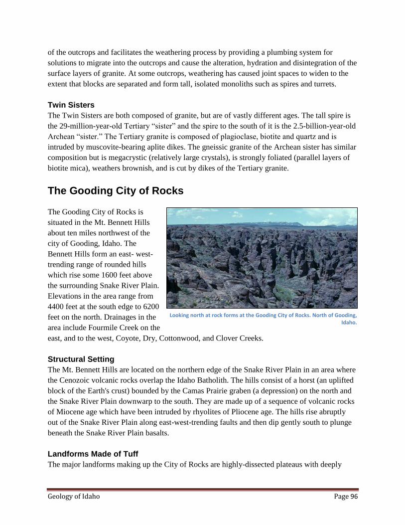
Geology of Idaho Page 96
of the outcrops and facilitates the weathering process by providing a plumbing system for
solutions to migrate into the outcrops and cause the alteration, hydration and disintegration of the
surface layers of granite. At some outcrops, weathering has caused joint spaces to widen to the
extent that blocks are separated and form tall, isolated monoliths such as spires and turrets.
Twin Sisters
The Twin Sisters are both composed of granite, but are of vastly different ages. The tall spire is
the 29-million-year-old Tertiary “sister” and the spire to the south of it is the 2.5-billion-year-old
Archean “sister.” The Tertiary granite is composed of plagioclase, biotite and quartz and is
intruded by muscovite-bearing aplite dikes. The gneissic granite of the Archean sister has similar
composition but is megacrystic (relatively large crystals), is strongly foliated (parallel layers of
biotite mica), weathers brownish, and is cut by dikes of the Tertiary granite.
The Gooding City of Rocks
The Gooding City of Rocks is
situated in the Mt. Bennett Hills
about ten miles northwest of the
city of Gooding, Idaho. The
Bennett Hills form an east- west-
trending range of rounded hills
which rise some 1600 feet above
the surrounding Snake River Plain.
Elevations in the area range from
4400 feet at the south edge to 6200
feet on the north. Drainages in the
area include Fourmile Creek on the
east, and to the west, Coyote, Dry, Cottonwood, and Clover Creeks.
Structural Setting
The Mt. Bennett Hills are located on the northern edge of the Snake River Plain in an area where
the Cenozoic volcanic rocks overlap the Idaho Batholith. The hills consist of a horst (an uplifted
block of the Earth's crust) bounded by the Camas Prairie graben (a depression) on the north and
the Snake River Plain downwarp to the south. They are made up of a sequence of volcanic rocks
of Miocene age which have been intruded by rhyolites of Pliocene age. The hills rise abruptly
out of the Snake River Plain along east-west-trending faults and then dip gently south to plunge
beneath the Snake River Plain basalts.
Landforms Made of Tuff
The major landforms making up the City of Rocks are highly-dissected plateaus with deeply
Looking north at rock forms at the Gooding City of Rocks. North of Gooding, Idaho.

Geology of Idaho Page 97
eroded and deeply cut stream channels. The many
streams and their tributaries though many flow
only in the spring of the year, have helped dissect
the volcanic rocks into weird and exotic forms.
These spectacular landforms occur primarily in a
geologic formation known as the City of Rocks
Tuff, a member of the larger Idavada Group. A
tuff is a fine-grained rock formed mainly of glass
particles in which crystals of feldspar, quartz and
other minerals are imbedded. The deposits are
believed to have been produced by the eruption of
dense clouds of glowing volcanic glass in a semi-
molten state. As the material fell to the ground the
glass particles were welded and fused together.
Many layers are solely composed of glass and
obsidian (volcanic glass) formed within the
welded tuff formation.
Joints Control Landforms and Features
The many pillars and arches in this tuff are a
result of two forces; structural deformation and
mechanical erosion. Weathering processes such as freezing and thawing have sculpted the rocks
along multidirectional joint patterns (natural fractures in the rocks) to create a myriad of exotic
features. For instance, closely-spaced horizontal joints make some columns appear like stacks of
coins, whereas converging horizontal and vertical joints create weak points which are typically
weathered to form concave features. Creation of the concave features such as undercut pillars,
mushroom caps, and arches are also products of the weathering process. Alternating hard and
soft layers in the rocks allow differential weathering and erosion to further shape the surface.
In some locations within the City of Rocks, major northwest-southeast-trending joints can be
seen to form "fins" of rock oriented in the direction of those joints. The fins and other geologic
features in the City of Rocks are quite similar to those found in the Arches National Monument
in Utah.
Hoodoos
Some of the more unusual landforms found within the area are columns, arches, monoliths, and
especially hoodoos. A hoodoo is a rock formation that originates in the following way: rocks are
fractured during periods of faulting; water then penetrates the cracks and causes them to widen.
This leaves a pillar of rock separated from the parent rock. The alternating hard and soft layers of
the tuff give an undulating or wavy appearance to the hoodoo. These features are common in
Unusual rock form at the Gooding City of Rocks.

Geology of Idaho Page 98
volcanic areas and are usually concentrated in regions where most of the rain fall occurs during a
short period of the year.
Big Wood River
A stretch of the bed of the Big Wood has world-class examples of bedrock erosional features.
This remarkable geologic attraction is situated approximately 10 to 13 miles northeast of the
town of Shoshone and is about 3 miles east of Kinzie Butte.
Basaltic Bedrock in the Big
Wood River Channel
The basalt flow that hosts the Big
Wood River channel has been
dated by Armstrong et al (1975)
near Magic Dam as 0.8 million
years old. This flow displays
extensive weathering and most of
the swales and depressions are
filled with loess which tends to
smooth out the rough flow-top
surface. The color of the basalt,
which is formed of compound
pahoehoe flows, ranges from light gray to very dark gray or black. In places where the channel
has eroded through this basalt to a depth of more than 50 feet, at least three individual flows or
cooling units are exposed along the canyon walls. At the upper few feet of the flows, features
such as lava blisters, columnar joints, ropy pahoehoe, vesicular zones, and flow foliation are
common.
Big Wood River after the Last Glacial Age
The Big Wood River originates from a number of tributaries draining out of the mountains to the
north. From the reference point of Ketchum, Idaho, the Big Wood River has major tributaries
running off the Boulder Mountains to the northeast, the Pioneer Mountains to the east and the
Smoky Mountains to the West. Most of the pebbles and cobbles in the Big Wood River in the
vicinity of the study area were derived from these mountains. This upland area was dramatically
shaped by glaciers during the last period of alpine glaciation which ended around 7,000 to
10,000 years ago. When the present position of the Big Wood River channel was established
approximately 10,000 years ago, there were enormous flows of glacial melt water running off the
high country. These large flows carried heavy sediment loads and were instrumental in
developing the spectacular potholes during the first few thousand years of the Big Wood River's
existence in its present position.
Two potholes will ultimately enlarge and coalesce to form an elongated pothole. Big Wood River, Idaho.
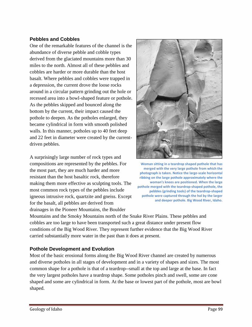
Geology of Idaho Page 99
Pebbles and Cobbles
One of the remarkable features of the channel is the
abundance of diverse pebble and cobble types
derived from the glaciated mountains more than 30
miles to the north. Almost all of these pebbles and
cobbles are harder or more durable than the host
basalt. Where pebbles and cobbles were trapped in
a depression, the current drove the loose rocks
around in a circular pattern grinding out the hole or
recessed area into a bowl-shaped feature or pothole.
As the pebbles skipped and bounced along the
bottom by the current, their impact caused the
pothole to deepen. As the potholes enlarged, they
became cylindrical in form with smooth polished
walls. In this manner, potholes up to 40 feet deep
and 22 feet in diameter were created by the current-
driven pebbles.
A surprisingly large number of rock types and
compositions are represented by the pebbles. For
the most part, they are much harder and more
resistant than the host basaltic rock, therefore
making them more effective as sculpting tools. The
most common rock types of the pebbles include
igneous intrusive rock, quartzite and gneiss. Except
for the basalt, all pebbles are derived from
drainages in the Pioneer Mountains, the Boulder
Mountains and the Smoky Mountains north of the Snake River Plains. These pebbles and
cobbles are too large to have been transported such a great distance under present flow
conditions of the Big Wood River. They represent further evidence that the Big Wood River
carried substantially more water in the past than it does at present.
Pothole Development and Evolution
Most of the basic erosional forms along the Big Wood River channel are created by numerous
and diverse potholes in all stages of development and in a variety of shapes and sizes. The most
common shape for a pothole is that of a teardrop--small at the top and large at the base. In fact
the very largest potholes have a teardrop shape. Some potholes pinch and swell, some are cone
shaped and some are cylindrical in form. At the base or lowest part of the pothole, most are bowl
shaped.
Woman sitting in a teardrop shaped pothole that has merged with the very large pothole from which the
photograph is taken. Notice the large-scale horizontal ribbing on the large pothole approximately where the
woman’s knees are positioned. When the large pothole merged with the teardrop-shaped pothole, the
pebbles (grinding tools) of the teardrop-shaped pothole were captured through the hol by the larger
and deeper pothole. Big Wood River, Idaho.

Geology of Idaho Page 100
As you walk through the deeper part of the channel or canyon you can readily see many
examples of "suspended" or "hanging" potholes at all levels along the smooth walls of the large
potholes that are responsible for the present size of the canyon. These suspended or hanging
potholes are generally exposed as a vertical section of less than one half of the original pothole.
Existing in almost every size and shape, the suspended or hanging potholes are the relics or
remnants of captured or cannibalized potholes. On the walls of some of the larger potholes, one
can identify as many as 20 hanging, relict potholes in every stage of development. By studying
these features on the canyon wall, it is possible to work out the sequence of development or
evolution of the deep channel.
Development of Asymmetry
All of the features within the Big Wood River Channel are overprinted with a strong asymmetry.
This asymmetry is imposed by the strong current-driven pebbles and cobbles against the
upstream side of the features. Consequently, the upstream side of features tends to be smooth,
convex and rounded; whereas, the downstream side tends to be concave with the leading edge of
the feature pointing in the downstream direction. When looking at the channel in a perpendicular
direction to the course of the channel, one can easily see the asymmetric development; similar to
asymmetric ripple marks, they have gentle, convex slopes on the upstream side and relatively
steep, concave slopes on the downstream side. Almost all the shapes in the channel were created
by the erosional processes of asymmetry development, overprinting the features resulting from
pothole development.
Age of the Big Wood River Channel
When the Black Butte lava flowed westward
over the 0.8 million year old lava some 10,000
years ago, the Big Wood River was rerouted,
possibly as much as one mile to its present
channel. Therefore, the sculptured rocks of the
Big Wood River are approximately the same age
as the Black Butte basalt. Because the newly
crystallized Black Butte lava is up to 10 feet
higher than the underlying older basalt, the Big
Wood River now follows the irregular flow front
of the Black Butte flow.
The Great Rift
The Great Rift system consists of a series of
north-northwest-trending fractures, which
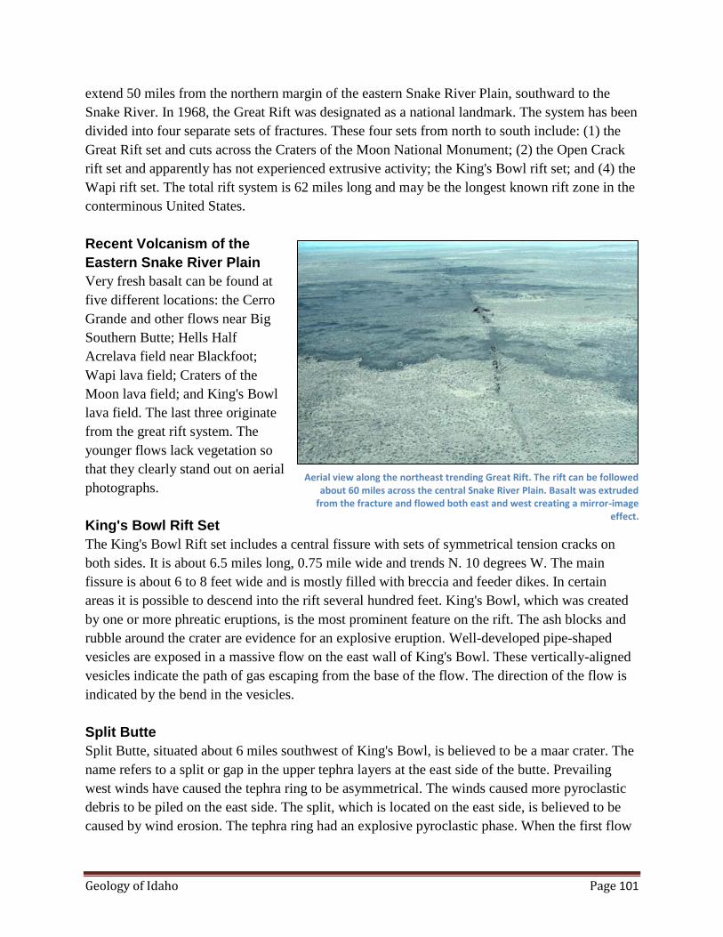
Geology of Idaho Page 101
extend 50 miles from the northern margin of the eastern Snake River Plain, southward to the
Snake River. In 1968, the Great Rift was designated as a national landmark. The system has been
divided into four separate sets of fractures. These four sets from north to south include: (1) the
Great Rift set and cuts across the Craters of the Moon National Monument; (2) the Open Crack
rift set and apparently has not experienced extrusive activity; the King's Bowl rift set; and (4) the
Wapi rift set. The total rift system is 62 miles long and may be the longest known rift zone in the
conterminous United States.
Recent Volcanism of the
Eastern Snake River Plain
Very fresh basalt can be found at
five different locations: the Cerro
Grande and other flows near Big
Southern Butte; Hells Half
Acrelava field near Blackfoot;
Wapi lava field; Craters of the
Moon lava field; and King's Bowl
lava field. The last three originate
from the great rift system. The
younger flows lack vegetation so
that they clearly stand out on aerial
photographs.
King's Bowl Rift Set
The King's Bowl Rift set includes a central fissure with sets of symmetrical tension cracks on
both sides. It is about 6.5 miles long, 0.75 mile wide and trends N. 10 degrees W. The main
fissure is about 6 to 8 feet wide and is mostly filled with breccia and feeder dikes. In certain
areas it is possible to descend into the rift several hundred feet. King's Bowl, which was created
by one or more phreatic eruptions, is the most prominent feature on the rift. The ash blocks and
rubble around the crater are evidence for an explosive eruption. Well-developed pipe-shaped
vesicles are exposed in a massive flow on the east wall of King's Bowl. These vertically-aligned
vesicles indicate the path of gas escaping from the base of the flow. The direction of the flow is
indicated by the bend in the vesicles.
Split Butte
Split Butte, situated about 6 miles southwest of King's Bowl, is believed to be a maar crater. The
name refers to a split or gap in the upper tephra layers at the east side of the butte. Prevailing
west winds have caused the tephra ring to be asymmetrical. The winds caused more pyroclastic
debris to be piled on the east side. The split, which is located on the east side, is believed to be
caused by wind erosion. The tephra ring had an explosive pyroclastic phase. When the first flow
Aerial view along the northeast trending Great Rift. The rift can be followed about 60 miles across the central Snake River Plain. Basalt was extruded
from the fracture and flowed both east and west creating a mirror-image effect.
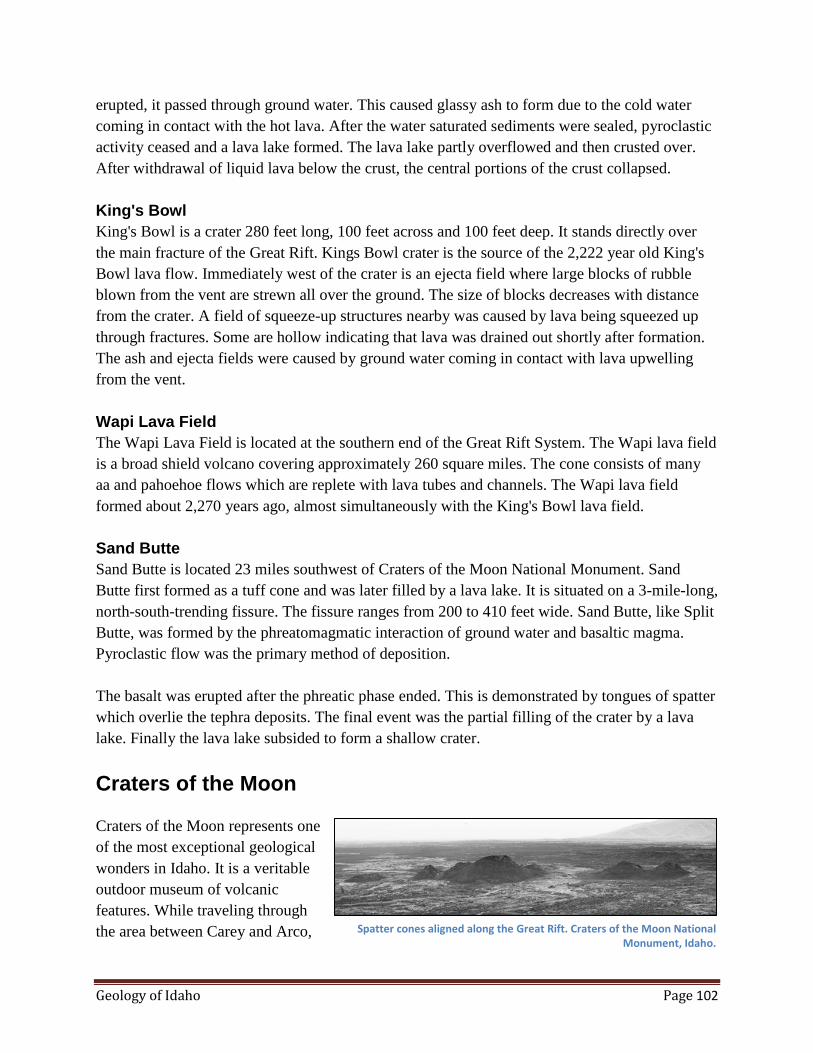
Geology of Idaho Page 102
erupted, it passed through ground water. This caused glassy ash to form due to the cold water
coming in contact with the hot lava. After the water saturated sediments were sealed, pyroclastic
activity ceased and a lava lake formed. The lava lake partly overflowed and then crusted over.
After withdrawal of liquid lava below the crust, the central portions of the crust collapsed.
King's Bowl
King's Bowl is a crater 280 feet long, 100 feet across and 100 feet deep. It stands directly over
the main fracture of the Great Rift. Kings Bowl crater is the source of the 2,222 year old King's
Bowl lava flow. Immediately west of the crater is an ejecta field where large blocks of rubble
blown from the vent are strewn all over the ground. The size of blocks decreases with distance
from the crater. A field of squeeze-up structures nearby was caused by lava being squeezed up
through fractures. Some are hollow indicating that lava was drained out shortly after formation.
The ash and ejecta fields were caused by ground water coming in contact with lava upwelling
from the vent.
Wapi Lava Field
The Wapi Lava Field is located at the southern end of the Great Rift System. The Wapi lava field
is a broad shield volcano covering approximately 260 square miles. The cone consists of many
aa and pahoehoe flows which are replete with lava tubes and channels. The Wapi lava field
formed about 2,270 years ago, almost simultaneously with the King's Bowl lava field.
Sand Butte
Sand Butte is located 23 miles southwest of Craters of the Moon National Monument. Sand
Butte first formed as a tuff cone and was later filled by a lava lake. It is situated on a 3-mile-long,
north-south-trending fissure. The fissure ranges from 200 to 410 feet wide. Sand Butte, like Split
Butte, was formed by the phreatomagmatic interaction of ground water and basaltic magma.
Pyroclastic flow was the primary method of deposition.
The basalt was erupted after the phreatic phase ended. This is demonstrated by tongues of spatter
which overlie the tephra deposits. The final event was the partial filling of the crater by a lava
lake. Finally the lava lake subsided to form a shallow crater.
Craters of the Moon
Craters of the Moon represents one
of the most exceptional geological
wonders in Idaho. It is a veritable
outdoor museum of volcanic
features. While traveling through
the area between Carey and Arco, Spatter cones aligned along the Great Rift. Craters of the Moon National Monument, Idaho.
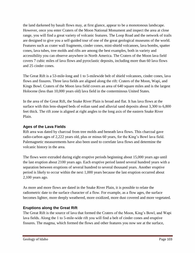
Geology of Idaho Page 103
the land darkened by basalt flows may, at first glance, appear to be a monotonous landscape.
However, once you enter Craters of the Moon National Monument and inspect the area at close
range, you will find a great variety of volcanic features. The Loop Road and the network of trails
are designed to give you a self-guided tour of one of the great geological museums of the world.
Features such as crater wall fragments, cinder cones, mini-shield volcanoes, lava bombs, spatter
cones, lava tubes, tree molds and rifts are among the best examples, both in variety and
accessibility you can observe anywhere in North America. The Craters of the Moon lava field
covers 7 cubic miles of lava flows and pyroclastic deposits, including more than 60 lava flows
and 25 cinder cones.
The Great Rift is a 53-mile-long and 1 to 5-milewide belt of shield volcanoes, cinder cones, lava
flows and fissures. Three lava fields are aligned along the rift: Craters of the Moon, Wapi, and
Kings Bowl. Craters of the Moon lava field covers an area of 640 square miles and is the largest
Holocene (less than 10,000 years old) lava field in the conterminous United States.
In the area of the Great Rift, the Snake River Plain is broad and flat. It has lava flows at the
surface with thin lens-shaped beds of eolian sand and alluvial sand deposits about 3,300 to 6,800
feet thick. The rift zone is aligned at right angles to the long axis of the eastern Snake River
Plain.
Ages of the Lava Fields
Rift area was dated by charcoal from tree molds and beneath lava flows. This charcoal gave
radio-carbon ages of 2,222 years old, plus or minus 60 years, for the King’s Bowl lava field.
Palemagnetic measurements have also been used to correlate lava flows and determine the
volcanic history in the area.
The flows were extruded during eight eruptive periods beginning about 15,000 years ago until
the last eruption about 2100 years ago. Each eruptive period lasted several hundred years with a
separation between eruptions of several hundred to several thousand years. Another eruptive
period is likely to occur within the next 1,000 years because the last eruption occurred about
2,100 years ago.
As more and more flows are dated in the Snake River Plain, it is possible to relate the
radiometric date to the surface character of a flow. For example, as a flow ages, the surface
becomes lighter, more deeply weathered, more oxidized, more dust covered and more vegetated.
Eruptions along the Great Rift
The Great Rift is the source of lava that formed the Craters of the Moon, King’s Bowl, and Wapi
lava fields. Along the 1 to 5-mile-wide rift you will find a belt of cinder cones and eruptive
fissures. The magma, which formed the flows and other features you now see at the surface,
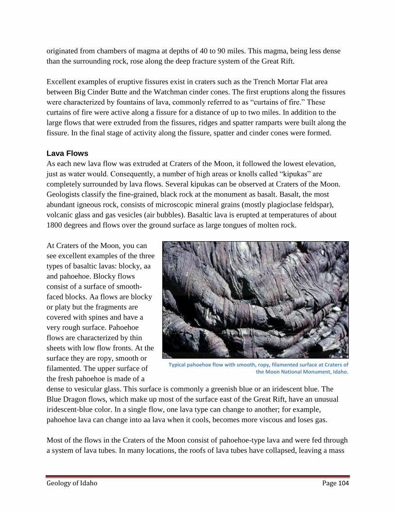
Geology of Idaho Page 104
originated from chambers of magma at depths of 40 to 90 miles. This magma, being less dense
than the surrounding rock, rose along the deep fracture system of the Great Rift.
Excellent examples of eruptive fissures exist in craters such as the Trench Mortar Flat area
between Big Cinder Butte and the Watchman cinder cones. The first eruptions along the fissures
were characterized by fountains of lava, commonly referred to as “curtains of fire.” These
curtains of fire were active along a fissure for a distance of up to two miles. In addition to the
large flows that were extruded from the fissures, ridges and spatter ramparts were built along the
fissure. In the final stage of activity along the fissure, spatter and cinder cones were formed.
Lava Flows
As each new lava flow was extruded at Craters of the Moon, it followed the lowest elevation,
just as water would. Consequently, a number of high areas or knolls called “kipukas” are
completely surrounded by lava flows. Several kipukas can be observed at Craters of the Moon.
Geologists classify the fine-grained, black rock at the monument as basalt. Basalt, the most
abundant igneous rock, consists of microscopic mineral grains (mostly plagioclase feldspar),
volcanic glass and gas vesicles (air bubbles). Basaltic lava is erupted at temperatures of about
1800 degrees and flows over the ground surface as large tongues of molten rock.
At Craters of the Moon, you can
see excellent examples of the three
types of basaltic lavas: blocky, aa
and pahoehoe. Blocky flows
consist of a surface of smooth-
faced blocks. Aa flows are blocky
or platy but the fragments are
covered with spines and have a
very rough surface. Pahoehoe
flows are characterized by thin
sheets with low flow fronts. At the
surface they are ropy, smooth or
filamented. The upper surface of
the fresh pahoehoe is made of a
dense to vesicular glass. This surface is commonly a greenish blue or an iridescent blue. The
Blue Dragon flows, which make up most of the surface east of the Great Rift, have an unusual
iridescent-blue color. In a single flow, one lava type can change to another; for example,
pahoehoe lava can change into aa lava when it cools, becomes more viscous and loses gas.
Most of the flows in the Craters of the Moon consist of pahoehoe-type lava and were fed through
a system of lava tubes. In many locations, the roofs of lava tubes have collapsed, leaving a mass
Typical pahoehoe flow with smooth, ropy, filamented surface at Craters of the Moon National Monument, Idaho.

Geology of Idaho Page 105
of broken lava and rubble on the floor of the tube. Many such collapsed areas in the Broken Top
and Blue Dragon flows provide “skylights” and entrances to lava tunnels for the numerous
visitors to the monument.
The older flows in Craters of the Moon lava field can be identified by the nature of the surface.
Younger flows have unweathered glassy crusts and a surface that is typically blue. Older lavas
tend to be covered by wind-blown deposits and their surface is light colored from weathering and
is strongly oxidized. A few of the flows in the craters area have an aa type surface. Aa flows
have a rough, jagged surface.
Cinder Cones
Numerous cinder cones exist
throughout the Snake River Plain.
However there are more than 25
exceptionally well developed
cinder cones aligned along a 17-
mile-long, northwest-trending
segment of the Great Rift. Cinders
are very vesicular clots of lava
blown out of a vent in the Earth’s
surface. Cinder cones are
developed by the accumulation of
cinder and ash in cone-shaped
hills. Many cinder cones at the
monument are a composite of two
or more cones with overlapping craters and flanks. These cones consist of agglutinated and
nonagglutinated ash layers typically interlayered with a few thin lava flows. Some cones, such as
the Inferno Cone and the Paisley Cone are asymmetric or elongate reflecting the wind direction
at the time of the eruption. As a general rule, winds from the west caused more downwind
accumulation of cinders on the east sides of cones.
Volcanic Bombs and Spatter Cones
Volcanic bombs are blown from volcanic vents as clots of fluid lava. As they move through the
air while still hot and plastic, they deform into aerodynamically-shaped projectiles of lava.
Spatter cones are relatively small cones formed by blobs of molten rock hurled out of volcanic
vents. The hot, plastic blobs weld to the outer surface of the cone and quickly harden into rock.
Cinder cone with multiple craters at Craters of the Moon National Monument.

Geology of Idaho Page 106
Hagerman Fauna
In 1988 the Hagerman Fossil Beds
National Monument was
established by Congress. In 1928
Elmer Cook, a local rancher
discovered fossil bones and
showed them to H.T. Stearns, a
U.S. Geological Survey Geologist.
Stearns forwarded the bones to
J.W. Gidley at the U.S. National
Museum. Gidley interpreted the
bones to be a fossil horse and
during the next two summers he
removed tons of bones. The horse,
identified as Equus simplicidens, is the earliest recognized example of the modern horse genus
Equus. Genetically Equus simplicadens may be more zebra than horse. The fossil bones were
represented by specimens of all different ages and genders. This concentration of bones may
have occurred when a herd of horses crossing a river were swept down river by a strong current
and deposited in an inside meaner bar where they were rapidly buried.
In 1988 the Idaho State Legislature designated the Hagerman horse the State fossil. The Glenns
Ferry sediments in the Hagerman area have yielded the world's greatest variety and numbers of
animals from the late Pliocene. These vertebrates include 18 fish, 4 amphibians, 9 reptiles, 27
birds and 50 mammals. More than 100 vertebrate species together with fresh-water clams and
snails and plant pollen allow accurate interpretation of the nature of the landscape and ecosystem
at the time. The Hagerman fauna perished some 3.5 Ma when the landscape was a broad, flat
flood plain on the southeast edge of ancestral Lake Idaho.
During the Pliocene, the Snake River Plain received about 20 inches of water per year so
vegetation was more diverse and susceptible to willows, alder, birch and elm as well as small
concentrations of pine. Plant pollen provides evidence of plant species and their associated water
requirements. Fossils of pelicans, cormorants, grebes, herons, egrets, storks, swans, ducks, geese
and rails require an aquatic environment; also, fish bones, frogs, turtles, muskrats, beaver and
otter are further evidence of water-dependent fauna.
The presence of species such as horse, camel, peccary and antelope require a habitat of grassy
plains with nearby water. The flood plain environment offers the necessary periods of flooding to
sweep up and concentrate the various species and the associated rapid sedimentation as the flood
abates to bury them.
Overview of Hagerman horse quarry with town of Hagerman in the background. Note the bedding of teh Pliocene Lake Idaho deposits.

Geology of Idaho Page 107
Menan Buttes
The Menan Buttes are located on
the Snake River Plain about 20
miles north of Idaho Falls in
southeastern Idaho. Five cones
were erupted along a north-
northwest-trending fissure. Both of
the two large cones are
approximately two miles long in a
northeast direction and about two-
thirds as wide. Each cone has a
large summit crater several
hundred feet deep and about one-
half mile long. The northern cone
stands about 800 feet above the
surrounding plain and the southern
cone about 550 feet.
Eruption Diverted the River
The two cones consist of glassy
olivine-basalt tuff. They were
erupted through the water-saturated
flood plain of the Snake River. As
a result of the buildup of the tuff
during the eruption, Henry's Fork of the Snake River was diverted to the south so that it now
joins the Main Fork of U.S. Geological Survey map showing Menan Buttes, southeast Idaho.
Note how the buttes formed in the flood plain of the Henrys Fork River and caused the river to
be diverted. Also note the asymmetry of the cones cause by wind blowing pyroclastic materials
toward the northeast. the Snake River at the east edge of the south cone.
Shape of the Cone
Most of the volcanic vent eruptions in this part of the Snake River Plain are basaltic shield
volcanoes. Steep-sided cones built of tuff are rare. The asymmetric shape of the cones was
caused by prevailing wind blowing towards the northeast. This wind carried most of the
pyroclastic fragments blown out of the crater towards the northeast. Therefore the southwest
slopes are steeper than the northeast slopes.
Composition of the Cones
The cones were built of glass fragments blown explosively from the crater vent. The successive
U.S. Geological Survey map showing Menan Buttes, southeast Idaho. Note how the buttes formed in the flood plain of the Henrys Fork River and caused the river to be diverted. Also note the asymmetry of the cones
caused by wind blowing pyroclastic materials toward the northeast.
Geology of Idaho Page 108
tuff beds from each eruption are conformable so that the beds inside the crater dip towards the
center. Those beds on the outer slopes of the cones dip outwards at angles of 20 to 30 degrees.
The layers range in thickness from less than an inch to several feet thick. The tuff is dark olive
gray in color and consists almost entirely of glass.
Cone Contains River Gravels
Because the cones were erupted through the riverbed, they contain many xenolithic (foreign
rock) cobbles, pebbles and sand grains from the river bed. The largest xenolithic pebbles and
cobbles are most prevalent near the crater's edge. Some rounded. cobbles are as large as one foot
across. This rounded river-derived material consists of aplite, granite, quartzite, basalt and
rhyolite. Approximately 1 to 2 percent of the material in the cone was derived from the river
gravels.
Steam-Charged Eruptions
The unique character of the tuff was caused by fluid lava making contact with the water in the
river alluvium. Upon contact with water, the lava chilled and was erupted explosively by steam.
Small fragments of lava were probably solidified to glass while driven explosively by steam
from the crater.
Below the cones, the river gravels are interbedded with basalt flows. Blocks of this basalt, up to
5 feet in diameter are numerous near the crater rim and give one a good idea of the power of the
steam-charged eruptions.
Age of the Buttes
Both buttes are approximately the same age which is believed to be very Late Pleistocene to
Early Recent. Eruption of the cones caused a southwest diversion of the Henry's Fork. Before the
eruption, the Henry's Fork flowed where North Butte now is situated.
Hot Springs of Idaho
Hot water bubbling out of the ground has been known about and used in Idaho for thousands of
years. Concentrations of artifacts at and petroglyphs on rocks near hot springs are evidence that
the areas were known about and used by Indians. More than 200 hot or warm (thermal) springs
occur in Idaho and are distributed throughout several geologic provinces. In order for a spring to
be classified as thermal it must be at least 68 degrees F. Some of Idaho's hot springs reaches
temperatures as high as 200 degrees F. Even higher temperatures have been encountered in deep
wells.

Geology of Idaho Page 109
Origin of Hot Springs
Hot springs develop when rain and melted snow waters infiltrate into the ground. This ground
water then sinks deep into the Earth and is warmed by the heat contained in the Earth's interior.
Because hot water is less dense it is pushed back to the surface by the continued sinking of
heavier, cold water. Annual replenishment to the system by cold meteoric water creates a
continuous system which is called hydrothermal convection. Hot springs develop when the
upwelling hot water rises along faults or other fractures in the Earth's crust and flows out onto
the surface.
Sources of Heat
Why do some areas of the Earth have hot springs and others do not? For example, there are few
if any hot springs identified in Idaho north of Idaho County. While there is heat in the Earth
beneath any spot on the surface, this heat is concentrated closer to the surface in some areas. One
means of near-surface concentration is a shallow magma chamber within the Earth's crust such as
would exist beneath a volcano. Yellowstone National Park is centered on such a volcano. We
know from measuring the way in which the vibrations of distant Earthquakes pass
through the Yellowstone area that there is a body of molten rock (magma chamber) at a depth of
about 3 to 6 miles. The resulting hydrothermal systems are world famous.
Another area where the heat of the Earth can be concentrated near enough to the surface to
generate hydrothermal systems is where the crust of the Earth is stretched and thinner than
normal. Such a condition exists over southern Idaho in the Snake River Plain and Great Basin
areas. A number of large warm water systems occur in this region of Idaho including the Boise,
Twin Falls, Bruneau-Grandview, Raft River, and Mountain Home systems.
Hot to warm springs also occur within the rocks of the Idaho Batholith. The heat in the batholith
is believed to result from the decay of radioactive elements contained in many of the minerals
which commonly occur in the granitic rocks.
Relationship of Faults to Hot Springs
Now that we have our sources of heat, we need a path for getting the hot water to the surface. In
an active volcanic area such as Yellowstone, faulting is created by upward pressure exerted by
rising magma, by explosive eruptions, and by deflation of a depleted magma chamber after an
eruption. The latter mechanism is the most common and forms what is called a ring fracture
system which approximates the outline of the magma chamber. Yellowstone has the added
advantage of being astride a zone of active north-south to northwest-trending faults known as the
Intermountain Seismic Belt. The broken rocks within the fault zones in Yellowstone act as an
excellent conduit for circulating ground-water.
The Snake River Plain and Great Basin area of southern Idaho are being stretched. This is a very
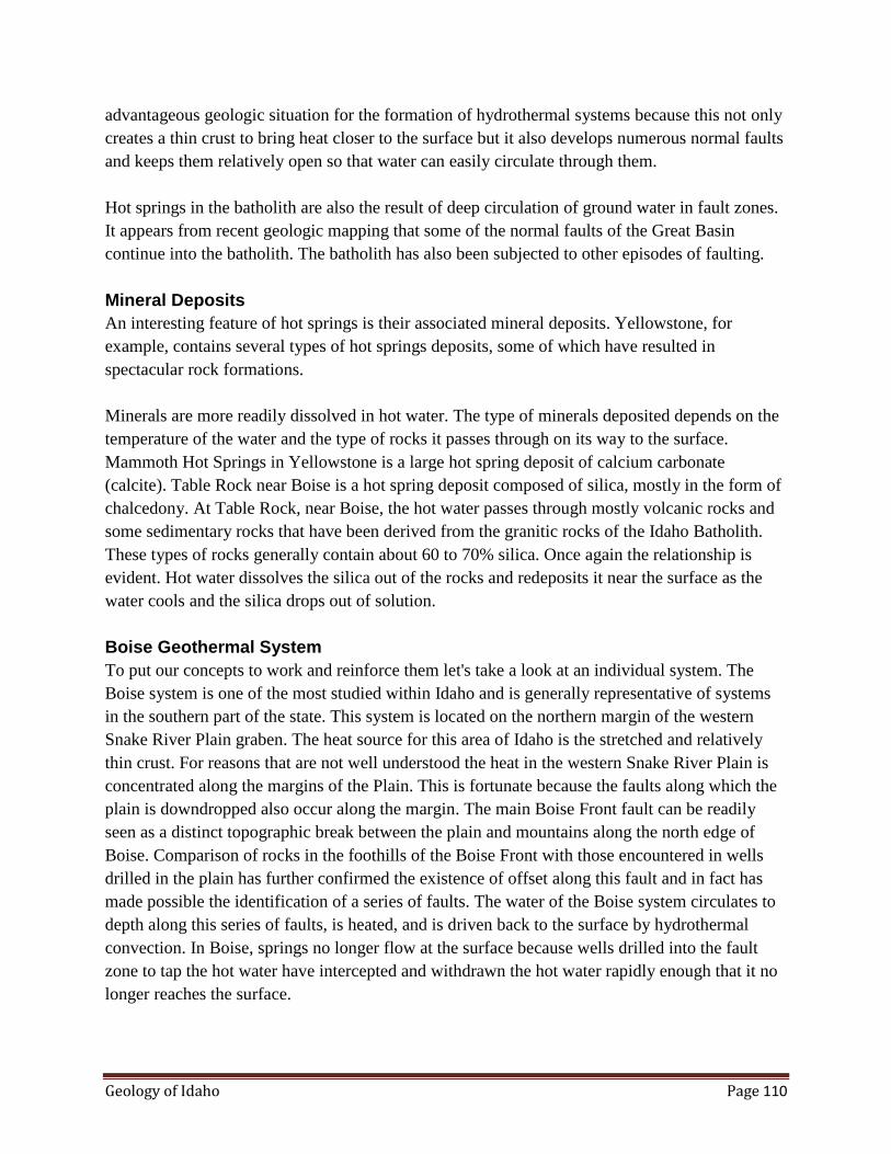
Geology of Idaho Page 110
advantageous geologic situation for the formation of hydrothermal systems because this not only
creates a thin crust to bring heat closer to the surface but it also develops numerous normal faults
and keeps them relatively open so that water can easily circulate through them.
Hot springs in the batholith are also the result of deep circulation of ground water in fault zones.
It appears from recent geologic mapping that some of the normal faults of the Great Basin
continue into the batholith. The batholith has also been subjected to other episodes of faulting.
Mineral Deposits
An interesting feature of hot springs is their associated mineral deposits. Yellowstone, for
example, contains several types of hot springs deposits, some of which have resulted in
spectacular rock formations.
Minerals are more readily dissolved in hot water. The type of minerals deposited depends on the
temperature of the water and the type of rocks it passes through on its way to the surface.
Mammoth Hot Springs in Yellowstone is a large hot spring deposit of calcium carbonate
(calcite). Table Rock near Boise is a hot spring deposit composed of silica, mostly in the form of
chalcedony. At Table Rock, near Boise, the hot water passes through mostly volcanic rocks and
some sedimentary rocks that have been derived from the granitic rocks of the Idaho Batholith.
These types of rocks generally contain about 60 to 70% silica. Once again the relationship is
evident. Hot water dissolves the silica out of the rocks and redeposits it near the surface as the
water cools and the silica drops out of solution.
Boise Geothermal System
To put our concepts to work and reinforce them let's take a look at an individual system. The
Boise system is one of the most studied within Idaho and is generally representative of systems
in the southern part of the state. This system is located on the northern margin of the western
Snake River Plain graben. The heat source for this area of Idaho is the stretched and relatively
thin crust. For reasons that are not well understood the heat in the western Snake River Plain is
concentrated along the margins of the Plain. This is fortunate because the faults along which the
plain is downdropped also occur along the margin. The main Boise Front fault can be readily
seen as a distinct topographic break between the plain and mountains along the north edge of
Boise. Comparison of rocks in the foothills of the Boise Front with those encountered in wells
drilled in the plain has further confirmed the existence of offset along this fault and in fact has
made possible the identification of a series of faults. The water of the Boise system circulates to
depth along this series of faults, is heated, and is driven back to the surface by hydrothermal
convection. In Boise, springs no longer flow at the surface because wells drilled into the fault
zone to tap the hot water have intercepted and withdrawn the hot water rapidly enough that it no
longer reaches the surface.

Geology of Idaho Page 111
There is an interesting feature of the Boise system that may explain why it and other systems
along the margin of the plain are located where they are. Recent geologic mapping has identified
a major northeast-trending fracture system within the Idaho Batholith which appears to extend
through the Boise geothermal area. This fracture system provides an excellent channel for the
ample meteoric water which falls as rain and snow on the Boise Front to infiltrate into the
ground and finally into the high temperature zones along the margin of the Snake River Plain.
Further work may make it possible to correlate other fracture systems in the batholith to hot
springs along the northern margin of the Snake River Plain and thus explain why hot springs do
not occur at regularly-spaced intervals.
Borah Peak Earthquake
East-central Idaho awoke to a crisp
autumn morning on Friday,
October 28, 1983. Suddenly, the
peaceful mountain morning was
shattered as powerful forces within
the Earth's crust were unleashed.
Normal morning activities were
interrupted as window panes
vibrated and alarmed people ran
out of their houses.
The Earthquake occurred at 8:06
a.m. (MD'I') with an epicenter
located in a sparsely populated
mountainous area between the
small rural communities of Challis
and Mackay. Challis and Mackay,
Idaho lie in the northwest-trending
valley on the west side of the of the
Lost River Range. Updated
calculations indicate that the Borah
Peak Earthquake registered a
Richter magnitude of 7.3. The
epicenter was located about 19
miles northwest of Mackay, at the
south margin of the Thousand
Springs Valley just west of 12,662-
foot Borah Peak The Earthquake caused two deaths in Challis and an estimated $15 million
Looking north at the fault scarps along the western edge of the Lost River Range south of Dickey Peak.
The 1983 Borah Peak earthquake registered 7.3 on the Richter scale and resulted in a 35 km long fault scarp. Several subvertical normal faults with
cumulative vertical displacement of 3 m disrupted the gravel road. Northwest of Mackay, Idaho.

Geology of Idaho Page 112
damage in the affected region.
Geologic Setting
The Earthquake occurred along a fault zone on the southwestern flank of the Lost River Range.
The core of the Lost River Range is composed mostly of folded and thrust-faulted Ordovician
through Pennsylvanian sedimentary rocks including limestone, dolomite, quartzite, siltstone, and
sandstone.
The Lost River Range is one of several northwest-trending mountain ranges in east-central
Idaho. The topography is typical of the Basin and Range Province. Ranges are separated by
broad sediment-filled valleys, and have range-front faults on their southwest flanks.
Ground Shaking
Primary effects of the Borah Peak Earthquake included ground shaking and surface rupture
directly related to fault movement along the western flank of the l,ost River Range. Ground
shaking was most intense near the epicenter between Challis and Mackay, but the Earthquake
was also felt over most of the northwestern United States and in parts of Canada. The initial
shock was followed by numerous aftershocks. In the 10 months following the main Earthquake,
there were at least 20 aftershocks with a magnitude of 4.0 or greater.
Secondary effects produced as a consequence of the Earthquake included seismically induced
landslides, ground cracking, and modification of the hydrologic system. Damage to roads,
buildings, and other structures occurred in the area between Mackay and Challis.
Ground Rupture Produced by Fault Displacement
Fault displacement that produced this intense Earthquake was expressed in spectacular surface
ground rupture along a northwest-trending, 22-mile-long zone on the western flank of the Lost
River Range. A west-northwest-trending section of faulting which branches off of the main
surface fault trace west of Dickey Peak gives the surface faulting pattern a Y-shape. Much of the
zone of surface rupture follows the Holocene and upper Pleistocene fault scarps of the Lost River
fault. Fault scarps, the most common features along the zone of surface faulting, look like small
steps or cliffs. Fault scarps are produced when adjacent blocks of the Earth's crust move relative
to each other and are displaced along a fault plane.
Detailed study of the surface faulting and focal mechanisms reveals that the dominant fault
movement associated with the Borah Peak Earthquake was dip slip, or vertical. That is, the Lost
River Range was uplifted vertically along the fault relative to the adjacent valley. Maximum
throw (vertical displacement) measured along the west flank of Borah Peak is about 9 feet. A
more minor component of left slip is also evident, indicating that that the Lost River Range block
also moved laterally northward, relative to the valley to the west, as well as upward. The high
Geology of Idaho Page 113
relief and linear northward-trending mountain ranges in this region and elsewhere in the Basin
and Range Province have been produced by similar repeated fault movements over geologic
time.
The surface fault trace is complex and comprised of multiple, gently curved, subparallel fault
scarps extending along a north-northwest trend. The zone of extensive ground rupture is more
than 300 feet wide in some locations. The complex nature the fault rupture can be clearly
observed in the area immediately north of Birch Springs. Along this section of the mountain
front, two to four en echelon (subparallel) scarps are visible. The maximum scarp height north of
Birch Springs is as much as 16 feet. The newly created fault scarps dip from 70 degrees to near
vertical and face westward toward the valley. However, within a few days after the Earthquake,
many fault scarps, particularly those in well-sorted stream sand and gravel deposits, were rapidly
degraded to angle of repose dips of about 30 degrees. At the base of the mountain-front slope, a
small down-dropped block or graben approximately 75 to 100 feet also formed.
Landslides Induced by Seismic Shaking
Landslides, rock falls, rock slides, and other ground failures were induced in an area of
approximately 1600 square miles surrounding the epicenter as an immediate result of the intense
seismic shaking. The steep and rugged terrain of the Lost River Range, and of the adjacent
Salmon River, Boulder, and White Knob Mountains significantly contributed to the
susceptibility to landsliding as a result of Earthquake shaking in the region. Earthquake-triggered
slope failures occurred in a variety of materials including colluvium, glacial deposits, talus
slopes, and in fractured bedrock areas.
The majority of the landslides were rock falls or rock slides. Particularly susceptible to rock falls
and rock slides were steep and rocky slopes composed of Challis Volcanics. Open joints and
fractures, typical of weathered Challis Volcanics, produced inherent slope instability in this unit
allowing large blocks to be easily loosened with seismic shaking.
Seventy-five miles north of the epicenter along steep roadcuts and cliffs on Highway 93 near
Salmon, the road was severely obstructed by rock falls and rock slides originating in outcrops of
Challis Volcanics. Dozens of boulders of Challis Volcanics, up to 10 feet in diameter, tumbled
down steep slopes of Challis damaging several houses. Some boulders rolled as much as 200 feet
out into the valley.
Largest Earthquake in 24 Years
The Borah Peak Earthquake was the largest Earthquake to hit the western United States in 24
years and was one of the only six historic Earthquakes of magnitude 7.0 or greater in the Basin
and Range recorded since 1872. The Earthquake had significant immediate effects on the land
surface, hydrologic system, and man-made structures. The Borah Peak Earthquake remains as a
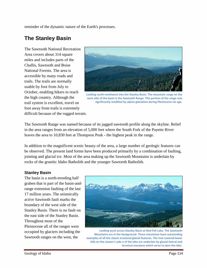
Geology of Idaho Page 114
reminder of the dynamic nature of the Earth's processes.
The Stanley Basin
The Sawtooth National Recreation
Area covers about 314 square
miles and includes parts of the
Challis, Sawtooth and Boise
National Forests. The area is
accessible by many roads and
trails. The trails are normally
usable by foot from July to
October, enabling hikers to reach
the high country. Although the
trail system is excellent, travel on
foot away from trails is extremely
difficult because of the rugged terrain.
The Sawtooth Range was named because of its jagged sawtooth profile along the skyline. Relief
in the area ranges from an elevation of 5,000 feet where the South Fork of the Payette River
leaves the area to 10,830 feet at Thompson Peak - the highest peak in the range.
In addition to the magnificent scenic beauty of the area, a large number of geologic features can
be observed. The present land forms have been produced primarily by a combination of faulting,
jointing and glacial ice. Most of the area making up the Sawtooth Mountains is underlain by
rocks of the granitic Idaho Batholith and the younger Sawtooth Batholith.
Stanley Basin
The basin is a north-trending half
graben that is part of the basin-and-
range extension faulting of the last
17 million years. The seismically
active Sawtooth fault marks the
boundary of the west side of the
Stanley Basin. There is no fault on
the east side of the Stanley Basin.
Throughout most of the
Pleistocene all of the ranges were
occupied by glaciers including the
Sawtooth ranges on the west, the
Looking north-northwest into the Stanley Basin. The mountain range on the west side of the basin is the Sawtooth Range. This portion of the range was
significantly modified by alpine glaciation during Pleistocene ice age.
Looking west across Stanley Basin at Red Fish Lake. The Sawtooth Mountains are in the background. These mountains have outstanding
examples of all the classic erosional glacial features. The tree covered lower hills on the viewer’s side e of the lake are underlain by glacial lateral and
terminal moraines which serve to dam the lake.
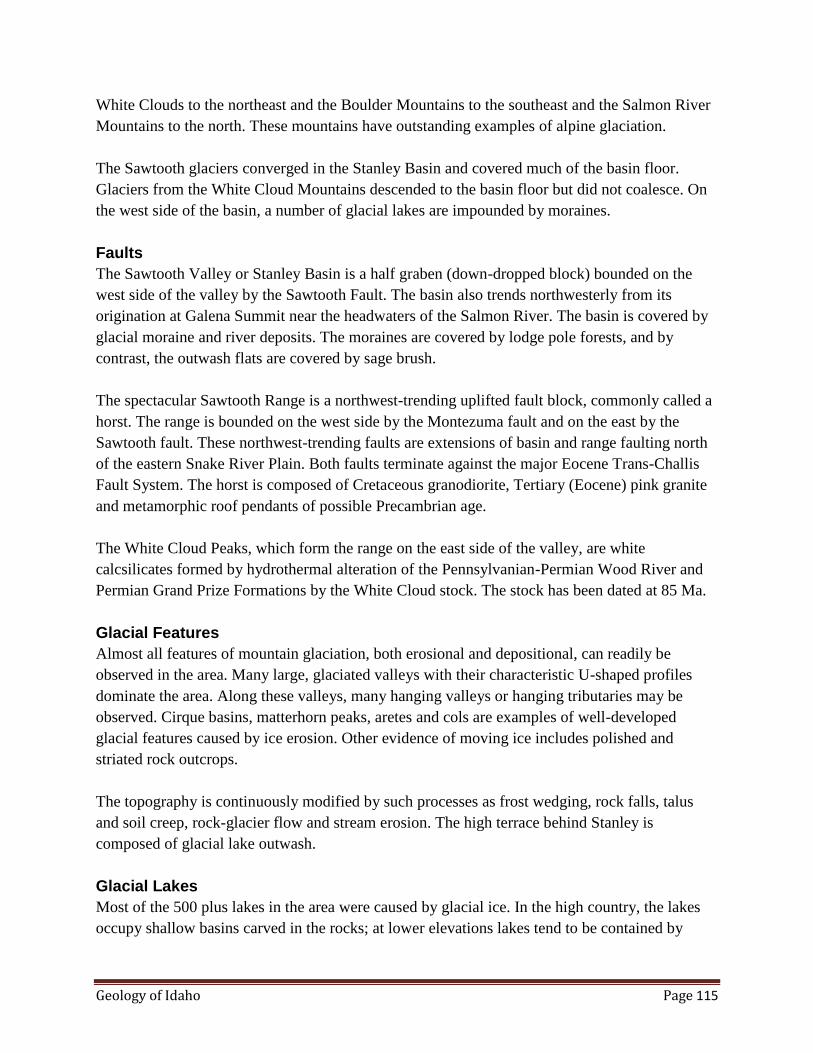
Geology of Idaho Page 115
White Clouds to the northeast and the Boulder Mountains to the southeast and the Salmon River
Mountains to the north. These mountains have outstanding examples of alpine glaciation.
The Sawtooth glaciers converged in the Stanley Basin and covered much of the basin floor.
Glaciers from the White Cloud Mountains descended to the basin floor but did not coalesce. On
the west side of the basin, a number of glacial lakes are impounded by moraines.
Faults
The Sawtooth Valley or Stanley Basin is a half graben (down-dropped block) bounded on the
west side of the valley by the Sawtooth Fault. The basin also trends northwesterly from its
origination at Galena Summit near the headwaters of the Salmon River. The basin is covered by
glacial moraine and river deposits. The moraines are covered by lodge pole forests, and by
contrast, the outwash flats are covered by sage brush.
The spectacular Sawtooth Range is a northwest-trending uplifted fault block, commonly called a
horst. The range is bounded on the west side by the Montezuma fault and on the east by the
Sawtooth fault. These northwest-trending faults are extensions of basin and range faulting north
of the eastern Snake River Plain. Both faults terminate against the major Eocene Trans-Challis
Fault System. The horst is composed of Cretaceous granodiorite, Tertiary (Eocene) pink granite
and metamorphic roof pendants of possible Precambrian age.
The White Cloud Peaks, which form the range on the east side of the valley, are white
calcsilicates formed by hydrothermal alteration of the Pennsylvanian-Permian Wood River and
Permian Grand Prize Formations by the White Cloud stock. The stock has been dated at 85 Ma.
Glacial Features
Almost all features of mountain glaciation, both erosional and depositional, can readily be
observed in the area. Many large, glaciated valleys with their characteristic U-shaped profiles
dominate the area. Along these valleys, many hanging valleys or hanging tributaries may be
observed. Cirque basins, matterhorn peaks, aretes and cols are examples of well-developed
glacial features caused by ice erosion. Other evidence of moving ice includes polished and
striated rock outcrops.
The topography is continuously modified by such processes as frost wedging, rock falls, talus
and soil creep, rock-glacier flow and stream erosion. The high terrace behind Stanley is
composed of glacial lake outwash.
Glacial Lakes
Most of the 500 plus lakes in the area were caused by glacial ice. In the high country, the lakes
occupy shallow basins carved in the rocks; at lower elevations lakes tend to be contained by
Geology of Idaho Page 116
lateral and terminal moraines. Examples of such impounded lakes include Alturas, Pettit, Yellow
Belly, Stanley, and Redfish Lakes. Many of the cirques are occupied by cirque lakes.
Glacial Lake Stanley (not to be confused with Stanley Lake) existed in the Stanley Basin (near
the town of Stanley) at a time when the Salmon River was dammed by glacial till. Excavations
near Redfish Lake reveal a section of glacial fluvial (glacial river) sediments grading upward into
a sequence of glacial lacustrine (glacial lakebed) sediments.
Glacial deposits consist of unsorted clay, sand, cobbles and boulders left by melting glaciers.
This material was removed from the mountains and transported to the site of deposition by
glaciers.
Ridges of Glacial Moraines
Along the eastern front of the Sawtooth Mountains is a series of elongated ridges standing
approximately 1,500 feet above the Stanley Basin. These ridges may be distinguished from the
bare, jagged Sawtooth Mountains in several ways. Because they are underlain by glacial till, they
are rounded and covered by a thick stand of lodgepole pine. Redfish Lake occupies the lower end
of a U-shaped valley and is contained by lateral moraines on the sides and a terminal moraine at
the end near the lodge.
Rock Types
The Thompson Creek Formation is the oldest rock in the area and may be of Precambrian age. It
consists of well-foliated mica schist interlayered with metamorphosed carbonate rocks. Where
the carbonate rocks have intrusive contracts with the granitic rocks, skarn minerals may be well
developed.
Light gray granitic rocks of the Idaho Batholith underlie about one-half of the Sawtooth
Mountains. The batholith contains varying amounts of quartz, orthoclase, plagioclase and biotite,
and has been dated at 108 million years.
The Sawtooth Batholith is an distinctive pink granite which contrasts sharply with the gray
granitic rocks of the Idaho Batholith. The color is caused by the presence of perthitic orthoclase.
The Sawtooth Batholith is younger than the Idaho Batholith. Dikes of the pink granite intrude the
gray granite.
These Tertiary plutons were probably emplaced at less than 2 miles depth, whereas the batholith
was emplaced at about 6 miles. The Tertiary plutons contain twice as much uranium and thorium
than is found in the Mesozoic batholith. Many gas cavities contain smoky quartz, feldspar and
aquamarine (beryl) crystals.

Geology of Idaho Page 117
Joints
The granitic rock of the Sawtooth Range is thoroughly jointed. The joints dip steeply and are
closely spaced. The two most common sets strike northeast and northwest. The jagged ridges of
the range were developed because the joints made the rock susceptible to erosion by frost
wedging.
Beryl (Aquamarine Deposits)
Beryl deposits have been known in the Sawtooth Mountains for many years. Beryl
mineralization is generally confined to the Sawtooth Batholith or near its periphery. Areas of
good beryl mineralization include the valleys of upper Pinchot Creek, upper Fall Creek, Benedict
Creek, Spangle Lakes, Ardeth Lakes, Edna Lake and Toxaway Lake. Aquamarine occurs as
scattered single grains, as northeast-trending zones of clustered grains and as sunbursts on joint
surfaces. High-angle pegmatite dikes contain crystals of aquamarine in vugs or cavities.
Aquamarine in pegmatites is associated only with quartz and orthoclase and is clear of
inclusions. Aquamarine also occurs as spherical concretions of aquamarine, albite and quartz.
Malm Gulch
The petrified forest of Malm Gulch
is in east-central Idaho about 12
miles south of the town of Challis.
It is located about three miles from
the east side of U.S. 93 up the
gulch in a southwesterly direction.
There are about 30 to 40 upright
stumps of silicified Sequoia trees
still in growth position and 10 to
15 horizontal logs exposed at the
surface. According to Jones, there
are at least six successive levels of
forests distributed through a
sequence of Eocene volcanic ash
layers totaling about 175 feet
thick. Each forest level represents
a period long enough for soil to
develop and trees to grow as much
as 10 feet in diameter before being destroyed by air-fall tuffs and mudflows. A tree ring count
indicates and approximate age of 500 years for a tree 9 feet in diameter. The average tree has a
diameter of 6 to 8 feet at the base. Although most of the wood is silicified, it is not gem quality.
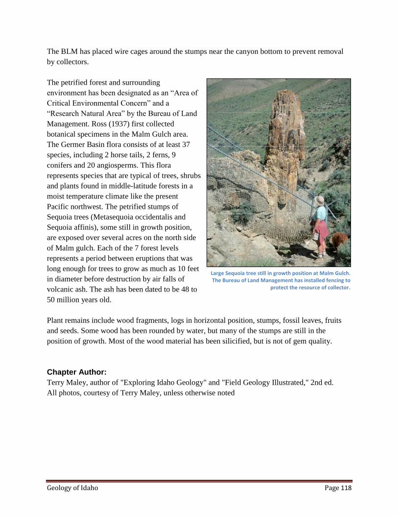
Geology of Idaho Page 118
The BLM has placed wire cages around the stumps near the canyon bottom to prevent removal
by collectors.
The petrified forest and surrounding
environment has been designated as an “Area of
Critical Environmental Concern” and a
“Research Natural Area” by the Bureau of Land
Management. Ross (1937) first collected
botanical specimens in the Malm Gulch area.
The Germer Basin flora consists of at least 37
species, including 2 horse tails, 2 ferns, 9
conifers and 20 angiosperms. This flora
represents species that are typical of trees, shrubs
and plants found in middle-latitude forests in a
moist temperature climate like the present
Pacific northwest. The petrified stumps of
Sequoia trees (Metasequoia occidentalis and
Sequoia affinis), some still in growth position,
are exposed over several acres on the north side
of Malm gulch. Each of the 7 forest levels
represents a period between eruptions that was
long enough for trees to grow as much as 10 feet
in diameter before destruction by air falls of
volcanic ash. The ash has been dated to be 48 to
50 million years old.
Plant remains include wood fragments, logs in horizontal position, stumps, fossil leaves, fruits
and seeds. Some wood has been rounded by water, but many of the stumps are still in the
position of growth. Most of the wood material has been silicified, but is not of gem quality.
Chapter Author:
Terry Maley, author of "Exploring Idaho Geology" and "Field Geology Illustrated," 2nd ed.
All photos, courtesy of Terry Maley, unless otherwise noted
Large Sequoia tree still in growth position at Malm Gulch. The Bureau of Land Management has installed fencing to
protect the resource of collector.