tex creek - idaho fish and game | idaho fish and game · · 2011-05-27tex creek wildlife...
TRANSCRIPT

TEX CREEK Wildlife Management Area
Management Plan July 1999
Idaho Department of Fish and Game Upper Snake Region 1515 Lincoln Road
Idaho Falls, Idaho 83401
Prepared By: Terry Thomas, Regional Habitat Biologist

i
TABLE OF CONTENTS
TABLE OF CONTENTS ................................................................................................................. i
EXECUTIVE SUMMARY............................................................................................................. 1
INTRODUCTION AND PHYSICAL DESCRIPTION .................................................................. 1
MISSION STATEMENT ............................................................................................................... 3
MANAGEMENT PRIORITIES ..................................................................................................... 3
CONSTRAINTS AND SIDEBOARDS ......................................................................................... 3
GOALS, OBJECTIVES, AND STRATEGIES .............................................................................. 4
APPENDIX A ............................................................................................................................... 12 MANAGEMENT ISSUES ............................................................................................... 12
APPENDIX B ............................................................................................................................... 17 TEX CREEK WMA MAPS ............................................................................................. 17
APPENDIX C ............................................................................................................................... 20 CONSTRAINING AGREEMENTS, PLANS, AND DOCUMENTS .............................. 20
APPENDIX D ............................................................................................................................... 24 SOIL TYPES ..................................................................................................................... 24
APPENDIX E ............................................................................................................................... 26 HABITAT TYPES ............................................................................................................ 26
APPENDIX F ................................................................................................................................ 27 NOXIOUS WEED CONTROL PLAN ............................................................................. 27
APPENDIX G ............................................................................................................................... 28 WILDLIFE ........................................................................................................................ 28
ELK ....................................................................................................................... 28 DEER .................................................................................................................... 35 OTHER BIG GAME SPECIES ............................................................................ 41 SHARP-TAILED GROUSE AND SAGE GROUSE ........................................... 41 OTHER WILDLIFE .............................................................................................. 44 FISHERIES ........................................................................................................... 44
WILDLIFE SPECIES INVENTORY ............................................................................... 45
APPENDIX H ............................................................................................................................... 50 MONITORING PLAN ...................................................................................................... 50
APPENDIX I ................................................................................................................................. 51 CAPITAL IMPROVEMENTS AND DEVELOPMENTS ............................................... 51

ii
APPENDIX J ................................................................................................................................ 53 LAND ACQUISITION ..................................................................................................... 53
APPENDIX K ............................................................................................................................... 54 CONSUMPTIVE USE INVENTORY ............................................................................. 54
APPENDIX L ............................................................................................................................... 55 NON-CONSUMPTIVE USE INVENTORY ................................................................... 55

1
EXECUTIVE SUMMARY The Tex Creek Wildlife Management Area (TCWMA) was originally acquired to provide mitigation by the U.S. Bureau of Reclamation (BOR) and the Corps of Engineers for big game winter range losses. These losses resulted from Teton and Ririe dam construction, impoundment, and flooding and the subsequent damage caused by the failure of the Teton Dam. Since the inception of TCWMA, the Idaho Department of Fish and Game (IDFG) has purchased additional properties adjacent to the original mitigation lands to benefit wintering big game and other wildlife and has entered into an agreement with the Bureau of Reclamation and the Bureau of Land Management (BLM) to reserve additional federal lands (BLM) primarily for wildlife. The area consists of lands owned by the BOR, the BLM, and IDFG. Idaho Department of Fish and Game has primary management responsibility. This document provides direction in the form of goals, objectives, and strategies for the management of TCWMA. The direction of TCWMA was determined after a series of public meetings. Issues pertaining to TCWMA were identified by the public and IDFG (Appendix A). These issues were developed into goals, objectives, and strategies. A draft version of these goals and strategies was offered for public inspection and comment in September 1996. No additional comments were received. The plan will serve as a guide for current and future managers in planning where to direct efforts and resources for maximum wildlife benefit, public enjoyment, and efficient operation. As new information and technology becomes available, and as more property is acquired, strategies may be modified to most effectively reach the goals and objectives in this plan. All goals, objectives, and strategies are dependent on adequate funding, personnel, and public support.
INTRODUCTION AND PHYSICAL DESCRIPTION The properties chosen for acquisition for the Tex Creek Wildlife Management Area (see map, Appendix B) had a long history of big game winter use. At the time of acquisition, the Indian Fork and Pipe Creek areas wintered 1,400 elk. Wintering deer were so numerous in Willow Creek Canyon that biologists had named one area Deer Heaven. The acquisition and cooperative management of these properties has ensured that these herds of big game animals would continue to have winter range. Tex Creek Wildlife Management Area is comprised of land owned by several government agencies and one private organization. The Ririe Segment (2,255 acres managed under a 100 year agreement signed in 1976), was purchased by the Corps of Engineers to mitigate big game habitat losses due to the construction of Ririe Dam. The Teton Segment (9,113 acres managed under a 25 year renewable agreement signed in 1981), was purchased by the Bureau of Reclamation (BOR) as mitigation for Teton Dam. The Idaho Department of Fish and Game (IDFG) holds title to 9,215 acres and the Rocky Mountain Elk Foundation (RMEF) owns 705 acres. The remaining 9,600 acres is owned by the Bureau of Land Management (BLM) and is

2
managed under a three-way cooperative agreement between the BLM, BOR, and IDFG (Appendix C). Primary management responsibility rests with IDFG. The entire project area encompasses 84,000 acres and includes 6,160 acres of state lands leased to private individuals and 53,665 acres of privately owned land. Elevations at TCWMA range from 5,119 feet at the Ririe Reservoir pool level to 7,287 feet near the east boundary. Soils are highly varied and range from deep well-drained loess formed silt loams to shallow stony soils. Significant amounts of heavy clay soils are also present. Rock outcrop and lava rock rims predominate in canyon areas (Appendix D). Soil erosion can be severe during spring runoff and summer storm events. Temperatures range from -35EF to 100EF. The mean annual temperature is about 43EF at the lower elevations. The growing season is generally less than 90 days and light frosts are common during the summer months. Mean annual precipitation ranges from about 12 to 18 inches, moving west to east across the area. Most precipitation falls as snow and spring rains. The area is prone to severe summer thunderstorms. Normal snow depths are moderate over most of the area. Willow Creek canyon may have a month or less of snow cover in some years with 8 to 10 inches being the normal maximum depth. The eastern portions of the area will normally accumulate 2 to 3 feet of snow. The area has predominantly south and west aspects. This, combined with a prevailing southwest wind, tends to minimize snow depths and keep travel routes and foraging areas available for wintering elk, deer, and moose. Vegetation on the area is diverse with good interspersion of different habitat classes. Bitterbrush shrub steppe is the largest single natural habitat class (about 3,500 acres). Tall sagebrush, low sagebrush, juniper, and serviceberry shrub fields are common. Aspen is the most predominant tall cover type. Douglas Fir occupies about 250 acres. Of the nearly 5,500 acres of historical cropland, about 4,700 acres has been converted back into permanent herbaceous cover, generally a mix of perennial forbs such as alfalfa, Lewis blue flax, and small burnett and bunch grasses such as Sherman bluebunch wheatgrass (Appendix E). About 800 acres remain in winter wheat rotation to serve as an attractant and high quality winter/spring forage for mule deer. Many developments have occurred over the past 20 years. Fences have been removed, new fencing has been constructed, old farmsteads have been cleaned up and buildings removed. A headquarters facility has been developed. Over 170,000 shrubs have been hand and machine planted. Springs have been developed to facilitate the livestock grazing use trade (Appendix C) and benefit wildlife. Terracing and water and sediment basins have been constructed on Ritter Bench, in the Pipe Creek drainage, Indian Fork drainage and in Bull’s Fork. The purpose of this work is to control erosion, hasten recovery of eroded areas, and to attempt to increase the water table and sub-irrigation of developed fields. A recent wildlife development was the construction of three ponds on Pipe Creek in the fall of 1996. These ponds were constructed with funds acquired from a BOR grant with matching funds

3
from Ducks Unlimited and the IDFG Habitat Improvement Program. The purpose of these ponds is to increase waterfowl production on the area and increase area diversity. Pastures were created in several areas in order to facilitate a use trade agreement which removes grazing pressure from formerly privately held critical winter range. This resulted in increased winter range for elk and deer and is helping in restore areas where combined elk and livestock use created a situation of forage over-utilization. Noxious weeds continue to be controlled by a variety of methods. This protects wildlife habitat from invasion by undesirable plant species (Appendix F). TCWMA is home to a variety of migratory and resident mammals, birds, reptiles, amphibians, and fish. A description of the wildlife present on TCWMA can be found in Appendix G.
MISSION STATEMENT Protect and manage the wildlife resources of the Tex Creek Wildlife Management Area, as mitigation for habitat losses elsewhere in the region, to insure sufficient quantities of high quality and secure habitat for wintering big game and for a wide variety of other game and nongame species. Provide high quality wildlife-based recreational opportunities and nature viewing compatible with this primary mission for the benefit of the public.
MANAGEMENT PRIORITIES Listed in order of priority:
1. Big game winter range for elk and deer
2. Upland game habitat for sharp-tailed grouse
3. Public hunting
4. Other game and nongame habitat
5. Wildlife based recreation, nature viewing, and education
6. Maintain and improve habitat for Yellowstone cutthroat trout
7. Public fishing opportunity
CONSTRAINTS AND SIDEBOARDS All strategies proposed in this plan are bounded by the contractual agreements between cooperating agencies, the mission of TCWMA, all applicable IDFG species management plans (Appendix H), and Department policies. Issues and strategies that are inconsistent with the mission or are outside the scope or function of TCWMA are not considered. In addition, the

4
implementation of all strategies will be subject to available funding, personnel, and safety considerations.
GOALS, OBJECTIVES, AND STRATEGIES I. Goal: Provide high quality secure winter range habitat for migratory big game and high
quality secure year around habitat for resident big game herds and other wildlife species on TCWMA.
A. Objective: Continue implementing vegetation enhancements that benefit wintering (and resident) big game by providing high quality forage and browse, improving distribution, and increasing security.
Strategies:
1. Manage fields to provide high quality habitat, reduce depredations, and improve distributions of elk and deer on TCWMA via a variety of techniques.
a) Manage the Teton segment and the Bulls Fork segment to emphasize elk. This will help to reduce any natural competition between elk and deer by creating a spatial separation.
b) Hay (through sharecropping) or mulch up to 400 acres a year in the core winter range to provide a more palatable, nutritious and attractive second growth.
c) Fertilize up to 400 acres per year to improve the vigor of the fields and to make them more palatable to big game.
d) Burn fields to improve field vigor and palatability to elk.
e) Use domestic livestock grazing when appropriate to hasten spring green up and help with reseeding efforts by trampling seed into the ground.
f) Pursue livestock grazing and other use trades consistent with the mission of TCWMA to secure critical wildlife habitat on adjacent or nearby private lands.
g) Rejuvenate field stands every 8-15 years to provide a variety of fields with differing maturity classes.
h) Consider adding strips of small grains to existing fields of permanent cover to attract big game onto the management area. This may become an important option as the Conservation Reserve Program matures and surrounding private lands revert back into grain production.
i) Continue to sharecrop small grains on Ritter Bench until a suitable
5
replacement for this highly attractive forage can be found. These grain fields provide deer with an excellent source of winter and spring forage and help to reduce potential depredations across the Willow Creek canyon on private property.
j) Divide fields into smaller blocks by planting shrub blocks and shrub travel lanes. This will add diversity, winter cover, and an alternate forage base. Deer in particular will benefit from additional browse availability and visual barriers may help reduce any competition that may exist between elk and deer. This may also encourage better distribution of big game animals, discourage large group sizes, reduce energy losses, and reduce disturbances to wintering animals.
k) Develop additional soil erosion control structures (long terraces or sediment basins, for example) when and where they are deemed necessary to recover eroded areas and to collect moisture.
l) Control noxious weeds chemically or mechanically along roadways. Use biological control methods for noxious weeds in all other areas if such means are available.
2. Conduct rangeland management techniques when and where necessary and practical to enhance native big game winter and summer range.
a) Manage aspen stands in a healthy and productive state.
b) Manipulate bitterbrush/sagebrush stands to improve native forage for wintering big game, particularly deer.
c) Use foliar fertilization where appropriate after testing and evaluation for efficacy.
d) Implement soil microbe enhancement where appropriate after testing and evaluation.
e) Plant native shrub seedlings where feasible on an ongoing basis.
f) Collect shrub seeds from on or near TCWMA to be used in shrub establishment efforts whenever possible.
g) Plant shrub seeds using a bulldozer with a track dribbler in some areas to evaluate this technique. If the technique proves valuable, expand the program, especially on the Ririe segment.
h) Encourage beaver activity to restore riparian areas which can provide important big game habitat.

6
i) Establish sediment basins in rangelands to control erosion as appropriate pending evaluation of trial project implemented in 1996.
j) Continue to seek opportunities to develop ponds to improve habitat diversity.
k) Use livestock grazing, when and where appropriate, to improve forage and help establish wildlife plantings. Graze domestic livestock only when there are clear and measurable benefits to wildlife habitat and populations.
l) Place large hay bales, when and where appropriate, into rangelands to help attract and disperse elk groups. This will reduce pressure on the core winter range for a longer period, and promote better utilization of existing forage in less traditional areas.
m) Control noxious weeds chemically and mechanically along roadways. Use biological control (if available) in rangelands off of roads.
B. Objective: Implement emergency winter feeding of elk and deer only when conditions combine to seriously threaten the herd or create serious depredations and as Department policy allows. Recognize that emergency feeding may cause as many problems as it solves. The concentration of animals and the potential for habitat destruction and disease transmission dictate that feeding occur only when necessary.
Strategies:
1. Feed (when necessary) with hay produced on TCWMA to reduce costs and weed infestation.
2. Use volunteers as much as possible to assist with feeding.
3. Implement a variety of methods to obtain a wide distribution of feeding areas to keep the group sizes as small as possible. This will be dependent on snow conditions and elk movements.
C. Objective: Ensure optimum wildlife populations for hunting and viewing for generations to come by creating secure habitat to protect wintering big game from unnecessary disturbance and limit depredations.
Strategies:
1. Pursue an agreement with Bonneville County to maintain winter road closures through important winter range areas from December 1 through April 15.

7
2. Sign roads that are open to motorized travel. Close unsigned roads to motorized travel.
3. Close any new roads created for administrative purposes to motorized travel.
4. Consider restricting all human entry (except administrative use) into TCWMA from December 1 through March 15 as conditions warrant.
5. Strictly enforce the antler hunting closure from January 1 to May 1.
II. Goal: Provide recreational hunting opportunity, non-consumptive wildlife based recreation, and public educational opportunities consistent with the mission of TCWMA.
A. Objective: Provide hunting access and opportunity on TCWMA.
Strategies:
1. Maintain motorized access on established and open roads for hunters while maintaining a quality hunting experience.
2. Maintain current situation until future conditions warrant change.
3. Maintain TCWMA roads in a low maintenance or unimproved status. (These roads may be impassable during inclement weather. Maintenance of roads owned by Bonneville County, which run through TCWMA, is the responsibility of the county.)
4. Maintain some roads and trails as non-motorized use only to provide quality-hunting experiences and to protect wildlife security, soils, and vegetation.
5. Maintain and improve working relationships between TCWMA and neighboring landowners to encourage landowners to allow recreational access to private property.
6. Periodically reevaluate the demand for and levels of hunter access to TCWMA. Implement management changes accordingly with input from user groups. (As the demand for hunting opportunity increases, a permitting system may need to be implemented at peak demand periods in order to maintain the quality of the hunting experience, protect species from over exploitation, and maintain a safe hunting environment.)
7. Plan and implement big game hunting seminars on TCWMA to improve hunter skills and ethics and aid hunters in realizing the value of TCWMA.
a) Coordinate this activity with local sportsmen and conservation groups.
b) Obtain sponsors from sportsmen and conservation groups and local vendors.

8
c) Prepare the initial seminar for late summer of 1998.
d) Refine the program based on experience from 1998 and begin an annual or bi-annual event.
B. Objective: Improve public access and opportunity for non-consumptive wildlife appreciation. (Non-consumptive uses of TCWMA will increase dramatically over the next 20 years. Birdwatching, wildlife viewing and photography, wildflower viewing, hiking, horseback riding, and related activities are all expected and legitimate uses of TCWMA.)
Strategies:
1. Develop a non-motorized trail system to improve access to unroaded portions of TCWMA and provide wildlife based recreational opportunity.
a) Develop interpretive signs on a portion of these trails to aid the public in understanding the area and its resources.
b) Solicit cost-sharing partners to help fund the development of a trail system.
c) Enlist volunteer organizations to adopt trails once they are established.
2. Develop, by 1999, an interpretive sign at the Pipe Creek entrance to TCWMA to describe the area and some of the opportunities available.
3. Develop interpretive signs for some of the roads and trails.
4. Develop, by 1999, a wildlife viewing platform on the Indian Fork pond.
5. Develop one to three photography blinds, when and where appropriate, as funding allows.
6. Pursue the development of a variety of outdoor educational programs to be conducted on TCWMA as funding and manpower allows.
7. Improve designated campsites by planting native trees for shade and providing a designated fire ring by 1998.
8. Increase the number of designated campsites from six to as many as nine, when and where appropriate, as funding allows.
9. Consider the addition of portable toilets as needed.
10. Update the bird list for TCWMA by 1999.

9
III. Goal: Expand TCWMA to accommodate the increased numbers of big game wintering on TCWMA and provide sufficient quantities of secure habitat.
A. Objective: Acquire additional winter range for the increased number of elk and deer now supported by TCWMA, a buffer zone around the core winter range to protect it from developmental encroachment and a migration corridor connecting TCWMA with public lands to the south.
Strategies:
1. Evaluate properties adjacent to TCWMA if and when they are for sale for their role in the wildlife management objectives of TCWMA. Attempt to acquire properties that have exceptional value to wildlife or to protect values currently managed by TCWMA.
2. Seek cost-share partners to help purchase critical properties.
IV. Goal: Improve sharp-tailed grouse habitat and populations on TCWMA.
A. Objective: Increase the amount of sharp-tailed grouse winter habitat on TCWMA.
Strategies:
1. Ensure that in shrub and thicket plantings for elk and deer, berry and bud producing species utilized by wintering grouse are included.
2. Ensure that major activities to improve habitat for elk are coordinated with sharp-tailed grouse habitat management.
3. Test leaving standing grain in strategic locations. Coordinate these efforts to avoid conflict with management objectives for big game. (Elk and deer are likely to key in on grain stands as well and this action may affect big game distributions.)
4. Coordinate management activities to comply with the Sharp-tailed Grouse Conservation Plan when finalized and approved.
B. Objective: Maintain and improve nesting cover and brood rearing habitat for sharp-tailed grouse.
Strategies:
1. Establish shrubs on field borders to provide additional nesting habitat for sharp-tailed grouse.
2. Manage fields within one kilometer of known leks to leave at least 60% residual cover for fall.
3. Continue to improve and restore riparian areas on TCWMA.
a) Encourage beaver activity where possible.

10
b) Continue to build small check dams where possible to rehabilitate wet sites.
c) Plant riparian vegetation where appropriate.
d) Minimize the use of pesticides on TCWMA. Follow Department and BOR policy for all pesticide use. Develop supplemental pesticide policies for pesticide use specific to TCWMA as necessary.
C. Objective: Improve the Department’s database on sharp-tailed grouse on TCWMA and surrounding lands.
Strategies:
1. Continue to search for new leks on TCWMA.
2. Search to monitor existing and mapped leks.
3. Continue to search for new leks on lands surrounding TCWMA.
4. Develop and implement a plan to monitor broods and habitat use on and in the vicinity of TCWMA.
V. Goal: Insure that management activities contribute to or at least do not seriously impact other species on TCWMA.
A. Objective: Provide diverse habitats in sufficient quantities to fulfill the needs of all native species on TCWMA.
Strategies:
1. Evaluate and implement habitat improvements for a diverse list of wildlife species using TCWMA. (Many projects previously mentioned may help to add diversity to TCWMA including: aspen treatments, shrub plantings, field management through grain production, haying, grazing or mulching, riparian restoration, erosion control, fire management, noxious weed control, fertilization, motorized trail restrictions, and limiting the use of pesticides. These projects will enhance habitat for such diverse species as ruffed and blue grouse, gray partridge, waterfowl, neotropical songbirds, bats, amphibians and reptiles, beaver, rodents, raptors, bluebirds and more.)
B. Objective: Seek opportunities to enhance nongame habitat.
Strategies:
1. Continue to provide habitat structures for selected nongame species including bluebirds, American kestrels, and other species.

11
C. Objective: Seek opportunities to enhance gamebird populations.
Strategies:
1. Develop ponds and brood rearing habitat for waterfowl on Pipe Creek and Cove Creek.
2. Evaluate impacts to gray partridge and adjust management techniques for projects potentially affecting gray partridge.
3. Evaluate transplanting chukar partridge back onto TCWMA.
4. Investigate ways to improve chukar survivability prior to transplants.
5. Do not transplant pheasants on TCWMA. (Most winter’s conditions preclude pheasant survival.)
6. Locate sage grouse leks on and in the vicinity of TCWMA.
7. Protect habitat associated with all sage grouse leks found on TCWMA.
8. Manage sage grouse habitat on TCWMA in accordance with the Department’s Sage Grouse Management Guidelines when finalized and approved.
9. Incorporate recommendations from current sage grouse research projects into management plans and projects.
10. Identify and protect sage grouse wintering areas on the WMA.
11. Cooperate with other agencies and landowners to protect wintering areas adjacent to the WMA.
D. Objective: Maintain and enhance Yellowstone cutthroat trout spawning and rearing habitat.
Strategies:
1. Manage use trade grazing to improve riparian habitat in Willow Creek, Tex Creek, and Bull’s Fork.
2. Work with neighboring landowners to eliminate trespass cattle grazing in Meadow Creek and Indian Fork.
3. Improve riparian zone condition on all portions of TCWMA through an ongoing program of planting riparian vegetation where appropriate.
4. Encourage beaver activity in all tributaries to create habitat, store water to maintain downstream flows, and reduce sediment loading in spawning areas.

12
APPENDIX A
MANAGEMENT ISSUES ISSUES RAISED BY THE PUBLIC BUT NOT CONSIDERED IN THE DEVELOPMENT OF TCWMA PLAN.
These issues were not considered because they were beyond the scope of TCWMA management plan or were outside the function or mission of TCWMA.
• Too many hunters in all big game areas.
• Low mature bull numbers.
• Access problems in the vicinity of the WMA.
• Too many moose on nearby private property.
• Poor landowner/sportsmen relations in Unit 69.
• Low elk numbers.
• Too many elk in Units 66 and 69.
• Need to increase mature mule deer buck numbers.
• Opposition to reversal of deer and elk seasons.
• Landowner relations is important - IDFG is doing a good job.
• Continued cooperation between landowners and IDFG is important.
• No general hunting seasons should be allowed on the WMA. ISSUES IDENTIFIED BY THE PUBLIC AND ADDRESSED BY TCWMA PLAN.
The goal, objective, or strategy which addresses these issues are contained in parentheses after the issue number. Issue 1: There is the potential for brucellosis transmission in the elk herd through concentration of elk herds on the winter range. See Goal I, Objective A; Goal III, Objective A. Background: TCWMA may winter up to 3,500 elk within or near its boundaries. Elk can often congregate in groups of 500 or more on this winter range. Brucellosis transmission is a possibility when large numbers of elk occupy a limited wintering area. In some situations, elk infected with brucellosis may transmit the disease to cattle, however, this has never been demonstrated in wild free-ranging elk/livestock interactions. Issue 2: The posting of private lands within TCWMA should not be allowed. See Goal II, Objective A, Strategy 4. Background: By Idaho law, private landowners control access to private property. Issue 3: TCWMA has been successful and should be expanded. Land acquisition should be a

13
top priority. See Goal III, Objective A. Background: Elk wintering in and around TCWMA have increased from about 1,400 prior to land acquisitions, to an estimated 3,500 in 1995. Mule deer numbers have increased as well. There is concern by IDFG that the numbers of game animals are exceeding the long term carrying capacity of TCWMA. TCWMA also provides hundreds of hunter/days, camping opportunities, nature viewing, and year long habitat for many species of wildlife. TCWMA currently encompasses about 30,885 acres. Issue 4: Purchase a buffer zone around TCWMA and the migration corridor from US Forest Service lands onto TCWMA. See Goal III, Objective A. Background: Development is beginning to encroach upon TCWMA. The Bonneville County engineer expects that within 20 years there will be sufficient primary and secondary home activity in the area to justify paving many of the roads in the area, dramatically increasing human presence. Increased human activity during migration and during the winter months will adversely effect elk and deer wintering in the area. The impact could range from increased animal stress to large scale movements off the winter range and into Idaho Falls or Ririe. A shift in winter range or migration routes would likely necessitate a significant reduction in herd numbers. Issue 5: Need to increase effort for established nature/hiking trails. See Goal II, Objective B, Strategy 1.a. Background: TCWMA is open to hiking and nature observation throughout the year. Many old vehicle trails exist which currently provide access for hikers, horseback riders, and mountain bike riders. However, the demand for this type of activity is likely to increase over the next 10 years as Bonneville County continues to grow. Issue 6: Need to establish a snowmobile trail from Juniper to where the Blacktail Road intersects with the Fall Creek Road. See Goal II, Objective B, Strategy 1.a. Background: This proposed route bisects the core of the Tex Creek winter range. It parallels the area where elk are fed during severe winters. The position of IDFG, attained through the experiences of field management personnel and numerous other researchers, is that even light snowmobile traffic will displace animals and cause unnecessary stress that may prove fatal to elk in weakened conditions. Issue 7: Need to increase upland game management and plant pheasants. See Goal IV, Objectives B and C; Goal V, Objective C. Background: Several native species of upland game live on TCWMA including sharp-tailed grouse, sage grouse, ruffed and blue grouse, and cottontail rabbits. Gray partridge, an introduced species, may also be found on TCWMA in modest numbers. Tex Creek provides only poor habitat for ringneck pheasant. Habitat exists on portions of TCWMA for chukar partridge. Winter snow depths preclude pheasants from over-wintering in most years at these elevations. Issue 8: Old trails on TCWMA which are currently closed to all motorized recreational use should be open to motorized access for game retrieval only. See Goal II, Objective A, Strategy 1.a.

14
Background: There are few areas on TCWMA that are further than one mile from a road or trail open to motorized vehicles (the west rim of the reservoir and the Willow Creek canyon are notable exceptions. Much of this area is landlocked by private property. However, even much of this area is accessible by motor boat). Independently conducted research indicates that the quality of the hunting experience diminishes rapidly with each increase in motorized activity. Motorized use on many trails is inconsistent with the soil management objectives of TCWMA. Tex Creek area soils have been rated in the top ten most highly erosive soils in the nation. Once accelerated erosion is initiated, it is difficult and expensive to control. Compliance with this issue would potentially violate the mission of TCWMA. Issue 9: TCWMA fields may become root bound. Total rest is not good for the fields. Winter wheat should be rotated into the plantings and left standing for game. See Goal I, Objective A, Strategy 1.h. Background: Most of the fields on TCWMA are utilized heavily by big game at some time of the year. Many fields are also mowed and baled to produce a more palatable second crop. When necessary, fields are plowed and reseeded, often with a grain nursery crop. This produces grain for several years. Issue 10: The control of noxious weeds and soil erosion are important. TCWMA is doing a good job with weed and erosion control. See Goal I, Objective A, Strategy 1.f, k, and l. Background: Control of noxious weeds and the reduction in soil loss due to erosion have been high management priorities for TCWMA. Management activities to control noxious weeds and reduce soil erosion directly increase the quantity and quality of the habitat available to wildlife. Issue 11: Cooperation between the Idaho Department of Fish and Game and nearby landowners is important. IDFG is doing a good job in cooperating with landowners. See Goal I, Objective A, Strategy 1.f; Goal II, Objective A, Strategy 4. Background: Landowner relations pertaining to TCWMA includes interaction with all neighbors who border or who lease or rent property that borders TCWMA. DEPARTMENT IDENTIFIED ISSUES
Issue 12: The population of Bonneville County will continue to grow over the next 10-20 years. The demand for wildlife related recreation will continue to grow. Need to develop strategies for dealing with human population growth and the associated increased public demand for resources available via TCWMA. There will likely be increased demands placed on TCWMA by hunters, wildlife watchers, and other types of recreational groups. TCWMA will need to respond to these increased demands without compromising the mission of TCWMA to provide secure habitat for wintering big game. See Goal II, Objective B. Issue 13: Elk numbers continue to rise on TCWMA. Need to increase the elk carrying capacity of TCWMA. See Goal I, Objectives A and B; Goal III, Objective A. Background: Wintering elk numbers in and around Tex Creek have increased from about 1,400 in the early 1970s to over 3,500 in 1995. In order for the elk herd (and mule deer herd) to remain healthy, they will require adequate forage, cover from the elements, space, and secure habitat

15
(from their primary predator, humans). In order to balance elk and deer numbers with their habitat, numbers either need to be reduced or habitat increased. Issue 14: Sharp-tailed grouse numbers in the area appear to be depressed. See Goal IV, Objectives A, B, and C. Background: Lek counts (the primary management tool for determining population trends) have shown an apparent decrease in sharp-tailed grouse over the past several years. Many traditional leks in the area are no longer active. This may be related to several factors: poor production due to cold wet springs, changes in agricultural practices, hunting, or predation. Any one or a combination of these may be working to depress grouse numbers. It is also possible that with the improved habitat, census of leks is becoming more difficult in the area. Issue 15: There is a perception that TCWMA is negatively effecting the local economy through loss of farm and tax revenues. See Goal II, Objective B. Background: The Department of Fish and Game pays fees in lieu of taxes directly to Bonneville County on property that IDFG owns. In addition, management of TCWMA requires extensive operations capital which is supplied by the United States Bureau of Reclamation. Much of this is spent locally in either Ririe or Idaho Falls. In addition, several sharecroppers work on TCWMA in small grain production or hay production. These sharecroppers have expenses associated with operating on TCWMA and earn income from their share of the products they harvest. Hunting also generates a substantial amount of revenue in the area and TCWMA provides hunting opportunity locally and winters elk, deer, and moose from an even larger area of influence. Non-consumptive wildlife based recreation also contributes to the local economy and this activity is expected to increase dramatically as the demographics of Bonneville County change over the next 20 years. Issue 16: Need to manage TCWMA for a diverse group of wildlife species. See Goal IV, Objectives A, B, and C; Goal V, Objectives A, B, and C. Background: A large variety of songbirds, shorebirds, raptors, small mammals, reptiles, and amphibians call TCWMA home for at least part of the year. These wildlife species contribute significantly to the overall ecosystem and provide the nature enthusiast with many opportunities to enjoy encounters with wildlife. Issue 17: TCWMA has a important role in controlling depredations on adjacent or nearby private lands. This role will increase with the reduction (contracts began to expire in 1995) in the number of acres enrolled in the Conservation Reserve Program (CRP). See Goal I, Objective A, Strategies 1, and 2; Objective B. Background: A wildlife depredation is damage done to agricultural crops, fences, ornamentals, or other private property. In 1991, IDFG was authorized by the Idaho State Legislature to begin compensating landowners for big game depredations in some circumstances and with some limitations. When depredations become significant and chronic (recurring), efforts to relieve the problem include herd reductions. TCWMA serves as a highly attractive area for big game

16
serving to direct them away from potential depredation problems. This in turn allows a larger number of big game animals to winter than would otherwise be possible if the herd was scattered across private property.

17
APPENDIX B
TEX CREEK WMA MAPS

18
Insert MAP - Tex Creek Wildlife Management Area

19
Insert MAP - Tex Creek WMA Land Ownership

20
APPENDIX C
CONSTRAINING AGREEMENTS, PLANS, AND DOCUMENTS Idaho Fish & Game five year and species plans:
Elk Management Plan (being revised) Deer Management Plan (being revised) Columbian Sharp-tailed Grouse Conservation Strategy Sage Grouse Management Plan
Agreements with Federal Agencies: Bureau of Reclamation Bureau of Land Management Natural Resource Conservation Service
Agreements with Local Government: Bonneville County
Use-Trade Agreements: Rodney Payne Leon Dance Boyd Schwieder
Fencing Agreements: With neighboring landowners
Share-cropping Agreements: With successful bidders on an as needed basis
Five Year Plans
Elk
The elk plan sets goals and objectives for herd dynamics and composition in all the units in the state. Objectives that are not being met may trigger additional management decisions in harvest strategies, land acquisitions, or other efforts that might help to achieve the objectives. Deer
The deer plan sets goals and objectives for herd dynamics and composition for all deer units in the state. Units not meeting objectives are scrutinized for causes and strategies are then developed to correct the problems. Sharp-tailed grouse
A detailed conservation strategy is being developed for the Columbian sharp-tailed grouse. This plan encompasses multiple agencies and covers the entire range of the Columbian sharp-tailed

21
grouse inside and outside of Idaho. Sage grouse
The purpose of the Sage grouse plan is to help identify methods for preserving and enhancing sage grouse populations. Agreements with Federal Agencies
Bureau of Reclamation
Ririe Segment: In 1976, a cooperative agreement was signed between the BOR and IDFG regarding the use of lands and waters for the Fish and Wildlife Conservation and Management Ririe Lake Project, Willow Creek, Idaho. This agreement is for 100 years.
Teton Segment: An Operations and Maintenance contract was executed between the BOR and IDFG for the administration of lands and facilities purchased by the BOR as wildlife mitigation for the Lower Teton Project. These lands are located on Tex Creek WMA and Cartier WMA. Signed in 1981, this agreement may be renewed, amended, or terminated upon written agreement between the BOR and IDFG during the 25 year life of the document.
These agreements outline requirements and restrictions for each agency. IDFG is to have the primary management responsibility with BOR providing funding for the operation and maintenance of their properties. Bureau of Land Management
A cooperative agreement was signed in 1981 in lieu of a withdrawal of all non-wildlife related uses of selected public lands in the Tex Creek area. It establishes land management guidelines to help maintain healthy wintering big game populations. Big game receive primary consideration within the agreement area; however, multiple resource uses that do not conflict with the big game may be permitted. This agreement will continue as is until it is modified or terminated only upon written agreement of the BLM, IDFG, and BOR. Natural Resource Conservation Service (NRCS)
Food Security Act Conservation Compliance Plan: This plan satisfies the Conservation Compliance and/or Sodbuster provisions of the Food Security Act of 1985. It was signed in 1989 to make lands being sharecropped on the Ritter Bench segment eligible for certain designated USDA program benefits.
Agreements with Local Government
Bonneville County

22
An agreement was developed for winter road closures on county maintained roads within TCWMA starting December 1996. Use-Trade Agreements
Grazing
An Exchange of Use Agreement was first signed with Mr. Rod Payne of the Quarter Circle O Ranch in October of 1982 for the autumn grazing season. This has been renewed on an annual or bi-annual basis since that time. A Coordinated Resource Management Plan (CRMP) has been developed and implemented which allows for spring grazing as well. The Department traded use with the cooperator to reduce big game and livestock competition on critical elk and deer winter range on Quarter Circle O by allowing Mr. Payne to graze selected areas on TCWMA at specified times and for a specified duration. In exchange, Mr. Payne significantly reduced, then eliminated, spring livestock grazing on his private property along Willow Creek and has eliminated fall grazing in the same area. Forage left there was then available to wintering big game. This situation changed somewhat with the acquisition of Mr. Payne’s property in December, 1997. Grazing will continue as per the CRMP through the year 2000 as stated in the deed. At that point, the agreement with Mr. Payne terminates. Fencing
Due to historical fences, approximately 45 acres belonging to Idaho State Department of Lands were cut off from the Leon Dance cattle grazing allotment. At the same time, approximately 75 acres of TCWMA was included in Dance’s grazing allotment. The grazing value of the two properties is nearly equal so a use-trade agreement was signed in 1995 to leave the fence as is. An agreement was signed in 1987 between the Department and Boyd Schwieder where about 20 acres of agricultural property are utilized by Mr. Schwieder in exchange for not grazing about 80 acres of his privately held rangeland along Bull’s Fork. This agreement expires December 31, 2000. During that time, a permanent land exchange will be pursued. Fencing Agreements
Tex Creek WMA has a fencing agreement with most of the neighbors on the north boundary of the WMA. Fencing agreements normally follow the Idaho Code of each landowner standing on his side of the fence at the midpoint and maintaining that section of the fence to his left. Cost of new fencing is shared equally. Leon Dance
A fencing agreement was signed in 1995 for the upkeep of the fence portion involving Idaho State Department of Lands.

23
Kim and Mike Ferguson
A fence was established along a common border to facilitate ease of maintenance. Gary Ferguson
A fence was established in an area where cattle trespass has become a problem. Tran King
This area had only a short drift fence before Mr. King purchased the property 1996. A new fence was established on the property line so Mr. King could begin grazing cattle. Robert Hudman
This fence was not on line when Mr. Hudman purchased the property in 1995. Since then, the fence has been established on line. Share-cropping Agreements
Share-cropping on the area is conducted using a bidding process. A minimum bid of 33% for the state is required. Almost 500 acres are involved in a grain rotation system. This is used to decrease depredation problems along Willow Creek and provide high quality forage for deer. To manage permanent cover fields in optimum condition for elk and deer forage, fields are often hayed in order to produce a more nutritious and preferred second crop. Hay is a by-product of this management technique. As TCWMA is not equipped to do this work, a sharecropper is sought to hay up to 400 acres a year if conditions warrant. TCWMA receives a minimum of 33% of the crop and it is stored on site to be used during emergency situations when extreme temperatures, animal condition, or other factors indicate it is necessary. Since the majority of the hay is produced on property owned by BOR, the hay must be used on site and cannot be used on other projects without compensation to BOR.

24
APPENDIX D
SOIL TYPES SOIL CLASSES FOUND ON THE TEX CREEK WILDLIFE MANAGEMENT AREA Aquic Cryoborolls-Typic Cryaquolls complex, flooded
This complex consists of nearly level to gently sloping soils along the Willow Creek at elevations of 5,800 to 7,500 feet. About 60 percent Aquic Cryoborolls and 40 percent Typic Cryaquolls. They are very deep and somewhat poorly drained with an annual average precipitation of 16 inches. Made up of silt loam to silty clay, this soil’s runoff rate is slow and hazard of erosion is slight. Dominant plant community is sedges, rushes, willows, and forbs. Cryoborolls-Rock outcrop complex, very steep
Found on the North and East facing slopes at elevations of 5,800 to 8,000 feet, this complex is about 45 percent Cryoborolls and 30 percent Rock outcrop. Well drained soils of silt loam and stony clay amongst rock fragments of shale, sandstone, and volcanic. About 25 percent of the soil is Paulson silt loam, Nielsen extremely laggy loam, and Dranyon extremely stony silt loam. With an annual average precipitation of 16 inches , the runoff is very rapid with high erosion hazard. Available water capacity is low to high. Dominant plant communities are quaking aspen, sagebrush, and bluegrasses. Paulson silt loam, 4 to 12 percent slopes
At elevations of 6,000 to 7,000 feet, this soil is very deep, well drained, and found on mountainsides. It consists of neutral silt loam and neutral silty clay loam. Permeability is moderately slow, available water capacity is very high, and runoff rapid with moderate erosion hazard. Dominant plant communities are mountain big sage, Idaho fescue, and bluebunch wheatgrass. Paulson silt loam, 12 to 30 percent slopes
Same as above except rapid runoff with steep slopes increases the erosion hazard to high. Paulson -Nielsen complex, 5 to 35 percent slopes
Found on mountain sides and ridges at elevations of 6,000 to 7,000 feet, this complex is about 55 percent Paulson silt loam intricately intermingled with 35 percent Nielsen extremely flaggy loam. Paulson is very deep and well drained neutral silty and clay loams with an annual average precipitation of 18 inches. Permeability is moderately slow. Available water capacity is very high. Runoff is rapid with high erosion hazard. Nielsen soil is shallow and well drained, neutral extremely flaggy; loam, clay loam and sandy clay loam. Permeability is moderate with low water availability. Runoff is rapid with high erosion hazard. Dominant plant communities are Idaho fescue, bluebunch wheatgrass, bluegrasses, mountain big sagebrush, and scattered patches of quaking aspen.

25
Rin silt loam, 4 to 12 percent slopes
Found on north-facing slopes and at elevations of 5,500 to 7,000 feet, this soil is very deep and well drained. Composed of neutral silt loam with moderate permeability and high water capacity. With an annual average precipitation of 10 inches, runoff is rapid and erosion hazard is moderate. Most areas are used for winter wheat and rangeland. Dominate native plant communities consists of bluebunch wheatgrass, slender wheatgrass, Woods rose, snowberry, and serviceberry. Rin silt loam, 12 to 45 percent slopes
Same as above. Ririe silt loam, 4 to 12 percent slopes
This soil is composed of mildly and moderately alkaline silt loam. It occurs on south and west-facing slopes at elevations of 5,200 to 6,200 feet. This soil is very deep and well drained with moderate permeability and very high water capacity. Average annual precipitation is 13 inches. Runoff is medium and erosion hazard is moderate. No dominant plant communities were shown. Ririe silt loam, 12 to 20 percent slopes
Same as above, but with high runoff and erosion hazard. Dominant plant communities are mountain big sagebrush, bitterbrush, bluebunch wheatgrass, and slender wheatgrass. Ririe silt loam, 20 to 30 percent slopes
Same as above, with a very high runoff rate and very high erosion hazard. Ririe-Rock outcrop complex, 4 to 30 percent slopes
This soil is composed of 60 percent Ririe silt loam and 20 percent rock outcrop. It occurs on west-facing slopes at an elevations of 5,200 to 6,200 feet. Average annual precipitation is 13 inches. It is moderately permeable and has high water capacity. It has a slow to rapid runoff rate with a slight to high erosion hazard. Dominant plant communities are mountain big sagebrush, bluebunch wheatgrass, slender wheatgrass, and bitterbrush. Tetonia silt loam, 4 to 12 percent slopes
This soil is composed of mildly to moderately alkaline silt loam. It occurs on north and east-facing slopes at elevations of 5,500 to 7,000 feet. Average annual precipitation is 15 inches. It is moderately permeable and has very high water capacity. It has a moderate erosion hazard. Torriorthents-Rock outcrop complex, very steep
This soil is composed of about 60 percent Torriorthents and 30 percent Rock outcrop. It occurs at elevations of 4,700 to 6,200 feet. Average annual precipitation is 12 inches. It is shallow to very deep and well drained silt and stoney loam or gravely, stony, or boulderly clay. It has slow to rapid permeability and has a low to high water capacity. It has a very high erosion hazard. Dominant plant communities are Indian rice grass, big sagebrush, and other shrubs.

26
APPENDIX E
HABITAT TYPES
Habitat Type Acres Perennial grasslands 250 Tall sagebrush 2,600 Low sagebrush 2,420 Bitter brush shrub steppe 3,770 Juniper woodland 150 Escarpment shrub 710 Aspen 2,260 Douglas fir 650 Dry meadow 650 Willow 280 Other riparian 300 Lakes 16 Amelanchier shrub steppe 1,540 Non-irrigated agricultural lands Grain/fallow rotation
850
Permanent cover plantings (grasses, forbs, and legumes)
3,650

27
APPENDIX F
NOXIOUS WEED CONTROL PLAN Noxious weeds have been under active control on TCWMA since its acquisition in 1976. Control measures include proper land use practices, mechanical control, chemical control, and biological control. The four main weed species being controlled are Musk Thistle Carduus nutans, Canada thistle Cirsium arvense, Houndstongue Cynoglossum officinale, and Hoary cress or White top Cardaria draba. Leafy spurge Euphorbia esula has not been identified on the area, but can be found on adjacent lands. Common burdock Arctium minus is not classified as a noxious weed but is controlled on TCWMA because it is considered a wildlife problem. In 1990, a plan was developed to establish guidelines, goals, and objectives for the control of noxious weeds on TCWMA. The long term objective is to eliminate chemical control and rely on biological weed control on the area. Biological control was started in the early 1980s by BOR with the release of the Musk thistle seed head weevil around Ririe reservoir. Starting in the early 1990s, releases of Canada seed head weevils began on TCWMA. Releases now include Canada thistle stem mining weevils and defoliating beetles. Chemical control is still used on infestations found along roadways, heavily used areas, and new infestations. 2-4D herbicide is used with a blue dye and delivered with a 200 gallon sprayer. Rapid revegetation of disturbed soil prior to noxious weed infestation is the preferred management option. Establishment of desirable plants minimizes weed control naturally. The most common methods of weed movement onto and within the WMA are vehicles, animal movements (wildlife, permitted and trespass cattle), non-area hay brought in as horse feed, and wind/water borne seed. Weed monitoring plots have been established throughout the area for permanent monitoring of infestations. Stem counts are conducted annually to determine effectiveness of control measures.

28
APPENDIX G
WILDLIFE ELK Elk were present in the area during the late 1840s as reported by Osborne Russell in a journal of a trapper. During the early 20th century, elk were rarely seen according to residents at that time. During the 1940s, the population began to grow and by the mid 1950s, depredation complaints on winter wheat were common. The first hunt was in 1952 with 50 permits and, in 1955, the first general hunt was held. In the mid-1960s and again in the early 1970s, permit levels were increased significantly in an attempt to alleviate depredation complaints. This herd has been steadily growing (see Elk Trend Counts, page 35) since that time and currently has 3,500 or more animals. For the past five years, permit levels have been at an all time high in an effort to stabilize the growth of the herd. Snow depth and timing of autumn snowstorms appear to be the most significant factors influencing migration from summer ranges to the Tex Creek winter range. Research (Brown 1980, see Abstract, page 32) indicates that the initialization of migration may occur any time from the 3rd week in November to mid December. Generally, most elk are on winter ranges by the first week in January. Elk migrate between seasonal ranges using the same migration corridors (see map, page 34). In 1978, 1979, and 1980, radio telemetry studies were conducted (Brown 1980) which indicate that elk wintering at TCWMA summer in big game units 66A, 66, 69, and 76 (listed in order of importance). This data is currently being updated beginning in January 1998. It is possible, given the increase in herd numbers, that the population segments have changed in relative importance. While TCWMA provides winter habitat for thousands of elk, it is also summer habitat for about 80-100 resident elk that move between TCWMA and adjacent private and public grounds. An estimated 20-30 calves are produced each year in this resident herd.

29
Spring-Fall Movements and Distribution of
Tex Creek Elk in
Southeast Idaho
Cecil Brown
ABSTRACT Between January 1978 and March 1980, 156 elk were tagged on the Tex Creek winter range. Radio collars were attached to 15 of these in 1978 and to 18 more in 1980. Kill locations were recorded for 32 marked elk, with mean distances from Tex Creek being 25.1±15.3 miles for males and 24.7±3.6 miles for females. Total maximum distances of relocations ranged from 7-70 miles, with no female recorded at greater than 45 miles. Fifty-five percent of the recorded kill locations were in Unit 66, 35% in Unit 66A, 3% in Unit 69, and 6% in Unit 76. Unit 66A received the bulk of the recorded summer-fall use by elk, with 69% of the radio-collared elk found there during all or portions of this period. Activity centers for the summer-fall period were calculated with 18 located in Unit 66A, 6 in Unit 66, 5 in Unit 69, and 3 in Unit 76. Average arrival dates on summer range were May 14, 1978, May 11, 1979, and May 13, 1980. Migration from winter range started in late March-early April and was completed by late April in all years. Return to the winter range was in mid-December in 1978, in January for 1979, and in mid-December in 1980. All radio-marked elk with more than one year’s data returned to the same summer range and all except two (tagged as calves) wintered on Tex Creek. Fall Creek Basin and a migration corridor along the South Fork of Bear Creek were identified as critical areas of seasonal use. Major calf rearing areas were identified in Unit 66A.

30
Insert MAP showing activity centers for radio collared elk, 1978-1980.

31
Insert MAP showing migration corridors used by radio collared elk.

32
Insert GRAPH – Unit 69 (East) Elk Trend Counts

33
Insert GRAPH – 1995 Unit 69 (East) Elk Herd Composition

34
Insert GRAPH – 1995 Unit 69 (East) Bull Elk Composition

35
DEER Osborne Russell did not mention mule deer in this area in the 1840s. Since he liked to hunt deer and indicated the presence of other big game in the general area, it seems likely that deer were not abundant. From early homesteaders, we know that deer were low in the 1920-1930 era. Deer numbers started to build in the late 1940s and 1950s, possibly due to livestock grazing practices that favored the production of browse plants. Deer trend counts on TCWMA are presented in the accompanying graph (page 43). Deer numbers have been increasing since the mid 1970s and now appear to fluctuate between 4,000 and 5,000. Research in 1985-1987 (Thomas 1987, see attached abstract, page 40) indicated that fawn production was moderate for the deer wintering on TCWMA. A significant amount of mule deer winter range was lost with the filling of Ririe Reservoir in 1975. Wintering deer are restricted to the Willow Creek canyon and adjacent side canyons during most winters. In these areas, snow depths are shallower, there is more protection from wind and extreme temperatures, and deer have easy access to winter wheat fields along the rims. This is the very habitat that was inundated by the reservoir. The Corps of Engineers mitigated for this by acquiring 2,255 acres to be managed as critical winter range for deer. Traditionally, this herd has relied in part on winter wheat to support it from late fall until spring migration. If the fields are blown free of snow, deer use them all winter long. Use peaks in the springtime. The role winter wheat plays in the survival of the herd or if it allows maintaining higher densities of wintering deer than possible on native range is unknown. It is suspected that it plays a key role. With the implementation of the Conservation Reserve Program (CRP), deer numbers took an apparent dramatic turn upward. Deer were soon found in many non-traditional areas taking advantage of the new seedings. However, this appeared to be a short-lived phenomenon. As the stands have matured, fewer deer are finding them attractive. Deer are still most common in historical core areas. It is possible that burning some stands of CRP could help to rejuvenate the stands and make them attractive, once again, to deer. Research (Thomas 1987) has shown that mule deer that winter at TCWMA also summer in the same areas as the elk that winter at TCWMA. Additionally, deer migrating from big game units 66A, 66, and 76 use the same migration corridors as the Tex Creek elk. A portion of the Tex Creek deer summer in unit 69 and use the Gray’s Lake Outlet and Willow Creek as migration corridors (see map, page 42). TCWMA provides yearlong habitat for up to 200 mule deer with an estimated fawn production of 80-100. White-tailed deer are also yearlong residents on TCWMA but the extent of their numbers is not known.

36
YEARLONG MOVEMENTS AND HABITAT USE OF MULE DEER ASSOCIATED WITH THE WILLOW CREEK WINTER
RANGE IN SOUTHEASTERN IDAHO
by
Terry Ross Thomas
A thesis submitted in partial fulfillment of the requirements for the degree
of
Master of Science
in
Fish and Wildlife Management
MONTANA STATE UNIVERSITY Bozeman, Montana
August 1987

37
ABSTRACT A study was conducted from May 1984 to November 1986 using radio telemetry to determine the yearlong distribution, movements, migration patterns, and habitat use of Rocky Mountain Mule Deer Odocoileus hemionus hemionus wintering in the Willow Creek drainage of Eastern Idaho. Deer summered 15-115 kilometers (km) from winter ranges with 63 percent summering in excess of 40 km from their winter home ranges. Mean minimum home range size for females was 5.3 square kilometers (km2). Males had significantly larger home ranges than females and females in the eastern half of the study area had significantly larger home ranges than those in the western half. Fidelity to seasonal home ranges was high during the study with only 1 male changing summer home ranges and 1 male and 1 female changing winter ranges. With few exceptions, deer were on summer ranges at the beginning of hunting season. Distance between summer and hunting season geographic activity centers (GAC) averaged 1.2 km. Livestock operations appeared to cause shifts in habitat use but a single instance of logging on a home range did not. Migration was generally direct and followed bold topographic features oriented toward the alternate seasonal ranges. Deer used the same migration corridors and transition ranges in spring and fall. Deer preferred closed canopy cover types on summer ranges, open canopy cover types during migration, closed canopy cover types early winter and grain fields in late winter. One winter-summer population unit was identified. There was little mixing of deer from different winter range subunits and female home range size for the winter of 1985-1986 averaged 1.8 km2. Helicopter disturbance during trend counts was shown to not cause shifts in distribution but some apparent shifting occurred in relation to crop rotation patterns. Trend counts indicated a stable population on the winter range 1984-1986. Male:female:fawn ratios for early winter 1985-1986 were 29:100:89. There was no significant difference between percent fawns in early and late winter (43 and 42 percent, respectively). Discrepancies between trend count indices and population characteristics are discussed.

38
Insert MAP showing summer distribution of deer marked on Willow Creek….1983-1986.

39
Insert MAP showing migration corridors of deer marked on Willow Creek.

40
Insert GRAPH – Unit 69 Mule Deer Trend Counts 1968-1994.

41
OTHER BIG GAME SPECIES Moose abound on TCWMA. An estimated 80-100 may be present during the rut in autumn. These animals are often very easy to see and provide significant wildlife viewing opportunities. TCWMA is part of the 369-2 antlered moose hunt and several bull moose are harvested on the WMA each year. It is also part of the unit 69 cow moose hunt. Black bear are uncommon on TCWMA but in both 1995 and 1996, bears were seen in Indian Fork. Bear sign has been noted in Meadow Creek and Tex Creek as well. Several mountain lions inhabit Tex Creek and the surrounding area. Tracks are occasionally noted in the winter and spring during patrols and surveys. SHARP-TAILED GROUSE AND SAGE GROUSE Columbian sharp-tailed grouse are the most significant game bird found on TCWMA. One research project was completed in 1991 (see abstract, page 46) which indicated that with proper management, sharp-tailed grouse nesting and brood rearing habitat is in good condition. Winter habitat appears to be adequate. However, sharp-tailed grouse numbers have been very low in recent years. A survey in the spring of 1996 indicated that most of the leks active in the past ten years have been abandoned, at least temporarily. Hunters reported that the 1996 season was very good for sharp-tailed grouse hunting. This comes after several years of very poor hunting but follows a good spring for nesting. Lek counts for 1998 did not vary much from those of the recent past but the fall of 1998 revealed an excellent crop of sharptails for hunters. This may indicate that the grouse are not limited by habitat but rather by spring weather. Sage grouse are yearlong inhabitants of TCWMA. However, most of the information known about them on TCWMA is incidental to other activities. Leks have been known to occur on the Quarter Circle O segment of TCWMA. Other leks are suspected but not verified. Sage grouse may also be moving onto TCWMA to winter, making it important habitat. Sage grouse numbers have declined throughout the Upper Snake Region and the Tex Creek area is no exception.

42
COMPLETION REPORT STATE WILDLIFE RESEARCH
STATE: Idaho SUBPROJECT: Columbian Sharp-tailed Grouse Ecology PROJECT: W-160-R-18 SUBPROJECT: 17 STUDY NAME: Seasonal Movements, Habitat Use, and Productivity STUDY: 1 JOB: 1 JOB NAME: Seasonal Movements, Habitat Use and Productivity PERIOD COVERED: July 1, 1990 to June 30, 1991
ABSTRACT Columbian sharp-tailed grouse Tympanuchus phasianellus Columbianus occupy less than 10 percent of their original range. The major objective of this study was to obtain seasonal movement, habitat use characteristics, and productivity information that will enable wildlife and land managers to make informed decisions regarding management of Columbian sharp-tailed grouse. Nest success was 72 percent and hen success was 86 percent. Vegetation data were collected on 23 nest sites and compared to 23 dependent and 116 independent random sites. Nests of grouse on both WMA’s were closer to leks than were independent sites. On Sand Creek, grouse nested in areas with a higher coverage of antelope bitterbrush Purshia tridentata than found at independent sites. On Tex Creek, grouse nested in areas with a higher coverage of three-tip sagebrush Artemesia tripartita than found at independent sites. Nests also occurred where there was a greater density of shrubs than found at independent locations. When comparing nests under shrubs, 2 variables differed (P ≤ 0.05) between successful (n=12) and unsuccessful (n=5) nests; density of shrubs ≥ 20 cm in height and grass height. Of 17 broods observed, mean daily movement (90 ± 16 m, n=42) and mean distance from nest (1234 ± 609 m, n=42) were greater (P ≤ 0.05) on Sand Creek than on Tex Creek (45 ± 16 m, n=145 and 307 ± 137 m, n=145 respectively). Vegetation data were collected on 32 sites used by broods and compared to 32 dependent and 116 independent random sites. Broods were located closer (P ≤ 0.05) to habitat edges, leks and riparian zones than independent sites. Broods also occurred where there were significantly taller (P ≤ 0.05) living shrubs and grass than found at independent sites. Eleven cover variables including grass height showed greater (P ≤ 0.05) cover occurred at brood sites in comparison to independent and dependent sites.

43
Habitat data were collected on 27 locations used by males and compared to 27 dependent and 27 independent random sites. Males, similar to broods, were located closer to leks, habitat edges and riparian zones than independent sites. When comparing brood and male locations, grass height was taller at brood sites.

44
OTHER WILDLIFE Tex Creek WMA flourishes with species other than deer and elk. Upland game such as blue and ruffed grouse, mourning doves, and cottontail rabbits are common. With the quantity of high quality habitat available and the variety of habitat types, furbearers and nongame species also thrive. Beaver, muskrat, ground squirrels, and coyotes are frequently seen mammals. Mountain bluebirds, red -tailed hawks, kestrels, and red-winged blackbirds are some of the more numerous birds. The most feared resident of TCWMA is the Western rattlesnake. This shy snake will move away if given the opportunity. It also provides much needed rodent control. Bald eagles are the only known threatened or endangered species on the TCWMA. They are common visitors during the winter as they feed on winter killed big game. There is also one resident pair of nesting bald eagles on TCWMA. FISHERIES Yellowstone cutthroat trout are being classified as a sensitive species by IDFG and the U.S. Forest Service and have been proposed for listing as threatened species by the United States Fish and Wildlife Service. As such, they are the most important fish species in terms of management on TCWMA. Cutthroat trout are native to the system and spawn in Willow Creek and many of it’s tributaries including Meadow Creek and Tex Creek. Non-native sport fish on TCWMA include: brown trout, rainbow trout, kokanee, smallmouth bass, and yellow perch. These species can all be found in Ririe Reservoir and utilize TCWMA streams and creeks for spawning. The attached species lists indicate the number of species a patient and observant visitor may see on TCWMA.

45
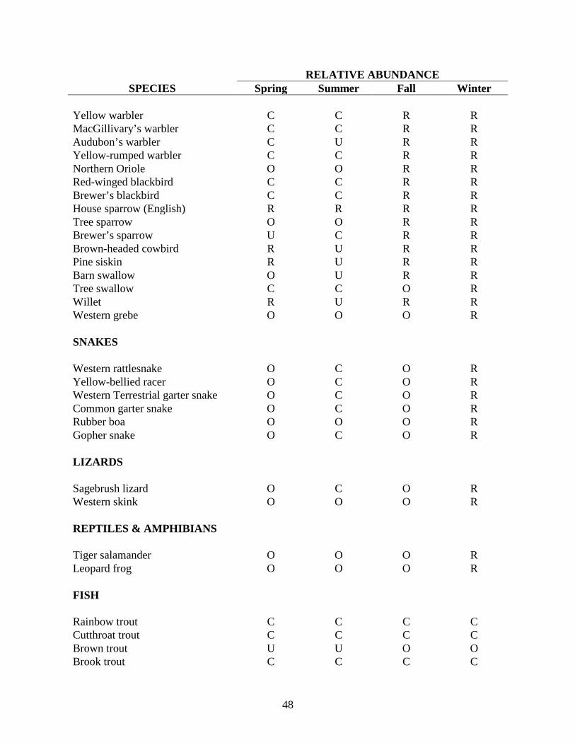
WILDLIFE SPECIES INVENTORY KEY: Spring (March-May) Summer (June-August) Fall (September-November) Winter (December-February) 1. A-Abundant, a species which is very numerous. 2. C-Common, certain to be seen or heard in suitable habitat. 3. U-Uncommon, present but not certain to be seen. 4. O-Occasional, seen only a few times during the season. 5. R-Rare, seen at intervals of 2 to 5 years. RELATIVE ABUNDANCE
SPECIES Spring Summer Fall Winter MAMMALS Elk A C C A Moose C C C C Mule deer A C C A White-tailed deer O O O O Bear O O O R Mountain lion O O O O Bobcat O O O O Coyote C C C C Nuttal’s cottontail O O O O White-tailed jackrabbit U U U U Least chipmunk U C C R Yellow-bellied marmot C C R R Richardson’s ground squirrel A A R R Golden mantled ground squirrel C C R R Red squirrel C C C C Northern pocket gopher C C C C Beaver C C C U Deer mouse A A A A Bushy-tailed wood rat A A A A Muskrat U U U U Porcupine C C C C Mink O O O O Badger C C C C Striped skunk R R R R

46
RELATIVE ABUNDANCE SPECIES Spring Summer Fall Winter
Great basin pocket mouse C C C C Montane meadow mouse C C C C Shrew (species unknown) O O O O Western jumping mouse C C C C BIRDS Golden eagle C U C C Bald eagle U U C C Turkey vulture R O O R Goshawk R R R R Sharp-shinned hawk O O O O Cooper’s hawk U O U R Northern harrier C C O O Rough-legged hawk R R R O Red-tailed hawk C C O R American kestrel C C C U Prairie falcon U U U O Great horned owl U U U U Short-eared owl U U U R Burrowing owl R R R R American widgeon O R O R Green-winged teal O R O R Mallard C C C R Killdeer C C O R Common snipe O C C R Herring gull O R R R Franklin’s gull O C O R Greater sandhill crane O O R R Spotted sandpiper C C O R Rock dove C C C O Sharp-tailed grouse C C C C Mourning dove C C U R Sage grouse U U U U Blue grouse U U U R Ruffed grouse C C C C Gray partridge U U U U Belted kingfisher O R R R Red-shafted flicker C C C C Yellow-bellied sapsucker C C O R Hairy woodpecker U U U O Downy woodpecker U U U U

47
RELATIVE ABUNDANCE SPECIES Spring Summer Fall Winter
Horned lark U U C A Steller’s jay O O O O Black-billed magpie C C C C Song sparrow C C C O White-crowned sparrow U R C O Chipping sparrow C U C C Slate-colored junco U R U R Oregon junco C O C C Vesper sparrow C C C O American goldfinch R C C R Green-tailed towhee C C C R Common raven C C C C Common crow C U O O Black-capped chickadee C U C C Mountain chickadee O O U O Calliope hummingbird C C O R Dipper R R R O Brown creeper O U O O Red-breasted nuthatch O O O O House wren C C R R Canyon wren U O U U Rock wren U C R R Long-billed marsh wren R R O R Robin A C A O Townsend’s solitaire C U C C Mountain bluebird C C C R Golden-crowned kinglet U R O R Ruby-crowned kinglet O R O R Water pipit R R U R Bohemian waxwing O R C C Northern shrike R R O R Loggerhead shrike O R R R Starling C C C R Western meadowlark C C U R Western tanager R U R R Evening grosbeak C O C C Pine grosbeak U R R U Black-headed grosbeak U R R U Gray-crowned rosy finch R R R U Purple finch R R R O Cassin’s finch U R R R Common redpoll C R C C
48
RELATIVE ABUNDANCE SPECIES Spring Summer Fall Winter
Yellow warbler C C R R MacGillivary’s warbler C C R R Audubon’s warbler C U R R Yellow-rumped warbler C C R R Northern Oriole O O R R Red-winged blackbird C C R R Brewer’s blackbird C C R R House sparrow (English) R R R R Tree sparrow O O R R Brewer’s sparrow U C R R Brown-headed cowbird R U R R Pine siskin R U R R Barn swallow O U R R Tree swallow C C O R Willet R U R R Western grebe O O O R SNAKES Western rattlesnake O C O R Yellow-bellied racer O C O R Western Terrestrial garter snake O C O R Common garter snake O C O R Rubber boa O O O R Gopher snake O C O R LIZARDS Sagebrush lizard O C O R Western skink O O O R REPTILES & AMPHIBIANS Tiger salamander O O O R Leopard frog O O O R FISH Rainbow trout C C C C Cutthroat trout C C C C Brown trout U U O O Brook trout C C C C

49
RELATIVE ABUNDANCE SPECIES Spring Summer Fall Winter
Kokanee U U C U Smallmouth bass U O O U Yellow perch U O O U Sculpin A A A A Redside shiner A A A A Dace A A A A Sucker A A A O Utah chub A A A O
50
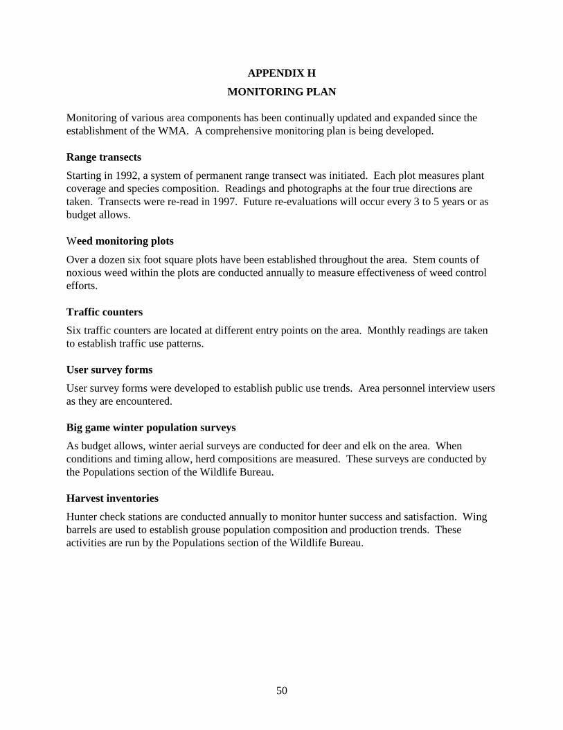
APPENDIX H
MONITORING PLAN Monitoring of various area components has been continually updated and expanded since the establishment of the WMA. A comprehensive monitoring plan is being developed. Range transects
Starting in 1992, a system of permanent range transect was initiated. Each plot measures plant coverage and species composition. Readings and photographs at the four true directions are taken. Transects were re-read in 1997. Future re-evaluations will occur every 3 to 5 years or as budget allows. Weed monitoring plots
Over a dozen six foot square plots have been established throughout the area. Stem counts of noxious weed within the plots are conducted annually to measure effectiveness of weed control efforts. Traffic counters
Six traffic counters are located at different entry points on the area. Monthly readings are taken to establish traffic use patterns. User survey forms
User survey forms were developed to establish public use trends. Area personnel interview users as they are encountered. Big game winter population surveys
As budget allows, winter aerial surveys are conducted for deer and elk on the area. When conditions and timing allow, herd compositions are measured. These surveys are conducted by the Populations section of the Wildlife Bureau.
Harvest inventories
Hunter check stations are conducted annually to monitor hunter success and satisfaction. Wing barrels are used to establish grouse population composition and production trends. These activities are run by the Populations section of the Wildlife Bureau.

51
APPENDIX I
CAPITAL IMPROVEMENTS AND DEVELOPMENTS Tex Creek WMA was originally an assortment of old homesteads with a number of buildings and structures. Most of these buildings have been destroyed, others have been improved and used for machinery storage. Building structures: 24' x 36' steel and concrete storage building (2) 10' x 20' steel and wood storage containers (3) 14' x 70' mobile homes 10' x 12' concrete block generator shed 10' x 12' wooden fire wood shed 40' x 20' wooden granary w/ attached lean-to 12' x 15' concrete block seed shed 10' x 12' concrete underground vault for water pressure tanks 6' x 8' wooden generator shed 30' x 50' steel Quonset 40' x 70' steel Quonset 12' x 12' open bay horse shed w/round corrals 30' x 60' open hay shed 10' x 14' concrete fuel tank catch basin (2) 50' diameter circular elk traps (1) unusable elk trap 40' x 20' granary---unused except as a landmark 30' x 50' steel Quonset---unused due to remote location from central facility Earth structures: (5) man-made ponds 150 erosion control terraces/check-dams Water improvements: 5 springs with control boxes and troughs Fences: 22 miles of 3 strand lay-down 21 miles of 3 and 4 strand 2 miles of field fence 13 miles of 3 strand, Ririe section boundary fence Campsites: Six areas have been approved and developed for camping. Each has a hitching rail and stock feed bunker. Plantings: Approximately 5,500 acres of dry land agricultural ground has been planted into permanent cover planting. Over 35,000 shrubs have been planted in the last four years.

52
800 acres of grain rotation are being planted for depredation control along the Willow Creek drainage.

53
APPENDIX J
LAND ACQUISITION
Source Funds Acres Cost 1981 A Rand Robinson HB530 160.00 $48,502 1982 Orlando Smith HB530 313.36 $67,500 1983 Wm & Zenna Longhurst HB530 489.76 $137,000 1984 Weeks Brothers HB530 2,278.00 $421,430 1984 HR Rockwood HB530 1,371.00 $395,000 1985 Nature Conservancy / Weeks HB530 464.00 $140,000 1985 Browns Meadow Creek Ranch HB530 680.00 $158,500 1986 Nature Conservancy / Brown HB530 464.00 $221,912 1989 Venna Croft Teton Mitigation 909.00 $95,500 1991 Harold & Phillip Schwieder HB530 280.00 $37,800 1991 AW Schwieder HB530 80.00 $10,800 1997 Rodney Payne / John Ferebauer HB530, RMEF, &
BPA 2,135.44 $778,300
Total 9,624.56 $2,512,244

54
APPENDIX K
CONSUMPTIVE USE INVENTORY
Estimated Consumptive Use Inventory Population Estimate Species Resident Seasonal No. Users User Days Harvest *Elk 80 3,200 1,400 7,486 294 *Deer 200 4,000 1,692 7,240 203 *Moose 30 20 29 18 29 Bobcat 10 ---- 3 30 1 Beaver 100 ---- 2 20 30 Muskrat 100 ---- 2 20 15 Raccoon 20 ---- 2 20 5 Sharp-tailed grouse 200 250 75 300 100 Sage grouse 50 75 10 20 10 Gray partridge 100 ---- 10 20 50 Ruffed grouse 300 ---- 50 150 200 Blue grouse 200 ---- 20 40 50 Mourning dove 500 2,500 30 60 120 Trout 5,000 ---- 300 900 1,200
*Number of users, number of user days, and harvest taken from 1995 Clearwater Research, Inc. controlled hunt telephone survey. Other estimates from Tex Creek WMA staff, 1997.

55
APPENDIX L
NON-CONSUMPTIVE USE INVENTORY
Estimated Non-consumptive Use Inventory* Use No. Users User days Education 90 7 Photography 40 120 Wildlife observation 200 600 Sightseeing 200 700 Horseback riding 50 100 Scouting / pre-hunt 240 480 Camping 50 100 Picnicking 30 30 Hiking 20 40 Mountain biking 20 40 Snowmobiling 100 200
*Estimated by Tex Creek WMA staff, 1997.

56
Plan prepared by: Terry R. Thomas Regional Wildlife Habitat Biologist Plan reviewed by: Steve Schmidt Regional Wildlife Habitat Manager Tom Parker State Wildlife Habitat Manager Plan approved by: Don Wright Regional Supervisor