geology update of the ohio utica-point pleasant play · geology update of the ohio utica-point...
TRANSCRIPT

Geology Update of the Ohio
Utica-Point Pleasant Play
Chris Perry Ohio Geological Survey
Ohio EPA Brownfield Conference
Columbus, OH May 23, 2012
Acknowledgements
Larry Wickstrom, Matt Erenpreiss, Ron Riley, Dean Martin, Greg Schumacher, Joe Wells, Lisa Van Doren, Chuck Salmons
– Ohio Geological Survey Geological Surveys of PA, WV, & NY Jackie Reed – Reed Geochemical
Consulting USGS – Bob Ryder, Sue Tewalt, Bob Milici,
Jingle Rupert

Talk Outline
Important Concepts: Source and Reservoir Rocks • Porosity & Permeability • Conventional vs. Unconventional Reservoirs • Paradigm Shift • Vertical vs. Horizontal Drilling
Utica Shale Geology Status of Utica Shale Play Brine Disposal & Water Usage Impacts & Potential of the Utica Shale Play

Ohio Oil & Gas Fields
•Ohio currently has in excess of 63,000 producing oil & gas wells
•Historically, over 250,000 wells have been drilled
•Production has been established in 66 of our 88 Counties.
The Lima-Indiana Trend of NW Ohio was one of the first true giant fields produced in the U.S. (1884-1934)
•Thus, oil & gas is not new to Ohio
Oil & Gas

Sandstone: A Conventional Reservoir Rock

A porous sandstone prepared for viewing under a microscope reveals pore spaces (blue areas).
SAND GRAIN
PORE
PORE
SAND GRAIN
SAND GRAIN
Gra
phic
from
Kos
teln
ick
(201
0).
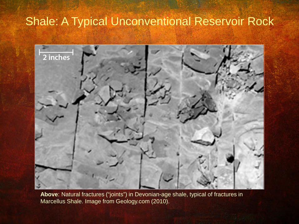
Above: Natural fractures (“joints”) in Devonian-age shale, typical of fractures in Marcellus Shale. Image from Geology.com (2010).
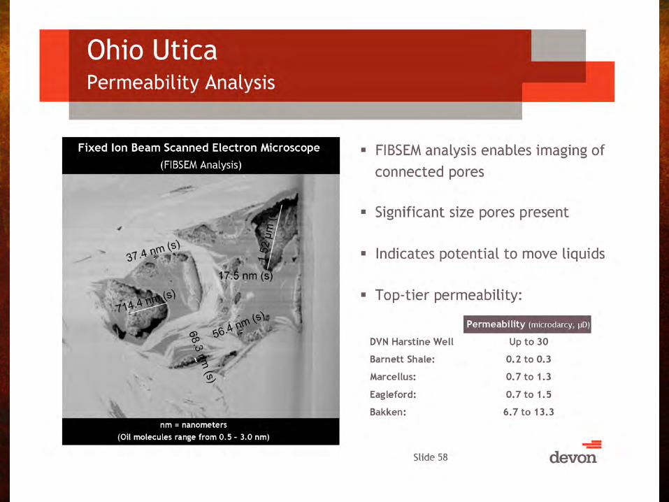
Shale: A Typical Unconventional Reservoir Rock
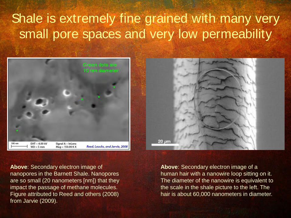
Shale is extremely fine grained with many very small pore spaces and very low permeability
Above: Secondary electron image of nanopores in the Barnett Shale. Nanopores are so small (20 nanometers [nm]) that they impact the passage of methane molecules. Figure attributed to Reed and others (2008) from Jarvie (2009).
Above: Secondary electron image of a human hair with a nanowire loop sitting on it. The diameter of the nanowire is equivalent to the scale in the shale picture to the left. The hair is about 60,000 nanometers in diameter.

Organic Porosity Development

Oil
From
Kos
teln
ick
(201
0), m
odifi
ed fr
om S
chm
oker
and
Osc
arso
n (1
995)
.
Paradigm Shift
Recent technological innovations allow some shales to be considered “unconventional” reservoirs.
Oil
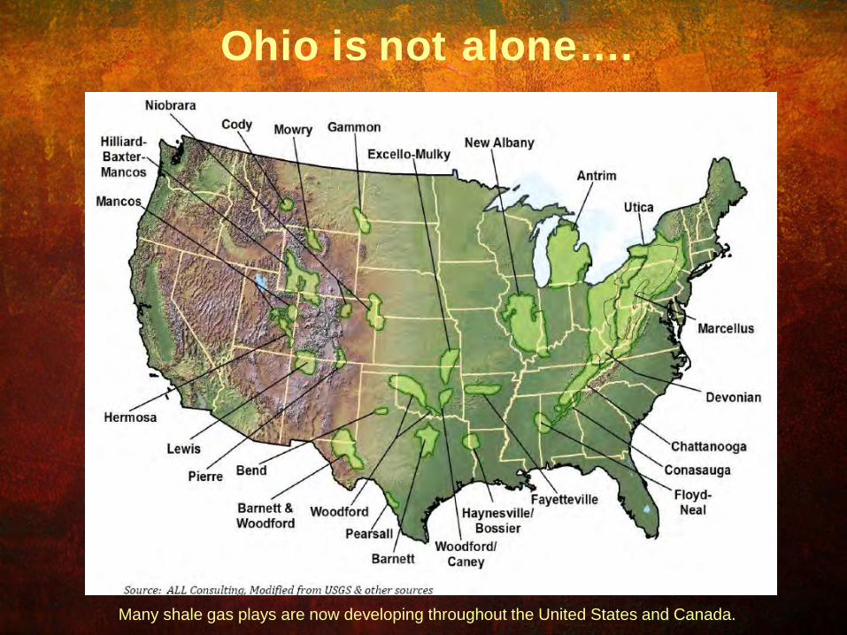
Many shale gas plays are now developing throughout the United States and Canada.
Ohio is not alone….

Late Ordovician with hypothetical currents
Mitchell and Bergström, 1991; and Ettensohn, 1999
http://www.mcz.harvard.edu/Departments/InvertPaleo/Trenton/Intro/GeologyPage/Geologic%20Sett
ing/paleoenvironmental.htm
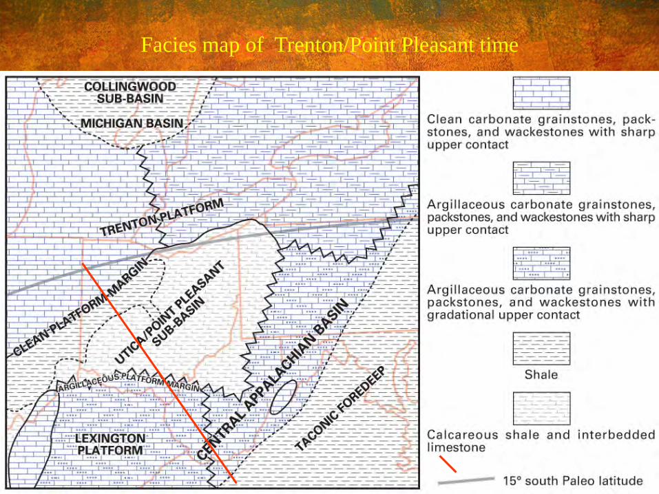
Facies map of Trenton/Point Pleasant time
Cross section
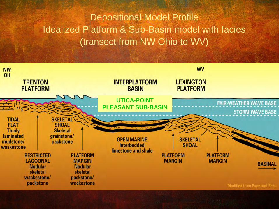
Depositional Model Profile Idealized Platform & Sub-Basin model with facies
(transect from NW Ohio to WV)
UTICA-POINT PLEASANT SUB-BASIN

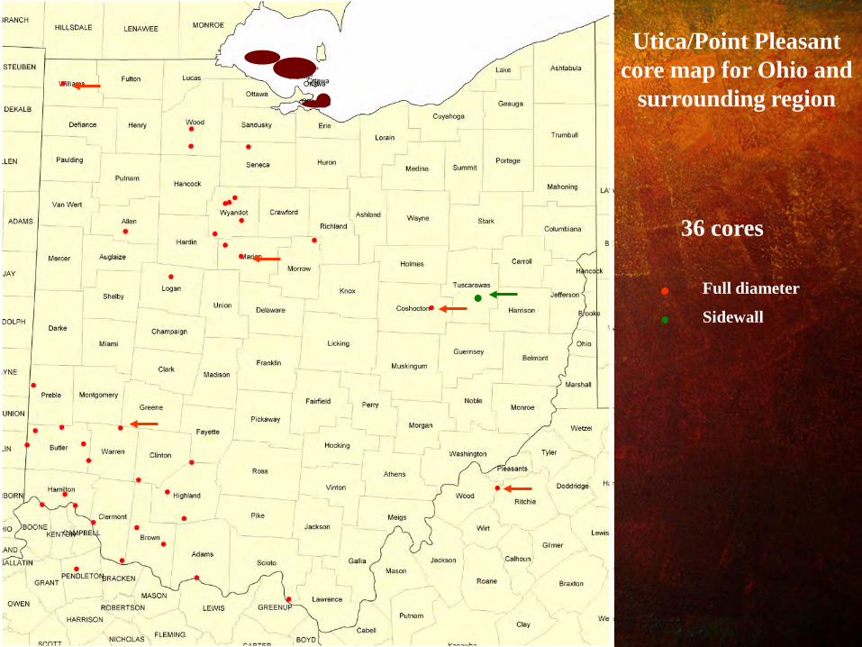
Utica/Point Pleasant core map for Ohio and
surrounding region
36 cores
Full diameter
Sidewall
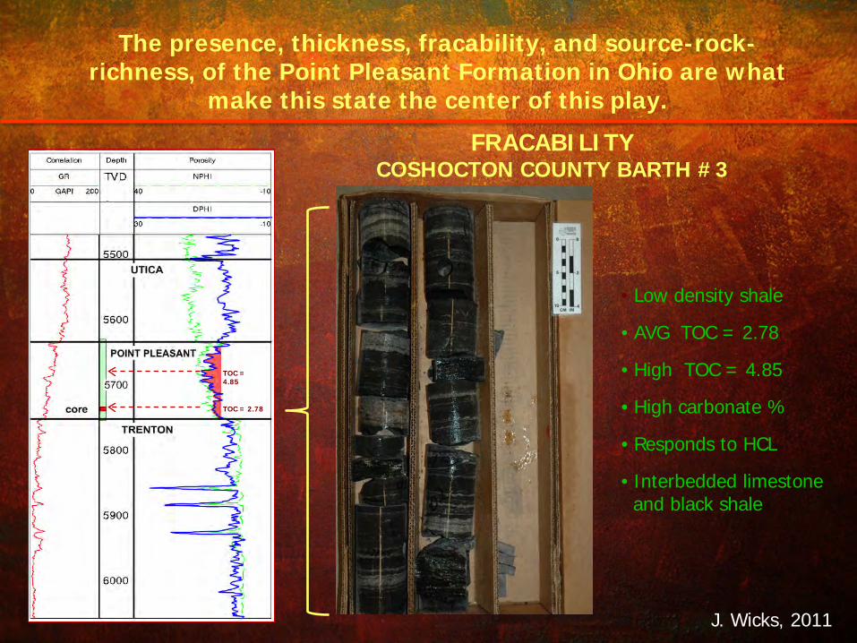
• Low density shale
• AVG TOC = 2.78
• High TOC = 4.85
• High carbonate %
• Responds to HCL
• Interbedded limestone and black shale
TOC = 4.85
TOC = 2.78
FRACABILITY COSHOCTON COUNTY BARTH #3
J. Wicks, 2011
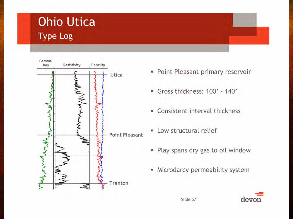
The presence, thickness, fracability, and source-rock-richness, of the Point Pleasant Formation in Ohio are what
make this state the center of this play.

CO2 No. 1 Well Tuscarawas County, Ohio
Point Pleasant
Depth: 6282.0 FEET Permeability (Klink.): 0.0003 mD Porosity: 4.2% Grain Density: 2.70 gm/cc
Lithology: Fossiliferous, slightly dolomitic mudstone (shale) to
argillaceous skeletal wackestone Framework Grains: Minor fine silt-sized to medium silt-sized quartz and mica; abundant calcareous fossil fragments (typically concentrated in layers), including bivalves, echinoderm fragments ostracods, rare phosphatic shell fragments and brachiopod spines, common organic particles
Matrix: Abundant detrital clay

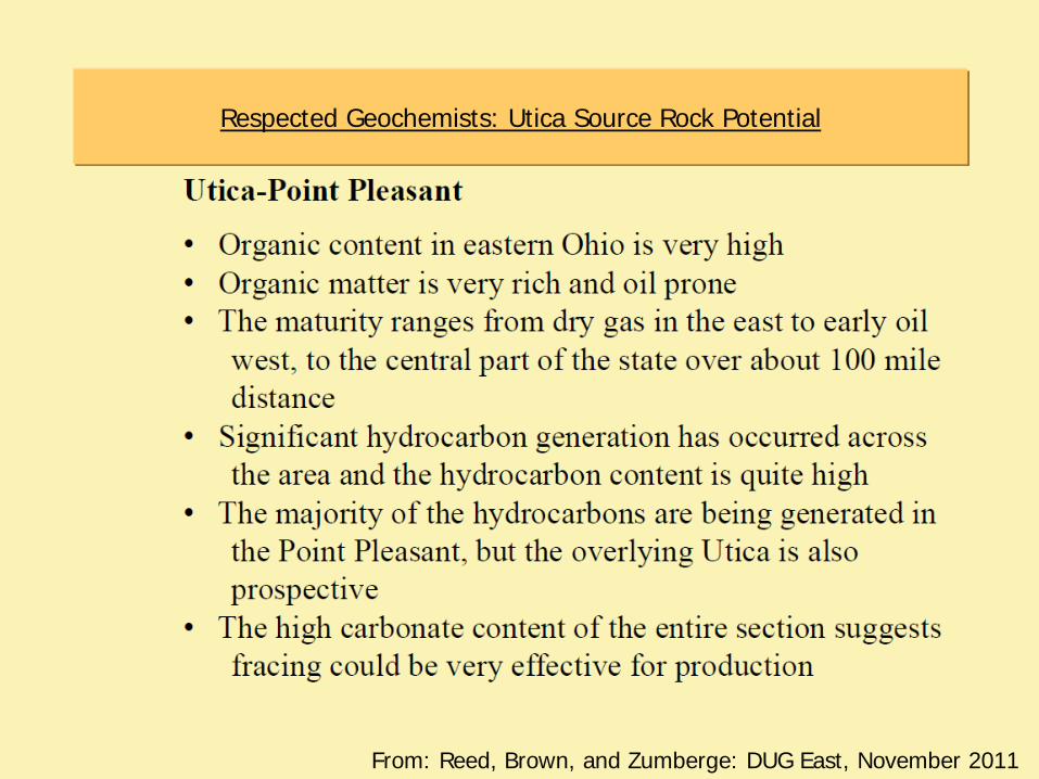
From: Reed, Brown, and Zumberge: DUG East, November 2011
Respected Geochemists: Utica Source Rock Potential

Ohio Geological Survey Core and Sample Repository
Number of Visitors using OGS’ sample repository – 2006 thru 2008: 134 visitors/yr (avg) – 2009: 439 (Utica-Pt.Plsnt sampling began) – 2010: 456 – 2011: 472 – 2012: 91 (thru 3/15)
Since Play’s Inception: Total wells sampled (cuttings):183
– total samples analyzed: 4,143
Total cores examined and sampled: 20 – total core samples analyzed: 586
One year confidentiality from date of sampling.

Wells with Utica-Point Pleasant Source Rock Analyses
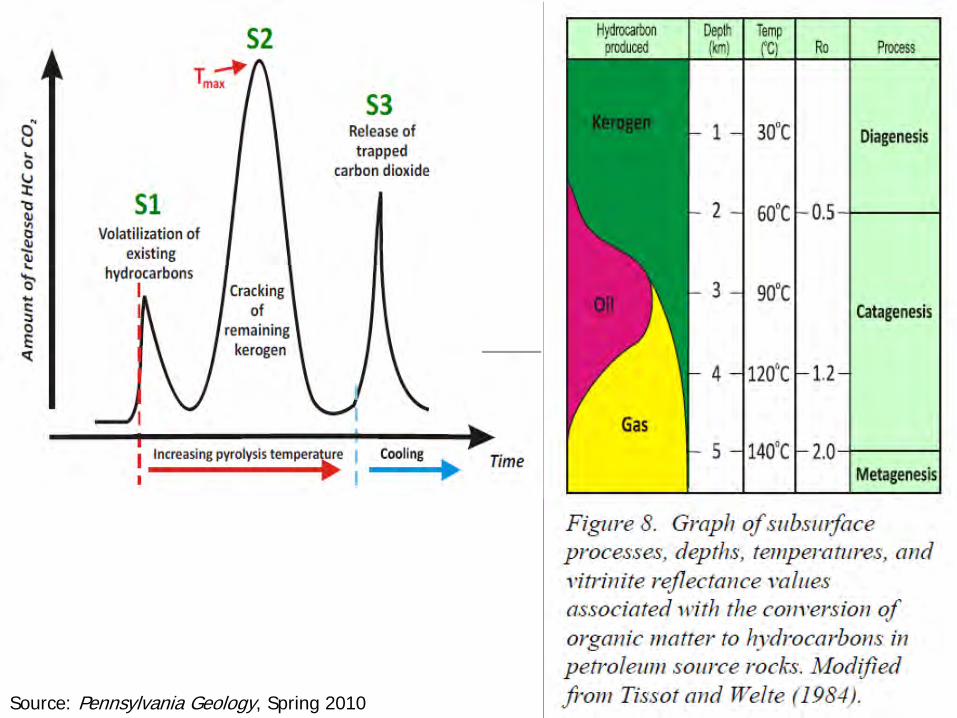
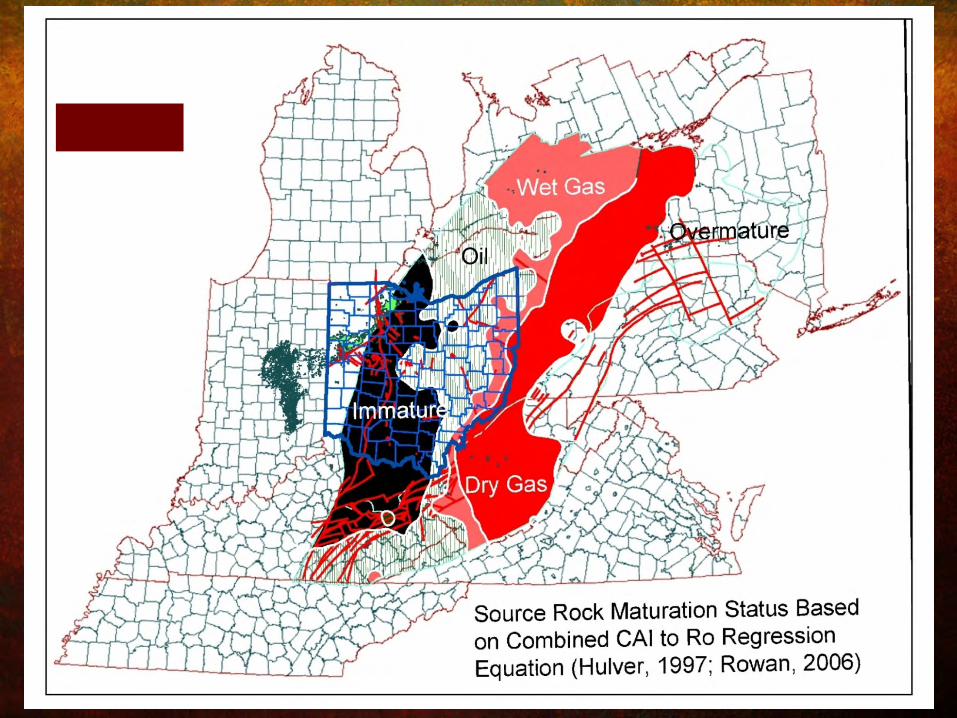
Source: Pennsylvania Geology, Spring 2010
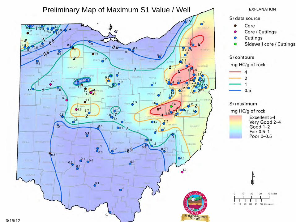
Preliminary Map of Maximum S1 Value / Well
3/15/12
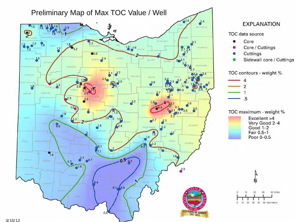
Preliminary Map of Max TOC Value / Well
3/15/12
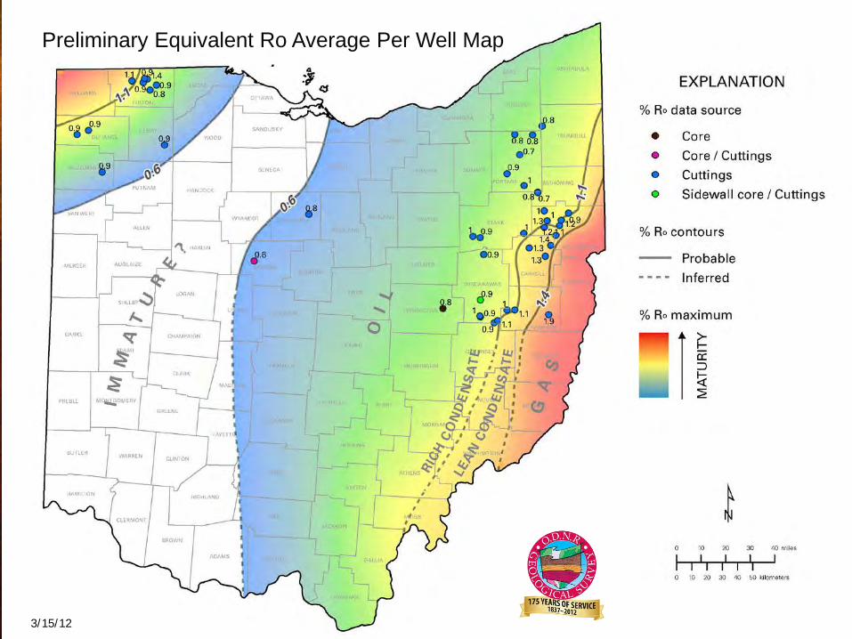
Preliminary Equivalent Ro Average Per Well Map
3/15/12
3/15/12
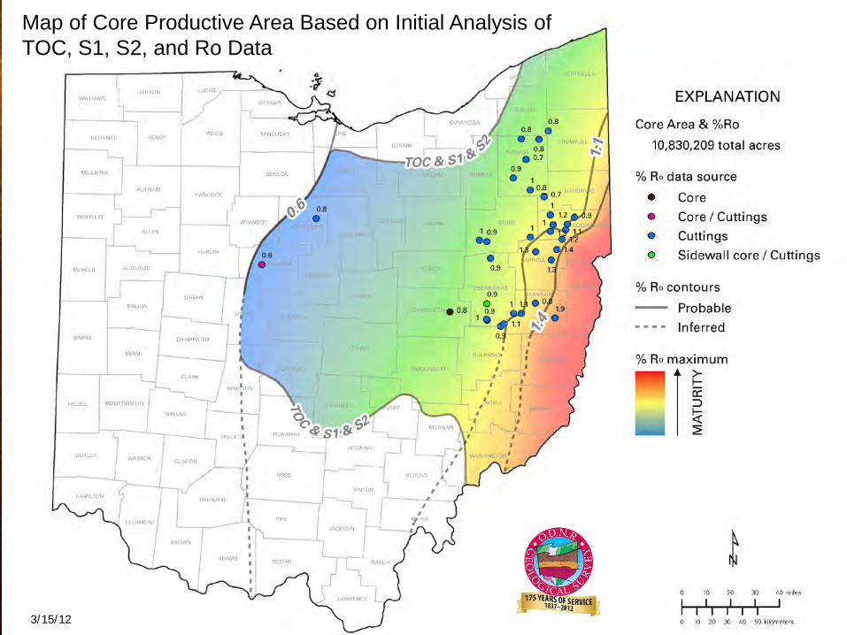
Map of Core Productive Area Based on Initial Analysis of TOC, S1, S2, and Ro Data
Play core area defined by TOC, S1, S2, and Ro
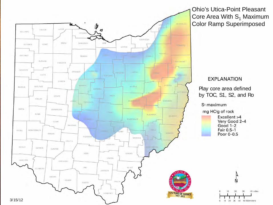
Ohio’s Utica-Point Pleasant Core Area With S1 Maximum Color Ramp Superimposed
3/15/12


Figure source: R.T. Ryder, USGS OFR 2008-1287
Gas-prone areas of Utica Shale found to be in the deeper portion of the basin. Much of Ohio may contain appreciable amounts of oil within Utica Wells, as illustrated by this schematic cross section by Ryder,(2008) which shows the results of geochemical analyses of well samples.
Why Ohio may be the Focus of the Utica-Point Pleasant Play
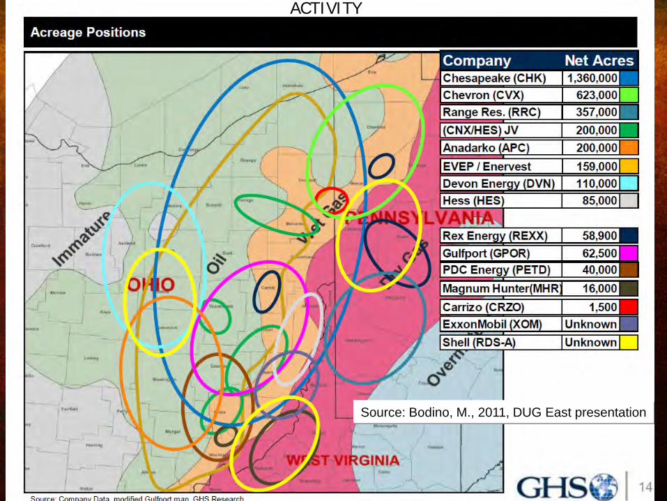
Source: Bodino, M., 2011, DUG East presentation
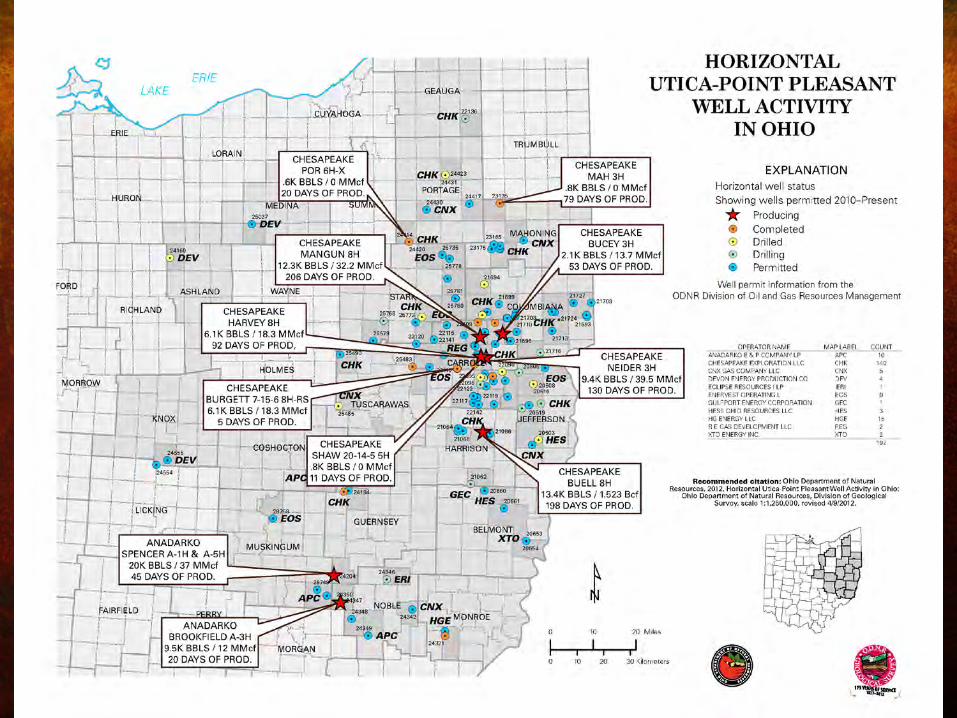
ACTIVITY
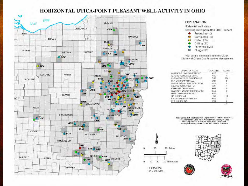
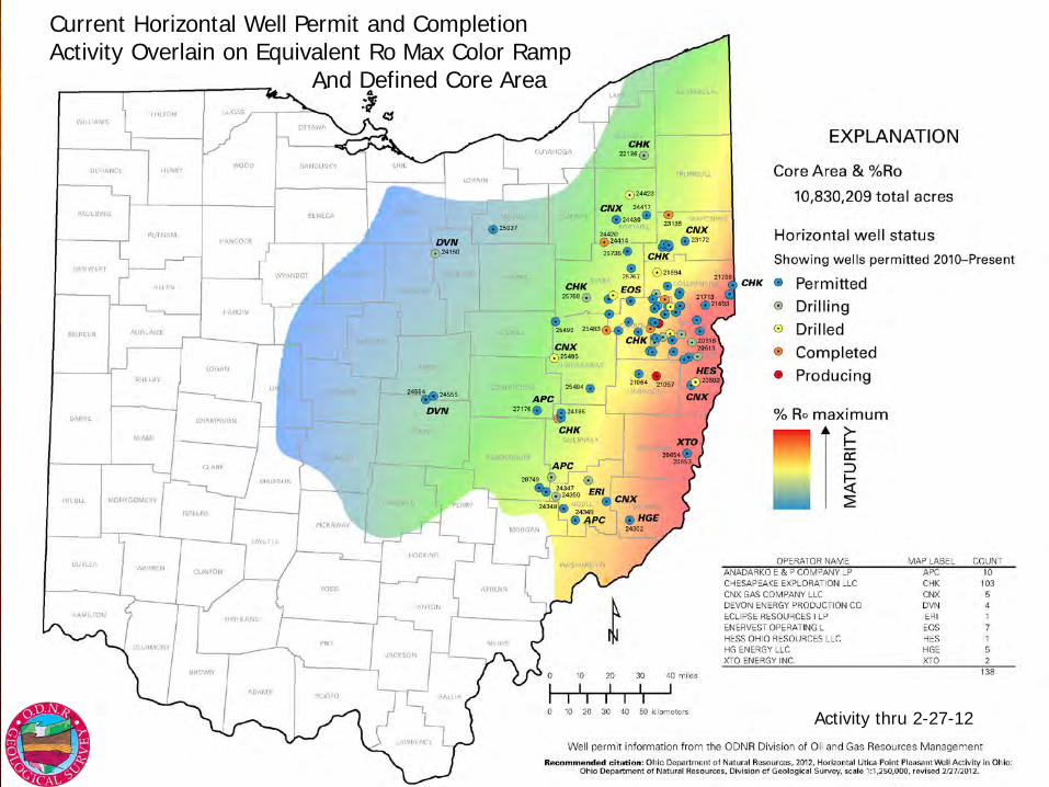
Current Horizontal Well Permit and Completion Activity Overlain on Equivalent Ro Max Color Ramp And Defined Core Area
Activity thru 2-27-12


Generalized Geology and Profile of a Utica Shale Well Prototype in East Central Ohio
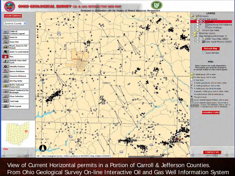
View of Current Horizontal permits in a Portion of Carroll & Jefferson Counties. From Ohio Geological Survey On-line Interactive Oil and Gas Well Information System
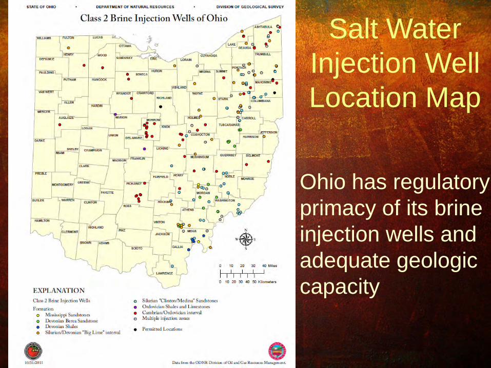
Ohio has regulatory primacy of its brine injection wells and adequate geologic capacity
Salt Water Injection Well Location Map
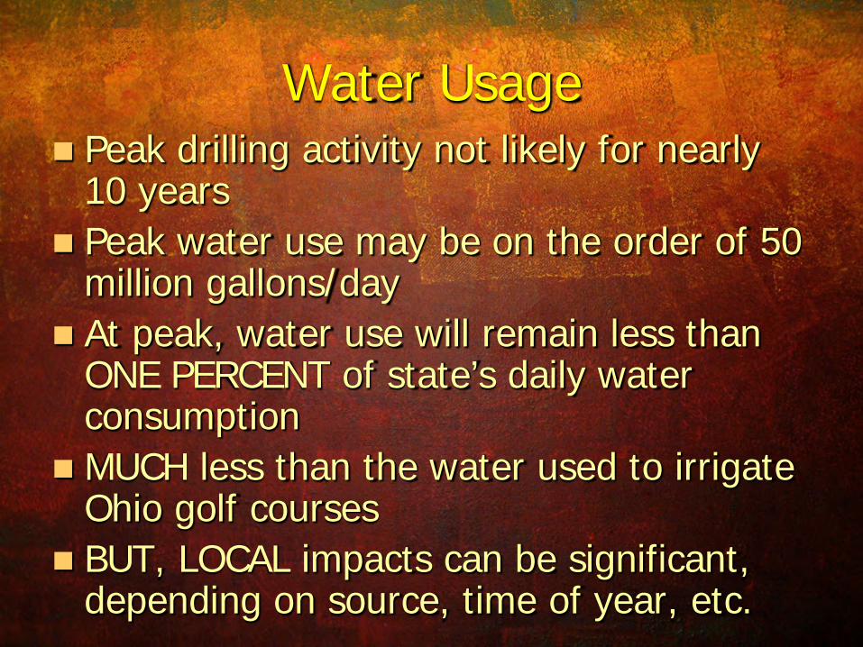
Water Usage Peak drilling activity not likely for nearly
10 years Peak water use may be on the order of 50
million gallons/day At peak, water use will remain less than
ONE PERCENT of state’s daily water consumption
MUCH less than the water used to irrigate Ohio golf courses
BUT, LOCAL impacts can be significant, depending on source, time of year, etc.
References Cole, G.A., and others, 1987, Organic Geochemistry and Oil-Source Correlations, Paleozoic of Ohio: AAPG Bulletin, v.
71, No. 7, p. 788-809. Cornell, S. R. 2000. Sequence Stratigraphy and Event Correlations of upper Black River and lower Trenton Group
Carbonates of northern New York State and southern Ontario, Canada: Cincinnati, Ohio, University of Cincinnati, M.S Thesis.
EnerVest, 2011, Developing Unconventional Gas (DUG) East Conference, John Walker, Pittsburgh PA November 17 GHS Research, 2011, (Global Hunter Securities), DUG East Conference, Michael Bodino, Pittsburgh PA,November 17 Jarvie, D.M., Shale Plays: Making Gas and Oil from Shale Resource Systems, 2010 Dallas Geo. Society 5/12/10 McDowell, A.N., 1976, What are the problems in estimating the oil potential of a basin?: Oil and Gas Journal, June 9,
1975, p. 85-90. Patchen, D.G., Hickman, J.B., Harris, D.C., Drahovzal, J.A., Lake, P.D., Smith, L.B., Nyahay, R., Schulze, R., Riley, R.A.,
Baranoski, M.T., Wickstrom, L.H., Laughrey, C.D., Kostelnik, J., Harper, J.A., Avary, K.L., Bocan, J., Hohn, M.E., and McDowell, R., 2006, A geologic play book for Trenton-Black River Appalachian basin exploration: U.S. Department of Energy Report, Morgantown, WV, DOE Award Number DE-FC26-03NT41856
Pollastro, R.M., Cook, T.A., Roberts, L.N.R., Schenk, C.J., Lewan, M.D., Anna, L.O., Gaswirth, S.B., Lillis, P.G., Klett, T.R., and Charpentier, R.R., 2008, Assessment of undiscovered oil resources in the Devonian-Mississippian Bakken Formation, Williston Basin Province, Montana and North Dakota, 2008: U.S. Geological Survey Fact Sheet 2008–3021, 2 p.
Repetski, J.E., Ryder, R.T., Weary, D.J., Harris, A.G., and Trippi, M.H., 2008, Thermal maturity patterns (CAI and %Ro) in Upper Ordovician and Devonian rocks of the Appalachian basin—A major revision of USGS Map I–917–E using new subsurface collections: U.S. Geological Survey Scientific Investigations Map 3006.
Ryder, R.T., 2008, Assessment of Appalachian basin oil and gas resources: Utica-Lower Paleozoic Total Petroleum System: U.S. Geological Survey Open-File Report 2008–1287.
Wickstrom, L. H., E.R. Venteris, J.A. Harper, and 26 other authors, 2005, Characterization of geologic sequestration opportunities in the MRCSP region—Final report under DOE cooperative agreement DE-PS26-05NT42255: Ohio Department of Natural Resources, Division of Geological Survey Open File Report 2005-1, 152 p. <http://www.dnr.state.oh.us/portals/10/pdf/OpenFileReports/OFR_2005-1.pdf>
Riley, R.A., 2010, A Utica-Point Pleasant type log for eastern Ohio: Ohio Department of Natural Resources, Division of Geological Survey, one sheet (PDF), available at <http://www.dnr.state.oh.us/Portals/10/Energy/Utica/TuscarawasWellRockAnalyses.pdf>.
Wallace L.G. and Roen, J.B., 1989, Petroleum source rock potential of the Upper Ordovician black shale sequence, northern Appalachian basin: U. S. Geological Survey Open-file report 89-488, 66 p.
Wickstrom, L.H., J.D. Gray, and R.D. Stieglitz, 1992, Stratigraphy, structure, and production history of the Trenton Limestone (Ordovician) and adjacent strata in northwestern Ohio: Ohio Department of Natural Resources, Division of Geological Survey Report of Investigations No. 143, 78 p., 1 pl.

www.OhioGeology.com