geospatial decision making in the semantic web · 2016-09-11 · geospatial decision making in the...
TRANSCRIPT

Geospatial Decision Making Geospatial Decision Making in the Semantic Webin the Semantic Web
Patrick Maué (IFGI)Dumitru Roman (STI)
GEOWS 2009 February 1st, 2009 - Cancun, Mexico
GEOWS.2009We are: IFGIWe are: IFGI/Introduction
- 2 -
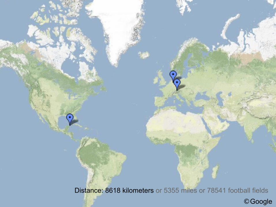
Distance: 8618 kilometers or 5355 miles or 78541 football fields ©Google

GEOWS.2009We are: STI2We are: STI2/Introduction
- 2 -
Münster
Innsbruck

GEOWS.2009We are: STI InternationalWe are: STI International/Introduction
- 2 -
Semantic Technologies Institute International Research in:
– Knowledge representation– Semantic Web– Service-Oriented Computing

GEOWS.2009We are: IFGIWe are: IFGI/Introduction
- 2 -
Institute for Geoinformatics at University of Münster, Germany
Research in – Semantic Interoperability – Spatial Assistance Systems– Sensor Web and Geoprocessing– Environmental Measurement and Spatio-temporal Modeling

GEOWS.2009Background: the SWING projectBackground: the SWING project/Introduction
- 2 -
Semantic Web Services Interoperability for Geospatial Decision Making
GEOWS.2009Background: the SWING projectBackground: the SWING project/Introduction
- 2 -
Presented results mostly outcome of this project 3 Years until 02.2009 Seven Partners, including users (BRGM), companies (ERDAS)
and research (DERI, JSI, SINTEF) BRGM Use Cases further discussed later http://www.swing-project.org (with all deliverables and
publications)

GEOWS.2009And who are you?And who are you?/Introduction
- 2 -

GEOWS.2009Tutorial ObjectiveTutorial Objective/Introduction
- 2 -
Demonstrating the SWING framework Geospatial Semantic Web
– Discussing Potential Applications– Showing potential benefits
Raise your interest

GEOWS.2009OverviewOverview/Introduction
- 2 -
Spatial Data Infrastructures Semantic Web Services Bridging the gap: Semantic Annotations SWING: use cases
SWING: Developed Tools Demonstration (Videos) Hands-On Session

Spatial Data InfrastructuresSpatial Data Infrastructures
Patrick Maué (IFGI)
GEOWS 2009 February 1st, 2009 - Cancun, Mexico

GEOWS.2009OverviewOverview
/ Spatial Data Infrastructures
- 2 -
Introducing Spatial Data Infrastructures The European INSPIRE Directive SDI Standards Examples of standard Web Services SDI Applications: Geospatial Decision-Making Web Service Compositions for Complex Tasks Contemporary Problems of SDIs

GEOWS.2009
Transition from desktop GIS to distributed services Why we need SDI?
– Keeping data up-to-date– Discovery and Evaluation (cross-country)– Resource-intensive– Billing and Security
- 2 -
What is SDI?What is SDI?
/ Spatial Data Infrastructures
GEOWS.2009
Transition from desktop GIS to distributed services Why we need SDI?
– Keeping data up-to-date– Discovery and Evaluation (cross-country)– Resource-intensive– Billing and Security
SDI rebuild all functionality of GIS SDI framework provides basis for
– Finding and Accessing spatial data– Describing and Evaluating spatial data
Applications built on top of SDIs
- 2 -
What is SDI?What is SDI?
/ Spatial Data Infrastructures

GEOWS.2009INSPIRE in EuropeINSPIRE in Europe
/ Spatial Data Infrastructures
- 2 -
Different data formats and quality standards across national borders
Some Principles (Excerpt)– It must be possible to combine spatial data from different sources
across the EU seamlessly and share them between several users and applications.
– It should be easy to discover available spatial data, evaluate their fitness for purpose and know the conditions applicable to their use.
Harmonisation (Standards!) required

GEOWS.2009Standards in SDIsStandards in SDIs
/ Standards
- 2 -
Open Geospatial Consortium (OGC) Currently 372 Members (Companies, Universities, …) Provides open standards Implementation guidelines for all SDI components
– Geospatial Web Services – Geospatial Data
OGC conformal Web Services can interoperate, regardless the intended applications and the served data.
GEOWS.2009OGC Standards: OWS CommonOGC Standards: OWS Common
/ Standards
- 2 -
OGC Conformal Web Service specifies– Access over HTTP (with KVP-encoding) – Minimum set of metadata – The getCapabilities operation– Exceptions handling– ...
Normative reference for all OGC standards

GEOWS.2009OGC Standards: WFSOGC Standards: WFS
/ Standards
- 2 -
Web Feature Service Interface– Specifies interface to retrieve Geographic Features– Data coming, for example, as Points, Lines, and Polygons– Features have Geometries and additional attributes– Data model specified in Feature Type Schema

GEOWS.2009WFS output example WFS output example
/ Standards
- 2 -
<element name="Zico_region" type="con:Zico_regionType" substitutionGroup="gml:_Feature" /> <complexType name="Zico_regionType"> <complexContent> <extension base="gml:AbstractFeatureType"> <sequence> <element name="msGeometry" type="gml:GeometryPropertyType"/> <element name="REGIONAL" type="string"/> <element name="NATIONAL" type="string"/> <element name="LIBELLE" type="string"/> <element name="TYPE" type="string"/> <element name="LA_MESURE" type="string"/> </sequence> </extension> </complexContent> </complexType>
Feature Type Zico_region

GEOWS.2009OGC Standards: WFSOGC Standards: WFS
/ Standards
- 2 -
Web Feature Service Interface– Specifies interface to retrieve Geographic Features– Data coming, for example, as Points, Lines, and Polygons– Features have Geometries and additional attributes– Data model specified in Feature Type Schema– Geographic Features with Geometry and arbitrary attributes
WFS data encoded in OGC GML– XML-dialect used to encode feature-based geospatial data– Adapted ISO standard
+ WCS, WCTS, …– The storage layer of traditional GIS

GEOWS.2009OGC Standards: WPS and WMSOGC Standards: WPS and WMS
/ Standards
- 2 -
Web Processing Service (WPS) Interface – Provides executable processes– No restrictions on input and output data– Takes role of GIS processing component

GEOWS.2009OGC Standards: WPS and WMSOGC Standards: WPS and WMS
/ Standards
- 2 -
Web Processing Service (WPS) Interface – Provides executable processes– No restrictions on input and output data– Takes role of GIS processing component
Web Mapping Service (WMS)– Visualisation of geospatial data– Render images in common formats– Can be directly integrated into websites

GEOWS.2009ExamplesExamples
/ Standards
- 2 -
Requesting a WFS from the Browser Requesting a WFS from generic GIS client

GEOWS.2009Geospatial Decision-MakingGeospatial Decision-Making Space as factor for decision making Examples: landfills, power plants, route planning Is a multi-criteria analysis looking at
– Constraints (e.g. Important Bird Areas)– Requirements (e.g. water access)
Requires – Acquisition of needed data– Preparation of data– Running the analysis– Rendering results for domain experts
/ Applications

GEOWS.2009ConstraintsConstraints
/ Applications
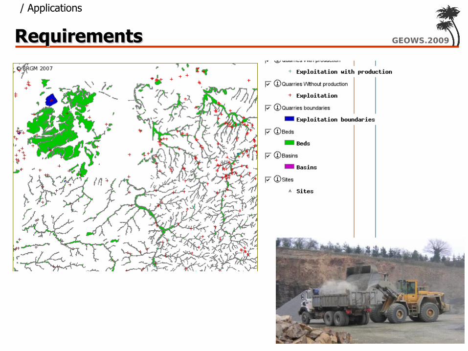
GEOWS.2009RequirementsRequirements
/ Applications

GEOWS.2009WorkflowsWorkflows Composing atomic Web Services Result itself a complex Web Service Workflow Engines Workflow Modeling Approaches
– XML-based (BPEL, Wf-XML)– UML-based (Activity Diagrams)– ASM or Petri-Nets
/ Workflows

GEOWS.2009Workflow exampleWorkflow example
/ Workflows
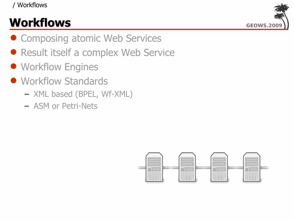
GEOWS.2009WorkflowsWorkflows Composing atomic Web Services Result itself a complex Web Service Workflow Engines Workflow Standards
– XML based (BPEL, Wf-XML)– ASM or Petri-Nets
/ Workflows

GEOWS.2009Open Issues of SDIsOpen Issues of SDIs Harmonization in between Standards Security and licensing Complexity & Performance Semantic Interoperability
/ Open Issues

GEOWS.2009Semantic InteroperabilitySemantic Interoperability
<element name="Zico_region" type="con:Zico_regionType" substitutionGroup="gml:_Feature" /> <complexType name="Zico_regionType"> <complexContent> <extension base="gml:AbstractFeatureType"> <sequence> <element name="msGeometry" type="gml:GeometryPropertyType"/> <element name="REGIONAL" type="string"/> <element name="NATIONAL" type="string"/> <element name="LIBELLE" type="string"/> <element name="TYPE" type="string"/> <element name="LA_MESURE" type="string"/> </sequence> </extension> </complexContent> </complexType>

GEOWS.2009OverviewOverview/Introduction
- 2 -
Spatial Data Infrastructures Semantic Web Services Bridging the gap: Semantic Annotations SWING: use cases
SWING: Developed Tools Demonstration (Videos) Hands-On Session

Semantic Web Services (SWS)Semantic Web Services (SWS)
GEOWS 2009 February 1st, 2009 - Cancun, Mexico

GEOWS.2009OutlineOutline
• Tasks to be automated in SWS• Ontologies and Web services: the WSMO approach• WSML – the language for formalizing WSMO• Web Service Discovery
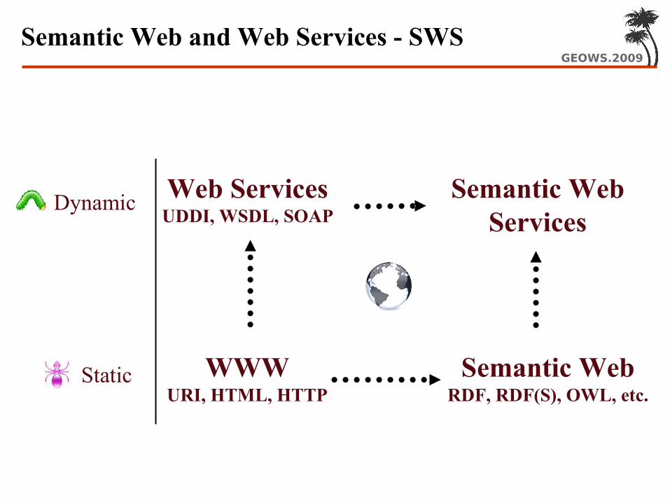
GEOWS.2009Semantic Web and Web Services - SWS
Static WWWURI, HTML, HTTP
Semantic WebRDF, RDF(S), OWL, etc.
Dynamic Web ServicesUDDI, WSDL, SOAP
Semantic WebServices
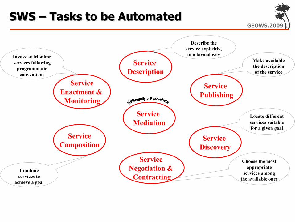
GEOWS.2009SWS – Tasks to be AutomatedSWS – Tasks to be Automated
Service Publishing
Service Description
ServiceEnactment &
Monitoring
Describe the service explicitly, in a formal way
Make available the description of the service
Locate different services suitable for a given goal
Combine services to
achieve a goal
Choose the most appropriate
services among the available ones
Invoke & Monitor services following
programmatic conventions
ServiceComposition
Service Negotiation &
Contracting
Service Discovery
Service Mediation

GEOWS.2009The WSMO Approach to SWSThe WSMO Approach to SWS
Objectives that a client may have when consulting a Web Service
Semantic description of WebServices: • Capability (functional)• Interfaces (usage)
Connectors between components withmediation facilities for handling
heterogeneities
Provide the formallyspecified terminology
of the information usedby all other components
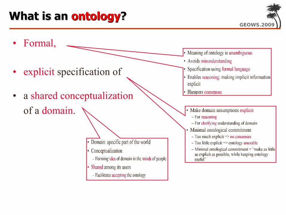
GEOWS.2009What is an What is an ontologyontology??
• Formal,
• explicit specification of
• a shared conceptualization of a domain.

GEOWS.2009Elements of OntologiesElements of Ontologies
Concept conceptual entity of the domain
Propertyattribute describing a concept
Relationrelationship between concepts or properties
Axiom coherency description between Concepts / Properties / Relations via logical expressions
Instanceindividual in the domain
Person
Student Professor
Lecture
isA – hierarchy (taxonomy)
name email
studentID
researchfield
topiclectureno.
attends holds
holds(Professor, Lecture) =>Lecture.topic = Professor.researchField
Ann memberOf student name = Ann Lee studentID = 12345

GEOWS.2009
Wide Variety of Languages for Wide Variety of Languages for Specifying OntologiesSpecifying Ontologies
• Graphical: Semantic Networks, Topic Maps, UML, RDF
• Logical: Description Logics, First Order Logic, Rules, Conceptual Graphs

GEOWS.2009A Conceptual Model for Web ServicesA Conceptual Model for Web Services
Web ServiceImplementation(not of interest in Web Service Description)
Capability
functional description
WSWS
WSWS
- Advertising of Web Service- Support for WS Discovery
client-service interaction interface for consuming WS - external visible
behavior- communication
structure - ‘grounding’
realization of functionality by aggregation- functional
decomposition - WS composition
Non-functional Properties
DC + QoS + Version + financial
- complete item description- quality aspects - Web Service Management
WSWS
Orchestration Interface

GEOWS.2009
Web Service Modeling Language Web Service Modeling Language (WSML)(WSML) Aim – to provide a language (or a set of interoperable
languages) for representing the elements of WSMO: Ontologies, Web services, Goals, Mediators
For ontologies, WSML provides a formal language based on:
– Description Logics– Logic Programming– First-Order Logic– F-Logic
WSML is a family of languages layered on top of XML and RDF
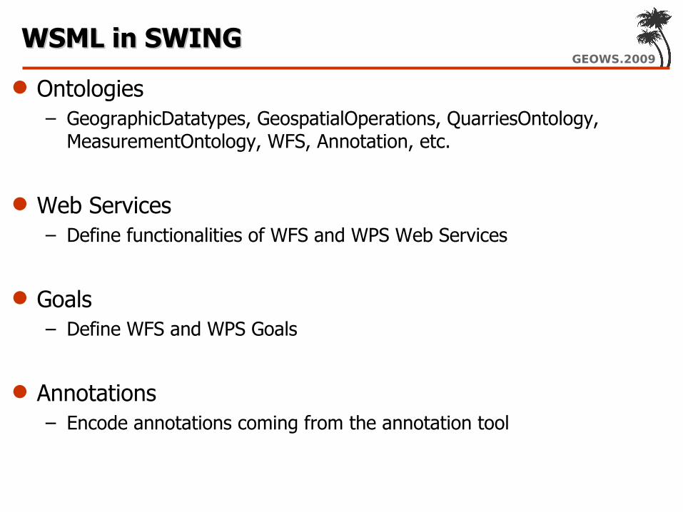
GEOWS.2009WSML in SWINGWSML in SWING
Ontologies– GeographicDatatypes, GeospatialOperations, QuarriesOntology,
MeasurementOntology, WFS, Annotation, etc.
Web Services– Define functionalities of WFS and WPS Web Services
Goals– Define WFS and WPS Goals
Annotations– Encode annotations coming from the annotation tool
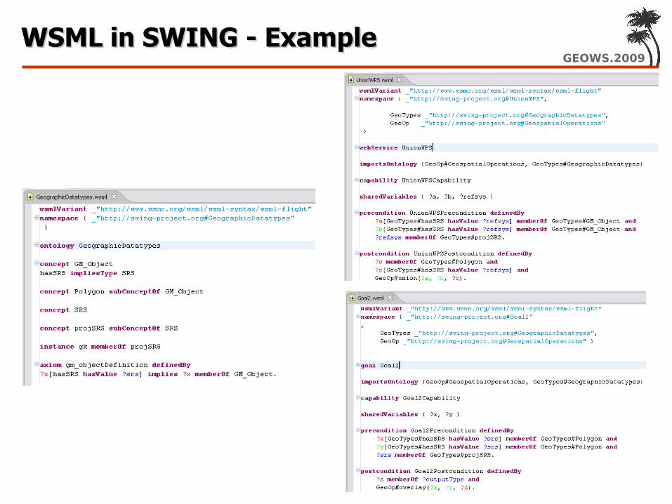
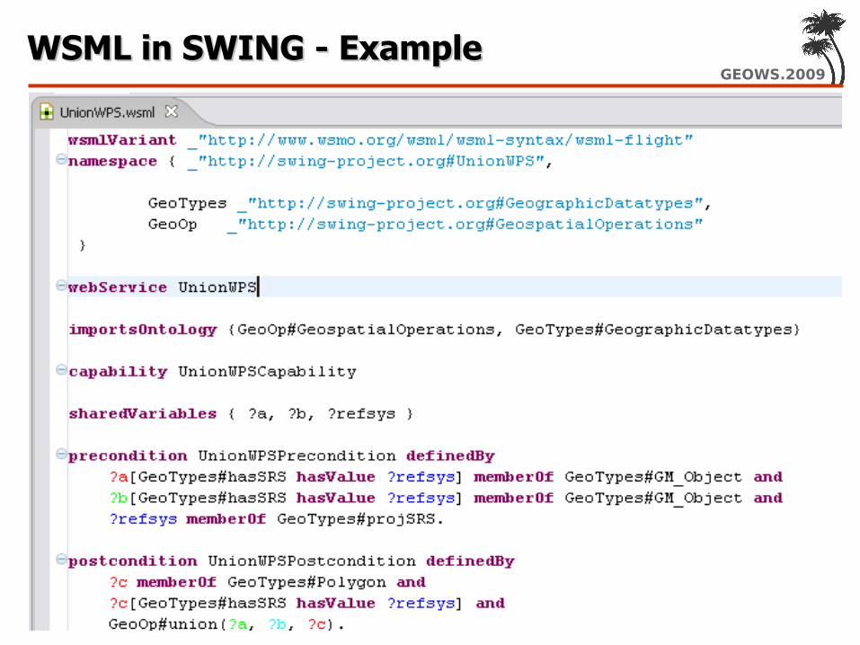
GEOWS.2009WSML in SWING - ExampleWSML in SWING - Example

GEOWS.2009WSML in SWING - ExampleWSML in SWING - Example
GEOWS.2009WSML in SWING - ExampleWSML in SWING - Example

GEOWS.2009WSML in SWING - ExampleWSML in SWING - Example

GEOWS.2009Web Service DiscoveryWeb Service Discovery
Functionality– Identify possible web services W which are able to provide the
requested service S for its clients An important issue …
– „being able to provide a service“ has to be determined based on given descriptions only (WS, Goal, Ontos)
– Discovery can only be as good as these descriptions• Very detailed WS descriptions: are precise, enable highly accurate results, are more
difficult to provide; in general, requires interaction with the provider (outside the pure logics framework)
• Less detailed WS descriptions: are easy to provide for humans, but usually less precise and provide less accurate results
Eas
e of
pro
visi
on
Pos
sibl
e A
ccur
acy
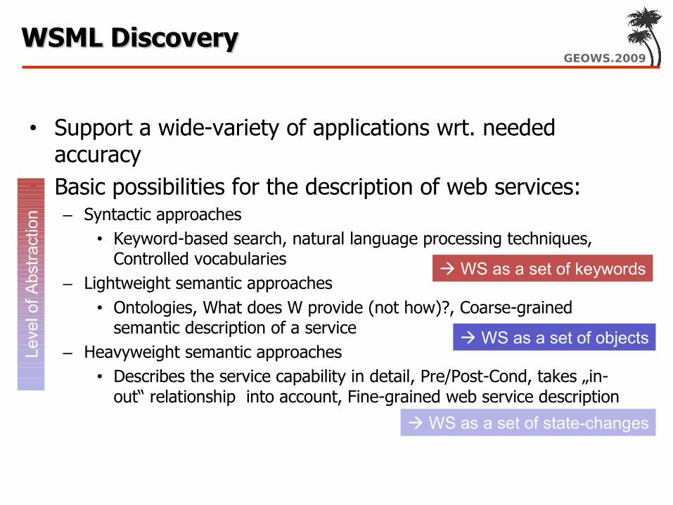
GEOWS.2009WSML DiscoveryWSML Discovery
• Support a wide-variety of applications wrt. needed accuracy
• Basic possibilities for the description of web services:– Syntactic approaches
• Keyword-based search, natural language processing techniques, Controlled vocabularies
– Lightweight semantic approaches• Ontologies, What does W provide (not how)?, Coarse-grained
semantic description of a service– Heavyweight semantic approaches
• Describes the service capability in detail, Pre/Post-Cond, takes „in-out“ relationship into account, Fine-grained web service description
Leve
l of A
bstra
ctio
n
WS as a set of keywords
WS as a set of objects
WS as a set of state-changes

GEOWS.2009WSML DiscoveryWSML Discovery
Responsible to find appropriate Web Services to achieve a goal Current discovery component is organized as a framework
performing discovery in two steps:1. (optional) keyword-based matching2. discovery based on either simple or rich descriptions of services
• Simple Descriptions “lightweight” discovery→– take into account postconditions and effects– WSML-DL: use concept subsumption; possible matches: exact, plugin,
subsume, intersection– WSML-Flight / WSML-Rule: use query containment; possible matches: exact,
plugin, subsume
• Rich Descriptions “heavyweight” discovery→– take into account preconditions and assumptions, postconditions and effects,
and the relation inbetween– WSML-Flight / WSML-Rule: use query containment; possible match: extended
plug-in match
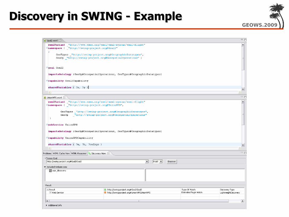
GEOWS.2009Discovery in SWING - ExampleDiscovery in SWING - Example

GEOWS.2009OverviewOverview/Introduction
- 2 -
Spatial Data Infrastructures Semantic Web Services Bridging the gap: Semantic Annotations SWING: use cases
SWING: Developed Tools Demonstration (Videos) Hands-On Session
Semantic AnnotationsSemantic Annotations
GEOWS 2009 February 1st, 2009 - Cancun, Mexico
?
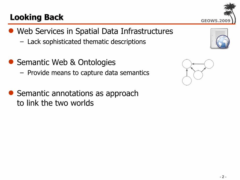
GEOWS.2009Looking BackLooking Back
- 2 -
Web Services in Spatial Data Infrastructures– Lack sophisticated thematic descriptions
Semantic Web & Ontologies– Provide means to capture data semantics
Semantic annotations as approach to link the two worlds

GEOWS.2009OverviewOverview
- 2 -
Explaining semantic annotations Ways to establish the connection Making use of the link
– Creating the semantic annotations– Querying based on semantic annotations
Semantic Annotations in OGC Standards

GEOWS.2009ZICOZICO
/ Example of Feature Type
<element name="Zico_region" type="con:Zico_regionType" substitutionGroup="gml:_Feature" /> <complexType name="Zico_regionType"> <complexContent> <extension base="gml:AbstractFeatureType"> <sequence> <element name="msGeometry" type="gml:GeometryPropertyType"/> <element name="REGIONAL" type="string"/> <element name="NATIONAL" type="string"/> <element name="LIBELLE" type="string"/> <element name="TYPE" type="string"/> <element name="LA_MESURE" type="string"/> </sequence> </extension> </complexContent> </complexType>
desc
ribes
Resource Metadata
Resource

GEOWS.2009Example of corresponding OntologyExample of corresponding Ontology
conc
eptu
aliz
es
Reality
Domain Ontology

GEOWS.2009Why the difference?Why the difference? Local vs. Global
– Describing the local and linking to global– Searching the global and finding the local
Data Models vs. Real world– Domain Ontologies capture real world semantics– Data Models represent application specific knowledge– Semantic Annotations keep it separated

GEOWS.2009Simple solution: concept to conceptSimple solution: concept to concept
Resource
desc
ribes
Resource Metadata
represents
Domain Ontology
conc
eptu
aliz
es
Reality
Domain Reference

GEOWS.2009Doesn't workDoesn't work
<complexType name="Zico_regionType"><element name="REGIONAL" type="string" reference=“dom:Identifier“/><element name="LIBELLE" type="string" reference=“dom:Identifier“/>
</complexType>
<complexType name="Zico_regionType"><element name="REGIONAL" type="string"
reference=“dom:GeographicalRegionName“/><element name="LIBELLE" type="string"
reference==“dom:ProtectedBirdRegionName“/></complexType>
Too generic loose benefits→ Too specific cluttered domain vocabulary→

GEOWS.2009Rule-based annotationsRule-based annotations
Resource
desc
ribes
Resource Metadata
represents
Domain Ontology
conc
eptu
aliz
es
Resource Ontology
Reality
Model Reference Domain Reference
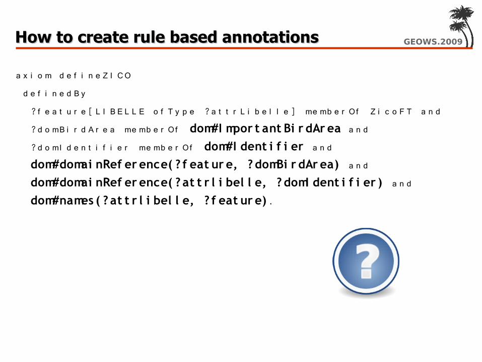
GEOWS.2009How to create rule based annotationsHow to create rule based annotations
a x i o m d e f i n e Z I CO
d e f i n e d B y
?f e a t u r e [ L I B E L L E o f T y p e ?a t t r L i b e l l e ] me mb e r Of Z i c o F T a n d
?d o mB i r d A r e a me mb e r Of dom#I mpor t ant Bi r dAr ea a n d ?d o mI d e n t i f i e r me mb e r Of dom#I dent i f i er a n d dom#domai nRef er ence( ? f eat ur e, ? domBi r dAr ea) a n d dom#domai nRef er ence( ? at t r l i bel l e, ? domI dent i f i er ) a n d dom#names ( ? at t r l i bel l e, ? f eat ur e) .
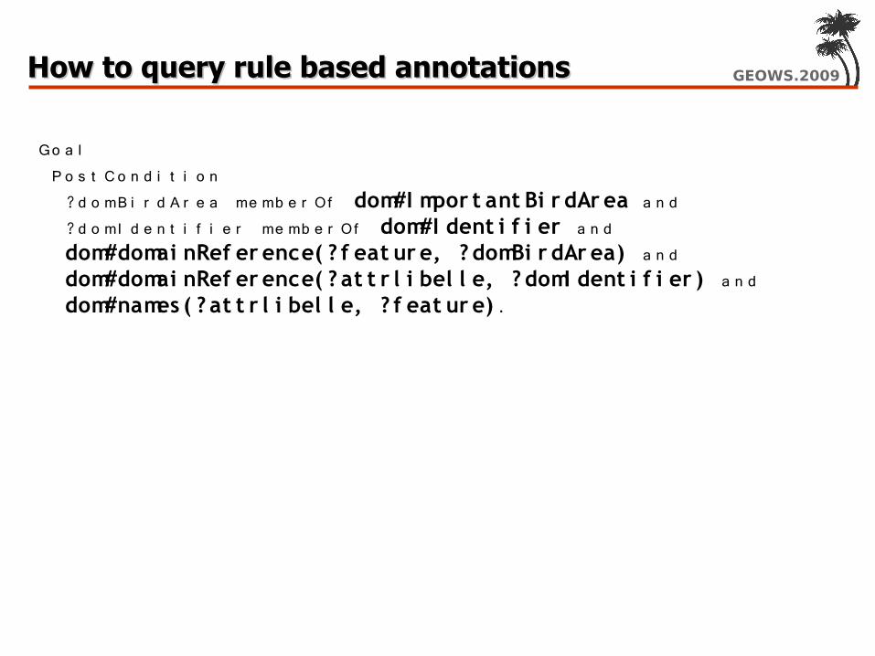
GEOWS.2009How to query rule based annotationsHow to query rule based annotations
Go a l P o s t C o n d i t i o n ?d o mB i r d A r e a me mb e r Of dom#I mpor t ant Bi r dAr ea a n d ?d o mI d e n t i f i e r me mb e r Of dom#I dent i f i er a n d dom#domai nRef er ence( ? f eat ur e, ? domBi r dAr ea) a n d dom#domai nRef er ence( ? at t r l i bel l e, ? domI dent i f i er ) a n d dom#names ( ? at t r l i bel l e, ? f eat ur e) .

GEOWS.2009Visually-supported Annotations/QueriesVisually-supported Annotations/Queries
GEOWS.2009Open Issues: StandardizationOpen Issues: Standardization Model References already standard (W3C SAWSDL) Support in OGC Standards required
– Storing semantic annotation– Querying semantic annotations– End-user tools support
Discussion Paper with different approaches prepared

GEOWS.2009Open Issues: ProcessesOpen Issues: Processes Model References already standard (W3C SAWSDL) Support in OGC Standards required
– Storing semantic annotation– Querying semantic annotations– End-user tools support
Discussion Paper with different approaches prepared How can we annotate Geoprocesses
– Domain vocabulary of Geo-operations required? All?– Or just describing relation between input and output?

GEOWS.2009OverviewOverview/Introduction
- 2 -
Spatial Data Infrastructures Semantic Web Services Bridging the gap: Semantic Annotations SWING: use cases
SWING: Developed Tools Demonstration (Videos) Hands-On Session

SSemantic emantic WWeb Services eb Services InInteroperabilityteroperability in in GGeospatial decision makingeospatial decision making
Use CasesUse Cases
GEOWS 2009 February 1st, 2009 - Cancun, Mexico

GEOWS.2009SWING application themeSWING application theme
BRGM : Mineral resources Management Aggregate production and consumption
– EU aggregate production & consumption is the largest macro-regional market in the world
– Aggregates - mineral resources with average low value• sand, gravel, crushed stone, ….• produced on-shore (quarries), off-shore, and some recycling
(concrete)– EU production 3 billion tons– EU employment 250,000 jobs– EU value 35 billion €– consumption 5-15 tonnes per capita per year– about 25,000 production sites in Europe

GEOWS.2009SWING application themeSWING application theme
Quarries and Aggregates
Vosges
Puy-de-Dome
Loire-Atlantique
Loiret
Sarthe
la Manche
Amsterdam
Essonne
Aggregates = crushed hard rock (limestone, volcanic rock, sandstone, recycled concrete, ….), or on- & off-shore sediments (sand & gravel)

GEOWS.2009SWINGSWING
Decision Making Support : – A new way of doing things in the Inspire Context
• Reduce time to deliver
• Brings interactivity
Objectives in SWING– develop a geospatial decision-making application that can
dynamically find and integrate interoperable semantic web services. (.... with the potential of being further developed and turned into a management and assessment system for natural resources)
– evaluate the appropriateness of the technical framework

GEOWS.2009Use Cases overall objective Use Cases overall objective
Given– Inputs for a new infrastructure project– Production/Consumption of actual quarries– Known Land-uses constraints– Geology
Find places where to get aggregates– From existing quarries– By opening new ones (Land-use constraints + Geology)

GEOWS.2009Use CasesUse Cases
200 000 tons
Concrete
50 000 tons
Granite
110 000 tons
Sand
Quantity(*)Substances
(*) All Quantity and Substances are given for example and are NOT real

GEOWS.2009The differents stepsThe differents steps
Use Case 1 : Production/Consomption Map
Use Case 2 : Land-Use constraints integration
Use Case 3 : Find the best place

GEOWS.2009Use Case 1 - Create a simple mapUse Case 1 - Create a simple map
Thematic Objective: Create a consumption-production map of aggregates
Technical challenges: – Set up needed DATA and Web Services (OGC and WSDL) – Build a WSML Domain Ontology – Annotate available WS with the Domain Ontology – Register WS in CAT and Store WS annotations – Setup simple WS composition, annotate and store into CAT, execute
it with WSMX.

GEOWS.2009Use Case 1 - Create a simple mapUse Case 1 - Create a simple map
Fake Consumption/Production Map (based on population of departments)

GEOWS.2009
Use Case 2 - Create a complex mapCompile constraints map

GEOWS.2009Use Case 2 - Create a complex mapUse Case 2 - Create a complex map
Thematic Objective: Create a map of land-use constraints and publish it as a decision making support document.
Data Sources for Use Case 2
Technical challenges – Implement WPS to combine multiple constraints – Extend the Domain Ontology to take land-use constraints into
account; Improve the Ontology engineering process – Improve the annotation process (towards semi-automatic
annotation) – Improve technical architecture of the end-user interface

GEOWS.2009Use Case 2 - Create a complex mapUse Case 2 - Create a complex map
ZNIEFF I & II
ZICO
ZPS
Land-Use Constraints
Negotiability level

GEOWS.2009Use Case 2 - Create a complex mapUse Case 2 - Create a complex map

GEOWS.2009
(*) All Quantity and Substances are given for example and are NOT real
Use Case 3 - Use created complex map to make sophisticated queriesGet quarry best location

GEOWS.2009Use Case 3 – Integrate Multiple CriteriaUse Case 3 – Integrate Multiple Criteria
Thematic Objective: Create an interactive map of the ranking according to combined criteria
Data Sources for UC3
Technical challenges: – Extended the domain ontology to catch domain experts knowledge– Use geoprocessing facilities to compute spatial data needed for
answering more sophisticated queries – Improved the annotation process towards semi-automatic
annotation – Use of mediation for interoperability (service request parameters
mediation)– Improve technical architecture of the end-user interface

GEOWS.2009Use Case 3 - Make sophisticated queriesUse Case 3 - Make sophisticated queries
200 000 tons
Concrete
50 000 tons
Granite
110 000 tons
Sand
Quantity(*)Substances
(*) All Quantity and Substances are given for example and are NOT real

GEOWS.2009
Generating and Publishing the Website Generating and Publishing the Website using MiMSusing MiMS

GEOWS.2009
Generating and Publishing the Website using Generating and Publishing the Website using MiMS (cont')MiMS (cont')

GEOWS.2009
- 2 -
Break

GEOWS.2009OverviewOverview/Introduction
- 2 -
Spatial Data Infrastructures Semantic Web Services Bridging the gap: Semantic Annotations SWING: use cases
SWING: Developed Tools Demonstration (Videos) Hands-On Session

SWING Architecture OverviewSWING Architecture Overview
GEOWS 2009 February 1st, 2009 - Cancun, Mexico

GEOWS.2009OutlineOutline
Roles Components and Interactions

GEOWS.2009
Roles – Decision Maker and Mineral Roles – Decision Maker and Mineral Resource SpecialistResource Specialist

GEOWS.2009
Roles – Service Composer and Ontology Roles – Service Composer and Ontology EngineerEngineer
GEOWS.2009
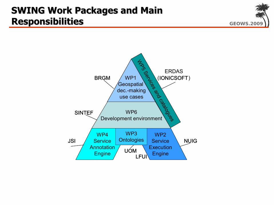
SWING Work Packages and Main SWING Work Packages and Main ResponsibilitiesResponsibilities
WP6Development environment
WP1 Geospatialdec.-makinguse cases
WP4Service
AnnotationEngine
WP2Service
ExecutionEngine
WP5 Services and catalogues
WP3Ontologies
BRGM
SINTEF
IONICSOFT
JSI
UOM
NUIG
LFUI
WP6Development environment
WP1 Geospatialdec.-makinguse cases
WP4Service
AnnotationEngine
WP2Service
ExecutionEngine
WP5 Services and catalogues
WP3Ontologies
BRGM
SINTEF
IONICSOFT
JSI
UOM
NUIG
LFUI
ERDAS( )

GEOWS.2009SWING ComponentsSWING Components
MiMS (WP1): Environment for domain expert. Convenient semantic annotation & discovery; use composed services like standard OGC servicesWSMX (WP2): Semantic web services platform. Geospatial semantic discovery; execution of composed services (as ASMs)Concept Repository (WP3): Ontologies for semantic annotation. Used throughout componentsVisual OntoBridge (WP4): Annotation tool. Semi-automatic annotation of services and queries; provides user with most plausible annotationsCatalogue (WP5): OGC Catalogue. Semantic discovery in interaction with WSMX; also provides adapter OGC ↔ WSMX ASM executionComposition Studio (WP6): Environment for IT expert. Convenient semantic annotation & discovery; graphically compose services; automatic export into WSMX ASMs

GEOWS.2009High-level Architecture and InteractionsHigh-level Architecture and Interactions

GEOWS.2009OverviewOverview/Introduction
- 2 -
Spatial Data Infrastructures Semantic Web Services Bridging the gap: Semantic Annotations SWING: use cases
SWING: Developed Tools Demonstration (Videos) Hands-On Session

GEOWS.2009Hands-On SessionHands-On Session/Introduction
- 2 -
Exercise: Building a workflow with Composition Studio Task: Create a composition as described in the File
CreatingWorkflowsSlides.pdf
Exercise: Creating a decision-support map with MiMS: Extract MiMS.zip in folder c:\MiMS and start launcher.bat
Tasks: – Try to follow the Steps in the mentioned Video – Create a „background“ map (e.g. search for departments)– Find data about protected bird areas, quarries, mineral resources, …– Create a legend and publish it as a website– Annotate an existing Web Feature Service about Birds