geotechnical w orks of the hong kong -zhuhai -macao bridge
TRANSCRIPT

Geotechnical works of the Hong Kong-Zhuhai-Macao Bridge Project
Albert T. Yeung i)
i) Associate Professor, Department of Civil Engineering, University of Hong Kong, Pokfulam, Hong Kong
ABSTRACT The Hong Kong-Zhuhai-Bridge Project, being situated in the waters of Lingdingyang (伶仃洋) of the Pearl River Estuary, is a mega sea-crossing infrastructure project currently under construction in the Pearl River Delta of China. It consists of a series of bridges, sub-sea tunnels, viaducts and artificial islands connecting the Hong Kong Special Administrative Region ("Hong Kong") (香港), Zhuhai City of Guangdong Province ("Zhuhai") (珠海), and the Macao Special Administrative Region ("Macao") (澳門), three major cities situated on the Pearl River Delta of China. The functions of the Project are: (1) to meet the demand of passenger and cargo interflows among Hong Kong, Mainland China (particularly the western Pearl River Delta region) and Macao; (2) to establish a new land transport link between the east and west banks of Pearl River; and (3) to enhance the economic and sustainable development of the three major cities in the Pearl River Delta region. The geotechnical works associated with the Project, including reclamations, onshore and offshore foundations, sub-sea tunnels, artificial islands, earth retaining structures and roadworks are extensive, large-scale, diversified, challenging and complex. In this special lecture, the background of the mega project and pertinent geotechnical works of the Project, in particular components contributed by the Hong Kong Special Administrative Region Government ("HKSARG"), are described. Moreover, green measures implemented to reduce environmental impacts during the design and construction stages of the Project are also presented. Keywords: Hong Kong-Zhuhai-Macao Bridge; geotechnical works; foundation, sub-sea tunnel; artificial island; reclamation; green measures; immersed tube tunnel, Chinese White Dolphin
1 INTRODUCTION
The Hong Kong-Zhuhai-Macao Bridge ("HZMB") Project is a mega sea-crossing infrastructure project currently under construction in the Pearl River Delta ("PRD") of China. It consists of a series of bridges, sub-sea tunnels, viaducts and artificial islands connecting the Hong Kong Special Administrative Region (香港特別行政區 ) ("Hong Kong") (香港 ), Zhuhai City of Guangdong Province of Mainland China (廣東省珠海市) ("Zhuhai") (珠海), and the Macao Special Administrative Region ( 澳門特別行政區 ) ("Macao") (澳門), three major cities in the PRD region of China.
The HZMB Project is expected to cost more than US$10.6 billion. However, it will benefit the economic development of the PRD region significantly. By linking up Hong Kong, Zhuhai and Macao, the completed HZMB Project will form a systematic regional transport network by providing an overland vehicular link. The link will substantially shorten the travel time between the eastern and western PRD region, so as to increase the interflows of passengers, cargoes and even capital within the region. Upon
completion of the HZMB Project, the western PRD region will be within a 3-hour-commuting radius from Hong Kong, resulting in substantial reduction in both transportation cost and time, whilst the cargo and passenger flows from the western PRD region, Guangdong (廣東省) and Guangxi (廣西省) Provinces, Mainland China will be able to utilize the transportation facilities of the Hong Kong International Airport ("HKIA") and the Kwai Chung Container Ports in Hong Kong. The HZMB will thus help to facilitate closer economic integrations between Hong Kong and the PRD region, so as to enhance the economic competitiveness of the region. Moreover, environmental impacts induced by vehicular traffic will be significantly reduced.
The link will also help to realize the strategic benefits of promoting the socio-economic development of the western PRD region. With closer economic tie with her neighboring region, Hong Kong can assume a leading role in driving the economic development in South China. It will also enable Hong Kong to continue as an international aviation and shipping center in the region. The connectivity of the HZMB to other major cities in the western PRD region is depicted in Fig. 1.
The 15th Asian Regional Conference on Soil Mechanics and Geotechnical Engineering
Japanese Geotechnical Society Special Publication
109http://doi.org/10.3208/jgssp.ESD-KL-3

Fig. 1. Connectivity of the HZMB to other major cities in the western PRD region
The geotechnical works associated with the Project, including reclamations, onshore and offshore foundations, sub-sea tunnels, artificial islands, earth retaining structures and roadworks, are extensive, large-scale, diversified, challenging and complex. The preservation of the Chinese White Dolphin habitats in nearby waters also poses tremendous environmental challenges to the Project. In this special lecture, the background of the mega project and pertinent geotechnical works of the Project, in particular components contributed by the Hong Kong Special Administrative Region Government ("HKSARG"), are described. Moreover, green measures implemented to reduce environmental impacts during the design and construction stage of the Project are also presented.
2 BACKGROUND OF THE PROJECT
Significant developments of vehicular transportation links from Hong Kong and Macao to the eastern PRD region of Guangdong province, Mainland China have been accomplished since the 1980s. However, the transportation links between Hong Kong and the western PRD region are underdeveloped. Other than the speedy hydrofoil service to Macao, the vehicular transportation link from Hong Kong to the western PRD region, denoted by the pink route in Fig. 1, is indirect, tortuous and lengthy. It is approximately 200 km long and requires approximately 4 hours of travel time. As a result, it is insufficient to meet the transportation needs of the region.
After the 1997 Asian Financial Crisis, the HKSARG considered that it was necessary to exploit the advantages of Hong Kong and Macao to revitalize the depressed economy and to seek new avenues for economic growth. As a result, the HKSARG proposed the construction of the HZMB, a vehicular sea-crossing linking Hong Kong, Zhuhai and Macao, to the Central Government of China in 2002. As shown in Fig. 1, the proposed HZMB is approximately 40 km long and it requires only approximately 45 minutes of travel time from Hong Kong to the western PRD region.
Research jointly sponsored by the National
Development and Reform Commission (國家發改委) and the HKSARG on Transport Links between Hong Kong and the West Bank of the Pearl River《香港與珠江
西岸交通聯係研究》was completed in July 2003. The results of the research indicate that the bridge connecting the three major cities in the PRD is of great political and economic importance, and should be constructed as soon as possible.
On 4th August, 2003, the State Council of China (中國國務院) approved the commencement of preliminary work for the HZMB Project, and established the HZMB Advanced Work Coordination Group ("AWCG") (港珠
澳大橋前期工作協調小組). The Group is composed of government representatives of Guangdong Province, Hong Kong and Macao, with HKSARG as the convener.
On 23rd February, 2004, the HZMB AWCG officially signed a Memorandum commissioning CCCC Highway Consultants Co., Ltd. to conduct the feasibility study for the HZMB Project. The Administrative Office of the HZMB AWCG was established in March 2004, indicating full-scale implementation of the preliminary work of the HZMB Project.
The Feasibility Study Report of Hong Kong-Zhuhai- Macao Bridge Project (To be Approved)《港珠澳大橋工
程可行性研究报告 (送審稿)》was formally submitted to the HZMB AWCG on 5th December, 2004, proposing three main categories of alternatives, i.e. the San Shek Wan (散石灣) northern alignments, the San Shek Wan southern alignments and the Extreme southern alignment, with a total of six alignment options.
The South China Sea Fisheries Research Institute was commissioned by the HZMB AWCG in March 2005 to conduct the thematic study of the influences of the Bridge on the Indo-Pacific humpback dolphin (Sousa chinensis) or commonly known as the Chinese White Dolphin.
On 2nd April, 2005, it was agreed by the representatives of the three regional governments to adopt: (1) San Shek Wan, Lantau in Hong Kong as the east landing point of the HZMB; (2) Gongbei (拱北), Zhuhai/Macao as the west landing point of the HZMB; and (3) the bridge-cum-tunnel solution of the north line from San Shek Wan to Gongbei/Macao.
On 27th December, 2006, the State Council approved the establishment of a Special Task Force for the HZMB (港珠澳大橋專責小組), led by the National Development and Reform Commission, to be in charge of the coordination of important and critical issues to expedite the progress of the HZMB Project. The HZMB Special Task Force was thus established in January 2007. Shortly afterward, the Special Task Force specified that the boundary crossing facilities of each regional government should be set up within their own respective territories, and the port setting and
110
inspection of the HZMB should follow the principle of "three regions, three custom inspections" (三地三檢).
The three regional governments agreed on the financial responsibility of the construction of the HZMB Main Bridge-cum-Tunnel on 27th November, 2008. The cost of the Main Bridge-cum-Tunnel will be shared according to an agreed principle of Equalization of Benefit to Cost Ratio where Hong Kong, Guangdong Province and Macao will bear 50.2%, 35.1% and 14.7% of the construction cost, respectively. The three regional governments would also be responsible for the construction of the boundary crossing facilities, ports and connecting links within their territories individually.
The Feasibility Study Report of Hong Kong-Zhuhai-Macao Bridge Project was officially approved by Premier Wen Jiabao at an executive meeting of the State Council on 28th October, 2009, marking the completion of the preliminary work of the HZMB Project and the official implementation of the Project.
Various design and construction contracts were signed by the Hong Kong-Zhuhai-Macao Bridge Authority (港珠澳大橋管理局 ) afterwards for the HZMB Main Bridge-cum-Tunnel. On 15th December, 2009, the construction commencement ceremony of the HZMB Project was held in Zhuhai, marking the beginning of the construction phase of the Project.
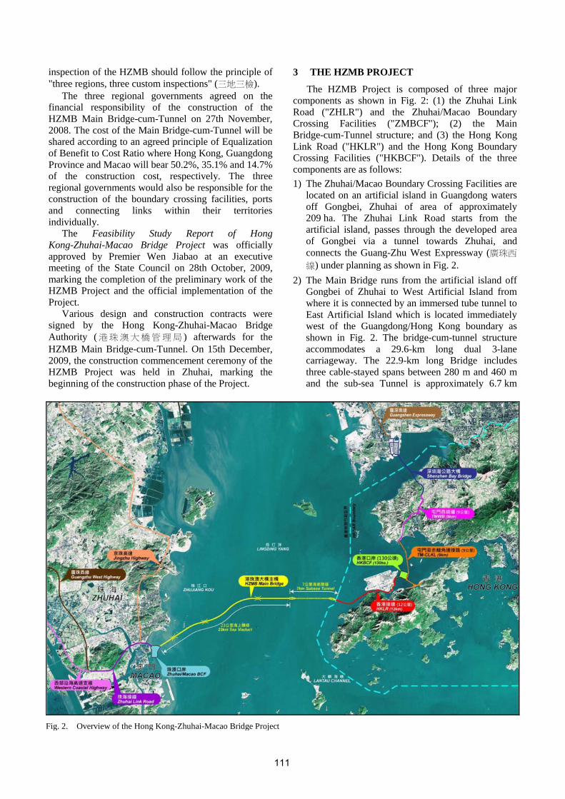
3 THE HZMB PROJECT
The HZMB Project is composed of three major components as shown in Fig. 2: (1) the Zhuhai Link Road ("ZHLR") and the Zhuhai/Macao Boundary Crossing Facilities ("ZMBCF"); (2) the Main Bridge-cum-Tunnel structure; and (3) the Hong Kong Link Road ("HKLR") and the Hong Kong Boundary Crossing Facilities ("HKBCF"). Details of the three components are as follows: 1) The Zhuhai/Macao Boundary Crossing Facilities are
located on an artificial island in Guangdong waters off Gongbei, Zhuhai of area of approximately 209 ha. The Zhuhai Link Road starts from the artificial island, passes through the developed area of Gongbei via a tunnel towards Zhuhai, and connects the Guang-Zhu West Expressway (廣珠西
線) under planning as shown in Fig. 2. 2) The Main Bridge runs from the artificial island off
Gongbei of Zhuhai to West Artificial Island from where it is connected by an immersed tube tunnel to East Artificial Island which is located immediately west of the Guangdong/Hong Kong boundary as shown in Fig. 2. The bridge-cum-tunnel structure accommodates a 29.6-km long dual 3-lane carriageway. The 22.9-km long Bridge includes three cable-stayed spans between 280 m and 460 m and the sub-sea Tunnel is approximately 6.7 km
Fig. 2. Overview of the Hong Kong-Zhuhai-Macao Bridge Project
111

long, connecting West Artificial Island and East Artificial Island.
3) The Hong Kong Link Road ("HKLR") connects the Main Bridge-cum-Tunnel from East Artificial Island to the Hong Kong Boundary Crossing Facilities ("HKBCF") as shown in Fig. 2. It is a dual 3-lane carriageway approximately 12 km long, and includes sections of sea viaduct, tunnel and at-grade road along the east coast of Airport Island. The HKBCF is located on an artificial island in Hong Kong waters off the northeast of the HKIA, connecting to Zhuhai and Macao via the HKLR and the Main Bridge-cum-Tunnel. It also connects to the HKIA as well as northwest New Territories and north Lantau of Hong Kong via the Tuen Mun-Chek Lap Kok Link ("TM-CLKL"). The Tuen Mun Western Bypass ("TMWB") is a 4.8-km long dual 2-lane highway connecting the TM-CLKL in the south and Tsing Tin Road in the north where it will connect to the Hong Kong-Shenzhen Western Corridor. The reclamation for the artificial island accommodating the HKBCF is approximately 150 ha in area including approximately 20 ha for the Southern Landfall for the sub-sea tunnel of the TM-CLKL. It has been mutually agreed that the Main
Bridge-cum-Tunnel within Guangdong territory (from the Guangdong/Hong Kong boundary to the artificial island accommodating the ZMBCF) will be built jointly by the three regional governments. The remaining section in Hong Kong territory (from San Shek Wan in Lantau, Hong Kong to the Guangdong/Hong Kong boundary) will be built by the HKSARG. The BCFs of the three regions and their link roads will be built and administered independently by each jurisdiction.
4 GEOLOGY OF THE REGION
Pearl River is discharging southwards through its estuary between Hong Kong and Macao into South China Sea. It is the only major source of sediments for this region other than local erosion products washed down into the sea during heavy summer rains.
The eastern and central waters of Hong Kong are protected from Pearl River by Lantau Island and no significant amounts of sediment are carried into these waters. However, thick deposits of soft marine deposits do occur, but their source is essentially clay, silt and sand derived from the erosion of decomposed granite and decomposed rhyolite. The Hong Kong waters are thus always clear, except close to shore after rains, and no dredging of navigational channels has ever been required.
In contrast, the western coast of Hong Kong is exposed to the influence of Pearl River, and so is Macao. Very thick deposits of soft marine deposits are found offshore; the waters are turbid for most times of
the year, and continual dredging of navigation channels in Macau has always been necessary.
Lumb (1977) concluded from his investigation on the soft marine deposits of Hong Kong and Macao that the source of material is not significant and the locally derived soils behave in the same manner as the Pearl River sediments.
Typical marine geology in the seabed of the region is soft marine deposits underlain by alluvium. The alluvium is underlain by residual soil and then by bedrock.
The soft marine deposits are in general silty clays with silt or sand seams and partings. The thickness of the marine deposits depends on depths of erosion prior to the Flandrian transgression.
Alluvium (fresh water deposits of interbedded alluvial clay and alluvial sand formed on stream beds and flood plains) often exists above the decomposed rock and below the soft marine deposits. It is composed of interbedding alluvial clay and alluvial sand.
Atterberg limits of the soft marine deposits and the alluvial clay collected by the author are presented in Fig. 3. It can be observed that almost all the data points lie in a narrow band parallel and slightly above the A-line. No distinction between the soft marine deposits and the alluvial clay in terms of Atterberg limits can be observed; suggesting that the engineering behavior of the two clays is very similar. They are collectively denoted as marine clays and can generally be classified as clay of upper plasticity range using the British Soil Classification System, i.e., LL > 35%.
Fig. 3. Plasticity chart of soft marine deposits and alluvial clay
The locations of data points on the plasticity chart shown in Fig. 3 indicate the predominant mineral in the marine clays is illite (Holtz & Kovacs 1981). The finding is consistent with those obtained from a comprehensive study of the microfabric, mineralogy and chemistry of marine clay samples obtained from Chek Lap Kok (Tovey 1986). The study undertaken includes: (1) qualitative and quantitative mineralogical analysis by X-ray diffraction; (2) microfabric analysis by scanning electron microscope; (3) chemical analysis of solid particles using X-ray fluorescence analysis; and
112

(4) chemical analyses of pore fluid using atomic absorption spectrophotometry for cations and ion exchange chromatography for anions.
Both the peak and remolded undrained shear strength of the uppermost marine clay increase with depth indicating the clay is normally consolidated. The Su/σv' ratio is approximately 0.30 and 0.11 for peak strength and remolded strength, respectively, where Su = undrained shear strength; and σv' = in-situ effective vertical overburden stress. Moreover, the sensitivity of the clay is approximately 2.85 (Yeung & So 2001).
The effective shear strength parameters of the marine clays measured in consolidated undrained triaxial tests are c' = 0 and φ' = 30°. There is practically no distinction between the soft marine deposits and the alluvial clay in terms of effective shear strength parameters. The measured friction angle is also consistent with the range of the measured values of plasticity index (Terzaghi et al. 1996).
The laboratory measured compression index Cc is in the range of 0.15 and 1.03 with an average value of 0.31 that is typical for clays of low plasticity. However, it should be noted that the average compression index of the soft marine deposits is approximately 0.6 and that of the alluvial clay is approximately 0.2. Although the soft marine deposits and the alluvial clay can be considered as a single material in terms of index properties and shear strength parameters, there is a significant difference in their compressibility. The difference is probably caused by the difference in stress history between the soft marine deposits and the alluvial clay.
The coefficient of consolidation of the marine clays has exhibited considerable natural variability ranging from 1-9 m2/yr. The coefficient of consolidation in the vertical direction due to horizontal drainage is at least twice that due to vertical drainage, rendering prefabricated vertical drains an effective means to accelerate consolidation settlement and to increase shear strength of the marine clays (Yeung & So 2001).
The marine clays are normally consolidated, highly compressible and often too weak to support the reclamation and any major infrastructures to be built on it without special treatment (Lee & Ng 1999; Yin 1999, 2002; Yeung & So 2001; Zhu & Yin 2001). Therefore, they were often dredged and dumped in past reclamation projects in Hong Kong, including the reclamation of Airport Island for the construction of the HKIA (Fung et al. 1984; Foott et al. 1987; Koutsoftas et al. 1987; Koutsoftas & Cheung 1994).
The granite bedrock underneath the region is decomposed to depths of more than 70 m below the present sea level. For decomposition to occur, there must be percolation of fresh water through the rock joints. Therefore, the sea level in the past must have been much lower than that at present to have allowed such decomposition to occur.
5 THE SEA-CROSSING
The sea-crossing will follow a route east to west from the HKBCF, passing through Hong Kong waters, then continuing to the west along the north side of the Dayushan Y3 Anchorage (23DY), before crossing several navigation channels, i.e. Tonggu Navigation Channel (銅鼓航道西線), Lingding West Channel (伶仃
西航道 ), Qingzhou Channel (青洲航道 ), Jianghai Channel (江海直達船航道) and Jiuzhou Channel (九洲
港航道), and to finish at the artificial island of the ZMBCF as shown in Fig. 4. The total length of the crossing is approximately 41.6 km, of which 12 km is in Hong Kong territory and 29.6 km is in Guangdong waters.
Fig. 4. A layout of the Main Bridge-cum-Tunnel
The boundary crossing facilities will be constructed and administered independently by the three regional governments under the "three regions, three custom inspections" system. The boundary crossing facilities for Hong Kong will be located in Hong Kong. Details of the HKBCF are given in a later section in this paper. The boundary crossing facilities for Mainland China (Zhuhai) and Macao will be co-located on an artificial island of 208.87 ha in Guangdong waters immediate east to Gongbei, Zhuhai/Macao. The artificial island consists of four distinct areas: (1) the administration facilities of the HZMB; (2) the connecting area in Zhuhai; (3) the Zhuhai Boundary Crossing Facilities administrative area; and (4) the Macao Boundary Crossing Facilities administrative area. The reclamation for the artificial island was completed on 28th November, 2013 as shown in Fig. 5.
Fig. 5. Reclamation for the Zhuhai/Macao Boundary Crossing Facilities
113

The link road to Zhuhai starts at the Zhuhai Boundary Crossing Facilities on the artificial island, passes Wanzai (灣仔) and the north side of Zhuhai Free Trade Zone (珠海保稅區), and reaches Hongwan (洪灣), Zhuhai. From there it will connect to a proposed 13.4 km highway to form the PRD regional loop from Nanping (南屏) to Hongwan. The link road will be constructed to dual 3-lane expressway standard, with design speed of 80 km/h, roadbed width of 32 m, total bridge width of 31.5 m and tunnel width of 2×14 m.
6 MAIN BRIDGE-CUM-TUNNEL
The scheme of using a bridge-cum-tunnel structure has been adopted for the sea-crossing in the waters of Guangdong. The Bridge is approximately 22.9 km long and across Qingzhou Channel, Jianghai Channel and Jiuzhou Channel. The Tunnel is approximately 6.7 km long and across Tonggu Navigation Channel and Lingding West Channel as shown in Fig. 4. Artificial islands are built at the ends of the Tunnel. West Artificial Island provides transition of the Bridge to the Tunnel. East Artificial Island provides transition of the HKLR viaduct to the Tunnel. Both artificial islands also accommodate tunnel ventilation shafts. The eastern edge of East Artificial Island is 150 m west of the Guangdong/Hong Kong boundary, and the eastern edge of West Artificial Island is 1.8 km from Lingding West Channel. The minimum edge to edge distance between the two artificial islands is approximately 5.25 km. The layout of the Main Bridge-cum-Tunnel is shown in Fig. 4.
The Bridge provides a dual 3-lane carriageway with a design speed of 100 km/h. The total bridge width is 33.1 m. The design live load for the Bridge complies with both China's Highway Class I for Bridge Design Vehicle Loads, and the live load provisions in the Design Manual for Roads and Railways of Hong Kong. The designed service life of the Bridge is 120 years. The construction environment of the HZMB is very complicated. Frequent typhoons, crisscross navigation, airport height restrictions, stringent environmental standards, etc. have to be taken into considerations. There are stringent requirements to control the water blockage ratio during the selection of options to minimize the impact of the Bridge to river flow, navigation and hydrology. There are approximately 130 bridge piers supported by approximately 1,100 rock socketed large-diameter bored piles as shown in Fig. 6. These piles are approximately 100 m long. The pier and pile cap is precast and installed on site as shown in Fig. 7. The precast bridge segments are then installed atop the piers as shown in Fig. 8.
The Tunnel also provides a dual 3-lane carriageway with a design speed of 100 km/h. The Tunnel is of width 2×14.25 m and vertical clearance of 5.1 m. The sub-sea Tunnel is the largest and one of the deepest immersed tube tunnels in the world, as it has to
accommodate three lanes of traffic in each direction and will therefore have extremely wide spans of nearly 15 m. It is situated some 45 m below the sea level, so as to ensure safe passage of 300,000 tonne shipping vessels on Pearl River. Therefore, the Tunnel is required to resist large hydrostatic and traffic loads. Moreover, the design has to take into account a design service life of 120 years in a harsh marine environment, and the adverse offshore conditions and complicated navigation environment for transport and immersion of the tunnel tube elements during construction, making the design and construction of the sub-sea Tunnel uniquely challenging.
The sub-sea Tunnel essentially consists of a set of 33 inter-connected precast concrete 'boxes' of typically
Fig. 6. Installed rock socketed large-diameter bored piles
Fig. 7. Installation of precast pier and pile cap
Fig. 8. Installation of bridge segments
114

180 m long as shown in Fig. 9. Weighing over 75,000 tonnes, these tunnel tube elements are the largest in the world. Having been transported afloat from the production site to the project location, they are connected together on the seabed using special rubber seals to ensure the connection is watertight. The installation of Tunnel Element E18 is shown in Fig. 10. After the temporary tunnel ends have being knocked through, one continuous tunnel structure is created.
Fig. 9. Cross-section of the Tunnel
Fig. 10. Installation of Tunnel Element E18 on 27th June, 2015
The Tunnel is situated between West Artificial Island and East Artificial Island. The containment structures of the two artificial islands are built of large steel cylinders installed by vibratory driving as shown in Fig. 11. The volumes inside the steel cylinders and the volumes within the containment structures are then filled with sand as shown in Fig. 12, after the installation of prefabricated vertical drains. The engineering properties of the soft marine deposits in the seabed within the containment structures are improved by surcharging with prefabricated vertical drains. Sand compaction piles are installed around the perimeters outside the containment structures as shown in Fig. 12 to support the seawall revetments. A cross-section of the artificial island indicating different methods of ground improvement is depicted in Fig. 13. The construction method minimizes the dredging and dumping of soft marine deposits.
7 THE HONG KONG BOUNDARY CROSSING FACILITIES
The Hong Kong Boundary Crossing Facilities ("HKBCF") will be located on an artificial island of approximately 150 ha reclaimed from Hong Kong waters off the northeast coast of the HKIA as shown in Fig. 14.
The construction works of the HKBCF include cargo and passenger clearing and vehicle inspection facilities, offices for frontline departments of the HKSARG, such as the Immigration Department, the Customs and Excise Department, etc., road networks, public transport interchange and associated civil, traffic control surveillance system and landscaping works, etc.
Geographically, the HKBCF are at a convenient location of excellent transportation connectivity, as it is linked by the HKLR, the TM-CLKL (in the north and southeast) and the highways leading to the HKIA. Moreover, as it is adjacent to the HKIA and near the
Fig. 11. Installation of large steel cylinder by vibratory driving
Fig. 12. Installation of sand compaction piles
Fig. 13. Cross-section of east and west artificial island showing different methods of ground improvement
115

Tung Chung new town, there are a variety of means of transportation facilities, including the HKIA, the SkyPier, the MTR Airport Express Line and the MTR Tung Chung Line, available in the proximity.
Fig. 14. Layout of the Hong Kong Boundary Crossing Facilities
The HKIA is also known as Chek Lap Kok Airport as it was built on a largely artificial island reclaimed from Chek Lap Kok Island. It handled 63.3 million passenger trips and 4.38 million tonnes of cargoes in 2014. With approximately 1,100 aircraft movements and more than 100 airlines linking the HKIA with approximately 180 destinations worldwide every day, it is one of the world's busiest passenger airports and the world's busiest cargo gateway. It has been consistently voted one of the top five airports in the world.
The SkyPier at the HKIA provides speedy ferry services for transfer passengers, making the HKIA a truly multi-modal transportation hub for convenient air and sea travel. The SkyPier serves these nine ports in the PRD: (1) Dongguan Humen ( 東莞虎門 ); (2) Guangzhou Lianhuashan (廣州蓮花山); (3) Guangzhou Nansha ( 廣 州 南 沙 ); (4) Macao (Maritime Ferry Terminal) [澳門(外港客運碼頭)]; (5) Macao (Taipa) [澳門 (氹仔 )]; (6) Shenzhen Fuyong (深圳福永 ); (7) Shenzhen Shekou (深圳蛇口); (8) Zhongshan (中山); and (9) Zhuhai Jiuzhou (珠海九洲).
The HKBCF will become a multi-modal transportation hub in the area. The road traffic of the area will be well connected since HZMB vehicles can use other routes in case any one of them becomes unavailable for whatever reason. The traffic at the Tung Chung new town will also be improved as traffic can use the Southern Connection of the TM-CLKL to bypass the Tung Chung new town. Details of the TM-CLKL are given in a later section of this paper.
Conventionally, seawalls for reclamation in Hong Kong were constructed on competent foundations by dredging the soft marine deposits in the seabed and replacing them by sand fill. The process requires dredging and dumping of a large quantity of soft marine deposits (Plant et al. 1998; Yeung and So 2004), and the winning of large quantity of sand fill to replace the soft marine deposits to construct the reclamation.
The adverse environmental and ecological impacts induced by the process of dredging and dumping of soft marine deposits are well documented (Sun et al. 2012; Zainal et al. (2012). Moreover, the winning of sand fill increases the volume of soft marine deposits to be dredged and dumped, as sand is always located below soft marine deposits.
A non-dredging reclamation technique was developed to reclaim the 150-ha artificial island for the HKBCF, including approximately 20 ha of land for the Southern Landfall of the TM-CLKL sub-sea tunnel, so as to minimize the environmental and ecological impacts of dredging and dumping of soft marine deposits. This is the first time this new reclamation technique is used in Hong Kong.
The 6,140 m long containment seawall of the artificial island will be formed by sinking 134 large-diameter circular steel cells of diameter 27 m or 31 m constructed of steel sheetpiles through the soft marine deposits. These steel cells are then filled up by inert construction & demolition ("C&D") materials or sand. In Hong Kong, C&D materials are defined to be any substance generated by construction or demolition activities, regardless of whether or not it has been processed, stockpiled or abandoned. Inert C&D materials are also known as public fill in Hong Kong, including rocks, concrete, asphalt, rubble, bricks, stones and earth. The remaining non-inert substances in C&D materials include bamboo, timber, vegetation, packaging materials, and other organic and perishable materials. Non-inert C&D waste is not suitable for land reclamation and/or other applications. Subject to recovery of reusable/recyclable items, it is disposed of in landfills (Yeung 2008).
The construction of the reclamation for the artificial island has also adopted the non-dredging method. Prefabricated vertical drains are installed in the soft marine deposits to accelerate their consolidation. Design methodology for prefabricated vertical drains is suggested by Yeung (1997). A piece of geotextile and a 2-m thick sand blanket are laid over the soft marine deposits prior to reclamation filling. As such, there will basically be no dredging and dumping of soft marine deposits for the HKBCF reclamation.
The adoption of the non-dredging reclamation will greatly reduce the amount of dredging and dumping of soft marine deposits by approximately 22 Mm3, and will also reduce the use of backfilling materials by approximately one half. As a result, there is much less impact to the water quality and marine ecology. Furthermore, there is a significant reduction in the construction marine traffic for transportation of dredged materials from the site and backfilling materials to the site during the reclamation process. This will help to preserve the marine ecology especially the Chinese White Dolphins habitats. The statistics of the many green benefits offered by the non-dredging reclamation
116

construction method over the conventional dredging reclamation construction method will be discussed in a later section of this paper.
8 THE HONG KONG LINK ROAD
The Hong Kong Link Road ("HKLR") is a dual 3-lane carriageway connecting the Main Bridge-cum- Tunnel at the Guangdong/Hong Kong boundary to the HKBCF as shown in Fig. 15.
Fig. 15. Layout of the Hong Kong Link Road
The HKLR comprises a 9.4 km long viaduct section from the Guangdong/Hong Kong boundary to Scenic Hill on the Airport Island; a 1 km tunnel section from Scenic Hill to the reclamation formed along the east coast of the Airport Island and a 1.6 km long at-grade road section on the reclamation to the HKBCF.
The viaduct section is the first bridge designed in Hong Kong using a precast pier structure. The construction team is faced with a variety of challenges, including severe marine conditions, complex navigation requirements, restricted land access, airport height restrictions, stringent dolphin protection requirements, deep rock head levels, the need to supply concrete using a floating batching plant, and the logistics of transporting concrete trucks on Ro-Ro barges.
The floating batching plant, a first in Hong Kong, facilitates marine production of concrete and significantly reduces marine and land traffic during construction. As a result, air and noise pollution are minimized.
The tunnel section of HKLR will pass under Scenic Hill, Airport Road and the MTR Airport Railway to minimize the environmental and visual impacts to the residents of the Tung Chung new town.
9 THE TUEN MUN-CHEK LAP KOK LINK
The TM-CLKL comprises a 9-km long dual 2-lane carriageway connecting Tuen Mun and north Lantau. The layout of the route is shown in Fig. 16. The alignment commences at a connection with the North Lantau Highway at Tai Ho Wan of Lantau. From the connection it heads northwest on a 1.6 km long sea
viaduct to the HKBCF. This section of the TM-CLKL is denoted as the Southern Connection of TM-CLKL. After landing on the eastern edge of the artificial island accommodating the HKBCF, the alignment turns north and heads into a 5-km long sub-sea tunnel from the Southern Landfall, i.e. the Northern Connection of the TM-CLKL. The toll plaza is situated further north in Tuen Mun Area 46 to reduce the extent of reclamation of the Northern Landfall. More details of the TM-CLKL are depicted in Fig. 17.
Fig. 16. Layout of the Tuen Mun-Chek Lap Kok Link
The construction contract of the Northern Connection involves the design and construction of a dual 2-lane sub-sea tunnel of approximately 5 km long between the HKBCF and Tuen Mun Area 40, and reclamation to form extra land of approximately 16.5 ha at Tuen Mun Area 40 as the Northern Landfall of the sub-sea tunnel of TM-CLKL.
As the deepest, longest and largest sub-sea road tunnel ever built in Hong Kong, the sum of the construction contract is also the largest ever awarded in Hong Kong, reflecting the scale and complexity of the project.
The world's largest tunnel boring machine of 17.6 m in diameter and two identical mix-shield tunnel boring machines of 14 m in diameter will be used to construct these road tunnels. The adoption of tunnel boring machines for the construction of these sub-sea tunnels will avoid the dredging and disposal of some 11 Mm3 of soft marine deposits required for tunnel construction by the traditional immersed tube method. Moreover, these state-of-the-art machineries are equipped with in-house innovations of the contractor, namely MOBYDIC, SNAKE and TELEMAC, which enable real-time geological mapping of rock faces, and robotic detection of damaged components on the cutter heads to reduce manual inspections under hyperbaric conditions.
Working under a compressed-air environment is the key challenge of this project. The project team has proposed to use a saturation technique for maintenance works on the cutter heads of the tunnel boring machines,
117

so as to maximize the health and safety of workers, and to enhance construction efficiency.
Sustainable measures are in place during and after construction, such as recycling excavated materials from the north reclamation as backfilling of the launch shaft or returning it as public fill. The two ventilation buildings will attain a Hong Kong BEAM Plus Gold rating upon completion. Wind turbines will also be built in both buildings for renewable power generation.
10 TUEN MUN WESTERN BYPASS
The Tuen Mun Western Bypass ("TMWB") is a dual 2-lane highway tunnel of approximately 4.8 km long connecting the TM-CLKL in the south and Tsing Tin Road in the north as shown in Fig. 18. Strategically, the TMWB, together with the TM-CLKL, will provide a north-south highway corridor linking the northwest New Territories with the HKBCF, the HKIA and north Lantau. The project is still in the consultation stage.
Fig. 18. Layout of the Tuen Mun Western Bypass
11 GREEN MEASURES
Many green measures are being implemented during the design and construction stages of the HZMB Project, in particular the components contributed by the HKSARG. These green measures are briefly discussed as follows.
10.1 Minimization of environmental impacts Various site and alignment options of the HKBCF,
HKLR and TM-CLKL have been examined, and the views obtained from extensive public consultation since 2007 have been considered to minimize environmental impacts of the HZMB Project including: 1) The HKBCF is located at the waters off the
northeast of the Airport Island so that it is away from major active areas of the Chinese White Dolphin. The location also has comparatively less impacts on the environment, hydraulics and navigation safety. Furthermore, it avoids impact on the natural hillsides and shorelines.
2) The HKBCF is at a distance of 2 km away from the Tung Chung new town to minimize air quality, noise and visual impacts on the residents.
3) The reclamation of the HKBCF and that for the Southern Landfall of the TM-CLKL sub-sea tunnel are integrated and constructed together to reduce the total length of seawalls by approximately 1.8 km. Moreover, the reclamation is constructed by a non-dredging reclamation method.
4) Natural rock amours are adopted on reclamation seawalls to mitigate visual impact.
5) The alignment of the HKLR will run along the Airport Channel at the southern side of the Airport Island which is away from the ecological sensitive
Fig. 17. Details of the TM-CLKL
118

areas such as the San Tau Site of Special Scientific Interest, as well as the nursery sites of the seagrass and horseshoe crab.
6) A tunnel-cum-at-grade road scheme for the HKLR is adopted in lieu of the all-viaduct scheme for the section from Scenic Hill on the Airport Island to the HKBCF to minimize visual impacts.
7) The HKLR viaduct will straddle the headland between San Shek Wan and Sha Lo Wan without affecting the natural shorelines of the Lantau Island.
8) The pile caps of the HKLR viaduct in the Airport Channel are below the seabed level to minimize hydrodynamic impacts.
9) The adoption of a sub-sea tunnel for the Northern Connection of the TM-CLKL has avoided the marine habitat at Tai Mo To.
10) The sub-sea tunnel will be constructed by tunnel boring machines in lieu of the traditional immersed tube method to avoid dredging and disposal of some 11 Mm3 of marine sediments, so as to minimize the overall impacts on the seabed, water quality, marine environment and habitats.
11) The Southern Connection of the TM-CLKL will be in the form of a sea viaduct, providing a direct connection between the HKBCF and the North Lantau Highway. The direct connection will avoid the traffic through the Tung Chung new town and alleviate the traffic and environmental impacts in the area.
12) The TM-CLKL Toll Plaza is relocated from reclaimed land of the Northern Landfall to Tuen Mun Area 46 to reduce reclamation.
13) A comprehensive Environmental Monitoring and Audit (EM&A) program is implemented during construction to monitor regularly the impacts on various environmental aspects including air quality, noise, water quality, waste management and ecology including the Chinese White Dolphin, etc. on the nearby sensitive receivers and areas which may be affected by the construction works of the HZMB Hong Kong projects.
14) The HKSARG will seek to designate the Brothers Islands as a marine park in compliance with the Marine Parks Ordinance upon completion of the Project to further enhance conservation of the environment.
15) Approximately 10,000 m3 of artificial reefs would be deployed as replacement and compensation to affected marine habitats.
16) Fish fry will be released at the new artificial reefs as well as the existing artificial reefs in Sha Chau and Lung Kwu Chau Marine Park to enhance the fish resources in the western Hong Kong waters.
Fig. 19. Chinese White Dolphin
10.2 Preservation of the Chinese While Dolphin habitat in Hong Kong
The Chinese White Dolphin, as shown in Fig. 18, is active in the vicinity waters of the HZMB Project. In the design stage, the locations and alignments of the HZMB components within Hong Kong waters are carefully chosen to avoid major active areas of the Chinese White Dolphin. During construction, various mitigation measures are implemented to minimize potential impacts to the Chinese White Dolphin including: 1) Non-dredging methods are adopted for reclamation
and seawall construction to reduce the amount of marine ecological disturbance caused by the dredging and disposal operations.
2) No underwater percussive piling is allowed. 3) No formation of underwater rock sockets for bored
piles is allowed during the peak dolphin calving season in May and June.
4) Noisy construction equipment mounted on marine construction vessels is acoustically-decoupled to minimize underwater noise.
5) Marine construction vessels have to follow pre-defined regular travel routes to avoid the active areas of Chinese While Dolphins.
6) Marine construction vessels have to travel at a speed lower than 10 knots in the areas of work site, marine park and proposed marine park.
7) Skipper of marine construction vessels working in the areas have to undergo specific training on local dolphins and porpoises.
8) A dolphin exclusion zone (DEZ) of 250 m radius is implemented during the silt curtain installation and the bored pile casing installation works. Works will be suspended if any dolphin is found within the DEZ.
9) Silt curtain enclosed areas are regularly checked and works will be suspended if any dolphin is found within the enclosed area.
10) The population of Chinese White Dolphins in the northwestern waters of Hong Kong is regularly
119

monitored. 11) The best available construction practices, such as
employing silt curtain and Y-shaped funnel, etc., are adopted to minimize sediment dispersion during construction (Yeung et al. 2008), and to avoid impact on water quality.
10.3 Green statistics The green statistics to be achieved by the HZMB
Project are summarized as follows: 1) The HZMB will open a new and direct connection
route between Hong Kong, Zhuhai and Macao. It will significantly shorten the journey for the flows of passengers and cargoes between Hong Kong and the western PRD region. The new direct route will also avoid detouring and help minimize use of fossil fuels and gas emissions by vehicles. From Zhuhai to the Kwai Chung Container Ports, the journey distance and traveling time will be reduced from approximately 200 km and 4 hours currently to approximately 65 km and 75 minutes, respectively, a reduction of over 60%. From Zhuhai to the HKIA, the journey distance and traveling time will be further reduced from over 200 km and approximately 4 hours to approximately 40 km and 45 minutes, respectively, with more than 80% reduction. It helps to reduce vehicle CO2 emission by at least 1,100 tonne/day.
2) The adoption of the non-dredging method for the reclamation of the HKBCF reduces the quantity of soft marine deposits to be dredged and disposed of by 97%, the quantity of backfilling materials by 50%, and the marine construction traffic by 50%.
3) Combining the reclamations for the HKBCF and the Southern Landfall of the TM-CLKL sub-sea tunnel reduces the total length of seawalls by 1.8 km, minimizing the impact on the marine environment.
4) The adoption of tunnel boring machines for the construction of the approximately 5 km sub-sea road tunnel for the Northern Connection of the TM-CLKL will avoid the dredging and disposal of some 11 Mm3 of marine sediments required for construction using the traditional immersed tube method.
5) The non-dredging method of reclamation will reduce the quantity of suspended particles by 70% during construction.
12 SUMMARY
The Hong Kong-Zhuhai-Bridge Project, being situated at the waters of Lingdingyang (伶仃洋) of the Pearl River Estuary, is a mega sea-crossing infrastructure project currently under construction in the Pearl River Delta of China. It consists of a series of bridges, sub-sea tunnels, viaducts and artificial islands
connecting the Hong Kong Special Administrative Region ("Hong Kong") ( 香港 ), Zhuhai City of Guangdong Province ("Zhuhai") (珠海), and the Macao Special Administrative Region ("Macao") (澳門), three major cities situated on the Pearl River Delta in China.
The geotechnical works associated with the HZMB Project, including reclamations, onshore and offshore foundations, sub-sea tunnels, artificial islands, earth retaining structures and roadworks are extensive, large-scale, diversified, challenging and complex.
The background of the mega project and pertinent geotechnical works of the Project, in particular components contributed by the Hong Kong Special Administrative Region Government ("HKSARG"), are described. Moreover, green measures implemented to reduce environmental impacts during the design and construction stages of the Project are also presented in this special lecture.
ACKNOWLEDGEMENTS
Most information used for the preparation of this special lecture is excerpted from the HZMB website developed by the Hong Kong-Zhuhai-Macao Bridge Authority (港珠澳大橋管理局), i.e. www.hzmb.org, the HZMB website developed by the Highways Department of the HKSARG, i.e. www.hzmb.hk, and the website of the Highways Department of the HKSARB, i.e. http://www.hyd.gov.hk/. These sources of useful information are gratefully acknowledged.
REFERENCES 1) Foott, R., Koutsoftas, D.C. & Handfelt, L.D. (1987): Test
fill at Chek lap Kok, Hong Kong, Journal of Geotechnical Engineering, ASCE, 113(2), 106-126.
2) Fung, A.K.L., Foott, R., Cheung, R.K.H. & Koutsoftas, D.C. (1984): Practical conclusions from the geotechnical studies on offshore reclamation for the proposed Chek Lap Kok Airport, Hong Kong Engineer, HKIE, 12(6), 17-26.
3) Holtz, R.D. & Kovacs, W.D. (1981): An Introduction to Geotechnical. Engineering, Prentice-Hall, Englewood Cliffs, N.J.
4) Koutsoftas, D.C. & Cheung, R.K.H. (1994): Consolidation settlements and pore pressure dissipation, Vertical and Horizontal Deformations of Foundations and Embankments, A.T. Yeung and G.Y. Félio, Editors, Geotechnical Special Publication No. 40, ASCE, New York, N.Y., Vol. 2, 1100-1110.
5) Koutsoftas, D.C., Foott, R. & Handfelt, L.D. (1987): Geotechnical investigations offshore Hong Kong, Journal of Geotechnical Engineering, ASCE, 113(2), 87-105.
6) Lee, K.M. & Ng, P.C.C. (1999): A geotechnical investigation of marine deposits in a nearshore seabed for land reclamation, Canadian Geotechnical Journal, 36(6), 981-1000.
7) Lumb, P. (1977): The marine soils of Hong Kong and Macau, Geotechnical Aspects of Soft Clays, R.P. Brunner and E.W. Brand, Editors, Asian Institute of Technology, Bangkok, 45-58.
8) Plant, G.W., Covil, C.S. & Hughes, R.A. (1998): Site Preparation for the New Hong Kong International Airport,
120

Thomas Telford, London, UK. 9) Sun, M.M., Ni, Y.Q., Wang, S.S. & Xiong, L.H. (2012):
Research about the effect of reclamation on marine ecology in the northeast of Zhoushan Island, Proceedings of 6th International Conference on Asian and Pacific Coasts, Hong Kong.
10) Terzaghi, K., Peck, R.B. & Mesri, G. (1996): Soil Mechanics in Engineering Practice, 3rd Edition, John Wiley & Sons, New York, N.Y.
11) Tovey, N.K. (1986): Microanalyses of a Hong Kong marine clay, Journal of Geotechnical Engineering, Southeast Asian Geotechnical Society, 17(2), 167-210.
12) Yeung, A.T. (1997): Design curves for prefabricated vertical drains, Journal of Geotechnical and Geoenvironmental Engineering, ASCE, 123(8), 755-759.
13) Yeung, A.T. (2008): Construction & demolition materials management in Hong Kong, Proceedings of the Institution of Civil Engineers, Municipal Engineer, 161(ME1), 43-49.
14) Yeung, A.T., Mak, M.S.W., Fung, I.W.H. & Au, S.K.A. (2008): A new laboratory apparatus to evaluate hydrodynamic dispersibility of soil during ocean dumping, Geotechnical Testing Journal, ASTM, 31(3), 199-205.
15) Yeung, A.T. & So, S.T.C. (2001): Geotechnical engineering
properties of Hong Kong marine clays, Proceedings of the 3rd International Conference on Soft Soil Engineering, Hong Kong, 695-700.
16) Yeung, A.T. & So, S.T.C. (2004): Marine site investigation of Lamma reclamation, Proceedings of the International Conference on Coastal Infrastructure Development - Challenges in the 21st Century, Hong Kong.
17) Yin, J.H. (1999): Properties and behaviour of Hong Kong marine deposits with different clay contents, Canadian Geotechnical Journal, 36(6), 1085-1095.
18) Yin, J.H. (2002): Stress-strain strength characteristics of a marine soil with different clay contents, Geotechnical Testing Journal, ASTM, 25(4), 459-462.
19) Zainal, K., Al-Madany, I., Al-Sayed, H., Khamis, A., Al Shuhaby, S., Al Hisaby, A., Elhoussiny, W. & Khalaf, E. (2012): The cumulative impacts of reclamation and dredging on the marine ecology and land-use in the Kingdom of Bahrain, Marine Pollution Bulletin, 64(7), 1452-1458.
20) Zhu, J.G. & Yin, J.H. (2001): Drained creep behaviour of soft Hong Kong marine deposits, Géotechnique, 51(5), 471-474.
121