gis data, workflow and software solutions for next ... · pdf fileput simply, ng911 is an...
TRANSCRIPT

GIS Data, Workflow and Software Solutions for Next Generation 9-1-1


“Put simply, NG911 is an Internet Protocol (IP)-based system that allows digital information (e.g., voice, photos, videos, text messages) to flow seamlessly from the public, through the 911 network, and on to emergency responders”. US DOT
Next Generation 911 (NG9-1-1)
Analog systems becoming under
utilized & expensive to manage
Changing expectations of
public
Changing landscape of communication
devicesWhy Next Gen?
AT&T wrote a letter to FCC asking for
permission to phase out their analog landline service
Existing system is over 40 years old
3
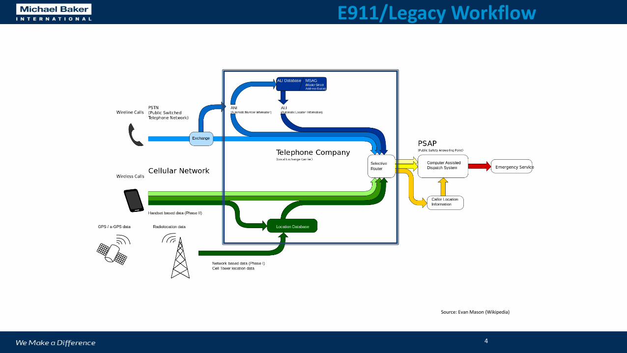
Source: Evan Mason (Wikipedia)
E911/Legacy Workflow
4

Source: Evan Mason (Wikipedia)
Next Generation 9-1-1

Roles & Responsibilities
9-1-1 Authority – State/Regional entity that establishes and maintains NG9-1-1 infrastructure as well as service and data provisioning
Addressing Authority – Local entity that is legally responsible for addressing…likely multiple entities
GIS Authority – Entity responsible for GIS data maintenance

Public Works
• Street signs
• May be “owner” of centerline
• Different business process
IT Director
• Security
• GIS software
• GIS resources
Elected Officials
• Answer to public pressure
• Answer to pubic when there is a botched 911 call
Planning/Permitting
• Addressing assignments
Who else is impacted by NG9-1-1?

Data Implications

GIS Data Types in NG9-1-1
Street Centerlines
Address Point (optional but recommended)
Responder Boundaries• Not the same as Emergency Service Zones (ESN) which is a combination of Law, Fire and
EMS
• Segregated by responder type (i.e. Law, Fire, EMS, Dog Catcher, etc.)
Additional Data (optional data like building floor plans or area response plans…may or may not be GIS data)
Must be edgematched with neighboring jurisdiction to work in ESInet(geometry: no gaps or slivers, attributes: Fletcher Pkwy [La Mesa] = Fletcher Parkway [El Cajon])

Address Data Exchange in NG9-1-1
GIS Data Provisioning - Spatial Information Function (SIF) Service Provisioning
• Location Information Service (LIS)• Location Validation Function (LVF)
Call for Service Routing• Emergency Call Routing Function (ECRF)• Emergency Service Routing Proxy (ESRP)• Policy Routing Function (PRF)
Additional Data Acquisition to facilitate call processing (e.g. geotagged photos, videos, additional coordinates)
All across an Emergency Service IP Network (ESInet)

Minimum Data Required to Support ECRF/LVF in i3 NG9-1-1 Architecture*
Road Centerlines
PSAP Boundaries
Emergency Services Boundaries
Source: data supplied should come from each jurisdiction that acts as a GIS authority.
Footprint: each PSAP needs access to a seamless, normalized and highly accurate footprint of data from any jurisdiction it shares a boundary with.
Update: new data and data errors should be updated in the GIS within a 3 business day cycle.
Accuracy: Each source entity is responsible for the accuracy (both spatial and attribution) of each dataset. This results in the need for coordination amongst neighboring jurisdictions as there are no allowable gaps, overlaps or redundancies in any of the datasets.
11
*Address Point data is not required per the NENA NG9-1-1 GIS Data Model but will likely be deemed so by the majority of end-users & likely eventually required

Civic Location Data eXchange Format (CLDXF) Standard
NENA-STA-004.1.1-2014, Published March 23, 2014
The CLDXF document was developed to: • Provide a definitive set of core civic location data elements that support emergency call
routing and dispatch.
• Map a profile between Presence Information Data Format-Location Object (PIDF-LO) and those same NENA core civic location data elements.
• Map those civic location data elements to the corresponding FGDC “United States Thoroughfare, Landmark, and Postal Address Data Standard” (FGDC-STD-016-2011) set of data elements, which was sponsored by the URISA and NENA.
• Provide illustrative examples of address parsing.
Defines the detailed data elements needed for address data exchange.

8 Street Name Elements in NENA CLDXF Standard (Section 3.3)
Street Name Pre Modifier (e.g., “Alternate” in Alternate Route 8)
Street Name Pre Directional (e.g., “North” in North Fairfax Drive)
Street Name Pre Type (e.g., “Avenue” in Avenue A; “County Route” in County Route 88)
Street Name Pre Type Separator (e.g., “of the” in Avenue of the Americas)
Street Name (e.g., “Fairfax” in North Fairfax Avenue)
Street Name Post Type (e.g., “Avenue” in North Fairfax Avenue)
Street Name Post Directional (e.g., “East” in Seventh Street East)
Street Name Post Modifier (e.g., “Extended” in East End Avenue Extended)

4 Address Number Elements in NENA CLDXF Standard (Section 3.4)
Address Number Prefix (alphanumeric prefix)
Address Number (integer to support address sorting, parity definition and in/out of address
range tests)
Address Number Suffix (alphanumeric suffix, e.g., “1/2” in 119 ½ Elm St.)
Optional: Milepost may be given in place of or in addition to the address number

6 Subaddress Elements in NENA CLDXF Standard (Section 3.6)
Building (e.g. "Building A" in 456 Oak Street, Building A, Apartment 206)
Additional Location Information (e.g. “West Wing” in 1600 Pennsylvania Avenue NW, West
Wing)
Floor (e.g. “Mezzanine” in 800 Jefferson Street, Mezzanine)
Unit (e.g. “Suite 3103” in 4300 Flamingo Avenue, Suite 3103)
Room ("Room 450F" in 1440 Market St., Room 450F)
Seat (e.g. “Cubicle 23” in 2500 Seventh Street, Room 105, Cubicle 23)

Street Name Parsing (RCL & AP)

Street Name Parsing (RCL)

Workflows Implications

MSAG to
Centerline• Correct anomalies
Boundary
Files
• PSAP boundary true-up
• Emergency Services Boundaries
• Authoritative Boundary
ALI to
GIS
Iterative Validation
& Clean-Up
• Validations ran in priority
• Internal
• Between Jurisdictions
19
• ALI maintenance workflow
Purposeful Order
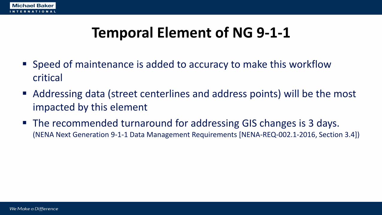
Temporal Element of NG 9-1-1
Speed of maintenance is added to accuracy to make this workflow critical
Addressing data (street centerlines and address points) will be the most impacted by this element
The recommended turnaround for addressing GIS changes is 3 days. (NENA Next Generation 9-1-1 Data Management Requirements [NENA-REQ-002.1-2016, Section 3.4])

Software Solutions


What is DataMark?
GIS Services and Applications
9-1-1 and Addressing Authority Clients
NG9-1-1 GIS Education Curriculum
& Standards Development
Outreach & Consulting
Data QC Validation

Products
• DataMark Data Exchange (DX)
• Translate – validate – extract
• Local and Mutual Aid Footprint Data Quality Metrics
• DataMark Editor (DME)
• Edit functionality based upon authoritative “users”
• Robust observation system allowing for 2-way communication of data errors (crowd sourced or internal)
5/25/201725

Robust translator and repository of geospatial data that enforces data meet stringent quality control metrics
• Stores the geospatial data from multiple source entities needed to support their NG9-1-1 call routing and CAD systems.
• Maintains the topology for each type of spatial dataset.
• Contains a stringent list of quality control validation rules (spatial and attribution) to which all data is upheld. Allows for some validation errors to be marked as exceptions with the rest of the fails requiring edits by the source entity.
• Accepts updates of the data as frequently as the source entity desires.
• Provides the quality data for extraction in a regional footprint translated into any feed or schema needed to support various proprietary NG9-1-1 functions, all while enabling the authority and accuracy of the spatial data provided to remain with the source data entity.
5/25/2017 26
DX Overview

DX
Data Update
New versions of Centerline, Address Points, Boundary Files submitted via the application.
Database Translation
Schemas are verified, new data is compared to old data with only updated (adds, deletes and changes) being coalesced into the master database.
Quality Control Check
Data is again processed through the spatial and attribution quality control checks.
Reporting
Summary and detail reports are produced for each data update provided. Each feature that fails quality control metric is detailed for review or exposed for being marked as exception (and will not fail again)
Step 1 Step 2 Step 3 Step 4
Extract
A user selected footprint of the DX™ database is available for customized extraction. Data can be translated into any saved schema to meet any business driver and downloaded or published as a feed.
Step 5

Centerline Validations
• Spatial
• Crosses Multiple Polygons
• Street pointing in wrong direction
• Not in polygon layer
• Attribution
• Address range overlaps
• Parity Errors
Address Point Validations
• Spatial
• Structure on wrong side of the street
• Crosses multiple polygons
• Structure out of order
• Not in polygon layer
• Empty geometry
• Attribute
• Not matching street range or street name
• Parity error
• On wrong block
• Out of order
• Duplicate point
Boundary Quality Control
• PSAP, Emergency Services Boundaries
• Gaps/Overlaps
• Attribute Spelling
Database Schemas
• Compare and map disparate datasets
• Ensure cardinality of attributes
• One-to-one mapping with master dataset
• Identify missing attributes
• Attribute type formatting
MSAG/ALI Synchronization
• Create MSAG from centerline data
• Compare to provided county MSAG
• Suggest resolution of discrepancies with a goal of 98% match rate
• Validate ALI w/ Centerline and Address Points
Quality Control (QC) Validation Checks
28
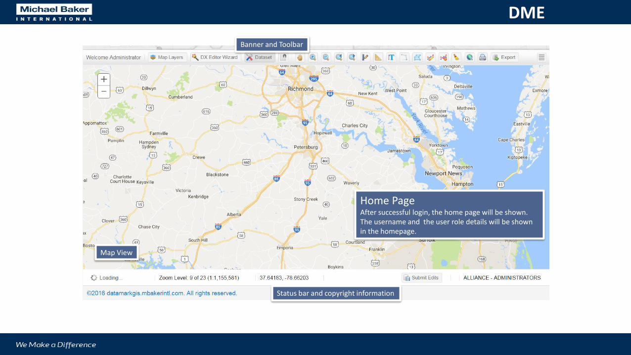
Home PageAfter successful login, the home page will be shown. The username and the user role details will be shown in the homepage.
Banner and Toolbar
Map View
Status bar and copyright information
DME

Better QA/QC for address rangesWhen a street segment is split, user will have the options to reassign the address ranges. This is based on “% of new length versus old length” rule.
DME

1
2
Submit ObservationCommunicate an issue with the data to other applicable parties (those who are users in DME and those who are not)1. Right click on map area to submit observation.2. Fill in title and comments. (will auto populate
sender and location)
DME

Current Clients
City of San Jose (CA)
Manatee County (FL)
City of Cincinnati (OH)
City of Philadelphia (PA)
Orleans Parish Communications District (New Orleans, LA)

Thank You! Jeff Ledbetter [email protected]
Steve Bein [email protected]
MBAKERINT.COM
www.datamarkgis.com
Join us for our upcoming
Webinar June 15th @ 10:00 amTo register email [email protected]