gis imaging solutions
TRANSCRIPT
GGIISS IImmaaggiinngg SSoolluuttiioonnss
GIS Imaging Solutions
IImmaaggee VViieewweerr
II//RRAASS CC
IImmaaggee AAnnaallyysstt
II//GGeeooVVeecc
II//PPaarrcceellVVeecc
GGeeooVVeecc OOffffiiccee
TTeerrrraaSShhaarree OOrrtthhoo MMaannaaggeerr

IImmaaggiinngg pprroodduuccttss wwiitthh pprroovveenn rreessuullttssZ/I Imaging offers solutions for integrating raster and vector dataacross the spectrum of mapping and geoengineering. OurGeographic Information Systems (GIS) imaging solutions providethe tools to handle image mapping, GIS, civil engineering, andconversion projects that require large images, whether fromsatellite or aircraft platforms, scanned maps, radar, or any othertype of imagery. Our imaging solutions have not only enduredthe demands of a production environment, they have excelled inmeeting those demands and have set the standard for all otherimaging products in the marketplace today.
Our GIS imaging solutions consist of the following products:• I/RAS C™ • Image Viewer™
• Image Analyst™ • I/ParcelVec™
• I/GeoVec™ • GeoVec Office
• TerraShare™ Ortho Manager
Image Analyst performs multi-spectral classifications that allow youto create landcover maps.
IImmaaggee iiss eevveerryytthhiinnggImagery, in one form or another, is beginning to appear in allgeoengineering disciplines. Our solutions allow you to integratedisparate data – native read of industry-standard formats, includ-ing TIFF, GeoTIFF, TIFF World, JFIF (JPEG), MrSID, BIL, USGS DOQ,NITF, BMP, PCX, and others – into your existing workflows.
Whether you are simply placing an image backdrop in yourdesign or doing complex feature extraction, our integrated solu-tions will make your task easier. You will benefit from our specialfeatures, such as rapid display and manipulation of very largeraster data sets, fast dynamic zoom, pan, fit, window area, andhybrid (raster and vector) plotting. Our solutions offer completevector graphics and raster integration, providing a seamless environment with other mapping, civil engineering, and GISapplications.
Z/I Imaging’s imaging products help you create and maintain the highest quality images for your project. Image Viewer, ImageAnalyst, and I/RASC provide standard and specialized features todisplay, manipulate, and enhance all types of image data for yourspecific application.
CClleeaann uupp yyoouurr iimmaaggeeIf your imagery already contains positional information, our solution will recognize and display it accordingly. However,sometimes this information is not present, and the image mustbe placed in the desired geographic space. Our solution allowsyou to register your image to your base vectors or even to anoth-er image for multidate comparisons. Image translations, rotation,skew, and scaling are on-the-fly. Our image solutions lead theway in image transformations. Choose from Helmert, affine,projective, 2nd through 5th order polynomial, or finite elementtransformation methods.
We have the most robust set of tools for contrast enhancementson the market today – including features such as recursive con-trast adjustments and dynamic display of contrast adjustment.Linear functions, equalized functions, simple contrast/brightness functions, gamma correction, density slicing, and more – all
DDaattaa iinnppuutt//iinntteeggrraattiioonn
Satellite imagery Aerial photography Image registration enhRaster cleanupScanned maps/plans
DDaattaa iinnppuutt//iinntteeggrraattiioonn PPrree--PPrrooPPrree--pprroo
AAnnaallyyssiiss OOuuttppuutt
working together to give you total control over the way yourimage map is displayed.
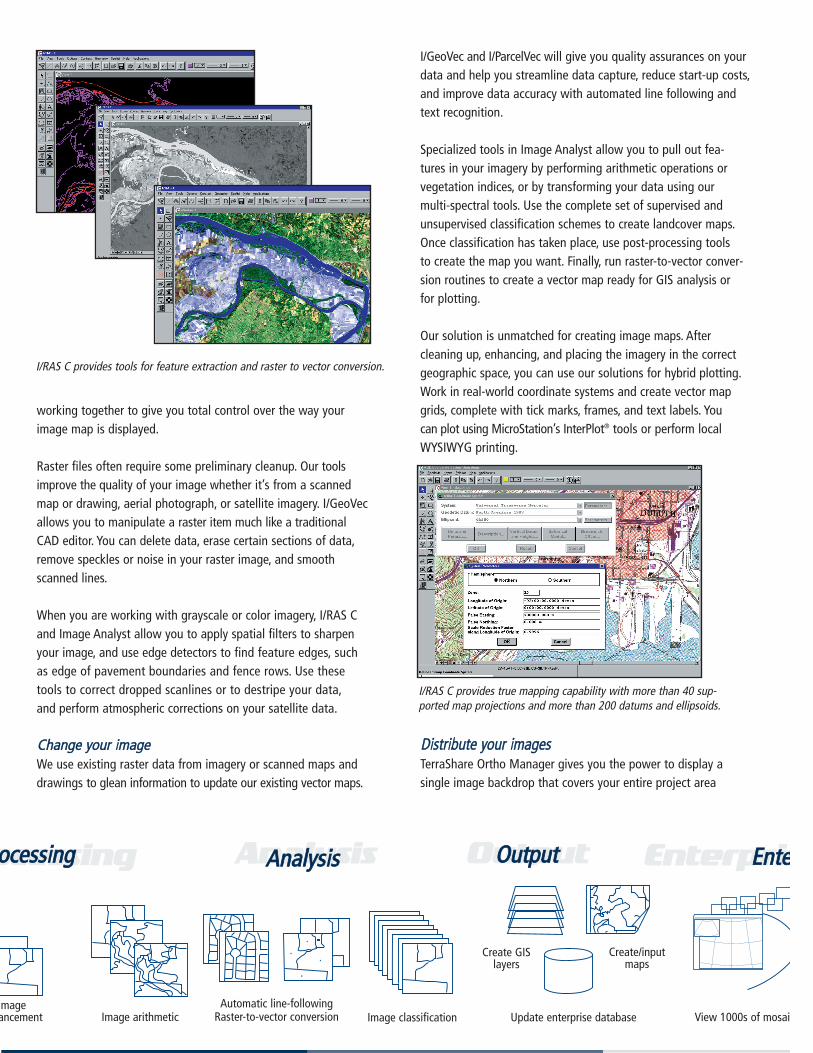
Raster files often require some preliminary cleanup. Our toolsimprove the quality of your image whether it’s from a scannedmap or drawing, aerial photograph, or satellite imagery. I/GeoVecallows you to manipulate a raster item much like a traditionalCAD editor. You can delete data, erase certain sections of data,remove speckles or noise in your raster image, and smoothscanned lines.
When you are working with grayscale or color imagery, I/RAS Cand Image Analyst allow you to apply spatial filters to sharpenyour image, and use edge detectors to find feature edges, suchas edge of pavement boundaries and fence rows. Use thesetools to correct dropped scanlines or to destripe your data,and perform atmospheric corrections on your satellite data.
CChhaannggee yyoouurr iimmaaggeeWe use existing raster data from imagery or scanned maps anddrawings to glean information to update our existing vector maps.
I/GeoVec and I/ParcelVec will give you quality assurances on yourdata and help you streamline data capture, reduce start-up costs,and improve data accuracy with automated line following andtext recognition.
Specialized tools in Image Analyst allow you to pull out fea-tures in your imagery by performing arithmetic operations orvegetation indices, or by transforming your data using our multi-spectral tools. Use the complete set of supervised andunsupervised classification schemes to create landcover maps.Once classification has taken place, use post-processing tools to create the map you want. Finally, run raster-to-vector conver-sion routines to create a vector map ready for GIS analysis or for plotting.
Our solution is unmatched for creating image maps. After cleaning up, enhancing, and placing the imagery in the correctgeographic space, you can use our solutions for hybrid plotting.Work in real-world coordinate systems and create vector mapgrids, complete with tick marks, frames, and text labels. You can plot using MicroStation’s InterPlot® tools or perform localWYSIWYG printing.
DDiissttrriibbuuttee yyoouurr iimmaaggeess TerraShare Ortho Manager gives you the power to display a single image backdrop that covers your entire project area
I/RAS C provides tools for feature extraction and raster to vector conversion.
I/RAS C provides true mapping capability with more than 40 sup-ported map projections and more than 200 datums and ellipsoids.
Update enterprise databasemage ancement Image arithmetic
Create GISlayers
Create/input maps
Image classificationAutomatic line-following
Raster-to-vector conversion
oocceessssiinnggoocceessssiinngg OOuuttppuutt
View 1000s of mosai
EEnntteerrpprriissEEnntteeAAnnaallyyssiiss
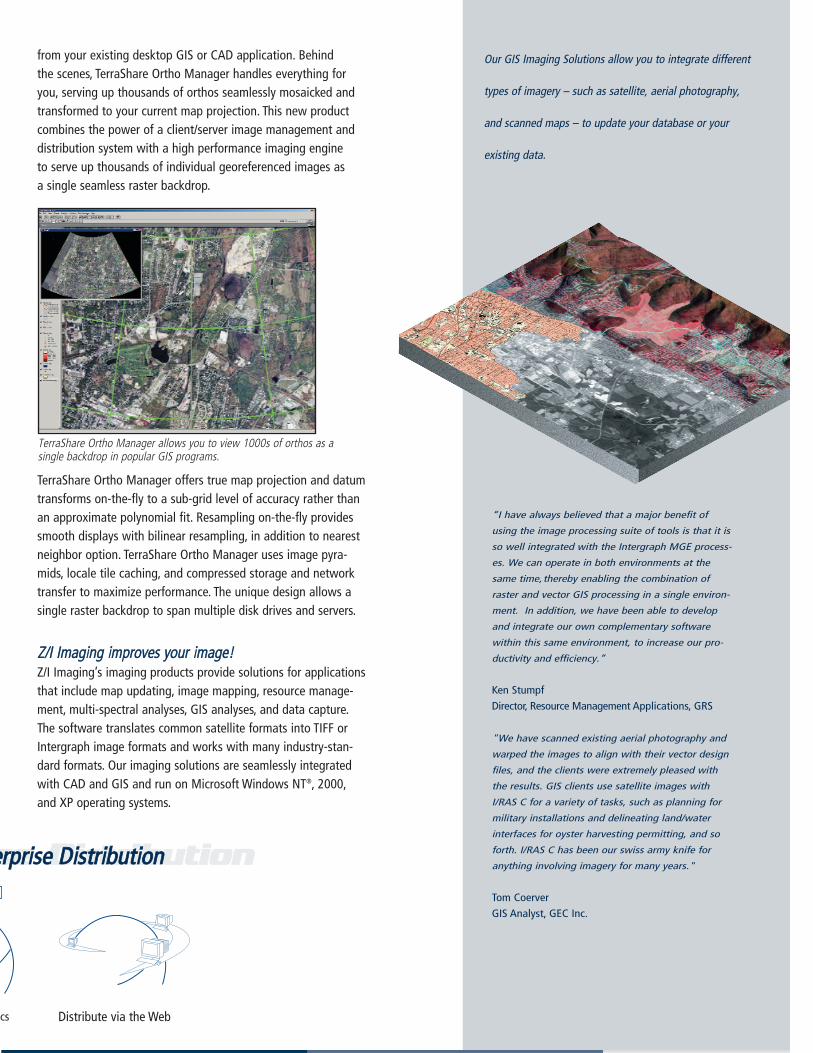
from your existing desktop GIS or CAD application. Behind the scenes, TerraShare Ortho Manager handles everything foryou, serving up thousands of orthos seamlessly mosaicked andtransformed to your current map projection. This new productcombines the power of a client/server image management anddistribution system with a high performance imaging engine to serve up thousands of individual georeferenced images as a single seamless raster backdrop.
TerraShare Ortho Manager offers true map projection and datumtransforms on-the-fly to a sub-grid level of accuracy rather thanan approximate polynomial fit. Resampling on-the-fly providessmooth displays with bilinear resampling, in addition to nearestneighbor option. TerraShare Ortho Manager uses image pyra-mids, locale tile caching, and compressed storage and networktransfer to maximize performance. The unique design allows asingle raster backdrop to span multiple disk drives and servers.
ZZ//II IImmaaggiinngg iimmpprroovveess yyoouurr iimmaaggee!!Z/I Imaging’s imaging products provide solutions for applicationsthat include map updating, image mapping, resource manage-ment, multi-spectral analyses, GIS analyses, and data capture.The software translates common satellite formats into TIFF orIntergraph image formats and works with many industry-stan-dard formats. Our imaging solutions are seamlessly integratedwith CAD and GIS and run on Microsoft Windows NT®, 2000,and XP operating systems.
TerraShare Ortho Manager allows you to view 1000s of orthos as asingle backdrop in popular GIS programs.
Our GIS Imaging Solutions allow you to integrate different
types of imagery – such as satellite, aerial photography,
and scanned maps – to update your database or your
existing data.
“I have always believed that a major benefit of
using the image processing suite of tools is that it is
so well integrated with the Intergraph MGE process-
es. We can operate in both environments at the
same time,thereby enabling the combination of
raster and vector GIS processing in a single environ-
ment. In addition, we have been able to develop
and integrate our own complementary software
within this same environment, to increase our pro-
ductivity and efficiency.”
Ken Stumpf
Director, Resource Management Applications, GRS
"We have scanned existing aerial photography and
warped the images to align with their vector design
files, and the clients were extremely pleased with
the results. GIS clients use satellite images with
I/RAS C for a variety of tasks, such as planning for
military installations and delineating land/water
interfaces for oyster harvesting permitting, and so
forth. I/RAS C has been our swiss army knife for
anything involving imagery for many years."
Tom Coerver
GIS Analyst, GEC Inc.
Distribute via the Webcs
ssee DDiissttrriibbuuttiioonneerrpprriissee DDiissttrriibbuuttiioonn
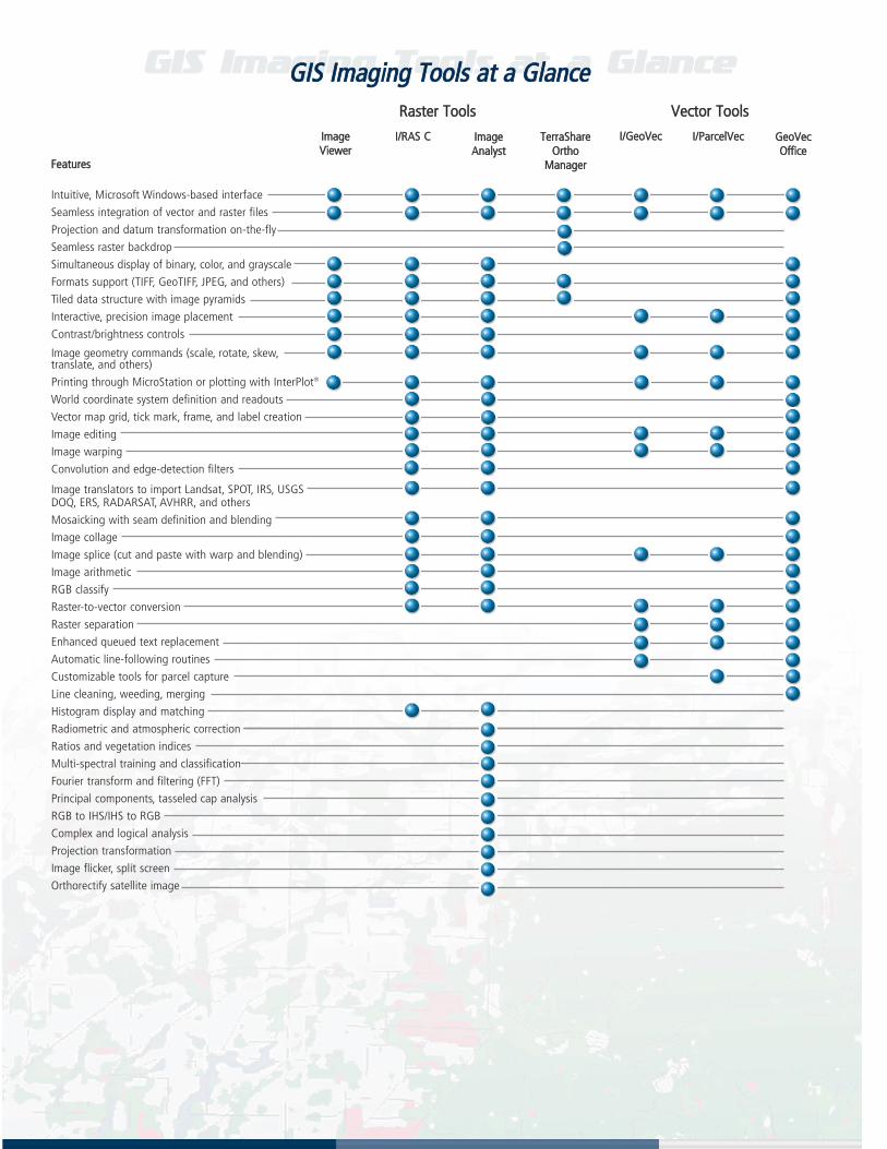
GGIISS IImmaaggiinngg TToooollss aatt aa GGllaanncceeGGIISS IImmaaggiinngg TToooollss aatt aa GGllaannccee
Intuitive, Microsoft Windows-based interface
Seamless integration of vector and raster files
Projection and datum transformation on-the-fly
Seamless raster backdrop
Simultaneous display of binary, color, and grayscale
Formats support (TIFF, GeoTIFF, JPEG, and others)
Tiled data structure with image pyramids
Interactive, precision image placement
Contrast/brightness controls
Image geometry commands (scale, rotate, skew,translate, and others)
Printing through MicroStation or plotting with InterPlot®
World coordinate system definition and readouts
Vector map grid, tick mark, frame, and label creation
Image editing
Image warping
Convolution and edge-detection filters
Image translators to import Landsat, SPOT, IRS, USGS DOQ, ERS, RADARSAT, AVHRR, and others
Mosaicking with seam definition and blending
Image collage
Image splice (cut and paste with warp and blending)
Image arithmetic
RGB classify
Raster-to-vector conversion
Raster separation
Enhanced queued text replacement
Automatic line-following routines
Customizable tools for parcel capture
Line cleaning, weeding, merging
Histogram display and matching
Radiometric and atmospheric correction
Ratios and vegetation indices
Multi-spectral training and classification
Fourier transform and filtering (FFT)
Principal components, tasseled cap analysis
RGB to IHS/IHS to RGB
Complex and logical analysis
Projection transformation
Image flicker, split screen
Orthorectify satellite image
VVeeccttoorr TToooollssRRaasstteerr TToooollss
IImmaaggeeVViieewweerr
II//RRAASS CC IImmaaggeeAAnnaallyysstt
TTeerrrraaSShhaarreeOOrrtthhoo
MMaannaaggeerr
II//GGeeooVVeecc II//PPaarrcceellVVeecc GGeeooVVeeccOOffffiiccee
FFeeaattuurreess

FFoorr mmoorree iinnffoorrmmaattiioonn oorr aa ddeemmoonnssttrraattiioonn,, ccaallll::
UU..SS.. ttoollll ffrreeee ++11--888888--553388--00771133UU..SS.. ++11--225566--773300--11559900EEuurrooppeeaann ++4499--77336644--2200--66550000JJaappaann ++8811--33--55446677--77335555ee--mmaaiill iinnffoo@@zziiiimmaaggiinngg..ccoommoonn--lliinnee wwwwww..zziiiimmaaggiinngg..ccoomm
TThhee GGIISS IImmaaggiinngg ffaammiillyy ooff pprroodduuccttssZ/I Imaging’s product suite for raster display, editing, and conversion provides total solutions that can be configured and dis-tributed across the enterprise, based on individual users’ needs,while maintaining file and user-interface compatibility. Our GISImaging suite includes:
• Image Viewer is a low-cost, high-powered solution for dis-playing map-registered, binary, grayscale, and color rasterimages. Straightforward viewing and management tools aredesigned for users who need powerful viewing and limiteddata manipulation.
• I/RAS C is a powerful toolkit for the display and manipulationof binary, grayscale, and color raster images and maps. I/RAS Cprovides a full set of commands to import, display, warp, mosa-ic, and enhance raster images. I/RAS C is a complete solutionfor cartographic updates, aerial image mapping, and GIS appli-cations that do not require multi-spectral analysis.
• Image Analyst offers all the features of I/RAS C, plus advancedprocessing and analysis tools for your specialized satellite andaerial images. Added features, such as radiometric and atmos-pheric correction, spatial filtering, color transforms, and multi-spectral classification, make Image Analyst the clear choice foradvanced users.
• I/ParcelVec accelerates parcel data capture by providing a setof semi-automated, customizable raster-to-vector conversiontools tailored for parcel management applications. The producttakes any scanned parcel drawings or other digital parcel datain raster form and converts them to vector features for use incadastral workflows in a variety of GIS, LIS, and AM/FM appli-cations. For parcel-related data, I/ParcelVec's powerful, easy-to-use customization tools offer significant increases in perform-ance and accuracy over table and heads-up digitizing and otherraster-to-vector conversion methods.
• I/GeoVec is used to interactively convert scanned maps intoGIS-intelligent vector features. I/GeoVec utilizes advanced semi-automatic line-following techniques, automatic cell and symbolplacement, queued text recognition, and automatic featurecapture and assignment. I/GeoVec allows for display, cleanup,restoration, manipulation, and revision of binary raster files.I/GeoVec's tools are optimized for the unique requirements ofmap data conversion and can handle both line work and text.
• GeoVec Office is a bundle that includes I/GeoVec, I/ParcelVec,I/RAS C, and MRF Mapping Toolkit. This feature-rich bundleprovides a comprehensive solution for creating and maintain-ing vector map data from raster data. Vector data can be useddirectly in MicroStation, exported to other CAD software, orloaded into Intergraph’s MGE, GeoMedia®, or third-party GISsoftware.
• TerraShare Ortho Manager manages and serves up 1000s of orthos as a single seamless raster backdrop in any desired map projection to end users in their existing desktop GIS and CAD applications.
TThhee ZZ//II IImmaaggiinngg SSoolluuttiioonnZ/I Imaging represents a wealth of experience in the earth imaging industry. Our hardware and software products give youstrength and reliability you can depend on. Our services ensurethat you get the best performance from your photogrammetric orimaging systems.
See how Z/I Imaging can provide the solution for all of your earth imaging needs.
I/ParcelVec providescustomizable tools forparcel capture.
I/Geo Vec streamlinesdata capture.