gleision mine incident - health and safety · pdf filegleision mine incident iii introduction...
TRANSCRIPT

Health and Safety Executive
Gleision Mine Incident 15 September 2011 A factual report by the Health and Safety Executive


Health and Safety Executive
Gleision Mine Incident 15 September 2011 A factual report by the Health and Safety Executive
HSE Books

Gleision Mine Incident
ii
© Crown copyright 2015
First published 2015
You may reuse this information (not including logos) free of charge in any format or medium, under the terms of the Open Government Licence. To view the licence visit www.nationalarchives.gov.uk/doc/open-government-licence, write to the Information Policy Team, The National Archives, Kew, London TW9 4DU, or email [email protected].
Some images and illustrations may not be owned by the Crown so cannot be reproduced without permission of the copyright owner. Enquiries should be sent to [email protected].
This guidance is issued by the Health and Safety Executive. Following the guidance is not compulsory, unless specifically stated, and you are free to take other action. But if you do follow the guidance you will normally be doing enough to comply with the law. Health and safety inspectors seek to secure compliance with the law and may refer to this guidance.
Gleision Mine Incident
iii
Introduction 1 Summary of the incident 1 Background 1 The mine 1 The mine plan 2 Method of work 3 Type of rock in the mine 4 Water in the mine 4 The events of 15 September 2011 4 The search and rescue operation 5 At the site 5 Away from the site 7 The site investigation 7 Preparatory work 7 Mine plans and the mine survey 8 Water flows within the mine 9 Evidence recovered from the mine surface 10 The Main Drift and H1 roadway 11 The Top Road and the old 1980s workings 12 The inrush stall 13 Surveying the inrush stall 16 Other lines of enquiry 16 Calculations 17 Conclusion of the site investigation 18 Securing the mine 18 Legal framework 18 The Health and Safety at Work etc Act 1974 18 The Management and Administration of Safety and Health at Mines Regulations 1994 18 The Mines (Precautions Against Inrushes) Regulations 1979 19 Conclusions relating to the site investigation 19 Lessons learned 20
Contents

Gleision Mine Incident
iv

Gleision Mine Incident
1
Introduction 1 This report is a factual account of the circumstances of the incident at Gleision Mine in September 2011 in which an inrush of water from old mine workings resulted in four mine workers tragically losing their lives. It is based on the Health and Safety Executive’s (HSE’s) involvement in the search and rescue attempt and in the full investigation that followed, which was led by South Wales Police.
2 The report aims to explain what happened, how it happened and why, the investigation process and what evidence was recovered. Where necessary, it contains additional information to aid understanding, for example in relation to mine plans, mining processes and mine water flows. The report does not cover the legal proceedings instigated by the Crown Prosecution Service (CPS) against the former mine manager and owners as these were explored during the subsequent trial in Swansea Crown Court.
Summary of the incident 3 On the morning of 15 September 2011, work was about to start as usual at Gleision Mine, a small coal mine in the Swansea Valley. At around 5.45 am, the mine manager arrived at the site and, over the next half hour or so, the other eight workers arrived on site. Around 7.00 am six of the workers went below ground (see paragraph 32).
4 At around 9.30 am, the first round of explosives was fired (see paragraph 11). The blast released a large body of water from old workings which rushed into the working stall, which was the part of the mine from where coal was being extracted, and where the manager, Malcolm Fyfield, and workers Phillip Hill, David Powell and Charles Breslin were. Two other workers, David Wyatt and Garry Jenkins, were nearby.
5 Such was the volume and speed of the water inrush that four of the men – Phillip Hill, David Powell, Charles Breslin and Garry Jenkins – were overwhelmed and died. Malcolm Fyfield was injured but managed to escape through the old workings and emerged on the surface about an hour later. David Wyatt and another worker underground, Nigel Evans, who was further away from the stall, just managed to escape to the surface and raise the alarm.
6 A sustained search and rescue operation over the next two days ultimately proved unsuccessful. Over the following days and weeks an initial on-site investigation was started as part of a major joint investigation led by South Wales Police and supported by HSE. The investigation was supported by others from Mines Rescue Service Ltd (MRSL) and the nearby Aberpergwm, Unity and Nant Hir mines. Invaluable support was also provided by specialist contractors, equipment suppliers, including Hewden Hire and Pump Supplies Ltd of Port Talbot, and other people with long experience of working small coal mines in South Wales. Their dedication kept the mine accessible for the duration of a very difficult investigation carried out in challenging circumstances.
7 HSE continued to assist South Wales Police beyond the site investigation phase, including helping plan and carry out interviews with key people and organisations.
Background The mine
8 Gleision Mine was a small-scale coal mine high on the southern slope of the Swansea Valley, opposite Godre’r-graig and near Pontardawe. It was one of very few such mines remaining in the South Wales coalfields.
9 The mine had been owned since 2009 by MNS Mining Ltd who in 2010 had a licence granted by The Coal Authority to extract coal from the No 2 Rhondda Seam. Planning permission granted by Neath Port Talbot County Borough Council limited the extraction of coal to the area defined on The Coal Authority licence.
10 The mine had been working under various owners and managers for many years. Operation was not continuous, there were sometimes years of inactivity. In the five years before the incident, coal production was intermittent, ownership changed three times and there were five different mine managers. The manager at the time of the incident, Malcolm Fyfield, was appointed in July 2011 by MNS Mining Ltd.
11 In the six months before the incident, Gleision Mine had been producing coal on a single daily shift basis. An average of six miners were employed in this period, as well as a supervisor and mine manager. The method used to get the coal was a traditional ‘bore and fire’ technique, where holes were drilled into the coal face, explosives were inserted into them and detonated to break out the coal.

Gleision Mine Incident
2
The mine plan
12 There is a legal requirement for up-to-date plans of mine workings to be kept at the mine. These have to be updated by a qualified mine surveyor every three months, or sooner if the mine workings progress more than 100 m from the last survey point. Looking at the mine plan (Figure 1) will help in understanding the layout of the mine and description of the events. It is marked to show the parts of the mine referred to in this report. The plan is a reproduction of the most recent one updated by the mine surveyor after an inspection he made below ground at Gleision on 3 July 2011 in the company of Malcolm Fyfield.
13 The plan shows the two surface entrances into the mine workings – the Main Drift Entrance and the Old North Road Entrance. The latter was not in use at the time as an entrance, but a ventilation fan at the top of it pulled air out of the mine, in turn drawing fresh air in through the Main Drift Entrance and around the mine workings.
14 The grey shaded areas on the plan are the parts of the Rhondda No 2 seam that have been extracted over the past 50 years or so. A proportion of these voids is filled with stone packs constructed as part of the mining method – in effect the spaces where the coal has been extracted are filled with rock dug out to
gain access to them. This provides additional support in those areas. The lines within the shaded areas are the tunnels that gave access to those areas. Most of these are either now inaccessible or very difficult to access.
15 The licence boundary, which is also the area to which the planning permission extended, is marked ‘Colliery Boundary’ on the mine plan.
16 The grid lines overlaying the plan are spaced 100 m apart and give an idea of the overall scale of the mine. A football pitch would occupy roughly two-thirds of one of the squares.
17 The green hatched areas to the south and east of both the Old South-West Workings and the Old Central Workings seemed to represent the ‘cautionary zone’ against potentially hazardous disused mine workings.
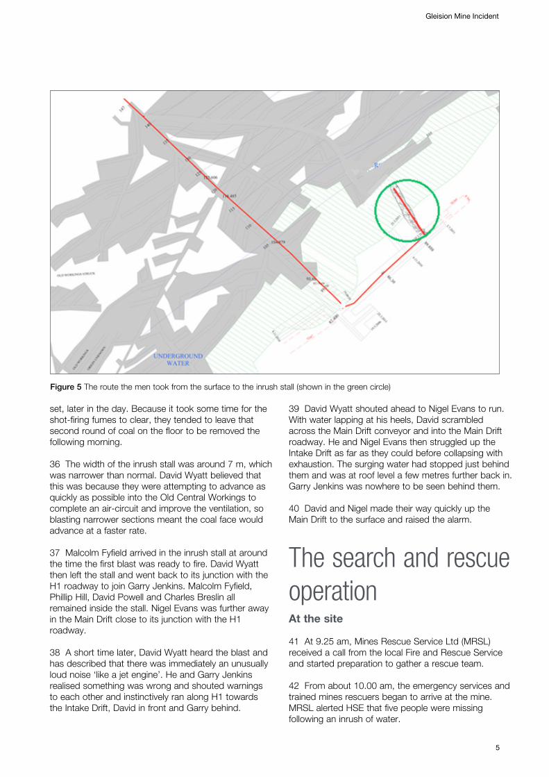
18 Three separate areas of old mine workings, the Old South-West Workings, the Old Central Workings, and the Far-East Workings, are marked in blue with the words ‘Underground Water’.
19 There is a blue line drawn on the plan in the Old Central area. The line is near the 109 m contour line which, in the event that there was no connection at a
Figure 1 Mine plan

lower level through which water could run, is the same level as a natural overflow point from the workings. HSE investigators therefore believed that this corresponded to the level of the water in the old workings immediately before the inrush.
20 Both the 1.7 m high Main Drift and the Old North Road tunnels follow the coal seam into the hillside. The Main Drift slopes down at a gradient of about 1 in 5 for about 300 m in a south-easterly direction. Figure 2 shows the view looking down the Main Drift, with a belt conveyor on the left hand side.
21 A roadway known as H1, 275 m into the Main Drift, led off to the left at approximately right angles. It was about 1.7 m high and went gently uphill for 130 m in a north-easterly direction. The H1 roadway contained a compressed-air-powered belt conveyor.
22 The most recent coal workings shown on the mine plan were to the left-hand side of the H1 roadway – the area is shown more closely in the plan extract shown in Figure 4. The inrush stall is not shown as the work to drive it had not started when the 3 July survey was undertaken and the mine plan was updated.
Method of work
23 In the months leading up to the incident the mine employed on average six miners, a supervisor and a mine manager, working a single shift. The coal was mined using traditional ‘bore and fire’ techniques. Holes were drilled into the coal and filled with explosives to break the coal away, which was hand-shovelled onto a small steel conveyor. Each blast would take about a metre thickness of coal from the face. The mine aimed to complete two blasts a day. These working areas, or coal stalls (as they are known), are driven within the coal seam, which was no more than 0.77 m, or around 2’6” high, less than the height of a typical kitchen work surface. They would be driven for no more than about 65 m into the coal, which was the length of the steel conveyor available.
24 The stalls were 10−15 m wide and were supported by props and wooden cross-bars. This arrangement would sometimes be supplemented by an array of wooden ‘chock pillars’ (built like a small ‘log cabin’). Part of the rock in the floor beneath the coal seam would be removed so that the steel conveyor would sit below floor level making shovelling coal onto it much easier.
25 In the access roadways, such as the Main and Return Drifts and the H1 roadway, the rock in the floor beneath the seam would also be removed to give a
Gleision Mine Incident
3
Figure 2 View looking down the Main Drift – the main way into the mine
Figure 3 The entrance to the H1 roadway from the Main Drift, taken after the inrush; some water and silt can be seen beneath the conveyor towards the bottom right
Figure 4 Plan extract

Gleision Mine Incident
4
finished height of around 1.7 m. This was to provide sufficient room for the belt conveyors and other equipment and to make travelling through the mine easier. The rock removed from the floor was packed into part of the space left by the removal of the coal, which had the side benefit of providing additional support. These pack walls could be quite thick, at up to 4 m in places.
Type of rock in the mine
26 The Rhondda No 2 seam lies between layers of mainly sandstone and grit rock, known internationally as the Pennant Sandstone Formation. The rock above the coal seam is a strong sandstone that forms the roof of the mine workings where the coal has been extracted. However, while it is strong rock it is also permeable, which means that water can seep through it. Most of the water found within the mine seeps down from the surface through the sandstone and drips from the roof of the mine workings. This means that the amount of water seeping into the mine will have increased over the years as more coal was extracted and hence more sandstone roof exposed. The flow rate into the mine workings is also known to vary with rainfall.
27 The rock forming the floor beneath the coal seam was a different type of rock but also strong.
Water in the mine
28 The water seeping through the sandstone drips into workings where the coal has been removed and the sandstone roof exposed. It trickles downhill through the mine workings forming rivulets that merge into streams. The layout of the mine workings is such that the water flows through the mine in a roughly north-east to south-westerly direction.
29 Some of the water overflowed naturally into the Old Gleision workings to the south-west at a point in the Main Drift known as the Lower Monks (see Figure 1). The remainder flowed down to the sump at the bottom of the Main Drift, from where it was pumped up to the Lower Monks and into the same disused mine workings. The water was then believed to flow through old Ynysmudw Colliery workings and then a series of interconnected old mine workings between the Swansea Valley and the Vale of Neath, eventually emerging at an outflow near Neath Abbey.
30 The mine plan suggested that some of the old workings within Gleision had been allowed to flood as there were three separate areas on the mine plan that
were marked ‘Underground Water’. There was also a fourth area of old workings, marked ‘South-East Workings’ on the plan, that were said by previous managers to be flooded. The contours of the mine plan also suggested that these old workings were also likely to be flooded. This was not marked on the mine plan in the same way, however this is not relevant to the incident.
The events of 15 September 2011 31 The following description is based on extracts from statements of the three survivors who were below ground at the time of the incident – Nigel Evans, David Wyatt and Malcolm Fyfield, the mine manager – and from surface workers Andrew Giles and Gerald Ward, a company director.
32 Malcolm Fyfield arrived on site at around 5.45 am on Thursday 15 September 2011. Over the next half hour, Gerald Ward, Andrew Giles, Nigel Evans, and David Wyatt, along with Garry Jenkins, David Powell, Charles Breslin and Phillip Hill all arrived at the mine. At about 7.00 am, all apart from Gerald Ward, Malcolm Fyfield and Andrew Giles went below ground.
33 It took around 20 minutes for Garry Jenkins, David Wyatt, David Powell, Charles Breslin and Phillip Hill to travel down the Intake Drift and then along H1 roadway to the coal face in the inrush stall. Travelling along H1 was quite difficult as the installation of a wider conveyor belt in 2010 had reduced the access space. The five men had to crawl for the last 40 m to reach the entrance to the inrush stall.
34 David Powell, Charles Breslin and Phillip Hill changed into their waterproof clothes and crawled the 54 m to the coal face. David Wyatt remained at the junction in H1 to run the chain conveyor and Garry Jenkins went to work on the H1 roadway further in towards the inrush stall.
35 Once the colliers had cleared the coal at the face from the previous day’s blasting, David Wyatt began taking some wooden supports forward to them. As he did so, he could hear them drilling the coal face to insert explosives for the next blast. When he reached them, they told him they were ready to ‘fire’ (blast the face using explosives). It was normal practice to blast the coal face twice each day; once in the morning and then, after the coal was cleared up and supports
set, later in the day. Because it took some time for the shot-firing fumes to clear, they tended to leave that second round of coal on the floor to be removed the following morning.
36 The width of the inrush stall was around 7 m, which was narrower than normal. David Wyatt believed that this was because they were attempting to advance as quickly as possible into the Old Central Workings to complete an air-circuit and improve the ventilation, so blasting narrower sections meant the coal face would advance at a faster rate.
37 Malcolm Fyfield arrived in the inrush stall at around the time the first blast was ready to fire. David Wyatt then left the stall and went back to its junction with the H1 roadway to join Garry Jenkins. Malcolm Fyfield, Phillip Hill, David Powell and Charles Breslin all remained inside the stall. Nigel Evans was further away in the Main Drift close to its junction with the H1 roadway.
38 A short time later, David Wyatt heard the blast and has described that there was immediately an unusually loud noise ‘like a jet engine’. He and Garry Jenkins realised something was wrong and shouted warnings to each other and instinctively ran along H1 towards the Intake Drift, David in front and Garry behind.
39 David Wyatt shouted ahead to Nigel Evans to run. With water lapping at his heels, David scrambled across the Main Drift conveyor and into the Main Drift roadway. He and Nigel Evans then struggled up the Intake Drift as far as they could before collapsing with exhaustion. The surging water had stopped just behind them and was at roof level a few metres further back in. Garry Jenkins was nowhere to be seen behind them.
40 David and Nigel made their way quickly up the Main Drift to the surface and raised the alarm.
The search and rescue operation At the site 41 At 9.25 am, Mines Rescue Service Ltd (MRSL) received a call from the local Fire and Rescue Service and started preparation to gather a rescue team.
42 From about 10.00 am, the emergency services and trained mines rescuers began to arrive at the mine. MRSL alerted HSE that five people were missing following an inrush of water.
Gleision Mine Incident
5
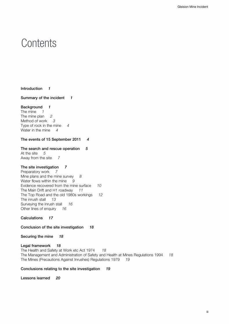
Figure 5 The route the men took from the surface to the inrush stall (shown in the green circle)
Gleision Mine Incident
6
43 It quickly became clear that the very small company that owned the mine was in no position to provide any support to the search and rescue operation. MRSL and HSE called for assistance from neighbouring mines and mining equipment suppliers, all of whom responded willingly and quickly. Three HSE mines inspectors were directed to attend the incident.
44 At 11.05 am, MRSL reported to HSE that one man had escaped. This proved to be the mine manager, Malcolm Fyfield, who had escaped by travelling through an old part of the mine (see Figure 6). MRSL also confirmed that David Wyatt and Nigel Evans were safe on the surface, but that four miners were still missing.
45 MRSL subsequently deployed a team below ground to explore the route through which Malcolm Fyfield had escaped. About 30 minutes later the rescue team returned to the surface, driven back by low oxygen levels.
46 At 12.55 pm, a rescue team wearing breathing apparatus re-entered the mine to resume the search for survivors, returning some time later to report that they had reached a point in the Old Central Workings beyond which they could not proceed because of the water and silt.
47 A plan of the mine workings had been found by that time in the manager’s office. The words ‘Underground Water’ seemed to indicate that these workings were flooded before the incident.
48 Hand-drawn markings on the plan were thought to indicate where working had taken place since the plan was last updated on 3 July 2011. This, along with information from David Wyatt on the last known position of miners and possible areas where they could take refuge, was the best information available to the rescuers.
49 Throughout the remainder of the day, pumping equipment was deployed into the flooded Main Drift in an attempt to lower the water level.
50 By around midnight, the water level had receded sufficiently to enable two cave divers in breathing apparatus to enter the H1 roadway. Within an hour they found Garry Jenkins about 16.5 m into the H1 roadway from its junction with the Main Drift.
51 The divers continued along H1 but came to a build-up of silt and debris and, finding no other signs of life in the accessible roadways, they returned to the Main Drift. Due to the difficult conditions, they were unable to recover Garry Jenkins at that time.
Figure 6 Malcolm Fyfield’s approximate escape route to the surface – his route from the inrush stall to point A is uncertain. Point B was where the first rescue team reached and encountered low oxygen levels. Point A was where the rescue team reached wearing breathing apparatus

52 By around 9.00 am on Friday 16 September, water levels were still receding and the air in H1 was found to be breathable. A team of five rescuers from Unity Mine, accompanied by an HSE mines inspector, entered the mine. The rescue team reached Garry Jenkins around 9.30 am.
53 Finding no sign of life further along H1, the rescue team, assisted by specialist Urban Search and Rescue (USAR) teams, brought Garry Jenkins to the surface. Further searches of the Old Central Workings around this time proved fruitless.
54 Another mines rescue team was working along the H1 roadway searching any open spaces. As they progressed, the amount of silt and other debris washed in by the inrush increased.
55 As they went further along H1, the rescue team found a coal stall not shown on the mine plan, again having apparently been driven following the 3 July 2011 survey. Working their way in along one side, they found nothing in this stall. When working their way back out down the other side, they found an area which was devoid of support and containing debris, props and tangled air hose. This proved to be the entrance to the ‘inrush stall’ where the men had been working immediately before the inrush. Without support, this area was unsafe to enter so they returned to rejoin the other rescue workers on H1.
56 To try and make a safe access into the inrush stall, where the missing men were thought to be, the rescue team excavated a narrow tunnel towards the inrush stall. They subsequently located David Powell partly submerged in the silt. About 20 minutes later they found Charles Breslin just behind David Powell. A short time later, at around 2 pm, they found Phillip Hill.
57 By 5.20 pm, all three had been recovered to the surface and the search and rescue attempt effectively concluded.
58 It is difficult to say exactly how many people were involved on or near the site during those 32 hours, but it was well into the hundreds, including:
� police, fire and ambulance services and their specialist USAR teams and Hazardous Area Response Teams (HARTs);
� part-time and full-time mines rescue personnel from South Wales and as far afield as Mansfield and Kellingley Mine Rescue Stations in Nottinghamshire and Yorkshire respectively;
� miners and mine supervisors from Unity, Aberpergwm and Nant Hir Collieries;
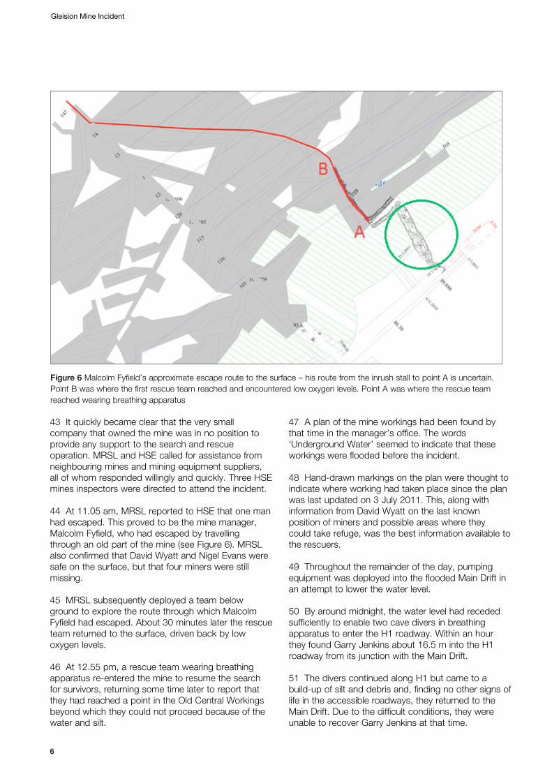
Gleision Mine Incident
7
� pump and other equipment suppliers, and specialist service providers;
� experienced cave divers from mid-Wales; � those working at the Rhos Community Centre
who did so much to support the families and others throughout the duration of the search and rescue effort.
Away from the site
59 Chief Superintendent Mark Mathias, South Wales Police Divisional Commander for Swansea and Neath Port Talbot (NPT), quickly declared a major incident to enable resources to be quickly called upon from a wide area. By early afternoon on 15 September 2011, a command centre had been set up at NPT offices in Baglan.
60 Responses that were initially considered included:
� the deployment of the cave divers; � bringing in heavy drilling equipment to mount a
rescue attempt from the surface should it not be possible to reach the men from below ground;
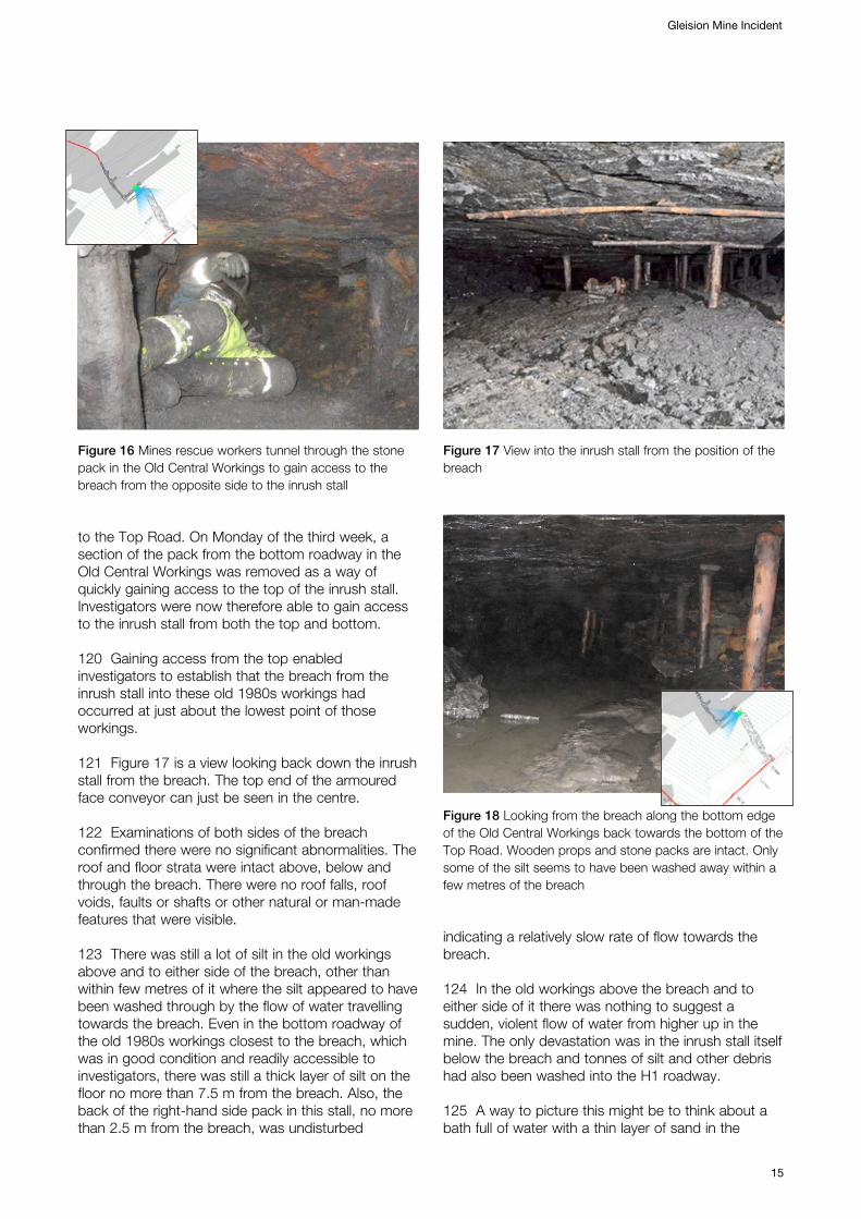
� the possibility of the RAF flying in sludge pumps from East Anglia should that become necessary.
In the event the last two proved unnecessary as the rescuers quickly became confident that enough water could be pumped out in less time than these options would take to allow access from below ground.
The site investigationPreparatory work
61 When the search and rescue operation concluded on Friday evening, arrangements were made with the operators of other mines in the vicinity to provide people to keep the mine secure and also to keep the water levels in the mine as low as possible until a full site investigation could begin.
62 The following morning, the police and HSE agreed on a joint investigation, but with South Wales Police formally leading under published arrangements for the investigation of work-related deaths.1 HSE’s primary role was to carry out the on-site investigation at the mine and to provide specialist support to the police in the wider investigation that had already started.
1 Work-related deaths: A protocol for liaison (England and Wales) WRDP1 HSE Books 2011 www.hse.gov.uk/enforce/wrdp

Gleision Mine Incident
8
63 An initial underground reconnaissance inspection confirmed that the investigation below ground would be extremely challenging. The inrush stall itself was not safely accessible at that time, but it was clear from the huge amount of debris at the bottom of the stall and in H1 that many of the roof supports had been washed away together with coal and some equipment. There was also a lot of slurry that proved to have been washed in by the inrush. The debris formed what was effectively a plug at the bottom of the stall, severely restricting access. It was clear that if investigators were to enter by this route it would require a significant amount of work to remove debris and re-establish roof supports.
64 There was a continual flow of water through the stall, out into the H1 roadway and down to a sump at the bottom of the main drift. Investigators could not rule out the possibility that some of the water flowing through the stall had accumulated and given rise to another inrush hazard. It was also impossible at that time to determine the thickness or condition of the coal pillar between any remaining or new accumulations of water.
65 In those early stages, therefore, the approach was to control the risk to investigators by minimising the time people spent in the H1 roadway. The principal focus was to try and gain access to the top of the inrush stall through the Old Central Workings, along a route known as the ‘Top Road’ – see Figure 1. This approach meant that the investigation team would be above the level of any other accumulations of water there might be and therefore not at risk from another uncontrolled release.
66 Taking the necessary materials and equipment into the mine took up most of the first week. This was a difficult task as most things needed for the investigation had to be carried or dragged several hundred metres into the mine.
67 By the start of the second week the investigation team had reassessed the risk of further inrush as sufficiently low to enable work at the bottom of the inrush stall for longer periods to create a safe route into and through the inrush stall to the face of the heading.
68 The investigation team also decided that the main access road, H1 roadway and if possible the inrush stall should be re-surveyed to ensure accurate measurements were available.
69 At this point it is right to acknowledge the enormous assistance provided by various parties to keep the mine open and accessible for the investigation team. The mine owner, MNS Mining Ltd,
who would normally have been expected to provide the necessary support, was in no position to do so, not least because it was a small company, half of its workforce had been killed in the tragedy, and the mine manager was in hospital.
70 The owners of Aberpergwm and Unity Mines, Mines Rescue Service Ltd, and the suppliers of pumps, generators and other site facilities and diesel all deserve special mention and thanks in this respect.
Mine plans and the mine survey
71 It is accepted that mine plans at small mines that do not have a resident mine surveyor are not always a precise representation of the extent of the workings. They should, however, be a reasonable approximation. It is unlikely that all of the void spaces from where the coal has been extracted between visits will be visible to the mine surveyor at the time of their quarterly surveys. In fact, the working methods at Gleision and other small coal mines working very thin seams is such that most of the void spaces are progressively obscured by stone packs that are built as part of the mining process. Between the legally required quarterly surveys the mine manager should ensure that a record is kept of the limits of coal extraction so that the mine surveyor can use this information to update the mine plans following each survey.
72 It is therefore not uncommon for there to be discrepancies of several metres in relation to the exact limits of excavations, and with older mine plans it can be significantly more. However, the position of the main mine roadways, subsidiary roadways and access points to the working areas is usually much more accurate. This is well known by mining surveyors and small coal mine managers. It was also taken into account by relevant mining legislation, which made conservative allowances for inaccuracies in mine plans, as described in the ‘Legal framework’ section later in this report.
73 When the position of the access point into the inrush stall was checked as part of the re-survey that was undertaken in the second and third weeks of the investigation, it showed that it was accurate to a few centimetres.
74 The survey also showed, however, that the limit of extraction at the bottom of an area of coal mined in the 1980s, which held the water that subsequently flowed through the inrush stall, was about 7 m further downhill towards the inrush stall than shown on the mine plan. This probably resulted from incomplete or inaccurate measures of the limits of the excavations being passed

onto the mine surveyor by the mine manager(s) in the 1980s. However, given the intention was to drive into these old mine workings, this difference is not significant, as explained in paragraph 163.
Water flows within the mine
75 Before describing the water flows etc it will be helpful to explain ‘spot heights’ and ‘contour lines’ on mine plans:
� A spot height is the height of the floor of the mine at any point. Mines that are driven into a hillside, as at Gleision, are generally above sea level as the whole of the hill is. So the ‘spot height’ refers to the height above sea level. To illustrate, the summit of Pen Y Fan, the highest point in the Brecon Beacons, has a spot height of 886 m.
� A contour line is a line that joins up points of equal height. Contour lines drawn on mine plans rely on judgements made by mine surveyors and so cannot be precise. They nevertheless give a good indication of how the steepness of the coal seam varies across the mine and can therefore be useful in planning the mine layout in relation to both transport and water flows.
76 The part of the Pennant Sandstone Formation around the Rhondda No 2 workings is not known for having naturally occurring spaces, where water can accumulate. Also, there were no disused shafts within, or near, the Gleision workings, and no old mine workings above the Rhondda No 2 seam where water could accumulate. The maximum slope of the rock layers, or strata, in this area is around 1 in 5. This means that the rock drops, in a roughly south-easterly direction, by 1 foot for every 5 feet it travels into the hillside. Looking at the mine plan reproduced earlier in this report, the workings slope down from top to bottom (north to south) and from right to left (east to west). Figure 8 illustrates how steeply the seam dips into the valley side.
77 Water entering the mine naturally tries to flow through those workings to the lowest point. Over many years the mine had progressively worked down into the hillside from the southern slope of the Swansea Valley where the seam outcropped at the surface, so the lowest point of the mine would nearly always be the current working area. Preventing water reaching the working places is necessary to enable people to work.
Gleision Mine Incident
9
Figure 7 The route resurveyed showing that the mine plan was generally accurate. R10 and Stn E are the top and bottom of the inrush stall, which appears semi-shaded as it was derived from the laser scan. The bottom edge of the semi-shaded area between R9 and R10 is the actual limit of excavation of coal from the Old Central Workings in the 1980s; it is 7 m further south-east than shown on the mine plan

Gleision Mine Incident
10
78 Mine managers aim to lay out mine workings as far as they can to control water flows so that the water will naturally stay clear of the working places, minimising the need for pumping and its associated costs.
79 Gleision is in an area of coal located between other long-abandoned mines, Ynysgynon to the north-east and Old Gleision Colliery and Ynysmudw to the south-west. It is not connected to the workings of Ynysgynon, which are assumed to be mostly flooded, but it is connected in at least two places to the Old Gleision workings. These workings are known to be largely dry as the water seems to drain through to Ynysmudw Colliery and then through a series of old interconnected mine workings in the Swansea Valley and the Vale of Neath, as described earlier in the ‘Water flows within the mine’ section in this report.
80 The layout of the mine indicates that in the past various mine owners and managers had taken advantage of the disused workings to the south-west as a suitable means of disposing of water, avoiding the costs of pumping water to the surface. Until about the 1980s, it is likely that most of the water drained by gravity into these workings and that little if any pumping was necessary. The mine roadways in the mine slope gently downwards from a north-east to south-west direction towards the main drift and water would have flowed along them in that direction.
81 These roadways would have mostly been driven in a north-east direction, in other words slightly uphill, so that any water would drain from them away from the working areas and flow in a south-easterly direction. This has always been a common technique in small coal mines and was being used at the time of the inrush. The H1 roadway was being driven slightly uphill in a north-easterly direction, with coal stalls being worked at approximately right angles to H1,
heading in a north-westerly direction up almost the full seam gradient of 1 in 5. Water dripping in from the roof of the stalls or from the roof of H1 would run down to a sump at the bottom of the Main Drift from where it was pumped up the Lower Monks and into the old workings to the south-east.
82 From the 1980s onwards, the mine progressed further downhill from the surface as more coal was extracted and, at about 180 m from the surface, passed the last known connection into the disused workings to the south-west.
83 During the 1980s, coal was extracted from an area of the mine to the north-east of the Main Drift. Working in a north-easterly direction, coal was progressively extracted across almost the full width of the licence area over a period of about 15 years or so. Whether by accident or design, one of the coal workings mined in the 1980s effectively formed a sump where water could accumulate. This is the area marked ‘Underground Water’ to the lower left centre of the plan.
84 The manager at the time the mine reopened in 2005 said that he installed a small dam around a 200 mm diameter ‘black pipe’ that was laid across the Main Drift at the so-called Lower Monks. The purpose of this pipe was to conduct the overflowing water from this area across the drift and directly into the connection with the disused workings (see photo of the Lower Monks in Figure 9).
Evidence recovered from the mine surface
85 The account of the search and rescue operation describes how a copy of the mine plan dated 3 July 2011 had been found in the manager’s office at Gleision and was used by rescue workers to try and
Figure 8 Seam dipping into the valley side Figure 9 The dam and black pipe at the Lower Monks on the Main Drift

determine where any survivors might be. It had drawn markings on it that appeared to show the possible layout of further planned workings in the green hatched area in the vicinity of the inrush stall. HSE mines inspectors arriving at site on the afternoon of 15 September quickly identified this as likely to be a ‘working copy’.
86 Other plans and sketches, including one that looked to be a sketch of the potential layout of future coal stalls in the area being worked, were also recovered from the manager’s office along with a ‘day book’ which described each day’s work and coal produced and inspection and other records that might indicate how the mine was being worked.
87 Working closely with officers from South Wales Police’s Major Crimes Unit HSE mines inspectors progressively analysed the information over the ensuing days, weeks and months, to build up a picture of how the mine was being worked at the time of the incident.
88 The site investigation team did not find any evidence at the mine of an assessment of inrush hazards or precautions to be taken to guard against the risks from inrushes. The ‘Legal framework’ section later in this report describes that, in addition to legislation of general application dealing with risk assessment and risk control, there were regulations specific to mines that go further in relation to the prevention of risks from inrush hazards in mines. These regulations had been in force for many years and their key principles have been carried forwards into the new Mines Regulations 2014, which came into force on 6 April 2015.
The Main Drift and H1 roadway
89 Investigators confirmed that a conveyor belt ran down the left-hand side of the Main Drift and a walkway to the right. The overall height averaged 1.7 m down to the Lower Monks at about 180 m in from the surface but both height and width became more restricted beyond that point.
90 At 260 m in from the Main Drift entrance, there was a stall on the right-hand (south-west) side which was shown on the most up-to-date copy of the mine plan. Further in on the right, directly opposite the H1 roadway at 275 m, there was a second stall. This was not shown on the mine plan.
91 At the entrance to H1, at its junction with the main drift, there was a tangle of hoses and other debris. Although the Intake Drift was known to extend for another 25 m beyond H1 this area was used as a
sump and was full of water and silt. The investigation team did not excavate this area as it was not relevant to the events leading up to the inrush.
92 In the H1 roadway clearances were restricted because of the silt and debris washed in by the water, which had buried the conveyor belt to various depths. It was only possible to travel on hands and knees on top of the conveyor belt which was just exposed above the silt. The conveyor belt in H1 was 800 mm wide and the clearance down each side averaged 500 mm, but in places was restricted to between 200 mm and 400 mm. It would therefore have been difficult to move quickly through these parts of the H1 roadway before the inrush. Forty-five metres along H1 from the Main Drift there was what appeared to be a coal stall on the left hand (uphill) side. This was not shown on the plan. This could only be seen because a 150 mm gap had opened up in the stone pack wall that had been built as part of the normal mining process. The material that had been in this gap was probably washed away by the force of the water during the inrush. It was not possible to gain entrance safely. It was estimated from peering into through the gap that the stall extended for about 15m and was supported by wooden props. It was not relevant to the inrush and was not explored further.
93 At 80 m along H1 there was another coal stall to the left. This was shown on the mine plan as stopping at the boundary of the green hatched area (cautionary zone). It was not possible to gain access to determine if this stall was as shown on the plan or whether it had gone further. There did not appear to be any significant damage in the stall itself but the H1 roadside stone pack walls were damaged and there was a coating of wet silt covering them.
94 The entrance to the inrush stall was 90 m along H1, again on the left side of the roadway. The area around this was filled with debris and silt. Equipment protruded from the silt and debris, indicating that this was the stall being worked at the time of the inrush.
95 Beyond the entrance to the inrush stall the H1 roadway height was reduced to 0.7 m and the conveyor belt structure had completely disappeared under the silt. It was from this point that rescue teams had dug into the stall on an angle to find the three remaining men.
96 At the start of the investigation water was running out of the rescue channel entrance and the air current was pulling strongly inwards towards the inrush stall confirming that there was now a ventilation connection at some point further up. The water flow through the inrush stall was later reduced by installing a secondary
Gleision Mine Incident
11

Gleision Mine Incident
12
pumping system higher up in the Old Central Workings as part of efforts to gain access to the inrush stall from the top.
97 One hundred and fourteen metres along H1 roadway investigators came to an area where they could stand upright. This part of the roadway had not been filled with silt and measured 1.8 m high and 2 m wide.
98 At 126.5 m, there was a distinctive waterline, or tide mark, on the props and on equipment lying there. HSE investigators interpreted this as showing the maximum height of the flood water during the inrush. Investigators later used this to establish approximately how far the water had travelled, which workings had flooded, and to help estimate the amount of water involved in the inrush.
The Top Road and the old 1980s workings
99 The upper section of this was part of the old return route was re-established in 2003–2005 and been repaired and supported at that time. Since then, many of the wooden props had rotted. In some places the stone pack-wall sides had collapsed into the road.
100 There was water flowing down the floor of the Top Road and travelling further along it the flow steadily increased. At a bend in the Top Road between 170 m–180 m, the gradient steepened to 1 in 5 and the water flow also increased significantly.
101 At around 215 m conditions changed very noticeably. The roof was dripping wet and all exposed surfaces were stained black and covered in mud and slimy silt. There were clear tide marks on the wooden props and mineralisation lines on the roadside packs – see Figure 10 (the insets illustrate the position from which the picture was taken). This all pointed to an indication of the water level in the Old Central Workings before the inrush. It was also the highest level that the water could have reached as this was the level of the overflow to the black pipe at the Lower Monks level in the Main Drift mentioned in paragraph 84. While tide marks are a clear indication of the high water level they are not necessarily an indication that water was at that level all the time.
102 Surveying fixed the tide marks 214 m in from the mine entrance and at 109 m above sea level; surveying also proved that the tide marks were level. The position of the tide marks corresponded closely to the level of the blue line marked on the mine plan below the 110 m contour line.
103 The investigation team noted that the wooden props below the tide marks were in much better visual condition than those above it. Later in the investigation a mines rescue worker mentioned that the old props below the tide marks were like new. He had cut through some of them to reuse, and after sawing through black stained outer surface, he found the core of the wooden props was solid and free from rot.
104 Further in still, there were some rust-covered 50 mm diameter steel compressed-air pipes. Together with many lay-flat type hoses this suggested that water pumps had been needed when the area was
Figure 10 Tide mark on wooden prop in the Top Road approximately 214 m from the mine entrance. The level of the mark is at 109 m above sea level
Figure 11 A laser level picks out the tide marks in the Top Road within the Old Central Workings
mined in the early 1980s. There was no evidence of any recent pumping activity or pumping equipment.
105 At 260 m from the mine entrance the investigators could get no further, due to accumulations of silt and debris that almost touched the roof. Water was draining away through a 250 mm gap above the deep deposits of silt accumulated at this point.
106 Air was being drawn up through the gap towards them, again suggesting that there was a path lower down that the air could come through. This was most likely to be the opening that had been created by using explosives to blast the coal in the inrush stall immediately before the inrush.
107 During the second week, investigators managed to get into a position to be able to see the edge of the coal in the old excavated workings beyond the silt.
108 Investigators were now able to determine that while there were some ponds of water beyond the silt, they did not form a significant inrush hazard. The water flowing out of the bottom of the inrush stall was about the same as that flowing down to the bottom of the Top Road and through the silt, meaning that it was not building up anywhere unseen. This meant access could now be made safely from the bottom of the stall.
The inrush stall
109 Investigators first gained access to the bottom of the inrush stall towards the end of the second week by using the small tunnel excavated by mines
rescuers during the search and rescue attempt. This gave investigators their first proper view inside, and they saw that the inrush stall had been mostly destroyed by the force of the water rushing through it. Most of the wooden roof supports, loose coal, rocks from the stone pack, and equipment that had been in the stall, had been washed down the right hand side of the stall. It had accumulated at the bottom of the stall and filled it for several metres floor to roof along with a tangle of assorted debris.
110 Twenty-five metres up into the stall a small amount of rock had fallen from the now unsupported roof where a small geological fault crossed it at a shallow angle. Water was dripping from the roof in places but there was no noticeably higher flow of water from the roof at any point, and no void or large hole in the roof or sides.
111 An armoured face conveyor, or AFC, is a heavy-duty steel conveyor typically used for this type of mining. The AFC was jack-knifed between the roof and floor for almost the whole of its 50 m length, as shown in Figure 13. This could only have been done by the force of the water and debris flowing through the stall during the inrush.
112 Continuing up the left-hand side of the stall, the investigators reached the coal face and saw for the first time the breach in the coal pillar that had been in place between the stall and the Old Central Workings. The coal seam height was between 700 mm and 800 mm. The thickness of the remaining coal pillar when breached was about 2 m and the width of the breach was 2.5 m at the narrowest point and 3.0 m at the widest.
Gleision Mine Incident
13
Figure 12 Silt and debris at the bottom of the Top Road Figure 13 In the inrush stall looking down towards the bottom

113 The investigators estimated the total inrush stall length at around 55-60 m with a width ranging between 7 m and 12 m. They found two linked ‘scroll rods’, which are lengths of drilling rod that can be linked together to drill holes several metres into the coal face. Also, a statement from a worker who had been in the stall the day before the accident described water running into the stall through an advance borehole ‘…like a tap half turned on’.
114 This indicated that some advance boring had been taking place. This is a technique used to determine both the remaining thickness of coal and the presence or otherwise of water when an active mine working is approaching old workings. Boreholes are drilled several metres into the coal face after each production cycle and will eventually contact the old workings they are heading towards. If the old workings are known to be dry then knowing precisely the distance between them and the coal face is useful in helping to plan the breakthrough to ensure no loss of strata control. If it is not known for certain if old workings are dry or waterlogged, advance boring can confirm whether or not the workings contain water that might need to be drained before breaking through.
115 Two mines inspectors conducted fingertip searches of the whole of the remaining coal face on two occasions to try and locate evidence of any advance boreholes having been made but found none. However, about a third of the coal face was no longer there because of the breach. The only holes they found were the two charged with explosives. They measured the diameter of these at about
50 mm, which was consistent with a hole drilled in coal using a 42 mm bit.
116 The top end of the AFC (closest to the breach point) appeared to have been driven back by about four metres from the coal face by the force of the inrush water until it had jack-knifed against the roof over its whole length. Usually, before shot-firing, miners will extend the AFC as close to the face as possible to minimise the effort of shovelling. A large stone, probably washed in during the inrush, was upturned against the end of the AFC (see Figure 14).
117 Looking through the breach, investigators could see into the Old Central Workings and the back of a stone pack, which was fully intact. The width of the void space between the side of the coal pillar at the edge of those old workings and the pack wall was later measured to be typically 2.4 m (see Figure 15).
118 It was not possible to view the full extent of the old workings through the breach at that time but it was noted that they were very damp and well-supported. The roof was intact with no breaks or falls in the vicinity of the breach and the roof supports and pack walls were undisturbed. There was water to the left hand side of the breach which was overflowing through the breach and running down the inrush stall. The direction of flow towards the breach suggested that the bottom of the Top Road, where the water was coming from, was somewhere off to the left; in other words to the south-west of the breach.
119 Investigators were now able to estimate, to within a few metres, the position of the breach relative
Gleision Mine Incident
14
Figure 14 The top end of the armoured face conveyor that had been driven back about 4 m by the force of the water
Figure 15 The breach at the top of the inrush stall into the Old Central Workings. The props set and the stone packs built when coal was extracted from there in the 1980s can just be seen through the breach
to the Top Road. On Monday of the third week, a section of the pack from the bottom roadway in the Old Central Workings was removed as a way of quickly gaining access to the top of the inrush stall. Investigators were now therefore able to gain access to the inrush stall from both the top and bottom.
120 Gaining access from the top enabled investigators to establish that the breach from the inrush stall into these old 1980s workings had occurred at just about the lowest point of those workings.
121 Figure 17 is a view looking back down the inrush stall from the breach. The top end of the armoured face conveyor can just be seen in the centre.
122 Examinations of both sides of the breach confirmed there were no significant abnormalities. The roof and floor strata were intact above, below and through the breach. There were no roof falls, roof voids, faults or shafts or other natural or man-made features that were visible.
123 There was still a lot of silt in the old workings above and to either side of the breach, other than within few metres of it where the silt appeared to have been washed through by the flow of water travelling towards the breach. Even in the bottom roadway of the old 1980s workings closest to the breach, which was in good condition and readily accessible to investigators, there was still a thick layer of silt on the floor no more than 7.5 m from the breach. Also, the back of the right-hand side pack in this stall, no more than 2.5 m from the breach, was undisturbed
Gleision Mine Incident
15
Figure 16 Mines rescue workers tunnel through the stone pack in the Old Central Workings to gain access to the breach from the opposite side to the inrush stall
Figure 17 View into the inrush stall from the position of the breach
Figure 18 Looking from the breach along the bottom edge of the Old Central Workings back towards the bottom of the Top Road. Wooden props and stone packs are intact. Only some of the silt seems to have been washed away within a few metres of the breach
indicating a relatively slow rate of flow towards the breach.
124 In the old workings above the breach and to either side of it there was nothing to suggest a sudden, violent flow of water from higher up in the mine. The only devastation was in the inrush stall itself below the breach and tonnes of silt and other debris had also been washed into the H1 roadway.
125 A way to picture this might be to think about a bath full of water with a thin layer of sand in the

bottom. When the plug is removed the speed of the water within a few centimetres of the plughole washes the sand through the plug hole, but the sand in the bottom of rest of the bath doesn’t move as the water elsewhere in the bath is moving towards the plug hole too slowly to disturb it.
Surveying the inrush stall
126 Over the first three weeks of the investigation, the mine surveyors from Aberpergwm and Unity Mines surveyed the mine up to the top and bottom of the inrush stall. The risks were too high for them to survey the inrush stall itself using conventional techniques.
127 For this, laser scanning was used which could be carried out remotely from a place of relative safety.
128 The re-survey confirmed that, taking account of the older technology used to construct the original of the mine plan recovered from the manager’s office, it was sufficiently accurate for all practical purposes in relation to the inrush stall.
129 An outcome of the resurvey was that the edge of the bottom-most of the Old Central Workings was about 7 m further to the south-east than shown on the mine plan; in other words 7 m closer to where the miners were tunnelling. This would not be wholly unexpected given what is known about potential inaccuracies in mine plans as described in ‘Mine plans and the mine survey’ of this report. It also appears that the position of the edge of the old workings had been detected by the advanced drilling carried out in the inrush stall on the day before the inrush.
130 Figures 19−21, produced by the laser scanning, give a better impression of the stall, parts of the Old Central Working closest to the breach and the breach point itself. The red text relates to the survey data collected by the surveyors from Aberpergwm and Unity Mines.
131 Figure 19 shows all of the inrush stall. The narrow ‘dog leg’ at the bottom is the way in excavated by rescuers and investigators to gain access. The stall would have been an almost constant width before the inrush, but silt and debris filled all of most of the bottom end of it after the inrush. The laser scanner could only measure the limits of the silt and debris rather than the edges of the original excavation in this part.
132 Figures 20 and 21 show the laser scan of the top of the inrush stall, the breach into the Old Central
Gleision Mine Incident
16
Figure 19 The laser scan showing all of the inrush stall
Workings and parts of those workings. The laser scanned parts of the Old Central Workings show the edge of the bottom-most working precisely correlating with the edge of the excavation shown on the mine plan, which is denoted by the grey shading. The laser-scanned open space running more or less parallel to this is the actual extent of the coal excavated from the Old Central Workings in the 1980s. The black lettering shows the distance through the breach between the top of the inrush stall and the edge of the Old Central Workings.
133 In Figure 21, the distance arrow of 7.0 m shows the distance between what was shown as the edge of the workings on the mine plan and the actual edge of these old workings surveyed and scanned during the investigation. The white space between them contains the stone pack built during the 1980s. The laser-scanned area between them (under the short red line) is the tunnel dug through the stone pack by investigators. The other distance arrows are as follows: 7.5 m – the width of the top of inrush stall; 3.05 m – the width of the breach on the inrush stall side; 2.5 m – the width of the breach on the Old Central Workings side.
Other lines of enquiry
134 Detailed examination of various old mine plans held by The Coal Authority did not show any evidence of old mine shafts within or near Gleision.
135 While there were no known mine shafts, a depression in the grassland on ground overlying the mine workings provided possible evidence of one. However, further detailed investigations, including excavation of the area, eventually confirmed that there was no evidence of a shaft or other mining activity, only clay on weathered sandstone.

136 Also, investigators found no evidence of under or overworking of the Rhondda No 2 seam that would have given rise to significant inrush potential.
137 Investigators considered whether or not any seismic activity might have contributed to the inrush. However, there was no report of tremors before the inrush from members of the public at the time nor from seismometer records held by the British Geological Survey.
138 HSE and South Wales Police also considered whether or not it was necessary to explore any other old workings, given that this could not be done without significant further risk to the investigators. Although the roof of accessible parts of the Old Central Workings above the breach was generally sound, gaining access to these areas would have required a great deal of work to make them safe, and to clear suffocating gases where oxygen levels were low. This would even then have only provided access to a small fraction of the total area excavated over the life of the mine, the remainder being obscured by the stone packs built over time.
139 Additionally, had a large volume of water from somewhere else in the mine rushed down towards the breach, it is likely to have caused a similar sort of devastation to that in the inrush stall. As there was no indication of water rushing towards the breach from any direction, investigators concluded that it was extremely unlikely that further exploration would yield any further relevant evidence. They therefore concluded that this was not a line of enquiry that needed to be pursued further.
140 Similarly, below the breach it was extremely unlikely that further exploration of the other stalls worked from the H1 roadway and Main Drift areas would yield any relevant evidence, as there was no
evidence that any significant amount of water had flowed from them. HSE and South Wales Police therefore agreed that further exploration of workings below the breach was not necessary.
Calculations 141 It is beyond doubt that a large volume of water flowed through the inrush stall in a very short time, sweeping away everything in its path and killing the four miners. The evidence recovered from the mine pointed to the source of the water being the Old Central Workings. From the measurements taken during the survey, including the levels of the tide marks above the breach in the Top Road and those in the H1 roadway, it was possible to make approximate calculations of the volume of water in the old workings immediately before the inrush, and the volume of water in the workings below the breach immediately after the inrush.
142. These calculations could only be approximate as they excluded a number of variables that could not be determined, such as:
� whether the water in the Old Central Workings was at the level indicated by the tide marks in the Top Road, or at some other lower level;
� the amount of roof lowering in the flooded workings above the breach;
� the amount of depression of the water level in H1 due to the compression of the air trapped beyond its junction with the bottom of the inrush stall.
143 The calculations indicated that somewhere between 2500−3000 tonnes of water flowed through the stall in about three minutes, at a speed of up to 20 mph.
Gleision Mine Incident
17
Figure 20 The laser scan of the top of the inrush stall and the bottom of the Old Central Workings
Figure 21 Arrows showing the measurements after the area was surveyed and scanned

Gleision Mine Incident
18
Conclusion of the site investigation 144 At a meeting on 6 October, HSE and South Wales Police agreed that all reasonable lines of enquiry had been followed, that the site investigation was complete and that the investigators could start to withdraw. From noon on Friday 7 October, the mine owner, MNS Mining Ltd, would resume control of the mine.
145 Site investigators subsequently began to remove the pumping and other equipment they had installed.
146 The final act below ground was to deal with the two charged shot holes found in the remaining face of the inrush stall so they did not pose a risk to anyone operating the mine in the future. Two of HSE’s mines inspectors fired the two shots to make them safe.
Securing the mine 147 HSE and South Wales Police agreed that the mine needed to be secured, but not permanently sealed in the event of the mine owner, mine manager or anyone else, needing or wanting to commission experts to examine the mine. HSE subsequently made these arrangements with The Coal Authority who completed the work a few days later.
148 As water began accumulating when the pumps were switched off, and there were also risks from suffocating gases, HSE prohibited any further coal production until adequate measures were put in place to address these issues.
Legal framework 149 This section gives an overview of what appear to be the most relevant provisions of health and safety law. The Health and Safety at Work etc Act 1974
150 This places a general duty on employers to ensure, so far as is reasonably practicable, the health, safety and welfare at work of all their employees. MNS Mining Ltd was the employer of the men who died in the inrush.
151 The Act also places duties on employees to take reasonable care for the health and safety of themselves and of other people who may be affected by their acts or omissions at work. All the people below ground at the time of the inrush, including the manager, Malcolm Fyfield, were employees within the meaning of the Act.
The Management and Administration of Safety and Health at Mines Regulations 1993
152 These place general duties on the mine owner, in this case MNS Mining Ltd, including a duty to ensure that the mine is managed and worked in accordance with the relevant statutory provisions and that adequate financial and other provisions are made to achieve this. The Regulations also impose a duty on the owner to appoint a suitably qualified and competent person to be the manager of the mine and specify his authority and duties.
153 They also require the appointment of a suitably qualified and competent person to be the surveyor for the mine and require him to ensure that suitable accurate plans and sections of the mine are prepared and maintained.
154 The Approved Code of Practice (ACOP) suggests that mine plans should be updated at intervals not exceeding three months and up to a point not more than 100 metres from the actual position at any time. It also says that the mine plan should show clearly and accurately all the workings in that seam together with all shafts, outlets, drifts, staple-pits or boreholes driven from or to it which are inside the boundaries of the mine or within 115 m.

Gleision Mine Incident
19
155 The ACOP also references The Mines (Precautions Against Inrushes) Regulations 1979 (see paragraph 156) with respect to including on the mine working plans information on cautionary zones around inrush hazards. The Mines (Precautions Against Inrushes) Regulations 1979
156 These Regulations impose duties on mine owners and managers of mines to take precautions to prevent inrushes of gas, water, and material which flows or is likely to flow when wet, from any source. Working within 37 m of any disused mine workings or 45 m of any other potentially hazardous areas is prohibited unless the manager follows the steps laid down in the Regulations. These areas within 37 m or 45 m of potentially hazardous areas are known as ‘cautionary zones’. They were set at this level many years ago and make conservative allowances for inaccuracies in old mine plans.
157 The mine owner and mine manager have joint duties to ensure that they are each in possession of all information relating to disused workings, including disused mine workings and strata likely to contain water or deposits likely to flow when wet, and to take steps to substantiate such information. They each have an obligation to pass on such information to the other and to the surveyor for the mine.
158 If the manager proposes to work within a cautionary zone, he must first assess the information he has to enable him to consider whether an inrush may occur if no precautionary measures are taken. If the manager considers that an inrush will not occur, he must then give advance notice to HSE and to workers’ representatives of his opinion and the reasons for that opinion. If the manager considers that an inrush may occur if precautionary measures are not taken, he has a duty to prepare a special scheme of work setting out the precautionary measures necessary to control the risks from inrush, and to send it in advance to HSE and to workers’ representatives. The manager must also ensure that any scheme is enforced until the risk has passed. A complete review and reform of mining-specific legislation had started in June 2011, about three months before the Gleision tragedy, and were therefore not connected to it. However, the circumstances leading up to the incident were considered and taken into account during the development of the Mines Regulations 2014 which are now in force.
Conclusions relating to the site investigation 159 The inrush stall was working towards the Old Central Workings with a view to breaking through into them.
160 The inrush occurred immediately after the centre section face of a coal production area, which was approximately 7.5 m wide and 0.75 m high, was blasted with explosives breaching the remaining coal between the stall and some old workings above that were waterlogged at the time the breach occurred. This allowed somewhere between 2500 and 3000 tonnes of water, silt and stone debris to flow down the 1 in 5 gradient and through the stall in about two to three minutes at a speed of about 20 mph, which swept away everything in its path, including the roof supports and equipment.
161 Three of the four people within the stall – Charles Breslin, Phillip Hill and David Powell – were overwhelmed and lost their lives. The mine manager, Malcolm Fyfield, who was with them, narrowly escaped death and emerged from the mine about 45–60 minutes later having escaped through old workings after the inrush had subsided. The fourth person who died, Garry Jenkins, who was in the H1 roadway near the bottom of the stall with David Wyatt, tried to escape but was overwhelmed by the inrush about 20 m from the bottom of the main drift. David Wyatt only just escaped.
162 A number of unknowns prevented accurate calculations of the water above the breach before the inrush and below it afterwards. However, the approximate calculations suggested the amount of water that ended up in the bottom-most parts of the mine was similar to the amount of water that could have been in the Old Central Workings above the breach before the inrush.
163 The mine plan being used at the time was sufficiently accurate for all practical purposes. While the bottom edge of the Old Central Workings worked in the 1980s was 7 m further south than was drawn on the mine plan this was not unexpected. In any event, the use of advance drilling to locate the old workings meant that this had no bearing on the incident.
164 The working relationships between South Wales Police, CPS and HSE were always very open and constructive and remained strong and effective throughout the period of the site investigation and beyond.

Gleision Mine Incident
20
Lessons learned 165 Focusing on inrush hazard identification, risk assessment, the deployment of suitable risk control measures and the application of the precautionary principle where there are uncertainties remain the correct principles to follow to protect people who may be at risk from inrush hazards. These principles were embodied in existing legislation and have been carried forwards into the new mining regulatory framework which is now in force.
166 Immediately following the incident, a programme of inspections focused on other mines with inrush hazards found the level of compliance with relevant legislation was generally good and no significant shortcomings were found.
167 The procedures set out in the multi-agency agreement ‘Work Related Death – A Protocol for Liaison (England and Wales)’ are generally fit-for-purpose.
168 The wider learning points in relation to the search and rescue operation arising out of the multi-agency debrief meetings at Baglan in December 2011 are beyond the scope of this report.
Published by the Health and Safety Executive 07/15


Health and Safety Executive
Gleision Mine Incident 15 September 2011 A factual report by the Health and Safety Executive
This report is a factual account of the circumstances of the incident at Gleision Mine in September 2011 in which an inrush of water from old mine workings resulted in four mine workers tragically losing their lives. It is based on the Health and Safety Executive’s (HSE’s) involvement in the search and rescue attempt and in the full investigation that followed, which was led by South Wales Police.
The report aims to explain what happened, how it happened and why, the investigation process and what evidence was recovered. Where necessary, it contains additional information to aid understanding, for example in relation to mine plans, mining processes and mine water flows. The report does not cover the legal proceedings instigated by the Crown Prosecution Service (CPS) against the former mine manager and owners as these were explored during the subsequent trial in Swansea Crown Court.
www.hse.gov.uk