global air navigation capacity & efficiency plan
DESCRIPTION
ICAOTRANSCRIPT

2013–2028 Global Air Navigation Capacity & Effi ciency Plan
Doc 9750DRAFT 2014-2016 Triennium Edition

2013-2028 Global Air Navigation Capacity & Efficiency Plan
2014–2016 Triennium Edition
© 2014 International Civil Aviation Organization
Published in Montréal, CanadaInternational Civil Aviation Organization999 University StreetMontréal, Quebec, CanadaH3C 5H7
ISBN No.: XXXXXXXXXXXXXXXXXXXXXXXXX

Achieve the sustainable growth of the global civil aviation system.
The International Civil Aviation Organization is the global forum of States for international civil aviation.ICAO develops policies, standards, undertakes compliance audits, performs studies and analyses, provides assistance and builds aviation capacity through the cooperation of Member States and stakeholders.
A. Safety: Enhance global civil aviation safety.
B. Air Navigation Capacity and Efficiency: Increase capacity and improve efficiency
of the global civil aviation system.
C. Security and Facilitation: Enhance global civil aviation security and facilitation.
D. Economic Development of Air Transport: Foster the development of a sound and economically-
viable civil aviation system.
E. Environmental Protection: Minimize the adverse environmental effects of civil aviation activities.
ICAO’s Vision
Our Mission
2014–2016 Strategic Objectives

The ICAO Global Air Navigation Capacity & Efficiency Plan (Global Plan) represents the Fourth Edition of the Organization’s Global Air Navigation Plan. It is designed to guide complementary and sector-wide air transport progress over 2013-28 and is approved triennially by the ICAO Council in conjunction with the ICAO Global Aviation Safety Plan.
The Global Plan represents a rolling, 15-year strategic methodology which leverages existing technologies and anticipates furture developments based on State/industry agreed operational objectives. The Block Upgrades are organized in five-year time increments starting in 2013 and continuing through 2028 and beyond. This structured approach provides a basis
for sound investment strategies and will generate commitment from States, equipment manufacturers, operators and service providers.
Although the ICAO work programme is endorsed by the ICAO Assembly on a triennial basis, the Global Plan offers a long-term vision that will assist ICAO, States and industry to ensure continuity and harmonization between their modernization programmes.
This new Global Plan begins by outlining the executive-level context for the Air Navigation challenges ahead, as well as the need for a more strategic, consensus-based and transparent approach to address them.
About this graphic:
‘Air Lines’ is a unique project (www.LX97.com) undertaken by artist Mario Freese, whereby graphic representations are generated from archived flight data to depict global scheduled routes flown over a 24-hour period. This particular image was created by averaging the daily flight totals from a one-week period in 2008.
What’s inside:
ICAO’s 15-year Plan Addressing Global Air Navigation Capacity & Efficiency

It follows by introducing a new Global Air Navigation Policy, beginning with an understanding of the ICAO “System of Systems” concept which underlies the rationalization of implementation and reporting activities that lay ahead.
The Global Plan explores the need for more integrated aviation planning at both the regional and State level and addresses required solutions by introducing the consensus-driven Block Upgrade systems engineering modernization strategy.
In addition, it identifies issues to be addressed in the near future alongside financial aspects of aviation system modernization. The increasing importance
of collaboration and partnership as aviation recognizes and addresses its multidisciplinary challenges ahead is also stressed.
The Global Plan also outlines implementation issues involving the near-term PBN and Block 0 Modules and the Planning and Implementation Regional Groups (PIRGs) that will be managing regional projects.
Descriptions of unilateral and collaborative implementation programmes being pursued by ICAO round out this section, while the final chapter explores the role of the new ICAO Air Navigation Capacity & Efficiency Report in conjunction with the IFSET operational performance monitoring tool.

Executive View Addressing growth and realizing the promise of twenty-first century air traffic management..................................................................... 8
Chapter 1 Global Air Navigation Policy
Defining and managing a ‘System of Systems’ .................................................................. 15 Collaboration and engagement with the aviation community .............................................. 18 Integrated planning for capacity and efficiency ................................................................. 20
Introduction to the airspace management – a shared resource ................................ 21 Homogeneous ATM areas ..................................................................................... 22 Major traffic flows/routing areas ........................................................................... 22 Airspace modernization planning .......................................................................... 22 Regional planning and reporting (PIRGs) ............................................................... 23 Data transparency and access to aid State/partner planning ................................... 24
Introduction to Aviation System Block Upgrades ............................................................... 26
Understanding Modules and Threads .................................................................... 29 Block Upgrade technology roadmaps ..................................................................... 30
Systemic, operational and emerging issues ...................................................................... 32 Future aviation spectrum access ..................................................................................... 34 Financing aviation system modernization ......................................................................... 36
Chapter 2 Implementation: Turning Ideas into Action
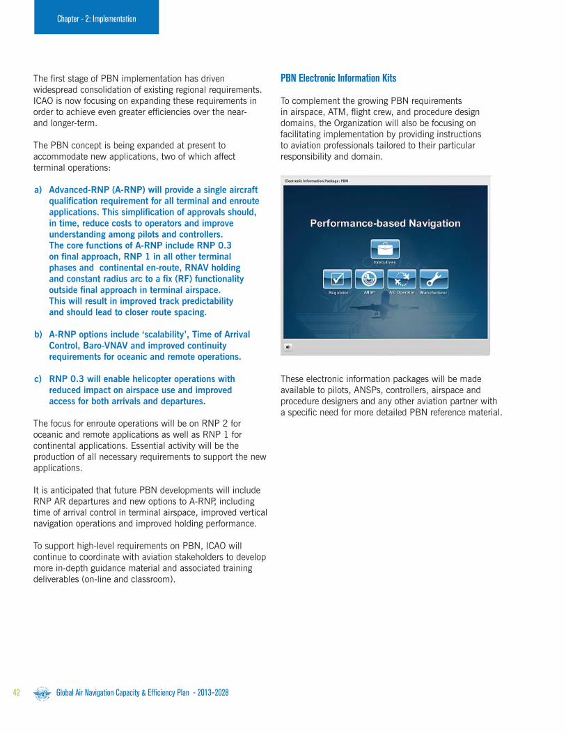
Performance-based Navigation: Our highest priority .......................................................... 39 ICAO e-Tools supporting Block 0 roll-out .......................................................................... 44 Electronic Implementation Kits ....................................................................................... 44 Training and human performance considerations............................................................... 45 Flexibility aspects of Block Upgrade implementation ......................................................... 46 Block 0 Modules ........................................................................................................... 47
Contents

Chapter 3 Near-term Standardization: Block 1
Block 1 Modules ........................................................................................................... 65
Chapter 4 Continuing Research: Blocks 2 and 3
Block 2 Modules ........................................................................................................... 85 Block 3 Modules ........................................................................................................... 89
Chapter 5: Aviation System Performance Management
Global Air Navigation Capacity & Efficiency Report ................................................................. 93 Measuring operational performance: IFSET ............................................................................ 94
Appendix 1: Fourth Edition Global Plan: Evolution & Governance ......................................................... 96
Appendix 2: Hyperlinked Online Support Documentation ...................................................................... 98
Appendix 3: Technology Roadmaps .................................................................................................... 100
Appendix 4: Module Dependencies .................................................................................................... 128
Appendix 5: Standards and Recommended Practices (SARPs) Development Planning ....................... 130
Appendix 6: Acronym Glossary ........................................................................................................... 132

$5.3 trillionCargo by value annually
Global Air Navigation Capacity & Efficiency Plan - 2013–20288
Executive Summary
Addressing Growth and Realizing the Promise of Twenty-first Century ATMThe Operational and Economic Context for the Global Air Navigation Capacity & Efficiency Plan
Air transport today plays a major role in driving sustainable economic and social development in hundreds of nations. It directly and indirectly supports the employment of 56.6 million people, contributes over $2 trillion to global Gross Domestic Product (GDP), and carries over 2.5 billion passengers and $5.3 trillion worth of cargo annually.
Aviation achieves its impressive level of macro-economic performance by serving communities and regions through clear cycles of investment and opportunity. Infrastructure development generates initial employment and the ensuing airport and airline operations generate new supplier networks, tourism influxes and access for local producers to distant markets. These burgeoning trade and tourism economies then continue to expand, fostering wider and more sustainable regional growth.
It’s no mystery then why air traffic growth has so consistently defied recessionary cycles since the mid-1970s, expanding two-fold once every 15 years. It avoided these recessions precisely because it served as one of our most effective tools for ending them – an important consideration for governments at every level in a challenging economic environment.
But even as air transport’s speed and efficiency significantly facilitate economic progress, its growth under certain circumstances can be a double-edged sword. Though a sure sign of increased living standards, social mobility and generalized prosperity on the one hand, unmanaged air traffic growth can also lead to increased Safety risks in those circumstances when it outpaces the regulatory and infrastructuredevelopments needed to support it.
Driving Economic Recovery
Aviation’s Global Impacts
$2.2 trillionContributed to global GDP
2.5 billionPassengers annually
$

Global Air Navigation Capacity & Efficiency Plan - 2013–2028 9
Executive Summary
To ensure that continuous Safety improvement and Air Navigation modernization continue to advance hand-in-hand, ICAO has developed a strategic systems approach linking progress in both areas under complimentary frameworks. This will now allow States and stakeholders to realize the safe, sustained growth, increased efficiency and responsible environmental stewardship that societies and economies globally now require.
This is aviation’s core challenge as we progress into the ensuing decades.
Fortunately, many of the procedures and technologies being proposed to address today’s need for increased capacity and efficiency in our skies also enhance many positive factors from a Safety standpoint.
Additionally, the more efficient routes facilitated by performance-based procedures and advanced avionics serve to significantly reduce aviation emissions – a key factor supporting more fuel-efficient modern aircraft as aviation pursues its 2008 commitment to comprehensively reduce its environmental impacts.
Recession Immunity
The Pace and Resilience of Modern Air Traffic GrowthGlobal air traffic has doubled in size once every 15 years since 1977 and will continue to do so. This growth occurs despite broader recessionary cycles and helps illustrate how aviation investment can be a key factor supporting economic recovery. 1977 1992 2007 2022

Global Air Navigation Capacity & Efficiency Plan - 2013–202810
Executive Summary
Technology Serving CommunityProviding Flexibility for Member States through the Consultative
and Cooperative Aviation System Block Upgrade Strategy
Air Navigation has witnessed some important improvements in recent decades, with a number of States and operators having pioneered the adoption of advanced avionics and satellite-based procedures.
And yet despite these important, localized advances in implementing what is known as Performance-based Navigation (PBN), a considerable remainder of the global Air Navigation system is still limited by conceptual approaches that arose early in the twentieth century. These legacy Air Navigation capabilities limit air traffic capacity and growth and are responsible for unnecessary CO2 being deposited in our atmosphere.
The solution to all of these concerns is a fully-harmonized global Air Navigation system built on modern performance-based technologies and procedures. This goal has been on the minds of Communications, Navigation and Surveillance/Air Traffic Management (CNS/ATM) planners for many years now, but because technology never stands still the realization of a dependable strategic path proved elusive to determine up to this point.
The solution to this impasse lay at the heart of ICAO’s core mission and values. Only by bringing together the States and stakeholders from every corner of the aviation community can a viable solution to twenty-first century Air Navigation be determined.
ICAO therefore began an intense round of collaboration including the Global Air Navigation Industry Symposium (GANIS), the first event of its kind. The GANIS, in addition to the series of outreach events preceding it which ICAO held in every world region, allowed ICAO to take feedback on what has now become known as the aviation system Block Upgrade strategy.
The Block Upgrades and their capacity Modules define a programmatic and flexible global systems engineering approach allowing all States to advance their Air Navigation capacities based on their specific operational requirements.
This will permit all States and stakeholders to realize the global-harmonization, increased capacity, and environmental efficiency that modern air traffic growth now demands in every region around the world.
Importantly, the Block Upgrade strategy represents the logical outcome of the CNS/ATM planning and concepts found in the Global Plan’s previous three editions. It additionally ensures continuity with the performance and operational concepts previously defined by ICAO in earlier Air Navigation manuals and documents.
If the air transport system is to continue to drive global economic prosperity and social development to the extent our community and the world have grown accustomed, especially in the face of dramatic regional traffic growth projections and the pressing need for more determined and effective climate-related stewardship, States must fully embrace the new Block Upgrade process and follow a unified path to the future global Air Navigation system.
The Global Plan’s aviation system
Block Upgrade strategy is a programmatic
and flexible global systems engineering
approach that allows all Member States
to advance their Air Navigation capacities
based on their specific operational
requirements. The Block Upgrades will
enable aviation to realize the global
harmonization, increased capacity, and
improved environmental efficiency that
modern air traffic growth now demands in
every region around the world.

Airport
Operations
Performance
Improvement Areas
Block 0
(2013)
Block 1
(2018)Block 2
(2023)
Block 3
(2028 onward)
Globally
Interoperable
Systems and Data
Optimum
Capacity and
Flexible Flights
Efficient
Flight Path
Modules (actual number of modules per Block/Performance Area may vary)
Executive Summary
The ICAO Block Upgrades (blue columns) refer to the target availability timelines for a group of operational improvements (technologies and procedures) that will eventually
realize a fully-harmonized global Air Navigation System. The technologies and procedures for each Block have been organized into unique ‘Modules’ (smaller white squares)
which have been determined and cross-referenced based on the specific Performance Improvement Area they relate to. ICAO has produced the systems engineering for its
Member States so that they need only consider and adopt the Modules appropriate to their operational need.
By way of example, Block ‘0’ (2013) features Modules characterized by operational improvements which have already been developed and implemented in many parts of the
world today. It therefore has a near-term implementation period of 2013–2018, whereby 2013 refers to the availability of its particular performance Modules and 2018 the
target implementation deadline. It is not the case that all States will need to implement every Module, and ICAO will be working with its Members to help each determine
exactly which capabilities they should have in place based on their unique operational requirements.
A Module ‘Thread’ associated with a specific Block Upgrade performance area. Some of the Modules under each consecutive Block feature the same Thread number, indicating
that they are elements of the same performance area process as it progresses toward (in this case) its target performance improvement area of ‘globally interoperable systems
and data’. Every Module under the Block Upgrade approach will similarly serve to progress towards one of the four target Performance Improvement Areas.
Global Plan Fourth Edition Aviation System Block Upgrade Methodology
Performance
Improvement Areas
Block 0
(2013)
Block 1
(2018)Block 2
(2023)
Block 3
(2028 onward)
Globally
Interoperable
Systems and Data
Module B0–25B0 = Block number25 = Thread number
Performance capability:
Increased interoperability,efficiency and capacitythrough ground-groundintegration.
Module B1–25
Performance capability:
Increased interoperability,efficiency and capacitythrough FF-ICE/1application beforedeparture.
Module B2–25
Performance capability:
Improved coordinationthrough multi-centreground-ground integration:(FF-ICE/1 & Flight Object,SWIM).
Module B3–25
Performance capability:
Improved operationalperformance throughthe introduction of Full FF-ICE.

Executive Summary
Global Air Navigation Capacity & Efficiency Plan - Fourth Edition12
The 2013–2028 ICAO Global Air Navigation Capacity & Efficiency Plan presents all States with a comprehensive planning tool supporting a harmonized global Air Navigation system. It identifies all potential performance improvements available today, details the next generation of ground and avionics technologies that will be deployed worldwide, and provides the investment certainty needed for States to make strategic decisions for their individual planning purposes.
Ongoing Air Navigation improvement programmes undertaken by a number of ICAO Member States (SESAR in Europe; NextGen in the United States; CARATS in Japan; SIRIUS in Brazil, and others in Canada, China, India and The Russian Federation) are consistent with the Block Upgrade framework. These States are now mapping their planning to respective Block Upgrade Modules in order to ensure the near- and longer-term global interoperability of their Air Navigation capacity and efficiency solutions.
What does the Global Plan’s Strategic Approach Mean for My State?Understanding Near-term Implementation and Reporting Requirements

Executive Summary
The Global Plan’s Block Upgrade planning approach also addresses user needs, regulatory requirements and the needs of Air Navigation Service Providers and Airports. This ensures one-stop, comprehensive planning.
A Module minimum implementation path addressing global interoperability needs is being discussed at AN-Conf/12. Details will be published in the final version of this 2014–2016 document to better support its overall scope and intent. As the Global Plan progresses, Module implementation will be fine-tuned through regional agreements in the ICAO Planning and Implementation Regional Group (PIRG) process. Less essential Modules will be left to the discretion of National planning.
The PIRG process will further ensure that all required supporting procedures, regulatory approvals and training capabilities are set in place. These supporting requirements will be reflected in regional online Air Navigation Plans (eANPs) developed by the PIRGs, ensuring strategic transparency, coordinated progress and and certainty of investment.
With respect to all of these regional and State planning efforts, the detailed information available in the Global Plan’s technology roadmaps (Appendix 4) and Module descriptions (Chapters 2, 3 and 4) will significantly facilitate the development of business cases for any operational benefit being considered.
Photo courtesy Cessna
Summarizing the 2013–2028 Global Plan Minimum Path:
• Obliges States to map their individual or regional programmes against the harmonized Global Plan, but provides them with far greater certainty of investment.
• Requires active collaboration with regional colleagues through the PIRGs in order to co-ordinate initiatives within applicable regional Air Navigation Plans.
• Provides all required tools for States and regions to consider comprehensive business case analyses as they seek to realize their specific operational improvements.

Chapter 1 Global Air Navigation Policy
Photo courtesy Boeing

Global Air Navigation Capacity & Efficiency Plan - 2013–2028 15
Chapter 1 - Global Air Navigation Policy
Global aviation is driven by a highly collaborative ‘system of systems’ that helps to determine all of ICAO’s Strategic Objectives. Because of the significant operational interdependencies between the Safety and Air Navigation components of the aviation system, the Organization is working with States and global air transport stakeholders to organize complementary action cycles driving continuous improvement in both these areas, as illustrated on the following pages.
The first of the action cycles are annual, defined by the Safety and Air Navigation Frameworks (darker blue circles) which coordinate global improvement and modernization programmes and initiatives through Standardization, Implementation, Monitoring and Analysis efforts in each area.
These annual Framework cycles enable the aviation community to collaboratively identify, address and continuously reassess tactical Safety and Air Navigation objectives at the global, regional and national level through the respective work programmes (blue, orange and green categories within inner circles).
The second action cycle is triennial (outermost ring), reflecting higher-level policy adjustments to the Global Plans which are approved by the ICAO Council and endorsed by States through the ICAO Assembly. Safety and Air Navigation Global Plan targets are refined on a complementary basis and reflect conclusions derived from State and stakeholder inputs, as well as ongoing reviews by the ICAO Air Navigation Commission.
At the highest level, the Safety and Air Navigation Global Plans are linked by Council approvals, continuous improvement methodologies, their shared goal of fostering improved cooperation sector-wide, and lastly the levels of investment they require from States and industry in order to succeed.
All of these cycles and goals are multidisciplinary and interrelated, highlighting the need for a strongly proactive and transparent strategic vision to unite the aviation community around them. The Global Plans provide this vision, enabling States and stakeholders to plan for and efficiently manage air traffic growth while proactively addressing existing and emerging Safety risk.
System of SystemsDefining and Managing a

Global Air Navigation Capacity & Efficiency Plan - 2013–2028
Executive Summary
ANNUAL GLOBAL SAFETYREPORT
TACTICALWORK PROGRAMMEADJUSTMENTS
RASGs
ICAO AIR NAVIGATIONCOMMISSION
REGIONALREPORTING
PARTNER INFORMATION SHARING & RISK ASSESSMENTS
Imple
menta
tion M
onitoring
Analy
sis
Tri
ennia
l IC
AO
Ass
em
blie
s
The Global Aviation
Safety System
Pol
icy (G
lobal P
lan)
Standardization
ICA
O C
ouncil
s icyc
The Global Aviation Safety System
Analysis activities involve the integration of global Safety information and regional Safety outcomes received through the RASGs. The analysis inputs are coordinated by ICAO and output is shared with States, Regional Safety Organizations and aviation partners to create a comprehensive assessment of Safety risk.
The agreed Safety results are used to update the annual ICAO Global Safety Report.
Monitoring initiatives include surveillance activities intended to detect implementation of State Safety Programme (SSP) and Safety Management System (SMS) protocols by States and industry partners, respectively.
Operational assessments are undertaken primarily by industry associations (IATA, ACI, CANSO) while the status of global regulatoryand State oversight capability is continuously monitored under the ICAO Universal Safety Oversight Audit Programme (USOAP).
Implementation of Global Plan policy goals is pursued collaboratively by States, Regional Safety Organizations and industry partners. High-level coordination of their initiatives is achieved via ICAO’s Regional Aviation Safety Groups (RASGs).
The RASGs also serve as regional ‘engines’, continuously pursuing Safety objectives and consolidating regional analyses and reporting results which are shared online with States, Regional Safety Organizations and industry partners. These regional results are further analyzed by ICAO Headquarters for global trends while transparency is provided through ICAO’s annual Safety Report.
Policy activities stem from the ICAO Global Aviation Safety Plan, which formalizes collaboratively-agreed initiatives and targets. Tactical annual adjustments to the Safety work programme are made based on the trends and outcomes reflected in ICAO’s yearly Safety Report.
Standardization efforts are undertaken as needs are identified.
Aviation Safety is continually improved through the use of Safety Management and risk assessment processes. This leads to tactical work programme adjustments organized around the Safety Framework action cycle, as illustrated below. Policy level revisions to the Global Aviation Safety Plan are reviewed by the Air Navigation Commission and approvedby the ICAO Council, in advance of their endorsement by the ICAO Assembly during its triennial meeting.
ICAO Council
ICAO Council

Global Air Navigation Capacity & Efficiency Plan - 2013–2028 17
Executive Summary
ICAO AIRNAVIGATIONCOMMISSION
REGIONALREPORTING
TACTICAL WORK PROGRAMMEADJUSTMENTS
PIRGs
Analy
sis
The Global Air Navigation System
PARTNER REVIEWS & IMPLEMENTATION AGREEMENTS
Imple
menta
tion M
onitoring
Pol
icy (G
lobal P
lan) Standardization Block Upgrade Strategy
Tri
ennia
l IC
AO
Ass
embl
ies
ICA
O C
ouncil
ANNUAL GLOBAL AIR NAVIGATION CAPACITY &EFFICIENCYREPORT
iIC
eg
The Global Air Navigation System
Analysis of reporting data is carried out collaboratively with aviation stakeholders. Results are then published in the annual ICAO Global Air Navigation Report, which then helps determine implementation adjustments to the tactical regional work programme to re-start the cycle.
Implementation and Monitoring in the ATM area is overseen by ICAO’s Planning and Implementation Regional Groups (PIRGs).
The PIRGs also serve as regional ‘engines’ to continuously pursue air navigation objectives, consolidating regional analyses and reporting and sharing these results online with States and industry partners. Analysis and reporting results are further analyzed by ICAO HQ for global trends and transparency is provided via the annual ICAO Global Air Navigation Report that will debut in early 2014.
ICAO’s Global Air Navigation Capacity & Efficiency plan establishes Policy-level Air Navigation objectives. These are based largely on the aviation system Block Upgrade ATM systems engineering approach which has been developed collaboratively by States and aviation stakeholders and defines the regional work programmes managed by ICAO’s Planning and Implementation Regional Groups (PIRGs). Tactical adjustments to the work programmes will be made annually and reported online in a new ICAO Global Air Navigation Report.
All Standards for Block 0 have been completed and implementation is underway. Block 1 Standards and Recommended Practices (SARPS) are currently being evaluated.
Harmonized performance and infrastructure/avionics improvements in the Air Navigation domain are led by the Fourth Edition Global Air Navigation Capacity and Efficiency Plan and the aviation system Block Upgrade strategy it outlines. The Block Upgrades will be implemented and refined through the annual Air Navigation tactical work programme, which in turn will guide Global Plan revisions on a triennial basis. These revisions are based on Air Navigation Commission reviews and are approved by the ICAO Council before being sent for Member State endorsement at the ICAO Assembly.
ICAO Council
ICAO Council

Global Air Navigation Capacity & Efficiency Plan - 2013–202818
Though the Global Plan primarily supports ICAO’s Member States, additional stakeholders such as airspace users and industry groups also have a direct and critical interest in the realization of a transparent process guiding the successful and interoperable modernization of the global aviation system.
Comprehensive and intensive consultation with these stakeholders has therefore been an essential step in the ICAO development approach for the Global Plan, most notably with respect to the Block Upgrades it presents and their supporting technology roadmaps.
ICAO’s new Air Navigation performance framework, which guides continuous improvement and modernization activities on an annual basis, has similarly been designed in clear recognition of how aviation’s multidisciplinary collaborations have been instrumental to important accomplishments in recent years.
These include the adoption of the PBN procedures, iFlex, improved runway safety and fatigue risk management outcomes, more effective and streamlined civil and military cooperation, and many other areas of collaborative progress.
It is largely due to this intensive consensus building on behalf of ICAO that the Block Upgrade framework will now be able to effectively steer State and industry planning and investment on a practical, programmatic basis over the coming decades.
Further collaboration of this nature, through pertinent ICAO forums, will be essential to effectively standardized Air Navigation progress as our sector continues to address its capacity, sustainability and interoperability challenges well into the future.
Collaboration and Engagement with the Aviation Community
Chapter 1 - Global Air Navigation Policy

Global Air Navigation Capacity & Efficiency Plan - 2013–2028 19
Chapter 1 - Global Air Navigation PolicyCollaboration and Engagem
ent with Aviation Comm
unity
Photo courtesy Bombardier

Global Air Navigation Capacity & Efficiency Plan - 2013–202820
Chapter 1 - Global Air Navigation Policy
Global Air Navigation policy defines the framework for standardization, implementation, monitoring and performance management of the Air Navigation system.
The multidisciplinary nature of this highly interdependent and complex system highlights the need for a transparent strategic process to unite the air transport community around a proactive vision. The Safety and Air Navigation Global Plans provide this vision so that ICAO, States and industry can plan for and manage future air traffic growth in a safe and efficient manner.
ICAO, in collaboration with aviation stakeholders, will annually monitor Global Plan status at worldwide, regional and national levels and make required tactical adjustments to its work programme using this data. The Global Plan itself will be formally updated triennially and endorsed by the Assembly. These triennial updates will include high-level policy revisions as approved by the ICAO Council, as well the necessary operational and technological updates identified during the annual review and adjustment cycles.
The Global Plan review and endorsement process provides States with a comprehensive aviation system appraisal, as well as advice which will facilitate policy adjustments and budget allocations. The nature of the Global Plan and its linkages to the triennial Assembly cycle ensure high-level coordination and alignment of global Air Navigation planning with the Strategic Objectives of ICAO.
The ICAO Air Navigation Commission will review the Global Plan as part of its annual work programme, reporting to the Council one year in advance of each ICAO Assembly. This report will provide the following based on operational considerations:
1. Review global progress made.
2. Consider technological, regulatory and other changes which may affect the Block Upgrade Modules and Technology Roadmaps.
3. Consider lessons learned by States and industry.
4. Propose adjustments to the technical components of the Global Plan.
Following approval by the Council, any amendments to the Global Plan and its specified supporting documents will then be submitted for endorsement by ICAO Member States at the following ICAO Assembly.
This approach provides for dynamic and tactical adjustments to the Air Navigation work programme on an annual basis, as well as review and updating of over-arching Global Plan policy and the Block Upgrade strategy on a three-year cycle.
Integrated Planning for Capacity & Efficiency

Homogenous
ATM Areas
Major Traffic Flows
Global Air Navigation Capacity & Efficiency Plan - 2013–2028 21
The basis for developing a seamless, truly global air traffic management (ATM) system is through an agreed structure of homogeneous ATM areas and major traffic flows/routing areas. It is on the basis of these areas and flows that the global Air Navigation community will be able to organize the disparate legacy elements of the worldwide aviation infrastructure into a single, global system.
ICAO maintains a dynamic list of homogeneous ATM areas and major traffic flows/routing areas as identified by the Organization’s Planning and Implementation Regional Groups
(PIRGs). The PIRGs, as reflected in the Air Navigation performance framework, play an essential implementation and reporting role on a cyclical, annual basis, translating Air Navigation policy into Air Navigation reality.
This more coordinated approach to airspace management also greatly simplifies and facilitates Special Use of Airspace (SUA) requirements among civil and military policy makers, regulators, Air Navigation Service Providers (ANSPs) and operators, supporting optimum, minute-by-minute allocation of airspace for all users.
Chapter 1 - Global Air Navigation PolicyIntegrated Planning and the Aviation System
Introduction to Airspace Management – A Shared Resource
Fig. 1:
Routing Area incorporating
Homogeneous ATM Areas
and Major Traffic Flows.

Global Air Navigation Capacity & Efficiency Plan - 2013–202822
Chapter 1 - Global Air Navigation Policy
Homogeneous ATM Areas
Homogeneous ATM areas feature shared ATM interests and requirements, based on similar levels of traffic density, complexity, required Air Navigation system infrastructure or other specified considerations.
Homogeneous ATM areas may extend over States, specific portions of States, or groupings of States. They may also extend over large oceanic and continental areas. The identification of distinct, homogenous ATM areas has been the first step towards the development of globally interoperable Air Navigation systems.
Major Traffic Flows/Routing Areas
A major traffic flow refers to a concentration of significant volumes of air traffic within the same or proximate flight trajectories. Major traffic flows can pass through multiple homogeneous ATM areas of varying characteristics.
A routing area encompasses one or more major traffic flows in addition to one or more homogeneous ATM areas of varying characteristics. Routing areas are identified solely to aid in the design and implementation of ATM systems and procedures for airspace or aircraft, specifying the common interests and requirements of relevant homogeneous ATM areas.
Homogeneous ATM areas and major traffic flows (list available on hyperlinked online support documentation) are related primarily to en-route airspace, or airspace in which aircraft pass through while in flight.
Airspace Modernization Planning
After identification of the homogeneous ATM areas and major traffic flows terminal areas and aerodromes that impact their determinations, Air Navigation planners should conduct a survey of the following:
a) Current and foreseen aircraft populations and capabilities.
b) Forecasts of averaged and peak aircraft movements.
c) Existing ATM legacy infrastructure, including related human resource availability and skill levels.
d) Civil/military access requirements and considerations with respect to SUA.
e) Other local/regional requirements as identified.
An analysis of the data gathered in the course of this survey will lead to the identification of ‘gaps’ or shortcomings in Air Navigation performance. Block Upgrade Modules should be evaluated against identified gaps in order to ascertain which specific Module’s set of operational improvements would be best suited to address the performance shortcoming(s).
The Module descriptions, available in detail on the ICAO website and summarized in Chapters 2 and 3 of this document, provide a summary of the performance capacities on a Module-by-Module basis to assist in the development and evaluation of these initial gap-analysis scenarios.
The ATM modernization planning process would continue with the development of scenarios for implementation and associated cost-benefit analyses, as well as the preliminary development of infrastructure support requirements. National and regional implementation plans would be developed or amended based on the Block Upgrade Modules selected.
It should be highlighted that the repetition of several of these steps may be required until a final choice of Modules/initiatives is selected.

23Global Air Navigation Capacity & Efficiency Plan - 2013–2028
Chapter 1 - Global Air Navigation Policy
Regional Planning and Reporting
In 2008, all ICAO Planning and Implementation Regional Groups (PIRGs) adopted a regional performance framework and invited States to implement a national performance framework for Air Navigation systems on the basis of ICAO Standards and Recommended Practices (SARPs) and guidance material.
From a reporting standpoint, the Air Navigation Planning and Implementation process calls for monitoring to be performed on an ongoing basis.
In order to support this performance planning and provide a common monitoring approach for all PIRGs/States, ICAO has developed a standardized Air Navigation reporting form available on its website.
This common reporting template is aligned with the Block Upgrade methodology. All PIRGs and States are encouraged to utilize it when reporting on the progress of their performance framework tactical work programmes.
All reporting will be analyzed on a collaborative basis between States and industry and will be aggregated into new annual Air Navigation Capacity & Efficiency reports published by ICAO. These report conclusions will serve as the basis for future policy adjustments aiding safety practicality, affordability and global harmonization, amongst other concerns.
PIRGs work in close conjunction with ICAO’s regional offices and Headquarters as it carries out its work programme responsibilities. The six ICAO PIRGs are:
a) APANPIRG (Asia/Pacific Air Navigation Planning and Implementation Regional Group)
b) APIRG (Africa-Indian Ocean Planning and Implementation Regional Group)
c) EANPG (European Air Navigation Planning Group)
d) GREPECAS (Caribbean/South American Planning and Implementation Regional Group)
e) MIDANPIRG (Middle East Air Navigation Planning and Implementation Regional Group)
f) NAT SPG (North Atlantic Systems Planning Group)
Link to PIRG org charts
via www.icao.int/XXXX
Implications for the PIRGs under the new ICAO Global Plan
Under the revised Global Plan performance framework, the PIRGs function primarily on the basis of regular consultations with States and industry to align the specific measures and initiatives that they integrate into Regional Air Navigation Plans.
PIRGs are additionally responsible under the performance framework work programme for coordinating the reporting from States and industry that feeds into later analysis activities, the annual Air Navigation Capacity & Efficiency Report, and any required tactical work programme revisions.
Performance reviews measure the implementation status of various Block Upgrade Modules, identify challenges (if any), and subsequently prescribe follow-up actions to address those challenges. They also provide an opportunity for the aviation community to compare infrastructure modernization progress and harmonization across ICAO’s regions.
Performance reviews are to be conducted via annual reports that will be developed by each ICAO regional office/PIRG in collaboration with local industry stakeholders. These are to be supported by data submission by States with respect to Block Upgrade Module metrics.
As a result, PIRG schedules will need to be revised in order to be effectively synchronized with the annual reporting schedule. Similarly, as the standarization effort is completed at the global level, PIRGs which have not yet transitioned will need to rationalize their sub-groups away from technologies and toward operational performance.

Global Air Navigation Capacity & Efficiency Plan - 2013–202824
Chapter 1 - Global Air Navigation PolicyChapter 1 - Global Air Navigation Policy
Data Transparency and Access to Aid State/Partner Planning
ICAO has been advancing work on a series of online and GIS-based mapping tools that present varying categories and ranges of reporting data in support of both Safety and Air Navigation stakeholders. The tools will be moved to the ‘cloud’ and delivered as Software as a Service (SaaS), meaning that each will be completely web-based, require no installation procedure for any user, and be available worldwide on a 24/7 basis.
All ICAO data tool applications are being developed to support access from mobile devices like tablets and smart phones. Primary focus will be placed on the usability, distribution and analysis of Safety data and information, with ICAO acting as a data integrator rather than simply a collector.
The ICAO data centre will serve as a unique global platform for sharing and collaboration among all Member States and stakeholders and the Organization will continue to develop executive views of its data and information. Supporting its strategic Global Plans for safety and Air Navigation, ICAO will continue to increase the number of analytical products it provides and tailor them to decision makers who require executive level information represented in interactive, easy-to-understand charts.
All of these tools will be coordinated on the basis of an integrated data set that will serve as the single foundation for a suite of applications aimed at users in the areas of analysis, GIS systems, aircraft data, Air Navigation planning and the SARPs of ICAO. This strategic architecture will ensure user-defined data presentation and interpretation in addition to real-time updating.
Please find more information on ICAO’s
GIS Mapping Tools via: www.icao.int/XXXX

If aviation is to continue to drive global economic prosperity and social development to the extent our community and the world have grown accustomed, especially in the face of dramatic regional traffic growth projections and the pressing need for more determined and effective climate-related stewardship, States must fully embrace the new Block Upgrade process and follow a unified path to the future global Air Navigation system.
Photo courtesy Cessna

Global Air Navigation Capacity & Efficiency Plan - 2013–202826
Chapter 1 - Global Air Navigation Policy
The Global Air Navigation Capacity & Efficiency Plan introduces ICAO’s Block Upgrade strategy, a systems engineering planning and implementation approach which has been the result of extensive collaboration and consultation between ICAO, its Member States and industry stakeholders.
ICAO developed the Block Upgrade global framework primarily to ensure that aviation Safety will be maintained and enhanced, that ATM improvement programmes are effectively harmonized, and that barriers to future aviation efficiency and environmental gains can be removed at reasonable cost.
The Block Upgrades incorporate a long-term perspective matching that of the three companion ICAO Air Navigation planning documents. They coordinate clear aircraft- and ground-based operational objectives together with the avionics, data link and ATM system requirements needed to achieve them. The overall strategy serves to provide industry-
wide transparency and essential investment certainty for operators, equipment manufacturers and ANSPs.
The core of the Block Upgrade concept is linked to four specific and interrelated aviation performance areas, namely:
a) Airport operations.
b) Globally-interoperable systems and data.
c) Optimum capacity and flexible flights.
d) Efficient flight paths.
The performance areas and the Upgrade Modules associated with each have been organized into a series of four Blocks (Blocks 0, 1, 2 and 3) based on target implementation timelines for the various capabilities they contain, as illustrated below.
Introduction: Aviation System Block Upgrades
Fig. 3: Block Upgrade strategy, depicting Block 0–3 availability milestones, target Performance Areas, and technology/procedure/capability Modules.
Airport
Operations
Performance
Improvement Areas
Block 0
(2013)
Block 1
(2018)Block 2
(2023)
Block 3
(2028 onward)
Globally
Interoperable
Systems and Data
Optimum
Capacity and
Flexible Flights
Efficient
Flight Path
Modules (actual number of modules per Block/Performance Area may vary)

Chapter 1 - Global Air Navigation Policy
Block 0 features Modules characterized by technologies and capabilities which have already been developed and implemented in many parts of the world today. It therefore features a near-term availability milestone, or Initial Operating Capability (IOC), of 2013 for high density based on regional and State operational need. Blocks 1 through 3 are characterized by both existing and projected performance area solutions, with availability milestones beginning in 2018, 2023 and 2028 respectively.
Associated timescales are intended to depict the initial deployment targets along with the readiness of all components needed for deployment. It must be stressed that a Block’s availability milestone is not the same as a deadline. Though Block 0’s milestone is set at 2013,
for example, it is expected that the globally harmonized availability of its capabilities (as well as the related Standards supporting them) will be achieved over the 2013 to 2018 timeframe. The same principle applies for the other Blocks and therefore provides for significant flexibility with respect to operational need, budgeting and related planning requirements.
While the traditional Air Navigation planning approach addresses only ANSP needs, the Block Upgrade methodology calls for addressing regulatory as well as user requirements. The ultimate goal is to achieve an interoperable global system whereby each State has adopted only those technologies and procedures suitable to its specific operational requirements.
Global Air Navigation Capacity & Efficiency Plan - 2013–2028 27
Introduction to Block Upgrades

Global Air Navigation Capacity & Efficiency Plan - 2013–202828
Chapter 1 - Global Air Navigation Policy

Global Air Navigation Capacity & Efficiency Plan - 2013–2028 29
Chapter 1 - Global Air Navigation Policy
Understanding Modules and Threads
Each Block Upgrade is made up of distinct Modules, as shown in the illustrations on p.26 and below. Modules only need to be implemented if and when they satisfy an operational need in a given State, and they are supported by procedures, technologies, regulations or Standards as necessary, as well as a business case.
A Module is generally made up of a grouping of elements which define required CNS Upgrade components intended for aircraft, communication systems, air traffic control (ATC) ground components, decision support tools for controllers, etc. The combination of elements selected ensures that each Module serves as a comprehensive and cohesive deployable performance capability.
A series of dependent Modules across consecutive Blocks is therefore considered to represent a coherent transition ‘Thread’ in time, from basic to more advanced capability and associated performance. Modules are therefore identified by both a Block number and a Thread number, as illustrated below.
Each Thread describes the evolution of a given capability through the successive Block timelines as each Module is implemented realizing a performance capability as part of the Global Air Traffic Management Operational Concept (Doc 9854, see description in Appendix 1, p.97).
Performance
Improvement Areas
Block 0
(2013)
Block 1
(2018)Block 2
(2023)
Block 3
(2028 onward)
Globally
Interoperable
Systems and Data
Module B0–25B0 = Block number25 = Thread number
Performance capability:
Increased interoperability,efficiency and capacitythrough ground-groundintegration.
Module B1–25
Performance capability:
Increased interoperability,efficiency and capacitythrough FF-ICE/1application beforedeparture.
Module B2–25
Performance capability:
Improved coordinationthrough multi-centreground-ground integration:(FF-ICE/1 & Flight Object,SWIM).
Module B3–25
Performance capability:
Improved operationalperformance throughthe introduction of Full FF-ICE.
Fig. 4: A Module Thread associated with a specific Block Upgrade performance area. Note that the Modules under each consecutive Block feature the same Thread number (25),
indicating that they are elements of the same Performance Area process as it progresses toward global interoperability.
Introduction to Block Upgrades

Global Air Navigation Capacity & Efficiency Plan - 2013–202830
Chapter 1 - Global Air Navigation Policy
Block Upgrade Technology Roadmaps
Technology roadmaps complement the Block Upgrades by providing timelines for the technology that will support the Communications, Navigation and Surveillance (CNS), Information Management (IM) and avionics requirements of the global Air Navigation system.
These roadmaps provide guidance for infrastructure planning (and status) by indicating on a per-technology basis the need for and readiness of:
a) Existing infrastructure.b) ICAO Standards and guidance material.c) Demonstrations and validations.d) Initial Operational Capability (IOC) of emerging
technologies.e) Global implementation.
While the various Block Upgrade Modules define the expected operational improvements and drive the development of all that is required for implementation, the technology roadmaps define the lifespan of the specific technologies needed to achieve those improvements. Most importantly, they also drive global interoperability.
Investment decisions are needed well in advance of the procurement and deployment of technology infrastructure. The technology roadmaps provide certainty for these investment decisions as they identify the pre-requisite technologies that will provide the operational improvements and related benefits. This is critically important as investments in aviation infrastructure are hardly reversible and any flaw in technological interoperability generates consequences in the medium- and long-term.
They are also useful in determining equipment lifecycle planning, i.e. maintenance, replacement and eventual decommissioning. The CNS investments represent the necessary baseline upon which the operational improvements and their associated benefits can be achieved.
It must be noted that according to the achievements over the past thirty years, the typical CNS deployment cycle for large scale objectives has been of the order of 20 to 25 years (including ground deployment and aircraft forward and retro fits).
Since no strategy can take into account all developments that occur in aviation over time, the technology roadmaps will be systematically reviewed and updated on a triennium cycle. An interactive online version of the roadmaps will also allow users to retrieve detailed information on specific Block Modules and additional cross-references.
The roadmaps are presented in Appendix 3 as diagrams which identify the relationships between the specific Block Upgrade Modules and associated enabling technologies and capabilities. They are accompanied by brief explanations to support their understanding and that of the challenges faced for each of them.
Link to more detailed online information
on the Block Upgrade technology roadmaps
via www.icao.int/XXXX

Global Air Navigation Capacity & Efficiency Plan - 2013–2028 31
Chapter 1 - Global Air Navigation Policy
Fig. 5: Graphic depicting the Block Upgrade Modules converging over time on their target operational concepts and performance improvements.
Introduction to Block Upgrades
Airport Accessibility
Preliminary AMAN/DMAN
Airport CollaborativeDecision-Making FULL
AMAN/DMAN/SMANAIRPORT OPERATIONS
Surface Operations
Wake TurbulenceSeparation
Remote AerodromeControl Towers
Advanced MET Information
Digital Aeronautical Information Management INTEROPERABLE
SYSTEMS & DATAFULL FF/ICE
Preliminary FF/ICE
System-Wide Information Management
Self-Separation
Free Routing
Initial Surveillance
OptimumFlight Levels COMPLEXITY
MANAGEMENTGLOBALLY
COLLABORATIVE ATMNetwork Operations
Airborne Collision Avoidance Systems
Ground-Based Safety Nets
Partial Trajectory-Based Operations
Continuos Descent Operations
EFFICIENTFLIGHT PATHS
FULLTRAJECTORY-BASED
OPERATIONSContinuous ClimbOperations
Remotely Piloted Aircraft Systems
MODULECAPABILITY
REALIZEDOPERATIONAL
CONCEPT
TARGETPERFORMANCE
BENEFIT

Global Air Navigation Capacity & Efficiency Plan - 2013–202832
Chapter 1 - Global Air Navigation Policy
Based on its consultative approach with Member States and industry, ICAO has identified the following complementary Safety and Air Navigation systemic, operational and emerging issues for aviation community planners.
This table will be updated based on annual revisions to the tactical work programmes in each of these areas, as well as any policy amendments to the Global Plans as per triennial ICAO Assembly assessments and endorsements.
Systemic, Operational and Emerging Issues
Safety and Air Navigation Priorities for 2014-2016 Triennium
Systemic Issues Operational Issues Emerging Issues
Saf
ety • Chart to be completed
after State inputs at the 12th Air Navigation Conference
Air
Nav
igat
ion
Human Performance and Risk Management

33
Chapter 1 - Global Air Navigation Policy
Many of the emerging issues highlighted in the preceding table represent logical outcomes and evolutions in the existing aviation system paradigm, based on established operational capabilities and concepts. Two in particular, however, represent potentially more significant paradigm shifts that could entail more dramatic impacts on the longer-term structure and operation of the aviation system.
The first of these developments has been the rapid introduction and adoption of RPAS. In 2012, ICAO finalized its first amendments regarding the operation and categorization of RPAS, marking an important milestone in their incorporation into the comprehensive international aviation regulatory framework.
RPAS civilian and scientific applications continue to expand rapidly and States from every ICAO region have begun developing and employing these systems in a variety of domains. ICAO is well into the exhaustive process of reviewing every Annex to the Chicago Convention in order to discern how the introduction of RPAS into the regulatory framework is going to impact existing Standards and aircraft/pilot classifications and licensing.
ICAO continues to cooperate and consult with States and industry stakeholders on the adoption of RPAS operations into pertinent regulatory frameworks and published the First Edition of the ICAO RPAS manual in 2014.
The commercialization of spaceflight will also pose some very new concerns for aviation stakeholders as private sector companies commence or expand on suborbital and orbital spaceflights for tourism and scientific purposes, as well as the development of commercial space stations.
The U.S. Federal Aviation Administration (FAA) has estimated that space tourism will become a $10 billion industry over the next decade.
Key to this transition will be the means by which flights from earthbound spaceports are integrated safely into existing air traffic management (ATM) networks for those portions of their journeys that occupy intra-atmospheric airspace. Currently, national authorities tend to close vast expanses of airspace in order to facilitate spacecraft launches and re-entries. Airlines must therefore reroute to avoid these closed airspace blocks, leading to higher fuel costs and carbon emissions.
Thought will also need to be focused on whether or not a regulatory framework for space navigation SARPs needs to be established for supra-atmospheric travel as well as spaceport operation and procedures, and to what limits.
With respect to navigation beyond the earth’s atmosphere specifically, a legal framework will need to be established to determine if planetary States will have any degree of authority over the Standards set for outer space, and therefore whether or not ICAO will be an appropriate forum for the development of the regulatory framework governing the safe transition of flight into supra-atmospheric territories.
The Chicago Convention does currently permit the ICAO Council to adopt SARPs pertaining to:
“...matters concerned with the safety, regularity, and efficiency of air navigation as may from time to time appear appropriate.”
The practical ability to enforce any such framework, however, beyond the voluntary agreement of private vessels, will pose additional concerns.
ICAO and its Members will be proactively addressing these topics over the next several triennia as spaceflight becomes and increasingly practical and affordable form of transportation and travel.
Aviation system game changers: Remotely Piloted Aircraft Systems (RPAS) and the commercialization of spaceflight
Photo courtesy Virgin Galactic
Systemic, Operational and Em
erging Issues

Global Air Navigation Capacity & Efficiency Plan - 2013–202834
Frequency spectrum availability has always been critical for aviation and is expected to become even more critical with the implementation of new technologies. In addition to the five technology roadmaps pertaining to communication, navigation, surveillance (CNS), information management (IM) and avionics, a global aviation spectrum strategy for the near-, medium- and long-term must support implementation of the Global Plan.
A long-term strategy for establishing and promoting the ICAO position for International Telecommunication Union World Radiocommunication Conferences (ITU WRCs) was adopted by the ICAO Council in 2001. The strategy prescribes the development of an ICAO position on the individual issues detailed in the agenda of an upcoming WRC, developed in consultation with all ICAO Member States and relevant international organizations. The strategy also includes a detailed ICAO policy on the use of each and every aeronautical frequency band. The policy is applicable to all frequency bands used for aeronautical safety applications.
An overall policy and a set of individual policy statements for each aviation frequency band can be found in Chapter 7 of the Handbook on Radio Frequency Spectrum Requirements for Civil Aviation, including the Statement of Approved ICAO Policies (Doc 9718).
Both the position and the policy are updated after each WRC and approved by the ICAO Council. The strategy for developing the position and policy can presently be found in Attachment E to Doc 9718.
The ICAO position and policy for the ITU WRC horizon extends beyond the 15-year timeframe of the current Global Plan and anticipates the development of the future aviation system. However, based on the outcome of WRC 12, the Block Upgrade Modules and the technology roadmaps, an update of the strategy for frequency spectrum will be managed by ICAO to anticipate changes and define safe mechanisms for redundancy between essential components of the future Air Navigation system.
Frequency Spectrum Considerations
Chapter 1 - Global Air Navigation Policy

Global Air Navigation Capacity & Efficiency Plan - 2013–2028 35
Future Aviation Spectrum Access
Due to the constraints specific to frequency allocations suitable to support safety-of-life critical services, little growth is foreseen in the overall size of aeronautical allocations in the longer term. However, it is vital that conditions remain stable in the existing frequency bands, to support continued and interference free access to support current aeronautical safety systems for as long as required.
Similarly, it is vital to manage the limited aviation spectrum resource in a manner which effectively supports the introduction of new technologies when available, in line with the Block Upgrade Modules and the technology roadmaps.
In the light of ever increasing pressure on the frequency spectrum resource as a whole, including aeronautical frequency spectrum allocations, it is imperative that civil aviation authorities and other stakeholders not only coordinate the aviation position with their State’s radio regulatory authorities, but also actively participate in the WRC process.
Frequency spectrum will remain a scarce and essential resource for Air Navigation as many Block Upgrades will require increased air-ground data sharing and enhanced navigation and surveillance capabilities.
Chapter 1 - Global Air Navigation Policy

Global Air Navigation Capacity & Efficiency Plan - 2013–202836
Chapter 1 - Global Air Navigation Policy
If effectively implemented, the Block Upgrade strategy presented in the Fourth Edition of the Global Plan promises to deliver significant benefits to the aviation community and to global, regional and local economies. Because these benefits will not likely accrue simultaneously to all stakeholders in every circumstance, however, it is necessary for the aviation community to mitigate individual, local or transitional situations in order to ensure that maximum global results will be realized.
Any increase in the performance of the aviation system is therefore dependant on the ability to support synchronized investments and deployments. ICAO has developed fundamental principles for the cost recovery of Air Navigation services and makes these available in ICAO’s Policies on Charges for Airports and Air Navigation Services (Doc 9082); and the Manual on Air Navigation Services Economics (Doc 9161). Together these documents provide the necessary guidance to properly allocate the cost of Air Navigation services and infrastructure to airspace users.
Additional ICAO resources such as the Air Navigation Services Economic Panel (ANSEP), GNSS Report, and Council provisional policy guidance, establish the basic principles on the recovery of global navigation satellite system (GNSS) costs by States. Additional financing reference documentation available to States and stakeholders through ICAO include:
a) Economics of Satellite-based Air Navigation Services (Circ 257).
b) Report on the Financial and Related Organizational and Managerial Aspects of Global Navigation Satellite System (GNSS) Provision and Operation (Doc 9660).
c) ICAO Council provisional policy guidance on the allocation of the incremental costs of more advanced GNSS.
d) Manual on Air Traffic Forecasting (Doc 8991).
Financing Aviation System ModernizationNote.– To be augmented pre-Assembly by pertinent April 2013 Air Transport Conference conclusions.

Global Air Navigation Capacity & Efficiency Plan - 2013–2028 37
Chapter 1 - Global Air Navigation Policy
ICAO Council provisional policy guidance on the allocation of the incremental costs of more advanced GNSS establish the following principles: the gratuity of basic GNSS services; the definition of costs for more advanced GNSS services for users who derive benefits; a transparent cost allocation; and a fair share of GNSS costs to be paid by civil aviation.
The application of existing ICAO policies and guidance material on user charges can assist States and providers to finance airport and Air Navigation services infrastructure projects.
The definition and implementation of financial and operational incentive mechanisms is necessary to facilitate the deployment of the Block Upgrade strategy worldwide. Insufficient commitment, financial resources and investment in required implementation projects can create delays and de-synchronization, impediments to the realization of the targeted performance objectives, and negative impact on the air transport economy worldwide. When properly implemented, however, the benefits are expected to far outweigh the costs.
The Global Plan Block Upgrade methodology and relevant technology roadmaps provide valuable elements supporting sound cost benefit analyses by those who will have to define and implement Air Navigation plans at the State or regional level. The Global Plan also provides timelines for the development of necessary ICAO provisions supporting implementation at broadly defined dates.
Together, the various Global Plan elements will help to foster investment certainty and constitute a sound basis for infrastructure planning and the proper management of the deployment of the Block Upgrade Modules. This in turn will lead to operational benefits that respond to the natural expectations of the airspace users. This is not expected to be entirely sufficient to ensure synchronized implementation worldwide and it is necessary to innovate in order to complement traditional ways of funding Air Navigation infrastructure.
The necessity to mitigate the ‘last mover advantage’ and encourage early investment by airspace users in new technologies and procedures will be one of the keys to the successful accomplishment of the Global Plan objectives. Suggested principles such as ‘best equipped best served’ or ‘best equipped pay less’ will be assessed and applied as appropriate.
For ANSPs, the unit rate adjustment according to the actual level of the performance delivered may also provide some incentives for efficient service delivery. These, and any new principles, shall be transparent and non discriminatory. Success should be measured by demonstrating improvements in aviation system operational performance and not simply by achieving a targeted equipage or implementation level.
Ensuring timely and synchronized deployment of enablers critical to the performance of the aviation system is a difficult task. There are situations where individual business cases are negative, requiring mitigation through regulatory and economic interventions to deliver global benefits. States and service providers also need to deploy new capabilities by the time airspace users equip for them, in order for all stakeholders to fully realize timely returns on investments.
Common global understanding and interpretation of the efforts being made to define a new financial policy paradigm is essential for the success of the shared strategy. Good collaboration through pertinent ICAO fora towards the definition of new principles for financing the proactive evolution of the aviation system is necessary to procure commitment for the timely investments in the air and on the ground.
Financing Aviation System Modernization
Photo courtesy Embraer

Chapter 2 Implementation: Turning Ideas into Action

Global Air Navigation Capacity & Efficiency Plan - 2013–2028 39
Chapter - 2: Implementation
Considering the flexibility that ICAO has intentionally built into its Block Upgrade approach, there are nevertheless some elements of the Global Plan that will need to be considered for worldwide applicability.
ICAO Assembly Resolution A37-11 (2010), for example, urges all States to implement air traffic services routes and approach procedures in accordance with the ICAO PBN concept. Therefore the Block Module on ‘Optimization of approach procedures including vertical guidance’ should be considered for implementation by all ICAO Member States in the near-term.
Additionally, from time to time it is essential to agree on a next generation replacement of existing elements that no longer meet global system requirements. The most recent example is the adoption of the 2012 ICAO flight plan. A future example could be the replacement for the aeronautical fixed telecommunication network (AFTN), the global system that has been distributing the ICAO flight plan for over half a century.
The characterization of the particular Block Modules that are considered necessary for the future safety or regularity of international Air Navigation, and may eventually become an ICAO Standard, is essential to the success of the Global Plan. In this context, a wide synchronization of global or regional deployment timelines will sometimes be necessary as well as consideration with respect to possible implementation agreements or mandates.
Approach-related PBN Progress
ICAO A37-11 called for implementation of PBN RNP approaches with vertical guidance (APV) with satellite-based augmentation system (SBAS) or barometric vertical navigation (Baro-VNAV). Where vertical guidance is not available, lateral guidance, only to most instrument flight rules (IFR) runway ends, was prescribed by 2016.
As a consequence of A37-11, RNP approaches (many incorporating vertical guidance) are being published at a growing rate throughout the world. More exacting RNP AR approaches have also been developed in a number of locations where terrain issues may limit access to the aerodrome.
While some States will be able to address A37-11 by 2016, the observed rate of implementation of PBN RNP approaches around the world currently indicates that this target is unlikely to be achieved globally.
PBN: Our Highest Priority
Performance-based Navigation
Prior to the development of the Block Upgrade Modules, ICAO had focused its efforts on the development and implementation of Performance-based Navigation (PBN), Continuous Descent Operations (CCO), Continuous Climb Operations (CCO) and Air Traffic Flow Management (ATFM).
The introduction of PBN procedures has thus far met or exceeded the expectations of the entire aviation community. Current implementation plans should help deliver additional benefits but remain contingent upon adequate training, expert support to States, continued maintenance and development of international SARPs, and closer coordination between States and partnering organizations.

FAPStandard arrival/approach
CDO
3ºArea of Maximum Noise Benefit
Global Air Navigation Capacity & Efficiency Plan - 2013–202840
Chapter - 2: Implementation
Environmental Gains through PBN Terminal Procedures (CDO and CCO)
Many major airports now employ PBN procedures and, in a large number of cases, judicious design has resulted in significant reductions in environmental impacts. This is particularly the case where the airspace design has supported continuous descent operations (CDO) and continuous climb operations (CCO).
CDOs feature optimized profile descents that allow aircraft to descend from the cruise to the final approach to the airport at minimum thrust settings. Besides the significant fuel savings this achieves, CDO has the additional environmental benefit of decreasing airport/aircraft noise levels, significantly benefitting local communities. In addition to the general benefits in this regard, derived from less thrust being employed, the PBN functionality ensures that the lateral path can also be routed to avoid more noise sensitive areas.
ICAO has established guidance material on the implementation of CDO’s and is in the process of developing training material and workshops to facilitate State implementations. Block Upgrade Modules B0-05, B1-05 and B2-05, described in Chapters 2 and 3, will serve to assist in the effective optimization of performance benefits achievable via CDO implementation. These Modules integrate with other airspace and procedure capabilities to increase efficiency, safety, access and predictability.
As a follow-up to its work in the CDO area, ICAO is also in the process of developing guidance material for CCO that can have similar benefits for departures. Block Upgrade Module B0-20, described in Chapter 2 (p.63), has been designed to support and encourage CCO implementation.
CCO does not require a specific air or ground technology, but rather is an aircraft operating technique aided by appropriate airspace and procedure design. Operating at optimum flight levels is a key driver to improve flight fuel efficiency and minimize carbon emissions as a large proportion of fuel burn occurs during the climb phase.
Enabling an aircraft to reach and maintain its optimum flight level without interruption will therefore help to optimize flight fuel efficiency and reduce emissions. CCO can provide for a reduction in noise, fuel burn and emissions, while increasing flight stability and the predictability of flight paths for both controllers and pilots.In busy airspace, it is unlikely that CCO can be implemented without the support of PBN to ensure strategic separation between arriving and departing traffic.
ICAO has recently published Manuals on CDO and CCO. Both documents provide guidance in the design, implementation and operation of environmentally friendly arrivals and departures.
CDOs in combination with CCOs can ensure that the efficiency of terminal operations is safely maximized while delivering significantly reduced environmental emissions. In order for this to be fully implemented, ATM tools and techniques, especially air traffic flow management (ATFM), have to be implemented and/or updated to ensure that arrival and departure flows are smooth and appropriately sequenced.
Fig. 6: PBN Continuous Descent Operation (CDO).
CDOs feature optimized profiles that allow
aircraft to come in from high altitudes
to the airport at minimum thrust settings,
decreasing noise in local communities
and using up to 30% less fuel than
standard ‘stepped’ approaches.

Chapter - 2: Implementation
Next Steps
PBN is a complex and fundamental change affecting multiple disciplines and specializations within the aviation workforce. It is also a Standards-intensive area requiring both the development of new Standards and the fine-tuning of existing provisions.
Future implementation of PBN in terminal airspace is furthermore seen as a key enabler for the advanced terminal operations envisaged by a mature ATM modernization programme.
In light of these ongoing areas of priority, the following have been highlighted as the key outstanding areas of concern for States and industry to help ensure effective ongoing implementation of PBN:
• The need for guidance material, workshops and symposia.
• Computer-based learning packages.
• Formal training courses to ensure that PBN requirements and Standards are fully understood and properly implemented.
• Active, coordinated support for continuing Standards development and amendment.
• Support for Block Upgrade provisions in order to ensure harmonized and integrated implementation of related technologies and communications/surveillance support tools to optimize performance capability objectives.
Performance-based Navigation
Fig. 7: PBN as an enabler for optimization of closely spaced
parallel runway operations.
Global Air Navigation Capacity & Efficiency Plan - 2013–2028 41
Geographic backdrop courtesy Google Earth
Global Air Navigation Capacity & Efficiency Plan - 2013–202842
Chapter - 2: Implementation
The first stage of PBN implementation has driven widespread consolidation of existing regional requirements. ICAO is now focusing on expanding these requirements in order to achieve even greater efficiencies over the near- and longer-term.
The PBN concept is being expanded at present to accommodate new applications, two of which affect terminal operations:
a) Advanced-RNP (A-RNP) will provide a single aircraft qualification requirement for all terminal and enroute applications. This simplification of approvals should, in time, reduce costs to operators and improve understanding among pilots and controllers. The core functions of A-RNP include RNP 0.3 on final approach, RNP 1 in all other terminal phases and continental en-route, RNAV holding and constant radius arc to a fix (RF) functionality outside final approach in terminal airspace. This will result in improved track predictability and should lead to closer route spacing.
b) A-RNP options include ‘scalability’, Time of Arrival Control, Baro-VNAV and improved continuity requirements for oceanic and remote operations.
c) RNP 0.3 will enable helicopter operations with reduced impact on airspace use and improved access for both arrivals and departures.
The focus for enroute operations will be on RNP 2 for oceanic and remote applications as well as RNP 1 for continental applications. Essential activity will be the production of all necessary requirements to support the new applications.
It is anticipated that future PBN developments will include RNP AR departures and new options to A-RNP, including time of arrival control in terminal airspace, improved vertical navigation operations and improved holding performance.
To support high-level requirements on PBN, ICAO will continue to coordinate with aviation stakeholders to develop more in-depth guidance material and associated training deliverables (on-line and classroom).
PBN Electronic Information Kits
To complement the growing PBN requirements in airspace, ATM, flight crew, and procedure design domains, the Organization will also be focusing on facilitating implementation by providing instructions to aviation professionals tailored to their particular responsibility and domain.
These electronic information packages will be made available to pilots, ANSPs, controllers, airspace and procedure designers and any other aviation partner with a specific need for more detailed PBN reference material.

Advanced-RNP (A-RNP) will provide a single aircraft
qualification requirement for all terminal and enroute
applications. This simplification of approvals should,
in time, reduce costs to operators and improve
understanding among pilots and controllers.
Photo courtesy Dassault

Global Air Navigation Capacity & Efficiency Plan - 2013–202844
Chapter - 2: Implementation
Review ICAO’s online video
tools via www.icao.int/XXXX
ICAO e-Tools Supporting Block 0 Roll-out
ICAO and global aviation stakeholders have developed a series of video-based and online tools to assist Member States in their understanding of what the Block 0 Modules will consist of and how they can be cost-effectively implemented.
ICAO’s website serves as the portal for centralized access to these tools, in addition to the Module-by-Module descriptions it is preparing for Member States and industry reference.
The Organization will be advising State and industry stakeholders as additional reference and educational materials become accessible over the next triennium.
Electronic Implementation Kits
ICAO has developed information kits describing the capabilities now being implemented for Performance-based Navigation (PBN) and Block 0.
These kits will serve as portable reference sources providing animations illustrating the benefits of the Module Upgrades and details on the documented information needed to implement each.

45
Chapter - 2: Implementation
Global Air Navigation Capacity & Efficiency Plan - 2013–2028
Training and Human Performance Considerations
Aviation professionals have an essential role in the transition to, and successful implementation of the Global Plan. The system changes will affect the work of many skilled personnel in the air and on the ground, potentially changing their roles and interactions and even requiring new proficiencies to be developed.
It is critical therefore that the concepts being developed within the Global Plan take account of the strengths and weaknesses of existing skilled personnel at every juncture. All actors with a stake in a safe air transportation system will need to intensify efforts to manage risks associated with human performance and the sector will need to proactively anticipate interface and workstation design, training needs and operational procedures while promulgating best practices.
ICAO has long recognized these factors and the consideration of human performance in the context of the Block Upgrade requirements will continue to evolve through State Safety Programme (SSP) and Industry Safety Management Systems (SMS) approaches.
Amongst other priorities, the management of change pertinent to the Block Upgrade evolution should include human performance-related considerations in the following areas:
a) Initial training, competence and/or adaptation of new/active operational staff.
b) New roles and responsibilities and tasks to be defined and implemented.
c) Social factors and management of the cultural changes linked to increased automation.
Human performance needs to be embedded both in the planning and design phases of new systems and technologies as well as during implementation. Early involvement of operational personnel is also essential.
Sharing of information regarding the various aspects of human performance and the identification of human performance risk management approaches will be a prerequisite for improving safety outcomes in today’s aviation operational context and the successful implementation of the Block Upgrades and other new systems into the future.
Widespread and effective management of human performance risks within an operational context cannot be achieved without a coordinated effort from regulators, industry service providers, and operational personnel representing all disciplines.

Global Air Navigation Capacity & Efficiency Plan - 2013–202846
Chapter - 2: Implementation
ICAO’s Global Plan Block Upgrade methodology establishes a rolling fifteen year global planning horizon.
The resultant framework is intended primarily to ensure that the aviation system will be maintained and enhanced, that air traffic management (ATM) improvement programmes are effectively harmonized, and that barriers to future aviation efficiency and environmental gains can be removed at a reasonable cost. In this sense the adoption of the Block Upgrade methodology will significantly clarify how the ANSP and airspace users should plan for future equipage.
Although the Global Plan has a worldwide perspective, it is not intended that all Block Modules are required to be applied in every State and region. Many of the Block Upgrade Modules contained in the Global Plan are specialized packages that should be applied only where the specific operational requirement exists or corresponding benefits can be realistically projected.
Accordingly, the Block Upgrade methodology establishes an important flexibility in the implementation of its various Modules depending on a State’s specific operational requirements. Guided by the Global Plan, regional and State planning should identify Modules which best provide the needed operational improvements. As the Block Upgrades do not presently define the constraints of transition on a geographical and time basis from one step to the next for the same operational improvement, this may be needed over time to ensure seamlessness of airspace for equipped aircraft and a smooth transition through the planned modernization.
The regular review of pertinent Block Upgrade implementations and the analysis of potential impediments will ultimately ensure the harmonious transition from one region to another following major traffic flows, as well as ease the continuous evolution towards the Global Plan’s performance targets.
The Block Upgrade methodology establishes an important flexibility in the implementation of its various Modules depending on a State’s specific operational requirements. Guided by the Global Plan, regional and State planning will identify those Modules which best provide the needed operational improvements.
Flexibility Aspects of Block Upgrade Implementation
Photo courtesy Embraer

Global Air Navigation Capacity & Efficiency Plan - 2013–2028 47
Chapter - 2: Implementation
Performance Improvement Area 1: Airport Operations
Block 0Block 0 is composed of Modules containing technologies and capabilities which have already been developed and implemented today. Based on the milestone framework established under the overall Block Upgrade strategy, ICAO Member States are encouraged to implement those Block 0 Modules applicable to their specific operational needs.
B0-65 Optimization of Approach Procedures including Vertical Guidance
The use of performance-based navigation (PBN) and ground-based augmentation system (GBAS) landing system (GLS) procedures to enhance the reliability and predictability of approaches to runways, thus increasing safety, accessibility and efficiency. This is possible through the application of basic global navigation satellite system (GNSS), Baro-vertical navigation (VNAV), satellite-based augmentation system (SBAS) and GLS. The flexibility inherent in PBN approach design can be exploited.
Applicability
This Module is applicable to all instrument, and precision instrument runway ends, and to a limited extent, non-instrument runway ends.
Benefits
Access and Equity: Increased aerodrome accessibility.
Capacity:In contrast with instrument landing systems (ILS), the GNSS-based approaches (PBN and GLS) do not require the definition and management of sensitive and critical areas. This results in increased runway capacity where applicable.
Efficiency:
Cost savings related to the benefits of lower approach minima: fewer diversions, overflights, cancellations and delays. Cost savings related to higher airport capacity in certain circumstances (e.g. closely spaced parallels) by taking advantage of the flexibility to offset approaches and define displaced thresholds.
Environment: Environmental benefits through reduced fuel burn.
Safety: Stabilized approach paths.
Cost:
Aircraft operators and Air Navigation Service Providers (ANSPs) can quantify the benefits of lower minima by using historical aerodrome weather observations and modelling airport accessibility with existing and new minima. Each aircraft operator can then assess benefits against the cost of any required avionics upgrade. Until there are GBAS (CAT II/III) Standards, GLS cannot be considered as a candidate to globally replace ILS. The GLS business case needs to consider the cost of retaining ILS or MLS to allow continued operations during an interference event.
Block 0

Global Air Navigation Capacity & Efficiency Plan - 2013–202848
Chapter - 2: Implementation
B0-70 Increased Runway Throughput through Optimized Wake Turbulence Separation
Improves throughput on departure and arrival runways through optimized wake turbulence separation minima, revised aircraft wake turbulence categories and procedures.
Applicability
Least complex – Implementation of revised wake turbulence categories is mainly procedural. No changes to automation systems are needed.
Benefits
Access and Equity: Increased aerodrome accessibility.
Capacity:
a) Capacity and departure/arrival rates will increase at capacity constrained aerodromes as wake categorization changes from three to six categories.
b) Capacity and arrival rates will increase at capacity constrained aerodromes as specialized and tailored procedures for landing operations for on-parallel runways, with centre lines spaced less than 760 m ( 2 500 ft) apart, are developed and implemented.
c) Capacity and departure/arrival rates will increase as a result of new procedures which will reduce the current two-three minutes delay times. In addition, runway occupancy time will decrease as a result of these new procedures.
FlexibilityAerodromes can be readily configured to operate on three (i.e. existing H/M/L) or six wake turbulence categories, depending on demand.
Cost:
Minimal costs are associated with the implementation in this Module. The benefits are to the users of the aerodrome runways and surrounding airspace, ANSPs and operators. Conservative wake turbulence separation standards and associated procedures do not take full advantage of the maximum utility of runways and airspace. U.S. air carrier data shows that, when operating from a capacity- constrained aerodrome, a gain of two extra departures per hour has a major beneficial effect in reducing delays.
The ANSP may need to develop tools to assist controllers with the additional wake turbulence categories and decision support tools. The tools necessary will depend on the operation at each airport and the number of wake turbulence categories implemented.
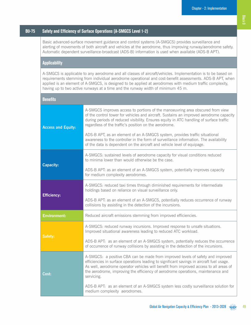
Global Air Navigation Capacity & Efficiency Plan - 2013–2028 49
Chapter - 2: ImplementationChapter - 2: Implementation
B0-75 Safety and Efficiency of Surface Operations (A-SMGCS Level 1-2)
Basic advanced-surface movement guidance and control systems (A-SMGCS) provides surveillance and alerting of movements of both aircraft and vehicles at the aerodrome, thus improving runway/aerodrome safety. Automatic dependent surveillance-broadcast (ADS-B) information is used when available (ADS-B APT).
Applicability
A-SMGCS is applicable to any aerodrome and all classes of aircraft/vehicles. Implementation is to be based on requirements stemming from individual aerodrome operational and cost-benefit assessments. ADS-B APT, when applied is an element of A-SMGCS, is designed to be applied at aerodromes with medium traffic complexity, having up to two active runways at a time and the runway width of minimum 45 m.
Benefits
Access and Equity:
A-SMGCS improves access to portions of the manoeuvring area obscured from view of the control tower for vehicles and aircraft. Sustains an improved aerodrome capacity during periods of reduced visibility. Ensures equity in ATC handling of surface traffic regardless of the traffic’s position on the aerodrome.
ADS-B APT, as an element of an A-SMGCS system, provides traffic situational awareness to the controller in the form of surveillance information. The availability of the data is dependent on the aircraft and vehicle level of equipage.
Capacity:
A-SMGCS: sustained levels of aerodrome capacity for visual conditions reduced to minima lower than would otherwise be the case.
ADS-B APT: as an element of an A-SMGCS system, potentially improves capacity for medium complexity aerodromes.
Efficiency:
A-SMGCS: reduced taxi times through diminished requirements for intermediate holdings based on reliance on visual surveillance only.
ADS-B APT: as an element of an A-SMGCS, potentially reduces occurrence of runway collisions by assisting in the detection of the incursions.
Environment: Reduced aircraft emissions stemming from improved efficiencies.
Safety:
A-SMGCS: reduced runway incursions. Improved response to unsafe situations. Improved situational awareness leading to reduced ATC workload.
ADS-B APT: as an element of an A-SMGCS system, potentially reduces the occurrence of occurrence of runway collisions by assisting in the detection of the incursions.
Cost:
A-SMGCS: a positive CBA can be made from improved levels of safety and improved efficiencies in surface operations leading to significant savings in aircraft fuel usage. As well, aerodrome operator vehicles will benefit from improved access to all areas of the aerodrome, improving the efficiency of aerodrome operations, maintenance and servicing.
ADS-B APT: as an element of an A-SMGCS system less costly surveillance solution for medium complexity aerodromes.
Block 0

Global Air Navigation Capacity & Efficiency Plan - 2013–202850
Chapter - 2: Implementation
B0-80 Improved Airport Operations through Airport-CDM
Implements collaborative applications that will allow the sharing of surface operations data among the different stakeholders on the airport. This will improve surface traffic management reducing delays on movement and manoeuvring areas and enhance safety, efficiency and situational awareness.
Applicability
Local for equipped/capable fleets and already established airport surface infrastructure.
Benefits
Capacity:Enhanced use of existing infrastructure of gate and stands (unlock latent capacity). Reduced workload, better organization of the activities to manage flights.
Efficiency:
Increased efficiency of the ATM system for all stakeholders. In particular for aircraft operators: improved situational awareness (aircraft status both home and away); enhanced fleet predictability and punctuality; improved operational efficiency (fleet management); and reduced delay.
Environment:Reduced taxi time; reduced fuel and carbon emission; and lower aircraft engine run time.
Cost:
The business case has proven to be positive due to the benefits that flights and the other airport operational stakeholders can obtain. However, this may be influenced depending upon the individual situation (environment, traffic levels investment cost, etc.).
A detailed business case has been produced in support of the EU regulation which was solidly positive.

Global Air Navigation Capacity & Efficiency Plan - 2013–2028 51
Chapter - 2: Implementation
B0-15 Improve Traffic Flow through Sequencing (AMAN/DMAN)
Manage arrivals and departures (including time-based metering) to and from a multi-runway aerodrome or locations with multiple dependent runways at closely proximate aerodromes, to efficiently utilize the inherent runway capacity.
Applicability
Runways and terminal manoeuvring area in major hubs and metropolitan areas will be most in need of these improvements.
The improvement is least complex – runway sequencing procedures are widely used in aerodromes globally. However some locations might have to confront environmental and operational challenges that will increase the complexity of development and implementation of technology and procedures to realize this Module.
Benefits
Capacity:Time-based metering will optimize usage of terminal airspace and runway capacity. Optimized utilization of terminal and runway resources.
Efficiency:
Efficiency is positively impacted as reflected by increased runway throughput and arrival rates. This is achieved through:
a) Harmonized arriving traffic flow from en-route to terminal and aerodrome. Harmonization is achieved via the sequencing of arrival flights based on available terminal and runway resources.
b) Streamlined departure traffic flow and smooth transition into en-route airspace. Decreased lead time for departure request and time between call for release and departure time. Automated dissemination of departure information and clearances.
Predictability: Decreased uncertainties in aerodrome/terminal demand prediction.
Flexibility By enabling dynamic scheduling.
Cost:
A detailed positive business case has been built for the time-based flow management programme in the United States. The business case has proven the benefit/cost ratio to be positive. Implementation of time-based metering can reduce airborne delay. This capability was estimated to provide over 320,000 minutes in delay reduction and $28.37 million in benefits to airspace users and passengers over the evaluation period.
Results from field trials of DFM, a departure scheduling tool in the United States, have been positive. Compliance rate, a metric used to gauge the conformance to assigned departure time, has increased at field trial sites from sixty-eight to seventy-five per cent. Likewise, the EUROCONTROL DMAN has demonstrated positive results. Departure scheduling will streamline flow of aircraft feeding the adjacent center airspace based on that center’s constraints. This capability will facilitate more accurate estimated time of arrivals (ETAs). This allows for the continuation of metering during heavy traffic, enhanced efficiency in the NAS and fuel efficiencies. This capability is also crucial for extended metering.
Block 0
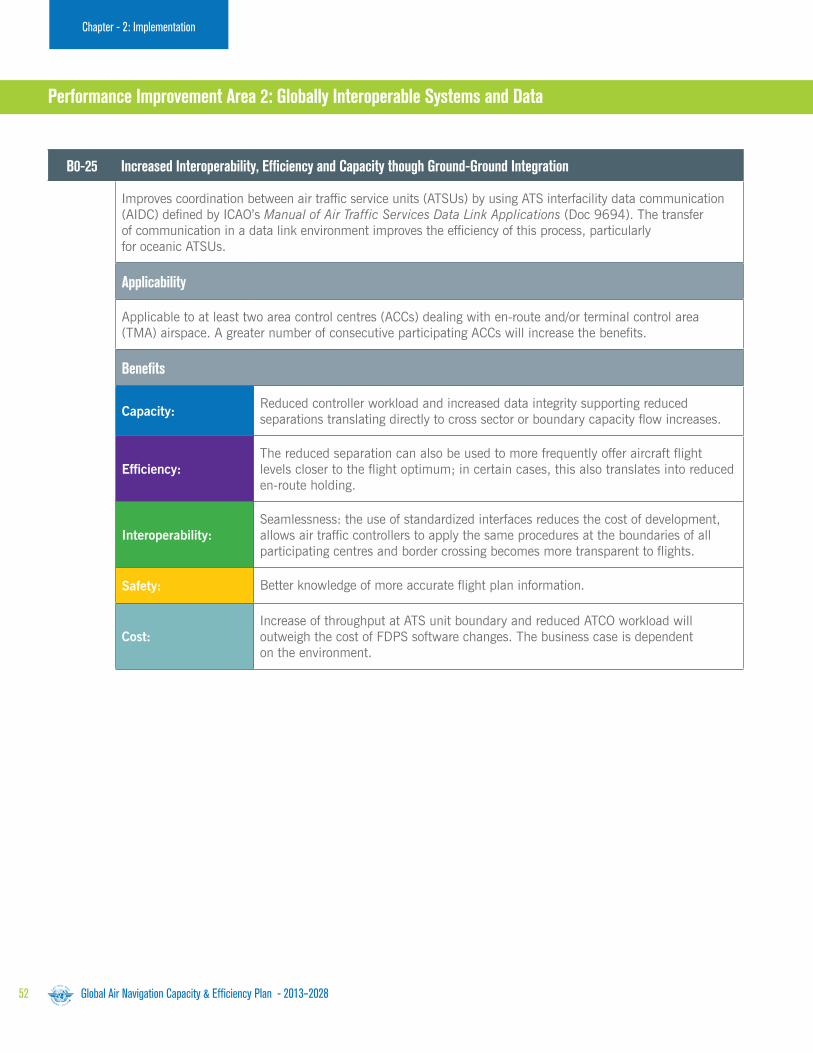
Global Air Navigation Capacity & Efficiency Plan - 2013–202852
Chapter - 2: Implementation
B0-25 Increased Interoperability, Efficiency and Capacity though Ground-Ground Integration
Improves coordination between air traffic service units (ATSUs) by using ATS interfacility data communication (AIDC) defined by ICAO’s Manual of Air Traffic Services Data Link Applications (Doc 9694). The transfer of communication in a data link environment improves the efficiency of this process, particularly for oceanic ATSUs.
Applicability
Applicable to at least two area control centres (ACCs) dealing with en-route and/or terminal control area (TMA) airspace. A greater number of consecutive participating ACCs will increase the benefits.
Benefits
Capacity:Reduced controller workload and increased data integrity supporting reduced separations translating directly to cross sector or boundary capacity flow increases.
Efficiency:The reduced separation can also be used to more frequently offer aircraft flight levels closer to the flight optimum; in certain cases, this also translates into reduced en-route holding.
Interoperability:Seamlessness: the use of standardized interfaces reduces the cost of development, allows air traffic controllers to apply the same procedures at the boundaries of all participating centres and border crossing becomes more transparent to flights.
Safety: Better knowledge of more accurate flight plan information.
Cost:Increase of throughput at ATS unit boundary and reduced ATCO workload will outweigh the cost of FDPS software changes. The business case is dependent on the environment.
Block 0
Performance Improvement Area 2: Globally Interoperable Systems and Data

Global Air Navigation Capacity & Efficiency Plan - 2013–2028 53
Chapter - 2: ImplementationChapter - 2: Implementation
B0-30 Service Improvement through Digital Aeronautical Information Management
The initial introduction of digital processing and management of information through, aeronautical information service (AIS)/aeronautical information management (AIM) implementation, use of aeronautical exchange model (AIXM), migration to electronic aeronautical information publication (AIP0 and better quality and availability of data.
Applicability
Applicable at State level with increased benefits as more States participate.
Benefits
Environment:Reducing the time necessary to promulgate information concerning airspace status will allow for more effective airspace utilization and allow improvements in trajectory management.
Safety: Reduction in the number of possible inconsistencies. Module allows reducing the number of manual entries and ensures consistency among data through automatic data checking based on commonly agreed business rules.
Interoperability: Essential contribution to interoperability.
Cost:
Reduced costs in terms of data inputs and checks, paper and post, especially when considering the overall data chain, from originators, through AIS to the end users. The business case for the aeronautical information conceptual model (AIXM) has been conducted in Europe and in the United States and has shown to be positive. The initial investment necessary for the provision of digital AIS data may be reduced through regional cooperation and it remains low compared with the cost of other ATM systems. The transition from paper products to digital data is a critical pre-requisite for the implementation of any current or future ATM or Air Navigation concept that relies on the accuracy, integrity and timeliness of data.
Block 0

Global Air Navigation Capacity & Efficiency Plan - 2013–202854
Chapter - 2: Implementation
B0-105: Meteorological Information Supporting Enhanced Operational Efficiency and Safety
Global, regional and local meteorological information:
a) Forecasts provided by world area forecast centres (WAFCs), volcanic ash advisory centres (VAACs) and tropical cyclone advisory centres (TCAC).
b) Aerodrome warnings to give concise information of meteorological conditions that could adversely affect all aircraft at an aerodrome, including wind shear.
c) SIGMETs to provide information on occurrence or expected occurrence of specific en-route weather phenomena which may affect the safety of aircraft operations.
This information supports flexible airspace management, improved situational awareness and collaborative decision-making, and dynamically-optimized flight trajectory planning. This Module includes elements which should be viewed as a subset of all available meteorological information that can be used to support enhanced operational efficiency and safety
Applicability
Applicable to traffic flow planning, and to all aircraft operations in all domains and flight phases, regardless of level of aircraft equipage.
Benefits
Capacity: Optimized use of airspace capacity. Metric: ACC and aerodrome throughput.
Efficiency:
Harmonized arriving air traffic (en-route to terminal area to aerodrome) and harmonized departing air traffic (aerodrome to terminal area to en-route) will translate to reduced arrival and departure holding times and thus reduced fuel burn.Metric: Fuel consumption and flight time punctuality.
Environment:Reduced fuel burn through optimized departure and arrival profiling/scheduling. Metric: Fuel burn and emissions.
Safety: Increased situational awareness and improved consistent and collaborative decision making. Metric: Incident occurrences.
Interoperability:Gate-to-gate seamless operations through common access to, and use of, the available WAFS, IAVW and tropical cyclone watch forecast information. Metric: ACC throughput.
Predictability:Decreased variance between the predicted and actual air traffic schedule. Metric: Block time variability, flight-time error/buffer built into schedules.
Participation:Common understanding of operational constraints, capabilities and needs, based on expected (forecast) meteorological conditions. Metric: Collaborative decision-making at the aerodrome and during all phases of flight.
Flexibility:Supports pre-tactical and tactical arrival and departure sequencing and thus dynamic air traffic scheduling. Metric: ACC and aerodrome throughput.
Cost:Reduction in costs through reduced arrival and departure delays (viz. reduced fuel burn). Metric: Fuel consumption and associated costs.

Global Air Navigation Capacity & Efficiency Plan - 2013–2028 55
Chapter - 2: ImplementationChapter - 2: Implementation
B0-10 Improved Operations through Enhanced En-route Trajectories
Allow the use of airspace which would otherwise be segregated (i.e. Special Use Airspace) along with flexible routing adjusted for specific traffic patterns. This will allow greater routing possibilities, reducing potential congestion on trunk routes and busy crossing points, resulting in reduced flight lengths and fuel burn.
Applicability
Applicable to en-route airspace. Benefits can start locally. The larger the size of the concerned airspace the greater the benefits, in particular for flex track aspects. Benefits accrue to individual flights and flows.Application will naturally span over a long period as traffic develops. Its features can be introduced starting with the simplest ones.
Benefits
Access and Equity: Better access to airspace by a reduction of the permanently segregated volumes.
Capacity:
The availability of a greater set of routing possibilities allows reducing potential congestion on trunk routes and at busy crossing points. The flexible use of airspace gives greater possibilities to separate flights horizontally. PBN helps to reduce route spacing and aircraft separations. This in turn allows reducing controller workload by flight.
Efficiency:
The different elements concur to trajectories closer to the individual optimum by reducing constraints imposed by permanent design. In particular the Module will reduce flight length and related fuel burn and emissions. The potential savings are a significant proportion of the ATM related inefficiencies. The Module will reduce the number of flight diversions and cancellations. It will also better allow avoidance of noise sensitive areas.
Environment:Fuel burn and emissions will be reduced; however, the area where emissions and contrails will be formed may be larger.
Predictability:Improved planning allows stakeholders to anticipate on expected situations and be better prepared.
Flexibility: The various tactical functions allow rapid reaction to changing conditions.
Cost:
FUA: In the United Arab Emirates (UAE) over half of the airspace is military. Opening up this airspace could potentially enable yearly savings in the order of 4.9 million litres of fuel and 581 flight hours. In the United States a study for NASA by Datta and Barington showed maximum savings of dynamic use of FUA of $7.8M (1995$).
Flexible routing: Early modelling of flexible routing suggests that airlines operating a 10-hour intercontinental flight can cut flight time by six minutes, reduce fuel burn by as much as 2% and save 3,000 kilograms of CO2 emissions. In the United States RTCA NextGen Task Force Report, it was found that benefits would be about 20% reduction in operational errors; 5-8% productivity increase (near term; growing to 8-14% later); capacity increases (but not quantified). Annual operator benefit in 2018 of $39,000 per equipped aircraft (2008 dollars) growing to $68,000 per aircraft in 2025 based on the FAA Initial investment Decision. For the high throughput, high capacity benefit case (in 2008 dollars): total operator benefit is $5.7B across programme lifecycle (2014-2032, based on the FAA initial investment decision).
Performance Improvement Area 3: Optimum Capacity and Flexible Flights
Block 0
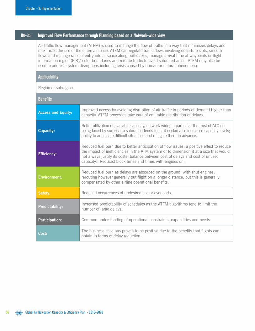
Global Air Navigation Capacity & Efficiency Plan - 2013–202856
Chapter - 2: Implementation
B0-35 Improved Flow Performance through Planning based on a Network-wide view
Air traffic flow management (ATFM) is used to manage the flow of traffic in a way that minimizes delays and maximizes the use of the entire airspace. ATFM can regulate traffic flows involving departure slots, smooth flows and manage rates of entry into airspace along traffic axes, manage arrival time at waypoints or flight information region (FIR)/sector boundaries and reroute traffic to avoid saturated areas. ATFM may also be used to address system disruptions including crisis caused by human or natural phenomena.
Applicability
Region or subregion.
Benefits
Access and Equity:Improved access by avoiding disruption of air traffic in periods of demand higher than capacity. ATFM processes take care of equitable distribution of delays.
Capacity:Better utilization of available capacity, network-wide; in particular the trust of ATC not being faced by surprise to saturation tends to let it declare/use increased capacity levels; ability to anticipate difficult situations and mitigate them in advance.
Efficiency:
Reduced fuel burn due to better anticipation of flow issues; a positive effect to reduce the impact of inefficiencies in the ATM system or to dimension it at a size that would not always justify its costs (balance between cost of delays and cost of unused capacity). Reduced block times and times with engines on.
Environment:Reduced fuel burn as delays are absorbed on the ground, with shut engines; rerouting however generally put flight on a longer distance, but this is generally compensated by other airline operational benefits.
Safety: Reduced occurrences of undesired sector overloads.
Predictability:Increased predictability of schedules as the ATFM algorithms tend to limit the number of large delays.
Participation: Common understanding of operational constraints, capabilities and needs.
Cost:The business case has proven to be positive due to the benefits that flights can obtain in terms of delay reduction.
Block 0
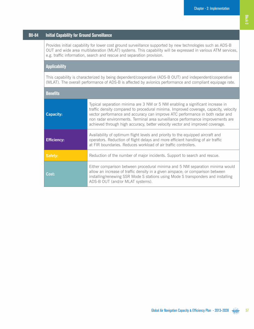
Global Air Navigation Capacity & Efficiency Plan - 2013–2028 57
Chapter - 2: Implementation
B0-84 Initial Capability for Ground Surveillance
Provides initial capability for lower cost ground surveillance supported by new technologies such as ADS-B OUT and wide area multilateration (MLAT) systems. This capability will be expressed in various ATM services, e.g. traffic information, search and rescue and separation provision.
Applicability
This capability is characterized by being dependent/cooperative (ADS-B OUT) and independent/cooperative (MLAT). The overall performance of ADS-B is affected by avionics performance and compliant equipage rate.
Benefits
Capacity:
Typical separation minima are 3 NM or 5 NM enabling a significant increase in traffic density compared to procedural minima. Improved coverage, capacity, velocity vector performance and accuracy can improve ATC performance in both radar and non radar environments. Terminal area surveillance performance improvements are achieved through high accuracy, better velocity vector and improved coverage.
Efficiency:Availability of optimum flight levels and priority to the equipped aircraft and operators. Reduction of flight delays and more efficient handling of air traffic at FIR boundaries. Reduces workload of air traffic controllers.
Safety: Reduction of the number of major incidents. Support to search and rescue.
Cost:
Either comparison between procedural minima and 5 NM separation minima would allow an increase of traffic density in a given airspace; or comparison between installing/renewing SSR Mode S stations using Mode S transponders and installing ADS-B OUT (and/or MLAT systems).
Block 0

Global Air Navigation Capacity & Efficiency Plan - 2013–202858
Chapter - 2: Implementation
B0-85 Air Traffic Situational Awareness (ATSA)
Two air traffic situational awareness (ATSA) applications which will enhance safety and efficiency by providing pilots with the means to enhance traffic situational awareness and achieve quicker visual acquisition of targets:
a) AIRB (basic airborne situational awareness during flight operations).
b) VSA (visual separation on approach).
Applicability
These are cockpit-based applications which do not require any support from the ground hence they can be used by any suitably equipped aircraft. This is dependent upon aircraft being equipped with ADS-B OUT. Avionics availability at low enough costs for GA is not yet available.
Benefits
Efficiency:Improve situational awareness to identify level change opportunities with current separation minima (AIRB) and improve visual acquisition and reduction of missed approaches (VSA).
Safety: Improve situational awareness (AIRB) and reduce the likelihood of wake turbulence encounters (VSA).
Cost:
The cost benefit is largely driven by higher flight efficiency and consequent savings in contingency fuel.
The benefit analysis of the EUROCONTROL CRISTAL ITP project of the CASCADE Programme and subsequent update had shown that ATSAW AIRB and ITP together are capable of providing the following benefits over N. Atlantic:
a) Saving 36 million Euro (50K Euro per aircraft) annually.
b) Reducing carbon dioxide emissions by 160,000 tonnes annually.
The majority of these benefits are attributed to AIRB. Findings will be refined after the completion of the pioneer operations starting in December 2011.
Block 0

Global Air Navigation Capacity & Efficiency Plan - 2013–2028 59
Chapter - 2: ImplementationChapter - 2: Implementation
B0-86 Improved Access to Optimum Flight Levels through Climb/Descent Procedures using ADS B)
Enables aircraft to reach a more satisfactory flight level for flight efficiency or to avoid turbulence for safety. The main benefit of ITP is significant fuel savings and the uplift of greater payloads.
Applicability
This can be applied to routes in procedural airspaces.
Benefits
Capacity: Improvement in capacity on a given air route.
Efficiency: Increased efficiency on oceanic and potentially continental en-route.
Environment: Reduced emissions.
Safety: A reduction of possible injuries for cabin crew and passengers.
B0-101 Airborne Collision Avoidance Systems (ACAS) Improvements
Provides short-term improvements to existing airborne collision avoidance systems (ACAS) to reduce nuisance alerts while maintaining existing levels of safety. This will reduce trajectory deviations and increase safety in cases where there is a breakdown of separation.
Applicability
Safety and operational benefits increase with the proportion of equipped aircraft.
Benefits
Efficiency:ACAS improvement will reduce unnecessary resolution advisory (RA) and then reduce trajectory deviations.
Safety: ACAS increases safety in the case of breakdown of separation.
Block 0

Global Air Navigation Capacity & Efficiency Plan - 2013–202860
Chapter - 2: Implementation
B0-102 Increased Effectiveness of Ground-Based Safety Nets
Monitors the operational environment during airborne phases of flight to provide timely alerts on the ground of an increased risk to flight safety. In this case, short-term conflict alert, area proximity warnings and minimum safe altitude warnings are proposed. Ground-based safety nets make an essential contribution to safety and remain required as long as the operational concept remains human centred.
Applicability
Benefits increase as traffic density and complexity increase. Not all ground-based safety nets are relevant for each environment. Deployment of this Module should be accelerated.
Benefits
Safety: Significant reduction of the number of major incidents.
Cost:The business case for this element is entirely made around safety and the application of ALARP (as low as reasonably practicable) in risk management.
Block 0
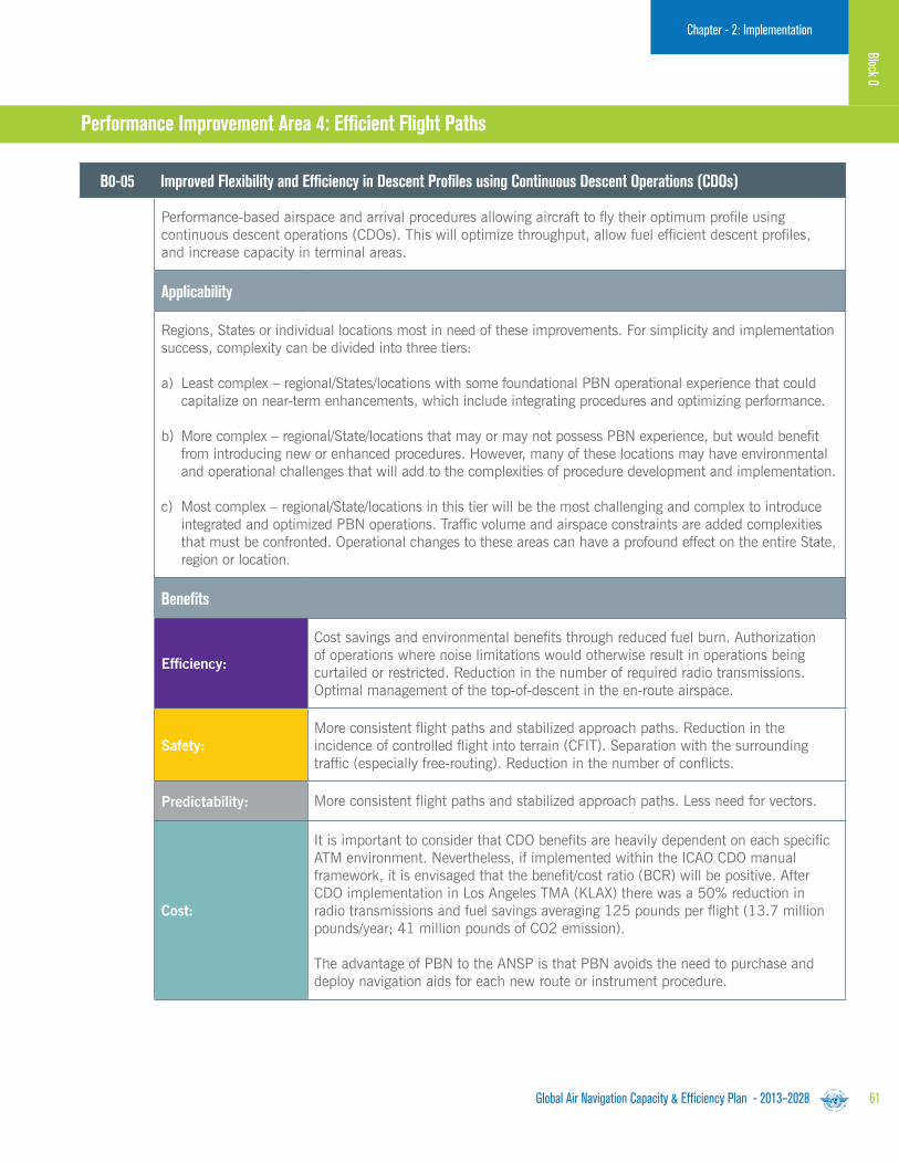
Global Air Navigation Capacity & Efficiency Plan - 2013–2028 61
Chapter - 2: ImplementationChapter - 2: Implementation
B0-05 Improved Flexibility and Efficiency in Descent Profiles using Continuous Descent Operations (CDOs)
Performance-based airspace and arrival procedures allowing aircraft to fly their optimum profile using continuous descent operations (CDOs). This will optimize throughput, allow fuel efficient descent profiles, and increase capacity in terminal areas.
Applicability
Regions, States or individual locations most in need of these improvements. For simplicity and implementation success, complexity can be divided into three tiers:
a) Least complex – regional/States/locations with some foundational PBN operational experience that could capitalize on near-term enhancements, which include integrating procedures and optimizing performance.
b) More complex – regional/State/locations that may or may not possess PBN experience, but would benefit from introducing new or enhanced procedures. However, many of these locations may have environmental and operational challenges that will add to the complexities of procedure development and implementation.
c) Most complex – regional/State/locations in this tier will be the most challenging and complex to introduce integrated and optimized PBN operations. Traffic volume and airspace constraints are added complexities that must be confronted. Operational changes to these areas can have a profound effect on the entire State, region or location.
Benefits
Efficiency:
Cost savings and environmental benefits through reduced fuel burn. Authorization of operations where noise limitations would otherwise result in operations being curtailed or restricted. Reduction in the number of required radio transmissions. Optimal management of the top-of-descent in the en-route airspace.
Safety: More consistent flight paths and stabilized approach paths. Reduction in the incidence of controlled flight into terrain (CFIT). Separation with the surrounding traffic (especially free-routing). Reduction in the number of conflicts.
Predictability: More consistent flight paths and stabilized approach paths. Less need for vectors.
Cost:
It is important to consider that CDO benefits are heavily dependent on each specific ATM environment. Nevertheless, if implemented within the ICAO CDO manual framework, it is envisaged that the benefit/cost ratio (BCR) will be positive. After CDO implementation in Los Angeles TMA (KLAX) there was a 50% reduction in radio transmissions and fuel savings averaging 125 pounds per flight (13.7 million pounds/year; 41 million pounds of CO2 emission).
The advantage of PBN to the ANSP is that PBN avoids the need to purchase and deploy navigation aids for each new route or instrument procedure.
Performance Improvement Area 4: Efficient Flight Paths
Block 0

Global Air Navigation Capacity & Efficiency Plan - 2013–202862
Chapter - 2: Implementation
B0-40 Improved Safety and Efficiency through the Initial Application of Data Link En-route
Implements an initial set of data link applications for surveillance and communications in air traffic control (ATC), supporting flexible routing, reduced separation and improved safety.
Applicability
Requires good synchronization of airborne and ground deployment to generate significant benefits, in particular to those equipped. Benefits increase with the proportion of equipped aircraft.
Benefits
Capacity:
Element 1: A better localization of traffic and reduced separations allow increasing the offered capacity.
Element 2: Reduced communication workload and better organization of controller tasks allowing increased sector capacity.
Efficiency:Element 1: Routes/tracks and flights can be separated by reduced minima, allowing flexible routings and vertical profiles closer to the user-preferred ones.
Safety:
Element 1: Increased situational awareness; ADS-C based safety nets like cleared level adherence monitoring, route adherence monitoring, danger area infringement warning; and better support to search and rescue.
Element 2: Increased situational awareness; reduced occurrences of misunder-standings; solution to stuck microphone situations.
Flexibility: Element 1: ADS-C permits easier route change.
Cost:
Element 1: The business case has proven to be positive due to the benefits that flights can obtain in terms of better flight efficiency (better routes and vertical profiles; better and tactical resolution of conflicts).
To be noted, the need to synchronize ground and airborne deployments to ensure that services are provided by the ground when aircraft are equipped, and that a minimum proportion of flights in the airspace under consideration are suitably equipped.
Element 2: The European business case has proved to be positive due to:
a) the benefits that flights obtain in terms of better flight efficiency (better routes and vertical profiles; better and tactical resolution of conflicts); and
b) reduced controller workload and increased capacity.
A detailed business case has been produced in support of the EU regulation which was solidly positive. To be noted, there is a need to synchronize ground and airborne deployments to ensure that services are provided by the ground when aircraft are equipped, and that a minimum proportion of flights in the aairspacce under consideration are suitably equipped.
Block 0

Global Air Navigation Capacity & Efficiency Plan - 2013–2028 63
Chapter - 2: ImplementationChapter - 2: Implementation
B0-20 Improved Flexibility and Efficiency Departure Profiles – Continuous Climb Operations (CCO)
Implements continuous climb operations (CCO) in conjunction with performance-based navigation (PBN) to provide opportunities to optimize throughput, improve flexibility, enable fuel-efficient climb profiles, and increase capacity at congested terminal areas.
Applicability
Regions, States or individual locations most in need of these improvements. For simplicity and implementation success, complexity can be divided into three tiers:
a) Least complex – regional/States/locations with some foundational PBN operational experience that could capitalize on near-term enhancements, which include integrating procedures and optimizing performance.
b) More complex – regional/State/locations that may or may not possess PBN experience, but would benefit from introducing new or enhanced procedures. However, many of these locations may have environmental and operational challenges that will add to the complexities of procedure development and implementation.
c) Most complex – regional/State/locations in this tier will be the most challenging and complex to introduce integrated and optimized PBN operations. Traffic volume and airspace constraints are added complexities that must be confronted. Operational changes to these areas can have a profound effect on the entire State, region or location.
Benefits
Efficiency:Cost savings through reduced fuel burn and efficient aircraft operating profiles. Reduction in the number of required radio transmissions.
Environment:Authorization of operations where noise limitations would otherwise result in operations being curtailed or restricted. Environmental benefits through reduced emissions.
Safety: More consistent flight paths. Reduction in the number of required radio transmissions. Lower pilot and air traffic control workload.
Cost:It is important to consider that CCO benefits are heavily dependent on the specific ATM environment. Nevertheless, if implemented within the ICAO CCO manual framework, it is envisaged that the benefit/cost ratio (BCR) will be positive.
Block 0

Chapter 3 Near-term Standardization: Block 1
Photo courtesy Bombardier/Learjet

Global Air Navigation Capacity & Efficiency Plan - 2013–2028 65
Chapter - 3: Near-term StandardizationBlock 1
The Block 1 Modules usher in some of the most promising new concepts and capabilities supporting the future ATM System, namely: Flight and Flow Information for a Collaborative Environment (FF-ICE); Trajectory-Based Operations (TBO); System-Wide Information Management (SWIM) and the integration of Remotely Piloted Aircraft (RPAs) into non-segregated airspace.
These concepts are at various stages of development. Some have been subject to flight trials in a controlled environment while others, such as FF-ICE, exist as a series of steps leading to the implementation of well understood concepts. As such, confidence is high that they will be successfully implemented but the near-term standardization is expected to be challenging, as outlined below.
Human Performance factors will have a strong impact on the final implementation of concepts such as FF-ICE and TBO. Closer integration of airborne and ground-based systems will call for a thorough end-to-end consideration of Human Performance impacts.
Similarly, technological enablers will also affect the final implementation of these concepts. Typical technological enablers include air-ground data link and the exchange models for SWIM. Every technology has limits on its performance and this could, in turn, impact the achievable operational benefits— either directly or through their affect on Human Performance.
The standardization effort will therefore need to follow three parallel courses:
a) The development and refinement of the final concept. b) Consideration of end-to-end Human Performance
impacts and their effect on the ultimate concept and the necessary technological enablers.
c) Further consideration of the technological enablers to ensure that their performance can support operations based on the new concepts and, if not, what procedural or other changes will be needed.
d) Harmonization of the relevant Standards
on a global level.
For example, RPAs will require a ‘detect and avoid’ capability as well as a Command and Control link which is more robust than the pilot-ATC link available today. In each case, these are meant to replicate the cockpit experience for the remote pilot. There will clearly be some limits to what technology can provide in this regard, hence consideration will need to be given to limits on operations, special procedures, etc.
This is the essence of the standardization challenge ahead. Stakeholders need to be sensitized and brought together to develop unified solutions and ICAO will address this through a series of events:
• In 2014, ICAO will host an event for industry and States, with industry providing end-to-end demonstrations of new concepts such as TBO and FF-ICE, including the Human Performance aspects.
• In 2014, ICAO will host a symposium on Aviation Data link: Now and Tomorrow. This event will help us determine the next steps for data link—both in terms of technology, services and implementation.
• In 2015, ICAO will hold an Air Navigation Information Management Divisional Meeting focused on SWIM.
Block 1 therefore represents the primary technical work programme for ICAO in the next triennium, in partnership with industry and regulators, in order to provide a coherent, globally harmonized set of operational improvements in the proposed timeframe.

Global Air Navigation Capacity & Efficiency Plan - 2013–202866
Chapter - 3: Near-term Standardization
B1-65 Optimized Airport Accessibility
Progresses further with the universal implementation of performance-based navigation (PBN) approaches. PBN and GLS (CAT II/III) procedures to enhance the reliability and predictability of approaches to runways increasing safety, accessibility and efficiency.
Applicability
This Module is applicable to all runway ends.
Benefits
Efficiency:Cost savings related to the benefits of lower approach minima: fewer diversions, overflights, cancellations and delays. Cost savings related to higher airport capacity by taking advantage of the flexibility to offset approaches and define displaced thresholds.
Environment: Environmental benefits through reduced fuel burn.
Safety: Stabilized approach paths.
Cost:
Aircraft operators and ANSPs can quantify the benefits of lower minima by modelling airport accessibility with existing and new minima. Operators can then assess benefits against avionics and other costs. The GLS CAT II/III business case needs to consider the cost of retaining ILS or MLS to allow continued operations during an interference event. The potential for increased runway capacity benefits with GLS is complicated at airports where a significant proportion of aircraft are not equipped with GLS avionics.
Performance Improvement Area 1: Airport Operations
Block 1The Modules comprising Block 1, which are intended to be available beginning in 2018, satisfy one of the following criteria:
a) The operational improvement is approved and ready for roll-out (but has not been used operationally).b) The operational improvement has been trialed successfully in a controlled operational environment. c) The operational improvement has been trialed successfully in a simulated environment.d) The operational improvement represents a well understood concept that has yet to be trialed.

Global Air Navigation Capacity & Efficiency Plan - 2013–2028 67
Chapter - 3: Near-term Standardization
B1-70 Increased Runway Throughput through Dynamic Wake Turbulence Separation
Improved throughput on departure and arrival runways through the dynamic management of wake turbulence separation minima based on the real-time identification of wake turbulence hazards.
Applicability
Least complex – implementation of re-categorized wake turbulence is mainly procedural. No changes to automation systems are needed.
Benefits
Capacity:Element 1: Better wind information around the aerodrome to enact reduced wake mitigation measures in a timely manner. Aerodrome capacity and arrival rates will increase as the result of reduced wake mitigation measures.
Environment:Element 3: Changes brought about by this element will enable more accurate crosswind prediction.
Flexibility:Element 2: Dynamic scheduling. ANSPs have the choice of optimizing the arrival/departure schedule via pairing number of unstable approaches.
Cost:
Element 1’s change to the ICAO wake turbulence separation minima will yield an average nominal four per cent additional capacity increase for airport runways. The four per cent increase translates to one more landing per hour for a single runway that normally could handle thirty landings per hour. One extra slot per hour creates revenue for the air carrier that fills them and for the airport that handles the extra aircraft operations and passengers.
The impact of the Element 2 Upgrade is the reduced time that an airport, due to weather conditions, must operate its parallel runways, with centre lines spaced less than 760 m (2,500 feet) apart, as a single runway. Element 2 Upgrade allows more airports to better utilize such parallel runways when they are conducting instrument flight rules operations – resulting in a nominal eight to ten more airport arrivals per hour when crosswinds are favourable for WTMA reduced wake separations. For the Element 2 Upgrade, the addition of a crosswind prediction and monitoring capability to the ANSP automation is required. For the Element 2 and 3 Upgrades, additional downlink and real-time processing of aircraft observed wind information will be required. There are no aircraft equipage costs besides costs incurred for other Module Upgrades.
Impact of the Element 3 Upgrade is reduced time that an airport must space departures on its parallel runways, with centre lines spaced less than 760 m (2,500 feet) apart, by two to three minutes, depending on runway configuration. Element 3 Upgrade will provide more time periods that an airport ANSP can safely use WTMD reduced wake separations on their parallel runways. The airport departure capacity increases four to eight more departure operations per hour when WTMD reduced separations can be used. Downlink and real time processing of aircraft observed wind information will be required. There are no aircraft equipage costs besides costs incurred for other Module Upgrades.
Block 1

Global Air Navigation Capacity & Efficiency Plan - 2013–202868
Chapter - 3: Near-term Standardization
B1-75 Enhanced Safety and Efficiency of Surface Operations – SURF, SURF-IA and Enhanced Vision Systems (EVS)
Provides enhancements for surface situational awareness, including both cockpit and ground elements, in the interest of runway and taxiway safety, and surface movement efficiency. Cockpit improvements including the use of surface moving maps with traffic information (SURF), runway safety alerting logic (SURF-IA), and enhanced vision systems (EVS) for low visibility taxi operations.
Applicability
For SURF and SURF-IA, applicable to large aerodromes (ICAO codes 3 and 4) and all classes of aircraft; cockpit capabilities work independently of ground infrastructure, but other aircraft equipage and/or ground surveillance broadcast will improve.
Benefits
Efficiency:Element 1: Reduced taxi times.
Element 2: Fewer navigation errors requiring correction by ANSP.
Safety:
Element 1: Reduced risk of collisions.
Element 2: Improved response times to correction of unsafe surface situations (SURF-IA only).
Element 3: Fewer navigation errors.
Cost:
The business case for this element can be largely made around safety. Currently, the aerodrome surface is often the regime of flight which has the most risk for aircraft safety, due to the lack of good surveillance on the ground acting in redundancy with cockpit capabilities. Visual scanning augmentation in the cockpit acting in conjunction with service provider capabilities enhances operations on the surface. Efficiency gains are expected to be marginal and modest in nature.
Improving flight crew situational awareness of aircraft position during periods of reduced visibility will reduce errors in the conduct of taxi operations, which lead to both safety and efficiency gains.

Global Air Navigation Capacity & Efficiency Plan - 2013–2028 69
Chapter - 3: Near-term Standardization
B1-80 Optimized Airport Operations through A-CDM Total Airport Management
Enhances the planning and management of airport operations and allows their full integration for air traffic management using performance targets compliant with those of the surrounding airspace. This entails implementing collaborative airport operations planning (AOP) and where needed, an airport operations centre (APOC).
Applicability
AOP: for use at all the airports (sophistication will depend on the complexity of the operations and their impact on the network).
APOC: will be implemented at major/complex airports (sophistication will depend on the complexity of the operations and their impact on the network).
Not applicable to aircraft.
Benefits
Efficiency:
Through collaborative procedures, comprehensive planning and pro-active action to foreseeable problems a major reduction in on-ground and in-air holding is expected thereby reducing fuel consumption. The planning and pro-active actions will also support efficient use of resources; however, some minor increase in resources may be expected to support the solution(s).
Environment:Through collaborative procedures, comprehensive planning and pro-active action to foreseeable problems a major reduction in on-ground and in-air holding is expected thereby reducing noise and air pollution in the vicinity of the airport.
Predictability:Through the operational management of performance, reliability and accuracy of the schedule and demand forecast will increase (in association with initiatives being developed in other Modules).
Cost:
Through collaborative procedures, comprehensive planning and pro-active action to foreseeable problems, a major reduction in on-ground and in-air holding is expected thereby reducing fuel consumption. The planning and pro-active actions will also support efficient use of resources; however, some minor increase in resources may be expected to support the solution(s).
Block 1

Global Air Navigation Capacity & Efficiency Plan - 2013–202870
Chapter - 3: Near-term Standardization
B1-81 Remotely Operated Aerodrome Control
Provides a safe and cost-effective air traffic services (ATS) from a remote facility to one or more aerodromes where dedicated, local ATS are no longer sustainable or cost-effective, but there is a local economic and social benefit from aviation. This can also be applied to contingency situations and depends on enhanced situational awareness of the aerodrome under remote control.
Applicability
The main target for the single and multiple remote tower services are small rural airports, which today are struggling with low business margins. Both ATC and AFIS aerodromes are expected to benefit.
The main targets for the contingency tower solution are medium to large airports – those that are large enough to require a contingency solution, but who require an alternative to A-SMGCS based “heads down” solutions or where maintaining a visual view is required.
Although some cost benefits are possible with remote provision of ATS to a single aerodrome, maximum benefit is expected with the remote of ATS to multiple aerodromes.
Benefits
Capacity: Capacity may be increased through the use of digital enhancements in low visibility.
Efficiency:Efficiency benefits through the ability to exploit the use of technology in the provision of the services. Digital enhancements can be used to maintain throughput in low visibility conditions.
Safety: Same or greater levels of safety as if the services were provided locally. The use of the digital visual technologies used in the RVT should provide safety enhancements in low visibility.
Flexibility:Flexibility may be increased through a greater possibility to extend opening hours when through remote operations.
Cost:
There are no current operational remote towers, therefore the cost/benefit analyses (CBAs) are necessarily based on some assumptions developed by subject matter experts. Costs incurred are associated with procurement and installation of equipment and additional capital costs in terms of new hardware and adaptation of buildings. New operating costs include facilities leases, repairs and maintenance and communication links. There are then short term transition costs such as staff re-training, re-deployment and relocation costs.
Against this, savings are derived from remote tower implementation. A significant portion of these result from savings in employment costs due to reduction in shift size. Previous CBAs indicated a reduction in staff costs of 10-35% depending on the scenario. Other savings arise from reduced capital costs, particularly savings from not having to replace and maintain tower facilities and equipment and from a reduction in tower operating costs.
The CBA concluded that remote towers do produce positive financial benefits for ANSPs. Further CBAs will be conducted during 2012 and 2013 using a range of implementation scenarios (single, multiple, contingency).

Global Air Navigation Capacity & Efficiency Plan - 2013–2028 71
Chapter - 3: Near-term Standardization
B1-15 Improved Airport Operations through Departure, Surface and Arrival Management
Extension of arrival metering and integration of surface management with departure sequencing will improve runway management and increase airport performance and flight efficiency.
Applicability
Runways and terminal manoeuvring areas in major hubs and metropolitan areas will be most in need of these improvements. Complexity in implementation of this Module depends on several factors. Some locations might have to confront environmental and operational challenges that will increase the complexity of development and implementation of technology and procedures to realize this Module. Performance-based Navigation (PBN) routes need to be in place.
Benefits
Capacity: Time-based metering will optimize usage of terminal airspace and runway capacity.
Efficiency:
Surface management decreases runway occupancy time, introduces more robust departure rates and enables dynamic runway rebalancing and re-configuration. Departure/surface integration enables dynamic runway rebalancing to better accommodate arrival and departure patterns. Reduction in airborne delay/holding. Traffic flow synchronization between en-route and terminal domain. RNAV/RNP procedures will optimize aerodrome/terminal resource utilization.
Environment: Reduction in fuel burn and environment impact (emission and noise).
Safety: Greater precision in surface movement tracking.
Predictability:
Decrease uncertainties in aerodrome/terminal demand prediction. Increased compliance with assigned departure time and more predictable and orderly flow into metering points. Greater compliance to controlled time of arrival (CTA) and more accurate assigned arrival time and greater compliance.
Flexibility: Enables dynamic scheduling.
Cost:Cost-benefits may be reasonably projected for multiple stakeholders due to increased capacity, predictability and efficiency of airline and airport operations.
Block 1

Global Air Navigation Capacity & Efficiency Plan - 2013–202872
Chapter - 3: Near-term Standardization
B1-25Increased Interoperability, Efficiency and Capacity through Flight and Flow Information for a Collaborative Environment Step-1 (FF-ICE/1) application before Departure
Introduces FF-ICE, Step 1 providing ground-ground exchanges using a common flight information reference model (FIXM) and extensible markup language (XML) standard formats before departure.
Applicability
Applicable between ATS units to facilitate exchange between ATM service provider (ASP), airspace user operations and airport operations.
Benefits
Capacity:Reduced air traffic controller (ATC) workload and increased data integrity supporting reduced separations translating directly to cross sector or boundary capacity flow increases.
Efficiency:Better knowledge of aircraft capabilities allows trajectories closer to airspace user preferred trajectories and better planning.
Safety: More accurate flight information.
Interoperability:The use of a new mechanism for FPL filing and information sharing will facilitate flight data sharing among the actors.
Participation:
FF-ICE, Step 1 for ground-ground application will facilitate collaborative decision-making (CDM), the implementation or the systems interconnection for information sharing, trajectory or slot negotiation before departure providing better use of capacity and better flight efficiency.
Flexibility: The use of FF-ICE, Step 1 allows a quicker adaptation of route changes.
Cost:The new services have to be balanced by the cost of software changes in the ATM service provider (ASP), airline operations center (AOC) and airport ground systems.
Performance Improvement Area 2: Globally Interoperable Systems and Data

Global Air Navigation Capacity & Efficiency Plan - 2013–2028 73
Chapter - 3: Near-term Standardization
B1-30 Service Improvement through Integration of all Digital ATM Information
Implements the ATM information reference model, integrating all ATM information, using common formats (UML/XML and WXXM) for meteorological information, and internet protocols.
Applicability
Applicable at the State level, with increased benefits as more States participate.
Benefits
Access and Equity: Greater and timelier access to up-to-date information by a wider set of users.
Efficiency:Reduced processing time for new information; increased ability of the system to create new applications through the availability of standardized data.
Safety: Reduced probability of data errors or inconsistencies; reduced possibility to introduce additional errors through manual inputs.
Interoperability: Essential for global interoperability.
Cost:Business case to be established in the course of the projects defining the models and their possible implementation.
Block 1

Global Air Navigation Capacity & Efficiency Plan - 2013–202874
Chapter - 3: Near-term Standardization
B1-31 Performance Improvement through the Application of System-Wide Information Management (SWIM)
Implementation of system-wide information management (SWIM) services (applications and infrastructure) creating the aviation intranet based on standard data models and internet-based protocols to maximize interoperability.
Applicability
Applicable at State level, with increased benefits as more States participate.
Benefits
Efficiency:Using better information allows operators and service providers to plan and execute better trajectories.
Environment:Further reduction of paper usage, more cost-efficient flights as the most up-to-date information is available to all stakeholders in the ATM system.
Safety: Access protocols and data quality will be designed to reduce current limitations in these areas.
Cost:
Further reduction of costs; all information can be managed consistently across the network, limiting bespoke developments, flexible to adapt to state-of-the-art industrial products and making use of scale economies for the exchanged volumes.
The business case is to be considered in the full light of other Modules of this Block and the next one. Pure SWIM aspects unlock ATM information management issues; operational benefits are more indirect.

Global Air Navigation Capacity & Efficiency Plan - 2013–2028 75
Chapter - 3: Near-term Standardization
B1-105 Enhanced Operational Decisions through Integrated Meteorological Information (Planning and Near-term Service)
Enables the reliable identification of solutions when forecast or observed meteorological conditions impact aerodromes or airspace. Full ATM-Meteorology integration is needed to ensure that: meteorological information is included in the logic of a decision process and the impact of the meteorological conditions (the constraints) are automatically calculated and taken into account The decision time-horizons range from minutes, to several hours or days ahead of the ATM operation (this includes optimum flight profile planning and tactical in-flight avoidance of hazardous meteorological conditions) to typically enable near-term and planning (>20 minutes) type of decision making. This Module also promotes the establishment of standards for global exchange of the information.
This Module builds, in particular, upon Module B0-105, which detailed a sub-set of all available meteorological information that can be used to support enhanced operational efficiency and safety.
Applicability
Applicable to traffic flow planning, and to all aircraft operations in all domains and flight phases, regardless of level of aircraft equipage.
Benefits
Capacity: Enables more precise estimates of expected capacity of a given airspace.
Efficiency:Reduces the number of deviations from user-preferred flight profiles. Decrease in the variability and numbers of ATM responses to a given meteorological situation, along with reduced contingency fuel carriage for the same meteorological situation.
Environment: Less fuel burn, and reduction of emissions due to fewer ground hold/delay actions.
Safety: Increased situational awareness by pilots, AOCs and ANSPs, including enhanced safety through the avoidance of hazardous meteorological conditions. Reduced contingency fuel carriage for the same meteorological condition.
Predictability:
More consistent evaluations of meteorological constraints, which in turn will allow users to plan trajectories that are more likely to be acceptable from the standpoint of the ANSP. Fewer reroutes and less variability in associated traffic management initiatives (TMIs) can be expected.
Flexibility:Users have greater flexibility in selecting trajectories that best meet their needs, taking into account the observed and forecast meteorological conditions.
Cost:
The business case for this element is still to be determined as part of the development of this overall Module, which is in the research phase. Current experience with utilization of ATM decision support tools, with basic meteorological input parameters to improve ATM decision making by stakeholders has proven to be positive in terms of producing consistent responses from both the ANSP and user community.
Block 1

Global Air Navigation Capacity & Efficiency Plan - 2013–202876
Chapter - 3: Near-term Standardization
B1-10 Improved Operations through Optimized ATS Routing
Provides, through performance-based navigation (PBN), closer and consistent route spacing, curved approaches, parallel offsets and the reduction of holding area size. This will allow the sectorization of airspace to be adjusted more dynamically. This will reduce potential congestion on trunk routes and busy crossing points and reduce controller workload. The main goal is to allow flight plans to be filed with a significant part of the intended route specified by the user-preferred profile. Maximum freedom will be granted within the limits posed by the other traffic flows. The overall benefits are reduced fuel burn and emissions.
Applicability
Region or sub-region: the geographical extent of the airspace of application should be large enough; significant benefits arise when the dynamic routes can apply across flight information region (FIR) boundaries rather than imposing traffic to cross boundaries at fixed predefined points.
Benefits
Capacity:
The availability of a greater set of routing possibilities allows for reduction of potential congestion on trunk routes and at busy crossing points. This in turn allows for reduction of controller workload by flight.
Free routings naturally spreads traffic in the airspace and the potential interactions between flights, but also reduces the “systematization” of flows and therefore may have a negative capacity effect in dense airspace if it is not accompanied by suitable assistance.
Reduced route spacing means reduced consumption of airspace by the route network and a greater possibility to match it with flows.
Efficiency:
Trajectories closer to the individual optimum by reducing constraints imposed by permanent design and/or by the variety of aircraft behaviours. In particular the Module will reduce flight length and related fuel burn and emissions.
The potential savings are a significant proportion of the ATM-related inefficiencies. Where capacity is not an issue, fewer sectors may be required as the spreading of traffic or better routings should reduce the risk of conflicts.
Easier design of high-level temporary segregated airspace (TSAs).
Environment:Fuel burn and emissions will be reduced; however, the area where emissions and contrails will be formed may be larger.
Flexibility:Choice of routing by the airspace user would be maximized. Airspace designers would also benefit from greater flexibility to design routes that fit the natural traffic flows.
Cost:The business case of free routing has proved to be positive due to the benefits that flights can obtain in terms of better flight efficiency (better routes and vertical profiles; better and tactical resolution of conflicts).
Performance Improvement Area 3: Optimum Capacity and Flexible Flights

Global Air Navigation Capacity & Efficiency Plan - 2013–2028 77
Chapter - 3: Near-term Standardization
B1-35 Enhanced Flow Performance through Network Operational Planning
Introduces enhanced processes to manage flows or groups of flights in order to improve overall flow. The resulting increased collaboration among stakeholders in real-time, regarding user preferences and system capabilities will result in better use of airspace with positive effects on the overall cost of ATM.
Applicability
Region or sub-region for most applications; specific airports in case of initial user driven prioritization process (UDPP). This Module is more particularly needed in areas with the highest traffic density. However, the techniques it contains would also be of benefit to areas with lesser traffic, subject to the business case.
Benefits
Capacity:Better use of airspace and ATM network, with positive effects on the overall cost efficiency of ATM. Optimization of DCB measures by using assessment of workload/complexity as a complement to capacity.
Efficiency: Reduction of flight penalties supported by airspace users.
Environment: Some minor improvement is expected compared to the Module’s baseline.
Safety: The Module is expected to further reduce the number of situations where capacity or acceptable workload would be exceeded.
Predictability:Airspace users have greater visibility and say on the likelihood to respect their schedule and can make better choices based on their priorities.
Cost: The business case will be a result of the validation work being undertaken.
Block 1

Global Air Navigation Capacity & Efficiency Plan - 2013–202878
Chapter - 3: Near-term Standardization
B1-85 Increased Capacity and Efficiency through Interval Management
Interval management (IM) improves the organization of traffic flows and aircraft spacing. This creates operational benefits through precise management of intervals between aircraft with common or merging trajectories, thus maximizing airspace throughput while reducing ATC workload along with more efficient aircraft fuel burn reducing environmental impact.
Applicability
En-route and terminal areas.
Benefits
Capacity:Consistent, low variance spacing between paired aircraft (e.g. at the entry to an arrival procedure and on final approach) resulting in reduced fuel burn.
Efficiency:Early speed advisories removing requirement for later path-lengthening. Continued optimized profile descents (OPDs) in medium density environments expected to allow OPDs when demand <=70%. Resulting in reduced holding times and flight times.
Environment: Reduced emissions due to reduced spacings and optimized profiles.
Safety: Reduced ATC instructions and workload without unacceptable increase in flight crew workload.
Cost: Labour savings due to reduced ATC workload.

Global Air Navigation Capacity & Efficiency Plan - 2013–2028 79
Chapter - 3: Near-term Standardization
B1-102 Ground-based Safety Nets on Approach
Enhances safety by reducing the risk of controlled flight into terrain accidents on final approach through the use of an approach path monitor (APM). APM warns the controller of increased risk of controlled flight into terrain during final approaches. The major benefit is a significant reduction of the number of major incidents.
Applicability
This Module will increase safety benefits during final approach particularly where terrain or obstacles represent safety hazards. Benefits increase as traffic density and complexity increase.
Benefits
Safety: Significant reduction of the number of major incidents.
Cost:The business case for this element is entirely made around safety and the application of ALARP (as low as reasonably practicable) in risk management.
Block 1
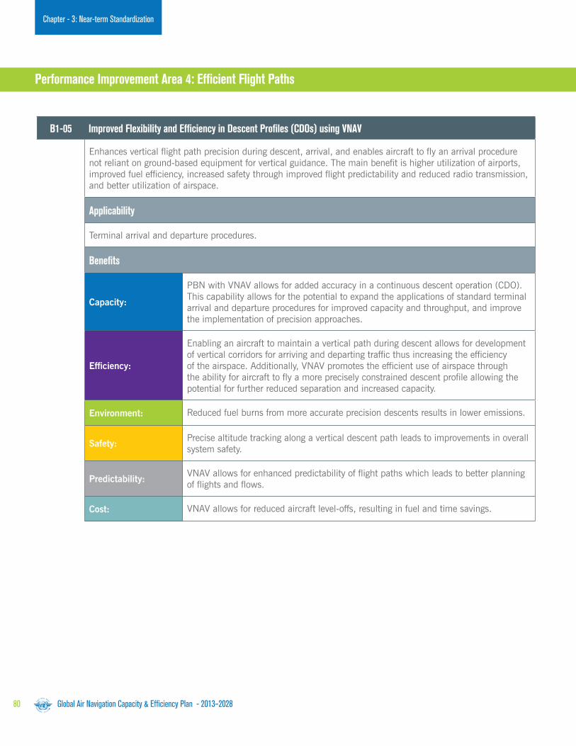
Global Air Navigation Capacity & Efficiency Plan - 2013–202880
Chapter - 3: Near-term Standardization
B1-05 Improved Flexibility and Efficiency in Descent Profiles (CDOs) using VNAV
Enhances vertical flight path precision during descent, arrival, and enables aircraft to fly an arrival procedure not reliant on ground-based equipment for vertical guidance. The main benefit is higher utilization of airports, improved fuel efficiency, increased safety through improved flight predictability and reduced radio transmission, and better utilization of airspace.
Applicability
Terminal arrival and departure procedures.
Benefits
Capacity:
PBN with VNAV allows for added accuracy in a continuous descent operation (CDO). This capability allows for the potential to expand the applications of standard terminal arrival and departure procedures for improved capacity and throughput, and improve the implementation of precision approaches.
Efficiency:
Enabling an aircraft to maintain a vertical path during descent allows for development of vertical corridors for arriving and departing traffic thus increasing the efficiency of the airspace. Additionally, VNAV promotes the efficient use of airspace through the ability for aircraft to fly a more precisely constrained descent profile allowing the potential for further reduced separation and increased capacity.
Environment: Reduced fuel burns from more accurate precision descents results in lower emissions.
Safety: Precise altitude tracking along a vertical descent path leads to improvements in overall system safety.
Predictability:VNAV allows for enhanced predictability of flight paths which leads to better planning of flights and flows.
Cost: VNAV allows for reduced aircraft level-offs, resulting in fuel and time savings.
Performance Improvement Area 4: Efficient Flight Paths

Global Air Navigation Capacity & Efficiency Plan - 2013–2028 81
Chapter - 3: Near-term Standardization
B1-40 Improved Traffic Synchronization and Initial Trajectory-based Operation
Improves the synchronization of traffic flows at en-route merging points and to optimize the approach sequence through the use of 4DTRAD capability and airport applications, e.g. D-TAXI.
Applicability
Requires good synchronization of airborne and ground deployment to generate significant benefits, in particular to those equipped. Benefit increases with size of equipped aircraft population in the area where the services are provided.
Benefits
Capacity:
Positively affected because of the reduction of workload associated to the establishment of the sequence close to the convergence point and related tactical interventions. Positively affected because of the reduction of workload associated to the delivery of departure and taxi clearances.
Efficiency:
Increased by using the aircraft RTA capability for traffic synchronization planning through en-route and into terminal airspace. ‘Closed loop’ operations on RNAV procedures ensure common air and ground system awareness of traffic evolution and facilitate its optimization. Flight efficiency is increased through proactive planning of top of descent, descent profile and en-route delay actions, and enhanced terminal airspace route efficiency.
Environment:More economic and environmentally friendly trajectories, in particular absorption of some delays.
Safety: Safety at/around airports by a reduction of the misinterpretations and errors in the interpretation of the complex departure and taxi clearances.
Predictability:
Increased predictability of the ATM system for all stakeholders through greater strategic management of traffic flow between and within FIRs en-route and terminal airspace using the aircraft RTA capability or speed control to manage a ground CTA. Predictable and repeatable sequencing and metering. “Closed loop” operations on RNAV procedures ensuring common air and ground system awareness of traffic evolution.
Cost:Establishment of the business case is underway. The benefits of the proposed airport services were already demonstrated in the EUROCONTROL CASCADE Programme.
Block 1

Global Air Navigation Capacity & Efficiency Plan - 2013–202882
Chapter - 3: Near-term Standardization
B1-90 Initial Integration of Remotely Piloted Aircraft (RPA) into Non-segregated Airspace
Implementation of basic procedures for operating remotely piloted aircraft (RPA) in non-segregated airspace, including detect and avoid.
Applicability
Applies to all RPA operating in non-segregated airspace and at aerodromes. Requires good synchronization of airborne and ground deployment to generate significant benefits, in particular to those able to meet minimum certification and equipment requirements.
Benefits
Access and Equity: Limited access to airspace by a new category of users.
Safety: Increased situational awareness; controlled use of aircraft.
Cost:The business case is directly related to the economic value of the aviation applications supported by RPAs.

Global Air Navigation Capacity & Efficiency Plan - 2013–2028 83
Chapter - 3: Near-term Standardization

Chapter 4 Continuing Research: Blocks 2 and 3
Photo courtesy Bombardier/Learjet

Global Air Navigation Capacity & Efficiency Plan - 2013–2028 85
Block 2Chapter - 4: Continuing Research
B2-75 Optimized Surface Routing and Safety Benefits (A-SMGCS Level 3-4 and SVS)
To improve efficiency and reduce the environmental impact of surface operations, even during periods of low visibility. Queuing for departure runways is reduced to the minimum necessary to optimize runway use and taxi times are also reduced. Operations will be improved so that low visibility conditions have only a minor effect on surface movement.
Applicability
Most applicable to large aerodromes with high demand, as the Upgrades address issues surrounding queuing and management and complex aerodrome operations.
B2-70 Advanced Wake Turbulence Separation (Time-based)
The application of time-based aircraft-to-aircraft wake separation minima and changes to the procedures the ANSP uses to apply wake separation minima.
Applicability
Most complex – establishment of time-based separation criteria between pairs of aircraft extends the existing variable distance re-categorization of existing wake turbulence into a conditions specific time-based interval. This will optimize the inter-operation wait time to the minimum required for wake disassociation and runway occupancy. Runway throughput is increased as a result.
Performance Improvement Area 1: Airport Operations
Block 2The Modules comprising Block 2 are intended to be available in 2023 and must satisfy one of the following criteria:
a) Represent a natural Thread progression from the preceding Module in Block 1.b) Be theoretically feasible. c) In certain airspace, support the operating environment in 2023.

Global Air Navigation Capacity & Efficiency Plan - 2013–202886
Chapter - 4: Continuing Research
B2-31 Enabling Airborne Participation in Collaborative ATM through SWIM
This allows the aircraft to be fully connected as an information node in SWIM, enabling full participation in collaborative ATM processes with exchange of data including meteorology. This will start with non-safety critical exchanges supported by commercial data links.
Applicability
Long-term evolution potentially applicable to all environments.
B2-25 Improved Coordination through Multi-entre Ground-Ground Integration (FF ICE, Step 1 and Flight Object, SWIM)
FF-ICE supporting trajectory-based operations through exchange and distribution of information for multi-centre operations using flight object implementation and interoperability (IOP) standards. Extension of use of FF-ICE after departure, supporting trajectory-based operations. New system interoperability SARPs to support the sharing of ATM services involving more than two air traffic service units (ATSUs).
Applicability
Applicable to all ground stakeholders (ATS, airports, airspace users) in homogeneous areas, potentially global.
B2-15 Linked Arrival Management and Departure Management (AMAN/DNAM)
Integrated AMAN/DMAN to enable dynamic scheduling and runway configuration to better accommodate arrival/departure patterns and integrate arrival and departure management. The Module also summarizes the benefits of such integration and the elements that facilitate it.
Applicability
Runways and terminal manoeuvring area in major hubs and metropolitan areas will be most in need of these improvements. The implementation of this Module is least complex. Some locations might have to confront environmental and operational challenges that will increase the complexity of development and implementation technology and procedures to realize this Block. Infrastructure for RNAP/RNP routes need to be in place.
Performance Improvement Area 2: Globally Interoperable Systems and Data

Global Air Navigation Capacity & Efficiency Plan - 2013–2028 87
Block 2Chapter - 4: Continuing Research
B2-35 Increased User Involvement in the Dynamic Utilization of the Network
CDM applications supported by SWIM that permit airspace users to manage competition and prioritization of complex ATFM solutions when the network or its nodes (airports, sector) no longer provide enough capacity to meet user demands. This further develops the CDM applications by which ATM will be able to offer/delegate to the users the optimization of solutions to flow problems. Benefits include an improvement in the use of available capacity and optimized airline operations in degraded situations.
Applicability
Region or sub-region.
B2-85 Airborne Separation (ASEP)
Creation of operational benefits through temporary delegation of responsibility to the flight deck for separation provision with suitably equipped designated aircraft, thus reducing the need for conflict resolution clearances while reducing ATC workload and enabling more efficient flight profiles. The flight crew ensures separation from suitably equipped designated aircraft as communicated in new clearances, which relieve the controller of the responsibility for separation between these aircraft. However, the controller retains responsibility for separation from aircraft that are not part of these clearances.
Applicability
The safety case needs to be carefully done and the impact on capacity is still to be assessed in case of delegation of separation for a particular situation implying new regulation on airborne equipment and equipage roles and responsibilities (new procedure and training). First applications of ASEP are envisaged in Oceanic airspace and in approach for closely-spaced parallel runways.
B2-101 New Collision Avoidance System
Implementation of the airborne collision avoidance system (ACAS) adapted to trajectory-based operations with improved surveillance function supported by ADS-B and adaptive collision avoidance logic aiming at reducing nuisance alerts and minimizing deviations.
The implementation of a new airborne collision warning system will enable more efficient operations and future airspace procedures while complying with safety regulations. The new system will accurately discriminate between necessary alerts and “nuisance alerts”. This improved differentiation will lead to a reduction in controller workload as personnel will spend less time to respond to “nuisance alerts”. This will result in a reduction in the probability of a near mid-air collision.
Applicability
Safety and operational benefits increase with the proportion of equipped aircraft. The safety case needs to be carefully done.
Performance Improvement Area 3: Optimum Capacity and Flexible Flights

Global Air Navigation Capacity & Efficiency Plan - 2013–202888
Chapter - 4: Continuing Research
B2-90 Remotely Piloted Aircraft (RPA) Integration in Traffic
Continuing to improve the remotely piloted aircraft (RPA) access to non-segregated airspace; continuing to improve the remotely piloted aircraft system (RPAS) approval/certification process; continuing to define and refine the RPAS operational procedures; continuing to refine communication performance requirements; standardizing the command and control (C2) link failure procedures and agreeing on a unique squawk code for C2 link failure; and working on detect and avoid technologies, to include automatic dependent surveillance – broadcast (ADS-B) and algorithm development to integrate RPA into the airspace.
Applicability
Applies to all RPA operating in non-segregated airspace and at aerodromes. Requires good synchronization of airborne and ground deployment to generate significant benefits, in particular to those able to meet minimum certification and equipment requirements.
B2-05 Improved Flexibility and Efficiency in Descent Profiles (CDOs) Using VNAV, Required Speed and Time at Arrival
A key emphasis is on the use of arrival procedures that allow the aircraft to apply little or no throttle in areas where traffic levels would otherwise prohibit this operation. This Block will consider airspace complexity, air traffic workload, and procedure design to enable optimized arrivals in dense airspace.
Applicability
Global, high density airspace (based on the United States FAA procedures).
Performance Improvement Area 4: Efficient Flight Paths

Global Air Navigation Capacity & Efficiency Plan - 2013–2028 89
Chapter - 4: Continuing Research
B3-15 Integration AMAN/DMAN/SMAN
This Module includes a brief description of integrated arrival, en-route, surface, and departure management.
Applicability
Runways and terminal manoeuvring area in major hubs and metropolitan areas will be most in need of these improvements. Complexity in implementation of this Block depends on several factors. Some locations might have to confront environmental and operational challenges that will increase the complexity of development and implementation of technology and procedures to realize this Block. Infrastructure for RNAP/RNP routes need to be in place.
B3-25 Improved Operational Performance through the Introduction of Full FF-ICE
Data for all relevant flights systematically shared between the air and ground systems using SWIM in support of collaborative ATM and trajectory-based operations.
Applicability
Air and ground.
Block 3
Performance Improvement Area 1: Airport Operations
Block 3The Modules comprising Block 3, intended to be available for implementation in 2028, must satisfy at least one of the following criteria:
a) Represent a natural progression from the preceding Module in Block 2.b) Theoretically feasible.c) In certain airspace, they will be required to support the operating environment in 2028.d) Represent an end-state as envisaged in the Global ATM Operational Concept.
Performance Improvement Area 2: Globally Interoperable Systems and Data

Global Air Navigation Capacity & Efficiency Plan - 2013–202890
Chapter - 4: Continuing Research
B3-85 Airborne Self-Separation (SSEP)
Creation of operational benefits through total delegation of responsibility to the flight deck for separation provision between suitably equipped aircraft in designated airspace, thus reducing the need for conflict resolution. Benefits will include reduced separation minima, reduction of controller workload, optimum flight trajectories and lower fuel consumption.
Applicability
The safety case needs to be carefully assessed and the impact on capacity is still be to assessed, implying new regulation on airborne equipment and equipage roles and responsibilities (procedure and training). First area for SSEP application is in low density areas.
B3-10 Traffic Complexity Management
Introduction of complexity management to address events and phenomena that affect traffic flows due to physical limitations, economic reasons or particular events and conditions by exploiting the more accurate and rich information environment of SWIM-based ATM. Benefits will include optimized usage and efficiency of system capacity.
Applicability
Regional or sub-regional. Benefits are only significant over a certain geographical size and assume that it is possible to know and control/optimize relevant parameters. Benefits mainly useful in the higher density airspace.
B3-105 Enhanced Operational Decisions through Integrated Meteorological Information (Near-term and Immediate Service)
The aim of this Module is to enhance global ATM decision making in the face of hazardous meteorological conditions in the context of decisions that should have an immediate effect. This Module builds upon the initial information integration concept and capabilities developed under B1-105. Key points are a) tactical avoidance of hazardous meteorological conditions in especially the 0-20 minute timeframe; b) greater use of aircraft based capabilities to detect meteorological parameters (e.g. turbulence, winds, and humidity); and c) display of meteorological information to enhance situational awareness. This Module also promotes further the establishment of standards for the global exchange of the information.
Applicability
Applicable to air traffic flow planning, en-route operations, terminal operations (arrival/departure) and surface. Aircraft equipage is assumed in the areas of ADS-B IN/CDTI, aircraft based meteorological observations, and meteorological information display capabilities, such as EFBs.
Performance Improvement Area 3: Optimum Capacity and Flexible Flights

Global Air Navigation Capacity & Efficiency Plan - 2013–2028 91
Chapter - 4: Continuing Research
B3-90 Remotely Piloted Aircraft (RPA) Transparent Management
Continuing to improve the certification process for remotely piloted aircraft (RPA) in all classes of airspace, working on developing a reliable command and control (C2) link, developing and certifying airborne detect and avoid (ABDAA) algorithms for collision avoidance, and integration of RPA into aerodrome procedures.
Applicability
Applies to all RPA operating in non-segregated airspace and at aerodromes. Requires good synchronization of airborne and ground deployment to generate significant benefits, in particular to those able to meet minimum certification and equipment requirements.
B3-05 Full 4D Trajectory-based Operations
The development of advanced concepts and technologies, supporting four dimensional trajectories (latitude, longitude, altitude, time) and velocity to enhance global ATM decision making. A key emphasis is on integrating all flight information to obtain the most accurate trajectory model for ground automation.
Applicability
Applicable to air traffic flow planning, en-route operations, terminal operations (approach/departure), and arrival operations. Benefits accrue to both flows and individual aircraft. Aircraft equipage is assumed in the areas of: ADS-B IN/CDTI; data communication and advanced navigation capabilities. Requires good synchronization of airborne and ground deployment to generate significant benefits, in particular to those equipped. Benefit increases with size of equipped aircraft population in the area where the service are provided.
Block 3
Performance Improvement Area 4: Efficient Flight Paths

Chapter 5 Aviation System Performance Management

Global Air Navigation Capacity & Efficiency Plan - 2013–2028 93
Chapter 5 - Aviation System Performance
Following the endorsement of a performance based approach to Air Navigation planning and implementation by the Eleventh Air Navigation Conference in 2003, as well as the 35th Session of the ICAO Assembly in 2004, ICAO completed the development of relevant guidance material in early 2008.
By 2009, all PIRGs, while adopting a regional perfor-mance framework, invited States to implement a national performance framework for Air Navigation systems on the basis of ICAO guidance material and aligned with the regional performance objectives, existing Regional Air Navigation Plans, and the Global ATM Operational Concept.
The next step called for performance monitoring through an established measurement strategy. While PIRGs are progressively identifying a set of regional performance metrics, States in the meantime have recognized that data collection, processing, storage and reporting activities supporting the identified regional performance metrics are fundamental to the success of performance-based approaches.
The Air Navigation planning and implementation performance framework (see pages 14–15) prescribes reporting, monitoring, analysis and review activities being conducted on a cyclical, annual basis. The Air Navigation reporting form will be the basis for performance monitoring relating to Block Upgrade implementation at the regional and national levels.
Reporting and monitoring results will be analyzed by ICAO and aviation partner stakeholders and then utilized in developing the annual Global Air Navigation Report.
The report results will provide an opportunity for the world civil aviation community to compare progress across different ICAO regions in the establishment of Air Navigation infrastructure and performance-based procedures.
They will also provide the ICAO Council with detailed annual results on the basis of which tactical adjustments will be made to the performance framework work programme, as well as triennial policy adjustments to the Global Plan and the Block Upgrade Modules.
Global Air Navigation Capacity & Efficincy Report
Review the online reporting
form via www.icao.int/XXXX

Global Air Navigation Capacity & Efficiency Plan - 2013–202894
Chapter 5 - Aviation System Performance
Recognizing the difficulty faced by many States in assessing the environmental benefits of their investments in operational measures to improve fuel efficiency, ICAO, in collaboration with subject matter experts and other international organizations, has developed the ICAO Fuel Savings Estimation Tool (IFSET).
IFSET helps to harmonize State fuel-savings assessments consistent with more advanced models already approved by the Committee on Aviation Environmental Protection (CAEP). It will estimate the difference in fuel mass consumed by comparing a pre-implementation (i.e. baseline) case against a post-implementation case (i.e. after operational improvements), as illustrated below.
Measuring Operational Performance:
ICAO Fuel Savings Estimation Tool (IFSET)
INTERFACE
Current OperationalScenario
Aircraft PerformanceDatabase
Esdtimated FuelConsumption & Savings
Improved OperationalScenario
Aircraft MovementsInformation
Operational Improvement
Baseline Fuel Consumption
Baseline minus Post-operational Consumption = Fuel Saved
Level segments Optimized descent
Post-Operational Improvement Fuel Consumption
Fig. 8: IFSET notional fluxogram.
Fig. 9: Notional illustration of fuel savings.
95Global Air Navigation Capacity & Efficiency Plan - 2013–2028
Chapter 5 - Aviation System Performance
The selection of the baseline case is an important step of the process. It will be defined by the user and could correspond to:
a) The published or planned procedure (AIP, flight plan) scenarios.
b) Daily practices.c) A combination of the two.d) Other criteria as appropriate.
In order to compute the fuel consumed in two different scenarios, the number of operations by aircraft category will be necessary, in addition to a combination of the following elements that describes both scenarios:
a) Average taxi time.b) Time spent or distance flown at a specific altitude.c) Top of descent altitude and bottom of descent altitude.d) Base of climb altitude and top of climb altitude.e) Distance flown in a climb or descent procedure.
IFSET was rolled-out to ICAO Member States through a series of workshops during 2012. It was developed not to replace the use of detailed measurement or modelling tools regarding fuel savings, but rather to assist those States without the facility to estimate the benefits from operational improvements in a straightforward and harmonized manner.

Global Air Navigation Capacity & Efficiency Plan - 2013–202896
Appendix 1: Global Plan Overview and Evolution
Continuity with ICAO Legacy and Companion Publications
The new Global Plan has its roots in an appendix to a 1993 report on what was then termed the Future Air Navigation System (FANS). These appendix recommendations were first presented as the FANS Concept and later became referred to more generally as CNS/ATM solutions.
The FANS initiative had answered a request from ICAO’s Member States for planning recommendations on how to address air transport’s steady global growth through the coordination of emerging technologies. As research and development into these technologies accelerated rapidly during the 1990s, the Plan and its concepts advanced with them.
A new standalone version was published as the ICAO Global Air Navigation Plan for CNS/ATM Systems (Doc 9750) in 1998, the second edition of which was released in 2001. During this period the Plan served to support State and regional planning and procurement needs surrounding CNS/ATM systems.
By 2004, ICAO’s Member States and the air transport industry at large had begun to encourage the transitioning of the Plan’s concepts into more practical, real-world solutions. Two ATM implementation roadmaps, made up of specific operational initiatives, were consequently developed on a collaborative basis by dedicated ICAO/industry project teams.
The operational initiatives contained in the roadmaps were later renamed Global Plan Initiatives (GPIs) and incorporated into the Third Edition of the GANP. The following illustration depicts the Plan’s evolution up to the 2014-16 Global Plan:
Global Plan Approval
The Global Plan has undergone significant change, driven mainly by its new role as a high-level policy document guiding complementary and sector-wide air transport progress in conjunction with the ICAO Global Aviation Safety Plan.
The Global Plans define the means and targets by which ICAO, States and aviation stakeholders can anticipate and efficiently manage air traffic growth while proactively maintaining or increasing Safety outcomes. These objectives have been developed through extensive consultation with industry stakeholders and constitute the basis for harmonized action at the global, regional and national level.
The need to ensure consistency between the Global Plan and the Strategic Objectives of ICAO necessitates placing this high-level policy document under the authority of the ICAO Council. The Global Plan and its amendments are therefore approved by the Council prior to eventual budget-related developments and endorsement by an Assembly.
Appendix 1: Global Plan Evolution & Governance
Fig. 10: Document and operational concept evolution
leading to the 2014-2016 Global Plan.
Includes
Block Upgrade
Methodology
Addresses ANSP,
Regulator AND
User requirements
Encompasses
Performance
Framework

Global Air Navigation Capacity & Efficiency Plan - 2013–2028 97
Appendix 1: Global Plan Overview and Evolution
ICAO Publication Legacy Framework culminating in the 2014-2016 Global Plan
Three ICAO companion documents, reflected in the illustration on the preceding page and described in more detail below, have also been instrumental in permitting ICAO and the aviation community to define the concepts and technologies that eventually made the Global Plan’s Block Upgrade systems engineering approach possible:
Global Air Traffic Management Operational Concept (Doc 9854)
The Global ATM Operational Concept (OCD) was published in 2005. It set out the parameters for an integrated, harmonized and globally interoperable ATM system planned up to 2025 and beyond. Doc 9854 can serve to guide the implementation of CNS/ATM technology by providing a description of how the emerging and future ATM system should operate. The OCD also introduced some new concepts:
a) Planning based on ATM system performance.b) Safety management through the system safety approach.c) A set of common performance expectations of the ATM community.
Manual on Air Traffic Management System Requirements (Doc 9882)
Doc 9882, published in 2008, may be used by PIRGs as well as by States as they develop transition strategies and plans. It defines the high-level requirements (i.e. ATM system requirements) to be applied when developing Standards and Recommended Practices (SARPs) to support the OCD. This document provides high-level system requirements related to: a) System performance-based on ATM community expectations.b) Information management and services.c) System design and engineering.d) ATM concept elements (from the OCD).
Manual on Global Performance of the Air Navigation System (Doc 9882)
This document, published in 2008, is aimed at personnel responsible for designing, implementing and managing performance activities. It achieves two key objectives:
a) It outlines performance framework and performance-based approach (PBA) from the performance concepts provided in the OCD.
b) It analyzes ATM community expectations and categorizes these into key performance areas (KPAs) from which practical metrics and indicators can be developed.
Doc 9883 also provides organizations with the tools to develop an approach to performance management suited to their local conditions.

Block 0 and 1 Module
Descriptions(Chap. 2)
2014-16 Global Plan
B0-65B0B0B0-666555
B1-70B1B1B1B1-77770000
etc.
B0-86B0B0B0-888666
B1-85B1B1B1B1-8-8885555
etc.
Hyperlinks to External Support Content
GANP Internal Content
TechnologyRoadmaps(Appx. 1)
Online ModuleSupport Documentation
Online Operational Concept Support Documentation
Modules Referencedin Roadmaps
Roadmap Operational
Improvment Categories
(e.g. Information Management; PBN;Ground-Ground Surveillance; etc.)
2014 16 Global Plan
Global Air Navigation Capacity & Efficiency Plan - 2013–202898
Appendix 2: Online Support Documents
The 2014-2016 Global Plan contains or is supported by policy and technical information that can be used at every level of the aviation community. This includes technical provisions describing the Block Upgrade Modules and the technology roadmaps, training and personnel considerations, cooperative organizational aspects, cost-benefit analyses and financing concerns, environmental priorities and initiatives, and integrated planning support.
These dynamic and ‘living’ Global Plan support components will be hyperlinked as online PDFs on the ICAO public website throughout the 2013–2028 applicability period.
Under the authority of the ICAO Council and Assembly, the Global Plan’s wide availability, accuracy, and review/update processes now provide ICAO Member States and industry stakeholders with the confidence that the plan can and
will be used effectively to direct relevant developments and implementations as required to achieve global ATM interoperability.
Hyperlinked Online Technical Support Provisions
The Global Plan’s Block Upgrade methodology and supporting technology roadmaps are hyperlinked to comprehensive technical materials that comprise the essential rationales and characteristics of the global plan. These materials have been developed through ICAO Conferences and Symposia, in addition to dedicated panels and working groups, all of which have featured the active and wide-ranging participation of State and industry experts.
The technical support attachments of the Global Plan can be accessed through the main PDF document as shown below:
Appendix 2:
Hyperlinked Online Support Documentation
Fig. 11: Mapping of the hyperlinked technical content supporting the Block Upgrade Modules and technology roadmaps.

Policy
Planning
Content Type
Applicable GANP Content Sections
Hyperlinked Online Supporting Documentation
Reference fromGANP Third Edition
Executive View
Chapter 1
Chapter 1
Chapter 2
Chapter 3
Appendix 2
Integrated ATM Planning Appendixes A, I
Ownership & Governance Models Appendix G
Implementation Chapter 4
Appendix 2
Skilled Personnel & Training Appendix B
Reporting Chapter 5 Air Navigation Report Form
Legal Considerations Appendix C
Financing & Investment Appendixes E,F,G
Environmental Benefits Appendix H
Module Technical Provisions GPIs
Environmental Benefits Appendix H
ICAO SARP/PANS Outlook
PIRG Organizational Structures
2014-16 Global PlanG
Global Air Navigation Capacity & Efficiency Plan - 2013–2028 99
Appendix 2: Online Support Documents
Although they introduce a new planning framework with increased definition and broad timelines, the Global Plan’s Block Upgrades are consistent with the Third Edition of the GANP’s planning process encompassing near-term, mid-term and long-term global plan initiatives (GPIs). This consistency has been retained to ensure the smooth transition from the former planning methodology to the Block Upgrade approach.
One of the clear distinctions between the Third Edition GANP and new Foruth Edition Global Plan is that the consensus-driven Block Upgrade methodology now provides more precise timelines and performance metrics. This
permits the alignment of planning on concrete, shared operational improvements that are referenced to the third edition of the GPIs in order to preserve planning continuity.
In addition to the comprehensive online technical content supporting the Block Upgrade Modules and technology roadmaps, ICAO has also posted essential background guidance materials that will assist States and stakeholders with matters of policy, planning, implementation and reporting.
A large amount of this content has been derived from the appendices in the Third Edition of the GANP, as illustrated in the table below:
Fig. 12: Online Documentation Supporting Policy, Planning, Implementation and Reporting. The far right column
indicates continuity tie-ins with the material in the Appendices of the Third Edition of the GANP.

HF (ATN)
Commercial Broadband Links
LDACS
Future Satellite
HF (ACARS)
VDL Mode 0/A (ACARS)
CPDLC over Baseline 1 (Link 2000+)Full 4D Applications
Advanced CPDLC & ADS-C over Baseline 2
ATN OSI then ATN IPS
ATN OSI then ATN IPS
ATN OSI
CPDLC & ADS-C over FANS/1A ACARS
ATN IPS
ATN IPS
ATN IPS
ATN IPS
Airport Surface Datalink Services
VDL Mode 2 (ACARS & ATN OSI)
Current Satellite Systems (ACARS)
AeroMACS
AIR-GROUNDDATA
COMMUNICATIONS
BLOCK 0
B0-86, B0-40
B1-15, B1-105, B1-40, B1-85
B2-15, B2-25, B2-31B2-75, B2-85, B2-05
B3-25, B3-105B2-75, B2-25, B2-31
B3-25, B3-105B3-85, B3-05
B1-15, B1-25, B1-105
B0-86, B0-40, B0-10
B0-86, B0-40, B0-10
B2-75, B2-25, B2-31 B3-25, B3-105
B1-15, B1-105B1-40, B1-85, B1-10
B1-105, B1-40, B1-85
B2-31
BLOCK 1 BLOCK 2 BLOCK 3
ENABLERS(LINK MEDIA)
SERVICES
2018
2023
2028
B2-15, B2-25, B2-31B2-75, B2-85, B2-05
B3-25, B3-105, B3-85B3-05, B3-10
B1-15, B1-25B1-105, B1-40
B2-15, B2-25, B2-31B2-85, B2-05
Global Air Navigation Capacity & Efficiency Plan - 2013–2028100
Appendix 3: Technology Roadmaps
Fig. 13: Explanation of Technology Roadmap format.
Technology Area
Modules
Technology Supporting Modules
Date of Technology Availability(Earliest possible implementation)
Date when Technology Needed for Block
The roadmaps illustrated in this Appendix have been designed to depict:
a) New and legacy technologies needed to support the block Modules:
1) Modules with an essential requirement
are shown in black.
2) Modules with an optional requirement
are shown in grey.
b) The date by which a technology is needed to support a block and its Modules.
c) The availability of a technology (if it precedes the block).
For ease of reference, CNS, IM and avionics have been divided on the following basis:
a) Communication:1) Air-ground data link communication.2) Ground-ground communication.3) Air-ground voice communication.
b) Surveillance:1) Surface surveillance.2) Ground-based surveillance.3) Air-to-air surveillance.
c) Navigation:1) Dedicated technology.2) Performance-based navigation.
d) Information Management.1) SWIM2) Other
e) Avionics:1) Communications.2) Surveillance.3) Navigation.4) Aircraft safety nets.5) Onboard systems.
Appendix 3:
Technology Roadmaps

Global Air Navigation Capacity & Efficiency Plan - 2013–2028 101
Appendix 3: Technology Roadmaps
Air-ground data link services fall into two basic categories:
• Safety-related ATS services where performance requirements, procedures, services and supporting technology are strictly standardized and regulated,
• Information-related services where performance requirements, procedures and supporting technology are less critical.
In general, the enablers (link media technologies) will be developed and deployed based on the need to support safety-related ATS services.
To prepare for Block 3, research and development is needed in the Blocks 1 and 2 timeframes; there are three areas of investigation where standards are being developed:
• Airports – a ground-based high capacity airport surface data link system is currently under development. The Aeronautical Mobile Airport Communications System (AeroMACS) is based on IEEE 802.16/WiMAX standard).
• SATCOM – a new satellite based data link system targeted at oceanic and remote regions. This link may also be used in continental regions as a complement to terrestrial systems. This could be a dedicated ATS SATCOM (e;g; European ESA Iris initiative) system or a multi-mode commercial system (e.g. Inmarsat Swift Broadband, Iridium).
• Terrestrial (terminal and en-route) – a ground-based data link system for continental airspace is currently under investigation. This has been termed the aeronautical L-band digital aeronautical communications system (LDACS).
In addition, studies are needed to a) review the role of voice communications in the long-term concept (primarily data centric); and to b) consider the need to develop a new appropriate digital voice communication system for continental airspace.
Communication
Roadmap 1 (see page 103) - in the Block 0 timeframe:
Enablers:
• Aviation will rely on existing communications systems, i.e. VHF ACARS and VDL Mode 2/ATN in continental areas.
• VHF ACARS will be transitioned towards VDL Mode 2 AOA (i.e. providing higher bandwidth) since VHF channels have become a very scarce resource in several regions of the world.
• SATCOM ACARS will continue to be used in Oceanic and remote regions.
Services:
• Data link service implementation is underway in Oceanic, En-Route airspace and at major Airports (FANS1/A and/or ICAO ATN based – ATN B1). Today’s data link service implementations today are based on different standards, technology and operational procedures, although there are many similarities. There is a need to converge quickly to a common approach based upon ICAO approved standards. The common global guidance material continues to be developed, namely the “Global Operational Data Link Document” - GOLD.
• Information services such as airline operational communications (AOC) are carried by aircraft for communication with airline company host computers. The air-ground communications media (such as VDL Mode 2) are shared with the safety related services due to cost and avionics limitations.
Comm
unication

Global Air Navigation Capacity & Efficiency Plan - 2013–2028102
Appendix 3: Technology Roadmaps
Roadmap 1 - in the Blocks 1 and 2 timeframe: (continued from page 101)
Enablers:
• ATS services will continue to exploit existing technology to maximize return on investment, hence VDL Mode 2/ATN will continue to be used for converged data link services in continental areas. New service providers may enter the market (mainly for service in oceanic and remote areas), provided they meet the ATS service requirements.
• AOC may begin to migrate towards new technologies at airports and in the en-route environment (e.g. AeroMACS at airports and existing commercial technology like 4G elsewhere) as they become commercially attractive. This may also apply to some information-based ATS.
• VHF ACARS will be phased out giving way to VDL Mode-2.
• HF ACARS will also be phased out and it seems logical that the aeronautical telecommunication network (ATN) will be adapted to support HF data link.
Services:
• An important goal is to harmonize the regional data link implementations through a common technical and operational standard, applicable to all flight regions in the world. The RTCA SC214 and EUROCAE WG78 have been established to develop common safety, performance and interoperability standards for this next generation of ATS data link services (ATN B2) for both continental and Oceanic and remote regions. These Standards, supported by validation results, will be ready by the end of 2013, to be followed by a comprehensive validation phase and will be available for implementation in some regions from 2018. These standards will form the basis of data link services for the long term and will support the move towards trajectory based operations.
• As avionics evolve, new high volume information services such as weather advisories, map updates etc. will become possible. These services could take advantage of new communication technology that could be deployed at some airports and in some en-route airspace, this may be seen as the beginning of air-ground SWIM. These new data link services could be either AOC or ATS. In many cases these will not need the same levels of performance as strictly safety-related ATS services and could therefore make use of commercially available mobile data services, thus reducing the load on the infrastructure supporting the safety-related ATS services.
Roadmap 1 - in the Block 3 timeframe:
Enablers
• Data link will become the primary means of communication. In such a data-centric system, voice will be used only in exceptional/emergency situations; increased data link performance, availability and reliability, supporting greater levels of safety and capacity.
• For Oceanic and remote regions, it is expected that the migration from HF to SATCOM will be completed by the Block 3 timeframe.
Services:
• the ATM Target Concept is a ‘net-centric’ operation based on full 4D trajectory management with data link (based on ATN Baseline 2) used as the prime means of communication, replacing voice due to its ability to handle complex data exchanges. In such a data-centric system, voice will be used only in exceptional/emergency situations.
Full air-ground SWIM services will be used to support advanced decision making and mitigation. SWIM will allow aircraft to participate in collaborative ATM processes and provide access to rich voluminous dynamic data including meteorology. Commercial information-based services to companies and passengers may also be implemented using the same technology.
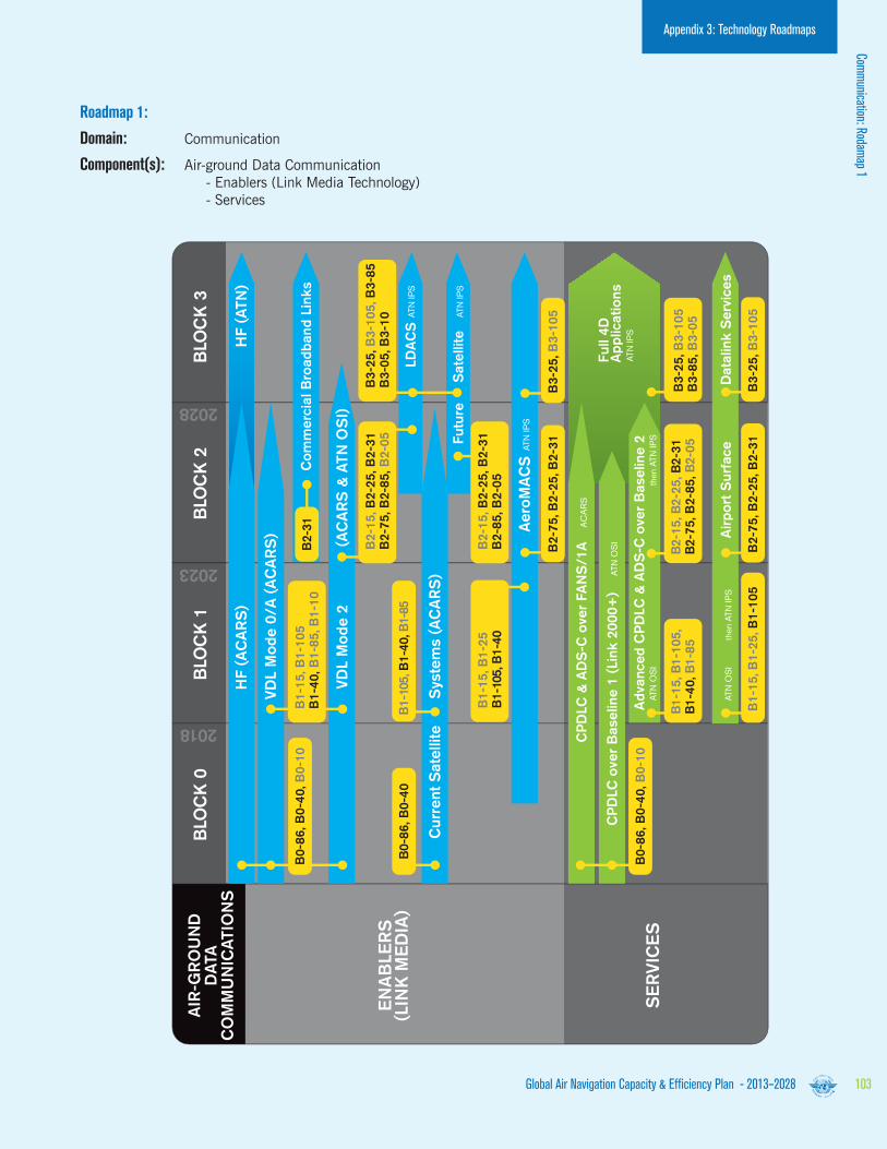
HF (
ATN
)
Co
mm
erc
ial B
road
band
Lin
ks
LD
AC
S
Fu
ture
Sate
llite
HF (
AC
AR
S)
VD
L M
od
e 0
/A
(A
CA
RS
)
CP
DLC
over
Baseline 1
(Lin
k 2
000+
)Fu
ll 4
D
Ap
plicatio
ns
Ad
vanced
CP
DLC
& A
DS
-C o
ver
Baseline 2
ATN
OS
I
then
ATN
IPS
ATN
OS
I
th
en A
TN IP
S
ATN
OS
I
CP
DLC
& A
DS
-C o
ver
FA
NS
/1A
AC
AR
S
ATN
IPS
ATN
IPS
ATN
IPS
ATN
IPS
Air
po
rt S
urf
ace
Data
link S
erv
ices
VD
L M
od
e 2
(AC
AR
S &
ATN
OS
I)
Cu
rrent
Sate
llite S
yste
ms (
AC
AR
S)
Aero
MA
CS
AIR
-GR
OU
ND
DA
TA
CO
MM
UN
ICA
TIO
NS
BLO
CK
0
B0-8
6, B
0-4
0
B1-1
5, B
1-1
05,
B1-4
0, B
1-8
5B
2-1
5, B
2-2
5, B
2-3
1B
2-7
5, B
2-8
5, B
2-0
5
B3-2
5, B
3-1
05
B2-7
5, B
2-2
5, B
2-3
1
B3-2
5, B
3-1
05
B3-8
5, B
3-0
5
B1-1
5, B
1-2
5, B
1-1
05
B0-8
6, B
0-4
0, B
0-1
0
B0-8
6, B
0-4
0, B
0-1
0
B2-7
5, B
2-2
5, B
2-3
1B
3-2
5, B
3-1
05
B1-1
5, B
1-1
05
B1-4
0, B
1-8
5, B
1-1
0
B1-1
05, B
1-4
0, B
1-8
5
B2-3
1
BLO
CK
1B
LO
CK
2B
LO
CK
3
EN
AB
LE
RS
(LIN
K M
ED
IA)
SE
RV
ICE
S
2018
2023
2028
B2-1
5, B
2-2
5, B
2-3
1B
2-7
5, B
2-8
5, B
2-0
5B
3-2
5, B
3-1
05, B
3-8
5B
3-0
5, B
3-1
0
B1-1
5, B
1-2
5B
1-1
05, B
1-4
0B
2-1
5, B
2-2
5, B
2-3
1B
2-8
5, B
2-0
5
Global Air Navigation Capacity & Efficiency Plan - 2013–2028 103
Appendix 3: Technology Roadmaps
Roadmap 1:
Domain: Communication
Component(s): Air-ground Data Communication - Enablers (Link Media Technology) - Services
Comm
unication: Rodamap 1

Global Air Navigation Capacity & Efficiency Plan - 2013–2028104
Appendix 3: Technology Roadmaps
Roadmap 2 - in the Block 0 timeframe:
Enablers:
• IP networks will continue to be deployed. Existing IPV4 systems will be gradually replaced by IPV6.
• Until now, inter-centre voice ATM communications were mainly based on analogue (ATS-R2) and digital (ATS-QSIG) protocols. A move has begun to replace ground-ground voice communications with voice over IP (VoIP).
• Air-Ground Voice communications will remain on 25 kHz VHF channels in continental regions (note: 8.33 kHz VHF voice channels will continue to be deployed in Europe). Migration from HF to SATCOM in Oceanic and remote regions is expected during this time.
Services:
• Two major ground-ground communications services will be in operation:
- ATS messaging operating over AFTN/CIDIN and/or AMHS in some areas.
- Air traffic service inter-facility data communications (AIDC) for flight co-ordination and transfer (OLDI in Europe).
• ATS messaging is used worldwide for the com-munication of flight plans, MET, NOTAMS etc. over AFTN/CIDIN technology. Migration towards AMHS (directory, store and forward services) over IP (or using ATN in some regions) will progress in all regions.
• AIDC is used to provide inter-centre coordination and transfer of aircraft between adjacent air traffic control units. Migration from legacy data network (e.g. X25) to IP data network is progressing in various regions.
• The beginnings of SWIM will start to appear. Operational services will be offered by some SWIM pioneer implementations over IP, Surveillance data distribution and MET data will also be distributed over IP. Migration to Digital NOTAM will start in Europe and the U.S.
Roadmap 2 - in the Blocks 1 and 2 timeframe:
Enablers:
• Traditional ground-ground voice communications will continue to migrate to VoIP. The migration is expected to be complete in 2020.
• Digital NOTAM and MET (using the AIXM and WXXM data exchange formats) will be widely implemented over IP networks.
• FIXM will be introduced as the global standard for exchanging flight data.
• To prepare for the long term, research and development is needed in the medium term for new satellite and terrestrial based systems. Voice communications will remain on 25 kHz VHF channels in continental regions (note: 8.33 kHz VHF voice channels deployment in Europe).
Services:
• ATS messaging will migrate to AMHS supported by directory facilities that will include security management. AIDC services will fully migrate towards using IP networks.
• Initial 4D air-ground services will require ground-ground inter-centre trajectory and clearance co-ordination via AIDC extensions or new flight data exchanges compatible with the SWIM framework.
• SWIM SOA services will mature and expand publish/subscribe and request/reply services in parallel to the more traditional messaging services based on AMHS but both will use the IP network.
Roadmap 2 - in the Block 3 timeframe:
It is quite likely that future digital systems will be used to carry voice. Where satellite communications are used, it will most likely be via the same systems used to support air-ground data link. In the terrestrial environment, it is not
clear whether LDACS will be used to carry this traffic or a separate voice system will be used. This will need to be the subject of R&D efforts in the Blocks 1 and 2 timeframes.

Fu
ture
Sate
llite S
yste
m
Fu
ture
Dig
ital V
oic
e S
yste
m?
VH
F (
25 K
Hz)
VO
ICE
Over
IP
IPV
6
IPV
4
VH
F (
8.3
3 K
Hz)
HF
Cu
rrent
Sate
llite S
yste
ms
CO
NG
ES
TIO
N R
ELI
EF
IPV
6(fo
r G/G
co-
ord
and
links
to A
/G tx
ceiv
ers)
GR
OU
ND
-GR
OU
ND
CO
MM
UN
ICA
TIO
NS
AIR
-GR
OU
ND
VO
ICE
CO
MM
UN
ICA
TIO
NS
BLO
CK
0
B2-2
5B
0-2
5, B
0-3
0B
3-0
5, B
3-2
5, B
3-1
05
B1-2
5, B
1-3
0B
1-3
1, B
1-1
05
BLO
CK
1B
LO
CK
2B
LO
CK
3
EN
AB
LE
RS
(LIN
K M
ED
IA)
EN
AB
LE
RS
(LIN
K M
ED
IA)
SE
RV
ICE
S
2018
2023
2028
Info
rmatio
n M
anag
em
ent
(see R
oad
map
)
AM
HS
AID
C
B0-2
5B
1-2
5
Global Air Navigation Capacity & Efficiency Plan - 2013–2028 105
Appendix 3: Technology Roadmaps
Roadmap 2:
Domain: Communication
Component(s): Ground-ground communication Air-ground voice communication - Enablers - Enablers (Link Media Technology) - Services
Comm
unication: Rodamap 2

Global Air Navigation Capacity & Efficiency Plan - 2013–2028106
Appendix 3: Technology Roadmaps
The important trends of the next 20 years will be that:
a) Different techniques will be mixed in order to obtain the best cost benefit depending on local constraints.
b) Cooperative surveillance will use technologies currently available today (using 1030/1090 MHz RF bands (SSR, Mode-S, WAM and ADS-B).
c) While refinements to capabilities may be identified, it is expected that the surveillance infrastructure currently foreseen could meet all the demands placed upon it.
d) The airborne part of the surveillance system will become more important and should be “future proof” and globally interoperable in order to support the various surveillance techniques which will be used.
e) There will be growing use of downlinked aircraft parameters bringing the following advantages:
1) Clear presentation of call-sign and level.
2) Improved situational awareness.
3) Use of some down-linked aircraft parameters (DAPs) and 25 ft altitude reporting to improve radar tracking algorithms.
4) Display of vertical stack lists.
5) Reduction in radio transmission (controller and pilot).
6) Improve management of aircraft in stacks.
7) Reductions in level busts.
f) Functionality will migrate from the ground to the air.
Surveillance


Global Air Navigation Capacity & Efficiency Plan - 2013–2028108
Appendix 3: Technology Roadmaps
Roadmap 3 - in the Block 0 timeframe:
• There will be significant deployment of cooperative surveillance systems ADS-B, MLAT, WAM).
• Ground processing systems will become increasingly sophisticated as they will need to fuse data from various sources and make increasing use of the data available from aircraft.
• Surveillance data from various sources along with aircraft data will be used to provide basic safety net functions.
• The beginnings of SWIM will start to appear. Operational services will be offered by some SWIM pioneer implementations over IP, Surveillance data distribution and MET data will also be distributed over IP. Migration to Digital NOTAM will start in Europe and the U.S.
Roadmap 3 - in the Block 1 timeframe:
• Deployment of cooperative surveillance systems will expand.
• Cooperative surveillance techniques will enhance surface operations.
• Additional safety net functions based on available aircraft data will be developed.
• It is expected that multi-static primary surveillance radar (MPSR) will be available for ATS use and its deployment will provide significant cost savings.
• Remote operation of aerodromes and control towers will require remote visual surveillance techniques, providing Situational awareness, this will be supplemented with graphical overlays such as tracking information, weather data, visual range values and ground light status etc.
Roadmap 3 - in the Block 2 timeframe:
• The twin demands of increased traffic levels and reduced separation will require an improved form of ADS-B.
• Primary surveillance radar will be used less and less as it is replaced by cooperative surveillance techniques.
Roadmap 3 - in the Block 3 timeframe:
• Cooperative surveillance techniques will be dominant as PSR use will be limited to demanding or specialized applications.
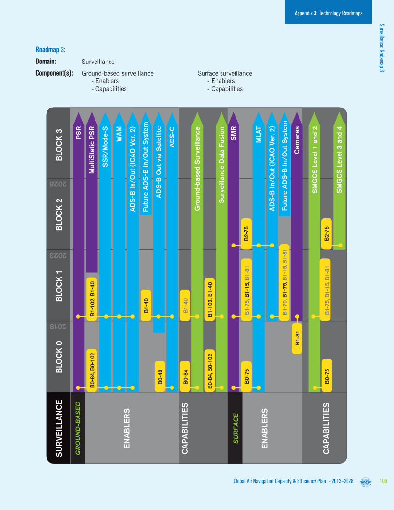
SM
R
PS
R
Mu
ltiS
tatic P
SR
Cam
era
s
MLA
T
SS
R/M
od
e-S
WA
M
AD
S-B
In/O
ut
(IC
AO
Ver. 2
)
Fu
ture
AD
S-B
In/O
ut
Syste
m
AD
S-B
Ou
t via
Sate
llite
AD
S-C
SM
GC
S L
evel 1 a
nd
2
SM
GC
S L
evel 3 a
nd
4
AD
S-B
In/O
ut
(IC
AO
Ver. 2
)
Fu
ture
AD
S-B
In/O
ut
Syste
m
SU
RV
EIL
LA
NC
EB
LO
CK
0
2018
2023
2028
B0-7
5
B1-8
1
B0-7
5
B1-1
02, B
1-4
0B
0-8
4, B
0-1
02
B1-4
0
Gro
und
-based
Su
rveilla
nce
Su
rveilla
nce D
ata
Fu
sio
n
B1-4
0
B0-4
0
B0-8
4
B1-1
02, B
1-4
0B
0-8
4, B
0-1
02
B1-7
0, B
1-7
5, B
1-1
5, B
1-8
1
B1-7
5, B
1-1
5, B
1-8
1
B1-7
5, B
1-1
5, B
1-8
1B
2-7
5
B2-7
5
BLO
CK
1B
LO
CK
2B
LO
CK
3
SU
RFA
CE
GR
OU
ND
-BA
SE
D
EN
AB
LE
RS
CA
PA
BIL
ITIE
S
EN
AB
LE
RS
CA
PA
BIL
ITIE
S
Global Air Navigation Capacity & Efficiency Plan - 2013–2028 109
Appendix 3: Technology Roadmaps
Roadmap 3:
Domain: Surveillance
Component(s): Ground-based surveillance Surface surveillance - Enablers - Enablers - Capabilities - Capabilities
Surveillance: Rodamap 3

Global Air Navigation Capacity & Efficiency Plan - 2013–2028110
Appendix 3: Technology Roadmaps
Roadmap 4 - in the Block 0 timeframe:
• Basic airborne situational awareness applications will become available using ADS-B IN/OOU (ICAO Version 2)
Roadmap 4 - in the Block 1 timeframe:
• Advanced situational awareness applications will become available, again using ADS-B IN/OUT (ICAO Version 2).
Roadmap 4 - in the Block 2 timeframe:
• ADS-B technology will begin to be used for basic airborne (delegated) separation.
• The twin demands of increased traffic levels and reduced separation will require an improved form of ADS-B.
Roadmap 4 - in the Block 3 timeframe:
• The ADS-B technology which supported Block 2 will be used for limited self-separation in remote and oceanic airspace.

Global Air Navigation Capacity & Efficiency Plan - 2013–2028 111
Appendix 3: Technology Roadmaps
AD
S-B
In/O
ut
(IC
AO
Ver. 2
)
In-T
rail P
roced
ure
s (
ITP
)
Air
bo
rne S
itu
atio
nal A
ware
ness d
uri
ng
Flig
ht
Op
era
tio
ns (
AIR
B)
Vis
ual S
ep
ara
tio
n o
n A
pp
roach
(V
SA
)
Basic
Su
rface S
itu
atio
n A
ware
ness (
SU
RF)
AS
EP
S-S
EP
Surf
ace S
ituation A
ware
ness w
ith Indic
ations a
nd A
lert
s (
SU
RF-I
A)
Air
bo
rne S
pacin
g A
pp
licatio
n (
AS
PA
) In
terv
al M
anag
em
ent
AD
S-B
In/ O
ut
(IC
AO
Ver. 3
)
SU
RV
EIL
LA
NC
EB
LO
CK
0
2018
2023
2028
B0-8
5, B
0-8
6
B0-8
6
B1-8
5
B2-8
5
B3-8
5
B0-8
5
B1-7
5
B1-7
5, B
1-8
5, B
1-1
02
B2-7
5, B
2-8
5, B
2-1
01
B3-8
5
BLO
CK
1B
LO
CK
2B
LO
CK
3
AIR
-AIR
EN
AB
LE
RS
CA
PA
BIL
ITIE
S
Roadmap 4:
Domain: Surveillance
Component(s): Air-air surveillance - Enablers - Capabilities
Surveillance: Rodamap 4
Global Air Navigation Capacity & Efficiency Plan - 2013–2028112
Appendix 3: Technology Roadmaps
Navigation concepts such as RNAV, RNP and PBN provide a range of options for the use of navigation technology. As these are very much dependent on local requirements, this section will provide a narrative description of the considerations for the use of navigation technology.
Navigation infrastructure
GNSS is the core technology that has led to the development of PBN. It is also the basis for future improvements in navigation services. The core historical constellations GPS and GLONASS have been in operations for well over a decade, and SARPs in support of aviation operations are in place. As a result, aviation usage of GNSS is currently widespread. GPS and GLONASS are being upgraded to provide service on multiple frequency bands. Other core constellations, namely the European Galileo and China’s Beidou are being developed. Multi-constellation, multi-frequency GNSS has clear technical advantages that will support the provision of operational benefits. To realize these benefits, ICAO, States, ANSPs, standards bodies, manufacturers and aircraft operators need to coordinate activities to address and resolve related issues.
SBAS based on GPS is available in North America (WAAS), Europe (EGNOS), Japan (MSAS) and will soon be available in India (GAGAN) and Russia (SDCM). Several thousand SBAS approach procedures are now implemented, mostly in North America, while other regions have started publishing SBAS-based procedures. SBAS typically supports APV operations, but can also support precision approach (Category I) operations. However, it is challenging for SBAS to support precision approach operations in equatorial regions using single-frequency GPS because of ionospheric effects.
GBAS CAT I based on GPS and GLONASS is available in Russia and, based on GPS, on some airports in several States. SARPs for GBAS CAT II/III are under operational validation. Related research and development activities are ongoing in different States. It is also challenging for GBAS to support a high availability of precision approach, in particular in equatorial regions.
Conventional navigation aids (VOR, DME, NDB, ILS) are in widespread use globally, and most aircraft are equipped with the relevant avionics. The vulnerability of GNSS signals to interference has led to the conclusion that there is a need to retain some conventional aids or alternative navigation service solution as a back-up to GNSS.
Navigation

Global Air Navigation Capacity & Efficiency Plan - 2013–2028 113
Mitigating the operational impact of a GNSS outage will rely primarily on the use of other constellation signals or employing pilot and/or ATC procedural methods, while taking advantage of on-board inertial systems and specific conventional terrestrial aids. In the case of a general GNSS outage in an area, reversion to conventional systems and procedures would result in lower service levels and a possible decrease in capacity. In the case of loss of signals from a specific constellation, the reversion to another constellation could allow maintaining the same PBN level.
The implementation of PBN will make area navigation operations the norm. DME is the most appropriate conventional aid to support area navigation operations (i.e. assuming DME multilateration on board capability), since it is currently used in multi-sensor avionics for this purpose. This could result in an increase in the number of DME installations in some regions. Similarly, ILS remaining widely used, will provide, where available, an alternate approach and landing capability in case of GNSS outage.
Roadmap 5 (page 115) depicts the expected evolution of navigation infrastructure and avionics.
Current Navigation Infrastructure
The current navigation infrastructure comprising VOR, DME and NDB navigation beacons was initially deployed to support conventional navigation along routes aligned between VOR and NDB facilities. As traffic levels increased, new routes were implemented which in many cases necessitated additional navigation facilities to be installed.
As a result, navigation aid deployment has been driven by economic factors and has led to a non-uniform distribution of navigation aids with some regions, notably North America and Europe, having a high density of navigation aids with many other regions having a low density, and some areas having no terrestrial navigation infrastructure at all.
The introduction of RNAV in the last decades has led to setting up new regional route networks that no longer relied on these conventional navaids infrastructure thus allowing wider flexibility to tailor the route network to the traffic demand This essential move has clearly stopped the direct link between the ground based navaids and the route network in the busiest air traffic regions.
With the continuous evolution of aircraft navigation capability through performance-based navigation, and the widespread use of GNSS positioning, regions of high traffic density no longer need a high density of navigation aids.
Appendix 3: Technology RoadmapsNavigation

Global Air Navigation Capacity & Efficiency Plan - 2013–2028114
Executive Summary
Future Terrestrial Infrastructure Requirements
The ICAO Global Plan has the objective of a future harmonized global navigation capability based on area navigation (RNAV) and performance-based navigation (PBN) supported by global navigation satellite system (GNSS).
The optimistic planning that was considered at the time of the Eleventh Air Navigation Conference for all aircraft to be equipped with GNSS Capability and for other GNSS constellations to be available, together with dual frequency and multi-constellation avionics capability being carried by aircraft have not been realized.
The current single frequency GNSS capability provides the most accurate source of positioning that is available on a global basis. With suitable augmentation as standardized within ICAO Annexes, Single frequency GNSS has the capability to support all phases of flight. The current GNSS has an extremely high availability, although it does not have adequate resilience to a number of vulnerabilities, most notably radio frequency interference and solar events causing ionospheric disturbances.
Until multiple GNSS constellations and associated avionics are available, it is essential that a suitably dimensioned terrestrial navigation infrastructure is provided which is capable of maintaining safety and continuity of aircraft operations.
The FANS report from April 1985 stated:
“The number and development of navigational aids should be reviewed with the aim of providing a more rational and more cost-effective homogeneous navigation environment.”
The current status of aircraft equipage for PBN operations supported by GNSS and terrestrial navigation aids, together with the availability of the ICAO PBN Manual and the associated design criteria provide the necessary baseline to commence the evolution to the homogeneous navigation environment envisaged within the FANS Report.
Infrastructure Rationalization Planning
It had initially been expected that the rationalization of the legacy navigation infrastructure would have been a consequence of a ‘top down’ process where the implementation of PBN and GNSS within volumes of airspace would result in navigation aids being made totally redundant so they could be simply be switched off.
All stakeholders generally agree that PBN is ‘the right thing to do’ and although PBN offers the capability to introduce new routes without additional navigation aids, it remains difficult to justify the case for whole scale implementation of PBN within a volume of airspace, unless there are capacity or safety issues to be addressed.
Many States have utilized PBN to implement additional routes as they are required to secure gains in capacity and operational efficiencies. This has resulted in volumes of airspace which contain a combination of new PBN routes and existing conventional routes.
It is now clear that for numerous reasons which include being unable to establish a positive business case for a large scale airspace redesign, a ‘top-down’ PBN implementation followed by infrastructure rationalization will take many years to complete, if ever.
As an alternative strategy, a bottom-up approach should be considered as at the end of each navigation aid’s economic life, an opportunity exists to consider if a limited PBN implementation to alleviate the need for the replacement of the facility is more cost effective than replacement of the navigation aid.
The replacement cost opportunity only presents itself if the navigation aid is fully depreciated and replacement is considered: it therefore arises on a 20-25 year cycle. In order to realize any cost saving, rationalization opportunities need to be identified and the necessary route changes planned and implemented to enable the facilities to be decommissioned at the end of their lifetime.
This bottom up approach to rationalization also provides a catalyst to start the airspace transition to a PBN environment, facilitating future changes to optimize routes to deliver gains in efficiency such as shorter routings and lower CO2 emissions.
In planning for the rationalization of navigation infrastructure, it is essential that all stakeholders’ needs and operational uses of the infrastructure are considered. These needs are likely to extend beyond the instrument flight procedures and routes promulgated in the State Civil Aeronautical Information Publication and may also include military instrument flight procedures, aircraft operational contingency procedures such as engine failure on take-off, and used for VOR-based separations in procedural airspace as detailed in ICAO Doc 4444.
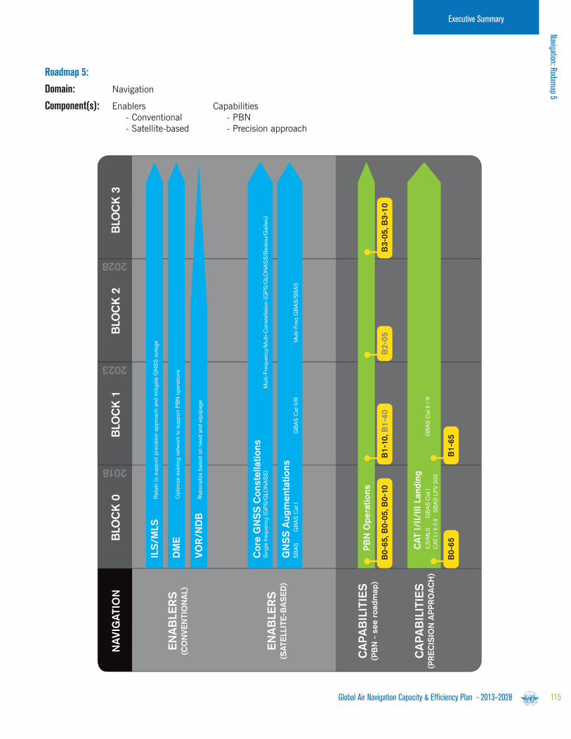
Global Air Navigation Capacity & Efficiency Plan - 2013–2028 115
Executive Summary
ILS
/MLS
GB
AS
Cat
IC
AT I
/ II
/I II
S
BA
S L
PV
200
GB
AS
Cat
II /
III
Ret
ain
to s
uppo
rt p
reci
sion
app
roac
h an
d m
itiga
te G
NS
S o
utag
e
CA
T I
/II
/II
I Land
ing
PB
N O
pera
tio
ns
ILS
/M
LS
Opt
imiz
e ex
istin
g ne
twor
k to
sup
port
PB
N o
pera
tions
DM
E
Sin
gle
frequ
ency
(GP
S/G
LON
AS
S)
Mul
ti-Fr
eque
ncy/
Mul
ti-C
onst
ella
tion
(GP
S/G
LON
AS
S/B
eido
u/G
alile
o)C
ore
GN
SS
Co
nste
llatio
ns
SB
AS
GB
AS
Cat
IG
BA
S C
at II
/III
Mul
ti-Fr
eq G
BA
S/S
BA
S
GN
SS
Au
gm
enta
tio
ns
Rat
iona
lize
base
d on
nee
d an
d eq
uipa
geV
OR
/N
DB
NA
VIG
ATIO
NB
LO
CK
0
B2-0
5B
1-1
0, B
1-4
0
B3-0
5, B
3-1
0
B0-6
5, B
0-0
5, B
0-1
0
B0-6
5B
1-6
5BLO
CK
1B
LO
CK
2B
LO
CK
3
EN
AB
LE
RS
(CO
NV
EN
TIO
NA
L)
EN
AB
LE
RS
(SA
TE
LLIT
E-B
AS
ED
)
CA
PA
BIL
ITIE
S(P
BN
- s
ee r
oad
map
)
CA
PA
BIL
ITIE
S(P
RE
CIS
ION
AP
PR
OA
CH
)
2018
2023
2028
Roadmap 5:
Domain: Navigation
Component(s): Enablers Capabilities - Conventional - PBN - Satellite-based - Precision approach
Navigation: Rodamap 5

Global Air Navigation Capacity & Efficiency Plan - 2013–2028116
Appendix 3: Technology Roadmaps
Performance-based Navigation
The roadmaps above depict migration paths for the implementation of PBN levels and precision approaches for the following operations: en route oceanic and remote continental, en route continental, TMA arrival/departure, and approach. There is no attempt to show detailed timelines because regions and States will have different requirements; some may need to move quickly to the most demanding PBN specification while others will be able to satisfy airspace users’ requirements with a basic specification. The figures do not imply that States/region have to implement each step along the path to the most demanding specification. Doc 9613 provides the background and detailed technical information required for operational implementation planning.
The PBN Manual identifies a large set of navigation applications. Among these applications, one sub-set is the RNP applications. It is important to realize that the implementation of RNP applications within an airspace contributes de facto to a re-distribution of the surveillance and conformance monitoring function. The RNP concept introduces an integrity check of the navigated position at aircraft level and allows the automatic detection of non-conformance to the agreed trajectory while this function is today the full responsibility of the ATCO. Therefore RNP implementation should provide additional benefits to the ATSU that is traditionally in charge of the conformance monitoring.

Global Air Navigation Capacity & Efficiency Plan - 2013–2028 117
Appendix 3: Technology Roadmaps
Roadmap 6:
Domain: Performance-based Navigation (PBN)
Component(s): En-route, Oceanic and remote continental En-route continental Terminal airspace: arrival and departure Approach
RN
AV
10 (
RN
P 1
0)
RN
P 4
R
NP
2
RN
AV
5R
NA
V 2
RN
AV
1
RN
AV
1 Basic
RN
P 1
RN
P 2
A
dvanced
RN
P
RN
P 0
.3
Mig
ratio
n p
ath
based
on R
eg
ion/S
tate
requ
irem
ents
PB
NB
LO
CK
0B
LO
CK
1B
LO
CK
2B
LO
CK
3
Enro
ute
Oceanic
and
Rem
ote
Co
ntinenta
l
Enro
ute
Co
ntinenta
l(H
elic
opte
r onl
y)
A
dvanced
RN
P
RN
P 0
.3(H
elic
opte
r onl
y)
RN
P A
PC
H (
SB
AS
: LP
V, B
AR
O V
NA
V: LN
AV
/V
NA
V, B
asic
GN
SS
: LN
AV
)
RN
P A
R A
PC
H(w
here
ben
efic
ial)
Term
inal A
irsp
ace:
Arr
ival &
Dep
art
ure
Ap
pro
ach
2018
2023
2028
Performance-based Navigation: Rodam
ap 6

Global Air Navigation Capacity & Efficiency Plan - 2013–2028118
Appendix 3: Technology Roadmaps
A goal of the Global ATM Operational Concept is a net-centric operation where the ATM network is considered as a series of nodes – including the aircraft – providing or using information.
Aircraft operators with flight/airline operational control centre facilities will share information while the individual user will be able to do the same via applications running on any suitable personal device. The support provided by the ATM network will in all cases be tailored to the needs of the user concerned.
The sharing of information of the required quality and timeliness in a secure environment is an essential enabler for the ATM Target Concept. The scope extends to all information that is of potential interest to ATM including trajectories, surveillance data, aeronautical information, meteorological data etc.
In particular, all parts of the ATM network will share trajectory information in real time to the extent required, from the trajectory development phase through operations and post-operation activities. ATM planning, collaborative decision making processes and tactical operations will always be based on the latest and most accurate trajectory data. The individual trajectories will be managed through the provision of a set of ATM services tailored to meet their specific needs, acknowledging that not all aircraft will (or will need to) be able to attain the same level of capability at the same time.
System-wide Information Management (SWIM) is an essential enabler for ATM applications. It provides an appropriate infrastructure and ensures the availability of the information needed by the applications run by the members of the ATM community. The related geo/time enabled, seamless and open interoperable data exchange relies on the use of common methodology and the use of a suitable technology and compliant system interfaces.
The availability of SWIM will make possible the deployment of advance end-user applications as it will provide extensive information sharing and the capability to find the right information wherever the provider is.
Information Management
Roadmap 7 - in the Block 0 timeframe:
• The SWIM concept of operations will be developed and refined.
Roadmap 7 - in the Block 1 timeframe:
• An initial SWIM capability supporting ground-ground communications will be deployed.
Roadmap 7 - in the Block 2 timeframe:
• The aircraft will become a node on the SWIM network with full integration with the aircraft systems.

Global Air Navigation Capacity & Efficiency Plan - 2013–2028 119
Appendix 3: Technology Roadmaps
Roadmap 7:
Domain: Information Management
Component(s): System wide-information management (SWIM)
B1-2
5, 3
0, 3
1 -
SW
IM (G
round-G
round):
Flight In
tents
befo
re d
epart
ure
, ATM
info
rmation e
xchanges
B2-2
5 S
WIM
(G
round-G
round):
Inte
r-C
entr
e c
oord
ination
B2-3
1 S
WIM
(A
ir-G
round):
Aircra
ft inte
gra
tion
ATM
Info
rmation R
efe
rence a
nd S
erv
ice M
odel,
Com
mon G
overn
ance, I
SO
, OG
C, e
tc.
SW
IM
BLO
CK
0
2018
2023
2028
BLO
CK
1B
LO
CK
2B
LO
CK
3
SW
IM C
ON
OP
SS
WIM
G-G
SW
IM A
-G
Information Managem
ent: Rodamap 7

Global Air Navigation Capacity & Efficiency Plan - 2013–2028120
Appendix 3: Technology Roadmaps
Roadmap 8 - in the Block 0 timeframe:
• SWIM will start to appear in Europe and the U.S.
• Operational services will be supported by service oriented architecture (SOA) pioneer implementations.
• Meteorological data will also be distributed over IP.
• Migration to digital NOTAM will commence and will be carried over IP.
Roadmap 8 - in the Blocks 1 and 2 timeframe:
• Digital NOTAM and MET information distribution (using the AIXM and WXXM information exchange formats) will be widely implemented over the SWIM network.
• Flight objects will be introduced, improving inter-facility co-ordination and providing multi-facility coordination for the first time. Flight objects will be shared on the SWIM network over an IP backbone and updated through SWIM synchronization services.
• The more traditional point-to-point ATS interfacility data communication (AIDC) message exchange will still coexist for some time with SWIM.
• Flight Information eXchange Model (FIXM) will propose a global standard for exchanging flight information.
• More generally it is expected that SWIM will support the implementation of new concepts such as virtual ATS facilities, which control airspace remotely.
Roadmap 8 - in the Block 3 timeframe and beyond:
• Full SWIM deployment is expected allowing all participants, including the aircraft, to be able to access a wide range of information and operational services including full 4D-trajectory sharing.
• Full implementation of flight objects will be achieved as the FF-ICE concept is realized.
Need for a common time reference
In moving towards the Global ATM Operational concept, and in particular 4D trajectory management and intensive exchanges of information through SWIM, some of the current provisions for time management might not be sufficient and could become a barrier to future progress.
The time reference for aviation is defined to be the Coordinated Universal Time (UTC). Requirements surrounding accuracy of time information depend on the type of ATM application where it is used. For each ATM application, all contributing systems and all contributing users must be synchronized to a time reference that satisfies this accuracy requirement.
UTC is the common time reference, but the present requirements for the accuracy with which aviation clocks are synchronized to UTC may be insufficient to cover
future needs. This relates to the integrity and timeliness of information or the use of dependent surveillance for closer separations, as well as more generally 4D trajectory operations. System requirements for synchronization using an external reference must also be considered.
Rather than defining a new reference standard, the performance requirement for accuracy has to be defined with respect to UTC for each system in the ATM architecture that relies on a coordinated time requirement. Different elements require different accuracy and precision requirements for specific applications. The increased exchange of data on SWIM creates the necessity of efficient ‘time stamping’ for automated systems that are in communication with each other. The time information should be defined at the source and incorporated in the distributed data, with the proper level of accuracy maintained as part of the data integrity.

Global Air Navigation Capacity & Efficiency Plan - 2013–2028 121
Appendix 3: Technology Roadmaps
Roadmap 8:
Domain: Information Management
Component(s): Flight and Flow AIS/AIM MET - Capabilities - Capabilities - Capabilities - Enablers - Enablers - Enablers
WX
XM
FIX
M
INFO
RM
ATIO
NM
AN
AG
EM
EN
TB
LO
CK
0
2018
2023
2028
Exchange o
f Flight In
tents
befo
re D
epart
ure
(in
itia
l FF-I
CE
)
Flight and F
low
Coord
ination (initia
l FF-I
CE
)
Dig
ital D
ata
exchange &
serv
ices, s
hort
er
update
cycle
s
Ele
ctr
onic
Chart
s, D
igital B
riefing, I
n F
light update
s
Dig
ital N
OTA
M
4D
Tra
jecto
ries, F
ull F
F-I
CE
BLO
CK
1B
LO
CK
2B
LO
CK
3
FLIG
HT &
FLO
W
CA
PA
BIL
ITIE
S
EN
AB
LE
RS
eA
IP, A
IXM
AIS
/AIM
ME
TE
OR
OLO
GY
CA
PA
BIL
ITIE
S
CA
PA
BIL
ITIE
S
EN
AB
LE
RS
EN
AB
LE
RS
B1-3
0, B
1-2
5
AIS
-AIM
Enhanced q
uality
Paper
--> D
igital data
availability
B0-3
0
B2-2
5B
3-2
5, B
3-0
5
B1-3
0
Dig
ital M
ET D
ata
exchange &
ME
T info
rmation s
erv
ices,
In
Flight update
s
Tra
ditio
nal alp
hanum
erical
codes r
epla
ced b
y
dig
ital data
; enhanced q
uality
B1-3
0, B
1-1
05
B3-1
05
Information Managem
ent: Rodamap 8

Global Air Navigation Capacity & Efficiency Plan - 2013–2028122
Appendix 3: Technology Roadmaps
Roadmap 9 - in the Block 0 timeframe:
• FANS2/B will be introduced which supports DLIC, ACM, AMC, and ACL services over ATN, thus providing better communication performance than FANS-1/A. In this first step with data link implementation over ATN, ACL is commonly used by ATC for the notification of voice frequencies changes to the aircraft. The more integrated solutions provide a connection between the FANS and the Radio Communication equipment. This integration enables the automatic transmission and tuning of these voice frequencies.
• The existing FANS-1/A system will continue to be used as there is a large base of equipped aircraft and it also supports both communication and navigation integration.
• Aircraft will have a traffic computer hosting the ‘traffic collision avoidance system’, and possibly the new air traffic situational awareness functions and airborne separation assistance systems. This capability is expected to undergo successive improvements in order to meet the requirement of later blocks.
Roadmap 9 - in the Block 1 timeframe:
• FANS3/C with CNS integration (via ATN B2) will be available providing communication and surveillance integration through a connection between the FANS and NAV (FMS) equipment. This avionics integration typically supports the automatic loading in the FMS of complex ATC clearances transmitted by data link.
• Surveillance integration (via ATN B2) will provide an integrated surveillance through a connection between the FANS equipment and the traffic computer. This avionics integration typically supports the automatic loading (within the traffic computer) of ASAS manoeuvres transmitted by data link.
Roadmap 9 - in the Block 2 timeframe:
• Aircraft access to SWIM will be provided using the various means described in the roadmap for air-ground data link communications.
The twin demands of increased traffic levels and reduced separation will require an improved form of ADS-B.
A key theme with the avionics evolution is the significant increase in capability that is possible through the integration of various onboard systems/functions.
Avionics

Global Air Navigation Capacity & Efficiency Plan - 2013–2028 123
Appendix 3: Technology Roadmaps
Roadmap 9:
Domain: AvionicsComponent(s): Communications & Surveillance
FA
NS
1/A
with C
om
m, N
av inte
gra
tion (via
AC
AR
S)
Tra
ffic
Com
pute
r
AD
S-B
In/O
ut (IC
AO
Ver. 2
)
Surv
eilla
nce Inte
gra
tion (v
ia A
TN
B
2)
AD
S-B
In/ O
ut (IC
AO
Ver. 3
)
FA
NS
2/B
with C
om
m,
N
av inte
gra
tion (via
ATN
B1)
AV
ION
ICS
BLO
CK
0
2018
2023
2028
B0-8
6, B
0-4
0, B
0-1
0
FA
NS
3/C
with C
NS
inte
gra
tion (via
A
TN
B2)
B1-1
5, B
1-4
0B
2-7
5, B
2-8
5, B
2-0
5
B1-7
5, B
1-8
5, B
1-1
02
B1-8
5B
2-7
5, B
2-8
5
B0-8
5, B
0-8
6B
2-7
5, B
2-8
5, B
2-1
01
B3-8
5, B
3-0
5
Aircra
ft a
ccess to S
WIM
B2-3
1B
3-2
5, B
3-1
05
B3-8
5
B1-1
5BLO
CK
1B
LO
CK
2B
LO
CK
3
CO
MM
UN
ICA
TIO
NS
SU
RV
EIL
LA
NC
E
EN
AB
LE
RS
EN
AB
LE
RS
Avionics: Rodamap 9

Global Air Navigation Capacity & Efficiency Plan - 2013–2028124
Appendix 3: Technology Roadmaps
Roadmap 10 - in the Block 0 timeframe:
• FMS supporting PBN represents a flight management system supporting PBN, i.e. providing multi sensor (GNSS, DME, etc.) navigation and area navigation, and qualified for RNAV-x and RNP-x operations.
• INS will continue to be used in conjunction with other navigation sources. Navigation will be underpinned by the capability to merge and manage navigation data from various sources.
Roadmap 10 - in the Blocks 1 and 2 timeframe:
• Airport navigation integration (via ATN B2) provides integration between the FMS and the airport navigation system function to among other things support the automatic loading within the traffic computer of ATC taxi clearances transmitted by data link.
• Flight management system capability will be enhanced to support initial 4D capability.
• GNSS-based services today rely on a single constellation, the global positioning system (GPS), providing service on a single frequency. Other constellations,, i.e; the GLObal NAvigation Satellite System (GLONASS), Galileo and BeiDou will be deployed. All constellations will eventually operate in multiple frequency bands. GNSS performance is sensitive to the number of satellites in view. Multi-
constellation GNSS will substantially increase that number, improving the availability and continuity of service. Furthermore, availability of more than thirty interoperable ranging sources will support the evolution of aircraft-based augmentation systems (ABAS) that could provide vertically guided approaches with minimal, or potentially no need for external augmentation signals. The availability of a second frequency will allow avionics to calculate ionospheric delay in real-time, effectively eliminating a major error source. The availability of multiple independent constellations will provide redundancy to mitigate the risk of service loss due to a major system failure within a core constellation, and will address the concerns of some States about reliance on a single GNSS constellation outside their operational control.
Roadmap 10 - in the Block 3 timeframe and beyond:
• Flight management system capability will be enhanced to support the full 4D capability.

Global Air Navigation Capacity & Efficiency Plan - 2013–2028 125
Appendix 3: Technology Roadmaps
Roadmap 10:
Domain: AvionicsComponent(s): Navigation
INS
Multi-S
ensor
Navig
ation M
anagem
ent
AV
ION
ICS
BLO
CK
0
2018
2023
2028
B0-1
0B
1-6
5, B
1-1
0, B
1-0
5
FM
S s
upport
ing P
BN
B0-1
0, B
0-0
5B
2-0
5B
1-6
5, B
1-1
0, B
1-0
5
FM
S initia
l 4D
FM
S F
ull 4
DB
1-4
0
Airport
Navig
ation Inte
gra
tion (via
ATN
B2)
B1-4
0
Multi-C
onste
llation/Fre
q &
Multi- S
ensor
B1-6
5B
3-1
0, B
3-0
5
B3-1
0, B
3-0
5
B1-1
0B
0-1
0
BLO
CK
1B
LO
CK
2B
LO
CK
3
NA
VIG
ATIO
N
EN
AB
LE
RS
Avionics: Rodamap 10

Global Air Navigation Capacity & Efficiency Plan - 2013–2028126
Appendix 3: Technology Roadmaps
Roadmap 11 - in the Block 1 timeframe:
• Enhanced vision systems (EVS) for aerodrome use will be available in the cockpit.
Roadmap 11 - in the Block 2 timeframe:
• Synthetic vision systems (SVS) for aerodrome use will be available in the cockpit.
Roadmap 11 - in the Block 0 timeframe:
• ACAS 7.1 will be the main airborne safety net. This will continue through the Block 1 timeframe.
• Electronic flight bags will become increasingly common in the cockpit. Care must be taken to ensure that they have been certified for the functions supported.
• Airport moving maps and cockpit display of traffic information will be supported with technologies such as ADS-B.

Global Air Navigation Capacity & Efficiency Plan - 2013–2028 127
Appendix 3: Technology Roadmaps
Roadmap 11:
Domain: AvionicsComponent(s): Airborne Safety Nets On-Board Systems
TA
WS
AC
AS
7.1
Ele
ctr
onic
Flight B
ags
Airport
Movin
g M
ap
AV
ION
ICS
BLO
CK
0
2018
2023
2028
B0-7
5B
1-7
5, B
1-4
0
CTD
I
B0-8
5, B
0-8
6B
1-7
5, B
1-8
5B
3-8
5, B
3-1
05
B2-7
5, B
2-8
5, B
2-0
5
Futu
re A
CA
S
B2-1
01
Weath
er
Radar
B2-7
0
EV
S
SV
S
B1-7
5
B0-1
01
B2-7
5
BLO
CK
1B
LO
CK
2B
LO
CK
3
AIR
BO
RN
ES
AFE
TY
NE
TS
ON
BO
AR
DS
YS
TE
MS
EN
AB
LE
RS
CA
PA
BIL
ITIE
S
DIS
PLA
YS
Avionics: Rodamap 11

Global Air Navigation Capacity & Efficiency Plan - 2013–2028128
Appendix 4: Module Dependencies
The illustration on the following page depicts the various dependencies which exist between Modules. These may cross Performance Areas and Blocks.
Dependencies between Modules exist either because:
i. There is an essential dependency.
ii. The benefits of each Module are mutually reinforcing, i.e. implementation of one Module enhances the benefit achievable with the other Modules(s).
For further information the reader is referred to the detailed online descriptions of each Module.
Lege
nd:
Li
nks
from
a M
odul
e in
Blo
ck ‘n
’ to
a M
odul
e in
Blo
ck ‘n
+1’
Dep
ende
ncie
s ac
ross
Thr
eads
/Pe
rfor
man
ce A
reas
Link
s to
oth
er T
hrea
ds/P
erfo
rman
ce A
reas
w
here
a M
odul
e is
dep
ende
nt o
n an
ear
lier
Mod
ule
or M
odul
es
Appendix 4:
Module Dependencies

Global Air Navigation Capacity & Efficiency Plan - 2013–2028 129
Appendix 4: Module Dependencies
GLO
BA
LLY
IN
TE
RO
PE
RA
BLE
S
YS
TE
MS
A
ND
DA
TA
AIR
PO
RT
OP
ER
ATIO
NS
EFFIC
IEN
T
FLIG
HT P
ATH
OP
TIM
UM
C
AP
AC
ITY
A
ND
FLE
XIB
LE
FLIG
HTS
B0-6
5B
1-6
5
B0-7
0B
1-7
0B
2-7
0
B0-7
5B
1-7
5B
2-7
5
B0-8
0B
1-8
0
B0-0
5B
1-0
5
B0-2
0
B0-4
0B
1-4
0
B1-9
0B
2-9
0B
3-9
0
B2-0
5B
3-0
5
B0-1
5B
1-1
5B
2-1
5B
3-1
5
B0-1
0B
1-1
0
B0-3
5B
1-3
5
B0-1
05
B1-1
05
B3-1
05
B0-8
6B
0-8
4
B1-8
5B
0-8
5
B0-1
02
B0-1
01
B2-1
01
B1-1
02
B2-8
5B
3-8
5
B2-3
5
B3-1
0
B0-2
5B
1-2
5B
2-2
5B
3-2
5
B0-3
0B
1-3
0
B1-3
1B
2-3
1
B1-8
1

Global Air Navigation Capacity & Efficiency Plan - 2013–2028130
Appendix 5: SARPs Planning
To be completed
Appendix 5:
Standards And Recommended Practices (SARPs)
Development Planning

Global Air Navigation Capacity & Efficiency Plan - 2013–2028 131
Appendix 5: SARPs Planning

AATFCM – Air traffic flow and capacity managementAAR – Airport arrival rateABDAA – Airborne detect and avoid algorithmsACAS – Airborne collision avoidance systemACC – Area control centreA-CDM – Airport collaborative decision-makingACM – ATC communications managementADEXP – ATS data exchange presentationADS-B – Automatic dependent surveillance—broadcastADS-C – Automatic dependent surveillance—contract AFIS – Aerodrome flight information serviceAFISO Aerodrome flight information service officer AFTN – Aeronautical fixed telecommunication networkAHMS – Air traffic message handling System AICM – Aeronautical information conceptual modelAIDC – ATS inter-facility data communicationsAIP – Aeronautical information publicationAIRB – Enhanced traffic situational awareness during flight operationsAIRM – ATM information reference model AIS – Aeronautical information servicesAIXM – Aeronautical information exchange modelAMA – Airport movement areaAMAN/DMAN – Arrival/departure managementAMC – ATC microphone checkAMS(R)S – Aeronautical mobile satellite (route) serviceANM – ATFM notification messageANS – Air navigation servicesANSP – Air navigation services providerAO – Aerodrome operations/Aircraft operatorsAOC – Aeronautical operational controlAOM – Airspace organization managementAPANPIRG – Asia/Pacific air navigation planning and imple-mentation regional groupARNS – Aeronautical radio navigation ServiceARNSS – Aeronautical radio navigation Satellite ServiceARTCCs – Air route traffic control centersAS – Aircraft surveillance
ASAS – Airborne separation assistance systemsASDE-X – Airport surface detection equipmentASEP – Airborne separationASEP-ITF – Airborne separation in trail followASEP-ITM – Airborne separation in trail mergeASEP-ITP – Airborne separation in trail procedureASM – Airspace managementA-SMGCS – Advanced surface movement guidance and control systemsASP – Aeronautical surveillance planASPA – Airborne spacingASPIRE – Asia and South Pacific initiative to reduce emissionsATC – Air traffic controlATCO – Air traffic controllerATCSCC – Air traffic control system command centerATFCM – Air traffic flow and capacity managementATFM – Air traffic flow managementATMC – Air traffic management control ATMRPP – Air traffic management requirements and performance panelATN – Aeronautical Telecommunication NetworkATOP – Advanced technologies and oceanic procedures ATSA – Air traffic situational awarenessATSMHS – Air traffic services message handling services ATSU – ATS unitAU – Airspace user AUO – Airspace user operations
BBaro-VNAV – Barometric vertical navigationBCR – Benefit/cost ratioB-RNAV – Basic area navigation
Global Air Navigation Capacity & Efficiency Plan - 2013–2028132
Appendix 6: Acronym Glossary
Appendix 6:
Acronym Glossary

Global Air Navigation Capacity & Efficiency Plan - 2013–2028 133
CCSPO – Closely spaced parallel operationsCPDLC – Controller-pilot data link communicationsCDO – Continuous descent operationsCBA – Cost-benefit analysisCSPR – Closely spaced parallel runwaysCM – Conflict managementCDG – Paris - Charles de Gaulle airportCDM – Collaborative decision-makingCFMU – Central flow management unitCDQM – Collaborative departure queue managementCWP – Controller working positions CAD – Computer aided designCTA – Control time of arrivalCARATS – Collaborative action for renovation of air traffic systemsCFIT – Controlled flight into terrainCDTI – Cockpit display of traffic informationCCO – Continuous climb operationsCAR/SAM – Caribbean and South American regionCOSESNA – Central American civil aviation agency.
DDAA – Detect and avoidDCB – Demand capacity balancingDCL – Departure clearanceDFM Departure flow managementDFS – Deutsche Flugsicherung GmbHDLIC – Data link communications initiation capabilityDMAN – Departure managementDMEAN – Dynamic management of European airspace networkD-OTIS – Data link-operational terminal information serviceDPI – Departure planning informationD-TAXI – Data link TAXI
EEAD – European AIS databasee-AIP – Electronic AIPEGNOS – European GNSS navigation overlay serviceETMS – Enhance air traffic management systemEVS – Enhanced vision systems
FFABEC Functional Airspace Block Europe CentralFAF/FAP – Final approach fix/final approach pointFANS – Future air navigation systemsFDP – Flight data processingFDPS – Flight data processing systemFF-ICE – Flight and flow information for the collaborative environmentFIR – Flight information regionFIXM – Flight information exchange modelFMC – Flight management computerFMS – Flight management systemFMTP – Flight message transfer protocolFO – Flight objectFPL – Filed flight planFPS – Flight planning systemsFPSM – Ground delay program parameters selection modelFRA – Free route airspaceFTS – Fast time simulationFUA – Flexible use of airspaceFUM – Flight update message
Appendix 6: Acronym Glossary

Global Air Navigation Capacity & Efficiency Plan - 2013–2028134
Executive Summary
GGANIS – Global Air Navigation Industry SymposiumGANP – Global air navigation planGAT – General air traffic GBAS – Ground-based augmentation systemGBSAA – Ground based sense and avoidGEO satellite – Geostationary satelliteGLS – GBAS landing systemGNSS – Global navigation satellite system GPI – Global plan initiativesGPS – Global positioning systemGRSS – Global runway safety symposiumGUFI – Globally unique flight identifier
HHAT – Height above thresholdHMI – Human-machine interfaceHUD – Head-up display
IIDAC – Integrated departure-arrival capabilityIDC – Interfacility data communicationsIDRP – Integrated departure route plannerIFR – Instrument flight rulesIFSET – ICAO Fuel Savings Estimation ToolILS – Instrument landing systemIM – Interval ManagementIOP – Implementation and InteroperabilityIP – Internetworking protocolIRR – Internal rate of returnISRM – Information service reference modelITP – In-trail-procedure
KKPA – Key performance areas
LLARA – Local and sub-regional airspace management support systemLIDAR – Aerial laser scansLNAV – Lateral navigationLoA – Letter of agreementLoC – Letter of coordinationLPV – Lateral precision with vertical guidance OR localizer performance with vertical guidanceLVP – Low visibility procedures
MMASPS – Minimum aviation system performance standardsMILO – Mixed integer linear optimizationMIT – Miles-in-trailMLS – Microwave landing systemMLTF – Multilateration task forceMTOW – Maximum take-off weight
NNADP – Noise abatement departure procedureNAS – National airspace systemNAT – North AtlanticNDB – Non-directional radio beaconNextGen – Next generation air transportation systemNMAC – Near mid-air collisionNOP – Network operations procedures (plan)NOTAM – Notice to airmenNPV – Net present value
OOLDI – On-line data interchangeOPD – Optimized profile descent OSED Operational service & environment definition OTW – Out the window

Global Air Navigation Capacity & Efficiency Plan - 2013–2028 135
Executive Summary
PP(NMAC) – Probability of a near mid-air collisionPACOTS – Pacific organized track systemPANS-OPS – Procedures for air navigation services - aircraft operationsPBN - Performance-based navigationPENS Pan-European Network ServicePETAL – Preliminary EUROCONTROL test of air/ground data linkPIA – Performance improvement areaP-RNAV – Precision area navigation
RRA – Resolution advisory RAIM – Receiver autonomous integrity monitoringRAPT – Route availability planning toolRNAV Area navigation RNP – Required navigation performanceRPAS – Remotely-piloted aircraft systemRTC – Remote tower centre
SSARPs – Standards and recommended practicesSASP – Separation and airspace safety panelSATCOM – Satellite communicationSBAS – Satellite-based augmentation systemSDM – Service delivery managementSESAR – Single European sky ATM researchSEVEN – System-wide enhancements for versatile electronic negotiationSFO – San Francisco international airportSIDS – Standard instrument departuresSMAN – Surface managementSMS – Safety management systemsSPRs – Special programme resourcesSRMD – Safety risk management documentSSEP – Self-separationSSR – Secondary surveillance radarSTA – Scheduled time of arrivalSTARS – Standard terminal arrivalsSTBO – Surface trajectory based operations SURF – Enhanced traffic situational awareness on the airport surfaceSVS – Synthetic visualisation systemsSWIM – System-wide information management
TTBFM – Time-based flow managementTBO – Trajectory-based operationsTCAS – Traffic alert and collision avoidance systemTFM – Traffic flow managementTIS-B – Traffic information service-broadcast TMA – Trajectory management advisorTMIs – Traffic management initiativesTMU Traffic management unitTOD – Top of DescentTRACON – Terminal radar approach controlTS – Traffic synchronizationTSA – Temporary segregated airspaceTSO – Technical standard orderTWR – Aerodrome control tower
UUA – Unmanned aircraftUAS – Unmanned aircraft systemUAV – Unmanned aerial vehicleUDPP – User driven prioritisation process
VVFR – Visual flight rulesVLOS – Visual line-of-sightVNAV – Vertical navigationVOR – Very high frequency (VHF) omnidirectional radio rangeVSA – Enhanced visual separation on approach
WWAAS – Wide area augmentation systemWAF – Weather avoidance fieldWGS-84 – World geodetic system - 1984 WIDAO – Wake independent departure and arrival operationWTMA – Wake turbulence mitigation for arrivalsWTMD – Wake turbulence mitigation for departuresWXXM – Weather exchange model

Global Air Navigation Capacity & Efficiency Plan - 2013–2028136
Executive Summary
