gold coast quarry - eisdocs.dsdip.qld.gov.aueisdocs.dsdip.qld.gov.au/completed projects/gold coast...
TRANSCRIPT
GOLD COAST QUARRYADDITIONAL INFORMATION:ENVIRONMENTAL IMPACT STATEMENT
OCTOBER 2013
Gold Coast Quarry Page i Additional Information: Environmental Impact Statement
Contact Information Cardno (Qld) Pty Ltd Trading as Cardno HRP ABN 57 051 074 992 Suite 15 3029 The Boulevard Emerald Lakes CARRARA QLD 4211 PO Box 2855 NERANG QLD 4211 Telephone: 07 5594 1322 Facsimile: 07 5594 1366 International: +61 7 5594 1322 www.cardno.com.au/cardnohrp
Document Information Prepared for Boral Resources (Qld) Pty
Limited Project Name Gold Coast Quarry File Reference HRP12003 Additional
Information (131022).docx Job Reference HRP12003 Date October 2013
Document Control
Vers
ion Date Description of Revision
Prep
ared
B
y
Prepared
Rev
iew
ed
By
Reviewed
2 22/10/2013 Final SC MS
1 17/10/2013 Original SC MS
Vers
ion
Reason for Issue Approved for Release By
Approved
Approved Release Date
© Cardno 2013. Copyright in the whole and every part of this document belongs to Cardno and may not be used, sold, transferred, copied or reproduced in whole or in part in any manner or form or in or on any media to any person other than by agreement with Cardno.
This report is based on our opinion of the town planning issues that arise from the statutory provisions relating to this site. Comments and conclusions in or construed from this report relating to matters of law are not to be relied upon. You should only rely upon the advice of your professional legal advisors with respect to matters of law. This report is provided on the basis that our standard Terms and Conditions apply. For a copy, please contact us or visit: http://www.cardno.com/en-au/AboutUs/CardnoHRP/Documents/Cardno%20HRP%20Terms%20and%20Conditions.pdf. Our report is based on information made available by the client. The validity and comprehensiveness of supplied information has not been independently verified and, for the purposes of this report, it is assumed that the information provided to Cardno HRP is both complete and accurate. Whilst, to the best of our knowledge, the information contained in this report is accurate at the date of issue, changes may occur to the site conditions, the site context or the applicable planning framework. This report should not be used after any such changes without consulting the provider of the report or a suitably qualified person
Gold Coast Quarry Page ii Additional Information: Environmental Impact Statement
Executive Summary Reference is made the Environmental Impact Statement (EIS) that was lodged on 24 April 2013. Upon the conclusion of the public advertising stage of the process, submissions that were received by the Coordinator-General’s Office were reviewed in detail by the proponent.
This document synthesises the matters raised in the submissions, and provides further clarification of the key matters raised by agencies and submitters.
From the outset, it is to be noted that the modelling undertaken to inform the technical reports lodged with the EIS involved a great deal of rigour. Furthermore, the extent of modelling undertaken for the proposed Gold Coast Quarry project greatly exceeds what is normally required for quarry developments in Queensland. It is also to be acknowledged that future approvals will dictate and confirm the regulatory limits within which the Gold Coast Quarry project is to operate. The modelling and technical reports completed for the EIS confirm that in all instances the regulatory limits will be achieved for the project through its design or the application of appropriate mitigation measures.
Gold Coast Quarry Page iii Additional Information: Environmental Impact Statement
Table of Contents
EXECUTIVE SUMMARY ...................................................................................................... II
TABLE OF CONTENTS .......................................................................................................III
APPENDICES ..................................................................................................................... IV
1 INTRODUCTION ....................................................................................................... 5
2 OVERVIEW OF SUBMISSIONS................................................................................ 6
3 ANALYSIS OF BROAD ISSUE CATEGORIES ........................................................ 8 3.1 Property Values ....................................................................................................................... 8 3.2 Visual / Scenic Amenity .......................................................................................................... 8 3.3 Flora and Fauna ....................................................................................................................... 9 3.4 Dust (Air Quality) ................................................................................................................... 10 3.5 Noise ....................................................................................................................................... 12 3.6 Vibration and Blasting .......................................................................................................... 13 3.7 Planning .................................................................................................................................. 14 3.8 Traffic Impacts ....................................................................................................................... 16
4 CLARIFICATION OF KEY MATTERS .....................................................................17 4.1 Chapter 4 Environmental Values and Management of Impacts – Section 4.5
Air Quality ............................................................................................................................... 17 4.1.1 Key Matter – Dust Deposition .................................................................................................. 17 4.1.2 Key Matter – Dust Impacts on Vegetation ............................................................................... 17 4.1.3 Key Matter – Guidelines for Crystalline Silica ......................................................................... 18 4.1.4 Key Matter – Meteorological Modelling ................................................................................... 18 4.1.5 Key Matter – Determination of Control Efficiencies ................................................................. 18 4.1.6 Key Matter – Air Emission Sources ......................................................................................... 18 4.1.7 Key Matter –Clarification of PM2.5 Emission Calculation ......................................................... 19 4.1.8 Key Matter – Miscellaneous Emission Assessment Matters ................................................... 19 4.1.9 Key Matter – Maximum 24-hour average ................................................................................ 20 4.1.10 Key Matter – Clarification of Cumulative Impacts ................................................................... 20 4.2 Chapter 4 Environmental Values and Management of Impacts – Section 4.4
Water Quality.......................................................................................................................... 21 4.2.1 Key Matter – Sediment Control Design Parameters ............................................................... 21 4.2.2 Key Matter – Sediment Control ............................................................................................... 22 4.2.3 Key Matter – Water Quality Discharge Objectives .................................................................. 23 4.2.4 Key Matter – Water Quality Testing......................................................................................... 24 4.2.5 Key Matter – Water Quality Impacts ........................................................................................ 24 4.3 Chapter 4 Environmental Values and Management of Impacts – Section 4.4 Groundwater and Section 4.3.3 Terrestrial Fauna Matters ............................................... 26 4.3.1 Key Matter – Groundwater dependant ecosystems ................................................................ 26 4.3.2 Key Matter – Seasonal Monitoring of Groundwater ................................................................ 27 4.3.3 Key Matter – White-bellied Sea Eagle ..................................................................................... 28 4.3.4 Key Matter – Impacts on Nocturnal Fauna .............................................................................. 28 4.4 Chapter 4 Environmental Values and Management of Impacts – Section 4.9
Transport ................................................................................................................................ 29 4.4.1 Key Matter – Containing Proposed Works in Road Reserve Areas ........................................ 29

Gold Coast Quarry Page iv Additional Information: Environmental Impact Statement
4.4.2 Key Matter – Road Safety Review and Site Access Design ................................................... 29 4.4.3 Key Matter – Pavement Impact Assessment .......................................................................... 29 4.5 Chapter 6 Economics and Management of Impacts .......................................................... 31 4.5.1 Key Matter – Economic Need .................................................................................................. 31 4.5.2 Key Matter – Benefit Cost Analysis Assumptions ................................................................... 31 4.5.3 Key Matter – Incorporation of Environmental Impacts ............................................................ 33
5 UPDATED MNES REPORT .....................................................................................35
6 CONCLUSION AND RECOMMENDATION .............................................................36
Appendices
Appendix A Clarification of Identified Air Quality Matters Appendix B Clarification of Identified Water Quality Matters Appendix C Clarification of Groundwater Dependent Ecosystems and Terrestrial Fauna Matters Appendix D Clarification of Groundwater Matters Appendix E Clarification of Traffic and Transport Matters Appendix F Clarification of Economic Matters
Gold Coast Quarry Page 5 Additional Information: Environmental Impact Statement
1 Introduction An analysis of the submissions lodged during the public advertising period has been undertaken by the proponent. The process has identified the following broad categories as matters of principal interest:
> Property values;
> Visual / scenic amenity;
> Fauna;
> Flora;
> Dust (air quality);
> Noise;
> Vibrations / blasting;
> Planning; and
> Traffic impacts.
From a detailed review of the above described broad categories, with the following key matters were identified as requiring further clarification:
> Air Quality – dust emissions, deposition rates and impacts on vegetation, modelling queries and control objectives.
> Water Quality – sediment and erosion control, total suspended solids and water discharge criteria.
> Groundwater Dependent Ecosystems – vegetation and hydrology impacts.
> Terrestrial Fauna – the White-bellied Sea Eagle and impacts on nocturnal fauna.
> Transport – traffic operations, traffic safety and pavement impact.
> Project need – continuity of supply and cost-benefit assumptions.
Some of the key matters raised by the submitters required the provision of further clarification material. The EIS project team has prepared the necessary information. This material has been provided as part of this submission:
> Attachment A: Clarification of Identified Air Quality Matters
> Attachment B: Clarification of Identified Water Quality Matters
> Attachment C: Clarification of Groundwater Dependent Ecosystems and Terrestrial Fauna Matters
> Attachment D: Clarification of Groundwater Matters
> Attachment E: Clarification of Traffic and Transport Matters
> Attachment F: Clarification of Economic Matters

Gold Coast Quarry Page 6 Additional Information: Environmental Impact Statement
2 Overview of Submissions The public advertising for the EIS extended for 30 business days, with the period concluding on 11 June 2013. The Office of the Coordinator-General has advised that, overall, a total of 258 submissions were received, comprising:
> 16 submissions from government agencies;
> 12 submissions from non-government organisations; and
> 230 submissions from private individuals. Included in the submissions received from private individuals were several form letters submitted by 3,829 respondents. It is noted that both positive and negative submissions associated with the project were received by the Coordinator-General’s Office.
Advice was also received from the former Australian Government Department of Sustainability, Environment, Water, Population and Communities (SEWPaC), now known as the Department of Environment (DoE). It is noted that SEWPaC is now known as the Department of Environment (DoE). The MNES report is in the process of being updated and will be issued under separate cover.
The proponent has reviewed all of the submissions that were received by the Coordinator-General’s Office during the public advertising period. The following figure depicts the key matters that were raised across all of the submissions:
Figure 2-1: Breakdown of matters raised in submissions
On the basis of the information derived for the purposes of Figure 2-1, the identified matters were grouped into broader categories in order to more appropriately correlate with the requirements of the Terms of Reference (ToR) and the EIS that was prepared. The result of this exercise is depicted in the following figure:

Gold Coast Quarry Page 7 Additional Information: Environmental Impact Statement
Figure 2-2: Percentage of submissions by matter category
From the information contained in Figure 2-2, the key matter categories identified in the submissions include:
> Property values;
> Visual amenity;
> Fauna;
> Flora;
> Dust (air quality);
> Noise;
> Vibrations / blasting;
> Planning; and
> Traffic impacts.
In terms of positive submissions received, the matters covered included building materials, the economy, employment opportunities, need for the project and provision of infrastructure projects.
Furthermore, when reviewing in detail the above described matter categories, it was apparent that there were specific matters that required further clarification. In summary, these matters were identified as being:
> Air Quality – dust emissions, deposition rates and impacts on vegetation, modelling queries and control objectives.
> Water Quality – sediment and erosion control, total suspended solids and water discharge criteria.
> Groundwater Dependent Ecosystems – vegetation and hydrology impacts.
> Terrestrial Fauna – the White-bellied Sea Eagle and impacts on nocturnal fauna.
> Transport – traffic operations, traffic safety and pavement impact.
> Project need – continuity of supply and cost-benefit assumptions.
This submission includes further clarification material in relation to these key matters. Reference is to be made to Section 4.0 and Attachments A to F.
Gold Coast Quarry Page 8 Additional Information: Environmental Impact Statement
3 Analysis of broad issue categories With respect to the broad issue categories that were identified in the submissions, and particularly with respect to the form letters lodged by 3,829 respondents, it is noted that the EIS was questioned and disputed without any supporting, technical evidence being provided. No issues requiring new bodies of technical work or matters which brought into question the validity of the EIS or its conclusions were identified.
The proponent therefore responds to the majority of the key matters by reiterating the technical findings of the EIS. Where clarification has been necessary, it is provided in the following sections.
3.1 Property Values The EIS concluded that there was no evidence that demonstrated that the project would adversely impact on surrounding property values.1 This conclusion was based upon the analysis of property sales in the surrounding area, the large buffers proposed at the Gold Coast Quarry, the minor impacts measured at the Nerang Quarry and the lack of evidence supporting price falls as a result of the announcement of the proposed Gold Coast Quarry.
In broad terms, the submissions detailed that surrounding property values would drop as a result of the project proceeding, even though no economic assessment was provided to confirm these claims.
On this basis, the proponent stands by the findings of the economic impact assessment that was included in the EIS.
3.2 Visual / Scenic Amenity The result of the EIS analysis was that the combined effect of the topographical characteristics of the site, the sensitive design approach that has been adopted, and the additional mitigation measures to which the proponent has committed is that the visual impacts of the project are minor and acceptable.2
The site occupies a complex arrangement of ridges, spurs and side valleys between Old Coach Road and Tallebudgera Creek Road, south of the Pacific Motorway (M1), the existing Boral West Burleigh Quarry and a former quarry now used as the Reedy Creek Recycling Centre and industrial development. The surrounding area of West Burleigh, Tallebudgera and Reedy Creek also includes residential and rural residential development, rural properties and forested ridges, forming part of the interface between the urban and hinterland parts of the City of Gold Coast.
The existing landscape values of the study area are associated mainly with its topography and its interface between urban and hinterland areas. The main ridges extending north-east from Springbrook to the coast are identified as visually significant. In general, these ridges form broad green wedges of forested hills which characterise the interface, although several have ridge-top housing or pockets of quarrying (current or past). These ridges form the background hills and forested skylines to local views and scenic driving routes; they divide and distinguish each residential precinct, and they also provide their setting and neighbourhood identity. The site is part of one of these forested ridges, which form important landscape elements in the study area, and the southern part of Gold Coast generally. However the site is not prominently visible from public places or within view corridors identified by Council as important to the Gold Coast, with the exception of an internal ridgeline and a ridge peak outside the proposed disturbance footprint.
The viewsheds of potentially affected residential areas were analysed as part of the EIS. The key finding was that the natural topography, wide separation buffers and the distance of view from residential dwellings all contribute to significantly reducing the visual impact of the proposed development.
1 Refer to Chapter 6.1.3 and Appendix PP of the EIS 2 Refer to Chapter 4.2.1 and Appendix S of the EIS
Gold Coast Quarry Page 9 Additional Information: Environmental Impact Statement
Additional mitigation measures are proposed to address the small extent of operational areas that will be temporarily visible over the course of the development, including:
> staged rehabilitation of terminal quarry benches and faces
> temporary rehabilitation works on some interim quarry benches and faces
> design, orientation and treatment of exposed faces
> trialing of non-vegetative measures to soften and screen exposed faces, as necessary
It is acknowledged that after 25-30 years, a limited number of quarry benches (temporarily revegetated) will be visible from a limited number of properties in elevated positions within Old Burleigh Town (which currently have views of West Burleigh Quarry). A cumulative impact in terms of visual amenity will not be created given that the West Burleigh Quarry will have ceased operating and the proponent is committed to progressively rehabilitating the benches of the quarry to reduce visual impacts.
In terms of the perceived views into the proposed quarry, the proponent stands by the findings of the scenic amenity assessment that was included in the EIS. With respect, the visual impact of trucks on roads is not considered a valid or relevant consideration.
The submissions primarily identified the movement of trucks in and out of the site as being the main visual amenity issue. There were some submissions that identified the potential views into the proposed quarry as being of concern (with the existing West Burleigh Quarry being used as the basis for this argument).
3.3 Flora and Fauna With respect to flora and fauna, the EIS confirmed that the proponent has demonstrated a strong commitment to the principles of ecologically sustainable development and sensitive design in all aspects of the project. The project is fully compliant with the regulatory framework and will deliver valuable, high quality environmental outcomes on the site.3
The existing flora and fauna assemblages of the site were investigated as part of a range of studies to inform the EIS. Investigations were primarily undertaken during both dry season and wet season sampling periods to allow for seasonal differences.
Flora field work used Queensland Herbarium methodologies to capture vegetation community and species information within, and where practicable, immediately surrounding the study area.
Regional ecosystem mapping was completed at a scale of 1:10,000 for the study area. The study area was mapped as supporting areas of remnant and regrowth of ‘Endangered’, ‘Of Concern’ and ‘Least Concern’ regional ecosystems as well as areas of non-remnant vegetation. The study confirmed the presence of all 4 regional ecosystems previously mapped by the State.
This study confirmed the presence of 8 flora species scheduled as threatened under the Nature Conservation Act 1992 and/or the Commonwealth’s Environment Protection and Biodiversity Conservation Act 1999. These include Silver leaf (Argophyllum nullumense), Long-leaved Tuckeroo (Cupaniopsis newmanii), Ball-fruited walnut (Endiandra globosa), Slender milkvine (Marsdenia coronata), Birdwing butterfly vine (Pararistolochia praevenosa), Rhodamnia maideniana, Durobby (Syzygium moorei) and Ribbon-root Orchid (Taeniophyllum muelleri). Significantly, none of these species were identified as occurring within areas directly impacted by the proposed disturbance footprint.
Fauna field investigations were undertaken in line with approved permits. Survey techniques used were diurnal/nocturnal bird searches, ground searches, Elliott trapping, pitfall trapping, hair funnel trapping, funnel trapping, camera trapping, spotlighting, transect counts, ultrasonic detection, call playback and habitat assessment.
Field investigations confirmed the presence of 12 native mammal species, 11 native reptile species, 9 frog species and 69 bird species. In addition 2 non-native mammal and 1 exotic amphibian species were identified.
3 Refer to Chapters 4.3 and 11 as well as Appendices N, X, Y, Z, AA and UU of the EIS
Gold Coast Quarry Page 10 Additional Information: Environmental Impact Statement
While there is widespread evidence of koala use (scats and scratches) and individual koalas were observed on 4 separate occasions during the study, dedicated transects aimed at estimating the site’s carrying capacity failed to record any individuals. Given this, a conservative estimate of 0.01 – 0.1 koalas/ha has been adopted based on areas yielding similar characteristics within the Koala Coast.
Glossy-Black Cockatoo’s were recorded utilising feed resources external to the proposed development footprint. An active White-bellied Sea Eagle nest was also confirmed during the study outside of the proposed development footprint.
The entire study area occurs within the Springbrook to Burleigh Heads Bioregional Corridor.
The proposed development avoids direct impacts on the 8 threatened flora species. While the development footprint will result in the clearing of 63ha of vegetation of mixed integrity, the proposed buffer accounts for 152ha that will be restored and managed. The proposed buffer retains the White-bellied Sea Eagle nest and a number of known Glossy-Black Cockatoo feed trees.
Where impacts on values are unavoidable, the proponent has committed to the following mitigation measures:
> the enhancement of buffer area vegetation through restoration
> the staged and sequential clearing of vegetation over the life of the quarry
> the delivery of an ecologically equivalent vegetation offset to offset the limited, unavoidable areas in which the clearing of vegetation is required
> propagation of seed from known Glossy-Black Cockatoo trees for use in restoration plantings
> design site access to include features to facilitate wildlife movement across the break in habitat
> provision of net benefit to koalas through delivering the recommendations of the Koala Management Plan
> monitoring of indirect impacts on threatened plant species. Adverse findings will trigger mitigation responses.
In general terms, the submissions raised the following themes:
> Impacts on fauna movement and fauna habitat. Particular reference was made to the koala.
> The fact that the site is within the identified Burleigh to Springbrook Bioregional Corridor and that the development of the site would adversely impact on the significance of the corridor.
> The loss of vegetation on the site.
The common solution that was suggested by public submitters was that the quarry should not go ahead and that the land should be retained as a vegetated reserve area.
The proponent stands by the conclusions of the technical assessments that have been completed for the EIS. The project achieves an appropriate balance between the utilisation of the site to extract a key hard rock resource, whilst at the same time, retaining and enhancing appropriately 150 hectares as a vegetation buffer. The vegetated buffer will still maintain fauna movements and habitat areas as well as preserving the threatened vegetation species that exist on the site.
3.4 Dust (Air Quality) The EIS demonstrated that the project will be fully compliant with the regulatory limits for air quality emissions and demonstrated that no unacceptable nuisance or health impacts will affect residential dwellings or other sensitive areas over the course of the project.4
A review of the project identified that the most significant potential air pollutant would be dust (considered as TSP5, PM2.5 and PM10
6).
4 Refer to Chapter 4.5 and Appendix GG of the EIS 5 Total suspended particles 6 Particulate matter less than 2.5 or 10 microns, respectively
Gold Coast Quarry Page 11 Additional Information: Environmental Impact Statement
The air quality impact assessment investigated the potential effect of dust emissions arising from the project at the stage of operations with the highest potential to generate air pollutant emissions. A cumulative assessment of the Gold Coast Quarry combined with ambient dust concentrations in the wider region was conducted. The air quality assessment also conservatively quantified crystalline silica emissions from the quarry and the potential health risk associated with such emissions.
The following activities proposed by the project have the potential to result in dust emissions:
> material handling by site machinery such as bulldozers / front end loaders / scrapers
> drilling of blast holes within the pit area
> blasting within the pit area
> excavation of raw material
> processing of raw material (crushing and screening) by both mobile and fixed plant
> wheel generated dust associated with haulage of raw material and product
> wind erosion of raw material and product stockpiles
> wind erosion of exposed areas (pit and plant areas)
The proponent has adopted specific design parameters and committed to a suite of operational practices that manage the potentially adverse impacts of dust emissions. A dispersion model was developed and used to predict dust concentrations in the surrounding residential communities that may be associated with the project. The design parameters and operational practices adopted by the proponent were incorporated in the dispersion model. Dust concentrations have also been predicted in the vegetated buffer that surrounds the disturbance area of the quarry. The vegetated buffer is located on the proponent’s land and was designed to maximise separation distances between the disturbance footprint and residential land-uses. A vegetated buffer will always be maintained between the quarry disturbance area and the boundaries of the site.
The key findings of the air quality assessment of the project were:
> the predicted ground-level concentrations of TSP, PM10 and PM2.5 due to the project are below the applicable regulatory limits in all residential areas and at all sensitive receptors assessed in isolation and cumulatively;
> the predicted dust deposition rates due to the project are below the relevant objectives and assessment criteria in all residential areas and at all sensitive receptors due to project operations assessed in isolation and cumulatively;
> some areas of the vegetation buffer receive higher dust deposition rates when evaluated against residential amenity criteria, but these are not considered large enough to adversely affect vegetation. The majority of the vegetation buffer receives a relatively low dust deposition rate;
> the predicted concentrations of respirable crystalline silica from operations of the project are less than 10% of the EPA Victoria assessment criterion in all residential areas and at all sensitive receptors;
> a Queensland Government study in 2009 measured respirable crystalline silica near two quarries in the Mount Cotton community. The study found that measured concentrations of respirable crystalline silica were less than 10% of the EPA Victoria assessment criterion;
> based on the findings of this assessment of the proposed Gold Coast Quarry and inference from the findings from the Queensland Government study, emissions of crystalline silica from the Gold Coast Quarry are low and present a minimal health risk.
The EIS has also demonstrated that there will be no cumulative impacts associated with air quality because compliance is achieved with the regulatory limits. Again, the assessment has considered background air quality levels which are a representative of the existing, baseline situation.
The submissions raised health issues broadly associated with dust and particularly crystalline silica as the main issue.
Gold Coast Quarry Page 12 Additional Information: Environmental Impact Statement
The proponent stands by the conclusions of the air quality assessment that has been completed for the EIS. Dust emissions are regulated by established parameters detailed within the State legislation. Future approvals will confirm these parameters, and the EIS has demonstrated that these parameters can be achieved through a combination of the project design and the implementation of appropriate mitigation measures.
With respect to crystalline silica, it is noted that there is no set criteria in Queensland legislation. As a result, the air quality assessment has applied a best practice approach on the basis of the accepted parameters that are applied in Victoria. The EIS demonstrates that the project adopts a best practice approach.
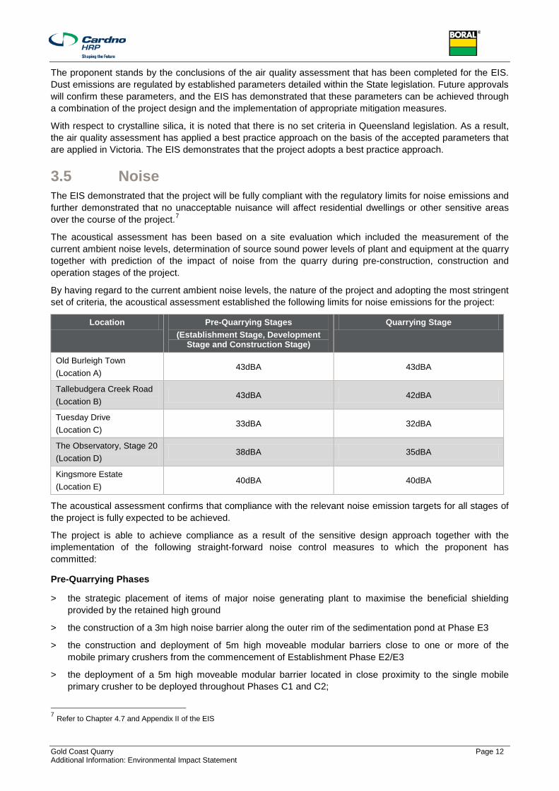
3.5 Noise The EIS demonstrated that the project will be fully compliant with the regulatory limits for noise emissions and further demonstrated that no unacceptable nuisance will affect residential dwellings or other sensitive areas over the course of the project.7
The acoustical assessment has been based on a site evaluation which included the measurement of the current ambient noise levels, determination of source sound power levels of plant and equipment at the quarry together with prediction of the impact of noise from the quarry during pre-construction, construction and operation stages of the project.
By having regard to the current ambient noise levels, the nature of the project and adopting the most stringent set of criteria, the acoustical assessment established the following limits for noise emissions for the project:
Location Pre-Quarrying Stages (Establishment Stage, Development
Stage and Construction Stage)
Quarrying Stage
Old Burleigh Town (Location A)
43dBA 43dBA
Tallebudgera Creek Road (Location B)
43dBA 42dBA
Tuesday Drive (Location C)
33dBA 32dBA
The Observatory, Stage 20 (Location D)
38dBA 35dBA
Kingsmore Estate (Location E)
40dBA 40dBA
The acoustical assessment confirms that compliance with the relevant noise emission targets for all stages of the project is fully expected to be achieved.
The project is able to achieve compliance as a result of the sensitive design approach together with the implementation of the following straight-forward noise control measures to which the proponent has committed:
Pre-Quarrying Phases
> the strategic placement of items of major noise generating plant to maximise the beneficial shielding provided by the retained high ground
> the construction of a 3m high noise barrier along the outer rim of the sedimentation pond at Phase E3
> the construction and deployment of 5m high moveable modular barriers close to one or more of the mobile primary crushers from the commencement of Establishment Phase E2/E3
> the deployment of a 5m high moveable modular barrier located in close proximity to the single mobile primary crusher to be deployed throughout Phases C1 and C2;
7 Refer to Chapter 4.7 and Appendix II of the EIS
Gold Coast Quarry Page 13 Additional Information: Environmental Impact Statement
> the erection of a 8m high x 176m long barrier / earth mound combination constructed along the high ground immediately to the west of western extent of Phase C2 together with a 6m high x 111m long barrier / earth mound combination constructed along the northern edge of Phase C2; and
> Compliance with the requirements of a Construction Noise Management Plan, especially with regard to the selection, operation and maintenance of “low noise” plant and equipment.
Quarrying Phases
> the full enclosure of all fixed crushing and screening plant, with openings in the enclosures for the entry and passage of product and conveyors only;
> at, or prior to, the commencement of Phase Q5, the construction of a 6m high x 150m long fixed acoustic barrier along a line parallel to and set back 6m from the common boundary with The Observatory Stage 20;
> rock drilling to be carried out using a “low noise” rock drill only which is to be operated for the minimum time feasible and, where necessary, screened using moveable modular barriers located at appropriate elevated positions between the operating drill rig and the nearest residences; and
> compliance with the requirements of an Environmental Noise Management Plan, especially with regard to the selection, operation and maintenance of “low noise” plant and equipment.
There are no cumulative impacts in relation to acoustic impacts. The EIS has demonstrated that compliance with regulatory limits is achieved throughout the various stages of the project through the implementation of appropriate mitigation measures. Achieving compliance with the regulatory limits is based on the assessment and consideration of the existing background noise levels, which are a cumulative contributor in themselves.
In terms of the submissions that were lodged, noise impacts were objected to generally and the proposed mitigation measures were largely dismissed or disputed.
The proponent stands by the conclusions of the acoustic assessment that has been completed for the EIS. Noise emissions are regulated by established parameters detailed within the State legislation. Future approvals will confirm these parameters, and the EIS has demonstrated that these parameters can be achieved through a combination of the project design and the implementation of appropriate mitigation measures.
3.6 Vibration and Blasting The EIS demonstrated that the project will be fully compliant with the regulatory limits for blasting impacts and demonstrated that no unacceptable nuisance will affect residential dwellings or other sensitive areas over the course of the project.8
Blasting is a standard, necessary and highly-controlled component of extractive industry operations. Blasting can potentially generate two types of adverse impact: air-borne vibrations (known as overpressure) and ground-borne vibration. Both overpressure and ground vibration levels are affected by blasting parameters, local geological characteristics and the topography between the blast source and the receiving environment.
In addition to the effects on rock mass that blasting is designed to create in the quarrying process, blasting at certain thresholds can affect personal amenity and structures. It is for this reason that blasting activities are subject to stringent regulation under Queensland’s Environmental Protection Act.
The project has been designed to ensure compliance with the regulatory limits set down by the Ecoaccess 2006 Guidelines (which support the operation of the Environmental Protection Act 1994). These regulations effectively limit ground vibration from blasting to 5 mm/s, and overpressure levels to 115 decibels (Linear) on at least 9 out of any 10 consecutive blasts. In addition, no vibration levels are to exceed 10 mm/s and no overpressure levels are to exceed 120 decibels (Linear) at any affected residence. For the purposes of modelling, this report has used a 95 percentile criterion in order to comply with the Ecoaccess 2006 Guidelines. The new proposed conditions are more onerous than the existing West Burleigh Quarry.
8 Refer to Chapter 4.7 and Appendix JJ of the EIS
Gold Coast Quarry Page 14 Additional Information: Environmental Impact Statement
The blasting impacts of the project will be well below the regulatory limits for human comfort and orders of magnitude below the levels that would be likely to generate structural damage. Any higher levels of vibration and overpressure will be fully contained within the boundaries of the proponent’s site.
The project is able to achieve compliance with the regulatory limits because of the separation between source and receiver that will be provided by the retention of vegetated buffers on the proponent’s land. The design of the development areas, together with the proponent’s commitment to adopt blast designs and operational procedures that have been developed in specific response to the local circumstances, also contribute to the blasting impacts being fully compliant.
Compliance with the regulatory limits effectively ensures a very low risk of damage to residential or commercial structures. Whilst there is sometimes a perception that vibration must cause damage to structures, there are no examples anywhere in the world where such damage has been substantiated. Notwithstanding, the TOR stipulates that the EIS should include an outline of the scope and methodology or pre-construction building surveys including a preliminary identification of the type and location of properties that should be surveyed. The proponent therefore proposes to offer building condition surveys to a limited number of houses in the surrounding area, prior to the commencement of works at the site, currently scheduled for 2016. The condition surveys will only be conducted if the property owners provide the necessary consent.
Blasting activities at the site will be fully compliant but may still be perceptible at some locations in the surrounding area. The proponent therefore proposes to carry out blasting on a weekly basis (that is, on average, every seven days). Blasting will generally be carried out in the middle of a regular weekday to minimise any disturbance to the surrounding area.
The vibration and overpressure impacts for each weekly event/s will have a duration of around two seconds, amounting to approximately 1.7 minutes of impact per year and a total of only 1 hour and 40 minutes over the 40 year operational life of the project.
Blasting at the proposed quarry will be conducted by highly trained and experienced shot-firers in strict accordance with both regulatory requirements and well tested operational procedures. No explosives will be stored at the site.
There are no cumulative impacts associated with blasting with respect to vibration and overpressure.
Submissions made in respect of the EIS broadly objected to blasting on the basis of its proximity to dwellings and the perceived impacts and damage to structures.
The proponent stands by the conclusions of the blasting assessment that has been completed for the EIS. Vibration and overpressure are regulated by established parameters detailed within the State legislation. Future approvals will confirm these parameters, and the EIS has demonstrated that these parameters can be achieved through a combination of the project design and the implementation of appropriate mitigation measures.
3.7 Planning The EIS concluded that the detailed town planning assessment that has been completed as part of the EIS demonstrates that the project is consistent with the higher order provisions of the statutory planning framework and ought to be approved.9
The project has been assessed against all components of the statutory planning framework that regulate land use and development. The project is consistent with the intent of the higher order provisions of the planning framework: the South East Queensland Regional Plan 2009 – 2031, State Planning Policy 2/07 – Protection of Extractive Resources and the Desired Environmental Outcomes of the Gold Coast City Council Planning Scheme.
At the more detailed level of the Gold Coast City Council Planning Scheme, conflict arises between the project and the requirements of the planning scheme. That conflict is not created by the project itself but is a direct
9 Refer to Chapter 3.1 and Appendix P of the EIS

Gold Coast Quarry Page 15 Additional Information: Environmental Impact Statement
and unavoidable consequence of the planning scheme not having been amended to appropriately reflect the provisions of either the South East Queensland Regional Plan 2009 – 2031 or State Planning Policy 2/07 – Protection of Extractive Resources. The inconsistency between parts of the planning scheme and the higher order statutory planning instruments ought to have been resolved through amendment to the planning scheme as far back as 2007, as required by the repealed Integrated Planning Act 1997 (now the Sustainable Planning Act 2009).
Despite the fact that the lower order conflict between the project and the planning scheme is a direct consequence of the planning scheme failing to appropriately reflect State Planning Instruments, the conflict is nevertheless justified by the following planning grounds (as is required by the Sustainable Planning Act 2009):
> the conflict arises because the planning scheme does not appropriately reflect State Planning Instruments;
> there is a strong need for the project
> the project will activate a Key Resource Area which has been identified as being of significance at the state and regional scale
> the project will activate the last and largest known hard-rock resource on the southern Gold Coast
> the proposed development will comply with all regulatory limits under the Environmental Protection Regulation 2008 (relating to noise, air quality, blasting and water quality)
> the retention of approximately 70% of the site as vegetated buffer will maintain and enhance the environmental and biodiversity values of the site – an outcome that would unlikely be achieved if the site were developed for urban development in accordance with the planning scheme
> the project does not cut across the high level planning strategy for the City.
When the EIS was lodged, the Draft SPP had only recently been released for public comment, and therefore a detailed assessment was not included in the document. It is noted that the KRA mapping in the Draft SPP again details Lot 105 as a Key Resource Area. The proposed development maintains intent for the site as detailed in the KRA mapping. Page 21 of the Draft SPP includes the assessment criteria for development proposals:
> 1(a) - The proposed development will not alienate or significantly impede the undertaking of extractive industry development within the identified resource/processing area of the KRA. In fact the proposed development activates the KRA.
> 1(b) - No sensitive land uses are proposed to be situated within the identified separation area of the KRA. In fact the separation area does not extend beyond the boundaries of Lot 105.
> 1(c) - The haulage routes are clearly detailed on the KRA mapping and the EIS has addressed both of these identified routes as part of the overall assessment. It is Council’s responsibility to ensure that there is no increase in the number of dwellings located within the separation area for the identified haulage routes.
> 1(d) - The haulage routes are clearly detailed on the KRA mapping and the EIS has addressed both of these identified routes as part of the overall assessment. It is Council’s responsibility to ensure that adjacent development does not adversely affect the safe and efficient use of the identified haulage route.
> The project achieves compliance with the assessment criteria detailed in the Draft SPP with respect to extractive resources. The guideline for mining and extractive resources is not an assessment tool for a development proposal. It is to be utilised by Councils when amending or creating planning schemes. As a result, an assessment against the guideline is not warranted.
The proposed development of the subject site is therefore consistent with the Draft SPP, which is anticipated to be a statutory document imminently. It is also to be noted that the Draft SPP again includes a requirement for Council’s to amend planning schemes to appropriately reflect the Draft SPP.
The submissions generally raised the issue of conflict between the project and the planning scheme.
Gold Coast Quarry Page 16 Additional Information: Environmental Impact Statement
The proponent stands by the conclusions of the town planning assessment that has been completed for the EIS. The conflict with the 2003 Gold Coast Planning Scheme has primarily arisen from the fact that the document has not been appropriately updated to reflect the South East Queensland Regional Plan 2009 – 2031 or State Planning Policy 2/07 – Protection of Extractive Resources in accordance with legislative requirements. Sufficient grounds were also demonstrated to overcome the conflict.
The requirement for Gold Coast City’s planning scheme to appropriately reflect higher order planning documentation will remain once the Draft SPP becomes statutory imminently.
3.8 Traffic Impacts The EIS concluded that, on the basis of the data and analysis undertaken, the proposed Gold Coast Quarry project is anticipated to have an insignificant impact on the safety and efficiency of the road network.10
The EIS includes an assessment of the project’s potential to significantly increase traffic volumes or cause significant impacts on the safety and efficiency of the surrounding road network.
The Queensland Department of Transport and Main Roads (TMR) and Gold Coast City Council are currently considering a connection linking the Pacific Motorway and Old Coach Road at the Bermuda Street Interchange. Although TMR’s future Bermuda Street connection is widely known and documented, it is currently unfunded and therefore the timing of its construction is uncertain. As a result, the EIS has considered two alternative road network scenarios: one road network with TMR’s future Bermuda Street connection and one without.
It is important to note that TMR’s future Bermuda Street connection is a totally separate road improvement project being independently investigated by road authorities and is not proposed or relied upon by the project.
The EIS demonstrated that the project is not anticipated to have a significant impact on the surrounding road network, irrespective of the timing of TMR’s future Bermuda Street connection. That is, the project generated traffic is not anticipated to significantly impact the performance of existing or future intersections within the study road network or significantly bring forward the need for upgrade works.
A safety assessment was undertaken for the proposed site access intersection (with Old Coach Road) which indicated that a channelised right turn lane and an auxiliary left turn lane should be provided at the intersection. A conceptual layout for these works has been developed and is submitted as part of the EIS.
A detailed pavement assessment was also undertaken, accounting for the impacts of project traffic on the State Controlled Road network. Reasonable and relevant contributions towards the rehabilitation and ongoing maintenance of the State controlled road network have been calculated. Reasonable and relevant contributions will also be made to Gold Coast City Council to contribute towards the safe and efficient operation of the Council road network.
There is no cumulative impact on the surrounding road network as a result of the proposed development. The EIS has demonstrated that the proposed development will not significantly impact on the surrounding road network. This determination is based on industry standard methodologies involving the consideration of background growth in traffic volumes which represents a cumulative assessment.
Further comments in relation to traffic matters are provided below in Section 4.0. It is also important to note that the proponent and DTMR have agreed to the reasonable maintenance and rehabilitation costs associated with the project and the State controlled road network. This agreement demonstrates an acceptance of the approach to traffic impact management.
The submissions highlighted traffic issues in relation to safety and adding to existing congested intersections during peak hours.
The proponent stands by the conclusions of the road impact assessment that has been completed for the EIS.
10 Refer to Chapter 4.9 and Appendix LL of the EIS
Gold Coast Quarry Page 17 Additional Information: Environmental Impact Statement
4 Clarification of Key Matters The submissions made to the Coordinator-General have been reviewed and the proponent considers the following to be the key matters requiring clarification.
4.1 Chapter 4 Environmental Values and Management of Impacts – Section 4.5 Air Quality
4.1.1 Key Matter – Dust Deposition The use of maximum monthly averages of dust deposition of 120 mg/m2/day as an indicator of dust nuisance and as the sole measure of performance would potentially allow short-term dust release and deposition rate exceedences. Clarify the mitigation measures to be set in place to quickly prevent and minimise the duration of any such event.
Response
The dust deposition guideline commonly used in Queensland as a benchmark for avoiding amenity impacts is 120 mg/m2/day as a maximum monthly average. The guideline is not defined in the Air EPP and is therefore not enforceable by legislation, but was recommended by the DEHP as a design objective. There are no short term objectives or indicators for dust deposition nuisance impacts and therefore only the maximum monthly average was used. Notwithstanding this, the dust management plan for Gold Coast Quarry will include measures to prevent and control short term nuisance dust.
A detailed response is provided at Attachment A.
4.1.2 Key Matter – Dust Impacts on Vegetation Demonstrate that the predicted levels of dust deposition in the buffer zone will not adversely affect the health of ecologically sensitive vegetation.
Response
Dr D. Doley from the University of Queensland (an expert in the effects of dust on vegetation) was commissioned to review the Gold Coast Quarry's EIS Flora and Fauna and Air Quality Assessment reports. A summary of Dr Doley's review is provided below:
"A model was developed to indicate the effects of dust deposition from the proposed Boral Gold Coast Quarry on vegetation within and surrounding the Boral property. The modelling results suggest that dominant components of vegetation types, particularly Eucalyptus species, are very unlikely to be affected adversely by the predicted dust loads within the Boral property, and in existing and proposed residential areas.
Predicted maximum dust deposition rates could impact on vegetation layers within plant communities that have a deeply shaded understorey of Regional Ecosystem 12.11.23. If the maximum rate of dust deposition predicted to be recorded in a deposit gauge applies uniformly throughout a vegetation profile, there could be sufficient additional shading by dust on leaves of ground cover species that their integrity could be threatened.
However, the ground layer of RE 12.11.23, occurs at a distance of more than 100 m and at least 20 m below the crest of a hill between the proposed quarry surface and the site in question. In addition, there is likely to be progressive interception of dust as it moves through vegetation (both laterally and vertically). This interception would reduce the risk to sensitive vegetation.
Practical mitigation measures, especially the establishment and maintenance of a Casuarina windbreak at the quarry edge is likely to reduce the concentration of dust in air moving laterally into the native vegetation by up to 80%".
Gold Coast Quarry Page 18 Additional Information: Environmental Impact Statement
A detailed response is provided at Attachment A.
4.1.3 Key Matter – Guidelines for Crystalline Silica Demonstrate that the appropriate guidelines and calculations have been used to determine the dust deposition rate and that crystalline silica emissions in particular will not present an increased risk to human health in terms of respiratory illnesses.
Response
The Gold Coast Quarry EIS air quality assessment includes an assessment of respirable crystalline silica. The silica assessment is presented in Section 10 of the Air Quality Assessment Report. The assessment has used appropriate guidelines and calculations to determine that crystalline silica emission will not present an increased risk to human health.
Notwithstanding this, the proponent will conduct routine monitoring of the exposure of its workforce to respirable crystalline silica throughout the lifetime of the Gold Coast Quarry.
A detailed response is provided at Attachment A.
4.1.4 Key Matter – Meteorological Modelling Clarification that the land breeze and sea breeze cycle, drainage wind and valley wind effects have been appropriately addressed in modelling.
Response
The meteorological modelling that was conducted for the Gold Coast Quarry EIS characterises the full range of meteorological conditions that would occur in the region including land and sea breeze cycles and drainage flows. This is evident in the wind roses and analysis presented in the air quality assessment.
A description of the meteorology generated by the model at the quarry location is provided in Section 6.2 of the Gold Coast Quarry EIS air quality assessment and includes a description of sea breeze and valley winds experienced at the site. Meteorological data from the Bureau of Meteorology's station at Coolangatta Airport (nearest station to the Gold coast Quarry site) was used to generate meteorological modelling data. The meteorological model setup and validation is provided in Appendix B of the Gold Coast Quarry EIS air quality assessment. The meteorological modelling methodology is appropriate.
A detailed response is provided at Attachment A.
4.1.5 Key Matter – Determination of Control Efficiencies Clarification of how dust control efficiencies to estimate emissions have been determined.
Response
An updated table with literature references and justifications for the dust control reduction efficiencies applied for the Gold Coast Quarry design is presented in the Appendix B of the response that has been prepared by Katestone.
A detailed response is provided at Attachment A.
4.1.6 Key Matter – Air Emission Sources Confirmation that all air emission sources have been included in the inventory, including any derivation of conveyor emissions. Demonstrate the applicability of coal mining equation for wind erosion of stockpiles to quarry material stockpiles.
Response
All air emissions sources have been included in the inventory. Section 2.2.4 of the Gold Coast Quarry EIS Air Quality Assessment details the potential emission sources from the Gold Coast Quarry and Section 7.2.1 Table 14 details the calculated emission rate for the worst case scenario of the Gold Coast Quarry operation.

Gold Coast Quarry Page 19 Additional Information: Environmental Impact Statement
Technical descriptions of how the dust emission rates have been calculated are provided in Appendix A of the air quality assessment that was prepared for the EIS.
Katestone confirms that the loading of fragmented rock and product material have been characterised as material handling operations, which are included in the inventory (See "extraction from pit" and "product loadout" in Table 14).
Appendix A, Section 2.8 and Section 2.12 details how the conveyor emissions and stockpile emissions, respectively, have been determined for the Gold Coast Quarry Air Quality Assessment.
There are no wind erosion emission factor equations explicitly for quarry stockpiles and therefore the coal mining equation for wind erosion of stockpiles has been used. This is valid as the coal mining equation represents an active stockpile (i.e. material is being added and taken away on a regular basis). The Gold Coast Quarry product stockpiles can be classed as active stockpiles.
A detailed response is provided at Attachment A.
4.1.7 Key Matter –Clarification of PM2.5 Emission Calculation Clarification of how the PM2.5 emissions have been estimated to confirm that appropriate modelling has been undertaken for air quality
Response
The PM2.5 dust emissions estimation for each activity is detailed in the tables in Appendix A of the Gold Coast Quarry EIS Air Quality Assessment. PM2.5 has different TSP ratios depending on the activity and is guided by the relevant emissions estimation handbooks. It is confirmed that appropriate modelling has been undertaken for air quality.
A detailed response is provided at Attachment A.
4.1.8 Key Matter – Miscellaneous Emission Assessment Matters Confirmation that the emission assessment has adequately addressed the following matters:
> location of the quarry pit operation with respect to the closest sensitive receptor;
> location of overburden stockpile;
> truck loading and dumping of the overburden material, particularly important during the early stage of site development; and
> mobile crushing plant during the early stage of development
Response
The Gold Coast Quarry Air Quality Assessment investigated the worst case scenario for operation of the quarry – stage Q5 operation (full development of the quarry), as detailed in Section 7.2 of the Air Quality Assessment report. It is not practical to assess the locations of all air emissions sources over the proposed 40 year lifetime of the Gold Coast Quarry and therefore a conservative approach was used, which adopted for the worst case assessment.
The locations of sensitive receptors and the location of the most important sources were taken into consideration. The most important source in terms of dust generation is the haulage of material from the pit to the processing plant along unsealed roads. The worst case modelled year represented the longest haul road from pit to plant which passes to the northwest, near to the closest receptors. (Figure 14 of the report shows the location of sources used in the air quality assessment modelling).
As detailed in Section 7.2 of the air quality assessment report, a dust inventory was calculated for each stage of the Gold Coast Quarry (Table 13) and then a worst case scenario selected. Detailed information on the dust inventories of each stage of the Gold Coast Quarry other than Q5 is provided in Appendix C of this memorandum.
A detailed response is provided at Attachment A.

Gold Coast Quarry Page 20 Additional Information: Environmental Impact Statement
4.1.9 Key Matter – Maximum 24-hour average Clarification of the maximum 24-hour average PM10 and TSP ground level concentration that has been utilised in the modelling.
Response
The Air EPP allows for 5 exceedance days of the 24-hour average PM10 objective. Therefore, the 6th highest 24-hour average PM10 concentration was provided in the air quality assessment. The maximum 24-hour average ground-level concentration of PM10 was not provided in the air quality assessment. This approach has previously been accepted by DEHP for quarry and mining projects. There is no 24-hour average ground-level concentration objective for TSP and therefore this was not provided in the air quality assessment. The dust management plan for Gold Coast Quarry will include measures to prevent and control short term release of dust to ensure no offsite health and nuisance impacts.
A detailed response is provided at Attachment A.
4.1.10 Key Matter – Clarification of Cumulative Impacts Clarification that the cumulative impact assessment has included other industrial sources in the area.
Response
The cumulative impact was estimated by the addition of a representative background to the increment due to the Gold Coast Quarry. The EIS assessed the worst case scenario of dust generated from the Gold Coast Quarry, which was when the project was operational (stage Q5 - full pit development). A dust inventory showed that emissions from the operational stages of the Gold Coast Quarry were double the establishment and development stages. West Burleigh Quarry (WBQ) was not modelled as a background source because it will be closed by the time the operational stages of the Gold Coast Quarry are underway so its inclusion in the cumulative assessment of worst case operation at the Gold Coast Quarry would be an overestimation. It should also be noted that the boundary dust deposition monitoring at WBQ shows that dust rarely leaves the site and in the instance that it does it occurs in an area to the north of the site near the product stockpiles. There is no information available regarding emissions from Reedy Creek waste disposal site and therefore it was not included in the cumulative assessment. However, its influence on dust levels within the Gold Coast Quarry modelling domain would be minimal.
Notwithstanding this, a representative background was selected based on historical long term air quality monitoring data at a representative monitoring station. As detailed in Section 8.3 of the air quality assessment report, there are no air quality monitoring stations in the Gold Coast area and therefore, monitoring data from the DEHP Springwood station was chosen as it represents a 'population average' for Southeast Queensland. It is also located in proximity to the Pacific Highway (M1).
A detailed response is provided at Attachment A.

Gold Coast Quarry Page 21 Additional Information: Environmental Impact Statement
4.2 Chapter 4 Environmental Values and Management of Impacts – Section 4.4 Water Quality
4.2.1 Key Matter – Sediment Control Design Parameters Clarification of the following matters:
> the sediment control design objective for basin design is sufficient for the operational lifespan of the project and the subsequent risk associated with extended periods of land disturbance;
> the basin design standard for ERAs involving significant land disturbance like this project includes a settling zone to accommodate runoff from a 1 in 5 ARI, 24hr rainfall event; and
> Confirmation that further sediment control design work will be undertaken at the appropriate time (i.e. detailed design / operational works) to ensure the quarry will be hydraulically efficient.
Response
The proponent confirms that further detailed design of the sediment basin will be undertaken in the subsequent stages of the project. A future Operational Works application would include specific design details which are appropriate given that land use approvals may include conditions that may be required to be reflected in the subsequent Operational Works application.
In response to the matters described above,, the following is noted:
> The volume of the sedimentation basin has been designed in accordance with industry-accredited best practice guidelines, namely:
− Best Practice Erosion & Sediment Control (2008) by International Erosion Control Association (IECA).
− Sediment Basin Design, Construction, Operation and Maintenance (2001) by Brisbane City Council.
− It should also be noted that the more stringent volume requirements (given in the IECA guideline) were adopted for the sediment basin design.
> The design standards that have been noted in the submissions are not known to be from any published or industry-accredited best practice guideline.
> As described in Appendix CC of the EIS “it is proposed that a ‘high efficiency’ flow-through sediment basin be adopted”, which has been shown to achieve significantly higher rates of sediment removal (relative to standard sediment basins, to which the state agency standards relate). It is therefore anticipated that the proposed sediment basin design will likely achieve sediment removal rates higher than standard sediment basins.
> It should also be noted that the assessment described in Appendix CC of the EIS, the project (and associated stormwater quality management strategy), will likely decrease stormwater pollutant loads discharging from the site (relative to the existing baseline).
− This is largely due to a demonstrated commitment to best practice is evident in all aspects of the design and operation of the project that relate to the management of water quality and quantity.
− The integrated water management hierarchy described in Appendix CC of the EIS includes multiple aspects, with treatment and disposal as the least preferred management options. The design of the sediment basin (whilst done in accordance with best practice industry-accredited guidelines, with higher treatment performance predicted through the use of ‘high efficiency’ flow through sediment basins), is still only a single element of this best practice management hierarchy.
With respect to the above, it is noted that there is no reference to a specific Gold Coast City Council standard. The IECA and BCC guidelines have been applied in the absence of any locally-specific guideline (e.g. prepared by Gold Coast City Council) in relation to the design of sedimentation basins for extractive industries (or similar operations).
A detailed response is provided at Attachment B.
Gold Coast Quarry Page 22 Additional Information: Environmental Impact Statement
4.2.2 Key Matter – Sediment Control > Clarification with respect to the following matters:
− the effectiveness of the sediment stripping efficiency of rock swales that are proposed;
− the effectiveness of the proposed high efficiency flow through sediment basin under a range of flow events; and
− the likely dosing needs to be undertaken by flocculants along with a consideration of the impact of these at downstream environments.
> Clarification of soil types, soil texture/class or particle size distribution associated with the site to assist with determining the effectiveness of erosion controls; and
> Confirmation that further assessment of the sediment basin will be undertaken at the appropriate time (i.e. detailed design / operational works).
Response
The proponent confirms that further assessment of the sediment basin will be undertaken as part of the detailed design process associated with a later Operational Works application.
In relation to the specific issues raised, please note the following:
Item #1: Sediment removal of rock swales
In the absence of any sediment removal data (or guidance) for modelling sediment removal in rock swales, the sediment removal of the proposed rock swales have been modelled based on input parameters recommended for swales.
Swales are typically grassed, and not typically laid with rock (as the proponent has proposed for the quarry project). Nevertheless, it is considered a reasonable assumption to apply modelling parameters recommended for grassed swales (to the proposed rock swales) given that the principal processes by which sediment is removed by swales (i.e. sedimentation – letting suspended material settle by gravity) is the same.
The presence of grass (instead of rock) within a swale would be anticipated to have a negligible impact to the sediment stripping performance of the swale. If anything, it is anticipated that a rock-lined channel will be slightly better at removing sediment from stormwater flows given the following:
> Higher channel roughness for rock channels (relative to grassed swales), and subsequently lower velocities (which will increase sediment retention/ deposition – reducing sediment loads discharged downstream).
> Greater ability for the retention of sediment (between gaps between the rocks) – and subsequently reduced risk of retained sediment being scoured/ ‘washed’ downstream.
Regardless, adopting different model parameters for the rock channel was tested in a sensitivity test and had very little impact to sediment removal of the catchment where the rock swales will be integrated into (given the presence of the proposed sedimentation basin downstream of the swales) and for the overall site (given that the proposed rock swales are only a minor part of the overall integrated water management strategy for the site).
Item #2: Efficiency of the sediment basin under a range of flow events
The analysis undertaken in Appendix CC of the EIS has already assessed the performance of the sediment basin “for a long term simulation of rainfall events” and/ or “under a range of flow events”. As described in Appendix B of the water resources report:
> The water balance assessment of the strategy (including the sediment basin) involved modelling using a 111-year period of historical rainfall data at daily time-steps. So, for example, the daily operation of the sediment basin (e.g. water level variation, inflows, outflows) was calculated applying the same 111-years of historical rainfall data as previously recorded.

Gold Coast Quarry Page 23 Additional Information: Environmental Impact Statement
> Similarly, the assessment of the ‘stormwater quality’ treatment performance of the strategy (including the sediment basin) utilising rainfall data from a period of ten years (from 1st January 1989 to 31st December 1998), using recorded pluvio data at six minute time-steps. The use of this climate data is in accordance with the relevant industry-accredited guideline for assessing ‘stormwater quality’ treatment performance.
> The 10-year modelling period is obviously smaller than the 111-years of data used for the water balance, but is required as many more calculations are undertaken given the smaller (6-minute) modelling time-step utilised (i.e. time interval between each modelling calculation). This smaller time-step is required to appropriately model the treatment performance of the sediment basin (and other treatment devices).
The climatic periods applied in the water balance and ‘stormwater quality’ treatment performance assessments obviously include a range of rainfall/ flow events. The issue raised is subsequently unjustified.
Further information in relation to the methodology applied to assess the performance of the sediment basin is available in Appendix B of the water resources report.
Item #3: Potential Impacts of Flocculants
It is recommended that an assessment of likely dosing needs with consideration of the impact of these at downstream environments will be incorporated into an appropriate flocculation and dewatering strategy for the sediment basin.
This issue has already been raised in Section 4.3 of the water resources report: “If aluminium-based flocculants (for example), are over-used however, these may result in toxic levels of aluminium in receiving waterways … An appropriate flocculation and dewatering strategy will … be required for the sediment basin”.
In this same section, the water resources report also notes that ”If turbidity is high, alum-based flocculants typically reduce aluminium in the water column because they remove sediment. They typically only contribute to the Al concentration if the Al concentration is already low.” As described in Section 3.5.2.2 of the water resources report, “Aluminium within the sites waterways appears to be high in both dissolved and particulate forms – and high levels were observed across all three sites.” Reference is to be made to Appendix CC of the EIS.
In addition to the above items, from a perspective of reducing the costs alone associated with flocculant use, it is anticipated that excessive flocculant usage will be highly unlikely.
It is therefore very unlikely that the proposed use of flocculants will have any negative impact on the health of downstream environments. Nevertheless, this will be further considered in the preparation of an appropriate flocculation and dewatering strategy (as recommended in the water resources report).
Item #4: Assessment of Soil Types
As the site development works involve cuttings of up to 35m in depth into fresh Argillite, it is not possible to obtain a sample of the future floor material for testing. Soil characteristics will vary greatly according to depth and location. Due to the ever changing extents of the overburden removal works, the type of soil being dealt with will undoubtedly change as the works progress. For the purpose of the sediment basin design, a 10% dispersive soil has been assumed.
A detailed response is provided at Attachment B.
4.2.3 Key Matter – Water Quality Discharge Objectives Clarification of the following matters that relate to water quality discharge objectives:
> the discharge criterion of 50mg/L Total Suspended Solids (TSS); .
> the water quality discharge objectives that will be employed to ensure downstream environmental values are suitably protected; and
> the appropriate mitigation measures that will be implemented to address potential water quality discharge impacts.

Gold Coast Quarry Page 24 Additional Information: Environmental Impact Statement
Response
As outlined in the water resources report, the project (and associated stormwater quality management strategy) is predicted to achieve a reduction in Total Suspended Solids (TSS) loads relative to the existing site and is therefore unlikely to cause greater environmental harm compared to existing conditions.
Whilst a significant portion of the total flow volume will overflow the sediment basin, this overflow volume will still be at least partially treated via the 'at source' erosion control measures, the rock-lined channel, and sediment basin. Whilst this overflow volume may not achieve a TSS concentration less than 50mg/L, TSS loads and concentrations are still anticipated to be significantly reduced by this stormwater ‘treatment train’ (combination of treatment measures) – and anticipated to be lower than the loads/ concentrations from the existing site.
Section 5.2.4.2 of the water resources report already states "Longer term discharge criteria should be developed from a comprehensive assessment of receiving water quality and the setting of appropriate receiving water quality objectives." The report also already recommends "developing and implementing site specific discharge criteria to ensure that downstream environmental values are suitably protected." Reference is to be made to Appendix CC of the EIS.
It should also be noted that the assessment described in the water resources report indicates that the project (and associated stormwater quality management strategy), will likely decrease stormwater pollutant loads discharging from the site (relative to the existing baseline). This is largely due to a demonstrated commitment to best practice, which is evident in all aspects of the design and operation of the project that relate to the management of water quality and quantity. The integrated water management hierarchy described in the water resources report includes multiple aspects, with treatment and disposal as the least preferred management options. The sediment basin is only a single element of this best practice management hierarchy.
A detailed response is provided at Attachment B.
4.2.4 Key Matter – Water Quality Testing Confirmation that a commitment has been made to water quality testing of the sediment basin prior to de-watering.
Response
It is confirmed that water quality testing will occur prior to de-watering.
Section 5 of the water resources report provides a detailed monitoring plan for the project – including recommended monitoring of discharges from the sediment basin. Reference is to be made to Appendix CC of the EIS.
A detailed response is provided at Attachment B.
4.2.5 Key Matter – Water Quality Impacts Demonstration that the construction and operation of the proposed quarry will not adversely impact water quality as a result of accidental or inappropriate release of contaminants or pollutants, as well as increased suspended sediment levels as a result of vegetation clearing and earthworks.
Response
The water resources report provides a detailed description of the mitigation measures to be employed to ensure the protection of water quality in downstream waterways. The State agency is referred to the following relevant sections of the water resources report for further information:
> “At a Glance”
> “Summary”
> Section 4 – “Potential Impacts and Mitigation Measures”
> “Appendix B: Stormwater Quality, Hydrology and Water Cycle Management Plan”

Gold Coast Quarry Page 25 Additional Information: Environmental Impact Statement
Reference is to be made to Appendix CC of the EIS.
Additional information in relation to mitigation measures for water quality protection is also provided in the following reports by Lambert & Rehbein:
> Erosion and Sediment Control Program – Boral Gold Coast Quarry, Reedy Creek (Appendix W of the EIS)
> Stormwater Management Program – Boral Gold Coast Quarry, Reedy Creek (Appendix EE of the EIS)
It is considered that sufficient detail regarding the mitigation measures is provided within these aforementioned reports.
A detailed response is provided at Attachment B.

Gold Coast Quarry Page 26 Additional Information: Environmental Impact Statement
4.3 Chapter 4 Environmental Values and Management of Impacts – Section 4.4 Groundwater and Section 4.3.3 Terrestrial Fauna Matters
4.3.1 Key Matter – Groundwater dependant ecosystems Clarification of the following matters relating to the potential for Groundwater Dependent Ecosystems (GDEs):
> utilisation of the Australian Groundwater Dependent Ecosystems Toolbox (2011) to confirm that no GDEs exist on the site;.
> addressing seasonal variations and downstream impacts to aquatic and riparian GDEs; and
> the adequacy of proposed mitigation measures in addressing identified impacts, particularly how changes to vegetation and hydrology will be detected and mitigated over the life of the quarry.
Response
Cardno Chenoweth has prepared a detailed analysis in response to this matter.
While vegetation fringing drainage lines is likely to ‘use’ groundwater resources owing to its proximity of the discharge point of water draining from the regolith, it is not dependant on this resource owing to its ephemerality and availability of other resources (i.e. soil moisture). The structure and floristic makeup of vegetation is the drainage lines are shaped by multiple biotic and abiotic inputs, not water alone. By definition, vegetation in the drainage lines are not groundwater dependant ecosystems (GDEs). On this basis assessment against Stages 2 and 3 have not been conducted as Stage 1 concludes vegetation communities associated with the drainage lines are not GDEs.
Downstream areas outside of the study area would be subject to the same unreliability of groundwater as those in the study area. Therefore it is unlikely these would be dependent on the surface expression of groundwater from the arising from the study area. Notwithstanding this, Australasian Groundwater and Environmental Consultants (AGE) had indicated that the regolith in the catchments to the south, west and north of the quarry footprint would continue to discharge to the drainage lines throughout and post quarry operations.
There are no proposed mitigation measures for GDEs as no GDEs dependant on groundwater from the study area have been identified within or downstream of the study area. However, the EIS proposes to monitor the health of vegetation in the mid catchment waterway and provide mitigation only if required. Specifically the following is noted:
Monitoring is fundamental to determining whether a mitigation response is required. Natural systems are dynamic. By way of example, the current study documented the natural attrition of threatened plant species within the Mid Catchment Waterway. It will therefore be necessary to undertake monitoring over time and take into account climatic conditions to ensure it accurately charts changes that can be attributed to the proposed development. The following monitoring actions are proposed for species within drainage lines and waterways along with the appropriate mitigation response.
> Monitor the population of threatened species specifically within the Mid Catchment and Northern Catchment Waterways upon commencement of earthworks. Information attained prior to clearing will assist in establishing the baseline condition. Information collected will include the number of individual threatened trees, a description of the health and vigour of individual threatened trees, a count of the number of trees/shrubs on which the Ribbon root orchid occurs and an estimate of the overall Ribbon root orchid population.
> For threatened species in the Mid-catchment Waterway upstream of the proposed sediment pond and in the Northern catchment - if there is a decline in the health of trees or abundance of Ribbon root orchid over 5 successive years that can be attributed to quarrying activities (e.g. changes in hydrology) then implement the following mitigative steps (1) supplement flows in the waterway to mimic the pre-clearing state; (2) if Ribbon root orchid continues to decline translocate a limited number of specimens to the Southern Catchment waterway to establish a separate population.

Gold Coast Quarry Page 27 Additional Information: Environmental Impact Statement
> For threatened tree species in the Mid-catchment Waterway downstream of the proposed sediment pond - if there is a decline in the health of trees over 5 successive years that can be attributed to quarrying activities (e.g. changes in hydrology) then manage the volume of water received by the vegetation.
The changes in hydrology noted in the proposed monitoring refers to potential reductions in surface flows resulting from a change in the surface area of the catchment. The primary objective of the monitoring and the proposed adaptive management response is to ensure the health of threatened plant species’ is maintained. Despite the possibility that there will be no impacts on threatened plant species because of the buffers provided and retention of much of the catchment, a precautionary approach will be adopted whereby monitoring aims to detect and respond to declining health where it can be attributed to a change in hydrology. This approach is regarded as appropriate because:
> there are no GDEs;
> the risk of impacts on the species is only regarded as medium;
> monitoring to be conducted during the life of the quarry targets threatened species and health will be measured against baseline (pre-quarry) conditions;
> there will be an achievable response if required to mimic pre-clearing conditions surface flow conditions; and
> there is a supplementary approach of translocating the ribbon root orchid to an unaffected drainage line within Boral’s holdings that supports host species in similar densities to the mid catchment waterway.
A detailed response is provided at Attachment C.
4.3.2 Key Matter – Seasonal Monitoring of Groundwater Confirmation of whether seasonal monitoring of groundwater levels has occurred for the purposes of the EIS.
Response
It is correct that seasonal monitoring of groundwater levels has not been undertaken and that groundwater levels have been measured at only two separate points in time.
In considering the need for monitoring the Groundwater Impact Assessment report concluded (Appendix FF of the EIS - Section 15.2), that groundwater is not a significant resource in the Study Area on which groundwater users, human or groundwater dependent ecosystems (GDE’s) are dependent. The closest bore listed on the DNRM database is located at the Gold Coast City Council Sports Field, about 800m south-east of the disturbance footprint and the next closest are two bores located approximately 1.5 km southwest of the site, and a group of four bores located about 1.5 km to the north of the site. With the exception of Council’s Sports Field bore the registered bores appear to be primarily used for domestic (garden watering), supplies. The flora and fauna impact assessment concluded that with respect to GDE’s “none of the ecosystems present within the study area are identified as communities that are dependent on groundwater”.
Based on this assessment of groundwater usage at the site and surrounds the Groundwater Impact Assessment (section 11.3.8), concluded that in accordance with Part 3, Section 6 of the Environmental Protection (Water) Policy (2009), the prime environmental value of groundwater within the Project area that may need to be enhanced or protected under this policy would be that for “agricultural use” in the form of garden watering from privately owned bores. However, as stated, the Council bore is only bore in the near vicinity of the quarry and it is in the perched aquifer and it is unlikely to be impacted. Therefore a groundwater management and monitoring plan was not designed for the EIS as it was shown, as summarized above, that groundwater is not a significant resource in the Study Area on which groundwater users (human or GDEs) are dependant, and that the impacts of the quarry on the groundwater regime are minimal. As such the potential for groundwater related environmental or social impact to result from the development occurring is considered negligible and therefore it is considered that groundwater monitoring, seasonal or otherwise, is not warranted.
A detailed response is provided at Attachment D.
Gold Coast Quarry Page 28 Additional Information: Environmental Impact Statement
4.3.3 Key Matter – White-bellied Sea Eagle Clarification of the potential impacts of the project on the White-bellied Sea Eagle and proposed measures (and offsets) to mitigate the potential impacts on the species.
Response
Cardno Chenoweth has prepared a detailed analysis in response to this matter.
Given the relatively minor change from the existing to the proposed sound environment, the examples of other locations where White-bellied Sea Eagles experience industrial noise and the scientific and anecdotal evidence of the tolerance of other raptors, it is not anticipated that there will be a significant impact on the study area’s nest site.
A detailed response is provided at Attachment C.
4.3.4 Key Matter – Impacts on Nocturnal Fauna Identify potential impacts of night time maintenance activities on nocturnal fauna and detail mitigation measures to address identified impacts.
Response
Cardno Chenoweth has prepared a detailed analysis in response to this matter.
Given the proposed lighting for the facility, the relatively low levels of light spill into a small portion of the wooded buffer and evidence from other quarry operations that a broad suite of native animals persist in similar environments there is very little likelihood of lighting having an impact on native wildlife.
A detailed response is provided at Attachment C.
Gold Coast Quarry Page 29 Additional Information: Environmental Impact Statement
4.4 Chapter 4 Environmental Values and Management of Impacts – Section 4.9 Transport
4.4.1 Key Matter – Containing Proposed Works in Road Reserve Areas Demonstrate that proposed works can be located within the existing road infrastructure and that safety design parameters will be met.
Response
The technical memorandum titled, “Gold Coast Quarry Project – Old Coach Road/Bridgman Drive Concept Layout,” addresses constraints at the Old Coach Road / Bridgman Drive / Pacific Motorway intersection. The memorandum specifically identifies that the potential upgraded configuration as proposed in the Road Impact Assessment for the project, can be accommodated entirely within the existing road reserve area.
A detailed response is provided at Attachment E.
4.4.2 Key Matter – Road Safety Review and Site Access Design Further clarification with respect to:
> an updated Road Safety Review addressing the impacts of increased heavy vehicle usage on other road corridor users (e.g. pedestrians and cyclists) particularly around conflict points such as intersections and roundabouts;
> the extent of the proposed road works around the site access point necessary to meet relevant standards, including addressing existing deficiencies in pavement condition and alignment; and
> outlining site access alternatives to demonstrate that the proposed site access is the best location.
Response
Cardno has prepared a Road Safety Review for the State-controlled sections of Old Coach Road. A copy of the review is at Attachment T2 of the response that has been prepared and is contained in Attachment E to this submission.
With respect to the site access location, the following is noted:
> Cardno’s assessment considered the performance and safety of the site access within the Road Impact Assessment included in the EIS. The access design prepared by the project’s Civil Engineer, Lambert & Rehbein, accords with all relevant civil engineering standards.
> As part of the design process for the project, a total of 6 different access points were considered. A plan detailing the 6 options is contained in Attachment T3 (refer to Attachment E). The proposed access for the project is identified as Option A on the appended plan. The other 5 options were discounted as not being feasible on the basis of extent of vegetation that was required to be cleared (identified as being either ‘endangered’ or ‘of concern’ ecosystems), significantly enlarging the disturbance footprint, relying on land beyond the road reserve area and subject site (i.e. potential owner’s consent issues), cost impositions and the existing terrain.
4.4.3 Key Matter – Pavement Impact Assessment Further validation of the methodology and calculations used to determine pavement impact to be provided.
Response
It is noted that the pavement impact assessment issue has now been resolved by way of the respective parties agreeing on the rehabilitation and maintenance contributions for the State controlled road network. As confirmation, these agreed figures are:
> Rehabilitation contribution = $170,262.00 (based on 90% loading).
> Maintenance contribution = $777,271.00.

Gold Coast Quarry Page 30 Additional Information: Environmental Impact Statement
The above figures will be paid on a per tonne basis over the life of the quarry.
A detailed response is provided at Attachment E.

Gold Coast Quarry Page 31 Additional Information: Environmental Impact Statement
4.5 Chapter 6 Economics and Management of Impacts 4.5.1 Key Matter – Economic Need Further demonstration that sufficient need for the quarry in terms of ensuring continuity in supply and reducing the monopoly effect of a single quarry operating in Nerang servicing the southern and central Gold Coast markets.
Response
The need for the proposed Gold Coast Quarry has been addressed in sections 4, 6.1, 7 and 9 of the Economic Impact Assessment.
It is Norling Consulting’s opinion that should the proposed Gold Coast Quarry not proceed, it would result in the creation of a monopoly scenario as a result of:
(i) The exhaustion of the West Burleigh Quarry reserves;
(ii) The proposed Gold Coast Quarry not proceeding to replace the existing West Burleigh Quarry upon closure;
(iii) The existing Nerang Quarry being the next closest and effectively operating as the southernmost quarry within the central and southern Gold Coast in the absence of both the existing West Burleigh Quarry and proposed Gold Coast Quarry;
(iv) The scarcity of alternative sites to establish quarry operations with the proposed Gold Coast Quarry being the only strategic hard rock resource on the central and southern parts of the Gold Coast with no alternative hard rock resources in this region capable of being extracted; and
(v) Reduced competition and choice for customers within the central and southern Gold Coast corridor seeking to minimise transport costs.
4.5.2 Key Matter – Benefit Cost Analysis Assumptions Further clarification of the following assumptions included in the Benefit Cost Analysis (BCA):
1. freight savings of 15 cents per kilometre;
2. escalation of aggregate prices by 2 per cent due to a monopoly scenario;
3. a negative impact of $2 million on property prices.
Response
Item #1 Freight Savings (BCA)
As highlighted in Section 7.9 of the Economic Impact Assessment “For the purposes of this CBA, Norling Consulting has estimated a freight savings of 15 cents per kilometre, per tonne could be achieved”, which was derived through an analysis of average transport costs of quarry aggregate.
Based on Norling Consulting’s previous experience including discussions with various quarry operators/experts, it is understood that transport costs vary by distance. An examination of transport costs of various quarries in Queensland suggests that this can range between 12 cents and 50 cents per kilometre per tonne at a distance of 40 kilometres.
For the purposes of the Cost Benefit Analysis, Norling Consulting adopted a conservative 15 cents per kilometre per tonne.
Item #2 Escalation of Prices (BCA)
Section 7.9 of the Economic Impact Assessment Report highlights that “The creation of a monopoly scenario would result in the escalation of aggregate prices to reflect the increased demand placed on a single quarry at a real rate of 2% per annum compared to a duopoly situation of 1.5% per annum” which was derived through an analysis of average annual price increase per tonne of hardrock in comparison to the Consumer Price Index (CPI) and Norling Consulting’s previous experiences.

Gold Coast Quarry Page 32 Additional Information: Environmental Impact Statement
The price for quarry hardrock has fluctuated in some years albeit prices have generally exhibited strong growth over this period. The average annual growth over the period on the Gold Coast was 6.5%, which has outperformed the general rate of inflation (2.9%) over this period, clearly indicating sustained and significant price increase in real terms, equivalent to 3.5% per annum. It is Norling Consulting’s opinion that the quarry sector is likely to continue to experience significant real price increases as a result of:
(a) The difficulty in obtaining licenses and approvals to extract quarry materials;
(b) The difficulty of developing and maintaining haulage routes;
(c) Increasing scarcity of quarry materials as proven resources become exhausted; and
(d) Increasing demand as a result of population growth and infrastructure development.
Whilst the average price increase for the Gold Coast has averaged 6.5% per annum between 1998 and 2012, it is considered that this is influenced by demand pressure placed on Gold Coast quarries from external markets beyond the Gold Coast (e.g. Brisbane, Ipswich, Logan etc), which have limited quarry reserves. As such, it is considered that these demand pressures are likely to have a greater influence on prices particularly on quarries located within the northern Gold Coast corridor (such as Stapylton and Oxenford etc) given the proximity of these quarries to service adjoining local government areas. It is Norling Consulting’s opinion that quarries located within the central and southern Gold Coast corridor (i.e. Nerang and West Burleigh) are less likely to be influenced by these external demand pressures on price given the separation between the northern and central/southern Gold Coast quarries. A real price increase of 1.5% per annum in the future is considered more applicable to the central/southern Gold Coast quarries to encourage price competitiveness and maintain economic viability of both the Nerang and West Burleigh Quarry (which would be replaced by the proposed Gold Coast Quarry should it proceed). This is well below the 3.5% real increase measure on the Gold Coast in the 1998 to 2012 period.
Notwithstanding, it is Norling Consulting’s opinion that demand pressures are likely to eventuate within the central and southern Gold Coast corridors (albeit not as pronounced) as a result of:
(i) Reserves at the existing West Burleigh Quarry becoming exhausted;
(ii) The proposed Gold Coast Quarry not proceeding;
(iii) Existing West Burleigh Quarry customers needing to source quarry material from elsewhere (such as Nerang being the only other and closest significant quarry operator within the central and southern Gold Coast corridor); and
(iv) The creation of a monopolistic scenario as a result of the previous points (i), (ii) and (iii).
Consequently, it is Norling Consulting’s opinion that such a situation is likely to lead to an increase in demand placed upon the Nerang Quarry to satisfy the central and southern Gold Coast corridor in the absence of both the West Burleigh Quarry and proposed Gold Coast Quarry (assuming it does not proceed). It is considered that the creation of a monopoly situation would exacerbate the real price increases in the future.
Norling Consulting has adopted a real price increase of 2.0% (a difference of only 0.5% per annum from the base case scenario identified) should only the Nerang Quarry be operational (i.e. reserves at the West Burleigh Quarry are exhausted and the proposed Gold Coast Quarry does not proceed) based on the following:
(a) Customers currently sourcing quarry aggregate from the existing West Burleigh Quarry would need to source their material from elsewhere (such as Nerang, which is the next closest quarry within the central/southern Gold Coast corridor) assuming the proposed Gold Coast Quarry did not proceed and the West Burleigh Quarry ceased operations. It is considered that this would essentially place increased demand pressure on the Nerang Quarry;
(b) The Nerang Quarry would operate in a monopolistic scenario as a result of being the next closest quarry operator of similar size and scale within the central and southern Gold Coast corridor; and
(c) The scarcity of alternative hardrock resources within the central and southern Gold Coast corridor with the proposed Gold Coast Quarry being the only strategic hardrock resource on the central and southern Gold Coast, with no alternative hardrock resources in this region capable of being extracted.

Gold Coast Quarry Page 33 Additional Information: Environmental Impact Statement
The proposed Gold Coast Quarry would ensure continued competition within the market place within the central and southern Gold Coast corridor through the provision of competitive volume, range, service and price points.
Item #3 Negative Impact of $2 million on property prices (BCA)
The impact on property values is considered an indirect project cost as a result of the proposed Gold Coast Quarry. In order to quantify the impact of the proposed Gold Coast Quarry on property values of the adjoining residential communities, Norling Consulting undertook the following analysis:
(a) Examined the median house prices for the surrounding residential areas within the Kingsmore Estate, The Observatory (including Stage 20 of the Observatory), Old Burleigh Town, Skyline Terrace, Tallebudgera Creek Road, Tuesday Drive and Chesterfield Drive (i.e. those areas identified in Section 6.4 and illustrated in Figure 6.2 of the Economic Impact Assessment Report);
(b) Examined the estimated percentage impacts on property values derived from the base case scenario (i.e. Nerang Quarry) as discussed in Section 6.4 and outlined in Table 6.1 of the Economic Impact Assessment;
(c) Examined the number of properties located within each of the identified residential areas within approximately 500 metres of the disturbance footprint boundary of the proposed Gold Coast Quarry;
(d) Examined the median house price for each of the identified residential areas; and
(e) Multiplied the estimated percentage impact by median house price by the number of houses to quantify the total estimated impact on property values.
As a result, Norling Consulting identified about 130 residential properties within the identified residential areas located within approximately 500 metres of the disturbance footprint boundary of the proposed Gold Coast Quarry. A range of estimated percentage impacts were applied to each residential area depending on proximity to the disturbance footprint boundary of the proposed Gold Coast Quarry, with an average impact of about -3.0%. Median house prices also varied amongst those identified residential areas equating to an average median house price of $531,000. In order to quantify the impact of property values, Norling Consulting multiplied the number of houses (i.e. 130) by the average median house price ($531,000)) by the average estimated percentage impact (-3.0%), which equates to $2.07 million (or $2 million rounded) i.e. ([(130 houses*$531,000 median house price)*-3.0% median house price] = $2.07 million).
For the purpose of the Cost Benefit Analysis, Norling Consulting adopted a negative impact of $2 million on property values noting that “...many subjective factors have a bearing on what people are prepared to pay for a residential property. Such subjective factors go beyond the satisfaction of regulatory parameters. That is, some people may not wish to live in proximity to a quarry even if it is clearly demonstrated that all impacts on that property fall within established regulatory requirements.” This impact value was adopted despite there being inconclusive evidence to suggest decreasing median house prices within the local area has occurred as a result of the proposed Gold Coast Quarry announcement.
4.5.3 Key Matter – Incorporation of Environmental Impacts The quantification and inclusion of environmental impacts due to the offsetting effect of rehabilitation and management contribution has not been included in the Benefit Coast Analysis.
Response
The Cost Benefit Analysis has not separately quantified each environmental impact/benefit in regards to the proposed Gold Coast Quarry albeit section 7.10 of the Economic Impact Assessment Report outlines the indirect project costs attributed to the proposed Gold Coast Quarry. As stated “a review of the environmental reports comprising the EIS indicates that any environmental detriments of the project are more than offset by rehabilitation and management of on-site buffer areas. For this reason, Norling Consulting’s opinion that there is no need for environmental impacts to be quantified in dollar values, with estimated property values able to appropriately reflect other potential impacts on the community such as noise and visual amenity.”
Furthermore, “it is Norling Consulting’s opinion that whilst it is possible to assign dollar values to the economic components of the proposed Gold Coast Quarry, it is difficult to fully quantify more intangible environmental

Gold Coast Quarry Page 34 Additional Information: Environmental Impact Statement
impacts/benefits.” Norling Consulting considers that the diminution in property values would provide some quantification of the environmental impacts/benefits as stated: “Given the close relationship between impacts such as noise, dust, visual amenity etc. and a diminution of property values, it is considered that this diminution provides an appropriate quantifiable assessment of environmental impacts in this instance.”
Based on Norling Consulting’s Cost Benefit Analysis it is considered that the proposed Gold Coast Quarry would result in significant net benefit to both the community and the proponent.
A detailed response is provided at Attachment F.

Gold Coast Quarry Page 35 Additional Information: Environmental Impact Statement
5 Updated MNES Report As detailed in Section 2.0, advice was received from the Department of Environment (DoE) with respect to the MNES report that was lodged with the EIS. The MNES report is in the process of being updated and will be issued under separate cover.
Gold Coast Quarry Page 36 Additional Information: Environmental Impact Statement
6 Conclusion and Recommendation This document has appropriately synthesised the matters raised in the submissions, and has provided further clarification of the key matters raised by the submitters. No issues requiring new bodies of technical work or matters which brought into question the validity of the EIS or its conclusions were identified as part of the work.
The proponent therefore responds to the majority of the key matters by reiterating the technical findings of the EIS.
The proponent respectfully requests that the Coordinator-General now considers the EIS and prepares an Evaluation Report for the project.