gps time series at campi flegrei caldera (2000-2013) · gps time series at campi flegrei caldera...
TRANSCRIPT

ANNALS OF GEOPHYSICS, 57, 2, 2014, S0213; doi:10.4401/ag-6431
S0213
GPS time series at Campi Flegrei caldera (2000-2013)
Prospero De Martino*, Umberto Tammaro, Francesco Obrizzo
Istituto Nazionale di Geofisica e Vulcanologia, Sezione di Napoli, Osservatorio Vesuviano, Naples, Italy
ABSTRACT
The Campi Flegrei caldera is an active volcanic system associated to ahigh volcanic risk, and represents a well known and peculiar example ofground deformations (bradyseism), characterized by intense uplift peri-ods, followed by subsidence phases with some episodic superimposedmini-uplifts. Ground deformation is an important volcanic precursor,and, its continuous monitoring, is one of the main tool for short time fore-cast of eruptive activity. This paper provides an overview of the contin-uous GPS monitoring of the Campi Flegrei caldera from January 2000 toJuly 2013, including network operations, data recording and processing,and data products. In this period the GPS time series allowed continuousand accurate tracking of ground deformation of the area. Seven mainuplift episodes were detected, and during each uplift period, the recurrenthorizontal displacement pattern, radial from the “caldera center”, sug-gests no significant change in deformation source geometry and locationoccurs. The complete archive of GPS time series at Campi Flegrei area isreported in the Supplementary materials. These data can be usefull forthe scientific community in improving the research on Campi Flegreicaldera dynamic and hazard assessment.
1. IntroductionThe Campi Flegrei (CF) caldera, which includes
the western part of Naples, is an active volcano associ-ated to a high volcanic risk [Ricci et al. 2013]. CF calderais located in the southern part of the Plio-QuaternaryCampanian Plain, where there are also others volcanicsystems (Ischia, Procida and Somma-Vesuvius). Theirvolcanism is related to the spreading of the TyrrhenianBasin, the collaps of the western margin of the Ap-pennine chain and Campania Plain graben formation[Finetti and Del Ben 1986, Luongo et al. 1991a, Pataccaand Scandone 2007, Vezzani et al. 2010]. The CF calderalast eruption, occurred in 1538, gave rise to Mt. Nuovo[Di Vito et al. 1987].
Many authors assign the most remarkable eventsin the CF volcanic history to the eruptions of the Cam-panian Ignimbrite and Neapolitan Yellow Tuffs (NYT)calderas occurred respectively at 40 and 15 ka. Since the
NYT eruption, the volcanic activity have been confinedinside the caldera boundaries [Rosi and Sbrana 1987,Deino et al. 2004, Fedele et al. 2008, Isaia et al. 2009,Arienzo et al. 2011].
CF are known worldwide to be a site of notableslow vertical ground movements (bradyseism), testifiedby many submerged Roman ruins which are foundalong the coast of Pozzuoli Gulf, at nearly 14 m belowsea level. These archeological ruins, as well as historicaland recent observations, indicate that such phenomenahave been active during the last 2000 years. Sinking hasbeen then dominant process in historical times, butphases of uplift are also documented mainly from thewell known evidence on the Serapeo columns (Romanmarket in Pozzuoli, the central part of the caldera)[Günther 1903, Parascandola 1947, Morhange at al.1999, 2006].
The most recent uplift episodes occurred in 1970-1972 and 1982-1984 with a cumulative vertical displace-ment of about 3.5 m at the town of Pozzuoli, partiallyrecovered successively. In addition to notable groundmovements, the 1982-84 crisis was characterized by in-tense seismic activity with the occurrence of about15,000 shallow earthquakes, with a maximum magni-tude of 4.0. [Corrado et al. 1977, Barberi et al. 1984,Berrino et al. 1984, De Natale et al. 1991, Luongo et al.1991b]. After 1984, small uplift episodes occurred in1989, 1994, 2000 with maximum amplitude ranging be-tween 1 and 7 cm [Del Gaudio et al. 2010]. From 2005,an inflation period has been detected [Troise et al. 2007]and, with increasing rates over time, is still ongoing. Theoverall uplift from 2005 to date is about 23 cm.
The dense urbanization of the CF area, makes themonitoring of geophysical and geochemical parameters,linked to the eruption precursors, essential for an assess-ment of volcanic hazard and risk mitigation. Ground de-formation is an important volcanic precursor, becauseit is linked to magma overpressure and migration.
Article historyReceived October 23, 2013; accepted February 12, 2014.Subject classification:Geodesy: measurements and monitoring, GPS, Time series, Campi Flegrei, Ground deformation.

The Osservatorio Vesuviano (INGV-OV), depart-ment of the Istituto Nazionale di Geofisica e Vul-canologia, is in charge of monitoring the Neapolitanvolcanic area. The monitoring system consists of sev-eral permanent networks, which provide seismological,geodetic and geochemical data. Continuous geodeticmeasurements are made using networks of tiltmeters,tide gauges and GPS stations. In particular, the perma-nent GPS network, called NeVoCGPS (Neapolitan Vol-canoes Continuous GPS), provides stations 3D positionover time [Bottiglieri et al. 2010, Vilardo et al. 2010,Tammaro et al. 2013].
With this paper we are providing GPS time seriesof the North, East and Vertical components of 14 sta-tions of the NeVoCGPS network operating at CF areafrom 2000 to date.
The paper is organized as follows: in Section 2, wedescribe the data recording and data processing of Ne-VoCGPS network; in Section 3, we present the time se-ries of GPS stations in CF area, Section 4 is dedicatedto the discussion, and finally Section 5 contains theconclusions.
2. The NeVoCGPS networkThe NeVoCGPS network consists of 30 perma-
nent stations located in the Neapolitan volcanic districtand surrounding area (Figure 1).
All stations have been equipped with data trans-mission channels and with antennas to reduce multi-path interference effect (choke-ring design).
Due to the high urbanization of the area and theconsiderable logistical constraints on siting (undisturbed
view of the sky for clear signal reception, power con-nection, data transmission and instruments protection),most of the stations are monumented on the roof ofstable buildings through three-dimensional forced cen-tering devices for precise antenna set up. In some cases,concrete pillars anchored on bedrock are adopted.
At present, 14 stations of the NeVoCGPS networkare operating at CF area (Figure 1). Some stations havebeen active since 2000 (Table 1).
DE MARTINO ET AL.
2
StationFirst observation
(decimal year)Time span interval
(year)
ACAE 2000.1 13.5
ARFE 2000.7 12.9
BAIA 2000.1 13.5
FRUL 2008.1 5.5
IPPO 2000.0 13.6
LICO 2003.2 10.4
MAFE 2010.5 3.1
MORU 2007.8 5.8
NISI 2009.3 4.3
QUAR 2000.0 13.6
RITE 2000.4 13.2
SOLO 2009.1 4.5
STRZ 2008.0 5.6
VICA 2009.0 4.6
Figure 1. Map of NeVoCGPS network. Red triangles indicate GPS permanent stations. The box on the left shows CF area and the stationsused in this paper.
Table 1. First observation and time span interval of the GPS sta-tions used in this paper.

3
2.1. Data recordingEvery day, 24 hours of observed dual-frequency
GPS data, with 30 seconds sampling rate and 15 degreescut-off angle, are downloaded from each site to the Os-servatorio Vesuviano [Tammaro et al. 2013]. The dataquality have to be quickly and accurately tested beforetheir processing and storage in a database. The Osser-vatorio Vesuviano uses an in-house automatic applica-tion (SETA) for a quality check. It makes use of freewareprograms, e.g. TEQC software, [Estey and Meertens1999], to translate from the binary receiver format tothe standard RINEX format, perform a quality check ofthe data and transfer the data files in an archive.
All the procedures for remote stations managing,raw data downloading, RINEX files generation and dataquality control work automatically [Tammaro et al.2013].
2.2. Data processingData processing is performed by the Bernese Pro-
cessing Engine (BPE) of the Bernese GPS software v.5.0 [Dach et al. 2007] in double difference mode. Thedata are processed on a daily basis using the Ultra-rapidInternational GNSS Service (IGS) products [Dow et al.2009], in a fully automated processing chain. Once theIGS final orbits and Earth rotation parameters (ERPs)become available, the data are reprocessed on a weeklybasis. The elevation cut-off is set at 15° and the IGS ab-solute phase center variations for the satellite and re-ceiver antennas are modeled.
Independent baselines are selected taking into ac-count the criterion of maximum common observations.The ambiguity resolution is based on the Quasi Iono-sphere Free analysis [Mervart et al. 1994]. Daily coor-dinates of the stations are estimated, together with thetroposphere, in the final ionosphere free L3 solution.The dry part of the troposphere is modeled using thedry-Niell a-priori model and estimating the tropospherezenith delay parameters every hour at each site usingthe wet-Niell mapping function [Niell 1996].
The daily and weekly normal equations (NEQs)are saved for subsequent combination.
In order to get high-precision results, the utiliza-tion in the processing of homogeneous GPS products(orbits and ERPs), same correction models (e.g. antennaphase center variations) and precise and stable referenceframe is essential.
During the time span (2000-2013) different im-provements were introduced by the IGS into the pro-cessing strategies and modeling of global GPS solutionsand different reference frames were adopted.
Since 2000, the IGS has used its own realizationsof the successive ITRF releases as reference frames for
its products. In November 2006, a reference framebased on ITRF2005 [Altamimi et al. 2007], called IGS05,was adopted by the IGS, simultaneously with theswitch from relative (igs_01.pcv) to absolute antennaphase center calibrations (igs05.atx) [Schmid et al.2007]. Because of growing velocity propagation errorsand of jumps having affected the positions of many ref-erence stations, IGS05 has become obsolete. So, a newreference frame based on ITRF2008, called IGS08, wasdesigned and officially adopted by the IGS starting withGPS week 1632 (April 17, 2011). Furthermore, an up-dated set of absolute antenna calibrations (igs08.atx)was adopted [Rebischung et al. 2012].
These changes have made the previous IGS prod-ucts inhomogeneous and inconsistent over time, intro-ducing discontinuities into the time series of GPS stationpositions.
In order to get homogeneous results, all the GPSdata of the NeVoCGPS network collected before No-vember 2006, have been reprocessed using orbits andERPs obtained by GPS-PDR reprocessing project of theglobal reference network based on absolute antennaphase center calibrations [Steigenberger et al. 2006].
Station specific discontinuities due to the antennacalibration updates from igs05.atx to igs08.atx are cal-culated with latitude-dependent correction models pro-posed by [Rebischung et al. 2012]. Also discontinuitiesassociated with equipment changes (e.g., due to the re-placement of antennas and/or tracking receivers, changeof the radome on the antenna, firmware updates, etc.)are estimated. All discontinuities are introduced in thestation information file as antenna eccentricities, and,after a final NEQs combination, we generate the up-dated time series of station coordinates.
The geodetic datum is realized by three No-NetTranslation conditions imposed on a set of six IGS08
GPS TIME SERIES AT CAMPI FLEGREI
StationNorth(mm)
East(mm)
Up(mm)
CAGL 12725M003 -2.1 2.6 -3.5
GRAS 10002M006 2.5 3.3 0.9
MATE 12734M008 2.5 -3.4 2.2
NOT1 12717M004 -2.2 -0.8 0.2
WTZR 14201M010 0.9 2.3 -3.5
ZIMM 14001M004 -1.4 -4.0 3.7
RMS / Component 2.2 3.2 3.0
RMS of Helmerttransformation
3.3 mm
Table 2. Residuals from Helmert transformation between IGS08and our solution for the reference stations.
reference stations (Minimum Constraint Solution), whichare included in the processing.
Table 2 shows the difference between the IGS08coordinates and our estimated values for the referencestations. Residuals demonstrate the consistency of es-timated coordinates with IGS08 at level of 3.3 mm intotal RMS after the Helmert transformation.
3. GPS time seriesThe estimated IGS08 horizontal components
(North and East) of the time series primarily reflect arigid motion of the Eurasian plate with an average rateof about 2.5 cm/yr in the NE direction. Therefore, toeliminate the global tectonic motion and highlight thevolcanic deformation, we define a local reference framebased on the NeVoCGPS reference station ENAV, lo-cated on the limestones of Sorrento Peninsula, outsidethe volcanic area, and with long time span of measure-ments and constant horizontal velocities [De Martino
DE MARTINO ET AL.
4
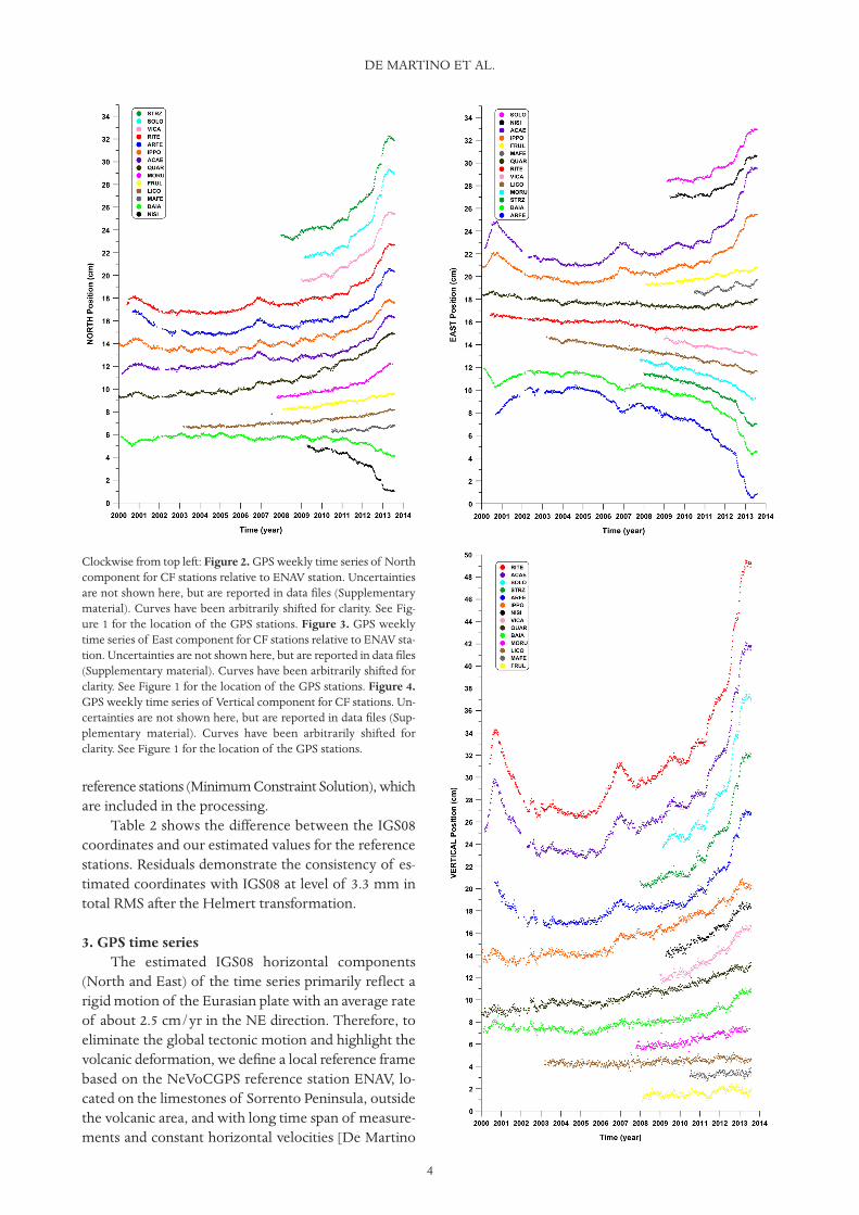
Clockwise from top left: Figure 2. GPS weekly time series of Northcomponent for CF stations relative to ENAV station. Uncertaintiesare not shown here, but are reported in data files (Supplementarymaterial). Curves have been arbitrarily shifted for clarity. See Fig-ure 1 for the location of the GPS stations. Figure 3. GPS weeklytime series of East component for CF stations relative to ENAV sta-tion. Uncertainties are not shown here, but are reported in data files(Supplementary material). Curves have been arbitrarily shifted forclarity. See Figure 1 for the location of the GPS stations. Figure 4.GPS weekly time series of Vertical component for CF stations. Un-certainties are not shown here, but are reported in data files (Sup-plementary material). Curves have been arbitrarily shifted forclarity. See Figure 1 for the location of the GPS stations.

5
et al. 2011, Tammaro et al. 2013]. We simply removethe ENAV horizontal GPS velocities (16.5 mm/yr and21.3 mm/yr, in the North and East component respec-tively) from all GPS time series of the CF area, whilethe vertical (Up) components were untouched.
The deformation signal does not have significantchanges on timescales shorter than a week, so we useweekly combined solutions. As an indicator of realis-tic uncertainties of the weekly positions, we use theRMS of daily solutions with respect to the weekly so-lution, the so-called repeatabilities [Steigenberger etal. 2012]. The mean RMS values are less than 1mmand 3 mm in the horizontal and vertical components,respectively.
Figures 2, 3 and 4 show the final GPS weekly posi-tion time series for the stations at CF from 2000 to July2013. In the Supplementary material, we report thecomplete archive in ASCII format of all the GPS timeseries used in this paper.
4. DiscussionGPS data at all the continuous recording stations
from 2000 to 2013 are shown in Figures 2, 3 and 4 dis-playing the whole evolution of the subsidence anduplift.
During this period, the RITE station, located at thecenter of Pozzuoli, has the largest associated uplift, ofabout 18.5 cm (Figure 5). The ACAE, ARFE, SOLO,STRZ stations (Figure 4), located within about 3 kmfrom RITE, have smaller vertical displacements from 6cm (ARFE) up to 17 cm (ACAE). The other stations, lo-cated over 3 km from RITE, have vertical displacementsfrom less than 1 cm (MAFE, FRUL) up to 6 cm (IPPO).Figures 2 and 3 show that the SOLO, ACAE, IPPO,FRUL and MAFE stations have horizontal displace-ments in NE direction. The RITE, VICA, LICO, MORU,STRZ and RITE sites have horizontal displacements inNW direction. NISI has a displacement towards SE andBAIA in SW direction. Only QUAR has a horizontal dis-placement mainly to North.
As mentioned in the introduction, CF are knownworldwide to be a site of notable slow vertical groundmovements (uplift and subsidence) and, as noted inseveral papers [e.g. De Natale and Pingue 1993, De Na-tale et al. 1997], the shape of vertical ground deforma-tion pattern is remarkably constant, independent fromthe total amount of displacement. This characteristicbehavior suggests that the position of the source is al-ways the same. The precise modeling of displacementsources generally requires a dense geodetic data sam-pling, therefore it is possible to use continuous GPSmeasurements to extract basic information aboutsource geometry and depth.
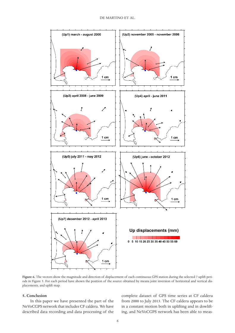
During period 2000-2013, we have identified, inthe RITE time series, 7 episodes of uplift with timespan greater than 0.23 years and/or a speed greaterthan 18 mm/yr. Figure 5 shows the horizontal dis-placements observed during the selected 7 uplift pe-riod. Simple geometrical considerations (crossingpoint of the displacement vectors for each uplift) sug-gest a stable source location. Therefore, for each upliftepisode, we jointly invert the horizontal and verticaldisplacements measured at GPS stations. We haveused dMODELS software package [Battaglia et al.2013a,b], which provides MATLAB functions andscripts to invert GPS data for spherical pressure sourcein a homogenous, isotropic, elastic, flat half-space.The seven sources obtained by the inversion results(0.4 < |2 <1.1) are concentrated in an area (South ofRITE station, Figure 6) of 130 × 260 m at depth rang-ing between 2400 and 3000 m.
Although the real conditions might be much morecomplex, it seems plausible to assume a constant posi-tion of the source of ground deformation. Neverthe-less, it is unequivocal that the location of the axis of thepressure source is remarkably constantly, although thesource depth and shape can change [De Natale andPingue 1993, De Natale et al. 1997]. Therefore, simula-tions with more complex sources in heterogeneousstructures are needed.
GPS TIME SERIES AT CAMPI FLEGREI
Figure 5. GPS weekly time series of Vertical component for stationRITE: (a) 2000-2006 time span; (b) 2007-2013 time span. The graybox indicate the selected seven uplift periods (Up1, Up2…,Up7).
5. ConclusionIn this paper we have presented the part of the
NeVoCGPS network that includes CF caldera. We havedescribed data recording and data processing of the
complete dataset of GPS time series at CF calderafrom 2000 to July 2013. The CF caldera appears to bein a constant motion both in uplifting and in dowlift-ing, and NeVoCGPS network has been able to meas-
DE MARTINO ET AL.
6
Figure 6. The vectors show the magnitude and direction of displacement of each continuous GPS station during the selected 7 uplift peri-ods in Figure 5. For each period have shown the position of the source obtained by means joint inversion of horizontal and vertical dis-placements, and uplift map.

7
ure uplift and subsidence during period 2000-2013.Simple geometrical considerations, and jointly in-
version of the horizontal and vertical displacementsmeasured at GPS stations seem to suggest a stablesource location during the time interval from 2000 to2013. Nevertheless, complex models with one or moresources and heterogeneous half-space are needed.
The complete dataset of GPS time series at CFarea from 2000 to July 2013 is reported in the Supple-mentary materials. These data can be useful for the sci-entific community in improving the research on CFcaldera dynamic and hazard assessment.
Acknowledgements. The authors thank Giuseppe Brandi,Andrea D’Alessandro, Mario Dolce, Santa Malaspina and ClaudioSerio, who have taken care of the maintenance of NeVoCGPS net-work. We are grateful to the Laboratorio di Geomatica e Car-tografia (INGV-OV) for providing the DTM (Digital Terrain Model)of the area. This research benefited from funding provided by theItalian Presidenza del Consiglio dei Ministri - Dipartimento dellaProtezione Civile (DPC). Scientific papers funded by the DPC donot represent its official opinions and policies.
ReferencesAltamimi, Z., X. Collilieux, J. Legrand, B. Garayt and
C. Boucher (2007). ITRF2005: A new release of theInternational Terrestrial Reference Frame based ontime series of station positions and Earth Orienta-tion Parameters, J. Geophys. Res., 112, B09401;doi:10.1029/2007JB004949.
Arienzo, I., A. Heumann, G. Wörner, L. Civetta and G.Orsi (2011). Processes and timescales of magmaevolution prior to the Campanian Ignimbrite erup-tion (Campi Flegrei, Italy), Earth and Planet. Sc.Lett., 306, 217-228; doi:10.1016/j.epsl.2011.04.002.
Barberi, F., G. Corrado, F. Innocenti and G. Luongo(1984). Phlegraean Fields 1982-1984: brief chronicleof a volcano emergency in a densely populated area,B. Volcanol., 47 (2), 175-185.
Battaglia, M., P.F. Cervelli and J.R. Murray (2013a).Modeling crustal deformation near active faults andvolcanic centers - A catalog of deformation models:U.S. Geological Survey Techniques and Methods,book 13, chap. B1, 96 pp.; http://pubs.usgs.gov/tm/13/b1.
Battaglia, M., P.F. Cervelli and J.R. Murray (2013b).dMODELS: A MATLAB software package for mod-eling crustal deformation near active faults and vol-canic centers, J. Volcanol. Geoth. Res., 254, 1-4, ISSN0377-0273; http://dx.doi.org/10.1016/j.jvolgeores.2012.12.018.
Berrino, G., G. Corrado, G. Luongo and B. Toro (1984).Ground deformation and gravity change accompa-nying the 1982 Pozzuoli uplift, B. Volcanol., 47 (2),187-200.
Bottiglieri, M., M. Falanga, U. Tammaro, P. De Martino,F. Obrizzo, C. Godano and F. Pingue (2010). Char-acterization of GPS time series at Neapolitan vol-canic area by statistical analysis, J. Geophys. Res.,115, B10416; doi:10.1029/2009JB006594.
Corrado, G., I. Guerra, A. Lo Bascio, G. Luongo and F.Rampoldi (1977). Inflation and microearthquake ac-tivity of Phegraean Fields, Italy, B. Volcanol., 40 (3),169-188.
Dach, R., U. Hugentobler, P. Fridez and M. Meindl(2007). Bernese GPS Software version 5.0, Astro-nomical Institute, University of Bern, Switzerland.
Deino, A.L., G. Orsi, S. de Vita and M. Piochi (2004).The age of the Neapolitan Yellow Tuff caldera-forming eruption (Campi Flegrei caldera - Italy) as-sessed by 40Ar/39Ar dating method, J. Volcanol.Geoth. Res., 133, 157-170; doi:10.1016/S0377-0273(03)00396-2.
Del Gaudio, C., I. Aquino, G.P. Ricciardi, C. Ricco andR. Scandone (2010). Unrest episodes at Campi Fle-grei: a reconstruction of vertical ground movementsduring 1905-2009, J. Volcanol. Geoth. Res., 185, 48-56.
De Martino, P., U. Tammaro, F. Obrizzo, V. Sepe, G.Brandi, A. D’Alessandro, M. Dolce and F. Pingue(2011). La rete GPS dell’isola d’Ischia: deformazionidel suolo in un’area vulcanica attiva (1998-2010),Quaderni di Geofisica, 95, 59 pp., ISSN 1590-2595.
De Natale, G., F. Pingue, P. Allard and A. Zollo (1991).Geophysical and geochemical modelling of the 1982-1984 unrest phenomena at Campi Flegrei caldera,southern Italy, J. Volcanol. Geoth. Res., 48, 199-222.
De Natale, G., and F. Pingue (1993). Ground deforma-tions in collapsed caldera structures, J. Volcanol.Geoth. Res., 57, 19-38.
De Natale, G., S.M. Petrazzuoli and F. Pingue (1997).The effect of collapse structures on ground defor-mations in calderas, Geophys. Res. Lett., 24, 1555-1558.
Di Vito, M.A., L. Lirer, G. Mastrolorenzo and G.Rolandi (1987). The Monte Nuovo eruption CampiFlegrei, Italy, B. Volcanol., 49, 608-615.
Dow, J.M., R.E. Neilan and C. Rizos (2009). The Inter-national GNSS Service in a changing landscape ofGlobal Navigation Satellite Systems, J. Geodesy, 83,191-198; doi:10.1007/s00190-008-0300-3.
Estey, L., and C. Meertens (1999). TEQC: The Multi-Purpose Toolkit for GPS/GLONASS Data, GPS So-lutions, 3 (1), 42-49.
Fedele, L., L. Scarpati, M. Lanphere, L. Melluso, V. Mor-ra, A. Perrotta and G. Ricci (2008). The Breccia Museoformation, Campi Flegrei, southern Italy: geochro-nology, chemostratigraphy and relationship withthe Campanian Ignimbrite eruption, B. Volcanol.,
GPS TIME SERIES AT CAMPI FLEGREI
70, 1189-1219.Finetti, I., and A. Del Ben (1986). Geophysical study of
the Tyrrhenian opening, B. Geofis. Teor. Appl., 27,74-115.
Günther, R.T. (1903). Contribution to the study of earthmovements in the Bay of Naples, Oxford.
Isaia, R., P. Marianelli and A. Sbrana (2009). Caldera un-rest prior to intense volcanism in Campi Flegrei(Italy) at 4.0 ka B.P.: implications for caldera dy-namics and future eruptive scenarios, Geophys. Res.Lett., 36, L21303; doi:10.1029/2009GL040513.
Luongo, G., E. Cubellis, F. Obrizzo and S.M. Petraz-zuoli (1991a). A physical model for the origin of vol-canism of the Tyrrhenian margin: the case of theneapolitan area, J. Volcanol. Geoth. Res., 48, 173-185.
Luongo, G., E. Cubellis, F. Obrizzo and S.M. Petraz-zuoli (1991b). The mechanics of the Campi Flegreiresurgent caldera - a model, J. Volcanol. Geoth. Res.,45, 161-172.
Mervart, L., G. Beutler, M. Rothacher and U. Wild(1994). Ambiguity resolution strategies using the re-sults of the International GPS Geodynamics Serv-ice (IGS), B. Geod., 68, 29-38.
Morhange, C., M. Bourcier, J. Laborel, C. Giallanella,J.P. Goiran, L. Crimaco and L. Vecchi (1999). Newdata on historical relative sealevel movements inPozzuoli, Phlaegrean Fields, Southern Italy, Phys.Chem. Earth (part A), 24, 349-354.
Morhange, C., N. Marriner, J. Laborel, M. Todesco andC. Oberlin (2006). Rapid sea-level movements andnon eruptive crustal deformations in the PhlegreanFields caldera, Italy, Geology, 34, 93-96; doi:10.1130/G21894.1.
Niell, A.E. (1996). Global mapping functions for the at-mosphere delay at radio wavelength, J. Geophys.Res. Solid Earth, 101 (B2), 3227-3246.
Parascandola, A. (1947). I Fenomeni Bradisismici delSerapeo di Pozzuoli, Stabilimento Tipografico G.Genovese, Naples.
Patacca, E., and P. Scandone (2007). Geology of theSouthern Apennines, B. Soc. Geol. Ital., 7, 75-119.
Rebischung, P., J. Griffiths, J. Ray, R. Schmid, X. Collilieuxand B. Garayt (2012). IGS08: the IGS realization ofITRF2008, GPS Solutions, 1-12; doi:10.1007/s10291-011-0248-2.
Ricci, T., F. Barberi, M.S. Davis, R. Isaia and R. Nave(2013). Volcanic risk perception in the Campi Fle-grei area, J. Volcanol. Geoth. Res., 254, 118-130;doi:10.1016/j.jvolgeores.2013.01.002.
Rosi, M., and A. Sbrana (1987). Phlegraean Fields, Qua-derni de “La Ricerca Scientifica”, CNR, Roma, 114,114-175.
Schmid, R., P. Steigenberger, G. Gendt, M. Ge and M.
Rothacher (2007). Generation of a consistent ab-solute phase center correction model for GPS re-ceiver and satellite antennas, J. Geodesy, 81 (12),781-798; doi:10.1007/s00190-007-0148-y.
Steigenberger, P., M. Rothacher, R. Dietrich, M. Fritsche,A. Rulke and S. Vey (2006). Reprocessing of a globalGPS network, J. Geophys. Res., 111, B050402; doi:10.1029/2005JB003747.
Steigenberger, P., M. Seitz, S. Bockmann, V. Tesmer andU. Hugentobler (2012). Precision and Accuracy ofGPS-derived Station Displacements, Phys. Chem.Earth, 53/54, 72-79; doi:10.1016/j.pce.2010.07.035
Tammaro, U., P. De Martino, F. Obrizzo, G. Brandi, A.D’Alessandro, M. Dolce, S. Malaspina, C. Serio andF. Pingue (2013). Somma Vesuvius volcano: grounddeformations from CGPS observations (2001-2012),Annals of Geophysics, 56 (4), S0456; doi:10.4401/ag-6462.
Troise, C., G. De Natale, F. Pingue, F. Obrizzo, P. DeMartino, U. Tammaro and E. Boschi (2007). Renewedground uplift at Campi Flegrei caldera (Italy): Newinsight on magmatic processes and forecast, Geo-phys. Res. Lett., 34, L03301; doi:10.1029/2006GL028545, ISSN 0094-8276.
Vezzani, L., A. Festa and F. Ghisetti (2010). Geology andTectonic Evolution of the Central-Southern Apen-nines, Italy, Geological Society of America, SpecialPaper 469, 1-58.
Vilardo, G., R. Isaia, G. Ventura, P. De Martino and C.Terranova (2010). InSAR Permanent Scatterer analy-sis reveals fault re-activation during inflation and de-flation episodes at Campi Flegrei caldera, RemoteSens. Environ., 114, 2373-2383; doi:10.1016/j.rse.2010.05.014.
*Corresponding author: Prospero De Martino,Istituto Nazionale di Geofisica e Vulcanologia, Sezione di Napoli,Osservatorio Vesuviano, Naples, Italy;email: [email protected].
© 2014 by the Istituto Nazionale di Geofisica e Vulcanologia. Allrights reserved.
DE MARTINO ET AL.
8