great otway national park ‒ anglesea, aireys inlet and surrounds · 2019-07-12 · sea of...
TRANSCRIPT

Parks Victoria Phone 13 1963 www.parks.vic.gov.au
Getting there Great Otway National Park is south of Melbourne via Geelong or Colac. Approach Anglesea and Aireys Inlet along the Great Ocean Road by taking either Anglesea Road or Surf Coast Highway from Geelong.
From the west, pick up the Great Ocean Road by approaching via Port Campbell.
A daily bus service between Geelong, Lorne and Apollo Bay connects with train services to Melbourne.
Things to see and do
Walking and bike riding
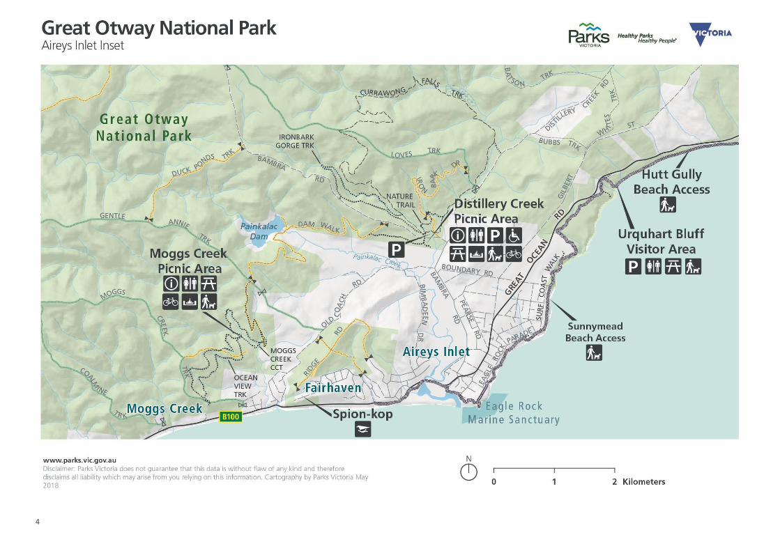
Shared pathways provide many opportunities for walking and bike riding in this section of Great Otway National Park. The Eumeralla area and Distillery Creek Picnic Area are now trailheads.
Distillery Creek Nature Trail – 1.5km, 30 minutes circuit (with a shared cycle trail section, see map)
This short nature walk features a diversity of plant and animal life in ironbark forest and along Distillery Creek. It’s a great family friendly walk with seats and interpretative signs along the way to rest and take in the environment.
The final section of this loop walk is shared with Currawong Falls Track bike riders. Take care.
Currawong Falls – 12km, 4 hours circuit, shared trail with cyclists
Starting from Distillery Creek Picnic Area, this invigorating walk or cycle trail takes in great views of Currawong Falls, which are at their best during or after heavy rain.
When riding your bike be sure to take care and look out for wildlife, other trail users, and to ride the track in a clockwise direction.
There are some steep rocky sections along this walk. Take care.
Surf Coast Walk, Ironbark Basin to Anglesea – 9.7km, 3.5 hours one way
Walk along Ironbark Track toward the coast, through to Point Addis Road then down onto Red Rocks Beach before climbing inland to the spectacular cliff tops and wind-swept heathlands as the Anglesea township comes into view. Visit www.surfcoastwalk.com.au
This track has some steep sections. Take care on steep sections.
Moggs Creek Nature Walk – 2km, 30 minutes circuit
A short walk rich in birdlife which follows the creek across several small wooden bridges. This trail also explores some of Victoria’s incredible array of beautiful indigenous plant and animal life.
Ocean View Circuit Walk – 4.5km, 2 hours return
Beginning from Moggs Creek Picnic Area, there are some steep sections along this walk though dry woodland and coastal heathland spring wildflowers. Walkers are further rewarded by spectacular coastal views to the Split Point Lighthouse, the Fairhaven and Eastern View beaches.
Spring wildflowers
The heathlands around Anglesea are the richest and most diverse vegetation community in Victoria. Discover them for yourself.
Spring time is particularly spectacular as the heathland erupts into a sea of vibrant colour.
Swimming and surfing
Swimming is very popular at beaches along the coastline, however many beaches and rivers are exposed to unseen dangers such as currents, rips, reefs and logs. Beaches are not patrolled within Great Otway National Park and Parks Victoria recommends swimming only at beaches patrolled by lifesaving services.
Beaches are patrolled by lifesavers when red and yellow flags are displayed.
Surfers frequent a variety of beaches along this coastline including the world-famous Bells Beach and Addiscot Beach.
Point Addis Marine National Park, Bells Beach and Southside Beach
Point Addis Marine National Park has spectacular scenery with wide sandy beaches that lead to a staggering diversity of marine life along the park’s coast and outer reefs. In between lies world-class surfing site Bells Beach and great opportunities to explore rock pools at low tide. Please note, there is a section of Southside Beach that is clothing optional as indicated by signs.
Diving, snorkelling and rock pool exploration
In calm weather conditions Jarosite and Ingoldsby Reef in Point Addis Marine National Park can provide good places to explore our unique local marine life. Visitors can explore rock pools at low tide, or delve into the magnificent underwater world by diving or snorkelling. Ensure you prepare and observe weather forecasts.
Great Otway National Park ‒ Anglesea, Aireys Inlet and surrounds Visitor Guide
The easternmost tip of Great Otway National Park is packed with and flanked by not-to-miss locations, such as iconic surf venue Bells Beach and Point Addis Marine National Park. Surfing, diving, snorkelling, bike riding, plant and bird viewing here are all world-class. Amazingly, about a quarter of Victoria’s plant species are represented here, including more than 80 native orchid species.

2
Addiscot Beach at Point Addis is another fantastic location for rock pooling at low tide.
Camping and accommodation
The villages of Anglesea and Aireys Inlet provide an abundance of accommodation, caravan parks and campgrounds.
Hammond Road Camping Area
Managed by Parks Victoria, Hammond Road Camping Area is located 12km inland from Aireys Inlet in a natural bush setting.
Bookings and fees are not required as camping is on a first in, first served basis. There are 20 campsites available.
All campsites are unpowered and will accommodate one vehicle. Sites 1-4 are suitable for caravans and campervans and direct vehicle access is available to these sites. Sites 5-10 are suitable for tents only with a parking area situated close by.
Non-flush toilets, car parking, shared picnic tables and fireplaces are available. Campfires are only allowed in fireplaces provided. Fuel stoves or gas barbecues are preferred for cooking. Bring your own drinking water and supply your own firewood.
Fishing
The coastline, as well as a number of streams and rivers which flow through the parks, provide great opportunities for keen anglers.
Fishing is not permitted in marine national parks and sanctuaries. Check separate marine visitor guides for activity/boundary guidelines as some beaches are excluded from marine parks.
Adults generally require a Victorian Recreational Fishing Licence, available from the Victorian Fisheries Authority online at www.vfa.vic.gov.au, or your local fishing licence outlet.
Picnicking
Moggs Creek Picnic Area
Moggs Creek is one of the many beautiful places in the park to picnic and features reasonably flat ground in a natural setting.
At the end of Ocean View Walk there is a magnificent vista from the lookout over the Great Ocean Road, Fairhaven and the ocean.
Distillery Creek Picnic Area
A great spot to picnic, with wood barbecues, tables and flushing toilets available. This is a trailhead for cycling and walking tracks.
Horse riding
A range of roads and tracks are available for horse riding in Great Otway National Park and Otway Forest Park.
For more information on horse riding and for seasonal road closures that may affect horse riding, see the Horse Riding in the Otways Parks Fact Sheet at www.parks.vic.gov.au
Four wheel driving and trail bike riding
Riders and licenced drivers with registered vehicles will find a range of formed tracks and roads on offer throughout the parks.
Seasonal track closures apply to many tracks in Great Otway National Park. For more information go to www.parks.vic.gov.au
Remember to always stay on the tracks and avoid muddy areas to reduce damage to the environment. Be considerate and slow down or stop for horse riders, cyclists or hikers.
Be sure to plan your driving and trail riding tour routes using detailed topographical maps. Check the Parks Victoria website for the latest track conditions and seasonal road closures at www.parks.vic.gov.au
Hang gliding
For the professional and skilled operator, take the views to the next level with a hang glide from launch points at Jarosite, Spion-kop or Southside. A special licence is required to launch from Spion-kop.
Dogs in the national park
Australia is home to a unique variety of flora and fauna and we ask all park visitors to follow directions specifying where you can walk your dog in the park.
Some areas of the park where dogs are permitted on-lead include:
Ironbark Basin Picnic Area; Southside Beach; Addiscot Beach; Point Addis to Anglesea via beach and Surf Coast Walk; Ironbark Gorge Walking Track; and, Ocean View Walking Track.
Dogs are also permitted off-lead along the beach between O’Donohue Road and Urquhart Bluff. Please ensure your dog is kept on a lead in the car parks and along the beach access tracks of these sites. During summer, there is a section of Urquhart Bluff beach that is dogs-on-leads at all times.
For further information see the Dogs in the Otways Fact Sheet.
Exploring the history Through their rich and diverse culture, Aboriginal people have been intrinsically connected to Country across this area of western Victoria for tens of thousands of years.
Following European settlement, the Otway forests saw a long logging history and were a timber source for more than 150 years. Timber production peaked in 1961 and ceased in 2008.
Great Otway National Park has been established for the protection and preservation of the natural values of the area. The Otway Forest Park offers a range of activities in less sensitive areas.
A permit system in designated areas of Otway Forest Park allows for timber and other forest produce (such as seeds and foliage) to be collected for firewood, posts, poles and decorative products.
Contact DELWP on 13 3186 for further information, relevant maps, permits and resources.
Be prepared and stay safe Great Otway National Park is in the South West and Central fire district. Bushfire and severe weather safety is a personal responsibility. Anyone entering parks and forests during the bushfire season or severe weather, such as strong winds, needs to stay aware of forecast weather conditions.
Check the Fire Danger Rating and for days of Total Fire Ban at www.emergency.vic.gov.au, on the VicEmergency smartphone app or call the VicEmergency Hotline on 1800 226 226. No fires may be lit on Total Fire Ban days. However, gas stoves may be used under certain conditions for food preparation.
Be aware that strong winds can occur anytime, which can be hazardous with falling timbers on walking tracks.
On Code Red Fire Danger Rating days and days of severe weather this park will be closed for public safety. Closure signs will be erected in some locations but do not expect an official warning. Check the latest conditions at www.parks.vic.gov.au or by calling 13 1963.
For emergency assistance call Triple Zero (000). If there is a green emergency marker sign near you, read the information on the marker to the operator.
May 15, 2018

3
4