gridded population workshop: new york: may 2000 high resolution and local scale: national population...
TRANSCRIPT

Gridded Population Workshop: New York: May 2000
High resolution and local scale: national population surface models from the UK Censuses
David Martin
Department of Geography
University of Southampton

Gridded Population Workshop: New York: May 2000
High resolution and local scale: overview UK data context 1971-2001 Need for non-zonal representations Redistribution model Implementation Applications Future directions Key references

Gridded Population Workshop: New York: May 2000
UK data context 1971-2001
Basic spatial unit for census output: enumeration district (ED) mean c. 400 population
100m population-weighted centroid 1991- improved spatial resolution and
(imperfect) link to postal centroids no cadastral mapping, no large-scale
digital land use mapping

Gridded Population Workshop: New York: May 2000
Need for non-zonal representations Wide variations in ED size and shape Space-filling, hence including extensive
unpopulated areas Large-scale redefinition of EDs (68%
1981-91)

Gridded Population Workshop: New York: May 2000
Redistribution model (1: basics)
Population-weighted centroid(s) as summary points of local distribution
Locally adaptive kernel estimation based on inter-centroid distances
Redistribution of centroid counts into grid: spatially discontinuous model
Various derivatives, including constraint to zone boundaries (1991- only)

Gridded Population Workshop: New York: May 2000
Redistribution model (2: function)
22
22
ij
ijij
dk
dkw
Weighting
Distance
wij
dij k

Gridded Population Workshop: New York: May 2000
Redistribution model (3: example)Centroids and boundaries Gridded population model

Gridded Population Workshop: New York: May 2000
Implementation (1: data)
10/100m ED centroids and counts 200m grid 250m initial search radius simple distance decay model no ED boundaries national models (c 155,000 centroids) FORTRAN now, Visual Basic to follow...

Gridded Population Workshop: New York: May 2000
Implementation (2: example)
300 x 300 km extract from national population model of UK based on 1991 Census

Gridded Population Workshop: New York: May 2000
Implementation (3: extensions)
Reallocate ED data onto 100m postcode locations in proportion to household counts, (c. 15 postcodes per ED)
Constraint to zone boundaries where available - preserves zonal populations (at grid resolution)

Gridded Population Workshop: New York: May 2000
Applications (1: examples)
Ancillary layer in urban satellite image interpretation (eg. Mesev et al, 1995)
Population base for distance-sensitive applications (eg. Lovett et al, 1997)
Basis for intercensal comparison (eg. Bracken and Martin, 1995)
Non-UK data with no boundaries
Gridded Population Workshop: New York: May 2000
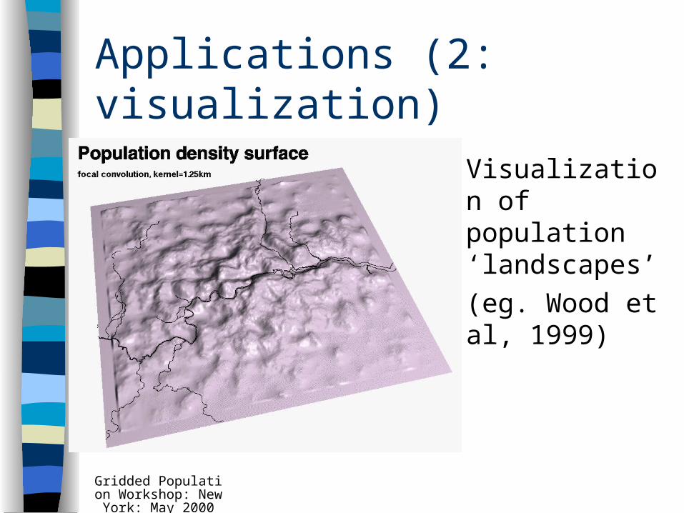
Applications (2: visualization)
Visualization of population ‘landscapes’
(eg. Wood et al, 1999)

Gridded Population Workshop: New York: May 2000
Applications (3: distance models)
East Anglia population model for modelling predicted visitor rate function
(eg. Brainard et al, 1997)
Gridded Population Workshop: New York: May 2000
Future directions
2001: Census design using GIS 2001: new, smaller output areas,
stronger link to postal geography Potential for error estimation and model
calibration from sub-threshold census data
International applications? (eg. Australia)

Gridded Population Workshop: New York: May 2000
Key references
Martin, D. (1989) Transactions IBG Bracken, I. and Martin, D. (1995) E&P a Martin, D. (1996) IJGIS http://census.ac.uk/cdu/surpop