groundwater quality protection practices - teaching and learning
TRANSCRIPT


GROUNDWATER QUALITY
PROTECTION PRACTICES
Submitted to:
Environment Canada224 West Esplanade
North Vancouver, B.C.V7M 3H7

- i -
TABLE OF CONTENTS
SECTION PAGE
ACKNOWLEDGMENTS............................................................................................. v
EXECUTIVE SUMMARY..........................................................................................vi
1.0 INTRODUCTION............................................................................................. 1
2.0 GROUNDWATER RESOURCES WITHIN THE FRASER BASIN................. 32.1 Lower Fraser Region..............................................................................32.2 Thompson Region.................................................................................. 42.3 Middle Fraser Region.............................................................................52.4 Upper Fraser Region ..............................................................................5
3.0 COMMON SOURCES OF GROUNDWATER CONTAMINATION ...............63.1 Category 1 - Sources Designed to Discharge Substances........................ 63.2 Category 2 - Sources Designed to Store Substances ............................... 63.3 Category 3 - Transport or Transmission Sources ....................................73.4 Category 4 - Sources Discharging Substances as a Consequence of
Other Planned Activities ........................................................................73.5 Category 5 - Naturally Occurring Sources Affected by Human Activity 8
4.0 GROUNDWATER PROTECTION MEASURES .............................................94.1 Non-Regulatory Groundwater Protection Measures.............................. 10
4.1.1 Public Involvement .................................................................. 104.1.2 Wellhead Protection Area Delineation...................................... 144.1.3 Vulnerability Mapping ............................................................. 154.1.4 Aquifer Classification............................................................... 174.1.5 Contaminant Inventory ............................................................. 174.1.6 Well Inventory ......................................................................... 194.1.7 Groundwater Monitoring .......................................................... 194.1.8 Spill Response Planning ........................................................... 204.1.9 Contingency Plans.................................................................... 214.1.10 Hazardous Waste Collection..................................................... 224.1.11 Technical Assistance ................................................................ 234.1.12 Land Acquisition...................................................................... 234.1.13 Purchase of Development Rights .............................................. 244.1.14 Conservation Easements ........................................................... 244.1.15 Cluster Development ................................................................ 25
4.2 Groundwater Protection Measures That May Be ImplementedThrough Either Regulatory or Non-Regulatory Means ......................... 25

- ii -
4.2.1 Storm Water and Sewage Control............................................. 254.2.2 Septic System Controls............................................................. 274.2.3 Agricultural Controls................................................................ 284.2.4 Roadsalt ................................................................................... 314.2.5 Transportation Controls............................................................ 314.2.6 Well Drilling and Abandonment............................................... 324.2.7 Geotechnical Controls .............................................................. 334.2.8 Forest Management .................................................................. 334.2.9 Market Approaches .................................................................. 344.2.10 Groundwater Quality Guidelines and Regulations .................... 35
4.3 Regulatory Groundwater Protection Measures ..................................... 354.3.1 Zoning...................................................................................... 354.3.2 Facility Siting, Design and Operation Controls......................... 364.3.3 Hazardous Materials Restrictions.............................................. 374.3.4 Underground Storage Tanks (USTs) and Pipelines ................... 374.3.5 Above Ground Storage Tanks................................................... 384.3.6 Sand and Gravel Mining........................................................... 394.3.7 Permitting ................................................................................ 394.3.8 Inspection and Compliance....................................................... 40
5.0 IMPLEMENTATION OF A GROUNDWATER PROTECTION PLAN ........ 415.1 Define Goals and Objectives ................................................................ 415.2 Identify Planning Team........................................................................ 425.3 Evaluate Existing and Future Groundwater Supply Requirements........ 425.4 Assess Available Geological, Hydrogeological and Geotechnical
Information and Delineate Groundwater Protection Area ..................... 425.5 Carry Out a Contaminant Inventory and Assess the Results ................. 445.6 Select Appropriate Groundwater Protection Measures.......................... 445.7 Design and Implement a Groundwater Monitoring Program ................ 455.8 Draw up Spill Response and Contingency Plans................................... 455.9 Secure Funding .................................................................................... 465.10 Public Education and Participation....................................................... 465.11 Implement Groundwater Protection Plan.............................................. 465.12 Summary ............................................................................................. 47
GLOSSARY 48

- iii -
TABLE 1 Common Sources of Groundwater ContaminationTABLE 2 Common Sources of Groundwater Contamination Listed AlphabeticallyTABLE 3 Use of Non-Regulatory Groundwater Protection MeasuresTABLE 4 Evaluation of Non-Regulatory Groundwater Protection MeasuresTABLE 5 Advantages and Disadvantages of Methods for Wellhead Protection AreasTABLE 6 Use of Groundwater Protection Measures That Could be Implemented Through
Either Regulatory or Non-Regulatory MeansTABLE 7 Evaluation of Groundwater Protection Measures That Could be Implemented
Through Either Regulatory or Non-Regulatory MeansTABLE 8 Use of Regulatory Groundwater Protection MeasuresTABLE 9 Evaluation of Regulatory Groundwater Protection MeasuresTABLE 10 Detailed Summary of Groundwater Protection Measures
FIGURE 1 Fraser River BasinFIGURE 2 Groundwater ContaminationFIGURE 3 Public Information Paper for Amherst, Nova ScotiaFIGURE 4 Public Information Brochure Published by the City of Renton, WashingtonFIGURE 5 Public Information Brochure Published by the Department of Environment,
NewfoundlandFIGURE 6 Brochure for Home-A-Syst (Public Education) Program sponsored by the
Cooperative Extension of Washington State University, 1995FIGURE 7 Public Support for Groundwater ProtectionFIGURE 8 Wellhead Protection Area DelineationFIGURE 9 Wellhead Protection Area Delineation Using “Simplified Variable Shapes” MethodFIGURE 10 Wellhead Protection Area Delineation Using Analytical ModelsFIGURE 11 Wellhead Protection Area Delineation Using Hydrogeological MappingFIGURE 12 Wellhead Protection Area Delineation Using Numerical Flow ModelsFIGURE 13 Predicted Travel Times and Proposed Protection Areas for the South Fredericton
Aquifer, New BrunswickFIGURE 14 Groundwater Sensitivity Map, Regina Regional Aquifers, SaskatchewanFIGURE 15 Hydrogeological Fence Diagram, Township 7, Surrey and Langley District
Municipalities, British ColumbiaFIGURE 16 Sample Contaminant Inventory Form Published by Washington State Department of
HealthFIGURE 17 Designated Transportation Routes for South Fredericton, New BrunswickFIGURE 18 Steps in the Development of a Groundwater Protection Plan

- iv -
APPENDIX I Objectives, Methodology and ApproachAPPENDIX II Overview of Groundwater Protection PracticesAPPENDIX III Selected Groundwater Protection PlansAPPENDIX IV Groundwater Protection Measures Compiled by OthersAPPENDIX V Database Containing Reference Documents
- v -
ACKNOWLEDGMENTS
Preparation of this report was carried out by Golder Associates Ltd. on behalf ofEnvironment Canada. The primary goal of the study was to review the applicability ofgroundwater protection practices developed within other jurisdictions to the Fraser RiverBasin. The study recommends strategies for potential application in the Fraser RiverBasin to support or supplement proposed groundwater quality protection legislation.Project funding was provided by the Fraser River Action Plan (Greenplan).

- vi -
EXECUTIVE SUMMARY
Groundwater is an essential and vital natural resource of British Columbia. It is the solesource of drinking water for over 20 percent of the province and plays a crucial role inthe maintenance of many ecosystems within the province by providing a source ofrecharge to surface waters. In recent years, British Columbia’s groundwater resourceshave come under increasing threat of contamination from a variety of sources, includingagricultural activities, land application of wastes, septic systems, municipal landfills,leaking underground storage tanks and industrial activities. Once contaminated,groundwater is exceedingly difficult, and sometimes impossible, to restore and the costsof developing alternative supplies are high.
The key to ensuring a safe groundwater supply is to prevent contamination fromoccurring in the first place through the implementation of groundwater protectionmeasures. To address this issue, a review of protection measures used in juristictionsoutside of British Columbia was carried out in order to identify those measures that couldbe applicable to the Fraser Basin. The review indicated that other juristictions, includingEurope and the United States, have federal and state legislation requiring groundwaterprotection, while in Canada, there are relatively few controls and programs to protect thisresource. The study also indicated that while federal and provincial or state initiativesoffer a degree of groundwater protection, the most effective means of protection occursat the municipal level through the implementation of site-specific groundwater protectionplans.
Groundwater protection can be implemented through either regulatory or non-regulatorymechanisms. A traditional form of regulatory control is the use of zoning to regulateland use activities in sensitive areas such as lands in the immediate vicinity of watersupply wells, or in groundwater recharge areas. An innovative approach to zoning thathas been implemented in Dayton, Ohio and other regions is the control of types andquantities of hazardous materials rather than restrictions on land use. The reviewindicated that grandfathering, whereby non-complying uses are permitted to continuewithout restrictions or conditions, is not an acceptable approach.
Numerous groundwater protection measures can be implemented through non-regulatorymeans. Public participation and education are among the most important non-regulatoryprotection measures. They are essential to the success of a groundwater protection planand provide a means of obtaining political and financial support. Another form of non-regulatory protection is the training of building inspectors to identify abandoned waterwells that may serve as pathways for contamination to migrate to underlying aquifers.Another means of non-regulatory protection is the implementation of a spill responseprogram, whereby addresses within a groundwater protection area are flagged in the 911

- vii -
system so that the 911 operator will be alerted that the location of the call is within anarea of public water supply concern.
One form of non-regulatory groundwater protection that offers a high degree ofprotection is the aquisition of lands within a sensitive zone, as was carried out inAmherst, Nova Scotia. Land aquisition is also a common approach to groundwaterprotection in Prince Edward Island, where some communities have purchased landswithin sensitive zones and then leased the lands back to the owners.
Groundwater protection plans may be adopted for a wellfield, an aquifer, or a group ofaquifers. They should be tailored to the needs of a municipality based on localhydrogeological conditions, land uses, and political and economic conditions.Municipalities are best suited to develop their own groundwater protection plans withinput from provincial and federal governments and groundwater consultants. Ten stepsthat should be followed for the development of a groundwater protection plan areoutlined below:
1. Define goals and objectives for the plan.
2. Identify a planning team.
3. Evaluate existing and future groundwater supply requirements versus alternativesources.
4. Assess available geological, hydrogeological and geotechnical information anddelineate groundwater protection area.
5. Carry out a contaminant inventory and assess the results.
6. Select appropriate groundwater protection measures.
7. Design and implement a groundwater monitoring program.
8. Draw up spill response and contingency plans.
9. Secure funding.
10. Implement the groundwater protection plan.
The review concluded that the Fraser Basin is well suited to the implementation ofgroundwater protection plans managed at the municipal level. Provided the above steps

- viii -
are followed, the implementation of a protection plan will help a community to ensure aclean, economical source of groundwater for years to come.

- 1 -
1.0 INTRODUCTION
Groundwater is an important yet vulnerable resource of the province of British
Columbia. It is the sole source of drinking water for 22 percent of British Columbia’s
total population and 40 percent of B.C.’s rural population, and accounts for 12 percent of
the total water consumption in the province and 22 percent of all groundwater developed
in Canada. In many areas of the province, groundwater represents the only viable and
economic source of water supply and as a result its use is expected to increase over the
coming years, particularly outside of the major metropolitan centres. In addition to
providing a vital source of public water supply, groundwater plays an essential role in the
maintenance of ecosystems by providing a source of recharge to wetlands, streams and
lakes.
In recent years, British Columbia’s groundwater resources have come under increasing
threats from contamination. Some of the more accessible and economic groundwater
resources in British Columbia are also derived from unconfined aquifers which are more
vulnerable to pollutants arising from a variety of sources including agricultural activities,
land application of wastes, septic systems, municipal landfills, leaking underground
storage tanks and industrial activities. In most instances, groundwater contamination is
discovered only after a water-supply well has been affected. Once contaminated,
remediation of groundwater is a very costly and lengthy process, and often by the time
the pollution is identified, the aquifer is damaged beyond repair. In cases where
groundwater supplies have been lost through contamination, the costs of remediation
and/or development of alternative water supplies have been estimated to be on the order
of $10,000 to $50,000 per household (Reference #301). Furthermore, the effects of
groundwater contamination do not end with the loss of well-water supplies. Surface
waters in wetlands, streams and lakes that are receptors of groundwater discharge are
subject to pollution by contaminated groundwater.
The most cost-effective means of ensuring a safe groundwater supply is to prevent
groundwater contamination from occurring in the first place. This can be accomplished
by implementing groundwater quality protection measures. Protection measures offer a
means of managing a land area around an individual well field or above an entire aquifer
to prevent groundwater contamination. Such measures provide a way of ensuring a safe

- 2 -
groundwater supply and avoiding the costs of installing treatment facilities or locating an
alternative source should the groundwater become contaminated. Although federal and
provincial initiatives can provide a level of groundwater protection, the most effective
means of groundwater protection occurs at municipal levels through the implementation
of site-specific groundwater quality protection plans. Each municipality can best
determine how to develop its own groundwater protection program based on the local
hydrogeological conditions, land uses, and political and economic conditions. The
objective of this report is to provide guidance to municipalities located within the Fraser
Basin for the implementation of groundwater quality protection plans.
The report is presented in five chapters and five appendices. Background information on
groundwater resources within the Fraser Basin is presented in Chapter 2. A discussion of
common sources of groundwater contamination is presented in Chapter 3. Chapter 4
presents a review of groundwater quality protection measures that could be implemented
at municipal levels through either regulatory or non-regulatory means. Chapter 5
outlines the steps involved in the development of a municipal groundwater quality
protection plan. Groundwater protection measures recommended in this report were
developed based on a review of groundwater quality protection practices used in
jurisdictions outside of British Columbia, including the United States, Europe, Australia,
Barbados and the nine other Canadian provinces. An outline of the methodology used
for the compilation and review of this information is provided in Appendix I. Appendix
II presents an overview of groundwater quality protection practices in western developed
nations. Appendix III presents a detailed evaluation of nine selected groundwater
protection plans that have been implemented at a municipal level. Summaries of
groundwater protection practices compiled by others are provided in Appendix IV. All
documents reviewed for the preparation of this report were organized into a project data
base under a document reference number. The data base is presented in Appendix V.

- 3 -
2.0 GROUNDWATER RESOURCES WITHIN THE FRASER BASIN
The Fraser Basin consists of the land drained by the Fraser River and its tributaries.
From its headwaters in the Rocky Mountains, the Fraser River flows 1375 km to its delta
on the Strait of Georgia, draining more than a quarter of the province (Figure 1). The
Fraser Basin is the heartland of British Columbia. It is home to 2 million people, or
60 percent of the province’s population, and accounts for 80 percent of the gross
provincial product. It is the source of almost half the productive forests and farmland,
and two thirds of tourism revenue, metal mine production and sockeye and pink salmon
catch. Most manufacturing, construction and service industries are located in the Basin.
The Fraser and the Thompson Rivers serve as major transportation corridors between the
West Coast and the rest of Canada (Reference #302).
The Fraser Basin is divided into four regions: Lower, Thompson, Middle and Upper. A
description of the groundwater resources in each of these four regions is described below.
2.1 Lower Fraser Region
The Lower Fraser Region begins at its eastern limit at the city of Hope and includes the
Fraser Valley to the west and Greater Vancouver at the Pacific coast. The Fraser Valley,
including the communities of Chilliwack, Abbotsford, Langley and Richmond, is a
predominantly rural area characterized by agricultural land use. However, in recent
years, the area has undergone rapid urbanization due to its proximity to Greater
Vancouver. Commercial fisheries are important throughout the Lower Fraser, and
forestry is particularly significant in the vicinity of Hope, Kent, Harrison and Mission
(Reference #302).
A recent pilot study carried out by the British Columbia Ministry of Environment, Lands
and Parks (B.C. Environment) identified a total of 73 different aquifers located in the
Fraser Lowland (Reference #272). These aquifers are situated within a complex
sequence of glacial, fluvial and marine sediments. The most highly productive aquifers
are shallow and unconfined, and many are used as a water supply source by private
residences, farms, municipalities, industries and fish hatcheries.


- 4 -
There are an estimated 10,000 water wells in the Fraser Valley. Water supply systems
range in size from those serving large urban communities to single domestic systems
(Reference #089). Groundwater studies in the Lower Fraser Region have identified the
presence of pesticides and elevated nitrates in groundwater as the result of agricultural
activities and septic effluent fields (Liebscher et al., 1992). These studies have been
widely publicized and there is a relatively high level of public awareness and concern
over groundwater contamination issues in this area.
2.2 Thompson Region
The Thompson Region extends from Blue River in the north to the Nicola Valley in the
south. It includes the communities of Kamloops, Clearwater, Merritt, Ashcroft, Salmon
Arm, and Cache Creek, among others. Kamloops has a diverse economy based on forest
industries, highway and rail services, mining, agriculture, regional trade, manufacturing,
and tourism and recreation. Forestry, mining, and agriculture are the leading activities in
Merritt, while mining, highway services and forest industries now employs more
residents than farming in the Ashcroft area. In the North Thompson, forest industries
dominate (Reference #302).
Principal aquifers within the area encompassing Kamloops, Ashcroft and Cache Creek
are located in the main river valleys. Almost three quarters of the wells in the area are
completed in water-bearing sand and gravel deposits, while the remainder, mainly in the
vicinity of Kamloops, are completed in bedrock. Most of the higher yielding wells in
unconsolidated aquifers are located in the Cache Creek area, where they are used for
irrigation or municipal and other agricultural purposes.
A limited amount of groundwater development has occurred in the Merritt area, where
roughly half of the wells are completed in bedrock and half are completed in
unconsolidated deposits. Most of the higher yielding wells are being utilized for
municipal water supply needs and industrial (mining) needs.
In the Clearwater and Salmon Arm areas, groundwater is obtained from relatively
permeable deposits of glacial and post-glacial sediments located in the valleys. Many of

- 5 -
the aquifers are hydraulically connected to nearby rivers, which serve as a source of
groundwater recharge (Reference #301).
2.3 Middle Fraser Region
The Middle Fraser is the largest region in the Basin. It includes the communities of
Quesnel, Williams Lake, Lillooet, 100 Mile House and Lytton. Land use is characterized
by forestry, mining, agriculture and tourism (Reference #302).
Approximately 80 percent of the wells in the Middle Fraser Region are completed in
unconsolidated deposits. Most of the productive aquifers are located within
heterogeneous deposits of reworked glacial, glaciofluvial and lacustrine deposits which
fill the large river valleys within the basin. The majority of wells are used for domestic
and livestock purposes. Higher capacity wells used for industrial and community water
supply are, for the most part, located within the major river valleys near major population
centres (Reference #301).
2.4 Upper Fraser Region
The Upper Fraser Region extends from the Fraser River Headwaters in the Rocky
Mountains to Bulkley House in the north and Quesnel in the south. Prince George is the
major community in the Region. Land use is characterized by forestry and mining, with
agricultural activities largely limited to the Nechako River Valley (Reference #302).
Similar to the Middle Fraser Region, approximately 80 percent of the wells are
completed in unconsolidated deposites, and most of the productive aquifers in the Upper
Fraser Region are associated with glaciofluvial, fluvial, alluvial and lacustrine deposits
located within the valleys of the Nechako and Fraser Rivers. The majority of wells are
for domestic and livestock use; high capacity wells have been completed for water supply
and industrial use (Reference #301).

- 6 -
3.0 COMMON SOURCES OF GROUNDWATER CONTAMINATION
Groundwater contamination can result from a number of different sources related to
residential, municipal, commercial, industrial and agricultural activities. Contaminants
may reach groundwater from activities on the land surface, such as industrial spills; from
sources below the land surface but above the water table, such as septic systems; or from
structures beneath the water table, such as wells (Reference #111). Tables 1 and 2
provide a summary of common sources of groundwater contamination. Some of these
sources are also discussed below.
3.1 Category 1 - Sources Designed to Discharge Substances
Category 1 comprises sources that were specifically designed to discharge substances to
the subsurface (septic systems, cesspools and dry wells) or to the surface (land
application of wastewater and sludge). Septic systems and cesspools are the most
frequently reported sources of groundwater contamination in the United States
(Reference #111). Their large number and widespread use has resulted in groundwater
contamination from bacteria, viruses, nitrates, detergents, oils and chemicals
(Reference #111). Dry wells, which collect storm water runoff and spilled liquids,
represent a severe threat to groundwater because they permit the direct transmission of
contaminants to the subsurface. Land application of wastewater or sludge can
contaminate groundwater with a number of contaminants including oils, nitrates and
heavy metals.
3.2 Category 2 - Sources Designed to Store Substances
Category 2 consists of sources that were specifically designed to store, treat, or dispose
of substances or that resulted from improper disposal. Private residences may contribute
to groundwater contamination through the improper disposal of cooking and motor oils,
lawn and garden chemicals, paints and paint thinners, disinfectants, medicines,
photographic chemicals, and swimming pool chemicals. (Reference #111). Surface
impoundments are potential sources because they usually comprise shallow lagoons used
by industries and municipalities to store, treat and dispose of liquid wastes. In many
cases these lagoons are not lined with impermeable barriers, thereby providing
opportunity for seepage of wastes to the subsurface (Freeze and Cherry, 1979). Waste

Figure 2Groundwater Contamination
*9’’’”Water table
I I
From: Groundwater - Nature’s Hidden Treasure, Freshwafer
Series A-5, Environment Canada

TABLE 1Common Sources of Groundwater Contamination
CATEGORY 1: Sources designed to discharge substances:
Subsurface disposal (septic tanks, cesspools)Land application of wastes (wastewater, sludge)
CATEGORY 2: Sources designed to store, treat, dispose of substances (unplannedrelease)
Residential sourcesSurface impoundments (not mine tailings)Waste pilesMaterials stockpilesAbove & underground storage tanksContainersOpen burning sites
CATEGORY 3: Transport or transmission sources
Pipelines (non-hazardous - sewer, water)Materials transport & transfer operations (truck, railroad)
CATEGORY 4: Sources discharging substances as a result of planned activities
Irrigation practicesPesticide applicationFertilizer applicationAnimal feeding operationsDe-icing salts applicationsUrban runoff
CATEGORY 5: Naturally occurring sources affected by human activity
Ground water/surface water interactionsSalt water intrusion
from: Table 1, Appendix “A”, File No. KA601-3-0469, Environment Canada.

Table 2Common Sources of Groundwater
Contamination Listed Alphabetically
Agricukural
Animalburial areasAnimal feedlotsChemicalapplication(e.g.,pesticides,fungicides,and fertilizers)Chemicalstorage areasIrrigationManure spreading and pits
Commercial
AirpoltsAuto repair shops ‘Boat yardsConstructionareaaCar washesCemeteriesDrycleaningestabliehmentaEducationalinstitutions ( e.g., labs, lawne,andchemicalstorage areas)
GaeetationeGolfcoureea(chemicalapplication)Jewelry and metal platingLaundromatMedical institutionsPaint shopsPhotographyestabliahmentdpnntereRailroadtracks and yardahnaintenanceRe=arch laboratories
Road deicingoperations (e.g.,roadsalt)Road maintenance depotaScrap and junkyardsStorage tanks and pipes (a)mve-ground,below-ground, underground)
Industrial
Asphalt plantaChemicalmanufacture, warehousing,and
distribution activitiesElectrical and electronicproducts andmanufacturing
Electroplatere and metal fabricatorFoundriesMachineand metalworkingshopsManufimturingand distribution cites for
cleaning suppliesMining(surfaceand underground)and mine
drainagePetroleum products production,storage, anddistribution centers
Pipelines (e.g.,oil,gas, coal slurry)Septage legoonaand sludgeStorage tanks (above-gmun&below-ground,
underground)Toxicand hazardous spillsWells - operating and abandonad(e.g.,oil, gas, water supply, itiaction, monitoring(and exploration)
Residential
Puel storage systemsFurniture and woodstrippers and refinishersHouseholdhazardoue producteHoueeholdlawns (chemicalapplication)Septic systams, cesqmols, water softenersSewer linesSwimmingpools(e.g. chlorine)
Waste Management
Firetraining facilitiesHazardoue waete management units (e.g., landfillland treatment are% surface impoundment,waste piles, incinerators, treatment tanks)
Municipal indneratoreMunicipal Ianti]llsMunicipal waatewater and sewer linesOpen burning aiteeRecyclingand reduction facilitiesStormwater drains, retention basins, transfer
stations
Woodpreserving facilities
From: Wellhead Protection Programs: Tools for Local Governments,
United States Environmental Protection Agency, 1989

- 7 -
piles and landfills also may contribute to groundwater contamination by generating
leachate that can contain a variety of contaminants. Several open dumps and landfills
that have no secondary controls (liners, interceptor trenches or ditches) are still in use.
Materials stockpiles, such as treated lumber, that are stored on the ground and in
uncovered areas also may leak or leach hazardous materials into the groundwater.
Underground storage tanks (USTs) are a well known source of groundwater
contamination. It is estimated that approximately 10% to 15% of USTs that are over
25 years old in Canada are leaking. Above-ground storage tanks also pose a threat to
groundwater when spills or leaks occur and adequate barriers are not in place
(Reference #111). Leakage from USTs and above-ground storage tanks frequently
results in groundwater contamination by fuels and chemicals.
3.3 Category 3 - Transport or Transmission Sources
Category 3 consists of sources related to the transport or transmission of substances.
Accidents or spills that occur along highway or railway corridors above unconfined
aquifers result in the contamination of groundwater by a number of substances. Sewer
pipes carrying wastes leak fluids into the surrounding soil and groundwater if the pipes
are not adequately tested and maintained. Abandoned or poorly maintained sewer and
water pipelines also provide conduits for subsurface contaminant migration.
3.4 Category 4 - Sources Discharging Substances as a Consequence of OtherPlanned Activities
Category 4 comprises sources that discharge substances as the result of planned activities
such as agriculture, road de-icing and urban activities. Freeze and Cherry (1979)
estimate that, of all human activities that influence the quality of groundwater,
agriculture is likely the most important. Agricultural activities resulting in groundwater
degradation are related to farmers, homeowners, businesses (golf courses), and
municipalities. Agricultural activities, including the use of chemical and manure
fertilizers, feedlots and soil enhancement with livestock and fowl wastes result in the
contamination of groundwater by nitrates. Liebscher et. al (1992) estimated that 60% of
groundwater samples from the Abbotsford aquifer have nitrate-nitrogen concentrations in
excess of the drinking water criterion of 10 mg/L.

- 8 -
Pesticides are another source of groundwater contamination resulting from agricultural
activities. In addition to representing significant health and environmental concerns,
certain pesticides tend to persist in soil and groundwater for long periods of time.
Liebscher et. al (1992) have identified 13 pesticides in groundwater in the Abbotsford
Aquifer resulting from agricultural activities.
Salt that is applied to roads to remove ice is also a source of contamination where it is
washed into the soil and then into the groundwater by precipitation. High sodium levels
in groundwater pose a health risk and may damage vegetation, vehicles and bridges
(Reference #111). In addition to road salt, runoff from urban sources may contain oil or
fuels leaked from vehicles and a number of other contaminants. Where runoff is allowed
to pond, infiltration to the subsurface is likely to occur.
3.5 Category 5 - Naturally Occurring Sources Affected by Human Activity
Category 5 consists of naturally occurring sources that are affected or induced by human
activity. For example, groundwater degradation may occur in areas where human
activity has altered natural groundwater-surface water interactions such as the
construction of golf courses and other developments. Salt water intrusion is another
common form of groundwater contamination in coastal communities where overpumping
occurs.

- 9 -
4.0 GROUNDWATER PROTECTION MEASURES
Groundwater quality protection measures can be implemented at municipal levels
through either regulatory or non-regulatory means. A range of both types of
groundwater protection measures were compiled from a “broad brush” review of
protection strategies used in Canada, the United States, Europe, Australia and Barbados
(Appendix II), in addition to a review of 36 groundwater protection plans from across
Canada and the United States that were implemented at municipal levels. A detailed
evaluation of nine of these groundwater protection plans is presented in Appendix III.
In the following discussion of groundwater protection measures, they have been grouped
into the following three broad categories:
1. Non-regulatory groundwater protection measures,
2. Groundwater protection measures that may be implemented through eitherregulatory or non-regulatory means, and
3. Regulatory groundwater protection measures.
Most groundwater protection plans are implemented through a combination of regulatory
(i.e., zoning) and non-regulatory (i.e., guidelines, public education) mechanisms. Every
protection plan reviewed for this study contained some degree of regulatory control.
A summary of the groundwater protection measures that were implemented for each of
the 36 groundwater protection plans is presented in Tables 3, 6 and 8. Tables 4, 7 and 9
provide an evaluation of the various protection measures based on the following criteria:
• extent to which the practice is proactive versus reactive
• degree of groundwater protection offered
• effort required for implementation
• relative cost to implement
• staffing requirements

- 10 -
• public acceptability
• flexibility (adaptability to site-specific hydrogeological, socio-economic anddemographic parameters)
4.1 Non-Regulatory Groundwater Protection Measures
4.1.1 Public Involvement
Public involvement is the most commonly used non-regulatory groundwater protection
measure. As shown in Table 3, almost every groundwater protection plan that was
reviewed emphasized the need for public involvement. Public involvement has two
related components: public participation and public education. Public participation is the
involvement of the community in the development and implementation of the
groundwater protection plan. Public education is the provision of information to the
public to create an awareness of the importance of protecting groundwater resources, to
reassure the public that their interests are protected, and to educate the public about the
steps they can take to protect this resource.
Common forms of public participation and education include the following:
1. Public information meetings
Public informational meetings were held by most agencies involved in theimplementation of groundwater protection plans. The meetings involvedconsultation with municipal councils, community members, the general public,industry, government agencies, public interest groups, universities andprofessional organizations.
2. Groundwater issues survey
A groundwater issues survey is a survey of a representative sample of the generalpublic to determine attitudes and behaviours concerning groundwater and theneed for groundwater protection. As an example, groundwater issues surveyquestionnaire was sent to over 900 households in Olmstead County, Minnesota atthe outset of the development of their groundwater protection plan. The surveyresults were used to obtain support from elected officials and interest groups(Reference #151).

TABLE 3
Use of Non-Regulatory Groundwater Protection Measures
mE-Re ins,
S okane, Washin
Peel, Ontario
Palm Beach,
I, Saskatchewan
ton
>
Florida
Long Island, New York
Ez!is2. Other Projection Plans
Aclon, Massachusem
Austin, Texas
Biola Comm. Ser. Distr., California
Brookkr s Count , South Dakota
Chel.sea, Maine
Che enne & Am ho Tribes, Oklahoma
Clark Count , Wmhin ton
ClinIon Townsfd , New Jerse
EsClover/Chambers Creek, Washin (on
C stal Lake, Illinois
Dade Coum , Fforida
Danbur , Connecticut
Descanso Comm. Ser. DIsK., California
Dorchester, Omario
Elkhaet Count , hrdimm
Ei5!sIssa uah, Washin [on
Julian Comm. Ser. DIstr., California
Nanrucket Islmrd, Massachusetts
Neweast}e Coum , Delaware
Ohn.etead Count , Minnesota
Pinelands, New lerse
Renton, Washin ton
SourMn ton, Connecticut
Thurs[on Count , Washin Ion
1Public Wellhead
Involvement Protection
Area
Delineation
x xII
=+=
x x
x x
x x
x x
1
I
x I x
=4==I
I
=!==x ! x
*
x
x xx x
x
I x
x xI
x I x
Vulnerability Aquifer Contaminant Well Groundwater Spill Contingency Hazardous Technical Land Purchase
Mapping
Conservation Cluster
Classification Inventory Inventory Monitoring Response Planning Wasle Assistance Acquisition Development Easements Development
Planning Collection Rights
x x x x x x x
x x x x
x x x x
x x x x x
x x x
x x x x
x x x
x
x x
x x x
x x x
x x x x x
x x
x x x x x
x x
x x
x
x x x
x
x x x x x
x x x x x x x
x
x x x x
x x
x x
x x
x x
x
x x x x x x
X = groundwa[er protection measure sha[ has been implemented or is under consideration
lmwsnAB.9mlAwl.l s12.xl*

TABLE 4Evaluation of Non-Regulatory Groundwater Protection Measures
Groundwater Protection Measure Extent to Degree of Implementation Relative Staffing Public FlexibilityWhich Proactive Protection Effort cost Requirements Acceptability
Public Involvement L-H M L-H L-H L-H H HWellhead Protection Area Delineation M M L M-H M M LVulnerability Mapping M H L H M M HAquifer Classification M M L M M M MContaminant Inventory L M L M M M MWell Inventory M M L M M M MGroundwater Monitoring L,Spill Response Planning
H M H H M HH H M L-H L M M
Contingency Plans H M M L-H L M HHazardous Waste Collection M L L-M M L H MTechnical Assistance M M H H H H HLand Acquisition H H H H L M LPurchase of Development Rights H H H M-H L L LConservation Easements H H M L L L LCluster Development H L H L M L L
L = LOW
M = MediumH = High
llLOTUS~AB-951MAlU942- 1832.xIs

- 11 -
3. Use of the media (newspapers, television, magazine and radio features)
In a summary of its groundwater protection plan, the City of Dayton, Ohio(Reference #137) emphasized the importance of interaction with the media inorder to obtain support for their groundwater protection program. According toofficials, “The importance of the media in sustaining momentum anddisseminating accurate information during the evolution of the WFPP (well fieldprotection plan) cannot be overstated.”
4. Distribution of magazines, bulletins, pamphlets, and maps
Disseminating information through the production and distribution of magazines,bulletins, pamphlets and maps has been an important aspect of many publicparticipation and information programs.1
As an example, Amherst, Nova Scotia published a public information paper(Figure 3) to launch the start of their groundwater protection plan(Reference #246). The paper described the events that led to the establishment ofthe protection zone and the measures being implemented to protect groundwater.Renton, Washington published a brochure providing information on the properhanding and disposal of hazardous wastes by home-owners (Figure 4).
Some forms of educational literature not directly associated with, butcomplimentary to protection plans are available through provincial governments.For example, Newfoundland, Quebec, Ontario and Alberta have published publicinformation brochures on proper well construction and maintenance (Figure 5).Other jurisdictions have published similar brochures on proper septic design andmaintenance.
5. Provision of signs at strategic locations
The use of signage around groundwater protection areas is considered to be ahighly effective and relatively inexpensive means of raising public awareness.For example, the Town of Amherst, Nova Scotia has placed signs at 50 mintervals around its entire groundwater protection zone. The signs indicate thatagriculture, forestry, open fires, motorized vehicles, pesticides, waste disposaland highway salting are not permitted in that area. The Cheyenne and ArapahoTribes of Oklahoma installed signs along roads to their groundwater protectionarea that included a phone number of a contact person in case of an emergency orrelease of a contaminant (Reference #103).
1 Examples of promotional literature have been provided to Environment Canada’s North
Vancouver library, and may be obtained by contacting the library at 666-5914 or 666-1794.

Figure 3Public Information Paper For Amherst, Nova Scotia
~-hd---))~ Page 3- History of Amherst Water Supply 1885-1983 Page 8- Construction of News Wellfield
Page 5- Wellfield Exploration Program Page 9- Groundwater ProtectIon Strategy
This paper is publlshed in conjunction with the Official Opsning of the North Tyndal We!lfield - October 21, 1993

Figure 4Public Information Brochure Published
by the City of Renton, Washington
‘The City of Renton depends upon the CedarRiveraquifer for up to 85V0of its water supplyThisaquifer liesin cheCedar Rivwcanyon near1+05and the Maple Valleyhighway (shown onmap as most sensitivearea].
As much as 14 million gallons per day ispumped into the City’swater system from fivewells located near 1+05.Water in the aquifer isreplenishedby precipitation above the aquifer,by underground flow from the Cedar Riwr, andbyowrland and underground flow of precipi-tation from adjacentdrainageareas(shown onthe map asmore sensitiveand sensitiveareasj.
Contaminants can enter the aquifer by any ofthesereplenishmentroutes.After contaminantshavv entered the soil, groundwater, or streamflows, they are extremely difficult to remove.Theydo not “justdisappeafl; most do not breakdown into harmless constituents, and smallamounts of contaminants can render largeamounts of water undrinkable.
lhe Citycurrenttyerrjoyshigh quali~water rlomtheCedarRiwraquif?r.No treatmentisrequired,exceptchlorination to ensuretotal disinfection.Pleasedoyourpa,rt to protectCedarRiverwaterqualiy
Potential contaminants include the following:
● poisons ● ~[ifreeze● pesticides,herbicides ● HouseholddeafM_S● Paints solvents ● Detergents. Gaso}ine,~el oils . Acids, ~j~
. Lubricating ● Sewage, manureoils, grease . Other hazardous
wastes
Gcnd ecological housekeepingdictatesproperdispsal oftheseand othercontaminantsregard-lessofwhere~u live.However, ifpuare in thesensitiveareasindicated on the map, it ispartic-ularly important to the City of Renton’swatersupply that you:
DO NOT. Dump or spill thesematerialson the ground
or into sumps.
● Dump or spill these materials into gutters,storm sewers, open drainage courses, or
ponds.
. Disposeof thesematerialsinjour septictankor garbage can.
● Allow Kl or heating oil tanksto leakonto orinto the ground.
DO●
●
b
o
●
Disposeof thesematerialsonly atapprovedcollection points,
Call King County Health Dept. (228-2620or587-2722) for information about collectionpoints
Call City of Renton(235-2631)to report spillsof these materials or to request additionalinformation,
Check ycmr home heating oil or fuel tanksand pipelines for leaks.
Check your septic tank and drainfield forproper operation.
City of RentonlX/ater Department

Figure 5Public Information Brochure Published
by the Department of Environment, Newfoundland
Where does groundwatercome from?
The groundwater that enters your wellmay have begun its journey many yearsago. In most cases it is derived directlyfrom precipitation; in others it first enters apond or river. From either sourcegroundwater must seep down verticallythrough the soil layers until it reaches thewater table. Water beneath this level isalways moving in a direction determinedby the elevation of the water table at thatpoint. Normally the movement is from highground to low ground but this can bealtered by the resistance to flow that isexerted by the soils and rock formationsthrou h which it seeps, Depending on the
7size o the openings in these materials,man years may elapse before the water
IIthat egan as rain or snow reaches yourwell,
How does ~roundwaterget contammated?
As roundwater seeps through the soiltand roc formations in which your well is
constructed, its quality is altered. This isusually to your advantage. Most surfacewaters are turbid and contain undesirableorganifims. The filtering effect of soils givesus the crystal clear, clean water that is.characteristic of groundwater. It can bewell appreciated that if the soil itself iscontaminated with substances such as oil,gasoline, animal wastes, or any soluablematerial, then the waters percolatingthrough such soil will becomecontaminated too. The other major causeof poor quality well water is the entranceof contaminated surface water directl into
{the well through defective casing seas orimproper pump installations.
How do I protect mywell from pollution?
Once a well has been drilled in a safelocation, the most obvious way to protect itis to be sure that the round around it
[“slopes away from it, T ISwill preventsurface water from pending near thecasing, The next ste is to provide the
1pro er hookup to t e pressure system.fOn y the pitless adapter or the drained well
pit are recommended for this purpose(these are depicted below). Burial of thewell is not recommended, RememberlYour well should be accessible forinspection and investigation in case anyproblem should arise in the future. Anundrained well pit is also to be avoided,Such a pit tends to fill up with water andpromote leakage into the well casing,
I.,--90( a..b. .,,
1
Casing seal md wellpitconstrudon
l.”
,,AllV*.I
O#”hn!
D?,l,,
..-,..,
“.!”
, ,,,,
.,
PitleM adapter
The followin common sensec?
~nishing the well:recautions nee to be taken when
Don’t locate oil tanks near the well.Don’t park old vehicles near the well,~ej’t store soluable materials near the
And-finally, check the well occasionallyto make sure that all is in order.
What if I decide toabandon my well?
If you ever decide to abandon yourwell remember, groundwater belongs toeverybody. In addition to providing youwith access to the resource for yourrequirements, your well will be a readyconduit for surface waters when the casingcorrodes away. Unwittingly, you maycontaminate our neighbour’s well. To
/prevent this rom happening, it is arequirement of the Well Drillin Act that
Isan abandoned well must be bac filledwith cement grout or bentonite clay.
What if I have anyspecific questions orproblems?
If your questions have not beenanswered here, please contact us at thefollowing address:
Department of Environment,Water Resources Division,Groundwater Branch,P.0, Box 4750,St. John’s, Newfoundland.AIC ST7
or phone S76-2539 or 576-2563

- 12 -
6. Telephone Information Lines
Dade County, Florida set up a 24-hour information line (“pollution hotline”) aspart of their groundwater protection plan to respond to residents’ questions andcomplaints (Reference #195). The City of Dayton, Ohio “flagged” all addresseswithin their designated groundwater protection area so that the 911 operator willbe alerted that the location of the call is within an area of public water supplyconcern.
7. Posters, information booths and slide shows
The municipality of Peel, Ontario solicited public support for their groundwaterprotection plan by setting up displays at community fairs. Nantucket Island,Massachusetts produced a large colour poster depicting Nantucket's waterresources. Posters have been placed in various public locations and sold at localbookstores (Reference #103). Olmstead County, Minnesota produced twoslide/tape presentations during the early part of their program which highlightedthe major groundwater resource issues in Olmstead County (Reference #151).
8. School educational programs
Several groundwater protection plans have involved education within schoolsabout the need for groundwater protection. Other educational programs targetedat young people but not associated with a particular protection plan includeProject “WET” (Water Education for Teachers) in Idaho (an interdisciplinarywater education program for Idaho educators and young people) (Reference#241) and a recent Children's Groundwater Festival in Milton, Ontario.
9. Assistance Programs
Assistance programs have been established in the United States to enhance publicawareness and education regarding groundwater quality issues. Home-A-Syst is avoluntary pollution risk assessment program established by the CooperativeExtension of Washington State University and targetted towards home ownersand small farms (Reference #230). Workshops are held during whichhomeowners and farmers evaluate possible sources of toxics, microorganisms,and nitrates on their properties using worksheets. The property owners areprovided with a series of fact sheets with information on actions to reducegroundwater contamination risks. A summary of work sheets and fact sheetsavailable from Home-A-Syst is provided in Figure 6. Farm-A-Syst is a similarprogram to Home-A-Syst designed to provide assistance to larger farmoperations. Farm-A-Syst Programs are underway across the United States(Reference #231).

Figure 6Brochure for Home*AoSyst (Public Education) Program
sponsoredby the Cooperative Extension of Washington State University,
1995
HOMEaA@SYSTThe Homestead
Assessment SystemFor Clean Groundwater
■ Prevention is the Key...Protecting your drinking water is vital to
your health. Your homestead activities
(water use, farm and home wastes, chemic-al and petroleum product storage, etc.)may be a major source of groundwatercontamination. Keeping your groundwaterfree of contaminants helps”to insure yourdrinking water stays clean as well. With-out proper protection and managemen~
your family, neighbors, and animals, could
beat risk.
_ What Home”A-Syst can do...The desire to protect your drinking watermay provide motivation for action, butmany people are not sure where to go forhelp. Now there is a voluntary program,the Homestead Assessment System(Home0A43yst), that is designed to giveyou the answers you need to protect yourgroundwater and your drinking water.
Home*A+yst is a confidential assessmentthat you can use on your own or in consul-tation with local experts. You decide whatto do with the results of your assessmentsand keep your action plan in your private
records. It is like having a detailed envi-ronmental assessment of your homesteadat little or no cost.
HomeOA”Syst was developed for use onall homesteads with wells. Most home-steads contain on-site septic systems,animals, and petroleum storage tanks.These are all potential threats to yourdrinking water supply.
I ., II
■ Aids in developi&’a~e&nml,‘voluhtii.ky act& p@itO ~
“ JoyceBergen 01989

W How HomeOA%ystworks...The program consists of two basic components-assessment worksheets and related fact sheets.
Ttte worksheets are easy to use and take you step by step through a series of risk categories(A). ,These risks are then ranked(lll), allowing you to assess possible groundwater contaminationactivities or structures around your homestead. The assessment also helps you rate your homesteadsoil’s geology and hydrologic features in order to give you an overall picture of potential and actualwater quality problems at the site. The rankings can then be used to develop an overall actionplan for protecting your drinking water. Each worksheet includes a helpful glossary of related termsused to compIete the worksheets.
The companion fact sheets provide information on actions that reduce contamination risks, sources ofadditional information, as well as contacts for possible financial, educational, and technical assistance.
A B2● Drinking Wafer Well Condition: Assessing Drinking Water Contamination Risk .w●
1.U* a pencil. You may wmt to makechanges. B1 3. Then took aboveIhs dcsmipdonymr tiled to lid your “rank numhcr-8—
● 2. For&category Ikrcd CMihc kfk thaI is appmpiak 10your ●●
(4. 3.2. or 1) andenter rharnumtu in UK blank under “yourrank.” .
●hormstd mad across10k right and&k he statement ● 4. Cempklc the X&II “WIIat do 1& wirh rhest rankings?”
●ltul &k dmnihes COndidonlCMyOWhonxsud. (Skip and ● S. Allow about 15.30 minurestommpterc OK waduhcct andsununatiz ●
●!aVe MWk any MISgolia Omrdrml appfy 10 yow IrOlm$ud. ● your risk amkingsfor well managementprM&s, ●
●w
●L:VfU$K LOWiJ&DUSK MODi~:Jl~)RISK HIGH RISK YOUR
(rank 1) RANK
L&ATION (Addressed in fact sheet 1, section 1)
Positionof Up gradient t%omail Up @tent fromor at Down gradientfrom seatingordepresaiondsisddng water pollutionsources. gradewith pollution most pollutionsources,
No surfacewaterneareasing.sulfa
well in sefat{on to sources. No surface Some surfacewater waferrunofftiompolmofk sources runoffreacheswell. watermnoff reaches
Surf~e waterrunoffmay reachwell. fivestockId pesticide
well. andfertitimsmixingdivertedfromwell. ~ fiel stokage+orfarm —
dumpmdrea well.
separation 400feet or mom 200 to 400 feetdktaneea between
Lessttranzlflfr!ttfmtsr Less than I(M featseparation dlsfancc sepamtion distance atl potentialmfkfamina-
wefJand home- fromaflpotentiaf fmm potentialto anypotantial
steadwontarnissa-tion aoumesbutmeets contamination sources.”*
contamination contaminationtion aoumxa*
requiredminimumsources. sources. sepamdon distance of
lot) feet .
CooperativeExtensionprogramsandemploymentareavailableto all withoutdkcnmination.Evidenceof noncompliancemaybe reported tfrrough your local Cooperative Extension office.
9 The origins of Home”A+y~t...Home”A*Syst is a program developed by theWashington State University CooperativeExtension, with the aid of farmers and otherrural dwellers, agricultural associations,industry, and state agencies. Support wasprovided by the Environmental ProtectionAgency and the Washington Department ofEcology.
Washington’s Home*A*Syst program is amodification of Farm*A*Syst, a successfulprogram developed through joint effortsbetween the University of Wisconsin andUniversity of Minnesota Extension Servicesand an Environmental Protection Agencyproject. Farm*A*Syst is now a nationalprogram supported by U.S. E.P.A., USDAExtension Service, and SCS.
I

- 13 -
Public support is considered essential to the success of a groundwater protection plan and
serves as a means of obtaining both political and financial support. Reference #247
provides a discussion of the process by which public awareness and support of new ideas,
such as groundwater protection, occur. According to Rogers (Reference #298), the
general public can be broadly categorized into five types of “adopters” (Figure 7).
Innovators, which represent only 2.5% of the population, have the ability to grasp
abstract ideas and are able to cope with the high degree of uncertainty associated with an
innovation. Early Adopters represent about 13.5% of the population and have the
greatest degree of opinion leadership in most social systems. The Early Majority, which
represent about 34% of the population, adopt new ideas just before the average member
of a social system. The Late Majority, represented by 34% of the population, adopts new
ideas just after the average member of a social group. Late Adopters, representing 16%
of the population, are the last in a social system to adopt an innovation. Roger's research
has shown that the adoption of a new idea follows an S-shaped curve as illustrated in
Figure 7. An idea is slow to be accepted at first and then accelerates until half of the
people finally adopt it. The shaded area on Figure 7 marks the time that a new idea
really “takes off”. Rogers’ research has shown that when 20% of the public has adopted
a new idea it is virtually unstoppable (Reference #247). Roger's research also stresses the
need for public awareness before adoption can be achieved. As shown in Figure 7, the
rate of awareness is faster than the rate of adoption. Typically, a 10% level of adoption
requires a 40% level of awareness.
One important aspect of public education is that the process must continue long after the
program is first implemented. Not only does this ensure that groundwater protection
measures will be followed, it helps to encourage a continual source of funding for the
duration of the project. It also serves to educate people who have recently moved to the
area. Another aspect of public education is that, as encountered by the Regional
Municipality of Peel, public interest may be low if there is a perceived lack of problems
with the groundwater quality in an area. In these cases it may be necessary for the
agency to be more proactive to seek public support to and explain the consequences of
not implementing groundwater protection measures.
The cost of public education programs can be highly variable, depending on the forms of
education used. For example, the use of signage around groundwater protection areas is

..—mwn
Figure 7Public Support for Groundwater Protection
Innovators Carly Early LareAdopters majti=lcy
Lace MoptlrsM*j Ortty
2.ss 13. s2 34% 34X 16X
TIME OFAm”PTIoN
A. “Adopter’’C ategories
TX*C
B. Rate of Awareness and Rate of Adoption
TIMC
C. Rate of Adoption
From: Management Options for Groundwater Protection in Thurston
Washington, Thurston County Planning Department, May, 1989County,

- 14 -
highly effective and relatively inexpensive. Our review of groundwater protection plans
indicates that most agencies have dedicated considerable resources to public education.
For example, officials involved in the implementation of the protection plan for Palm
Beach, Florida spend approximately 30% of their time on public education programs.
Although essential to the success of a protection program, the effectiveness of public
education may be difficult to measure.
4.1.2 Wellhead Protection Area Delineation
Wellhead protection consists of the protection of groundwater in an area immediately
around an individual well or wellfield. Until recently, this has been the classical
approach to groundwater protection in the United States and Europe. Wellhead
protection areas are established based on one or more of the following characteristics:
distance, drawdown, travel time, flow boundaries and assimilative capacity (ability of a
subsurface formation to attenuate the concentrations of contaminants). The United
States' Environmental Protection Agency (U.S. EPA) has identified six methods that can
be used to delineate a wellhead protection area. The methods, listed below, are in order
of increasing technical sophistication:
• arbitrary fixed radii• calculated fixed radii• simplified variable shapes• analytical models• hydrogeological mapping• numerical flow and transport models
Arbitrary fixed radius refers to drawing a complete circle of specified radius around each
well or wellfield to delineate the wellhead protection area. The radius may be selected
on the basis of very generalized hydrogeologic considerations and/or professional
judgment (Figure 8).
Calculated fixed radius consists of drawing a circle around the well or wellfield based on
a calculated time of travel. The radius is calculated using an analytical equation that is
based on the volume of water that will be drawn to a well in the specified time (Figure
8).

Figure 8
Wellhead Protection Area DelineationUsing the “Arbitrary Fixed Radius” Method
Land Su!-face /
From: Converse Consultants NW and Guidelines for Delineation of Wellhead Protection
Areas, United States Environmental Protection Agency, June, 1987
Wellhead Protection Area DelineationUsing the “Calculated Fixed Radius” Method
Qt = ITIH? ~ pJ_Q&
When t = 40 yearsr = 6000 feet ~
From:
Lr-1/
/
Wellhead Protection Strategies for Confined Aquifer Settings,
United States Environmental Protection Agency, 1991

- 15 -
Simplified variable shapes involves the use of analytical models to produce various
“standard form” capture zones using different sets of representative or probable
hydrogeological settings. A best-fit standard form is then selected by determining which
representative conditions most closely match the pumping rates and hydrogeology of the
well. The appropriate standard form is then oriented around the well according to
groundwater flow patterns and is taken as the area needing protection (Figure 9).
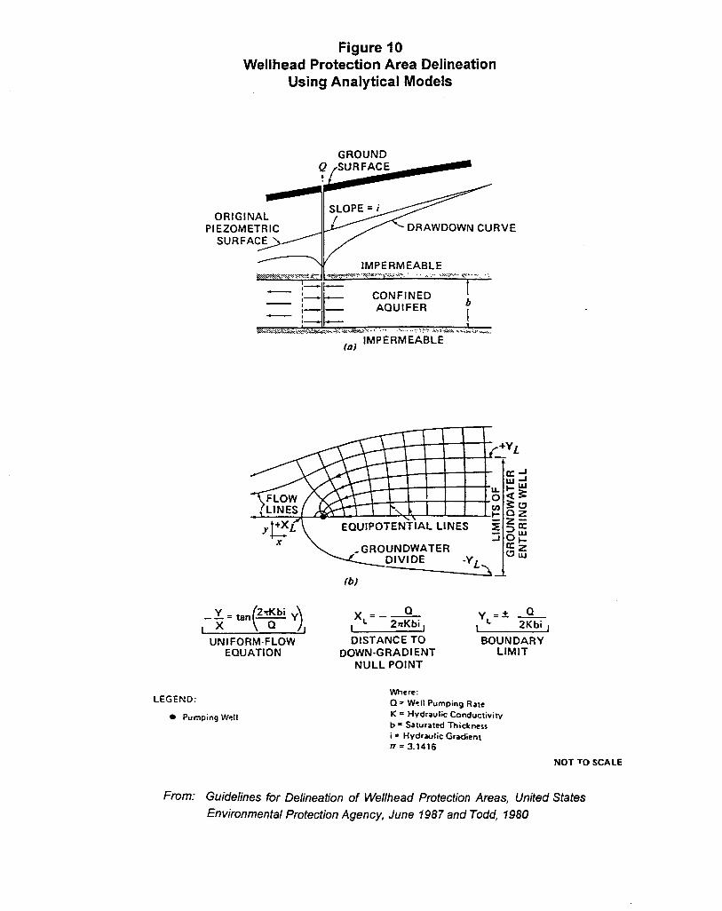
Analytical modelling typically involves the use of mathematical equations that represent
two-dimensional problems to solve well hydraulic and flow equations to delineate
capture zones of wells (Figure 10).
Hydrogeological mapping uses geological, geomorphic, geophysical and tracer dye
methods in the field to map aquifers, flow boundaries, flow patterns and directions
(Figure 11).
Numerical modelling uses computer codes to simulate a two- or three-dimensional
representations of an aquifer by solving numerical equations (Figure 12) (References #99
and #110).
The appropriateness of the various methods for wellhead area delineation is dependent on
the objectives of the program, the local hydrogeological conditions and available
resources (Reference #99). A summary of the advantages and disadvantages of each
delineation method prepared by B.C. Environment (Reference #99) is provided in
Table 5. Further information on the various delineation methods can be obtained in the
guidance document issued by the EPA entitled Guidelines for Delineation of Wellhead
Protection Areas (Reference #110). A map showing proposed groundwater protection
areas for the South Federicton Aquifer in New Brunswick is present in Figure 13.
4.1.3 Vulnerability Mapping
Vulnerability mapping consists of determining the sensitivity of a groundwater resource
to contamination through consideration of a number of hydrogeological variables. It
provides a means of identifying groundwater protection areas on a regional scale rather
than through classical wellhead protection area delineation. A number of different

Figure 9Weilhead Protection Area Delineation Using
“Simplified Variable Shapes” Method
STEP 1: DELINEATE STANL2A RDIZELI FORIUS FOR CERTAIN AQUIFER TYPE
2 3
Pumping Rate = ~1 02 Q3
-Various standardized forms are generatedusing analytical equations using sets ofrepresentative hydrcrgedogic Pa~meterS-
-Upgradient extent of WHPA is cakulatedwith TOT equation; downgradient withuniform flow equation.
STEP 2: APPL Y STANDARDIZED FORM TO WELLHEAD f.N AQUtFER TYPE
-Standardized form is then applied towell with similar pumping rate andhydrogeologic parameters
LEGEND
● Pumping Well
1
Direction o?Ground-water FIOW
NOT TO SCALE
From: Guidelines for Delineation of We//head Protection Areas, (Jnjted states
Environmental Protection Agency, June, 1987
LEGEND:
Figure 10Wellhead Protection Area Delineation
Using Analytical Models
GROUNDQ SURFACE4
7 F
ORIGINALSLOPE = i/
PIEZOMETRIC DRAWDOWN CURVESURFAC~
/I
IMPERMEABLE~\x~~$.y*?y>Y>z<?: ~N\\w.:\.\..vy,.,..,...:,..... . . ,,,. .....\>\...~,- . :
I,— l—:— — CONFINED t
—,t— — AQUIFER—,*— . t
t.,,Xti<:k.,+,-s’=.**<<:.*. .@.. . ... ..>.,:.?A>:..*,.,.,;* .--=,.,a) IMPERMEABLE
(b)
L ( ),
_ ~. tan 2*bi ~ xL=–~ yL=& ~
x Q 1 ZmKbi, 1 2Kbi ,
UNIFORM-FLOW DISTANCE TO BOUNDARYEQUATION DOWN-GRADIENT LIMIT
NULL POINT
Where:
Q = Well Pumping Rate
● Pumping Well K = Hydraulic Conductiviw
b = Saturated Thicknessi = Hydraulic Grti,ent
fT =3.1416
NOT TO SCALE
From: Guidelines for Delineation of Wellhead Protection Areas, United States
Environmental protection Agency, June 1987 and Todd, 1980

Figure 11Wellhead Protection Area Delineation
Using Hydrogeological Mapping
LAND SUR FACE
/
A,
STREAM WHPA
~=ER
A
L-
LEGEND:
1
. - ............................. .................... . . . . . ..........................................................‘ .................. . . . . . . . . . . . . . . . . .
*
. PumDing Well
—— Ground-water Divide
% Direction of Gnxmd-watw Flow
A,
_-l
From: Guidelines for Delineation of Wellhead Protection Areas, United States
Environmental Protection Agency, June, 1987

Figure 12Wellhead Protection Area Delineation
Using Numerical Flow Models
ConceptualModel
FiniteElement
Mesh
f-mm: Go/der Associates Ltd., 1983.

Table 5Advantages and Disadvantages of
Methods For Wel[head Protection Areas
METHOD ADVANTAGES DISADVANTAGES
ARBITRARY FIXED RADIUS Quick implementation Does not use local hydrogeologyInexpensive May be highly inaccurateRequires little technical Scientifically indefensibleinput
CALCULATED FIXED RADIUS Uses hydrogeological data Does not consider allEase of application hydrogeological factorsLow cost May be erroneous for slopedLittle technical skill watertableneeded “
VARIABLE SHAPES Uses hydrogeological data Not accurate in complex settingsto generate type curves Large data requirement can beIs site specific (if data costlyavailable) Greater time and expertiseQuick and easy to use Small data errors can skew
results
ANALYTICAL MODELS Quick and inexpensive if Detailed data needed
data available Higher technical skill neededSite specific. applicable More time consumingPowerful and accurate tool More costly
HYDROGEOLOGIC MAPPING Highly detailed Labour intensiveUseful in complex settings Lmge time commitment
High level of expertise needed
NUMERICAL MODELLING Models complex problems Most costlyUse as predictive tool Requires highly skilled usersHigh degree of accuracy Require large database as inputand confidence in results Requires reality checksHandles many parameters May be over-utilisation
From: Delineating Protection Areas, B.C. Environment, Wellhead Protection
Seminac Clearbrook, British Columbia, January 12, 1994


- 16 -
schemes for mapping aquifer vulnerability are available. Among these, the DRASTIC
scheme is the best known. The acronym for this mapping approach, DRASTIC,
represents the following seven hydrogeological variables that are combined to create a
vulnerability map:
D = Depth to waterR = RechargeA = Aquifer mediaS = Soil mediaT = TopographyI = Impact of vadose zoneC = Hydraulic Conductivity of the Aquifer
DRASTIC provides a good guide to vulnerability at a regional scale, but has limited
potential for classifying true vulnerability at specific sites and should not be used to the
exclusion of additional site assessment tools. According to the Australian Water
Resources Council, the Le Grand classification system, a standardized system for
evaluating waste-disposal sites developed by the National Water Well Association, is
more suited to site-specific evaluation (Reference #174). Limitations of existing
vulnerability schemes are that they do not account for existing groundwater
contamination and they assume that any potential future contaminant releases would
occur from surface sources. In other words, the schemes do not address potential
contaminant releases from deep, subsurface sources such as abandoned wells, or
contaminants such as dense non-aqueous phase liquids (DNAPLs) that would tend to
penetrate to greater depths within an aquifer (Reference #131).
As discussed in Appendix II, vulnerability mapping is becoming increasingly popular in
Europe, the United States, and Canada. As an example, a vulnerability map was
prepared for Clark County, Washington using DRASTIC (Reference #139). Aquifers
supplying Regina, Saskatchewan were classified into four sensitivity categories (extreme,
high, moderate, low) and one category of unknown sensitivity, based on the thickness
and permeability of surficial materials overlying the aquifer (Figure 14). Sensitivity
maps were generated using spatial analysis software (SPANS) to analyze and
amalgamate existing “depth to aquifer” and geological source maps.


- 17 -
Vulnerability mapping is an effective means of identifying groundwater protection zones
because it recognizes the significance of protecting groundwater recharge areas in
addition to wellhead areas. Vulnerability mapping is more appropriate than the classical
wellhead delineation approach in areas where the geology is complex and numerous
water wells are present. Depending on the level of mapping required, the vulnerability
mapping may involve significant costs.
4.1.4 Aquifer Classification
Aquifer classification is similar to vulnerability mapping except that, in addition to
susceptibility to contamination, aquifers are classified according to their present use as a
water supply source (i.e., human consumption & food production; agricultural, industry
& mining; ecosystem support, or no definable use), their potential use for future water
supply, and their existing water quality. Aquifer classification is used as a means of
establishing the degree of protection that an aquifer may require. It is a major
component of the United States EPA groundwater strategy, with numerous states having
developed some type of aquifer classification system. Some of the state classification
systems have been adopted or revised to suit particular groundwater management plans.
For example, Southington, Connecticut has adopted an aquifer classification similar to
the state of Connecticut, but more complex (Reference #247). The Town’s program has
eight aquifer classes instead of four and has eliminated the state zone that allows for
waste disposal. B.C. Environment recently developed a map-based aquifer classification
system and is currently applying the system to selected areas in the Fraser River Basin.
So far, over 200 aquifers have been delineated and classified. Fence diagrams of
hydrostratigraphic units within the Fraser Lowland have also been produced by
Environment Canada (Figure 15) (Reference #299).
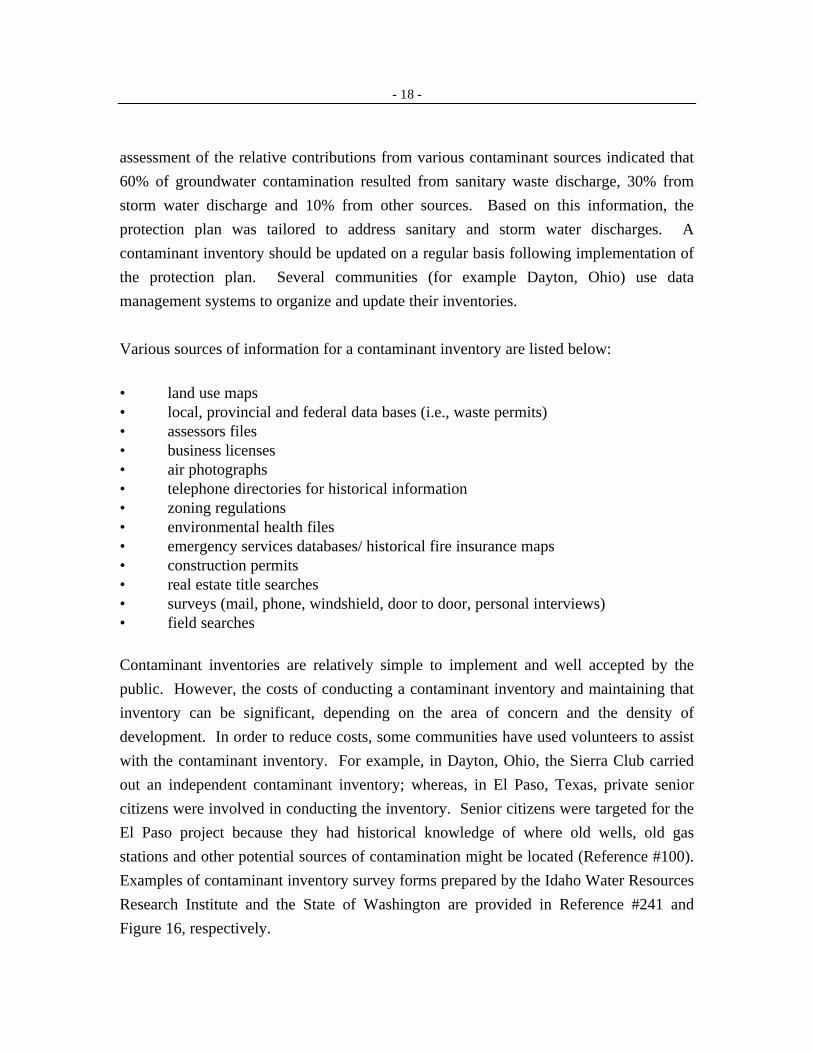
4.1.5 Contaminant Inventory
Contaminant inventories are most often carried out prior to the implementation of a
groundwater protection plan. The purpose of the inventory is to identify past, present
and potential point and non-point sources of groundwater contamination within a
protection area. The groundwater protection plan can then be tailored to address the risks
identified by the contaminant inventory. For example, in Spokane, Washington, an

Figure 15Hydrogeological Fence Diagram, Township 7, Surrey and
Langley District Municipalities, British Columbia
I ~,. ‘“--.,==-T------ :..--,.--.-- p,,_-i ‘“ .:e.’‘Z;- ,,,=.,.:--.:-.,:“~.= -y --T. .+:$1-:---.:
:-, - y, e-=,r:n,: “-,..--- ., _-,., . . . . . . . . -
-&==T.. =:x. Y-----‘>I ! ,,
.;. v=--!, . . . . . . =-v—
J ==-- = as~+=:xs%<-it ‘.. -y” .. —-_.. _-! $ ,. I
, .C -------...___.--...,., ;, ,1~--- v. ___. -------< —_- .?.-:.-s ..--..::-—--- .- -— =s-.- =--.: ZT ..;-; L-.,&y.ll. l;,, ,e-- --- — ._ - .-_.,_.,- ., ..,----
=-.,.?.:= 2:.--== -~ -—->--:.,:-Y, --: .---=---- :,-.=.-s-., J ->=:~.{.i ------- —— --- = ,---S>=.V>V.V.V--~::.: -:-.
!:. ”:,= ------- .--. -,’. --------
.—-,— _------ ~ :~.=---------- . .. .. . ... .-------- .m.-._--_-. : G
= .-=,-:: ---_, :.--.,. .== c.n--,,T:::. = :,=....L-_ z:.-.,.---:::---,-...,- ..---- . . . . ... ., ___ ._, _
I —- —-. :.= .:---:: n:-- -..k-<a e 2--—--- .- = ,--.:---e ::= --4 T-T:-A-&v.== 7:-J :W.-w,-:.--7,’-:-..:
p7J %-%ss==s~sz.’;=----- :7 .7.:-:L-,------ --
From: Figure 9, ‘Township 7, Surrey and Langley District Municipalities, B. C.”- ~:-?:-::=s---m~-n,n,---- ....... .-.,..__.=- 7--&-..T.-_-&n,.:..-z- -
,. —------ ._.,___Compiled by E. C. Ha/stead to Accompany Repott by E. C. Ha/stead,
National Hydrology Reseach Institute, Inland Waters Directorate, 1979.
- 18 -
assessment of the relative contributions from various contaminant sources indicated that
60% of groundwater contamination resulted from sanitary waste discharge, 30% from
storm water discharge and 10% from other sources. Based on this information, the
protection plan was tailored to address sanitary and storm water discharges. A
contaminant inventory should be updated on a regular basis following implementation of
the protection plan. Several communities (for example Dayton, Ohio) use data
management systems to organize and update their inventories.
Various sources of information for a contaminant inventory are listed below:
• land use maps• local, provincial and federal data bases (i.e., waste permits)• assessors files• business licenses• air photographs• telephone directories for historical information• zoning regulations• environmental health files• emergency services databases/ historical fire insurance maps• construction permits• real estate title searches• surveys (mail, phone, windshield, door to door, personal interviews)• field searches
Contaminant inventories are relatively simple to implement and well accepted by the
public. However, the costs of conducting a contaminant inventory and maintaining that
inventory can be significant, depending on the area of concern and the density of
development. In order to reduce costs, some communities have used volunteers to assist
with the contaminant inventory. For example, in Dayton, Ohio, the Sierra Club carried
out an independent contaminant inventory; whereas, in El Paso, Texas, private senior
citizens were involved in conducting the inventory. Senior citizens were targeted for the
El Paso project because they had historical knowledge of where old wells, old gas
stations and other potential sources of contamination might be located (Reference #100).
Examples of contaminant inventory survey forms prepared by the Idaho Water Resources
Research Institute and the State of Washington are provided in Reference #241 and
Figure 16, respectively.

Figure 16Sample Contaminant Inventory Form Published by
Washington State Department of Health
Sample Inventory Form
Sows NumberPub& Water SupplyWell #InventoryPersonsee AnachedMsp*
k Landowner’sNa.mx
B. tidTSSSZ
C. Phone Numbec
D. CitX zip MC
E. county:
Residential Commen5al AgclJltural IndustrialCity Gov’t Site= State GOv’t Site— — ~er _
CAe the potential contaminantt sources listed below that you have identified at this site. In the spaceddd hti=b tie #of *A Potentti source present at tie site (e.g., 2 underground storage *).
QUUlr&Y QIWa@X.
AbandonedWatar WeIi _
AboveGrormdStorage Tank _
Airport
Animal Feedlot
Ibtificial Recharge
Auto SalvageYard
Cemetery
cesspool
ChemicalStorage Facility _
Drainage Well/Canal
Dump
Fertilizer/Pesticide Application _
Golf course
Grain Storage Bin
Highway
HoldingPond
14jectim Well
Landfill
Mine
Municipal Sewage Line
QU=IYRailroad
SepticTank
Service Station Dkposal Well
Sewage Plant Sludge Disposal
Stream (lake, river, creek)
Underground Storage Tank
Contents
Water Well
Other
—
—
—
—
—
Notas.

- 19 -
4.1.6 Well Inventory
A well inventory program consists of identifying all water wells in a groundwater
protection area. A well inventory, combined with a contaminant inventory and
hydrogeological information, can be used to define a groundwater protection area. It also
provides useful information regarding surficial geology and aquifer classification. From
the groundwater protection plans reviewed, three communities were identified where
well inventory programs were being considered but had not yet been implemented; the
Regional Municipality of Peel, Ontario; Clark County, Washington (Reference #139) and
the Biola Community Service District, California (Reference #150).
In British Columbia, well records that are submitted on a voluntary basis by drillers are
maintained by B.C. Environment. A well inventory program would likely involve
obtaining available well records from B.C. Environment and supplementing the
information with field surveys. The Geological Survey of Canada has recently
developed a database containing information from about 4,300 water wells in the Fraser
Lowlands (Reference #297). Locations of wells in the Fraser Lowlands have also been
summarized on maps produced by Environment Canada (Reference #299).
4.1.7 Groundwater Monitoring
Groundwater monitoring is one of the most common non-regulatory forms of
groundwater protection. It may involve monitoring of both groundwater chemistry and
the physical groundwater flow regime (water-level monitoring). For some communities,
such as the Regional Municipality of Waterloo, groundwater monitoring is only carried
out at water supply wells. Other communities, such as Dayton, Ohio, have installed
groundwater monitoring wells downgradient of known or potential sources of
contamination to provide early warning of impending water quality problems.
Specific facilities that may warrant groundwater monitoring include landfills, industrial
sites, underground storage tanks and agricultural lands. Groundwater monitoring may
also be carried out for new land developments. For example, in Newcastle County,
Delaware, where a new 35 acre residential development was under construction adjacent
to a public supply well field, permanent monitoring wells were installed and are

- 20 -
monitored on a quarterly basis for pH, specific conductivity, total dissolved solids and
total organic carbon (Reference #196). In addition to groundwater monitoring, several
groundwater protection plans include surface water monitoring in areas of storm water
discharge.
In addition to ongoing groundwater monitoring following implementation of a protection
plan, monitoring should be carried out prior to implementation to characterize baseline
groundwater conditions. This baseline information is used to select appropriate
groundwater protection measures and also provides a means of assessing the success of
the protection program. Several communities have developed data management systems
to process their groundwater monitoring data.
4.1.8 Spill Response Planning
Spill response planning consists of coordinating with emergency response personnel to
identify special procedures that should be implemented to protect groundwater quality in
the event of a spill or accident. These measures may be as simple as ensuring that
sufficient quantities of absorbents are on hand to respond to a spill (Reference #098).
Several groundwater protection plans include spill response measures. Of these, the spill
response plan for Dayton, Ohio is perhaps the most comprehensive. Dayton has set aside
a contingency fund for emergency response totaling 5 million dollars. Dayton has a
standing contract with a contractor to provide necessary services in the event of an
emergency. The contract includes the provision of drilling equipment, an on-site
laboratory for volatile chemical analyses, and systems for extraction and treatment of
contaminated groundwater. In addition to the emergency response contract, signs have
been posted in key areas of the designated protection area to enhance the spill reporting
process. All addresses within the designated area are also “flagged” in the 911 system so
that the 911 operator will be alerted that the location of the call is within an area of
public water supply concern.
Similar to Dayton's signs, the Cheyenne and Arapaho tribes of Oklahoma are planning to
install signs along roadways into their groundwater protection area with telephone

- 21 -
numbers of individuals to contact in the case of an emergency or the release of a
contaminant (Reference #103).
Other communities that have established contingency funds or are planning to do so
include Newcastle County, Delaware, which posted an escrow bond for emergency
remediation (Reference #196), and Clark County, Washington, which is considering the
establishment of an emergency fund and the purchase of water-specific emergency
equipment (Reference #139). Both Fredericton, New Brunswick and Thurston County,
Washington (Reference #247) are considering training and educational programs for
emergency response personnel. Amherst, Nova Scotia and Waterloo, Ontario have
prepared spill response plans that include information regarding team leader
responsibilities, reporting procedures, available resources and operational methods. The
State of Washington is developing a set of standard operating procedures to be used by
emergency response personnel in groundwater protection zones (Reference #098).
Although not specifically related to a groundwater protection plan, Danbury, Connecticut
has implemented a comprehensive spill response program through regulatory means.
The City passed an ordinance requiring facilities handling hazardous materials to prepare
an emergency response plan. The plan must contain a map of the facility, a hazard
identification statement, a notification procedure, a fire response plan, an evacuation plan
and a spill prevention, control and countermeasure plan (Reference #213).
4.1.9 Contingency Plans
Contingency planning consists of developing a plan for the location and provision of
alternative drinking water supplies in the event that the existing well field cannot be
used. Disruptions to the existing well field may be related to either contamination or
non-contamination effects. The contingency plan should identify short-term alternatives
in the event of a minor disruption, and long-term alternatives in the event of a complete
loss of water supply.
Several groundwater protection plans have either developed or are considering provisions
for an emergency water supply. For example, Julian Community Services District, San
Diego County, California has arrangements with a private well owner to fill a tanker

- 22 -
truck with clean water in the event of an interruption in their water supply
(Reference #150).
The development of a contingency plan is considered an essential part of groundwater
protection.
4.1.10 Hazardous Waste Collection
Hazardous wastes are defined as materials that are designated under local environmental
regulations. Hazardous waste collection most commonly involves the collection of
household hazardous wastes within a groundwater protection area. The purpose of a
collection program is to limit groundwater contamination by the inappropriate disposal of
household wastes or by accidental spills from accumulated hazardous materials.
Hazardous waste collection may take several forms. It may involve organizing a
hazardous waste collection day once or several times a year, operation of drop-off
stations for generators of small quantities of hazardous waste, or a “mobile unit” program
whereby vehicles travel to a number of locations to collect hazardous waste.
Hazardous waste collection programs are currently underway in Dayton, Ohio; El Paso,
Texas and Spokane, Washington. Here in British Columbia, there is no central depot that
accepts household hazardous waste. Recently, a program was launched requiring paint
wholesalers and manufacturers to establish 10 used paint collection centres in the Greater
Vancouver Regional District. A retail chain of hardware stores has also recently
embarked on a program to accept used household paint in British Columbia.
Hazardous waste programs are generally sponsored by government agencies and
administered by private contractors. Costs associated with hazardous waste collection
programs are not known. There may be several legal issues associated with the
collection, transport and disposal of hazardous waste. Despite the potential difficulties
associated with implementation, a hazardous waste collection program offers the public a
mechanism by which they can practice the groundwater protection measures learned
through the educational programs.

- 23 -
4.1.11 Technical Assistance
Technical assistance involves providing guidance to target groups in order to reduce the
risk of groundwater contamination. The assistance commonly involves the use of a
professional who travels to a site and provides an assessment of the situation.
In most cases, technical assistance is used to protect groundwater from agricultural-
related activities. For example, the Swedish government provided free agro-consultants
to educate farmers regarding the sequencing of chemical applications to reduce the
loading effects on groundwater from fertilizers. Another example is a community in the
U.S. that is setting up a volunteer master gardener program whereby experienced
gardeners in the community provide free advice to homeowners regarding organic
(chemical-free) gardening techniques. The purpose of the program is to reduce the risk
of groundwater contamination from the overuse of fertilizers and pesticides in residential
areas.
Less frequently, technical assistance may involve providing guidance to commercial or
industrial facilities regarding waste reduction or facility upgrading to allow a greater
degree of groundwater protection. Another form of technical assistance may involve
training of local building inspectors to identify abandoned wells and underground storage
tanks.
Technical assistance provides an effective means of working directly with target groups
to better manage private lands and thereby protect groundwater. It can be more effective
than a general public education program because it offers a site-specific, “show them”
rather than “tell them” approach (Reference #247).
4.1.12 Land Acquisition
Land acquisition involves the acquisition of a parcel of land by purchase, exchange or
donation. While land acquisition has been associated with the protection of surface water
supplies for some time, it is more recently being employed as a groundwater protection
measure. As discussed in Appendix II, land acquisition is a popular means of
groundwater protection in Prince Edward Island. The Town of Amherst, Nova Scotia

- 24 -
purchased 1,500 acres of land surrounding their new wellfield to protect their
groundwater water supply. Land acquisition has also been used by several American
communities, including Long Island, New York; Acton, Massachusetts; Crystal Lake,
Illinois; the Pinelands, New Jersey; and Chelsea, Maine.
Land acquisition is considered one of the most effective means of non-regulatory
groundwater protection because it allows total control over the property. It is relatively
easy to implement and is most effective in rural areas where there is little existing
development. However, the costs of land acquisition usually are high, which limits the
amount of land that can be purchased.
4.1.13 Purchase of Development Rights
Purchase of development rights involves purchasing the right to develop a parcel of land
while retaining the property in private ownership. The property owner is paid the
difference between the current value and the development value of their land. This
allows the property owner to continue his or her current use while limiting future
development. The purchase of development rights is a relatively new concept and no
examples of its application in Canada were identified during our literature review.
Programs are reportedly underway in the U.S. in Massachusetts, New York, Maryland,
New Hampshire, Connecticut, Rhode Island, Washington and New Jersey
(Reference #247). Most of these involve agricultural lands.
The purchase of development rights offers a relatively high degree of groundwater
protection and is less costly than land acquisition.
4.1.14 Conservation Easements
A conservation easement is a voluntary, legal agreement that a property owner makes to
restrict the type and amount of development that may take place on his or her property
(Reference #247). An owner may agree to give away certain rights such as the right to
construct buildings, to subdivide land, to restrict access, or to harvest timber
(Reference 247).

- 25 -
The primary advantage of a conservation easement program is that it permits the control
of future land use without the associated purchase costs. Because conservation
easements require the voluntary consent of the property owner, the success of the
program is dependent on the degree of public acceptance and the goodwill of the
property owner. As such, implementation of a protection plan in a targeted area using
conservation easements would be difficult.
No specific case studies were identified where this method of groundwater protection has
been used.
4.1.15 Cluster Development
Cluster development involves promoting and concentrating development in less sensitive
areas outside of groundwater protection zones. Clustering of residential development
facilitates the use of cost-effective sewering systems, restricts open lawns, reduces
highway needs (and therefore highway runoff) and allows for the retention of large tracts
of natural vegetation.
The promotion of clustering is under consideration in Long Island, New York
(Reference #177); Idaho's Panhandle Health District (Reference #103); New Jersey
Pinelands (Reference #177), and Thurston County, Washington (Reference #247). In
Spokane, Washington, efforts are underway to encourage development in areas that are
expected to be supplied with sewer service within the next 10 years (Reference #286).
4.2 Groundwater Protection Measures That May Be Implemented ThroughEither Regulatory or Non-Regulatory Means
4.2.1 Storm Water and Sewage Control
Most groundwater protection plans include measures to control storm and sewage
discharge (Table 6). Emphasis on control of these sources may be related to the fact that,
as shown by the inventory of contaminant sources in Spokane, Washington, a significant
percentage of groundwater contamination can be related to storm and sewage discharge.
Regulatory controls include registration, permitting, testing, collection, containment and
treatment of storm water and sewage discharges. Other measures, that could be

TABLE 6Use of Groundwater Protection Measures That Could be Implemented
Through Either Regulatory or Non-Regulatory Means
Slormwater Septic Agncuhrral Roadsalt Transportation Well Geotechnical Forest Market Groundwater
& Sewage System Controls Controls Controls Drilling & Controls Management Approaches Guidelines
Controls Conlrols Abandonment
1. Selected Protection Plans
Dayton, Ohio x x
Waterloo, Ontario
x
x x x xAmherst, Novis Scotia x x x x
Sou(h Fredericton, NB
x
x x x
Regina, Saskatchewan
x
x x x x xSpokane, Washington x x xPeel, Ontario
Palm Beach, Florida x
Long Island, New York
x
x x
2. O[her Pro[ec[ion Plans
Acton, Massachuse[[s x x xAustin, Texas x xBiola Comm. Ser. Disw., California x x
Brookings County, South Dakota x x
Chelsea, Maine
Cheyenne & Ampoho Tribes, Oklahoma
Clark County, Washington x x
Clinton Township, New Jersey
x x xx x
Clover/Chambers Creek, Wmhington x x x xCryslal Lake, Illinois x x
Dade Coumy,Florida x xDanbury,ConnecticutDescmso Comm. Ser. Distr., California x
Dorchester, Ontario xElkharr County,Indiana xEl Paso, Texas x x
Ftrlmouth, Massachusetts
x
x xIdaho’sPmrhandleHealthDistrict
x xx
Issaquah,WashingtonJulian Comm. Ser. Distr., California x
Nantucket Island, Massachusetts
Newcastle County, Delaware x
Olmstead County, Minnesota x
Pinelands, New Jersey x
Renton, Washington
x x
x x
Soulhington, Connecticut
x
x x
Thurslon County, Washington x x x x x
X = groundwa(er protection measure that has been implemented or is under consideration
lfl.01US/1’A!J.9Sf%f AfW42 .1832 XII

EvaluationTABLE 7
of Groundwater Protection Measures That Could be ImplementedThrough Either Regulatory or Non-Regulatory Means
lGroundwater Protection Measure I Extent to I Degreeof I Implementation Relative I Staffing I Public IFlexibilityWhich Proactive Protection Effort cost Requirements Acceptability
Storm Water & Sewage Control M H H M M M MSeptic System Controls M H H H H L MAgricultural Activities M H H H H L-M MRoadsah M M M L L M MTransportation Controls M L H L L M MWell Drilling & Abandonment M M M L L L MGeotechnical Controls M M H M M L MForest Management M M H H H H MMarket Approaches L-H M H L-H M L-H LGroundwater GuidelinesiRerwlations L-H M H M M 1.-H M
L = LowM = MediumH = High
1lLOTUSfl_AB-951MA fU942- 1832,xIs

- 26 -
implemented through either regulations or guidelines (non-regulatory means), include
regular maintenance, inspection and upgrading of storm and sewage utilities. The degree
of control that should be implemented depends on the discharge source and the
sensitivity of the area.
Several examples of storm water and sewage control are provided in the groundwater
protection plans. Washington State has emphasized the need for stringent subdivision
rules to regulate road drainage and runoff in protected areas (Reference #103). Dayton,
Ohio and Southington, Connecticut have prohibited dry wells in groundwater protection
areas, and Palm Beach, Florida has prohibited infiltration trenches. In a new residential
development adjacent to a major public water supply well field in Newcastle County,
Delaware, a double-lined storm water retention pond has been constructed to prevent
infiltration (Reference #196). Fredericton, New Brunswick has implemented a program
for regular inspection, repair, upgrading and replacement of storm sewer catch basins and
pipes in their downtown area. Amherst, Nova Scotia has recommended that all
stormwater systems be directed away from their well field. Acton, Massachusetts carried
out an inventory of all industrial and commercial discharges containing hazardous
materials (Reference #247). Spokane, Washington has made extensive efforts to extend
the area served by public sewer systems (Reference #286). Clark County, Washington
has recommended the development of a comprehensive stormwater management manual
and a coordinated, county-wide approach to implementing it (Reference #247). Austin,
Texas has implemented numerous stormwater management controls, including: isolation
and treatment of “first flush” or first 1/2 inch (1.3 cm) of a storm event, requirements for
on-site storage and treatment systems, requirements for developers to pay a fee per lot for
the City to assume the responsibility of on-site systems, submission of erosion and
sedimentation-grading plans, requirements for vacuum street sweeping three times per
week for commercial parking lots over 5000 square feet (460 square metres) and
requirements for leak-proof sewer construction (Reference #247).
Storm water and sewage design and maintenance controls are an effective means of
groundwater protection. However, similar to other source controls, these measures may
only be successful if implemented by regulatory rather than non-regulatory means.
Implementation of controls would be easier for new utilities than existing ones, and
would require a moderate level of inspection and enforcement.

- 27 -
4.2.2 Septic System Controls
Numerous groundwater protection plans included measures to protect groundwater from
contamination from on-site septic systems. Some communities prohibit the use of on-site
septic systems in sensitive areas. For example, Renton, Washington requires all new
developments (both residential and non-residential) to connect to a central sanitary sewer
system (Reference #083). Dade County, Florida prohibits in-ground sewage disposal
within subzone 1 (within 100 feet or 30 m of a water supply well) (Reference #195).
Crystal Lake, Illinois prohibits septic systems in outwash soil areas (Reference #247).
Regina, Saskatchewan is considering the use of holding tanks rather than underground
disposal where there is no protective overburden.
Another common means of controlling groundwater contamination from septic systems
is to impose minimum lot size restrictions to reduce septic system density. For example,
Austin, Texas requires a minimum lot size of one acre for on-site sewage disposal
(Reference #247); Long Island, New York requires two acres (Reference #177); Dade
County, Florida requires either one acre or 2.5 acre lot sizes, depending on the proximity
to water supply wells (Reference #242); Pinelands, New Jersey has 3.2 acre lot size
restriction based on requirements for a maximum concentration of 2 ppm nitrate at the
property boundary (Reference #177); and Idaho's Panhandle Health District requires a
five acre minimum lot size (Reference #103).
Other measures include tighter controls on the siting, design and operation of in-ground
systems. For example, Thurston County, Washington has an operational permit for some
septic systems for a three-year period that is revokable if the system is found to be
polluting (Reference #247). Spokane County, Washington requires that septic systems
be constructed with dry line sewers so that houses could be connected to public sewers
when they become available (Reference #286).
Although septic systems can effectively treat and dispose of most domestic wastewaters,
they do not have the capability to remediate solvents and other hazardous wastes that
may be disposed in septic systems. To address this issue, Dade County, Florida is
attempting to prevent improper disposal in septic systems by light industry. Similarly,
Clover/Chambers Creek Basin, Washington is imposing pretreatment requirements on

- 28 -
commercial establishments that may handle, store or dispose of hazardous chemicals
(Reference #140). Clark County is considering several measures aimed at better
controlling the siting, design and operation of septic systems, including the following
(Reference #139):
• encouraging a ban on the manufacture, sale and/or use of septic system cleanersthat contain chlorinated organic solvents;
• increasing educational programs to assist property owners to better protect,operate and maintain their septic systems;
• requirements for septic system inspection and maintenance prior to propertytransfer;
• extending sewer services to areas of high septic density, or areas of aquifersusceptibility; and
• development of a county-wide mandatory septic system maintenance program.
Most of the protection measures outlined above are regulatory in nature and would
require significant administrative effort and expense to implement. However, if
implemented, they would offer an effective means of groundwater protection. Non-
regulatory measures could take the form of guidelines, public educational programs and
free inspections of existing systems. Non-regulatory measures would likely be less
effective than regulatory measures, but less expensive and more readily accepted.
4.2.3 Agricultural Controls
Control of agricultural activities is a common means of groundwater protection. For
some communities, it may consist of prohibition of agricultural activities within a
sensitive area. For example, Amherst, Nova Scotia prohibits agricultural land use within
Zones 1 and 2 of its groundwater protection area. Similarly, Brooking County, South
Dakota prohibits feedlots within its groundwater protection area (Reference #103).
More commonly, agricultural activities are permitted within protected areas but are
controlled through the use of restrictions and guidelines. Several communities restrict
the amount and types of chemicals that can be stored on farms. For example, Dayton,

- 29 -
Ohio will only allow storage of a one-year supply of agricultural chemicals for on-site
application; Dorchester, Ontario prohibits bulk storage of chemicals, fertilizers and
petroleum products other than those to be used in the normal operation of the farm
(Reference #199); Amherst, New Brunswick restricts manure storage, and Germany has
regulations regarding the storage of fertilizers.
In addition to storage restrictions, there are regulations and guidelines controlling the use
of agricultural chemicals. Amherst prohibits the use of biocides in Zones 1 and 2 and
restricts the use of biocides in Zone 3 of its protection area to those with a total
degradation life of less than 50 years; Clark County is considering the regulation of
pesticide and fertilizer use (Reference #139), and Germany has regulations controlling
the metal content in sludge and the use of sludge, fertilizers and manure.
Another means of protecting groundwater from agricultural activity is to control the
sequencing of chemical application through regulations, guidelines and educational
programs. For example, Brookings County, South Dakota will only allow application of
nitrogen fertilizer in the autumn (Reference #103), while Sweden controlled the
sequencing of chemical application by providing free agro-consultant advice to farmers.
Another means of agricultural control is to require farmers to report on their activities.
Farmers in Dayton, Ohio are required to report the types and amounts of chemicals
applied on an annual basis. The reports are used to determine appropriate monitoring
locations and analytical protocol for groundwater sampling. Clark County, Washington
is considering a notification program that would require applicators to provide public
notification of pesticide applications.
Controls to limit the number of livestock on agricultural land are in place in Dorchester,
Ontario and Amherst, Nova Scotia.
Non-regulatory forms of groundwater protection include research into agricultural
practices and groundwater monitoring. Clark County is considering research into best
management practices for animal waste disposal and research into pesticide and fertilizer
use patterns. Integrated pest management programs (IPM) are being promoted in three
community service districts in California (Reference #150). These programs involve

- 30 -
monitoring climatic events and crop diseases to better target the use of chemicals and to
minimize their use. Alternative biological pest controls and the use of chemicals
characterized as having lower persistence in the environment are also being encouraged
in these districts.
Another form of non-regulatory groundwater protection is to provide education and
technical assistance for farmers. Both Clark County and Clover/Chambers Creek Basin
are considering educational programs that will improve pesticide and fertilizer
application practices (Reference #140). As described in Appendix II, Sweden educates
farmers on agricultural practices through the use of free agro-consultants. As discussed
in Section 4.1, Farm-A-Syst programs are underway across the United States to help
farmers evaluate possible sources of contamination on their properties and implement
appropriate protection measures.
In British Columbia, members of the dairy industry have formed a working group known
as the Dairy Producers’ Conservation Group (DPCG). The DPCG publishes a quarterly
newsletter (The News Spreader) that presents an annual Dairy Farmer Conservation
Award, provides Best Agricultural Waste Management Plans, organizes field days and
tours, and makes presentations at various workshops and courses (Reference #295). In
1994, the DPCG published two booklets entitled “Nitrogen Management for Silage Corn
Production in South Coastal British Columbia” and “Guidelines for Preparing you own
Environmental Farm Plan” (Reference #295).
Given the relatively high contribution of agricultural activities to groundwater
contamination, any degree of agricultural control should provide a measure of
groundwater protection. However, because agricultural contaminant sources are
commonly non-point sources, the effectiveness of the controls may be difficult to assess.
As discussed above, agricultural controls may be implemented by either regulations or
guidelines. Guidelines may be just as effective as regulations and better accepted if
accompanied by educational and technical assistance programs.

- 31 -
4.2.4 Roadsalt
Several groundwater protection plans include measures to control groundwater
contamination from roadsalt. Acton, Massachusetts; Waterloo, Ontario; Thurston,
Washington and Regina, Saskatchewan have implemented, or are considering,
prohibition or restriction of application of roadsalt. Southington, Connecticut prohibits
storage of road salt within its groundwater protection area (Reference #247), while
Brookings County, South Dakota requires that all roadsalt storage be covered (Reference
#103). Amherst, New Brunswick recommends that roadsalt be mixed with sand to
reduce contaminant potential.
Controls for roadsalt may be implemented through regulations or guidelines. Roadsalt
control is a relatively inexpensive measure that is easy to implement and offers a
moderate degree of groundwater protection.
4.2.5 Transportation Controls
A select number of groundwater protection plans include controls for transportation over
aquifers. Of these, the measures under consideration by Fredericton, New Brunswick
appear to be the most comprehensive. Fredericton has identified an alternative trucking
route outside of its groundwater protection area for all trucks carrying dangerous goods,
hazardous wastes or other compounds exceeding designated critical quantities
(Figure 17). They have also designated a preferred rail route for railcars containing
similar materials. For trucks that are required to enter the groundwater protection area
for delivery purposes, a designated route has been identified. Consideration is being
given to reduced speed limits, posting of warning signs to encourage driver caution and
more attention to road maintenance and repairs along this route. Other measures include
training of emergency response personnel on response procedures in the event of
chemical spills along the transportation route, and educating delivery personnel regarding
the need for caution during delivery. Spokane, Washington, is considering a similar
program to control the impact of chemical releases along transportation routes. Waterloo
is also considering rerouting vehicle traffic carrying hazardous material away from the
immediate vicinity of its well fields.


- 32 -
Transportation controls are relatively inexpensive and can be implemented with moderate
ease. Because they are preventative measures, their benefits are not easily quantifiable.
4.2.6 Well Drilling and Abandonment
Water wells that have been improperly constructed or inappropriately sited may be
susceptible to contamination from surface or shallow groundwater sources. To reduce
the potential for groundwater contamination by this means, guidelines for well siting,
construction and maintenance could be provided to drillers and property owners. None
of the protection plans examined included guidelines for well drilling. However,
guidelines, information brochures and regulations on well drilling are available at the
provincial level. Development of guidelines on well drilling would be relatively
inexpensive.
Although none of the groundwater protection plans included provisions for well drilling,
several communities are considering the implementation of measures to ensure proper
well abandonment. Improperly abandoned water wells or environmental monitoring
wells can provide direct conduits to an aquifer that may lead to groundwater
contamination. Current practice in the well drilling industry is to partially backfill with
loose cuttings, insert a surface plug, or to simply weld a steel cap on top of an abandoned
well. In the environmental industry, often no measures are taken to properly abandon
former monitoring wells. Conceivably, guidelines or regulations for proper grouting of
abandoned wells could be adopted. Regulations are currently in effect for proper
abandonment of water wells at a provincial level in most provinces.
Better tracking of abandoned wells may be facilitated with a well inventory program.
Clark County, Washington, is considering the development of a process to assess the
presence of abandoned wells on properties prior to transfer of ownership. They also
want to establish and implement a procedure that requires proponents of development to
evaluate building sites for the presence of abandoned wells as a condition of site plan
approval. Another measure under consideration is training building inspectors to identify
wells and ensure proper abandonment (Reference #139).

- 33 -
4.2.7 Geotechnical Controls
Similar to abandoned water wells and environmental monitoring wells, building piles and
testholes drilled for geotechnical purposes can provide pathways for contaminant
migration to lower aquifers. Regina, Saskatchewan and Fredericton, New Brunswick are
considering requirements for proper sealing of geotechnical testholes and building piles.
Landstripping, excavations, ditching and trenching may also affect aquifer sensitivity.
Regina has recommended that excavations into the overlying protective clays be
minimized in areas where the overburden is less than 5 m and that excavations be
restricted to less than 5 m in areas where the overburden is less than 10 m thick.
Although geotechnical controls may be exercised through guidelines, successful
implementation would likely require some form of regulatory control.
4.2.8 Forest Management
Amherst, Nova Scotia is the only groundwater protection plan that included provisions
for forestry controls. Because forestry is one of the few activities permitted in their
groundwater protection zone, Amherst has implemented stringent forestry controls.
Their groundwater protection plan requires that a forest management plan be developed
and approved for anyone planning to harvest more than 20 chords of wood from the
groundwater protection area. Elements to be incorporated into the plan include the
control of activities around streams, restricting cutting to one block at a time, prohibition
of whole tree cutting, proper location and construction of haul roads, skid trails and log
landings, management to minimize the risk of fire, control of pesticides and herbicides,
and posting of performance bonds. Forest harvesting within Zone 1 is restricted to select
cutting only.
Presumably, although guidelines for forestry practice could be issued, successful
implementation of forestry controls may require regulatory control.

- 34 -
4.2.9 Market Approaches
Market approaches involve the use of taxes, subsidies, marketable pollution permits and
insurance bonds to encourage groundwater protection. These measures may be either
regulatory or non-regulatory.
The regulatory market approach involves adopting a “polluter pays” principle, whereby
the costs of contamination are passed on to the dischargers. Examples include requiring
facilities to post bonds of credit for pollution prevention (Palm Beach, Florida,
Reference #177), and the use of penalties for facilities that do not comply with zoning or
permitting requirements. Renton, Washington has penalties of up to $500 per day for
facilities that violate its groundwater ordinance (Reference #083).
Non-regulatory market approaches involve the use of financial incentives to achieve
groundwater protection. Examples include the use of tax credits for retaining private
land as open space and the use of land credit exchange programs to encourage
development out of protected areas and into those areas designated for development
(New Jersey Pinelands, Reference #177). In Dayton, Ohio, businesses are eligible for
grants and loans from the City’s well field protection fund to finance corrective actions
required by the well field protection program (Reference #256). Fredericton, New
Brunswick is considering incentive programs to encourage local residents to convert
from heating oil to alternative heating methods to reduce the need for heating oil tanks.
The City is currently deciding on a means of compensating dry cleaning businesses who
are required to relocate their facilities as a result of the groundwater protection plan.
Non-regulatory market approaches allow some control over future land use. However,
because they require the voluntary consent of the property owner, the programs may be
difficult to implement in a targeted area and the properties could always be removed
from the program at a later date. In addition, such programs would require significant
resources.

- 35 -
4.2.10 Groundwater Quality Guidelines and Regulations
Another form of groundwater protection consists of the establishment of site-specific
thresholds for groundwater quality. These thresholds may take the form of
non-regulatory groundwater guidelines or groundwater regulations. Establishment of
groundwater guidelines or regulations provides a means of protecting groundwater and
minimizing groundwater degradation to acceptable levels. For some areas, this may
involve adopting a policy of non-degradation, whereby the quality of groundwater is not
permitted to decline below existing levels. For example, Long Island, New York
adopted a policy of non-degradation in order to maintain the high ambient quality of
groundwater in their groundwater recharge area (Reference #177). In other areas, a
limited degradation policy may be adopted. The intent of limited degradation policies is
to preserve groundwater quality above certain specified standards. For example,
Falmouth, Massachusetts (References #103 and #177) and the New Jersey Pinelands
(Reference #177) have established specific nitrogen concentration standards for their
groundwater protection areas.
Establishment of site-specific groundwater quality guidelines or regulations requires
sound technical support. Establishment of groundwater quality regulations, rather than
guidelines (non-regulatory), may be required for the measure to be effective.
4.3 Regulatory Groundwater Protection Measures
4.3.1 Zoning
Zoning involves the regulation of land use and/or hazardous materials in sensitive areas.
It is one of the most common regulatory means of groundwater protection. Zoning
controls are commonly implemented using “Groundwater Overlay Zones”, which
identify the boundaries of the protection area. The overlay zone is superimposed on the
existing zoning map. Selected examples where zoning is used to control land use
include: Amherst, Nova Scotia, where forestry, agriculture, open fires, waste disposal,
highway salting and other activities are restricted; Brookings County, South Dakota,
where new feedlots, uncovered road salt storage and car washes are prohibited
(Reference #103); and Acton, Massachusetts, where residential and septic system
densities are controlled (large lot zoning) (Reference #247). Zoning ordinances were the

TABLE 8
Use of Regulatory Groundwater Protection Measures
Zoning Facility Hazardous USTS& Above-Ground Sand& Permitting Inspection&
Siling, Materials Pipelines StorageTanks Gravel ComplianceDesign, Restrictions Controls
Operation
1. Selected Projection Ptans
Dayton, Ohio x x x x x x
Waterloo, Ontario x x
Amherst, Nova Scotia x
South FredericIon, NB x x x x
Regina, Saskatchewan x x x x
Spokane, Washington x x x x
P&l, Ontario
Palm Beach, Florida x x x x
Long Island, New York x x
2. Other Protection Plans
Acton, Massachusetts x x x
Austin, Texas x x x
Biola Comm. Ser. Disw., California
Brookings Coumy, South Dakota x x
Chelsea, Maine x x
Cheyenne & Arapoho Tribes, Oktahoma
Clark Coun(y, Wmhington x x x x x x
Clinton Township, New Jersey x x xCtover/Chambers Creek, Washington x x xCrystal Lake, Illinois x
DadeCoumy,Ftorida x x x xDanbury,ConnecticutDescmrsoComm. Ser. Distr., California
Dorchester, On!ario x x x
Elkhart County, Indiana x
El ho, TCXaS x x x x
Falmouih, Massachusetts x x x x x
Idaho’s PwshandteHecdthDistrict
Issaquah, Washington x x
Julian Comm. Ser. Distr., Catifomia
Nantucket Island, Massachusetts
Newcaslle County, Detaware x ‘x
Olms!ead County, Minnesota
Pinehmds, New Jersey x
Renton, Washhgton x x x x x
Sou[hington, Connecticut x x x x
Thurston County, Washington x x x 1
X = groundwater protection measure that has been imptemen(ed or is under consideration
lLmsmAn.95mfAm2 .1832..l1

TABLE 9
Evaluation of Regulatory Groundwater Protection
Groundwater Protection Measure Extent to Degree of Implementation Relative Staffing Public FlexibilityWhich Proactive Protection Effort cost Requirements Acceptabilityy
Zoning M H H H H L-M M
Facility Siting, Design & Operation M H H H H L-H M
Toxic & Hazardous Materials Restrictions M H H H H L-H M
USTS & Pipelines M H H H H L M
Above Ground Storage Tanks M M H M M M M
Sand & Gravel Mining Controls M M H M L M M
Permitting M H H H H L M
Inspection M H H H H L M
L = LOW
M = MediumH = High
lILOTUSfT’AB-951MARI’942-1832.xIs

- 36 -
primary mechanism for the control of hazardous substances in Dayton, Ohio. Another
form of zoning is large-lot zoning, which involves the use of minimum lot sizes as a
means of controlling septic system densities.
Always implemented by local governments, zoning is a well accepted method of
groundwater protection and can be easily adopted to the unique circumstances of a local
community (Reference #247). Zoning is most effective for regulating new developments
or preventing problems. It is very difficult to implement new regulations or change
zoning in areas that have already been developed. The use of grandfathering clauses,
whereby non-complying uses are permitted to continue within a groundwater protection
zone, is an unacceptable approach to groundwater protection. Zoning controls may not
always be perceived as necessary and may be challenged legally if the zoning boundaries
are based solely on arbitrary delineation.
4.3.2 Facility Siting, Design and Operation Controls
Often associated with zoning, several groundwater protection plans include measures to
control the siting, design and operation of various industrial and municipal facilities.
Most of these controls are regulatory in nature. However, it may be possible to exercise
some control through guidelines rather than regulations.
Siting, design and operating controls may be required for some of the following facilities
in areas underlain by sensitive aquifers: airports, auto repair shops, car washes,
cemeteries, dry cleaning establishments, laboratories, landfills, gas stations, golf courses,
railyards, manufacturing facilities, recycling facilities, surface impoundments, transfer
stations, waste treatment and storage facilities, underground storage facilities and other
commercial and industrial facilities.
Forms of regulatory control include siting restrictions, design and construction standards,
permitting, licensing and fees. Another measure, which may be either regulatory or non-
regulatory, is the development of best management practices. Examples of best
management practices include operational requirements, implementation of discharge
standards, regular maintenance and inspection, monitoring (for example landfill sites in
Clark County, Washington), secondary containment for liquid waste disposal (Brookings

- 37 -
County, South Dakota, Reference #139), preparation of contingency plans for inadvertent
discharges of contaminants (Brooking County, South Dakota), development of closure
plans and employee training. Control of facility siting, design and operation is often the
best way of controlling specific point sources of groundwater contamination.
4.3.3 Hazardous Materials Restrictions
A select number of groundwater protection plans have focused their efforts on the control
of types and quantities of toxic and hazardous materials within groundwater protection
areas rather than placing restrictions on land use. Toxic and hazardous waste restrictions
form the basis of the groundwater protection plans for Dayton, Ohio; Fredericton, New
Brunswick, and Palm Beach, Florida. This regulatory approach is the best means of
protecting groundwater in areas that have already been developed, while at the same time
minimizing the economic impacts to local businesses.
In addition to restrictions on the quantity and types of hazardous materials, other
controls, such as registration and tracking, and proper storage, handling and disposal of
hazardous materials can be implemented using regulations or guidelines (non-regulatory
means). An example of a non-regulatory means of control is in Fredericton, New
Brunswick, where guidelines may be developed to instruct service stations in the proper
storage and disposal of car care products such as antifreeze, solvents and other
compounds.
4.3.4 Underground Storage Tanks (USTs) and Pipelines
A number of groundwater protection plans make provisions for the control of
underground storage tanks (USTs) and one plan (Dade County, Florida, Reference #195)
regulates underground pipelines. Control of USTs may involve the prohibition of USTs
or the adoption of performance standards or guidelines for use of USTs in protected
areas. Regina, Saskatchewan and Clinton, Township, New Jersey (Reference #063) have
prohibited USTs in sensitive areas, while Dayton, Ohio is implementing a plan to phase
out all USTs containing regulated substances other than vehicle lubricants and fuel for
heating over a five-year period. Fredericton, New Brunswick is considering incentive

- 38 -
assistance programs to encourage conversion from heating oil to alternative heating
methods.
Examples of performance standards or guidelines for USTs include requirements for
permitting, secondary containment, pressure testing and groundwater monitoring.
Clover/Chambers Creek Basin, Washington is carrying out an inventory of existing USTs
and educating tank owners of their responsibilities. They are also considering
establishing a fee for new tanks and an annual tank fee to assist with their funding
(Reference #140).
Control of USTs and pipelines is an effective means of groundwater protection. There
are guidelines, such as those recently released by the Alberta government, that may have
some application to the control of USTs; however, adequate control of USTs may only
be successful through regulatory means. Some communities, such as Palm Beach,
Florida, were not able to gain jurisdiction over USTs and therefore could not exercise
any control. Another difficulty with the control of USTs is that, in the case of Dayton,
Ohio, there may be a conflict with fire code regulations since prohibition would require
the storage of flammable materials be relocated to above-ground facilities. Another
problem associated with the relocation of materials to above-ground facilities is the
increased vulnerability of the facilities to vandalism and corrosion. Regulation of USTs
would require moderate administrative support for inspection and enforcement.
4.3.5 Above Ground Storage Tanks
Only two of the groundwater protection programs examined (Regina, Saskatchewan and
Clark County, Washington) made specific reference to the control of above-ground
storage tanks; however other plans may have addressed this issue through facility design
and construction controls. Above-ground storage tanks would be controlled by similar
means to USTs. Measures may include permitting and secondary containment using
liners and dykes.
Similar to USTs, regulatory controls over above-ground storage tanks would be more
effective than non-regulatory controls. Public acceptance of controls for above-ground
storage tanks may be better than for USTs because the risk of contamination from above-
- 39 -
ground tanks may be more readily understood by the non-professional. Administrative
support for inspection and enforcement would be moderate.
4.3.6 Sand and Gravel Mining
Sand and gravel mining frequently occurs in areas where the sand and gravel provide a
shallow, productive aquifer and high groundwater yields. In many cases, mining may
remove near surface layers of soils and geological deposits that would otherwise provide
a level of protection to the underlying groundwater (Reference #137). In addition, many
sites from which sand and gravel is extracted are later used as landfills or as sites for
asphalt plants.
Three groundwater protection plans included provisions for the control of sand and
gravel mining. Chelsea, Maine is considering gravel mining restrictions (Reference
#064) and Dorchester, Ontario imposed restrictions to sand and gravel mining through
the Pits and Quarry Control Acts (Reference #199). Dayton, Ohio permits gravel mining
but requires drainage control and the provision of security to prevent unauthorized access
and possible illegal dumping.
The control of sand and gravel operations may reduce the risk of groundwater
contamination from existing operations but would not address the risk of contamination
from the numerous abandoned sand and gravel pits where illegal dumping is common.
Control of sand and gravel mining is most effective through regulatory means.
4.3.7 Permitting
Permitting is used to restrict uses within groundwater protection zones that may cause
groundwater contamination if left unregulated (Reference #103). Permitting can be used
to control numerous activities, including commercial and industrial activities, municipal
and industrial waste discharges (Acton, Massachusetts), septic systems (Thurston County,
Washington), wells, USTs, landfills and forestry activities. Fredericton, New Brunswick
wishes to use their existing building permitting system as a mechanism by which aquifer
protection mechanisms would be triggered.

- 40 -
Permitting is a well recognized method of controlling land uses within groundwater
protection zones. It requires a case-by-case analysis to ensure equal treatment of
applicants, and a detailed understanding of the area's sensitivity by the permit granting
authority.
4.3.8 Inspection and Compliance
Inspection is a necessary means of ensuring compliance with zoning and permitting
measures. Inspections should be undertaken for any facilities that are controlled by
zoning and permitting requirements, such as septic systems, USTs, pipelines, and
landfills. Dayton, Ohio employs five full-time professional staff to inspect the over 700
businesses in its groundwater protection area. Fredericton, New Brunswick has
recommended random inspections and enforcement to ensure compliance with its plan.
Clark County, Washington is considering the use of inspections at the time of real estate
transfer that would include abandoned wells, USTs, hazardous waste, and the condition
of septic systems (Reference #139).

- 41 -
5.0 IMPLEMENTATION OF A GROUNDWATER PROTECTION PLAN
The most effective means to implement the groundwater protection measures described
in Chapter 4 is to first develop site-specific groundwater protection plans at the
municipal level. A municipality is best suited to develop its own groundwater protection
plan based on local hydrogeologic conditions, land uses, and political and economic
conditions. This chapter presents 10 steps for developing a groundwater protection plan.
The steps provide a simple, structured approach that communities with little or no
experience in groundwater protection or hydrogeologic methods can implement with
some technical assistance from provincial and federal governments and groundwater
consultants.
In our discussions with other municipalities that have implemented protection plans, they
have indicated that the process of developing and implementing a protection plan is a
highly valuable experience. It provides the municipality an opportunity to gain more
knowledge about its local aquifers and to identify priorites for groundwater management,
and raises public awareness about the need for groundwater protection.
The steps in the development of a groundwater protection plan are presented in Figure 18
and discussed below.
5.1 Define Goals and Objectives
The first step in the development of a groundwater protection plan is to define the long-
term goals and objectives of the municipality, and to recognize that they may require
revision and expansion as the program develops. Most groundwater protection plans are
designed to prevent future contamination of groundwater. Others also include provisions
for clean up of existing groundwater contamination. Long-term goals should include the
delineation of the area to be protected and the development of a protection plan to control
activities within this area. Protection measures may be implemented for a particular
aquifer, a number of aquifers, or an individual well field.

FIGURE 18Steps in the Development of a Groundwater Protection Plan
1. Define Goals and Objectives
....
2. identify Planning Team \
3. Evaluate Existing and Future Ground-
water Supply Requirements
“A
4. Assess Available Geological, Hydro-
geological and Geotechnical
Information and Delineate Ground-
water Protection Area
5. Carry out a Contaminant Inventory and
Assess the Results.
6. Select Appropriate Groundwater
Protection Measures
7. Design and Implement a Groundwater
Monitoring Program
w
8. Draw up Spill Response and
Contingency Plans
d7/
9. Secure Funding
t Y
Public
Education
and
Participation
I 10. Implement Groundwater Protection
Plan rl/DRAWlNGS1942- 1832.PPI

- 42 -
5.2 Identify Planning Team
Once the goals and objectives of a protection plan are established, a planning team
should be identified that will be reponsible for the development and implemention of the
plan. The planning team should consist of representatives from local, provincial and
federal governments, and groundwater consultants. Other agencies, including public
service organizations, businesses, farmers, developers, drillers, first nations peoples and
environmental groups should also be involved in the planning process.
When selecting the planning team, it is important to involve individuals who have a first-
hand knowledge of issues related to groundwater protection; for example, local health
inspectors who are in the field dealing with problems related to septic systems. Since
groundwater does not correspond to political boundaries, several juristictions may be
involved in the implementation of the plan and cooperation between these juristictions is
essential to the success of the plan. Similarly, most protection measures do not clearly
fall under the responsibility of a single government agency, and therefore an
interdepartmental approach is required. Whatever the makeup of a planning team, it is
essential to have a strong and continuous committment from the members. Our review
indicates that the most important element of a successful management plan is the
selection of a dynamic, pro-active leader to spearhead the project.
5.3 Evaluate Existing and Future Groundwater Supply Requirements
The development of a groundwater protection plan must include an assessment of
groundwater resources. The assessment should include an evaluation of both existing
and future domestic, municipal, agricultural and industrial groundwater and surface water
supply requirements, along with an evaluation of groundwater recharge required for the
maintenance of wetlands, streams and lakes.
5.4 Assess Available Geological, Hydrogeological and Geotechnical Informationand Delineate Groundwater Protection Area
Once an assessment of groundwater resources has been completed, a protection area
should be delineated on the basis of local hydrogeological conditions. As described in
Sections 4.1.2 through 4.1.4, various techniques can be employed to delineate a

- 43 -
groundwater protection area. Methods range from the traditional “wellhead protection”
approach, which defines the protection area based on travel times, to the delineation of
the protection area based on vulnerability mapping and/or aquifer classification. Once
defined, a protection area may consist of a municipal well field, an entire aquifer, or
several aquifers. Much of the information on local hydrogeological conditions that is
needed to carry out protection area delineation is already available from existing
geological, hydrogeological and geotechnical reports. A summary of some of the
available sources of information is provided below.
• Environment recently developed a map-based aquifer classification system and iscurrently applying the system to selected areas of the Fraser Basin. So far over200 aquifers, including 73 aquifers in the Fraser Lowland, have been delineatedand classified (Reference #272).
• The Geological Survey of Canada published a series of 23 maps of unconfinedaquifers at a 1:250,000 scale for the entire Fraser River Basin (Reference #306).
• Groundwater mapping has been carried out in the Fraser Valley by Armstrongand Brown (1953) (Reference #307), and Halstead (1986) (Reference #308).
• B.C. Environment recently issued a report on the Groundwater Resources ofBritish Columbia (Reference #301).
• A series of hydrogeological fence diagrams and well location maps for the FraserLowland have been published by Environment Canada (Reference #299).
• Other sources of hydrogeological information are contained within published andunpublished reports prepared by, or for, the federal and provincial governmentsas well as reports by private consultants.
• The Groundwater Section of B.C. Environment maintains a computerized database of well records that are submitted to the province by drillers on a voluntarybasis. Basic groundwater information from the water well records is availablefrom the data base via the internet.
• The Geological Survey of Canada has recently developed a data base containinginformation from about 4,300 water wells in the Fraser Lowlands(Reference #297). The data is being used to develop two-dimensionalhydrostratigraphic cross-sections and subsurface maps, and three-dimensionalmodels of aquifers.

- 44 -
• The Groundwater Section of B.C. Environment operates some 149 groundwaterobservation wells throughout the province. Water-level information is availablefrom some of these wells.
• Information on water quality is available from several sources including theSEAM data base, Provincial Ministry of Health, the Groundwater Section of B.C.Environment, Environment Canada and site specific studies carried out by privateconsultants.
• Environment Canada issued a report on Nitrates and Pesticides in the AbbotsfordAquifer in 1992 (Reference #90).
• A review of groundwater mapping and assessment in British Columbia andpreparation of criteria and guidelines for a consistent approach to groundwatermapping and assessment has been carried out on behalf of the ResourcesInventory Committee Earth Science Task Force (Reference #091).
5.5 Carry Out a Contaminant Inventory and Assess the Results
A contaminant inventory should be carried out to identify past, present and potential
point and non-point sources of groundwater contamination within a protection area. The
groundwater protection plan can then be tailored to address the most serious risks
identified by the inventory. Tables 1 and 2 provide a summary of common sources of
contamination that should be considered when carrying out the contaminant inventory.
Sources of information for a contaminant inventory are listed in Section 4.1.5. As a cost
saving measure, private volunteers (for example, senior citizens) could assist with the
inventory. An example of a contaminant inventory survey form that could be completed
by volunteers is provided in Figure 16. A data management system should be established
to organize the contaminant inventory and the inventory should be updated on a regular
basis.
5.6 Select Appropriate Groundwater Protection Measures
Once the groundwater protection area has been delineated and potential sources of
contamination have been identified, appropriate groundwater protection measures should
be selected for implementation. The selection of appropriate measures will depend on
the location and area of the protection zone, the results of the contaminant inventory, the

- 45 -
mechanisms available for implementation, and available funding. A protection plan must
include provisions for the protection of groundwater against accidental spills; however,
the plan should not focus on spills to the exclusion of other less dramatic events. Rather,
a sound protection plan focuses on routine, common sense prevention activities that have
been developed from experience (Reference #286). Our review indicates that the success
of a protection plan is not necessarily related to the number of protection measures
implemented, but rather the selection of the most appropriate protection measures.
Table 10 presents a detailed check list of all groundwater protection measures discussed
in Chapter 4 for consideration. The protection measures are listed in order from the most
simple and inexpensive to the more complex and costly. Tables 4, 7 and 9 present a
summary of groundwater protection measures ranked according to the extent to which
the practice is proactive, the degree of protection offered, cost, staffing requirements,
public acceptability and flexibility. Summaries of protection practices compiled by
others are provided in Appendix IV.
5.7 Design and Implement a Groundwater Monitoring Program
A groundwater monitoring program should be designed and implemented as part of a
protection plan. It should involve monitoring of both groundwater chemistry and the
physical groundwater flow regime. Monitoring should be carried out at water supply
wells and downgradient of known or potential sources of contamination to provide early
warning of impending water quality problems. A data management system should be
developed to process the monitoring data. It is important that, in addition to the
collection of data, sufficient resources be allocated to the interpretation and assessment of
the data to ensure the effectiveness of the program.
5.8 Draw up Spill Response and Contingency Plans
Spill response and contingency plans should be prepared as part of the groundwater
protection plan. A spill reponse plan should identify measures that should be
implemented to protect groundwater in the event of a spill or accident. A contingency
plan should identify alternative drinking water supplies in the event that a wellfield

TABLE 10Detailed Summary of Groundwater Protection Measures
A. Non-Regulatory Groundwater Protection Measures
1. Public involvement ✓ Public information meetings✓ Groundwater issues survey✓ Newspapers, television, magazine and radio
features✓ Distribution of magazines, bulletins, pamphlets
and maps✓ Provision of signs at strategic locations✓ Telephone information lines✓ Posters, information booths and slide shows✓ School educational programs✓ Assistance programs
2. Wellhead Protection Area Delineation✓ Arbitrary fixed radii✓ Calculated fixed radii✓ Simplified variable shapes✓ Analytical models✓ Hydrogeological mapping✓ Numerical flow and transport models
3. Vulnerability Mapping ✓ i.e. DRASTIC
4. Aquifer Classification
5. Contaminant Inventory ✓ Use private volunteers✓ Establish a data management system
6. Well Inventory
7. Groundwater monitoring ✓ Groundwater chemistry monitoring✓ Water-level monitoring✓ Monitoring of water-supply wells✓ Monitoring groundwater downgradient of
landfills, industrial sites, USTs and agriculturallands
✓ Surface water monitoring✓ Establish a data management system

8. Spill Response planning i Prepare aspill response plan~ hlstall signs at strategiclocationsWith
emergency phone numbers~ Training foremergency response personnel~ Flag addresses within the protection area in the
911 systemi Require facilities handling hazardous materials
to prepare spill response planst/ Standing contract with a cleanup contractor~ Contingency fund
9. Contingency Plans ~ Short-term water supply~ Long-term water suPPly
10. Hazardous Waste Collection
# Drop-off at central depot~ Mobile units that travel to various locations~ Collection days once or twice per year
11. Technical Assistance ~ Volunteer master gardener program
~ Training building inspectors to recognizeabandoned wells and USTS
~ Agricultural consultants~ Septic system consultants~ Training for commercial and industrial facilities
12. Land Acquisition ~ Donation~ Land exchange~ Land purchaseK Purchase and lease back
3. Purchase of Development
4. Conservation Easements
5. Cluster Development i Encourage development in less sensitive areas~ Encourage development where sewer extension
is planned

B. Groundwater protection measures that maybe implemented through eitherRegulatory or Non-Regulatory means
1. Storm Water and Sewage ControlStormwater management planDesign standards for drainage systems and catchbasinsRegular inspection and maintenanceUpgrading and replacementTesting of stormwater and sewage dischargesPermitting of stormwater and sewage dischargesContainment and treatment of dischargesSubdivision controls
~ Prohibit dry wells and infiltration trenches
Educational programsTechnical assistanceWater conservationSiting controlProhibition in sensitive areasMinimum lot size requirementsDesign controlRestrict use by industryExtend sewer systemUse holding tanksOperational permitsRegular inspection program and maintenanceprogramInspection prior to property transferBan cleaners with organic solvents
Educational programs (working groups)Technical AssistanceBest Management PracticesRestrict amount and type of chemicals storedPesticide/fertilizer application controlProhibit/restrict agricultural activities in
sensitive areasReporting requirementsResearch

4. Roadsalt Controls ~ Mix roadsalt with sand# Covered storage~ Prohibit roadsalt in sensitive areas
5. Transportation Controls Y Designated truck routeK Designated rail route~ Warning signs~ Speed limits~ Education of delivery personnel~ Training for emergency response personnel~ Road and maintenance repair
6. Well Drilling and AbandonmentY Siting guidelines/regulations~ Construction guidelines/regulations# Maintenance guidelines/regulationsK Guidelines/regulations for well abandonment~ Identification of abandoned wells as a condition
of site plan approvallproperty transaction
7. Geotechnical Controls ~ Guidelines/regulations for grouting boreholes~ Limit depth of excavations in sensitive areas
8. Forest Management ~ Forest management plani Management to reduce the risk of fire# Control of activities around streams~ Cutting restrictionsi Design controls for haul roads, skid trails and
log landingsi Control of pesticides and herbicides~ Performance bonds
9. Market Approaches Y Performance bonds~ Surcharge on water use# Penalties/fines for non-compliancei Financial incentives through tax credits~ Financial incentives through grants and loans
10. Groundwater Quality Guidelines/Regulationsi Non-degradation policyi Limited degradation policy

—
c. Regulatory Groundwater Protection Measures
1. Zoning ~ Overlay zones~ Prohibition of hazardous materials~ Prohibition of land usesi Aquifer-wide protection areai Protection area around a well fieldi Large-lot zoning
2. Facility Siting, Design and Operation Controls~ Best management planY Siting Restrictions~ Design and cons~ction st~d~ds (i.e.>
secondary containment)
~ Operating standards~ Permitting and licensing
~ Regular inspection and maintenance~ Contingency plan
3. Hazardous Materials Restrictions~ Control type and quantity of hazardous
materials~ Registration and tracking controlsY Storage and handling controls~ Disposal controls
4. Underground Storage Tanks and Pipelines~ Operations standardsi Secondary containmentY Pressure testing~ Groundwater Monitoring~ Permitting# FeesY Prohibition in sensitive areas

,.
5. Above-ground Storage TanksY Operations standards# Secondary containment# Pressure testing~ Groundwater Monitoringi PermittingK FeesY Prohibition insensitive areas
5. Sand and Gravel Mining Y Security requirements# Drainage control~ Mining restrictionsi Prohibition in sensitive areas
7. Permitting
8. Inspection and Compliance
- 46 -
cannot be used, or additional water supplies are required. Examples of spill response and
contingency plans are presented in Section 4.1.8 and 4.1.9, respectively.
5.9 Secure Funding
The implementation of a protection plan will require a source of funding. There may be
opportunities for cost sharing between the municipalities and the provincial and federal
governments. Other potential funding sources include property taxes or surcharges on
water use.
5.10 Public Education and Participation
Public involvement is essential to the success of a groundwater protection plan and
should be carried out during each step of the development. The public should participate
in the development and implementation of the plan, and should be educated regarding the
importance of the plan and the steps they can take to protect groundwater. Successful
interaction with the media is critical to gaining public support for the program.
Public education should be continued long after the protection program is first
implemented. This ensures that groundwater protection measures are followed and helps
to secure a continual source of funding. It also serves to educate people who have
recently moved into the area. Public interest in groundwater protection may be low in
areas where there is a perceived lack of problems with groundwater quality. In these
areas, it may be necessary to be more proactive in seeking public support. A more
detailed discussion of public education and participation is provided in Section 4.1.1.
5.11 Implement Groundwater Protection Plan
Implementation of groundwater protection measures may be carried out through either an
incremental approach, starting with the most simple and cost-effective protection
measures and progressing to more complex measures; or by a uniformed approach,
whereby all measures are implemented at once.

- 47 -
5.12 Summary
In summary, the review has indicated that the Fraser Basin is well suited to the
implementation of groundwater protection plans managed at the municipal level.
Provided the above steps are followed, the implementation of a protection plan will help
a community to ensure a clean, economical source of groundwater for years to come.
J:\WORD5\RPT-95\MAR\JPS-1832.DOC

- 48 -
GLOSSARY
Alluvium. A general term for uncolsolidated material deposited by a stream or otherbody of running water.
Aquifer. A porous, permeable geologic unit capable of transmitting groundwater insufficient volumes for development under normal hydraulic gradients.
Aquitard. A porous, normally fine grained geologic unit not capable of transmittinggroundwater in sufficient volumes for development under normal hydraulicgradients. Can provide a natural protective layer for aquifers.
Attenuation. The removal of contaminants from a solution passing through a porousmedium by natural mechanisms such as ion exchange, chemical precipitation,absorption and filtration.
Baseflow. Represents groundwater discharge to a river or stream. Baseflow isparticularly important during extended dry periods or drought as it may contributesignificantly to the maintenance of streamflow quantity and quality.
Bedrock. The consolidated or unweathered rock mass underlying the soil or otherunconsolidated geologic material.
Best Management Practices (BMP). A set of “operating guidelines” that prescribeprocedures to be followed to minimize the risk that these activities may pose tothe water resource.
By-law. A form of subordinate legislation made by an authority subordinate to alegislature for the purpose of regulation, administration, or control.
Catchment. See Watershed.
Cone of depression. The depression of hydraulic heads around a well caused by thewithdrawal of water.
Confined aquifer. An aquifer saturated with water and bounded above and below bybeds having a distinctly lower hydraulic conductivity than the aquifer itself.
Contaminant plume. An elongated and mobile column or band of a pollutant movingthrough the subsurface.

- 49 -
Contaminants. All solutes introduced into the hydrologic environment as a direct resultof human activities (Freeze and Cherry, 1979).
Database. A collection of interrelated information, usually stored on some form ofmass-storage system such as magnetic tape or disk.
Discharge Area. An area characterized by an upward component of flow from the watertable; normally occurs in topographically low areas. Discharge areas are typicallysmaller than recharge areas.
Drainage basin. The land area from which surface runoff drains into a stream system.
Drawdown. The decline in groundwater level at a point caused by the withdrawal ofwater from an aquifer.
Ecosystem. An environment containing a community of adapted organisms interactingin such a manner that there is a transfer of energy through the system andrecycling of material resources within the system.
Freshwater. Water containing only small quantities (generally less than 1,000 mg/L) ofdissolved minerals.
Geographic Information System (GIS). A computer-based land resource informationsystem for the collection, storage, retrieval, transformation and display of spatialdata.
Glacial drift. A general term for material transported by glaciers and deposited directlyon land or in the sea.
Groundwater divide. A ridge in the water table or potentiometric surface from whichgroundwater moves away at right angles in both directions. The line of highesthydraulic head in the water table of potentiometric surface.
Groundwater flow. The movement of water through the pore spaces of geologicmaterials in response to variations in the potential energy of the water.Groundwater moves in the direction of decreasing potential and can vary fromrates of between several centimetres per year to several hundred metres per year.
Groundwater. Generally, water occurring below the water table that moves through thesaturated subsurface materials due to pressure gradients.

- 50 -
Hazardous Waste. Means any waste present in sufficient quantities to present a danger-
(i) to life or health of living organisms when released into the environment
(ii) to the safety of humans or equipment in disposal plants if incorrectlyhandled
Hazardous substances may possess toxic, carcinogenic, mutagenic or teratogeniccharacteristics as well as flammability, chemical reactivity, infectious or otherbiologically damaging properties (including radioactivity).
Hydraulic conductivity. The capacity of a rock to transmit water; expressed as thevolume of water that will move in unit time under a unit hydraulic gradientthrough a unit area measured at right angles to the direction of flow.
Hydraulic gradient. The slope of the water table or potentiometric surface; that is, thechange in water level per unit of distance along the direction of maximum headdecrease. Determined by measuring the water level in several wells.
Hydraulic head. In groundwater, the height above a datum plane (such as sea level) of acolumn of water. In a groundwater system, it is composed of elevation head andpressure head.
Hydrogeology. Branch of science dealing with groundwater, and the geological controlson its occurrence and movements, its availability and chemistry.
Hydrologic cycle. The exchange of water between the Earth and the atmosphere throughevaporation and precipitation.
Leachate. The liquid effluent associated with seepage from a landfill.
Nonpoint source. Pollution from water runoff over the surface of the land.
Overburden. The sequence of unconsolidated or “loose” geologic materials that lieabove the consolidated or bedrock surface.
Permeable. Having a texture that permits water to move through it perceptibly underthe head differences ordinarily found in subsurface water.
Point source. A discrete readily definable source of pollution such as a pipe orwastewater treatment plant.

- 51 -
Policy. A definite course of action developed to meet identified needs and to addressexisting and emerging issues.
Pollution. A state of contamination for which the water quality has deterioriated to apoint where the ability of the water to support or maintain the existing orpotential uses is diminished.
Potable. Water which is fit for human consumption.
Recharge Area. An area characterized by a downward component of flow away fromthe water table; normally occurs in topographically high areas but can occur inclosed depressions.
Saltwater intrusion. The movement of saltwater into a part of an aquifer formerlyoccupied by freshwater.
Saturated zone. The zone (below the unsaturated zone) in which interconnectedopenings contain only water.
Stormwater Infiltration. A concept whereby storm runoff is collected and allowed toinfiltrate into the soil materials as a means of enhancing natural groundwaterrecharge. Careful designs are necessary to prevent surface contaminants frombeing introduced into the groundwater environment.
Till. General term for a wide variety of poorly sorted sediments, ranging in size fromclay sized particles to boulders, that were deposited by glaciers.
Time of travel. The amount of time it takes for water to reach a well from a certaindistance.
Unconfined aquifer. An aquifer that contains both an unsaturated and a saturated zone(i.e., an aquifer that is not full of water).
Unsaturated zone. The subsurface zone, usually starting at the land surface, thatcontains both water and air.
Vulnerability. A relative evaluation of the potential exposure of a groundwater resourceto contamination from planned and unplanned sources.
Water Quality Standards. Standards developed by a number of agencies, throughoutthe world, that are used as a basis to assess water for various different uses: suchas human consumption, livestock consumption, etc.

- 52 -
Water Resources Protection Strategy. A framework for preventing or minimizing theimpacts on water quality and water quantity arising from land use practices orother activities that have the potential to degrade water supplies. The frameworkprovides strong technical support for the many initiatives required to protectwater resources.
Water table. The plane which forms the upper surface of the zone of saturation.
Watershed. The area or basin over which all surface water collects; normally boundedbetween adjacent watersheds by a “divide”; also termed catchment.
Zone of Capture. The zone of capture of a pumping well is the land area over whichgroundwater is diverted to a pumping well.

APPENDIX I
OBJECTIVES, METHODOLOGY AND APPROACH

- I-1 -
1.0 PROJECT OBJECTIVES
The overall objective of the study was to review non-regulatory groundwater protection
practices in other jurisdictions for unconfined aquifers and recharge areas that could be
applicable to the Fraser River Basin. The study recommends strategies for potential
application in the Fraser River Basin to support or supplement proposed groundwater
quality protection legislation.
The specific objectives of the study, based on Environment Canada's Terms of Reference
dated February 21, 1994, were:
• a thorough compilation and review of information on groundwater qualityprotection strategies for unconfined aquifers and recharge areas, used in otherjurisdictions;
• a description of the goals and objectives of these groundwater protectionpractices;
• an evaluation and comparison of the existing practices, guidelines or strategiesand of the degree to which various components of these approaches may beappropriate for the Fraser River Basin in B.C.;
• a description of the strengths and weaknesses of the representative strategies;
• recommendation of protection strategies for potential application in the FraserRiver Basin.

- I-2 -
2.0 METHODOLOGY AND APPROACH
Golder's review of groundwater quality protection practices was carried out through a
series of tasks outlined below;
• Task 1 - Compilation of Groundwater Protection Practices in Other Jurisdictions
• Task 2 - Project Kick-off Meeting
• Task 3 - Groundwater Protection Practices Review
• Task 4 - Classification, Evaluation and Summarization of the VariousGroundwater Protection Practices
• Task 5 - Recommendations
• Task 6 - Interim Progress Meeting
• Task 7 - Groundwater Protection Guideline Recommendations, Documentationsand Report Preparation
• Task 8 - Presentation of Draft Report
• Task 9 - Preparation and Presentation of Final Report
The methodology and approach used to complete these tasks is described below.
2.1 Task 1 - Compilation of Groundwater Protection Practices in OtherJurisdictions
Task 1 consisted of gathering information on groundwater protection practices used in
other jurisdictions. To complete this task, Golder used its worldwide network of offices
located across Canada, the United States, Europe and Australia to assemble information
from government representatives, members of the groundwater community and Golder's
project files. Communication was carried out by electronic mail, telephone and letters.
Among its inquiries, Golder contacted government representatives from all Canadian
provinces and from each of the 10 Environmental Protection Agency (EPA) regions in
the United States. In addition, a representative from Golder's Waterloo, Ontario office

- I-3 -
attended a Groundwater Protection Symposium held in Waterloo in June 1994 and
provided information for incorporation into the review.
2.2 Task 2 - Project Kick-Off Meeting
A project kick-off meeting attended by groundwater representatives from Environment
Canada, the British Columbia Ministry of Environment and Golder Associates Ltd. was
held on May 3, 1994. The purpose of the meeting was to review and discuss Golder’s
approach for evaluating groundwater protection practices.
2.3 Task 3 - Groundwater Protection Practices Review
Over 300 documents were received in response to Golder's inquires. All documents were
subjected to a “broad brush” review by Golder and were organized into a project
database under a database document number and descriptors. The title, publisher, author
and jurisdiction of the document were entered into the database under the document
number. Each document was categorized in terms of its intended scope (i.e., aquifer
protection plan, government strategy, public information brochure) and where possible, a
brief summary of the contents of the document was provided.
2.4 Task 4 - Classification, Evaluation and Summarization of the VariousGroundwater Protection Practices
Following a “broad brush” review of all documents and information received (Task 3), a
select number of groundwater protection plans considered to be most relevant to the
Fraser Basin in British Columbia were chosen for detailed evaluation. The groundwater
protection plans were evaluated to identify strengths and weaknesses of the representative
strategies.
2.5 Task 5 - Recommendations
Task 5 consisted of developing a range of feasible options for a non-regulatory approach
to groundwater quality protection of unconfined aquifer and recharge areas, and
proposing recommended strategies on the basis of the evaluation conducted under Task
4.

- I-4 -
2.6 Task 6 - Interim Progress Meeting
An interim progress meeting attended by groundwater representatives from Environment
Canada, the British Columbia Ministry of Environment and Golder Associates Ltd. was
held on July 20, 1994. The purpose of the meeting was to discuss protection options and
to allow the Federal and Provincial agencies to provide further direction prior to
proceeding with the development of project draft report.
2.7 Task 7 - Groundwater Protection Guideline Recommendations,Documentation and Report Preparation
Task 7 consisted of developing a draft report for review by Environment Canada and the
British Columbia Ministry of Environment. The draft report was issued on
November 18, 1994.
2.8 Task 8 - Presentation of the Draft Report
The draft report was presented to a joint meeting of Federal and Provincial groundwater
representatives on November 24, 1994.
2.9 Task 9 - Preparation and Presentation of Final Report
This final report represents Task 9 of Golder’s review of groundwater protection
practices. The report is presented in five chapters and five appendices. Background
information on groundwater resources within the Fraser Basin is presented in Chapter 2.
A discussion of common sources of groundwater contamination is presented in
Chapter 3. Chapter 4 presents a review of groundwater quality protection measures that
could be implemented at municipal levels through either regulatory or non-regulatory
means. Chapter 5 outlines the steps involved in the development of a municipal
groundwater quality protection plan. An outline of the methodology used for the
preparation of this report is provided in Appendix I. Appendix II presents an overview
of groundwater quality protection practices in western developed nations. Appendix III
presents a detailed evaluation of nine selected groundwater protection plans that have
been implemented at a municipal level. Summaries of groundwater protection practices
compiled by others are provided in Appendix IV and the database of document
references is presented in Appendix V.

APPENDIX II
OVERVIEW OF GROUNDWATER PROTECTION PRACTICES

- II-1 -
1.0 OVERVIEW OF GROUNDWATER PROTECTION PRACTICES
1.1 General
Information on groundwater protection in jurisdictions outside of British Columbia was
gathered using Golder's worldwide network of offices. An effort was made to obtain
guidelines, policies and strategies regarding non-regulatory groundwater quality
protection practices. Among its findings, the search revealed that groundwater protection
is rarely handled in a solely non-regulatory manner, but is almost always associated with
some degree of regulatory control. An overview of the status of groundwater protection
in the United States, Europe, Australia, Barbados and Canada is presented below.
1.2 USA
Groundwater is recognized as an important natural resource in the United States, where
more than 50 percent of the population relies on groundwater for home water supply
(Reference #012). The United States has made significant efforts towards groundwater
protection over the past decade and a half through a detailed regulatory approach.
Groundwater protection legislation is administered and enforced by the U.S.
Environmental Protection Agency (EPA) through 10 EPA regions across the country.
Implementation is carried out on a state by state basis.
Early efforts towards groundwater protection by the EPA involved the release of their
initial Groundwater Protection Strategy under Section 106 of the Clean Water Act
(Reference #108) in 1984. In response to this program, all states, U.S. Territories and
the District of Columbia developed statewide groundwater management strategies.
Several states passed legislation incorporating elements of, or entire state strategies.
Elements common to many of the strategies included the adoption of aquifer
classification systems, wellhead protection programs and non-degradation policies
(Reference #118).
Although the development of groundwater protection strategies by each state served to
emphasize the need for groundwater protection, more significant steps towards the
protection of groundwater resources were achieved through the passage of the 1986
federal “Safe Drinking Water Act Amendments” (Section 1428). This legislation

- II-2 -
required that each state submit and obtain approval of a groundwater Wellhead
Protection Plan. As of late 1993, and in response to available federal funding, over 20
states had submitted such plans, and several have been approved. The EPA has issued
several guidance documents to assist the states in developing their plans (References
#104, #105, #106, #110 and #111).
Recent efforts towards groundwater protection by the EPA have involved the release of
its Groundwater Protection Strategy for the 1990s in July 1991 and release of the
National Program Guidance for Comprehensive State Ground Water Protection Program
(CSGWPP) in January 1993 (Reference #283). As of the winter of 1994, at least one
state in each of the 10 EPA regions had embarked upon the development of a
Comprehensive State Groundwater Protection Program (CSGWPP) (Reference #074).
According to Reference #074, key components in the development of the state CSGWPP
programs have been the previous development and implementation of groundwater
classification systems that serve as the foundation on which other groundwater programs
are built, and an increased emphasis on data management and pollution prevention.
Currently, the EPA is combining the essential elements of the Wellhead Protection
Program and the CSGWPP criteria and goals under their proposed Source Water
Protection (SWP) Program.
Although groundwater protection strategies, wellhead protection plans and CSGWPP's
have been developed, or are currently being developed, on a state level, actual
implementation of aquifer and wellhead protection plans most commonly occurs at the
municipal level. Aquifer management plans that have been implemented and have been
found to be particularly successful are examined in Appendix III. Many of the successful
groundwater protection plans have been implemented under the Sole Source Aquifer
program. The Sole Source Aquifer (SSA) program is a federal program that allows a
community to petition the EPA to designate an aquifer as the sole or principle drinking
water source for an area where there are no reasonably available alternative sources
should the aquifer become contaminated. The primary benefit of the SSA designation is
that proposed federal financially-assisted projects that have the potential to contaminate
the aquifer are subject to EPA review. The SSA designation also helps to increase public

- II-3 -
awareness, enhances the communities' ability to receive state funding, and allows the
community to receive technical support from the EPA.
In addition to federal, state and local governments, numerous organizations exist in the
U.S. that are actively involved in groundwater protection. For example, the League of
Woman Voters has issued several educational publications on groundwater protection
(Reference #233) and recently organized a national town meeting to discuss issues of
groundwater protection (Reference #234). The National Groundwater Foundation is
currently sponsoring a Groundwater Guardian Program designed to support and
recognize communities protecting their groundwater. Nine communities representing six
U.S. States and one Canadian province are taking part in this year's program. Other
organizations include the National Rural Water Association and the Nebraska
Groundwater Foundation.
1.3 Europe
Groundwater is highly valued in Europe because it is used as a drinking water source by
half the European population (Reference #174). There has been a long-standing tradition
of groundwater protection in Europe in response to pressures from intensive land
practices, large population centres and large water demands. In contrast to the United
States, where much of the effort has focused on the cleanup of existing contamination
through Superfund type projects, efforts in Europe have been directed towards the
prevention of future contamination of water supply (Reference #172). In addition to
water quality issues, European countries have also been concerned with issues of
allocation and optimal groundwater usage (Reference #114).
Most European groundwater protection schemes have been modelled after the German
system and consist of the establishment of well-head protection zones based on distance
and travel times. A general summary of the protection zones is presented below.
Zone I: Land use is restricted to water supply equipment (i.e. pump house andpiping) only. No other development is permitted.
Zone II: Land use restrictions are placed on most industrial and agriculturalactivity.

- II-4 -
Zone III: Limited restrictions are placed on certain types of industries, and on thestorage and use of certain types of oils and chemical compounds.
A country by country comparison of groundwater protection zones for Europe compiled
by the International Association of Hydrogeologists (Reference #096) and updated by
Golder's Italian office, is presented in Table II-1.
One of the criticisms of the classical European approach to well head protection is that in
many cases, little distinction is made between different aquifer systems and associated
variations in flow and attenuation characteristics (Reference #096). Similarly, the
wellhead protection scheme may not apply to sensitive lands located outside of the well-
head protection zones (Reference #021). In response to these concerns, vulnerability
mapping, which consists of ranking areas based on hydrogeological characteristics and
susceptibility to contamination, is becoming increasingly popular in Europe. The UK has
recently embarked on a four-year groundwater vulnerability mapping project. The
National Research Council in Italy has published a “Unified Legend for the Aquifer
Pollution Vulnerability Maps” (Reference #039). The status of groundwater protection
in some key European Countries is described in further detail below.
1.3.1 Germany
The concept of a time-distance integrated groundwater protection program was
developed in Germany as far back as the 1930s and as a result, the German scheme
serves as a model for many other European programs (Reference #135). More than 70
percent of the public drinking water supply and almost all private water supply are
derived from groundwater in Germany. Federal legislation requires groundwater
protection through wellhead protection measures in all provinces. The delineation and
enforcement of the wellhead protection zones are the responsibility of each province.
The most effective wellhead protective programs appear to be run by the provinces of
Lower Saxony, located in northern Germany, where mostly unconfined aquifers are
present, and Baden-Wuerttemberg, located in southern Germany, where most
groundwater is derived from bedrock sources.
One of the major threats to groundwater resources in Germany is the contamination of
groundwater by agricultural activities. Approximately 50% (in 1989) of the drinking

TABLE II-1Summary of Groundwater Protection Zones in European Countries
Fed. Rep.
Prohibitions Gcccclmy Ausbia Belgium Fdand The Netherlands France Switzerland csdrOsbdCia Hmgary Sue&n 07est Britain Nonvay DDR fnfss ItSly
My watersupply ZcmeI fsrmudiatc hrrmediale frrtalce Well field ImmcrMe ZOncl
ctivities allowed Well field PmtcctionF- sanitary Zcmel Well site Zorrel
Protection areaZone I Zare of abwlute
10mprotection production 7.5sse protection
erca ‘r.uu ~well area dcfmcc
(10-20m) 5-20m 10-50m Wire 50m (10-30m) (5-ltMm) (15-5orrr) (>.lorcr)
----------
Mribition on ZOnen Protccticfr area lCOm Inner Catcluccentarm Inner protection Z.orrcn Internal second Inner pcotcdion Zartc nltlild~ Agricukural 24 Irrs. protection
ZQrre II ZOrwn zone ofarea sarritscy protection Wne
CSbictims me
Obsemrsce
ZOlre
fmrer protection
area
(31M-1000m) (>30 m) lodsys
50 days 50 &Ya>15t3deys
50 &ys4C0 days 60 &y3 dodsys
60 days 50-60 days ????loo-4oodsys
>100m ~?~~ 5odaya??? >100m (>- 2tM m)
restrictions on zQncln A Partialpfokction Remote protection outer frmtcction Protection area Rerrrotc ~otection zone [n Extcrnsl second Hydro geological Outer protection ZQtre m
main industries,Z4me of Zone 113A Zcme Iff zone Ofprotcctior
m erea 2UCC IO years &lay al-m >202 m
torsge and tc’alrsportssrrhuy protection pmtccliorl area area complete inpt
(>800 m)as a fhnctims
Wne,fcertaisr chemicals
Catchmmt Ioyeara of the
areand oil
time
Prokctimr area Zone A
2krsl j>] 200 m)
20 years May
Zarce.lIIB
.----------Zme Iif B Far rcchtqe erea 25- lCOycardelsy 25 y=
Zorre B regicmsl protection
OUTERBOfJNOARYOF RSCHARGEARSA
Adapted fium Table 6.1, Overview of the Pmtectiorr of Choundwatcr Qoslity, H.G. van Wsegeninsls fhrcr Themetictd Bsclcgmund, Hydrogealogy rmd practice of Groundwstec protection Zmrrcs,fntematiorrd Associetiem of Hydrogeologists, Volume 6, 19S5.
IAONWAB94NOVEM2- 1812..11

- II-5 -
water in Germany has been affected by pesticides and an estimated 0% to 8% of public
water supply systems and 50% of private supply systems have nitrate levels above the
German drinking water limit of 50 mg/l as NO3 (Reference #135). Among other
guidelines, the Water Authority of Lower Saxony has developed guidelines to reduce
groundwater contamination through agriculture-related substances. The guidelines
include limits on the metal content in sludge that can be applied as fertilizer to
agricultural land; regulations regarding the storage of fertilizers, and references to the
maintenance of pasture land surfaces, crop rotation, plant coverage of soil, use of
fertilizers and manures, agricultural work and irrigation.
1.3.2 Sweden
Approximately 15% of the population of Sweden uses private water wells and 50% of
the urban population uses groundwater (Reference #129). Over 60% of groundwater is
obtained from shallow, unconfined sand and gravel deposits contained within glacial
eskers (personal communication, Golder Sweden).
A federal Water Law that restricts land use within a given distance of water wells has
been in place in Sweden since 1897. The law is administered through the municipalities.
As of 1991, approximately 40% of groundwater supplies in Sweden were protected
through zoning restrictions (Reference #129). Groundwater protection measures have
typically been developed in municipalities where larger populations are present. Federal
guidance on groundwater protection is provided through the Grand Reservoir Protection
System (the Swedish Environmental Protection Act or EPA). In 1991, the Law of
Natural Resources (NRL) was adopted which serves to link the EPA and the Water Law
through a permitting process. The NRL was modelled after the Californian system and
has a strong emphasis on environmental impact assessment. The law requires
localization studies prior to all development projects. Developers are then required to
undertake groundwater protection measures before a permit is granted.
A large effort is currently underway towards groundwater protection at Stockholm's main
airport. A new runway is being constructed on a delta system supplying groundwater to
50,000 inhabitants. Due to concerns over contamination of the aquifer by de-icing
chemicals, the developer has been required to install a liner beneath the entire runway to

- II-6 -
protect the groundwater. Another recent groundwater quality issue in Sweden is the
concern over salt water intrusion. Rapid development in coastal areas has lead to salt
water intrusion in many existing shallow wells. Strict regulations have been imposed on
groundwater allocation in these areas. Household water-saving measures such as
prohibiting bathtubs (showers only) and requiring low-pressure showers have been
imposed. Sweden has made efforts towards the protection of groundwater from
agricultural activities using non-regulatory measures such as public education. For
example, many farmers were applying fertilizers before the spring flood. A measure of
groundwater protection was achieved by educating farmers to change the sequencing of
chemical application. Free agroconsultants were made available to provide guidance to
the farmers.
1.3.3 United Kingdom
Groundwater provides approximately 35 percent of the total public water supply for the
UK. Groundwater protection in England and Wales is currently under the sole regulatory
authority of the National Rivers Authority (NRA), which came into being in 1989 as the
result of the 1989 Water Act. Prior to that time, groundwater protection was under the
jurisdiction of 10 regional Water Authorities, each with its own groundwater protection
policy. The NRA's jurisdiction extends to all “controlled waters”, including
groundwater, surface water, esturial waters and coastal waters. The NRA issued a
groundwater policy document in 1992 entitled “Policy and Practice for the Protection of
Groundwater” (Reference #050). The NRA's groundwater policy document is non-
statutory and is not legally enforceable; however, there are legislative provisions through
which the policies can be implemented. So far, the policies have been relatively well
received by industry, with the exception of gasoline retailers and wholesalers, who are
concerned with the restrictions pertaining to underground storage utilities.
The groundwater protection policies include provisions for the control of groundwater
abstractions; physical disturbance of aquifers and groundwater flow; waste disposal to
land; contaminated land; disposal of sludges and slurries to land; discharges to
underground strata via soakaway pits, permeable lagoons, septic systems and sewage
treatment plants; diffuse pollution, and additional threats to groundwater supply. The
key to enforcement and regulation of the policies is based on zonation of sources and

- II-7 -
resources. The NRA is currently involved in a groundwater vulnerability mapping
program based on an eight-fold groundwater vulnerability classification scheme. The
NRA is also engaged in a nation-wide program of mapping groundwater protection zones
for 750 major water supply sources. Three groundwater protection zones have been
recognized based on distance and groundwater travel times (Table 1).
1.4 Australia
Groundwater is used as a source of domestic water for approximately 1 million people,
or 18 percent of the population of Australia. Perth, located in Western Australia, is the
only major urban centre relying on groundwater for its drinking water supply, with over
two-thirds of the Perth population deriving their drinking water from groundwater. Most
of the groundwater resources in the Perth area are located in shallow, unconfined sands
of the coastal plain. In other areas of Australia, groundwater is used primarily by rural
communities.
Groundwater protection in Australia falls under the jurisdiction of the State and
Territorial governments. In 1992, the Australian Water Resources Council (AWRC)
published a set of “Draft Guidelines for Groundwater Protection” (Reference # 174) as
part of their National Water Quality Management Strategy. It is our understanding that
these guidelines have not been well received because rather than providing federal policy
statements on groundwater protection, the guidelines provide guidance on the steps each
state and territory should take to develop their own policies and strategies for
groundwater protection.
To date, the only significant efforts made towards groundwater protection appear to have
occurred in Western Australia, where groundwater is more widely used and, because
most is derived from unconfined sources, is most vulnerable to potential contamination.
The Geological Survey of Western Australia recently completed vulnerability mapping
of the Perth Basin (extending a distance of 900 km from Augusta to Geralton) using a
five-fold ranking scheme based on the DRASTIC system (Reference #204). The Water
Authority of Western Australia has designated several “Underground Water Pollution
Control Areas” in the Perth Metropolitan area and has assigned three levels of protection
to these areas (Priorities 1,2 and 3) based on existing ownership and zoning, proximity to
- II-8 -
water supply wells and groundwater flow paths and levels of threat (Reference #041).
Public information brochures have been issued describing these zones (Reference #209)
and groundwater protection measures that could be adopted by the general public to
protect groundwater (Reference #208). No aggressive measures towards groundwater
protection in the Perth area appear to have been implemented. A groundwater
management plan was developed for the Cockburn area, located near Perth
(Reference #207). Although the plan highlighted significant areas of groundwater
contamination in Cockburn, the plan excluded any provisions for groundwater protection
and simply addressed the issue of groundwater allocation.
Recently, a draft State Environmental Protection Policy (Groundwaters of Victoria) was
issued by the State of Victoria, located in southern Australia (Reference #289). The
policy sets out beneficial uses of groundwater that are to be protected, water quality
objectives, proposed actions and a monitoring program.
1.5 Barbados
The regulatory programme of groundwater protection adopted by the Government of
Barbados is one of the earliest plans in existence (1963) (Reference #092). The source of
most potable water in Barbados is groundwater obtained from deep wells in coral
aquifers. Development of a plan was essential because of groundwater contamination
problems related to the high population density, the absence of wastewater collection
systems and the high permeability of the coral limestone aquifers. The program
consisted of restrictions on development and waste disposal practices through the
establishment of five control zones. The control zones were delineated based on travel
times.
Potential risks to groundwater quality in Barbados are primarily from saltwater intrusion
and wastewater from private residences, industry and agriculture. The 1963 plan
included the restriction of all development within Zone 1, immediately surrounding all
existing and potential water supply wells. This represented an area of approximately
7085 acres across Barbados, much of which was highly desirable for development. A
water resources study of Barbados, carried out in 1978, included an assessment of ways
that the area of zone 1 could be reduced in response to pressures from developers.

- II-9 -
Alternatives included 1) the provision of sewers in Zone 1; 2) improved treatment at each
well; 3) improved design of in-ground septic systems, and 4) reduction in the size of
Zone 1 from 300 travel days to 100 travel days based on pollution survival times. The
study also recommended reducing the number of control zones from five to three to
allow easier application and management of the zones. Currently, the government of
Barbados is commissioning another study to update the status of water resources on the
island.
1.6 Canada
Groundwater is the source of water supply for over 26% of Canadians (Reference #291).
The use of groundwater for household and industrial use in Canada has increased
dramatically over the past 20 years and is expected to continue to grow, particularly
outside of large cities where groundwater is often readily available and more economical
to develop (Reference #172). A recent report summarizing the status of groundwater
issues and research in Canada prepared by a Task Force appointed by the Canadian
Geoscience Council (Reference #256) stated that “Canada needs to make major advances
in areas such as groundwater inventory, protection and research in order to achieve
responsible and effective management of this important freshwater resource.” As stated
by the Task Force, reasons cited for the relative lack of action in Canada with regard to
groundwater management included the following:
“1. Ownership of groundwater beneath provincial land is primarily in the hands ofprovincial governments.
2. Groundwater is used by a minority (7 - 8 million) of Canadians for domesticwater supply. In contrast, federal politicians take a more active concern forgroundwater issues in Europe, the United States, Mexico and in many otherregions, where groundwater is the primary source of water supply for the majorityor near-majority of the populations.
3. An abundance mentality regarding groundwater has developed in Canada,because we have been so richly blessed with water resources. As a result, we areblind to the possibility of ultimate limitations to groundwater resource quantityand quality.

- II-10 -
4. Groundwater poses administrative problems for the federal government becausefew groundwater issues fit entirely within the mandate of a single department oreven a single directorate in one department.”
Among 21 other recommendations, the Task Force report recommended the
establishment of a federal groundwater protection office for disseminating information
about groundwater protection. Currently, groundwater protection in Canada falls under
the jurisdiction of the provinces, each of which has developed its own set of policies and
procedures (Reference #091). A summary of the status of groundwater protection on a
province-by-province basis is provided below.
1.6.1 British Columbia
Statistics compiled in 1981 by the British Columbia Ministry of Environment showed
that 22% of British Columbia's population depended on groundwater for their water
supply. Groundwater accounts for 12% of the total water consumption in the province
and represents 22% of all groundwater extracted in Canada. The largest use of
groundwater in British Columbia is by industry (55%), followed by agriculture (20%),
municipal (18%) and rural domestic use (7%) (Reference #291).
Some of the more accessible and economic groundwater resources in British Columbia,
such as those in the Fraser and the Okanagan Valleys, are also from unconfined aquifers,
which are more vulnerable to pollutants arising from industrial and agricultural activities.
The detection of pesticides and elevated nitrates in the Abbotsford Aquifer (Environment
Canada, Liebscher et. al, 1992) and areas of the Fraser Valley (Reference #90) have
become a highly publicized health concern for the residents of these areas. Such
concerns have led to the development of the community-based group, Enviro-health,
established under the Upper Fraser Valley Union Board of Health. In addition to the
“non-point” pollution sources from agricultural land use practices, unconfined aquifers
are subjected to a variety of other non-point and point loadings from historic and current
practices such as “soak-away pits” (dry wells), point loadings from poultry and other
livestock manure piles, and other human and animal wastes, leaking underground storage
tanks (LUSTs) and infiltration lagoons, among other sources. Further, groundwater
quality may be compromised through inadequate well construction and well
abandonment techniques, a lack of resources and inadequate groundwater legislation.

- II-11 -
British Columbia has existing legislation and regulations that have a degree of indirect
control over groundwater protection (i.e., the Waste Management Act, Health Act,
Municipal Act and Pesticide Control Act); however, British Columbia is the only
province in Canada that does not have some form of direct groundwater legislation. The
existing provincial Water Act does not apply to groundwater supplies. B.C. Environment
recently released a comprehensive discussion paper titled “Stewardship of the Water”
(Reference #258) as part of a major policy review aimed at updating the Water Act. The
paper proposes that the new Water Act be expanded to include groundwater. Associated
proposals that, once adopted, would aid in the protection of groundwater include:
• the designation of groundwater management areas to regulate well drilling andgroundwater use by means of permitting of new wells and test wells, licensing ofexisting wells, certification and licensing of well drillers and pump installers,approval for groundwater investigations;
• mandatory submission of well records;
• enhanced data collection, inventory and aquifer classification;
• standards for well construction, maintenance and closure;
• standards of operations for specified land use activities to prevent pollution ofgroundwater;
• the designation of sensitive groundwater recharge/discharge areas and protectionzones around major wells;
• development of aquifer management plans; and
• the regulation of high risk activities in and around wells.
Non-regulatory groundwater protection measures currently in place in British Columbia
consist of a set of “Guidelines for Minimum Standards in Water Well Construction”, that
were published by B.C. Environment in 1982 (Reference #257) and are currently under
revision, along with an approved training program for well drillers. Recent initiatives for
groundwater protection included a “Wellhead Protection Seminar” (January 12, 1994)
sponsored by B.C. Environment, which served to highlight the inadequacies of current
practice, and the need to develop effective groundwater management plans.

- II-12 -
In a report prepared for Environment Canada through the Fraser River Action Plan
(“Groundwater Mapping and Assessment in British Columbia”, Piteau Associates
Engineering Ltd. and Turner Groundwater Consultants Ltd., October 1993),
recommendations were made that identified the need for improved access to groundwater
information and increased public awareness of groundwater issues. Since then,
B.C. Environment developed an aquifer classification system and is applying the system
to selected areas in the Fraser River Basin. So far, over 200 aquifers have been
delineated and classified on a 1:50,000 scale (Reference #272). The province, in
partnership with Environment Canada, intends to follow up with vulnerability mapping
on a 1:20,000 scale. In addition, the Geological Survey of Canada recently launched a
three-year comprehensive regional mapping program aimed at delineating and
characterizing aquifers and groundwater flow in the Greater Vancouver and Lower
Fraser Valley regions (Reference #249).
1.6.2 Alberta
Groundwater is used as a drinking water source by approximately 27% of the Alberta
population (Reference #291). Groundwater in Alberta is managed by Alberta
Environmental Protection and is regulated under the Environmental Protection and
Enhancement Act (Reference #273) and the Water Resources Act. Regulations currently
in place include licensing of drillers, regulations for well construction and abandonment,
and permitting of wells supplying over 3000 Imperial gallons per day.
Most of Alberta is covered with a mantle of low-permeability clay deposits that have
provided a degree of natural protection against groundwater contamination. As a result,
there appears to have been little emphasis on groundwater protection in Alberta. No
guidelines are in place that serve to protect groundwater, with the exception of the recent
guidelines pertaining to storage tanks. The provincial government has undertaken a
significant number of regional groundwater studies; however, the emphasis of those
studies has been more on water supply than water quality. The province has also
prepared groundwater protection maps which have reportedly been adopted by the oil
field industry to prevent contamination of useable groundwater zones. A groundwater
information guide (Reference #274) that lists measures to prevent pollution of
groundwater is also available through the provincial government. Other steps towards

- II-13 -
groundwater protection have involved increased restrictions on well drillers in counties
located outside of Calgary, where development is occurring at a rapid rate.
1.6.3 Saskatchewan
Fifty-four percent of Saskatchewan residences depend on groundwater for their drinking
water supply (Reference #291). Water quality issues in Saskatchewan fall under the
jurisdiction of Saskatchewan Environment, while water resource issues are addressed by
the crown corporation, Sask Water. Although it has no regulatory control over
groundwater, the Saskatchewan Research Council (SRC) maintains the provincial
observation well network and provides staff and resources for groundwater studies.
Groundwater is regulated under the Groundwater Conservation Act (Reference #018) and
the Water Corporation Act (Reference #014). These acts are presently under review and
are expected to be revised and consolidated into one act in 1995.
Several regulations are in place under the two acts that allow the province some control
over the protection of groundwater. Given the relatively dry climate in Saskatchewan,
the issue of groundwater allocation, rather than groundwater protection, appears to have
been the driving force behind the development of these regulations. A three-step
approval process is currently in place for the development of non-domestic groundwater
supplies, which involves obtaining separate permits for groundwater investigation, well
construction and well operation. This process allows Sask Water the opportunity to
impose restrictions at various stages of the project on a case-by-case basis. For example,
before Sask Power was recently permitted to develop a new groundwater supply, they
were required to conduct an inventory of 100 neighbouring wells and establish a
monitoring network of some 30 stations. Other existing regulations include mandatory
submission of well logs and geophysical logs to the provincial government, licensing of
drilling rigs, and requirements for the abandonment of test holes and wells.
Although no guidelines exist on a provincial level that specifically protect groundwater,
several related guidelines are in place that indirectly protect groundwater. These include
guidelines for monitoring well installation, numerous guidelines related to agricultural
practices, and guidelines related to pipelines, storage tanks and mineral exploration.

- II-14 -
Sask Water has undertaken a series of aquifer management plans for three aquifer
systems in the province that are under considerable pumping stress. These aquifer
systems include the Regina, Yorkton and Southeast systems. The intent of the plans is to
more accurately define the aquifers, quantify the groundwater resources available,
quantify the demand, and establish an aquifer management plan to ensure that the
groundwater resources are protected from contamination and over-allocation
(Reference #013). The management plan for the Regina aquifer, which has been
developed the furthest, is discussed in detail in Appendix III.
1.6.4 Manitoba
Approximately 24 percent of Manitoba's population relies on groundwater
(Reference #291). Groundwater management in Manitoba is the responsibility of the
Department of Natural Resources, while groundwater remediation is handled by the
Department of Environment. Groundwater is regulated under the Groundwater and
Water Well Act, which includes provisions for the licensing of well drillers and the
mandatory submission of well records. The emphasis on groundwater protection in
Manitoba has not involved the development of guidelines or regulations but rather,
programs of groundwater mapping, monitoring and public education. In addition to
numerous groundwater availability studies, the provincial government has published a
series of seven groundwater pollution hazard maps of Southern Manitoba. The province
currently maintains a monitoring network of almost 500 stations for monitoring
groundwater chemistry and water levels. The Department of Natural Resources provides
site-specific guidance on groundwater issues for individual municipalities upon request
and has issued a report summarizing information and services available from the
province (Reference #032).
Although the emphasis on groundwater protection in Manitoba has not involved the
development of guidelines, the province, in cooperation with producer groups, recently
developed draft guidelines for large-scale hog operations aimed at protecting water
quality. The Department of Natural Resources is currently working on guidelines for
beef producers (Reference #292).

- II-15 -
1.6.5 Ontario
Approximately 26% of the population of Ontario obtains its domestic supply from
groundwater, and water use is projected to double between 1985 and 2000
(Reference #125). Although the Ontario government has allocated considerable funds to
groundwater research, relatively little progress has apparently been made towards
groundwater protection (Reference #172). Regulations, including the Water Resources
Act, the Environmental Protection Act and the Planning Act, are in place through which
groundwater protection could be implemented; however, few protection initiatives have
been undertaken by the province. Instead, groundwater protection responsibilities have
been relegated to various municipalities, some of which have developed region-specific
groundwater protection strategies. A comprehensive Water Resources Protection
Strategy was developed by the Regional Municipality of Waterloo in 1992
(Reference #170). Implementation of the protection strategy will be carried out over the
next 10 years. The Regional Municipality of Peel, located west of Toronto, initiated a
wellhead protection study in the fall of 1992, and plans to implement groundwater
protection measures in 1995. Both Waterloo and Peel’s programs are examined in detail
in Appendix III.
One program initiated by the provincial government aimed at protecting surface water
supplies is the Municipal - Industrial Strategy for Abatement (MISA) Program. The
purpose of the program is to reduce discharges of toxic contaminants from industrial and
municipal discharges (Reference #282 and #293).
Government efforts towards public education in Ontario have included publication of a
booklet on water wells and groundwater supplies (Reference #200) and fact sheets on
protection of water wells against contamination and proper well abandonment
(References #201, #202 and #203). Public concerns over groundwater quality have
resulted in the recent formation of Groundwater Education Ontario, a group dedicated to
the education and promotion of groundwater awareness. Recent efforts towards
groundwater education in Ontario include the Children's Groundwater Festival held at the
Ontario Agricultural Museum in Milton, Ontario in June 1994. The event attracted 6500
school children and 1000 adults.

- II-16 -
1.6.6 Quebec
Groundwater is used as a drinking water source by approximately 17% of the Quebec
population and 31% of Quebec municipalities (Reference #291). Groundwater is
managed by the Ministère de l'Environnement et de la Faune du Québec (Ministry of
Environment and Fauna) and is currently regulated under the “Loi sur la Qualité de
l'Environnement” (Environmental Quality Act) (Reference #259) and a set of 20 year-old
groundwater regulations.
Significant efforts toward groundwater protection in Quebec are currently underway.
The government has recently embarked on a four-year strategy for the protection and
conservation of groundwater. As part of this strategy, new regulations entitled
“Ouvrages de Captage d'eau Souterraine” (Structures for Capturing Groundwater) are
being prepared to replace the 20 year-old regulations governing groundwater. The new
regulations, which are expected to be adopted in the spring of 1995, pay considerable
attention to the protection of groundwater. Under the new regulations, municipalities,
which are currently required to submit a zoning plan every five years, will also be
required to prepare a groundwater management plan. Municipalities with populations
under 2500 will be eligible for provincial funding of up to 75% of the total cost of
implementation. To assist municipalities with the preparation of groundwater
management plans, the government has released a “Guide Pour la Détermination des
Pêrimètres de Protection Autour de Captage d'Eau Souterraine” that provides technical
assistance for the determination of groundwater protection zones (Reference #028).
Groundwater protection plans are already in place in three municipalities in Quebec. The
mining community of Amos, located in northwestern Quebec, has requested that the
Ministry grant a special permit to prohibit mining operations near their well field. In
Cap-de-la-Madelaine, where groundwater is obtained from shallow sand aquifers, local
zoning bylaws have been used to protect groundwater quality. A multi-million dollar
project has recently been completed in the Îles-de-la-Madeleine, located in the Gulf of St.
Lawrence. The Madeleine Islands, which are completely reliant on groundwater for
water supply, were experiencing salt water intrusion problems. The province developed
a set of regulations specific to this area to provide groundwater protection.

- II-17 -
Other efforts by Quebec include plans for hydrogeological mapping of all groups of
municipalities across the province. The maps are expected to include an aquifer
classification scheme, vulnerability mapping and an inventory of groundwater resources.
Existing vulnerability maps at scales of 1:50,000, 1:125,000 and 1:250,000 are
referenced in References #265 through #271.
1.6.7 New Brunswick
Sixty-four percent of New Brunswick's population relies on groundwater. Groundwater
is managed by the Department of Environment and is currently regulated under Clean
Water Act and the Clean Environment Act (Reference #291). According to Cherry
(1993) (Reference #012), New Brunswick has experienced some of Canada's most severe
groundwater contamination problems for more than two decades. In response to
incidents of major groundwater contamination, the province launched a Groundwater
Protection Program in 1990.
The purpose of the Groundwater Protection Program is to control existing and future
land use activities in an effort to protect drinking groundwater supplies. The main thrust
is to create protection zones in areas of municipal wells and recharge areas
(Reference #282). Seven groundwater protection studies are being carried out across the
province under the Clean Water Act on an equal cost-sharing basis between the
municipalities and the province. Consultants are used to conduct the protection studies
and prepare draft regulations, and residents living within the protected areas are informed
through public meetings. Protection zones for semi-confined/confined aquifers have
been delineated using time of travel, while protection zones for bedrock aquifers have
been defined on the basis of groundwater divides and mass balance approaches. As yet,
no studies have been carried out on unconfined aquifers (Reference #029); however, it is
likely that the criteria New Brunswick has adopted for semi-confined situations will be
equally applicable for unconfined cases.
Results of the studies have concluded that the use of chlorinated solvents is incompatible
with the operation of a municipal water supply. Other recommendations include limiting
the quantities of petroleum hydrocarbons and organic liquids that can be stored or used
within the protected areas, and restricting septic systems. Draft regulations have also

- II-18 -
been prepared aimed at controlling existing and future land uses within the protected
areas (Reference #029). None of the protection plans have been fully implemented as of
yet. The protection plan prepared for South Fredericton (Reference #030), which is
examined in detail in Appendix III is likely to become the first fully implemented plan.
The Department has identified an additional 40 municipalities across the province where
it plans to carry out groundwater protection studies. As a result of their Groundwater
Protection Program, New Brunswick is considered to be at the front of provincial
activities for groundwater protection in Canada.
1.6.8 Nova Scotia
Approximately 45% of the population of Nova Scotia obtains its drinking water from
groundwater supplies, mostly from bedrock wells (Reference #291). Groundwater is
regulated under the Well Drilling Act (Reference #024) which provides for licensing of
well drillers, mandatory submission of well records and a few basic precautions to
protect groundwater quality (Reference #026), and the Environmental Assessment Act.
An Environmental Act has recently been drafted, with provisions for water resources not
much different from the existing Well Drilling and Water Act. The Water Act
(Reference #022) was originally developed for use in regulation of surface water;
however, the Act, which allows the province to “designate” a water supply area
(Reference #023), has recently been used for the protection of groundwater in the
Amherst area. A comprehensive groundwater protection plan was recently developed for
the town of Amherst and represents the province's most significant achievement towards
groundwater protection. The plan is examined in detail in Appendix III. Some effort has
been made by the Department of Environment towards developing a province-wide land
use policy which would allow for the protection of groundwater, along with floodlands
and wetlands; however, the government has been reluctant to implement such policies on
a province-wide basis.
1.6.9 Prince Edward Island
Prince Edward Island (PEI) is the only province in Canada entirely dependent on
groundwater as its source of domestic, municipal and industrial groundwater supply

- II-19 -
(Reference #130). All groundwater supplies on the island are obtained from highly
fractured sedimentary Permo-Pennsylvanian red bed units consisting of porous
sandstones interbedded with siltstones and claystones (Reference #130).
Groundwater protection in PEI is managed through the Department of Environment.
Groundwater is regulated under the Environmental Protection Act and associated
regulations dealing with environmental impact assessments, water well regulations,
petroleum storage tank regulations and sewage disposal regulations (Reference #130).
Although there are regulations which bear directly on groundwater management, the
approach to groundwater protection in PEI is largely non-regulatory in nature and is
managed on a case-by-case basis by the Department of Environment. Prior to the
development of community and municipal groundwater supplies, the province provides
recommendations on well siting and land use activities near the well field. The
community usually purchases the land around the well field and often the land is leased
back to the original owner. So far, all new well fields have been sited in areas where
existing land use is compatible with the province's recommendations. Because grants are
commonly provided to communities to assist in the development of a groundwater
supply, recommendations made by the Department of Environment are usually readily
accepted by local communities without the need for regulations.
The only large capacity well fields on the island are located in the towns of
Charlottetown and Summerside. Charlottetown has two existing well fields and plans to
develop a third well field at some distance outside of town. The town has purchased the
woodland around the new well field and plans to lease it for use as a controlled woodlot.
Summerside has plans for the development of two well fields, one in the near future and
another in the distant future. The town plans to hire a consultant to develop a formal
groundwater protection plan similar to that developed for Amherst, Nova Scotia.
1.6.10 Newfoundland
Approximately 29% of Newfoundland's population depends on groundwater as their
source of potable water (Reference #291). Greater than 90% of the 12,000 drilled wells
in the province are completed in bedrock. Groundwater is regulated under the Well
Drilling Act (Reference #255) under which regulations are in place for locating wells,

- II-20 -
well construction, testing and abandonment, licensing for drillers and mandatory
submission of well records (Reference #254). At the present time, a Water Resources
Act is not in place.
No formal guidance documents have been issued regarding groundwater protection in
Newfoundland; however, the province has undertaken several non-regulatory initiatives
which serve to protect groundwater. The most significant effort was the initiation and
funding of groundwater protection studies for community well fields at Bager,
Stephenville Crossing and St. Alban’s. The studies resulted in the establishment of three
groundwater protection zones around each well field based on time of travel.
Implementation of protection measures is carried out by the communities. An additional
groundwater protection study for Goose Bay is currently underway.
The Newfoundland and Labrador Department of Environment has issued eight
hydrogeological reports covering the island portion of the province. One of these reports
is provided as Reference #008. Guidance documents have been published regarding
aquifer pumping tests (Reference #002) and cottage lot developments (Reference #001).
Public brochures have been issued which provide information on siting and constructing
wells, protecting wells from contamination, and proper pump installation
(References #003, #004 and #005). Other groundwater protection measures carried out
by the province include reaching an agreement with drillers to install at least one length
of surface casing (6.2 m) in every well; and ongoing studies on landfill contamination,
road salt contamination and well construction practices. The province has also responded
to new groundwater quality issues by issuing policy statements and notifying the public
through newspaper advertisements. Examples include a policy statement on the use of
creosote rail ties in retaining walls and an alert published in the newspapers when old
submersible pumps where reportedly leaking PCBs into wells from capacitors within the
pump (Reference #006).

APPENDIX III
SELECTED GROUNDWATER PROTECTION PLANS

- III-1 -
1.0 SELECTED GROUNDWATER PROTECTION PLANS
1.1 General
This chapter presents a detailed evaluation of six selected groundwater protection plans
and a summary of three additional plans. For each plan, where information was
available, a discussion of the following is provided: site background, objectives of the
protection plan, extent of the groundwater protection area, contaminant inventory,
protection measures that were adopted or are under consideration, control agency and
staffing requirements, cost of the plan, funding sources, and an evaluation of the
effectiveness of the plan.
Summaries of non-regulatory and regulatory protection measures that were implemented,
or are under consideration, by the nine communities are presented in Tables 2 and 3,
respectively. Groundwater protection measures implemented, or under consideration, at
numerous other communities are also summarized in the tables for reference. Since
publication of the documents reviewed, the groundwater protection measures listed for
each community may have been enhanced with the implementation of other protection
measures. Similarly, some measures may have been under consideration at the time the
documents were reviewed, but may not have been incorporated into the final protection
plan.
1.2 Dayton, Ohio
1.2.1 Background
The City of Dayton, Ohio is situated above the Great Miami Buried Valley Aquifer
System, which is designated federally in the United States as a sole source aquifer. The
City uses this resource to supply drinking water to 400,000 people in the metropolitan
area. Dayton took steps to initiate a well field protection program (WFPP) in 1985 after
investigations of potential pollution sources around its two well fields indicated that at
that time, ten percent of the groundwater was critically contaminated and forty percent
was expected to become contaminated by the year 2000 (Reference #193). A major fire
in an industrial park surrounded by one of Dayton’s well fields served to heighten public
awareness of the need for groundwater protection.

- III-2 -
Dayton first implemented its WFPP in 1988. Since then, the WFPP has been widely
recognized as one of the most exemplary local groundwater protection programs. As a
result of its efforts towards groundwater protection, Dayton was awarded one of the
national Municipal Leaque's “All-America City” awards in 1991 (Reference #103).
1.2.2 Objectives
The primary focus of Dayton’s groundwater protection efforts is on threats associated
with hazardous materials and chemicals used in business and industry. The basic
objectives of Dayton's wellfield protection program are two-fold (Reference #137):
• Prevent and minimize risk of groundwater contamination and
• Reduce existing risk to groundwater resources which supply Dayton's drinkingwater.
1.2.3 Groundwater Protection Area
The designation of the protection areas for the City's well fields was based on a one-year
time-of-travel with an additional buffer zone in areas where aquifer borders encroach on
the one-year boundary. Travel times were calculated from a series of groundwater flow
models.
1.2.4 Contaminant Inventory
Prior to developing the groundwater protection strategy, an inventory of waste disposal
and wastewater treatment sites and land use was carried out. An independent inventory
of potential sources of contamination near city wells was also carried out on a voluntary
basis by Sierra Club members.
1.2.5 Groundwater Protection Measures
The Dayton wellfield protection program is based on three ordinances passed by the
Dayton City Commission. One ordinance establishes a wellfield overlay zoning district;
a second sets up reporting and inspection procedures, and a third establishes a fund for

- III-3 -
wellfield protection activities (Reference #103). Groundwater protection measures
associated with these ordinances are described below.
Land Use Control Zoning
Land use control zoning was adopted as a principal means groundwater protection. It
was perceived that using zoning as the primary mechanism for the new WFPP would be
preferable to the business community because of zonings’ familiarity and acceptance. In
order to optimize the effectiveness of the zoning, while minimizing unnecessary
economic impact to local businesses, the types and quantities of hazardous chemicals
(regulated substances) used by businesses are regulated rather than the type of business
activity. Under the protection plan, “regulated substances” are defined as chemicals and
mixtures that are classified as health hazards by the Occupational Safety and Health
Administration (OSHA). The implementation of these land use control measures has
resulted in the reduction of over five million pounds of hazardous chemicals within the
wellfield protection area.
Underground Storage Tanks
The following groundwater protection measures have been undertaken in Dayton for
underground storage tanks (USTs);
• all existing USTs must be upgraded to secondary containment and monitoredsystems within five years,
• USTs which contain regulated substances other than vehicle lubricants and fuelfor heating must be eliminated in five years (this requirement may conflict withfire code requirements), and
• restrictions of new USTs in the wellfield protection area.
Agricultural Chemicals
Groundwater protection regulations require that no more than a one-year supply of
agricultural chemicals be stored for on-site application. In addition, the types and
amounts of chemicals applied must be reported on an annual basis. This information is
used to aid in the selection of appropriate locations for monitoring wells.

- III-4 -
Sand and Gravel Mining
Conditional use zoning provisions require that sand and gravel operations undertake
drainage control measures and provide security to prevent possible illegal dumping.
Dry Wells
Given their susceptibility to contamination, soak away pits (dry wells) are prohibited by
the wellfield protection plan.
Public Participation
Community participation was considered critical to the development of the wellfield
protection plan. The media played an important role in helping increase public
awareness and support for groundwater protection, particularly during the early years
while the WFPP was being developed. Efforts were made to involve the public in the
development of the WFPP through the City’s seven existing Priority Boards, which serve
as a formal mechanism for obtaining neighbourhood input for city government. Public
education was carried out through meetings, slide presentations, and distribution of a
series of fact sheets on various pollutant sources, such as hazardous materials, landfills,
chemical lawn treatment and septic tanks. Because of the WFPP’s focus on new zoning
requirements, special efforts were undertaken to educate the business community. A
guidebook was developed to assist new businesses starting up in the well field protection
overlay district, and firms already located in the protection area were informed through a
series of workshops (Reference #286).
Monitoring
The City of Dayton maintains a network of some 150 monitoring wells that are set up
around production zones as an early warning system. Monitoring wells and production
wells are sampled on a quarterly basis for a range of contaminants (metals, VOCs and
inorganic parameters) (Reference #286). A computerized Geographic Information
System (GIS) was developed to correlate groundwater quality data with chemical
inventory reports.

- III-5 -
Spill Response
The City of Dayton has a standing contract with a contractor to provide necessary
services in the event of an emergency. The contract includes the provision of drilling
equipment, an on-site laboratory for volatile analysis, and systems for groundwater
extraction and treatment. The advantage of the City's emergency response contract is
that it reduces the dependence on state and federal assistance which may be less effective
and more costly. In addition to the emergency response contract, signs have been posted
in key areas of the designated protected area to enhance the spill reporting process. All
addresses within the designated area are also “flagged” in the 911 system so that the 911
operator will be alerted that the location of the call is within an area of public water
supply concern.
1.2.6 Control Agencies and Staff Requirements
The designated wellfield protection area includes portions of three cities, two townships,
a village and a U.S. Air Force base. Communication among the participating
jurisdictions is maintained through a multi-jurisdictional coordinating committee and
implementation is carried out by the City of Dayton Office of Environmental Protection.
Five full-time professionals are employed to inspect approximately 700 businesses within
the protection area. Health District employees provide inspection services in
jurisdictions outside of the City of Dayton.
1.2.7 Costs and Source of Funding
The cost of development of Dayton’s well field protection plan consisted of a one-time
expenditure of 1.35 million dollars (U.S.). For the population of 400,000 affected by the
plan, this represented a cost of just over $3 (U.S.) per person. Development of the
WFPP consisted of designation of the well field protection area, installation of
monitoring wells, an inventory of existing and potential contaminant sources, and
development of legislation.
The annual costs for management of the WFPP consist of approximately $445,000 (U.S.)
for personnel and $100,000 (U.S.) for sampling and analysis of monitoring wells.

- III-6 -
An important source of support for the WFPP has been the Well Field Protection Fund.
The fund is supported through a one dollar surcharge per thousand cubic feet of water
usage. The fund has been used to develop a $5 million (U.S.) contingency fund for
emergency response purposes, and to make about $3 million (U.S.) a year available for
“risk-reduction projects”. Risk reduction projects consist of 1) investigation and cleanup
of spills, and 2) provision of grants or loans to the private sector to upgrade their
facilities to meet the requirements of the WFPP.
Approximately 30 percent of Dayton’s water-related budget has been funded through
federal grants. Dayton also received contributions from local businesses, along with
funding through contracts with local jurisdictions (Reference #286).
1.2.8 Effectiveness of Protection Plan
The wellfield protection plan for the City of Dayton is considered to have been very
successful. One of the keys to its success was the way in which zoning was based on
regulated substances, rather than land use. This resulted in the reduction of over five
million pounds of chemicals within the protection area, while at the same time, relatively
little negative economic impact was experienced by the business community. Other
effective elements included the use of a coordinating committee to successfully achieve
consensus among the seven jurisdictions involved; the use of surcharges on the water to
generate the wellfield protection fund, and a dynamic personality to spearhead the
project. Mr. Douglas “Dusty” Hall, the City's Environmental Protection Manager,
provided strong leadership through the promotion and implementation of the plan.
Public education and participation were also considered to be key to the successful
implementation of the plan. The City found that when they relaxed their public
education programs once the program had begun, some losses in funding occurred.
1.3 Regional Municipality of Waterloo, Ontario
1.3.1 Background
The Regional Municipality of Waterloo (the Region) is comprised of the Tri-Cities of
Waterloo, Kitchener and Cambridge, along with the smaller communities of Elmira and

- III-7 -
St. Jacobs. The Region, which represents the largest urban area in Canada that depends
on groundwater (approximately 375,000 people) (Reference #114), obtains its municipal
water supply from an integrated system of both groundwater and surface water supplies.
The groundwater component consists of approximately 126 wells, including nine wells
adjacent to the Grand River that are supplied through infiltration from the river. Surface
water is abstracted from the Grand River and piped overland into the water distribution
system. The bulk of the groundwater abstracted in the Cambridge area is derived from
Paleozoic carbonate bedrock, while most groundwater abstracted in the Kitchener -
Waterloo area is derived from a complex series of Pleistocene outwash sands and gravels
interlayered between dense, glacial till.
In response to water supply problems and a groundwater contamination incident which
forced the shut-down of wells supplying the Town of Elmira in 1989/1990, the Region
retained a consultant (Golder) to assist in the development of a Strategy for Water
Resources Protection in 1990. The strategy, which was issued in May 1992
(Reference #170), represented Canada's first comprehensive groundwater protection
strategy. The protection strategy consists of eight elements as summarized below:
• water resources identification;
• contamination source identification;
• water quality monitoring and management;
• data management;
• integrated watershed management;
• policies and legislation for water resources protection; emergency preparednessand response; and
• community consultation and awareness.
A series of work plans were developed to facilitate the completion of these tasks.
Implementation of the protection strategy will be carried out over the next 10 years.

- III-8 -
1.3.2 Objectives
The basic objectives of the Region's strategy to protect water resources are to:
• limit the risk from historic or existing land use practices, and
• to minimize the risk from future land uses.
1.3.3 Groundwater Protection Area
The Region has recently embarked on a program to carry out initial delineation of
wellhead protected areas in high priority areas. Detailed delineation of wellhead
protection areas for each of the approximately 55 wells/wellfields in the region will be
carried out over the period of 1996 through the year 2000. The Region has identified the
need to obtain additional information regarding: 1) the location and extent of
groundwater resources (particularly in recharge areas); 2) the sensitivity of regional
aquifers, and 3) the relationship between surface water and groundwater supplies, prior to
the delineation of wellhead protection zones. Reconnaissance-level hydrogeological
studies, including capture zone analysis (from long-term well field shut down tests and
pumping tests) and mapping of recharge areas, are currently underway to address some
of these data gaps. The compilation of hydrogeological information will be aided by a
data management system that is currently under development.
1.3.4 Contaminant Inventory
The Region intends to identify and evaluate potential sources of surface and groundwater
contamination by means of an initial (reconnaissance-level) inventory of potential
sources of contamination currently in progress, followed by a more detailed evaluation of
contaminant sources in sensitive areas over the period of 1995 through 2000. Some of
the data sources used to compile the contaminant inventory include: reports issued by the
provincial government and private consultants; records of waste generators and spills
maintained by Ontario Environment; inventories of fuel/oil storage facilities maintained
by the Ministry of Consumer and Corporate Affairs; historical records; airphotos; fire
insurance maps; well records, and maps showing the location of city sewers.

- III-9 -
1.3.5 Groundwater Protection Measures
Development of policies and legislation for the protection of surface and groundwater
resources is currently underway and is expected to be completed in 1995. Protection
measures that were recommended for consideration in the Strategy for Water Resources
Protection include:
• restricting the use of road de-icing chemicals in the immediate vicinity of wellfields;
• inspection of storm and especially sanitary sewers to detect and repair significantleaks;
• re-routing vehicle traffic carrying hazardous materials away from the immediatevicinity of the well fields;
• abandoning unused test wells using appropriate procedures; and
• implementation of best management plans where warranted to reduce thelikelihood of future contaminant releases from industrial and municipal lands.
Elements that could be considered as general groundwater protection measures that are
currently underway, or planned for 1995, include: groundwater monitoring, data
management, watershed management, emergency preparedness, and public consultation.
These measures are described below.
Groundwater Monitoring and Management
The Region currently conducts monitoring of surface water and groundwater quality and
monitors groundwater levels. Expansion of the groundwater monitoring network beyond
the existing well fields has been recommended to provide an early warning capability for
key parameters that pose a threat to the groundwater supply.
Data Management
Development of a data management system is currently underway as a means of
compiling and managing information on water resources, geology, hydrogeology and
water quality.

- III-10 -
Emergency Preparedness and Response
The Region has an existing emergency plan that addresses a broad range of emergencies.
Measures developed for the protection of water resources are being incorporated into the
plan on an ongoing basis. The plan consists of measures to respond to emergencies that
might threaten water resources; and for emergency water supply in the event that major
water supply sources be shut-down because of contamination.
Public Consultation
A community consultation and awareness program was initiated in 1994 with the
formation of the Water Resources Protection Liaison Committee. The purpose of public
participation is to create awareness of the importance of protecting water resources, to
reassure the public that its interests are being protected, and to develop support and
participation in implementing the protection strategy. Audiences targeted for
consultation include community members, industry, government agencies, environmental
advisory and public interest groups, universities and professional affiliations. So far,
initiatives towards educating the general public have consisted of open house meetings
related to specific projects.
1.3.6 Control Agencies and Staff Requirements
A steering committee that was established in 1990 directed the preparation of the Water
Resources Protection Strategy. A Water Resources Protection Liaison Committee was
formed in May of 1994 to facilitate implementation of the strategy. The new Liaison
Committee is composed of representatives from the Region, area municipalities,
government agencies, the local business community, local environmental groups, the
local agricultural association and the Waterloo Centre for Groundwater Research.
Overall coordination of the groundwater protection strategies is carried out by the
Region's Water Resources Protection Group, which consists of a manager, a senior
hydrogeologist, two hydrogeologists and a contract hydrogeological technician.

- III-11 -
1.3.7 Costs and Sources of Funding
Total expenditures on the Water Resources Protection Strategy over the period of 1990
through 1993 have amounted to 2.58 million dollars. Projected annual costs for
protection activities are estimated to be 1.4 million dollars for 1994 and 1995, over
$900,000 for 1996 through 1999, over $700,000 for the year 2000, and over $200,000
for the years 2001 through 2003 (Reference #036). For the population of 375,000
affected by the plan, this represents an annual cost of about $3.75 per person. Although
the annual costs are significant, they are minimal compared with the multi-million dollar
costs of abandoning the well fields and developing an alternative water supply, such as
the proposal to construct a full-service pipeline from one of the Great Lakes
(Reference #171).
1.3.8 Effectiveness of Protection Plan
The Region has recognized the importance of strong leadership and the need for
communication with the public in order to successfully implement the Water Resources
Protection Strategy. As the strategy is in its early phases of implementation, the majority
of benefit from the measures remain to be realized.
1.4 Amherst, Nova Scotia
1.4.1 Background
The Town of Amherst relies on groundwater to supply water to its population of 9600.
In 1983, the Town was forced to abandon two of its former seven production wells when
perchloroethylene (PCE) was detected in those wells. The source of the VOCs was
found to be related to Dickey Brook, a brook that flows from east to west through
Amherst and is hydraulically connected to the aquifer. Dickey Brook receives discharges
from industrial sources and from leaking sewer pipes. The PCE was found to originate
from the disposal of drycleaning fluid in the Town's sewer system.
In response to concerns over the vulnerability of the Town's aquifer to potential
contamination from these and other industrial activities, a groundwater exploration
program was carried out over the period of 1985 through 1987 to identify an alternative

- III-12 -
groundwater supply. The program resulted in the identification and development of a
new wellfield (the North Tyndal Wellfield) in a rural area fifteen kilometers northeast of
the town. The wellfield is comprised of four production wells completed in interbedded
siltstones, shales and fine sandstones of the Pictou Group. The Town of Amherst
adopted a groundwater management plan and protection strategy in September 1991 to
protect their newly developed wellfield (Reference #242). Implementation of the
program began in October 1993 with the official opening of the wellfield.
1.4.2 Objectives
The objective of the protection strategy was to eliminate potential sources of
contamination that would impair the quality of the groundwater developed and allow the
continual use of the land in the area for non-contaminating activities and uses
(Reference #246).
1.4.3 Groundwater Protection Area
The groundwater protection area was delineated on the basis of travel times using a
publically available three-dimensional finite difference groundwater flow model
developed by the U.S. Geological Survey (MODFLOW). Three zones of protection were
designated on the basis of travel times. Zone 1, comprising 1,500 acres, represents the
innermost zone and is based on a 10 year delay time; Zone 2, comprising 2,600 acres,
represents a 50 year delay time, and Zone 3, comprising 5,200 acres, represents the long-
term capture zone of the wellfield.
1.4.4 Contaminant Inventory
An inventory of existing land use and activities was undertaken during the development
of the groundwater protection plan as a means of identifying potential sources of
contamination. Potential sources of contamination were classified according to the
following characteristics: surface or subsurface transmissions to groundwater; point or
diffuse distribution; rare, sporadic or continuous release; distance from the well field, and
the relative area over which the contaminant may be produced.

- III-13 -
1.4.5 Groundwater Protection Measures
The key to Amherst's groundwater protection plan was the development of the new
wellfield in a rural area where relatively few potential sources of contamination were
present. Steps taken towards the future protection of groundwater within the well field
included the acquisition of all land within Zone 1 and the control of activities within all
three protection zones. These measures, which were undertaken through the
implementation of the provincial Water Act, are described below.
Land Acquisition
Land acquisition was considered to be the most reliable means of protecting the Town's
groundwater supply. As a result, the Town of Amherst purchased all of the land within
Zone 1 of the protection area. In addition, they presently own approximately 800 acres
within Zones 2 and 3 and intend to purchase additional land within these zones as the
land becomes available.
Land Use Prohibition
Activities permitted within Zone 1 are restricted to water supply operations and forest
management through select cutting. Within Zone 2, only forest resource harvesting and
limited recreational activities are permitted, along with public transportation along an
adjacent roadway, Tyndal Road. Recreational activities permitted within Zone 2 include
hiking, hunting and fishing. Recreational activities that are not permitted within Zone 2
include the use of motorized vehicles such as ATVs, snowmobiles and motorcross, and
the construction of structures and facilities such as hunting camps and recreational
cottages. Within Zone 3, forestry, low density residential development, agriculture
(excluding intensive activities in the form of feedlots and enclosed pig or poultry
production), recreation, cemeteries, quarries and borrow pits (subject to provincial
regulations) and transportation are permitted.
Forest Management
The groundwater management plan requires that a forest management plan be developed
and approved for anyone planning to harvest more that 20 chords of wood from the
- III-14 -
groundwater protection area. Elements to be incorporated into the forest management
plan include the control of activities around streams, restricting cutting to one block at a
time, prohibition of whole tree cutting, proper location and construction of haul roads,
skid trails and log landings, management to minimize the risk of fire, control of
pesticides and herbicides, and posting of performance bonds. Forest harvesting within
Zone 1 is restricted to select cutting only.
Biocide Prohibitions
The use of chemical biocides is prohibited in Zones 1 and 2 and restricted in Zone 3
unless the total degradation life (defined by the plan as being equivalent to five half-life
reductions) can be scientifically demonstrated to be less than 50 years.
Roadsalt Restrictions
The use of road salt for de-icing along the portion of Tyndal Road that passes through the
groundwater protection area is not permitted. The road salt should be replaced with a
sand/salt mixture to reduce contaminant potential.
Fire Restrictions
No open fires are permitted within the groundwater protection zone.
Refuse, Waste and Discharge Restrictions
The deposit or discharge of refuse or waste is prohibited within the groundwater
protection area. On-site sewage disposal and the disposal of animal waste is permitted
within Zone 3.
Storm Water Drainage
Storm water systems affecting the immediate wellfield area should be directed away
from the wellfield.

- III-15 -
Agricultural Restrictions
Agricultural activities within Zone 3 are subject to controls on manure storage and
application, as well as restrictions on livestock capacity. At the present time, only two
farms are located within the protection zone. There is a low level of agricultural activity
associated with these properties (i.e., one farmer runs a horse riding stable while the
second farmer owns one donkey). As a result, there has not yet been a need to exercise
agricultural controls.
Surveillance
Surveillance of the groundwater protection zone should be carried out to ensure that the
groundwater management plan is being followed.
Public Education
Public awareness was considered to be key to the implementation of the protection plan.
Signs were posted along access roads to the protection area and at 50 m intervals around
the perimeter of Zone 1. A public information paper (Figure 3) (Reference #246) was
released in October 1993 to launch the official opening of the North Tyndal Wellfield.
Monitoring
A long-term surface water and groundwater monitoring program was developed as part
of the groundwater protection strategy (Reference #244) for the North Tyndal Wellfield.
The program consists of quarterly sampling at seven surface water stations and annual
sampling at nine groundwater monitoring well locations. Samples are to be tested for
general chemistry, metals, volatile organic compounds (VOCs) and pesticides.
Spill Response
A detailed contingency plan that makes provisions for a rapid response to accidental
spills of dangerous goods within the protected area was prepared (Reference #245). The
contingency plan includes information regarding team leader responsibilities, reporting
procedures, available resources and operational methods.

- III-16 -
1.4.6 Control Agencies and Staff Requirements
Management of the groundwater protection zone is shared by the Town of Amherst, the
Municipality of Cumberland County and the Province of Nova Scotia, with the execution
of management functions conducted principally by the Amherst Water Utility. A
Wellfield Advisory Committee was established by the councils of the Town of Amherst
and the Municipality of the County of Comberland to advise the two councils on policy
issues.
1.4.7 Costs and Sources of Funding
According to Amherst's Utility Manager, Mr. Ben Pitman, costs of the development of
the groundwater management plan were approximately $200,000. This included
consultants fees, survey costs, legal fees, staff time and expenses. It is understood that
the Town has spent an estimated 6.5 million dollars for development of the new water
supply system. Approximately $300,000 of this was used to purchase land within the
groundwater protection zone, while the remainder was used to fund the water supply
system piping and infrastructure. The provincial government provided about half of the
funding for the development of the groundwater management plan and a quarter of the
funding for the new water supply system. The remainder of the costs were covered by a
fund generated from water rates. Currently, each household pays approximately $180
per year for its water.
1.4.8 Effectiveness of Protection Plan
The Town of Amherst reports that it is pleased with its newly developed groundwater
protection plan. One of the keys to the successful implementation of the plan was the
Town's ability to develop a new wellfield in a rural area and to control land use in that
area through land acquisition. The use of signage along roads and around the perimeter
of the protection area is considered to have been an effective means of raising public
awareness.

- III-17 -
1.5 South Fredericton Aquifer, New Brunswick
1.5.1 Background
The City of Fredericton, New Brunswick obtains over 95 percent of its water supply for
its population of some 45,000 people from seven production wells completed in the
South Fredericton Aquifer. The South Fredericton Aquifer is situated beneath the City
and the adjacent Saint John River. It is comprised of glacial outwash sands and gravels
that are partially confined by an overlying deposit of glaciolacustrine silt and clay, which
is in turn covered by alluvium. A protection study for the South Fredericton Aquifer was
recently carried out by Gemtec Limited on behalf of the New Brunswick Department of
Environment and the City of Fredericton (Reference #030). A series of groundwater
protection measures are proposed for the South Fredericton Aquifer that have yet to be
finalized and implemented.
1.5.2 Objectives
The intent of the groundwater protection study was to designate an appropriate protection
area and to institute the required controls to adequately protect the aquifer from
contamination and from unregulated withdrawals.
1.5.3 Groundwater Protection Area
Three protection areas were delineated based on travel times to production wells, the
presence or absence of the confining clay layer and the location of specific property
lines. The locations of these areas are shown in Figure 1.
1.5.4 Contaminant Inventory
An inventory of past and present land use and chemicals associated with this land use
was carried out as part of the protection study. Sources of information used included a
field survey to identify fuel oil users, NBGIC property mapping and associated database,
a literature review, an investigation of former land uses, a residential home heating oil
survey and Department of the Environment records of petroleum storage tank locations.

- III-18 -
1.5.5 Proposed Groundwater Protection Measures
Hazardous Materials Restrictions
Once finalized, the aquifer protection regulations will be exercised under the Clean
Water Act (Province of New Brunswick, 1990) and administered by New Brunswick
Environment. The basis of the proposed aquifer protection regulations is limiting the
quantity and type of chemicals within the protection area rather than placing restrictions
on land use. It has been proposed that chlorinated solvents not be permitted in the
groundwater protection areas and that petroleum hydrocarbons, organic liquids and
pesticides and preservatives be subjected to varying degrees of control. Requirements
regarding the type and quantity of chemicals that may be stored and used within the
groundwater protection zones will result in some businesses (two dry cleaning
establishments and two bulk storage facilities) having to relocate. Businesses allowed to
remain within protection zones will be subject to conditions and restrictions such as the
use of alternative chemicals or compounds, and/or requirements for monitoring, record
keeping and the use of secondary containment and warning systems.
Sunset Clauses
The use of “sunset clauses” in the case of non-complying uses will be used to set time
limits by which regulations must be met. This will ease the financial burden on the
owner and allow time for alternative solutions to be pursued.
Application and Permitting
An application and permitting system will likely be developed to provide a mechanism
by which aquifer protection regulations would be triggered for building permits and
rezonings.
Enforcement and Inspection
Random inspections and enforcement will be required to ensure that activities are
operated in an acceptable manner with regard to aquifer protection and to ensure that
allowable quantities of chemicals are not exceeded on the property.

- III-19 -
Public Education
The federal government is currently funding an “On-Site” program which is aimed at
helping unemployed professionals seek employment in the environmental field. The City
of Fredericton has hired a former health inspector under this program to head up their
public awareness campaign. The health inspector helps to educate and inform the public
on a one-to-one basis by phone and site visits. Other public education methods that may
be used in the future include (Reference #030):
• newspapers, television and radio articles and features;
• distribution of promotional literature, maps and regulations to households throughmail delivery, water and sewer bills;
• promotion of dangerous chemical collection or disposal days or locations;
• provision of signs at strategic locations to educate people of the sensitive natureof the area they are entering; and
• an information line could be set up to respond to residents' questions regardingthe aquifer protection program and how to properly dispose of any contaminantsthey may possess.
Compensation for Non-Complying Land Use
Consideration is currently being given to compensating two dry cleaning businesses that
are required to relocate outside of the protection areas. Possible solutions include
purchase of the properties by the City or the province, providing compensation, or a trade
of lands owned by the City in exchange for the non-complying property.
The use of satellite warehouse operations located outside of the protected zone and the
use of empty or limited containers in the store to provide customers with information on
the products was suggested as a means of helping chemical storage facilities to comply
with the requirements.

- III-20 -
Training Programs
Owners, employees and shipping companies may be required to participate in training
courses that provide information on acceptable methods for handling, storing, disposal
and transportation of chemicals.
Heating Oil Tanks
Existing heating oil tanks within Protection Zone 1 must be removed or replaced within a
certain time frame. Conversion to alternative heating methods may be encouraged
through incentive assistance programs.
Guidelines for Storage and Disposal of Chemicals Generated by Service Stations
Recommendations were made to develop guidelines for service stations for the storage
and disposal of car-care products such as antifreeze, solvents and other compounds.
Transportation Controls
A designated truck route has been recommended for the transport of hazardous chemicals
through Fredericton. Implementation of the truck route may be carried out by the
Department of Transport, in cooperation with the Ministry of the Environment and the
City. For trucks that must travel within the protected area, provisions may be made for
reduced speed limits, posting of warning signs, and attending promptly to road
maintenance and repairs.
Storm Sewers
The City of Fredericton has embarked on a program to upgrade and repair their existing
storm sewers and damaged or leaking catch basins and pipes. These actions will reduce
the risk of aquifer contamination by storm water runoff.
Residential Compliance
Recommendations were made to investigate the storage and use of chemicals in
residential areas by means of a questionnaire sent with water and sewer bills to all

- III-21 -
homeowners. Inspection and monitoring could be carried out where a contaminant was
suspected or where the questionnaire indicated contaminants existed.
Monitoring
Currently, bacteriological testing is carried out on a monthly basis from each of the seven
production wells, fifteen standby wells and 26 other locations within the distribution
system. In addition, 29 locations, including all existing and potential raw water sources,
are sampled annually for both organic and inorganic chemical analysis. More frequent
sampling of a number of strategically located monitoring wells for organic analysis is
recommended.
Spill Response
It was recommended that the City of Fredericton ensure that their emergency response
personnel are trained in emergency response procedures for chemical spills in the specific
context of aquifer protection.
1.5.6 Control Agencies and Staff Requirements
Implementation of the aquifer protection plan will be carried out by the City under their
Community Planning Act, with input from the provincial Department of Environment.
The Province will be largely responsible for the administration and enforcement and the
City will provide some administration, inspection services and public education
programs.
1.5.7 Costs and Source of Funding
The cost incurred for the development of the groundwater protection plan was on the
order of $80,000. Based on a population of some 45,000 affected by the plan, this
resulted in a cost of less than $2 per person. Funding was provided on an equal cost-
sharing basis by the City of Fredericton and province.

- III-22 -
1.5.8 Effectiveness of Protection Plan
The proposed protection plan for the South Fredericton Aquifer has yet to be
implemented, and therefore can not be fully evaluated as of yet. Based on discussions
with the Department of the Environment, the Clean Water Act grants the province
significant powers to impose groundwater protection measures. While the control of
hazardous substances is an effective way to protect groundwater, the province has
experienced difficulties addressing the issue of existing non-complying uses. For
example, under the protection plan for the South Fredericton Aquifer, the use of
chlorinated solvents is incompatible with the operation of a municipal water supply. As
a result, there are two dry cleaning establishments within the protection area which must
be re-located. The province is currently grappling with the issue of how these businesses
should be compensated. Originally, the protection plan also required that two gas
stations be relocated. The two gas stations subsequently closed or re-located their
operations on their own accord over the course of the study oncy they realized the
implications of the impending protection plan.
1.6 Regina Region Aquifers, Saskatchewan
1.6.1 Background
Approximately 35 percent of the City of Regina's drinking water supply is derived from
groundwater. Some local industries, farmers and rural home owners in surrounding
communities depend on this groundwater resource for their entire needs
(Reference #020). Groundwater is obtained from a complex series of five interconnected
aquifers (the Regina Region Aquifers) formed by the deposition of sands and gravels in a
collapse structure during the most recent periods of glaciation (Reference #283).
In 1987, the City of Regina, together with Saskatchewan Environment, Saskatchewan
Research Council and the Saskatchewan Water Corporation, formed the Regina
Groundwater Technical Committee (Reference #283). Since that time, the committee
has helped to facilitate several initiatives towards aquifer assessment and protection.
Efforts towards the development of a groundwater protection plan for the City of Regina
were initiated with the commissioning of a Regina Aquifers Sensitivity Mapping and
Land Use report by Saskatchewan Environment in 1990 (Reference #021). In addition,

- III-23 -
an Allocation Plan was developed on behalf of Saskatchewan Water Corporation in 1989
(Reference #020). Development of the aquifer management plan was initiated in 1993
and is still underway.
1.6.2 Objectives
The purpose of the Regina Aquifers Sensitivity Mapping and Land Use study was to map
sensitive lands over the aquifers, to review the effectiveness of the existing legislation
and control mechanisms currently in place, and to develop guidelines for protecting the
aquifer from contamination.
1.6.3 Groundwater Protection Area
The City of Regina used sensitivity mapping to identify areas to be addressed by their
aquifer management plan. As described in the Regina Aquifers Sensitivity Mapping and
Land Use report, sensitivity mapping was considered more appropriate for the Regina
Aquifers than the more classical wellhead protection approach for several reasons:
• “it recognizes the significance of protecting groundwater recharge areas inaddition to wellhead areas;
• it lends itself to future applications in regional land use planning;
• delineating wellhead protection areas for each of the 1400 wells in the study areais not viable from a regional perspective;
• the geology of the Regina area is complex, making wellhead protectioncumbersome; and
• sensitivity mapping is becoming the preferred approach for regional studies byother jurisdictions.”
Regina's aquifers were classified into four sensitivity categories (extreme, high,
moderate, low), and one category of unknown sensitivity, based on the thickness and
permeability of surficial materials overlying the aquifer outlined below (Figure 14).
Extreme - a major aquifer is present which extends to surface and has no protectiveclay or till overburden; or, a major aquifer is present beneath 0 to 5 metres
- III-24 -
of undifferentiated overburden of which the upper portion consists of siltyor sandy material.
High - a major aquifer is present beneath 0 to 5 metres of protective clay or tilloverburden; or, a major aquifer is present beneath 5 to 10 metres ofundifferentiated overburden of which the upper portion consists of silty orsandy material; or, a major aquifer has not been mapped but surficialsands are present which may form local unconfined aquifers of limitedextent.
Moderate - a major aquifer is present beneath 5 to 10 metres of protective clay or tilloverburden; or, a major aquifer is present beneath no less than 10 metresof undifferentiated overburden of which the upper portion consists of siltyor sandy material.
Low - a major aquifer is present beneath no less than 10 metres of protective clayor till overburden.
Unknown - no major aquifers have been mapped and the surficial material is clay ortill offering a protective cover of unknown thickness; minor aquifers maybe present but have not been mapped; more test hole data and mapping isrequired to better assess the sensitivity of these areas; at most locationssensitivity is expected to be low.
Sensitivity maps were generated using spatial analysis software (SPANS) to analyze and
amalgamate existing “depth to aquifer” and geological source maps.
1.6.4 Contaminant Inventory
An inventory was carried out to identify transportation facilities, urban areas, industrial
areas, sewage lagoons and landfill sites located over the Regina Aquifers. Land use
activities were compiled from planning and zoning maps, rural municipality maps and
1:50,000 National Topographic Series (NTS) maps. Sewage lagoons and locations were
compiled from records maintained by Saskatchewan Environment.
1.6.5 Groundwater Protection Measures
The Regina Aquifers Sensitivity Mapping and Land Use report recommended several
groundwater protection measures and provided a review of existing provincial and local

- III-25 -
legislation and control mechanisms that could be used to implement those measures. A
summary of the recommended groundwater protection measures is provided below.
Land Use Controls
Industrial, urban, rural, agricultural, transportation and waste management land use
activities within City limits are legislated through the implementation of the “Aquifer
Overlay Zone” created by ammending the City’s zoning bylaws. Efforts are still
underway to address land use controls in rural areas and communities outside of the City
limits.
Above-Ground and Underground Storage Tanks
The use of above-ground and underground storage tanks (USTs) is prohibited in highly
sensitive areas. Liners and dykes should be used for above ground storage tanks and
secondary containment and leak detection systems should be used for USTs in less
sensitive areas.
Chemical Use
The use of hazardous materials and/or hazardous liquids is restricted, depending on the
existing land use and sensitivity zone.
Excavations
In areas where protective overburden is thin (5 metres or less), common excavation
practices such as constructing basements, trenches, road ditches and land levelling can
significantly affect aquifer sensitivity by altering drainage patterns and causing ponding
of water which may lead to unwanted recharge. Excavations should be kept to a
minimum in highly sensitive zones and restricted to less than 5 metres in less sensitive
zones.
Waste Containment
The use of liners is recommended for containment of landfills, sewage lagoons and waste
storage areas in sensitive zones.

- III-26 -
Road Salt and Manure
The application of road salt and manure must be avoided in sensitive areas and
minimized in areas where overburden is thin.
Private Sewage
Holding tanks, rather than underground disposal, must be used in areas where there is no
protective overburden.
Stormwater Runoff
Stormwater runoff from agricultural, rural, urban and industrial land uses must be
controlled or possibly contained and treated, depending on the source of discharge and
the sensitivity zone.
Spills
Spills in sensitive areas must be cleaned up (i.e., excavated) immediately.
Sealing of Wells and Testholes
Wells and testholes drilled for both water supply and geotechnical purposes must be
properly abandoned in all areas by sealing the excavations with grout.
Monitoring
Design and implementation of a monitoring system was recommended as a means of
providing early detection of spills and contamination. Saskatchewan Environment is
currently developing a monitoring plan and database. Monitoring includes groundwater
sampling, soil testing and maintaining inventories of substances received, stored or
disposed.

- III-27 -
1.6.6 Control Agencies and Staff Requirements
One of the key elements of the aquifer management plan that still must be addressed is
the creation of an aquifer management body. The creation of an independent aquifer
management body is required to facilitate implementation by the City of Regina and the
two other rural municipalities affected by the plan. It is our understanding that while the
City of Regina has adopted the plan and is commencing implementation, the protection
plan has not been accepted by the two rural municipalities.
1.6.7 Costs and Sources of Funding
The province spent some $200,000 over a three to four year period for a water quality
study and the development of an Allocation Plan and the Regina Aquifers Sensitivity
Mapping and Land Use report.
1.6.8 Effectiveness of the Plan
Regina’s plan has the potential to be very effective provided that a cooperative spirit and
public awareness can be realized. One aspect of the development of the Regina
protection plan that was apparently unsuccessful was that the plan was developed using a
“chain approach” rather than a “team approach”. As an example, at times documents
were transferred from hydrogeologists to planners to lawyers with little interaction
between groups. This resulted in the development of a 600-page document that is
considered by some to be cumbersome and lacking in clarity and purpose. Efforts are
currently underway to revise the management plan to make it a more workable
document.
Another unsuccessful aspect of the Regina protection plan was that while the City of
Regina adopted the plan and incorporated protection measures into its zoning bylaws, the
plan was not accepted by the two nearby rural municipalities. As a result, certain
industries that do not comply with Regina’s new zoning bylaws are relocating to the two
rural municipalities where no groundwater protection measures are in place. Some parts
of these rural municipalities are located in highly sensitive recharge areas. The rural
municipalities argue that implementation of groundwater protection measures would
result in job losses. In retrospect, better cooperation between the City of Regina, the two

- III-28 -
rural municipalities and two provincial government departments may have been achieved
through the creation of an independent aquifer management body, and/or through
increased public awareness.
1.7 Spokane, Washington
1.7.1 Background
The Rathdrum Prairie - Spokane Valley Aquifer covers nearly 400 square miles in
northern Idaho and eastern Washington and is a source of drinking water for nearly
400,000 people. The aquifer, which exhibits exceptionally high flow rates, is comprised
of unconfined, coarse gravel. This, and the relatively shallow watertable, make the
aquifer highly vulnerable to contamination. The Spokane Water Quality Management
Plan was initiated in 1977 in response to citizen concerns regarding the spread of
urbanization and the potential for groundwater contamination associated with
development.
Implementation of the plan was facilitated following federal designation of the Rathdrum
Prairie - Spokane Valley Aquifer as a “sole source” aquifer. The Sole Source Aquifer
(SSA) program is a federal project that allows a community to petition the EPA to
designate an aquifer as the sole or principle drinking water source for an area where there
are no reasonably available alternative sources should the aquifer become contaminated.
The primary benefit of the SSA designation is that proposed federal financially-assisted
projects that have the potential to contaminate the aquifer are subject to U.S. EPA
review. The SSA designation also helps to increase public awareness, enhances the
communities ability to receive state funding, and allows the community to receive
technical support from the EPA.
The Spokane Water Quality Management Plan represents one of the first groundwater
protection programs in the United States (Reference #086). Protection efforts in Spokane
apparently have been in place for so long that they have blended into the background,
rather than being perceived as a specific program or effort (Reference #286).

- III-29 -
1.7.2 Objectives
The two basic objectives of the Water Quality Management Plan are:
1) Non-degradation –water quality should not change over the long-term from 1977-8 levels; and
2) All contaminants should be controlled at their source of generaton – eliminate,rather than control the problem. For example, eliminate the use of chemicals ormove facilities using them away from the aquifer to control the consequences ofspills (Reference #286).
1.7.3 Contaminant Inventory
Prior to development of the Water Quality Management Plan, a groundwater monitoring
program was carried out to identify groundwater quality trends and potential contaminant
sources. The study included monitoring of over 100 wells and analyses of over
1000 groundwater samples. The results of the program indicated that about 60 percent of
the contaminants reaching the aquifer were from sanitary waste discharges, 30 percent
from storm water runoff and 10 percent from other sources such as household chemical
disposal. This information was used to determine the appropriate level of effort required
by the groundwater management plan to address the potential contaminants of concern.
1.7.4 Groundwater Protection Measures
The Water Quality Management Plan contains almost 200 recommendations for
achieving their objectives. Based on the results of the contaminant inventory, the aquifer
management plan was directed towards the control of sewer construction and storm water
management. Chemical storage and leaking underground tanks were also targeted for
action, along with the control of the impact of chemical releases during chemical
transport.
Zoning and Land Use
Spokane County adopted an Aquifer Sensitive Area overlay zone to regulate land use,
stormwater, on-site septic systems, and critical materials in the sensitive area. An
important feature of the land use plan was to encourage development to locate in areas

- III-30 -
that were expected to be supplied with sewer service within the next 10 years
(Reference #286).
Wastewater Management
A comprehensive Wastewater Management Plan was developed to coordinate the use of
centralized collection and treatment facilities and on-site wastewater disposal in the
urbanizing areas. Development of this plan required cooperation and agreement between
the City of Spokane and Spokane County. Efforts are underway to extend sewer services
to unincorporated areas on a priority basis. In areas of new development where
connection to the sewer was not economically feasibile, a design-construction ordinance
allowed such development to be constructed with interim septic systems, but also
required that they be constructed with dry line sewers so the houses could be connected
to public sewers when they became available (Reference #286).
Stormwater Management
Both the County and the City of Spokane adopted guidelines for stormwater
management. These included specified construction practices for stormwater control in
new developments and requirements that all developed land in the Aquifer Sensitive
Area incorporate stormwater runoff treatment facilities if deemed feasible by the County
engineer (Reference #286).
Hazardous Material Control
The County enacted an ordinance establishing procedures for the handling and disposal
of hazardous materials used by businesses, industries and residents located over the
aquifer. The ordinance requires that facilities handling such materials be connected to a
control sewer system, or alternatively, employ disposal measures such sealed lagoons,
holding tanks, licensed haulers, or have a permit to discharge to surface water. The
ordinance also requires that facilities be designed to ensure control of any spills
(Reference #286).

- III-31 -
Public Education
Public education was considered to be an important element of the groundwater
protection plan. Most efforts toward public education during the development of the
plan were initiated by the Citizen Committee. The committee met with some
200 different groups to provide information about the plan, and hosted a call-in show on
local television to inform the public.
Now that the plan is underway, major emphasis on citizen education is planned for the
next few years as a means of raising the awareness level of new people moving into the
area. On-going education efforts include the development of information materials,
developing materials for use in schools, and newspaper advertising, radio spots and bus
placards (Reference #286).
Groundwater Monitoring
Groundwater monitoring of 50 water supply wells is carried out on a quarterly basis for
potability parameters and VOCs, and on a semi-annual basis for toxic metals. The
monitoring results are reviewed by the technical advisory committee (Reference #286).
1.7.5 Control Agencies and Staff Requirements
The Water Quality Management Plan was developed by Spokane County with
participation by the City of Spokane and input from a Citizen’s Representatives Core
Committee (CRC) consisting of some 40 members, and a Technical Advisory Committee
comprised of other local and state agencies. After the plan was developed, an Aquifer
Protection Implementation Office was formed in 1980 to supply staff support and
technical expertise for the implementation of the Water Quality Management Plan. The
office is currently located in the Division of Engineering and Roads of the Spokane
County Public Works Department and has is staffed by two full-time and one part-
time people. The office helped to coordinate the efforts of the 26 federal, state and local
agencies that were involved in the implementation of the plan.
- III-32 -
1.7.6 Costs and Sources of Funding
The cost of developing of the Water Quality Management Plan was about $600,000
(U.S.). For the population of 400,000 affected by the plan, this represented a cost of
approximately $1.50 (U.S.) per person. The cost of running the Aquifer Protection
Implementation Office is approximately $200,000 (U.S.) per year and the groundwater
monitoring program amounts to about $100,000 (U.S.) per year. Some $14 million
(U.S.) has also been spent on the construction of a wastewater interceptor system.
The Aquifer Protection Implementation office is funded jointly by the City of Spokane
and Spokane County through a new County Aquifer Protection Area taxing district, with
additional support from the State Department of Ecology. The area has also received
federal funding related to the sole source aquifer of up to $1 million per year. Some of
this funding has been used to support the implementation of the groundwater
management plan, including public education aspects. Other amounts have been passed
through to other agencies to help fund the inspection and enforcement of UST
regulations and to develop and implement chemical storage regulations. The funds have
also been used to develop a better understanding of the aquifer through geographic
mapping and seismic surveys (Reference #286).
1.7.7 Effectiveness of Protection Plan
One element of the Spokane Water Quality Management Plan that was considered to be
particularly successful was determining the relative impacts of contaminant sources as a
means of identifying the appropriate level of protection measures required. As a result of
this assessment, Spokane has made an extensive effort to extend the area served by
public sewer systems in addition to regulating the location and density of developments
using on-site systems. Another successful element of the Plan was the cooperation
achieved between Spokane County, the City of Spokane and other jurisdictions,
including representatives from the State of Idaho, which is also served by the aquifer.
Plan recommendations were presented in general terms so that various local government
could adapt them to their particular situations (Reference #286). Another successful
element was the recognition of the need for on-going public education to raise the
awareness of citizens who recently moved into the protection area. A unique feature of

- III-33 -
Spokane’s program was the creation of a new county taxing district for the aquifer
protection area (Reference #286).
1.8 Regional Municipality of Peel, Ontario
1.8.1 Background
The Town of Caledon, which is located west of the City of Toronto within the Regional
Municipality of Peel, relies on groundwater to service several hamlets and communities
in the area. A water resources study for the Town of Caledon was carried out from 1988
to 1992. The study found the groundwater quality of the area to be generally acceptable,
but identified a number of municipal wells where increasing nitrate concentrations were
observed. Based on these results, a wellhead protection area study for the Town of
Caledon was initiated by the Region of Peel in 1992. The study is comprised of four
components:
• municipal well inventory and contaminant source inventory
• computer modelling of wellhead areas
• delineation of protection areas
• implementation and contingency planning
Computer modelling of wellhead areas is currently being completed. The next step will
involve the delineation of protection areas and the development of policies and
guidelines that will be integrated into the Region's Official Plan. Implementation and
contingency planning is expected to be underway in 1995. Funding for the program is
being provided by the Region.
1.8.2 Effectiveness of Protection Plan
Based on discussions with the Region’s consultant, one of the most important lessons
learned over the course of the project was the importance of public education. At the
start of their public education campaign, the Region found that there was little public
interest in the wellhead protection plan, possibly due to the perceived lack of problems

- III-34 -
with the groundwater quality in the area. Because of poor attendance at open-house
meetings, it was necessary for the Region to become more proactive to solicit public
support through participation in major County fairs and exhibitions. The response of the
public to displays at these events was considered very positive. The Region is now
considering the benefits of communicating the program to the local schools in the study
area.
1.9 Palm Beach County, Florida
1.9.1 Background
Approximately 80 percent of Palm Beach County's potable water supply is obtained from
groundwater derived from shallow, unconfined aquifers. The water wells are operated
by various public and private utilities. Although Palm Beach County supports largely
urban and agricultural land use, rather than industrial activity, 37 of its water wells have
been lost due to contamination. A wellfield protection plan was initiated to protect
groundwater from contamination due to the use, handling or production of hazardous and
toxic materials.
The plan consists of the establishment of four zones around each wellfield. Zones I, II
and III are based on travel times, while the outer boundary of Zone IV corresponds to the
one-foot (0.3 m) drawdown contour of the water table resulting from normal
groundwater pumping. Activities within each zone are controlled by the reduction of
hazardous and toxic materials (regulated substances). In general, Zone 1 is a zone of
prohibition, Zone 2 is a zone of secondary containment and groundwater monitoring,
Zone 3 is a zone of secondary containment and Zone 4 is a zone of daily monitoring of
regulated substances. Other aspects of the plan include closure of floor drains and
infiltration trenches, pressure testing of storm sewers, groundwater monitoring, and
inspection.
1.9.2 Effectiveness of Protection Plan
So far, 478 of the present and proposed wells and 42 wellfields have been placed under
the wellfield protection program. Under the program, over three million U.S. gallons (13
million litres) of regulated substances and 118 pollutant storage tanks were either

- III-35 -
removed or were subjected to controls such as secondary containment and monitoring.
Approximately 300 facilities elected to exempt themselves from the permitting
requirements of the program by reducing the amount of regulated substances handled by
the facilities to volumes below an established threshold of five U.S. gallons (19 litres) or
25 pounds (11 kg).
One of the keys to the success of the wellfield protection plan was a referendum that
granted the County the power to enforce the program. Public education and media
support were also essential to the success of the plan. County staff who are involved in
the implementation of the protection plan spend about 30 percent of their time on public
education programs. Also important to the success of the plan was the omission of
grandfather clauses that would otherwise allow non-complying uses to continue.
One unsuccessful element of the protection plan was that the State of Florida hindered
the County's efforts by not allowing the County to have jurisdiction over underground
storage tanks. Another reported problem was that the County did not secure a continuous
source of funding for the groundwater protection program.
1.10 Long Island, New York
1.10.1 Background
Long Island, New York has a long history of groundwater protection. Its groundwater
protection strategy is based on “Plan 208”, which was completed in 1978 and designates
eight hydrogeological zones in Nassau and Suffolk Counties. The focus of the
groundwater protection strategy is the protection of groundwater recharge areas rather
than the wellhead. Relatively undeveloped portions of the deep flow recharge zones
have been identified where there is an opportunity to preserve ambient water quality
through land use controls and management practices. Consideration is being given to
establishing a water surcharge to fund acquisition of critical watershed areas. Other
recommendations include the transfer of development rights in conjunction with the use
of zoning, clustering, and control of siting of public utilities.
- III-36 -
1.10.2 Effectiveness of Protection Plan
Keys to the success of the Long Island Protection Strategy include:
• the program was designed by local people to meet local needs;
• there was cooperation and consensus among federal, state, and county agencies;
• there was appropriate leadership and a long-term commitment by individuals andorganizations involved;
• public education was achieved through the media and schools to generate support;
• existing programs were adapted where possible;
• an infrastructure and incentives were put into place to encourage voluntarycompliance.

APPENDIX IV
GROUNDWATER PROTECTION MEASURES COMPILED BY OTHERS

Table IV-IGroundwater Protection Measures Summarized by a Consultant
for the United States Environmental Protection Agency
Appllcablllty tO
WelMraad Protection
Ragulstory: Zoning
Overfay GW Protection Districts Used to map WHPAS,Providesfor identification ofsansilive areas for protection.Used in conjunction with othertOdS that fofbw.
Prohibition of Various Land Uses Usedwifhin mapped WHPAStoprohibit lmown ground-watercontaminantsand uses thatgenerate contaminants.
Large-Lot Zoning
Used to restrict uses withinWHP* that may cause groundwater rxmtamhrationif leftunregulated.
Usedto recba impacts ofreakfantialdavalopmant by limitingnumbersof units within WHPAS.
Transfer of Development Rights used to transfer development fromWHPASto focations outsideWHPAS.
Land U.. PracUca
Community fdentifias WHPASonpractfcalbase/zonirrgmap.
community adopts Specbl permit%rasftofds” for Varfws Usql andsbuctums wirhfnWHPAS.Community grants sprxiaf permitsfor ‘threshol& uses rxrfy if groundwater quaMywill not be compro-mised.
Community ‘down zones” toincraasa minimum rwaageneeded for reskfantfafdevefop-mant.
Communityoffers transfer optionwithin zoning ordinance. Commu-nitv identifies areas wherede~elopment is to be transferred‘from=and ‘to”.
from: The Besis of Gmundwater Regulation by J, Wten, in Pianning, June, 1992
La@ Consfdaratbns
Well arxw@acfmethod ofIdantifytng sansitiwr araas.May fac9 fagefChaffengesifWHPA boundaries are basedsofafyon artilrrarydelineation.
Weft recognized function ofzoning.Approrxiate tachnhue to wcrtect
tiorr.
Well recognized method ofsegregating land useswithincritical resouroa areas such asWHPAS.Requires caseby-ease analysis toensure equaf treatment ofappfkxnts.
Well recognized parogative offocal government.Requires rational connectionbetween minimum fot sizeselected and resource protectiongoals.Arbitrary farge lot zones havebean shuck down without logicalconneaion to Master Plan orWHPA program.
Accepted land use pfanning tool.
Admlnlstrstlve Conafderatlons
*
Requires staff to davafop overfaymap.lnharant nature of zoning provides“grandfather’ protactiomto pre-existing uses and structures
Requires amendment to zoningOrtfmance.Raqukas enforcement by bothvisual inspaclion and on-siteinvestigations.
Requires dateifed unrkwstamfqof WHPA sensitivity by bcaf permitgranting authorfty.Requires enforcement of specialpermit Wirements and on-siteinvestigations.
Requires amendment to zoningoKfinanoa.
Cumbersome acfrninislrativerequirements.Not well suited for smaflcommuni-ties without significant administra-tive resourcas.

=-’
Z66L‘eLJnf‘6U&7/du!‘U&WWI“IIAquo!le/n6e~.fejeAtpuna@JOs!sefje~~:IJXW
“~elseAlJs4spylJp8~qwewe3Jcyuepusuqmdsq
)ofatqelwqmustw!nbe~
“Seoutwpop)uoatpMoJ6wumuquepues~uuedems!0/~qsefi!l~s!uppeseq*e~
“SseoludeA~
‘[email protected]!lU!$8J8QIMW
-w!nbcuU~8dSU~UrSlU~JOjU~
‘uop~pqns#u6,p.log!pmUsIpJelqupupu
aPem@JJooemuAllqqls
SUOl]WSp18U~OAl\CJJSIUIUJpv
“Sv&MU!~!MSPSOJ
ucqs!h!pqnslosu6!sep6ugeeu!6ue“SvdHMU!l#!MSUO!S~~fWpemmpeAolduteOJpes~
u!flounJ/e6wp$peelQB@i3JOj‘SvdHMJO‘Io4uoauo!s~pqnsSUO~B@WpUBSqNUO!S~lpqnSep!smopqm!pqS6wpupPEOJ
IOesodmdpqdesoulleMWS6ugss@ope~!ununuo~uop!hipqns\t3qlemsueqPesns\ueweJ!nbe~eLieu!wa
‘s!seqes~Aq+mmeuopeoJo~ueeqlsntuspmpumseimmuoped
wddns~U~5BlpllIWS
seJ@41JSpmplm$smUeuuqJed
VdHMwwdsJOuqdopv
pwqod6upqeanomeq01UOIKIMJIJOOIWOIIeJu
]notp!MpockyemAeq~!pe6uq-IeqoeqAWJSWiJOOWOJEI
‘stmmeomosweq~suesu!qa!MS8JllUSWdaUWJdqOASp61@Q$e~
-pmunuooJOIuopdopqdeaoulleM
8uolweppJ~ptlq
“WJSOU03
ti!mmldQPWUqlm!lJJ!lJeqJoJO6u!seqdLs3!s#Ipqns‘sdm
flupflnq10uuqetawSKWJ03qkwOsesodq4!unuuuo~
“(SvdHM
U!W!M“q)pemqpq(Jfl#e~snpebsqMseemeqpyefy~!unutwo~
“enJw9Jo
~100JdOSnpUq
10J]~uoplAlpqns:A.4o101n6e~
“ieAel
pe]dimeU801SvdHMU!~I!MluetudqeAepihluuqlAqSWdHM
JOuogwold0A~SiJ6&k)SMOIIV“~!lenb
JelenhJOJspmpmspeuluuewp-cud6UPJO#JS~qSQdHMU!l#@
Iuewdqmspqqn6a01Pesn
“uogoqwdpuet.my-SU!18PP8S~l~JO)UB@a@J
-nvoddoe~s~!unwuwosMqlv‘SvdHMU~!MlUSUKkJ~ASp
loeouemmoeqewgqPesn
“pem~uoluAl!seeemuamimpse6Jeqo-S!p,[email protected]
‘SvdHM/0sP!~O/UillIJdO~A~
lBpuep!se4ep!n6qpesfl
uol\ae~oJdpeeqlleM
u6peaandlasnl~

Ragulstory: Health Ragulatlono
Underground Fuel StoreWsystems
Pnvateiy4Xmad WastawatarTreatment Plants (Small SewageTreatment Plants)
septic Cfeener Eten
Septic System Upgradas
Table IV-IGroundwater Protection Measures Summarized by a Consultant
for the United States Environmental Protection Agenay
Applicability tO
Wellhead ProtectIon
Used to prohib~ undergroundfuelstoragesystems(UST) withinWHPAS.Used to regulate UST’SwithinWHPAS,
Used to prWbn Small SewageTmabnant Plants (SSTP) withinWHPAS.
Used to pmhib~ the application ofceriain sofvantseptic cleanerswithin WHPAS,a known groundwater contaminant. ,
Used to require periodii inspectionand upgrading of septtc systems.
Toxic and Hazardous Used to ensure proper handlingMateriafs Handling Ffeguiafions and dsposel of toxic materials/
waste,
bnd the Pracke
Communityadopts healtfVzoningotinsnce prohibiting USl?s withinWHPASCommunityadopts special permitor parformenca standards for useof UST’Swithin WHPAS.
Community adopts healthlzoningordinsmcapdribiting SSTP’Swithin WHPAS.Community adopts special permitor parformenca standards for useof SSTPS within WHPAS.
Community adopts healthlzoningordinanca prohibiting the use 0!septic cleaners mntaining 1,1,1-TrfchforoaU’raneor other sofvantccvnpoundswirhin WHPAS.
Legal Oonsfderalfona
Welfaccepted rwgulatmy option forfocal gmmmrnant.
Well accepted regulatory option forfocal government.
Well accepted method ofprotacfi~” ground water quality.
Admfnlalrallve Conaldarattona
Prohibition of UST’Sraquim fittfeadminisfratfve support.Regulating USTS require’moderate amounts of administra-tive supporl for inspection follow-up and enforcement.
Prohibition of SSTPS require Iitffeadministrative support.Regulating SSTP’Srequiremoderate amount of administrativesupport for inspection followup andenforcement.
Difficult ragulatkwrto enforce evenwith sufiiaant ackninistrativesupport.
Communityadopts heafth/zoning Well accepted purview of Significant acfmhistrativeordinance requiring inspection govammant to ensure prota~”on rwsourcesraquired for this optionand, if necessary,upgrading of of ground water. to be auccassful.septic systemson a time basis(i.e. every 2 years) or upon fitfe/proparty transfer.
.
Community adopts healWzoning Well amepted purview of Requires administrative suppcilordinenca requiring registration government to ensure potecffon and on-site inspections.and inspection of all businesses of ground water.within WHPA using toxitihazardous materials above certainquantities,
From: The Basis of Gmunrjwater Regulation by J. Mten, in Planning, June, 1992

Private Well Protection
Table IV-IGroundwater Protection Measures Summarized by a Consultant
for the United States Environmental Protection Agency
Appllcablllty tO
Wellhaad ProtectIon Land Use Praclkxr Legal Conslderaflons Admlnlstratlve Consfdamllons
Used to protect private on-site Communityadopta healti/zoning Well acarpfed puMaw of Requires administrative supportwater wppty wells. otinanoe to require permits for government to ensure protection and retiew of applications.
new prfvatawaftsand to ensure of gruund wafer.approp~b wall to septio system
u
setbac+m.Afaorequires pump and waterquality testing.
Non-Regulatory: Land Transfer●nd Voluntary Restrklfono
Sale/Donation Land aoquired by a armmunily As non-regulatory technique, There are many legal cOnse- There are few administrativewithin WHPAS,either by purchase communitiesgenerally work in quances of aocepting land for requirements involved in acceptingor donation, partnershipwith non-profit land donation or sale from the private donations or sales of land from theProvides broad protection to the conservationorganizations. saotor,mostly involving fiability. private sector.ground water supply. Administrative ~uirements for
maintenance of land accepted orpurchased may be substantial,partiarlarly if the community doasnot have a program for openspace maintenance.
Conservation Easements
Limited Development
Can be used to Iirnitckveloprnant Simifar to safeskfonations,wWrinWHPAS. conservationeasements are
generally obtained with theassistanceof nrmprofit fandconservationorganization.
As the title impliis, this techniquelimits development to portions of aland parcel outside of WHPAS.
Non-Regulatory: Monitoring Usad to monitor ground waterquality within WHPAS,
Land davebpars work withcommunityas part of a cf.uster/PUD to develop limited portions ofa site and restrict other portions,parikxrlarfythose within WHPAS.
Communitiesestablish groundwater monitoring program withinWHPA. - -Communitiesrequire developerswithin WHPASto monitor groundwater quality downgradient fromtheir development,
From: The Basis of Gruundwater Regulation by J. VWten,in Planning, June, 1992
Same as above. Same as above.
Similar to those noted in cluster/ Similar to those noted in ctuster/
PUD under zoning. PUD under zoning.
Accepted method of ensuring Requires moderate administrativeground water quality. staffing to ensure routine sampling
and response if sampfing indicatescontamination.

Contingency Plans
H-rdous Waste Collection
Non-Ragufatory: Public Education
Lagldmfve:
Ragkmal WHPA Districts
Land Banking
Table IV-IGroundwater Protection Measures Summarized by a Consultant
for the United States Environmental Protection Agency
Applicablllty toWellhaad Protection
Used fDensure appropriateresponse in cases of confsminarrlrelease or other emergencies.within WHPA.
Used to reduca accumulation ofhazardous materials withinWHPASand the mmmunify atfarge.
Usad to inform communityrasidentsof die connectionbetween land use wilhin WHPASand drinking water quafify.
Used to orotact raoional aouifersystams.by establ~hing n&vfagisfativedistricts that oftenfransmd existing corporateboundaries.
Usad to acquire and protect landwithin WHPAS,
Land Use Pracllce
Community prepares a ccmfirr-ganq pfarrlnvoMng wide range ofmunicipatlcounryoffiiials.
Communities, in cooperation withthe state, regional pkanrrirtgcommission,or ofher entity,sponsora ‘hazardous wastecollection day” several times paryear.
Communitiescan employ a varietyof pubfii education fadmiquesranging from brochures detailingtheir WHPA program to seminarsto invdvamant in events such ashazardouswaste coflecfion days.
Requiresstare legislative action tocreate a new Iegisfativeauthority.
Land banks are usuatlyaccom-plished with a transfer faxestablished by state governmentempoweringfocal government toimpose a tas on the transfer ofland from one party to another,
La@ Conslderallons
None
There ara saveraf tegal issuesraised by the colfedorr, transportand disposal of hazardous waste.
No oufsfarrcthglegal corrsidara-tions.
Well accepted method ofprotecting I@onel ground waterresources.
Land banks can be subject to legalchallenge as an unjust tax, buthave been accepted as alegitimate method of raisingrevenue for resource protection.
Admlnlstratlve Corwldafatlons
Requires significant up-frontplanning to anticipate and bepreparad for emergencies!
Hazardouswaste collectionprograms am generally sponsoredby gowmment agencies, butadministered by a privatecontractor.
Requires some degree ofadminis~tive supporl forprograms such as brochuremailing to more intensive supportfor seminars and hazardous wasteaollacficmdays.
Administrative requirements willvary depending on the goal of therwgionaldistrict.Mapping of the regional WHPASrequires moderate administrativesupport while mating land usecontrols within the WHPA willrequire significant administrativepersonnel and support.
Land banks require significantadminisbafive support if they areto function effecfivefy.
Frum: The Basis of Gruw]dwater Regulation by J. VWten,in Planning, June, 1992

@TIUl
Zoning
Table IV-2Regulatory Groundwater Protection Measures
Examined by Thurston County, Washington
LEGAL ~K MA- ADVANTAES RAJCX DISSIWAMTA=S
Amend Zoning Provides miform regulaticms by Difficult to change zoning inOrdinance land use type (zone); special area developed areas; scmetime
regulations can be addd for difficult to inplement nenvarying degrees of protection; ragut Oti= or Overtay standards;general ly uell mderstood regulations not atways perceived
as necessary
Roratoriun - Interim Susperd ●xisting Provides imnediate relief to Must dmunstrate that a crisisRegulations ordi nences; edopt current situatim; a([cus an exists; tmporary in nature;
teaporary ordinance Opportmi ty to develop a long term creates risk of legal chat [engesolution; can select technitpe* i ch mstches the severicrisis
Source Controls ‘Adopt special Provides tmiform reguiatordi nence, amend activities regardless of
y of the
ons forlocation;
zoning, health and applies to existing and neupublic work development; able to target andordinances prioritize prob[em peliution
swrces
Aquif ●r Draft stateClassification authority
Provides means of rating gromdwater resources; adopts drinkingvoter standards for most aquifers;will prohibit land use activitiesthat impact ground water
information lacking on controls(BMPs) for s- PO( lution sources;f eu programs being developed bystate and federal agencies;individua[ contribution toprobl emlsol ut i on not general 1yacknoul edged
Hay require years of seqd ing datato upgrade an aquifer; mayincrease PO( Lut i m from currentlevel to allowable standard;poor(y connectd to surface waterstandards or land use activities;no local control
From: Table 2, Regulatory Management Options; Management Options for
Groundwater Protection in Thurston County, Washington, May, 1989,
Thurston County Planning Department

oPT1_
Acquisition
Table IV-2Non-Regulatory Groundwater Protection Measures
Examined by Thurston County, Washington
LEGALPRAXWXK
Loca[ authority,eminent dcauin
Purchase of Local authorityDevelopment Rights
ConservatismEasements
OpenSpace TaxProgram
KAJ~ KtVAllTACES MAJ~ DIS4DVAWTAGES
Provides ccs7@ete ccmtrol of lends Ac~isition costs are high and mayprchased, t reded, or I ard benkd; ( irni t lands purchased; removesgmera[ly simple process; easy to lards frcm proparty tax ro~ 1s;inplmcnt proparties require long term
management
Provides for sinultaneouaty keeping Relatively nau concept; difficultyproperty on the tax rol 1s and in determining the true valuecontrolling iand use; less costly (coat) of the rights; propertiesthan fee sinple ac~isition r-ire some long-term oversight
Legal agreanant Provides significant property erd Requires voluntary consent ofbetween the federal insane tax benefits to property owner; may have piecemeal1andouner and the property omer; 1imi ts future use ●ffect; difficult to inplement aorganization of lands withcut purchase protection plan in a targeted areareceiving the●asement
State enabling Provides substantial property tax Requires voluntary consent oflegislation, r-tion for ●nrol led properties; property ouner; property can beemendnent to ccmnty retains private lad as open space removed frcsn program; difficult TOopen space tax i~iement a protection pian in aprogram targeted area
Technical Assistance Government a 1 program Provides technicat information at Rqires voluntary action byiou or no cost; encourages ktter property ouner; may not assurenumagement of private lands; field cmpliance with regulations; mayagents able to work directly with be difficult to measure resultstarget grcups
Public Education Govermnenta 1 prcgram Provides generai information on Requires little direct action byproblems and solutions to a uide effected perties; processpo@ation; basis for informed general (y slow and tong term; maydecision making; generally be difficult to measure change innonthreateni ng actions
From: Management Options for Groundwater Protection in Thurston County,
Washington, May, 1989, Thurston County Planning Department

Table IV-3Groundwater Protection Measures at Six
Sites Examined by the Urban Institute
POLICEAND REGULATORYPOWERS
Zoning Ordinarrces
Subdivision Regulations
Site Plan Reviews
Design Standards
Open space districts d d J /,
Conservation and recreation districts d d d d
Aquifer recharge or wellhead protection zones d d J d J
Overlay districts (aquifer or wellhead) d / d J d J
prohibition of hazardous materials d J / /
Prohibition of adverse uses d J J d /
landfill locations d J d / J
d dMinimum lot sizes d d 4
Slope controls, drainage maintenance and Jeasements I/ J
Gradations in protection for vulnerable areas d d J
Environmental review requirements / J J / / /
Cross-checking with water/environmental J d J d /departments 4
Permit renewal documentation/site visits d JL
Building codes / J d J
Setback requirements J J / J
Septic system standards J J / J d
Drainage systems, catch basins / d d / J d
From: Assessing the Experience of Local Gmundwater Protection Prugrems, E.B. t-her and
E. Mortey with J. Stangec The Urban Institute, Washington, D,C., Febfua~, 1994

Table IV-3Groundwater Protection Measures at Six
Sites Examined bv the Urban insti(ute
Operating Standards
Source Controls
Wellhead ProtectionOrdinances
POLICIESAND PRACTICES
Purchaseof Property orDevelopment Rights
Performance standards d d “d
Underground storagetanks d / J d d
Sinkhole protection (forKarst topography) J d
Alternative waste treatment systemspermitted d /
Storage”and transportof hazardousmaterials 4 / d J d
Best management practices d d
Underground storagetanks / J d d
Pesticide management plans J J /
prohibited materials from zones d d d d
Groundwater dischargepermits d J d 4
Exclusive use zones J 8/ J
Overlay methods / J d 4
Time of travel delineations / / /.
Capital or bond fund programs 4 J J J
Easements J J / / d
Restrictive covenants J d“ d d
Recharge area acquisition program If / /
Leaseback of lands J
Deed restrictions J d
From: Assessing the Experience of Locai Grvundwater Protection Pmgmms, E.B, Liner and
E, Mortey with J. Stangerj The Urban institute, Washington, D.C., Febmary, ‘1994

Table IV-3Groundwater Protection Measures at Six
Sites Examined bv the Urban Institute
Public Education
Groundwa(er Monitoring
I
Household Hazardous Waste
Collection
Water Conservation
EmergencyResponsePlans
.
,,.,,,................................:.,:.,... ,.,.,.,.,:...,:.:,:::*.:,,.,.,,,.:.,,,,.,,,.....
Adult J d / d
Schools J J J J /,
Media J / J / /
Xeriscaping J / J
Soume materials guidance J / 4 J
Alternative materials guidarrce d d J
Pesticide/fertilizer application d / J / J d
Best Management Practices d J J
Monitoring wells at landtllls and criticrd locations J { J / d,
Regular tesling for listed contaminants J J J d /
Regular testing for pathogens, viruses d J J /
Waslewaler treaunent plants d J J
Regular (annual) inspections / / J J
Self-monitoring reports J J J J
Regular collection programs exist J J d J
Distribution of flow control devices d / J J d
Retrofitting efforts (toilet tank replacement) / J d
Recycling wastewater J J
Interagency, intergovernmental plan J I # J ~~
From: Assessing the Experience of Local Grvundwater Protection Pmgrems, E.B. Liner and
E. Modey with J. Stangafi The Urban institute, Washington, D.C., February, 1994

Regional PolicyDevelopment Plan
Other Melhods: Groundwaleris Protected or Conservedby:
Table IV-3Groundwater Protection Measures at Six
Sites Examined by the Urban Institute
. . .
Aquifer management program / d J d /
Assessments in growth management plans / / Jf 1
Frum: Assessing the Experience of Local Gmundwater Protection Pmgrems, E.B. Liner and
E, Mortey with J. Stanger, The Urban Institute, Washington, D.C., February, 1994

APPENDIX V
DATABASE CONTAINING REFERENCE DOCUMENTS

PLEASE NOTE, APPENDIX V CONTAINS 45 PAGES, SO IN INTEREST OF MINIMIZINGCOSTS, IT WAS NOT PIUNTED.
IF REFERENCES TO THIS APPENDIX ARE REQUIRED, PLEASE CONTACTENVIRONMENT CANADA VANCOUVER OFFICE AT 604-666-6711 FOR HELP ORCONTACT ENVIRONMENT CANADA LIBRARY AT 604-666-5914 FOR A COPY OF THEREQUIRED REFERENCE.