guide to surface water withdrawal approvals - …...brook, river, wetland, lake, or another pond. a...
TRANSCRIPT
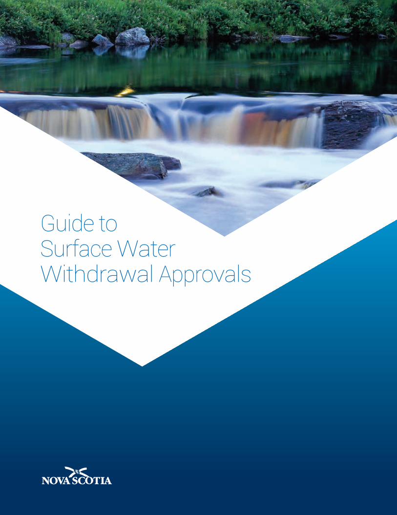
Guide to Surface Water Withdrawal Approvals
Guide to Surface Water Withdrawal ApprovalsNovember 2016

© Crown copyright, Province of Nova Scotia, 2016
Contents
Introduction ............................................................................................................. 1
Approach to Surface Water Allocation ......................................................................1
Definitions .......................................................................................................................2
Submission Requirements ..........................................................................................3
Description of Submission Requirements ............................................................. 6
1. Completed Application Form ..................................................................................6
2. Site Plan ......................................................................................................................6
3. Description of Operation ..........................................................................................7
4. Intended Water Use ..................................................................................................7
5. Description of Existing or Previous Water Withdrawal Approvals .................. 9
6. Watershed Characteristics ....................................................................................10
7. Delineation of Drainage Area ................................................................................10
8. Storage of Water .....................................................................................................12
9. Hydrological Assessment .....................................................................................13
10. Wetlands .................................................................................................................14
11. Fisheries and Oceans Canada Requirements .................................................15
12. Monitoring Plan .....................................................................................................16
13. Contingency Plan ..................................................................................................16
14. Water Conservation Plan .....................................................................................17
Appendix A – Submission Checklist .................................................................... 19
1
GU
IDE
TO S
UR
FACE
WAT
ER W
ITH
DR
AWAL
APP
RO
VALS
Introduction
Under the Environment Act, the Activities Designation Regulations (Division I; ADR) require that you obtain a water withdrawal approval if a surface water withdrawal exceeds 23,000 litres per day, subject to the exemptions outlined in the ADR. To obtain a water withdrawal approval, the Approval and Notification Procedures Regulations require that you submit to Nova Scotia Environment (NSE) a completed application form and supporting documentation.
This guide describes the submission requirements, supporting documentation, and the criteria used by NSE to evaluate surface water withdrawal applications.Applications for surface water withdrawals are classified into three (3) categories. This guide outlines the submission requirements for each. Although efforts have been made to make the guidance presented in this document applicable to as many potential applications as possible, final application requirements may deviate from the contents of this guide at the discretion of NSE staff.
Approach to Surface Water Allocation
A surface water withdrawal approval is one of the primary mechanisms used by the department to ensure that water resources are being developed in a sustainable way.
As the provincial regulator, NSE seeks answers to the following questions when considering applications for approval:
• Is the withdrawal sustainable?
• Will the activity cause an adverse effect on the environment?
• Will the activity impact other water users?
• Has the applicant demonstrated a need for the water requested?
Water allocation is based on the applicant’s current water needs rather than potential future needs. The applicant cannot reserve water for future use beyond the expiry date of the approval. Water allocations are considered on a “first-come, first-served” basis.
2
GU
IDE
TO S
UR
FACE
WAT
ER W
ITH
DR
AWAL
APP
RO
VALS
Definitions
Drainage area – the area of land draining to the point along the watercourse where the proposed water withdrawal is to take place.
Offline pond – a pond that is not connected to or receiving water from a stream, brook, river, wetland, lake, or another pond. A pond that is fed or potentially fed by groundwater would also be considered an offline pond if it meets the following size and separation criteria:
• Less than 4 m deep and greater than 30 m from the nearest stream, wetland, or off-site well less than 10 m deep; OR
• Greater than 4 m deep and greater than 60 m from the nearest stream, wetland, or off-site well less than 10 m deep.
Qualified person – an individual with hydrological knowledge, either having completed a degree in environmental science, with specialization in hydrology, aquatic ecology, limnology, biology, physical geography, and/or water resource management, or having equivalent education and experience.
Qualified professional – a professional engineer or professional geoscientist registered to practise in the province of Nova Scotia. A qualified professional must possess sufficient knowledge to complete a hydrological assessment.
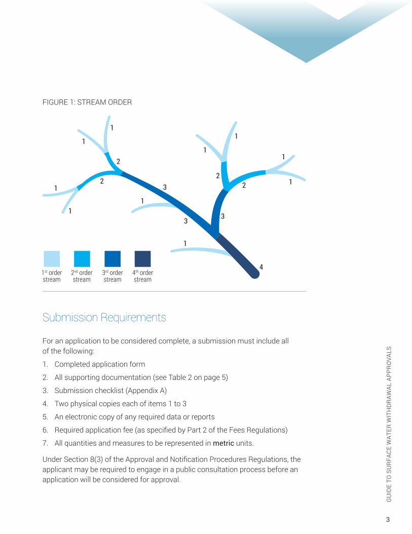
Stream order – a method of classifying streams, determined by their location in the watershed. A stream located high in a watershed with no streams running into it is considered a 1st order stream. A stream with two or more first order streams joining together is a 2nd order stream. A stream with two or more 2nd order streams joining together is a 3rd order stream, and so on (see Figure 1 on the following page). Stream ordering is to be based on the water courses identified on the provincial 1:10,000 scale water features map (interactive map found at novascotia.ca/nse/surface.water).
3
GU
IDE
TO S
UR
FACE
WAT
ER W
ITH
DR
AWAL
APP
RO
VALS
FIGURE 1: STREAM ORDER
Submission Requirements
For an application to be considered complete, a submission must include all of the following:
1. Completed application form
2. All supporting documentation (see Table 2 on page 5)
3. Submission checklist (Appendix A)
4. Two physical copies each of items 1 to 3
5. An electronic copy of any required data or reports
6. Required application fee (as specified by Part 2 of the Fees Regulations)
7. All quantities and measures to be represented in metric units.
Under Section 8(3) of the Approval and Notification Procedures Regulations, the applicant may be required to engage in a public consultation process before an application will be considered for approval.
1st order stream
2nd order stream
3rd order stream
4th order stream

4
GU
IDE
TO S
UR
FACE
WAT
ER W
ITH
DR
AWAL
APP
RO
VALS
TABLE 1 – CATEGORIES AND DESCRIPTIONS
SURFACE WATER WITHDRAWALS - CATEGORIES AND DESCRIPTIONS
Category 1 – A qualified person or qualified professional is not required
A) Renewals or applications with expired approvals
Must meet all of the following:
• Active approval or less than 5 years past expiry
• Hydrological assessment of the site (in accordance with current or 2004 approval guidance)
• No requests for additional water• No evidence of adverse effects• No complaints or non-compliance activity
B) Offline ponds • Withdrawals from offline ponds
Category 2 – Reports must be prepared by a qualified person or qualified professional
A) Lakes • Larger than 5 hectares; and • Withdrawals that reduce lake water levels
by 0.2 m or less using Equation 1 found in Appendix B.
B) Rivers and streams • 3rd order or greater; and • Taking less than 25% of the median
flow during the driest month of the withdrawal period
Category 3 – Reports must be prepared by a qualified professional
All other surface water withdrawal/ diversion applications
Includes but not limited to:
• Activities that do not meet the criteria outlined in Categories 1 and 2
• Micro- hydroelectric generating stations• Water diversions• Surface water heat pump systems

5
GU
IDE
TO S
UR
FACE
WAT
ER W
ITH
DR
AWAL
APP
RO
VALS
TABLE 2 – SUBMISSION REQUIREMENTS BY CATEGORY
This table identifies the submission requirements and items in the guide related to each of the three categories of surface water withdrawals.
SUBMISSION REQUIREMENTS CATEGORY
Item Description 1 2 3
1 Completed application form 3 3 3
2 Site plan 3 3 3
3 Description of operation 3 3 3
4 Intended water use 3 3 3
5 Description of existing or previous water withdrawal approvals
3 3 3
6 Watershed characteristics n/a n/a 3
7 Delineation of drainage area n/a 3 3
8 Storage of water 3 3 3
9 Hydrological assessment n/a 3 3
10 Wetlands 3 3 3
11 Fisheries and Oceans Canada requirements n/a 3 3
12 Monitoring plan 3 3 3
13 Contingency plan n/a n/a 3
14 Water conservation plan 3 3 3
6
GU
IDE
TO S
UR
FACE
WAT
ER W
ITH
DR
AWAL
APP
RO
VALS
Description of Submission Requirements
1. Completed Application Form
Applications for surface water withdrawals are available at any NSE regional office, or online at novascotia.ca/nse/water/docs/Application-WaterApproval.pdf
Section 6 (1) of the Approval and Notification Procedures Regulations provides a list of the information required in an application. This includes proof that the applicant owns the property, has a lease or other written agreement from the landowner, or has the legal right to carry out the activity on the site.
A completed application form, all required documentation, and the appropriate application fee must be included with the submission. Incomplete submissions will be returned. Once an application has been accepted as complete, the application for approval will undergo a technical review.
More information about surface water allocations can be found on our website: novascotia.ca/nse/surface.water/
2. Site Plan
A site plan consists of a sketch or survey drawing of the site. Site plans must include:
• Withdrawal point(s)
• Location of any ponds, reservoirs, watercourses, or wetlands
• Discharge point (if applicable)
• Land boundaries
• Any other features specified by NSE
If necessary, a survey plan prepared by a licensed Nova Scotia land surveyor may be required. A delineation of wetland boundaries by a qualified person may also be required if the proposed withdrawal has the potential to disrupt wetlands– see Section 10.

7
GU
IDE
TO S
UR
FACE
WAT
ER W
ITH
DR
AWAL
APP
RO
VALS
3. Description of Operation
The applicant must provide a description of the operations occurring on the site, including:
• Method of withdrawal
• Pump equipment specifications (if applicable)
• Discharge details, including the percentage of water being returned to the watercourse and any treatment processes (if applicable)
• Other active NSE approvals related to the site, including approval numbers
If water is discharged back into a watercourse, a separate approval may be required. Please contact the local NSE office for details.
4. Intended Water Use
The applicant must demonstrate a need for the volume of water requested. Water withdrawals cannot be reserved for future use. Documentation must show that the allocation is required regularly and will be used in its entirety.
All applications must include:
• How the water will be used
• Water demands, including: - Daily duration of withdrawal (hours) - Average and maximum withdrawal days per year (days), with an
outline of the dates when the withdrawals will occur - A description and start/end dates of any periods of increased withdrawals
(e.g., any seasonal changes or increases) - Water withdrawal rate (litres per day) for a day when water is being withdrawn - Maximum daily rate of withdrawal (litres per day) - Maximum instantaneous withdrawal rate (e.g., maxiumum pumping rate;
litres per second)
• Calculations or methods used to support the estimated water use, or records of actual water use
• Location and quality of water being discharged to the environment (if applicable)
• Any additional information requested by NSE
• See examples provided in Appendix B

8
GU
IDE
TO S
UR
FACE
WAT
ER W
ITH
DR
AWAL
APP
RO
VALS
Specific information related to the intended use is also required. (See examples.)
Withdrawals for crop irrigation:
• Type(s) of crops
• Amount of land to be irrigated (hectares)
• Average number of days that water will be pumped (weekly and monthly)
• Number of days in the crop growing season
• If rotating crops, identify which type of crop requires the most water
Withdrawals for watering of livestock:
• Number of animals on site
• Water requirements per animal (average daily and maximum daily)
• Usage requirements for other purposes (e.g., wash water and barn clean-up)
Withdrawals for municipal, registered public, and private drinking water supplies:
• Population served by the water distribution system
• Projected population growth during the approval period (for new approvals or renewals requesting additional water)
• Water usage per capita
• Any water-intensive industries using, or to be added to, the system, along with their usage rates
Industrial withdrawals:
• Description and usage requirements for each production process or phase that requires water (e.g., washing, dust suppression, cooling, water-jet cutting, production of chemical solutions used in the manufacturing process)
• Other non-process water requirements and usage estimates (e.g., drinking water, washrooms, kitchens)
• Total estimated water usage for the facility

9
GU
IDE
TO S
UR
FACE
WAT
ER W
ITH
DR
AWAL
APP
RO
VALS
Golf courses:
• For new developments – all information related to the initial water requirements of the golf course (based on the number of irrigated hectares)
• Detailed description of ongoing water requirements (including average and maximum withdrawal rates)
Open-loop surface-water heat pump:
• Overview of the system, including water requirements
• Discharge details, including: - Discharge location - Rates - Water quality (e.g., temperature)
5. Description of Existing or Previous Water Withdrawal Approvals
If the application relates to an existing or previous water approval, a description of that approval is required, including:
• Amount of the water allocation
• Issue date and expiry date of the approval
• Approval number
NSE may also require a copy of the approval.
For renewals (no changes to the active approval): In addition to the completed application form, submissions must include all required monitoring results for the previous 5 years.
For amendments to an existing approval: Any changes or requests to amend an existing approval must be clearly documented by the approval holder. Depending on the nature of the amendment, a qualified person or qualified professional may be required to submit additional information on behalf of the approval holder. If more water is requested, the withdrawal must be re-categorized, using Table 1 (see page 4). Additional information may be required if the withdrawal changes to a higher category.

10
GU
IDE
TO S
UR
FACE
WAT
ER W
ITH
DR
AWAL
APP
RO
VALS
6. Watershed Characteristics
Applications for Category 3 allocations require an overview of characteristics within the secondary watershed (as defined by NSE’s 1:10,000 Secondary and Shore Direct Watersheds of Nova Scotia map). The overview must include the following:
• Description of the watercourse – Physical parameters of the watercourse (e.g., width and length of river, surface area and dept0h of lake).
• Climate – Precipitation rates, evapotranspiration rates, average monthly temperatures for each month of the intended withdrawal period.
• Land use / land cover – Breakdown of the current land uses within the watershed and proportions (e.g., 35% agricultural, 20% residential developments, 15% commercial developments, 15% wetland, 10% forest, 5% forested wetland).
• Areas of special concern – Location and description of other areas of interest – such as wetlands, protected water areas, source-water protection plans, protected areas, and municipal water supplies – within the watershed (more information on these topics can be found at novascotia.ca/nse).
• Other water users – Description of any other water withdrawals occurring within the watershed (upstream or downstream), including location, activity type, name of owner/operation.
• Species at risk and their habitats – Identification of any aquatic species recognized provincially or federally as being at risk, and any habitats identified as critical to the species’ survival and recovery. Information on federal species at risk can be found at the Government of Canada Species at Risk Public Registry, and provincial species at risk on the Nova Scotia Department of Natural Resources website (novascotia.ca/natr/wildlife/biodiversity/species-list.asp).
• Soils and geology – Description of local geology and soil characteristics, including average soil depth, soil type, and soil drainage characteristics.
7. Delineation of Drainage Area
Category 2 and 3 applications require a delineation of drainage area prepared by a qualified person or qualified professional (as outlined in Table 1 on page 4). Submissions must contain a map delineating the area of the watershed draining to the withdrawal point. The map must be scaled appropriately (e.g., 1:5,000, 1:10,000, 1:25,000) to a level of detail that allows NSE to reproduce the delineation. Figure 2 (following page) shows an example of a delineated drainage area to the withdrawal point A. The total surface area of the drainage area must be clearly identified.

11
GU
IDE
TO S
UR
FACE
WAT
ER W
ITH
DR
AWAL
APP
RO
VALS
FIGURE 2. EXAMPLE OF DRAINAGE AREA
A
A
12
GU
IDE
TO S
UR
FACE
WAT
ER W
ITH
DR
AWAL
APP
RO
VALS
8. Storage of Water
If the proposed withdrawal occurs on a lake or pond (natural or artificially created), the water storage capacity of the withdrawal source must be indicated in the submission. An artificially created body of water (e.g., as created by a water control structure, etc.) with a storage capacity exceeding 25,000 cubic metres requires an approval which must be referenced in the submission.
All categories of applications (including offline ponds) must provide the following details:
• Dimensions of the pond, lake, or storage structure (i.e., approximate surface area and average depth)
• Volume of water in the lake, pond, or storage structure
• Pond linings, if any
• Summary of the sources of inflow into the storage
If a water control structure (e.g., dam) is used, it is the applicant’s responsibility to ensure the integrity and safety of the structure meets industry standards. NSE may request that the integrity of the structure be confirmed by a professional engineer licensed by Engineers Nova Scotia.
Category 3 applications: Dimensions and total storage must be validated to confirm that source capacity is adequate. Bathymetric data may be used in the validation process. NSE may request that bathymetric data be submitted during the review of the application.
13
GU
IDE
TO S
UR
FACE
WAT
ER W
ITH
DR
AWAL
APP
RO
VALS
9. Hydrological Assessment
The applicant must demonstrate that sufficient water is available within the system to support the requested withdrawal rates and downstream environmental flow.
Category 2 applications: must validate that the proposed withdrawal complies with the description outlined in Table 1. For cases where the proposed withdrawal is located downstream of a water control structure (e.g., dam, weir), a description and outline of the effects of the structure (and any related water withdrawals/diversions) on flows at the withdrawal location must be provided.
Category 3 applications: must include the following items:
• Quantity assessment:
- For withdrawals from flowing watercourses – Using a flow-duration curve, the applicant must demonstrate that sufficient water is available in the system to support the proposed withdrawal for the period in which the primary withdrawal will take place. A flow-duration curve plots discharge against the percentage of time that the discharge is equaled or exceeded using daily average flow values.
For assessment purposes, flow duration curves must be included in graphical format on both standard and logarithmic scales, with summary data provided including the 50, 90, and 95% exceedance frequency values summarized in tabular format. The use of at least 20 years of data from within the last 30 years is required as part of this analysis.
In addition, 7 day low flow analysis using the 10 and 20 year return periods (i.e., 7Q10 and 7Q20) must be provided to support the application. The frequency plot from this analysis must be provided as well as supporting details related to the development of the 7Q10 and 7Q20 values (e.g., details of any watershed pro-rating completed, summary of the frequency distribution chosen, etc.). This information, in addition to the other requirements outlined below, supports the analysis of the feasibility and sustainability of the proposed withdrawal.
- For withdrawals from a lake or pond (naturally or artificially created) - A water balance (water budget) analysis must be prepared for the proposed storage system to assess whether the proposed rate of water withdrawal can be sustained long term.

14
GU
IDE
TO S
UR
FACE
WAT
ER W
ITH
DR
AWAL
APP
RO
VALS
The water balance calculation must take into account the maximum cumulative withdrawal rates of all withdrawal sites on the watercourse, any upstream flow restrictions (e.g., upstream storage, water control structures), any downstream flow requirements, precipitation, evapotranspiration, and any groundwater influences. Water balances must be completed on a minimum of a monthly timescale for an entire year following the water year calendar (i.e., April 1 to March 31). Water balances for both average and 1 in 20 year return period storage conditions must be provided. The frequency plot from the 1 in 20 year return period analysis must be provided as well as other details related to the development of the 1 in 20 year return period values (e.g., details of any watershed pro-rating completed, summary of the frequency distribution chosen, etc.). Specifically, the water balance must demonstrate that the following conditions are met downstream or at the withdrawal point:
- The natural storage in the system will not degrade in the long term or experience short-term significant drops in water levels.
- Other water users and approval holders can continue their pattern of use without causing the flow to drop below the ecological maintenance flow.
- Wetlands or other sensitive areas will not be adversely affected.
If historical monitoring data are available for the withdrawal site (e.g., water levels, pumping rates, water quality, hydrometric data), they should be used to assess how the watercourse has responded historically to pumping. For an ungauged watershed, a watershed assessment must also be undertaken, using hydrometric data from gauged watersheds to extrapolate long-term trends pertaining to water quantity. Precipitation data used must be from a reputable source (e.g., Environment Canada, established universities).
• Ecological Maintenance Flow (EMF) - the flow regimes and water levels required to maintain the ecological functions that sustain fisheries associated with that water body and its habitat. The applicant must demonstrate that sufficient water is available in the system to sustain fisheries throughout the water withdrawal period. The EMF requirement is determined to be 75% of the median flow during the seasons that the water withdrawal is taking place.
15
GU
IDE
TO S
UR
FACE
WAT
ER W
ITH
DR
AWAL
APP
RO
VALS
The EMF must be calculated and maintained downstream from the withdrawal point for each season that the withdrawal occurs, even if the withdrawal only occurs for part of the season. A multi-season or year-round water withdrawal would require EMFs be calculated by determining the median flow for each season of the water withdrawal and by multiplying these values by 0.75. For example, a water withdrawal from June through August would require that EMFs be calculated for both spring and summer seasons.
Seasons are defined as follows: - Winter (January to March) - Spring (April to June) - Summer (July to September) - Autumn (October to December)
This would equate to four seasonal EMFs for a year round water withdrawal. The seasonal median flow is required to be calculated by using a minimum of 20 years of daily flow data within the last 30 years.
Note: If flow cannot naturally be maintained downstream (e.g., in ephemeral or headwater watercourses), NSE may reduce or prohibit withdrawal of water from the watercourse, and request submission of alternatives (e.g., offline storage ponds).
10. Wetlands
If a wetland has the potential to be affected by the withdrawal, additional studies may be required. If a wetland alteration approval is required or already in place for the withdrawal site, it must be documented in the wetland section of the submission package.
Please contact the local NSE office or refer to the wetland section of the NSE website (novascotia.ca/nse/wetland/) to determine if additional work may be required for wetlands.
16
GU
IDE
TO S
UR
FACE
WAT
ER W
ITH
DR
AWAL
APP
RO
VALS
11. Fisheries and Oceans Canada Requirements
All surface water withdrawal applications will be forwarded to the Department of Fisheries and Oceans Canada (DFO) Fisheries Protection Program (FPP) for review and comment under the Fisheries Act and Species at Risk Act. The following information is required as part the submission:
Category 2 applications: The applicant must provide engineering drawings of the intake which must confirm that pump intakes are screened to prevent the entrainment or impingement of fish. Entrainment occurs when a fish is drawn into a water intake and cannot escape. Impingement occurs when an entrapped fish is held in contact with the intake screen and is unable to free itself.
Category 3 applications: In addition to the intake details and screen requirements for Category 2 applications, all Category 3 applications must include a description of the aquatic habitat, with photos. This should include, but is not limited to:
• High- and low-water marks
• Description of aquatic vegetation
• Substrate characterization
• Fish species present (including species at risk)
• Description of riparian vegetation
In the event of a significant change in the water level in a pond or lake as identified by NSE/DFO, additional information relating to the potential impacts in the littoral zone may be required. For flowing watercourses, the applicant may be required to provide a cross-section of the watercourse in addition to the requirements outlined in Section 9.
Note: If the application involves other barriers to fish passage, additional information may be requested. For questions related to fish habitat and associated submission requirements please contact DFO:
Fisheries Protection Program Attention: Referrals Secretariat Fisheries and Oceans Canada PO Box 1006 Dartmouth, Nova Scotia B2Y 4A2
Telephone: 902-426-3909 Fax: 902-426-7174 Email: [email protected]

17
GU
IDE
TO S
UR
FACE
WAT
ER W
ITH
DR
AWAL
APP
RO
VALS
12. Monitoring Plan
All water withdrawal approvals include terms and conditions that require the approval holder to monitor the rate at which water is extracted from a watercourse. Monitoring is typically required to be done daily.
All categories: The applicant must submit a plan outlining how daily withdrawal rates will be monitored and recorded. In most situations, the approval holder will be required to install and monitor flowmeters. This requirement may be waived if alternative means are available to accurately determine water usage.
Category 3 applications: Where necessary, the following information is required for all Category 3 applications (if omitted, the qualified professional must provide a rationale supporting the omission):
• Downstream flow monitoring – a description of how flows downstream of the withdrawal will be monitored and the methodology used to determine if sufficient flow is being maintained for environmental protection. Methodologies used must follow accepted practices for stream gauging (e.g., the midsection method using an appropriate current meter, with considerations such as outlined in WMO 20101). Any stage - discharge curves must be supported by an adequate quantity of discharge measurements, and justification provided as part of the application.
• Water level – a description of how water levels will be monitored to ensure that the lake, pond, or stream is not being affected by the water withdrawal activity. A description of the proper siting of equipment to be installed must be included within the application.
• Wetlands – a detailed plan related to the monitoring of nearby wetlands. This includes baseline studies and ongoing monitoring to ensure that a wetland is not altered without a wetland alteration approval issued by NSE.
NSE reserves the right to request additional information as necessary to support the application.
1 WMO (World Meteorological Organization), 2010. Manual on Stream Gauging. Volume 1 - Fieldwork. WMO-No. 1044, ISBN 978.92.63.11044-2.

18
GU
IDE
TO S
UR
FACE
WAT
ER W
ITH
DR
AWAL
APP
RO
VALS
13. Contingency Plan
For Category 3 applications, NSE may require that a contingency plan be submitted to the department for approval. The plan must outline the actions that will be undertaken by the approval holder should an infrequent, unlikely, or unexpected event affect the normal flow of water, including situations where:
• Environmental flow cannot be sustained
• Significant drops in water level are observed
• Drought conditions are observed
• Other water quantity issues identified by the applicant or NSE
The contigency plan must contain clear triggers for implementation of any action to be taken under the plan. Actions may include stringent water conservation methods and use of alternative water sources, as examples.
14. Water Conservation Plan
Each surface water withdrawal application must include a water conservation plan. The plan should demonstrate the efforts being undertaken by the applicant to reduce water consumption – to protect the resource and the environment, while ensuring there is sufficient water for all users.
The plan must be maintained so that the information is up to date. NSE may require periodic updates to be submitted.
Water conservation plans must include the following:
• A list of water conservation measures being implemented at the site
• A detailed description of each measure (including how and when it is applied)
• Calculation of the potential or actual water reductions derived from each conservation measure
• A list of other approvals or certifications received for water conservation (e.g., Environmental Farm Plan, other environmental certification as appropriate)
A variety of initiatives may be considered as water conservation measures. The following are some of the types of measures that could be included in a water conservation plan.
19
GU
IDE
TO S
UR
FACE
WAT
ER W
ITH
DR
AWAL
APP
RO
VALS
General conservation measures:
• Withdrawing from an offline pond instead of directly from a watercourse
• Installing low-flow nozzles, utilities, and fixtures
• Performing a system integrity check and fixing any leaks on the system
• Collecting and using rainwater from rooftops / parking lots for non-potable purposes
• Reducing or eliminating withdrawals during the dry season (June 1 to September 30)
Agricultural conservation measures:
• Using centre-pivot, drip irrigation, or other more efficient methods instead of sprinkler irrigation
• Ensuring that the irrigation schedule is right for the type of crop (i.e., reducing over-irrigation)
• Planting crops with lower water needs
• Scheduling irrigation to ensure optimal soil moisture
Industrial conservation measures:
• Re-using process water where possible
• Reducing process water needs
• Reducing spillage/waste
Conservation measures for municipal water supplies:
• Ensuring that leak detection systems are in place and functioning
• Providing water conservation educational material to customers
• Metering users
Conservation measures for golf courses:
• Installing/using soil moisture sensors
• Installing/using computerized automated soil-moisture sensing and irrigation decision-making equipment
• Selecting turf grasses with lower water demands
• Withholding water during grow-in to encourage deeper rooting
• Installing storage for use during dry periods
20
GU
IDE
TO S
UR
FACE
WAT
ER W
ITH
DR
AWAL
APP
RO
VALS
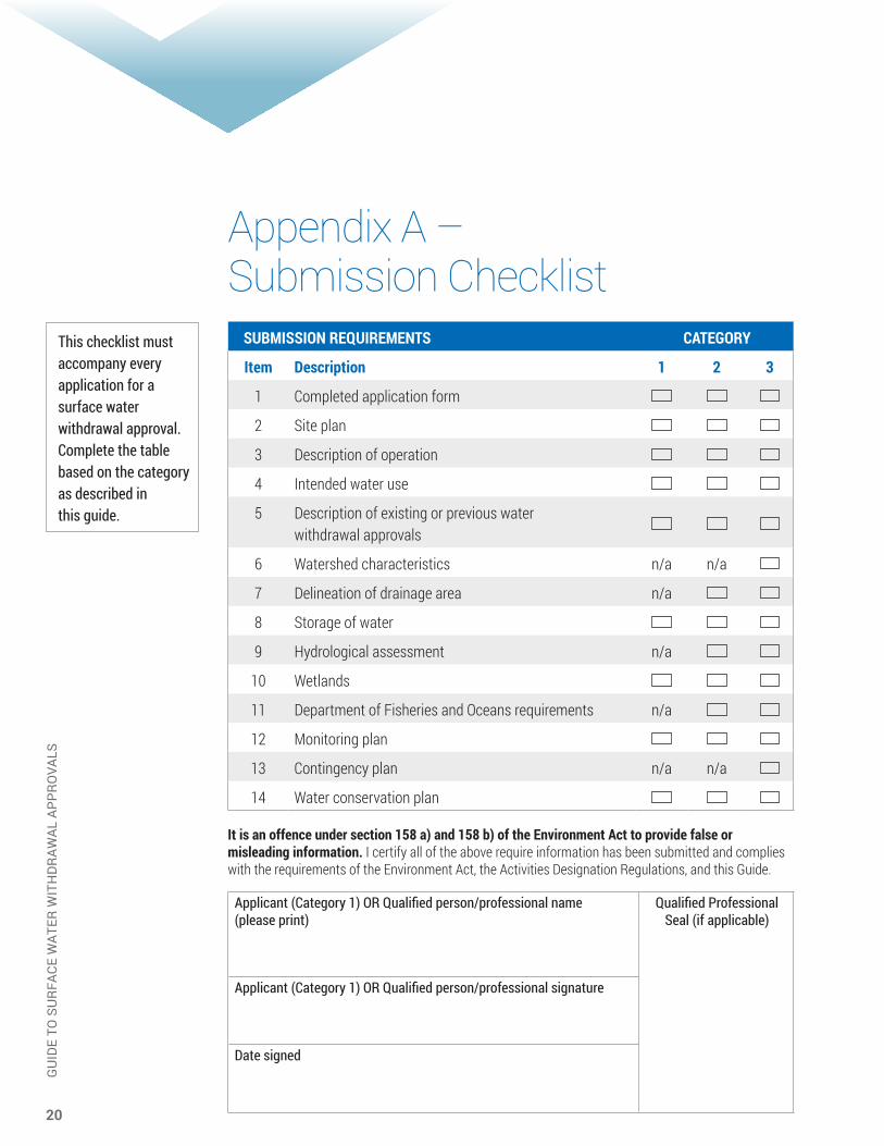
This checklist must accompany every application for a surface water withdrawal approval. Complete the table based on the category as described in this guide.
Appendix A – Submission Checklist SUBMISSION REQUIREMENTS CATEGORY
Item Description 1 2 3
1 Completed application form
2 Site plan
3 Description of operation
4 Intended water use
5 Description of existing or previous water withdrawal approvals
6 Watershed characteristics n/a n/a
7 Delineation of drainage area n/a
8 Storage of water
9 Hydrological assessment n/a
10 Wetlands
11 Department of Fisheries and Oceans requirements n/a
12 Monitoring plan
13 Contingency plan n/a n/a
14 Water conservation plan It is an offence under section 158 a) and 158 b) of the Environment Act to provide false or misleading information. I certify all of the above require information has been submitted and complies with the requirements of the Environment Act, the Activities Designation Regulations, and this Guide.
Applicant (Category 1) OR Qualified person/professional name (please print)
Qualified Professional Seal (if applicable)
Applicant (Category 1) OR Qualified person/professional signature
Date signed
21
GU
IDE
TO S
UR
FACE
WAT
ER W
ITH
DR
AWAL
APP
RO
VALS
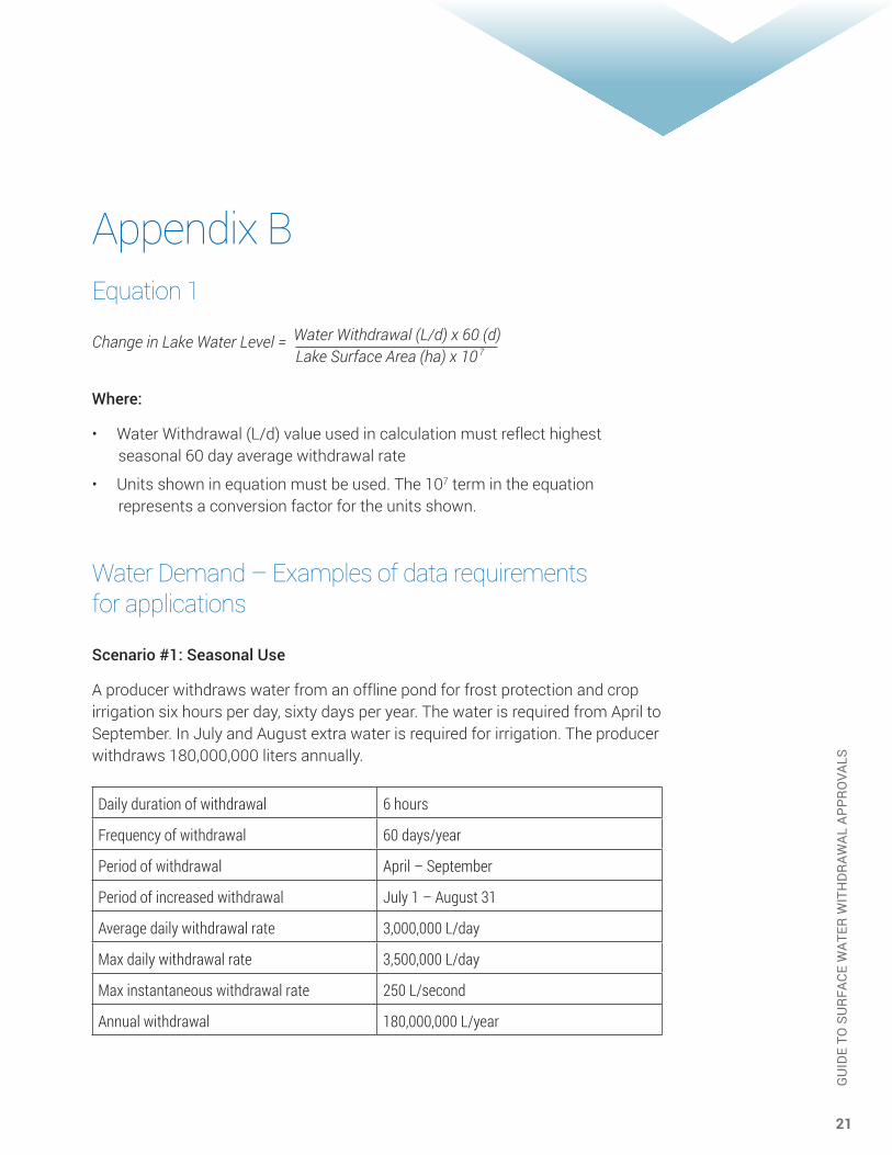
Appendix BEquation 1
Change in Lake Water Level = Water Withdrawal (L/d) x 60 (d) Lake Surface Area (ha) x 10 7
Where:
• Water Withdrawal (L/d) value used in calculation must reflect highest seasonal 60 day average withdrawal rate
• Units shown in equation must be used. The 107 term in the equation represents a conversion factor for the units shown.
Water Demand – Examples of data requirements for applications
Scenario #1: Seasonal Use
A producer withdraws water from an offline pond for frost protection and crop irrigation six hours per day, sixty days per year. The water is required from April to September. In July and August extra water is required for irrigation. The producer withdraws 180,000,000 liters annually.
Daily duration of withdrawal 6 hours
Frequency of withdrawal 60 days/year
Period of withdrawal April – September
Period of increased withdrawal July 1 – August 31
Average daily withdrawal rate 3,000,000 L/day
Max daily withdrawal rate 3,500,000 L/day
Max instantaneous withdrawal rate 250 L/second
Annual withdrawal 180,000,000 L/year

22
GU
IDE
TO S
UR
FACE
WAT
ER W
ITH
DR
AWAL
APP
RO
VALS
Scenario #2: Year Round Use with Peak
A municipality withdraws water from a river to supply potable water. The withdrawal is fairly constant throughout the year, but peaks significantly during the summer due to lawn watering.
Daily duration of withdrawal 24 hours
Frequency of withdrawal 365 days/year
Period of withdrawal January - December
Period of increased withdrawal June 15 – September 15
Average daily withdrawal rate 10,000,000 L/day
Max daily withdrawal rate 15,000,000 L/day
Max instantaneous withdrawal rate 200 L/second
Annual withdrawal 4,100,000,000 L/year
Scenario #3: Consistent Use
A water bottling plant withdraws water from a nearby lake. The plant operates year round and consistently takes the average daily withdrawal rate. Water is withdrawn twelve hours per day.
Daily duration of withdrawal 12 hours
Frequency of withdrawal 365 days/year
Period of withdrawal January - December
Period of increased withdrawal N/A
Average daily withdrawal rate 50,000 L/day
Max daily withdrawal rate 60,000 L/day
Max instantaneous withdrawal rate 10 L/second
Annual withdrawal 18,250,000 L/year
