hazard mitigation plan former central connecticut region
TRANSCRIPT

Hazard Mitigation Plan for the Former Central Connecticut Region – 2016‐2021 Update Page | 180
8.0 City of New Britain Annex
8.1 Introduction
The former Central Connecticut Region, which includes New Britain, is updating its Natural Hazard Mitigation Plan (the Plan). The goal of the Plan for the City of New Britain is to reduce losses of life and property, and minimize economic consequences of natural hazards. The City of New Britain has developed a series of objectives to meet this goal as discussed in Section 8.3, and specific strategies are identified under appropriate objectives with the goal of enacting these strategies by 2021. The Plan contains two parts. The first four chapters comprise a regional section that considers risks from various natural hazards, and lays out a series of broad goals and objectives. The final seven chapters is a collection of municipal plans referred to as “annexes”. These municipal annexes serve three functions. The first is to gather, in one place, information from various municipal departments about how the City currently prepares for, and responds to, natural hazards. The second is to gather the projects and priorities that the community will pursue to improve its natural hazard preparedness and strengthen its disaster response efforts. The final purpose is to make the community eligible for funding from the Federal Emergency Management Agency (FEMA). To be eligible for many of FEMA’s grant and assistance programs, a municipality must have a current FEMA‐approved Natural Hazard Mitigation Plan that is adopted by the local governing body by resolution. Chapter 8 presents the updated municipal annex of the Plan for the City of New Britain. It presents a brief overview of the city, its challenges, its vulnerabilities, and its goals, objectives, and strategies for the next five years. 8.1.1 Background New Britain is positioned geographically in the eastern section of the former CCRPA region, with Berlin bordering to the south, Plainville to the west, and Southington to the southwest. Other neighboring communities including Farmington to the north and Newington to the east. The City of New Britain is the most populous municipality in the former CCRPA region. New Britain encompasses 13.3 square miles of land area and is home to 73,206 residents as of the 2010 census. New Britain has a population density of 5,504 people per square mile, far higher than the Hartford County average (1,190 persons per square mile) and the state average (644 persons per square mile). New Britain’s population, with a median age of 33, falls below the county and state averages of 40 years old. This is partly due to a declining population of residents above the age of 65 and of individuals between age 25 and 44 years old. Future population projections are varied for New Britain. One model used by the City of New Britain expects a sharp decline to fewer than 64,000 residents by 2030, while other projections used by state and regional agencies predict modest population increases. Each of these projections place potential challenges on the city’s revenue base, demand for services, and land use. In addition, the City of New Britain has maintained itself as a center of cultural diversity, where past and present immigrant communities continue to locate and concentrate to work in the city’s industrial districts. This factor has had implications on community and neighborhood planning activities, and attracting and retaining residents remains a key component of New Britain’s development goals.

Hazard Mitigation Plan for the Former Central Connecticut Region – 2016‐2021 Update Page | 181
Elevation in New Britain ranges from approximately 60 to 430 feet. The land in New Britain is in the upper reaches of three sub‐regional watersheds. The central and northern sections of the city drain to the Park River, the western portion of the city drains to the Quinnipiac River, and the southern portion of the city drains to the Mattabesset River. Significant streams in the city other than the Quinnipiac River include Bass Brook, Piper Brook, Willow Brook, and Webster Brook. New Britain is located at the junction of Interstate 84, Route 72, and Route 9. New Britain is distinctly characterized—compared to other regional partners—as a densely populated, younger, and culturally diverse city. New Britain’s major businesses and industries include health care, State government, city government (including schools), and manufacturing. Top employers include The Hospital of Central Connecticut (3,600 employees), the State of Connecticut (2,800 employees), the City of New Britain (2,200 employees), The Hospital for Special Care (1,400 employees), the headquarters of Stanley Black and Decker (780 employees), and Tilcon Connecticut (735 employees). An active segment of the Hartford, Providence and Fishkill Railroad is operated by Pan Am Southern for freight between New Britain and Waterbury. The city is relatively built‐out, with most recent commercial and industrial development occurring on properties that have previously been developed (either infill or redevelopment. One exception of new development on previously undeveloped land is the Costco that is being built adjacent to Target on Route 71. This is being built on property that was formerly part of the Stanley Golf Course. Another exception is the Pinnacle Business Park which was permitted a few years ago. Approximately 16 acres still remain in this park for development. There are also plans to redevelop the former Police Station site. In addition, a small amount of residential redevelopment is occurring. Apartment complexes such as Cabin Heights and Pinnacle Heights Extension have been redeveloped recently. The City of New Britain is professionally managed by staff assisting a full‐time Mayor. The new Police Department includes the City’s Emergency Operations Center, while a backup is still available at City Hall. The Police Department is comprised of approximately 150 full‐time police officers and additional emergency dispatch personnel and support staff. Fire protection is provided by a full‐service Fire Department with eight stations. The city is almost entirely served by public water and sewer. In its most recent Plan of Conservation and Development (POCD) from 2010, the City of New Britain categorizes itself as a mature city, where little vacant land exists to build outward. Instead, New Britain addresses strategic planning and development as it relates to the conserving limited available vacant land and designating certain areas available for development. New Britain, with only about 3% vacant land use available, has focused on preservation of designated open spaces and infrastructure development that conserves land use, water, and energy efficiency. Development focuses on encouraging low impact development housing, business development adjacent transportation corridors, and revitalizing neighborhoods, which promote redevelopment and conservation of limited open space and landscapes. Although nearly 1,500 new dwelling units could be built in the city under existing zoning, this level of development is believed unlikely to occur. Similarly, although there is the potential for 2.9 million square feet of additional commercial and industrial development under existing zoning, this level of development is believed unlikely to occur. The 2010 POCD also discusses steeply sloped soils and 1% annual chance floodplains as well as the need to avoid building in unsafe areas. The current POCD predates the initial hazard mitigation plan from 2011, and it is expected that elements of hazard mitigation planning will be incorporated into the next POCD update in 2020. As the population of the community, building square footage, and associated

Hazard Mitigation Plan for the Former Central Connecticut Region – 2016‐2021 Update Page | 182
infrastructure increases, so does the risk of damage from natural hazards as discussed in the next section.
8.2 Challenges
The top three natural hazards that present a high risk to New Britain include winter storms and tropical storms/hurricanes. According to information from the City and the FEMA Public Assistance Funded Projects Summary (Open Government Initiative), there were 10 federally declared disasters or emergencies since 1999 that resulted in reimbursement requests to FEMA. These expenses included debris and snow removal, emergency protective measures, and repairs to damaged infrastructure and buildings experienced by private citizens and businesses. A summary is presented in Table 6‐1. The types of events in this table are consistent with the top two natural hazards listed above.
Event Name Declaration
Date
City of New Britain
Reimbursement
Other Local Agency1 Reimbursement
Total Cost2
DR‐1302 Tropical Storm Floyd 9/23/1999 $31,158.62 $0 $41,544.83
EM‐3176 Snow (February) 3/11/2003 $72,356.70 $7,042.55 $105,865.67
EM‐3192 Snow (December) 1/15/2004 $55,197.16 $38,710.99 $125,210.87
EM‐3200 Snow (January) 2/17/2005 $109,299.97 $71,964.24 $241,685.61
DR‐1619 Severe Storms and Flooding (October)
12/16/2005 $89,291.99 $62,273.97 $202,087.95
EM‐3266 Snow (February) 5/2/2006 $93,642.12 $104,915.69 $264,743.75
DR‐1958 Severe Winter Storm 3/3/2011 $120,905.96 122,790.11 $324,928.09
DR‐4023 Tropical Storm Irene 9/2/2011 $52,037.92 $4,297.50 $75,113.89
DR‐4046 Severe Storm Alfred 11/17/2011 $536,985.07 $350,782.11 $1,183,689.57
DR‐4106 Severe Winter Storm 3/21/2013 $263,045.35 $258,669.00 $695,619.13
Table 8‐1 Recent Disasters Where New Britain Applied for Public Assistance.1. Other Agencies = Fire Districts, Schools, Housing Authorities, Private and Non‐Profit Agencies 2. Assuming that federal reimbursement was 75% of damages.
Source: FEMA
Other natural hazards present a moderate or low risk. A general discussion of the City of New Britain’s emergency response capabilities and a discussion of the vulnerability of the community to each hazard is discussed in more detail in the sections below. In particular, New Britain’s unique stock of older buildings, local and state routes and highways, rail lines, medical facilities, businesses, and overall scale of development present a variety of vulnerabilities to natural hazards. 8.2.1 All Hazards The City of New Britain has a variety of emergency operation procedures in place to respond to the effects of natural hazards. In addition to maintaining an Emergency Operations Plan (updated annually) and an Emergency Operations Center, the City maintains shelters, has identified warming/charging stations, and has identified a variety of resources to assist with response to natural hazard events. The City also maintains a training program for its emergency personnel. The City makes regular use of the statewide CT Alerts emergency notification system when residents need to be informed about a natural hazard event. The City is in the process of revamping its website and intends to add more information about preparedness and mitigation in the coming years.

Hazard Mitigation Plan for the Former Central Connecticut Region – 2016‐2021 Update Page | 183
New Britain continually coordinates with Charter Oak State College and Central Connecticut State University regarding emergency procedures. Both schools have sheltering facilities that are utilized (primarily for their students) during emergencies. All critical facilities in the city have generators. Shelters were only lightly utilized during the recent disasters. The City High School can be used as a shelter, but the generator only powers part of the building. The City would like to upgrade the generator to allow for the High School to act as a regional shelter with a capacity of 1000 people. While the city has sufficient shelter supplies at present, it would like more and would definitely need more to stock a regional shelter. The City recognizes that most residents choose to shelter in place if possible, and recommends that residents stock three days of supplies. The majority of the generators providing backup power to critical facilities are relatively dated and could use updating. These include the generators on the following list. The city attempted to apply for generator funding but was unable to obtain funds. In general, the older generators are prioritized for replacement:
Two of the Fire Stations have generators that are more than 45 years old, two have generators that are 30 years old, two have generators that are between 10 and 30 years old, and the two newest fire station generators are both around 10 years.
The Police Department generator is relatively new, but the EMS generator is closer to 10 years in age.
The City would like a new portable generator to provide backup to a 30‐year old portable unit used to power the sewage pumping station. A permanent generator at this location would be preferred.
The City is in the process of instituting a vehicle tracking program which will allow emergency managers to track response vehicles in the field and be able to accurately plot downed trees, fires, and plowing conditions. This system will assist with data tracking and archiving information for future retrieval. The City recently implemented a new radio system that allows for intra‐department communication. The New Britain Fire Department also provides fire prevention training in school each year. While the above assets are necessary to keep the city up and running, emergency planners also pay close attention to their most vulnerable citizens. Populations that may be particularly vulnerable include: people living under the poverty line, people with limited or no English proficiency, minorities, and people who are dependent on transit. 8.2.2 Flooding Flooding is a moderate issue in the City as regular localized flooding occurs at known locations several times per year. Webster Brook, Bass Brook, and the Quinnipiac River all produce minor flooding at times, while Willow Brook and West Canal can create more frequent and severe flooding problems. Location Figure 8‐1 below shows the locations of critical facilities in New Britain, as well as the relationship between them, flood zones, and the most populated areas of the city. As shown in the map, a significant portion of the city is located within the 1% annual flood zone although the majority of critical facilities are not located in a flood zone. The areas of the city that are in or adjacent to flood zones tend to be heavily populated.

Hazard Mitigation Plan for the Former Central Connecticut Region – 2016‐2021 Update Page | 184
Figure 8‐1. Flood Zones, Cri cal Facili es, and Popula on Density in New Britain.
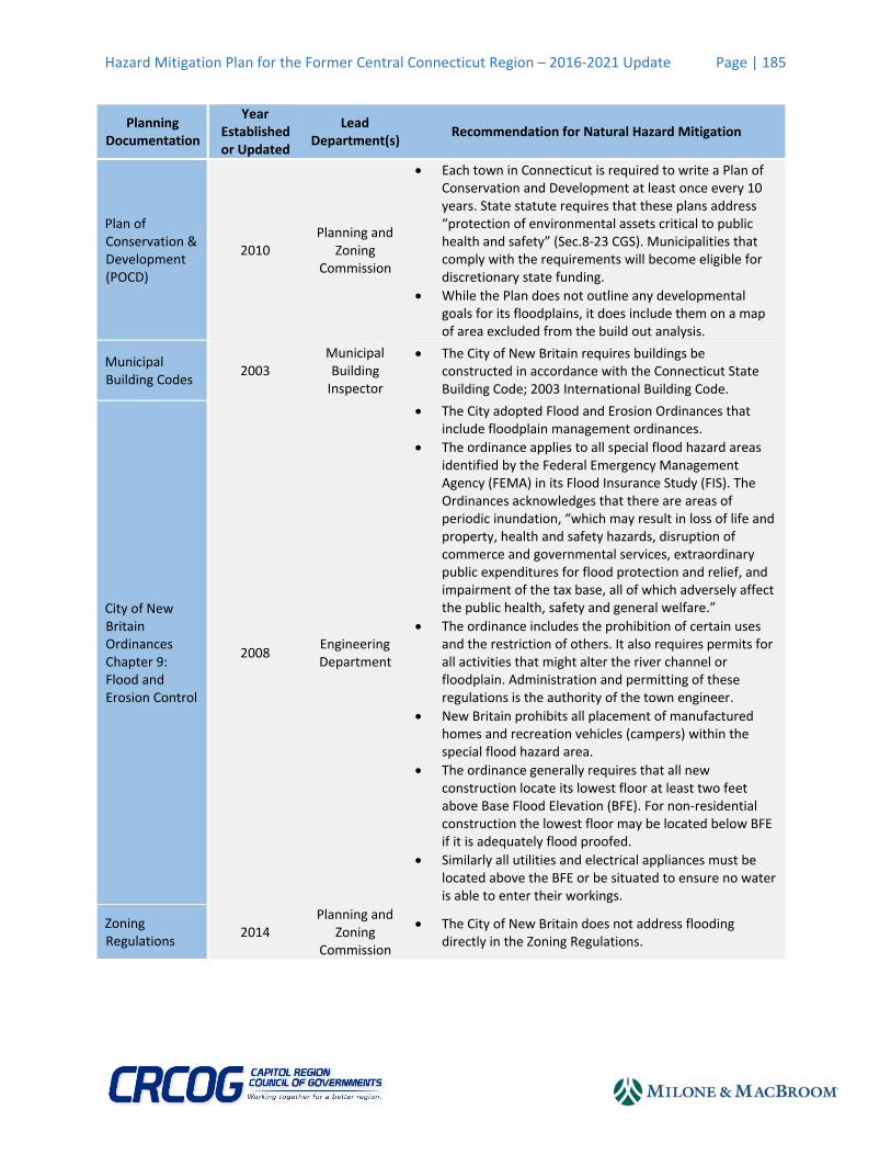
Areas at risk of flooding are generally unchanged since the initial Plan. Willow Brook in the southern section of the city generally causes the most severe flood damage. Existing Capabilities The City of New Britain has in place codes and ordinances to reduce the risks to public health and property posed by flooding. These regulations primarily limit any activities on floodplains that would increase flood heights and velocities, or reduce or alter naturally occurring floodplains and water catchment areas. The City defines floodplains, hereafter special flood hazard areas, from the Federal Flood Insurance Rate Maps identified in FEMA’s Flood Insurance Study. The following includes a brief description of how the City of New Britain is addressing flood risk in its most important planning documents (Table 8‐2).
Hazard Mitigation Plan for the Former Central Connecticut Region – 2016‐2021 Update Page | 185
Planning Documentation
Year Established or Updated
Lead Department(s)
Recommendation for Natural Hazard Mitigation
Plan of Conservation & Development (POCD)
2010 Planning and
Zoning Commission
Each town in Connecticut is required to write a Plan of Conservation and Development at least once every 10 years. State statute requires that these plans address “protection of environmental assets critical to public health and safety” (Sec.8‐23 CGS). Municipalities that comply with the requirements will become eligible for discretionary state funding.
While the Plan does not outline any developmental goals for its floodplains, it does include them on a map of area excluded from the build out analysis.
Municipal Building Codes
2003 Municipal Building Inspector
The City of New Britain requires buildings be constructed in accordance with the Connecticut State Building Code; 2003 International Building Code.
City of New Britain Ordinances Chapter 9: Flood and Erosion Control
2008 Engineering Department
The City adopted Flood and Erosion Ordinances that include floodplain management ordinances.
The ordinance applies to all special flood hazard areas identified by the Federal Emergency Management Agency (FEMA) in its Flood Insurance Study (FIS). The Ordinances acknowledges that there are areas of periodic inundation, “which may result in loss of life and property, health and safety hazards, disruption of commerce and governmental services, extraordinary public expenditures for flood protection and relief, and impairment of the tax base, all of which adversely affect the public health, safety and general welfare.”
The ordinance includes the prohibition of certain uses and the restriction of others. It also requires permits for all activities that might alter the river channel or floodplain. Administration and permitting of these regulations is the authority of the town engineer.
New Britain prohibits all placement of manufactured homes and recreation vehicles (campers) within the special flood hazard area.
The ordinance generally requires that all new construction locate its lowest floor at least two feet above Base Flood Elevation (BFE). For non‐residential construction the lowest floor may be located below BFE if it is adequately flood proofed.
Similarly all utilities and electrical appliances must be located above the BFE or be situated to ensure no water is able to enter their workings.
Zoning Regulations
2014 Planning and
Zoning Commission
The City of New Britain does not address flooding directly in the Zoning Regulations.

Hazard Mitigation Plan for the Former Central Connecticut Region – 2016‐2021 Update Page | 186
Planning Documentation
Year Established or Updated
Lead Department(s)
Recommendation for Natural Hazard Mitigation
Subdivision Regulations
2014 Planning and
Zoning Commission
City Subdivision regulations stipulate that subdivisions
must minimize the risk of flood damage. This includes
locating utilities and other facilities away from danger.
The application submitted by the subdivisions must also
include the location of any watercourses.
The Flood and Erosion Control Ordinances echo these demands with a couple additions: (1) drainage be designed to reduce flood exposure, (2) elevations and floodway data be included in all subdivision applications located in the special flood hazard area.
Drainage infrastructure related to subdivision for roads shall be designed for not less than the 4% annual flood hazard event.
Inland Wetlands and Watercourses Regulations
2011
Conservation Commission
Flood and Erosion
Control Board
The Conservation Commission was established in 1964 and given the mandate of inland wetland agency in 1973 to implement the Inland Wetland and Watercourses Regulations (in accordance with Section 19‐35 of Ordinances). Under Connecticut General Statutes all municipalities shall regulate activities on those wetlands and watercourses that lie within municipal borders. While these regulations are primarily for the protection of environmental and ecological assets, they also address impacts to safety and public health. As such, the Conservation Commission has a role to play in mitigating risk in flood hazard areas.
The Flood and Erosion Control Board has the authority to plan, layout, acquire, construct, reconstruct repair maintain, supervise and manage a flood or erosion control system. This board also has the authority to take and hold property or issue bonds for the construction of a flood or erosion control system.
Capital Improvement Plan (CIP)
2015 All
Departments
Identifies the long‐term municipal plans associated with funding equipment and infrastructure improvement.
Specifically, New Britain will seek funding to improve drainage and culverts along Allen Street, replace the Shuttle Meadow Avenue over Shuttle Meadow Pond Brook, and West Canal Flooding Abatement.
At this time, minor funds are dedicated to flood related projects, namely dam and canal repairs
National Flood Insurance Program (NFIP)
1981 Town Manager
The City of New Britain is a participating community in FEMA’s National Flood Insurance Program since 1981 and intends to continue participation in the NFIP for the foreseeable future.
The National Flood Insurance Program has paid 79 property damage claims in New Britain totaling $424,247.91 to date.
The National Flood Insurance Program has paid 35 repetitive loss property damage claims in New Britain on 14 properties. These claims have totaled $264,339.87.
Hazard Mitigation Plan for the Former Central Connecticut Region – 2016‐2021 Update Page | 187
Planning Documentation
Year Established or Updated
Lead Department(s)
Recommendation for Natural Hazard Mitigation
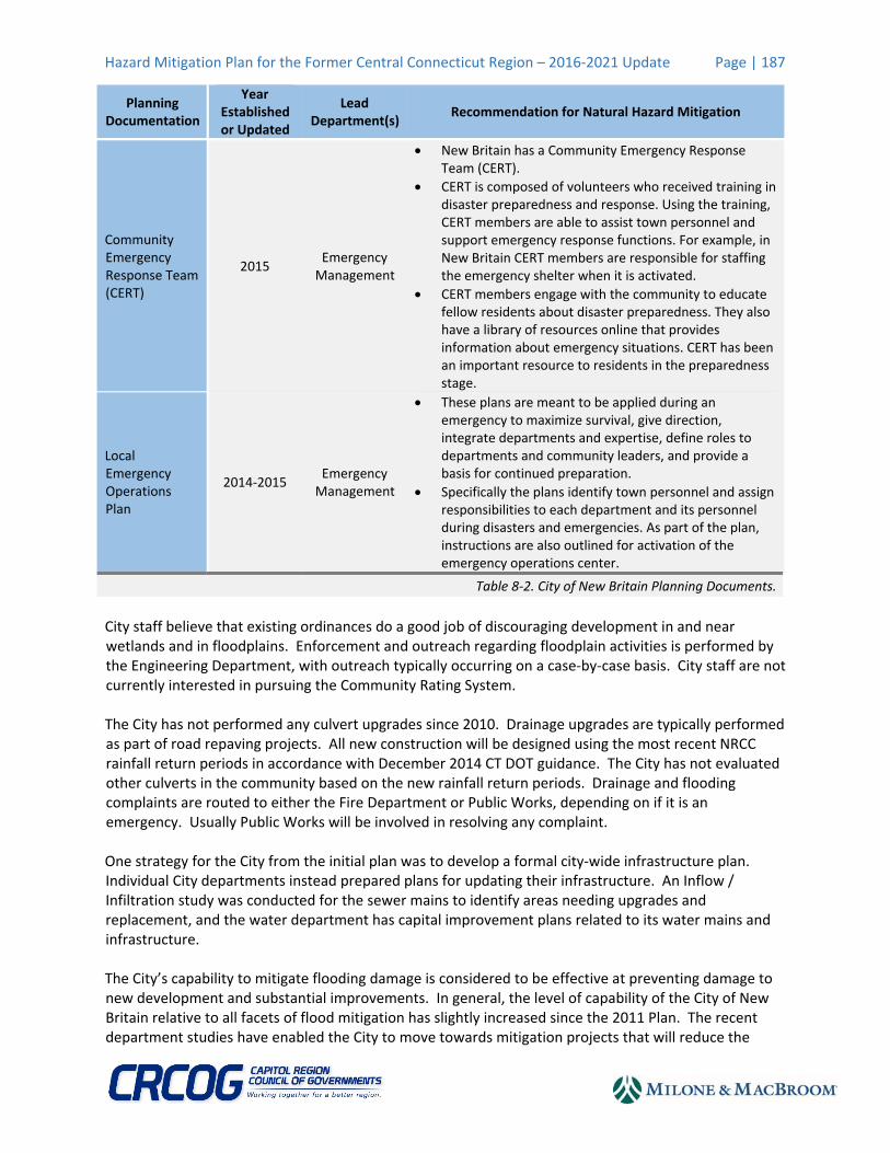
Community Emergency Response Team (CERT)
2015 Emergency Management
New Britain has a Community Emergency Response Team (CERT).
CERT is composed of volunteers who received training in disaster preparedness and response. Using the training, CERT members are able to assist town personnel and support emergency response functions. For example, in New Britain CERT members are responsible for staffing the emergency shelter when it is activated.
CERT members engage with the community to educate fellow residents about disaster preparedness. They also have a library of resources online that provides information about emergency situations. CERT has been an important resource to residents in the preparedness stage.
Local Emergency Operations Plan
2014‐2015 Emergency Management
These plans are meant to be applied during an emergency to maximize survival, give direction, integrate departments and expertise, define roles to departments and community leaders, and provide a basis for continued preparation.
Specifically the plans identify town personnel and assign responsibilities to each department and its personnel during disasters and emergencies. As part of the plan, instructions are also outlined for activation of the emergency operations center.
Table 8‐2. City of New Britain Planning Documents.
City staff believe that existing ordinances do a good job of discouraging development in and near wetlands and in floodplains. Enforcement and outreach regarding floodplain activities is performed by the Engineering Department, with outreach typically occurring on a case‐by‐case basis. City staff are not currently interested in pursuing the Community Rating System. The City has not performed any culvert upgrades since 2010. Drainage upgrades are typically performed as part of road repaving projects. All new construction will be designed using the most recent NRCC rainfall return periods in accordance with December 2014 CT DOT guidance. The City has not evaluated other culverts in the community based on the new rainfall return periods. Drainage and flooding complaints are routed to either the Fire Department or Public Works, depending on if it is an emergency. Usually Public Works will be involved in resolving any complaint. One strategy for the City from the initial plan was to develop a formal city‐wide infrastructure plan. Individual City departments instead prepared plans for updating their infrastructure. An Inflow / Infiltration study was conducted for the sewer mains to identify areas needing upgrades and replacement, and the water department has capital improvement plans related to its water mains and infrastructure. The City’s capability to mitigate flooding damage is considered to be effective at preventing damage to new development and substantial improvements. In general, the level of capability of the City of New Britain relative to all facets of flood mitigation has slightly increased since the 2011 Plan. The recent department studies have enabled the City to move towards mitigation projects that will reduce the
Hazard Mitigation Plan for the Former Central Connecticut Region – 2016‐2021 Update Page | 188
impacts of flooding over the long‐term. The City’s participation in the MapMod program several years ago resulted in digital FIRMs for the community which make it easier to demonstrate floodplain boundaries to property owners. Impacts and Loss Estimates Flood losses reported under the NFIP to properties in New Britain are listed in Table 8‐2. Several historical events were noted by City personnel. In particular, a storm from June 1992 caused widespread damage in the city totaling approximately $650,000. Willow Brook is a well‐known source of flooding in the city. Overflow from the brook floods a southwest neighborhood where 60‐80 properties are affected, as well as the New Britain stadium. The strong storm in June of 1992 caused extensive flooding from Willow Brook. The City has performed several projects to mitigate flooding along Willow Brook in the past, but these projects are believed to have been related to flood conveyance and bank protection and not at reducing flood levels. In addition, when Shuttle Meadow Reservoir is at capacity it overflows into the brook. The City has performed culvert upgrades between the brook and the reservoir to prevent debris clogs to mitigate flooding. City staff indicate that there are not any good engineering solutions to the flooding along Willow Brook. The floodplain will remain at risk to flooding because there is no chokepoint downstream to mitigate. A significant amount of grant funding would be needed to eliminate flooding along the brook, as flooding is primarily caused by the volume of storm drainage. Fortunately, floodwaters tend to recede very quickly, so although homes are affected they are not inundated for long. In general, repetitive loss properties are only affected during the very large rain events. Drainage is reportedly adequate for the typical smaller rain events. West Canal is another source of frequent flooding in the city, although it is undocumented on FEMA’s FIRMs due to its high elevation. The West Canal directs water to Shuttle Meadow Reservoir. It is an open channel which includes a piped section. Homeowners have occasionally been affected by flooding when the canal overtops. The 1992 storm caused the canal (built in 1908) to breach; flooding washed out nearby streets and inundated homes. The City paid out $30,000 in damages to homeowners who were not eligible for reimbursements under the NFIP. Development in the area impacted by flooding from West Canal is not limited by the City’s flood control regulations, which apply only to areas documented in FIRMs. Homeowners on Birchwood Drive claimed in the spring of 2015 that the canal is “leaking” and causing damage to their driveways, although the Water Department believes that the effects are related to a high groundwater table. The Water Department has an engineer conducting a study to determine potential mitigation actions. Allen Street is an area outside of the floodplain that experiences occasional flooding (once every few years) that can affect a couple of homes. Similar to Willow Brook, flooding in this area is believed to be a storm volume issue, and not a downstream control issue. Drainage infrastructure and water and sewer lines throughout the City are in need of major upgrades. The majority of the infrastructure was constructed in or around 1872 and was not designed to support the level of development the city has seen. Undersized pipes result in flooding, sewer backups, system leaks, and other problems.

Hazard Mitigation Plan for the Former Central Connecticut Region – 2016‐2021 Update Page | 189
CCRPA used FEMA’s HAZUS‐MH model to analyze poten al risks that the City of New Britain might face from a major flooding event. A Level 1 HAZUS‐MH Analysis was prepared by CCRPA. Such analyses are known to generally skew high in part based on the limited data entered by the user. Thus, while the numbers below are likely higher than would actually be experienced under a 1% annual chance flood event, they are nonetheless useful for planning purposes. The model es mates that the total economic losses in the city including residen al and commercial damage and business interrup ons due to a flood having a 1% chance of occurring in any given year (the 100‐year flood) would be $94,640,000. Key impact areas of such a flooding event are summarized in Table 8‐3.
Impact of Flooding Estimated Damage from 1% Annual Chance Flood Event
Households Displaced 1,027
People Needing Shelter 2,419
Buildings at Least Moderately Damaged 73
Total Estimated Economic Losses $94,700,000.00
Total Residential Building & Content Losses $29,830,000.00
Total Commercial, Industrial, & Other Building & Content Losses $64,440,000.00
Total Business Interruption Losses $440,000.00
Table 8‐3. HAZUS‐MH 1% Annual Chance Flood Losses for New Britain.Source: HAZUS‐MH
Based on the public assistance reimbursements in Table 8‐1 and the historical record above, the City of New Britain has incurred approximately $893,632.78 since 1992 (22 years) for impacts due to flooding. Based on the information for the NFIP in Table 8‐2, a total of $424,247.91 has been paid out to NFIP‐insured properties since 1981 (33 years). The annualized loss due to flooding based on this information is $53,475.67. The annualized loss estimate based on the county‐wide damages presented in the 2014 Connecticut Natural Hazards Mitigation Plan Update (CT NHMP) as described in Section 3.2 is slightly lower at $42,592. The greater figure is utilized herein as an estimate of annualized loss for the community. 8.2.3 Winter Storms Winter storms are among the greatest natural hazard concerns for the City of New Britain. Snow and ice removal can become quite expensive, exceeding municipal budgets. Ice and snow can make roads impassable and knock down tree limbs which in turn disrupts utility service. The combined effect can leave people stranded in their homes, potentially without heat or power. Location All areas of New Britain are susceptible to winter storms. Higher elevations may be at a greater risk because the frequency of winter storm events is typically greater in such areas. Areas in floodplains are at increased risk of winter storm damage due to any flooding that may accompany a winter storm. Existing Capabilities The City has 166 miles of local roads to clear each winter storm. Removal of the ice and snow for New Britain's city‐owned roads is handled by a combination of city staff and contractors; the city also handles debris removal. New Britain’s hills pose a particular problem; to mitigate the problem, the city will pre‐

Hazard Mitigation Plan for the Former Central Connecticut Region – 2016‐2021 Update Page | 190
treat hilly streets with salt before a big storm. The City has set plowing routes that are tweaked from year to year. The effect of recent winter storms has led the City to modify the plan, including adjustments to snow plowing priorities. For example, the heavy snow of 2011 caused concerns about roofs and risk of collapsing buildings, particularly at city schools. The majority of roofs on City‐owned buildings are flat, including the schools, three parking garages, and the new Police Station. The City now has an informal program to review snow accumulation on city‐owned roofs each winter, with clearing occurring when depths are sufficiently deep or wet. The City does not believe that it needs a formal snow load evaluation and removal program at this time. The City has the usual trouble with tree limbs downed by snow and ice; these take out power lines, block roads, and can leave people without electricity, heat, or communication lines when they are already isolated. Burying power lines would alleviate these problems, but is prohibitively expensive on a citywide basis. In addition, it would require work on private property to reconnect homes and businesses. City staff believe that many homes and business have substandard electrical hookups because the majority of the buildings in the city are more than 50 years old. The Greater New Britain Chamber of Commerce recommends that businesses prepare backup systems and have procedures for reaching out to their employees if they cannot access their place of work. After recent storms, many businesses have sought to become entirely self‐sufficient so they do not need to rely on anyone else to get them up and running. Businesses have purchased plows so they can plow themselves out and many now have generators. Following the recent storms, Eversource has increased their outreach to businesses as well as to the City. The City’s capabilities are considered to be effective in regards to response to winter storms, although the City’s capability to mitigate severe winter storm damage is limited to City facilities. In general, the level of capability of the City of New Britain relative to all facets of winter storm mitigation has slightly increased since the 2011 Plan with the introduction of the informal snow load evaluation procedures and the improved coordination between the City and Eversource. Impacts and Loss Estimates Two recent storms had a significant impact on the city. The first was Winter Storm Alfred in late October 2011, and the second was the blizzard of January 2013. Table 8‐4 below considers the impact of Winter Storm Alfred on the city. Debris removal was the largest impact, although residents were left without heat for more than a week. It took 11 days for power to be completely restored, although the majority of residents had power restored in eight days. Businesses with refrigerated goods had substantial losses.
Impact of Severe Winter Storm Estimated Losses from a Severe Winter Storm Comparable to
Winter Storm Alfred (October 2011)
Number of Electrical Customers Served (2013) 34,207
Maximum Outages During Severe Winter Storm (2011) 20,509
Maximum Outages Percentage of Customers (2011) 59.96%
Number of Businesses Experiencing Outages 131
Total Lost Wages (Daily) $26,102.53

Hazard Mitigation Plan for the Former Central Connecticut Region – 2016‐2021 Update Page | 191
Impact of Severe Winter Storm Estimated Losses from a Severe Winter Storm Comparable to
Winter Storm Alfred (October 2011)
Average Lost Wages (Weekly) $52,004.00
Miles of Local Roads Plowed by Town of City of New Britain 183.89
Municipal Cost (Plowing, Road Treatment, Cleanup) $715,980.09
Table 8‐4. October 2011 Severe Winter Storm Losses for New Britain.Source: Eversource, CCRPA Internal Analysis
The Greater New Britain Chamber of Commerce reported that Guida’s has over 1,000 gallons of product that can go to waste if backup power is not available or power is not restored. Many businesses were plowed in following Alfred; for example, Creed Monarch’s driveway had snow banks up to 12 feet high and second shift had a difficult time getting into the facility. The owner had to call the city to plow the entrance to the driveway. The Chamber reports that damage to buildings was not the problem, rather the power outages and impassible roads. The January 2013 blizzard produced a significant amount of snow in New Britain. Snow removal was the primary financial impact with the city expending its entire snow removal budget for the winter on that one event. It took three days of plowing to make all of the roads passable; after five days two lanes were clear on each street, and it took eight days to clear all roads from curb to curb. Emergency vehicles had difficulty responding and needed a plow escort. According to the Greater New Britain Chamber of Commerce, it is important to get employees back to work as soon as possible following a storm. The biggest economic impacts are typically to smaller businesses that struggle to make payroll or businesses that are on a 30‐day cycle. Disasters can have a devastating effect on these businesses. Based on the public assistance reimbursements in Table 8‐1, the City of New Britain has incurred $2,941,742.69 since 1999 (15 years) for impacts due to winter storms. The annualized loss due to winter storms based on this information is $196,116.18. The annualized loss estimate based on the county‐wide damages presented in the 2014 CT NHMP as described in Section 3.2 is much lower at $78,017. The greater figure is utilized herein as an estimate of annualized loss for the community. 8.2.4 Tropical Cyclones and Hurricanes New Britain faces a number of challenges due to tropical storms and hurricanes. The primary problem is dealing with the impact of downed trees which can interrupt power supply for many days and hinder egress through neighborhoods. Secondary impacts are generally caused by heavy rainfall accompanying the storm. Location All areas of New Britain are susceptible to tropical storms and hurricanes. Higher elevations may be at a greater risk because the speed of the wind may be greater. Areas in floodplains are at increased risk of tropical storm and hurricane damage due to any flooding that may accompany such an event. Existing Capabilities The City of New Britain uses a variety of preparedness and response procedures to deal with the impacts of tropical storms and hurricanes. City departments have purchased sufficient supplies over the past few years to be prepared for the next major storm event. The City believes it has an adequate budget
Hazard Mitigation Plan for the Former Central Connecticut Region – 2016‐2021 Update Page | 192
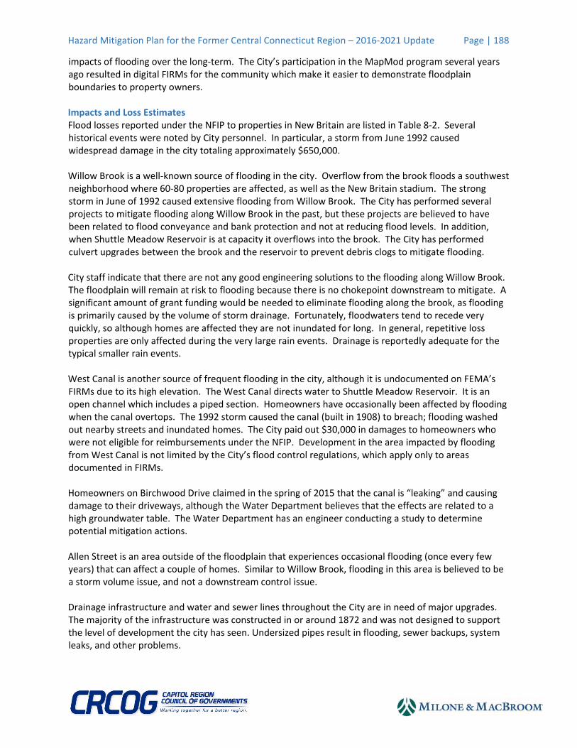
dedicated to tree maintenance and a Tree Warden who is in charge of municipal trimming. The City has a full tree crew and hires contractors for larger jobs. Much of the tree trimming in New Britain near power lines is conducted by Eversource Energy. A significant amount of trimming occurred in New Britain following the 2011 storms. The City’s capabilities are considered to be effective with regard to mitigating hurricane damage. In general, the level of capability of the City of New Britain relative to all facets of tropical storm and hurricane mitigation has slightly increased since the 2011 Plan with the recent trimming by Eversource reducing the overall vulnerability of the city. Impacts and Loss Estimates Following Tropical Storm Irene in 2011, power was lost for up to six days in New Britain, with power restored to most areas within two days. A maximum of 10,358 customers were without power. CCRPA used FEMA’s HAZUS‐MH model to analyze the risks that the City of New Britain might face from a hurricane as powerful as the 1938 Hurricane. The model estimates the economic losses to the city including residential and commercial damage and business interruptions due to such a Category 3 hurricane would be approximately $287.4 million. The impacts of such a storm are summarized below in Table 6‐5.
Impact of Simulated 1938 Hurricane Today Estimated Losses from 1938
Hurricane Event
Households Displaced 881
People Needing Short‐Term Shelter 261
Buildings at Least Moderately Damaged 7,271
Building Completely Damaged 61
Total Estimated Economic Losses $ 287,426,170
Total Residential Building Losses $ 229,324,530
Total Commercial, Industrial, & Other Building Losses $ 51,927,310
Total Business Interruption Losses $ 6,174,330
Total Debris Generated (in tons) 333,729
Truckloads (at 25 tons/truck) of building debris 13,349
Table 8‐5. HAZUS‐MH 1938 Hurricane Simulated Losses for New Britain. Source: HAZUS‐MH
Based on the public assistance reimbursements in Table 8‐1, the City of New Britain has incurred $75,113.89 in damages since 1999 (15 years) for impacts due to tropical storms and hurricanes. The annualized loss due to tropical storms and hurricanes based on this information is $5,007.59. The annualized loss estimate based on the county‐wide damages presented in the 2014 CT NHMP as estimated by HAZUS‐MH is much higher at $4,589,178. The greater figure is utilized herein as an estimate of annualized loss for the community. 8.2.5 Thunderstorms and Tornadoes New Britain faces regular challenges due to tornadoes and thunderstorms, although these events are typically less damaging than tropical storms or hurricanes. The primary problem is dealing with the impact of downed trees which can interrupt power supply and hinder egress through neighborhoods.

Hazard Mitigation Plan for the Former Central Connecticut Region – 2016‐2021 Update Page | 193
Secondary impacts are generally caused by heavy rainfall accompanying the storm, and direct wind damage or lightning and hail damage to structures and vehicles. Location All areas of New Britain are susceptible to tornadoes and thunderstorms. Higher elevations may be at a greater risk because the speed of the wind may be greater. Areas in floodplains are at increased risk of thunderstorm damage due to any flooding that may accompany such an event. Existing Capabilities The strategies used to mitigate tornado and thunderstorm damage are similar to those used to mitigate damage from tropical storms and hurricanes. The City budget for tree maintenance is considered sufficient at this time. This is only for City properties and right‐of‐ways. The City’s capability to mitigate thunderstorm damage is similar to that for tropical storms and hurricanes, but the City’s ability to mitigate tornado damage is relatively limited. In general, the level of capability of the City of New Britain relative to all facets of thunderstorm and tornado mitigation has slightly increased since the 2011 Plan with the recent tree trimming work that has been performed over the past few years. Impacts and Loss Estimates According to City staff, there are no areas of the City that are specifically prone to wind damage. Older trees along streets are the most likely to cause damage during storms. The annualized loss estimate for thunderstorms based on the county‐wide damages presented in the 2014 CT NHMP as described in Section 3.2 is $9,723. The annualized loss estimate for tornadoes based on the county‐wide damages presented in the 2014 CT NHMP as described in Section 3.2 is $1,074,069. 8.2.7 Wildfires New Britain does not typically experience wildfires as the city is extensively developed. When they do occur, most are accidentally set, although some have been ignited by lightning or undetermined sources. Location Less developed areas in New Britain highest risk for a wildfire, particularly the open lands near Interstate 84 and undeveloped lands in the southwestern corner of the city near Shuttle Meadow Reservoir. Existing Capabilities The City maintains mutual aid agreements with all surrounding communities for fire protection. For example, the City has responded to fires on water company land in other communities. The City does not maintain any dry hydrants or cisterns. The public water system is generally relied upon to provide fire protection water which is available in nearly the entire city. Tanker trucks are typically used when water is not immediately available. If necessary, the City would draft water from surface water sources. Section 8‐36 of the municipal code (as revised through October 13, 2010) bans open burning without a permit except for the use of outdoor wood‐burning stoves. Three Open Burning Officials have been certified by the Connecticut DEEP Open Burning Program and oversee the local permit program. The City’s capabilities are considered to be effective in regards to wildfire response. In general, the level of capability of the City of New Britain relative to all facets of wildfire mitigation is unchanged since the 2011 Plan.
Hazard Mitigation Plan for the Former Central Connecticut Region – 2016‐2021 Update Page | 194
Impacts and Loss Estimates The greatest areas of concern are outlying vacant lands without access. These areas are primarily in the western and southwestern sides of the city. However, as noted above, wildfires are very rare in New Britain. City parks have areas of contiguous forest that could burn, but these areas are easily accessed by emergency vehicles such that any fires would be quickly contained. The annualized loss estimate for wildfires based on the county‐wide damages presented in the 2014 CT NHMP as described in Section 3.2 and the population density of New Britain is $219. 8.2.7 Drought Only severe droughts would have the potential to cause damages in New Britain. The short‐duration and moderate droughts that generally occur every few years are not a concern to City staff. Location All areas of New Britain are susceptible to drought. The largest concern is that New Britain’s reservoirs could experience significant drawdowns that could lead to mandatory water conservation measures. Existing Capabilities The City primarily relies on regional and statewide measures for mitigating the impacts of drought such as the Connecticut Drought Management Plan. The municipal water department maintains an Emergency Contingency Plan that outlines the necessary response procedures when drought is impacting their sources of supply. The City Water Department is a member of the Water Utility Coordinating Committee that will be reconvening in 2016 and will discuss regional water supply issues and needs including ensuring that supply is available during periods of drought. The City does not perform any other mitigation activities for drought and its capability to mitigate drought is relatively limited. In general, the level of capability of the City of New Britain relative to all drought of flood mitigation is unchanged since the 2011 Plan. Impacts and Loss Estimates City staff could not recall any specific damages due to drought. Public water is available in nearly 100% of the community. The Water Department came close to implementing voluntary water conservation measures during 2007 but did not have to actually implement them. Based on the information above, it is likely that the annualized loss due to drought has been minimal over the past 20 years. An annualized loss figure of $0 has been used for this Plan update. This is likely lower than the actual annualized loss due to drought, but the number is considered acceptable at this time and can be revised if needed in future updates of this Plan. 8.2.8 Earthquakes Although low intensity earthquakes regularly occur in Connecticut, these earthquakes are not damaging and are generally imperceptible to residents. Stronger earthquakes have historically occurred in Connecticut which have the potential to cause critical levels of damage. Location All areas of New Britain are susceptible to earthquakes. Property owners with structures that pre‐date current building codes (particularly pre‐1990 structures) are considered to be at increased risk of
Hazard Mitigation Plan for the Former Central Connecticut Region – 2016‐2021 Update Page | 195
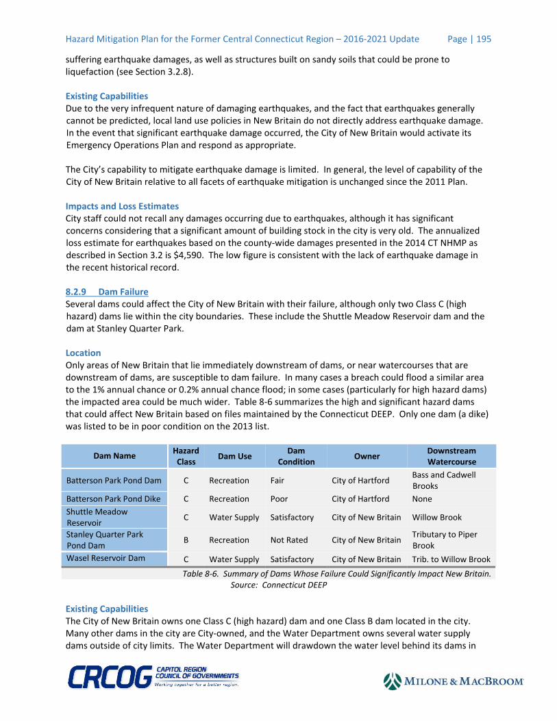
suffering earthquake damages, as well as structures built on sandy soils that could be prone to liquefaction (see Section 3.2.8). Existing Capabilities Due to the very infrequent nature of damaging earthquakes, and the fact that earthquakes generally cannot be predicted, local land use policies in New Britain do not directly address earthquake damage. In the event that significant earthquake damage occurred, the City of New Britain would activate its Emergency Operations Plan and respond as appropriate. The City’s capability to mitigate earthquake damage is limited. In general, the level of capability of the City of New Britain relative to all facets of earthquake mitigation is unchanged since the 2011 Plan. Impacts and Loss Estimates City staff could not recall any damages occurring due to earthquakes, although it has significant concerns considering that a significant amount of building stock in the city is very old. The annualized loss estimate for earthquakes based on the county‐wide damages presented in the 2014 CT NHMP as described in Section 3.2 is $4,590. The low figure is consistent with the lack of earthquake damage in the recent historical record. 8.2.9 Dam Failure Several dams could affect the City of New Britain with their failure, although only two Class C (high hazard) dams lie within the city boundaries. These include the Shuttle Meadow Reservoir dam and the dam at Stanley Quarter Park. Location Only areas of New Britain that lie immediately downstream of dams, or near watercourses that are downstream of dams, are susceptible to dam failure. In many cases a breach could flood a similar area to the 1% annual chance or 0.2% annual chance flood; in some cases (particularly for high hazard dams) the impacted area could be much wider. Table 8‐6 summarizes the high and significant hazard dams that could affect New Britain based on files maintained by the Connecticut DEEP. Only one dam (a dike) was listed to be in poor condition on the 2013 list.
Dam Name Hazard Class
Dam Use Dam
Condition Owner
Downstream Watercourse
Batterson Park Pond Dam C Recreation Fair City of Hartford Bass and Cadwell Brooks
Batterson Park Pond Dike C Recreation Poor City of Hartford None
Shuttle Meadow Reservoir
C Water Supply Satisfactory City of New Britain Willow Brook
Stanley Quarter Park Pond Dam
B Recreation Not Rated City of New Britain Tributary to Piper Brook
Wasel Reservoir Dam C Water Supply Satisfactory City of New Britain Trib. to Willow Brook
Table 8‐6. Summary of Dams Whose Failure Could Significantly Impact New Britain.Source: Connecticut DEEP
Existing Capabilities The City of New Britain owns one Class C (high hazard) dam and one Class B dam located in the city. Many other dams in the city are City‐owned, and the Water Department owns several water supply dams outside of city limits. The Water Department will drawdown the water level behind its dams in
Hazard Mitigation Plan for the Former Central Connecticut Region – 2016‐2021 Update Page | 196
anticipation of a heavy rainfall event if the dam is already at or near full. The Town has copies of EAPs prepared for other dams whose failure could affect New Britain; this information is maintained by the Emergency Management Director. The Water Department dams are considered to be in good to excellent condition. The Water Department recently hired a consultant to perform dam inspections on a two‐year basis for its dams for the next few years based on the inspection requirements of Connecticut DEEP. City staff were not aware of any concerns with privately‐owned dams within New Britain. The City’s ability to mitigate dam failure is considered to be good for City‐owned dams but limited for privately owned dams and dams owned by other municipalities (in these cases, preparation for emergency response is the primary goal). In general, the level of capability of the City of New Britain relative to all facets of dam failure mitigation has slightly increased since the 2011 Plan due to the recent dam safety law revisions that have occurred statewide. Impacts and Loss Estimates Potential losses downstream of Class C (high hazard) dams could be catastrophic. An annualized loss estimate for dam failure was developed assuming that failure had a 0.1% annual chance of occurrence in consideration of the estimated value of properties within the 0.2% annual chance floodplain in New Britain. The annualized loss in New Britain due to dam failure is estimated to be $28,000. This figure is low consistent with the very few dam failure incidents which have occurred in the city in consideration of the large value of buildings downstream.
8.3 Goals, Objectives, and Strategies
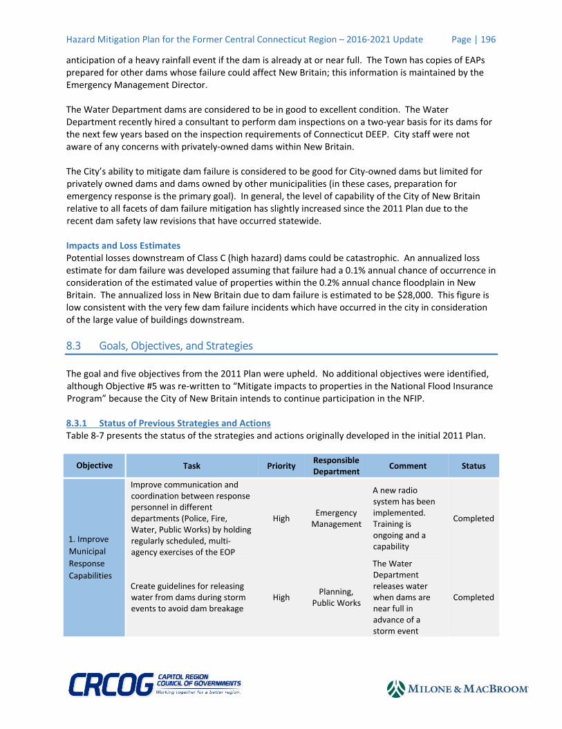
The goal and five objectives from the 2011 Plan were upheld. No additional objectives were identified, although Objective #5 was re‐written to “Mitigate impacts to properties in the National Flood Insurance Program” because the City of New Britain intends to continue participation in the NFIP. 8.3.1 Status of Previous Strategies and Actions Table 8‐7 presents the status of the strategies and actions originally developed in the initial 2011 Plan.
Objective Task Priority Responsible Department
Comment Status
1. Improve
Municipal
Response
Capabilities
Improve communication and coordination between response personnel in different departments (Police, Fire, Water, Public Works) by holding regularly scheduled, multi‐agency exercises of the EOP
High Emergency Management
A new radio system has been implemented. Training is ongoing and a capability
Completed
Create guidelines for releasing water from dams during storm events to avoid dam breakage
High Planning,
Public Works
The Water Department releases water when dams are near full in advance of a storm event
Completed
Hazard Mitigation Plan for the Former Central Connecticut Region – 2016‐2021 Update Page | 197
Objective Task Priority Responsible Department
Comment Status
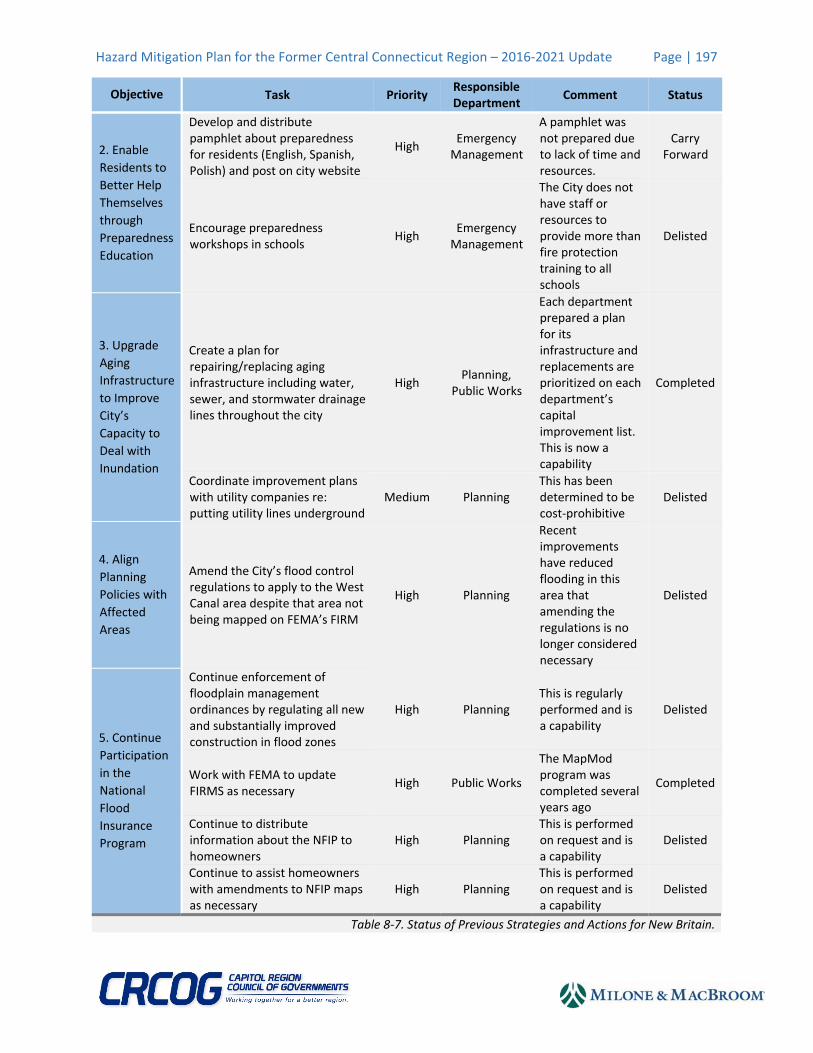
2. Enable
Residents to
Better Help
Themselves
through
Preparedness
Education
Develop and distribute pamphlet about preparedness for residents (English, Spanish, Polish) and post on city website
High Emergency Management
A pamphlet was not prepared due to lack of time and resources.
Carry Forward
Encourage preparedness workshops in schools
High Emergency Management
The City does not have staff or resources to provide more than fire protection training to all schools
Delisted
3. Upgrade
Aging
Infrastructure
to Improve
City’s
Capacity to
Deal with
Inundation
Create a plan for repairing/replacing aging infrastructure including water, sewer, and stormwater drainage lines throughout the city
High Planning,
Public Works
Each department prepared a plan for its infrastructure and replacements are prioritized on each department’s capital improvement list. This is now a capability
Completed
Coordinate improvement plans with utility companies re: putting utility lines underground
Medium Planning This has been determined to be cost‐prohibitive
Delisted
4. Align
Planning
Policies with
Affected
Areas
Amend the City’s flood control regulations to apply to the West Canal area despite that area not being mapped on FEMA’s FIRM
High Planning
Recent improvements have reduced flooding in this area that amending the regulations is no longer considered necessary
Delisted
5. Continue
Participation
in the
National
Flood
Insurance
Program
Continue enforcement of floodplain management ordinances by regulating all new and substantially improved construction in flood zones
High Planning This is regularly performed and is a capability
Delisted
Work with FEMA to update FIRMS as necessary
High Public Works
The MapMod program was completed several years ago
Completed
Continue to distribute information about the NFIP to homeowners
High Planning This is performed on request and is a capability
Delisted
Continue to assist homeowners with amendments to NFIP maps as necessary
High Planning This is performed on request and is a capability
Delisted
Table 8‐7. Status of Previous Strategies and Actions for New Britain.
Hazard Mitigation Plan for the Former Central Connecticut Region – 2016‐2021 Update Page | 198
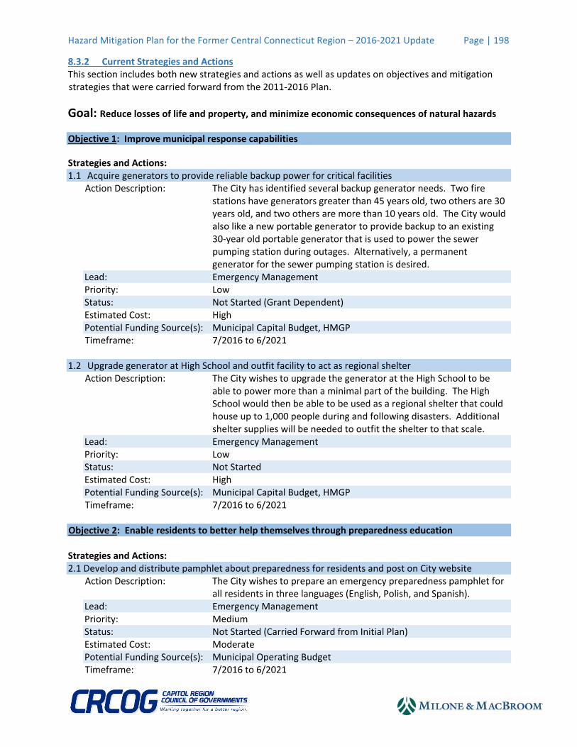
8.3.2 Current Strategies and Actions This section includes both new strategies and actions as well as updates on objectives and mitigation strategies that were carried forward from the 2011‐2016 Plan.
Goal: Reduce losses of life and property, and minimize economic consequences of natural hazards
Objective 1: Improve municipal response capabilities
Strategies and Actions: 1.1 Acquire generators to provide reliable backup power for critical facilities
Action Description: The City has identified several backup generator needs. Two fire stations have generators greater than 45 years old, two others are 30 years old, and two others are more than 10 years old. The City would also like a new portable generator to provide backup to an existing 30‐year old portable generator that is used to power the sewer pumping station during outages. Alternatively, a permanent generator for the sewer pumping station is desired.
Lead: Emergency Management Priority: Low Status: Not Started (Grant Dependent) Estimated Cost: High Potential Funding Source(s): Municipal Capital Budget, HMGP Timeframe: 7/2016 to 6/2021
1.2 Upgrade generator at High School and outfit facility to act as regional shelter
Action Description: The City wishes to upgrade the generator at the High School to be able to power more than a minimal part of the building. The High School would then be able to be used as a regional shelter that could house up to 1,000 people during and following disasters. Additional shelter supplies will be needed to outfit the shelter to that scale.
Lead: Emergency Management Priority: Low Status: Not Started Estimated Cost: High Potential Funding Source(s): Municipal Capital Budget, HMGP Timeframe: 7/2016 to 6/2021
Objective 2: Enable residents to better help themselves through preparedness education Strategies and Actions: 2.1 Develop and distribute pamphlet about preparedness for residents and post on City website
Action Description: The City wishes to prepare an emergency preparedness pamphlet for all residents in three languages (English, Polish, and Spanish).
Lead: Emergency Management Priority: Medium Status: Not Started (Carried Forward from Initial Plan) Estimated Cost: Moderate Potential Funding Source(s): Municipal Operating Budget Timeframe: 7/2016 to 6/2021

Hazard Mitigation Plan for the Former Central Connecticut Region – 2016‐2021 Update Page | 199
2.2 Add information about preparedness, mitigation, and City capabilities to the City website
Action Description: The City is in the process of increasing the amount of information on its website. The website will be updated to include sections discussing preparedness for and mitigation of natural hazard impacts.
Lead: Emergency Management, Engineering Priority: High Status: Not Started Estimated Cost: Low Potential Funding Source(s): Municipal Operating Budget Timeframe: 7/2016 to 6/2021
2.3 Encourage sign‐ups for the CT Alerts emergency notification system
Action Description: The City uses CT Alerts to provide a city‐wide emergency notification system. Targeted mailings may be used to encourage signups in particularly vulnerable areas, such as special flood hazard areas and dam failure inundation areas.
Lead: Emergency Management Priority: High Status: In Progress Estimated Cost: Low Potential Funding Source(s): Municipal Operating Budget Timeframe: 7/2016 to 6/2018.
Objective 3: Upgrade aging infrastructure to improve City’s capacity to deal with inundation Strategies and Actions: 3.1 Enact flooding mitigation measures identified by the City consultant related to the West Canal
Action Description: The City Water Department has a consultant studying flooding along the canal, which the Water Department believes are related to a high water table. The City should enact any reasonable flood mitigation measures that are identified by the consultant.
Lead: Engineering, Water Department Priority: Low Status: Not Started (Study Dependent) Estimated Cost: High Potential Funding Source(s): Municipal Capital Budget, HMGP, PDM, FMA Timeframe: 7/2016 to 6/2021
3.2 Perform targeted upgrades of aging and undersized drainage infrastructure throughout the city.
Action Description: The majority of infrastructure in the city was installed in or around 1872 and is undersized. The City plans to identify the most important systems to upgrade and begin devoting funding to the work
Lead: Engineering, Public Works Priority: Medium Status: Not Started Estimated Cost: High Potential Funding Source(s): Municipal Capital Budget, CT DOT Timeframe: 7/2016 to 6/2021
Hazard Mitigation Plan for the Former Central Connecticut Region – 2016‐2021 Update Page | 200
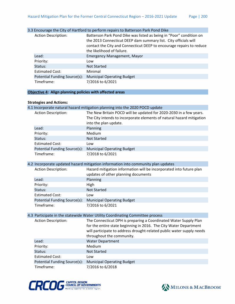
3.3 Encourage the City of Hartford to perform repairs to Batterson Park Pond Dike
Action Description: Batterson Park Pond Dike was listed as being in “Poor” condition on the 2013 Connecticut DEEP dam summary list. City officials will contact the City and Connecticut DEEP to encourage repairs to reduce the likelihood of failure.
Lead: Emergency Management, Mayor Priority: Low Status: Not Started Estimated Cost: Minimal Potential Funding Source(s): Municipal Operating Budget Timeframe: 7/2016 to 6/2021
Objective 4: Align planning policies with affected areas Strategies and Actions: 4.1 Incorporate natural hazard mitigation planning into the 2020 POCD update
Action Description: The New Britain POCD will be updated for 2020‐2030 in a few years. The City intends to incorporate elements of natural hazard mitigation into the plan update.
Lead: Planning Priority: Medium Status: Not Started Estimated Cost: Low Potential Funding Source(s): Municipal Operating Budget Timeframe: 7/2018 to 6/2021
4.2 Incorporate updated hazard mitigation information into community plan updates Action Description: Hazard mitigation information will be incorporated into future plan
updates of other planning documents Lead: Planning Priority: High Status: Not Started Estimated Cost: Low Potential Funding Source(s): Municipal Operating Budget Timeframe: 7/2016 to 6/2021
4.3 Participate in the statewide Water Utility Coordinating Committee process Action Description: The Connecticut DPH is preparing a Coordinated Water Supply Plan
for the entire state beginning in 2016. The City Water Department will participate to address drought‐related public water supply needs throughout the community.
Lead: Water Department Priority: Medium Status: Not Started Estimated Cost: Low Potential Funding Source(s): Municipal Operating Budget Timeframe: 7/2016 to 6/2018

Hazard Mitigation Plan for the Former Central Connecticut Region – 2016‐2021 Update Page | 201
4.4 Ensure local officials have most updated version of the Connecticut Drought Management Plan Action Description: The Connecticut Drought Management Plan is periodically updated.
Local officials, land use commissions, health departments, fire departments, and local water utilities should all be made aware of updates to this plan.
Lead: Planning Priority: Medium Status: Not Started Estimated Cost: Minimal Potential Funding Source(s): Municipal Operating Budget Timeframe: 7/2016 to 6/2021
Objective 5: Mitigate impacts to properties in the National Flood Insurance Program Strategies and Actions: 5.1 Work with RLP owners to mitigate RLPs upon property owner’s request
Action Description: Repetitive loss properties in New Britain are typically only damaged during severe flood events. 14 repetitive loss properties are located in New Britain that have experienced 35 flood losses. Mitigation could include acquisition/demolition, elevation, floodproofing, or other techniques.
Lead: Engineering Priority: Medium Status: Not Started (Property Owner and Grant Dependent) Estimated Cost: High Potential Funding Source(s): Municipal Capital Budget, HMGP, PDM, FMA Timeframe: 7/2016 to 6/2021
5.2 Update the local floodplain management ordinance to meet current model ordinance requirements
Action Description: The City of New Britain last updated this ordinance in 2008. Since that time, FEMA and the Connecticut DEEP have revised the model ordinance.
Lead: Planning Priority: High Status: Not Started Estimated Cost: Moderate Potential Funding Source(s): Municipal Operating Budget Timeframe: 7/2016 to 6/2018
Hazard Mitigation Plan for the Former Central Connecticut Region – 2016‐2021 Update Page | 202
5.3 Work with property owners to mitigate flood damages when grant funding is available Action Description: 60‐80 buildings are considered floodprone along Willow Brook as well
as in other parts of the city. The City will work with property owners to perform localized or neighborhood mitigation actions upon property owner request when grant funding is available. Mitigation could include acquisition/demolition, elevation, floodproofing, or other techniques.
Lead: Engineering Priority: Low Status: Not Started (Property Owner and Grant Dependent) Estimated Cost: High Potential Funding Source(s): Municipal Capital Budget, HMGP, PDM, FMA Timeframe: 7/2016 to 6/2021
8.4 Contributors to Plan Update
Robert Trottier, P.E. (City Engineer) Steven Schiller, AICP (Planner) Chris Polkowski (Public Works) Sharon Baretta (Fire Commissioner) Thomas Ronalter (Fire Chief) Gil Bligh (Director of Utilities) Denis Pelegrino (Facilities Manager) Mike Hadvab (Parks & Recreation) Mark Moriarty (Director of Public Works) Bill Carroll (Business Development Director, Greater New Britain Chamber of Commerce)