hinckley national rail freight interchange: application ... · table 12.1 sensitivity of cultural...
TRANSCRIPT
HINCKLEY NATIONAL RAIL FREIGHT INTERCHANGE
Hinckley National Rail Freight Interchange:
application for an EIA scoping opinion ___________________________________________________________________________
Application by db symmetry under Regulation 10 of the Infrastructure
Planning (Environmental Impact Assessment) Regulations 2017
March 2018

ENVIRONMENTAL IMPACT ASSESSMENT SCOPING REPORT DB SYMMETRY
2 HINCKLEY NATIONAL RAIL FREIGHT INTERCHANGE
DB SYMMETRY ENVIRONMENTAL IMPACT ASSESSMENT SCOPING REPORT
3 HINCKLEY NATIONAL RAIL FREIGHT INTERCHANGE
HINCKLEY NATIONAL RAIL FREIGHT INTERCHANGE
Hinckley National Rail Freight Interchange:
application for an EIA scoping opinion ________________________________________________________________
Application by db symmetry under Regulation 10 of the Infrastructure
Planning (Environmental Impact Assessment) Regulations 2017
March 2018

ENVIRONMENTAL IMPACT ASSESSMENT SCOPING REPORT DB SYMMETRY
4 HINCKLEY NATIONAL RAIL FREIGHT INTERCHANGE
DB SYMMETRY ENVIRONMENTAL IMPACT ASSESSMENT SCOPING REPORT
5 HINCKLEY NATIONAL RAIL FREIGHT INTERCHANGE
C o n t e n t s
Page List of figures 9 List of tables 11 SUMMARY 13 1. INTRODUCTION 19 Background 19 Project overview 19 Location 21 The applicant 22 The project team 23 Environmental impact assessment 24 Purpose and structure of this report 26 Contacts 28 2. THE PROJECT 31 Background 31 Project need and objectives 33 Project description 34 Indicative project programme 36 3. ALTERNATIVES 41 Introduction 41 Location 41 Design and technology 45 Size and scale 47 Selection and evolution of the preferred scheme 47 4. CONSULTATIONS 51 Introduction 51 Consultations undertaken to date 51 Consultations for the purpose of the EIA 53
continued /
ENVIRONMENTAL IMPACT ASSESSMENT SCOPING REPORT DB SYMMETRY
6 HINCKLEY NATIONAL RAIL FREIGHT INTERCHANGE
5. ENVIRONMENTAL IMPACT ASSESSMENT 55
Introduction 55 Other relevant guidance 55 Study area and temporal scope 56 Assessment approach 56 Habitat Regulations Assessment screening 59 Health Impact Assessment 59 Sustainability 59
6. LAND USE AND SOCIO-ECONOMIC EFFECTS 61
Introduction 61 Baseline assessment 61 Potential environmental effects 63 Proposed scope of the assessment 64 Summary 67
7. TRANSPORT AND TRAFFIC 69
Introduction 69 Baseline assessment 73 Proposed scope of the assessment and potential environmental effects 75 Summary 83
8. AIR QUALITY 85
Introduction 85 Baseline assessment 86 Potential environmental effects 87 Proposed scope of the assessment 87 Summary 88
9. NOISE AND VIBRATION 89
Introduction 89 Baseline assessment 89 Proposed scope of the assessment and potential environmental effects 92 Summary 99
10. LANDSCAPE AND VISUAL EFFECTS 101
Introduction 101 Baseline assessment 101 Potential environmental effects 106 Proposed scope of the assessment 107 Summary 109
DB SYMMETRY ENVIRONMENTAL IMPACT ASSESSMENT SCOPING REPORT
7 HINCKLEY NATIONAL RAIL FREIGHT INTERCHANGE
11. ECOLOGY AND BIODIVERSITY 121 Introduction 121 Baseline assessment 121 Potential environmental effects 127 Proposed scope of the assessment 127 Summary 128 12. CULTURAL HERITAGE 135 Introduction 135 Baseline assessment 135 Potential environmental effects 139 Proposed scope of the assessment 140 Summary 142 13. SURFACE WATER AND FLOOD RISK 145 Introduction 145 Baseline assessment 145 Potential environmental effects 148 Proposed scope of the assessment 149 Summary 151 14. HYDROGEOLOGY 153 Introduction 153 Baseline assessment 154 Potential environmental effects 154 Proposed scope of the assessment 155 Summary 156 15. GEOLOGY, SOILS AND CONTAMINATED LAND 157 Introduction 157 Baseline assessment 157 Potential environmental effects 158 Proposed scope of the assessment 159 Summary 160 16. MATERIALS AND WASTE 163 Introduction 163 Baseline assessment 164 Potential environmental effects 165 Proposed scope of the assessment 166 Summary 168
ENVIRONMENTAL IMPACT ASSESSMENT SCOPING REPORT DB SYMMETRY
8 HINCKLEY NATIONAL RAIL FREIGHT INTERCHANGE
17. ENERGY AND CLIMATE CHANGE 169 Introduction 169 Baseline assessment 169 Potential environmental effects 170 Proposed scope of the assessment 171 Summary 172 18. CUMULATIVE AND TRANSBOUNDARY EFFECTS 173 Introduction 173 Baseline assessment 173 Potential environmental effects 174 Proposed scope of the assessment 174 Summary 178 19. CONCLUSIONS 179 Topics to be scoped out 179 Request for a scoping opinion 179 Preliminary environmental information 179 Environmental Statement for the DCO application 180
_____________________________________________________________________________________
DB SYMMETRY ENVIRONMENTAL IMPACT ASSESSMENT SCOPING REPORT
9 HINCKLEY NATIONAL RAIL FREIGHT INTERCHANGE
L i s t o f f i g u r e s
Figure 1.1 Site plan showing the preliminary DCO boundary 29 Figure 2.1 Preliminary illustrative master plan 39 Figure 3.1 Leicester and Leicestershire Enterprise Partnership Strategic 49 Economic Plan, Key Opportunity Areas – Five Growth Areas Figure 10.1 Local public rights of way network 111 Figure 10.2 Zone of theoretical visibility – ground level 113 Figure 10.3 Zone of theoretical visibility – 30m development parameters 115 Figure 10.4 Photo viewpoint location plan 117 Figure 10.5 Environmental designations within 5km 119 Figure 11.1 Ecological designations 131 Figure 11.2 Preliminary phase 1 habitat plan 133 Figure 12.1 Known heritage assets 143 Figure 13.1 Environment Agency flood zone mapping for the site and its 146 surroundings Figure 13.2 Environment Agency surface water map for the site and its 147 surroundings

ENVIRONMENTAL IMPACT ASSESSMENT SCOPING REPORT DB SYMMETRY
10 HINCKLEY NATIONAL RAIL FREIGHT INTERCHANGE
DB SYMMETRY ENVIRONMENTAL IMPACT ASSESSMENT SCOPING REPORT
11 HINCKLEY NATIONAL RAIL FREIGHT INTERCHANGE
L i s t o f t a b l e s
Table 1.1 The consultant team appointed by db symmetry to progress 23 The HNRFI project Table 2.1 Proposed project timetable for the HNRFI 37 Table 4.1 Summary of consultations undertaken to date 52 Table 5.1 Sensitivity of a generic environmental receptor to change 57 Table 5.2 Criteria for assessing the magnitude of environmental effects 57 Table 5.3 Framework for assessing the significance of environmental effects 58 Table 6.1 Framework for assessing the magnitude of effect on each 66 agricultural business affected by the proposals Table 7.1 Relevant national transport policy 69 Table 7.2 County transport planning policy 71 Table 7.3 Local transport planning policy 72 Table 7.4 Additional transport planning guidance 73 Table 7.5 Categorisation of transport effects for the purpose of this EIA 77 Table 7.6 Pedestrian fear and intimidation thresholds 79 Table 7.7 Transport and traffic – receptor sensitivity 80 Table 7.8 Magnitude of change criteria for use in the transport and 81 traffic assessment Table 7.9 Matrix for determining the potential overall significance of 82 traffic effects Table 7.10 Significance of transport effects 83 Table 8.1 Background concentrations of air pollutants within a 1km 86 radius of the site Table 8.2 Air quality monitoring data from diffusion tubes closest to the site 87
ENVIRONMENTAL IMPACT ASSESSMENT SCOPING REPORT DB SYMMETRY
12 HINCKLEY NATIONAL RAIL FREIGHT INTERCHANGE
Table 9.1 Potential construction noise – significant effects at noise- 93 sensitive receptors Table 9.2 Levels of magnitude to be employed in the assessment of road 95 traffic noise (construction and operational) Table 9.3 Levels of magnitude to be employed in the assessment of 96 noise from operational activities Table 9.4 Timescales employed in the assessment of the duration of 97 noise effects Table 9.5 Impact descriptors for individual noise receptor. 97 Table 10.1 Proposed viewpoints for the landscape and visual assessment 105 Table 12.1 Sensitivity of cultural heritage receptors 138 Table 12.2 Cultural heritage assessment – magnitude of change 138 Table 12.3 Cultural heritage assessment - significance matrix 139 Table 18.1 Zones of influence to be employed in the assessment of cumulative 174 Effects – summary table
DB SYMMETRY ENVIRONMENTAL IMPACT ASSESSMENT SCOPING REPORT
13 HINCKLEY NATIONAL RAIL FREIGHT INTERCHANGE
S u m m a r y Background S1. Commercial property development company db symmetry is promoting proposals for a
new strategic rail freight interchange on land east of Hinckley, in Blaby District in Leicestershire. A strategic rail freight interchange (SRFI) is a large multi-purpose freight interchange and distribution centre linked into both the rail and trunk road systems. SRFIs reduce the cost of moving freight by rail and encourage the transfer of freight from road to rail.
S2. Under the Planning Act 2008, the proposals qualify as a Nationally Significant
Infrastructure Project (NSIP). To secure permission to build and operate the project, db symmetry must make an application for a Development Consent Order (DCO) to the Planning Inspectorate (PINS), which will examine the DCO application on behalf of the Secretary of State for Transport.
S3. Before making a DCO application, db symmetry will undertake an Environmental Impact
Assessment (EIA) of its proposals. EIA is a process that aims to improve the environmental design of a development proposal and to provide the decision maker with sufficient information about the environmental effects of the project. The findings of the EIA will be reported in an Environmental Statement (ES) that will be submitted with the DCO application.
S4. The purpose of this EIA scoping report is to request that the Secretary of State confirms in
writing his opinion as to the scope, and level of detail, of the information to be provided in the ES.
The applicant S5. db symmetry was formed as a UK joint venture through the purchase of a 60% holding in
Barwood Developments Limited by clients advised by Delancey, a specialist real estate investment, development and advisory company. The remaining 40% shareholding is controlled by the executive management team.
S6. The company has a land portfolio comprising 1,200 hectares, comprising over 400
hectares consented for logistics use, and a further 800 hectares being promoted through the planning process for logistics use, with an expected development value of over £3 billion. The portfolio is concentrated on the strategic road network in the UK and primarily around the Golden Triangle of the M1, M69 and M40 and north-west England’s prime M6 and M62 corridors.
ENVIRONMENTAL IMPACT ASSESSMENT SCOPING REPORT DB SYMMETRY
14 HINCKLEY NATIONAL RAIL FREIGHT INTERCHANGE
The site S7. The site and the proposed development are described in chapter two of this scoping
report. The site lies 3 km to the north-east of Hinckley, in Blaby District in Leicestershire, in a level area of mixed farmland to the north-west of M69 Junction 2. The Nuneaton to Felixstowe railway forms the north-western boundary of the site, with the M69 motorway defining the south-eastern boundary. To the south-west of the site are blocks of deciduous woodland, including Burbage Wood, Aston Firs and Freeholt Wood, and two gypsy and traveller community sites. Beyond the north-eastern site boundary lies the village of Elmesthorpe, a linear settlement on the B581 Station Road.
The draft proposals S8. The project is known as the Hinckley National Rail Freight Interchange (HNRFI) and
includes the following main elements.
i). Railway sidings and freight transfer area alongside the two-track railway between Hinckley and Leicester. This line forms a part of Network Rail’s ‘F2N’ freight route between Felixstowe and Nuneaton, lengths of which have been the subject of upgrades, and is also well-placed in the national rail network to provide direct links to and from major cargo terminals at Southampton, Liverpool and the Humber estuary.
ii). A dedicated road access directly from Junction 2 of the M69 motorway, which
connects the M6 near Coventry to the M1 near Leicester and links to the A5 in between. As a part of the proposals, a northbound off-slip and a southbound on-slip would be added to this Junction, which currently caters only for motorway traffic heading to and from the north.
iii). Up to 225.57 hectares (ha) of level land for the construction of a rail port for the
loading and unloading of freight trains, and for a total area of up to 850,000 square metres gross internal area (GIA) (650,000 square metres gross external area (GEA) ‘footprint’ and 200,000 square metres of mezzanine floorspace) of high-bay storage and logistics buildings in a single land parcel bounded by the railway to the north-west and the M69 to the south-east.
iv). Land for landscape and planting works, ecological mitigation, drainage balancing
ponds and footpath and cycleway links. Need S9. Chapter two of this report explains the need for, and objectives of, the proposed HNRFI
and provides the description of development on which the EIA scoping exercise has been based. It also identifies the indicative project programme between EIA scoping and the submission of a DCO application for the proposed development.
DB SYMMETRY ENVIRONMENTAL IMPACT ASSESSMENT SCOPING REPORT
15 HINCKLEY NATIONAL RAIL FREIGHT INTERCHANGE
S10. The national need for new strategic rail freight interchange facilities is identified in the National Policy Statement (NPS) for National Networks, published by the government in December 2014. This identifies a clear need for an expanded network of SRFIs and notes that it is important for SRFIs to be located near the business markets they will serve – major urban centres or groups of centres – and linked to key supply chain routes. The NPS recognises that given the locational requirements and need for both rail and road connection, the number of suitable locations for SRFIs will be limited.
S11. The NPS for Ports, published by the government in January 2012, recognises that the
balance of modes for goods to enter and leave ports can have a variety of traffic and transport impacts on surrounding infrastructure. It recognises that the most significant impact, in the case of unitised traffic, is likely to be on the surrounding road infrastructure. To mitigate such impacts, The NPS for Ports states that rail and coastal or inland shipping should be encouraged over road transport, where cost effective. Such an objective can be achieved through the delivery of SRFIs.
S12. 45% of British rail freight goes through the Midlands. The recently published UK Industrial
Strategy emphasises the importance of investment in infrastructure to drive growth across the UK. The HNRFI is considered to be aligned with these strategies that seek to promote substantial economic growth.
Alternatives S13. Chapter three of this report describes the main alternatives to the proposed HNRFI that
have been considered by db symmetry. This chapter addresses factors including location, design and technology, size and scale and the considerations that informed the selection of the preferred scheme, including market considerations.
S14. The general area of search comprised a corridor running from the north-east to the south-
west of Leicester along the Nuneaton to Felixstowe railway, which afforded a range of operational advantages including train movement capacity and connections to the wider rail network.
S15. The preferred site east of Hinckley appeared to offer an optimum balance of advantages,
including:
i). an ample area of open level land; ii). a long at-grade rail frontage; iii). the potential for direct road access to the strategic highway network from M69
Junction 2, with scope to add southbound slips to the Junction; iv). suitable separation from existing residential settlements.
S16. db symmetry is testing options for the layout of the proposed HNRFI, including different
configurations of railway sidings, roads, buildings, drainage, landscape and planting and other environmental mitigation. Draft development layouts will be tested and refined in the light of detailed EIA studies and pre-application consultations.
ENVIRONMENTAL IMPACT ASSESSMENT SCOPING REPORT DB SYMMETRY
16 HINCKLEY NATIONAL RAIL FREIGHT INTERCHANGE
Consultations S17. Pre-application consultation is an important requirement for applications for
Development Consent Orders relating to nationally significant infrastructure projects such as this Project. The Applicant will undertake effective pre-application consultation with the local authorities; consultees, and other stakeholders including the public. An informal public consultation will take place in mid-2018 with local communities. This engagement will deploy a range of methods to promote effective engagement with surrounding communities. Statutory consultations will follow in winter 2018-2019 and will include a fully reasoned response to the informal public consultation exercise.
Environmental impact assessment: general approach S18. The environmental effects of the proposal will be considered during the construction and
operational phases. The findings of the EIA will be presented in a series of volumes consisting of a main written statement, a non-technical summary, figures and appendices.
S19. The EIA for db symmetry’s project will be undertaken in accordance with what are known
as ‘Rochdale Envelope’ principles. This means that the EIA will assess the physical and operational parameters of the project as opposed to a detailed design. This flexibility is essential to ensure that the development can respond to occupier demand and the evolving requirements of the freight logistics industry.
S20. The EIA will embrace the following considerations:
• Habitat Regulations Assessment - chapter five of this report explains how the potential effects of the project on protected habitats will accord with the Conservation of Habitats and Species Regulations 2010 (the Habitat Regulations).
• Health Impact Assessment - the ES chapters on air quality, noise and vibration, flood
risk, hydrogeology and contamination will assess the potential impact of the construction and operational phases of the development on human health. Mitigation will be proposed to address any identified risk to human health in accordance with appropriate industry standards.
• Sustainability - the DCO submission will be supported by a sustainability strategy that
will include relevant details of the methods to be used to minimise energy consumption and improve efficiency.
DB SYMMETRY ENVIRONMENTAL IMPACT ASSESSMENT SCOPING REPORT
17 HINCKLEY NATIONAL RAIL FREIGHT INTERCHANGE
Environmental impact assessment: approach for individual topics S21. Chapters six to seventeen consider the scope of the technical assessments that will be
undertaken under individual EIA topic headings, as follows:
Chapter 6 Land use and socio-economic effects Chapter 7 Transport and traffic Chapter 8 Air quality Chapter 9 Noise and vibration Chapter 10 Landscape and visual effects Chapter 11 Ecology and biodiversity Chapter 12 Cultural heritage Chapter 13 Surface water and flood risk Chapter 14 Hydrogeology Chapter 15 Geology, soils and contaminated land Chapter 16 Materials and waste Chapter 17 Energy and climate change
S22. In accordance with paragraphs 11.2-11.3 of Planning Inspectorate Advice Note Seven:
Environmental Impact Assessment: Preliminary Environmental Information, Screening and Scoping (version 5, March 2015), each chapter includes the following information, where available at this early stage in the EIA process: • results of desktop and baseline studies where available;
• referenced plans presented at an appropriate scale to convey clearly the information
and known aspects associated with the proposal;
• guidance and best practice to be relied upon,
• methods used or proposed to be used to predict impacts and the significance criteria framework used;
• any mitigation proposed at this stage and predicted residual impacts;
• impacts from consequential or cumulative development;
• an indication of any European designated nature conservation sites that are likely to
be significantly affected by the proposed development and the nature of the likely significant impacts on these sites.
Cumulative and transboundary effects S23. Chapter eighteen of the scoping report sets out how it is intended to approach the
cumulative effects assessment (CEA). The chapter explains how db symmetry proposes to identify and assess the combined effects of the proposed development with other existing
ENVIRONMENTAL IMPACT ASSESSMENT SCOPING REPORT DB SYMMETRY
18 HINCKLEY NATIONAL RAIL FREIGHT INTERCHANGE
and/or approved development in an agreed area of influence. Conclusions on scope S24. This EIA scoping report sets out the Applicant’s existing knowledge of the environment in
the site and its surroundings, provides a description of the proposed HNRFI development and identifies the anticipated likely significant environmental effects of the project during construction and operation. On the basis of existing knowledge, it is concluded that no environmental topics should be ‘scoped out’ of the EIA at this stage.
Request for a scoping opinion S25. This report comprises db symmetry’s formal request under Regulation 10(1) of the
Infrastructure Planning (Environmental Impact Assessment) Regulations 2017 for an opinion as to the scope and level of detail, of the information to be provided in the environmental statement for the HNRFI project.
S26. The applicant considers that it has complied with the requirements of Regulation 10(3) of
the same Regulations concerning the information to be supplied with an EIA scoping opinion request.
DB SYMMETRY ENVIRONMENTAL IMPACT ASSESSMENT SCOPING REPORT
19 HINCKLEY NATIONAL RAIL FREIGHT INTERCHANGE
One Introduction BACKGROUND 1.1 Commercial property development company db symmetry is promoting proposals for a
new strategic rail freight interchange (SRFI) on land east of Hinckley, in Blaby District in Leicestershire. A strategic rail freight interchange (SRFI) is a large multi-purpose freight interchange and distribution centre linked into both the rail and trunk road systems. SRFIs reduce the cost of moving freight by rail and encourage the transfer of freight from road to rail.
1.2 Under the Planning Act 2008, the proposals qualify as a Nationally Significant
Infrastructure Project (NSIP). Accordingly, an application for a Development Consent Order (DCO) is to be made to the Planning Inspectorate (PINS), which will examine the DCO application on behalf of the Secretary of State.
1.3 Before making a DCO application, db symmetry will undertake an environmental impact
assessment (EIA) of its proposals. EIA is a process that aims to improve the environmental design of a development proposal and to provide the decision maker with sufficient information about the environmental effects of the project.
1.4 The findings of an EIA are described in a written report known as an environmental
statement (ES). An ES provides environmental information about the scheme, including a description of the development, its predicted environmental effects and the measures proposed to ameliorate any adverse effects. db symmetry will submit an ES alongside its DCO application.
1.5 To ensure that its EIA takes into account relevant considerations and, equally, avoids
matters considered irrelevant to the determination of the DCO application, db symmetry wishes at the outset to establish the scope of its EIA. Regulation 10 of the Infrastructure Planning (Environmental Impact Assessment) Regulations 2017 (‘the EIA Regulations’) enables a person who proposes to make a DCO application to ask the Secretary of State to confirm in writing their opinion as to the scope, and level of detail, of the information to be provided in the ES.
1.6 The current report is db symmetry’s request for a scoping opinion under Reg. 10 of the EIA
Regulations. PROJECT OVERVIEW 1.7 The proposed development is described in chapter two of this report and is known as the
Hinckley National Rail Freight Interchange (HNRFI or ‘the project’). Chapter two also
ENVIRONMENTAL IMPACT ASSESSMENT SCOPING REPORT DB SYMMETRY
20 HINCKLEY NATIONAL RAIL FREIGHT INTERCHANGE
outlines the need for the project. The generic purpose of the proposed development is explained in paragraph 2.44 of the Department for Transport’s National Policy Statement for National Networks (December 2014, page 20):
The aim of a strategic rail freight interchange (SRFI) is to optimise the use of rail in the freight journey by maximising rail trunk haul and minimising some elements of the secondary distribution leg by road, through co-location of other distribution and freight activities. SRFIs are a key element in reducing the cost to users of moving freight by rail and are important in facilitating the transfer of freight from road to rail, thereby reducing trip mileage of freight movements on both the national and local road networks.
1.8 The essential components of an SRFI development include direct rail connections to ports
at which freight is imported and exported and high quality strategic road connections to the region or regions that the interchange will serve. An SRFI also requires a substantial area of broadly level and free-draining land for storage and logistics buildings and associated haulage yards.
1.9 With these requirements in mind, the HNRFI project includes the following main elements.
i). Railway sidings and freight transfer area alongside the two-track railway between Hinckley and Leicester. This line forms a part of Network Rail’s ‘F2N’ freight route between Felixstowe and Nuneaton, lengths of which have been the subject of upgrades. It is therefore ideally located in terms of connections to the ports of Felixstowe and London Gateway, and is also well-placed in the national rail network to provide direct links to and from major cargo terminals at Southampton, Liverpool and the Humber estuary.
ii). A dedicated road access directly from Junction 2 of the M69 motorway, which
connects the M6 near Coventry to the M1 near Leicester and links to the A5 in between. As a part of the proposals, a northbound off-slip and a southbound on-slip would be added to this Junction, which currently caters only for motorway traffic heading to and from the north.
iii). Up to 225.57 hectares (ha) of level land bounded by the railway to the north-west
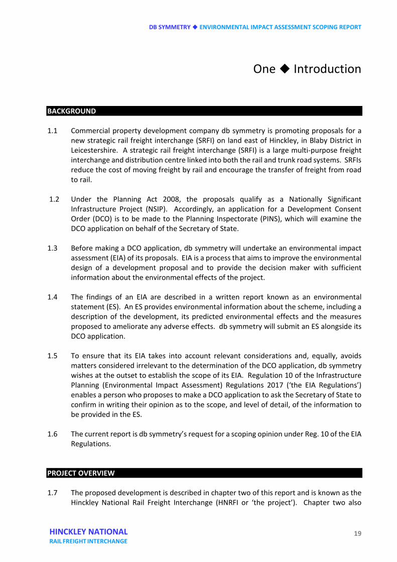
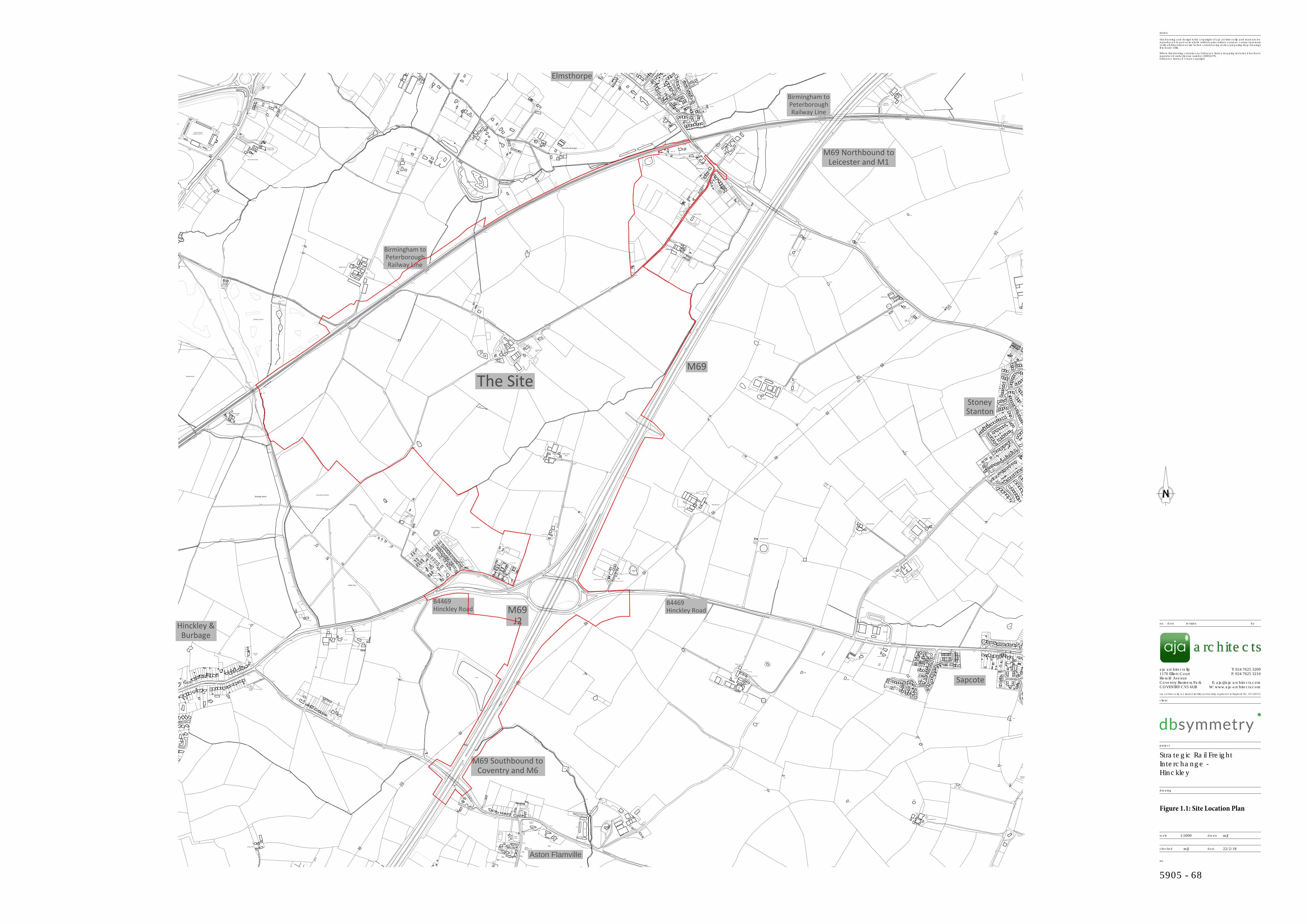
and the M69 to the south-east, for the development of a total area of up to 850,000 square metres gross internal area (GIA) (650,000 square metres gross external area (GEA) ‘footprint’ and 200,000 square metres of mezzanine floorspace) of high-bay use class B8 storage and logistics sheds. In total, 81% of the land shown within the preliminary DCO boundary shown in figure 1.1 of this report is the subject of option agreements between the landowners and db symmetry.
iv). Land for landscape and planting works, ecological mitigation, drainage balancing
ponds and footpath and cycleway links.
DB SYMMETRY ENVIRONMENTAL IMPACT ASSESSMENT SCOPING REPORT
21 HINCKLEY NATIONAL RAIL FREIGHT INTERCHANGE
LOCATION Strategic 1.10 The site is located in what the UK logistics industry regards as the ‘Golden Triangle’, which
extends from Northamptonshire up the M1 to East Midlands Airport, and westward as far as Birmingham. The application site is at a central location in the Golden Triangle. The West Midlands conurbation, Coventry, Leicester, Nottingham, Derby and Northampton all lie within 50 km of the proposed site, and there are direct road connections to the north-west and London beyond.
County 1.11 The site is in south-west Leicestershire to the east of Hinckley in a corridor of settlements
along the M69 and M1 motorways that includes Coventry and Nuneaton to the south and Leicester, Coalville, Loughborough, Derby and Nottingham to the north. This settlement corridor is identified in Leicester and Leicestershire 2050: our vision for growth (‘LL 2050’, consultation draft, November 2017, page 7).
1.12 LL 2050 has been prepared by the County, City, Borough and District Councils in
Leicestershire, together with the Leicester and Leicestershire Enterprise Partnership, and will inform a joint strategic growth plan for the county. The consultation draft acknowledges Leicestershire’s central position and connectivity in the UK (LL 2050 consultation draft, page 4) and proposes a growth corridor along the A46 ‘expressway’ – a new road that would branch from the M69 close to the proposed HNRFI and skirt the southern and eastern sides of Leicester, crossing the M1 motorway at a new Junction 20a (LL 2050 consultation draft, page 14). Land inside this arc is identified as the ‘A46 growth corridor’ in LL 2050, with the potential to accommodate c. 40,000 new homes and associated employment. The proposed HNRFI site lies at the western end of the A46 growth corridor.
Local 1.13 The site lies 3 km to the north-east of Hinckley town centre, in a level area of mixed
farmland to the north-west of M69 Junction 2. The Nuneaton to Felixstowe railway forms the north-western boundary of the site, with the M69 motorway defining the south-eastern boundary. To the south-west of the site are blocks of deciduous woodland, including Burbage Wood, Aston Firs and Freeholt Wood, and two gypsy and traveller community sites. Beyond the north-eastern site boundary lies the village of Elmesthorpe, a linear settlement on the B581 Station Road.
1.14 Other settlements in the locality include the small towns of Barwell and Earl Shilton 1 km
to the north beyond the A47, the smaller settlements of Stoney Stanton and Sapcote lying respectively 2km to the east and south east, the village of Aston Flamville 1 km to the south beyond M69 Junction 2, and the larger settlement of Burbage, 1.5 km to the south-west.
ENVIRONMENTAL IMPACT ASSESSMENT SCOPING REPORT DB SYMMETRY
22 HINCKLEY NATIONAL RAIL FREIGHT INTERCHANGE
1.15 Local rivers, roads and features of landscape, cultural and ecological interest in the locality
are identified in corresponding thematic chapters of this report. 1.16 The site itself is 225.57ha in area and largely comprises level farmland used for grazing and
arable farming. Field boundaries are marked by a combination of hedgerows – some interspersed with trees – and fences. The site is little developed, the exceptions being Woodhouse Farm, a large farmstead at the centre of the site comprising Old Woodhouse Farm and Woodfield, along with two properties on Burbage Common Road and smaller developments known as Hobbs Hayes and Freeholt Lodge adjacent to the motorway.
1.17 In order to ensure that the proposed development is deliverable, the preliminary DCO
boundary also includes the following.
i). Junction 2 of the M69 – including corridors of land for the provision of the northbound off-slip and southbound on-slip that the Junction currently lacks, with allowance made for construction works and compounds.
ii). Land for potential landscape and ecology mitigation on the south-western site
boundary, adjacent to Aston Firs and Burbage Wood. iii). Land around the Burbage Common Road overbridge and two pedestrian crossings
over the railway, all to allow for potential replacement/improvement works that might be required.
iv). The northern stretch of Burbage Common Road connecting the main body of the
proposed site to the B581 Station Road in Elmesthorpe (for the avoidance of doubt, this road is included only in case it is required for emergency access and is not proposed for use in connection with the operation of the HNRFI).
1.18 The site lies wholly within Blaby District in Leicestershire. The municipal boundary with
Hinckley and Bosworth Borough, also in Leicestershire, passes close to the southern and south-western boundary of the site along the alignment of Smithy Lane.
THE APPLICANT 1.19 db symmetry was formed as a UK joint venture through the purchase of a 60% holding in
Barwood Developments Limited by clients advised by Delancey, a specialist real estate investment, development and advisory company. The remaining 40% shareholding is controlled by the executive management team.
1.20 The company has a land portfolio comprising 1,200 hectares, comprising over 400
hectares consented for logistics use, and a further 800 hectares being promoted through the planning process for logistics use, with an expected development value of over £3 billion. The portfolio is concentrated on the strategic road network in the UK and primarily
DB SYMMETRY ENVIRONMENTAL IMPACT ASSESSMENT SCOPING REPORT
23 HINCKLEY NATIONAL RAIL FREIGHT INTERCHANGE
around the Golden Triangle of the M1, M69 and M40, and north-west England’s prime M6 and M62 corridors. Currently, db symmetry has six speculative buildings totalling over 80,000 sq m and more than five sites under construction, all due for completion in 2018. Built to an institutional specification, these developments can be fitted out to meet occupiers’ individual requirements.
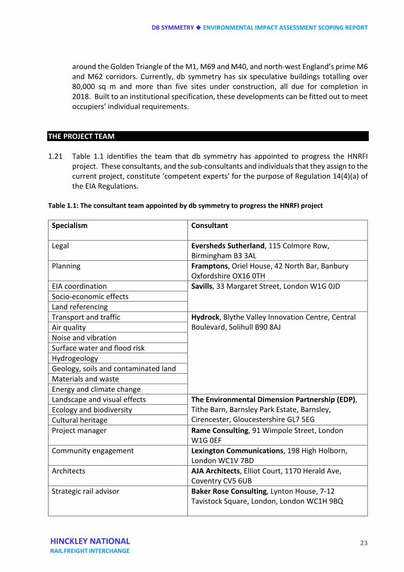
THE PROJECT TEAM 1.21 Table 1.1 identifies the team that db symmetry has appointed to progress the HNRFI
project. These consultants, and the sub-consultants and individuals that they assign to the current project, constitute ‘competent experts’ for the purpose of Regulation 14(4)(a) of the EIA Regulations.
Table 1.1: The consultant team appointed by db symmetry to progress the HNRFI project Specialism Consultant
Legal Eversheds Sutherland, 115 Colmore Row,
Birmingham B3 3AL Planning Framptons, Oriel House, 42 North Bar, Banbury
Oxfordshire OX16 0TH EIA coordination Savills, 33 Margaret Street, London W1G 0JD Socio-economic effects Land referencing Transport and traffic Hydrock, Blythe Valley Innovation Centre, Central
Boulevard, Solihull B90 8AJ Air quality Noise and vibration Surface water and flood risk Hydrogeology Geology, soils and contaminated land Materials and waste Energy and climate change Landscape and visual effects The Environmental Dimension Partnership (EDP),
Tithe Barn, Barnsley Park Estate, Barnsley, Cirencester, Gloucestershire GL7 5EG
Ecology and biodiversity Cultural heritage Project manager Rame Consulting, 91 Wimpole Street, London
W1G 0EF Community engagement Lexington Communications, 198 High Holborn,
London WC1V 7BD Architects AJA Architects, Elliot Court, 1170 Herald Ave,
Coventry CV5 6UB Strategic rail advisor Baker Rose Consulting, Lynton House, 7-12
Tavistock Square, London, London WC1H 9BQ
ENVIRONMENTAL IMPACT ASSESSMENT SCOPING REPORT DB SYMMETRY
24 HINCKLEY NATIONAL RAIL FREIGHT INTERCHANGE
Railway engineers WSP Parsons Brinckerhoff, 1 Queens Drive, Birmingham B5 4PJ
Utilities adviser RPS Planning and Development, Sherwood House, Sherwood Avenue, Newark, Nottinghamshire NG24 1QQ
Quantity surveyor Feasibility Limited, No. 5 Hagley Court North, The Waterfront, Level Street, Brierley Hill DY5 1XF
ENVIRONMENTAL IMPACT ASSESSMENT 1.22 Regulation 6 of the EIA Regulations determines development to be ‘EIA development’ if
any of the following circumstances apply:
• the applicant notifies the Secretary of State in writing under regulation 6(2)(a) that it proposes to provide an ES in respect of proposed development; or
• the Secretary of State or an examining authority adopts a screening opinion to the
effect that the development is EIA development; or • the Secretary of State directs an accepted application to be EIA development.
1.23 Schedule 2 of the EIA Regulations identifies the types of development that might require
EIA if likely to have significant effects on the environment by virtue of factors such as their nature, size or location. The proposed development is included in the following parts of Schedule 2 of the EIA Regulations:
• Part 10(a) ‘Industrial estate development projects’;
• Part 10(c) ‘construction of intermodal transhipment facilities and of intermodal
terminals’;
• Part 10(d) ‘construction of railways’
• Part 10(f) ‘construction of roads’. 1.24 Following consideration of the characteristics of development, the location of
development and the types and characteristics of the potential impact, db symmetry considers the Scheme is EIA development, requiring an ES to accompany the application for a DCO. db symmetry has notified the Secretary of State in writing under regulation 8(1)(b) that it proposes to provide an ES in respect of the HNRFI project.
1.25 PINS has published a series of advice notes to guide the preparation and examination of
DCO applications. Advice Note Seven: Environmental Impact Assessment: Preliminary
DB SYMMETRY ENVIRONMENTAL IMPACT ASSESSMENT SCOPING REPORT
25 HINCKLEY NATIONAL RAIL FREIGHT INTERCHANGE
Environmental Information, Screening and Scoping (version 6, December 2017) explains in paragraph 8.3 that the Planning Inspectorate considers that a good ES is one that:
• provides a clear description of the Proposed Development through all phases of the
development consistent with the DCO - i.e. in terms of construction, operation and decommissioning phases;
• clearly explains the processes followed to develop the ES including the established scope for the assessment;
• explains the reasonable alternatives considered and the reasons for the chosen option taking into account the effects of the Proposed Development on the environment;
• details the forecasting methods for the assessment and the limitations (as relevant);
• assesses in an open and robust way the assessment of likely significant effects explaining where results are uncertain;
• provides sufficient details of the measures envisaged to prevent, reduce and where possible offset any significant adverse effects, the likely efficacy of such measures and how they are secured;
• details the need for any ongoing monitoring or remediation; and
• demonstrates that the information is sufficient to enable a reasoned conclusion to be reached.
1.26 db symmetry took Advice Note 7 into account in the production of the current EIA scoping
opinion request and will follow the guidance in Advice Note 7 as it relates to the production of Preliminary Environmental Information during the pre-application consultation process and the consultation process itself.
1.27 The EIA for db symmetry’s project will be undertaken in accordance with what are known
as ‘Rochdale Envelope’ principles in reflection of the fact that the DCO will need to retain flexibility around the internal layout and design of the HNRFI. This flexibility is essential to ensure that the development can respond to occupier demand and the evolving requirements of the freight logistics industry. PINS Advice Note 9: Using the Rochdale Envelope (version 2, April 2012) identifies the guiding principles that db symmetry will follow. In summary:
• an application should acknowledge the need for details to evolve over a number of
years, within clearly defined parameters and the EIA must take account of this and reflect the likely significant effects of such a project;
• the permission given must create clearly defined parameters, with the DCO including
ENVIRONMENTAL IMPACT ASSESSMENT SCOPING REPORT DB SYMMETRY
26 HINCKLEY NATIONAL RAIL FREIGHT INTERCHANGE
Requirements (akin to conditions in a conventional planning permission) to ensure that the process of evolution remains within the parameters;
• the level of detail of the proposal, within the defined parameters, must be such as to enable a proper assessment of the likely environmental effects, and necessary mitigation;
• The assessment might conclude that a particular effect may fall within a fairly wide range. In assessing the ‘likely’ effects, it is entirely consistent with the objectives of the EIA Regulations to adopt a cautious ‘worst case’ approach: mitigation measures should be adequate to deal with the worst case so as to optimise the effects of the development on the environment;
• this flexibility is not to be abused and does not give developers an excuse to give inadequate descriptions of their projects;
• it is for the Secretary of State, guided by the Examining Authority, to determine what degree of flexibility can be permitted in the particular case having regard to the specific facts of an application. It will be prudent for developers and authorities to ensure they have assessed the range of possible effects implicit in the flexibility provided by the permission.
PURPOSE AND STRUCTURE OF THIS REPORT 1.28 Regulation 10(3) of the EIA Regulations identifies the essential information that must be
provided in a request to the Secretary of State for an EIA scoping opinion:
(3) A request under paragraph (1) must include— (a) a plan sufficient to identify the land; (b) a description of the proposed development, including its location and technical
capacity; (c) an explanation of the likely significant effects of the development on the
environment; and (d) such other information or representations as the person making the request may
wish to provide or make. 1.29 Insert 2 of PINS Advice Note Seven: EIA: Process, Preliminary Environmental Information,
and Environmental Statements (version 6, December 2017) recommends, inter alia, that an EIA scoping opinion request should also include the following information:
• an explanation of the approach to addressing uncertainty where it remains in relation
to elements of the Proposed Development e.g. design parameters;
DB SYMMETRY ENVIRONMENTAL IMPACT ASSESSMENT SCOPING REPORT
27 HINCKLEY NATIONAL RAIL FREIGHT INTERCHANGE
• referenced plans presented to an appropriate scale to convey clearly the information and all known features associated with the Proposed Development
• an outline of the reasonable alternatives considered and the reasons for selecting the preferred option;
• a summary table depicting each of the aspects and matters proposed to be scoped out
of further assessment with justification provided; • results of desktop and baseline studies where available and where relevant to the
decision to scope in or out aspects or matters; • a detailed description of the aspects and matters proposed to be scoped out of further
assessment with justification provided; • results of desktop and baseline studies where available and where relevant to the
decision to scope in or out aspects or matters; • aspects and matters to be scoped in, the report should include details of the methods
to be used to assess impacts and to determine significance of effect e.g. criteria for determining sensitivity and magnitude;
• any avoidance or mitigation measures proposed, how they may be secured and the
anticipated residual effects; • references to any guidance and best practice to be relied upon; • evidence of agreements reached with consultation bodies (for example the statutory
nature conservation bodies or local authorities); and, • an outline of the structure of the proposed ES.
1.30 Where available, this information is included in the current report, which is structured as
follows.
Chapter 2 explains the background to, need for and objectives of the project, and provides a project description and outline programme to the submission of a DCO application.
Chapter 3 outlines the alternatives sites and schemes that db symmetry considered before
deciding to promote its preferred solution. Chapter 4 explains the consultations undertaken to date, the further consultations that
will be undertaken in support of the EIA process and the overall programme for stakeholder engagement during the pre-application stage of the DCO project.
ENVIRONMENTAL IMPACT ASSESSMENT SCOPING REPORT DB SYMMETRY
28 HINCKLEY NATIONAL RAIL FREIGHT INTERCHANGE
Chapter 5 describes the overall approach that db symmetry proposes to adopt for EIA,
including the relevant technical guidance for road and rail projects. Chapters 6 – 17 provide a baseline assessment, an outline of potential environmental
effects and the proposed scope of the assessment under individual environmental topic headings, as follows:
Chapter 6 Land use and socio-economic effects Chapter 7 Transport and traffic Chapter 8 Air quality Chapter 9 Noise and vibration Chapter 10 Landscape and visual effects Chapter 11 Ecology and biodiversity Chapter 12 Cultural heritage Chapter 13 Surface water and flood risk Chapter 14 Hydrogeology Chapter 15 Geology, soils and contaminated land Chapter 16 Materials and waste Chapter 17 Energy and climate change
Chapter 18 outlines the scope of the assessment of cumulative and transboundary effects. Chapter 19 sets out the conclusions of this EIA scoping opinion request.
CONTACTS 1.31 For further information about the current project, please view the project website at
www.hinckleynrfi.co.uk or to speak with a member of the project team, via a dedicated Community Information Line - telephone 0844 556 3002 (Monday – Friday, 9:00am – 5:30pm).
1
S
H
E
R
B
O
R
N
E
R
O
A
D
137
151
7
1
6
1
Pond
S
A
P
C
O
T
E
R
O
A
D
138
DORCHESTER ROAD
1
2
6
Issues
1
1
9
141
1
3
Woodfields
150
Sinks
Issues
1
6
2
103.6m
8
8
1
2
9
7
P
a
t
h
(
u
m
)
P
a
t
h
(
u
m
)
97.3m
P
a
t
h
(
u
m
)
MP 5.5
FB
P
a
t
h
(
u
m
)
T
r
a
c
k
Wood House
Farm
Path (um)
T
r
a
c
k
D
r
a
i
n
Sheepy Wood
Burbage Common
Ford
96.3m
L Twr
Marsden Stadium
96.6m
Pond
95.9m
Moirana
B
U
R
B
A
G
E
C
O
M
M
O
N
R
O
A
D
Visitors Centre
T
r
a
c
k
C
o
tta
g
e
Ram
allan
P
a
th
(u
m
)
B
U
R
B
A
G
E
C
O
M
M
O
N
R
O
A
D
L Twr
B
r
ia
r
w
o
o
d
(Hinckley United F C)
B
a
s
s
e
t
95.7m
L Twr
95.6m
Gas Gov
L Twr
97.4m
L Twr
P
ath (um
)
96.8m
95.9m
L
a
y
-
b
y
Drain
C
y
c
le
T
ra
c
k
&
P
a
th
A
4
7
D
r
a
i
n
FB
FB
Cottage Farm
Issues
Green
1
5
1
8
Pond
7
102.1m
3
0
Site
E
T
L
Threeways
100.6m
T
r
a
c
k
2
2
100.3m
1
9
96.3m
108.5m
5
3
8
Manor
Rosevale House
Ppg Sta
3
3
Oak Tree
101.5m
7
1
6
96.6m
103.6m
107.3m
Farm
T
r
a
c
k
2
5
8
98.5m
D
r
a
i
n
B
4
6
6
9
C
a
s
t
l
e
w
o
o
d
M
o
b
i
l
e
H
o
m
e
P
a
r
k
1
9
Stone
22
Wytch
5
Pond
1
6
3
6
2
A
S
T
O
N
L
A
N
E
1
6
5
8
S
M
I
T
H
Y
L
A
N
E
O
a
k
a
p
p
l
e
1
8
Travellers
Acorn Cottage
2
4
Aston Oaks
98.5m
Pond
Rosevale Park
H
I
N
C
K
L
E
Y
R
O
A
D
2
3
104.2m
100.6m
100.6m
101.2m
98.8m
102.7m
2
8
The Homestead
Track
2
1
Acres
5
Wood
T
r
a
c
k
2
0
18
102.7m
Pond
Pond
Sewage
1
1
6
6
99.4m
97.5m
1
6
9
102.4m
1
7
1
A
S
T
O
N
F
L
A
M
V
I
L
L
E
R
O
A
D
Garage
2
4
1
4
98.8m
S
A
P
C
O
T
E
R
O
A
D
3
3
Pond
2
7
Cottage
100.3m
The Nook
Aston Firs
View
Issues
1
4
Winter
2
6
104.9m
102.4m
20
95.7m
Tra
ck
Pond
FB
Tra
ck
Sinks
D
r
a
i
n
Issues
Park
Car
FB
T
r
a
c
k
95.2m
28
1
6
FB
1
3
Pond
C
a
s
t
l
e
w
o
o
d
MP 6
M
o
b
i
l
e
H
o
m
e
P
a
r
k
FB
S
M
IT
H
Y
L
A
N
E
T
r
a
c
k
FB
Track
Pond
Pond
T
r
a
c
k
Tra
ck
FB
Pond
Issues
FB
FB
Burbage Wood
1
7
Drain
B
u
r
b
a
g
e
C
o
m
m
o
n
FB
Pond
FB
P
a
t
h
(
u
m
)
95.0m
1
2
P
a
th
(
u
m
)
P
a
t
h
(
u
m
)
Track
93.9m
1
0
Elmesthorpe Plantation
96.0m
Pond
P
a
t
h
(
u
m
)
FB
T
r
a
c
k
Ponds
Path (um
)
Silos
P
a
t
h
(
u
m
)
Pond
Pond
Ponds
Pond
Footbridge
D
r
a
i
n
D
ra
in
Bridge Farm
Car Park
Pond
Hissar House Farm
B
U
R
B
A
G
E
C
O
M
M
O
N
R
O
A
D
SP
Issues
T
ra
c
k
P
a
t
h
(
u
m
)
2
7
Pond
2
8
Pond
Shelter
T
r
a
c
k
PCs
B
R
I
D
L
E
P
A
T
H
2
6
B
U
R
B
A
G
E
C
O
M
M
O
N
R
O
A
D
MP 6.25
Burbage Common
Path
(um
)
Church View
Fields Farm
Sinks
Pond
Nursery
B
4
6
6
8
B
4
6
6
8
B
r
o
o
k
ly
n
A
4
7
L
E
IC
E
S
T
E
R
R
O
A
D
2
5
Pond
P
e
n
r
y
l
2
9
95.0m
Station
S
c
r
o
p
t
o
n
B
R
I
D
L
E
P
A
T
H
R
O
A
D
P
e
a
c
e
H
a
v
e
n
Pumping
Pond
4
Manor
Cottage
Tennis Court
Pond
C
o
t
t
a
g
e
The
94.7m
MA
NO
R H
OU
SE
H
I
N
C
K
L
E
Y
R
O
A
D
Pond Spinney
Manor
Pond
Church Farm Court
Old Rectory
Pond
Pond
CLO
SE
House
LB
Cottage
Colt House
5
1
105.5m
98.2m
Church Fm
Pond Spinney
104.5m
2
1
Bryher
GP
98.1m
Dunton
Pond
Dovecote
101.6m
Manor
Stable
S
H
A
R
N
F
O
R
D
R
O
A
D
7
Pond
102.8m
97.4m
1
9
St Peter's
Lodge
TCB
Pond
W
e
s
t
Farm
Church
Cottage
House
Pond
1
9
109.1m
5
B 4
669
1
4
H
IN
C
K
L
E
Y
R
O
A
D
Weir
4
2
0
CG
1
1
Pond
Stables
E
T
L
Issues
B
4
6
6
9
Pond
Averley House Cottage
9
HINCKLEY ROAD
Ps
1
5
B
4
6
6
9
B
4
6
6
9
B
4
6
6
9
Pond
Oaks
2
S
M
I
T
H
Y
L
A
N
E
1
3
Travellers Site
El Sub Sta
Averley House Farm
Pond
M
6
9
Caravan & Castle
Pond
7
FB
FB
Old
Rowan Lodge
T
r
a
c
k
Hobbs Hayes
W
o
o
d
f
i
e
l
d
The Barn
Farm
9
7
.
0
m
Woodhouse
Freeholt Lodge
Farm
Hawthorne Lodge
Farm
Chestnut Court
Laurel
Court
Pond
M
6
9
Pond
Woodhouse
Pond
1
Pond
E
T
L
2
t
o
5
Pond
CG
Willow Lodge
Woodfield
P
a
t
h
(
u
m
)
Freeholt Wood
1
9
2
Pond
Pond
FB
B
IL
L
IN
G
T
O
N
R
O
A
D
E
A
S
T
FB
Pond
91.4m
FB
FB
1
8
Farm
94.4m
Pond
Pond
95.2m
89.0m
Issues
Pond
D
r
a
i
n
Water
Scrap Yard
T
r
a
c
k
88.5m
2
3
Carinya
B
U
R
B
A
G
E
C
O
M
M
O
N
R
O
A
D
Farm
T
r
a
c
k
MP 6.5
T
r
a
c
k
Elmesthorpe Estate
D
r
a
i
n
Pond
Willows
Billington Rough
84.1m
FB
94.0m
MP 6.75
Langton Farm
Fish Pond
2
0
Pond
2
2
B
U
R
B
A
G
E
C
O
M
M
O
N
R
O
A
D
2
4
Billington
Pond
88.0m
2
1
The Weeping
Issues
T
r
a
c
k
Pond
96.0m
Meadows
1
FB
5
1
1
S
t
o
r
n
o
w
a
y
H
e
a
t
h
e
r
s
t
o
n
e
C
o
m
b
e
s
T
h
e
L
a
u
r
e
l
s
T
h
e
H
a
v
e
n
B
5
8
1
2
I
l
a
m
H
o
u
s
e
1
C
R
E
S
C
E
N
T
Kennels
6
T
h
e
8
1
4
V
i
e
w
3
4
2
T
h
e
P
o
p
l
a
r
s
B
I
L
L
I
N
G
T
O
N
R
O
A
D
E
A
S
T
A
v
o
n
H
o
u
s
e
C
l
o
v
e
h
o
l
m
e
P
l
e
a
s
a
n
t
L
E
I
G
H
T
O
N
C
R
E
S
C
E
N
T
6
7
1
4
8
Wortley
LB
1
U
p
p
i
n
g
h
a
m
L
O
V
E
L
A
C
E
1
7
W
i
l
l
o
w
s
H
a
y
d
n
h
o
l
m
e
88.4m
1
7
a
C
h
a
c
e
w
a
t
e
r
Cottages
T
H
E
R
O
U
N
D
H
I
L
L
S
1
2
2
Pond
T
r
a
c
k
Pond
Pond
Pond
Willow
Lay-b
y
100.1m
Strawberry
Cottage
B
4
6
6
9
93.5m
93.6m
96.4m
T
r
a
c
k
The Standings
T
r
a
c
k
Nuttingore
Tank
The Old
Fields Farm
View
96.0m
93.4m
Byre
T
h
e
O
l
d
D
a
i
r
y
The Courtyard
Farm
Pond
H
IN
C
K
L
E
Y
R
O
A
D
Pond
93.5m
Oakley Stud
Pond
95.1m
Pond
Business Centre
D
r
a
i
n
Strawberry Cottage
Pond
T
h
e
P
a
s
tu
re
s
Issues
97.0m
T
r
a
c
k
FB
L
A
N
E
S
T
A
N
T
O
N
Pond
T
r
a
c
k
Nursery
Pond
Farm
Ponds
T
r
a
c
k
Ponds
M
6
9
Ponds
Pond
Pond
E
T
L
Red Hill Farm
Harecroft Farm
Highgate Lodge
Ponds
Pond
Pond
Messenger's Barn
S
T
A
T
I
O
N
R
O
A
D
3
L
y
n
h
u
r
s
t
T
rack
MP 7.25
Oaklands
4
G
r
o
s
n
o
n
t
B
U
R
B
A
G
E
C
O
M
M
O
N
R
O
A
D
Arms
G
r
e
e
n
-
L
e
y
s
181
0
Glebe Farm
The White House
(PH)
7
94.8m
Pond
N
e
w
H
o
l
m
e
T
r
a
c
k
14
87.1m
2
0
Acacia
Langton House
S
T
A
N
T
O
N
R
O
A
D
2
MP 7.5
97.9m
The Home Farm
T
r
a
c
k
90.5m
T
r
a
c
k
1
a
12
Dra
in
B
O
S
T
O
C
K
C
L
O
S
E
The Gables
T
h
e
E
l
m
s
D
rain
9
Pond
89.7m
West View
90.3m
The Bungalow
89.5m
S
L
Wentworth
1
Black Pine Lodge
3
I
v
a
n
h
o
e
S
T
A
T
I
O
N
R
O
A
D
The Homestead
4
90.9m
M
6
9
2
1
FB
B
e
n
n
e
t
t
s
4
1
Pump
M
6
9
3
2
S
P
I
N
N
E
Y
F
A
R
M
C
L
O
S
E
T
r
a
c
k
3
8
Thorney
P
a
t
h
(
u
m
)
1
8
3
4
Fields Farm
2
8
El Sub Sta
1
0
Wash
Sheep
Bungalow
Pond
Allotment
D
O
N
K
E
Y
L
A
N
E
T
r
a
c
k
T
r
a
c
k
Springfield Farm
The
Pond
Gardens
64
5
6
1
9
91.3m
B 4
669
HIN
CK
LE
Y R
OA
D
2
2
29
9
46
Slurry Beds
2
15
1 to 4
34
42
Ponds
1
8
1
3
8
T
r
a
c
k
4
44a
89.6m
2
90.5m
15
2
8
6
43
40
28
Livesey
15
1
7
57
8
Pond
Pond
44
11
11
Pond
Gardens
L
O
V
E
T
T
C
L
O
S
E
1
2
1
1
2
1
1
1
15a
ESS
71
40
LIVESEY
2
Pond
1
27
Lodge
7
to
Allotment
R
O
A
D
LIME AVENUE
T
r
a
c
k
1
LB
Court
2
ELDER CLOSE
1
PA
R
K
Pond
26
4
6
19
41a
29
1
2
39
DRIVE
Bram
ble
8
1
Lodge
16
3
0
Livesey
1
32
ROOKERY CLOSE
7
1
1
96.1m
1
1
8
6
1
H
O
W
E
C
L
O
S
E
5
2
1
3
1
1
0
6
2
0
C
L
O
S
E
8
1
1
2
16
E
l
S
u
b
S
t
a
2
2
5
T
A
N
S
E
Y
C
R
E
S
C
E
N
T
93.5m
10
GE
OR
GE
2
14
2
2
Ponds
2
0
1
Ponds
Boundary Farm
1
R
O
B
E
R
T
S
O
N
F
A
R
N
D
O
N
D
R
I
V
E
11
7
3
4
5
2
F
IS
H
E
R
C
L
O
S
E
Tank
S
M
I
T
H
Y
1
4
4
F
A
R
N
D
O
N
C
L
O
S
E
E
T
L
3
2
1
1
S
h
e
l
t
e
r
2
9
3
2
M
O
R
T
I
B
O
Y
S
1
6
2
3
3
9
1
3
1
W
A
Y
1
6
1
6
1
D
r
a
in
4
2
2
1
7
1
1
2
1
8
1
3
M
E
T
C
A
L
F
5
P
E
T
E
R
'S
C
L
O
S
E
3
3
1
4
H
I
N
C
K
L
E
Y
R
O
A
D
22
1
2
2
D
O
U
D
N
E
Y
C
L
O
S
E
2
6
8
27
M
A
R
R
I
O
T
T
C
L
1
5
1
0
5
7
5
C
L
1
4
94.6m
2
2
5
9
2
7
5
7
1
3
2
B
5
8
1
S
T
A
T
IO
N
R
O
A
D
Signal Post
Issues
Rose Bank
Pond
86.1m
83.2m
Pond
El Sub Sta
T
h
e
L
a
u
r
e
l
s
El Sub Sta
B
5
8
1
R
o
s
e
l
y
n
MP 7.75
Aston Flamville
M69J2
M69 Southbound toCoventry and M6
M69 Northbound toLeicester and M1
StoneyStanton
Hinckley &Burbage
Elmsthorpe
Sapcote
B4469Hinckley Road
B4469Hinckley Road
Birmingham toPeterboroughRailway Line
Birmingham toPeterboroughRailway Line
M69
The Site
drawn
date
scale
checked
no
drawing
project
client
aja architects llp
Coventry Business Park
T: 024 7625 3200
no. bydate revision
notes
W: www.aja-architects.com
F: 024 7625 3210
COVENTRY CV5 6UB
aja architects llp is a limited liability partnership registered in England No. OC326721
1170 Elliott CourtHerald Avenue
this drawing and design is the copyright of aja architects llp and must not bereproduced in part or in whole without prior written consent. contractors mustverify all dimensions on site before commencing work or preparing shop drawingsIf in doubt ASK.
Where this drawing contains any Ordnance Survey mapping material, it has beenreproduced under license number 100052278.Ordnance Survey © Crown copyright
architectsarchitects
Strategic Rail FreightInterchange -Hinckley
Figure 1.1: Site Location Plan
1:5000 mjl
mjl 22/2/18
5905 - 68

ENVIRONMENTAL IMPACT ASSESSMENT SCOPING REPORT DB SYMMETRY
30 HINCKLEY NATIONAL RAIL FREIGHT INTERCHANGE
(This page is intentionally blank)
DB SYMMETRY ENVIRONMENTAL IMPACT ASSESSMENT SCOPING REPORT
31 HINCKLEY NATIONAL RAIL FREIGHT INTERCHANGE
Two The project BACKGROUND 2.1 This chapter explains the need for and objectives of the proposed HNRFI and provides the
description of development on which the EIA scoping exercise has been based. It also identifies the indicative project programme between EIA scoping and the submission of a DCO application for the proposed development.
2.2. The chapter explains how, by providing multi-modal transport options at a hub location
on the national rail and road networks, the project is intended to meet the needs of the logistics industry, including port operators, in serving manufacturers, distributors and retailers
2.3 In December 2013 the Leicester and Leicestershire Housing, Planning and Infrastructure
Group (HPIG) commissioned MDS Transmodal and Savills to undertake a study examining the strategic distribution sector in Leicestershire. The main objectives of the study were to enable a better understanding of the logistics sector and to determine future need objectively, whilst managing change and supporting sustainable economic growth.
2.4 The consultants produced the Leicester and Leicestershire Strategic Distribution Sector
Study (LLSDSS) Final Report in November 2014. The report identified several significant challenges, which may be summarised as follows.
• The emergence of competing inland locations to the north and east of the ‘golden
triangle’ and in ports; regions/locations which to date have not generally accommodated major national distribution facilities.
• Given a choice of sites, major distribution centre operators would be expected to locate at a rail-served site in the golden triangle as it continues to offer the most competitive location for national distribution.
• The key to addressing the emerging competition, and hence maintain and grow the established competitive advantage, is the continued development of new commercially attractive strategic sites in the East Midlands, a significant proportion of which will need to be directly rail-served (in addition to the usual requirements for high quality connections to the strategic highway network).
• Functional obsolescence of the existing warehouse stock, changes in market trading conditions (particularly the growth in on-line shopping) and technological advances have resulted in a trend towards a requirement for fewer but larger warehouse units. As a result, many existing sites no longer have the plot sizes now required by the market, implying a need to bring forward new/additional sites.
ENVIRONMENTAL IMPACT ASSESSMENT SCOPING REPORT DB SYMMETRY
32 HINCKLEY NATIONAL RAIL FREIGHT INTERCHANGE
2.5 As explained in chapter three of the report, four overarching conclusions were drawn from
the study.
• A need to identify and allocate new land at commercially attractive strategic sites to maintain and enhance the established competitive advantage within the area, enabling the sector to grow in a sustainable manner.
• To deliver the identified need through long-term, strategic and collaborative planning across the county of Leicestershire and potentially with authorities in neighbouring areas.
• To commence the preparatory work immediately, with the preparation of local plan policies to commence now so that the right sites in the most competitive locations can come forward for development as and when they are required by the market.
• The strategy requires the implementation of a number of highway and railway enhancement schemes requiring liaison with the Highways Agency and Network Rail to ensure that the enhancement schemes are ultimately delivered.
2.6 The report identifies three ‘best’ key areas of opportunity and, three ‘good’ areas of
opportunity for strategic distribution uses. db symmetry’s proposed site is located centrally within Key Area A: Leicester to Hinckley corridor.
2.7 The report identified the expected forecast demand with the likely land supply at rail
served sites to 2030, assuming that all rail served sites (SRFIs) which had been consented or submitted within the DCO process, together with smaller schemes are operational by 2036. The consultants identified a shortfall (high range) of 115 hectares.
2.8 The consultants expressed the opinion that one further SRFI will need to be brought
forward within Leicestershire up to 2036 (and towards the end of the planning period considered – Final Report, part 2.45). The genesis of this project has been in response to the level of need identified in the LLSSDS.
2.9 Supplements to and a partial update of the reports were completed in January 2017. The
Wider Market Developments: Implications for Leicester and Leicestershire (Jan 2017), commissioned by Harborough District Council on behalf of the local authorities in Leicestershire, further supported the findings that the Golden Triangle has a distinct competitive advantage in the strategic distribution sector and that the main findings of the 2014 report remain relevant.
2.10 In March 2017 the Department of Communities and Local Government (DCLG) launched
the Midlands Engine Strategy as a demonstration of the government’s commitment to making the Midlands a powerful engine for economic growth. The Strategy identifies the Midlands as sitting at the very heart of the UK economy. With a fifth of the UK’s total manufacturing capability the Midlands is seen as being essential to the national economic
DB SYMMETRY ENVIRONMENTAL IMPACT ASSESSMENT SCOPING REPORT
33 HINCKLEY NATIONAL RAIL FREIGHT INTERCHANGE
success. 2.11 45% of British rail freight goes through the Midlands. The recently published UK Industrial
Strategy emphasises the importance of investment in infrastructure to drive growth across the UK. The HNRFI is considered to be aligned with these strategies that seek to promote substantial economic growth.
2.12 Leicester and Leicestershire Authorities are currently undertaking public consultation on
a Strategic Growth Plan – running from 11 January to 5 April 2018 – which focuses on four key matters, namely the delivery of new housing, supporting the economy, identification of essential infrastructure and protecting our environment and built heritage. The authorities intend to meet the need from strategic Class B8 uses within a separate study, recognising the evolving needs of the logistics centre in supporting manufacturing, and the growth in electronic retailing.
2.13 This is expected to build on the work undertaken by the Leicester and Leicestershire
Economic Partnership in developing its Strategic Economic Plan for 2014-2020, which identified south-west Leicestershire as a Key Opportunity Area (Growth Area 5), with the potential for future growth utilising the improved freight capacity of the Nuneaton to Felixstowe rail line and better access to the M69.
2.14 The DCO submission will explain the relationship of the HNRFI with these strategies. PROJECT NEED AND OBJECTIVES 2.15 As explained in the National Networks National Policy Statement (NPS), the government
has concluded that there is a compelling need for an expanded network of SRFIs and that it is important that SRFIs are located near the business markets they will serve – major urban centres or groups of centres – and are linked to key supply chain routes. The NPS recognises that given the locational requirements and need for both rail and road connection, the number of suitable locations for SRFIs will be limited.
2.16 The National Networks NPS confirms that the compelling need for development of the
national networks has been accepted by the government and it makes clear that the Examining Authority and the Secretary of State should start their assessment of applications on this basis.
2.17 The NPS for Ports recognises that the balance of modes for goods to enter and leave ports
can have a variety of traffic and transport impacts on surrounding infrastructure. It acknowledges that the most significant impact, in the case of unitised traffic, is likely to be on the surrounding road infrastructure. To mitigate such impacts, The NPS for Ports states that rail and coastal or inland shipping should be encouraged over road transport, where cost effective. Such an objective can be achieved through the delivery of rail freight interchanges.
ENVIRONMENTAL IMPACT ASSESSMENT SCOPING REPORT DB SYMMETRY
34 HINCKLEY NATIONAL RAIL FREIGHT INTERCHANGE
2.18 The ES that will accompany the DCO application will explain the need for the Project and the objectives of the development, taking into account:
• the background to and changing pattern of international and national logistics
requirements, trade and the importance of key nodal points for agglomerating functions to serve specific markets and achieve appropriate modal shifts;
• relevant national transport and planning policy including the National Policy Statements on National Networks and Ports, the Office of Road and Rail's and Network Rail's Freight Policy and the National Rail Freight Network;
• local policy and objectives, particularly in relation to the Leicester and Leicestershire Economic Partnership's Economic Plan; the Leicester and Leicestershire Distribution Study November 2014 and January 2017 update; the Midlands Transport Studies – Midlands Connect Strategy: Powering The Midlands Engine March 2017 and DCLG Midlands Engine Strategy March 2017;
• policies and objectives of adjoining local authorities of Warwickshire County Council, Northamptonshire County Council, Solihull Metropolitan Borough Council and Coventry City Council.
PROJECT DESCRIPTION 2.19 The location and site of the proposed development are described in chapter one of this
EIA scoping opinion request. This section describes the proposed main physical features of the development and their general mode of operation. Figure 2.1 provides a preliminary illustrative master plan of the proposed development.
Railport 2.20 Branching from and parallel to the Nuneaton to Felixstowe railway will be a series of
sidings. These will be long enough to allow container freight trains up to 775 metres in length to be brought to the site for unloading and loading. These trains will originate at UK container ports such as Felixstowe, London Gateway, Southampton, Liverpool and the Humber ports, as well as regional terminals in Scotland and elsewhere. The project would enable mitigation of traffic and transport impacts related with localised traffic and congestion at ports, as well as the national network, through enabling modal shift of unitised traffic to rail. Alongside the sidings will be a hard-surfaced area to provide for movements of the vehicles used to unload containers, articulated lorries and for temporary container storage.
2.21 The site would operate on a 24 hours a day / seven days a week basis and would be lit
throughout the night.
DB SYMMETRY ENVIRONMENTAL IMPACT ASSESSMENT SCOPING REPORT
35 HINCKLEY NATIONAL RAIL FREIGHT INTERCHANGE
Motorway access 2.22 Junction 2 of the M69 motorway would be reconfigured to enable the addition of a dual
carriageway access into the site. Other than for emergency access routes considered below this would be the only means of vehicular access into the HNRFI.
2.23 In addition, a northbound off-slip and a southbound on-slip will be added to junction 2,
making it a flexible ‘all-ways’ junction and enabling the convenient flow of traffic on the M69 from the direction of Coventry, the M6 and the A5.
2.24 All freight and employees’ vehicles would be allowed to enter and leave the site solely by
this route. Warehouses and logistics buildings 2.25 The greater part of the HNRFI site would be dedicated to high-bay use class B8 storage
and logistics sheds, with a total floor area of up to 850,000 square metres GIA (650,000 square metres GEA ‘footprint’ and 200,000 square metres of mezzanine floorspace). It is in these buildings that the containerised loads arriving by train will be broken down and prepared for dispatch to their ultimate destinations by road. These buildings will incorporate freight loading bays in the external walls and will have associated areas for lorry manoeuvring and parking and staff car parks. Some buildings will have direct rail access. Around each building will be boundary land for landscape works, planting and surface water drainage features.
Access 2.26 It is proposed that the DCO will include provisions for the stopping up of the section of
Burbage Common Road that crosses the site. Emergency access points to the HNRFI would be provided via Burbage Common Road at two points – from the B581 at Elmesthorpe to the north and from the B4668 / A47 between Barwell and Hinckley. For the avoidance of doubt, normal access to and from the site by these routes would be restricted by security gates and would only be opened for the purpose of access by emergency service vehicles.
2.27 Pedestrian, cycle and horseback access across the site would be maintained. The
proposed DCO boundary shown in figure 1.1 of this report includes land around the existing railway crossings, comprising two pedestrian crossings and an overbridge on Burbage Common Road, to allow for potential replacement/improvement works that may be required.
2.28 A network of internal roads is proposed to provide access to the Railport and logistics
buildings. Roads and junctions will be designed to promote the safe and efficient movement of goods vehicles and car traffic. Parallel footpaths and cycleways will be provided.

ENVIRONMENTAL IMPACT ASSESSMENT SCOPING REPORT DB SYMMETRY
36 HINCKLEY NATIONAL RAIL FREIGHT INTERCHANGE
Landscape and habitats 2.29 The HNRFI site as a whole will be surrounded by a landscape buffer that will incorporate
bunds, tree and shrub planting and water features. These will be designed with a view to providing biodiverse wildlife habitats. A larger area for landscape and habitat is included in the south-western part of the site to serve as a buffer between the development and the woodlands and Burbage Common beyond the site boundary, which include a SSSI and local wildlife sites.
Utilities 2.30 The development will include appropriate provision for water, electricity and gas supply
and for the disposal of foul and surface water. New electricity sub-station provision is proposed within the site.
2.31 The development will include appropriate provision for the supply of water, electricity and
gas, interconnectivity for telecoms and the disposal of foul and surface water. Provision is included within the site boundary for new electricity sub-stations, gas metering kiosks etc. with connection to all existing off site utility infrastructure to be undertaken by the utility providers under their existing statutory powers. The points of connection will be determined by those undertakers at a future date.
Construction 2.32 The proposed DCO boundary shown in figure 1.1 includes land likely to be required to
enable the construction of the development. The draft DCO boundary includes land around the Burbage Common Road overbridge and two pedestrian crossings over the railway, all to allow for potential replacement/improvement works that might be required. Land has also been identified in the south-west and south-east quarters of M69 junction 2 to serve as temporary construction laydown areas for the proposed northbound off-slip and a southbound on-slip at junction 2.
INDICATIVE PROJECT PROGRAMME 2.33 The major project milestones between the submission of this EIA scoping opinion request
and the submission of a DCO application for the HNRFI are identified in table 2.1 (overleaf). This programme may be subject to change.
2.34 Based on db symmetry’s current understanding of the site, it is considered that this
timetable allows sufficient time for the completion and analysis of field surveys and the development of appropriate environmental mitigation strategies, and for design refinement in response to community engagement. Should field survey assessment or other considerations indicate that this is not the case, db symmetry reserves the right to vary the pre-application programme and will update PINS on any changes.
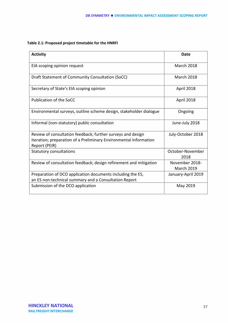
DB SYMMETRY ENVIRONMENTAL IMPACT ASSESSMENT SCOPING REPORT
37 HINCKLEY NATIONAL RAIL FREIGHT INTERCHANGE
Table 2.1: Proposed project timetable for the HNRFI
Activity
Date
EIA scoping opinion request
March 2018
Draft Statement of Community Consultation (SoCC)
March 2018
Secretary of State’s EIA scoping opinion
April 2018
Publication of the SoCC
April 2018
Environmental surveys, outline scheme design, stakeholder dialogue
Ongoing
Informal (non-statutory) public consultation
June-July 2018
Review of consultation feedback; further surveys and design iteration; preparation of a Preliminary Environmental Information Report (PEIR)
July-October 2018
Statutory consultations
October-November 2018
Review of consultation feedback; design refinement and mitigation
November 2018-March 2019
Preparation of DCO application documents including the ES, an ES non-technical summary and a Consultation Report
January-April 2019
Submission of the DCO application
May 2019

ENVIRONMENTAL IMPACT ASSESSMENT SCOPING REPORT DB SYMMETRY
38 HINCKLEY NATIONAL RAIL FREIGHT INTERCHANGE
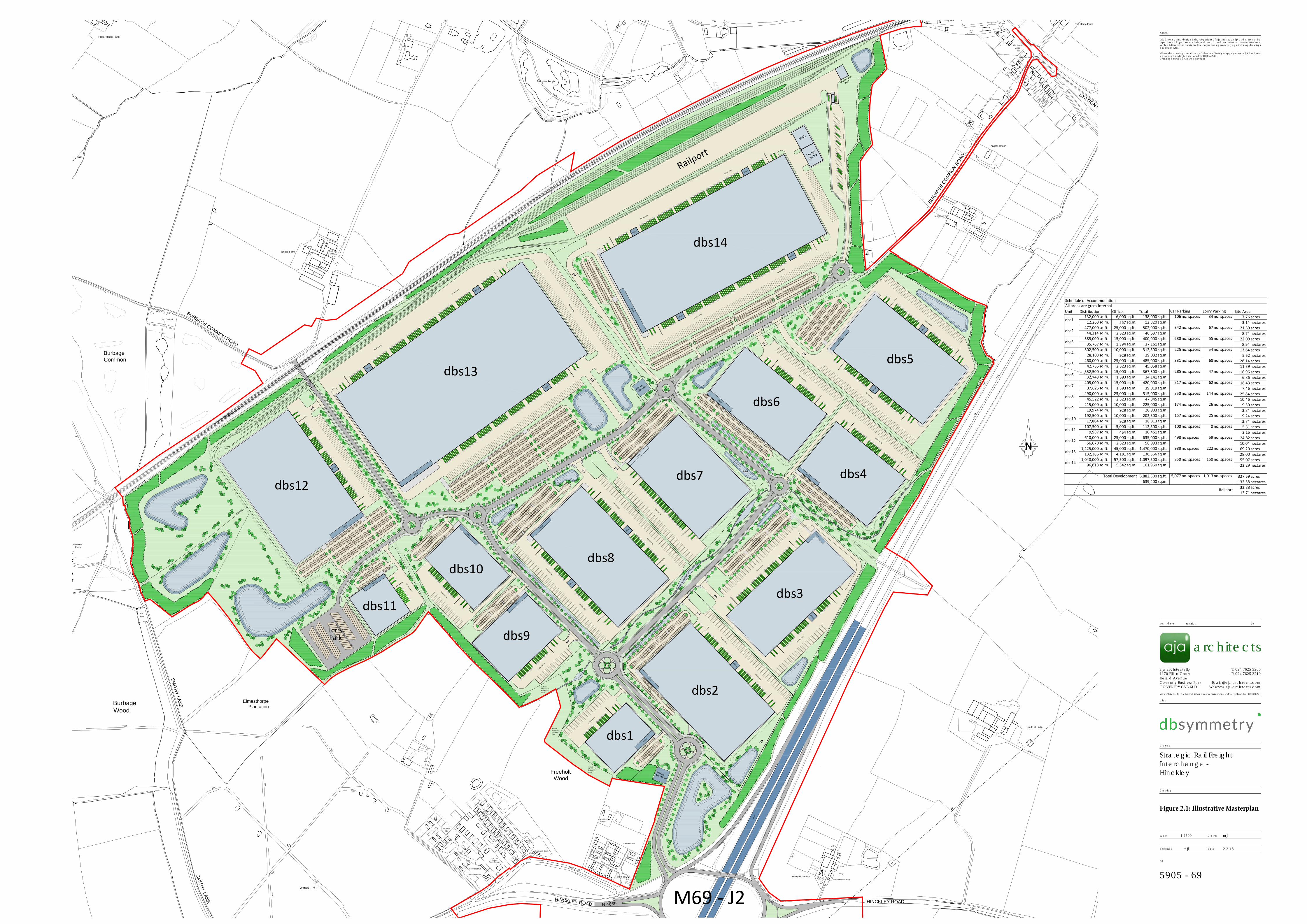
Wood House
Farm
Burbage
Common
1
5
1
8
7
3
0
Site
T
r
a
c
k
1
9
5
3
8
Rosevale House
3
3
Oak Tree
7
1
6
T
r
a
c
k
2
5
C
a
s
t
l
e
w
o
o
d
M
o
b
i
l
e
H
o
m
e
P
a
r
k
1
9
22
5
2
8
S
M
I
T
H
Y
L
A
N
E
Travellers
Acorn Cottage
2
4
Rosevale Park
2
3
2
8
Track
2
1
T
r
a
c
k
2
0
18
1
2
4
3
3
2
7
Cottage
Aston Firs
1
4
Winter
2
6
20
Track
Track
Park
Car
T
r
a
c
k
28
1
6
1
3
C
a
s
t
l
e
w
o
o
d
M
o
b
i
l
e
H
o
m
e
P
a
r
k
S
M
IT
H
Y
L
A
N
E
T
r
a
c
k
Track
T
r
a
c
k
Tra
ck
Burbage
Wood
1
7
B
u
r
b
a
g
e
C
o
m
m
o
n
P
a
t
h
(
u
m
)
1
2
Track
1
0
Elmesthorpe
Plantation
P
a
t
h
(
u
m
)
T
r
a
c
k
Silos
Bridge Farm
Car Park
Hissar House Farm
P
a
t
h
(
u
m
)
2
7
2
8
T
r
a
c
k
PCs
B
R
I
D
L
E
P
A
T
H
2
6
B
U
R
B
A
G
E
C
O
M
M
O
N
R
O
A
D
Burbage
Common
1
9
5
B 4
669
1
4
H
IN
C
K
LE
Y
R
O
A
D
4
2
0
CG
1
1
Stables
9
HINCKLEY ROAD
Ps
1
5
B
4
6
6
9
B
4
6
6
9
Oaks
2
S
M
I
T
H
Y
L
A
N
E
1
3
Travellers Site
El Sub Sta
Caravan & Castle
7
M
6
9
E
T
L
Woodfield
Freeholt
Wood
Scrap Yard
T
r
a
c
k
B
U
R
B
A
G
E
C
O
M
M
O
N
R
O
A
D
Billington Rough
Langton Farm
Fish Pond
2
1
T
r
a
c
k
B
4
6
6
9
M
6
9
S
T
A
T
I
O
N
R
O
A
D
3
L
y
n
h
u
r
s
t
4
G
r
o
s
n
o
n
t
Arms
G
r
e
e
n
-
L
e
y
s
(PH)
7
N
e
w
H
o
l
m
e
T
r
a
c
k
Langton House
2
The Home Farm
T
r
a
c
k
1
a
T
h
e
E
l
m
s
9
The Bungalow
Wentworth
1
Black Pine Lodge
I
v
a
n
h
o
e
M
6
9
B
e
n
n
e
t
t
s
PrimarySub Station
Officesdbs1
Servi
ce Area
Parking
dbs2
Offices
Servi
ce Area
Parking
Offices
Service Area dbs3
Parking
dbs4
Offices
Service Area
Parking
dbs9
dbs10
dbs11
Offices
Offices
Offices
Service Area
Service Area
dbs8
Service Area
Service Area
Parking
Offices
Offices
Service Area
Service Area
dbs7
Parking
Parking
Offices
dbs6
Offices
Parking
Servi
ce Area
Servi
ce Area
Offices
Parking
Service Area
Service Area
Offices
Parking
Offices
Service Area
Parking
Pond
dbs14Offices
Offices
Offices
Offices
VMU
Energy
Centre
Offices
Service Area
Service Area
Service Area
Service Area
Service Area
Maintenance
Block
Railport
M69 - J2Offi
ces
Office
s
Office
s
Parki
ng
dbs5
Service Area
Service Area
Averley House Cottage
Averley House Farm
E
T
L
CG
T
r
a
c
k
Red Hill Farm
LorryPark
HistoricWoodlandProtectionZone
HistoricWoodlandProtectionZone
HistoricWoodlandProtectionZone
Primary
Sub Station
Offices
Offices
Offices
Offices
dbs13
Service Area
Service Area
Parking
Service Area
dbs12Offic
es
Offices
Parking
Parking
Parking Schedule of AccommodationAll areas are gross internalUnit Distribution Offices Total Car Parking Lorry Parking Site Area
dbs1132,000 sq.ft. 6,000 sq.ft. 138,000 sq.ft. 106 no. spaces 34 no. spaces 7.76 acres
12,263 sq.m. 557 sq.m. 12,820 sq.m. 3.14 hectares
dbs2477,000 sq.ft. 25,000 sq.ft. 502,000 sq.ft. 342 no. spaces 67 no. spaces 21.59 acres
44,314 sq.m. 2,323 sq.m. 46,637 sq.m. 8.74 hectares
dbs3385,000 sq.ft. 15,000 sq.ft. 400,000 sq.ft. 280 no. spaces 55 no. spaces 22.09 acres
35,767 sq.m. 1,394 sq.m. 37,161 sq.m. 8.94 hectares
dbs4302,500 sq.ft. 10,000 sq.ft. 312,500 sq.ft. 225 no. spaces 54 no. spaces 13.64 acres
28,103 sq.m. 929 sq.m. 29,032 sq.m. 5.52 hectares
dbs5460,000 sq.ft. 25,000 sq.ft. 485,000 sq.ft. 331 no. spaces 68 no. spaces 28.14 acres
42,735 sq.m. 2,323 sq.m. 45,058 sq.m. 11.39 hectares
dbs6352,500 sq.ft. 15,000 sq.ft. 367,500 sq.ft. 285 no. spaces 47 no. spaces 16.96 acres
32,748 sq.m. 1,393 sq.m. 34,141 sq.m. 6.86 hectares
dbs7405,000 sq.ft. 15,000 sq.ft. 420,000 sq.ft. 317 no. spaces 62 no. spaces 18.43 acres
37,625 sq.m. 1,393 sq.m. 39,019 sq.m. 7.46 hectares
dbs8490,000 sq.ft. 25,000 sq.ft. 515,000 sq.ft. 350 no. spaces 144 no. spaces 25.84 acres
45,522 sq.m. 2,323 sq.m. 47,845 sq.m. 10.46 hectares
dbs9215,000 sq.ft. 10,000 sq.ft. 225,000 sq.ft. 174 no. spaces 26 no. spaces 9.50 acres
19,974 sq.m. 929 sq.m. 20,903 sq.m. 3.84 hectares
dbs10192,500 sq.ft. 10,000 sq.ft. 202,500 sq.ft. 157 no. spaces 25 no. spaces 9.24 acres
17,884 sq.m. 929 sq.m. 18,813 sq.m. 3.74 hectares
dbs11107,500 sq.ft. 5,000 sq.ft. 112,500 sq.ft. 100 no. spaces 0 no. spaces 5.31 acres
9,987 sq.m. 464 sq.m. 10,451 sq.m. 2.15 hectares
dbs12610,000 sq.ft. 25,000 sq.ft. 635,000 sq.ft. 498 no spaces 59 no. spaces 24.82 acres
56,670 sq.m. 2,323 sq.m. 58,993 sq.m. 10.04 hectares
dbs131,425,000 sq.ft. 45,000 sq.ft. 1,470,000 sq.ft. 988 no spaces 222 no. spaces 69.20 acres
132,386 sq.m. 4,181 sq.m. 136,566 sq.m. 28.00 hectares
dbs141,040,000 sq.ft. 57,500 sq.ft. 1,097,500 sq.ft. 850 no. spaces 150 no. spaces 55.07 acres
96,618 sq.m. 5,342 sq.m. 101,960 sq.m. 22.29 hectares
Total Development 6,882,500 sq.ft. 5,077 no. spaces 1,013 no. spaces 327.59 acres639,400 sq.m. 132.58 hectares
Railport 33.88 acres13.71 hectares
drawn
date
scale
checked
no
drawing
project
client
aja architects llp
Coventry Business Park
T: 024 7625 3200
no. bydate revision
notes
W: www.aja-architects.com
F: 024 7625 3210
COVENTRY CV5 6UB
aja architects llp is a limited liability partnership registered in England No. OC326721
1170 Elliott CourtHerald Avenue
this drawing and design is the copyright of aja architects llp and must not bereproduced in part or in whole without prior written consent. contractors mustverify all dimensions on site before commencing work or preparing shop drawingsIf in doubt ASK.
Where this drawing contains any Ordnance Survey mapping material, it has beenreproduced under license number 100052278.Ordnance Survey © Crown copyright
architectsarchitects
Strategic Rail FreightInterchange -Hinckley
Figure 2.1: Illustrative Masterplan
1:2500 mjl
mjl 2-3-18
5905 - 69

ENVIRONMENTAL IMPACT ASSESSMENT SCOPING REPORT DB SYMMETRY
40 HINCKLEY NATIONAL RAIL FREIGHT INTERCHANGE
(This page is intentionally blank)
DB SYMMETRY ENVIRONMENTAL IMPACT ASSESSMENT SCOPING REPORT
41 HINCKLEY NATIONAL RAIL FREIGHT INTERCHANGE
Three Alternatives INTRODUCTION 3.1 According to regulation 14(2)(d) of the EIA Regulations, the ES shall include:
‘a description of the reasonable alternatives studied by the applicant, which are relevant to the proposed development and its specific characteristics, and an indication of the main reasons for the option chosen, taking into account the effects of the development on the environment’.
3.2 As noted in chapter one of this EIA screening opinion request, Insert 2 of PINS Advice Note
Seven: Environmental Impact Assessment: Preliminary Environmental Information, Screening and Scoping (version 6, December 2017) recommends that an EIA scoping opinion request should also include ‘an outline of the reasonable alternatives considered and the reasons for selecting the preferred option’.
3.3 This chapter describes the options for the proposed HNRFI considered by db symmetry in
order to test the suitability of the site. 3.4 This chapter addresses considerations including location, design and technology, size and
scale and the considerations that informed the selection of the proposed site, including market considerations.
LOCATION 3.5 db symmetry has extensive experience in developing logistics schemes and has one of the
largest land portfolios in the UK. Working with strategic rail adviser Baker Rose and drawing upon evidence from the Leicester and Leicestershire Distribution Sector Study (November 2014) (as updated by the Wider Market Developments: Implications for Leicester and Leicestershire (January 2017) and the Leicester and Leicestershire Enterprise Partnership’s Strategic Economic Plan 2014-20 (March 2014), it was established that there remains a significant need for rail-related logistics development in addition to the consented East Midlands Gateway development close to East Midlands Airport and the M1 motorway. The brief for this project was to identify a suitable site that had rail and road connectivity to the major deep water ports of Felixstowe, London Gateway, Liverpool and Southampton.
3.6 As shown in figure 3.1, the Leicester and Leicestershire Enterprise Partnership’s Strategic
Economic Plan (LLEP’s SEP) identified Key Opportunity Areas as five priority Growth Areas, being:
ENVIRONMENTAL IMPACT ASSESSMENT SCOPING REPORT DB SYMMETRY
42 HINCKLEY NATIONAL RAIL FREIGHT INTERCHANGE
• GROWTH AREA 1 (GA1). The Leicester Urban Area (based on the Waterside and Abbey Meadows Strategic Regeneration Area);
• GROWTH AREA 2 (GA2). East Midlands Enterprise Gateway (based on the East
Midlands Gateway Strategic Rail Freight Terminal;
• GROWTH AREA 3 (GA3). Coalville (based on improving the A511 corridor to bring forward already planned developments) Growth Corridor;
• GROWTH AREA 4 (GA4). Loughborough (based on the Loughborough University
Science and Enterprise Park for bio and pharmaceutical R&D);
• GROWTH AREA 5 (GA5). South West Leicestershire, in which the proposed Hinckley National Rail Freight interchange is situated.
3.7 The LLEP’s SEP identified the South West Leicestershire Growth Area (GA5) as offering:
‘a unique combination of key commercial and employment hubs. These provide the opportunity to harness major employment and housing opportunities for Leicester and Leicestershire. The M1 corridor (including the M69/M1 Junction 21 location) and A5 corridor are crucial economic areas in their own right, with established and expanding services, distribution, retail and leisure roles providing thousands of jobs for the sub-region.
The area is also the major gateway to the Leicester Urban Area. Major Sustainable Urban Extensions and Strategic Employment Sites can create 9,000 new homes and 21 hectares of commercial development at New Lubbesthorpe, Earl Shilton and Barwell SUEs.
The success of these significant opportunities depends largely on the delivery of supporting infrastructure. Such investment, alongside other key initiatives such as the major upgrading of the Nuneaton-Felixstowe freight line, will also open up longer term growth potential in this area’.
3.8 The importance of the Nuneaton to Felixstowe freight line improvements is recognised in both the Leicester and Leicestershire Distribution Study and the LLEP’s SEP, with the latter commenting that:
‘Freight connectivity will be substantially enhanced by the upgrade of the Nuneaton-Felixstowe freight railway line which will significantly increase freight capacity through accommodating longer trains up to 750m and larger shipping containers. This route passes through the Growth Area.’
3.9 The LLEP published a Logistics and Distribution Sector Growth Action Plan in May 2015, which states that:
DB SYMMETRY ENVIRONMENTAL IMPACT ASSESSMENT SCOPING REPORT
43 HINCKLEY NATIONAL RAIL FREIGHT INTERCHANGE
‘The LLSDSS researched the baseline position, key challenges and plans for growth within the LLEP area and established that the development of new, commercially-attractive sites directly served by rail is of upmost importance for Leicestershire to remain one of the strategic locations for Logistics and Distribution’. The bold type is as per the LLEP’s Plan.
3.10 An SRFI on the Nuneaton to Felixstowe line, ideally within the south-west Leicestershire growth Area (GA5), with good access to the M69, M1, A5 corridors, would provide optimal multi-modal connectivity and a nodal point for the expressed need for future growth. The project would accord with the considerations of the NPSs for National Networks and Ports, reducing the pressure on the road network especially at ports.
3.11 Baker Rose examined locations on the rail network in Leicestershire that might present opportunities for the location of a SRFI on or readily connectable to the Nuneaton to Felixstowe freight line using a combination of professional knowledge of the network, local knowledge, rail network maps and Google Earth.
Site search criteria 3.12 Paragraph 2.45 of the National Networks NPS states that the logistics industry, providing
warehousing and distribution networks for UK manufacturers, importers and retailers is predominantly a road based industry. The NPS recognises, however, that users and buys of such services are increasingly looking to integrate rail freight into their transport operations, requiring the industry to develop new facilities that are ‘alongside the major rail routes, close to major trunk roads as well as near to the conurbations that consume the goods’. The following criteria were employed for the search area.
Rail
• Access for W10 gauge intermodal container traffic. W10 is the mainstream gauge for intermodal freight in the UK and enables the transport of containers 2.9 metres high and 2.5 metres wide on wagons with a bogie spacing of 14.02 metres.
• Ability to receive 775 metre long freight trains. • Ability for trains to reach to the SRFI site from more than one direction. • Proximity to the main rail lines. • Ability to gain ready access to rail lines. • Availability of train paths that avoid conflicts with passenger services, with capacity
for handling at least four freight trains per day. • Rail connectivity to major deep water ports of Felixstowe, London Gateway,
Liverpool and Southampton, enabling opportunities for modal shift from road to rail.
Road • Access to the national motorway network. • Access to the strategic highway network. • Access at all times of the day and week without creating disturbance to neighbouring
ENVIRONMENTAL IMPACT ASSESSMENT SCOPING REPORT DB SYMMETRY
44 HINCKLEY NATIONAL RAIL FREIGHT INTERCHANGE
and nearby land uses.
Environmental • Avoidance of housing. • Avoidance of flood plain. • A broadly level topography that minimises the need for excessive ground works. • A tract of land largely free of built development, extending to a minimum of 60
hectares.
Commercial and economic
• Compatibility with the objectives of the Leicester and Leicestershire Economic Partnership’s Economic Plan, particularly the Key Areas of Opportunity designated Growth Areas.
• Avoidance of conflicts with existing rail terminals. • The demand profile for users and occupiers. • Proximity to a labour force.
Appraisal 3.13 The appraisal of the locational criteria through Leicestershire led readily to the
identification of land to the north-east of Hinckley as an optimum location for a SFRI that satisfied the locational requirements identified at paragraph 3.12 above.
3.14 In summary form this location affords the following operational advantages:
• the railway between Nuneaton and Felixstowe was upgraded in 2014 to the W10 gauge described above, enabling intermodal freight trains up to 775 metres in length from Felixstowe to serve the Midlands directly. This also means that intermodal trains can travel to the region from all the UK deep sea ports and every major city in Britain with standard wagons carrying 2.9 metre high containers;
• the preferred site is located on a main rail freight corridor identified by Network Rail (F2N Route). Locally this route carries only two passenger trains per hour, providing substantial capacity for freight. There is considered to be capacity on the section between Nuneaton and Leicester to be able to accommodate the Midland Engine’s aspirations for significantly increased passenger services;
• the Nuneaton to Felixstowe railway aligns with a significant economic growth corridor identified by the Leicester and Leicestershire Economic Partnership, as set out above;
• The railway is topographically at grade with the land to the east with an extensive frontage to enable the installation of railway sidings;
DB SYMMETRY ENVIRONMENTAL IMPACT ASSESSMENT SCOPING REPORT
45 HINCKLEY NATIONAL RAIL FREIGHT INTERCHANGE
• M69 junction 2 lies at the southern edge of the site and affords potential for direct access to the motorway network;
• M69 junction 2 currently provides limited access and has the potential for increased
operational capacity through reformatting as an all-directions motorway junction. The installation of a south bound on-slip and northbound off-slip has the potential for greater connectivity from M69 to the West Midlands;
• Investigation into land interests revealed existence of extensive land holdings held by
a few land owners. 3.15 db symmetry and its advisers studied the option of an SRFI being developed on land
between the M69 and the Nuneaton to Felixstowe railway, and enlarged to include land to the east of the M69 (NE of J2).
3.16 Environmental consultant EDP was commissioned to undertake an environmental
appraisal of the Hinckley/Burbage option, including landscape, biodiversity and heritage considerations. EDP suggested that development to the east of the M69 would have a greater effect on landscape character and visual amenity than the land contained by roads, the railway and woodland to the west.
3.17 On this basis, db symmetry concluded that the site for the SRFI should be focused upon
land between the railway and the M69, which affords the best opportunity to bring forward a SRFI meeting the policy requirements of the National Networks NPS, and supporting the principles of the NPS for Ports, and the practical potential to deliver a site of the scale required.
DESIGN AND TECHNOLOGY 3.18 Railway facilities will be provided commensurate with the development’s designation as a
strategic rail freight interchange and the guidance for transport links and locational requirements as set out in the National Networks NPS:
• it will be capable of handling over four trains per day;
• it will include a rail network connection;
• it will include an intermodal terminal for rail handling and storage;
• it can include a number of rail connected or rail accessible buildings with all building
users having access to the intermodal rail terminal;
• it will be able to accommodate 775 m long trains that can be handled with minimal shunting.
ENVIRONMENTAL IMPACT ASSESSMENT SCOPING REPORT DB SYMMETRY
46 HINCKLEY NATIONAL RAIL FREIGHT INTERCHANGE
3.19 The main features of the project will be:
• the potential to provide rail connections in either direction – eastbound or westbound;
• reception sidings adjacent to the main line able to accommodate 775m long trains, with provision for future electrification;
• a parallel intermodal terminal with several unloading sidings and an area for storage
or stacked containers;
• provision for direct access from a railway siding and two or more of the warehouses to be developed on the site.
3.20 The terminal and rail facilities will be on the developer’s land and planned and constructed
by the developer. 3.21 The connection to the rail network will require changes to Network Rail’s track and
signalling. Network Rail has established processes in place for such changes. The DCO application will include an explanation of these processes, the necessary stages and conclusions required to enable connection to the network.
3.22 The proposed development may require the diversion of two footpaths that cross the
railway on at-grade pedestrian crossings. The policy background for the closure of the pedestrian level crossings along with the proposed remedy and its implications will be justified.
3.23 The project is currently at the conceptual stage and, in refining its proposals, db symmetry
will have regard to the following requirements identified in chapter four of the National Networks NPS, including:
• criteria for ‘good design’ for national network infrastructure (NPS pp. 36-37);
• climate change adaptation (NPS pp. 37-39);
• pollution control and other environmental protection regimes (NPS pp. 39-41);
• the identification and mitigation f potential statutory nuisances (NPS p. 41);
• safety, security and health (NPS pp. 41-44).
DB SYMMETRY ENVIRONMENTAL IMPACT ASSESSMENT SCOPING REPORT
47 HINCKLEY NATIONAL RAIL FREIGHT INTERCHANGE
SIZE AND SCALE 3.24 The Project will comprise up to 850,000 square metres GIA (650,000 square metres GEA
‘footprint’ and 200,000 square metres of mezzanine floorspace) of built logistics space to be served by an intermodal terminal, with rail-linked buildings provided according to demand. The proposals will be developed in accordance with paragraph 4.88 of the National Networks NPS:
‘Applications for a proposed SRFI should provide for a number of rail connected or rail accessible buildings for initial take-up, plus rail infrastructure to allow more extensive rail connection within the site in the longer term. The initial stages of the development must provide an operational rail network connection and areas for intermodal handling and container storage. It is not essential for all buildings on the site to be rail connected from the outset, but a significant element should be’.
3.25 It is recognised that size and scale are critical to the viability of SRFIs and as part of the
project and assessment of alternatives, it will be demonstrated how the HNRFI can be developed in a phased manner with the timely delivery of associated rail and road infrastructure.
3.26 As noted, the Applicant will demonstrate how the scheme performs against the site
locational requirements that are identified within the NPS for National Networks particularly in the context of:
• the rail freight interchange function (NPS para. 4.83); • transport links and location requirements (NPS paras 4.84 – 4.87); • Scale and design (NPS paras 4.88 – 4.89).
SELECTION AND EVOLUTION OF THE PREFERRED SCHEME 3.27 In accordance with paragraphs 4.26 and 4.27 of the National Networks NPS, db symmetry
is testing and will continue to test options for the layout of the proposed HNRFI, including different configurations of railway sidings, roads, buildings, drainage, landscape and planting and other environmental mitigation. Draft development layouts will be tested and refined in the light of detailed EIA studies and pre-application consultations. An outline of the main alternatives studied by the applicant and an indication of the main reasons for the applicant’s choice, taking into account the environmental effects will be presented in the ES.

ENVIRONMENTAL IMPACT ASSESSMENT SCOPING REPORT DB SYMMETRY
48 HINCKLEY NATIONAL RAIL FREIGHT INTERCHANGE
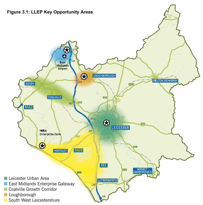
A607
A47
A50
A6
A50
A6
A47
A607
A47
A50
A6
50
A6
A4
6
A6
ll
ll ll llll
ll
ll
ll
M42A5A
lll
llll
llllll
ll
A47A47A47
LOUGHBOROUGH
COALVILLE
ASHBY
HINCKLEY
LEICESTER
MELTON MOWBRAY
LUTTERWORTH
MARKET HARBOROUGH
J19
J20
J21
J21a
J22
J23
J24
J25
M1
M69
East MidlandsAirport
MIRAEnterprize Zone
A5
■ Leicester Urban Area■ East Midlands Enterprise Gateway■ Coalville Growth Corridor■ Loughborough■ South West Leicestershure
Figure 3.1: LLEP Key Opportunity Areas

ENVIRONMENTAL IMPACT ASSESSMENT SCOPING REPORT DB SYMMETRY
50 HINCKLEY NATIONAL RAIL FREIGHT INTERCHANGE
(This page is intentionally blank)
DB SYMMETRY ENVIRONMENTAL IMPACT ASSESSMENT SCOPING REPORT
51 HINCKLEY NATIONAL RAIL FREIGHT INTERCHANGE
Four Consultations INTRODUCTION 4.1 Pre-application consultation is a key requirement for applications for Development
Consent Orders relating to nationally significant infrastructure projects such as this Project. The Applicant will undertake effective pre-application consultation with the local authorities; consultees, and other stakeholders including the public. The Applicant will arrange for early involvement of local communities through public exhibitions held locally to the site and other means of achieving public engagement as the proposals are assembled.
4.2 In accordance with the development consent regime for nationally significant infrastructure projects (NSIPs) a Statement of Community Consultation (SoCC) is being prepared in consultation with Blaby District Council and Leicestershire County Council - the host authorities, and Hinckley and Bosworth Borough Council, a nearby neighbouring local authority. The purpose of the SoCC is to describe how the Applicant will undertake consultations on the Project and set out the arrangements to achieve effective pre -application engagement.
4.3 It is intended that an informal public consultation will take place during summer 2018 with
local communities. This engagement will deploy a range of methods to promote effective engagement with surrounding communities. In discussion with the local authorities a series of local events will be held in locations that are convenient to the ‘host’ communities within Blaby District and Hinckley and Bosworth Borough. Consultation is being undertaken with the Gypsy and Traveller Liaison Officer to prepare a strategy to engage with the two gypsy and traveller community sites south of M69 junction 2 and abuts the site boundary.
4.4 Statutory consultations will follow in winter 2018 and will include a fully reasoned
response to the informal public consultation exercise. CONSULTATIONS UNDERTAKEN TO DATE 4.5 As summarised in table 4.1 (overleaf), at the time of preparing this Scoping Opinion
request, several meetings have been held with planning officers of Blaby District Council and Hinckley and Bosworth Borough Council. The purpose of the meetings has been to ensure that the planning authorities have been aware of the intentions of db symmetry to assemble a scheme for a SRFI pursuant to the DCO process and to update officers generally on the progress of site assembly, and broad development considerations.

ENVIRONMENTAL IMPACT ASSESSMENT SCOPING REPORT DB SYMMETRY
52 HINCKLEY NATIONAL RAIL FREIGHT INTERCHANGE
Table 4.1: Summary of consultations undertaken to date
4.6 A working draft SoCC has been discussed with officers representing Blaby District Council,
and has been introduced to officers of Hinckley and Bosworth Borough Council. A joint meeting was held in February 2018 with officers of these authorities and officers representing Leicestershire County Council and the Strategic Planning Group preparing the Strategic Growth Plan for Leicester and Leicestershire.
Date of Meeting Consultee Items discussed
7 December 2015 at Blaby District Council
Catherine Hartley – Head of Planning
The general principle of a SRFI development
21 April 2017, with a site visit on 18 May 2017
David Young – Business Development Manager, Network Rail Freight Team Gareth Edwards – Freight Access Manager, Network Rail Freight Team
Development concept, route capacity, site-specific constraints to a rail port connection
24 July 2017 at Blaby District Council
Catherine Hartley – Head of Planning Matthew McConville - Major Schemes Officer
Further discussion on the concept of the development.
12 October 2017 at Blaby District Council
Matthew McConville – Major Schemes Officer Louise Hryniw – Strategic Growth Manager
Initial discussion on the scope of the Statement of Community Consultation.
10 November 2017 Hinckley and Bosworth Borough Council
Kirstie Rea – Planning Officer Steven Meynell – Planning Manager
Initial discussion on the scope of the Statement of Community Consultation.
DB SYMMETRY ENVIRONMENTAL IMPACT ASSESSMENT SCOPING REPORT
53 HINCKLEY NATIONAL RAIL FREIGHT INTERCHANGE
4.7 The meeting took the form of a presentation of the emerging proposal for Hinckley NRFI, and provided an update on programme. The meeting provided an opportunity for joint discussion on the finalisation of the SoCC, which will continue to be progressed.
CONSULTATIONS FOR THE PURPOSE OF EIA 4.8 The Planning Act 2008 and the EIA Regulations set specific and inter-related requirements
for notification and consultations with defined categories of consultees. The general requirements are summarised in PINS Advice Note 3: EIA notification and consultation (version 7, August 2017), which takes into account the requirements of the 2017 EIA Regulations.
4.9 In undertaking the EIA, db symmetry will meet relevant statutory consultation
requirements, including effective and timely dialogue with the consultees identified by PINS under Regulation 11 of the EIA Regulations. db symmetry may add to PINS’s Regulation 11 list of consultees when fulfilling its duty to consult under section 42 of the Planning Act 2008.
4.10 The indicative project programme set out in table 2.2 of this report includes an informal
(non-statutory) public consultation in June-July 2018 and statutory consultations in October-November 2018 (nb subject to change). The timing of the statutory consultation will provide the project team with nine months to progress the EIA and refine the project design, such that the Preliminary Environmental Information Report (PEIR) that will help inform the statutory consultation will be able to present a representative picture of the site, the scheme and the likely environmental effects of the project. The PEIR will be accompanied by a non-technical summary. Further details of db symmetry’s consultation arrangements are provided in the Statement of Community Consultation (SoCC).
4.11 Throughout the pre-application process and the DCO examination, db symmetry will
promote the agreement of statements of common ground (SoCG) with stakeholders on matters including the scope of environmental studies, assessment methodologies and the conclusions of the EIA process.

ENVIRONMENTAL IMPACT ASSESSMENT SCOPING REPORT DB SYMMETRY
54 HINCKLEY NATIONAL RAIL FREIGHT INTERCHANGE
DB SYMMETRY ENVIRONMENTAL IMPACT ASSESSMENT SCOPING REPORT
55 HINCKLEY NATIONAL RAIL FREIGHT INTERCHANGE
Five Environmental impact assessment INTRODUCTION 5.1 This chapter of the scoping report sets out the scope of the proposed EIA and identifies
the proposed structure for the chapters of the ES. The ES will consider various environmental parameters as required by Schedule 4 of the EIA regulations.
5.2 The EIA Regulations require that the ES should identify those aspects of the environment
likely to be ‘significantly affected’ both directly and indirectly by the development. It should then describe the nature of those significant effects taking account the magnitude of the impact and sensitivity of the receptor. These assessments will be individual to the specific environmental parameters and will include mitigation where appropriate and an evaluation of any residual effects.
5.3 The environmental effects of the proposal will be considered during the construction and
operational phases. The findings of the EIA will be presented as is typical in a series of volumes consisting of a non-technical summary, a main written statement, figures and appendices.
5.4 Planning policy considerations will be addressed in a separate Planning Statement
submitted with the DCO application. The Planning Statement will consider the suitability of the proposal having regard to the National Networks NPS and other planning policy, address any policy implications of the project and draw conclusions from the policy review, ES and other material planning considerations.
OTHER RELEVANT GUIDANCE 5.5 The EIA for the current project will take into account the following guidance of relevance
to projects of this particular type. Design Manual for Roads and Bridges 5.6 The project includes reconfiguration works to Junction 2 of the M69 motorway to enable
dual carriageway access to the site and the addition of a northbound off-slip and a southbound on-slip to the motorway from Junction 2. The proposed design process of the project and preparation of ES will be informed by the Design Manual for Roads and Bridges (DMRB). This is a comprehensive manual of requirements, advice and other published documents relating to works on motorway and trunk roads and has been developed by Highways England and equivalent bodies in Scotland, Wales and Northern Ireland. The transport and traffic chapter of db symmetry’s ES will have due regard to the requirements of the DMRB, including relevant approval procedures, design and environmental
ENVIRONMENTAL IMPACT ASSESSMENT SCOPING REPORT DB SYMMETRY
56 HINCKLEY NATIONAL RAIL FREIGHT INTERCHANGE
assessment guidance. Governance for Rail Investment Projects 5.7 Governance for Rail Investment Projects (GRIP) is Network Rail’s delivery mechanism for
projects on operational railways. It specifies a process for the management and control of projects which was developed to minimise the risk associated with proposed projects on operational railway. GRIP is project driven and divides the project into eight distinct stages that include feasibility, option selection, detailed design, construction, testing and delivery. The DCO application will be progressed alongside Network Rail’s GRIP procedures.
STUDY AREA AND TEMPORAL SCOPE 5.8 The study area and temporal scope will differ for each EIA. Each ES chapter will define its
own assessment study area geographically and provide a temporal scope indicating clearly the timescales over which the environmental effects will be considered. The temporal scope will generally consider the construction and operational phases. The nature and timing of any decommissioning process is difficult to forecast in any meaningful way.
ASSESSMENT APPROACH Methodologies 5.9 Each technical chapter of the ES will include an explanation of the assessment
methodology used for the specific assessment topic, adopted from relevant guidance for that topic. Wherever possible the methodologies will be used to predict environmental effects in a standard significance criteria framework. Where there is variation from this approach, an explanation will be provided in the relevant ES chapter to provide contextual information to support any alternative significance criteria used.
5.10 The EIA will identify significant environmental effects by estimating the predicted change
that will take place as a result of the construction and operation of the project compared with the baseline scenario. Each chapter will begin by identifying potential receptors. A receptor might be a location, a group of locations, buildings, people, features or wildlife and each topic subject will potentially affect a different range of receptors. Each chapter will identify those receptors relevant to the topic and explain how they have been identified. Once the receptors are identified they will then be assessed to determine their sensitivity to change as a result of the project from the known baseline. The receptors will be attributed a sensitivity level ranging from very high to very low as set out in table 5.1 below.
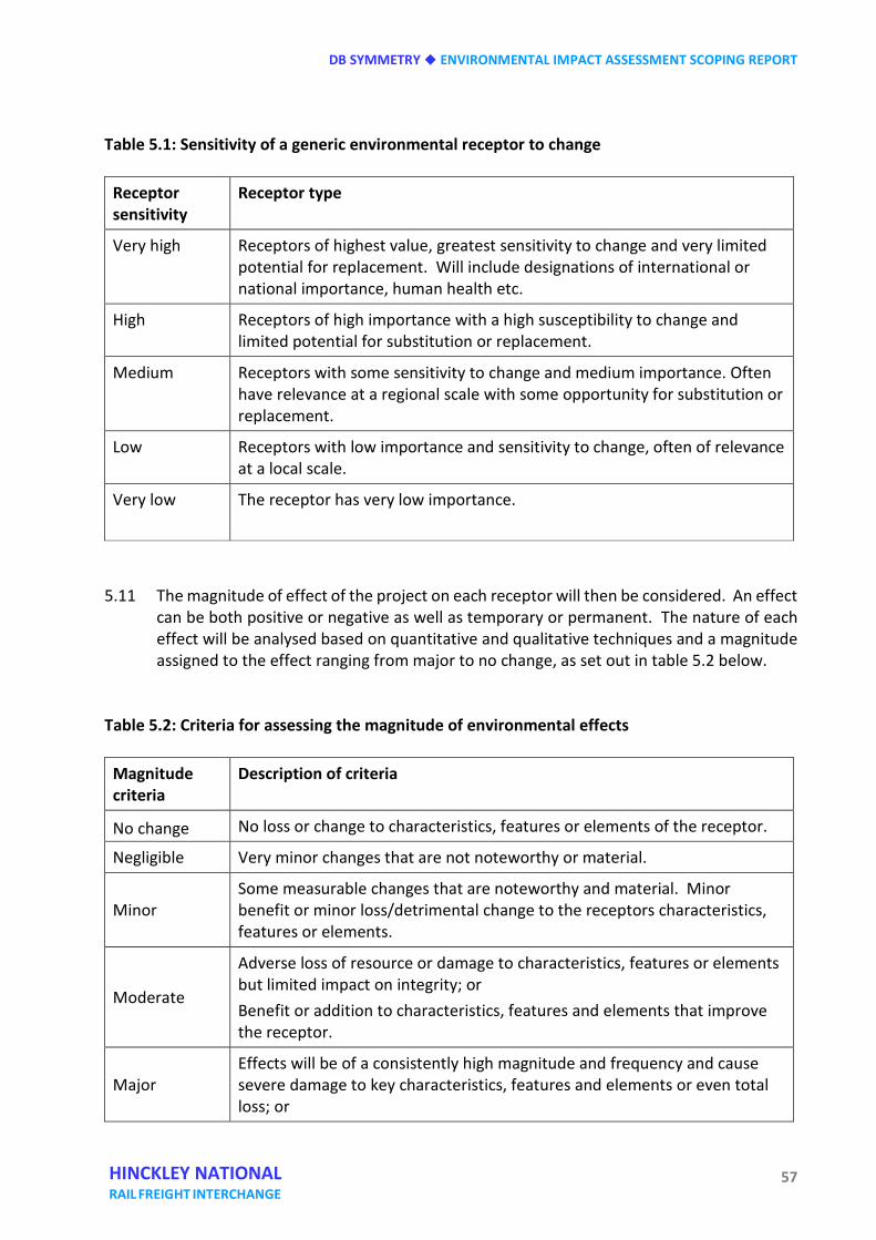
DB SYMMETRY ENVIRONMENTAL IMPACT ASSESSMENT SCOPING REPORT
57 HINCKLEY NATIONAL RAIL FREIGHT INTERCHANGE
Table 5.1: Sensitivity of a generic environmental receptor to change
Receptor sensitivity
Receptor type
Very high Receptors of highest value, greatest sensitivity to change and very limited potential for replacement. Will include designations of international or national importance, human health etc.
High Receptors of high importance with a high susceptibility to change and limited potential for substitution or replacement.
Medium Receptors with some sensitivity to change and medium importance. Often have relevance at a regional scale with some opportunity for substitution or replacement.
Low Receptors with low importance and sensitivity to change, often of relevance at a local scale.
Very low The receptor has very low importance.
5.11 The magnitude of effect of the project on each receptor will then be considered. An effect
can be both positive or negative as well as temporary or permanent. The nature of each effect will be analysed based on quantitative and qualitative techniques and a magnitude assigned to the effect ranging from major to no change, as set out in table 5.2 below.
Table 5.2: Criteria for assessing the magnitude of environmental effects
Magnitude criteria
Description of criteria
No change No loss or change to characteristics, features or elements of the receptor.
Negligible Very minor changes that are not noteworthy or material.
Minor Some measurable changes that are noteworthy and material. Minor benefit or minor loss/detrimental change to the receptors characteristics, features or elements.
Moderate
Adverse loss of resource or damage to characteristics, features or elements but limited impact on integrity; or Benefit or addition to characteristics, features and elements that improve the receptor.
Major Effects will be of a consistently high magnitude and frequency and cause severe damage to key characteristics, features and elements or even total loss; or
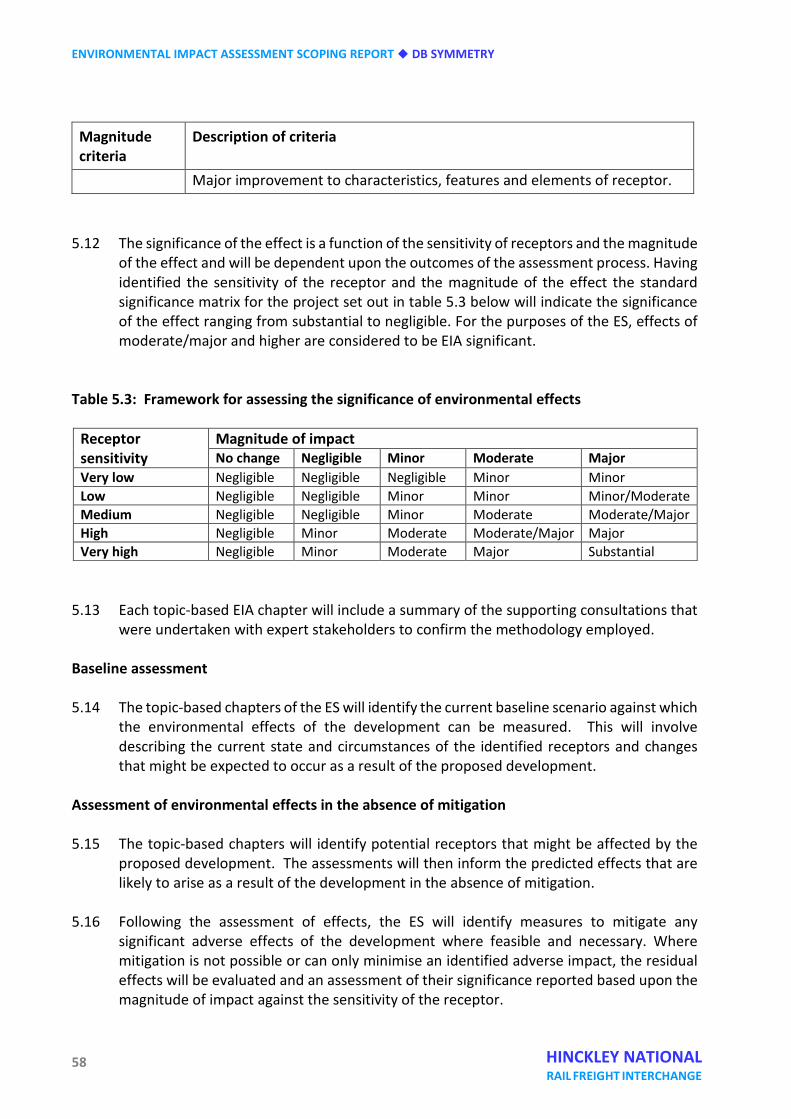
ENVIRONMENTAL IMPACT ASSESSMENT SCOPING REPORT DB SYMMETRY
58 HINCKLEY NATIONAL RAIL FREIGHT INTERCHANGE
Magnitude criteria
Description of criteria
Major improvement to characteristics, features and elements of receptor. 5.12 The significance of the effect is a function of the sensitivity of receptors and the magnitude
of the effect and will be dependent upon the outcomes of the assessment process. Having identified the sensitivity of the receptor and the magnitude of the effect the standard significance matrix for the project set out in table 5.3 below will indicate the significance of the effect ranging from substantial to negligible. For the purposes of the ES, effects of moderate/major and higher are considered to be EIA significant.
Table 5.3: Framework for assessing the significance of environmental effects
Receptor sensitivity
Magnitude of impact No change Negligible Minor Moderate Major
Very low Negligible Negligible Negligible Minor Minor Low Negligible Negligible Minor Minor Minor/Moderate Medium Negligible Negligible Minor Moderate Moderate/Major High Negligible Minor Moderate Moderate/Major Major Very high Negligible Minor Moderate Major Substantial
5.13 Each topic-based EIA chapter will include a summary of the supporting consultations that
were undertaken with expert stakeholders to confirm the methodology employed. Baseline assessment 5.14 The topic-based chapters of the ES will identify the current baseline scenario against which
the environmental effects of the development can be measured. This will involve describing the current state and circumstances of the identified receptors and changes that might be expected to occur as a result of the proposed development. environmental
Assessment of environmental effects in the absence of mitigation 5.15 The topic-based chapters will identify potential receptors that might be affected by the
proposed development. The assessments will then inform the predicted effects that are likely to arise as a result of the development in the absence of mitigation.
5.16 Following the assessment of effects, the ES will identify measures to mitigate any
significant adverse effects of the development where feasible and necessary. Where mitigation is not possible or can only minimise an identified adverse impact, the residual effects will be evaluated and an assessment of their significance reported based upon the magnitude of impact against the sensitivity of the receptor.
DB SYMMETRY ENVIRONMENTAL IMPACT ASSESSMENT SCOPING REPORT
59 HINCKLEY NATIONAL RAIL FREIGHT INTERCHANGE
HABITAT REGULATIONS ASSESSMENT SCREENING 5.17 It is necessary to consider at this stage the potential effects of the project and in
combination with other plans and projects on protected habitats as required by the European Commission’s Habitats Directive 92/43/EEC and The Conservation of Habitats and Species Regulations 2010 (the Habitat Regulations).
5.18 One European protected habitat exists within 15km of the site, namely Ensor’s Pond, a
Special Area of Conservation (SAC) located 11km to the south-west. Ensor’s Pond is designated for its large population of white-clawed crayfish, which is isolated from other Midlands populations of crayfish that have become infected by a fungal disease known as Aphanomyces astaci.
5.19 Given the distance of the site from the nearest European site and the nature of the
proposed development, it is not anticipated that the project in isolation or in combination with other plans and projects would have a likely significant effect. Nonetheless, db symmetry will submit a Habitat Regulations Assessment screening report to scope out any further need to undertake an Appropriate Assessment.
HEALTH IMPACT ASSESSMENT 5.20 The development proposed is not associated with an understanding of linked health
implications and is not considered to represent a serious risk to public health. The ES chapters on air quality, noise and vibration, flood risk, hydrogeology and contamination will assess the potential impact of the construction and operational phases of the development on human health. Mitigation will be proposed to address any identified risk to human health in accordance with appropriate industry standards.
5.21 Given the nature of the proposed development not being directly linked with risks to
human health and the consideration of the issue in the relevant technical chapters of the ES it is not intended to provide a separate chapter on human health in the ES.
SUSTAINABILITY 5.22 The DCO submission will be supported by a sustainability strategy that will include relevant
details of the methods to be used to minimise energy consumption and improve efficiency. 5.23 The project is being developed as a scheme that promotes sustainable development
contributing to the economic, social and environmental strands of sustainability. The freight movements that the development would cater for already have a carbon footprint and the proposal would not be increasing the extent of this footprint. The sustainability strategy will reflect the project’s ability to remove a proportion of the heavy goods vehicle traffic from the road network with a greater reliance on rail freight movements.

ENVIRONMENTAL IMPACT ASSESSMENT SCOPING REPORT DB SYMMETRY
60 HINCKLEY NATIONAL RAIL FREIGHT INTERCHANGE
DB SYMMETRY ENVIRONMENTAL IMPACT ASSESSMENT SCOPING REPORT
61 HINCKLEY NATIONAL RAIL FREIGHT INTERCHANGE
Six Land use and socio-economic effects INTRODUCTION 6.1 This chapter sets out the scope of the land use and socio-economic impact assessment. In
common with subsequent chapters of this EIA scoping report it has the following structure:
• baseline assessment;
• potential environmental effects;
• proposed scope of assessment;
• summary. 6.2 The socio-economic impact assessment will include consideration of the extent to which
the proposed HNRFI aligns with the national need for SRFIs as described in paragraphs 2.42 to 2.58 of the National Networks NPS.
BASELINE ASSESSMENT Description and key features 6.3 The baseline assessment will include information about the population that could be
affected by the proposed development (the receptors). This section of the report will set out the following data for residents in the study area, compared to regional and national data for context:
• population profile; age structure; growth rates; • levels of employment activity;
• average weekly income;
• occupational profile of the employment activity;
• qualifications and skills;
• relative levels of deprivation.
ENVIRONMENTAL IMPACT ASSESSMENT SCOPING REPORT DB SYMMETRY
62 HINCKLEY NATIONAL RAIL FREIGHT INTERCHANGE
6.4 The baseline assessment will also identify:
• the size and characteristics of the local, regional and national economy;
• characteristics of the housing market(s) within commuting distance of the site, including plans for new housing to accommodate population growth;
• the landholdings of each agricultural business affected by the proposed development; the nature of each businesses affected and type of tenancy.
Proposed method 6.5 Baseline information on the economic conditions of the area will be collated from:
• the UK National Census (2011) and other ONS-produced sources; • Business Register and Employment Survey.
6.6 These will provide a relevant quantitative ‘baseline’ of socio-economic conditions.
However, it should be stressed that many social and economic conditions are by definition complex, interrelated, and difficult to characterise or measure in any precise way. As a result, some judgements on what is most relevant might be necessarily subjective.
6.7 For analysis of the local housing market(s), the baseline information will be drawn from:
• Strategic Housing Market Assessments for housing markets within the study area, usually produced as part of the evidence base for local planning policy;
• local plans.
6.8 For the baseline conditions of existing businesses the information on existing landholdings
will be collated from db symmetry’s data, the Land Registry and property agents. Information on the nature of the businesses and tenancies will be obtained predominantly from interviews with the tenants, landowners and agents.
Reference case 6.9 The assessment will consider the reference case, being the future baseline conditions of
the site. Currently the site is used predominantly for agriculture. There is no relevant planning history for the site’s redevelopment so we assume that the site would continue its current use in the absence of the proposed development.
DB SYMMETRY ENVIRONMENTAL IMPACT ASSESSMENT SCOPING REPORT
63 HINCKLEY NATIONAL RAIL FREIGHT INTERCHANGE
POTENTIAL ENVIRONMENTAL EFFECTS 6.10 Potentially significant socio-economic effects are anticipated to relate to:
• direct, indirect and induced employment generated by construction activity. This will be derived from the associated costs to be provided by the client and multipliers;
• direct, indirect and induced employment generated by the new businesses locating on the site. This will be largely derived from floorspace figures to be provided by the client and multipliers;
• impacts to the regional and national economy once the development is operational; • impacts of workers on demand for housing within commuting distance;
• impact on existing agricultural businesses resulting from the change in land use;
• social and economic impacts of severance for local communities from construction or
operational traffic, if the impacts of that traffic cannot be mitigated. Construction employment 6.11 Construction of the proposed scheme would take place over a period of time and would
support the employment of a range of trades and professions in the construction industry. It would also have an indirect economic effect through the sourcing of building materials, services and supplies as well as the local expenditure of construction workers.
Operational employment 6.12 With up to 850,000 square metres GIA (comprising 650,000 square metres GEA ‘footprint’
and 200,000 square metres of mezzanine floorspace) of buildings on site, there will be significant levels of employment once fully occupied. With standard employment densities of 77 sq m per worker (HCA Employment Densities Guide) there could be some 8,400 workers on-site. There will also be indirect benefits to the supply chain, through the commission of sub-contractors and suppliers from the new economic activity.
Economic impact 6.13 The impact of the proposed development on the regional and national economy will be
assessed, in terms of gross value added. Replacing agricultural operations with 8,400 workers is likely to have significant benefits to the economic productivity of the region. This assessment will also be informed by the quality of agricultural land as identified in the soils, geology and contaminated land chapter of the ES and any adverse effects associated with its loss.
ENVIRONMENTAL IMPACT ASSESSMENT SCOPING REPORT DB SYMMETRY
64 HINCKLEY NATIONAL RAIL FREIGHT INTERCHANGE
Demand for housing 6.14 The significant amount of new jobs created on-site could lead to pressures on the housing
stock of settlements within commuting distance. The degree to which the new jobs in the proposed development have been accounted for in the economic growth forecasts that informed the strategic housing market assessments by local councils will be assessed, as will the plans for future housing delivery in the study area.
Impact on existing agricultural businesses 6.15 The proposed development will result in the cessation of current agricultural activities on
the land. This will have adverse effects on a number of agricultural businesses. The assessment will evaluate the impacts in the context of the wider landholdings of each business affected, the type of ownership and the desires of the tenant affected.
Impact from severance 6.16 The potential for severance of local communities from construction and operational traffic
will be assessed in the transport and traffic chapter of the ES. If any significant adverse effects cannot be mitigated by design measures the socio-economics and land use chapter will assess the social and economic effects.
PROPOSED SCOPE OF THE ASSESSMENT Approach 6.17 This section presents the broad approach to the assessment of socio-economic impacts
for the proposed development. The assessment will be consistent with Treasury Green Book Guidance. The stages of the methodology include the following.
• Impact assessment – consider the scale, magnitude, and duration, frequency and
permanence of the potential impacts during both the demolition/construction and operational phases of the proposed development.
• In the employment assessment this will conclude on the net additionality of the proposed development, after taking into account displacement, leakage, multipliers and deadweight.
• Consider mitigation measures, cumulative impacts, and residual impacts.
• Summarise final impact assessment.
6.18 To assess the effects on existing agricultural businesses the following approach will be
followed.
DB SYMMETRY ENVIRONMENTAL IMPACT ASSESSMENT SCOPING REPORT
65 HINCKLEY NATIONAL RAIL FREIGHT INTERCHANGE
• Impact assessment – consider the magnitude of the potential impacts on businesses operating on the land and their sensitivity to permanent loss of access to land within the application area.
• Consider mitigation measures, cumulative impacts, and residual impacts.
• Summarise final impact assessment. Geographic scope 6.19 The concept of a primary area of influence or zone of impact is standard in EIA practice.
However, there is no standard measure of scale and the relevant area differs for each project and site context, and is not directly transferrable to socio-economic impact assessment due to the mobility and network of potential receptors. Also the area of influence might be affected by physical barriers to access such as major roads, railways or rivers. We will consider the socio-economic effects across a number of geographic scales, as described below.
• Study area – this is the primary impact area surrounding the development site. We
define this as the area within commuting distance of the proposed development. We will work with the traffic consultants to determine the appropriate isochrones around the site, accounting for the predicted catchment area from which the workforce is likely to commute.
• Regional – defined as the Midlands. This will be used to frame the baseline conditions.
• National – England. This will be used to frame the baseline conditions.
6.20 The effects on existing agricultural businesses will be assessed against the landholdings of
those businesses affected by the proposed development. Temporal scope 6.21 The temporal scope for the assessment will take into account the length of the
construction phase and will be used to consider temporary and permanent impacts of the development. The temporal scope includes:
• short term – 0-5 years, immediate impacts; • medium term – 5-10 years, generally identified as temporary impacts during the
construction phase;
• long term – 10+ years, potentially permanent impacts during operational phase of the development.
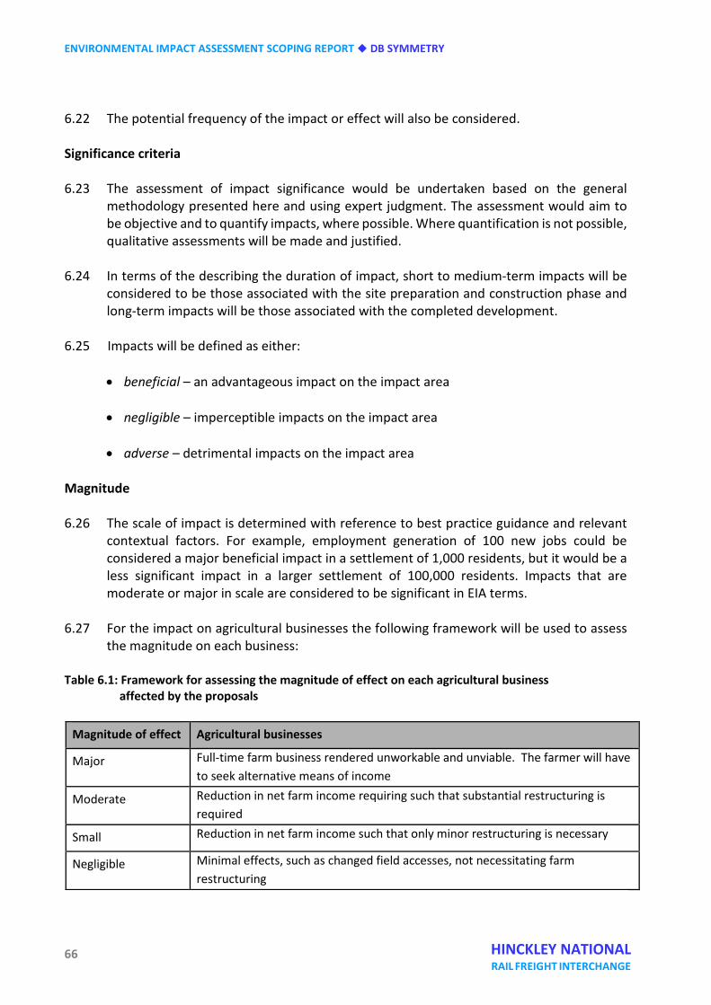
ENVIRONMENTAL IMPACT ASSESSMENT SCOPING REPORT DB SYMMETRY
66 HINCKLEY NATIONAL RAIL FREIGHT INTERCHANGE
6.22 The potential frequency of the impact or effect will also be considered. Significance criteria 6.23 The assessment of impact significance would be undertaken based on the general
methodology presented here and using expert judgment. The assessment would aim to be objective and to quantify impacts, where possible. Where quantification is not possible, qualitative assessments will be made and justified.
6.24 In terms of the describing the duration of impact, short to medium-term impacts will be
considered to be those associated with the site preparation and construction phase and long-term impacts will be those associated with the completed development.
6.25 Impacts will be defined as either:
• beneficial – an advantageous impact on the impact area
• negligible – imperceptible impacts on the impact area
• adverse – detrimental impacts on the impact area Magnitude 6.26 The scale of impact is determined with reference to best practice guidance and relevant
contextual factors. For example, employment generation of 100 new jobs could be considered a major beneficial impact in a settlement of 1,000 residents, but it would be a less significant impact in a larger settlement of 100,000 residents. Impacts that are moderate or major in scale are considered to be significant in EIA terms.
6.27 For the impact on agricultural businesses the following framework will be used to assess
the magnitude on each business: Table 6.1: Framework for assessing the magnitude of effect on each agricultural business
affected by the proposals
Magnitude of effect Agricultural businesses
Major Full-time farm business rendered unworkable and unviable. The farmer will have to seek alternative means of income
Moderate Reduction in net farm income requiring such that substantial restructuring is required
Small Reduction in net farm income such that only minor restructuring is necessary
Negligible Minimal effects, such as changed field accesses, not necessitating farm restructuring
DB SYMMETRY ENVIRONMENTAL IMPACT ASSESSMENT SCOPING REPORT
67 HINCKLEY NATIONAL RAIL FREIGHT INTERCHANGE
Assumptions 6.28 By the nature of the methodology, estimates of change in the socio-economic elements
such as economic and employment impacts are subject to uncertainty. The estimates in the ES will be based on good practice, but there will likely be a degree of uncertainty around estimates. Actual impacts are likely to be in a range of +/- 20% of estimates.
SUMMARY 6.29 In summary the potentially significant environmental effects from a socio-economic
perspective are anticipated to be as follows.
• Direct, indirect and induced employment generated by construction activity. This will be derived from the associated costs to be provided by the client and multipliers.
• Direct, indirect and induced employment generated by the new businesses locating on the site. This will be largely derived from floorspace figures to be provided by the client and multipliers.
• Impacts to the regional and national economy once the development is operational.
• Impacts of workers on demand for housing within commuting distance.
• Impact on existing agricultural businesses resulting from the change in land use.
• Social and economic impacts of severance for local communities from construction or
operational traffic, if the impacts of that traffic cannot be mitigated. 6.30 The impact of these effects will be assessed against the reference case of ‘no scheme’, in
accordance with best practice guidance and the Treasury Green Book.

ENVIRONMENTAL IMPACT ASSESSMENT SCOPING REPORT DB SYMMETRY
68 HINCKLEY NATIONAL RAIL FREIGHT INTERCHANGE
DB SYMMETRY ENVIRONMENTAL IMPACT ASSESSMENT SCOPING REPORT
69 HINCKLEY NATIONAL RAIL FREIGHT INTERCHANGE
Seven Transport and traffic INTRODUCTION 7.1 The purpose of the transport and traffic section of the ES is to describe and, where
possible, quantify the likely significant effects that the proposed development will have on the transport network surrounding the development.
7.2 This section of the ES will be informed by a Transport Assessment (TA) which is currently
being prepared by Hydrock and will be appended to the ES. This will include a full multi-modal impact assessment that will consider the impact of the proposed development on all transport infrastructure surrounding the site.
7.3 The assessment of individual environmental elements will be carried out in accordance
with the ‘Guidelines for the Environmental Assessment of Road Traffic’ (1993) published by the Institute of Environmental Assessment (IEA, now IEMA), and where appropriate Volume 11 of the ‘Design Manual for Roads and Bridges’ (DMRB) entitled ‘Environmental Assessment’ (2008) published by the former Department of Environment, Transport and the Regions (DETR), now the Department for Transport (DfT).
7.4 These documents provide accepted methodologies for the appraisal of the environmental
effects of transport. Legislation and policy 7.5 This section sets out the national, regional and local policy background for the proposed
development relating to transport. Table 7.1 – Relevant national transport policy National policy Key provisions
National Policy Statement (NPS) for National Networks (December 2014)
The NPS provides transport guidance to guide individual development for Nationally Significant Infrastructure Projects (NSIP) brought forward under it. The principal aims of the NPS are to deliver: • networks with the capacity, connectivity and resilience to
support national and local economic activity and to facilitate growth and create jobs;
• networks which support and improve journey quality, reliability and safety;
ENVIRONMENTAL IMPACT ASSESSMENT SCOPING REPORT DB SYMMETRY
70 HINCKLEY NATIONAL RAIL FREIGHT INTERCHANGE
• networks which support the delivery of environmental goals
and the move to a low carbon economy; • networks which join up our communities and link effectively to
each other. The NPS also identifies the economic and environmental benefits of rail freight Interchanges. It is supported by the Strategic Rail Freight Interchange Policy Guidance (2011) which sets out further details as to the benefits of rail freight interchange developments.
Strategic Rail Freight Interchange Policy Guidance (November 2011)
The main objectives of government policy for SRFIs is to: • reduce road congestion;
• reduce carbon emissions; • support long-term development of efficient rail freight
distribution logistics; • support growth and create employment. The government aims to meet these objectives by encouraging the development of a robust infrastructure network of Strategic Rail Freight Interchanges.
National Planning Policy Framework (NPPF) (2012)
NPPF advocates that planning policies and decisions should consider whether: • the opportunities for sustainable transport modes have been
taken up depending upon the nature and location of the site to reduce the need for major transport infrastructure;
• safe and suitable access to the site can be achieved for all people;
• improvements can be undertaken within the transport network
that cost-effectively limits the significant impacts of the development. Development should only be prevented or refused on transport grounds where the residual impacts of development are severe.
The NPPF stresses the importance of providing a travel plan for all developments that generate significant amounts of movement. It
DB SYMMETRY ENVIRONMENTAL IMPACT ASSESSMENT SCOPING REPORT
71 HINCKLEY NATIONAL RAIL FREIGHT INTERCHANGE
also gives priority to provision for low emission vehicles, including in particular the provision of electric car charging facilities.
Table 7.2 – County transport planning policy Regional policy Key provisions
Leicestershire Local Transport Plan (2011-2026)
The Leicestershire Local Transport Plan 3 (LTP3) seeks to give some certainty to transport planning and policy in developing a strategic framework. The LTP recognises that planning policies will be grounded in the reality that most people will wish to own and use cars, but as far as possible, new development will be planned to avoid increasing traffic pressure by ensuring that a choice of attractive alternatives is available.
ENVIRONMENTAL IMPACT ASSESSMENT SCOPING REPORT DB SYMMETRY
72 HINCKLEY NATIONAL RAIL FREIGHT INTERCHANGE
Table 7.3 – Local transport planning policy
Local policy Key provisions
Blaby Development Plan including the Blaby Local Plan (Core Strategy) DPD adopted February 2013 and saved policies contained within Blaby District Local Plan (1999)
The core strategy sets out the overarching strategy and core policies to guide the future development of the district up to 2029. The local plan is gradually being replaced by Development Plan Documents (DPDs) which form part of the Local Development Framework. The majority of the Local Plan Policies from the 1999 local plan have been saved until they are replaced by policies in the DPDs. The primary spatial objective for transportation and the need to travel reads: ‘In order to limit the impacts of new development on levels of vehicle movements, congestion and on the environment the preferred approach of Blaby District Council is to seek to reduce the need to travel by private car by locating new development so that people can access services and facilities without reliance on ‘private motor vehicles’. In addition, the Council will seek to protect and enhance local services and facilities (including retail and employment) to reduce the need to travel. In order to maximise modal shift, safe, sustainable and accessible transport modes (including walking, cycling and public transport) will be promoted. This will be achieved by providing new routes for pedestrians, cyclists and public transport (as part of new development proposals) and enhancing existing facilities. This will be particularly important in the design and development of the proposed SUE west of Leicester.’
Hinckley and Bosworth Local Development Framework 2009 Core Strategy
Whilst the site is situated within the Blaby District Council administrative boundary, the traffic impacts have potential to occur off-site and across neighbouring authorities. For this reason it is considered pertinent to consider the Hinckley and Bosworth policy. The core strategy sets out the overarching strategy and core policies to guide the future development of the borough up to 2026. The local plan is gradually being replaced by Development Plan Documents (DPDs) which form part of the Local Development Framework. The majority of the Local Plan Policies from the 2006
DB SYMMETRY ENVIRONMENTAL IMPACT ASSESSMENT SCOPING REPORT
73 HINCKLEY NATIONAL RAIL FREIGHT INTERCHANGE
local plan have been saved until they are replaced by policies in the DPDs. The primary spatial objective for transportation and the need to travel reads: ‘To reduce the high reliance on car travel in the borough and to increase the opportunities for other forms of transport by focusing the majority of development in the Hinckley urban area where there is a range of transport options available and through securing improvement to public transport infrastructure and facilities that promote walking and cycling and through the use of travel plans.’
Table 7.4 – Additional transport planning guidance
Guidance document Key provisions
Design Manual for Roads and Bridges
The Design Manual for Roads and Bridges provides guidance as to the requirements to the General Principles and Guidance of Environmental Impact Assessment (Volume 11) for larger development schemes.
Manual for Streets 2
Manual for Streets 2 (MfS2) - Wider Application of the Principles, is a companion guide to MfS and builds on the philosophies set out in MfS and demonstrates how they can be extended beyond residential streets.
BASELINE ASSESSMENT Accessibility 7.6 The ES transport and traffic chapter and the supporting TA will include a detailed analysis
of accessibility to the site. The following provides a brief summary. Vehicular access 7.7 A new dedicated dual carriageway access is proposed from M69 Junction 2. This will be
coupled with the introduction of southern slip roads. These will assist in distributing traffic across the Junction and the wider network, thus reducing impacts.
7.8 Two emergency accesses will be retained from Burbage Common Road on the north-
eastern and north-western boundaries of the site. It is intended that Burbage Common
ENVIRONMENTAL IMPACT ASSESSMENT SCOPING REPORT DB SYMMETRY
74 HINCKLEY NATIONAL RAIL FREIGHT INTERCHANGE
Road will be stopped-up at the site boundary, with all internal roads to be maintained privately.
Pedestrian access 7.9 The B581 and the B4668, which are located at either end of Burbage Common Road, both
have footways running alongside their carriageways. 7.10 Both the B4469 Hinckley Road and the wide M69 Junction 2 gyratory have footways on
the northern side of the carriageway. The M69 entry and exit slip roads are crossed via uncontrolled crossings.
7.11 There is also an extensive network of public right of way (PRoW) routes in the vicinity of
the site. 7.12 An additional detailed review of pedestrian facilities will be incorporated in the supporting
TA. Cycling access 7.13 A detailed review of local cycling facilities will be provided, addressing routes within the
vicinity of the site, including local and national cycle routes, dedicated cycle path links and any other cycle-specific infrastructure.
Public transport 7.14 The nearest bus stops to the site are located approximately 200 m west of Junction 2 of
the M69. These stops are served by the X6 bus, operated by De Courcey Travel. 7.15 The X6 runs between Coventry and Leicester, operating an hourly service between 06.40
and 19.25. Travel time to Coventry is approximately 45 minutes, with Leicester approximately 40 minutes away.
7.16 Hinckley has a railway station, served by CrossCountry trains. This is situated on the
Birmingham – Peterborough line. Services run between Hinckley and Birmingham / Leicester depending on direction of travel, with usually one train per hour in either direction. On weekdays a few additional peak hour trains operate in addition to the usual services. A continuous footway exists between the site and the railway station along the B4669 and B590, with an approximate walking/cycle distance of 4.3km.
Traffic flows 7.17 A SATURN (Simulation and Assignment of Traffic to Urban Road Network) model is
maintained by Leicestershire County Council, covering the whole of the county and Leicester city. The model is incorporated within the Leicester and Leicestershire Integrated Transport Model (LLITM). It is anticipated that this will be used to assess
DB SYMMETRY ENVIRONMENTAL IMPACT ASSESSMENT SCOPING REPORT
75 HINCKLEY NATIONAL RAIL FREIGHT INTERCHANGE
network-wide changes in traffic flows, particularly given the proposed mitigation with the two new slip roads onto Junction 2 of the M69.
7.18 It is proposed that traffic flows across the network will be derived from the LLITM. 7.19 In addition, the following surveys have been commissioned:
• 12-hour manual classified turning count and queue length surveys at M69 Junction 2;
• 14-day automatic traffic count (ATC) on B4669 west;
• 14-day ATC on B4669 east;
• 12-hour journey time surveys at M69 Junction 2. PROPOSED SCOPE OF THE ASSESSMENT AND POTENTIAL ENVIRONMENTAL EFFECTS 7.20 The identification of the baseline conditions and assessment of the significance of effects
on transport and traffic will be based on the findings of the TA that will be provided as an Appendix to the ES.
7.21 The assessment will be undertaken in compliance with best practice guidance including
Planning Practice Guidance (PPG); Manual for Streets 1 and 2; Guidelines on the Environmental Assessment of Road Traffic; and (if relevant) the now superseded DfT document Guidance on Transport Assessment. The methodology applied to the assessment will adhere to that set out in the IEA Guidelines and focus on potential effects on local roads and the users of those roads.
Assessment scenarios 7.22 Subject to agreement with the Local Highway Authority, the following years will be
assessed (note these are limited to selecting the available years that exist within the LLITM model):
• 2016 base year
• 2021 (anticipated first year of occupation)
• 2031 (ten years post-occupation)
Development traffic 7.23 Trip generation will be calculated using, where possible, methodologies/trip rates agreed
and applied in respect of other local and pertinent planning applications. Trip generation
ENVIRONMENTAL IMPACT ASSESSMENT SCOPING REPORT DB SYMMETRY
76 HINCKLEY NATIONAL RAIL FREIGHT INTERCHANGE
by all modes will be calculated within the TA and vehicles distributed across the network, likely through the use of the LLITM.
Committed development 7.24 Known committed developments in the vicinity will be included in the assessments
undertaken within this chapter. This will capture the anticipated traffic growth in the area. 7.25 It is anticipated that the majority of noteworthy committed developments within the area
will be captured within the LLITM under the current local plan period. 7.26 The inclusion of any additional development within the assessment will be discussed and
agreed with the Local Highway Authority as part of any scoping discussions associated with the preparation of both the TA and ES.
Study area 7.27 It is anticipated that the LLITM model will form an initial assessment of the changes in
traffic flow arising from the development proposals across the network. This will identify the changes in traffic flow on the network and therefore the extent of study area used to assess the effects of traffic within this ES chapter.
Effects requiring further consideration 7.28 The IEA guidelines identify a number of traffic related environmental effects that may arise
from a proposed development and which may require consideration. 7.29 These effects can be arranged into two categories: those that have been scoped into this
assessment and those that have been considered in another chapter of the ES. The effects by category are shown in Table 7.5.
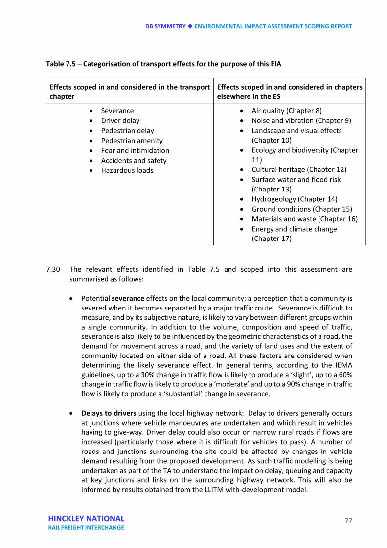
DB SYMMETRY ENVIRONMENTAL IMPACT ASSESSMENT SCOPING REPORT
77 HINCKLEY NATIONAL RAIL FREIGHT INTERCHANGE
Table 7.5 – Categorisation of transport effects for the purpose of this EIA
Effects scoped in and considered in the transport chapter
Effects scoped in and considered in chapters elsewhere in the ES
• Severance • Driver delay • Pedestrian delay • Pedestrian amenity • Fear and intimidation • Accidents and safety • Hazardous loads
• Air quality (Chapter 8) • Noise and vibration (Chapter 9) • Landscape and visual effects
(Chapter 10) • Ecology and biodiversity (Chapter
11) • Cultural heritage (Chapter 12) • Surface water and flood risk
(Chapter 13) • Hydrogeology (Chapter 14) • Ground conditions (Chapter 15) • Materials and waste (Chapter 16) • Energy and climate change
(Chapter 17) 7.30 The relevant effects identified in Table 7.5 and scoped into this assessment are
summarised as follows:
• Potential severance effects on the local community: a perception that a community is severed when it becomes separated by a major traffic route. Severance is difficult to measure, and by its subjective nature, is likely to vary between different groups within a single community. In addition to the volume, composition and speed of traffic, severance is also likely to be influenced by the geometric characteristics of a road, the demand for movement across a road, and the variety of land uses and the extent of community located on either side of a road. All these factors are considered when determining the likely severance effect. In general terms, according to the IEMA guidelines, up to a 30% change in traffic flow is likely to produce a ‘slight’, up to a 60% change in traffic flow is likely to produce a ‘moderate’ and up to a 90% change in traffic flow is likely to produce a ‘substantial’ change in severance.
• Delays to drivers using the local highway network: Delay to drivers generally occurs at junctions where vehicle manoeuvres are undertaken and which result in vehicles having to give-way. Driver delay could also occur on narrow rural roads if flows are increased (particularly those where it is difficult for vehicles to pass). A number of roads and junctions surrounding the site could be affected by changes in vehicle demand resulting from the proposed development. As such traffic modelling is being undertaken as part of the TA to understand the impact on delay, queuing and capacity at key junctions and links on the surrounding highway network. This will also be informed by results obtained from the LLITM with-development model.
ENVIRONMENTAL IMPACT ASSESSMENT SCOPING REPORT DB SYMMETRY
78 HINCKLEY NATIONAL RAIL FREIGHT INTERCHANGE
• Pedestrian delay: The delay incurred by pedestrians is generally a direct consequence
of their ability to cross roads. Thus, the provision of crossing facilities, the geometric characteristics of the road, and the traffic volume, composition and speed are all factors that can affect pedestrian delay. These factors will be considered when assessing this effect. It should be noted that the IEA guidelines advise that in assessing levels of, and changes in, pedestrian delay, assessors do not attempt to use quantitative thresholds. This is due to the range of local factors and conditions which can influence pedestrian delay. Instead, the Guidelines recommend the use of professional judgement to determine whether pedestrian delay is a significant effect. Pedestrian delay will be considered in the context of the change in travel demand generated by the proposed development, the existing pedestrian facilities on the network and any potential increase in traffic flows.
Studies, quoted within the IEA guidance (HFA et al, Assessment Methodology Report, The West London Assessment Studies, 1990) have shown that pedestrian delay is considered perceptible / significant if it exceeds 10 seconds for a link with no crossing facilities. These studies identify that a 10 second pedestrian delay broadly equates to a two-way link flow of 1,400 vehicles per hour.
• Pedestrian amenity: The term pedestrian amenity is broadly defined as the relative
pleasantness of a journey. It is considered to be affected by traffic flow, speed and composition, as well as footway width, lighting and quality and the separation/protection from traffic. It encompasses the overall relationship between pedestrians and traffic, including fear and intimidation which is the most emotive and difficult effect to quantify and assess. The IEA guidance references the DfT Manual of Environmental Appraisal (1983) which suggests that a tentative threshold for judging the significance of changes in pedestrian amenity would be where the traffic flow (or its HGV component) is halved or doubled.
• Fear and intimidation: Potential effects on pedestrians associated with fear and intimidation are caused by an increase in volume of traffic and its HGV composition, and the lack of protection caused by factors such as narrow footway widths. There are no commonly agreed thresholds for estimating levels of danger or fear and intimidation, however the IEMA guidelines suggest the adoption of values from Pedestrian Delay, Annoyance and Risk - Imperial College, Crompton (1981) when considering any effect on pedestrian fear and intimidation. These thresholds are replicated in Table 7.6 and can be used as a first approximation of the likelihood of pedestrian fear and intimidation. Other factors do however also need to be considered such as proximity to traffic and footpath widths.
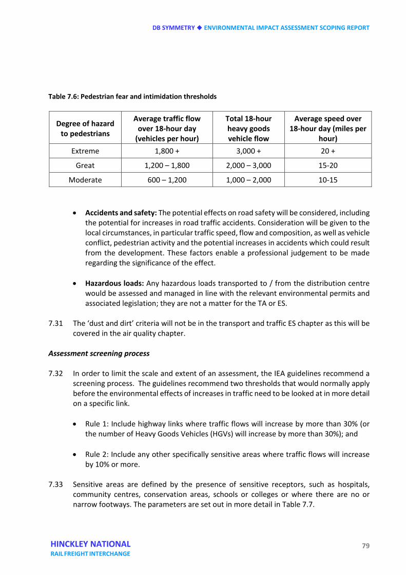
DB SYMMETRY ENVIRONMENTAL IMPACT ASSESSMENT SCOPING REPORT
79 HINCKLEY NATIONAL RAIL FREIGHT INTERCHANGE
Table 7.6: Pedestrian fear and intimidation thresholds
Degree of hazard to pedestrians
Average traffic flow over 18-hour day
(vehicles per hour)
Total 18-hour heavy goods vehicle flow
Average speed over 18-hour day (miles per
hour) Extreme 1,800 + 3,000 + 20 +
Great 1,200 – 1,800 2,000 – 3,000 15-20
Moderate 600 – 1,200 1,000 – 2,000 10-15
• Accidents and safety: The potential effects on road safety will be considered, including the potential for increases in road traffic accidents. Consideration will be given to the local circumstances, in particular traffic speed, flow and composition, as well as vehicle conflict, pedestrian activity and the potential increases in accidents which could result from the development. These factors enable a professional judgement to be made regarding the significance of the effect.
• Hazardous loads: Any hazardous loads transported to / from the distribution centre would be assessed and managed in line with the relevant environmental permits and associated legislation; they are not a matter for the TA or ES.
7.31 The ‘dust and dirt’ criteria will not be in the transport and traffic ES chapter as this will be
covered in the air quality chapter. Assessment screening process 7.32 In order to limit the scale and extent of an assessment, the IEA guidelines recommend a
screening process. The guidelines recommend two thresholds that would normally apply before the environmental effects of increases in traffic need to be looked at in more detail on a specific link.
• Rule 1: Include highway links where traffic flows will increase by more than 30% (or
the number of Heavy Goods Vehicles (HGVs) will increase by more than 30%); and
• Rule 2: Include any other specifically sensitive areas where traffic flows will increase by 10% or more.
7.33 Sensitive areas are defined by the presence of sensitive receptors, such as hospitals,
community centres, conservation areas, schools or colleges or where there are no or narrow footways. The parameters are set out in more detail in Table 7.7.
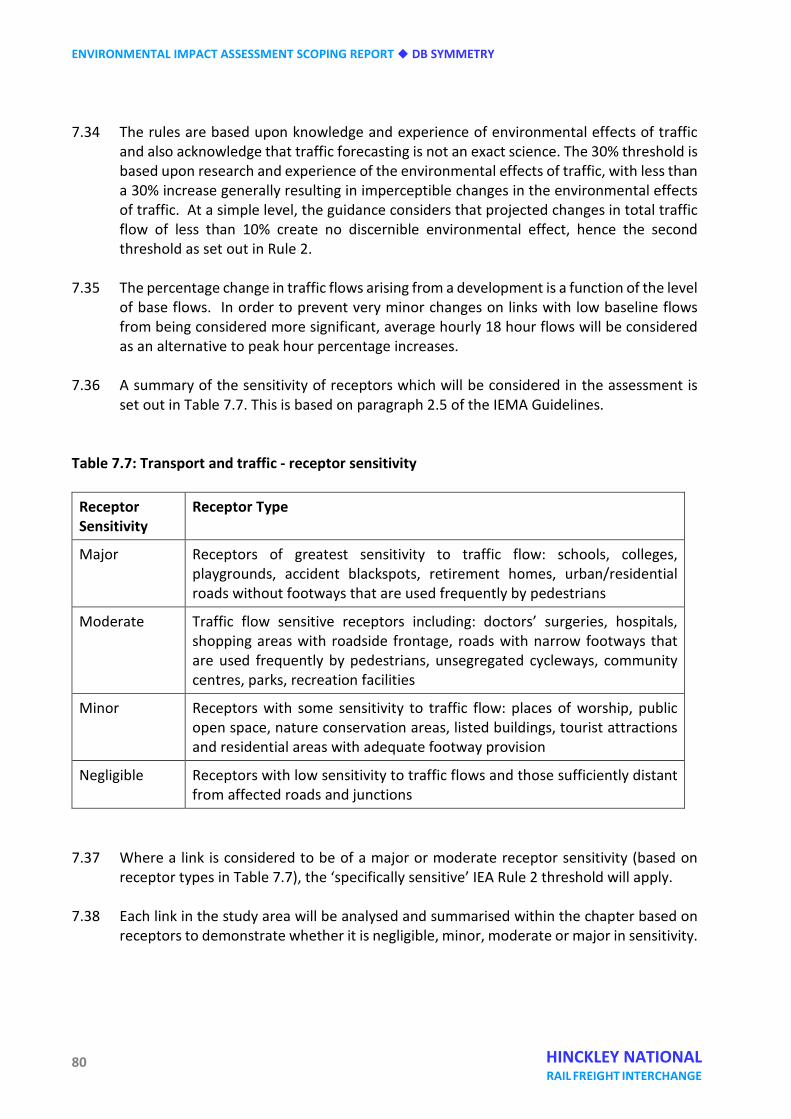
ENVIRONMENTAL IMPACT ASSESSMENT SCOPING REPORT DB SYMMETRY
80 HINCKLEY NATIONAL RAIL FREIGHT INTERCHANGE
7.34 The rules are based upon knowledge and experience of environmental effects of traffic and also acknowledge that traffic forecasting is not an exact science. The 30% threshold is based upon research and experience of the environmental effects of traffic, with less than a 30% increase generally resulting in imperceptible changes in the environmental effects of traffic. At a simple level, the guidance considers that projected changes in total traffic flow of less than 10% create no discernible environmental effect, hence the second threshold as set out in Rule 2.
7.35 The percentage change in traffic flows arising from a development is a function of the level
of base flows. In order to prevent very minor changes on links with low baseline flows from being considered more significant, average hourly 18 hour flows will be considered as an alternative to peak hour percentage increases.
7.36 A summary of the sensitivity of receptors which will be considered in the assessment is
set out in Table 7.7. This is based on paragraph 2.5 of the IEMA Guidelines. Table 7.7: Transport and traffic - receptor sensitivity
Receptor Sensitivity
Receptor Type
Major Receptors of greatest sensitivity to traffic flow: schools, colleges, playgrounds, accident blackspots, retirement homes, urban/residential roads without footways that are used frequently by pedestrians
Moderate Traffic flow sensitive receptors including: doctors’ surgeries, hospitals, shopping areas with roadside frontage, roads with narrow footways that are used frequently by pedestrians, unsegregated cycleways, community centres, parks, recreation facilities
Minor Receptors with some sensitivity to traffic flow: places of worship, public open space, nature conservation areas, listed buildings, tourist attractions and residential areas with adequate footway provision
Negligible Receptors with low sensitivity to traffic flows and those sufficiently distant from affected roads and junctions
7.37 Where a link is considered to be of a major or moderate receptor sensitivity (based on
receptor types in Table 7.7), the ‘specifically sensitive’ IEA Rule 2 threshold will apply. 7.38 Each link in the study area will be analysed and summarised within the chapter based on
receptors to demonstrate whether it is negligible, minor, moderate or major in sensitivity.
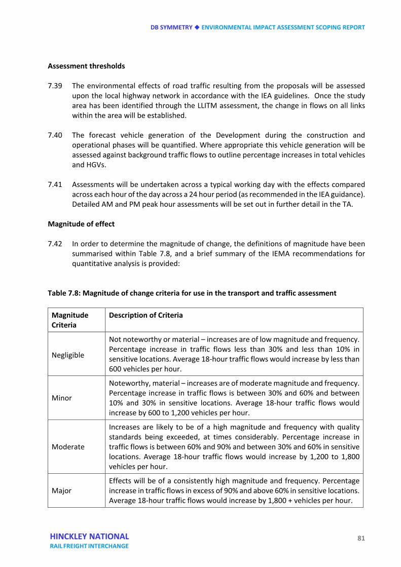
DB SYMMETRY ENVIRONMENTAL IMPACT ASSESSMENT SCOPING REPORT
81 HINCKLEY NATIONAL RAIL FREIGHT INTERCHANGE
Assessment thresholds 7.39 The environmental effects of road traffic resulting from the proposals will be assessed
upon the local highway network in accordance with the IEA guidelines. Once the study area has been identified through the LLITM assessment, the change in flows on all links within the area will be established.
7.40 The forecast vehicle generation of the Development during the construction and
operational phases will be quantified. Where appropriate this vehicle generation will be assessed against background traffic flows to outline percentage increases in total vehicles and HGVs.
7.41 Assessments will be undertaken across a typical working day with the effects compared
across each hour of the day across a 24 hour period (as recommended in the IEA guidance). Detailed AM and PM peak hour assessments will be set out in further detail in the TA.
Magnitude of effect 7.42 In order to determine the magnitude of change, the definitions of magnitude have been
summarised within Table 7.8, and a brief summary of the IEMA recommendations for quantitative analysis is provided:
Table 7.8: Magnitude of change criteria for use in the transport and traffic assessment
Magnitude Criteria
Description of Criteria
Negligible
Not noteworthy or material – increases are of low magnitude and frequency. Percentage increase in traffic flows less than 30% and less than 10% in sensitive locations. Average 18-hour traffic flows would increase by less than 600 vehicles per hour.
Minor
Noteworthy, material – increases are of moderate magnitude and frequency. Percentage increase in traffic flows is between 30% and 60% and between 10% and 30% in sensitive locations. Average 18-hour traffic flows would increase by 600 to 1,200 vehicles per hour.
Moderate
Increases are likely to be of a high magnitude and frequency with quality standards being exceeded, at times considerably. Percentage increase in traffic flows is between 60% and 90% and between 30% and 60% in sensitive locations. Average 18-hour traffic flows would increase by 1,200 to 1,800 vehicles per hour.
Major Effects will be of a consistently high magnitude and frequency. Percentage increase in traffic flows in excess of 90% and above 60% in sensitive locations. Average 18-hour traffic flows would increase by 1,800 + vehicles per hour.
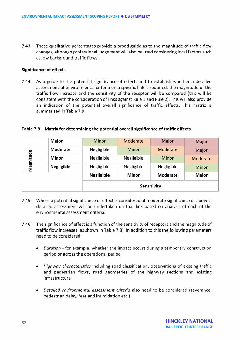
ENVIRONMENTAL IMPACT ASSESSMENT SCOPING REPORT DB SYMMETRY
82 HINCKLEY NATIONAL RAIL FREIGHT INTERCHANGE
7.43 These qualitative percentages provide a broad guide as to the magnitude of traffic flow
changes, although professional judgement will also be used considering local factors such as low background traffic flows.
Significance of effects 7.44 As a guide to the potential significance of effect, and to establish whether a detailed
assessment of environmental criteria on a specific link is required, the magnitude of the traffic flow increase and the sensitivity of the receptor will be compared (this will be consistent with the consideration of links against Rule 1 and Rule 2). This will also provide an indication of the potential overall significance of traffic effects. This matrix is summarised in Table 7.9.
Table 7.9 – Matrix for determining the potential overall significance of traffic effects
Mag
nitu
de
Major Minor Moderate Major Major
Moderate Negligible Minor Moderate Major
Minor Negligible Negligible Minor Moderate
Negligible Negligible Negligible Negligible Minor
Negligible Minor Moderate Major
Sensitivity
7.45 Where a potential significance of effect is considered of moderate significance or above a
detailed assessment will be undertaken on that link based on analysis of each of the environmental assessment criteria.
7.46 The significance of effect is a function of the sensitivity of receptors and the magnitude of
traffic flow increases (as shown in Table 7.8). In addition to this the following parameters need to be considered:
• Duration - for example, whether the impact occurs during a temporary construction
period or across the operational period
• Highway characteristics including road classification, observations of existing traffic and pedestrian flows, road geometries of the highway sections and existing infrastructure
• Detailed environmental assessment criteria also need to be considered (severance,
pedestrian delay, fear and intimidation etc.)
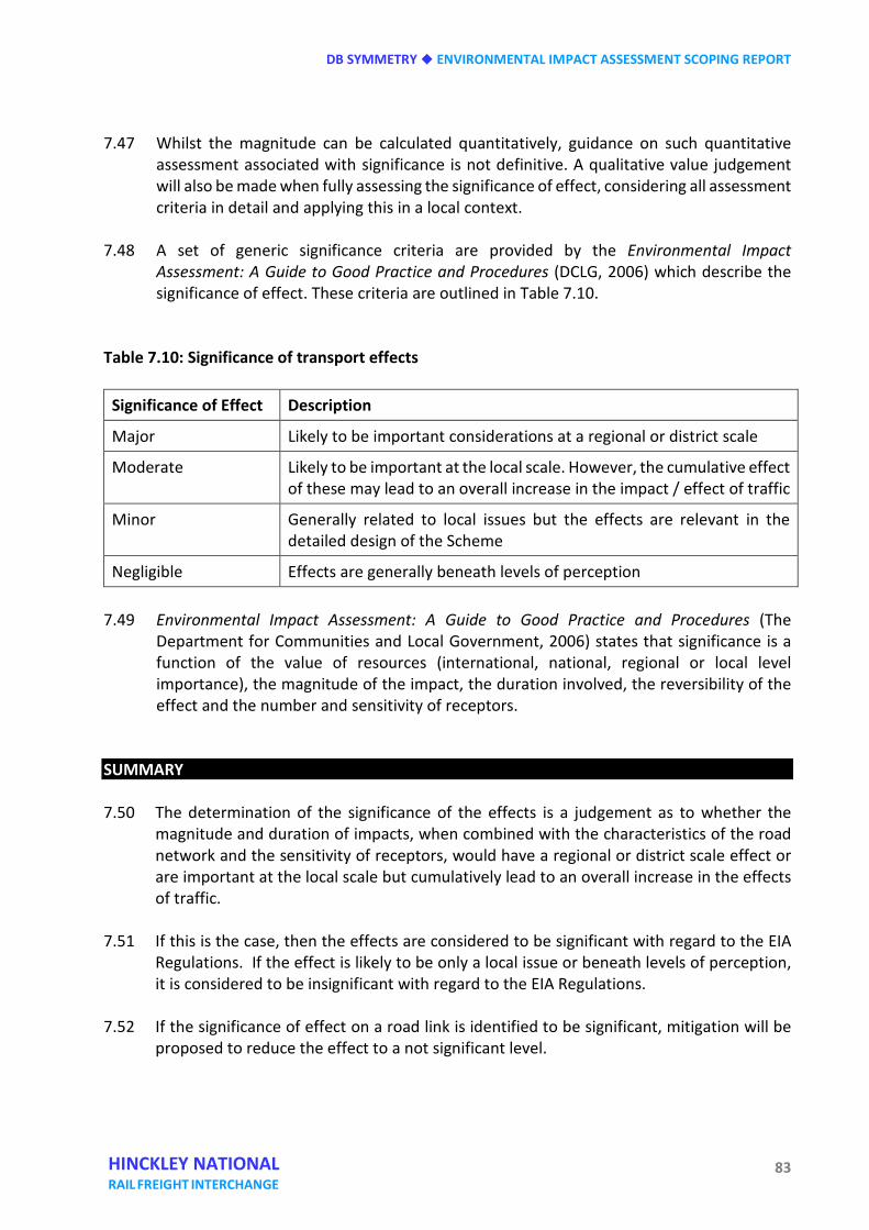
DB SYMMETRY ENVIRONMENTAL IMPACT ASSESSMENT SCOPING REPORT
83 HINCKLEY NATIONAL RAIL FREIGHT INTERCHANGE
7.47 Whilst the magnitude can be calculated quantitatively, guidance on such quantitative assessment associated with significance is not definitive. A qualitative value judgement will also be made when fully assessing the significance of effect, considering all assessment criteria in detail and applying this in a local context.
7.48 A set of generic significance criteria are provided by the Environmental Impact
Assessment: A Guide to Good Practice and Procedures (DCLG, 2006) which describe the significance of effect. These criteria are outlined in Table 7.10.
Table 7.10: Significance of transport effects
Significance of Effect Description
Major Likely to be important considerations at a regional or district scale
Moderate Likely to be important at the local scale. However, the cumulative effect of these may lead to an overall increase in the impact / effect of traffic
Minor Generally related to local issues but the effects are relevant in the detailed design of the Scheme
Negligible Effects are generally beneath levels of perception 7.49 Environmental Impact Assessment: A Guide to Good Practice and Procedures (The
Department for Communities and Local Government, 2006) states that significance is a function of the value of resources (international, national, regional or local level importance), the magnitude of the impact, the duration involved, the reversibility of the effect and the number and sensitivity of receptors.
SUMMARY 7.50 The determination of the significance of the effects is a judgement as to whether the
magnitude and duration of impacts, when combined with the characteristics of the road network and the sensitivity of receptors, would have a regional or district scale effect or are important at the local scale but cumulatively lead to an overall increase in the effects of traffic.
7.51 If this is the case, then the effects are considered to be significant with regard to the EIA
Regulations. If the effect is likely to be only a local issue or beneath levels of perception, it is considered to be insignificant with regard to the EIA Regulations.
7.52 If the significance of effect on a road link is identified to be significant, mitigation will be
proposed to reduce the effect to a not significant level. 7.53 Whilst an integral part of the scheme, it is considered that the introduction of the new slip
roads at M69 junction 2 will form part of the overall mitigation package, due to the

ENVIRONMENTAL IMPACT ASSESSMENT SCOPING REPORT DB SYMMETRY
84 HINCKLEY NATIONAL RAIL FREIGHT INTERCHANGE
benefits that it will bring to the wider network and the resultant redistribution of non-development related traffic. In addition, known mitigation includes the preparation and implementation of a Construction Traffic Management Plan and a Travel Plan for the site, for which framework documents will be prepared and submitted with the DCO application. Further mitigation will be identified through assessment and the determination of the significance of the effects.
DB SYMMETRY ENVIRONMENTAL IMPACT ASSESSMENT SCOPING REPORT
85 HINCKLEY NATIONAL RAIL FREIGHT INTERCHANGE
Eight Air quality INTRODUCTION 8.1 The study area lies in Blaby District and close to the boundary with Hinckley and Bosworth
Borough. Blaby District currently has four declared Air Quality Management Areas (AQMAs) within its boundary, although none of these is close to the development site. AQMAs are designated where there are exceedances of the annual average levels of Nitrogen Dioxide (NO2) as defined by the National Air Quality Objectives (NAQOs). The closest AQMA is along the M1 corridor at Enderby and Narborough on the edge of Leicester, 8 km to the north-east of the site. There are no AQMAs in Hinckley and Bosworth Borough.
8.2 There are a number of air quality monitoring sites in the District and in neighbouring Hinckley and Bosworth Borough, which record levels of Nitrogen Dioxide (NO2) in the area. These monitoring sites will be used to validate the air quality model that will be built for this assessment and ensure the model is accurate.
8.3 An air quality model will be developed in order to assess the levels of air pollutants at the site as well as at sensitive locations nearby. In particular, the model will estimate current and potential future levels of Nitrogen Dioxide (NO2) and Particulate Matter (PM10 and PM2..5) The following sections will outline the scope of the assessment to be undertaken.
Legislation and policy context 8.4 Paragraphs 5.3 to 5.15 of the National networks NPS provide guidance on generic air
quality impacts and their assessment. Paragraph 5.7 of the NPS states that the environmental statement should describe:
• existing air quality levels;
• forecasts of air quality at the time of opening, assuming that the scheme is not built
(the future baseline) and taking account of the impact of the scheme;
• any significant air quality effects, their mitigation and any residual effects, distinguishing between the construction and operation stages and taking account of the impact of road traffic generated by the project.
8.5 Paragraphs 5.8 and 5.9 of the National Networks NPS advises that the assessment should
take Defra’s national air quality projections into account and provide a judgement on whether the project would affect the UK’s ability to comply with the European Air Quality Directive.
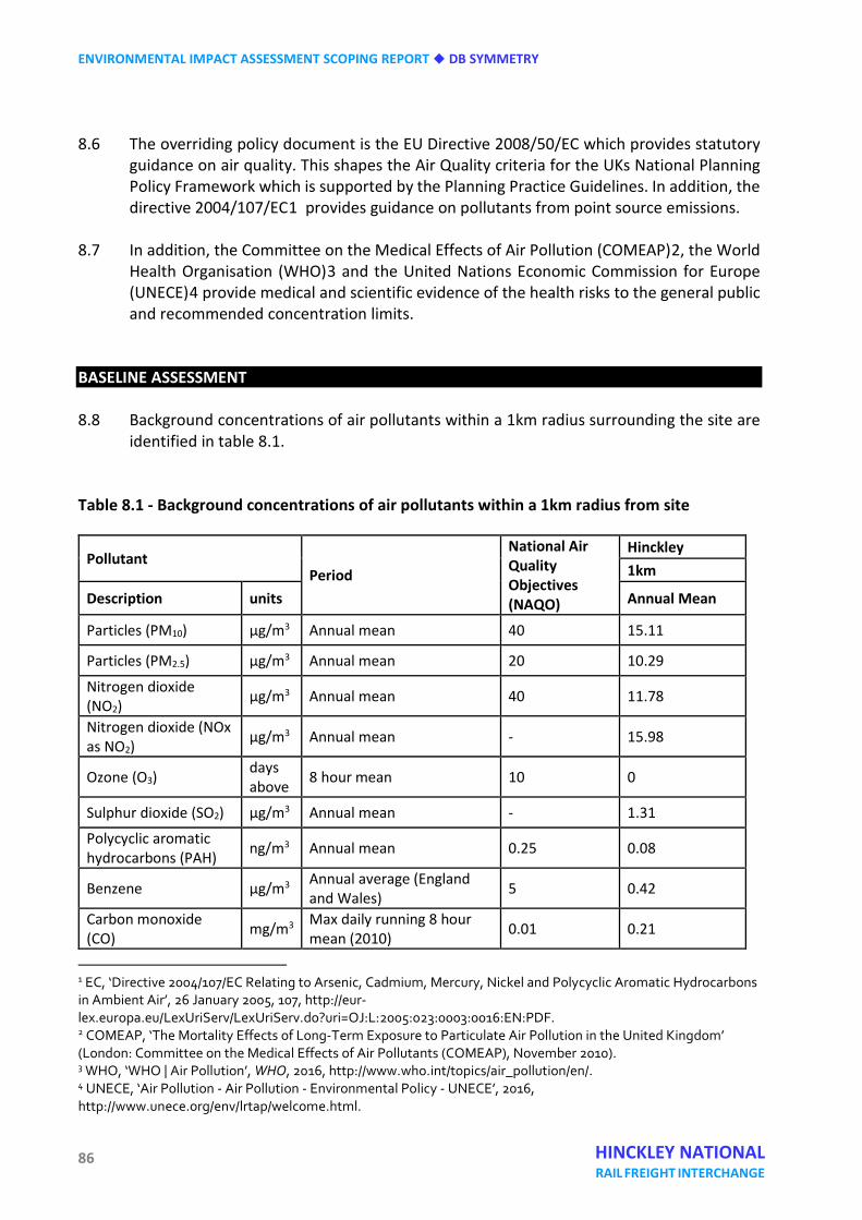
ENVIRONMENTAL IMPACT ASSESSMENT SCOPING REPORT DB SYMMETRY
86 HINCKLEY NATIONAL RAIL FREIGHT INTERCHANGE
8.6 The overriding policy document is the EU Directive 2008/50/EC which provides statutory guidance on air quality. This shapes the Air Quality criteria for the UKs National Planning Policy Framework which is supported by the Planning Practice Guidelines. In addition, the directive 2004/107/EC1 provides guidance on pollutants from point source emissions.
8.7 In addition, the Committee on the Medical Effects of Air Pollution (COMEAP)2, the World
Health Organisation (WHO)3 and the United Nations Economic Commission for Europe (UNECE)4 provide medical and scientific evidence of the health risks to the general public and recommended concentration limits.
BASELINE ASSESSMENT 8.8 Background concentrations of air pollutants within a 1km radius surrounding the site are
identified in table 8.1. Table 8.1 - Background concentrations of air pollutants within a 1km radius from site
Pollutant Period
National Air Quality Objectives (NAQO)
Hinckley 1km
Description units Annual Mean
Particles (PM10) µg/m3 Annual mean 40 15.11
Particles (PM2.5) µg/m3 Annual mean 20 10.29
Nitrogen dioxide (NO2)
µg/m3 Annual mean 40 11.78
Nitrogen dioxide (NOx as NO2)
µg/m3 Annual mean - 15.98
Ozone (O3) days above 8 hour mean 10 0
Sulphur dioxide (SO2) µg/m3 Annual mean - 1.31
Polycyclic aromatic hydrocarbons (PAH) ng/m3 Annual mean 0.25 0.08
Benzene µg/m3 Annual average (England and Wales) 5 0.42
Carbon monoxide (CO) mg/m3 Max daily running 8 hour
mean (2010) 0.01 0.21
1 EC, ‘Directive 2004/107/EC Relating to Arsenic, Cadmium, Mercury, Nickel and Polycyclic Aromatic Hydrocarbons in Ambient Air’, 26 January 2005, 107, http://eur-lex.europa.eu/LexUriServ/LexUriServ.do?uri=OJ:L:2005:023:0003:0016:EN:PDF. 2 COMEAP, ‘The Mortality Effects of Long-Term Exposure to Particulate Air Pollution in the United Kingdom’ (London: Committee on the Medical Effects of Air Pollutants (COMEAP), November 2010). 3 WHO, ‘WHO | Air Pollution’, WHO, 2016, http://www.who.int/topics/air_pollution/en/. 4 UNECE, ‘Air Pollution - Air Pollution - Environmental Policy - UNECE’, 2016, http://www.unece.org/env/lrtap/welcome.html.
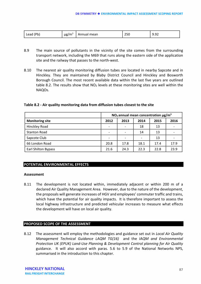
DB SYMMETRY ENVIRONMENTAL IMPACT ASSESSMENT SCOPING REPORT
87 HINCKLEY NATIONAL RAIL FREIGHT INTERCHANGE
Lead (Pb) µg/m3 Annual mean 250 9.92
8.9 The main source of pollutants in the vicinity of the site comes from the surrounding
transport network, including the M69 that runs along the eastern side of the application site and the railway that passes to the north-west.
8.10 The nearest air quality monitoring diffusion tubes are located in nearby Sapcote and in
Hinckley. They are maintained by Blaby District Council and Hinckley and Bosworth Borough Council. The most recent available data within the last five years are outlined table 8.2. The results show that NO2 levels at these monitoring sites are well within the NAQOs.
Table 8.2 - Air quality monitoring data from diffusion tubes closest to the site
NO2 annual mean concentration µg/m3 Monitoring site 2012 2013 2014 2015 2016 Hinckley Road - - 18 13 - Stanton Road - - 14 13 - Sapcote Club - - - 13 - 66 London Road 20.8 17.8 18.1 17.4 17.9 Earl Shilton Bypass 21.6 24.3 22.3 22.8 23.9
POTENTIAL ENVIRONMENTAL EFFECTS Assessment 8.11 The development is not located within, immediately adjacent or within 200 m of a
declared Air Quality Management Area. However, due to the nature of the development, the proposals will generate increases of HGV and employees’ commuter traffic and trains, which have the potential for air quality impacts. It is therefore important to assess the local highway infrastructure and predicted vehicular increases to measure what effects the development will have on local air quality.
PROPOSED SCOPE OF THE ASSESSMENT 8.12 The assessment will employ the methodologies and guidance set out in Local Air Quality
Management Technical Guidance LAQM TG(16) and the IAQM and Environmental Protection UK (EPUK) Land-Use Planning & Development Control planning for Air Quality guidance. It will also accord with paras. 5.6 to 5.9 of the National Networks NPS, summarised in the introduction to this chapter.
ENVIRONMENTAL IMPACT ASSESSMENT SCOPING REPORT DB SYMMETRY
88 HINCKLEY NATIONAL RAIL FREIGHT INTERCHANGE
8.13 The main purpose of the assessment is to determine the current conditions in the area
and what effects future increases in vehicle movements might have on existing sensitive receptors. In addition, concentrations at the development site after it has been constructed will be assessed for exceedances of the NAQO.
8.14 A detailed Air Quality Assessment (AQA) will be undertaken using the air dispersion model
ADMS Urban (Version 4.1.1) to establish the current air quality situation in the area. This software is commercially available, has been validated for this type of assessment and is used extensively for AQAs. ADMS-Urban is able to provide an estimate of air quality both before and after development, taking into account important input data such as background pollutant concentrations, meteorological data, traffic flows and on-site energy generation (if applicable). The model output is verified against local monitoring data, as shown in table 8.2, to increase the accuracy of the predicted pollutant concentrations.
8.15 The AQA will use traffic data provided by the transport consultants, in order to determine
how increases in traffic will affect air quality levels in the area. The assessment will include a model outlining the baseline scenario (assumed to be 2016), a model from the proposed first year of operation assuming there is no development, and finally a model from the proposed first year of operation including the development traffic data. This will allow the assessment to look at all scenarios and what impact the development will have.
8.16 The Environmental Health Department of Blaby District Council will be consulted in order
to determine the methodology, required receptors and monitoring locations. 8.17 An assessment to determine the impacts of dust caused by construction works will also be
included in the report. This will be carried out in accordance with the Institute of Air Quality Management (IAQM) guidance. The main stages of works are construction, demolition, and disturbance caused by dust and dirt emissions from construction vehicles arriving and leaving the site. The assessment will consider sensitive locations within 350m of the site boundary and within 50m of the construction vehicle route up to 500m from the site entrance.
SUMMARY 8.18 The baseline conditions of the proposed development site are favourable as there are
currently no exceedances of the NAQOs at nearby monitored receptors. However, the size and nature of the proposals means that a detailed air quality assessment will be required as part of the EIA. The assessment will consider baseline transport data and predicted future transport data, as well as taking into account the cumulative effects of the project in conjunction with developments nearby on local air quality.
DB SYMMETRY ENVIRONMENTAL IMPACT ASSESSMENT SCOPING REPORT
89 HINCKLEY NATIONAL RAIL FREIGHT INTERCHANGE
Nine Noise and vibration INTRODUCTION 9.1 The proposed development has the potential to generate adverse noise and vibration
effects on existing noise sensitive receptors during the site clearance, preparation and construction phases.
9.2 Once the development is completed, noise associated with road and rail traffic
movements, employment operations and externally located and externally exhausting fixed plant have the potential to have adverse effects on noise sensitive receptors located in the immediate vicinity.
9.3 Noise sensitive receptors will include noise sensitive premises, such as residential
dwellings, but may also include noise sensitive areas of special interest such as habitats for protected species or other wildlife.
9.4 An assessment of the likely significance of effects of noise and vibration of the proposed
development on the identified noise sensitive receptors will be undertaken by Hydrock Acoustic Consultants (HAC). Noise and vibration isolation, insulation and absorption mitigation measures may be specified as a result of the predicted impacts of noise and vibration emissions associated with all phases of the proposed development. A full assessment including appendices will be reported in the project ES.
BASELINE ASSESSMENT Overview 9.5 The impact of noise from construction and demolition activities, road and rail traffic
associated with the construction and operational phases and noise from plant, equipment and operational uses associated with the proposed development will be assessed.
Legislation, policies, guidance and good practice 9.6 Assessment of the effects of the proposed development on the noise sensitive receptors
will be undertaken in accordance with, but not limited to, the assessment methodologies set out in the following best practice guidance and standards:
• National Policy Statement for National Networks – including the section on noise and
vibration at paragraphs 5.186 -5.200. • Noise Policy Statement for England (NPSFE); • National Planning Policy Framework (NPPF);
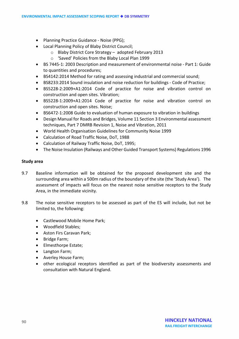
ENVIRONMENTAL IMPACT ASSESSMENT SCOPING REPORT DB SYMMETRY
90 HINCKLEY NATIONAL RAIL FREIGHT INTERCHANGE
• Planning Practice Guidance - Noise (PPG); • Local Planning Policy of Blaby District Council;
o Blaby District Core Strategy – adopted February 2013 o ‘Saved’ Policies from the Blaby Local Plan 1999
• BS 7445-1: 2003 Description and measurement of environmental noise - Part 1: Guide to quantities and procedures;
• BS4142:2014 Method for rating and assessing industrial and commercial sound; • BS8233:2014 Sound insulation and noise reduction for buildings - Code of Practice; • BS5228-2:2009+A1:2014 Code of practice for noise and vibration control on
construction and open sites. Vibration; • BS5228-1:2009+A1:2014 Code of practice for noise and vibration control on
construction and open sites. Noise; • BS6472-1:2008 Guide to evaluation of human exposure to vibration in buildings • Design Manual for Roads and Bridges, Volume 11 Section 3 Environmental assessment
techniques, Part 7 DMRB Revision 1, Noise and Vibration, 2011 • World Health Organisation Guidelines for Community Noise 1999 • Calculation of Road Traffic Noise, DoT, 1988 • Calculation of Railway Traffic Noise, DoT, 1995; • The Noise Insulation (Railways and Other Guided Transport Systems) Regulations 1996
Study area 9.7 Baseline information will be obtained for the proposed development site and the
surrounding area within a 500m radius of the boundary of the site (the ‘Study Area’). The assessment of impacts will focus on the nearest noise sensitive receptors to the Study Area, in the immediate vicinity.
9.8 The noise sensitive receptors to be assessed as part of the ES will include, but not be
limited to, the following:
• Castlewood Mobile Home Park; • Woodfield Stables; • Aston Firs Caravan Park; • Bridge Farm; • Elmesthorpe Estate; • Langton Farm; • Averley House Farm; • other ecological receptors identified as part of the biodiversity assessments and
consultation with Natural England.
DB SYMMETRY ENVIRONMENTAL IMPACT ASSESSMENT SCOPING REPORT
91 HINCKLEY NATIONAL RAIL FREIGHT INTERCHANGE
Desk-based studies
Construction phase 9.9 The significance of effects of the proposed development during the site preparation,
construction and operational phases will be assessed. The assessment will outline both the long and short term predicted effects of each phase of the development and any required or specified mitigation measures in order to reduce any significant adverse effects of noise and vibration upon the identified noise sensitive receptors.
9.10 An assessment will be undertaken to determine the effects of noise and vibration
associated with construction activities on nearby noise sensitive receptors. The assessment will be carried out in accordance with BS5228:2009.
9.11 The significance of construction noise and vibration effects will be determined through
the guidance of BS 5228 Part 1 Annex E and BS 5228 Part 2. The assessment of noise levels due to construction activity and their significance of effects will be dependent on the prevailing ambient and construction noise levels, as well as the magnitude, duration, time of occurrence and frequency of the noise change.
Road traffic noise
9.12 An assessment of road traffic noise likely to affect the site and surrounding receivers will
be undertaken using baseline and future road traffic volume data obtained from the transport consultants and input into Datakustik CadnaA version 4.5.151 (CadnaA) noise modelling software.
9.13 The assessment will predict the likely effects of future traffic associated with the Proposed
Development on nearby noise sensitive receptors. The impact will be assessed using the methodology provided in the Design Manual for Roads and Bridges (DMRB) or any other relevant guidance agreed with or specified by the Local Authority.
Operational phase
9.14 An assessment of the impact of operational noise sources, such as external fixed plant,
externally exhausting plant, commercial operations and any equipment associated with the Proposed Development at proposed and existing noise sensitive receptors will be undertaken using CadnaA noise modelling software and measurement data collected during field studies.
9.15 Where data is not available to allow prediction of noise levels from plant and equipment
associated with the Proposed Development, measurement data collected during field studies will be used for the setting of noise emissions limits. The prediction methodology will be presented in the noise and vibration chapter of the ES together with technical appendices.
ENVIRONMENTAL IMPACT ASSESSMENT SCOPING REPORT DB SYMMETRY
92 HINCKLEY NATIONAL RAIL FREIGHT INTERCHANGE
Field studies 9.16 A combination of long and short term environmental noise measurements will be
undertaken in accordance with the requirements and guidance of BS 7445-1: 2003 and BS 4142:2014. Measurements will be undertaken at multiple locations across the proposed development site for a minimum of 96 hours in order to determine the baseline noise levels of the site. The survey will include extensive measurement of the surrounding road and rail network as well as background noise levels at the identified nearest noise sensitive receptors.
9.17 Baseline noise measurements will be used to develop an acoustic model of the proposed
development site and surroundings using CadnaA software, Ordnance Survey contour mapping, geo satellite imagining and measured noise levels in order to determine the existing noise climate of the site. The noise model will be used in part to quantify the impacts of the phases of the development on nearby noise sensitive receptors.
Consultations 9.18 Liaison will be undertaken with the environmental health department of Blaby District
Council in order to confirm proposed noise monitoring locations. A suitable monitoring methodology will be agreed prior to site survey work being undertaken.
9.19 Further consultation will be undertaken with Natural England in order to determine the
prevalence of designated nature conservation sites, protected landscapes and protected species within the study area. These areas might include Burbage Wood, Aston Firs and Freeholt Wood.
PROPOSED SCOPE OF THE ASSESSMENT AND POTENTIAL ENVIRONMENTAL EFFECTS Significance of effects 9.20 The significance of likely effects arising from plant and equipment associated with the site
clearance, construction and operational phase of the Proposed Development on the noise environment will be determined by identifying the magnitude of the effect and the sensitivity of the receptor. Identifying the sensitivity, magnitude and significance will be based on the criteria described below.
Magnitude of effects – construction noise 9.21 The magnitude of effect of construction noise will be considered in relation to the
guidance provided in BS 5228. A quantitative assessment of noise effects will be undertaken based on the typical construction equipment, plant and construction phasing schedule that would be required for the construction phase of the Proposed Development.
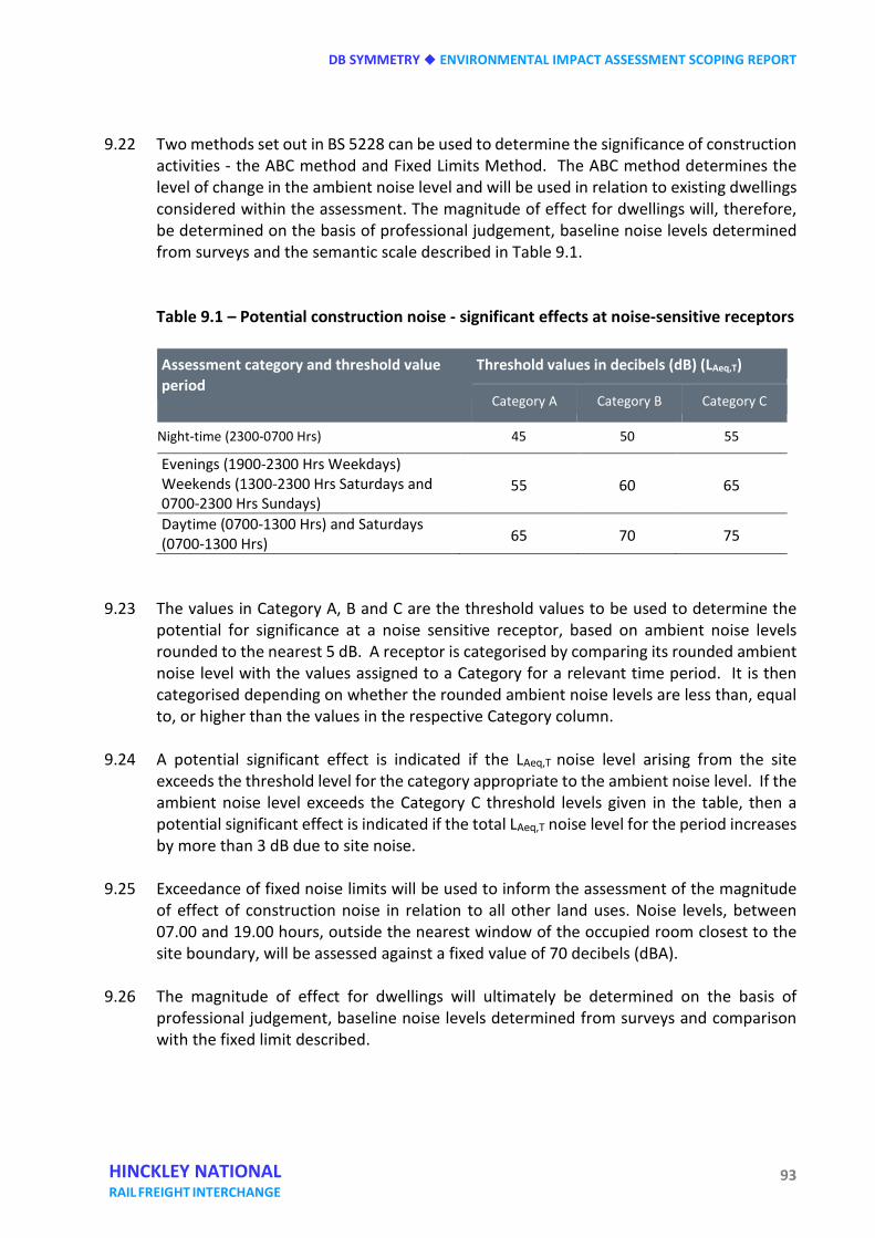
DB SYMMETRY ENVIRONMENTAL IMPACT ASSESSMENT SCOPING REPORT
93 HINCKLEY NATIONAL RAIL FREIGHT INTERCHANGE
9.22 Two methods set out in BS 5228 can be used to determine the significance of construction activities - the ABC method and Fixed Limits Method. The ABC method determines the level of change in the ambient noise level and will be used in relation to existing dwellings considered within the assessment. The magnitude of effect for dwellings will, therefore, be determined on the basis of professional judgement, baseline noise levels determined from surveys and the semantic scale described in Table 9.1.
Table 9.1 – Potential construction noise - significant effects at noise-sensitive receptors
Assessment category and threshold value period
Threshold values in decibels (dB) (LAeq,T)
Category A Category B Category C
Night-time (2300-0700 Hrs) 45 50 55
Evenings (1900-2300 Hrs Weekdays) Weekends (1300-2300 Hrs Saturdays and 0700-2300 Hrs Sundays)
55 60 65
Daytime (0700-1300 Hrs) and Saturdays (0700-1300 Hrs) 65 70 75
9.23 The values in Category A, B and C are the threshold values to be used to determine the
potential for significance at a noise sensitive receptor, based on ambient noise levels rounded to the nearest 5 dB. A receptor is categorised by comparing its rounded ambient noise level with the values assigned to a Category for a relevant time period. It is then categorised depending on whether the rounded ambient noise levels are less than, equal to, or higher than the values in the respective Category column.
9.24 A potential significant effect is indicated if the LAeq,T noise level arising from the site
exceeds the threshold level for the category appropriate to the ambient noise level. If the ambient noise level exceeds the Category C threshold levels given in the table, then a potential significant effect is indicated if the total LAeq,T noise level for the period increases by more than 3 dB due to site noise.
9.25 Exceedance of fixed noise limits will be used to inform the assessment of the magnitude
of effect of construction noise in relation to all other land uses. Noise levels, between 07.00 and 19.00 hours, outside the nearest window of the occupied room closest to the site boundary, will be assessed against a fixed value of 70 decibels (dBA).
9.26 The magnitude of effect for dwellings will ultimately be determined on the basis of
professional judgement, baseline noise levels determined from surveys and comparison with the fixed limit described.
ENVIRONMENTAL IMPACT ASSESSMENT SCOPING REPORT DB SYMMETRY
94 HINCKLEY NATIONAL RAIL FREIGHT INTERCHANGE
Magnitude of effects – construction vibration 9.27 The magnitude of effect of construction vibration will be considered in relation to the
guidance provided with BS 5228-2:2009. Typically, the main effects of vibration arise from piling activities. It is noted that the duration of construction vibration impacts is of less significance because all of the construction works generating vibration will be of relatively short duration.
9.28 The significance of potential construction vibration effects is categorised according to the
vibration magnitude as follows:
• any works causing a vibration level greater than 10 mm/s (measured as a peak particle velocity) will constitute a high adverse impact;
• any works causing a vibration level between 1 mm/s and 10 mm/s will constitute a moderate adverse impact;
• any works causing a vibration level between 0.3 mm/s and 1 mm/s will constitute a low adverse impact;
• any works causing a vibration level less than 0.3 mm/s will constitute a neutral or negligible impact.
Magnitude of effects – road and rail traffic 9.29 The Design Manual for Roads and Bridges (DMRB) will be used as the basis for the
assessment of road traffic noise in relation to the Proposed Development. DMRB provides a simple and detailed method for assessing the effects of road traffic noise during both the construction and operational phases. The assessment methodology is usually used for new roads. However, the simple method provides a robust methodology for assessing the change in traffic on existing roads.
9.30 The simple assessment requires a calculation of the short term and long-term effects of
the Development at noise sensitive receptors through a comparison of the following design scenarios, based on projected baseline and design year traffic data as follows:
• do-minimum scenario in the baseline year against do-something in the baseline year;
• do-minimum scenario in the baseline year against do-something in the future
assessment year.
9.31 The magnitude of effect will be determined on the basis of a noise change assessment, making reference to tables 3.1 and 3.2 ‘Classification of Magnitude of Noise Impacts in the short-term and long term’ from the DMRB, which is set out in Table 9.2.
DB SYMMETRY ENVIRONMENTAL IMPACT ASSESSMENT SCOPING REPORT
95 HINCKLEY NATIONAL RAIL FREIGHT INTERCHANGE
9.32 In accordance with paragraph 5.191 of the National Networks NPS, the Department of Transport’s Calculation of Railway Noise will be used in conjunction with the methodology outlined in the Noise Insulation (Railways and other Guided Transport Systems) Regulations to determine the predicted increase in noise level owing to rail traffic at the nearest noise sensitive receptors.
Table 9.2 – Levels of magnitude to be employed in the assessment of road traffic noise (construction and operational)
9.33 As neither document contains a method to determine the level of magnitude owing to the
impact from rail noise on noise sensitive receptors, the magnitude of effect will be determined using the methodology outlined in the DMRB and table 9.2.
Magnitude of effects – operational phase 9.34 The magnitude of effect of any externally located or externally exhausting plant or
equipment associated with the Proposed Development will be assessed. Further assessment will be undertaken of operational noise that might arise from commercial activities, such as the movement of stock within warehouse yards, on the identified noise sensitive receptors through the methodology set out in BS 4142:2014.
9.35 BS 4142:2014 provides guidance on the assessment of the likelihood of complaints relating
to noise from industrial sources. The standard presents a method of assessing potential noise impact by comparing the noise level due to industrial sources (the Rating Level) with that of the existing background noise level at the nearest noise sensitive receptor in the absence of the source (the Background Sound Level).
Level of magnitude Noise change LA10,18hr dB short term
Noise change LA10,18hr dB long term
Magnitude of impact – as described in DMRB
High 5+ 10+ Major
Moderate 3-4.9 5-9.9 Moderate
Low 1-2.9 3-4.9 Minor
Negligible 0.1-0.9 0.1-2.9 Negligible
0 0 No change
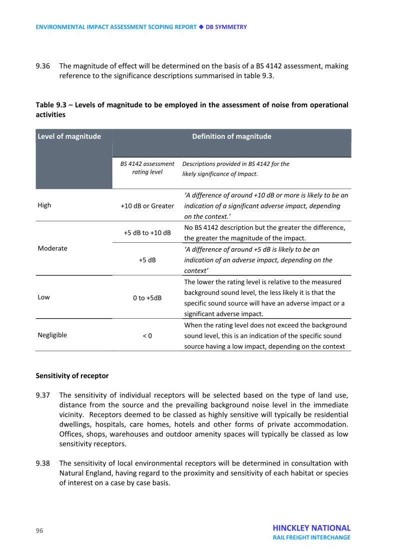
ENVIRONMENTAL IMPACT ASSESSMENT SCOPING REPORT DB SYMMETRY
96 HINCKLEY NATIONAL RAIL FREIGHT INTERCHANGE
9.36 The magnitude of effect will be determined on the basis of a BS 4142 assessment, making reference to the significance descriptions summarised in table 9.3.
Table 9.3 – Levels of magnitude to be employed in the assessment of noise from operational activities Level of magnitude Definition of magnitude
BS 4142 assessment rating level
Descriptions provided in BS 4142 for the likely significance of Impact.
High +10 dB or Greater ‘A difference of around +10 dB or more is likely to be an indication of a significant adverse impact, depending on the context.’
Moderate
+5 dB to +10 dB No BS 4142 description but the greater the difference, the greater the magnitude of the impact.
+5 dB ‘A difference of around +5 dB is likely to be an indication of an adverse impact, depending on the context’
Low 0 to +5dB
The lower the rating level is relative to the measured background sound level, the less likely it is that the specific sound source will have an adverse impact or a significant adverse impact.
Negligible < 0 When the rating level does not exceed the background sound level, this is an indication of the specific sound source having a low impact, depending on the context
Sensitivity of receptor 9.37 The sensitivity of individual receptors will be selected based on the type of land use,
distance from the source and the prevailing background noise level in the immediate vicinity. Receptors deemed to be classed as highly sensitive will typically be residential dwellings, hospitals, care homes, hotels and other forms of private accommodation. Offices, shops, warehouses and outdoor amenity spaces will typically be classed as low sensitivity receptors.
9.38 The sensitivity of local environmental receptors will be determined in consultation with
Natural England, having regard to the proximity and sensitivity of each habitat or species of interest on a case by case basis.
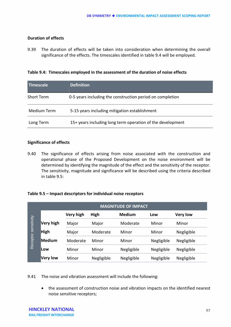
DB SYMMETRY ENVIRONMENTAL IMPACT ASSESSMENT SCOPING REPORT
97 HINCKLEY NATIONAL RAIL FREIGHT INTERCHANGE
Duration of effects 9.39 The duration of effects will be taken into consideration when determining the overall
significance of the effects. The timescales identified in table 9.4 will be employed. Table 9.4: Timescales employed in the assessment of the duration of noise effects Timescale Definition
Short Term 0-5 years including the construction period on completion
Medium Term 5-15 years including mitigation establishment
Long Term 15+ years including long term operation of the development
Significance of effects 9.40 The significance of effects arising from noise associated with the construction and
operational phase of the Proposed Development on the noise environment will be determined by identifying the magnitude of the effect and the sensitivity of the receptor. The sensitivity, magnitude and significance will be described using the criteria described in table 9.5:
Table 9.5 – Impact descriptors for individual noise receptors
Rec
epto
r sen
sitiv
ity
MAGNITUDE OF IMPACT
Very high High Medium Low Very low
Very high Major Major Moderate Minor Minor
High Major Moderate Minor Minor Negligible
Medium Moderate Minor Minor Negligible Negligible
Low Minor Minor Negligible Negligible Negligible
Very low Minor Negligible Negligible Negligible Negligible 9.41 The noise and vibration assessment will include the following:
• the assessment of construction noise and vibration impacts on the identified nearest noise sensitive receptors;
ENVIRONMENTAL IMPACT ASSESSMENT SCOPING REPORT DB SYMMETRY
98 HINCKLEY NATIONAL RAIL FREIGHT INTERCHANGE
• the noise and vibration associated with the operation of the development;
• formulation of mitigation measures where appropriate.
9.42 The site clearance and construction noise and vibration effects will be assessed through
the guidance outlined in BS5228-1/2:2009 in order to determine the significance of impact on noise sensitive receptors based on a concise construction phasing plan.
9.43 The operational impacts of the proposed development will be assessed through the
methodology outlined in BS4142:2014, BS8233:2014, BS6472-1:2008 and the DMRB in order to determine the significance of their effects.
9.44 The assessments of construction and operational effects will take into account proposed
mitigation measures. 9.45 The significance of effects of the proposed development during the site clearance,
construction and operational phases will be summarised in the assessment chapter. The assessment chapter shall outline both the long and short term predicted effects of each phase of the development and any required or specified mitigation measures in order to reduce the impact of noise and vibration upon the identified noise sensitive receptors.
9.46 With respect to the advice provided in the NPPF and the Planning Policy Guidance on
Noise:
• Effects of Major significance are above the Unacceptable Adverse Effect Level (UAEL) and should be prevented and require mitigation;
• Effects of Moderate significance are above the Significant Observed Adverse Effect Level (SOAEL) and should be avoided and require mitigation;
• Effects of Minor significance are below the SOAEL and do not require mitigation but they are above the Lowest Observed Adverse Effect Level (LOAEL) and should be minimised and reduced as far as reasonably practicable.
9.47 The Noise PPG indicates that an unacceptable adverse effect (level) occurs above SOAEL. The term UAEL has therefore been used to describe effects at this level although it is not a term referred to elsewhere in the PPGN except in the table of effects. As such, effects of Major or Moderate significance are defined as Significant and effects of Minor significance or below are defined as Not Significant.
Cumulative assessment 9.48 Intra-project and inter-project cumulative effects will be assessed in accordance with the
aforementioned methodology. The potential intra-project relationship of effects with other environmental impacts will be considered during the assessment.
DB SYMMETRY ENVIRONMENTAL IMPACT ASSESSMENT SCOPING REPORT
99 HINCKLEY NATIONAL RAIL FREIGHT INTERCHANGE
9.49 The inter-project cumulative effects of the Proposed Development acting in combination
with other major developments will also be assessed. Those developments that are considered to be of relevance to the assessment of noise will be identified and agreed in advance with the Local Authority.
Mitigation and residual effects 9.50 Having assessed the magnitude of impact against the identified receptors, the assessment
will consider whether any mitigation measures are necessary. Where possible, mitigation measures will be embedded into the design of the Proposed Development to reduce the environmental effects to an acceptable level. However, where this is not sufficient further mitigation will be specified where adverse effects have been identified.
9.51 The residual effects of the Proposed Development, taking embedded and additional
mitigation into account will be confirmed to reduce, remove or compensate for significant adverse effects identified.
SUMMARY 9.52 The noise and vibration effects of the proposed development during the site preparation,
construction and operational phases will be assessed using appropriate methodologies. The assessment will outline both the long and short term predicted effects of each phase of the development and any required or specified mitigation measures in order to reduce any significant adverse effects of noise and vibration upon the identified noise sensitive receptors.

ENVIRONMENTAL IMPACT ASSESSMENT SCOPING REPORT DB SYMMETRY
100 HINCKLEY NATIONAL RAIL FREIGHT INTERCHANGE
DB SYMMETRY ENVIRONMENTAL IMPACT ASSESSMENT SCOPING REPORT
101 HINCKLEY NATIONAL RAIL FREIGHT INTERCHANGE
Ten Landscape and visual effects INTRODUCTION 10.1 This section explains the general approach that will be taken to the assessment of
landscape and visual effects and the way in which it will be reported in the ES.
10.2 Landscape and visual effects are independent but related issues. Landscape effects relate to changes to the landscape fabric and the features contributing to the landscape character and quality. Visual effects relate to the appearance of such changes within views and the resulting effect on visual amenity.
10.3 The landscape and visual assessment has already commenced and has examined the current landscape and visual baseline conditions within the site and its broader context with reference to sensitive visual receptors and landscape designations. The assessment process will involve an ongoing analysis of the likely landscape and visual effects of the evolving development proposals and, where impacts cannot be avoided through design, will recommend additional mitigation measures.
BASELINE ASSESSMENT Landscape designations 10.4 A summary of relevant designations is provided below:
• no statutory landscape designations lie within the 5km search area; • one non-statutory landscape designation, the Croft Hill Area of Local Landscape Value
(ALLV) falls approximately 1.5km to the north-east of the site; • no Registered Parks and Gardens lie within the 5km search area; • a number of Public Rights of Way (PRoW) cross the site, broadly running north-west to
south-east and mainly linking scattered farmsteads and hamlets. These are shown in figure 10.1;
• there is no Ancient Woodland within the site. However, there are several blocks of
Ancient Woodland close to the south-western edge of the site, at Burbage Wood, Aston Firs, Freeholt Wood and Sheepy Wood.
• There are no Tree Preservation Orders (TPOs) within the boundary of the site, but Aston
Firs and Freeholt Wood on the southern boundary are the subject of a TPO.
ENVIRONMENTAL IMPACT ASSESSMENT SCOPING REPORT DB SYMMETRY
102 HINCKLEY NATIONAL RAIL FREIGHT INTERCHANGE
Landscape policy National Policy Statement for National Networks 10.5 The assessment will follow guidance contained in the landscape and visual impacts section
of paragraphs 5.143 – 5.161 of the National Networks NPS in relation to the assessment process as well as policy advice in relation to development outside nationally designated areas.
National Planning Policy Framework 10.6 At the heart of the National Planning Policy Framework (NPPF) is a presumption in favour
of sustainable development; this being the key principle running throughout the document and the development of NPPF policies. Considering this broad aim alongside the three dimensions of sustainable development, in particular that relating to environmental matters, LVIA can support the creation of successful places in which to live and work.
10.7 Paragraph 17 of the NPPF sets out 12 core land-use planning principles, which includes, at
bullet point five, that planning should ‘take account of the different roles and character of different areas, promoting the vitality of our main urban areas, protecting the Green Belts around them, recognising the intrinsic character and beauty of the countryside’.
10.8 Section 11 of the NPPF is concerned with ‘Conserving and enhancing the natural
environment’. Paragraph 109 states that ‘the planning system should contribute to and enhance the natural and local environment by (inter alia) protecting and enhancing valued landscapes’
Local plan policy 10.9 Local landscape policy of relevance to the site is contained in:
• Blaby District Local Plan 1999 (saved policies 2007); • Blaby District Core Strategy adopted February 2013;
10.10 Saved policies of relevance to landscape and visual amenity in the Blaby District Local Plan
1999 include the following:
• CE22 – landscaping; • CE23 – Croft Hill Area of Local Landscape Value.
DB SYMMETRY ENVIRONMENTAL IMPACT ASSESSMENT SCOPING REPORT
103 HINCKLEY NATIONAL RAIL FREIGHT INTERCHANGE
Emerging local plan policy 10.11 Policies of relevance to landscape and visual amenity contained in the emerging Blaby
District Local Plan 2029 include the following
• Policy CS2 – design of new development; • Policy CS14 – green infrastructure (GI); • Policy CS18 – countryside; • Policy CS19 – bio-diversity and geo-diversity.
10.12 The site lies in the Countryside Policy Area as shown on the emerging Local Plan 2029
proposals map and thus Development Management Policy 2 ‘Development in the Countryside’ in the Submission Version of the Local Plan (Delivery) is of relevance as follows:
In areas designated as Countryside on the Policies Map, development proposals consistent with Core Strategy Policy CS18 will be supported where the following criteria are met:
General a) The development is in keeping with the appearance and character of the existing
landscape, development form and buildings. Decisions in respect of impact on landscape character and appearance will be informed by the Blaby Landscape and Settlement Character Assessment, Leicestershire and Rutland Historic Landscape Characterisation Study, National Character Areas and any subsequent pieces of evidence; and,
b) The development provides a satisfactory relationship with nearby uses that would not
be significantly detrimental to the amenities enjoyed by the existing or new occupiers, including but not limited to, consideration of:
i. overdevelopment of the site due to factors including footprint, scale and mass; ii. privacy, light, noise, disturbance and overbearing effect; and, iii. vibration, emissions, hours of working, vehicular activity
Landscape character 10.13 At a National Level the site lies within Natural England’s National Character Area (NCA) No
94 ‘Leicestershire Vales’, which is briefly described as ‘low-lying clay vales and river valleys’.
10.14 The local landscape character is defined in the Blaby District Character Assessment (2008),
and the Hinckley and Bosworth Landscape Character Assessment (2017). Also of relevance
ENVIRONMENTAL IMPACT ASSESSMENT SCOPING REPORT DB SYMMETRY
104 HINCKLEY NATIONAL RAIL FREIGHT INTERCHANGE
is Blaby Landscape and Settlement Character Assessment, Leicestershire and Rutland Historic Landscape Characterisation Study.
10.15 The Blaby District Character Assessment (2008), identifies the site across two Landscape
Character Types (LCT). The northern area of the site falls within LCT A ‘Floodplain’ and the southern area is within LCT G ‘Wooded Farmland’.
10.16 In terms of Landscape Character Areas (LCA), the site falls similarly within two zones. The
northern parts of the site lie in LCA E: ‘Elmesthorpe Floodplain’ and the southern portions are located within LCA A: ‘Aston Flamville Wooded Farmland’.
10.17 The character of the site and its immediate surroundings is generally consistent with published assessments identified above, particularly in relation to the regularly shaped field pattern dominated by arable fields and woodland.
10.18 Across the whole site, the topography slopes broadly from north to south at a height of between c.85m in the north to c.110m AOD, although there are a number of more localised undulations across the site within this range.
10.19 Given the arable land use, landscape features on site are largely limited to field boundary trees and hedgerows and a variety of agricultural dwellings and buildings associated with the farmsteads across the site. The site is traversed by Burbage Common Road as well as a number of PRoW.
10.20 In addition to reviewing the above documents, the assessment will take heed of the
guidance provided in relation to trees, provided in BS 5837:2012 Trees in Relation to Design, Demolition and Construction (BSI, 2012).
Visual amenity 10.21 Figures 10.2 and 10.3 (Plans EDP3267/17, EDP3267/14) illustrate the Zone of Theoretical
Visibility (ZTV) of:
a) the site in its current form; b) the site, with proposed development at a building height of 23m and a maximum fill
of 7m, being assessed at a height parameter across the site of 30m. 10.22 These ZTVs illustrate the theoretical visibility of the site based on topographical data, built
development data and National Tree Data up to 1km, assuming excellent visibility with no atmospheric attenuation. In reality, other components of the landscape such as buildings and hedgerows will introduce screening effects which, coupled with the atmospheric conditions, will reduce this visibility in some instances. The ZTVs will be refined and reviewed as the development parameters are explored further.
10.23 For its size, the visual influence of the site in its current form is very limited given the
DB SYMMETRY ENVIRONMENTAL IMPACT ASSESSMENT SCOPING REPORT
105 HINCKLEY NATIONAL RAIL FREIGHT INTERCHANGE
extent of woodland and built form in the local vicinity. As figure 10.3 demonstrates, the visual influence of the site will increase with development. The visual assessment process will determine the extent of the increase in visual influence as well as the magnitude of any visual effects that arise.
10.24 The woodland along the south and south-western boundaries serves to limit views to the
south, but higher ground to the north-west at Barwell and to the north at Elmsthorpe allows opportunities for more open views across the site from some locations.
10.25 Open views of the site are largely limited to those from Burbage Common Road as it passes through the site, the various PRoW which cross the site and the M69, although roadside vegetation provides some interruption and the speed and nature of travel limit the availability of views. In the wider landscape there will be opportunities for partial views of the proposed development from roads, PRoW and residential properties.
10.26 Other sources of visual receptor include passengers on trains travelling on the Nuneaton to Felixstowe railway line which is on an embankment along the western site boundary and residential receptors within the farmsteads across the site as well as within properties in relatively close proximity such as at Langton Farm.
10.27 Figures 10.3 and 10.4 (Plan EDP3267/05a) includes 33 representative viewpoints that have been identified in the ZTV for a development with a maximum height parameter of 30 metres. These viewpoints are at locations where there are likely to be sensitive visual receptors, including receptors in designated landscapes such as Burbage Common and Croft Hill ALLV and those on PRoW and at residential properties. These viewpoints will form the basis of the visual assessment, the significance of any effect being assessed in terms of the magnitude of change in the view and the sensitivity of the visual receptor. The location of these views is set out in the table below:
Table 10.1: Proposed viewpoints for the landscape and visual assessment
Viewpoint number
Viewpoint location
1 View from PRoW V35/1 2 View from PRoW U50/1 3 View from PRoW U52/6 4 View from PRoW U52/8/
Burbage Common Road Bridge over railway 5 View from PRoW V23/1 over railway 6 View from PRoW U50/3 7 View from Burbage Common Road 8 View from PRoW V29/6 footbridge over M69 9 View from PRoW U53/2
10 View from Hinckley Road 11 View from PRoW V29/3
ENVIRONMENTAL IMPACT ASSESSMENT SCOPING REPORT DB SYMMETRY
106 HINCKLEY NATIONAL RAIL FREIGHT INTERCHANGE
12 View from M69 overbridge on Aston Lane 13 View from M69 overbridge on Lychgate Lane 14 View from PRoW U63/1 15 View from Burbage Common 16 View from Burbage Common Road 17 View from PRoW U52/9 18 View from PRoW U52/11 19 View from churchyard of St Mary, Elmesthorpe 20 View from M69 overbridge on B581 21 View from Station Road/PRoW V29/10 22 View from PRoW V49/2, Stoney Stanton 23 View from Hinckley Road, west of Sapcote 24 View from PRoW V34/2 25 View from churchyard of St Mary, Barwell 26 View from Shilton Road, Barwell 27 View from Thurlaston Lane 28 View from M69 overbridge on Pingle Lane 29 View from PRoW U18/1 30 View from Croft Hill Area of Local Landscape Value 31 View from Coventry Road 32 View from Bumblebee Lane, High Cross 33 View from B578, Lutterworth Road
POTENTIAL ENVIRONMENTAL EFFECTS 10.28 The landscape and visual assessment has already commenced and has examined the
current landscape and visual baseline conditions within the site and evaluated the site in its broader context including landscape and landscape related designations as illustrated in figure 10.5 (Plan EDP3267/10a).
10.29 The assessment process will involve an iterative analysis of the likely landscape and visual effects of the evolving development proposals. Where likely significant adverse effects cannot be avoided through design, additional mitigation measures will be considered.
10.30 The most notable landscape effect as a result of the development would be the change in character from open agricultural land to commercial development across much of the site. Other potential effects include the removal of sections of hedgerow and occasional individual boundary trees to allow for access and layout, together with the planting of new hedgerows and trees to strengthen the structure of the landscape.
10.31 The main potential likely significant landscape and visual effects of the proposed development once completed, irrespective of any mitigation measures, are summarised below.
DB SYMMETRY ENVIRONMENTAL IMPACT ASSESSMENT SCOPING REPORT
107 HINCKLEY NATIONAL RAIL FREIGHT INTERCHANGE
• Potential adverse landscape impacts caused by the operational development would generally be localised in scale and restricted to the site itself and immediate environs, particularly where existing woodland and linear tree belts provide visual screening.
• Change to the character of the landscape of the site, through alteration of land use
and introduction of new temporary and permanent features, the latter including beneficial effects such as the creation of new habitats within the site boundary.
• A permanent, long-term adverse impact on landscape character would occur due to
physical impact on landscape within the site, introduction of new built form and associated ground remodelling within existing agricultural land, movement of vehicles and people within the site, and increase in the volume of light pollution from both street lighting and internal lighting of built form.
• There would be adverse physical impact on landscape elements and features within the site caused by the localised removal of existing landscape features and;
• potential adverse visual effects upon close proximity views from roads including Burbage Common Road and the M69, PRoW, Burbage Common (Registered Common Land) and Burbage Country Park, adjacent railway line and residential receptors due to visibility of the completed scheme (including built development, traffic and lighting).
PROPOSED SCOPE OF THE ASSESSMENT 10.32 The methodology for undertaking the Landscape and Visual Assessment will follow the
guidelines set out in the third edition of Guidelines for Landscape and Visual Impact Assessment (GLVIA - Landscape Institute and Institute of Environmental Management and Assessment, 2013). This will be used as a basic approach and amended as necessary to cover specific site issues.
10.33 The first stage of the assessment is to establish the baseline conditions of the site and surrounding area, which would include identifying the landscape character and key features of the landscape and whether any landscape designations affect the site. Sources examined for the desktop study will include: • local planning policy • landscape and heritage designations • Natural England’s National Character Areas • district and local level character areas
ENVIRONMENTAL IMPACT ASSESSMENT SCOPING REPORT DB SYMMETRY
108 HINCKLEY NATIONAL RAIL FREIGHT INTERCHANGE
• Natural England’s Natural Area Profile
• public rights of way • local OS maps • aerial photographs
10.34 Site appraisal will also be undertaken. The aim of the site appraisal is to:
• confirm the extent of study areas for the landscape and visual assessments
respectively;
• identify and confirm the arboricultural resource in accordance with BS 5837:2012;
• confirm the status of baseline conditions identified by the desktop;
• confirm the landscape character areas within the study area and compare these to the actual baseline condition. This will also include consideration of the parallel archaeology and heritage, ecology and arboricultural assessments;
• identify the Primary Visual Envelope of the site and record key viewpoints from within this, which will be used to inform the landscape and visual assessment of the proposed development.
10.35 The second stage of the landscape and visual assessment would seek to describe and make
judgements on:
• landscape effects that might arise as a result of the proposed development on discrete landscape character areas and/or character types comprising features that may possess a particular quality or merit as well as effects on the landscape elements and features within the site boundary itself;
• visual effects that might arise as a result of the proposed development on views from visual receptors, such as users of local rights of way, and upon the amenity value of the views from surrounding uses.
10.36 Measures to mitigate any adverse visual effects upon the landscape value and visual
quality of the area will be integral to the design process, the master plan for the site developing in response to the findings of the assessment work with regard to layout, scale and massing, materials and finishes and landscape elements included in the parameter plans as ‘designed in’ mitigation.
10.37 Finally, an assessment of any residual effects which may arise following the incorporation
of mitigation measures will be undertaken and the significance of these effects stated.
DB SYMMETRY ENVIRONMENTAL IMPACT ASSESSMENT SCOPING REPORT
109 HINCKLEY NATIONAL RAIL FREIGHT INTERCHANGE
The evaluation of residual effects will be considered for Year 1 and Year 15. This allows for the consideration of the screening effects of screen planting that will be incorporated as mitigation for the development.
10.38 In addition, the assessment of landscape effects will include a full BS 5837:2012 compliant
tree survey and report, and an Arboricultural Impact Assessment.
10.39 The final output of the exercise will be to provide text and illustrative material which:
• establishes the baseline conditions at a point at which the site will become available for development;
• assesses the landscapes sensitivity to change of the nature and extent of the proposed development;
• assesses the landscape and visual impact of the development on the site and relevant surrounding area;
• identifies areas of landscape and visual concern and/or benefit in relation to the development and during its construction;
• advises on any proposals to mitigate significant negative effects;
• identifies the residual impacts of the development. SUMMARY
10.40 The site is not covered by any statutory landscape designations and could be designed and
developed in accordance with national and local landscape planning policy.
10.41 There are no significant constraints to development in landscape, visual and arboricultural terms. However, development of the site in the manner proposed would alter the character of the landscape in the local area.
10.42 Whilst the landscape is not subject to a protective designation, it is crossed by public rights of way and is visible to a variety of receptors locally. Detractors such as the noise and movement from the M69 and railway are noted but are not so significant as to ‘urbanise’ the landscape, which retains its rural agricultural character.
10.43 Opportunities exist to improve and enhance the structure of the landscape across the
area, which has been partially degraded and fragmented with the intensification of agricultural practices. A strong framework of green infrastructure across the site is likely to be required as mitigation and, incorporating hedgerow and woodland planting and connectivity to the landscape beyond the site.

ENVIRONMENTAL IMPACT ASSESSMENT SCOPING REPORT DB SYMMETRY
110 HINCKLEY NATIONAL RAIL FREIGHT INTERCHANGE
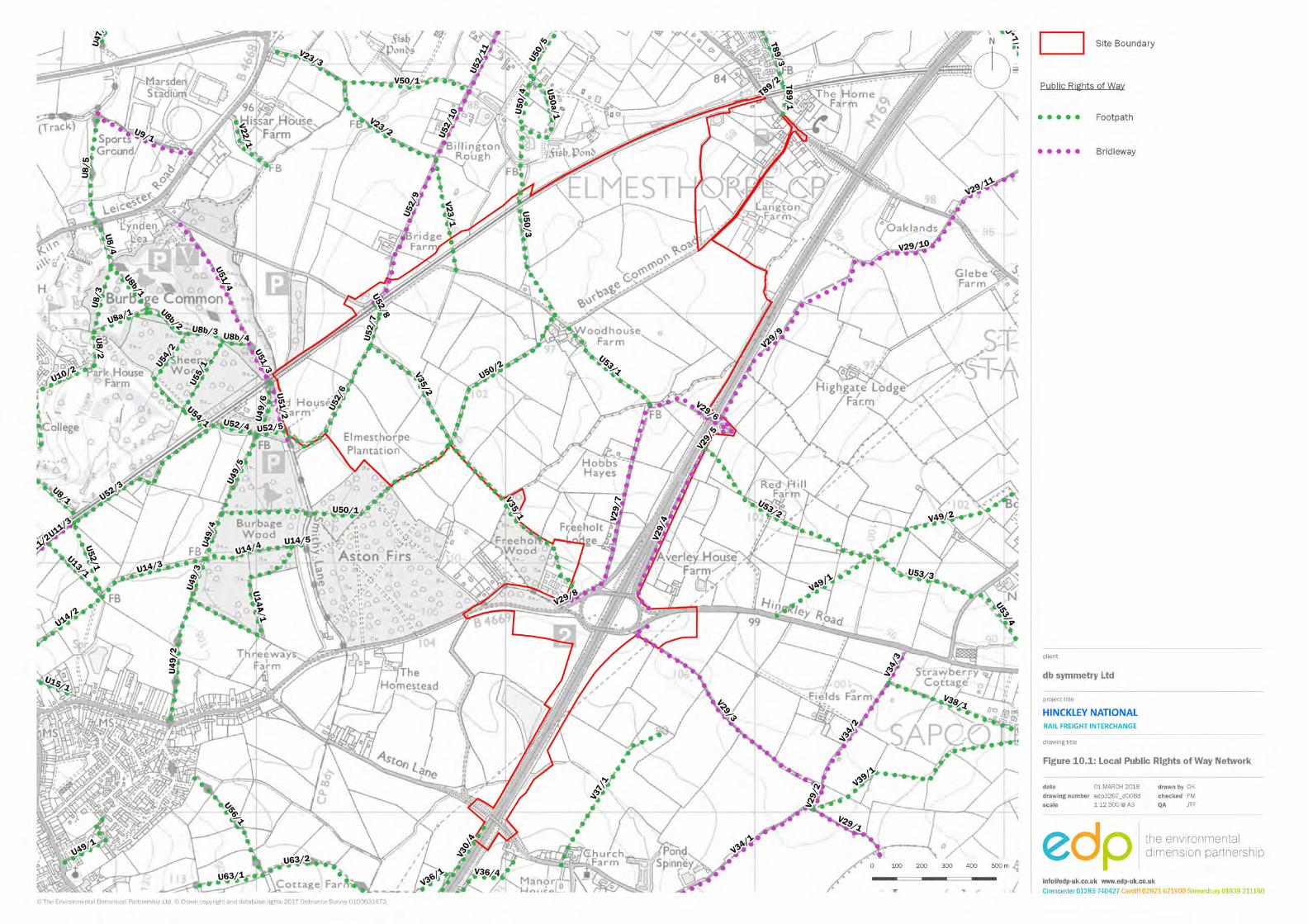

ENVIRONMENTAL IMPACT ASSESSMENT SCOPING REPORT DB SYMMETRY
112 HINCKLEY NATIONAL RAIL FREIGHT INTERCHANGE
(This page is intentionally blank)
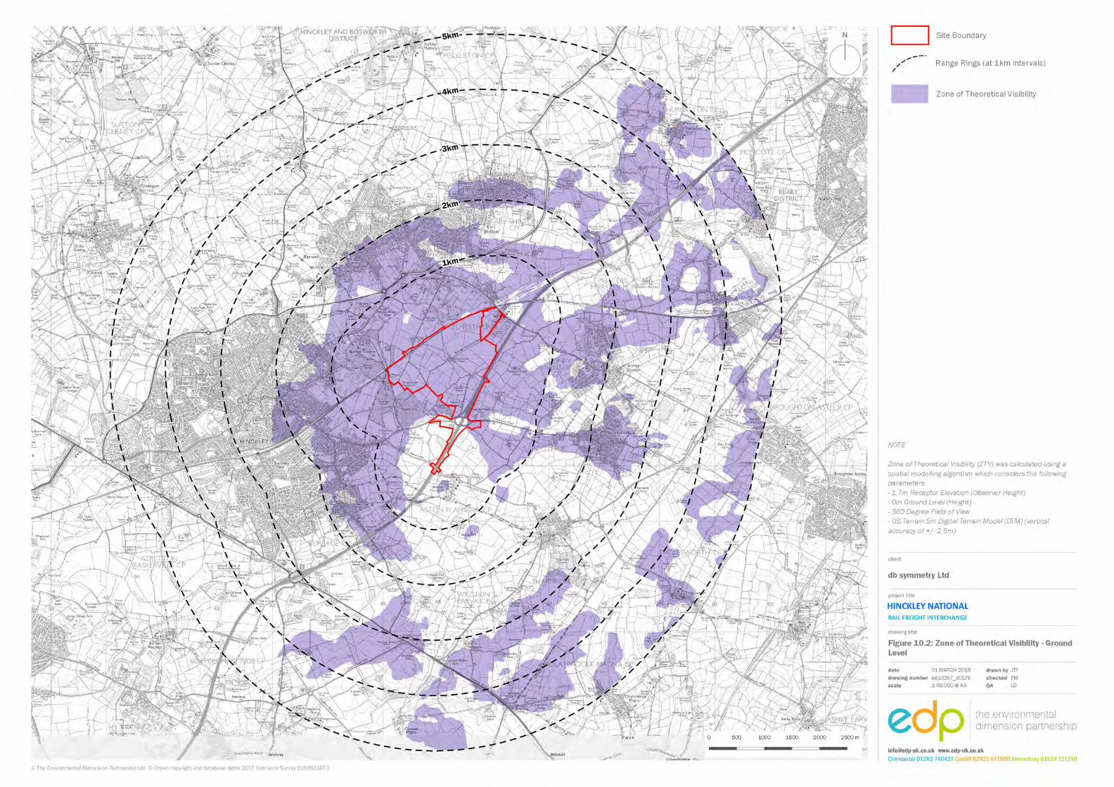

ENVIRONMENTAL IMPACT ASSESSMENT SCOPING REPORT DB SYMMETRY
114 HINCKLEY NATIONAL RAIL FREIGHT INTERCHANGE
(This page is intentionally blank)
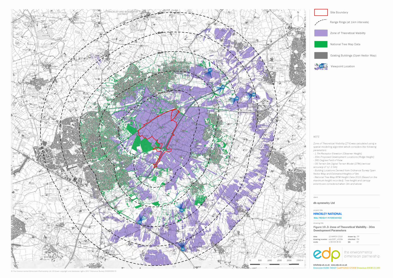
. . ., .... . .,,.��:.titlf,,: -@ill) -�=�Y!,o.
© The Environmental Dimension Partnership Ltd.© Crown copyright and database rights 2017 Ordnance Survey 0100031673
2500 m
.. ...
D Site Boundary
---,,,,
....
Range Rings (at 1km intervals)
= Zone of Theoretical Visibility
-National Tree Map Data
- Existing Buildings (Open Vector Map)
Viewpoint Location
NOTE
Zone of Theoretical Visibility (ZTV) was calculated using a spatial modelling algorithm which considers the following
parameters:
-1. 7m Receptor Elevation (Observer Height)
- 30m Proposed Development Locations (Ridge Height)
- 360 Degree Field of View
- OS Terrain 5m Digital Terrain Model (DTM) (vertical
accuracy of+/- 2 5m)
- Building Locations Derived from Ordnance Survey Open
Vector Map and Estimated Heights of 9m
- National Tree Map NTM Height Data 2015 (Based on the
maximum height recorded). Tree height and canopy
extents are considered when 3m and above
client
db symmetry Ltd
project title
HINCKLEY NATIONAL
RAIL FREIGHT INTERCHANGE
drawing title
Figure 10.3: Zone of Theoretical Visibility - 30m
Development Parameters
date 12 MARCH 2018
drawing number edp3267 _d028a
scale 1:48.000@ A3
edp
drawn by JTF
checked FM
QA GY
the environmental dimension partnership
[email protected] www.edp-uk.co.uk
Cirencester 01285 740427 Cardiff 02921 671900 Shrewsbury 01939 211190

ENVIRONMENTAL IMPACT ASSESSMENT SCOPING REPORT DB SYMMETRY
116 HINCKLEY NATIONAL RAIL FREIGHT INTERCHANGE
(This page is intentionally blank)
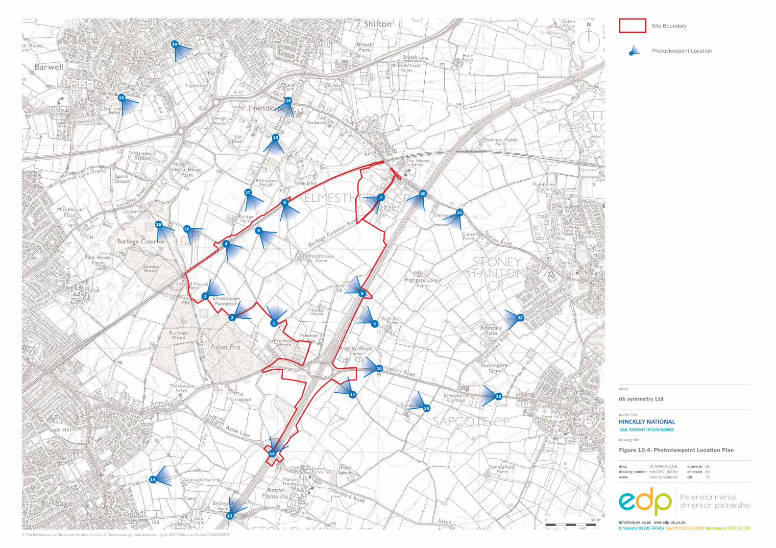
16
4
155
17
3
21
11
6
18
720
21
22
10
9
8
24
13
12
1925
26
14
23
Site Boundary
Photoviewpoint Location1
project title
drawing title
Figure 10.4: Photoviewpoint Location Plan
db symmetry Ltd
client
0 500m
datedrawing numberscale
LBFMJTF
drawn bycheckedQA
01 MARCH 2018 edp3267_d005eRefer to scale bar
© The Environmental Dimension Partnership Ltd. © Crown copyright and database rights 2017 Ordnance Survey 0100031673
[email protected] www.edp-uk.co.ukCirencester 01285 740427 Cardiff 02921 671900 Shrewsbury 01939 211190

ENVIRONMENTAL IMPACT ASSESSMENT SCOPING REPORT DB SYMMETRY
118 HINCKLEY NATIONAL RAIL FREIGHT INTERCHANGE
(This page is intentionally blank)
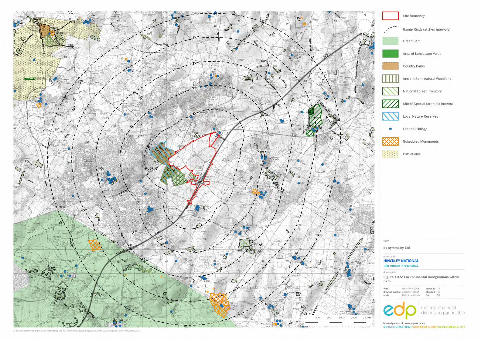

ENVIRONMENTAL IMPACT ASSESSMENT SCOPING REPORT DB SYMMETRY
120 HINCKLEY NATIONAL RAIL FREIGHT INTERCHANGE
(This page is intentionally blank)
DB SYMMETRY ENVIRONMENTAL IMPACT ASSESSMENT SCOPING REPORT
121 HINCKLEY NATIONAL RAIL FREIGHT INTERCHANGE
Eleven Ecology and biodiversity INTRODUCTION 11.1 The Ecology chapter of the ES will evaluate the likely significant effects of the proposed
development in terms of ecology and nature conservation. To do this, an ecological impact assessment (EcIA) will be undertaken based on the ecology baseline data gathered at the site over the course of 2016, 2017 and 2018. In addition EDP will consult with the Planning Inspectorate, Blaby District Council, Leicestershire County Council, local interest groups and Natural England on the scope of these surveys and recommended mitigation. Cumulative effects arising from the effect of the proposal in conjunction with other developments will also be considered.
BASELINE ASSESSMENT Legislative context 11.2 Animal and plant species that are considered to be threatened as a result of their rarity,
vulnerability or persecution are afforded protection through both European and UK law. The Conservation of Habitats and Species Regulations 2010 (commonly known as the Habitat Regulations) protects a number of rare and vulnerable animal and plant species listed for protection in Europe, whilst the Wildlife and Countryside Act 1981 (as amended by the Countryside and Rights of Way Act, 2000 and Natural Environment and Rural Communities Act 2006) affords protection to wild bird species requiring protection in Europe and other rare or vulnerable native species of animals and plants not protected under the Conservation of Habitats and Species Regulations 2010. In addition, the Animal Welfare Act 2006 further protects wild animals from unnecessary suffering when under the control of man and includes the Wild Mammals (Protection) Act 1996 which protects wild mammals from intentional cruelty and the Protection of Badgers Act 1992 which affords protection specifically to badgers.
11.3 The Habitat Regulations also protects European Sites including Special Protection Areas
(SPA), Special Areas of Conservation (SAC) and RAMSAR Sites which are recommended for designation by the Joint Nature Conservation Committee (JNCC). Sites of Special Scientific Interest (SSSIs) are of national importance, designated by Natural England (and predecessors) under the Wildlife and Countryside Act 1981 (as amended), and are also protected from any development that might destroy or adversely affect such sites, either directly or indirectly.
11.4 'Important' hedgerows are protected from removal (up-rooting or otherwise destroying)
by the Hedgerow Regulations 1997.
ENVIRONMENTAL IMPACT ASSESSMENT SCOPING REPORT DB SYMMETRY
122 HINCKLEY NATIONAL RAIL FREIGHT INTERCHANGE
National policy 11.5 The National Networks NPS sets out the guidance on how decisions will be made relating
to development consent orders for nationally significant infrastructure projects. The NPS strategic aims broadly mirrors those of the National Planning Policy Framework (NPPF). However, the NPS recognises that some developments will have some adverse local impacts on noise, emissions, landscape/visual amenity, biodiversity, cultural heritage and water resources. The significance of these effects and the effectiveness of mitigation is uncertain at the strategic and non-locationally specific level of this NPS. Therefore, whilst applicants should deliver developments in accordance with government policy and in an environmentally sensitive way, including considering opportunities to deliver environmental benefits, some adverse local effects of development might remain.
Local policy 11.6 Local ecology and biodiversity policy of relevance to the site are contained in:
• Blaby District Local Plan 1999 (saved policies 2007);
• Blaby District Core Strategy adopted February 2013;
• Draft Blaby District Local Plan 2029 11.7 Saved policies in the Blaby District Local Plan 1999 of relevance to ecology and biodiversity
in the current local plan include the following:
• CE19 – Other Nature Conservation Site Protection;
• CE21 – Existing Trees and Woodland. 11.8 Policies of relevance to ecology and biodiversity contained in the emerging Blaby District
Local Plan 2029 include Policy CS19 – Bio-diversity and geo-diversity. Baseline data collection 11.9 The baseline data collection has and will involve a desk study exercise, an extended Phase
1 habitat survey and detailed Phase 2 surveys for a range of protected species, undertaken during the appropriate survey seasons.
11.10 A desk study was undertaken in February 2016, with records of designated sites and notable/protected species sourced from the Leicestershire and Rutland Environmental Records Centre (LRERC). Additionally, a search of the Multi-Agency Geographic Information for the Countryside (MAGIC) website’s interactive map was also undertaken.
DB SYMMETRY ENVIRONMENTAL IMPACT ASSESSMENT SCOPING REPORT
123 HINCKLEY NATIONAL RAIL FREIGHT INTERCHANGE
11.11 The Phase 1 survey technique adopted was at a level intermediate between a standard
Phase 1 Survey (JNCC, 2010), based on habitat mapping and description, and Phase 2 surveys based on detailed habitat and species surveys. This survey technique is commonly known as an Extended Phase 1 Survey. This level of survey does not aim to compile a complete floral and faunal inventory for the study area.
11.12 The level of survey involves identifying and mapping the principal habitat types and
identifying the dominant plant species present in each principal habitat type. In addition, any actual or potential protected species or species of principal importance are identified and appropriate surveys scoped.
Baseline environment Desk study 11.13 The site is not covered by any national or international statutory nature conservation
designations. Ecological designations within and in the vicinity of the site are illustrated in figure 11.1 (Plan EDP3267/11a). Located to the west of the site is the Burbage Common and Woods Local Nature Reserve (LNR), much of which overlaps with the Burbage Wood and Aston Firs SSSI adjacent to the site’s western boundary. This SSSI is designated for its ash-oak-maple woodland, one of the best remaining examples in Leicestershire. Three additional SSSIs exist to the north-east of the site: • Croft Pasture (2.8km), an area of acidic mixed grassland;
• Croft and Huncote Quarry (3.1km), designated for geological reasons; and
• Croft Hill (3.2km), an area of tussocky acid grassland, the largest of its kind in
Leicestershire.
11.14 A single SAC exists within 15km of the site, namely Ensor’s Pond, located 11km to the south-west. It is designated for its large population (50,000 individuals) of white-clawed crayfish, which is isolated from other Midlands populations which have become infected by a fungal disease known as Aphanomyces astaci.
11.15 In terms of non-statutory designated sites, Leicestershire and Rutland use a system of Local Wildlife Sites (LWS), candidate Local Wildlife Sites (cLWS) and potential Local Wildlife Sites (pLWS). LWS are designated sites, cLWS are sites that meet the criteria of being a LWS but have not yet been designated, and pLWS are sites that might meet the criteria but have not yet been assessed.
11.16 Within 3km of the central grid reference of the site are thirteen LWS, of which three lie partly within the site (Burbage Common and Woods, Field Rose Hedgerow, Elmesthorpe Plantation Hedgerow); thirteen cLWS (none within the site), and sixty pLWS, of which seven are within the site (Freeholt Meadow, Castlewood Grassland, Burbage Common
ENVIRONMENTAL IMPACT ASSESSMENT SCOPING REPORT DB SYMMETRY
124 HINCKLEY NATIONAL RAIL FREIGHT INTERCHANGE
Road Hedgerows, Burbage Common Road Railway Bridge, Junction 2 Grassland, B4669 Road Verge and Elmsthorpe Boundary Hedgerows).
11.17 LRERC also provided a list of parish, district and county sites, which were designated as a result of a large scale habitat assessment in the late 1980s and early 1990s. This system has since been superseded by LWS, but many of the sites still hold biodiversity value. Six of these were found within the site; two parish level ponds, three parish level hedgerows (two of which also form one of the pLWS) and one district level hedgerow.
Phase 1 habitat survey 11.18 The habitats have been recorded during a walkover survey and an extended Phase 1
Habitat survey as illustrated in figure 11.2 (Plan EDP3267/09a). The survey was undertaken following the standard guidance for Phase 1 survey 5. The majority of the site consists of arable land that is cropped with winter wheat, barley, rape and grass ley. There are also some areas of improved grassland. These areas are intensively managed and hold relatively little ecological value.
11.19 Areas of habitat that hold greater ecological value within the site are the stream corridor, a number of ponds, semi-improved grassland and the hedgerows that surround the majority of the fields.
11.20 Overall the majority of the habitats present within the site are considered to be of low
ecological value but capable of supporting birds, badgers, bats, otter, water vole, amphibians and potentially reptiles.
Phase 2 Surveys 11.21 The site and its immediate surroundings are capable of supporting a number of protected
and notable species, for which detailed Phase 2 surveys would be required to inform the proposals and the application going forward. The precise scope of these detailed surveys would be determined with reference to current best practice guidelines and standard methodologies 6,7,8,9,10,11, and through consultation with Natural England and the relevant
5 Joint Nature Conservation Council (2010) Handbook for Phase 1 Habitat Survey – A Technique for
Environmental Audit (reprinted with minor corrections for original Nature Conservancy Council publication). 6 Bibby, C.J., Burgess, N.D. et Hill, D.A. (2000): Bird Census Techniques. Academic Press, London, 2nd edition 7 Chanin, P. & Smith, G. 2003. Monitoring the Otter Lutra lutra. Conserving Natura 2000 Rivers Monitoring Series
No 10. Peterborough, English Nature 8 Strachan, R., Moorhouse, T. and Gelling, M. (2011). Water Vole Conservation Handbook (3rd edition). Wildlife
Conservation Research Unit, University of Oxford 9 Oldham R.S., Keeble J., Swan M.J.S. & Jeffcote M. (2000).Evaluating the suitability of habitat for the Great
Crested Newt (Triturus cristatus). Herpetological Journal 10 (4), 143-155. 10 Froglife (1999) Reptile survey: an introduction to planning, conducting and interpreting surveys for snake and
lizard conservation. Froglife Advice Sheet 10, Froglife, Halesworth; DMRB (2005) Nature conservation advice in relation to reptiles and roads. Volume 10, Section 4, Part 7, HA/116/05. DMRB
11 Collins, J. (ed.) (2016). Bat Surveys: for Professional Ecologists: Good Practice Guidelines (3rd edition). The Bat Conservation Trust, London
DB SYMMETRY ENVIRONMENTAL IMPACT ASSESSMENT SCOPING REPORT
125 HINCKLEY NATIONAL RAIL FREIGHT INTERCHANGE
local authority. These include the following. • Bat roosting - the data search identified a large number of unspecified and maternity
roost sites within 3 km of the central grid reference, with the closest being a common pipistrelle roost site located approximately 200m to the south of the site. No Annex II bat records were found within the 6 km search zone. Existing buildings and mature trees on the site have the potential to support roosting bats. All buildings and suitable trees to be affected by the proposals will be assessed for their potential to support roosting bats by a suitably qualified and licenced bat ecologist. Following these surveys, further surveys may be required to determine the presence or absence of bat roosts within these features.
• Bat activity - some of the habitats on site, including the hedgerows, semi-improved grassland and woodland edges, are likely to support foraging and commuting bats and the nearby ancient woodland is likely to act as a source of foraging and commuting bats. However, the majority of the site, being intensively managed arable and pastoral farmland, is unlikely to be of significant value, especially considering the proximity to the M69 motorway. On balance, the site represents a medium quality resource for foraging and commuting bats and it is considered that a moderate level of survey effort would be sufficient, subject to consultation with the LPA.
• Badger - there are a large number of records for badger in the surrounding area, and it is very likely that they are present in the large extent of woodland to the south-west of the site and its surrounding area. Evidence of badger activity within the site was recorded during the initial site walkover and Phase 1 habitat survey, in the form of tracks, snuffle holes and latrines. No badger setts were recorded but further surveys would be required to search for their presence within the site. Further specific surveys will be conducted to search for evidence of badger activity.
• Water vole and otter - records of water vole were returned from LRERC within ponds, ditches and streams to the north and north-west of the site. Given the number of ponds within the site and the stream corridors, further surveys are considered necessary. Surveys would involve up to two surveys (depending on whether presence is confirmed during the first) at least two months apart during the water vole breeding season of April to September.
• Dormouse - no records of dormouse were returned within the search radius, and only one historic record exists on the NBN gateway, 9km from the site. However, there is suitable habitat within and bordering the site, including large blocks of ancient woodland, and the hedgerow network is well connected. For this reason, the local authority’s ecologist will be consulted with regard to dormouse surveys within suitable habitat.
• Reptiles - there are a small number of records within the local area of grass snake, including one record within an arable field margin to the north of the site, as well as a single (recent) record of adder. As the site supports some habitat suitable for both of
ENVIRONMENTAL IMPACT ASSESSMENT SCOPING REPORT DB SYMMETRY
126 HINCKLEY NATIONAL RAIL FREIGHT INTERCHANGE
these species, including the areas of rough grass along the site boundaries/hedgerows and pond margins, surveys to determine the use of the site by reptile species would be required. This would entail the deployment of artificial ‘refugia’ (squares of roofing felt) within suitable habitat on site and seven visits across the season, ideally within the optimum months of April, May and September.
• Great crested newts - records of great crested newts were returned for the areas north, west and south of the site boundaries. There are a number of ponds and wetland habitats located within or in close proximity to the site that might support breeding amphibians. Some of the on-site ponds were surveyed in 2017 through the use of environmental DNA testing (eDNA), which did not record the presence of great crested newts. Further surveys of those water bodies not currently surveyed will be undertaken to establish the presence or absence of newts from the ponds and establish populations of newts if present. These surveys would be undertaken between mid-March and mid- June, including some in the peak season between mid-April and mid-May.
• Wintering birds - there are records from the surrounding area of wintering skylark,
yellowhammer, linnet and lapwing, including some from within the site. During the initial walkover and Phase 1 survey a number of incidental records of birds were recorded within the site including linnet, yellowhammer, skylark, song thrush and house sparrow. It is therefore considered that wintering bird surveys will be required of the site, with three visits between November and March. This will be confirmed through consultation with PINS and the local authority ecologist.
• Breeding birds - a large number of records for protected and notable bird species were returned as part of the desk study as present within the locality (see Appendix EDP 3), including regular records of Schedule 1 species such as barn owl, hobby and peregrine. There are also large numbers of notable records of farmland species, such as yellow wagtail, lapwing, skylark, linnet, lesser redpoll, grey partridge and yellowhammer. A breeding bird survey of the site will be undertaken at the site with three visits made between April and July. Specific surveys would also be undertaken for the presence of nesting barn owl within buildings and mature trees.
• Botanical survey - some of the areas of grassland within the site will require further survey to assess their full value. These surveys will be undertaken at an appropriate time of year, preferably in the period between May and early July.
• Hedgerow survey - some of the hedgerows on the site would be regarded as species rich and possibly important. Therefore, it will be necessary to undertake further surveys of some of the hedgerows to fully evaluate their level of importance. This will be undertaken between April and July.
11.22 It is considered that given the extent and quality of habitats present on site, in addition to
a review of local species records and the Phase 1 Survey results, targeted surveys for invertebrates can be scoped out. However, an invertebrate habitat suitability survey is
DB SYMMETRY ENVIRONMENTAL IMPACT ASSESSMENT SCOPING REPORT
127 HINCKLEY NATIONAL RAIL FREIGHT INTERCHANGE
proposed in April/ May 2018 to establish if further more specialised surveys would be required.
POTENTIAL ENVIRONMENTAL EFFECTS 11.23 Without mitigation, development would result in the loss of habitats and/or
direct/indirect disturbance to species supported by habitats on and off site. Possible beneficial effects include those arising from landscaping, habitat management and enhancements and other green infrastructure links within the proposed development.
Construction 11.24 During this phase, the without mitigation impacts and effects on ecology would result from
habitat loss and direct and indirect disturbance/harm to species.
11.25 Direct impacts would involve the loss of habitats, loss of refuge for species, physical harm from construction process and vehicles and potential pollution/contamination events from chemicals and materials used.
11.26 Indirect impacts would potentially involve increased lighting during construction affecting foraging and commuting nocturnal species, noise disturbance, vibration disturbance and potential off site effects from pollution/contamination such as contaminated run-off into hydrological systems and dust deposition on off-site habitats.
Operational 11.27 Operational effects without mitigation include the potential disturbance to habitats and
species from increased recreational pressure within the site. This can result in damage to habitats through trampling and disturbance to species in retained habitats through physical presence.
11.28 Other impacts include increased lighting, noise and traffic that will adversely affect the foraging and commuting resources within the retained and created habitats. It also increases the potential of road traffic collisions with species.
11.29 There is the potential of positive impacts during the operational phase through the
provision of habitats of greater biodiversity than those currently present on the site and the implementation of appropriate management of the retained and created habitats to maximise their biodiversity potential.
PROPOSED SCOPE OF THE ASSESSMENT 11.30 The assessment will follow the methodology provided in the Guidance for Ecological
Impact Assessment (CIEEM, 2016). Existing data held by the Environmental Record Centre,
ENVIRONMENTAL IMPACT ASSESSMENT SCOPING REPORT DB SYMMETRY
128 HINCKLEY NATIONAL RAIL FREIGHT INTERCHANGE
Natural England and the Environment Agency will be examined. The results of the Phase 1 habitat survey have been used to identify any protected species surveys required. Findings from the ecological assessment will inform the master planning and mitigation strategy. Should any significant effects remain after mitigation/enhancement, these will be considered against legislation and policy.
Geographical scope 11.31 CIEEM guidelines require ecological receptors to be valued (or to have the potential to be
valued) according to a geographical scale. Assigned ecological values are based purely on the innate biodiversity value of the flora, fauna and habitats in terms of the conservation of genetic resources and do not take account of their amenity or economic values.
Temporal scope 11.32 CIEEM guidelines aim to establish a standard in the assessment of the effects of potential
development on wildlife receptors, which is then informed by the interpretation of contextual information and professional judgment. The assessment of significance is based on a number of features including the value and sensitivity of the receptor; the magnitude or size of the effect; the frequency of the effect and whether it is permanent or temporary and the likelihood of it actually occurring.
11.33 Assessment of potential ecological effects resulting from the development proposals is based on predicting ecologically significant changes to the baseline conditions that are likely to occur as a result of the development. An impact is significant or not based upon its effect on the 'integrity' of a nature conservation site or 'conservation status' of habitats and species.
11.34 CIEEM guidance requires that impacts be assessed with and without mitigation. However,
there are a range of standard working practices and avoidance measures (in relation to ecology) that are used during construction phases to avoid statutory offences. These will be set out within a draft Ecological Construction Method Statement (ECMS) to be secured through a DCO Requirement. In addition, a number of measures will be 'designed in' to the scheme as part of the iterative assessment process to avoid or minimise impacts on ecological features. As it is certain these ‘embedded’ mitigation measures will be applied to the development, pre-mitigation impacts are assessed on the basis these measures would be applied.
11.35 The assessment will also report the residual effects of the development following
mitigation. SUMMARY 11.36 The site is not covered by any statutory designated sites for nature conservation and
although there are some nationally designated sites within the potential zone of influence,
DB SYMMETRY ENVIRONMENTAL IMPACT ASSESSMENT SCOPING REPORT
129 HINCKLEY NATIONAL RAIL FREIGHT INTERCHANGE
these will be fully considered and appropriately safeguarded during the design process.
11.37 There are a number of non-statutory designated sites that are within and adjacent to the site that will be carefully considered in the assessment and appropriate avoidance, enhancement or mitigation provided to ensure no residual impacts from the scheme.
11.38 There is the potential for loss and damage of protected or important habitats and species
as a result of the proposals that will be fully assessed as part of the EcIA. These will be avoided or mitigated through the design process to ensure that the proposals fully comply with legislation and both national and local planning policy requirements.
11.39 Opportunities exist to improve and enhance the structure of the ecological network within
the area, which has been partially degraded and fragmented with the intensification of agricultural practices. A strong framework of green infrastructure across the site would be required as mitigation and enhancement with hedgerow and woodland planting and connectivity to the habitats beyond the site.

ENVIRONMENTAL IMPACT ASSESSMENT SCOPING REPORT DB SYMMETRY
130 HINCKLEY NATIONAL RAIL FREIGHT INTERCHANGE
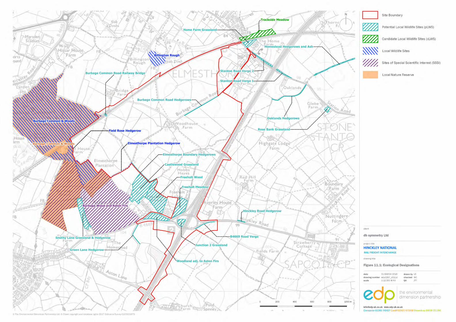

ENVIRONMENTAL IMPACT ASSESSMENT SCOPING REPORT DB SYMMETRY
132 HINCKLEY NATIONAL RAIL FREIGHT INTERCHANGE
(This page is intentionally blank)
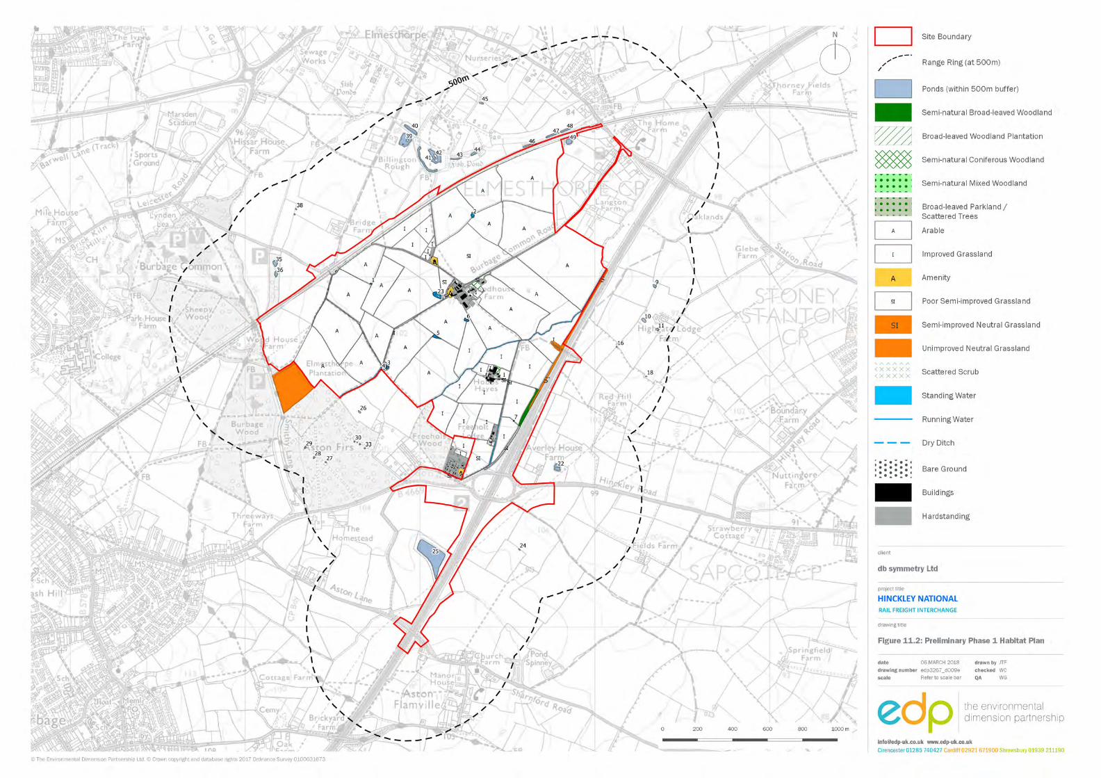

ENVIRONMENTAL IMPACT ASSESSMENT SCOPING REPORT DB SYMMETRY
134 HINCKLEY NATIONAL RAIL FREIGHT INTERCHANGE
(This page is intentionally blank)
DB SYMMETRY ENVIRONMENTAL IMPACT ASSESSMENT SCOPING REPORT
135 HINCKLEY NATIONAL RAIL FREIGHT INTERCHANGE
Twelve Cultural heritage INTRODUCTION 12.1 The assessment for the site will evaluate the known and potential archaeological and
heritage resource within the site and an appropriate wider study area. This will be placed in the local regional and national context and assessed against national criteria.
BASELINE ASSESSMENT 12.2 The baseline assessment to inform the ES has commenced. The cultural heritage
assessment will be informed by an appropriate level of baseline assessment , in line with the historic environment policy in paragraphs 5.120-5.142 of the National Networks NPS, including an archaeological and heritage assessment, a setting assessment and appropriate programme of investigative fieldwork that may include geophysical survey and trial trenching, as agreed with relevant consultees.
12.3 Known heritage assets within the site and the local area are illustrated in figure 12.1.
Designated heritage assets
12.4 The preliminary baseline assessment has established that there are no designated heritage assets, such as scheduled monuments, listed buildings or registered parks and gardens within the site.
12.5 Within approximately 2 km of the site are several groups of listed buildings located within the settlements of Stoney Stanton to the east (including the Grade II* listed Church of St Michael) and Elmesthorpe to the north (including the Grade II listed Church of St Mary). Two scheduled monuments are located within 2 km of the site, comprising a ruined church at Elmesthorpe and Sapcote Castle and Moat, on the west edge of Sapcote, south-east of the site. The north edge of the Aston Flamville conservation area is also located to the south of the site.
12.6 In general terms, the majority of the designated heritage assets in the wider area comprise listed buildings clustered in the historic cores of the settlements surrounding the site. Several listed buildings, including the Church of All Saints, are located in Sapcote to the south east; Aston Flamville to the south; and a number of listed buildings, including the Grade II* listed Church of St Catherine are located in Burbage to the south-west. The Grade I listed Church of St Mary is located on the southern edge of Barwell, north west of the site.
12.7 A preliminary assessment indicates that, in the overwhelming majority of cases, the
ENVIRONMENTAL IMPACT ASSESSMENT SCOPING REPORT DB SYMMETRY
136 HINCKLEY NATIONAL RAIL FREIGHT INTERCHANGE
positions of the listed buildings and conservation areas within the wider area, in relation to their surrounding settlements and the prevailing topography, are such that the site does not form part of their settings. However, there are a number of listed churches in the surrounding settlements that, by virtue of their location on local high points with views outwards in the direction of the site, or through the prominence of their towers or spires in the local landscape, are experienced in combination with the land within the site.
Non-designated heritage assets 12.8 There are relatively few non-designated heritage assets or archaeological events recorded
within the site by the Leicestershire Historic Environment Record (HER).
12.9 A single archaeological event is recorded on the western edge of the site (ELE8716) and relates to a desk-based assessment in advance of a construction of a sewer. No features of apparent interest were recorded on the site during the course of the assessment.
12.10 The remaining HER entries relate to an undated cropmark of a possible ditch (MLE68) recorded in the northern portion of the site and a late 19th century barn (MLE20555) at Hobbs Hayes farm in the southern part of the site.
12.11 Two fields containing ridge and furrow earthworks, deriving from medieval agricultural practice, were also identified during the course of a preliminary site walkover.
12.12 Historic mapping indicates that the extant farmsteads within the site were established variously in the 19th or early 20th centuries.
12.13 Historic Landscape Characterisation (HLC) data provided by the HER indicate that the fields within the site are predominantly characterised as reorganised piecemeal enclosure or planned enclosure originating in the late post-medieval period.
12.14 None of the archaeological or landscape features identified within the site to date by the HER and site walkover is considered to represent an ‘in-principle’ constraint to development.
12.15 The surrounding area has produced evidence for archaeological activity dating from the
early prehistoric period through to the medieval period, although this is predominantly evidenced by records relating to chance finds of artefacts rather than conclusive evidence of settlement.
12.16 The scarcity of archaeological information for the site is likely to be reflective of a lack of
systematic investigation in the wider area, rather than the actual absence of archaeological remains. The limited evidence for archaeological activity in the wider area, coupled with the extensive size of the site, suggests that inevitably there is some potential for it to contain hitherto unidentified buried archaeological remains relating to the prehistoric, Roman and later periods. However, based on the current evidence, any such remains are likely to be heavily compromised by later agricultural activity.
DB SYMMETRY ENVIRONMENTAL IMPACT ASSESSMENT SCOPING REPORT
137 HINCKLEY NATIONAL RAIL FREIGHT INTERCHANGE
12.17 Further assessment will be required to better understand the nature, presence and extent
of any buried features that might survive within the site through an appropriate programme of investigative fieldwork, although, on the basis of the current evidence, any such remains are unlikely to be of sufficient importance or extent, or survive to a level, which would warrant preservation in situ.
Assessment methodology 12.18 Tables 12.1, 12.2 and 12.3 (below) set out the criteria that will be employed in attributing
‘sensitivity’ to archaeological and heritage assets, identifying the magnitude of any changes to them (i.e. the impact) and assessing the significance of the resulting effects in EIA terms.
12.19 The sensitivity of the heritage assets identified will be assessed on the basis of table 12.1.
The magnitude and significance of potential effects on archaeological remains and built heritage resources, arising from the implementation of the proposed development, will be identified and appropriately assessed, based on tables 12.2 and 12.3.
12.20 The significance of effect is assessed with reference to the heritage asset’s sensitivity and
the magnitude of impact. The criteria in Table 12.1 are based on criteria established by the Highways Agency in its Design Manual for Roads and Bridges (HA 2007). This is an industry standard assessment methodology, and the only one adopted by a government agency. The attribution of the sensitivity will rely upon professional judgement.
12.21 The classification of the magnitude of change on heritage assets is rigorous and based on
consistent criteria. This will take account of such factors as the physical scale and type of disturbance to them and whether features or evidence would be lost that are fundamental to their historic character, integrity and therefore significance. The magnitude of change will be assessed using the criteria in Table 12.2.
ENVIRONMENTAL IMPACT ASSESSMENT SCOPING REPORT DB SYMMETRY
138 HINCKLEY NATIONAL RAIL FREIGHT INTERCHANGE
Table 12.1: Sensitivity of cultural heritage receptors
Receptor Sensitivity of receptor
Very High High Medium Low Negligible
World Heritage Site
Scheduled Monument
Grade I or II* listed building
Grade I or II* registered park or garden
Other nationally important archaeological asset
Grade II listed building
Grade II registered park or garden
Conservation area
Other asset of regional or county importance
Locally important asset with cultural or educational value
Heritage site or feature with no significant value or interest
Table 12.2: Cultural heritage assessment - magnitude of change
Magnitude of Change
Large Medium Small Negligible None Change to the significance of a heritage asset so that it is completely altered or destroyed
Change to the significance of a heritage asset so that it is significantly modified
Change to the significance of a heritage asset so that it is noticeably different
Change to the significance of a heritage asset that hardly affects it
No change to the significance of an asset
12.22 Following the evaluation of sensitivity for specific archaeology and cultural heritage receptors and the magnitude of impact, the significance of effect will be assessed using the criteria shown in table 12.3 below.
DB SYMMETRY ENVIRONMENTAL IMPACT ASSESSMENT SCOPING REPORT
139 HINCKLEY NATIONAL RAIL FREIGHT INTERCHANGE
Table 12.3: Cultural heritage assessment - significance matrix
Magnitude of Change
Sensitivity of receptor
Very High High Medium Low Negligible
Large Severe Major Moderate Moderate or Minor Minor
Medium Major Major or Moderate
Moderate or Minor Minor Negligible
Small Moderate Moderate or Minor Minor Negligible Neutral
Negligible Moderate or Minor Minor Negligible Neutral Neutral
None Neutral Neutral Neutral Neutral Neutral
12.23 The assessment matrix defined in table 12.3 is not intended to be ‘prescriptive’, but rather
it allows for the employment of professional judgement to determine the most appropriate level of effect for each heritage asset that is identified.
12.24 Effects will be categorised with regard to their nature (adverse, beneficial or neutral) and
their permanence (permanent, temporary or reversible). For all forms of heritage asset (receptor); including archaeological sites and remains; historic buildings, places and areas; and historic landscapes; the sensitivity of the receptor will be combined with the predicted magnitude of change to heritage significance to arrive at the significance of effect in EIA terms.
12.25 The combination of sensitivity and magnitude of change is undertaken with reference to
the matrix in table 12.3, with those effects defined as severe or major being deemed ‘significant’. All other effects are determined to be ‘not significant’ in EIA terms.
POTENTIAL ENVIRONMENTAL EFFECTS 12.26 The cultural heritage assessment has already commenced and has examined the known
historic environment baseline conditions within the site and its broader context. The assessment process will involve ongoing analysis of the likely cultural heritage effects as the evidence base expands and the development proposals evolve. Where impacts cannot be avoided through design, additional mitigation measures will be recommended.
12.27 In accordance with paragraph 5.127 of the National Networks NPS and other best-practice
guidance (see below), the assessment will identify the heritage significance of assets and assess the impact of the development on that significance. Impacts are not harmful unless they adversely affect a heritage asset’s significance.
ENVIRONMENTAL IMPACT ASSESSMENT SCOPING REPORT DB SYMMETRY
140 HINCKLEY NATIONAL RAIL FREIGHT INTERCHANGE
12.28 Archaeological resources are susceptible to a range of impacts during development. These relate to works associated with site preparation as well as construction related activities, including:
• demolition and site clearance activities that disturb archaeological remains; • excavation that extends into archaeological sequences, for example deep foundations
or basements resulting in the removal of the resource; • piling activities resulting in disturbance and fragmentation of the archaeological
resource; • dewatering activities resulting in desiccation of waterlogged remains and deposits.
12.29 The implications, if any, of these actions will be considered and significance criteria allocated to any identified impact.
12.30 In terms of the effects on cultural heritage, the effects of the development can be direct, such as loss or damage to a heritage feature, or indirect, including the effect resulting from change to the setting of a listed building or scheduled monument for example. This component of the assessment will be cross-referenced with the landscape and visual assessment. Any such impacts will be discussed and significance criteria applied.
12.31 Once impacts have been identified, means by which they can be avoided through design
will be explored as a priority. If impacts cannot be avoided through design then alternative strategies, which might include site investigation and recording, will be proposed. The residual impacts following the implementation of these measures will then be defined and significance criteria applied.
12.32 An appropriate archaeological mitigation strategy will be implemented to offset the
potential effects associated with the form of development proposed. PROPOSED SCOPE OF THE ASSESSMENT 12.33 The first stage of the assessment is to verify the baseline conditions of the site and
surrounding area. The proposed scope of works includes an archaeological and heritage assessment of the historic environment at and around the site, informed by an appropriate programme of investigative fieldwork, including geophysical surveys and / or trial trenching. as agreed with relevant consultees.
12.34 The aim of the assessment work will be to identify, as far as is reasonably possible, the nature of the archaeological and cultural heritage resource within the study area, to assess significance and to make appropriate recommendations for the future treatment of any remains which may be affected.
DB SYMMETRY ENVIRONMENTAL IMPACT ASSESSMENT SCOPING REPORT
141 HINCKLEY NATIONAL RAIL FREIGHT INTERCHANGE
12.35 A robust and proportionate setting assessment will be undertaken for all designated
heritage assets within an appropriate radius of the site, in addition to any assets beyond this study area that may be found to be potentially sensitive to the development proposals.
12.36 The study area for the assessment of setting effects will be informed by landscape and visual considerations. At this initial stage, a study area of 2 km measured from the boundaries of the site is considered appropriate to assess the potential for impacts on designated heritage assets through changes to their settings. Additional assets beyond this study area will be assessed as appropriate.
12.37 Nonetheless, the assessment will take into account the understanding that the ability to
see a proposed development from or in combination with a heritage asset does not necessarily equate to an effect upon that heritage asset. It is a question of whether such intervisibility contributes to significance.
12.38 A 1 km radius study area from the boundaries of the site is considered appropriate to
inform the baseline assessment of the site’s archaeological potential, in terms of non-designated heritage assets.
12.39 In addition to field visits and consultation with relevant officers and stakeholders, consultation with the following resources will be undertaken:
• Leicestershire Historic Environment Record.
• The relevant local history centre/ record office and other local repositories.
• The National Heritage List for England.
• Historic Ordnance Survey mapping.
• Historic aerial photography.
• Archaeological Data Service Online Catalogue.
• Previous desk-based assessments, EIAs or fieldwork reports prepared for other sites
in the vicinity.
12.40 The assessment will thereafter identify and evaluate the nature and likelihood of the impacts of the development, in both the long and short term, on the identified archaeological and cultural heritage features against clearly defined criteria. Significance will be assigned to impacts relative to the sensitivity of the resource and the magnitude of impact in accordance with best practice.
ENVIRONMENTAL IMPACT ASSESSMENT SCOPING REPORT DB SYMMETRY
142 HINCKLEY NATIONAL RAIL FREIGHT INTERCHANGE
12.41 The baseline assessment process will give due regard to industry best practice guidance
produced by the Chartered Institute for Archaeologists and relevant Historic England guidance, including Historic Environment Good Practice Advice in Planning, Note 3, The Setting of Heritage Assets (HE 2015).
12.42 The EIA assessment for archaeology and cultural heritage will be prepared with reference
to guidance set out in the Highways Agency Design Manual for Roads and Bridges, Vol.11, Section 3, Part 2. This is an industry standard assessment methodology, and the only one adopted by a Government agency.
SUMMARY 12.43 The site does not contain any designated heritage assets and there are no ‘in-principle’
constraints to its development in heritage terms. Therefore, the development proposals are capable of being designed and developed in accordance with national and local historic environment planning policy.
12.44 The development proposals have the potential to impact on known, and hitherto unidentified, non-designated heritage assets within the site.
12.45 More widely, there is the potential for impacts on designated heritage assets beyond the site through changes to their settings.
12.46 The assessment will identify and evaluate the nature and likelihood of the impacts of the development, in both the long and short term, on the identified archaeological and cultural heritage features against clearly defined criteria. Significance will be assigned to impacts relative to the sensitivity of the resource and the magnitude of impact in accordance with best practice.
12.47 An appropriate archaeological mitigation strategy will be implemented to offset any potential effects associated with the proposed development.
12.48 At this stage, there is no indication that the implementation of development of the form
proposed would result in any significant effects, in EIA terms, on cultural heritage receptors.
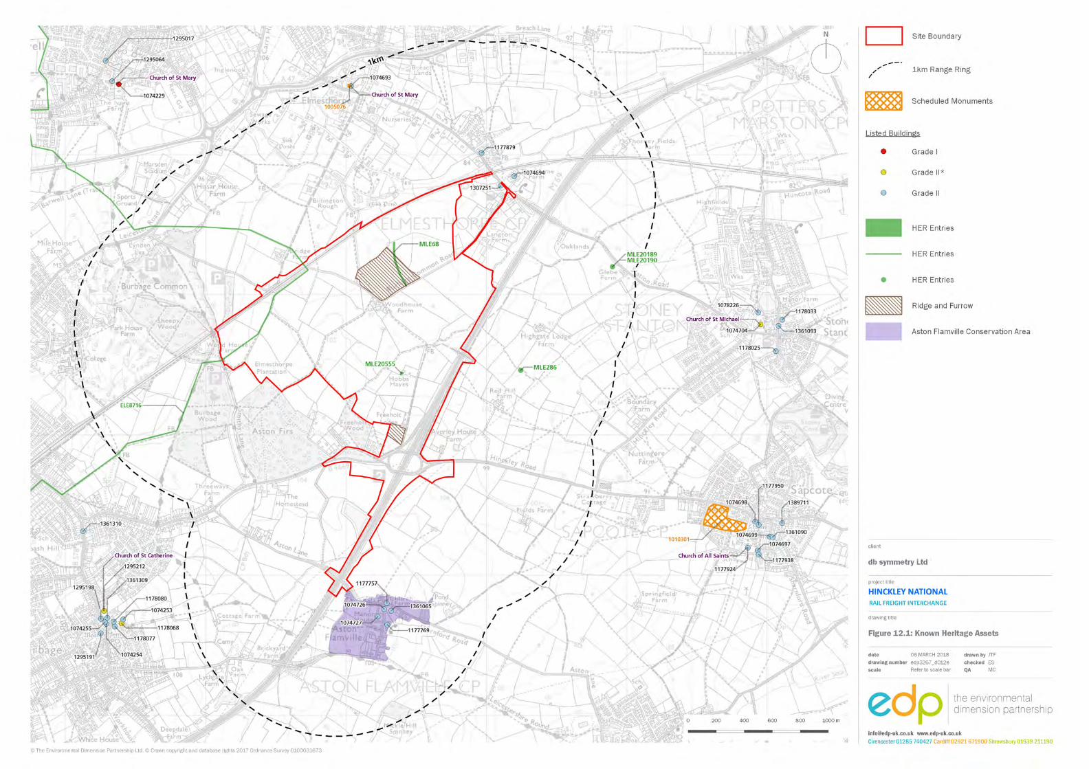

ENVIRONMENTAL IMPACT ASSESSMENT SCOPING REPORT DB SYMMETRY
144 HINCKLEY NATIONAL RAIL FREIGHT INTERCHANGE
(This page is intentionally blank)
DB SYMMETRY ENVIRONMENTAL IMPACT ASSESSMENT SCOPING REPORT
145 HINCKLEY NATIONAL RAIL FREIGHT INTERCHANGE
Thirteen Surface water and flood risk INTRODUCTION 13.1 An assessment will be undertaken of the likely significant effects of the proposed
development on the environment with respect to surface water and flood risk. 13.2 The assessment will be supported and informed through consultations with various
stakeholders, including the Environment Agency, Leicestershire County Council (in its role as Lead Local Flood Authority), and Severn Trent Water. Reference will also be made to relevant national and local surface water / flood risk planning and legislative policy.
13.3 A standalone Flood Risk Assessment report will also be prepared, which will include a
proposed Surface and Foul Water Drainage Strategy. This will form an appendix to the ES. BASELINE ASSESSMENT Hydrology 13.4 An unnamed stream flows north-eastwards through the southern portion of the site. A
number of field drainage ditches and small ponds are also present within the site. These discharge into a tributary of the Thurlaston Brook to the north-east of the site, which in turn discharges to the River Soar.
Flood risk 13.5 The Environment Agency’s Flood Zone map (figure 13.1, overleaf) shows the majority of
the site to be in Flood Zone 1 (defined as land having a less than 1 in 1,000 annual probability of fluvial or tidal flooding). However, a small portion of the site adjacent to the northern boundary is shown to be in Flood Zone 2 (defined as land having between a 1 in 100 and 1 in 1,000 annual probability of fluvial flooding, or between a 1 in 200 and 1 in 1,000 annual probability of tidal flooding), associated with the tributary of the Thurlaston Brook.
13.6 The Environment Agency’s Flood Risk from Surface Water map also shows various areas
of the site to be at ‘low’, ‘medium’ and ‘high’ risk of surface water flooding respectively. Areas indicated to be at potential risk of surface water flooding generally correlate with the location of existing surface water bodies, and is considered a more realistic indication of potential flood risk within the site, compared with the Environment Agency’s Flood Zone map, given that this mapping does not take account of watercourses with a catchment area of less than 3 km2, which is likely the case with the on-site watercourses in this situation. In accordance with paragraph 5.92 of the National Networks NPS, the
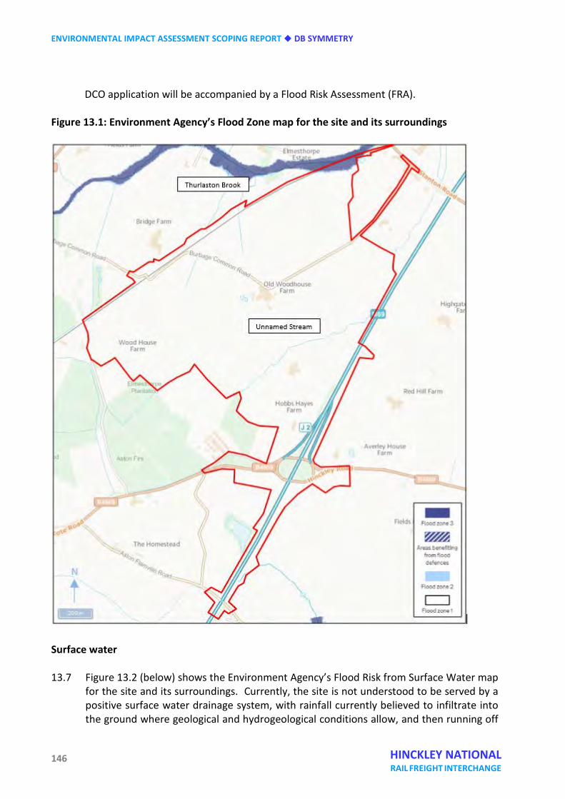
ENVIRONMENTAL IMPACT ASSESSMENT SCOPING REPORT DB SYMMETRY
146 HINCKLEY NATIONAL RAIL FREIGHT INTERCHANGE
DCO application will be accompanied by a Flood Risk Assessment (FRA). Figure 13.1: Environment Agency’s Flood Zone map for the site and its surroundings
Surface water 13.7 Figure 13.2 (below) shows the Environment Agency’s Flood Risk from Surface Water map
for the site and its surroundings. Currently, the site is not understood to be served by a positive surface water drainage system, with rainfall currently believed to infiltrate into the ground where geological and hydrogeological conditions allow, and then running off
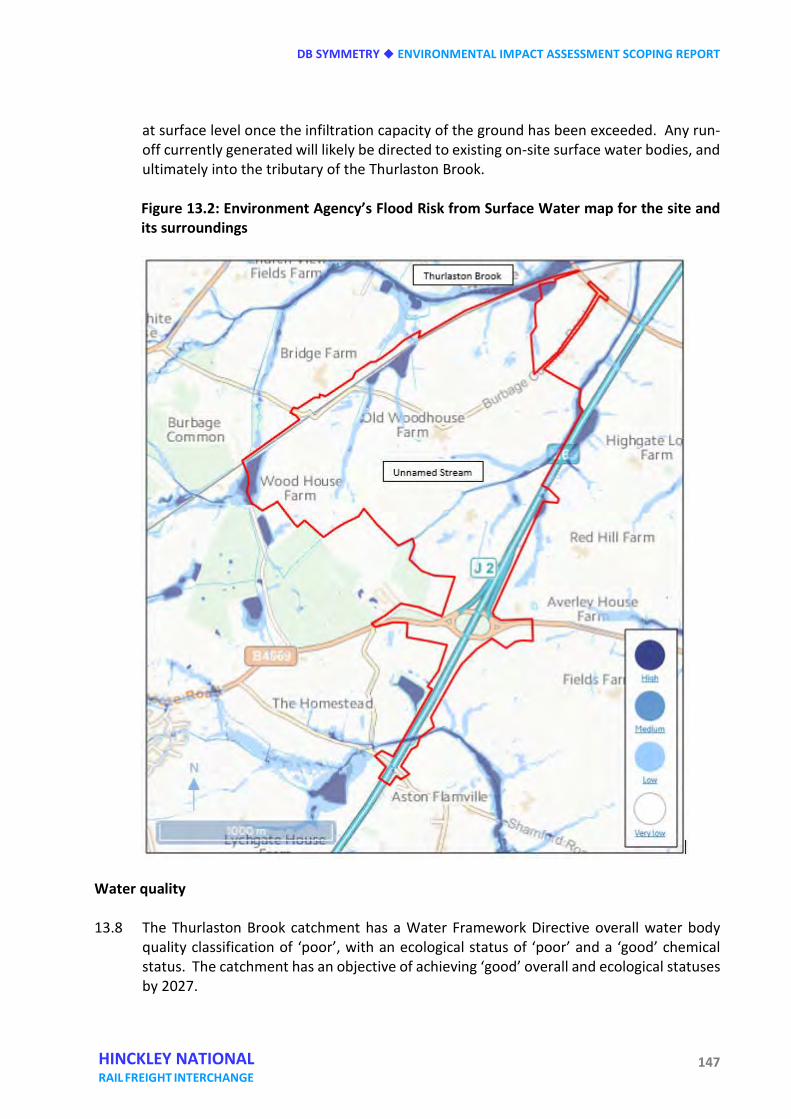
DB SYMMETRY ENVIRONMENTAL IMPACT ASSESSMENT SCOPING REPORT
147 HINCKLEY NATIONAL RAIL FREIGHT INTERCHANGE
at surface level once the infiltration capacity of the ground has been exceeded. Any run-off currently generated will likely be directed to existing on-site surface water bodies, and ultimately into the tributary of the Thurlaston Brook.
Figure 13.2: Environment Agency’s Flood Risk from Surface Water map for the site and its surroundings
Water quality 13.8 The Thurlaston Brook catchment has a Water Framework Directive overall water body
quality classification of ‘poor’, with an ecological status of ‘poor’ and a ‘good’ chemical status. The catchment has an objective of achieving ‘good’ overall and ecological statuses by 2027.
ENVIRONMENTAL IMPACT ASSESSMENT SCOPING REPORT DB SYMMETRY
148 HINCKLEY NATIONAL RAIL FREIGHT INTERCHANGE
Foul water 13.9 The site is located within Severn Trent Water’s sewerage area, though is not believed to
currently be served by a positive foul water drainage system, with foul water from existing properties within the site understood to currently be disposed to on-site management / disposal systems.
Potable water supply 13.10 Potable water is supplied to the area by Severn Trent Water. The Environment Agency
classifies the Severn Trent Water region as having a ‘moderate’ degree of ‘water stress’. POTENTIAL ENVIRONMENTAL EFFECTS 13.11 The proposed development has the potential to have a variety of impacts on surface water
and flood risk receptors, as follows: Flood risk 13.12 The proposed development of the site could result in the loss of potential floodplain
storage, impedance of overland flood flow routes and loss / disturbance to existing surface water bodies through the temporary or permanent obstruction of stream and ditch channels. Such potential effects could influence the flood risk posed on-site and to downstream third-party land.
Site discharges – quantity 13.13 If unmitigated, the volume of surface water run-off from the proposed development could
significantly increase the likelihood of downstream adverse effects, in terms of increasing flood risk as a result of surcharging water bodies and/or sewerage systems.
Site discharges – quality 13.14 The discharge of additional surface and foul water from the site has the potential to
adversely affect downstream water quality, if unmitigated. Surface water discharges have the potential to contain pollutants generated as part of construction and operation activities, whilst foul water discharges could adversely affect water quality in receiving water bodies if not appropriately treated.
Potable water supply 13.15 The proposed development will involve the use and consumption of potable water, both
during construction and operation. This has the potential to adversely affect water resource availability within the region.
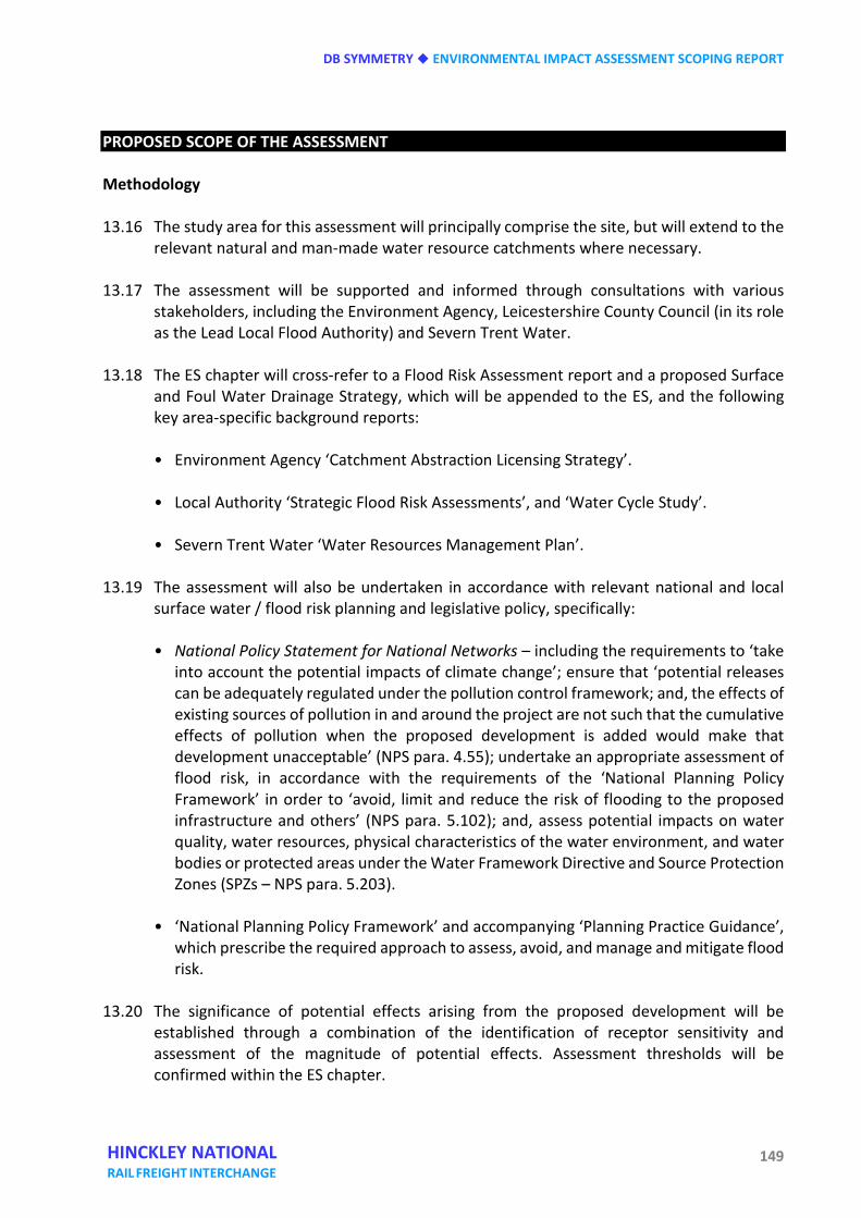
DB SYMMETRY ENVIRONMENTAL IMPACT ASSESSMENT SCOPING REPORT
149 HINCKLEY NATIONAL RAIL FREIGHT INTERCHANGE
PROPOSED SCOPE OF THE ASSESSMENT Methodology 13.16 The study area for this assessment will principally comprise the site, but will extend to the
relevant natural and man-made water resource catchments where necessary. 13.17 The assessment will be supported and informed through consultations with various
stakeholders, including the Environment Agency, Leicestershire County Council (in its role as the Lead Local Flood Authority) and Severn Trent Water.
13.18 The ES chapter will cross-refer to a Flood Risk Assessment report and a proposed Surface
and Foul Water Drainage Strategy, which will be appended to the ES, and the following key area-specific background reports:
• Environment Agency ‘Catchment Abstraction Licensing Strategy’. • Local Authority ‘Strategic Flood Risk Assessments’, and ‘Water Cycle Study’. • Severn Trent Water ‘Water Resources Management Plan’.
13.19 The assessment will also be undertaken in accordance with relevant national and local
surface water / flood risk planning and legislative policy, specifically:
• National Policy Statement for National Networks – including the requirements to ‘take into account the potential impacts of climate change’; ensure that ‘potential releases can be adequately regulated under the pollution control framework; and, the effects of existing sources of pollution in and around the project are not such that the cumulative effects of pollution when the proposed development is added would make that development unacceptable’ (NPS para. 4.55); undertake an appropriate assessment of flood risk, in accordance with the requirements of the ‘National Planning Policy Framework’ in order to ‘avoid, limit and reduce the risk of flooding to the proposed infrastructure and others’ (NPS para. 5.102); and, assess potential impacts on water quality, water resources, physical characteristics of the water environment, and water bodies or protected areas under the Water Framework Directive and Source Protection Zones (SPZs – NPS para. 5.203).
• ‘National Planning Policy Framework’ and accompanying ‘Planning Practice Guidance’,
which prescribe the required approach to assess, avoid, and manage and mitigate flood risk.
13.20 The significance of potential effects arising from the proposed development will be
established through a combination of the identification of receptor sensitivity and assessment of the magnitude of potential effects. Assessment thresholds will be confirmed within the ES chapter.
ENVIRONMENTAL IMPACT ASSESSMENT SCOPING REPORT DB SYMMETRY
150 HINCKLEY NATIONAL RAIL FREIGHT INTERCHANGE
13.21 It is anticipated that the assessment will consider the construction and operational stages of the proposed development over the lifetime of the proposed scheme, i.e. taking account of the potential influence of climate change on the surface water and flood risk receptors under consideration.
13.22 In accordance with the guidance provided in paragraphs 5.92 - 5.97 and 5.221 – 5.223 of
the National Networks NPS it is proposed that the surface water and flood risk chapter of the ES will assess the likely significant effects of the proposed development on the following receptors:
• Flood risk: the assessment of flood risk will primarily be presented within the
standalone Flood Risk Assessment report, and will be based upon desk-top information and the undertaking of site-specific hydrogeological and hydrological modelling to ascertain the existing flood risk posed to the site, the implications of the proposed development on flood risk, and the testing of mitigation options, if required.
• Surface water - quantity: the potential effect of the proposed development on the rate and volume of surface water run-off will be determined, and a proposed Surface and Foul Water Drainage Strategy prepared to address any identified adverse impacts.
• Surface water - quality: the potential risk of pollutants being generated as a result of
the construction and operation of the proposed development will be determined, along with the assessment of potential impacts, and identification of any necessary mitigation measures.
• Foul water - quantity: consultation will be sought with Severn Trent Water to identify
any potential infrastructure capacity issues. The potential impact of the proposed development on available treatment capacity will then be assessed, and mitigation measures proposed, if necessary.
• Foul water - quality: the standard of available foul water treatment infrastructure will
be confirmed via consultations with Severn Trent Water. The impact of the proposed development will then be ascertained, and mitigation measures outlined, if necessary.
• Potable water supply: the potential demand on potable water supply as a result of the
proposed development will be identified, along with an assessment of the potential impact of such demand on water resource availability, and in turn management measures recommended, if required.
DB SYMMETRY ENVIRONMENTAL IMPACT ASSESSMENT SCOPING REPORT
151 HINCKLEY NATIONAL RAIL FREIGHT INTERCHANGE
SUMMARY 13.23 It is proposed that an assessment will be undertaken of the likely significant effects of the
proposed development on the environment with respect to surface water and flood risk. 13.24 Based on an initial baseline assessment and identification of potential environmental
effects, the following receptors are proposed to be ‘scoped in’ to the surface water and flood risk chapter of the ES: • flood risk;
• surface water – quantity;
• surface water – quality;
• foul water – quantity;
• foul water – quality;
• potable water supply.
13.25 The assessment will be supported and informed through consultations with various
stakeholders, reference to relevant national and local surface water / flood risk planning and legislative policy, assessment of desk-top information, and the preparation of site-specific hydrogeological and hydrological modelling. In addition, a standalone Flood Risk Assessment report will be prepared, which will include a proposed Surface and Foul Water Drainage Strategy.

ENVIRONMENTAL IMPACT ASSESSMENT SCOPING REPORT DB SYMMETRY
152 HINCKLEY NATIONAL RAIL FREIGHT INTERCHANGE
DB SYMMETRY ENVIRONMENTAL IMPACT ASSESSMENT SCOPING REPORT
153 HINCKLEY NATIONAL RAIL FREIGHT INTERCHANGE
Fourteen Hydrogeology INTRODUCTION 14.1 An assessment will be undertaken of the likely significant effects of the proposed
development on the environment with respect to hydrogeology. 14.2 For the purpose of the EIA the term ‘hydrogeology’ refers to groundwater resources,
specifically groundwater quality and quantity. This chapter relates to potential effects on groundwater resources.
14.3 The assessment will be supported and informed through consultations with various
stakeholders, including the local authority (lead regulator for land contamination), Environment Agency (local authority consultee for controlled waters issues relating to land contamination and lead regulator for environmental permitting, abstractions and discharge consents). Reference will also be made to relevant national and local groundwater and land contamination planning and legislative policy.
14.4 A standalone phase 1 environmental risk assessment report will also be prepared, which
will include a preliminary risk assessment relating to groundwater. Subsequently an intrusive site investigation will be undertaken. These reports will form an appendix to the ES.
14.5 For the purpose of the Water Framework Directive the designations of Principal and
Secondary Aquifers are based on the Environment Agency’s interactive aquifer designation map. Where aquifers have been mapped and are capable of sustaining a yield of 10 m3/day of potable water or supplying 50 people on a continuous basis, the Environment Agency has designated a number of Groundwater Bodies to help manage water quality under the River Basin Management Plans. Groundwater bodies are defined based on their support for ecosystems as well as their capacity to supply drinking water. Some localised small aquifers capable of supporting the above supply might be too small to map and can be identified only by investigation.
14.6 Where an aquifer exists and it contains groundwater but is incapable of sustaining the
above supply, the groundwater is not part of a Groundwater Body and might not be considered a strategic resource. In which case the groundwater is not a receptor, but can be a pathway to other receptors by virtue of its ability to transport contaminants.
14.7 This chapter should be read in conjunction with chapter 13 Surface water and flood risk
and chapter 15 Geology, soils and contaminated land, both of which provide relevant additional guidance.
ENVIRONMENTAL IMPACT ASSESSMENT SCOPING REPORT DB SYMMETRY
154 HINCKLEY NATIONAL RAIL FREIGHT INTERCHANGE
BASELINE ASSESSMENT 14.8 The site is underlain in different areas by superficial deposits comprising Alluvium, River
Terrace Deposits and several types of Glacial Till. The Glacial Tills include Bosworth Clay (clay and silt), Thrussington Member (sandy, gravelly clay and silt) and Wolston Sand and Gravel (sand and gravel, locally with lenses of silt, clay or peat). Occasionally there are no superficial deposits. The Thrussington Member and Wolston Sand and Gravel are classified as Secondary A or B aquifers.
14.9 Secondary A aquifers are permeable layers capable of supporting water supplies at a local
rather than strategic scale, and can be a source of base flow to rivers. Secondary B aquifers are lower permeability layers that might store and yield limited amounts of groundwater, with limited baseflow to rivers, often from fissuring and weathering.
14.10 The solid geology underlying the entire site comprises Mercia Mudstone Group, which is
dominantly red, less commonly green-grey, mudstone and subordinate siltstone and sandstone with some halite (salt) bearing units. Beds of gypsum and anhydrite are common. The Bosworth Clay Member (Glacial Till) and the Mercia Mudstone Group are classed by the Environment Agency as unproductive strata, which are deposits with low permeability that have negligible significance for water supply or river base flow.
14.11 Groundwater in these aquifers is a potential receptor, should there be any sources of
contamination on site and viable pathways by which the contamination at the sources could migrate to the receptor.
14.12 Understanding of the baseline conditions will be developed further during the phase 1
preliminary risk assessment stage and during the preliminary stages of the ground investigation to establish a conceptual ground model that will include the current groundwater regime and groundwater quality. This will act as a comparison for the potential effects of future changes that could affect the chemical quality of groundwater and surface water.
14.13 The assessment will include a review of existing private water supplies, abstraction
licences and discharge consents and any that are proposed as part of the proposed development, and will take into account any significant effects arising from the assessments proposed in chapters 13 and 15 of this EIA scoping report.
POTENTIAL ENVIRONMENTAL EFFECTS 14.14 Potential sources of contamination on site will be identified during the desk study, site
inspection and intrusive phases of the ground investigation. Existing groundwater resources will be assessed during the desk study phase, including the potential significance of any groundwater resource value.
DB SYMMETRY ENVIRONMENTAL IMPACT ASSESSMENT SCOPING REPORT
155 HINCKLEY NATIONAL RAIL FREIGHT INTERCHANGE
14.15 The proposed development has the potential to affect the existing groundwater resource during the construction phase by construction activities, leading to the mobilisation of existing contaminants (e.g. via bulk earthworks, piling or penetrative ground improvement) or via spillages of construction materials or fuels.
14.16 In addition, the development could lead to the sterilisation of land that may have been a
significant future resource for groundwater abstraction. PROPOSED SCOPE OF THE ASSESSMENT 14.17 In accordance with the guidance provided in paragraphs 5.221 – 5.223 of the National
Networks NPS it is proposed that the hydrogeology chapter of the ES will assess the likely significant effects of the proposed development on the following receptors:
• The Thrussington Member, and Wolston Sand and Gravel Secondary A and B Aquifers.
14.18 Assessment of the impact of the proposed development will also be undertaken in
accordance with, but not limited to, the below policies:
• National Planning Policy Framework 2012;
• Blaby District Local Plan (Core Strategy) Development Plan, February 2013;
• National Policy Statement for National Networks, December 2014;
• Environment Agency Protect Groundwater and Prevent Groundwater Pollution, March 2017;
• Blaby District Revised Local Development Scheme, November 2017;
• Blaby District Local Plan (Delivery) Development Plan (Proposed Submission Version)
November 2017. 14.19 The hydrogeological assessment will include the following.
• Identification and confirmation of aquifer status at desk study stage (groundwater
receptor).
• Identification of potential contamination sources at desk study, walkover and intrusive investigation stages.
• Identification of any existing private water supplies, abstractions and discharge consents.
ENVIRONMENTAL IMPACT ASSESSMENT SCOPING REPORT DB SYMMETRY
156 HINCKLEY NATIONAL RAIL FREIGHT INTERCHANGE
• Assessment of potential pathways that might create pollutant linkages.
• Installation of groundwater monitoring instruments and subsequent monitoring, groundwater sampling and laboratory testing to establish groundwater regime and existing quality.
• Should unacceptable risks to groundwater or surface water from contamination linkages be identified, appropriate remedial measures will be assessed and recommended.
14.20 The water quality assessment will based upon comparison of groundwater monitoring
data to appropriate assessment criteria (UK drinking water standards (DWS) and environmental quality standards (EQS)) under the UK’s obligations under the European Water Framework Directive (WFD). It includes the most common contaminants for use as a screening exercise. This is known as a generic quantitative risk assessment.
14.21 Should further more detailed assessment be required to understand the potential risks to
groundwater resources from specific contaminants, then a detailed quantitative risk assessment will be undertaken using recognised Environment Agency-approved groundwater modelling software.
SUMMARY 14.22 It is proposed that an assessment will be undertaken of the likely significant effects of the
proposed development on the environment with respect to hydrogeology (groundwater resources).
14.23 Based on an initial baseline assessment and identification of potential environmental
effects, the following receptors are proposed to be ‘scoped in’ to the hydrogeology chapter of the ES: • The Thrussington Member, and Wolston Sand and Gravel Secondary A and B Aquifers.
14.24 The assessment will be supported and informed through consultations with the local
authority and Environment Agency, reference to relevant national and local groundwater and land contamination law, policy and guidance, assessment of desk-top information, and intrusive site investigation, risk assessment and, if necessary, site remediation.
DB SYMMETRY ENVIRONMENTAL IMPACT ASSESSMENT SCOPING REPORT
157 HINCKLEY NATIONAL RAIL FREIGHT INTERCHANGE
Fifteen Geology, soils and contaminated land INTRODUCTION 15.1 Although it is an extensive area, the site is believed to have been historically in
predominantly agricultural use and the amount of land contamination issues are expected to be relatively limited. However, sufficient work is required to give robust and reliable confirmation that this is the case. Should the investigation prove this not to be the case, either generally or locally, specific works will be undertaken to establish the actual conditions and what remedial action may be required.
15.2 The ground investigation will be carried out in accordance with recognised best practice
as set out in guidance documents such as in the CLR 11 Model Procedures (Environment Agency 2004a), GP3 (Environment Agency August 2013), BS 5930:2015 and BS 10175:2011+A1:2013. Important aspects of the risk assessment process are transparency and justification.
15.3 In line with the CLR 11 Model Procedures (Environment Agency 2004a), the Preliminary
Risk Assessment includes a geo-environmental Hazard Identification, which seeks to list all the suspected contaminant sources, the receptors that might be harmed by those sources and the pathways via which the sources might reach the receptors to cause the harm. The source-pathway-receptor concept is known as a contaminant linkage (formerly a pollutant linkage) and only when a linkage is complete is there any possibility of risk of harm arising.
15.4 This chapter will also set out the technical details of the assessment of Agricultural Land and the way in which it will be reported within the ES.
15.5 Agricultural land within Grades 1, 2 and Subgrade 3a of the Agricultural Land Classification (ALC) is considered the ‘best and most versatile agricultural land’ (BMV). This is land which is most flexible, productive and efficient in response to inputs. Further details of the ALC system and policy implications are set out by Natural England in its Technical Information Note 049.
BASELINE ASSESSMENT 15.6 The geohazard identification process uses professional judgement to evaluate all the
hazards in terms of possible contaminant linkages. Possible contaminant linkages are potentially unacceptable risks in terms of the current contaminated land regime and legal framework and require either remediation or further assessment. These will be addressed via intrusive ground investigation and the chemical analysis of soil and water samples to establish the baseline land contamination conditions.
ENVIRONMENTAL IMPACT ASSESSMENT SCOPING REPORT DB SYMMETRY
158 HINCKLEY NATIONAL RAIL FREIGHT INTERCHANGE
15.7 The land for the proposed development is predominantly agricultural. The only available agricultural land quality information is provisional MAFF/Defra mapping, which shows the land as grade 3. These maps have a low degree of accuracy and do not differentiate between subgrade 3a (best and most versatile) and subgrade 3b. Detailed survey work is required to accurately determine the quality of the agricultural land resource.
15.8 1:50,000 British Geological Survey mapping shows surface geology to variously consist of some Alluvium, overlying Glacial Till (including Bosworth Clay, Thrussington Member and Wolston Sand and Gravel), underlain by Mercia Mudstone beneath the entire site. In local areas there are no superficial deposits. Such variation would be expected to significantly affect soil types and land quality. The national soil map (1:250,000 scale) shows the land to include different soil types, varying in texture and degree of drainage impedance. The land therefore needs to be surveyed in detail to determine the nature of the soil resource, identify potential impacts and propose suitable mitigation.
15.9 For the purposes of the baseline assessment the land includes more than one agricultural business. The effects of existing contaminant source – pathway – receptor linkages on farm businesses need to be assessed for a full economic impact assessment to be undertaken. This will be considered in the land use and socio-economic effects assessment (see chapter 6, above).
POTENTIAL ENVIRONMENTAL EFFECTS 15.10 The receptors which are likely to be affected in a source – pathway – receptor linkage
assessment are:
• human health – future site end users (in a commercial / industrial end use scenario as defined in CLR 11 Model Procedures), including off site occupiers of remaining neighbouring land;
• Controlled Waters (surface water and groundwater quality);
• property / buildings;
• ecological receptors.
15.11 Some linkages might be identified that constitute a theoretical connection between a
source and a receptor, but professional judgement shows them not to be possible for some reason. These are labelled ‘no linkage’ and no further action is required. If a linkage is possible, a comparison is made of consequence against probability in accordance with the guidance given in CIRIA Report C552 (Rudland et al 2001), but modified as mentioned below.
DB SYMMETRY ENVIRONMENTAL IMPACT ASSESSMENT SCOPING REPORT
159 HINCKLEY NATIONAL RAIL FREIGHT INTERCHANGE
15.12 Classification of consequences and probability are given in CIRIA Report C552 Tables 6.3 and 6.4, modified to take into account ‘significant harm or significant possibility of significant harm’ (SH/SPOSH) in line with current practice.
15.13 The basis of the classification is that ‘severe’ and ‘medium’ are likely to result in SH/SPOSH as defined by the EPA 1990, Part 2A, with ‘severe’ resulting in acute harm. ‘Mild’ lies below the level of SH/SPOSH but above the level of ‘no harm’ as implied by the relevant Generic Assessment Criterion (GAC, see below). Minor lies below the ‘no harm’ level.
15.14 The scoping study has been informed by published soils, geology and agricultural land
quality mapping information. PROPOSED SCOPE OF THE ASSESSMENT 15.15 An initial broad-based general ground investigation will be undertaken across the entire
site in accordance with current best practice, using a combination of machine-excavated trial pits and dynamic probe boreholes to take soil samples for laboratory contamination testing. This will determine the general contamination conditions, identifying potential sources of contamination and soil quality in general. The chemical testing will identify standard suites of metals, inorganic and organic compounds, including pesticides and herbicides, together with asbestos. Geotechnical soil classification testing will also be undertaken.
15.16 Where specific potential sources of contamination are identified in the desk study / site
walkover stages, these will be investigated individually. At least 80 sampling locations will be investigated in the initial stages, with further investigation in subsequent phases. The investigation will include monitoring of groundwater levels, groundwater quality, and surface water quality.
15.17 The Model Procedures of CLR 11 provide guidance on key information sources with
respect to potential contamination arising from past land uses of a site. In particular, the now withdrawn CLR 8 (Environment Agency 2002b), the DoE Industry Profile documents and ISO10381-5 provide good summaries of priority pollutants for UK sites. Additionally, the Environment Agency (2004b) has produced a list of priority pollutants for ecological risk assessment. These documents will be used, with the findings of the Phase 1 investigation, to scope the analyses of chemicals of potential concern. It should be noted that whilst CLR 8 was withdrawn in August 2008 it was not replaced and its findings are still considered useful.
15.18 There is a minimum requirement for soil chemical analysis, even for greenfield sites, in
order to satisfy the ‘suitable for use’ criterion of the planning regime. This is represented by default lists of determinands for solids derived particularly from tables 2.1 and 2.2 of CLR 8, listing potential inorganic and organic contaminants on typical former industrial land uses in the UK.
ENVIRONMENTAL IMPACT ASSESSMENT SCOPING REPORT DB SYMMETRY
160 HINCKLEY NATIONAL RAIL FREIGHT INTERCHANGE
15.19 The default list of determinands is designed to screen for unacceptable risks to property development and future occupiers and comprises substances potentially affecting human, vegetation and construction materials receptors. The list includes common metals, metalloids and inorganic species, pH, asbestos fibres and screening tests for common organic compound groups which are deemed chemicals of potential concern. Sulphate is a contaminant whose principal receptor is concrete in the ground and is not considered toxic except in extreme conditions. Sulphate analysis is included in the list of geotechnical tests. Some common determinands such as elemental sulphur and sulphide are not included because there is insufficient information available to calculate meaningful assessment criteria.
15.20 In the assessment of risks to human health, Generic Assessment Criteria (GAC) are derived
using largely generic assumptions about the characteristics and behaviour of sources, pathways and receptors. These assumptions will be conservative in a defined range of conditions.
15.21 The Contaminated Land Exposure Assessment (CLEA) framework uses soil guideline values
(SGV) in assessing risks to human health from exposure to soils contaminated with selected contaminants under generic conditions.
15.22 It should be noted that exceedance of GACs does not automatically mean that the soil is
‘contaminated’. The derivation of GACs includes a number of precautionary assumptions such that non-exceedance will indicate that risk to human health is acceptable and that the land is suitable for use, with regard to the contaminant in question. SGVs are not binding standards, but may be used to inform judgments about the need for action and the selection of remediation standards or target values for individual sites.
15.23 The legal test for land contamination under the statutory guidance of Part 2A of the
Environment Protection Act 1990 is ‘significant harm or significant possibility of significant harm’. Exceedance of a GAC does not necessarily meet this legal test, i.e. exceedance of a GAC does not necessarily equate to unacceptable risk. Consequently, the GACs are considered as screening values only in accordance with guidance by Defra (July 2008) and the legal definition of contaminated land in 2012 by the publication of revised contaminated land statutory guidance.
15.24 The scope of ground investigations includes assessment by desk study, site reconnaissance
and intrusive investigation to establish pathway linkages for all sources and receptors and identify any potential unacceptable linkages that might require remedial action.
SUMMARY 15.25 The 2012 National Planning Policy Framework states that the standard of remediation to
be achieved through the grant of planning permission for new development, including permission for land remediation activities, is the removal of unacceptable risk and making sure the site is suitable for its new use. As a minimum, after carrying out the development
DB SYMMETRY ENVIRONMENTAL IMPACT ASSESSMENT SCOPING REPORT
161 HINCKLEY NATIONAL RAIL FREIGHT INTERCHANGE
and commencement of its use, the land should not be capable of being determined as contaminated under Part 2A. The requirements for planning are, therefore, the same as for Part 2A.
15.26 The approach in the proposed scope of site investigation works will aim to satisfy the
relevant statutory requirements and potential planning conditions regarding land contamination.
15.27 The land use and socio-economic effects chapter of the ES will consider the effects of the
scheme on the existing agricultural baseline, and propose suitable management to mitigate these effects where appropriate.

ENVIRONMENTAL IMPACT ASSESSMENT SCOPING REPORT DB SYMMETRY
162 HINCKLEY NATIONAL RAIL FREIGHT INTERCHANGE
DB SYMMETRY ENVIRONMENTAL IMPACT ASSESSMENT SCOPING REPORT
163 HINCKLEY NATIONAL RAIL FREIGHT INTERCHANGE
Sixteen Materials and waste INTRODUCTION 16.1 In the construction of the buildings, access roads and hardstanding areas proposed, there
will be a need to undertake extensive earthworks to modify the existing landforms to the required levels to form satisfactory platforms for construction. Suitable materials will need to be used and compaction undertaken to ensure the satisfactory performance of heavily loaded floor slabs and paved external areas.
16.2 As far as possible, earthworks will be designed to achieve a cut-fill balance, whereby soils excavated at the site will be re-used elsewhere on the site to achieve the required final levels in accordance with the proposed development.
16.3 Any material excavated on site may be classified as waste and it is the responsibility of the
holder of a material to form their own view on whether or not it is waste. This includes determining when waste that has been treated in some way can cease to be classed as waste for a particular purpose. One of the ways this can be achieved is set out in the Development Industry Code of Practice (CoP) (CL:AIRE, March 2011). This builds on the Environment Agency guidance document ‘Definition of waste: developing greenfield and brownfield sites (2006b)’.
16.4 The handling, re-use or disposal of waste is regulated by the Environment Agency (EA).
The EA will take into account the use of the CoP in deciding whether to regulate materials as waste. If materials are dealt with in accordance with the CoP, the EA considers that those materials are unlikely to be waste at the point when they are to be used for the purpose of land development. This might be because the materials were never discarded in the first place, or because they have been submitted to a recovery operation and have been completely recovered so that they have ceased to be waste.
16.5 The chemical analyses in this investigation will be designed for the purposes of risk
assessment with respect to human health, plant life and controlled waters as discussed in the report. Whilst the results might be useful in applying the Hazardous Waste Assessment Methodology given in Environment Agency Technical Guidance WM3, they are not primarily intended for that purpose and additional analysis might be required should waste classification be required for consideration of off-site disposal of contaminated soils. A preliminary exercise will be undertaken to characterise the soils encountered in the investigation in order to inform the waste characterisation process using a proprietary web-based tool. Separate analyses are required to meet the waste acceptance criteria for specific landfill sites.
16.6 The proposed development will require the use of raw materials, both local to and off site, as part of the construction phase. Proposals for development will ensure that waste is
ENVIRONMENTAL IMPACT ASSESSMENT SCOPING REPORT DB SYMMETRY
164 HINCKLEY NATIONAL RAIL FREIGHT INTERCHANGE
reduced as much as possible, and that during the construction and post-construction phases of the proposal, waste arisings are either re-used or recycled where feasible.
16.7 During construction, wastes will be correctly segregated to maximise re-use and recycling.
Where any contaminated or hazardous arisings cannot be treated on site during remediation works, suitable disposal options will be identified as part of the environmental assessment process.
BASELINE ASSESSMENT 16.8 A detailed topographical survey in conjunction with the ground investigation will be
undertaken in order to establish a ground model of sufficient detail to address the baseline conditions and to enable subsequent design to continue.
16.9 The construction and operational waste assessment methodology will include:
• liaison with Blaby District Council’s environmental health department to determine
and clarify the overall proposed scope and methodology;
• baseline waste assessment of the proposed development site and surrounding area;
• development of materials and waste volumes for the proposed development (construction and operation);
• materials and waste impact assessment associated with the operation of the
development;
• identification of waste streams generated during construction and operation phases; • analysis of the volumes of waste generated and materials used during the construction
and operation phases; • identification of any hazardous or potentially hazardous waste that might arise; • identification of potential risks to the surrounding area;
• formulation of mitigation measures where appropriate.
16.10 Material selection will involve review of certification standards and application of
appropriate and sustainable material selection.
16.11 Inside buildings, an assessment of environmentally sensitive (non-toxic) building materials will be undertaken. Materials that produce VOC (volatile organic compounds and formaldehyde) will be avoided, where possible, to ensure the levels of VOC within the

DB SYMMETRY ENVIRONMENTAL IMPACT ASSESSMENT SCOPING REPORT
165 HINCKLEY NATIONAL RAIL FREIGHT INTERCHANGE
buildings fall below the World Health Organisation (WHO) guidelines. 16.12 Waste throughout the construction process will be kept to a minimum through the
implementation of the waste hierarchy. This hierarchy promotes the reuse and recycling of materials, with disposal being the final option. Diversion from landfill will also be promoted.
16.13 Waste storage within the development will be in line with local authority’s waste storage requirements. Dedicated recyclable and non-recyclable storage facilities will be provided on the ground floor.
POTENTIAL ENVIRONMENTAL EFFECTS 16.14 Achievement of a cut-fill balance using suitable materials will be an important factor in
minimising adverse environmental effects from the development.
16.15 One of the aims of the ground investigation will be to assess whether the soils likely to be excavated will be geotechnically and chemically suitable for this purpose. This will minimise the need to remove excavated materials for off-site disposal as waste. Costs of waste disposal are high, particularly when landfill tax is taken into account. The environmental impacts of unnecessary waste are also high in terms of the use of landfill space and vehicle movements involved in the transport of the waste. Achieving a cut to balance is therefore high on the list of priorities in terms of environmental sustainability.
16.16 At present, the site is a mixture of farmland, small holdings and private dwellings. The site is a source of agricultural and green waste and likely small quantities of commercial waste from Hobbs Hayes Farm and Woodhouse Farm. The exact quantities of waste generated at the site are currently unknown.
16.17 Blaby District Council provides trade waste collection and disposal services for dry waste to businesses throughout the district. The destination for composting, landfill, recyclables, material recovery facilities and any treatment plant are to be determined.
16.18 Waste arising from the preparation, site removal and construction processes will require management. The development of the HNRFI will result in significant amount of construction and demolition waste being produced. A Resource Management Plan (RMP) will be prepared. This, alongside other construction phase waste management measures, will help to ensure that construction waste is minimised, re-used and recycled wherever possible and will ensure that there are no significant effects on the capacity of the local waste management infrastructure as a result of the development. Preliminary waste targets will be developed alongside the waste management strategy.
16.19 The likelihood of contamination across the development site will be determined. Excavation for fill and infrastructure work will be required. The need for remediation of any contamination could generate contaminated waste that would require management
ENVIRONMENTAL IMPACT ASSESSMENT SCOPING REPORT DB SYMMETRY
166 HINCKLEY NATIONAL RAIL FREIGHT INTERCHANGE
and/or disposal but this would be examined as part of the ground investigation assessment.
16.20 In operation, the proposals will lead to the generation of increased amounts of municipal and commercial waste and the introduction of on-site recycling and waste storage facilities.
PROPOSED SCOPE OF THE ASSESSMENT 16.21 A 3-D model will be constructed in the design process based on topographical surveys,
design levels and construction thicknesses to assess the volumes of materials required to be excavated, transported and placed in earthworks construction.
16.22 The ground investigation will aim to establish the suitability for use of excavated materials as engineered fill, both geotechnically and chemically, such that unacceptable contamination linkages are not formed, in order to establish the optimum balance of materials.
16.23 Liaison will be undertaken with Blaby DC’s environmental health department in order to confirm the baseline conditions and methodology for assessment of the construction and operational waste streams.
16.24 Assessment of the impact of the proposed development will be undertaken in accordance with, but not limited to, the assessment methodologies as detailed in the below best practice guidance and standards: • National Policy Statement for National Networks – including the waste management
section at paragraphs 5.39 – 5.45;
• National Planning Policy Framework 2012; • National Planning Policy for Waste 2014; • Waste Strategy for England and Wales 2000;
• Waste Strategy for England 2007;
• Waste Management Plan for England 2013;
• Waste Regulations 2011;
• Hazardous Waste Regulations 2005;
• Leicestershire Municipal Waste Management Strategy Update 2012;
DB SYMMETRY ENVIRONMENTAL IMPACT ASSESSMENT SCOPING REPORT
167 HINCKLEY NATIONAL RAIL FREIGHT INTERCHANGE
• Leicestershire and Leicester Waste Development Framework 2021;
• Leicestershire Minerals and Waste Local Plan 2031 (2016). 16.25 In line with Blaby District Council’s Core Strategy requirements, the development will seek
to adopt the following measures. • A hierarchy of waste management in the following priority order: waste prevention,
re-use, recycle/compost, recovery, and disposal as a last resort.
• Design and services flexible enough to allow new technological developments to be accommodated.
• Consideration of waste collection to maximise recycling opportunities.
• Provision of secure waste management facilities.
• Any new sensitive receptors are not located near to or do not place additional burdens
on existing licenced waste management facilities.
• The use of a Site Waste (Resource) Management Plan.
16.26 The total embodied carbon of the development can be influenced by the design and choice of materials. Building materials will be selected for the scheme to ensure, where feasible, that they: • have a low embodied energy;
• are sustainably sourced;
• are durable to cater for their level of use and exposure;
• will not release toxins into the internal and external environment.
16.27 A desktop waste audit will be undertaken in order to determine the potential impacts from
the demolition and construction phases in addition to the operational phase, to inform the design team of the likely waste volumes and streams generated from the project. Effects and proposed mitigation will be reported in the ES.
16.28 The waste management strategy will be developed in order to detail the proposed waste management, storage and collection arrangements and measures to minimise waste generation. It is recommended that post construction (operational) waste is examined separately to the construction waste streams as these are likely to be relatively insignificant in relation to existing waste generation levels within the county.

ENVIRONMENTAL IMPACT ASSESSMENT SCOPING REPORT DB SYMMETRY
168 HINCKLEY NATIONAL RAIL FREIGHT INTERCHANGE
16.29 Where necessary, consideration within the design stage of the development process will be provided, outlining appropriate mitigation measures in order to ensure that relevant waste guidelines can be met.
SUMMARY 16.30 The results of the ground investigation will inform a detailed ground model of the site to
influence the design process to achieve the most sustainable end product, such that waste and the adverse effects of excessive waste in the construction process are minimised.
16.31 The significance of the effects of the proposed development during the site clearance, construction and operational phases will be assessed.
16.32 The assessment shall outline both the long and short term predicted effects of each phase of the development and any required or specified mitigation measures in order to reduce the impacts relating to material consumption and waste generation.
#
DB SYMMETRY ENVIRONMENTAL IMPACT ASSESSMENT SCOPING REPORT
169 HINCKLEY NATIONAL RAIL FREIGHT INTERCHANGE
Seventeen Energy and climate change INTRODUCTION 17.1 Opportunities to provide efficient energy and water distribution systems including, where
appropriate, renewable technologies will be investigated as part of the scheme development. Resource consumption will include water, land and minerals.
17.2 Development will directly or indirectly increase greenhouse gas emissions; locally or
offsite depending on the chosen heat and power generation technologies deployed. Greenhouse gas emissions will also increase as a result of increased traffic and energy use associated with the development. Opportunities to minimise CO2 emissions will be explored in detail as part of the energy strategy and infrastructure development.
17.3 Climate change adaptation will include an assessment of air temperature rise over the
lifetime of the building, and its impact on occupant comfort and building resilience. Water management and flood protection is covered under separate section of the EIA.
17.4 Impacts relating to air, land, noise, light and water are covered under separate sections of
the EIA. BASELINE ASSESSMENT 17.5 The baseline assessment will be undertaken as follows.
• Liaison with the local authority’s energy and sustainability officer to determine and
clarify the overall proposed scope and methodology.
• Establish the energy and sustainability performance planning requirements for the project.
• Determination of demolition effects and their potential climate change impacts.
• Assessment of the baseline energy consumption and CO2 emissions, against a Building
Regulations compliant scheme.
• Building modelling using CIBSE AM11 approved dynamic thermal modelling tools (Simplified Building Energy Model).
• Analysis of energy delivery options including site wide communal infrastructure.
• Development of scheme and building layout to optimise energy efficiency without
ENVIRONMENTAL IMPACT ASSESSMENT SCOPING REPORT DB SYMMETRY
170 HINCKLEY NATIONAL RAIL FREIGHT INTERCHANGE
undermining viability. • Provision of passive and active design measures. • Consideration of large scale renewable and/or low carbon energy generation
technologies to support the scheme demand requirements. • Identification of the predicted effects of climate change on the site and surrounding
areas. • Assessment of climate change vulnerability and sensitivity of receptors. • Formulation of mitigation measures where appropriate.
POTENTIAL ENVIRONMENTAL EFFECTS 17.6 Climate change is likely to have a significant impact in Leicestershire, along with the rest
of the country, particularly through increased rainfall intensity resulting in an increase in the number and severity of flooding events, and periods of drought at other times.
17.7 A Climate Change and Renewable Energy Study was undertaken in 2008 (IT Power) to
quantify the potential for renewable energy in the Leicestershire and Rutland area. This identifies one potential wind farm site located to the west of Enderby, north of the M69. Other large scale forms of renewable sources of energy including hydropower, biomass, and solar do not appear to offer the potential to generate more than 2MW of electricity at individual locations, although the rapid deployment of field-scale solar photovoltaics in the decade since the IT Power report was prepared suggests a higher potential for this particular technology. At the HNRFI site there is significant scope for building integrated solutions to cumulatively deliver a significant supply. Key objectives include:
• minimising energy and water use in addition to developing renewable energy
resources.
• reducing greenhouse gas emissions to mitigate the rate of climate change.
17.8 Blaby District Council has set objectives to improve the energy efficiency of existing and new developments and to promote the use of renewable energy sources. It is working to improve the energy efficiency of council-owned properties and is investigating how improvements to energy efficiency and renewable energy technology might be achieved in new developments through planning policies.
17.9 At present, the existing site is a mixture of farmland, small holdings and private dwellings.
The site is largely greenfield and the creation of an employment site will increase energy and water consumption. Opportunities to provide efficient energy and water distribution
DB SYMMETRY ENVIRONMENTAL IMPACT ASSESSMENT SCOPING REPORT
171 HINCKLEY NATIONAL RAIL FREIGHT INTERCHANGE
systems including, where appropriate, renewable technologies will be investigated as part of the scheme development.
17.10 Similarly, development will directly or indirectly increase greenhouse gas emissions;
locally or offsite depending on the chosen heat and power generation technologies deployed. Greenhouse gas emissions will also increase as a result of increased traffic and energy use associated with the development. Opportunities to minimise CO2 emissions will be explored in detail as part of the energy strategy and infrastructure development.
17.11 Demolition effects will require consideration in terms of climate change impact. This is
covered under the materials and waste section. PROPOSED SCOPE OF THE ASSESSMENT 17.12 Assessment of the impact of the proposed development on receptors will be undertaken
in accordance with, but not limited to, the assessment methodologies as detailed in the below best practice guidance and standards.
• National Policy Statement for National Networks – including the advice on climate
change adaptation (NPS paras 4.36 – 4.47) and carbon emissions (NPS paras. 5.16 – 5.19).
• The National Planning Policy Framework 2012.
• UK Climate Projections (UKCP) for lifetime of development – using the UKCP09 High Emissions Scenario (High Impact, Low Likelihood) against the 2080 projections at the 50% probability level, in accordance with NPS requirements.
• Building Regulations Approved Document Part L2A Conservation of Fuel and Power in
New Buildings other than Dwellings 2013.
• Blaby District Core Strategy 2013.
• Blaby District Local Development Scheme 2015.
• Blaby District Delivery Development Plan Submission Version. 17.13 The energy and sustainability assessment will review and respond to the local authority
specific energy criteria contained in the Core Strategy and other local policy documents. All likely significant climate factors in terms of carbon impact will be assessed against UK government carbon budgets in accordance with NPS requirements and the government’s overarching carbon reduction strategy Carbon Plan 2011.
ENVIRONMENTAL IMPACT ASSESSMENT SCOPING REPORT DB SYMMETRY
172 HINCKLEY NATIONAL RAIL FREIGHT INTERCHANGE
17.14 The scope of the energy and CO2 emissions assessment will cover all building and, where required, process loads (i.e. regulated and unregulated energy). Energy consuming activities will be reviewed across the site in order to develop a suitable energy strategy. This might include a mixture of localised and communal or site wide technologies to meet energy demand requirements. Technologies will be assessed in line with environmental objectives; air, land, noise pollution. Selection will be based on economic, technical and environmental viability. Mitigation measures may include flue dilution, filters and attenuators. These will be developed in line with other design criteria for the site.
17.15 The operational stage assessment will include energy demand and energy used, the nature
and quantity of materials used, residues and emissions, including light heat and radiation, risks of major accidents and disasters and the sustainable availability of resources such as land, soil, water and biodiversity.
17.16 Climate change adaptation will also be reviewed, this includes the effect of future
temperature rises on building operation and occupant comfort (namely risk of overheating) and planning for resilience in building design:
• increase in annual average temperatures;
• increase in number and severity of hot days;
• increase in rain downpours and winter rainfall;
• increase in dry spells and drought events, particularly in summer months.
SUMMARY 17.17 An energy and sustainability strategy will be developed and submitted alongside the
planning application and DCO submission. This will detail the proposed energy strategy, local or offsite CO2 emissions and sustainable design measures including responses to climate change adaptation.
17.18 Energy and sustainability measures are recommended to be examined as part of these
submission documents rather than the ES, as the environmental impacts relating to air, land, noise, light and water resulting from buildings and energy generation equipment will be covered under other chapters of the ES.
DB SYMMETRY ENVIRONMENTAL IMPACT ASSESSMENT SCOPING REPORT
173 HINCKLEY NATIONAL RAIL FREIGHT INTERCHANGE
Eighteen Cumulative and transboundary effects INTRODUCTION 18.1 This section of the scoping report sets out how it is intended to approach the cumulative
effects assessment (CEA) in accordance with the Planning Inspectorate’s (PINS) guidance advice note seventeen and its suggested methodology.
18.2 The requirement for cumulative effects assessment is set out in Article 4(3) and Article
5(1) of the Environmental Impact Assessment (EIA) Directive and under the Planning Act 2008 for NSIPs and implemented through the EIA Regulations 2017.
18.3 Schedule 4 of the EIA Regulations 2017 provides relevant information for inclusion in
environmental statements. At Schedule 4(5) the regulations state that ‘the description of the likely significant effects on the factors specified in regulation 4(2) should cover the direct effects and any indirect, secondary, cumulative, transboundary, short-term, medium-term and long-term, permanent and temporary, positive and negative effects of the development.’
18.4 The cumulative impact comprises the combined effects of the proposed development with
other existing and/or approved development. No detailed definition is provided in the EIA Regulations to clarify what existing and/or approved development should consist of. In the current context it is considered appropriate to consider other developments that have been allocated in a plan, developments that have been consented or remain under formal consideration in the planning process.
18.5 The ES for the HNRFI will consider which other developments have the potential for
cumulative effects on the same receptors as the project within a defined geographical area known as the Zone of Influence (ZOI). The significance of the cumulative effects needs to be considered with regard to the effects on specific environmental receptors, which will include the characteristics of the natural environment as well as the neighbouring residents/communities.
BASELINE ASSESSMENT 18.6 The baseline assessment will be defined by the effects of the proposed development on
the environmental receptors as set out in the technical chapters of the ES in conjunction with other projects that are expected to be completed before construction of the project. This baseline position will be used to compare the significance of the impact on environmental receptors when taking into account the cumulative impact of the proposed development and the shortlisted other development in the ZOI.
ENVIRONMENTAL IMPACT ASSESSMENT SCOPING REPORT DB SYMMETRY
174 HINCKLEY NATIONAL RAIL FREIGHT INTERCHANGE
POTENTIAL ENVIRONMENTAL EFFECTS 18.7 It is not intended to address every individual receptor contained within the technical
chapters of the ES for potential cumulative environmental effects. The receptors to be considered in the context of cumulative impact will be those that are identified as sensitive to the cumulative effects of the shortlisted development to be taken forward for CEA within the ZOI.
18.8 EIA topics with potential for cumulative and transboundary effects are the socio-
economics and transport and traffic. Most of the technical analyses in the ES are considered likely to identify effects sensitive to site only or in the immediate locality, such that they will not be affected or influenced cumulatively by other development. It is proposed that these latter topics will be scoped out of the CEA, with appropriate justification given in the ES.
PROPOSED SCOPE OF THE ASSESSMENT 18.9 Given the scale and nature of the project it is acknowledged that a broad spatial and
temporal ZOI is generally expected. The Planning Inspectorate has provided in advice note seventeen a methodology to approaching CEA in the context of NSIPs. PINS encourage applicants to follow this methodological approach where it is appropriate to do so and it is intended to adopt this approach where possible.
18.10 This scoping report provides the first step of stage 1 of PINS suggested methodology to
establish the projects ZOI in respect of each of the technical chapters of the ES. Table 18.1: Zones of influence to be employed in the assessment of cumulative effects - summary table Environmental Topic Zone of Influence (ZOI) Socio-economic The ZOI will be the primary impact area surrounding the
development site defined as the area within commuting distance of the proposed development. The site will be accessed from the M69, with public transport services and local footpath and cycleways provided, so workers will be able to access the site using a number of modes of transport. The ZOI will be determined in conjunction with the transport consultants accounting for the predicted catchment area the workers would commute from. 2011 census travel to work data will inform the ZOI. Consideration will be given to any relevant major
DB SYMMETRY ENVIRONMENTAL IMPACT ASSESSMENT SCOPING REPORT
175 HINCKLEY NATIONAL RAIL FREIGHT INTERCHANGE
employment sites or commitments within the ZOI.
Transport and Traffic The defined study area of the highway network will be used to determine the ZOI for considering cumulative effects. It is anticipated that the Leicester and Leicestershire Integrated Transport Model will form an initial assessment of the change in traffic flows arising from the development proposals across the network. This will identify the change in traffic flows and therefore the extent of the area to be considered as the ZOI to consider cumulative effects of other development.
Air Quality The AQMAs will be defined in the area. Blaby District Council has four declared although none of these is located within close proximity of the site. The ZOI will be defined by the TA in considering commuting distances and any cumulative impact expected from traffic generation, distribution and associated emissions from other strategic development in the ZOI.
Noise and Vibration Highly site specific, with assessments and ZOI limited to within 1km of the site.
Landscape and Visual Effects The landscape will be defined in accordance with GLVIA guidelines and following reference to defined landscape character areas and an assessment of the site surroundings, topography and characteristics a ZOI will be defined. The ZOI will be informed by the Zone of Theoretical Visibility. Given the relatively flat nature of the site and the intended design of the buildings it is considered likely that the ZOI on landscape can be refined to 5km from the site.
Ecology and Biodiversity Assessment will be focussed on site specific effects and the ZOI will take into account strategic developments within 2km of the site. The distance from the closest European site at 11km considered in conjunction with the nature of the development is considered sufficient to scope this out of the ZOI.
Cultural Heritage Buried archaeology is highly site specific with the ZOI limited to the site only. Given the location of above ground heritage assets within
ENVIRONMENTAL IMPACT ASSESSMENT SCOPING REPORT DB SYMMETRY
176 HINCKLEY NATIONAL RAIL FREIGHT INTERCHANGE
defined settlements and the topography of the site there is very limited scope for the development to significantly influence the setting of cultural heritage. It is therefore considered appropriate to refine the ZOI for consideration of cumulative effects of the project and other development on cultural heritage to within 2km of the identified heritage asset.
Surface Water and Flood Risk Assessments based on the development site, with due regard to impacts on wider catchments of water courses. Flood risk and drainage issues will be managed on site within existing limits in accordance with best practice and as such there will be no cumulative effects with other development.
Hydrogeology Assessments based on the development site, with due regard to contaminant impacts on wider catchments of water courses. Any risks to hydrogeology will be managed on site in accordance with best practice and as such there will be no cumulative effects with other development.
Geology, Soils and Contaminated Land
Highly site specific, with assessments and ZOI limited to the site only.
Materials and Waste Highly site specific, with assessments and ZOI limited to the site only.
Energy and Climate Change Highly site specific, with assessments and ZOI limited to the site only.
18.11 It is intended to develop a list of ‘other development’ as required by Stage 1 through desk
based studies including the following.
• Planning Register searches of Blaby District Council and Hinckley and Bosworth Borough Council.
• Review of Development Plan Documents of Blaby District Council and Hinckley and Bosworth Borough Council.
• Leicester and Leicestershire 2050: Our Vision for Growth – Draft Strategic Growth Plan
• PINS’s on-line NSIPs register.
DB SYMMETRY ENVIRONMENTAL IMPACT ASSESSMENT SCOPING REPORT
177 HINCKLEY NATIONAL RAIL FREIGHT INTERCHANGE
18.12 At this stage of scoping, the significant projects already identified as part of Stage 1 and to
be taken forward to the shortlisting process of Stage 2 include:
• Daventry International Rail Freight Terminal (DIRFT) – Approximate distance from the project: 21km
• East Midlands Gateway Rail Freight Interchange (EMGRFI) – Approximate distance from the project: 33km
• Northampton Gateway Rail Freight Interchange (NGRFI) – Approximate distance from
the project: 49km
• Rail Central (Strategic Rail Freight Interchange) – Approximate distance from the project: 48km
• West Midlands Interchange – Approximate distance from the project: 55km
18.13 A planning application (local planning application reference number 17/01043/HYB) has
recently been made for land east of J1 of the M69, 4 km to the south-west of the site. The application is for a 29,563 sq m storage and distribution facility, a 49,470 sq m industrial / storage and distribution unit and other associated uses. The cumulative effects of this application will be considered in the HNRFI air quality assessment.
18.14 The list of other developments identified will then be categorised into tiers based upon
PINS methodology, which focuses on the level of certainty that can be attributed to each development. The following categories will be used:
• Tier 1 – Under construction, permitted or application under consideration – Greatest
level of certainty. • Tier 2 – Projects on PINS’s Programme of Projects where a scoping report has been
submitted – Less certainty.
• Tier 3 - Projects on PINS’s NSIP register, where a scoping report has not been submitted, identified in a relevant development plan or identified in other plans and programmes where it is reasonably likely to come forward – Greatest level of uncertainty.
18.15 Stage 2 will then consider the temporal scope, scale and nature of these other
developments as well as any other relevant factors to determine which developments should be taken forward to stage 3 and be subject to CEA. It is expected that many of the other developments identified, including other rail freight interchange projects, will be scoped out of the CEA due to their remoteness from the HNRFI site. Under these circumstances, justification will be provided for the exclusion of sites from the shortlist of
ENVIRONMENTAL IMPACT ASSESSMENT SCOPING REPORT DB SYMMETRY
178 HINCKLEY NATIONAL RAIL FREIGHT INTERCHANGE
other developments taken forward to CEA.
18.16 Stages 3-4 will be undertaken alongside preparation of the ES after the formal scoping opinion has been received. In summary, stage 3 would consist of information gathering and documentation in respect of the shortlisted developments and will be used to inform the CEA before Stage 4 and the assessment process. The assessment process will consider the shortlisted other developments and document whether cumulative effects may arise. Any adverse effects will be documented and appropriate mitigation plans will be developed and submitted as part of the DCO submission documentation.
18.17 The proposed method of assessing cumulative effects is in accordance with PINS’ Advice
Note 17 (Version 1): Cumulative Effects Assessment published December 2015. This Advice Note, however, predates the current EIA Regulations. If Advice Note 17 is revised, the assessment of cumulative effects will follow PINS’ up to date advice.
SUMMARY 18.18 The CEA will consider the cumulative effects of other development on representative
receptors within a zone of influence of the project. This scoping report seeks to identify an agreed scope for identifying other developments which will also be discussed and agreed with the relevant local planning authorities as part of ongoing discussions in respect of the development proposals. Following agreement of a shortlist of ‘other development’ to be taken forward to CEA, the cumulative effects of the project in combination with the identified other development on receptors sensitive to cumulative impact will be considered in the ES.
DB SYMMETRY ENVIRONMENTAL IMPACT ASSESSMENT SCOPING REPORT
179 HINCKLEY NATIONAL RAIL FREIGHT INTERCHANGE
Nineteen Conclusions TOPICS TO BE SCOPED OUT 19.1 This report has set out the Applicant’s existing knowledge of the environment in the site
and its surroundings, provided a description of the proposed HNRFI development and identified the anticipated likely significant environmental effects of the project during construction and operation. On the basis of existing knowledge it is concluded that no environmental topics should be ‘scoped out’ of the EIA at this stage.
19.2 Should this conclusion change materially in the light of accumulating knowledge, db
symmetry will seek to receive a revised EIA scoping opinion from the Secretary of State. REQUEST FOR A SCOPING OPINION 19.3 This report comprises db symmetry’s formal request under Regulation 10(1) of the
Infrastructure Planning (Environmental Impact Assessment) Regulations 2017 for an opinion as to the scope and level of detail, of the information to be provided in the environmental statement for the HNRFI project.
19.4 The applicant considers that it has complied with the requirements of Regulation 10(3) of
the same Regulations concerning the information to be supplied with an EIA scoping opinion request.
PRELIMINARY ENVIRONMENTAL INFORMATION 19.5 db symmetry will produce a Preliminary Environmental Information Report (PEIR) to
inform its statutory pre-application consultations about the project. According to Regulation 12 (2) of the EIA Regulations, preliminary environmental information is defined as information that has been compiled by the applicant and is reasonably required for the consultation bodies to develop an informed view of the likely significant environmental effects of the development (and of any associated development).
19.6 The PEIR should enable specialist and non-specialist consultees to understand the likely
environmental effects of the proposed development and should help to inform their consultation responses on the proposed development. There is no requirement for the PEIR to replicate or be a draft of the Environmental Statement that will ultimately accompany the DCO application. However, db symmetry considers that it is appropriate to structure the PEIR in this way.
ENVIRONMENTAL IMPACT ASSESSMENT SCOPING REPORT DB SYMMETRY
180 HINCKLEY NATIONAL RAIL FREIGHT INTERCHANGE
ENVIRONMENTAL STATEMENT FOR THE DCO APPLICATION 19.7 db symmetry’s DCO application will be accompanied by an ES that complies with the EIA
Regulations. The ES will reflect the scoping opinion here requested from the Secretary of State.