hong kong planning standards and guidelines chapter 12
TRANSCRIPT

PLANNING DEPARTMENTTHE GOVERNMENT OF THE HONG KONG SPECIAL ADMINISTRATIVE REGION
HONG KONG PLANNINGSTANDARDS AND GUIDELINES
Chapter
12MiscellaneousRock Cavern DevelopmentPetrol Filling StationsPotentially Hazardous InstallationsVehicle Repair WorkshopsPort Back-up and Open Storage UsesUse of Land beneath Flyovers and Footbridges
CHAPTER 12 MISCELLANEOUS PLANNING STANDARDS AND GUIDELINES
CONTENTS
1. Introduction 1
2. Rock Cavern Development 1
3. Petrol Filling Stations 10
4. Potentially Hazardous Installations 16
5. Vehicle Repair Workshops 24
6. Port Back-up and Open Storage Uses 31
7. Use of Land Beneath Flyovers and Footbridges 50
(August 2018 Edition)

1
MISCELLANEOUS PLANNING STANDARDS AND GUIDELINES
1. Introduction
1.1 The purpose of this chapter is to provide planning standards and guidelines for those land uses or facilities which do not fall within the purview of other chapters. These facilities and land uses are not at present related to each other. However, some of them may be expanded or combined in future to form new chapters of their own. As such, this chapter may be expanded or curtailed to suit new requirements.
2. Rock Cavern Development
2.1 An Innovative Long-Term Land Supply Source
2.1.1 Rock caverns refer to large man-made spaces in rock. Hong Kong’s geological conditions offer excellent opportunities for the development of rock caverns for different land uses. Hong Kong with its highly favorable geological setting is well placed to benefit from rock cavern development. The strong crystalline igneous rocks which underlie much of the metropolitan area and the New Territories provide an excellent excavation media below the weathered mantle and are ideal for forming caverns. Caverns are designed on the principle of utilizing the strength of the rock mass to form the roof arch and sidewalls. Detailed guidance on key planning and implementation requirements of cavern development including site investigation, cavern design and construction, monitoring and maintenance is given in Geoguide 4 – Guide to Cavern Engineering published by the Civil Engineering and Development Department (CEDD).
2.1.2 Hong Kong is a high-density compact city with hilly topography and limited developable land. Cavern development is one of the viable innovative means in enhancing long-term land supply to create capacity for Hong Kong’s sustainable growth as follows:
(i) relocate suitable existing government facilities to and locate
suitable future government facilities (e.g. service reservoir,
refuse transfer station, sewage treatment works etc.) in rock
caverns, thereby releasing surface sites for other beneficial
uses (e.g. residential and community uses);

2
(ii) remove incompatible land uses by housing suitable “Not in
My Backyard” type facilities, both existing and planned, in
caverns for minimizing their nuisance to the community
while enhancing the development potential of the released
land and its surrounding areas; and
(iii) accommodate suitable public and private sector facilities
where there is shortage of available surface land, thereby
reducing surface land take and providing lower cost
accommodation especially for land extensive uses.
2.1.3 Although cavern developments would possibly incur a higher initial capital cost than similar developments above-ground, the comparison of cavern and non-cavern options for a proposed development should be made on an equitable basis, with cost-benefit analysis as a reference for taking account of factors including the value or development potential of the surface land if so released, the cost of land formation, the value of excavated materials for re-use, and other intangible benefits such as environmental and social benefits. In view of the scarce land resource as well as high land value in Hong Kong, cavern development could be an economically viable solution in comparison with above-ground options.
2.1.4 The CEDD in conjunction with Planning Department (PlanD) completed the Long-Term Strategy for Cavern Development - Feasibility Study in March 2017. The Study has recommended, among others, the formulation of a strategic territory-wide Cavern Master Plan (CMP), as a holistic approach in planning and implementing cavern development and taking forward this innovative means of enhancing land supply. The 2016 Policy Address highlighted the formulation of the CMP and relevant guidelines as a holistic strategy to promote cavern development in Hong Kong. The Committee on Planning and Land Development (CPLD) of the Government in 2016 endorsed a number of initiatives for the long-term strategy for cavern development, including promulgation of the CMP to the public and its incorporation into the HKPSG and establishment of the Sub-Committee on Cavern Development (SCCD) under CPLD as part of the institutional framework to take forward the long-term strategy for cavern development in Hong Kong.
2.2 Cavern Master Plan
2.2.1 The CMP in Figure 1 provides a broad strategic planning framework to guide and facilitate wider application of cavern development in Hong Kong and is a non-statutory planning tool. It is a territory-wide plan showing the location and boundary of 48 Strategic Cavern Areas (SCVAs) that are with a minimum area of about 30 hectares and are well placed for developing rock caverns in Hong Kong. The SCVAs cover a total footprint area of about 4 600 hectares and are all Government land. Taking

3
account of the space provisions for necessary features such as intervening rock pillars for support and adits for access and inter-connection, the net total cavern space available for development use will be about 1 200 to 1 800 hectares (i.e. a reduction factor of about 60% to 75%).
2.2.2 The CMP is accompanied by an Explanatory Statement (ES) and a set of Information Notes (INs) for SCVAs.
Explanatory Statement (ES)
2.2.3 The ES is intended to provide the key information on the CMP including a list of land uses with potential for development in rock caverns. It sets out the objectives of the CMP, outlines the criteria for delineating SCVAs (such as geological suitability, land use planning, environmental constraints, fire safety requirements, etc.) and highlights key implementation issues.
Information Note (IN)
2.2.4 For each SCVA, an IN is provided to describe the characteristics, development potential as well as constraints of the area. It includes details of the geological, planning, environment and traffic characteristics and other key issues/constraints on cavern development. It also outlines the potential land uses and the extent of potential portal locations. A reference drawing is appended to each IN to illustrate the spatial context of the information provided.
2.2.5 The CMP, ES and INs collectively serve to fulfil the objectives of facilitating territory-wide cavern development and promulgating essential information for project proponents both in the public and private sectors to identify suitable cavern sites for their development projects. For the full version of these documents, please refer to the departmental websites of CEDD (https://www.cedd.gov.hk/eng/cavern/index.html) and PlanD (https://www.pland.gov.hk/pland_en/info_serv/cmp/index.html). The CMP will be updated by the CEDD and PlanD as necessary, taking account of changing circumstances. For enquiries, please contact the Geotechnical Engineering Office of the CEDD and Technical Services Section of PlanD.
2.3 Land Uses with Potential for Development in Rock Caverns
2.3.1 The CMP has included a list of land uses with potential to be developed in rock caverns (Table 1). The list is not exhaustive and should be used for general guidance only. The suitability of each case should be assessed on its individual merits giving due consideration to relevant planning, design and other considerations.

4
2.4 Key Planning and Design Considerations for Delineating Cavern Area
2.4.1 The following are the key planning and design considerations for identifying and delineating the SCVAs which are also relevant for identifying other cavern areas:
(i) Suitable Settings: The area should have favourable
topography and geology for developing caverns. SCVAs
are in general located in hilly terrain with steep hillsides and
shallow rock head to minimize the length of access tunnels
required and hence reduce the extent of portal formation
works. Shallow rock head could provide adequate rock
cover to support the development of sizable caverns.
(ii) Accommodating multiple facilities: The area should be
suitably large with sufficient number of portal locations that
could enable compatible multiple cavern facilities to be
developed.
(iii) Traffic and Connectivity: Easy access to existing and
planned major transport infrastructure is one of the key
factors in the determination of the location and the potential
land uses for SCVAs. The proximity to and capacity of
existing/planned traffic and transport infrastructure should
support the land uses to be accommodated within SCVAs
e.g. land uses which would typically generate larger traffic
volumes, such as warehousing, should only be considered
where the surrounding infrastructure has reasonable capacity.
The proximity to MTR stations and other modes of public
transport should also be taken into account in the
identification of land uses which require easy access by
employees and/or the general public.
(iv) Portal Locations: The preference for the potential portal
locations is those close to steep hillsides and/or having
sufficient surrounding space for providing a staging area for
cavern construction and for the siting of above ground
structures to support cavern development. Typical above
ground structures include ventilation shaft and
administration buildings, which may be required for specific
facilities depending on the requirements of individual
projects.
(v) Fire and Evacuation:
(a) Fire safety is one of the key requirements for cavern
development. In accordance with the Guide to Fire
Safety Design for Caverns jointly published by the
Building Authority and Fire Services Department in
1994 which is applicable only to underground rock

5
caverns for use by public utilities such as sewage
treatment works, refuse transfer station and water
service reservoir, the total horizontal distance of escape
route inside caverns should not be excessive. For the
uses of caverns as described in the above Guide, a
maximum distance of 750 m in the place of safe
passage may be permitted under the prescriptive fire
safety requirements of the Guide. For other proposed
uses not covered by the Guide, the fire safety design
should comply with the performance requirements
specified in Section 2 of Part A of the Code of Practice
for Fire Safety in Buildings 2011 (the Code). Where
there is genuine difficulty in complying with the
deemed-to-comply provisions for any design of special
hazards due to their size, use, complexity or location, an
alternative solution based on fire engineering approach
may be adopted as specified in Part G of the Code.
(b) For the purpose of defining the boundary of SCVA, a
maximum distance of 800m (i.e. 750m plus 50m buffer
zone) from the potential portal locations was
recommended whenever practical. Such confinement
was to ensure optimizing the use of SCVAs while
safeguarding the importance to strictly adhere to the
prescriptive fire safety requirements of the Guide i.e.
cavern facilities to be operated within the SCVA would
not exceed the maximum distance of 750m. This
arrangement would prevent developments outside the
SCVAs from being located too close to the SCVA
which may undermine the usable cavern space. The
additional 50m buffer zone would not house any cavern
facilities and serves only as a separation distance
between cavern facilities and any other developments
outside the SCVA.
2.4.2 For key planning and implementation requirements of cavern development including site investigation, cavern design and construction, monitoring and maintenance, please refer to Geoguide 4 – Guide to Cavern Engineering published by the CEDD mentioned in paragraph 2.1.1 above.
2.5 Implementation
2.5.1 The CMP is intended to provide a holistic framework and systematic guidelines for cavern development. The SCVAs identified are not exhaustive and there may be other areas that could be suitable for cavern development but do not meet the selection criteria of SCVAs. Detailed planning and engineering feasibility studies as well as technical assessments, such as environmental impact assessment and traffic impact assessment,
6
should be conducted for development proposals in rock caverns on a case-by-case basis. Public consultation should also be carried out on a project basis as appropriate.
Interfacing with other Statutory or Administrative Requirements
2.5.2 The CMP does not exempt cavern development, no matter within or outside SCVAs, from any relevant statutory requirements or from any provisions of land leases. Proponents for cavern development projects should follow the relevant statutory and administrative procedures/requirements as appropriate at the implementation stage.
2.5.3 Irrespective of mechanisms or documents defining underground
ownership, the facilities or any building works underground and
above-ground all count towards gross floor area in calculating
the permissible plot ratio of a site under the Building (Planning)
Regulations, unless exempted under the Buildings Ordinance.
Land Disposal
2.5.4 Appropriate means for disposal of land strata and/or
development rights for cavern developments including but not
limited to land sale or “build, operate and transfer” or other
means should be considered, taking into account the nature of
cavern developments, their interface with other developments or
infrastructure above-ground or underground, as well as future
re-use or re-development of the caverns. The development
parameters and relevant development control should ideally be
specified in the engineering conditions or land lease conditions.
Relevant departments should also be consulted on the
maintenance requirements of the proposed development for
incorporation into the engineering conditions or land lease
conditions where considered appropriate.
Environmental Impact
2.5.5 The development of a rock cavern is a designated project under
the Environmental Impact Assessment (EIA) Ordinance, and the
statutory EIA process is required to be followed by the project
proponents. The EIA Ordinance provides the framework for
assessing environmental impacts (including air quality, water
quality, ecology, noise, landscape and visual, cultural heritage,
etc.) of a designated project defined under the EIA Ordinance
and for enforcing the implementation of mitigation measures
through the Environmental Permit system.
2.5.6 About 40% of the total SCVA area are within Country Parks and
Special Areas. For cavern developments within Country Parks,
project proponents should seek the views and obtain consent of
7
the Country and Marine Parks Authority, who may request
further consultation with the Country and Marine Parks Board or
its Country Parks Committee where appropriate. All projects
must be justified on its own merits of developing caverns within
Country Parks.
Technical Circular
2.5.7 Development Bureau Technical Circular (Works) No. 8/2017 –
Rock Cavern Development has been issued to promulgate the
policy and associated measures to promote and facilitate wider
application of cavern development in Hong Kong. It also sets
out the terms of reference and membership composition of the
SCCD established under the CPLD.
2.5.8 The Government will adopt a proactive approach to promote the
use of caverns for accommodating suitable Government facilities
and infrastructures. Cavern option assessments shall be carried
out by the project proponents in the early conceptual stage for
three types of new Government facilities, viz. refuse transfer
station, sewage treatment works and service reservoir, whenever
suitable cavern sites could be identified. For a project
involving land uses with potential for development in rock
caverns, the project proponent should first explore, as
appropriate, potential cavern sites for the proposed development.
In handling the relevant site search request, PlanD, with the
assistance of the GEO, will facilitate the identification of
potential cavern sites. This would ensure early recognition of
potential cavern sites that may be used as an alternative to
surface land sites for the planned development, and hence
facilitate the assessment of the cavern option by the project
proponent during the initial project planning stage.
2.5.9 The Technical Circular is available on the website of DEVB
(https://www.devb.gov.hk/TechnicalCirculars.aspx?section=53&
lang=1).

8
Table 1: Land Uses with the Potential for Development in Rock Caverns
Types of Land Uses
1. Commercial Uses
-Food and beverage
-Food/Wine storage
-Retail
2. Industrial Uses
-Container storage
-Data centre
-Industry
-LPG bulk storage
-Oil bulk storage
-Research/Testing laboratories
-Storage/Warehousing
3. Government/Institution/Community and Other Specified Uses
-Archives
-Civic centre
-Columbarium/Mausoleum/Mortuary
-Cultural/Performance venue
-Explosives depot/magazine
-Incinerator
-Indoor games/Sports hall
-Indoor swimming pool/complex
-Maintenance depot
-Recreational complex
-Refuse transfer facility
-Service reservoir
-Sewage/Water treatment plant
-Slaughterhouse
-Transport connections & networks
-Underground quarrying
-Vehicle parking
-Vehicle (including bus) depot
-Wholesale market
4. Public Utilities
-Power station
-Public utility installation
Note: Potential land uses should be assessed on a case-by-case basis on their
suitability for cavern development in consultation with the relevant
bureau/departments having regard to, amongst others, safety, operational,
environmental, technical and financial considerations.

9
FIGURE 1: CAVERN MASTER PLAN
10
3. Petrol Filling Stations (PFS) 3.1 Use
3.1.1 The principal function of PFS is to provide fuelling facilities as well as
air and water for motor vehicles. In general and unless as otherwise specified, vehicular fuels may mean petrol, diesel, oil, and liquefied petroleum gas (LPG). Except as otherwise specified, PFS in this chapter generally refers to conventional petrol filling station, petrol cum liquefied petroleum gas filling station and liquefied petroleum gas filling station.
3.1.2 In addition to fuelling facilities, servicing such as lubricating and
cleansing may be undertaken in approved locations. 3.1.3 Some PFS also provide toilet facilities and retail sale compatible with
and related to the operation of the station.
3.2 Location 3.2.1 Functionally, PFS should be located where they are readily accessible to
vehicles to avoid motorists having to make unnecessary circuitous detours for the purpose of refuelling.
3.2.2 PFS fall into two loosely definable categories : those catering for the
needs of through traffic and those serving on a local basis such as residential, commercial or industrial areas. For the former category, the fringe of built-up areas would be a suitable place where PFS are to be located to serve through traffic. Sites near the junctions of major roads also provide special accessibility and visibility. For the latter category, consideration should be given to reserve PFS sites at convenient locations not causing nuisance or unacceptable risk to adjacent users. They should be easily reached by vehicles without passing through local streets in high density commercial and/or residential areas.
3.3 Road Safety Considerations for Siting
3.3.1 Generally, PFS that are located on Expressways, Trunk Roads, Primary
Distributor Roads or Rural Roads A should be at specially selected sites with well designed ingress and egress slip roads. On Expressways they should preferably form part of a service area, as indicated in Chapter 6, Volume 2, Transport Planning and Design Manual. On Trunk, Primary and Rural Roads A, the intervals should not be less than 5 km.
3.3.2 On single carriageway roads lower in the hierarchy, if stations are to be
provided on either side of the road, they should not be located directly opposite each other, but should be staggered within visible distance of one another but not less than 100m apart, with the left hand station seen first. Where stations are located on the same side of the road, they should be spaced at least 300m apart unless they are contiguous with a common entrance and exit. On dual carriageway roads, stations may be sited opposite to one another.
3.3.3 On Expressways, PFS would be at least 2 km from any intersection.
On Trunk Roads, Primary Distributor Roads and Rural Roads A, PFS should not be sited within 100m of any bends, vertical curve or road junction. In other words, a minimum sight distance of 100m should be provided on the approaches to PFS entrances and exits. For roads lower in the hierarchy, this distance should be 50m.

11
3.3.4 On the whole, PFS should be sited in such a way as to avoid unnecessary back tracking. The function of the road, the volume and speed of traffic on the particular stretch of road, visibility and other relevant factors should be taken into consideration in selecting PFS sites.
3.3.5 The Transport Department and the Hong Kong Police Force (Traffic
Hqs) should be consulted on every case with regard to the traffic and road safety considerations as there may be circumstances which warrant a more flexible application of the above guidelines.
3.4 Layout of PFS
Site Dimensions
3.4.1 The site dimensions of new PFS are as follows :
Type of PFS Minimum
Size (m²)
Minimum Frontage
(m)
Minimum Depth*
(m)
Minimum Width of
Access Road (m)
(a) PFS without LPG facilities 375
(b) LPG filling station 375 25 15 6
(c) PFS with LPG facilities 750#
Note : * Including footway.
#
Not necessarily required for an existing PFS which is retrofitted with LPG
filling facilities.
3.4.2 Where container vehicle patronage is anticipated, the minimum frontage
and depth of site are 40m and 15m respectively. There should be a minimum width of 3m for the footway and 8.5m for the access, with a barrier between the PFS and the carriageway. Where circumstance permits, the depth of the site should be greater than 15m taking into account the greater space required for manoeuvre of the container vehicles and greater width of footway separation.
Ingress and Egress 3.4.3 Whether in a built-up area or countryside, a PFS should be able to serve
its customers clear of the highway and its ingress and egress should be designed to give good visibility.
3.4.4 In general, only one ingress and one egress are normally permitted and
PFS shall be designed for one-way operation to avoid vehicles having to reverse and to discourage vehicles taking short-cuts by entering via the egress point and leaving via the ingress point.
3.4.5 However, where there are two or more road frontages and the PFS is
sandwiched between two roads, an additional entrance or exit may be permitted if it would improve internal circulation and would neither disrupt traffic circulation on the roads fronting the site nor adversely affect evacuation of vehicles in emergency.
Filling Point 3.4.6 The filling points should be located to enhance internal circulation and
avoid vehicle queue formation onto the adjacent roads. In addition, the station should be designed with the dispensers sited as near the exit as possible in order to ensure that vehicles will not stand on the carriageway while waiting to be refuelled.
12
Waiting Spaces 3.4.7 Adequate vehicle spaces should be provided within the station to avoid
vehicles queuing along the public road. Within the site, one vehicle space should be provided adjacent to each metered filling point. Additionally, a minimum of four waiting spaces should be provided between the entrance and the filling points to hold vehicles awaiting refuelling.
3.4.8 Where general lubrication and other servicing facilities are also available,
four additional spaces should be provided for each service bay. Those spaces should not obstruct the refuelling vehicles.
3.4.9 Consideration shall also be given to provide an additional space between
each air-pumping point.
3.5 Environmental and Fire Safety Considerations 3.5.1 For PFS within built up areas, they should preferably be located in
relatively open areas and not surrounded by developments. Where such requirement cannot be met, it is desirable that the surrounding buildings of the PFS are only low-rise.
3.5.2 The siting of PFS should take into account the potential noise impact on
the adjacent sensitive receivers due to the operation of the PFS and vehicle movements in and out of the PFS, particularly during night hours. In this respect, the locations of the ingress/egress need to be carefully considered to avoid noise disturbances.
3.5.3 Where PFS are located near noise sensitive uses, all noise generating
facilities of the PFS should be so arranged to minimise direct noise impact. Any noise impact should be mitigated with appropriate measures to satisfy the noise standards stipulated in Table 4.1 of Chapter 9 (Environment) of the HKPSG.
3.5.4 Restriction on operation hours of stations may also be required to
minimize possible nuisance to noise sensitive uses. For definition of noise sensitive uses, Appendix 4.1 to Chapter 9 of the HKPSG should be referred to.
3.5.5 Adequate space should be made available within the PFS for tanks, vent
pipes, tank filling points, tank vehicle off-loading stands, pumps and dispensers and buildings, to be placed to meet operational, safety and environmental considerations. The outlets of fuel tanks vent pipes should be suitably located to avoid nuisance to air sensitive uses.
3.5.6 Facilities for carwashing, petrol filling and maintenance activities should
be covered as far as possible. All car servicing bays and lubrication bays should be covered. Such covering structure should not affect air circulation of the PFS.
3.5.7 Adequate petrol-intercepting facilities should be installed and maintained
to intercept any waste water/grease/debris generated from the station prior to connection to any storm drain or sewer.
3.5.8 Drainage for covered area should be connected to foul sewer via petrol
interceptor while that for open area should be connected to stormwater drain via petrol interceptor with stormwater bypass. Wastewater from other sources should be connected to foul sewer direct. Rainwater collected from roofs and canopies should be connected to stormwater drain direct. The surface drainage for covered area and open area should be separated by 150mm raised kerb or bump.
13
3.5.9 For small PFS with two to three islands for filling (or four to six
dispensers) and isolated canopies occupying less than two-third of the total area, all surface drainage can be connected to the storm drains via a petrol interceptor.
3.5.10 If sewer connection is not available, appropriate wastewater treatment
facility must be installed to receive effluents from the petrol-interceptor. 3.5.11 Chemical wastes produced should be handled properly. Under the Waste
Disposal Ordinance (Cap. 354), the producer has to arrange for proper storage and disposal of the chemical wastes at licensed facilities and to engage a licensed collector to remove and transport the waste. Adequate vehicle access and headroom should be provided to allow clearance of chemical wastes from petrol interceptors. For those stations providing lubricating oil replacement services or other services generating chemical wastes, storage area should be provided for subsequent chemical waste collection and disposal. No drainage should be provided to the chemical waste storage area.
3.5.12 Fire hydrant should be provided within 100m from the PFS. Advices
from FSD and WSD should be sought if the proposed PFS sites are located beyond 100m from existing fire hydrants.
3.5.13 The development of PFS without LPG filling facilities is governed under
the Dangerous Goods Ordinance (Cap. 295) as well as other relevant ordinances. In granting a licence under Cap. 295, both the “off-site” and “on-site” risks of PFS have to be fully addressed. “Off-site” risk means the potential fire risk posed to life and neighbouring property in the event of a fire at the PFS whereas “on-site” risk refers to the potential fire risk associated with the operation, layout and facilities thereat.
3.5.14 Safety distances for all fuelling facilities in the station are in conformity
with the requirements stipulated in the “Guidance for the Design, Construction, Modification and Maintenance of Petrol Filling Stations” published jointly by The Association for Petroleum and Explosives Administration and the Institute of Petroleum;
3.5.15 Other fire safety requirements may be imposed by relevant authorities to
mitigate the “off-site” and “on-site” risks of PFS.
3.6 Visual Consideration 3.6.1 The design of PFS should not degrade the visual character and the
quality of the locality. 3.6.2 Landscape treatment such as amenity stripes, boundary walls, buffer
distance from adjacent developments, the design of the signposts, canopies, etc. can help to improve the appearance of PFS. Landscaping should be incorporated into the design of PFS as far as possible.
14
3.7 Special Requirements Relevant to LPG Filling Stations or PFS with LPG Filling Facilities 3.7.1 LPG filling station/facilities is classified as a notifiable gas installation
under the Gas Safety Ordinance, Cap. 51, where a Quantitative Risk Assessment Report will be required to ascertain that the risk level posed by the station would be acceptable in accordance with the Government Risk Guidelines referred to in Chapter 12, Section 4.4. In general, they are subject to more stringent requirements than PFS without LPG filling facilities. While the suitability for incorporation of LPG filling facilities in PFS and the separation distances from land uses shall be subject to Quantitative Risk Assessment, as a general rule, the following separation distances should apply :
High-rise residential/educational/hospital : 55m Commercial/recreational/industrial : 15m Low density residential/incidental dwelling (sporadic
dwellings dispersed over a large area) : 15m 3.7.2 According to the gas safety requirements, the vent pipes of pressure
relief valves for underground LPG storage tanks of an LPG filling station shall not be obstructed by any obstacles. Moreover, the discharge outlets of the vent pipes shall be at least 4.5m from any openings of a building or any non-flameproof electrical equipment.
3.8 Special Requirements Relevant to PFS within Buildings
3.8.1 LPG filling station or LPG cum petrol filling station should be a
free-standing development. It is not acceptable to put any part of the station within buildings from both gas safety and risk points of view.
3.8.2 For PFS without LPG filling facilities, the off-site risk mentioned in para.
3.5.13 for that particular station would initially determine its feasibility for incorporation within a building. Such off-site risk is considered unacceptable when population in the neighbourhood are exposed to danger of serious fire risks which cannot be mitigated by means of fire separation and/or dedicated fire protection system. As such, they should not be located in residential buildings, mixed commercial and residential buildings or basements of all types of buildings.
3.8.3 Siting of PFS without LPG filling facilities within buildings should be
avoided as far as possible from environmental point of view. If they have to be located within buildings, they need to be located in areas of adequate air circulation to avoid accumulation of aerial emissions.
3.8.4 The ground floors of carpark, industrial or commercial buildings may be
used for PFS without LPG filling facilities provided that: (a) The station is completely separated from other parts of the
buildings by enclosures, both laterally and vertically, having a fire resistance period of four hours;
(b) The site is open for ventilation at least on one of the longest sides
or two adjoining sides; (c) Adequate ventilation, either natural or mechanical, is provided;
15
(d) Adequate headroom should be provided for the safe operation of
PFS; (e) The portion of the floor area immediately and vertically above the
station in the building is to be used for occupancy with low fire/life risk acceptable to the Director of Fire Services e.g. carparking, mechanical plants;
(f) For commercial buildings, the portion of the floor area of the three
floors immediately and vertically above the station should not be used for occupancy with high life risk or sleeping risk, such as child care centre, kindergarten, residential care home for the elderly, guest house and etc. In addition, any part of the buildings shall not be used for places of public entertainment and cinema according to the Building (Planning) Regulations. Other commercial uses may be permitted on the upper floors subject to acceptability of the off-site risk of the proposed station mentioned in para. 3.5.13 above;
(g) Openings and windows, if any, on the three levels (floors) directly
above the station should be bricked up. This however may be varied subject to a Quantitative Risk Assessment having regard to the design and occupancies of the building;
(h) All other fire safety requirements imposed to mitigate the on-site
risks are fully complied with; and (i) Any necessary planning approval has been granted by the Town
Planning Board.
3.8.5 Some traffic guidelines should also be observed if the ground floors of carpark, industrial or commercial buildings are used for PFS : (a) The ingress and egress should be separated from the vehicular
entrance and exit of the buildings; (b) Adequate vehicle spaces should be provided within the station to
avoid vehicles queuing along the public road; and (c) Adequate traffic signs and markings should be provided to guide
users to/from the station.
3.9 The Question of Need 3.9.1 The need for PFS cannot be realistically quantified. Site reservation
depends on the anticipated growth of the area and volume of traffic. In site reservation in new development areas, concerned departments would be consulted to ascertain the anticipated demand of such facility.
3.9.2 In assessing planning applications for PFS, all relevant factors
including land use compatibility, traffic, environmental and fire safety would be taken into consideration and each case would be assessed on its individual merits. Should the application be considered acceptable, approval conditions may be imposed to ensure that the proposed facility could meet the various requirements. It must be emphasized that the absence of petrol of a particular brand does not constitute a need for additional PFS.
16
4. Potentially Hazardous Installations 4.1 Definition of Potentially Hazardous Installations
A Potentially Hazardous Installation (PHI) is an installation which stores hazardous materials in quantities equal to or greater than a specified threshold quantity, which varies with different substances. The threshold quantity generally follows the specification in the UK Notification of Installations Handling Hazardous Substances Regulations 1982. Some of the threshold quantities have been suitably amended in the light of local conditions. In addition, all explosives factories and Government explosives depots are classified as PHIs.
4.2 Threshold Quantities for Existing PHIs in Hong Kong 4.2.1 The threshold quantities for the more common types are as follows :
Type Quantity Liquefied Petroleum Gas 25 tonnes or more storage facilities (in oil terminals, bulk stores & substitute natural gas plant, etc.) Town gas installations 15 tonnes or more Chlorine stores 10 tonnes or more; (mainly at water treatment or any storage in works) one tonne drums Petrol or naphtha stores 10 000 tonnes (mainly at oil depots) or more Liquid oxygen storage (mainly at 500 tonnes or more industrial gas facilities) Explosive factories/ any quantity Government explosives depots
4.3 Risk Management
4.3.1 The Government's policy is to minimize the potential risks associated
with a PHI to internationally acceptable levels by controlling the siting of PHIs and the land use in the vicinity, and by requiring the installation to be constructed and operated to specified standards. The Coordinating Committee on Land-use Planning and Control relating to Potentially Hazardous Installations (CCPHI) was established in December 1986 to coordinate Government actions in relation to PHIs in Hong Kong. Information on the list and location of PHIs, which is regularly updated by CCPHI, is contained in a separate pamphlet and will be made available upon request.
4.3.2 For every PHI, a Consultation Zone (CZ) should be delineated within
which proposed development will be referred to CCPHI for consultation. The extent and size of the CZ is determined with regard to local variation in topography, the types of PHI and their storage capacities. For explosives factories and depots, in addition to the CZ, a Safety Zone (SZ) should be determined in accordance with the
17
current British Table of Safety Distances (Explosives Acts 1875 and 1923).
4.3.3 Within the CZ of PHIs, planning restrictions may need to be imposed on
future developments. Proposals for development that will result in an increase in the number of persons living or working in the CZ have to be submitted to CCPHI for consideration. Sizable developments are normally not approved.
4.3.4 Within the SZ for explosives depots, no inhabited buildings or
congregation of people will be allowed. The size of the zone will depend upon the quantity of explosives stored.
4.3.5 Development proposals in the CZ will be assessed against the
Government risk guidelines (section 4.4) to ensure that risks to the public are confined to within acceptable limits. Where the risk guidelines cannot be met, for existing PHIs, CCPHI will consider the necessary risk mitigation measures to bring the risk level down. Details of the risk guidelines, the undertaking of hazard assessments, planning studies and action plans are given in sections 4.4 and 4.5.
4.4 The Risk Guidelines
4.4.1 A set of Risk Guidelines (RG) has been adopted by CCPHI to assess the
off-site risk levels of PHIs. These guidelines are expressed in terms of individual and societal risks.
4.4.2 Individual risk is the predicted increase in the chance of death per year to
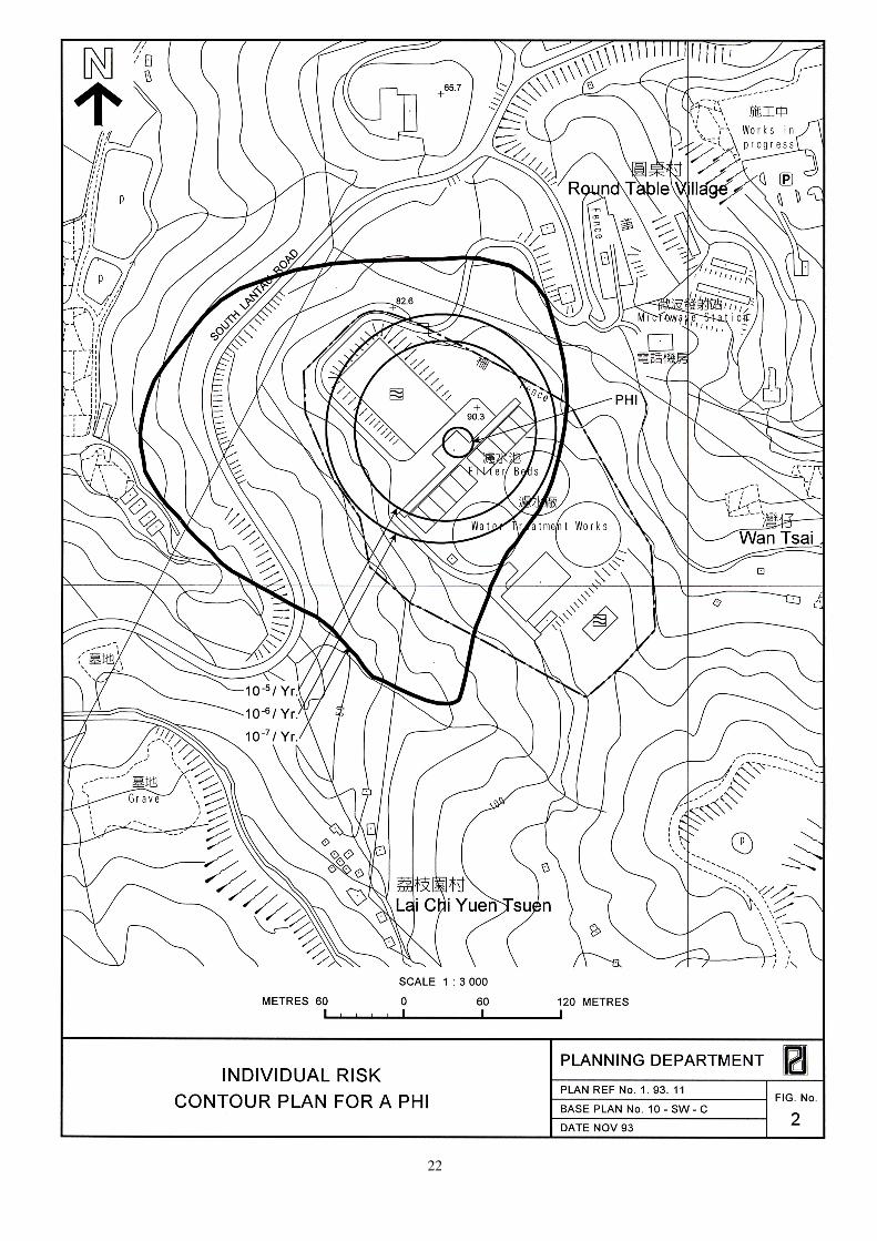
an individual who lives or works near to a PHI. As individual risk varies with location, it is often shown on a map of the area surrounding a PHI as contours of equal risk which decrease according to distance from the PHI (Fig. 2). Furthermore, when utilizing risk contours, the estimated duration of exposure of a person to the PHI should also be taken into consideration to determine the individual risk for comparison with the RG. The CCPHI individual RG requires that the maximum level of off-site individual risk associated with PHIs should not exceed 1 in 100 000 per year i.e. 1 x 10
-5/year. To put this in perspective, the average
annual risk of dying in a traffic accident is about 1 in 10 000. 4.4.3 Societal risk expresses the risks to the whole population living near a
PHI. The societal RG is presented graphically in Fig. 3. The acceptability of societal risk is judged against the frequency and number of deaths of potential incidents at the PHI. The societal RG is expressed in terms of lines plotting the frequency (F) of N or more deaths in the population from incidents at the PHI. Two FN risk lines are used in the societal RG to determine `acceptable' or `unacceptable' societal risks. In order to avoid major disasters resulting in more than 1000 deaths, there is a vertical cut-off line at the 1000 fatality level extending down to a frequency of 1 in a billion years. An intermediate region is also incorporated in the societal RG in which the acceptability of societal risk is borderline and should be reduced to a level which is “as low as reasonably practicable” (ALARP). It seeks to ensure that all practicable and cost-effective measures which can reduce risks will be considered.
18
4.5 The Undertaking of Hazard Assessments, Planning Studies and Action Plans for Existing and Proposed PHIs Hazard Assessment (HA) 4.5.1 A HA is a technical study on the level of off-site individual and societal
risks associated with a particular PHI. It is undertaken by suitably experienced specialists taking into account elements like the nature of the hazardous substances (such as their inflammability or toxicity) and the likely failure events (such as explosion and drifting of gas upon leakage). The HA will identify potential incidents at the PHI and calculate the frequency and consequences of each incident. The HA study will produce calculations of individual risk and societal risk for comparison against the RG. The HA will assess the risks posed by the PHI on the present and future population in its vicinity, and to determine what actions can be taken to reduce such risks.
4.5.2 For Government installations, the undertaking of HA will be steered by a
Working Group to be chaired by the commissioning department. For PHIs which are owned and operated by private companies, the HA will normally be undertaken by the private PHI operator in consultation with the Government (see Annex I). The concerned department will assume a supervising role for the undertaking of HA.
Planning Study (PS) 4.5.3 A PS examines the present and future land use and development
proposals in the neighbourhood of each PHI and advises on the necessary planning considerations and development control within the CZ of the PHI.
4.5.4 PS are to be undertaken by District Planning Offices (DPOs)
concurrently with the HA. In the course of preparing the HA and PS, all present and future land uses and development options should be considered, and the relevant departments consulted. Recommendations should be made on how to ensure that the existing and future developments can be protected from being exposed to unacceptable risk caused by the respective PHI. These recommendations will be included in an Action Plan. EMSD and EPD should give technical advice in respect of the extent of hazard created by the PHI. DPOs should provide EMSD and EPD with detailed information on land use, buildings and population level within the CZ.
Action Plan (AP) 4.5.5 After the completion of the HA and the PS, an AP should be drawn up by
the relevant DPO, setting out the actions required to bring the risk to a level which is as low as reasonably practicable. It sets out various measures, within the existing administrative and statutory framework, to implement the recommendations of the HA and PS. Possible actions may include, for example, reduced inventory level of hazardous substances at the PHI, physical and operational improvements to the installation, special planning and development control, and other immediate administrative and emergency measures.
4.5.6 DPOs should submit draft APs for the approval of CCPHI. DPOs should
also incorporate relevant recommendations into the respective departmental plans and statutory outline zoning plans.

19
Role of Government Departments Dealing with PHIs 4.5.7 The current division of responsibilities among Government departments
dealing with PHIs is given in Annex 1. The HA, PS and AP, when completed, will be submitted to CCPHI for consideration and endorsement.
4.6 Land Use Planning and Control in the Vicinity of Existing PHIs
4.6.1 The HA, PS and AP for a PHI will form the basis for land use planning
and development control within the CZ. Depending on the findings and recommendations of the HA, the following are possible measures which may be taken to reduce risk or contain risk at its present level : (a) statutory re-zoning to reduce development potential with regard to
population in buildings or otherwise; (b) stopping public works and Housing Department projects for which
there is no contractual commitment and which would increase population in buildings or otherwise;
(c) for public works and Housing Department projects with
contractual commitment which would increase population, modify as far as practicable to include preventive alterations or replanning of open space;
(d) non-development clearance of squatters; (e) preventive alterations to existing public housing buildings,
re-planning of estate open space, or construction of protective bunds;
(f) advancing the date of redevelopment of a building in an old public
housing estate; (g) relocation of hazardous release sources within the PHI site; (h) refusal of licence or formal design approval for increased
inventory at the PHI, or requirement for reduction in inventory at the PHI as a licensing condition or “improvement notice”; and
(i) improvement to plants and buildings at the PHI site.
4.7 Processing Applications for New PHIs 4.7.1 The Government department which receives an application for
establishing a PHI for Liquefied Petroleum Gas, Liquefied Natural Gas, Substitute Natural Gas or Town Gas should notify the Electrical and Mechanical Services Department (EMSD) or the Environmental Protection Department (EPD) for all other non fuel gas PHIs. EMSD and EPD are responsible for advising the relevant licensing authorities on the off-site risks of PHIs.
4.7.2 The Planning Department should, in consultation with EMSD or EPD,
conduct a site search to identify suitable sites for the proposed PHI. A HA and a PS should be undertaken when a site has been identified for the proposed PHI. The undertaking of HA and PS should follow the procedures as described in section 4.5 above.

20
4.7.3 The HA and PS should be submitted to CCPHI for endorsement. The
proposer of the project will also have to go through all the usual planning application procedures.
4.7.4 The concerned District Board is normally consulted on any proposals to
establish new PHIs in the district.
4.8 Interim Planning Guidelines for Dealing with Applications for Developments in the Vicinity of PHIs before Completion of Hazard Assessments and Planning Studies 4.8.1 It is assumed that, for interim planning purposes, existing PHIs will not
be relocated before the completion of the HA and PS. The working principle is to try to reduce, wherever reasonably practicable, the number of people living, working and congregating (including transient population) in the CZ of a PHI. Any change which will result in an increase in the number of persons in the CZ should not be allowed, unless this results in any private party being deprived of development rights. Decisions affecting private rights will have to await the completion of the HA and PS.
4.8.2 The general guidelines for dealing with applications for development
within the CZ are as follows : (a) no amendments of statutory or departmental town plans which
allow an increase in planned population, whether in buildings or otherwise;
(b) no lease modifications (including regrants) which allow increase in
planned population, whether in buildings or otherwise; (c) no disposal or allocation of new sites for residential use or
congregation, be they permanent or temporary developments and redevelopments;
(d) decision on uncommitted public works and equivalent Housing
Department projects which increase population in buildings or otherwise will have to await the completion of HA and PS; and
(e) applications for development within the CZ that merit special
consideration may be submitted to CCPHI for special approval.
4.9 Protection of Future PHI Sites 4.9.1 Site searches are conducted to identify possible future PHI sites. All
these sites are in remote areas with sparse population. It is not the intention that the areas identified as having potential for PHIs should be precluded from development. Rather it is the intention that CCPHI should be able to monitor development pressures in areas which have the best attributes for future PHIs.
4.9.2 A “CCPHI Monitoring Zone” should be delineated for each potential PHI
site. CCPHI should be consulted when non-PHI proposals arise within the zone which could prejudice the continued reservation of the site for PHI use.

21
Annex I
Role of Government Departments Dealing with PHIs The current division of responsibilities amongst Government departments is listed as follows : Advisor Licensing Commissioning Preparation Installation Operator on Risk Authority of HA of PS, AP Liquefied Private DEMS Gas Authority Company/ DPO Petroleum Company EMSD Gas Store Liquefied Private DEMS Gas Authority/ Company/ DPO Petroleum Company D of FS EMSD Gas/Oil (Note 1) Terminal Town Gas Private DEMS Gas Authority/ Company/ DPO Installation Company D of FS EMSD (Note 2) Petrol Private DEP D of FS Company/ DPO Store Company EPD Chlorine DWS DEP - WSD/EPD DPO Store Liquid Private DEP D of FS Company/ DPO Oxygen Store Company EPD Government DCE DEP C of Mines DCE/ DPO Explosives DEP Depot Explosives Private DEP C of Mines Company/ DPO Factory Company DCE/DEP Notes 1. Since LPG usually generates greater off-site risk, EMSD will commission the HA
and advise on risk, with EPD represented with respect to oil installations. 2. The role of D of FS in dealing with town gas installation is the licensing of
storage and use of naphtha.
22

23
UNACCEPTABLE
10 100 1 000 10 000
Number of Fatalities (N)
ALARP region
ACCEPTABLE
Fre
qu
en
cy
(F
) o
f a
cc
ide
nts
wit
h N
or
Mo
re F
ata
liti
es
(P
er
Ye
ar)
Fig. 3
Societal Risk Guidelines for Acceptable Risk Levels
10-2
10-3
10-4
10-5
10-6
10-7
10-8
10-9
24
5. Vehicle Repair Workshops
5.1 Use
5.1.1 Vehicle repair workshops (VRWs) provide an important service to the public.
However, their operations often cause transport and environmental problems,
particularly in residential areas and rural areas.
5.1.2 Existing VRWs are usually small establishments (less than 5 employees)
occupying a net floor area between 50 to 100 sq.m. The common
activities include mechanical work, welding, paint spraying and selling
of tyres and automotive parts.
5.1.3 Due to site constraints, VRWs in the urban area usually repair private
cars, taxis and light vans. Goods vehicles are normally repaired in the
New Territories and container-vehicles near the container port areas.
5.2 Accommodation
5.2.1 VRWs should be located away from residential areas or sensitive
receivers. Balancing between environmental objectives and business
requirements, VRWs in the main urban area and new towns should be
accommodated on the periphery of industrial areas, either in
purpose-designed buildings or on the lower floors of industrial buildings.
VRWs can combine with compatible uses, such as petrol-filling station,
in suitable locations. Such buildings would need additional safety and
fire prevention equipments. Advice from the Director of Fire Services
should be sought at the planning stage.
5.2.2 In the rural areas, low density VRW buildings compatible with the
surrounding environment could be considered. VRWs may be planned on
the periphery of new towns, or in urban transition areas on sites
designated for rural workshop, taking land use, environmental, traffic and
infrastructural criteria into consideration.
5.3 Locational Requirements
5.3.1 In planning for new VRWs, consideration should be given to the existing
distribution of VRWs and additional demands arising from new
developments.
5.3.2 VRWs generally prefer to be located in areas of reasonable proximity to
their customers or to have a high degree of accessibility by road or public
transport. Purpose-designed VRW buildings should be located on flat,
easily formed and serviced land. However, they are usually constrained
by the availability of suitable sites near population centres.
5.3.3 For buildings to be located in existing or proposed industrial areas, the exact
location will need to be carefully assessed to avoid conflicts in land

25
allocation for high-technology industries and industrial-office uses in such
areas. Upgrading of suitable existing VRW sites in the rural areas should
be encouraged, depending upon the meeting of land use, environmental,
traffic and infrastructural criteria. Such sites should be, as far as possible,
close to existing lorry parking and port back-up areas.
5.4 Planning Guidelines for VRWs
5.4.1 Building Characteristics
(a) VRWs are workshop type activities which can operate on the lower
floors of multi-storey industrial buildings. Suitable sites can be
identified in the urban areas and new towns for the construction of
special-purpose, multi-storey buildings to accommodate solely
VRWs. The plot ratio guidelines given in Chapter 5 of the HKPSG
should apply but an average plot ratio of 8 may be considered,
taking local site conditions and other factors like viability into
account.
(b) In the rural areas, VRW sites can be generally larger as land rents
are cheaper and some operations such as lorry or bus repairs
require more space. Such operations are more akin to open
storage-type operations and indeed may generate similar
environmental problems. In such cases, it is recommended that the
following development parameters be used :
(i) low rise building of one to two storeys;
(ii) maximum plot ratio of 0.5;
(iii) provided with water supply and with proper sewage disposal
system; and
(iv) for open-air developments, adequate paving and drainage
should be provided to minimise land contamination and
drainage problems as well as suitable fencing to minimise
visual impacts of unsightly development.
5.4.2 Minimum Site Size
(a) A minimum floor plate of 729 sq.m. (27m x 27m) is required for
high-rise purpose-designed buildings to achieve an efficiency ratio (net usable floor area/gross floor area) of 60 per cent, utilising a vehicle lift. For single-use multi-storey buildings for VRW accommodation, a minimum site area of 972m² will be required. For buildings utilising ramps, a minimum floor plate of 1944 sq.m. (36m x 54m) is required to achieve a similar efficiency ratio. For low-rise lorry repair workshops, a minimum space of 1575 sq.m. per floor (35m x 45m) would be required with an efficiency ratio of 65%. On the basis of a plot ratio of 0.5 and a single-storey building, the minimum site area requirement is 3150m².
26
(b) The size of site should be determined according to local circumstances.
Larger sites are preferred as they allow more flexibility in building
design and achieve a better efficiency ratio.
5.4.3 Range of Unit Sizes
VRWs vary in sizes, ranging from small establishments (up to 100 sq.m.),
medium establishments (100 to 200 sq.m.) to large establishments (over
200 sq.m.). Purpose-designed VRW buildings should provide the
opportunities to accommodate establishments of varying sizes.
5.4.4 Workspace Requirements
The term 'workspace' refers to an area large enough to accommodate a
vehicle and the person working on it. In general, small VRWs have
between 0.5 and 1 workspace per person. The larger firms have between
2 and 5 workspaces per person.
5.4.5 Internal Arrangements
It is preferable to locate the workshops for goods vehicles on the ground
floor of a purpose-designed building (see Figure 4) to minimise the
provision of heavy floor loadings and ramps for lorries which are
expensive. Workshop for private cars, taxis and light vehicles would
therefore be provided on the upper floors. A reception area doubling as a
parking and holding area may be planned above the floor dedicated to
goods vehicles. The holding area should be of appropriate size and
designed in such a way as to avoid queuing of vehicles and tailing back
onto public roads. The alternative design for goods vehicles suggested in
Figure 5 would be appropriate for low-density workshop development in
the rural areas.
5.4.6 Parking Requirements
In designing purpose-designed buildings or accommodating VRWs in
industrial buildings, the general intention is to provide all the necessary
facilities off-street, including parking requirements. A minimum of 2
parking spaces should be provided for each workshop unit or 0.75
parking space per workspace or 150m² of GFA whichever is the higher.
Parking may be provided on separate floors. Vehicle lifts may be
provided as an alternative to ramping.
5.4.7 Other Facilities Required
In general, toilets should be shared and the building may make provision for
a small canteen if appropriate. For multi-storey VRW buildings, a central
management office and a general loading/unloading area would be required.
Small VRWs would have to combine various functions within their usable
areas. As a general guide, a two-person workshop would require an
internal area of 10 x 9 sq.m., including storage and minor office
space. For new VRWs premises, oil/petrol interceptors should be

27
provided for dangerous goods such as engine oil, brake fluid, kerosene,
paint and thinner. Dangerous goods stores should be planned at the
periphery of the building facing the street for fire fighting purpose. Approval
of Fire Services Department is necessary.
5.4.8 Environmental and General Design Consideration
The accommodation for VRWs should not result in adverse
environmental impacts to surrounding developments and the general
guidelines given in Chapter 9 of the HKPSG should be taken into
consideration at the detailed design stage.
28
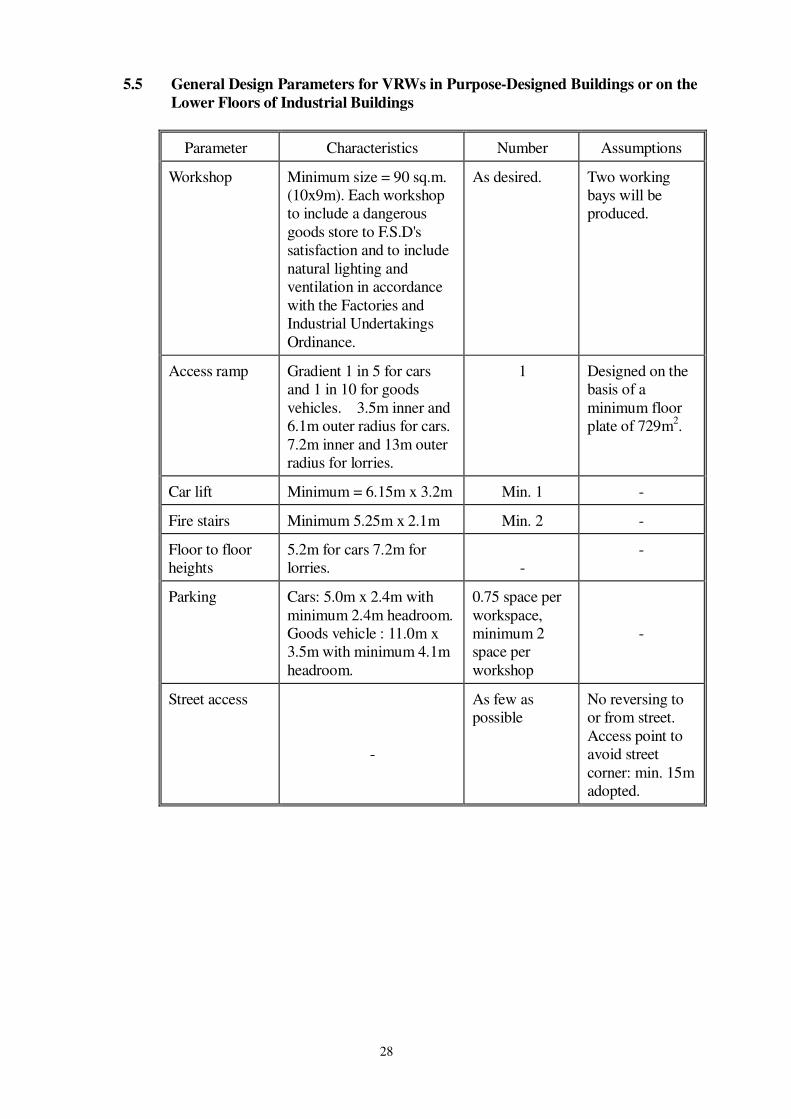
5.5 General Design Parameters for VRWs in Purpose-Designed Buildings or on the
Lower Floors of Industrial Buildings
Parameter Characteristics Number Assumptions
Workshop Minimum size = 90 sq.m.
(10x9m). Each workshop
to include a dangerous
goods store to F.S.D's
satisfaction and to include
natural lighting and
ventilation in accordance
with the Factories and
Industrial Undertakings
Ordinance.
As desired. Two working
bays will be
produced.
Access ramp Gradient 1 in 5 for cars
and 1 in 10 for goods
vehicles. 3.5m inner and
6.1m outer radius for cars.
7.2m inner and 13m outer
radius for lorries.
1 Designed on the
basis of a
minimum floor
plate of 729m2.
Car lift Minimum = 6.15m x 3.2m Min. 1 -
Fire stairs Minimum 5.25m x 2.1m Min. 2 -
Floor to floor
heights
5.2m for cars 7.2m for
lorries.
-
-
Parking Cars: 5.0m x 2.4m with
minimum 2.4m headroom.
Goods vehicle : 11.0m x
3.5m with minimum 4.1m
headroom.
0.75 space per
workspace,
minimum 2
space per
workshop
-
Street access
-
As few as
possible
No reversing to
or from street.
Access point to
avoid street
corner: min. 15m
adopted.

29
Footnotes : (1) Figures are used only for illustration purpose. Detailed design should be subject to the
provisions of Building (planning) Regulations.
(2) For indication purpose, the minimum site area and floorplate are 972m2 and 729m2
respectively.

30
31
6. Port Back-up and Open Storage Uses
6.1 Introduction
6.1.1 At present, sites reserved for open storage uses are zoned ‘Open Storage’ on
Outline Zoning Plans (OZPs). Certain types of open storage and port
back-up uses which are expected to generate significant impacts are put
under Column 2 of the Notes pertaining to the ‘Open Storage’ zone. These
uses require planning permission from the Town Planning Board. Open
storage (not elsewhere specified), i.e. not specified in Column 2, is included
under Column 1 and is always permitted. The ‘Other Specified Uses’
designation applies to sites specially reserved for port back-up uses, as in the
case of ‘Other Specified Uses (Container Back-up)’ zoning.
6.1.2 The intention of the chapter is to provide guidance to district planners in
zoning land for open storage uses and in determining which types of uses
should be subject to more stringent control by putting them under
Column 2 of the Notes of an OZP. The guidelines are also designed to
inform the public of Government's land use policies with regard to these
uses.
6.2 Definition of Port Back-up and Open Storage under the Guidelines
6.2.1 A broad distinction is proposed in these guidelines between open storage
and port back-up uses, which are related to their different operational
requirements and environmental, transportation and land use planning
impacts. Within these two broad categories, specific forms of activities
are defined.
6.2.2 Open Storage
(a) ‘Open storage’ uses considered here relate to activities carried out on a
site for which the greater part is uncovered (i.e. generally assumed to be
more than 50%). Activities include storage, repair or breaking other
than container-related uses. Storage activities ancillary to industrial,
workshop, warehousing and other commercial activities on the same
site are excluded from this definition. The definition however includes
temporary structures such as those found on dumping and vehicle repair
sites (for example galvanised sheeting used for carports), as these do
not radically differ from the appearance, nature or impact of operations
carried out in open accommodation. The operational nature of a site,
such as revealed in the description of an activity, can also be considered
in determining whether its use comprises open storage.

32
(b) Activities conforming to the above definition comprise those surveyed
in the Study on Port Back-up Land and Open Storage Requirements,
namely:
- Storage of rattan and bamboo
- Storage of logs and timber
- Storage of ceramic/pottery products
- Storage of processed agricultural products
- Storage of scrap metal
- Storage of cans/tanks etc.
- Storage of paper and general rubbish
- Storage of cement/sand
- Storage of chemical products
- Storage of dangerous goods
- Storage of vehicles for stripping/breaking or repair
- Storage of new vehicles and vehicle parts for sale or disposal
- Vehicle depot
(c) Given the wide range of operational activities and products
covered by the above uses, grouping of these activities is useful for
their general description reflecting distinct economic activities and
the different impacts which such major types of activities generate
on the environment. Four main groups comprise:
- Storage of construction materials and equipment
- Vehicle storage
- Storage of products
- Dumping and vehicle parts storage/repair activities
(d) The above descriptions are considered to be an accurate definition
of those activities which have spread throughout the Territory
during the 1980's and which differ significantly from uses such as
warehousing, workshops, and utility installations.
6.2.3 Port Back-up
(a) Port back-up uses are those port-related activities which are
situated off-port (i.e. beyond the perimeter of container terminals,
river trade terminals and public and private cargo working areas).
Such activities are essential to the operation of port activities but
do not need to be located within the confines of the port.
(b) The definition is based on both locational and operational
characteristics. In general terms, on-port activities are those relating
directly to quayside operations, such as container handling to/from
ships, and activities requiring immediate access to the waterfront.
Although by their nature, off-port activities do not require such close
33
proximity to waterfront operations, some can still benefit from
locations immediately adjacent or near to the port. For the purpose of
these guidelines, the following activities are defined as port back-up
uses:
- container lorry park (equivalent to container trailer/tractor
park)
- empty container storage and repair
- container yard (for the storage and handling of loaded
containers)
- container freight station
6.2.4 A precise description of each main category of open storage and port
back-up use and the impacts these activities generate on the environment,
transport and land use planning are provided in Annex 2.
6.3 Need for Greater Control
6.3.1 Over the last decade, land taken up for open storage and port back-up
uses has doubled. Port back-up activities have recorded the highest rates
of increase since 1983, expanding from under 30 sites covering 28 ha in
1983 to over 237 sites covering 198 ha in 1993.
6.3.2 The rapid rise of open storage and port back-up uses in many parts of
Hong Kong's rural areas has occurred in a largely haphazard and
uncontrolled manner. The driving force behind this proliferation of
activities has been the increasing demand for cheap and relatively large
sites, improved accessibility to the rural areas, and the economic benefits
arising from converting agricultural land to storage uses which until 1990
when Interim Development Permission Areas were designated, was
largely exempt from planning control.
6.3.3 The adverse forms of impacts, resulting from the growth in this type of
storage activities, may be summarised as follows.
6.3.4 Proliferation of Uses
The scale of the sprawl of port back-up and open storage uses in the New
Territories has resulted in a general degradation of the rural environment,
changing the character of former agricultural areas such as Lau Fau Shan
and Kam Tin to that of a poor quality, urban fringe type environment.
6.3.5 Noncompatible Land Uses
Many activities are located within areas not suitable for this type of use,
being in close proximity to residential and Government, Institution and
Community uses, or sensitive environmental areas such as Sites of Special
Scientific Interest (SSSIs) where ecology systems may be disturbed, or areas
34
of unspoilt countryside. Adverse environmental impacts on sensitive
receivers such as noise from movements of heavy vehicles and container
handling operations, air pollution from vehicular movements and visual
intrusion are a result of such poor land use interface.
6.3.6 Traffic Generation
The dispersion of sites, particularly port back-up uses which are high
traffic generators, has led to increase travel trips to the port, the border
and between different container back-up sites. This has given rise to
greater traffic congestion on the strategic road networks, (particularly
along the Tolo Highway and Castle Peak Road), increased air pollution,
traffic noise impact and travel costs, and reduction in operational
efficiency, notably regarding access to the port. Sites in areas served by
poor access roads, including rural tracks, have introduced inappropriate
heavy vehicular traffic to the rural areas, leading to congestion on local
roads, reducing environmental quality, and threatening road safety to
village communities.
6.3.7 Environmental Degradation
In addition to traffic generation and sprawl of activities, many sites are
currently degrading the environment through poor waste management
practices, noise and air pollution from heavy vehicles, pollution of water
courses and land contamination. Inadequate refuse collection methods
and absence or poor maintenance of drains are current problems. The
conversion of agricultural land to storage uses and the filling of fish
ponds for such purposes also contribute to drainage problems. The
obstruction of natural drainage systems has caused increasing
flood risk.
6.3.8 Operational Efficiency
The ideal locations for many port back-up activities are near to the port,
the border or close to strategic transport routes. However, the availability
of cheap and relatively large sites from agricultural land has resulted in
the dispersion of port back-up sites in the peripheral parts of the New
Territories. Such dispersion is not conducive to effective operation of the
industry.
6.4 Future Demand for Storage Use
6.4.1 Based on projections carried out in 1993, maximum demand for port
back-up use could be in the order of 380 ha by 2001. Land for open
storage is expected to generate demand of between 450 ha to 550 ha by
2001. By 2011, demand for port back-up and open storage land could
register an estimated maximum increase of around 150% and 100%
respectively representing a corresponding total land area of around 510 ha
and 750 ha, compared with the levels in 1993. The above figures represent
35
considerable land areas and since the estimated demand is so high, it is the
planning intention that some existing sites which have less adverse
environmental, traffic and drainage impacts can be retained at least in the
short to medium term, until planned sites can be developed to accommodate
the additional demand and relocate inappropriate existing uses.
6.4.2 The extent to which additional demand will manifest itself is nevertheless
dependent on numerous factors, not least:
(a) the growth in container throughput at Hong Kong's ports;
(b) the degree to which the existing supply of land is retained for port
back-up and open storage uses;
(c) the degree to which activities are likely to locate in China; and
(d) levels of efficiency in site utilisation.
6.4.3 The availability of new sites planned and the level of supporting
infrastructure will also determine the rate and nature at which activities
can be accommodated.
6.4.4 Both land demand and supply therefore need to be constantly updated in
the light of the above considerations. Monitoring of economic and land
use trends and changes should be undertaken to determine the extent of
land provision required in the medium to long term. Such monitoring
will also determine policies with respect to the enforcement of existing
problem sites, and processing of planning applications.
6.4.5 The following guidelines are aimed at achieving a more effective
distribution of port back-up and open storage sites, and improving the
environmental, transport and land use planning for such activities.
6.5 Broad Area Policy Guidelines
6.5.1 Broad area policy guidelines are intended to provide a general planning
framework at a spatial policy level. Broad areas are defined according to
the existing distribution of port back-up and open storage sites and
geographical characteristics such as land use patterns, road access and
physical features.
6.5.2 The broad area policy guidelines define five different categories of areas,
based on an evaluation of 25 broad areas where existing port back-up and
open storage uses concentrate and new areas suitable for longer term
accommodation. The guidelines should be applied flexibly in the course of
district planning and/or assessment of planning application, with reference to

36
the broad area recommendations contained in the “Study on Port Back-up
Land and Open Storage Requirements” completed at the end of 1994.
6.5.3 Type 1 Areas: Recommended for intensification
These are areas which are generally suitable for continued use and
further intensification in the short to medium term. Generally, conditions
are such that little strategic road infrastructure improvements are needed
although large scale intensification in some areas are subject to long term
road construction. Individual sites may require mitigation measures to
overcome such constraints as drainage and access.
6.5.4 Types 2 Areas: Recommended for limited intensification
These areas possess opportunities for limited intensification generally
because of their strategic location, good infrastructure and conducive
environment. Nevertheless, these areas may have other types of
constraints, such as sensitive receivers (e.g. residential areas), which
require intensification to be selective according to the types of uses and
site locations.
6.5.5 Type 3 Areas: Recommended for limited intensification with improvements
These are areas which have more significant constraints in terms of land
use compatibility, access and environmental quality and which require
either greater investment in improvements/mitigation measures or a more
limited allocation of sites.
6.5.6 Type 4 Areas: Prevent proliferation of uses
Further activities should be prevented from such areas which are
considered to be incompatible to the environment.
6.5.7 Type 5 Areas: Discontinue sites
These areas are those where the long term aim should be to discontinue
existing activities and improve the environmental quality of the area.
6.6 Broad Locational Principles
6.6.1 The following broad locational principles should be adopted for all open
storage and port back-up uses.
6.6.2 Encourage Concentration of Uses
Wherever possible, uses should be concentrated in distinct areas and
adjacent to existing sites, thus avoiding further proliferation of activities.

37
Empty container storage and repair sites should not be allowed in areas of
populated countryside. For open storage sites, concentration of activities at
a local level is appropriate to activities such as dumping and construction
materials/equipment storage which need to be distributed around various
parts of the Territory to service different urban areas and construction sites.
Concentration of activities would reduce the unsightly sprawl of activities
currently prevalent in many urban transition areas, reduce travel trips
between sites, and allow economies of scale for Government to instigate
infrastructural improvements and mitigative measures such as road
upgrading and drainage improvements.
6.6.3 Encourage Location to Strategic Areas
Given Hong Kong's small land area, it is necessary to maximise land
resources and operational efficiency. The planning of extensive new
container port areas provide good opportunities for the concentration of
port back-up activities here, and the development of new industrial areas
also present longer term opportunities to provide appropriate solution
spaces for open storage activities. Border areas well served by strategic
infrastructure, may also be appropriate for port back-up activities given
the increase in container movements to China and the presence of large
port back-up sites already established here. Open storage uses should be
concentrated at selected and clearly demarcated sites around major urban
centres such as new towns, where activities are related to the needs of
such urban areas, and on solution spaces near to industrial or port
activities.
6.6.4 Maximise Transport Efficiency
New sites are best located near existing and new strategic road
infrastructure, allowing traffic to be segregated from countryside areas
and communities. However they should be subject to detailed traffic
impact assessments on the overall capacity of the strategic road network
as well as the local road system.
6.6.5 Encourage Location in Environmentally Acceptable Areas
The long term aim is to improve those rural areas currently blighted by port
back-up and open storage uses by encouraging relocation to broad areas
where activities would minimise environmental impacts. Reduction of sites
in flood plain areas would also reduce potential flooding problems. The
Territorial Development Strategy and Sub-regional Development Statements,
which include strategic environmental planning policies for concentrating
bad neighbour development away from sensitive receivers and
environmental protection areas, should be adhered to and opportunities to
locate activities in hitherto sparsely populated areas to the west of the
Territory such as North East Lantau and Tuen Mun West should be
maximised, subject to suitable access being provided.

38
6.7 General Locational Guidelines for Specific Uses
6.7.1 The following sub-paragraphs provide general guidelines for reserving sites
in OZPs, Outline Development Plans, and Layout Plans or in considering
planning applications from the private sector. They should be considered
together with the detailed site planning standards and guidelines described in
Section 6.8.
6.7.2 Container Lorry Parks
(a) Sites should ideally be located in areas with good access to both
the port and drivers' residences. In this regard, the port and
industrial areas in Kwai Chung, including those off Container
Terminals (CTs) 1 to 7 and the new CTs 8 and 9 facilities, offer
appropriate locations in this respect although they are constrained
by current shortages of land and competing pressures for other
uses. Sites near the border with good access to strategic road
networks are also recommended, provided the local roads can cope
with its additional traffic and adequate public transport is provided
for the workers.
(b) New allocation of sites in OZPs should aim to develop large sites
consistent with the policy of preventing proliferation of small sites.
In areas where the identification of permanent sites is difficult,
other temporary measures such as extension of short term
tenancies and short term waivers and/or temporary use of
reclamation sites should be supported wherever practicable.
(c) The development of multi-storey container lorry parks should be
encouraged in the urban areas, especially at Kwai Chung, where
the demand for both on-port and off-port facilities is high. Such
multi-storey parks may be combined with container freight station
activities or other compatible uses to enhance viability.
6.7.3 Container Storage and Repair
The overriding need is for large sites to facilitate the use of machinery and
on-site queuing areas for lorries, and allow maximum storage of containers
during peak periods. Locations adjacent to the new container terminals are
desirable for those activities storing containers for short periods of time.
Those stored over longer periods (more than 3 days) can be located in other
parts of the New Territories, preferably on sites near to the border and with
easy access to the strategic road networks. Co-located with other
container-related sites, including container lorry parks, is desirable to
minimise traffic generation.

39
6.7.4 Container Yards
Sites should be located near waterfront areas or with good accessibility to
points of distribution. Requirements include good security, 24-hour working
conditions and good infrastructure and services, such as power supplies for
refrigerated containers. On-site queuing areas for vehicles are required
during peak periods and interface with residential uses should be avoided
where traffic volumes are high.
6.7.5 Container Freight Stations (CFS)
(a) Priority should be given to sites near the port and within industrial
zones of the main urban areas to facilitate access to main
distribution points and markets and reduce travel trips. Industrial
and godown uses are compatible to both the nature and impacts of
these activities.
(b) Although experiencing declining rates of demand at the port, CFS
activities on or adjacent to the port remains a compatible use. CFS
activities with longer dwell times can be accommodated in the
New Territories, notably in areas of existing industrial, open
storage or port back-up use.
6.7.6 Storage of Construction Materials and Equipment
(a) Flexibility is required on the locational requirements to
accommodate construction materials and equipment, which often
require short term sites. For example, temporary sites can be
located in newly reclaimed areas provided that they do not cause
adverse impact to the environment. Consideration can be given to
designate certain sites in the urban areas, such as the urban
transition zone, for such uses on a permanent basis.
(b) Interface with sensitive receivers should be avoided for the storage
of cement and sand, and the visual impact should be minimised for
equipment storage.
6.7.7 Storage of Vehicles
Large sites for new vehicle storage with less locational preference but good
security are required. Sites may be required on a temporary basis given the
seasonal nature of the industry. Multi-storey car parks may be considered
as an alternative to open storage, as this provides good security. Variation in
demand makes forward planning for this use difficult.

40
6.7.8 Storage of Products
Sites need not necessarily be located near to sources of distribution or
markets, although logs and timber would best be situated near the production
points such as saw-mills or near to where these are imported at port locations.
6.7.9 Dumping and Vehicle Parts Storage/Repair Activities
A concentration of activities is recommended in specially demarcated
open storage sites outside urban areas. Dump sites could be adjacent to
industrial, warehousing or other storage activities. Vehicle parts and
storage uses could also be located near to container lorry parks in the
New Territories.
6.8 Site Planning Standards and Guidelines
6.8.1 The followings are proposed to improve the environmental impacts of
new sites, and existing sites where practicable. Such improvements can
be achieved through the selection and/or approval of new sites, through
application of regulatory measures, or voluntary actions by site operators.
6.8.2 Land Use Interface
(a) Sites should not be located adjacent to sensitive receivers such as
residential dwellings, hospitals, schools and other community
facilities. Reference should be made to relevant sections of
HKPSG Chapter 9, Environment. Sites within 100 metres of
Country Parks and other sensitive environmental areas such as
SSSIs should normally not be allowed unless it could be
demonstrated that such uses would have insignificant impacts on
the sensitive environmental areas. Compatible uses are industrial,
godowns, port uses, other open storage and port back-up uses and
public utility installations. Use of sites within major road corridors,
where these do not adjoin sensitive receivers should be supported.
(b) The use of buffering on both large and small sites should be
encouraged. Buffer distances vary according to:
- the scale and nature of land use;
- the nature of its surroundings ( e.g topography, condition of
surrounding roads, numbers and distribution of sensitive
receivers, visual impact, etc);
- presence of man-made or natural screening features; and
- the urban or rural content of the surroundings.
(c) Suitable buffer distances should therefore be determined on a site by
site basis in accordance with the standards set out in Table 1.3 of

41
HKPSG Chapter 9, Environment.
(d) Sites which are screened from sensitive receivers by non-sensitive
buildings, major transport alignments, natural vegetation and
topography should be considered favourably.
6.8.3 Visual Aspects
(a) Container stacking causes considerable visual intrusion in rural
areas. Open storage, by nature of its uses, requires to
accommodate products of varied size, shape and appearance.
Activities which could theoretically be carried out on storage sites
can result in visual and physical clutter. The provision of
landscaping provides an opportunity to counter such effects.
(b) Where proposed container storage and repair sites cause significant
visual intrusion to surrounding or adjacent residential uses in the
rural areas, stacking restrictions to a maximum of 3 units
(equivalent to the height of a traditional village house) should be
considered where practicable.
(c) Landscaping is more effective for large sites which afford greater
set backs from the road. Mounding with planting in the form of a
continuous belt can effectively screen development and act as a
noise buffer (see Figure 6). Port back-up and open storage uses
located in industrial or port areas usually bring about less visual
intrusion to the surrounding areas.
6.8.4 Site Size and Intensity
(a) The approximate median values for each broad type of port
back-up and open storage activity, as revealed by the survey in the
Study on Port Back-up Land and Open Storage Requirements
completed in 1994, should be used as a minimum site area for
assessing whether applications for planning permission conform to
current standards of provision.
Minimum
Use Site Requirement
- Container storage and repair 5 100m2
- Container yard 4 900m2
- Container lorry park 3 000m2
- Container freight station* 2 000m
2
- Open storage 1 000m2
* Sites in the New Territories should have a minimum area of 2 000m2. This
requirement does not apply to facilities at the container port which are
considerably larger

42
(b) However, the issue of site size for port back-up and open storage
facilities is sensitive to a number of considerations not least:
- the availability and timing of land both at Territory-wide and
local level;
- road and traffic conditions serving the site; and
- environmental and drainage constraints affecting the site.
(c) Restricted availability of sites, particularly in the urban areas, and
in the short to medium term when demand is estimated to outstrip
land supply, may preclude the selection of sites over a certain size.
Thus, smaller sites may need to be considered in the short to
medium term. Moreover reductions in the area of designated
sites may result from environmental, drainage and transport
constraints. In such instances, strict adherence to an optimum size
would be too rigid an approach.
(d) Moreover, the definition of a minimum and optimum size of site
involves considerable uncertainties. It is difficult to justify in
operational terms, given that increasing efficiency may not be
correlated to increasing size of site. The ultimate efficiency will
depend on the amount of goods/activities stored by a particular
operation, which may operate more effectively on a small site than
a large one. Similarly the area required for on-site parking is
dependent on the numbers of trips and dwell times generated by
the activity, rather than size of site. It is recommended therefore
that discretion should be used in both addressing planning
applications and designating sites in OZPs for use as open storage
and port back-up purposes. This should be based on the
individual merit of the site in question, its planning history
(whether it is vacant or underused), its urban or rural context, the
compatibility of its surroundings and, in the case of an application
for planning permission, whether the applicant can demonstrate
that no adverse impacts would be generated.
(e) For the purpose of reserving sites for future use, emphasis should
be placed on providing larger sites areas to allow for a greater
concentration of activities. These will also encourage greater
investment on the site to improve services and efficiency (for
example provision of utility infrastructure and increased
mechanisation) and to ensure effective environmental protection
measures are afforded.
(f) As a general guideline, the policy of locating port back-up use in large,
integral areas such as near to the container terminals, should prompt
site reservations of over 1 ha. Where a major solution space is
identified, based on strategic consideration, reservation in excess of 10
ha should be allowed. The actual extent could however be determined
by demand forecasts and land availability, as confirmed by
43
monitoring of demand and supply.
(g) For multi-storey buildings, it is recommended that the maximum
Metroplan standard for godown (at a plot ratio of 8) should be
applied to a multi-storey container lorry park combined with other
compatible uses.
(h) For open storage, sites of over 0.5 ha should be reserved where the
objective is to create solution spaces for new/reprovisioned growth.
The actual size could also be linked to the amount of land to be
discontinued in a particular broad area, due to enforcement
proceedings or rezoning and would again be subject to land
availability constraints.
(i) Intensity of use on each site varies according to location (i.e. on- or
off-port), mechanisation, and types and length of products stored.
As a general principle therefore, a guideline on intensity of use for
off-port storage activities is not suitable and discretion should be
left to the operator in attaining the most effective site utilisation
providing transport and environmental conditions are satisfied.
Stacking heights of containers are restricted to a maximum of
seven units by operational constraints, and may be restricted
according to land use interface.
6.9 Transport Aspects
6.9.1 Container-related sites should be in areas with good access to the
strategic road network. Sites should have a clearly defined entrance/exit
point which complies with guidelines contained in the Transport
Planning and Design Manual - Vol. 2, Section 3.6. Additional points of
access may be considered for large sites. Adequate parking and queuing
areas should be provided within the curtilage of the site to avoid on-street
parking and queuing. The arrangements for access and queuing/parking
areas should be to the satisfaction of Transport Department.
6.9.2 A traffic impact assessment (TIA) should be conducted for each new site,
having regard to the cumulative effects of other sites. The TIA should
include estimates of the amount, type and routing of traffic using the site,
assessment of the extent of traffic impact on nearby local and strategic
road networks, and recommendations for solving any adverse impacts.
The adequacy of the site access and off-street queuing/parking areas
should also be demonstrated.
6.9.3 Adequate set backs should be provided to allow sight lines to meet Transport
Department's requirements.
44
6.10 Environmental Planning Aspects
6.10.1 New sites should be subject to the appropriate level of the EIA process* :
(a) For container storage and repair sites, container yards and
container lorry parks, noise modelling should be carried out to
demonstrate that noise impacts on sensitive receivers are within
recommended noise criteria contained in HKPSG Chapter 9,
Environment;
(b) Sites should be properly paved to avoid potential land and water
contamination from leakage of oils, fuels and other discharges
(relating mostly to container and vehicle repair activities,
container lorry parks, dumping/breaking of motor vehicles and
spillage of stored materials). Dust emissions from vehicular
traffic and container handling on site and odour emissions should
also be minimised;
(c) Adequate drainage should be provided on site for disposal of
storm water and discharge of effluent. Domestic sewage must be
discharged to the public sewerage if public sewerage facilities are
available. Sites located in flood risk zones should be subject to a
drainage impact study and necessary flood mitigation measures.
The cumulative effects on flood risk through conversion of
agricultural land to storage uses is of major concern and should
be fully taken into account in assessing the feasibility of the
proposals;
(d) Measures to mitigate water quality impacts such as runoff
containment through bunded areas, oil/fuel and chemical
interception and sediment traps to intercept any leakage and
spillage should be considered;
(e) Adequate provision should be made for refuse collection and
disposal on site. Moreover, all sites should meet fire safety
standards;
(f) Operating hour restrictions could be considered where sites are
assessed as causing potential noise or glare impacts, (mostly
relating to container storage and yards). This could be stipulated
under the lease conditions which could also include monitoring
requirements and measures embodied in a Code of Practice; and
(g) Reference should be made to the Dangerous Goods Ordinance for
guidelines on storage and handling and licencing procedures.
* The EIA process is set out in PELB TC No. 2/92 “Environmental Impact Assessment of Major Development
Projects” and EPD Advice Note 2/92 “Environmental Impact Assessment Process to Major Private Sector
Projects”.

45
Annex 2
Description of Open Storage and Port Back-up Uses and General Impacts
1. Open Storage
Storage of Construction Materials and Equipment
1.1 Storage of construction materials (such as bricks, scaffolding, sand) and equipment
(caterpillars, rollers etc) is the most common form of storage in Hong Kong. Activities are
located throughout the Territory. Materials are mostly stored near points of production,
while equipment is stored near to construction and development sites.
Impacts
1.2 Impacts depend on the nature, bulk and quantity of materials or equipment stored.
Environmental impacts may occur on visual amenity, through the storage of heavy plant
material, and air quality, notably through the handling and storage of sand and cement.
Generally low levels of traffic are generated by such sites.
Vehicle Storage
1.3 This involves the storage of new and used vehicles for sale as well as the disposal and
storage of vehicle components. Commercial and informal parking of cars as well as
container lorry parking are not included in this category. Sites are located near to the port
but also in the New Territories given the increasing trade of new motor vehicles between
Hong Kong and China.
Impacts
1.4 The scale of activities has been influenced by import/export regulations to China. In peak
years vehicle storage can take up large areas of land. Traffic generation is however low and
concentrated during peak periods. Relatively low environmental impacts are generated.
Storage of Products
1.5 This category embraces a large range of products varying in bulk and quantity. Products
include timber and logs (the largest component), rattan and bamboo products, ceramic and
pottery products and processed agricultural products. In general these are low value
products as higher value manufactured goods are usually stored within built
accommodation. Sites are typically located in low valued land, remote locations or near
to sources of production.

46
Annex 2 (Cont'd)
Impacts
1.6 Generally low traffic levels are generated and impacts on noise, water and air quality are
slight, being restricted to access and loading/unloading of trucks, given the absence of
manufacturing activities. Visual intrusion may occur for larger forms of storage, such as
timber and logs.
Dumping and Vehicle Parts Storage/Repair Activities
1.7 This comprises dumping of scrap vehicles, car breaking, storage of scrap metal or used
storage tanks, cans, paper and general rubbish. It also includes vehicle repair activities,
usually associated with car dumping, temporary vehicle storage and storage of spare parts.
Being the end product of material consumption, principally arising from urban population,
such sites tend to be scattered in urban fringe areas.
Impacts
1.8 These are low value activities requiring little investment on site. Such sites usually have
unkempt appearance and ill defined boundaries. This, together with the storage of
unsightly goods, creates considerable visual intrusion, which is compounded by the
proliferation of sites within a distinct area. Other problems result from noise impacts of
breaking or repair, seepage of effluent on land and watercourses (due to inadequate
drainage), and general littering.
2. Port Back-up Uses
Container Lorry Park
2.1 These are used for day time and overnight parking of container lorries (tractors) and trailers.
Sites are currently located both near to the existing container port (typically
accommodating tractors and unladen trailers) where they are near to drivers' residences, or
near to border areas such as San Tin and Lau Fau Shan where they act as transhipment
centres for the movement of full and empty containers between the port and China.
Impacts
2.2 The main impacts of container lorry parking relates to traffic generated by the site. Noise
impacts are caused by the starting up of engines, movement of trucks around the site such
as from the use of air brakes, and traffic noise generated from trucks travelling to and from
the site. Air pollution results from exhaust gases from the vehicles and, where sites are
unpaved and uneven, from discharges of dust particles entrained in the tread of tires and

47
Annex 2 (Cont'd)
subsequently released to the atmosphere as particulates. Leakages of oils and other vehicle
fluids can cause land contamination and pollution of water courses, where sites are
unpaved and not serviced by proper drainage. Traffic generation is high and tends to be
concentrated during morning and evening peaks.
Container Storage and Repair
2.3 These serve mainly as overflow sites to serve the port, at which there is insufficient space
to store containers. Absence of adequate land around the container port has led to the
proliferation of sites in distinct areas of the New Territories where cheaper land costs
prevail. The larger sites are characterised by stacking of containers of up to 7 units high and
include well organised, mechanised operations involving relatively high investments.
Repair of containers are usually included at the larger sites; very few sites are used
exclusively for repair activities.
Impacts
2.4 Visual intrusion, noise from container handling and truck movements, air pollution from
dust emissions (on unpaved sites) and exhaust fumes from vehicles, and leakage of effluent
from vehicles and repair activities are all common environmental problems associated with
these sites. Traffic problems include off-site queuing of vehicles and movements of trucks
on poor road quality (including unpaved rural tracks), which result in safety hazards for
pedestrians, congestion and further degradation of the rural environment. The highest
generation rates of container traffic are recorded on such sites.
Container Freight Station (CFS)
2.5 CFSs act as centres for the consolidation or splitting of container loads for onward
distribution. Off-port CFS activities are accommodated within purpose built buildings or as
part of godowns, and are mostly distributed in built up areas, notably in and around Tsuen
Wan where they act as consolidation points for distribution in the remainder of the Territory.
CFS activities not requiring fast and efficient access to the port tend to locate in the New
Territories.
Impacts
2.6 The use of covered accommodation minimises noise and air pollution impacts on adjacent
areas. Traffic problems may be caused by on-street queuing, where delays in the
processing of trucks occur. Such problems are usually within defined peak hours related to
shipping movements.

48
Annex 2 (Cont'd)
Container Yard
2.7 Container Yards store loaded containers awaiting onward distribution. Unlike CFS
activities, no consolidation or splitting of loads take place on such sites. These are
normally associated with goods and containers handled by the mid-stream operators
through private or public cargo working areas. Investment on such sites are usually high,
as the value of goods stored is high, including perishable foodstuffs. The majority of
activities at container yards are uncovered and sites are usually large, varying between 755
metre square to 33,900 square metres with a mean of just under one ha.
Impacts
2.8 Impacts on visual intrusion and noise is less due to absence of stacking of containers at
these sites. Although generating less traffic than container storage sites, queuing of trucks
may occur off-site during peak hours. Traffic congestion caused by the sites may be severe
where these are serviced by small rural roads.
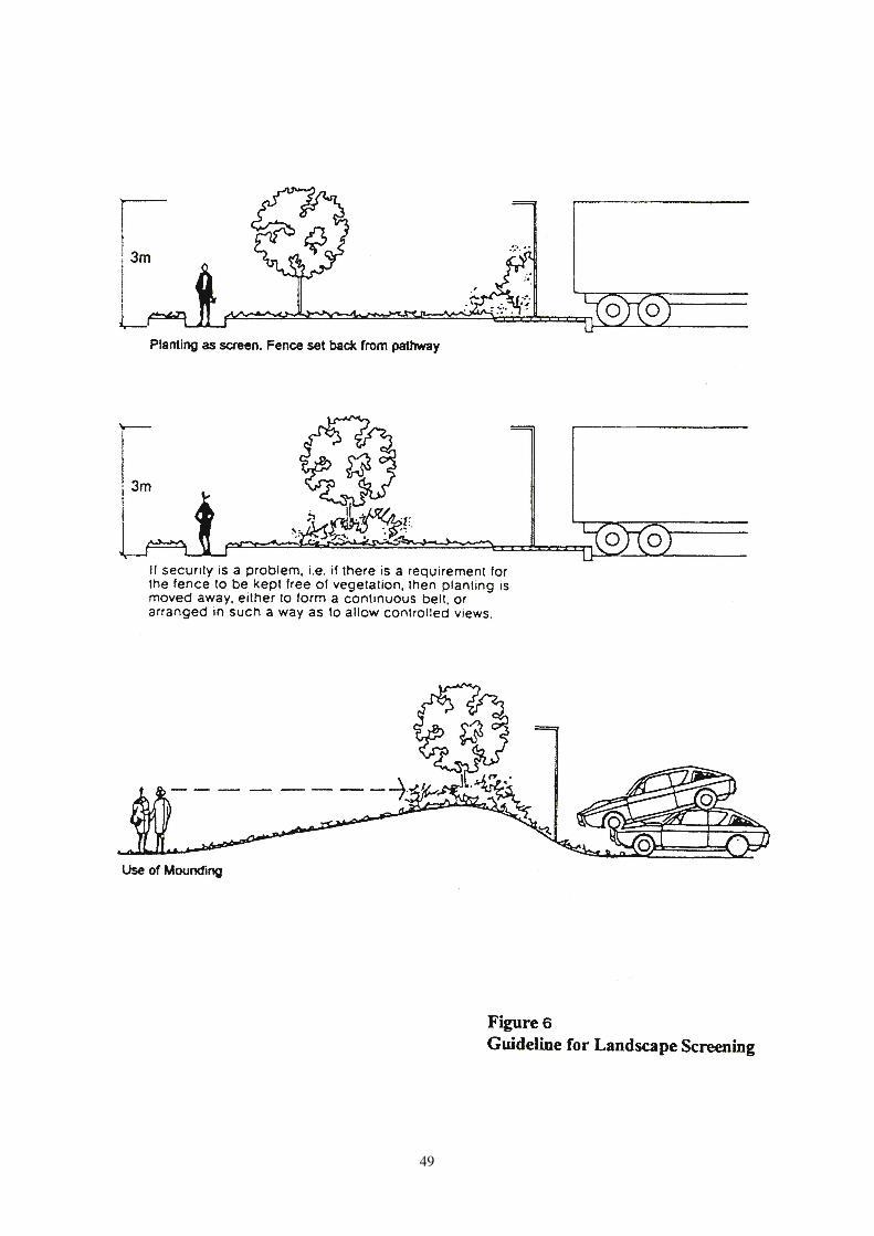
49

50
7. Use of Land beneath Flyovers and Footbridges
7.1 General Consideration
7.1.1 Flyovers/footbridges are primarily designed and built as transport
corridors/pedestrian links to facilitate transport/pedestrian movements.
They may not be suitably located and the traffic/environmental
conditions may not be conducive to accommodate all land use activities.
Flyover/footbridges sites should only be considered as alternative
solution space for uses upon exhausting all other suitable sites, provided
that such uses are acceptable in terms of land use, structural, fire safety,
traffic, environmental, visual and all other relevant considerations as
detailed in para. 7.1.4 below.
7.1.2 While sites beneath flyovers/footbridges could be made use of for
certain uses, opportunity should be taken to introduce more greening
and landscaping works beneath flyovers/footbridges. This would help
improve the visual appearance of the space and building/structure
beneath the flyovers/footbridges which, given their massiveness, could
have a bearing on the townscape.
7.1.3 For more proactive integration and co-ordination, the possibility of
including appropriate potential uses beneath major flyovers/footbridges
should be given early consideration. In planning for new
flyovers/footbridges, reference should also be made to the future
planning intentions and land use zonings on Outline Zoning Plans to
avoid severance of land use parcels located beneath the proposed
flyovers/footbridges.
7.1.4 The following guidelines are for general application to all uses in
considering their suitability beneath flyovers/footbridges :
(a) Land Use
(1) The nature of the proposed use should not be incompatible
with the broad land use pattern and planning intentions of the
area.
(2) Where there is a deficiency of or need for a particular facility
in a locality and alternative provision through normal land
use reservation in the locality cannot satisfy the need, the use
of flyover/footbridge sites should be actively and favourably
considered.
(b) Structural
(1) Any building/structure must be structurally isolated from the
flyover/footbridge structure including the columns, bridge decks,
supports and soffit to avoid structural damage. Use of cranes
beneath flyovers/footbridges should be prohibited unless
otherwise agreed by the Highways Department and, for private
51
development, the Buildings Department.
(2) Any building/structure should not detrimentally affect the
safe use of adjacent roads or interfere with sightlines of
vehicles on adjacent roads.
(3) Any building/structure should leave sufficient clearance and
space for necessary inspection, maintenance and repair of the
flyover/footbridge structure within the site and not from any
adjacent carriageway. Government and his agent(s) should
have free and unlimited access to the site for carrying out
inspection and maintenance works to the
flyovers/footbridges.
(4) Any building/structure constructed and activities undertaken
on the site should meet the conditions and requirements laid
down by the Highways Department and, for private
developments, the Buildings Department.
(5) The drainage system of the flyovers/footbridges should not
be blocked, damaged or overloaded.
(c) Fire Safety
(1) Uses which may cause a high level of fire hazard, e.g. storage
of inflammable goods, should not be permitted.
(2) Construction of any permanent/temporary building/structure
should comply with the fire safety requirements laid down by
the Fire Services Department and, for private developments,
should meet any conditions and requirements laid down by
the Buildings Department.
(d) Traffic
(1) Uses should not cause undesirable traffic impact on the
surrounding roads.
(2) Vehicular ingress and egress must be designed so that
vehicles entering or leaving the site would not affect the
safety of road users on adjacent roads, nor interfere with or
obstruct through traffic. Access road satisfying the standards
for the proposed activities should be provided if required.
(3) Safe pedestrian/emergency access to and from the site, taking
into account the adjacent traffic flow condition, should be
provided.
(4) Transport Department should be consulted on the traffic aspects
arising from the proposed uses including requirements for
provision of loading/unloading areas.

52
(e) Environmental
(1) Environmentally sensitive uses which may generate users’
exposure for a prolonged period of time to unacceptable
environmental conditions of the adjacent roads should not be
permitted.
(2) Uses which are themselves environmental pollution sources
should only be permitted if there are no environmentally
sensitive uses located in proximity to the flyovers/footbridges.
(3) Proper management and provision of mitigation measures
against possible air/noise/odour pollution to the surrounding areas and general public should be provided.
(4) Appropriate ventilation system, e.g. air conditioning with
fresh air intake properly located, must be provided where necessary.
(5) Site should be free of air-flow obstructions.
(6) Reference to the relevant environmental guidelines and
standards contained in Chapter 9 of HKPSG should be made
and the Environmental Protection Department should be
consulted on the environmental aspects arising from the proposed uses.
(f) Visual
(1) Any building/structure beneath flyovers/footbridges should
be carefully planned/designed to improve the visual quality,
to balance the solid and void, and to maintain the air and visual permeability at street level for a better townscape.
(2) To soften the visual appearance, opportunity should be taken
to introduce more greening and soft landscaping of the right
species beneath flyovers/footbridges which would not
damage the flyover/footbridge structures or underground
utilities.
7.2 List of Uses beneath Flyovers and Footbridges
7.2.1 A list indicating the uses which are acceptable, conditionally acceptable and
unacceptable to be located beneath flyovers and footbridges is included in
Annex 3. These three categories of uses are broadly defined as follows
Acceptable Uses
Uses which are compatible with the broad land use pattern of the surrounding area and would not generate undesirable impacts based on structural, fire safety, traffic, environmental and visual considerations, would be acceptable beneath flyovers/footbridges.
53
Conditionally Acceptable Uses
Uses which may generate some degree of impacts based on all relevant
considerations but such impacts could be easily and effectively mitigated
through imposition of conditions in the land documents, may be
acceptable on a case-by-case basis.
Unacceptable Uses
Uses which may generate undesirable impacts based on all relevant
considerations and such impacts could not be easily or effectively
mitigated, are considered not suitable for being sited beneath
flyovers/footbridges.
7.2.2 The uses listed in Annex 3 are for general guidance only and by no means
exhaustive. Application of these guidelines may be adjusted subject to the
exact nature of use, locality of the site, design of the flyovers/footbridges and
other relevant considerations.
7.3 Identification of Land Uses beneath New Major Flyovers and Footbridges
7.3.1 For more proactive integration and co-ordination, instead of allowing
suitable uses as incidental uses after completion of flyovers/footbridges,
appropriate potential uses should be actively considered and identified for
land beneath major flyovers/footbridges in advance whenever possible
during the planning stage of major flyovers/footbridges projects.
7.3.2 Relevant works departments should include the requirements for
identification of possible land uses beneath flyovers/footbridges in the
Investigation Stage of new major flyover/footbridge projects after
inclusion into Category B of the Public Works Programme. In
proposing land uses beneath flyovers/footbridges, reference should be
made to the guidelines in Sections 7.1 and 7.2 wherever appropriate.
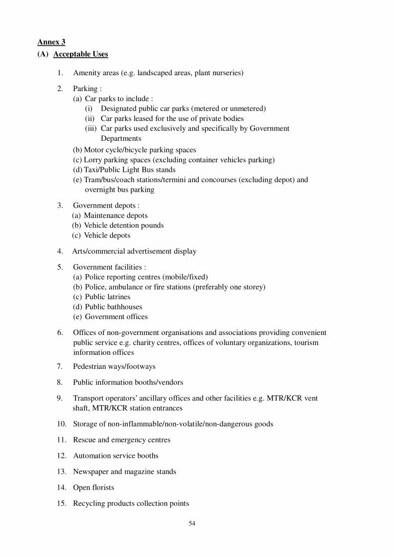
54
Annex 3
(A) Acceptable Uses
1. Amenity areas (e.g. landscaped areas, plant nurseries)
2. Parking :
(a) Car parks to include :
(i) Designated public car parks (metered or unmetered)
(ii) Car parks leased for the use of private bodies
(iii) Car parks used exclusively and specifically by Government
Departments
(b) Motor cycle/bicycle parking spaces
(c) Lorry parking spaces (excluding container vehicles parking)
(d) Taxi/Public Light Bus stands
(e) Tram/bus/coach stations/termini and concourses (excluding depot) and
overnight bus parking
3. Government depots :
(a) Maintenance depots
(b) Vehicle detention pounds
(c) Vehicle depots
4. Arts/commercial advertisement display
5. Government facilities :
(a) Police reporting centres (mobile/fixed)
(b) Police, ambulance or fire stations (preferably one storey)
(c) Public latrines
(d) Public bathhouses
(e) Government offices
6. Offices of non-government organisations and associations providing convenient
public service e.g. charity centres, offices of voluntary organizations, tourism
information offices
7. Pedestrian ways/footways
8. Public information booths/vendors
9. Transport operators’ ancillary offices and other facilities e.g. MTR/KCR vent
shaft, MTR/KCR station entrances
10. Storage of non-inflammable/non-volatile/non-dangerous goods
11. Rescue and emergency centres
12. Automation service booths
13. Newspaper and magazine stands
14. Open florists
15. Recycling products collection points
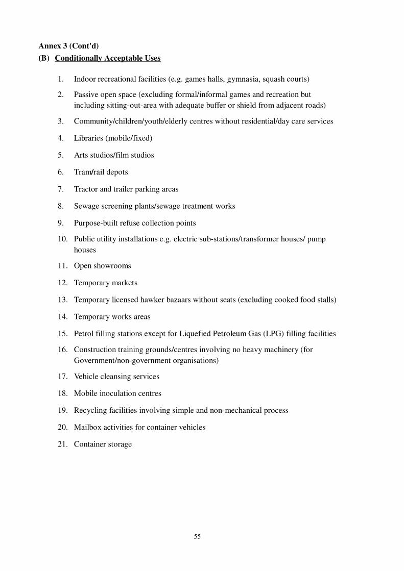
55
Annex 3 (Cont'd)
(B) Conditionally Acceptable Uses
1. Indoor recreational facilities (e.g. games halls, gymnasia, squash courts)
2. Passive open space (excluding formal/informal games and recreation but
including sitting-out-area with adequate buffer or shield from adjacent roads)
3. Community/children/youth/elderly centres without residential/day care services
4. Libraries (mobile/fixed)
5. Arts studios/film studios
6. Tram/rail depots
7. Tractor and trailer parking areas
8. Sewage screening plants/sewage treatment works
9. Purpose-built refuse collection points
10. Public utility installations e.g. electric sub-stations/transformer houses/ pump
houses
11. Open showrooms
12. Temporary markets
13. Temporary licensed hawker bazaars without seats (excluding cooked food stalls)
14. Temporary works areas
15. Petrol filling stations except for Liquefied Petroleum Gas (LPG) filling facilities
16. Construction training grounds/centres involving no heavy machinery (for
Government/non-government organisations)
17. Vehicle cleansing services
18. Mobile inoculation centres
19. Recycling facilities involving simple and non-mechanical process
20. Mailbox activities for container vehicles
21. Container storage
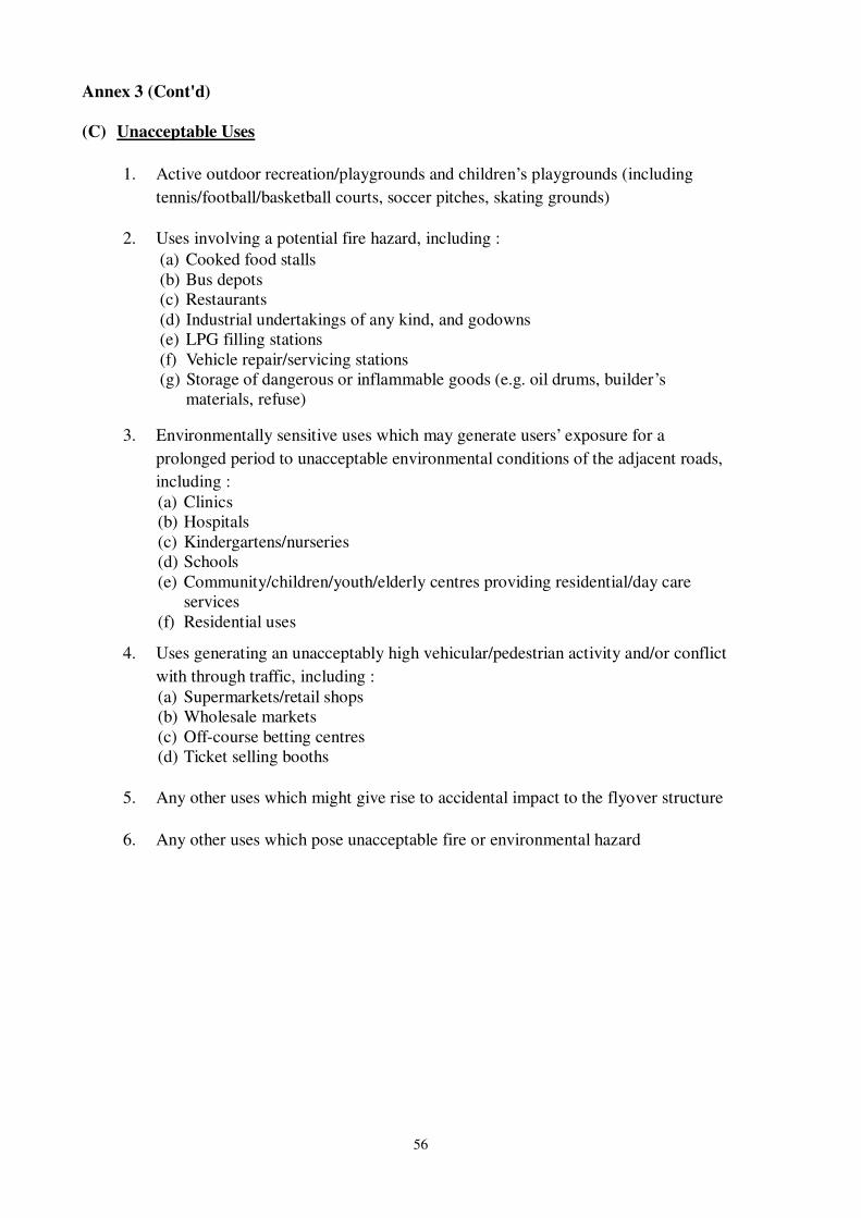
56
Annex 3 (Cont'd)
(C) Unacceptable Uses
1. Active outdoor recreation/playgrounds and children’s playgrounds (including
tennis/football/basketball courts, soccer pitches, skating grounds)
2. Uses involving a potential fire hazard, including :
(a) Cooked food stalls
(b) Bus depots
(c) Restaurants
(d) Industrial undertakings of any kind, and godowns
(e) LPG filling stations
(f) Vehicle repair/servicing stations
(g) Storage of dangerous or inflammable goods (e.g. oil drums, builder’s
materials, refuse)
3. Environmentally sensitive uses which may generate users’ exposure for a
prolonged period to unacceptable environmental conditions of the adjacent roads,
including :
(a) Clinics
(b) Hospitals
(c) Kindergartens/nurseries
(d) Schools
(e) Community/children/youth/elderly centres providing residential/day care
services
(f) Residential uses
4. Uses generating an unacceptably high vehicular/pedestrian activity and/or conflict
with through traffic, including :
(a) Supermarkets/retail shops
(b) Wholesale markets
(c) Off-course betting centres
(d) Ticket selling booths
5. Any other uses which might give rise to accidental impact to the flyover structure
6. Any other uses which pose unacceptable fire or environmental hazard