hull and coastal streams: catchment flood management plan
TRANSCRIPT
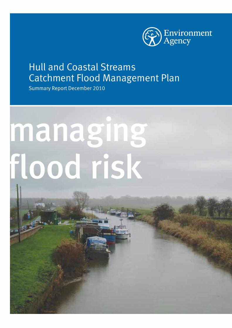
managing flood risk
Hull and Coastal Streams Catchment Flood Management PlanSummary Report December 2010

We are the Environment Agency. It’s our job to look after your environment and make it a better place – for you, and for future generations.
Your environment is the air you breathe, the water you drink and the ground you walk on. Working with business, Government and society as a whole, we are making your environment cleaner and healthier.
The Environment Agency. Out there, making your environment a better place.
Published by:
Environment Agency
Rivers House
21 Park Square South
Leeds LS1 2QG
Tel: 0870 8506506
Email: [email protected]
www.environment-agency.gov.uk
© Environment Agency
All rights reserved. This document may be reproduced
with prior permission of the Environment Agency.
December 2010

Environment Agency Hull and Coastal Streams Catchment Flood Management Plan 1
Introduction
I am pleased to introduce our summary of the Hull and Coastal Streams Catchment Flood Management Plan (CFMP). This CFMP gives an overview of the flood risk in the Hull and Coastal Streams area and sets out our preferred plan for sustainable flood risk management over the next 50 to 100 years.
The Hull and Coastal Streams CFMP is one of 77 CFMPs for England and Wales. Through the CFMPs, we have assessed inland flood risk across all of England and Wales for the first time. The CFMP considers all types of inland flooding, from rivers, ground water, surface water and tidal flooding, but not flooding directly from the sea (coastal flooding), which is covered by Shoreline Management Plans (SMPs). Our coverage of surface and ground water is however limited due to a lack of available information.
The role of CFMPs is to establish flood risk management policies which will deliver sustainable flood risk management for the long term. This is essential if we are to make the right investment decisions for the future and to help prepare ourselves effectively for the impact of climate change. We will use CFMPs to help us target our limited resources where the risks are greatest.
This CFMP identifies flood risk management policies to assist all key decision makers in the catchment. It was produced through a wide consultation and appraisal process; however it is only the first step towards an integrated approach to flood risk management. As we all work together to achieve our objectives, we must monitor and listen to each other’s progress, discuss what has been achieved and consider where we may need to review parts of the CFMP.
There is a long history of flooding within the Hull and Coastal Streams CFMP area. Flooding has been reported from rivers, groundwater, surface water and sewers.
Just over 56,600 properties are at risk from a one per cent flood, if there were no defences in place. Within the CFMP area a large proportion of the properties are at risk from other sources such as groundwater and surface water flooding and tides.
We cannot reduce flood risk on our own, we will therefore work closely with all our partners to improve the co-ordination of flood risk activities and agree the most effective way to manage flood risk in the future. We have worked with others including Planning and Local Authorities, Internal Drainage Boards, Yorkshire Water, British Waterways, National Farmers Union and Natural England to develop this Catchment Flood Management Plan.
This is a summary of the main CFMP document, if you need to see the full document an electronic version can be obtained by emailing [email protected]. Alternatively paper copies can be viewed at our offices in Willerby, and Rivers House, Leeds.
David Dangerfield, Yorkshire and North East Regional Director
2 Environment Agency Hull and Coastal Streams Catchment Flood Management Plan
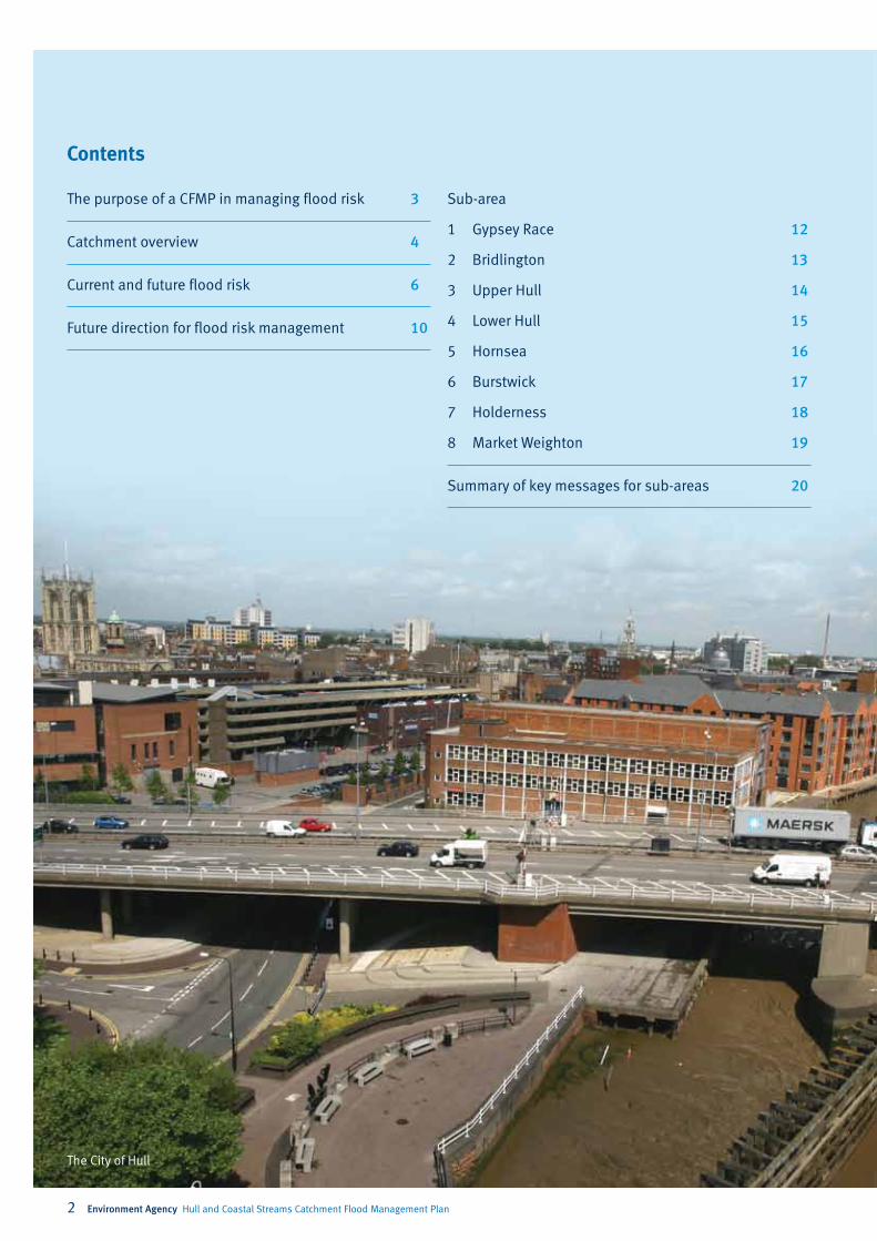
Contents
The purpose of a CFMP in managing flood risk 3
Catchment overview 4
Current and future flood risk 6
Future direction for flood risk management 10
Sub-area
1 Gypsey Race 12
2 Bridlington 13
3 Upper Hull 14
4 Lower Hull 15
5 Hornsea 16
6 Burstwick 17
7 Holderness 18
8 Market Weighton 19
Summary of key messages for sub-areas 20
The City of Hull

Environment Agency Hull and Coastal Streams Catchment Flood Management Plan 3
The purpose of a CFMP in managing flood risk
Note: Some plans may not be led by us – we may identify their need and encourage their development.
Figure 1 the relationship between CFMPs, delivery plans, projects and actions
Projects and actions• Make sure our spending delivers the best
possible outcomes.
• Focus on risk based targets, for example numbers of households at risk.
Policy delivery plans (see note)• Influence spatial planning to reduce risk
and restore floodplains.
• Prepare for and manage floods (including local Flood Warning plans).
• Managing assets.
• Water level management plans.
• Land management and habitat creation.
• Surface water management plans.
Policy planning• CFMPs and Shoreline Management Plans.
• Action plans define requirement for delivery plans, projects and actions.
activities in the wider context of the catchment;
• Transportation planners;
• Land owners, farmers and land managers that manage and use land for agriculture, conservation and amenity purposes;
• The public and businesses to enhance their understanding of flood risk and how it will be managed.
CFMPs promote more sustainable approaches to managing flood risk. The policies identified in the CFMP will be delivered through a combination of different approaches.
CFMPs help us to understand the scale and extent of flooding now and in the future, and set policies for managing flood risk within the catchment. CFMPs should be used to inform planning and decision making by key stakeholders such as:
• The Environment Agency, who will use the plan to guide decisions on investment in further plans, projects or actions;
• Local authorities who can use the plan to inform spatial planning activities and emergency planning;
• IDBs, water companies and other utilities to help plan their
The following actions and their implementation will be subject to further appraisal and funding, and prioritised by their supporting evidence. The CFMP is a living document and actions will be updated as necessary to reflect changing responsibilities and delivery mechanisms.
The relationship between the CFMP, delivery plans, strategies, projects and actions is shown in Figure 1. The River Hull Flood Risk Management Strategy lies within this CFMP area and looks in more detail at the River Hull catchment and proposes options for managing flood risk over the next 100 years.
4 Environment Agency Hull and Coastal Streams Catchment Flood Management Plan
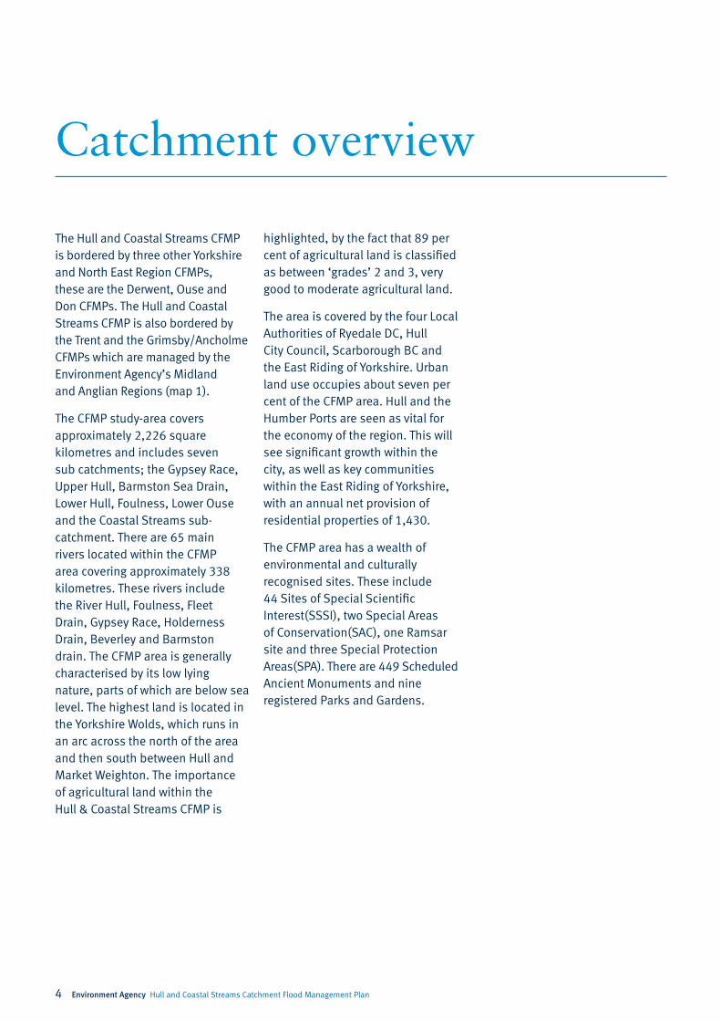
Catchment overview
The Hull and Coastal Streams CFMP is bordered by three other Yorkshire and North East Region CFMPs, these are the Derwent, Ouse and Don CFMPs. The Hull and Coastal Streams CFMP is also bordered by the Trent and the Grimsby/Ancholme CFMPs which are managed by the Environment Agency’s Midland and Anglian Regions (map 1).
The CFMP study-area covers approximately 2,226 square kilometres and includes seven sub catchments; the Gypsey Race, Upper Hull, Barmston Sea Drain, Lower Hull, Foulness, Lower Ouse and the Coastal Streams sub-catchment. There are 65 main rivers located within the CFMP area covering approximately 338 kilometres. These rivers include the River Hull, Foulness, Fleet Drain, Gypsey Race, Holderness Drain, Beverley and Barmston drain. The CFMP area is generally characterised by its low lying nature, parts of which are below sea level. The highest land is located in the Yorkshire Wolds, which runs in an arc across the north of the area and then south between Hull and Market Weighton. The importance of agricultural land within the Hull & Coastal Streams CFMP is
highlighted, by the fact that 89 per cent of agricultural land is classified as between ‘grades’ 2 and 3, very good to moderate agricultural land.
The area is covered by the four Local Authorities of Ryedale DC, Hull City Council, Scarborough BC and the East Riding of Yorkshire. Urban land use occupies about seven per cent of the CFMP area. Hull and the Humber Ports are seen as vital for the economy of the region. This will see significant growth within the city, as well as key communities within the East Riding of Yorkshire, with an annual net provision of residential properties of 1,430.
The CFMP area has a wealth of environmental and culturally recognised sites. These include 44 Sites of Special Scientific Interest(SSSI), two Special Areas of Conservation(SAC), one Ramsar site and three Special Protection Areas(SPA). There are 449 Scheduled Ancient Monuments and nine registered Parks and Gardens.

Environment Agency Hull and Coastal Streams Catchment Flood Management Plan 5
Map 1. The location and extent of the Hull and Coastal Streams CFMP area

6 Environment Agency Hull and Coastal Streams Catchment Flood Management Plan
Current and future flood risk
Overview of the current flood risk What is at risk?
Within the Hull and Coastal Streams CFMP area there are over 55,600 properties at risk from a one per cent annual probability river flood assuming no defences. There are around 237 kilometres of flood defences, a number of pumping stations, tidal sluices and barriers that reduce the probability of flooding throughout the catchment.
There are also a large number of properties at risk from tidal flooding and from surface water and sewer flooding within the urban areas.
The consequences of flooding are not solely related to the built environment. Our analysis shows that 3.6 square kilometres of SSSI, 0.5 square kilometres of SAC and 1.8 kilometres of SPA are at risk of flooding from rivers during a one per cent annual probability flood, which would see them inundated.
Flood risk has two components: the chance (probability) of a particular flood and the impact (or consequence) that the flood would have if it happened. The probability of a flood relates to the likelihood of a flood of that size occurring within a one year period and is expressed as a percentage. For example, a one per cent flood has a one per cent chance or 1 in 100 chance of occurring in any one year.
As part of the CFMP process, we have developed a catchment wide broadscale model to determine the risk of flooding, from both main and non-main rivers assuming no defences. It is vital that we understand this level of risk in the event that defences are overtopped or fail. The flood risk quoted in this report is for the one per cent flood probability.
There is a long history of flooding within the CFMP area dating back as far as 1657. Hull was affected during the tidal floods of 1953 causing flooding to much of the low lying land on the East Coast of England. Hull was also affected in the 1969 tidal flood, affecting much of the city centre. Recently the area was severely affected by the floods in June 2007. Over 8,500 properties were flooded in Hull from surface water. In the East Riding of Yorkshire Council area over 18,000 properties were affected. Flooding was recorded in Burstwick, Cottingham, Hedon, Bransholme and Kingswood during the 2007 flood.
The main sources of flood risk for people, property, infrastructure and the land are:
• flooding from rivers;
• surface water drainage and sewer flooding;
• tidal flooding;
• sea/coastal flooding;
• groundwater.
Tidal flooding is covered in the Humber Strategy, whilst flooding from the sea/coast is covered in the Shoreline Management Plan.
Environment Agency Hull and Coastal Streams Catchment Flood Management Plan 7
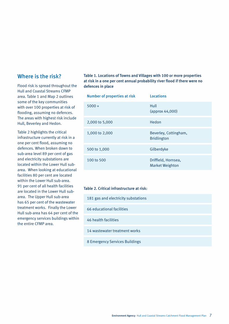
Where is the risk?
Table 2. Critical infrastructure at risk:
181 gas and electricity substations
66 educational facilities
46 health facilities
14 wastewater treatment works
8 Emergency Services Buildings
Table 1. Locations of Towns and Villages with 100 or more properties at risk in a one per cent annual probability river flood if there were no defences in place
Number of properties at risk Locations
5000 + Hull (approx 44,000)
2,000 to 5,000 Hedon
1,000 to 2,000 Beverley, Cottingham, Bridlington
500 to 1,000 Gilberdyke
100 to 500 Driffield, Hornsea, Market Weighton
Flood risk is spread throughout the Hull and Coastal Streams CFMP area. Table 1 and Map 2 outlines some of the key communities with over 100 properties at risk of flooding, assuming no defences. The areas with highest risk include Hull, Beverley and Hedon.
Table 2 highlights the critical infrastructure currently at risk in a one per cent flood, assuming no defences. When broken down to sub-area level 89 per cent of gas and electricity substations are located within the Lower Hull sub-area. When looking at educational facilities 80 per cent are located within the Lower Hull sub-area. 91 per cent of all health facilities are located in the Lower Hull sub-area. The Upper Hull sub-area has 65 per cent of the wastewater treatment works. Finally the Lower Hull sub-area has 64 per cent of the emergency services buildings within the entire CFMP area.

8 Environment Agency Hull and Coastal Streams Catchment Flood Management Plan
How we currently manage the risk in the catchment
Map 2. Properties at risk of flooding within the Hull and Coastal Streams catchment
The catchment has a long history of flooding which has resulted in a number of engineering schemes being implemented to reduce the risk of flooding. In the Hull and Coastal Streams CFMP area there are currently 237 kilometres of defences and pumping stations which help to reduce the probability of flooding across various parts of the catchment.
In addition, activities are carried out to reduce the probability of flooding:
• Maintaining the defences, including regular inspection to ensure condition is maintained.
• Maintaining over 338 kilometres of river channels including removal of blockages likely to increase flood risk.
• Working with local authorities to influence the location and layout of development, ensuring that inappropriate development is not allowed in the floodplain through the application of PPS25.
• Operation of the Hull Tidal Surge Barrier, which is discussed in detail in the Humber Strategy.
Further activities are carried out which reduce the consequences of flooding in the catchment including:
• Understanding where flooding is likely by mapping flood risk including detailed modelling of rivers and recording major flooding within in the catchment.
• Providing a flood forecasting and warning service via 35 separate flood warnings across the CFMP area. This warning service also alerts our professional partners and emergency responders to instigate their own flood responses.
• Promoting awareness of flooding to organisations and members of the public so they are prepared in case they need to take action at times of flooding.
• Promoting resilience and resistance measures for those properties already in the floodplain.
Environment Agency Hull and Coastal Streams Catchment Flood Management Plan 9
The impact of climate change and future flood risk
The effect that flooding will have in the future is influenced by a range of issues such as climate change, changes in land use (e.g. development), and changes in how land is managed.
Within the Hull and Coastal Streams CFMP area we carried out a catchment sensitivity analysis of a number of future flood risk drivers. These included:
• Slowing runoff by large scale changes to agricultural practices.
• Increased urbanisation.
• Impact of climate change.
Our results showed that changes in agricultural land management have the potential to decrease flows by up to 10 per cent indicating that the catchment is sensitive to land management change. However, to gain this scale of benefit changes across the whole catchment would be required which is not feasible.
Our analysis shows that the catchment is not sensitive to increased urban development as the total area of increased urban development is small compared to the total catchment area. The implementation of PPS25 will reduce inappropriate development within flood risk areas and controls the drainage from new development.
The Hull and Coastal Streams CFMP area is most sensitive to the impacts of climate change. The key predictions for the impact of climate change are:
• More frequent and intense storms causing more widespread and regular flooding from drainage systems and some rivers.
• Increased winter rainfall increasing the likelihood of large-scale flooding.
To replicate the impact of climate change on river flows we applied a 20 per cent increase to all river
3000
Num
ber o
f Pro
pert
ies
at F
lood
Ris
k
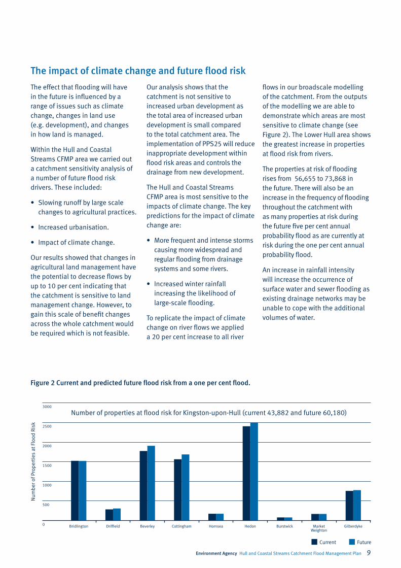
Figure 2 Current and predicted future flood risk from a one per cent flood.
0
500
1000
1500
2000
Current Future
2500
flows in our broadscale modelling of the catchment. From the outputs of the modelling we are able to demonstrate which areas are most sensitive to climate change (see Figure 2). The Lower Hull area shows the greatest increase in properties at flood risk from rivers.
The properties at risk of flooding rises from 56,655 to 73,868 in the future. There will also be an increase in the frequency of flooding throughout the catchment with as many properties at risk during the future five per cent annual probability flood as are currently at risk during the one per cent annual probability flood.
An increase in rainfall intensity will increase the occurrence of surface water and sewer flooding as existing drainage networks may be unable to cope with the additional volumes of water.
Bridlington Driffield Beverley Cottingham Hornsea Hedon Burstwick Market Weighton
Gilberdyke
Number of properties at flood risk for Kingston-upon-Hull (current 43,882 and future 60,180)
10 Environment Agency Hull and Coastal Streams Catchment Flood Management Plan
Future flood risk management
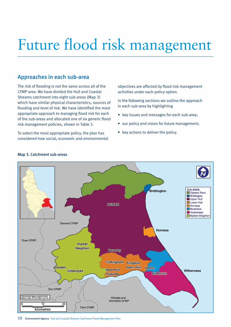
Map 3. Catchment sub-areas
Approaches in each sub-area
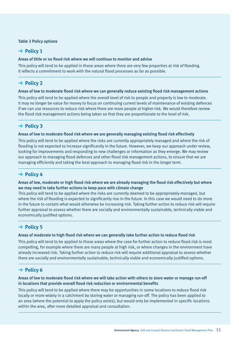
The risk of flooding is not the same across all of the CFMP area. We have divided the Hull and Coastal Streams catchment into eight sub-areas (Map 3) which have similar physical characteristics, sources of flooding and level of risk. We have identified the most appropriate approach to managing flood risk for each of the sub-areas and allocated one of six generic flood risk management policies, shown in Table 3.
To select the most appropriate policy, the plan has considered how social, economic and environmental
objectives are affected by flood risk management activities under each policy option.
In the following sections we outline the approach in each sub-area by highlighting
• key issues and messages for each sub-area;
• our policy and vision for future management;
• key actions to deliver the policy.
Environment Agency Hull and Coastal Streams Catchment Flood Management Plan 11
➜ Policy1
Areas of little or no flood risk where we will continue to monitor and advise
This policy will tend to be applied in those areas where there are very few properties at risk of flooding. It reflects a commitment to work with the natural flood processes as far as possible.
➜ Policy2
Areas of low to moderate flood risk where we can generally reduce existing flood risk management actions
This policy will tend to be applied where the overall level of risk to people and property is low to moderate. It may no longer be value for money to focus on continuing current levels of maintenance of existing defences if we can use resources to reduce risk where there are more people at higher risk. We would therefore review the flood risk management actions being taken so that they are proportionate to the level of risk.
➜ Policy3
Areas of low to moderate flood risk where we are generally managing existing flood risk effectively
This policy will tend to be applied where the risks are currently appropriately managed and where the risk of flooding is not expected to increase significantly in the future. However, we keep our approach under review, looking for improvements and responding to new challenges or information as they emerge. We may review our approach to managing flood defences and other flood risk management actions, to ensure that we are managing efficiently and taking the best approach to managing flood risk in the longer term.
➜ Policy4
Areas of low, moderate or high flood risk where we are already managing the flood risk effectively but where we may need to take further actions to keep pace with climate changeThis policy will tend to be applied where the risks are currently deemed to be appropriately-managed, but where the risk of flooding is expected to significantly rise in the future. In this case we would need to do more in the future to contain what would otherwise be increasing risk. Taking further action to reduce risk will require further appraisal to assess whether there are socially and environmentally sustainable, technically viable and economically justified options.
➜ Policy5
Areas of moderate to high flood risk where we can generally take further action to reduce flood risk
This policy will tend to be applied to those areas where the case for further action to reduce flood risk is most compelling, for example where there are many people at high risk, or where changes in the environment have already increased risk. Taking further action to reduce risk will require additional appraisal to assess whether there are socially and environmentally sustainable, technically viable and economically justified options.
➜ Policy6
Areas of low to moderate flood risk where we will take action with others to store water or manage run-off in locations that provide overall flood risk reduction or environmental benefits
This policy will tend to be applied where there may be opportunities in some locations to reduce flood risk locally or more widely in a catchment by storing water or managing run-off. The policy has been applied to an area (where the potential to apply the policy exists), but would only be implemented in specific locations within the area, after more detailed appraisal and consultation.
Table 3 Policy options

12 Environment Agency Hull and Coastal Streams Catchment Flood Management Plan
Sub-area 1
Gypsey Race
Our key partners are:
Land Owners
East Riding of Yorkshire Council
The issues in this sub-area
The Gypsey Race is a chalk, groundwater dominated catchment in the northern part of the CFMP area. The catchment is mainly rural and there is very limited risk of flooding from the river in this sub-area as it is contained within a well defined valley. There are less than five properties at risk from river flooding during the one per cent flood, assuming no defence and there is no predicted increases in the future. Due to it being within a chalk catchment, the Gypsey Race channel can dry up for much of its length during dryer parts of the year.
The vision and policy
Under Policy Option 2 we will reduce flood risk management activities but ensure that risk does not increase downstream in Bridlington. We will restrict maintenance activities to those that ensure blockages do not develop in downstream culverts. The area predicted to be at flood risk in the future increases slightly as a result of climate change. The current expenditure on flood risk management does not reduce flood risk. By choosing this management option the rivers will be allowed to develop more naturally which may produce some environmental benefits.
The key messages
• Flooding within the sub-area is limited.
• We will reduce maintenance but ensure that there is no increase in risk of blockages to Bridlington, downstream of the sub-area.
• A study into the impacts of groundwater flooding will help to determine how it should be managed
Actions to implement the policy
• Develop a System Asset Management Plan to manage the river channel within the sub-area proportionately to the level of local and downstream risk.
• Raise individual property owners awareness about flood risk and possible resilience measures.
• Improve understanding of groundwater flooding through the sub-area.
Environment Agency Hull and Coastal Streams Catchment Flood Management Plan 13
Sub-area 2
Bridlington
Our key partners are:
East Riding of Yorkshire Council
Yorkshire Water
Developers
Landowners
The issues in this sub-area
This is an urban sub-area. The Gypsey Race is culverted through the majority of Bridlington and discharges into the North Sea through an outlet pipe in the sea wall.
The broadscale modelling of the sub-area identified over 1500 properties at risk both now and in the future. However, more detailed analysis demonstrates that the culvert through the town has the capacity to carry in excess of the one per cent river flow. As such flood risk is much lower at around 100 properties.
The vision and policy
Under Policy Option 3, our vision for the sub-area is that we will work in partnership to identify a sustainable approach to regenerating Bridlington. As part of this approach we will encourage the development of detailed planning documents that identify design principles and sustainable water management techniques for the regeneration of areas of Bridlington. This will enable a sustainable approach to managing river and surface water risks, particularly through the possible removal of extensive culverted reaches of the Gypsey Race. We will carry out blockage removal at culverts.
The key messages
• Regeneration presents an opportunity to remove culverts through the town.
• Our broadscale model over estimates the number of properties at risk.
Actions to implement the policy
• Develop detailed development plans for the Bridlington Regeneration Strategy which consider water management.
• Develop a System Asset Management Plan which will ensure risk is managed at current levels. This will include finding appropriate solutions to monitor culvert capacity.
• Produce a register of all culverts and outfalls within the sub-area. As part of this study; identify locations where culverts can be removed or improved through redevelopment.
• Improve public awareness of the risk of flooding.

14 Environment Agency Hull and Coastal Streams Catchment Flood Management Plan
• Whilst all of the assets we operate perform an important function, some of our land drainage assets are unlikely to receive flood risk funding in the future.
• We will work in partnership with local bodies to to find alternative funding sources to help to reduce flood risk.
Actions to implement the policy
• FFinalise, publish and implement the River Hull flood risk management strategy and continue consultation with stakeholders during the implementation of its actions and work in partnership to reduce flood risk by securing the long-term future of the flood risk assets.
• EA to work with ERYC to review evidence of land management and flood risk benefits of pumping stations in the Holderness Drain system.
• Consider the implications of changing the flood regime on SSSIs. The findings should be used to inform future sustainable approaches to flood risk management and ensure that the condition of each SSSI is maintained, and where possible improved.
• Work in partnership with the Lead Local Flood Authority to reduce the risk of flooding from surface water.
Upper Hull
Sub-area 3
Staff from the Environment Agency at the Driffield show to raise awareness
Our key partners are:
East Riding of Yorkshire Council
Beverley and North Holderness IDB
Landowners
Yorkshire Water
River Hull Flood Action Group
Flooding in Leven Action Group
The issues in this sub-area
The sub-area includes all of the River Hull Catchment upstream of Hull. The sub-area includes the towns of Beverley, Driffield and a number of villages including Nafferton, Tickton and Leconfield. In the lower sections the river is perched above and disconnected from its natural floodplain. Water
from the floodplain has to be pumped into the river. There is a complex network of existing artificial field drains regulated by a series of pumping stations. Currently there are over 2,800 properties at risk during the one per cent undefended flood which may rise to just over 3,000 during the future one per cent flood. There are also a number of important nature conservation sites. Disruption to roads, railways and a number of critical infrastructure installations is identified in the lower sections of the Hull catchment.
The vision and policy
Under policy option 3, the short-term (up to 5 years) vision for the sub-area is that we will continue to provide flood protection across the area. In the medium term we anticipate difficulties in continuing to get flood risk funding for all of our current activities. We will continue to develop a more detailed understanding of flood risk from the implementation of the River Hull Flood Risk Management Strategy and partnership working. This CFMP policy will be kept under review and may be changed as a result of this partnership working.
The key messages
• The drainage network here is heavily engineered and complex, any changes to its management need careful consideration as the impact may be widespread.

Environment Agency Hull and Coastal Streams Catchment Flood Management Plan 15
Sub-area 4
Lower Hull
Our key partners are:
Hull City Council
East Riding of Yorkshire Council
Land Owners
Yorkshire Water
The issues in this sub-area
This sub-area is located in the south of the CFMP area at the mouth of the River Hull. It contains the urban areas of Hull and surrounding settlements such as Cottingham, Hessle and Willerby. The sub-area is at risk of river, tidal and surface water/sewer flooding and with low lying flat land there are few physical constraints to floodwaters, hence there are many potential interactions with adjoining sub-areas. In total there are just under 47,000 properties identified at risk during the undefended one per cent river flood. This could rise to over 63,000 in future flooding scenarios, although current defences and flood risk management actions reduce this risk.
The vision and policy
Through Policy Option 5, our vision is for flood risk management to be improved for all sources of flooding. Partnership working between professional partners involved in managing risk will continue, in order to better understand the complexity of the flooding mechanisms and find suitable sustainable solutions. This should reduce the flood risk within the Lower Hull. This protection will be focused on surface water risk, as well as some river flooding risk.
The key messages
• There are many organisations and individuals with different responsibilities and accountabilities that will need to work together to reduce flood risks in Lower Hull Sub-area.
• Reducing flood risk will be a long and expensive process. We need to start to work together now and openly share information with one another.
• Surface water, drainage networks, rivers and tides all come together to contribute to the complex flood risk in Lower Hull Sub-area.
Actions to implement the policy
• Working with Hull City Council and landowners, make improvements where required to flood defences on the River Hull.
• Working with Hull City Council and landowners, make improvements where required to better manage flood risk on the River Hull.
• Ensure emergency response plans are reviewed and take account of increases in flood risk through climate change and other catchment changes.
• Work in partnership to reduce the risk of flooding from surface water.
• Improve public awareness of the risk of flooding from all sources.
• Work in partnership to support the development of both Hull City Council and East Riding of Yorkshire Council’s Surface Water Management Plans, and to deliver the resulting strategic and co-ordinated set of actions.
16 Environment Agency Hull and Coastal Streams Catchment Flood Management Plan
Our key partners are:
East Riding of Yorkshire Council
Natural England
Yorkshire Water
The issues in this sub-area
This small sub-area is dominated by the Hornsea Mere SSSI and SPA. It contains the urban area of Hornsea and surrounding settlements such as Rolston and Southorpe with some agricultural land, but the largest feature is the mere itself. The main watercourse is the Stream Dike which flows from the mere to the North Sea. Hornsea is a tourist attraction and the mere is a centre for water based recreation. Flood risk is centred on Hornsea, in total there are currently 187 properties at risk from the one per cent river flood assuming no defences which may increase to 193 in future flooding scenarios.
The vision and policy
Under Policy Option 3 our vision is to continue with current flood risk management practices. This will include looking at improvements and efficiencies which can offer multiple benefits. These include reducing the impact of flooding for those regularly affected. Working with those who have ownership of the control structures on Hornsea Mere will allow us to optimise its use for managing flood risk and environmental status. Continued regulation of the discharges into the Stream Dike through the land-use planning process is also crucial here.
The key messages
• Balancing the requirements of maintaining water levels in Hornsea Mere and reducing flood risk is key to the future management of water in the Hornsea area.
• More detailed understanding of the interactions between surface, tidal and river flood risk should inform the detailed management approaches in the future.
Actions to implement the policy
• Development of a greater understanding of the interaction between Hornsea Mere, surface water drainage and tide locking.
• Confirm responsibilities for management of structures and of water levels within the mere.
• Work with partners to develop detailed management plans for managing risk in the sub-area that are consistent with all plans and policies. This will include a Systems Asset Management Plan, Water Level Management Plans and the Shoreline Management Plan.
• Improve flood warning service available within the sub-area.
• Continue to promote the use of SuDS and other drainage control solutions for development and re-development within Hornsea.
Hornsea
Sub-area 5
Environment Agency Hull and Coastal Streams Catchment Flood Management Plan 17
Burstwick
Our key partners are:
East Riding of Yorkshire Council
Land Owners
Yorkshire Water
The issues in this sub-area
This sub-area is located in the south east of the CFMP catchment area. It runs from the Humber Estuary to the North Sea. It contains the urban areas of Hedon, Burstwick, Elstronwick, Grimston and Sproatley and the area is drained by Burstwick Drain which becomes Hedon Haven in the south-west. The sub-area is predominantly flat and is at risk from surface water and river flooding. The areas of Hedon and Burstwick were flooded in 2007. Our analysis of the catchment
shows that for the one per cent undefended flood there are 2,507 properties at risk and this rises to 2,577 in the future scenarios.
The vision and policy
Under Policy Option 5 our vision for this sub-area is that action will be taken to reduce the risk of surface water flooding in Hedon and other vulnerable locations and we will adequately manage flood risk from Burstwick Drain. The ongoing partnership work on the South Holderness study will enable us to understand combined flood risk from all sources and will consider potential solutions for managing this risk in the future. It is important that risks from all sources are managed and it is essential that the key partners work together to develop integrated management plans to achieve this.
The key messages
• Flood risk is concentrated in the village areas.
• The sub-area is at risk of flooding from multiple sources.
• Climate change could increase the frequency of river flooding as well as numbers at risk.
Actions to implement the policy
• Produce a System Asset Management Plan to determine the most sustainable approach to reducing flood risk.
• Complete the flood defences in Hedon and Burstwick (predicted completion in 2010).
• Work in partnership to provide information and advice to individual properties within Hedon and Burstwick to improve flood resilience and flood proofing.
• Work in partnership to develop a Surface Water Management Plan for the sub-area. Where locations of surface water flood risk are identified, ensure that cross boundary issues are taken into account and fed into the management of surrounding sub-areas.
Sub-area 6
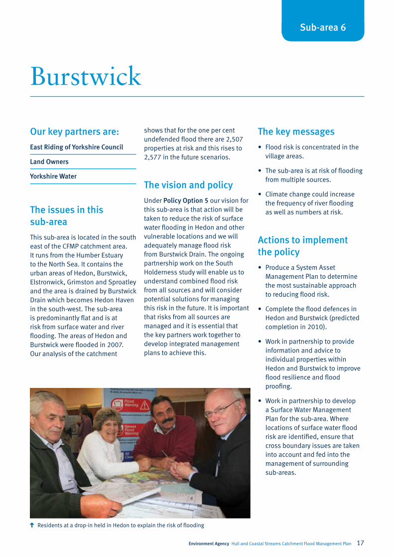
Residents at a drop-in held in Hedon to explain the risk of flooding

18 Environment Agency Hull and Coastal Streams Catchment Flood Management Plan
Holderness
Sub-area 7
The vision and policy
We have selected Policy Option 3. Our vision in this sub-area is that the risk of flooding will continue to be managed but that we will review our maintenance activities on rivers to ensure that they are economically justified. The ongoing partnership work on the South Holderness study will enable us to understand combined flood risk from all sources and will consider potential solutions for managing this risk in the future. Tidal and coastal flood risk is the dominant source of flood risk in the sub-area but its management is dealt with by the Humber Strategy and the Shoreline Management Plan.
The key messages
• We have worked closely with our Humber Strategy team in the development of this CFMP. Our policy and actions are consistent with the Strategy outputs for the Estuary shoreline.
• Floodplains are vital in the effort to reduce the risk to life and property. We must protect undeveloped floodplain from inappropriate development.
Our key partners are:
East Riding of Yorkshire Council
Land Owners
Yorkshire Water
The issues in this sub-area
The Holderness sub-area is located in the south-east of the catchment and incorporates Thorngumbald in the north-west down to the Humber Estuary in the south.
The area is flat and low lying and is primarily higher quality agricultural land, used for arable farming and horticulture, with a number of villages scattered throughout including Thorngumbald, Patrington and Easington. There is an important gas installation on the east coast with associated pipelines running underground across this sub-area. The main flood risk is tidal flooding which is addressed in the Shoreline Management plan (SMP) and the Humber Strategy. However, river flood risk is spread throughout the sub-area with 152 properties at risk currently, assuming no defences and 164 properties at risk in the future. Due to the flat nature of the sub-area, Internal Drainage Boards (IDB) supervise all pumping to maintain land drainage.
Actions to implement the policy
• Work with partners to develop joint management plans for all sources of flooding.
• Ensure there are no conflicts between policies and that all sources of flooding are managed in an integrated manner; this will be developed in the South Holderness Study.
• Identify risk and develop emergency plans for critical infrastructure.
• Improve flood warning take up within the sub-area.
• Work with land owners and communities to reduce the consequences of flooding.
Environment Agency Hull and Coastal Streams Catchment Flood Management Plan 19
Our key partners are:
East Riding of Yorkshire Council
Land Owners
The issues in this sub-area
The Market Weighton sub-area is located in the south-west of the catchment. It stretches from Market Weighton in the north to the Humber in the south. The western boundary meets the Derwent catchment and in the east are the Yorkshire Wolds. It is low lying and flat across most of the sub-area apart from where it rises to form the chalk Wolds. The main urban areas within the system are Market Weighton, Howden (on the very western boundary of the sub-area) and the neighbouring villages of Gilberdyke and Newport. There are also a number of smaller settlements in the south-east such as North Cave, Brought and Welton. Currently 2,544 properties are at risk of flooding during the one per cent undefended river flood which may rise to 2945 properties during the future flooding scenario.
The vision and policy
Policy Option 3. Our vision for this sub-area is that action will continue to be taken to manage river and surface water flood risk
in key locations. Risk in Howden, the largest community, is managed adequately but there is dispersed risk from both rivers and surface water throughout the sub-area. Communities such as North Cave, and Market Weighton are already benefiting from targeted action to manage risk but our approach in the future must consider all sources of flood risk in combination.
The key messages
• This sub-area is complex because of its location near the confluence of several major rivers.
• It is also heavily reliant on pumping drainage water from the arable areas into Market Weighton Canal.
• Further problems have been recorded on Mill Beck from ageing culverted sections of the main channel overflowing when the culverts can no longer contain flood waters.
• There is development pressure within the area. This needs to be carefully managed to ensure it does not create an increase in risk (through the implementation of PPS 25).
Actions to implement the policy
• Produce and implement a System Asset Management Plan for the sub-area to determine the most sustainable approach to managing assets.
• Complete work on North Cave Beck flood alleviation scheme.
• Develop a Surface Water Management Plan for Market Weighton and other communities at risk of surface water flooding and remove culvert register action.
• Work in partnership to identify the long term approach to the current pumping regime.
• Investigate the interaction between Market Weighton Canal and the River Foulness and the risk canal flooding poses on local development.
• Establish and maintain a register of structures or features which are likely to have an effect on flood risk in their area together with information about them. Use this register to identify the location of pinch points where flood water may overspill.
Market Weighton
Sub-area 8

20 Environment Agency Hull and Coastal Streams Catchment Flood Management Plan
Map of CFMP policies
1 No active intervention.
2 Reduce current flood risk management actions.
3 Continue with existing or alternative actions to manage flood risk at the current level.
4 Take action to sustain the current scale of flood risk into the future.
5 Take further action to reduce flood risk.
6 Take action with others to store water or manage run-off in locations that provide overall flood risk reduction or environmental benefits, locally or elsewhere in the catchment.


Environment first: This publication is printed on paper made from 100 per cent previously used waste. By-products from making the pulp and paper are used for composting and fertiliser, for making cement and for generating energy.
Would you like to find out more about us, or about your environment?
Then call us on 08708 506 506* (Mon-Fri 8-6)
email [email protected]
or visit our website www.environment-agency.gov.uk
incident hotline 0800 80 70 60 (24hrs)
floodline 0845 988 1188
* Approximate call costs: 8p plus 6p per minute (standard landline).Please note charges will vary across telephone providers.
GENE0410BSEY-E-P