hydro-power generation-impact on enviroment
DESCRIPTION
Seminar Session 16TRANSCRIPT
TECHNICAL SESSION S-16
HYDRO-POWER GENERATION-IMPACT ON ENVIROMENT
CONVERSION OF DEVSARI HEP(252 MW) FROM STORAGE TO RUN OF THE RIVER SCHEME ON TECHNICAL,SOCIOECONOMIC AND ENVIROMENTAL ISSUES
BY:R.N.MISRA,DIRECTOR (CIVIL),SJVN LTD.
DEEPAK NAKHASI,GM(CIVIL DESIGNS),SJVN LTD
K.L.AUMTA,AGM(CIVIL DESIGNS),SJVN LTD
HARSH B MEHTA, Sr. ENGINEER ,SJVN LTD.
DATED : 11/04/2013
Scope of the presentation
• Salient features of the present Run of the river scheme
• Various Alternative Studies
• Comparison of various alternatives
• Conclusion
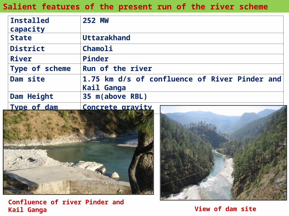
Salient features of the present run of the river schemeInstalled capacity 252 MWState UttarakhandDistrict ChamoliRiver PinderType of scheme Run of the riverDam site 1.75 km d/s of confluence of River Pinder and Kail GangaDam Height 35 m(above RBL)Type of dam Concrete gravity
Confluence of river Pinder and Kail GangaView of dam site
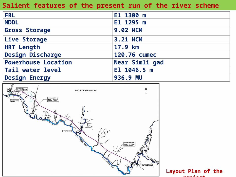
Salient features of the present run of the river schemeFRL El 1300 mMDDL El 1295 mGross Storage 9.02 MCMLive Storage 3.21 MCMHRT Length 17.9 kmDesign Discharge 120.76 cumecPowerhouse Location Near Simli gadTail water level El 1046.5 mDesign Energy 936.9 MU
Layout Plan of the project

Various Alternatives Studies
Alternative 1: 90 m high dam at 1.75 Km D/S of confluence of River Pinder and Kail Ganga having FRL= El 1370 m with TWL= El 1120 m and HRT Length =12.445 km.
Alternative 2: 60 m high dam at 1.75 Km D/S of confluence of River Pinder and Kail Ganga having FRL= El 1325 m with TWL= El 1120 m and HRT length=12.445 km.
Alternative 3: 35 m high dam at 1.75 Km D/S of confluence of River Pinder and Kail Ganga having FRL = El 1300 m with TWL = El 1120 m and HRT length =12.445
km.
Alternative 4: 35 m high dam at 1.75 Km D/S of confluence of River Pinder and Kail Ganga having FRL =El 1300 m with TWL =El 1046.5 m and HRT length=17.9 km.
Various Alternatives Studies
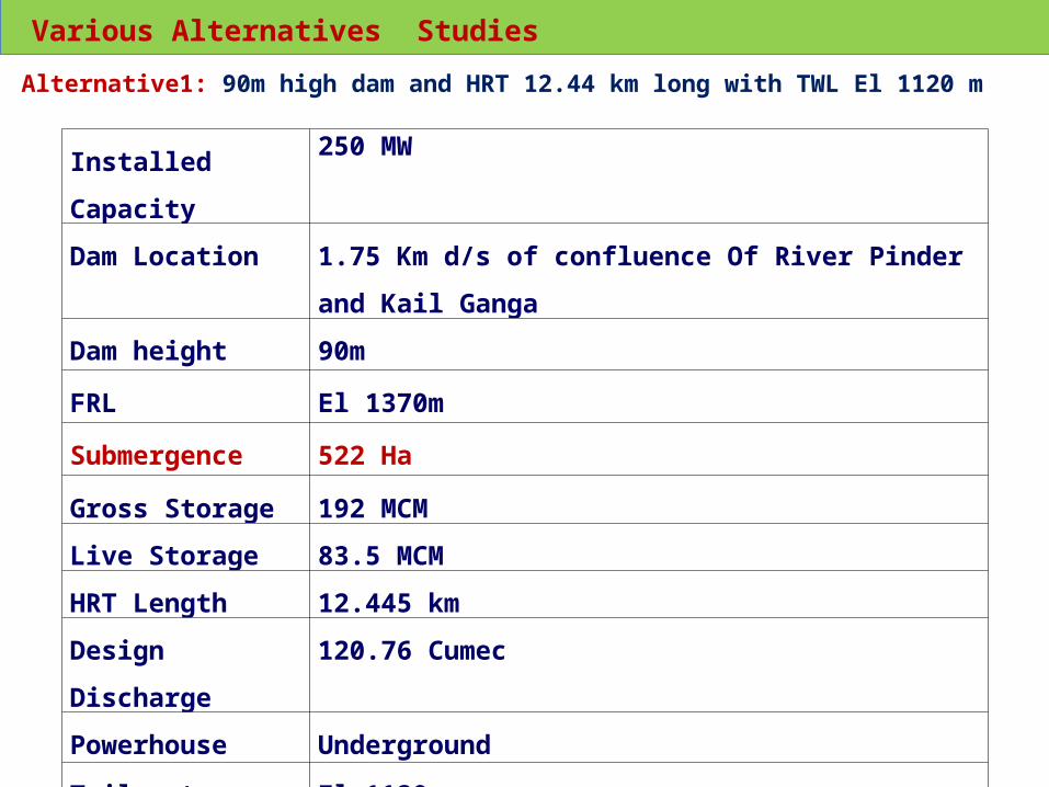
Alternative1: 90m high dam and HRT 12.44 km long with TWL El 1120 m
Installed Capacity 250 MW
Dam Location 1.75 Km d/s of confluence Of River Pinder and Kail
Ganga
Dam height 90m
FRL El 1370m
Submergence 522 Ha
Gross Storage 192 MCM
Live Storage 83.5 MCM
HRT Length 12.445 km
Design Discharge 120.76 Cumec
Powerhouse Underground
Tail water Level El 1120 m
Design Energy 890MU

Various Alternatives Studies
a) Geological Factor• Geological conditions of reservoir area are not suitable for 90 m high dam due
to presence of :• Multiple shears, active/dormant slides, debris/creep zone and
disturbed rock strata on right bank of Pinder River above EL 1300 m and same shall be affected by reservoir fluctuation.
• Severe slope instability along right bank of Pinder river• Presence of two major tectonic planes near confluence of Kail
ganga and Pinder river.
Geological map of reservoir area
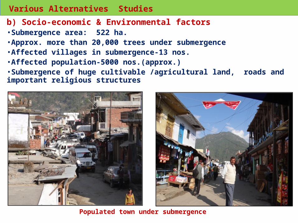
Various Alternatives Studies b) Socio-economic & Environmental factors•Submergence area: 522 ha.•Approx. more than 20,000 trees under submergence•Affected villages in submergence-13 nos. •Affected population-5000 nos.(approx.) •Submergence of huge cultivable /agricultural land, roads and important religious structures
Populated town under submergence

Various Alternatives Studies
Religious places under submergence
Dense forest under submergenceHuge cultivable/agricultural under submergence
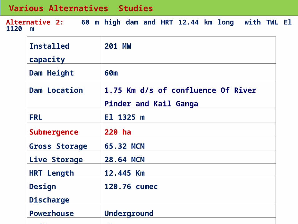
Various Alternatives Studies Alternative 2: 60 m high dam and HRT 12.44 km long with TWL El 1120 m
Installed capacity 201 MW
Dam Height 60m
Dam Location 1.75 Km d/s of confluence Of River Pinder and
Kail Ganga
FRL El 1325 m
Submergence 220 ha
Gross Storage 65.32 MCM
Live Storage 28.64 MCM
HRT Length 12.445 Km
Design Discharge 120.76 cumec
Powerhouse Underground
Tail water Level El 1120 m
Design Energy 753.36 MU

Various Alternatives Studies
a)Geological factorsGeological conditions of reservoir area are not suitable for 60 m high dam due to
presence of :• Toes of two major slides, one on left bank of Kail Ganga and other on right
bank of Pinder get submerged and affected by reservoir fluctuation • Multiple shears, creeping areas along with cultivated lands/old slide
debris/talus and active & dormant slides and disturbed rock strata above EL 1300 m.
• Tectonic planes near confluence of Kail Ganga and Pinder river.
b)Socioeconomic & Environmental factors•Submergence area: 220 ha. •Approx. 10,000 trees will be submerged /destroyed.•Affected villages to be displaced-3 nos. •Affected population-2000 nos.(approx.) •Submergence of roads and important religious structures The road leading from Dewal to Melkhet and beyond upto the border connecting number of villages shall get submerged at many reaches on route.Prachin nanda devi temple at Purna and Shiv mandir near Devsari bridge.
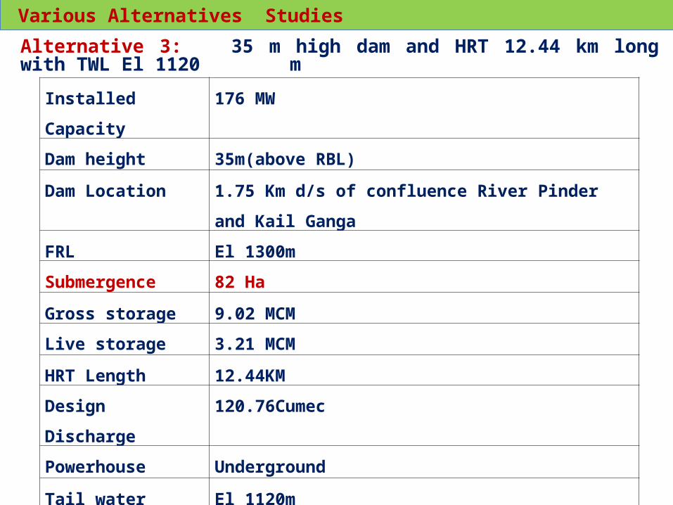
Various Alternatives Studies Alternative 3: 35 m high dam and HRT 12.44 km long with TWL El 1120
m
Installed Capacity 176 MW
Dam height 35m(above RBL)
Dam Location 1.75 Km d/s of confluence River Pinder and Kail
Ganga
FRL El 1300m
Submergence 82 Ha
Gross storage 9.02 MCM
Live storage 3.21 MCM
HRT Length 12.44KM
Design Discharge 120.76Cumec
Powerhouse Underground
Tail water Level El 1120m
Design Energy 646MU

Various Alternatives Studies
a)Geological factors
• No multiple shears, active/dormant slides and disturbed rock strata problem.
• All creeping areas and cultivated land remain above FRL El 1300 m and none of them affected by reservoir fluctuation.
b)Socio-economic & Environmental factors• Submergence area -82 ha.
• Affected villages due to submergence of only part of 1 village and affected population is only 26 families.
• Does not involve submergence of any historical/religious places and public structures or any existing road.
• About less than 2000 trees affected in submergence area.
Various Alternatives Studies
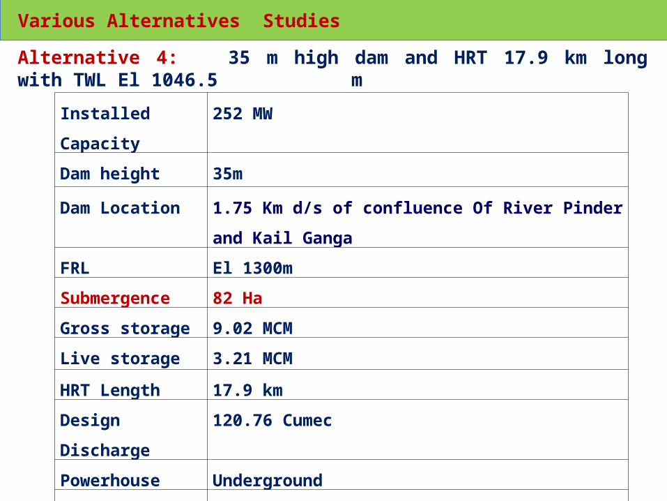
Alternative 4: 35 m high dam and HRT 17.9 km long with TWL El 1046.5 m
Installed Capacity 252 MW
Dam height 35m
Dam Location 1.75 Km d/s of confluence Of River Pinder and Kail
Ganga
FRL El 1300m
Submergence 82 Ha
Gross storage 9.02 MCM
Live storage 3.21 MCM
HRT Length 17.9 km
Design Discharge 120.76 Cumec
Powerhouse Underground
Tail water Level El 1046.5 m
Design Energy 936 MU

Various Alternatives Studies
a)Geological factors• No multiple shears, active/dormant slides and disturbed rock strata
problem in reservoir area.
• All creeping areas and cultivated land remain above FRL El 1300 m and none of them affected by reservoir fluctuation.
• Chances of RIS remains less with minimum depth of water column.
b)Socio-economic & Environmental factors• Submergence area: 82 ha.
• Affected villages due to submergence of only part of 1 village and affected population is only 26.
• Does not involve submergence of any historical/religious places and public structures or any important roads.
• About less than 2000 trees affected in submergence area.
• This alternatives involves least socio- economic and environmental problem and maximum power benefit.

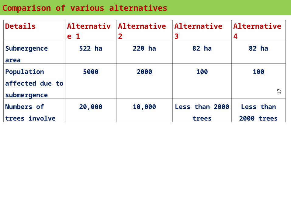
Comparison of various alternatives
Details Alternative 1 Alternative 2 Alternative 3 Alternative 4
Location 1.75 km d/s of
confluence
1.75 km d/s of
confluence
1.75 km d/s of
confluence
1.75 km d/s of
confluence
Dam Height 90m 60m 35m 35 m
FRL El 1370m El 1325m El 1300m El 1300 m
MDDL El 1355m El 1310m El 1295m El 1295m
Gross
Storage
192MCM 65.32 MCM 9.02 MCM 9.02 MCM
Live Storage 83.5 MCM 28.64 MCM 3.21 MCM 3.21 MCM
HRT Length 12.445km 12.445 km 12.445 km 17.9 km
Design
Discharge
120.76Cumec 120.76 Cumec 120.76 Cumec 120.76 cumec
PH Location D/s of Pranmati
Nallah
D/s of Pranmati
Nallah
D/s of Pranmati
Nallah
Near Simli Gad
I.C. 250 MW 201 MW 176 MW 252MW
TWL El 1120m El 1120m El 1120m El 1046.5 m
Energy 890 MU 753.60 MU 646 MU 936.9 MU
16
Comparison of various alternatives
Details Alternative 1 Alternative 2 Alternative 3 Alternative 4
Submergence area 522 ha 220 ha 82 ha 82 ha
Population
affected due to
submergence
5000 2000 100 100
Numbers of trees
involve
20,000 10,000 Less than 2000
trees
Less than 2000
trees
17

Conclusion
Keeping in view various technical, Socio economic and Environmental considerations and views of GSI
Alternative “4” with 35 m high concrete dam having 17.9 km long HRT is considered for adoption and implementation.

19
THANK YOU