ichthys project gas export pipeline · pdf fileichthys project gas export pipeline...
TRANSCRIPT

ICHTHYS PROJECT GAS EXPORT PIPELINE (PRESERVATION STAGE)
ENVIRONMENT PLAN- SUMMARY
EP Summary
Document No.: C075-AH-PLN-10017 Security Classification: Public

Ichthys Project Gas Export Pipeline (Preservation stage) Environment Plan- Summary
Document no.: C075-AH-PLN-10017 Security Classification: Public Revision: 1 Date: 10 February 2016
Document distribution
Copy no.
Name Hard copy
Electronic copy
00 Document control
01 NOPSEMA
Notice
All information contained with this document has been classified by INPEX as Public and must only be used in accordance with that classification. Any use contrary to this document's classification may expose the recipient and subsequent user(s) to legal action. If you are unsure of restrictions on use imposed by the classification of this document you must refer to the INPEX Sensitive Information Protection Standard or seek clarification from INPEX.
Uncontrolled when printed.

Ichthys Project Gas Export Pipeline (Preservation stage) Environment Plan- Summary
Document no.: C075-AH-PLN-10017 Security Classification: Public Revision: 1 Date: 10 February 2016
Table of contents 1 INTRODUCTION 1
1.1 Background 1 1.2 Activity overview 1 1.3 Pipeline preservation stage 1 1.4 Titleholder’s nominated liaison person 2
2 DESCRIPTION OF ACTIVITY 3 2.1 Operational area 3 2.2 Inspection activities 3 2.3 Maintenance and repair activities 3 2.4 Support vessel description 5
3 DESCRIPTION OF RECEIVING ENVIRONMENT 6 3.1 Regional setting 6
3.1.1 North-west Marine Region 6 3.1.2 North Marine Region 6 3.1.3 Commonwealth marine reserves 8 3.1.4 Western Australian marine reserves 8 3.1.5 Key ecological features 10
3.2 Physical environment 13 3.2.1 Climate and meteorology 13 3.2.2 Rainfall 14
3.3 Biological environment 14 3.3.1 Benthic communities 14 3.3.2 Shoreline habitats 14 3.3.3 Marine fauna 15
3.4 Existing users and uses 20 3.5 Particular values and sensitivities 20
3.5.1 Zone 1 20 3.5.2 Zone 2 22
4 STAKEHOLDER CONSULTATION 25 4.1 Stakeholder identification and classification 25 4.2 Stakeholder engagement 25 4.3 Stakeholder monitoring and reporting 25 4.4 Stakeholder complaints and grievance management 26 4.5 Consultation summary 26 4.6 Ongoing stakeholder consultation 34
5 ENVIRONMENTAL IMPACTS AND RISKS 37
6 MONITORING ENVIRONMENTAL PERFORMANCE 45 6.1 Management system audit 48 6.2 Vessel inspections 48

Ichthys Project Gas Export Pipeline (Preservation stage) Environment Plan- Summary
Document no.: C075-AH-PLN-10017 Security Classification: Public Revision: 1 Date: 10 February 2016
6.3 Performance reporting to regulator 49 6.3.2 Reportable incidents 49 6.3.3 Recordable incidents 49 6.3.4 Annual performance reporting 49
7 OIL POLLUTION EMERGENCY PLAN 50 7.1 Primary response measures 50 7.2 Secondary response measures 51 7.3 Operational and scientific monitoring plans 52
8 REFERENCES 53
List of tables Table 1-1: Titleholder’s nominated liaison person 2 Table 2-1: Inspection activities 3 Table 2-2: Maintenance and repair activities 3 Table 3-1: Particular values and sensitivities within Zone 1 21 Table 3-2: Particular values and sensitivities within Zone 2 22 Table 4-1: Stakeholder engagement summary 26 Table 4-2: Summary of relevant objections or claims associated with stakeholder
consultation 31 Table 4-3: Ongoing stakeholder consultation 34 Table 5-1: Environmental exposure evaluation summary 38 Table 5-2: Summary of potential impacts and risks and associated control measures 42 Table 6-1: Summary of INPEX HSEQ-MS elements 45 Table 7-1: Resources for Operational Monitoring and Evaluation 51 Table 7-2: Resources for wildlife hazing 52
List of figures Figure 1-1: Location of the GEP route and the Ichthys Field 2 Figure 3-1: Indicative environment that may be affected – Zone 1 and Zone 2 7 Figure 3-2: Commonwealth and state marine reserves 9 Figure 3-3: Key ecological features within Zone 1 and Zone 2 11 Figure 3-4: Biologically important areas associated with marine mammals and turtles 16 Figure 3-5: Biologically important areas associated with fish and sharks 18 Figure 3-6: Biologically important areas associated with marine avifauna 19 Figure 5-1: ALARP options preference 41

Ichthys Project Gas Export Pipeline (Preservation stage) Environment Plan- Summary
Document no.: C075-AH-PLN-10017 Security Classification: Public Revision: 1 Date: 10 February 2016
Abbreviations and acronyms
Abbreviation/acronym Description
AFMA Australian Fisheries Management Authority (Cwlth)
AMOSC Australian Marine Oil Spill Centre
AMSA Australian Maritime Safety Authority (Cwlth)
APASA Asia-Pacific Applied Science Associates
ASBTIA Australian Southern Bluefin Tuna Industry Association
BIA biologically important area
BOM Bureau of Meteorology
CFA Commonwealth Fisheries Association
CMR Commonwealth marine reserve
CMT crisis management team
CP cathodic protection
CPF central processing facility (offshore)
DAWR Department of Agriculture and Water Resources (Cwlth)
DER Department of Environment Regulation (WA)
DGPS Differential Global Positioning System
DoE Department of the Environment (Cwlth)
DoFWA Department of Fisheries (WA)
DMP Department of Mines and Petroleum
DP dynamic positioning
DPaW Department of Parks and Wildlife (WA)
DPIF Department of Primary Industries and Fisheries (NT)
EMBA environment that may be affected
EP environment plan

Ichthys Project Gas Export Pipeline (Preservation stage) Environment Plan- Summary
Document no.: C075-AH-PLN-10017 Security Classification: Public Revision: 1 Date: 10 February 2016
Abbreviation/acronym Description
EPBC Act Environment Protection and Biodiversity Conservation Act 1999 (Cwlth)
ERT emergency response team
ESC environment and scientific coordinator
FIS filtered inhibited seawater
FPSO floating production, storage and offtake (facility)
ha hectare
HAZID hazard identification
HSEQ-MS health, safety, environment and quality management system
GEP gas export pipeline
GERB gas export riser base
I-GEM Industry–Government Environmental Metadata
IMO International Maritime Organization
IMP invasive marine pest
IMR inspection, maintenance and repair
IMT incident management team
INPEX INPEX Ichthys Pty Ltd
KEF key ecological feature
LNG liquefied natural gas
LPG liquefied petroleum gas
MEG monoethylene glycol
MGO marine gas oil
MoC management of change
MoU memorandum of understanding
NEBA net environmental benefit analysis

Ichthys Project Gas Export Pipeline (Preservation stage) Environment Plan- Summary
Document no.: C075-AH-PLN-10017 Security Classification: Public Revision: 1 Date: 10 February 2016
Abbreviation/acronym Description
NMR North Marine Region
NOPSEMA National Offshore Petroleum Safety and Environmental Management Authority (Cwlth)
NOPTA National Offshore Petroleum Titles Administrator
NT EPA Northern Territory Environment Protection Authority
NWMR North-west Marine Region
OM operational monitoring
OPEP oil pollution emergency plan
OPGGS (E) Regulations 2009 Offshore Petroleum and Greenhouse Gas Storage (Environment) Regulations 2009 (Cwlth)
OSMP operational and scientific monitoring
OSRL Oil Spill Response Limited
OVID offshore vessel inspection database
PDCA plan, do, check, act
PLR pig launcher and receiver
ppb parts per billion
PPRR prevention, preparedness, response, recovery
ROV remotely operated underwater vehicle
SIMOPS simultaneous operations
SM scientific monitoring
SOPEP shipboard oil pollution emergency plan
DoTWA Department of Transport (WA)
WA EPA Western Australia Environmental Protection Authority
WAFIC Western Australian Fishing Industry Council
WestPlan MOP State Emergency Management Plan for Marine Oil Pollution (WA)

Ichthys Project Gas Export Pipeline (Preservation stage) Environment Plan- Summary
Document no.: C075-AH-PLN-10017 1 Security Classification: Public Revision: 1 Date: 10 February 2016
1 INTRODUCTION
This Environment Plan Summary has been prepared to meet Regulation 11(4) of the Offshore Petroleum and Greenhouse Gas Storage (Environment) Regulations 2009 (OPGGS (E) Regulations 2009) and summarises the information provided within Ichthys Project Gas Export Pipeline (Preservation Stage) EP (the EP) accepted by NOPSEMA.
1.1 Background
INPEX Ichthys Pty Ltd (INPEX), on behalf of the Ichthys Upstream Unincorporated Joint Venture Participants intends to develop the Ichthys Field in the Browse Basin off the north-west coast of Western Australia to produce liquefied natural gas (LNG), liquefied petroleum gases (LPGs) and condensate for export to markets in Japan and elsewhere.
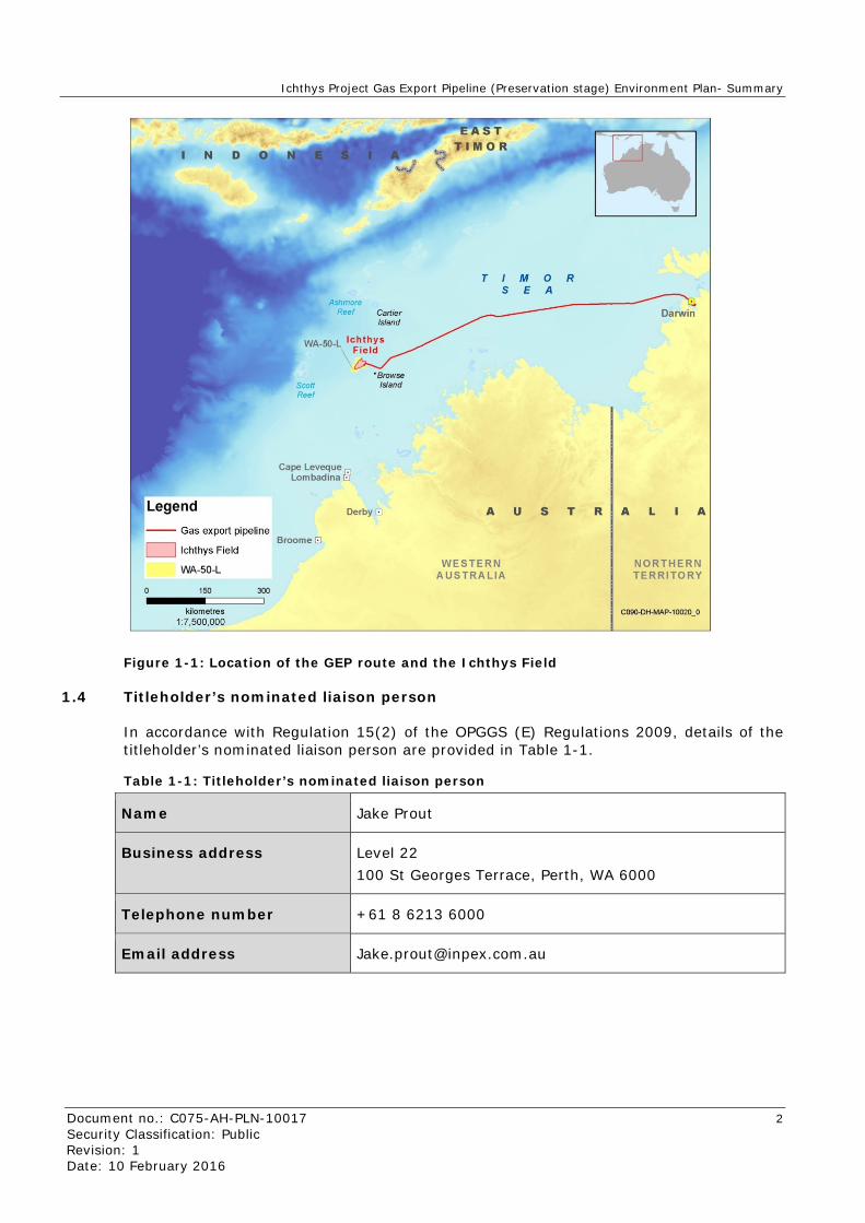
The Ichthys Field is located within the area covered by production licence WA-50-L in the northern Browse Basin, approximately 210 km north-west of the coast of mainland Western Australia and 820 km south-west of Darwin. Gas from the Ichthys Field will undergo preliminary processing on an offshore central processing facility (CPF) to remove water and raw liquids, including the greater part of the condensate. This condensate will be pumped to a nearby floating production, storage and offtake (FPSO) facility, from which it will be transferred to tankers for export to overseas markets. The gas will be transferred from the CPF via an 889 km gas export pipeline (GEP), covered by pipeline licences WA-22-PL and NT-PL/4 in Commonwealth waters, to an onshore processing plant at Bladin Point in Darwin (Figure 1-1).
1.2 Activity overview
The Ichthys Project Gas Export Pipeline (Preservation Stage) Environment Plan (the EP) describes inspection maintenance and repair (IMR) activities, conducted from vessels, that may occur along the GEP during the preservation stage.
1.3 Pipeline preservation stage
After the mechanical completion stage is complete in the first quarter (Q1) of 2016, the 889 km pipeline will remain preserved for a period of up to two years, until hydrocarbons are introduced into the GEP (and the operations stage commences).
The preservation stage comprises two periods:
1. During the first period (after the flooding and hydrotesting is completed, during the GEP mechanical completion activity), the pipeline remains filled with filtered inhibited seawater (FIS) at ambient pressure to prevent microbiologically induced corrosion of the GEP.
2. During the second period, after the pipeline is precommissioned – managed under the GEP Precommissioning EP (C050-AH-PLN-10001) accepted by the National Offshore Petroleum Safety and Environmental Management Authority (NOPSEMA) – the GEP is put under a partial vacuum and filled with nitrogen gas to inert the pipeline. Once inert, the pipeline will remain preserved, under a partial vacuum (~0.1 atmospheres) until hydrocarbons are introduced.
Ichthys Project Gas Export Pipeline (Preservation stage) Environment Plan- Summary
Document no.: C075-AH-PLN-10017 2 Security Classification: Public Revision: 1 Date: 10 February 2016
Figure 1-1: Location of the GEP route and the Ichthys Field
1.4 Titleholder’s nominated liaison person
In accordance with Regulation 15(2) of the OPGGS (E) Regulations 2009, details of the titleholder’s nominated liaison person are provided in Table 1-1.
Table 1-1: Titleholder’s nominated liaison person
Name Jake Prout
Business address Level 22 100 St Georges Terrace, Perth, WA 6000
Telephone number +61 8 6213 6000
Email address [email protected]

Ichthys Project Gas Export Pipeline (Preservation stage) Environment Plan- Summary
Document no.: C075-AH-PLN-10017 3 Security Classification: Public Revision: 1 Date: 10 February 2016
2 DESCRIPTION OF ACTIVITY
2.1 Operational area
The GEP is approximately 889 km long, with approximately 793 km located within Commonwealth waters, between the Ichthys Field and the Northern Territory 3 n mile limit. The operational area (Zone 1) for the petroleum activity is defined as a 2 km wide corridor, 1 km either side of the GEP centreline, up to, and including, the GERB. Zone 1 represents the area where planned activities may be undertaken. Zone 2 represents the extent of the environment that may be affected (EMBA) by unplanned activities in relation to the petroleum activity. This has been defined using predictive oil spill modelling for the identified worst-case spill scenarios relevant to the activity.
2.2 Inspection activities
Inspections of the pipeline will generally involve a support vessel travelling along the route of the pipeline using towed acoustic instruments or a remotely operated underwater vehicle (ROV) connected to the support vessel via an umbilical.
Confirmed planned activities that will occur along the GEP under the management of this EP are ROV inspections. The other activities as described in Table 2-1 and Table 2-2, although not planned, may occur as a result of the ROV inspections and have therefore been included for contingency purposes. Typically, support vessels will be on site for between 5 and 60 days per year, depending on the type of inspection. Events such as cyclones, seismic activity or third-party interference that could affect the GEP infrastructure may also trigger inspections. Potential inspection activities are described in Table 2-1.
Table 2-1: Inspection activities
Inspection activity Description
ROV inspections ROVs will be deployed from a vessel to undertake visual, cathodic protection (CP) and infrastructure integrity inspections.
Marine acoustic surveys These may include the use of sidescan sonar and multibeam echo sounders and are typically conducted from a support vessel using towed (or autonomous) underwater vehicles with acoustic instruments.
2.3 Maintenance and repair activities
Maintenance and repair activities are expected to be infrequent and rare, with frequency dependent on the results of inspections and monitoring of GEP infrastructure. If maintenance or repairs are required, a vessel may remain on site for between 5 and 60 days at a time, depending on the nature of the work required. However, additional field time may be required for an activity, depending on the specific circumstances. Potential maintenance and repair activities are described in Table 2-2.
Table 2-2: Maintenance and repair activities
Activities Description
Maintenance activity

Ichthys Project Gas Export Pipeline (Preservation stage) Environment Plan- Summary
Document no.: C075-AH-PLN-10017 4 Security Classification: Public Revision: 1 Date: 10 February 2016
Activities Description
Seabed intervention activities
These may involve activities such as physical seabed intervention/excavation alongside infrastructure to gain access to, or enable repairs of, infrastructure. Excavation may involve activities such as jetting, sidecasting or mass flow excavation. Seabed intervention activities may also include the installation of grout bags, concrete mattresses, rock placement or other physical structures to stabilise and protect infrastructure on the seabed.
Cathodic protection system maintenance
This may involve activities such as the replacement of anodes and CP equipment may be added to, or placed adjacent to infrastructure using a vessel and ROV spread.
Marine growth removal activities
These may involve the removal of marine growth and calcareous deposits using mechanical techniques and/or chemical treatments using a vessel and ROV spread.
Repair activity
Clamp repair Minor repairs using clamps may be required following a minor physical impact or integrity issue with the GEP infrastructure. In the event a minor / clamp repair is required, the seabed around the GEP may need to be excavated to enable access for the clamp to be placed around the full diameter of the GEP. Alternatively, the GEP may be lifted and grout-bags placed under the GEP, or mud-mats and hydraulically operated pipe-lifting frames may be installed on the seabed to raise the GEP off the seafloor to allow clamp access. Once full access to the GEP is achieved, the GEP concrete weight and asphalt enamel coating will be removed using physical removal techniques such as high-pressure water blasting. The exposed GEP outer steel surface will then be physically smoothed in preparation for the clamp installation. The clamp will then be lowered around the GEP section to be repaired, locked into position, and grout injected to seal the clamp around the GEP repair location.
Pigging (before a major repair)
In the event of a major repair (i.e. pipe section replacement due to integrity loss), pig trains could be launched from the gas export riser base (GERB), onshore LNG plant, or both, to isolate the GEP from seawater ingress during the repair at the defect / repair location. A pig launcher and receiver (PLR) is available in Darwin and would be used to launch pigs from the onshore LNG plant into the GEP. A PLR would also be installed at the GERB to launch pigs into the GEP. During a major repair, it is likely that support vessels, a ROV and a flooding spread would be required. Pig trains would likely contain monoethylene glycol (MEG) to recondition the inner walls of the GEP and pigs would be driven with FIS, nitrogen gas or air. If FIS is used to drive the pig train, the same FIS chemicals will be used as assessed under the GEP Precommissioning EP (C050-AH-PLN-10001). Upon pig train arrival at either side of the repair location, the pigs will “lock” into position, isolating either side of the GEP from the repair location. The original contents of the GEP (FIS or nitrogen gas and any seawater which has entered the GEP) would be pushed in front of the pig trains and expelled from the GEP at the defect / repair location, or via the PLR at the GERB or in Darwin (depending whether the repair location is “piggable”).

Ichthys Project Gas Export Pipeline (Preservation stage) Environment Plan- Summary
Document no.: C075-AH-PLN-10017 5 Security Classification: Public Revision: 1 Date: 10 February 2016
2.4 Support vessel description
The lengths of the support vessels used for inspection, maintenance and repair (IMR) activities are expected to range from between approximately 70 m and 130 m. However, vessel type and specifications will depend on vessel availability and specific activity requirements. All vessels will be required to hold station or operate using dynamic positioning (DP), thereby preventing the need to anchor.
Vessels will only use a Group II hydrocarbon fuel with similar characteristics to those of marine gas oil (MGO) and will not be bunkered when undertaking an activity. Lifting and transfer of equipment and supplies from one support vessel to another may also be required.

Ichthys Project Gas Export Pipeline (Preservation stage) Environment Plan- Summary
Document no.: C075-AH-PLN-10017 6 Security Classification: Public Revision: 1 Date: 10 February 2016
3 DESCRIPTION OF RECEIVING ENVIRONMENT
An indication of the spatial extent of Zone 1 (GEP corridor) and Zone 2 (EMBA) is depicted in Figure 3-1. Zone 2 is defined by the sum of identified, credible worst-case spill scenarios, using the outermost extent of several modelled spill scenarios (all seasons) based on a 10 g/m2 thickness for surface hydrocarbons and 500 parts per billion (ppb) for entrained hydrocarbons. The characteristics of the environment within this area are described in this section.
3.1 Regional setting
Australia’s offshore waters have been divided into six marine regions in order to facilitate their management by the Australian Government under the Environment Protection and Biodiversity Conservation Act 1999 (EPBC Act). Zones 1 and 2 are located within both the North-west Marine Region, and North Marine Region.
3.1.1 North-west Marine Region
The North-west Marine Region (NWMR) comprises Commonwealth waters from the Western Australian – Northern Territory border in the north, to Kalbarri in the south.
The NWMR is distinguished by its wide continental shelf, very high-amplitude tidal regimes (especially in the north), high cyclone incidence, unique current systems and warm, low-nutrient surface waters.
The Department of the Environment (DSEWPaC 2012) states that the NWMR region supports high species richness of tropical Indo-West Pacific biota, but low levels of endemism. The vast size of the region and its range of geomorphic features and habitats are reflected in its high species diversity, unique ecosystems and associated trophic interactions and communities. The marine environment of the NWMR encompasses a number of regionally important marine communities and habitats which support a high biodiversity of marine life and feeding and breeding aggregations. These include the following:
• Ashmore Reef and Cartier Island
• Scott Reef
• Rowley Shoals
• Browse Island.
The GEP route (Zone 1) does not traverse these reefs and islands. Only Browse Island is within the EMBA (Zone 2).
3.1.2 North Marine Region
The North Marine Region (NMR) comprises Commonwealth waters from west Cape York Peninsula to the Western Australian – Northern Territory border.
This region is highly influenced by tidal flows and less so by ocean currents.
The marine environment of the NMR is known for its high diversity of tropical species but relatively low endemism, in contrast to other bioregions. DEWHA (2008) indicates within the NMR, particularly rich areas of biodiversity include:
• the Gulf of Carpentaria coastal zone
• the plateau and saddle north-west of the Wellesley Islands
• submerged coral reefs of the Gulf of Carpentaria.

Ichthys Project Gas Export Pipeline (Preservation stage) Environment Plan- Summary
Document no.: C075-AH-PLN-10017 7 Security Classification: Public Revision: 1 Date: 10 February 2016
Figure 3-1: Indicative environment that may be affected – Zone 1 and Zone 2
120·oe
Ashmore R••f ...
INDONESIA
0 Browse Island
L-----~ Beagle J
( 122"0~
~1."~~~::. y ·· • ~ Collier
. Broome
King Sqund
•Derby
lN'O'E
Bay
126.0'E
• VanCJoon _ Shoal
• Truscott
WESTERN AUSTRALIA
126'0'E
IZ'S'O'E
R>itTop~ B:mk ( _
JOSEPH BONAPARTE GULF
~-, ......_..,....-\,.., ~ ...
Wyndham•
12:8'0E T.'lf >r.tm:~I'IOI~ «"1'4\-.e<I'On ~':\'$1'1t4pAJecllfdtiiiNt •"#t:J.• i':l'IZ'r.~~ Oll'f" .ar.~l"'<.'$1r.cf00((11!1"'41~.a(Je:'l »(l(ltlfllri''IC'lf 111'"11\0J ?'Opoto.' lll"'!'i!(: OC'\";.SM(t.ffJlP£1( JIPfo;,'llfti'J:Ct"...co.floMM${,'fO'>k!bi••W:OII,~.l)' N~!'$C l'1oe WtWW'X!/I'!C prDo'f!/~0'-'I,U~o'r..li'.:C ~ 'ojl.alttJk """'-'le" (\<eq t'!I'Wf ~ 0«'.':' IIIIW:' » (o\!,l\' Mt' ~t'\«11:)' tll~ CCII\I*l'tiiN:I .X Mt' •1~'111.W011 ,or.' ~r,r..;l. f."' jllooi)IUfll:.:' o:l 0'•~" .'J:II" ~!WoN~~ t.:lt.t'.'> 0)' WPiX. foGI 4•1)' t"''IOI'' ;)l't'fflU~OII: lf@EX «~I$ f.t" 1\101\:; t:>.~lll'f I.IW Ol 4'.(' ~ lo':l\lolll.li'XIIl Of 'C'Nil'N' pi«~ c.o; ,:_
NORT'HERN TERR lT ORY
130"1i'E
~
\ PIIrlll 1..----
Leg.end
--~$1\il1 '.oo'ili9T$<3nm)
- zooe1 ·GEPRoutEI
CJz~,e2 ~Et.tao\ - G~nk.. ~roal:o or..d r~c:f;
Notes hltnclr<,.•.-tn ~u~ltll<> ~~'~"'1'h' ,~c ..... .,,_.,,,,..
~Y•lio2t01.
N"iolt~O<--N)•~ l:ht~.0.0~411'..,1$<0o.~flo. Of•-••••". c ... ....,~~~ ~ o.~e <)o.ff(f.>O$o::o_('lo$2;(' Twe> <M. :OO:l
&>.1M .... • • <M.• :»>6 «1?\~S•(•U- f<il\34- :01.,1) •~$ (A~I ~-t."GIS-201fo~0'2i
GE:" - JI'K - iO~OW.'I •
Projection N
A

Ichthys Project Gas Export Pipeline (Preservation stage) Environment Plan- Summary
Document no.: C075-AH-PLN-10017 8 Security Classification: Public Revision: 1 Date: 10 February 2016
None of these biodiversity-rich areas are traversed by the GEP route (Zone 1) and all are outside the EMBA defined by Zone 2.
3.1.3 Commonwealth marine reserves
Commonwealth marine reserves (CMRs) have been established around Australia as part of the National Representative System of Marine Protected Areas, the primary goal of which is to establish and effectively manage a comprehensive, adequate and representative system of marine reserves to contribute to the long-term conservation of marine ecosystems and protect marine biodiversity. The CMRs located within Zone 2 are as follows:
• Kimberley Commonwealth Marine Reserve
• Oceanic Shoals Commonwealth Marine Reserve.
These CMRs are shown in Figure 3-2 and are described below.
Kimberley Commonwealth Marine Reserve
The Kimberley CMR is located approximately 20 km south of the closest point of approach to Zone 1. It occupies an area of approximately 74,500 km2.
This CMR provides an important migration pathway and nursery areas for the protected humpback whale, and foraging areas for migratory seabirds, migratory dugongs, dolphins and threatened and migratory marine turtles. It is adjacent to important foraging and pupping areas for sawfish and important nesting sites for green turtles.
Two key ecological features (KEFs) are included in the reserve, namely the Ancient Coastline and the Continental Slope Demersal Fish Communities, that are both described in Section 3.1.5
Oceanic Shoals Commonwealth Marine Reserve
Zone 1 traverses the southern edge of the Oceanic Shoals CMR. This CMR occupies an area of approximately 72 000 km2. The reserve is an important resting area for turtles between egg-laying events (inter-nesting area), for the threatened flatback turtle and olive ridley turtle. It is also an important foraging area for the threatened loggerhead turtle and olive ridley turtle.
Four KEFs are represented in the reserve: the carbonate bank and terrace system of the Van Diemen Rise (unique seafloor feature), the carbonate banks of the Joseph Bonaparte Gulf (enhanced productivity, high biodiversity, unique seafloor feature), pinnacles of the Bonaparte Basin (enhanced productivity, unique seafloor feature), and shelf break and slope of the Arafura Shelf (unique seafloor feature). These are described in Section 3.1.5.
3.1.4 Western Australian marine reserves
There are no Western Australian marine reserves within Zone 1 however Browse Island and a portion of the proposed North Kimberley Marine Park are within Zone 2.
Browse Island
Browse Island is the nearest landform to Zone 1 (14 km away) and is a Class C nature reserve. It is an isolated sandy cay surrounded by an intertidal reef platform and shallow fringing reef.

Ichthys Project Gas Export Pipeline (Preservation stage) Environment Plan- Summary
Document no.: C075-AH-PLN-10017 9 Security Classification: Public Revision: 1 Date: 10 February 2016
Figure 3-2: Commonwealth and state marine reserves
120•0'E
• Mermaid Reef
@ Clerke Reef
120•0'E
INDONESIA
Hibernia Reef
•
Fantome Shoals
Ashmore Reef .. Woodbine • Bank
-.
123.20'E 125•0'E
126.40'E
Echo Shoals
SahuiBanks
Deep Shoals 1
Van Cloon Shoals
126.40'E
128.20'E
-Sunrise Bank
Margaret Harries Bank
The Boxers Area
Deep Shoals 2
JOSEPH BONAPARTE GULF
128.20'E n.. m formation con tamed on th13 map IS confitHntJ~Iand for mtorm1tJon only. and must not be communceted to other pefiOns w«hout the p11or wrtrten consent of INPEX Any unauthonsed use of sudl mforrNttOn ~y expose the utUtr and the provider of that mtormatJOn to legal rok \Mint every effort has been mMie to ensure tM acclKacy and completeness of the ..,fonnet/011 presented no gue,..ntee 11 QIYefl nor ,.sponsl> ly taken by IN PEX for any errors or om,ssa::tri.S IN PEX accepts no IJiblty for any use of trt. NH1.,formet.an or reNnce p,.ced on 11
13o•o·E
DRAFT
Cobourg
Vernon lslattd
NORTHERN TERRITORY
13o•o·E 131.40'E
Legend
-- Coastal waters {3 nm)
Australia-Indonesia Memorandum of Understanding 1974
-- Zone 1 • GEP route
~ c:Jzone2 - EMBA
~ c=J lchthys gas field
~ Shoals, banks and reefs
[SJ IM!st Klmber1ey Notional
(/)
!': ~
Hentage S1te
WA Marine Parks
Proposed North Kimberley Manne Par1<
Commonweafth Marine Reserves (CMR)
rzzJ K1mbef1ey
Oceanic Shoals
Notes Th~t '""P neorpontn dN wtlich b eopynght of 111e Common-~th of
A~o~ttral• 2006
0-'n .. Neme-Cu•todi~-D-'• B.g S.nk Sho.lt ·BHP - IH7
Cam den Sound M-. Park · OEC • 2010 Commonweallh Marne Rnervet Network· DEH • 2012
Marine F'Winnu Reeons • DEH • 2007 N0191em Klmber1er M•n• Pa-ts- Dof - 2011
SeaF..-.MarineCtlan-AHS· 2000 Bathymetty Topogr~hy- GA- 20011
G.ac!ata Sariet 3 250K Tq:.o • GA - 200e Global Map I m Tq:.o- GA- 2001
Geodeta Seri .. 3 2_5rn Tq:.o- GA- 2003 W'. Nall.lre Reserves - DEC - 2012100130
W'.MarinePatki-OEC-201210e/30
IN PEX Projection N
Datum A Scale
0 75 150
kilometres
COMMONWEALTH AND STATE RESERVES, BANKS AND SHOALS

Ichthys Project Gas Export Pipeline (Preservation stage) Environment Plan- Summary
Document no.: C075-AH-PLN-10017 10 Security Classification: Public Revision: 1 Date: 10 February 2016
The Browse Island reef complex is an outer shelf, biohermic structure rising from a depth of approximately 200 m. It is a flat-topped, oval-shaped, platform reef with the largest diameter being about 2.2 km. The island is a triangular, vegetated sandy cay, standing just a few metres above high tide level. It measures approximately 700 m by 400 m.
Reef habitats at Browse Island are not diverse. Rocky shore habitat is represented only by exposed beach rock, and there are no intertidal sand flats. The lagoon habitat is poorly developed, with poor water circulation, and it shows evidence of recent infill and high mortality.
The reef platform, especially on the western side, is high and barren in many places. Only the reef crest and seaward ramp habitats around the edge of the reef support moderately rich assemblages of molluscs. The shallow subtidal zone is narrow, and supports relatively small areas of well-developed coral assemblages (INPEX 2010). Green and flatback turtle nesting occurs during the summer months. Browse Island also provides habitat for seabirds and shorebirds. These are further discussed in Section 3.3 under the description of the biological environment.
Proposed North Kimberley Marine Park
The proposed North Kimberley Marine Park will extend all the way from the northern boundary of the Camden Sound Marine Park to the Northern Territory border. This vast area has a complex coastline with many gulfs, headlands, cliff-lined shores and archipelagos. Extensive tidal flats have formed in places, some associated with the mouths of the numerous rivers that drain to the coast here. Together, these environments support a wide range of habitats and marine life.
The proposed park, which will be the second largest marine park in Australia, has important populations of manta rays, dugongs and all six species of threatened marine turtle found in Australia, extensive fringing mangrove forests and remote and virtually untouched coral reefs and sponge gardens (DPAW 2015).
3.1.5 Key ecological features
The Commonwealth Government (DEWHA 2008; DSEWPaC 2012) has identified parts of Australian marine ecosystem that are considered to be of importance for a marine region’s biodiversity or ecosystem function and integrity.
Three KEFs occur within Zone 1 and seven KEFs occur within Zone 2 (Figure 3-3). KEFs that are within each zone are identified below and described thereafter.
Zone 1:
• an ancient coastline at the 125 m depth contour
• the carbonate bank and terrace system of the Sahul Shelf
• the pinnacles of the Bonaparte Basin.
Zone 2:
• an ancient coastline at the 125 m depth contour
• the carbonate bank and terrace system of the Sahul Shelf
• carbonate bank and terrace system of the Van Diemen Rise
• continental slope demersal fish communities
• the pinnacles of the Bonaparte Basin.

Ichthys Project Gas Export Pipeline (Preservation stage) Environment Plan- Summary
Document no.: C075-AH-PLN-10017 11 Security Classification: Public Revision: 1 Date: 10 February 2016
Figure 3-3: Key ecological features within Zone 1 and Zone 2
120' 0'E
INDONESIA
S ngapatam Reef
.Derby
120'0'E 121' 40'E 123' 20'E 125'0'E
126'40'E
.. --
• Truscott
WESTERN AUSTRALIA
126'40'E
"' ·.
128'20'E
JOSEPH BONAPARTE GULF
Wyndham.
• Kununurra
128'20'E The m formatiOn con tamed on thiS map 1s con~nt.aland for mformat1011 on~. and must not be commumcaled to other ~rsons without the pr101 wtJtten consent of INPEX_ Any unauthoriSed use of such mformatJOII may expose the user end the proVIder of that m formation to legal r~&k Ylrhtllt e~ry effort has been made to ensure t'le I!ICCIA'Iflcy and completftness of the r~formet/On presented_ no guenmtee IS g1wn nor responsib1 ty taken by INPEX for any errors oromssstons INPEX accepts no l•blltty for any use of the uid 1t1formet10n or reliance pMced on 1t
130'0'E
DRAFT
• Darwin
NORTHERN TERRITORY
130'0'E 131 ' 40'E
Legend
-- Coastal waters (3 nm)
-- Territorial sea (12 nm)
-- Zone 1 - G EP Route
c:JZone2-EMBA
Key Ecological Features (KEF)
- ~;~:n~ec;~s~:~o:'r Carbonate banks and terrace system of Sahul Shelf
- g~~r:~~:s~to=mroonities - ~~;:~~e
0
~~7n Carbonate banks and
- ~a~~~e::ne~: the
Notes ThiS map I"'C:Orporates d~ta wt\..:h Is oopynghtofthe Comrnon-.tlh of
Au•IT-'• 200e.
INPEX IICknowleOges lhelolowll'lg d•tatources. o.t .. et Nsme-Custodisn- O.t•
eodsY Serin 3 25011 Topo- Geo.1011nt• Au.,.is- 200e Eto4ogltal '-•turn-Dept. of Environme nt - 2011108111
Olfshore Features S hoals - INPGIS - 201410M)8 Shoals -Austr•bn Mlfi1.ome S.fetyAulhority-20CKU11r23
GEP route -JPK -2014105114 Petroleum safety zone -INPOFS -201-4..011'24
P"*"ll'l' buhr-IHPOIS-20151'02120 Ot~t>illarea-INPGIS -20 1 5102.120
Nithol Beyp~""'"'- SKM- 2013105115 Metkertl bhery- SKM- 20131'05/15
IN PEX
NORTH WEST AUSTRALIA Key Ecological Features

Ichthys Project Gas Export Pipeline (Preservation stage) Environment Plan- Summary
Document no.: C075-AH-PLN-10017 12 Security Classification: Public Revision: 1 Date: 10 February 2016
Ancient coastline at the 125 m depth contour
The ancient coastline runs diagonally in a north-easterly direction and is traversed by the GEP (Zone 1) as shown in Figure 3-3. Parts of the ancient coastline, particularly where it exists as a rocky escarpment, are thought to provide biologically important habitats in areas otherwise dominated by soft sediments. The topographic complexity of the escarpments may facilitate vertical mixing of the water column, providing relatively nutrient-rich local environments. The ancient coastline is an area of enhanced productivity attracting baitfish which, in turn, supplies food for migrating species.
While there is little information available on the fauna associated with the hard substrate of the escarpment, it is likely to include sponges, corals, crinoids, molluscs, echinoderms and other benthic invertebrates, representative of hard substrate fauna in the North West Shelf (DSEWPaC 2012).
Carbonate bank and terrace system of the Sahul Shelf
The carbonate bank and terrace system of the Sahul Shelf is located in the western Joseph Bonaparte Gulf and is traversed by the GEP (Zone 1) as shown in Figure 3-3. It is recognised for its biodiversity values (unique seafloor feature with ecological properties of regional significance), which apply to both its benthic and pelagic habitats. The banks consist of a hard substrate with flat tops between 150 and 300 m deep. Each bank occupies an area generally less than 10 km2 and is separated from the next bank by narrow sinuous channels.
The banks support a high diversity of organisms including reef fish, sponges, soft and hard corals, gorgonians, bryozoans, ascidians and other sessile filter-feeders. They are foraging areas for loggerhead, olive ridley and flatback turtles. Humpback whales and green and freshwater sawfish are also likely to occur in the area (DEWHA 2008).
Carbonate bank and terrace system of the Van Diemen Rise
The Van Diemen Rise, located north-west of the Tiwi Islands (the two principal islands of which are Melville Island and Bathurst Island), supports a complex system of shallow carbonate banks and shoals over a limestone terrace, strongly dissected by tidal channels and paleo-river channels (including the over 150 m deep Malita Shelf Valley). Shallow, clear waters provide for a deep euphotic zone (the depth to which sufficient light for photosynthesis penetrates into the ocean), and therefore enhanced benthic primary production, while localised upwellings generated by interactions between the complex topography and tidal currents encourage phytoplankton productivity and aggregations of fish. The banks, shoals and channels offer a heterogeneous environment of shallow to deep reef, canyon, soft sediment and pelagic habitats to a diverse range of tropical species of predominantly Western Australian affinities.
Continental slope demersal fish community
The continental slope demersal fish community is, at its nearest, approximately 20 km from Zone 1. The level of endemism of demersal fish species in this community is the highest among Australian continental slope environments.
The biota present on the continental slope is the basis of the food web for demersal fish and higher-order consumers in this system. Loss of benthic habitat along the continental slope at depths known to support demersal fish communities could lead to a decline in species richness, diversity and endemism associated with this feature (DSEWPaC 2012).
Ichthys Project Gas Export Pipeline (Preservation stage) Environment Plan- Summary
Document no.: C075-AH-PLN-10017 13 Security Classification: Public Revision: 1 Date: 10 February 2016
Pinnacles of the Bonaparte Basin
An area containing limestone pinnacles, up to 50 m high (above surrounding seabed), is located in the western Joseph Bonaparte Gulf on the mid to outer edge of the shelf. This general area is traversed by the GEP (Zone 1) as shown in Figure 3-3. The pinnacles provide areas of hard substrate in an otherwise relatively featureless, soft sediment environment and are thus presumed to support a high number of species. Associated communities are thought to include sessile benthic invertebrates including hard and soft corals and sponges, and aggregations of demersal fish species such as snapper, emperor and grouper. The pinnacles are thought to be a feeding area for flatback, loggerhead and olive ridley turtles, while green turtles may traverse the area. Freshwater and green sawfish as well as humpback whales may also occur in the area (DSEWPaC, 2012). It should be noted that the GEP route has been designed to avoid any significant seabed features and the GEP route (Zone 1) does not traverse any large pinnacles.
3.2 Physical environment
3.2.1 Climate and meteorology
NWMR
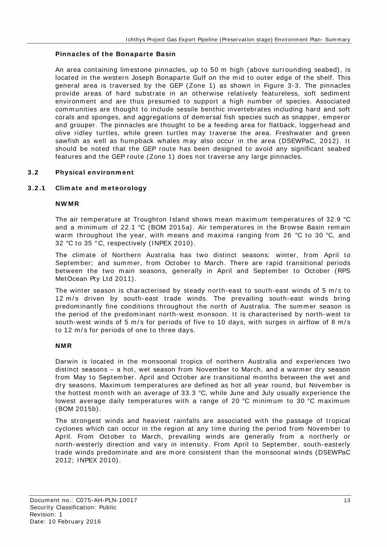
The air temperature at Troughton Island shows mean maximum temperatures of 32.9 °C and a minimum of 22.1 °C (BOM 2015a). Air temperatures in the Browse Basin remain warm throughout the year, with means and maxima ranging from 26 °C to 30 °C, and 32 °C to 35 °C, respectively (INPEX 2010).
The climate of Northern Australia has two distinct seasons: winter, from April to September; and summer, from October to March. There are rapid transitional periods between the two main seasons, generally in April and September to October (RPS MetOcean Pty Ltd 2011).
The winter season is characterised by steady north-east to south-east winds of 5 m/s to 12 m/s driven by south-east trade winds. The prevailing south-east winds bring predominantly fine conditions throughout the north of Australia. The summer season is the period of the predominant north-west monsoon. It is characterised by north-west to south-west winds of 5 m/s for periods of five to 10 days, with surges in airflow of 8 m/s to 12 m/s for periods of one to three days.
NMR
Darwin is located in the monsoonal tropics of northern Australia and experiences two distinct seasons – a hot, wet season from November to March, and a warmer dry season from May to September. April and October are transitional months between the wet and dry seasons. Maximum temperatures are defined as hot all year round, but November is the hottest month with an average of 33.3 °C, while June and July usually experience the lowest average daily temperatures with a range of 20 °C minimum to 30 °C maximum (BOM 2015b).
The strongest winds and heaviest rainfalls are associated with the passage of tropical cyclones which can occur in the region at any time during the period from November to April. From October to March, prevailing winds are generally from a northerly or north-westerly direction and vary in intensity. From April to September, south-easterly trade winds predominate and are more consistent than the monsoonal winds (DSEWPaC 2012; INPEX 2010).

Ichthys Project Gas Export Pipeline (Preservation stage) Environment Plan- Summary
Document no.: C075-AH-PLN-10017 14 Security Classification: Public Revision: 1 Date: 10 February 2016
3.2.2 Rainfall
NWMR
The region experiences strong seasonality in wind direction and rainfall, with monsoonal climate patterns and highly variable tidal regimes. The region has a pronounced cyclone season between December and March. Troughton Island historical rainfall data shows the highest maximum (269.8 mm) and mean (>100 mm) monthly rainfalls occur from December to March (BOM 2015a). Heavy rainfall is typical of the tropical wet seasons (spring and summer) and is associated with cyclones. Rainfall intensity is expected to range from approximately 215–460 mm/h over 5-minute intervals (based on 1-year and 200-year average recurrence intervals) (AMEC 2011).
NMR
The rainfall in the NMR is highly seasonal and is largely generated by monsoonal thunderstorms and tropical cyclones between December and March. The catchments across northern Australia receive around half of the rain that falls on the Australian continent. There is a latitudinal gradient in annual rainfall across the NMR, with the southern Gulf of Carpentaria receiving higher rainfalls than northern areas of the NMR. Rainfall is largely affected by fluctuations in the value of the Southern Oscillation Index, which gives an indication of the development and intensity of El Niño and La Niña climatic episodes. El Niño events are characterised by sustained warming of the central and eastern tropical Pacific Ocean, a reduction in winter rainfall and the erratic behaviour of cyclones. La Niña events are more likely to be associated with above-average rainfall and an earlier start to the northern monsoon season in tropical Australia. Darwin has a mean annual rainfall of 1739.7 mm, with rain falling on an average of 94 days, mainly in the wet season (BOM 2015b).
Monthly mean evaporation ranges from 167 mm in February, to 259 mm in October. The humidity is higher during the wet season (72% in February) than in the dry season (37% in July), mirroring rainfall patterns (BOM 2015b).
3.3 Biological environment
3.3.1 Benthic communities
Surveys within Zone 1 (Neptune Geomatics 2009) recorded featureless, unconsolidated clay–silt sands along the greater part of the pipeline route (>98%), with the most dominant seabed features being areas of pockmarks and sand waves. Rock subcrop occurred in some areas and exposed outcrop was very rare.
Given the large regional area associated with Zone 2, a large number of different benthic communities occur within this area. These habitats include banks and shoals (Figure 3-2), coral reefs and seagrasses.
3.3.2 Shoreline habitats
There are no islands or shorelines within Zone 1; however, these habitats do exist within Zone 2. Shoreline habitats within Zone 2 are mainly associated with islands comprised of sandy beaches, mangroves and other habitat that sustains feeding and breeding sites for important seabird species and marine reptiles.

Ichthys Project Gas Export Pipeline (Preservation stage) Environment Plan- Summary
Document no.: C075-AH-PLN-10017 15 Security Classification: Public Revision: 1 Date: 10 February 2016
Mangroves
Mangrove communities make up a common shoreline habitat along the Northern Territory and Western Australian coastlines, with extensive mangrove communities along the Kimberley, Joseph Bonaparte and Melville islands coastlines.
More than a quarter of the world’s species of mangroves can be found along the Kimberley coast, covering an area of approximately 140 000 hectares (ha). During 2009, shoreline ecological aerial and ground surveys were conducted from Darwin in the Northern Territory, to Broome in Western Australia, in response to the Montara oil spill (Duke et al. 2010). Approximately 5102 km of shoreline was surveyed, analysed and mapped to quantitatively characterise coastal ecological features. Mangroves were found to grow along 63% of the surveyed shoreline, and salt marshes occurred over 23.8% of the shoreline.
Although mangrove communities are not well developed on most islands along the northern Western Australian and Northern Territory coastlines, small stands of mangroves do exist on some of these islands.
Sandy beaches
Sandy beaches are located throughout the region and some are considered significant habitat for turtles and seabirds, with turtle and seabird nesting occurring above the high tideline. Generally, sands are highly mobile and therefore do no support a high level of biodiversity. Fauna within beach habitats usually consists of polychaete worms, crustaceans and bivalves, which provide a valuable food source for resident and migratory seabirds and shorebirds (CALM 2005). Natural processes tend to supply fresh sediments and larval stock with each tidal influx.
3.3.3 Marine fauna
Species of conservation significance
Species of conservation significance within Zone 2 were identified through a search of the Department of the Environment (DoE) Protected Matters database (summary provided in Appendix A). The search identified a total of 30 “Threatened” species and 48 “Migratory” species that potentially use or pass through Zone 2. In addition, the search identified 98 “Listed marine species” and 26 “whales and other cetaceans” that may occur at, or immediately adjacent to, the area.
Given the large number of species that have the potential to be present, further investigations were undertaken to identify if any biologically important areas (BIAs) associated with species of conservation significance were present within either of the zones.
Marine mammals
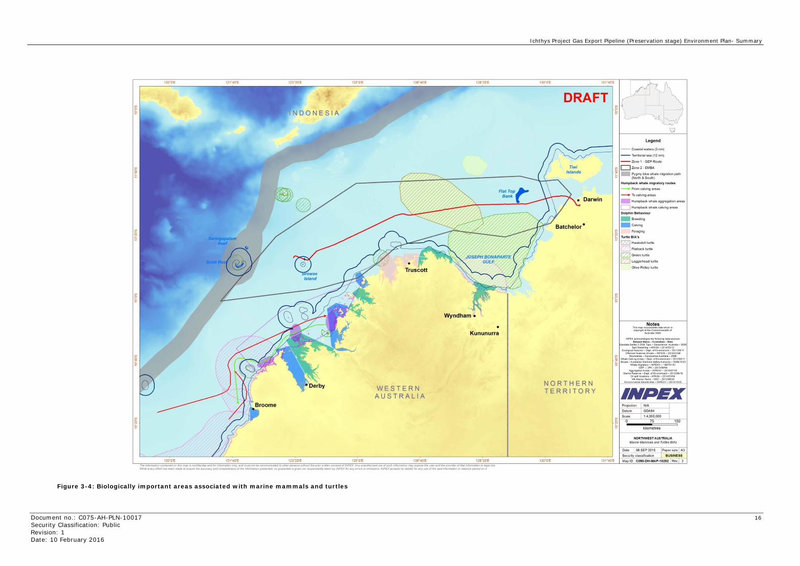
There are no BIAs for marine mammals within Zone 1. However, within Zone 2, four BIAs are present as shown in Figure 3-4:
• humpback whale aggregation and calving areas
• a humpback whale migration route
• a pygmy blue whale migration route
• breeding, calving and foraging areas for inshore dolphins.
Ichthys Project Gas Export Pipeline (Preservation stage) Environment Plan- Summary
Document no.: C075-AH-PLN-10017 16 Security Classification: Public Revision: 1 Date: 10 February 2016
Figure 3-4: Biologically important areas associated with marine mammals and turtles
ng patam Reef
TNDONESIA
Truscott
• Kununurra
WESTERN AUSTRALIA
128' 20'E The "fomlat1011 0011ta~ on ttt• map !a co"bnt~' artd tit "'fo.ma/.o'l only artd muat not,. commu'loll;alltd to other~,.,, wtnoul tne pntNwfltef! COI'IMnt of I~PEX Any utN~otnofll«< .-M o/ ''- >btm.IIOII may expo• v-.. us.t and tne provrt»r of that !llfot>nai.IOII to .11tga1 till! 14-tt 1t • .,.ry ell'ort flu C.en INde 10 an5llt"e ~ .et. IK'f Md C(WI ,.,.,.u of~ ~forma to! preaent.d no gu.rantrH;, g• .. tt ttor respoMtbiity tall en by INPf.X folany arn:ra or onuu011a WPEX ''" pts no ,.t:llly IOr any use 01 the A<d .,_forme ton rK rall•nr.• pMcfld on 1t
NORTHERN TERRITORY
Legend
-- Coastal waters (3 nm)
-- Territorial sea (12 nm)
--Zone 1 • GEP Route
~ c:JZone 2 - EMBA
~ Pygmy blue whale migrotion path (N- &South)
Humpback whale migratory routes
From calving a reas
~ To calv•ng areas
Hu!ll)back whale aggregation areas
HurJ'4)back whale caNing areas
Flatback turt~
~ Green turtle
C] Loggerhead turtle
Olive Ridley turtle
Notes TM • ., lnCO'f*'"H OMa wflldl 'COfi)'"ONoflh• COM-·Itlof
An u• • 200&
INPEXK~Hhfralaowongdela IGU~e•
o.t_.Hwne- CvslOdien - o.te _, S.n.t 3 250k T~-G•OK• ne• A.lltltlbt- 2006 ~~llfi0-A~SA-2014..ol/12
Eeoklgoc• """"'"- Oept. dEnWot\NeM-20111011'11 Ohhofe Fn turet S~-INPOIS -201"101101
~ ~cS:::='.;~0::·:;"~.;~2.05111 ~ sno.a-:===-~~~~~~=~~111121
GEP -JPK-2013108.'0<1 AQtt t;MIOII Aren -IHP£NV -2010107118
w.mei!:--Oepl ol l!rtwonmtnl-201votlfll Ollop.toe.Mioiii-A~SA-201&103.01
W,.MtfineP.-ki -DEC-2012A:Iel30 Enwl;Jnmen~ Sen~- WPENV - 201311012$
Scale
~ 0--~-=::===::1
Ichthys Project Gas Export Pipeline (Preservation stage) Environment Plan- Summary
Document no.: C075-AH-PLN-10017 17 Security Classification: Public Revision: 1 Date: 10 February 2016
Marine reptiles
There is one BIA for marine reptiles intersected by Zone 1. This is the Bonaparte Depression, which provides significant foraging habitat for olive ridley and loggerhead turtles (Figure 3-4). Within Zone 2, a range of BIAs are present for all species of marine turtles. These important areas can be split into foraging, nesting and internesting areas and have been identified as:
• foraging – Joseph Bonaparte Gulf and Bonaparte Depression
• nesting areas – Browse Island and Cassini Island.
Fishes and sharks
Within Zone 1 and Zone 2, a single DoE-defined BIA exists: a whale shark foraging area (Figure 3-5). Although not specifically identified by the DoE as a BIA, KEFs within Zone 2 are also known to provide important habitat to diverse fish assemblages.
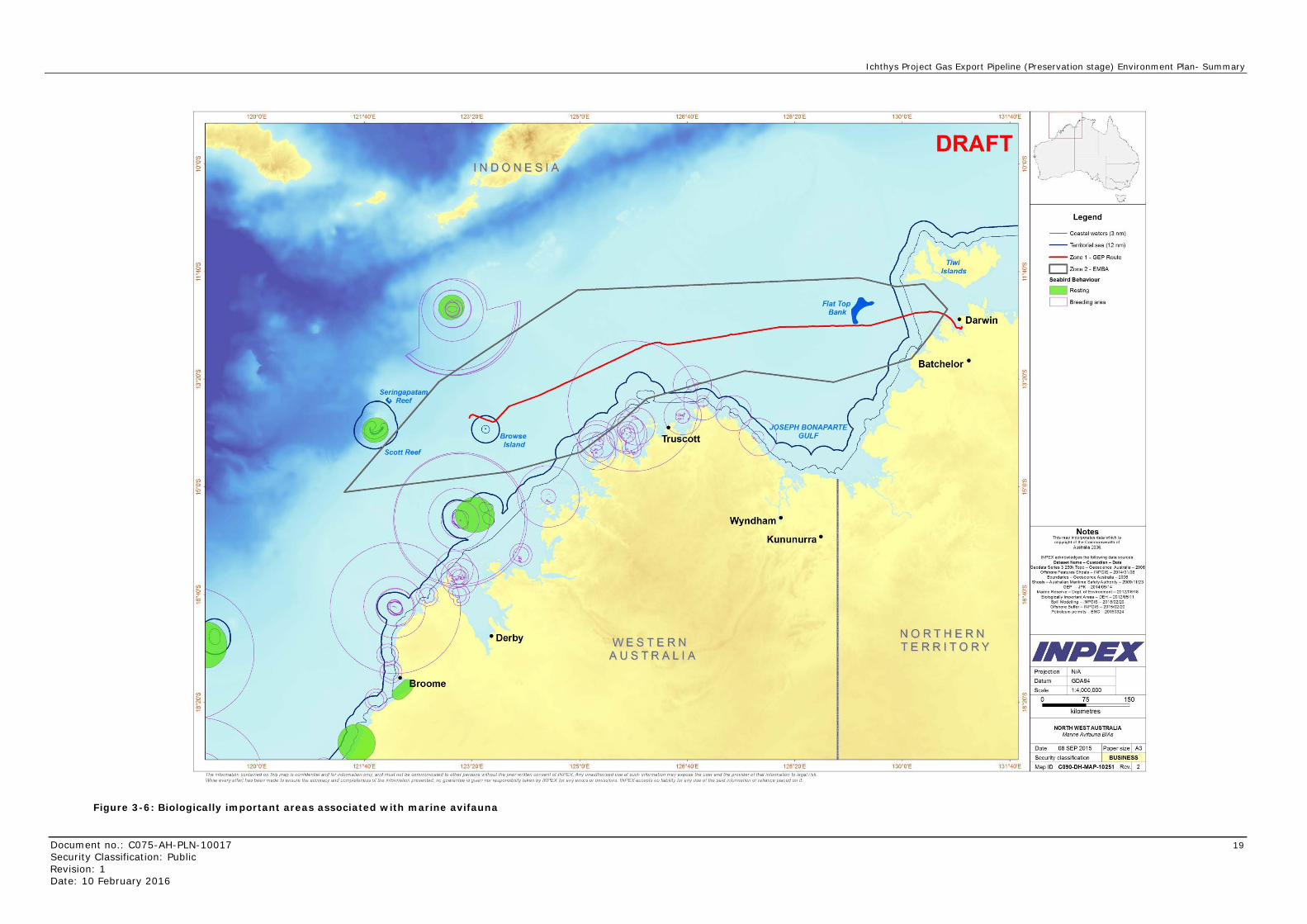
Marine avifauna
A single BIA overlaps Zone 1 as shown in Figure 3-6. This is associated with lesser frigatebirds that make high use of areas around breeding sites (i.e. areas within 30 km of breeding sites). These birds are partly resident and partly nomadic dispersing widely between breeding seasons. Breeding in this area is associated with Ashmore Reef, Long Reef, Adele Island, the Lacepede Islands and Bedout Island which are all located within Zone 2.
Zone 2 overlaps a large number of BIAs present for a number of different marine avifauna species. These areas are generally associated with coastal areas of north-west WA and islands within the region. Coastal habitat is generally used for resting and breeding, while adjacent offshore areas are used for foraging activities.

Ichthys Project Gas Export Pipeline (Preservation stage) Environment Plan- Summary
Document no.: C075-AH-PLN-10017 18 Security Classification: Public Revision: 1 Date: 10 February 2016
Figure 3-5: Biologically important areas associated with fish and sharks
120•o·E
120•0'E
S ngapatam Reef
122·o·E
INDONESIA
• Derby
124. 0'E
12s•o·E
• Truscott
WESTERN AUSTRALIA
12s•o·E
12a•o·E
Wyndham •
• Kununurra
12a•o·E
The •nfotmatlon contiJifled on thiS map IS confident•/ and tor mformatiOII onty. and must not be commumcated to other persons wtlhout the pr1or wrtten consent of INPEX Any uneuthon:sed t~.se of such m formatiOn m.y eKpos. the uar and the proVKJer of that mformetton to ~gal fiSk ""'te e~ry erron hes t>een made to ensure the .ccur.cy W~d completeness of the lflfOrmatiOfl presented no guarantee IS gwen nor tesponstbi/lty taken by IN PEX tor any errors or onii$$/Ofi.S IN PEX accepts no habllty for any use ot the said lflfonnlltiOn or rekance p•cea on 11
130. 0'E
DRAFT
NORTHERN TERRITORY
130•o·E
Legend
-- Coastal waters (3 nm)
-- Territorial sea (12 nm)
-- Zone 1 • GEP Route
c::J Zone 2 - EMBA
\1\tlale shafi( foraging BIA
Key Ecological Features (KEF)
- ~~~~~8c:s~~~~tr Carbonate banks and terrace system of Sahul Shelf
- g~:r:(~i;~0rommunities - :nn::.~ o~!~~
Carbonate banks and
- ~;~~~e~ne~i:the
Notes Thb map ~nc:orp<N11tes d~ta wttictl i$ copyright of IM Common-811h of
Auw81i112'008
IHPEX a<:knowleGgn th• follow~ d•UIIOUIU$" 0.1 ... 1 H.,..•-Custodl.,.- O.t•
.od.WS.n.s3 25011 T~-O•OK .. nc:• Auttr•ll•-200tl Ecdoglcall••turn- ().pt. ofEnwonrn•nt- 2011.101111
Ohhor• Sho81s -INPOIS- 2014.'01108 Boundanes-Geose .. n~:• Australia- 2'008
Stlarll O.ns~- CWR- 200M)1131 GEP - .FK - 2014./05114
NorfiPt Stl•tk Flth.,.-,-OOF -2010r'O&Ite Envvonman~ Sansllrllbes-INPENV- 2013110125
Blofog~~;allrnportMtAr .. s-OEH -2012J05111
IN PEX
150
NORTHWEST A USTRALIA
Fish and Sharks BIAs
Ichthys Project Gas Export Pipeline (Preservation stage) Environment Plan- Summary
Document no.: C075-AH-PLN-10017 19 Security Classification: Public Revision: 1 Date: 10 February 2016
Figure 3-6: Biologically important areas associated with marine avifauna
INDONESIA
• Derby WESTERN AUSTRALIA
Wyndham•
Kununurra •
The mformat10n contamed on th1s map 1s confident18/and for mformat10n only_ and must not be commumcated to other persons without the puor wntten consent of JNPEX Any unauthoriSed use of such mformatron may expose the user and the proVIder of that m formation to legal rtsk W111Je every e"ort has been made to ensure the accuracy and completeness or the Ill formation presented. no guarantee ts given nor responsibility taken by IN PEX for any e"ors or om1ss10ns INPEX accepts no liability for any use or lire sa1d 111format10n or reliance placed on 1t.
DRAFT
NORTHERN TERR I TORY
Legend
- - Coastal waters (3 nm)
-- Territorial sea (12 nm)
--Zone 1 • GEP Route
c::J Zone 2 - EMBA
Seablrd Behaviour
- Resting
D Breeding area
Notes Tll~mapineorpOJates data wtlictlis
copyright of me Commonwealm of Austtalia 2006.
INPEX acknowledges ltle following data sourcn · Oal .. l l Name- Cu stodian- O.te
eodata S&riH 3 2501o; Topo - G&oseience Australia - 2006 Oltshor& Features Shoals - INPGIS - 20141011Q8
Boundaries - Geoscience Australia - 2006 Shoals - Australian Maribme SafetyAultlority- :201»111123
GEP - JPK - 2014/05114 Marine Ru erve - Dept. o f Environment - 2012106/18
Biologlc,.l y Important Areas - DEH - 2012105111 ~ill Model1011 - IN PG IS - 2015102120 Ofl'shore Buller- IN PGIS - 2015102120 Petroleum pe rmits - ENC - 20150324
IN PEX
NORTH WEST AUSTRALIA Marine Avifauna BIAs

Ichthys Project Gas Export Pipeline (Preservation stage) Environment Plan- Summary
Document no.: C075-AH-PLN-10017 20 Security Classification: Public Revision: 1 Date: 10 February 2016
3.4 Existing users and uses
Commercial fishing
Within Zone 2, five Commonwealth-managed fisheries and eight state-managed/ territory-managed commercial fisheries have the potential to operate. The Commonwealth-managed fisheries are the:
• Northern Prawn Fishery
• North West Slope Trawl Fishery
• Western Tuna and Billfish Fishery
• Southern Bluefin Tuna Fishery
• (Western) Skipjack Tuna Fishery
The state-managed/territory-managed fisheries are the:
• Coastal Line Fishery
• Coastal Net Fishery
• Offshore Net and Line Fishery
• Spanish Mackerel Fishery
• Kimberley Prawn Managed Fishery
• Northern Demersal Scalefish Managed Fishery
• Mackerel Managed Fishery
• Joint Authority Northern Shark Fishery
Traditional Indonesian fishing
The Australian and Indonesian governments signed a memorandum of understanding (MoU) in 1974 (DSEWPaC 2012) which permits fishing by Indonesian and Timorese fishers, using traditional fishing methods only, in an area of Australian waters in the Timor Sea. The MoU area, covers Scott Reef and its surrounds, Seringapatam Reef, Browse Island, Ashmore Reef, Cartier Island and various banks and shoals.
The MoU requires fishers to use traditional, sail-powered fishing vessels and non-motorised equipment, and prohibits them from taking protected species, such as turtles, dugongs and clams. Fishers target a range of animals, including sea cucumbers (bêche-de-mer), trochus (topshell snail), reef fish and sharks. Indonesian fishing effort is high at Scott Reef, and also takes place at Browse Island.
Although a portion of Zone 1 falls within the MoU, actual fishing activities on Browse Island are within Zone 2 only.
3.5 Particular values and sensitivities
A summary of the environmental values and sensitivities, with the potential to occur within Zone 1 and Zone 2, is provided in Sections 3.5.1 and 3.5.2 below.
3.5.1 Zone 1
The particular values and sensitivities with the potential to occur within Zone 1 are summarised in Table 3-1.

Ichthys Project Gas Export Pipeline (Preservation stage) Environment Plan- Summary
Document no.: C075-AH-PLN-10017 21 Security Classification: Public Revision: 1 Date: 10 February 2016
Table 3-1: Particular values and sensitivities within Zone 1
Values and sensitivities Description
Receptors that are considered socially important as identified during stakeholder engagement (including social and cultural heritage matters).
Commonwealth-managed and state-managed/territory-managed commercial fisheries.
Benthic primary producer habitats. These have been defined as seabed communities where algae (e.g. macroalgae, turf and benthic microalgae), seagrasses, mangroves, corals, or mixtures of these groups are prominent components (WA EPA 2009).
None identified within this area.
Regionally important areas of high diversity (such as shoals and banks).
None identified along the GEP route. However, Zone 1 includes the following: Commonwealth marine reserves (CMRs) • Oceanic Shoals CMR. KEFs • ancient coastline at 125 m depth contour • the carbonate bank and terrace system of the
Sahul Shelf • the pinnacles of the Bonaparte Basin.
World heritage values of a declared World Heritage property within the meaning of the EPBC Act.
None identified within this area.
National heritage values of a National Heritage place within the meaning of the EPBC Act.
None identified within this area.
Ecological character of a declared Ramsar wetland within the meaning of the EPBC Act.
None identified within this area.
Presence of a listed threatened species or listed threatened ecological community within the meaning of the EPBC Act.
Biologically important areas (BIAs): Turtles • foraging (Joseph Bonaparte Gulf and the
Bonaparte Depression). Fish • whale sharks foraging area • Zone 1 KEFs, due to increased species diversity
and abundance. Marine avifauna • foraging adjacent to breeding areas associated
with lesser frigatebirds. A large number of threatened species or migratory species have been identified as having the potential to transit the area.

Ichthys Project Gas Export Pipeline (Preservation stage) Environment Plan- Summary
Document no.: C075-AH-PLN-10017 22 Security Classification: Public Revision: 1 Date: 10 February 2016
Values and sensitivities Description
Presence of a listed migratory species within the meaning of the EPBC Act.
A large number of threatened species or migratory species have been identified as having the potential to transit the area.
Values and sensitivities that exist in, or in relation to, part or all of: • a Commonwealth marine area within
the meaning of the EPBC Act • Commonwealth land within the
meaning of the EPBC Act. Specifically, values and sensitivities include receptors (e.g. plankton and benthic communities) that when exposed have the potential to affect regionally significant ecological diversity and productivity from benthic and planktonic communities.
Plankton: Planktonic communities within Zone 1 are likely to be the same planktonic communities that are found within Zone 2 and the broader areas of the NWMR and NMR. Benthic communities: There are no primary producer benthic communities or other significant or sensitive benthic communities within Zone 1.
3.5.2 Zone 2
The particular values and sensitivities with the potential to occur within Zone 2 are identified in Table 3-2.
Table 3-2: Particular values and sensitivities within Zone 2
Values and sensitivities Description
Receptors that are considered socially important, as identified during stakeholder engagement (including social and cultural heritage matters).
Commonwealth-managed and state-managed/territory-managed commercial fisheries, traditional and recreational fishing. Flat Top Bank has been identified as a location of specific value for recreational fishing. The unique coastline of the West Kimberley National Heritage Place has been recognised as important by Aboriginal stakeholders.
Benthic primary producer habitats. These have been defined as seabed communities within which algae (e.g. macroalgae, turf and benthic microalgae), seagrasses, mangroves, corals, or mixtures of these groups are prominent components (WA EPA 2009).
Benthic primary producer habitats including corals, seagrasses and mangroves are present within Zone 2.
Regionally important areas of high diversity (such as shoals and banks).
Zone 2 includes the following: CMRs • Kimberley CMR • Oceanic Shoals CMR. KEFs • ancient coastline at 125 m depth contour • the carbonate bank and terrace system of the
Sahul Shelf • the carbonate bank and terrace system of the
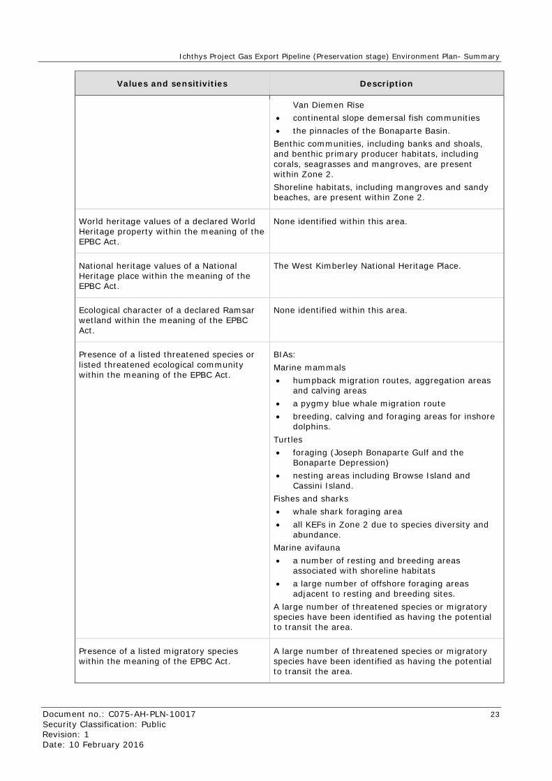
Ichthys Project Gas Export Pipeline (Preservation stage) Environment Plan- Summary
Document no.: C075-AH-PLN-10017 23 Security Classification: Public Revision: 1 Date: 10 February 2016
Values and sensitivities Description
Van Diemen Rise • continental slope demersal fish communities • the pinnacles of the Bonaparte Basin. Benthic communities, including banks and shoals, and benthic primary producer habitats, including corals, seagrasses and mangroves, are present within Zone 2. Shoreline habitats, including mangroves and sandy beaches, are present within Zone 2.
World heritage values of a declared World Heritage property within the meaning of the EPBC Act.
None identified within this area.
National heritage values of a National Heritage place within the meaning of the EPBC Act.
The West Kimberley National Heritage Place.
Ecological character of a declared Ramsar wetland within the meaning of the EPBC Act.
None identified within this area.
Presence of a listed threatened species or listed threatened ecological community within the meaning of the EPBC Act.
BIAs: Marine mammals • humpback migration routes, aggregation areas
and calving areas • a pygmy blue whale migration route • breeding, calving and foraging areas for inshore
dolphins. Turtles • foraging (Joseph Bonaparte Gulf and the
Bonaparte Depression) • nesting areas including Browse Island and
Cassini Island. Fishes and sharks • whale shark foraging area • all KEFs in Zone 2 due to species diversity and
abundance. Marine avifauna • a number of resting and breeding areas
associated with shoreline habitats • a large number of offshore foraging areas
adjacent to resting and breeding sites. A large number of threatened species or migratory species have been identified as having the potential to transit the area.
Presence of a listed migratory species within the meaning of the EPBC Act.
A large number of threatened species or migratory species have been identified as having the potential to transit the area.

Ichthys Project Gas Export Pipeline (Preservation stage) Environment Plan- Summary
Document no.: C075-AH-PLN-10017 24 Security Classification: Public Revision: 1 Date: 10 February 2016
Values and sensitivities Description
Values and sensitivities that exist in, or in relation to, part or all of: • a Commonwealth marine area within
the meaning of the EPBC Act Commonwealth land within the meaning of the EPBC Act.
Specifically, receptors (e.g. plankton and benthic communities) that when exposed have the potential to affect regionally significant ecological diversity and productivity from benthic and planktonic communities.
Planktonic communities within Zone 2 are the same planktonic communities within the broader areas of NWMR and NMR. There are many primary producer benthic habitats and other significant/sensitive benthic communities within Zone 2.

Ichthys Project Gas Export Pipeline (Preservation stage) Environment Plan- Summary
Document no.: C075-AH-PLN-10017 25 Security Classification: Public Revision: 1 Date: 10 February 2016
4 STAKEHOLDER CONSULTATION
INPEX has been a member of the Australian business community since 1986 and, during this time, has engaged with stakeholders on a regular basis for a broad range of activities. INPEX also participates in industry forums, conferences and community meetings in order to facilitate opportunities for meaningful engagement.
In 2013, INPEX began an annual campaign, designed to provide up-to-date information to stakeholders on the offshore components of the Ichthys Project on a regular basis, while attempting to reduce stakeholder fatigue.
Engagement for this activity was carried out in accordance with a process that involved the following:
• stakeholder identification and classification
• stakeholder engagement
• stakeholder monitoring and reporting
• stakeholder complaints and grievance management.
4.1 Stakeholder identification and classification
This stage involved a workshop to identify relevant stakeholders and assess the levels of interest and influence that each stakeholder would specifically, or potentially, have in relation to the activities.
4.2 Stakeholder engagement
In order to facilitate the engagement process, INPEX prepared consultation fact sheets (in 2013, 2014 and 2015) which described the following:
• the components of the offshore facilities, including the GEP
• the Ichthys Project schedule
• logistics support
• field management
• regulatory requirements
• environmental sensitivities
• emissions and discharges
• environmental management
• enquiries and feedback information.
The fact sheets are produced in both electronic and printed formats to enable all modes of engagement.
4.3 Stakeholder monitoring and reporting
All queries and feedback were recorded and forwarded for follow-up, where applicable. All responses provided to stakeholders were appropriate to the nature of their communication, e.g. technical queries were investigated by area experts and responses were provided.

Ichthys Project Gas Export Pipeline (Preservation stage) Environment Plan- Summary
Document no.: C075-AH-PLN-10017 26 Security Classification: Public Revision: 1 Date: 10 February 2016
4.4 Stakeholder complaints and grievance management
Any queries received in response to the proposed activities were treated as issues and dealt with in the course of developing the EP and associated oil pollution emergency plan (OPEP). Any complaints raised in relation to the conduct of engagement would have been treated as grievances and managed in accordance with the INPEX Community Grievance Management Procedure. However, no grievances were recorded during the engagement process.
4.5 Consultation summary
A summary of relevant stakeholders, and any concerns of merit they identified during the consultation process, is provided in Table 4-1. A summary of the relevant matters raised by those stakeholders and their feedback is provided in Table 4-2.
Table 4-1: Stakeholder engagement summary
Stakeholder Relevant matter raised
Commonwealth Government departments and agencies; Ministers of relevant portfolios
Australian Maritime Safety Authority (AMSA) No
Australian Fisheries Management Authority (AFMA) Yes
Parliamentary Secretary to the Minister for Agriculture (jurisdiction for Fisheries)
No
Department of Agriculture and Water Resources (DAWR) – Biosecurity No
Department of Industry (DoI) No
National Offshore Petroleum Titles Administrator (NOPTA) No
Minister for Industry No
Department of the Environment (DoE) No
Minister for the Environment No
Department of Defence (Northern Command) No
Australian Customs and Border Protection Service (Broome Office) No
Western Australian Government departments and agencies; Ministers of relevant portfolios
Department of Environment Regulation (DER) – Hazard Management and Contaminated Sites branches
Yes
Department of Parks and Wildlife (DPaW) – Environmental Management Branch
Yes
Minister for the Environment No

Ichthys Project Gas Export Pipeline (Preservation stage) Environment Plan- Summary
Document no.: C075-AH-PLN-10017 27 Security Classification: Public Revision: 1 Date: 10 February 2016
Stakeholder Relevant matter raised
Department of Transport (WA DoT) – Marine Safety Branch Yes
Department of Fisheries (DOFWA) Yes
Minister for Fisheries No
Department of Mines and Petroleum (DMP) Yes
Minister for Mines and Petroleum No
Minister for Energy No
Shire of Broome No
Shire of Derby / West Kimberley No
Shire of Wyndham / East Kimberley No
Kimberley Ports Authority No
Northern Territory Government departments and agencies; Ministers of relevant portfolios
Chief Minister No
Northern Territory Environment Protection Authority (NT EPA) No
Parks and Wildlife Commission No
Department of Transport – Marine Safety Branch No
Department of Primary Industry and Fisheries (DPIF) Yes
Department of Mines and Energy No
Minister for Primary Industry and Fisheries; Mines and Energy No
Darwin Port Corporation No
National Native Title Tribunal, relevant Aboriginal and Torres Strait Islander (ATSI) land councils and prescribed bodies corporate, traditional owners and relevant land councils in areas potentially impacted by the operations activities
National Native Title Tribunal No
Kimberley Land Council No
Indigenous Land Corporation No
Larrakia Development Corporation No

Ichthys Project Gas Export Pipeline (Preservation stage) Environment Plan- Summary
Document no.: C075-AH-PLN-10017 28 Security Classification: Public Revision: 1 Date: 10 February 2016
Stakeholder Relevant matter raised
Larrakia Nation Aboriginal Corporation No
Bardi and Jawi Niimidiman Aboriginal Corporation (prescribed body corporate) (represents traditional owners in Dampier Peninsula and other areas)
No
Wanjina-Wunggurr (Native Title) Aboriginal Corporation (represents traditional owners in Kalumburu and other areas)
No
Nyamba Buru Yawuru Ltd (Yawuru Native Title Holders Aboriginal Corporation) (represents traditional owners of Broome)
No
Djarindjin Community (Dampier Peninsula) No
Kooljaman at Cape Leveque (Dampier Peninsula) No
Lombadina Community (Dampier Peninsula) No
Commonwealth-managed fisheries stakeholders
Commonwealth Fisheries Association (CFA) No
Australian Southern Bluefin Tuna Industry Association (ASBTIA) No
Jamaclan Marine Services No
NPF Industry Pty Ltd No
Northern Prawn Fishery (QLD) Trawl Association Inc. – no longer in operation in 2016)
No
WA Seafoods No
Individual licence/permit holders in the following fisheries: • Northern Prawn Fishery • North West Slope Trawl Fishery • Western Skipjack Fishery • Western Tuna and Billfish Fisheries
No
Western Australian-managed fisheries stakeholders
Western Australian Fishing Industry Council (WAFIC) (also represents Commonwealth-managed fisheries in offshore WA)
No
Pearl Producers Association of Western Australia No
Individual licence/permit holders in the following fisheries: • Kimberley Prawn Managed Fishery
No

Ichthys Project Gas Export Pipeline (Preservation stage) Environment Plan- Summary
Document no.: C075-AH-PLN-10017 29 Security Classification: Public Revision: 1 Date: 10 February 2016
Stakeholder Relevant matter raised
• Mackerel Managed Fishery • Northern (North Coast) Shark Fishery • Northern Demersal Scalefish Fishery • Pearl Oyster Managed Fishery (through Pearl Producers
Association)
Northern Territory-managed fisheries stakeholders
Northern Territory Seafood Council Yes
Northern Territory Guided Fishing Industry Association No
Individual licence/permit holders in the following fisheries: • Coastal Line Fishery • Demersal Fishery • Jigging Fishery • Spanish Mackerel Fishery • Mud Crab Fishery • Offshore Net & Line Fishery • Pearl Oyster Fishery • Trepang Fishery
No
Recreational fishing associations
Recfishwest (WA) No
Amateur Fishermen’s Association of the Northern Territory No
Environmental, heritage and marine research groups
Centre for Whale Research (WA) Inc. No
Australian Conservation Foundation No
World Wildlife Fund for Nature No
Conservation Council of WA No
Environment Centre of the Northern Territory No
Australian Marine Conservation Society No
Oil spill response
Australian Marine Oil Spill Centre (AMOSC) Yes
Asia-Pacific Applied Science Associates (APASA) No

Ichthys Project Gas Export Pipeline (Preservation stage) Environment Plan- Summary
Document no.: C075-AH-PLN-10017 30 Security Classification: Public Revision: 1 Date: 10 February 2016
Stakeholder Relevant matter raised
Oil Spill Response Limited (OSRL) No
Other businesses
Mermaid Marine Australia Limited No
Industry Capability Network – Northern Territory No

Ichthys Project Gas Export Pipeline (Preservation stage) Environment Plan- Summary
Document no.: C075-AH-PLN-10017 31 Security Classification: Public Revision: 1 Date: 10 February 2016
Table 4-2: Summary of relevant objections or claims associated with stakeholder consultation
Category, jurisdiction, subcategory
Stakeholder organisation Engagement Feedback summary
Authority, Australia, central authority
AFMA Engagement in 2013, 2014 and 2015 with AFMA for determinations of relevant fisheries (potentially impacted by INPEX activities), updated contact details for licence holders in relevant fisheries and representative industry associations.
AFMA advised INPEX to continue engagement with identified fisheries, and that the identified fisheries remained accurate according to their records. INPEX continues to check validity of the licence holders with AFMA and issues fact sheets on an annual basis to inform licence holders of Project updates.
Authority, Western Australia, state/local authority
DoFWA Email messages sent in 2013, 2014 and 2015 requesting determination of relevant fisheries offering to consult DoFWA at its discretion.
DoFWA advised INPEX to continue engagement with identified fisheries and representative bodies (WAFIC, Recfishwest, Pearl Producers Association), and that the identified fisheries remained accurate according to their records. INPEX continues to check validity of the licence holders with DoFWA and issues fact sheets on an annual basis to inform licence holders of Project updates.
Authority, Western Australia, state/local authority
DER: Hazard Management Branch Contaminated Sites Branch
Email messages in 2013, 2014 and 2015 to DER Pollution Reporting Line and Contaminated Sites contacts regarding spill notifications (OPEP emergency contacts list).
DER requested that, should there be an oil spill with the potential to impact Browse Island in WA state waters, INPEX should notify DER about the oil spill as soon as possible, as per Section 72 of the Environmental Protection Act 1986 (WA). Notification can be made to DER 24/7, year-round, via the Pollution Reporting Line, Tel: 1300 784 782.
Ichthys Project Gas Export Pipeline (Preservation stage) Environment Plan- Summary
Document no.: C075-AH-PLN-10017 32 Security Classification: Public Revision: 1 Date: 10 February 2016
Category, jurisdiction, subcategory
Stakeholder organisation Engagement Feedback summary
Authority, Western Australia, state/local authority
WA DoT – Marine Safety Branch
Email fact sheets in 2013. Email of fact sheet and a briefing held in 2014. Fact sheet also sent in 2015 – no response received. 2015 – INPEX attended WA DoT oil and gas operators briefing on proposed revision to the State Emergency Management Plan for Marine Oil Pollution (WestPlan MOP) in Sept 2015.
2014 briefing discussed potential for credible spill scenarios to enter WA state waters. INPEX committed to ensuring that the OPEPs will be aligned with state and national response networks and that INPEX will continue to engage with WA DoT in the following ways: • INPEX will provide a copy of the final approved OPEPs
before the activity begins. • OPEPs will include a description of proposed
Operational and Scientific Monitoring Programs to be implemented in the event of spill.
• INPEX will include early notification of incidents that could potentially impact state waters (i.e. within 2 hours). Notifications will be directed to the Oil Spill Response Coordination Unit’s 24-hour reporting number: (08) 9480 9924.
• INPEX will notify WA DoT of any change of activity where the functions, interests and activities of WA DoT are altered from the previous consultation in relation to the Project.
• INPEX will continue to monitor potential changes that may affect the OPEP when the WestPlan MoP is revised.
Authority, Western Australia, state/local authority
Department of Mines and Petroleum (DMP)
Stakeholder sent fact sheets in 2013, 2014 and 2015.
INPEX to provide DMP with pre-start notifications confirming the proposed start dates of each activity, and cessation notifications, to inform DMP upon completion of each activity via email to: [email protected].
Authority, Western Australia, state/local authority
Department of Parks and Wildlife
Email of fact sheets in 2013. Fact sheet and e-mails in July 2014 March 2015- Phone call and follow-up
INPEX and DPAW discussed the possibility of including metadata within IGEMS where possible. DPAW advised INPEX would require a permit to haze birds
Ichthys Project Gas Export Pipeline (Preservation stage) Environment Plan- Summary
Document no.: C075-AH-PLN-10017 33 Security Classification: Public Revision: 1 Date: 10 February 2016
Category, jurisdiction, subcategory
Stakeholder organisation Engagement Feedback summary
e-mail messages May 2015- Briefing provided on INPEX activities and baseline monitoring in Browse basin and follow- up emails.
from DOT as this is considered a pre-emptive action. DPAW requested that INPEX should consider that risk of oiled wildlife occurring on Browse Island is considered higher than the risk of surface or entrained oil reaching the island because birds affected closer to a spill may fly back to, and seek refuge on the island when preparing the OPEP. In addition DPAW confirmed that they may support wildlife response but that INPEX should maintain their own independent capacity to respond.
Authority, Northern Territory, state/local authority
Northern Territory Department of Primary Industry and Fisheries (DPIF)
Emails sent in 2013, 2014 and 2015 requesting determination of relevant fisheries with respect to Operations facilities, offering to consult with DPIF at its discretion.
In conjunction with the Northern Territory Seafood Council, provided confirmation of relevant fisheries, updated contact details for licence holders in those fisheries, and details of representative industry associations to contact. INPEX continues to check the validity of the licence holders with DPIF and issues fact sheets on an annual basis to inform licence holders of Project updates.
Businesses, Australia, industry associations –marine (Northern Prawn Fishery)
Northern Territory Seafood Council
E-mail messages sent in 2013, 2014 and 2015 requesting determination of relevant fisheries with respect to Operations facilities, offering to consult the Department at its discretion (refer to Department of Primary Industry and Fisheries entry).
In conjunction with DPIF, provided confirmation of relevant fisheries, updated contact details for licence holders in those fisheries, and details of representative industry associations to contact. INPEX continues to check the validity of the licence holders with the Northern Territory Seafood Council and issues fact sheets on an annual basis to inform licence holders of Project updates.
Oil spill response AMOSC Fact sheets sent in 2013, 2014 and 2015. Confirmation that AMOSC can meet obligations described in the OPEP.
AMOSC provided minor comments on the OPEP that have since been addressed in the document, and issued a statement advising that they can provide resources and capability in relation to the OPEP.

Ichthys Project Gas Export Pipeline (Preservation stage) Environment Plan- Summary
Document no.: C075-AH-PLN-10017 34 Security Classification: Public Revision: 1 Date: 10 February 2016
4.6 Ongoing stakeholder consultation
Regulation 14(9) of the OPGGS (E) Regulations 2009 specifies a requirement for consultation with relevant authorities of the Commonwealth, states or territories, and other relevant interested persons or organisations. The mechanisms to provide ongoing opportunities for consultation in relation to the EP’s implementation are summarised in Table 4-3.
Table 4-3: Ongoing stakeholder consultation
Stakeholder Information supplied Frequency
AMSA Project updates (fact sheet). INPEX will attend MoU forums with AMSA representatives.
Annually
AFMA AFMA will be advised of any engagement with Commonwealth-managed fisheries stakeholders, highlighting the issues raised.
As required
Department of Fisheries (WA) DoFWA will be advised of any engagement with WA-managed fisheries stakeholders, highlighting the issues raised.
As required
Department of Primary Industry and Fisheries DPIF will be advised of any engagement with NT-managed fisheries stakeholders, highlighting the issues raised.
As required
• Parliamentary Secretary to the Minister for Agriculture (jurisdiction for Fisheries)
• Department of Agriculture and Water Resources (DAWR) – Biosecurity
• Department of Industry • National Offshore Petroleum Titles Administrator
(NOPTA) • Minister for Industry (DoI) • Department of the Environment (DoE) • Minister for the Environment • Department of Defence (Northern Command) • Australian Customs and Border Protection
Service (Broome Office) • DER – Hazard Management and Contaminated
Sites branches • DPaW – Environmental Management Branch • Minister for the Environment
Project updates (fact sheet). Annually (stakeholder relevance reviewed at same date)

Ichthys Project Gas Export Pipeline (Preservation stage) Environment Plan- Summary
Document no.: C075-AH-PLN-10017 35 Security Classification: Public Revision: 1 Date: 10 February 2016
Stakeholder Information supplied Frequency
• WA DoT – Marine Safety Branch • Minister for Fisheries • Department of Mines and Petroleum (DMP) • Minister for Mines and Petroleum • Minister for Energy • Shire of Broome • Shire of Derby / West Kimberley • Shire of Wyndham / East Kimberley • Kimberley Ports Authority • Chief Minister • Northern Territory Environment Protection
Authority • Parks and Wildlife Commission • Department of Mines and Energy • Minister for Primary Industry and Fisheries; • Minister for Mines and Energy • Darwin Port Corporation • National Native Title Tribunal • Kimberley Land Council • Indigenous Land Corporation • Larrakia Development Corporation • Larrakia Nation Aboriginal Corporation • Bardi and Jawi Niimidiman Aboriginal
Corporation • Wanjina-Wunggurr (Native Title) Aboriginal
Corporation • Nyamba Buru Yawuru Ltd (Yawuru Native Title
Holders AC) • Djarindjin Community (Dampier Peninsula) • Kooljaman at Cape Leveque (Dampier Peninsula) • Lombadina Community (Dampier Peninsula) • Commonwealth Fisheries Association • Australian Southern Bluefin Tuna Industry
Association (ASBTIA) • Jamaclan Marine Services • NPF Industry Pty Ltd • WA Seafood Exporters • Individual licence/permit holders in relevant
AFMA-managed fisheries • Western Australian Fishing Industry Council • Pearl Producers Association of Western Australia • Individual licence/permit holders in relevant
WA-managed fisheries • Northern Territory Seafood Council • Northern Territory Guided Fishing Industry
Association • Individual licence and permit holders in relevant
Northern Territory-managed fisheries

Ichthys Project Gas Export Pipeline (Preservation stage) Environment Plan- Summary
Document no.: C075-AH-PLN-10017 36 Security Classification: Public Revision: 1 Date: 10 February 2016
Stakeholder Information supplied Frequency
• Recfishwest (Western Australia) • Amateur Fishermen’s Association of the Northern
Territory • Centre for Whale Research (Western Australia)
Inc. • Australian Conservation Foundation • World Wildlife Fund for Nature • Conservation Council of Western Australia Inc. • Environment Centre Northern Territory • Australian Marine Conservation Society • Australian Marine Oil Spill Centre (AMOSC) • RPS APASA Pty Ltd • Oil Spill Response Limited (OSRL) • Mermaid Marine Australia Limited • Industry Capability Network Northern Territory.

Ichthys Project Gas Export Pipeline (Preservation stage) Environment Plan- Summary
Document no.: C075-AH-PLN-10017 37 Security Classification: Public Revision: 1 Date: 10 February 2016
5 ENVIRONMENTAL IMPACTS AND RISKS
In accordance with Division 2.3, Regulation 13(5) of the OPGGS (E) Regulations 2009, an environmental risk assessment was undertaken to evaluate impacts and risks arising from the petroleum activity.
Environmental hazard identification (HAZID) workshops were undertaken for the EP, chaired by independent facilitators. The workshops involved numerous environmental, health, safety, project, and emergency response personnel, pipeline integrity engineers, subsea engineers and marine advisers. The workshops were undertaken in accordance with INPEX risk management processes. The approach generally aligns with the processes outlined in Standards Australia and Standards New Zealand AS/NZS ISO 31000:2009, Risk management—Principles and guidelines and the AS/NZS handbook HB 203:2012 Managing environment-related risk.
The environmental impact and risk evaluation process was undertaken in nine distinct stages:
1. the establishment of context
2. the identification of aspects, hazards and threats (and evaluation of interaction to determine an impact pathway)
3. the identification of potential consequences (severity)
4. the identification of existing design safeguards and control measures
5. the proposed additional safeguards (ALARP evaluation)
6. an assessment of the likelihood
7. an assessment of the residual risk
8. an assessment of the acceptability of the residual risk
9. the definition of environmental performance outcomes, standards and measurement criteria.
The first stage in the process involved defining the activity, characterising the environment and identifying the particular values and sensitivities of that environment. An assessment was then undertaken to identify the aspects associated with the petroleum activity. The aspects identified for the petroleum activity were as follows:
• land disturbance (in this context- seabed disturbance)
• emissions and discharges
• noise and vibration
• loss of containment
• waste management
• biodiversity protection and conservation.
Hazards and threats were then identified using the following definition:
“A physical situation with the potential to cause harm to people, damage to property, damage to the environment”.
Therefore, for an environmental risk or impact to be realised, there needs to be a pathway to expose an environmental value or sensitivity to a hazard. If there is no credible potential for exposure, there is no risk of harm or damage. Subsequently, there is no potential for impact (or consequence).
Ichthys Project Gas Export Pipeline (Preservation stage) Environment Plan- Summary
Document no.: C075-AH-PLN-10017 38 Security Classification: Public Revision: 1 Date: 10 February 2016
Given the various receptors present in the environment, these have been refined to environmentally sensitive or biologically important receptors (values and sensitivities). These have been selected using regulations, government guidance and stakeholder feedback.
For the purposes of the exposure evaluation, environmental values and sensitivities considered included the following:
• receptors that are considered socially important as identified during stakeholder engagement (including social and cultural heritage)
• benthic primary producer habitats; these have been defined as seabed communities where algae (e.g. macroalgae, turf and benthic microalgae), seagrass, mangroves, corals or mixtures of these groups are prominent components (EPA 2009)
• regionally important areas of high diversity (such as shoals and banks)
• particular values and sensitivities as defined by Regulation 13(3) of the OPGGS(E)R,
− the world heritage values of a declared World Heritage property within the meaning of the EPBC Act
− the national heritage values of a National Heritage place within the meaning of that Act
− the ecological character of a declared Ramsar wetland within the meaning of that Act
− the presence of a listed threatened species or listed threatened ecological community within the meaning of that Act
− the presence of a listed migratory species within the meaning of that Act
− any values and sensitivities that exist in, or in relation to, part or all of: Commonwealth marine area within the meaning of that Act1, or
− Commonwealth land within the meaning of that Act.
• Biologically important areas associated with EPBC Listed species.
An evaluation of the hazards and threats associated with aspects of the activity that interact with the environment was undertaken and where the evaluation determined credible exposure of a “value and sensitivity”, that aspect has been further assessed. The outcome of the exposure evaluation is presented in Table 5-1.
Table 5-1: Environmental exposure evaluation summary
Activity or aspect Potential to result in environmental impact
and risk?
IMR activities
Seabed disturbance
Seabed intervention activities such as jetting, mass flow excavation, grout bags/concrete mattress/rock placement on seabed
Yes
1 Note that this value and sensitivity includes receptors (e.g. plankton and benthic communities) that when exposed have the potential to affect regionally significant ecological diversity and productivity from benthic and planktonic communities.

Ichthys Project Gas Export Pipeline (Preservation stage) Environment Plan- Summary
Document no.: C075-AH-PLN-10017 39 Security Classification: Public Revision: 1 Date: 10 February 2016
Activity or aspect Potential to result in environmental impact
and risk?
Emissions and discharges
Grout/concrete/asphalt discharges No
Marine growth and lime-scale removal chemicals No
Noise and vibration
Changes in ambient noise levels from marine acoustic surveys during inspection of subsea infrastructure and operation of seabed intervention equipment
No
Loss of containment
Release of FIS/MEG/nitrogen due to minor or major defects in the GEP
Yes
Support vessel activities
Seabed disturbance
Anchoring will not be required for a general support vessel operations
No
Emissions and discharges
Change in air quality from power generation (vessels) No
Change in light levels from navigation lights (vessels) No
Change in water temperatures from cooling water discharges (vessels)
No
Change in water quality from desalination brine and food scraps discharges (vessels)
No
Change in water quality from sewage and grey water discharges (vessels)
No
Change in water quality from contaminated deck drainage, surface water runoff and stormwater drainage discharges (vessels)
No
Noise and vibration
Changes in ambient underwater noise levels from vessel operations
No
Loss of containment

Ichthys Project Gas Export Pipeline (Preservation stage) Environment Plan- Summary
Document no.: C075-AH-PLN-10017 40 Security Classification: Public Revision: 1 Date: 10 February 2016
Activity or aspect Potential to result in environmental impact
and risk?
Accidental release overboard or from vessel or submerged IMR equipment
Yes
Vessel collision resulting in Group II spill (250 m3 MGO) Yes
Waste
Solid waste management onboard vessels No
Biodiversity protection and conservation
Ballast-water discharge and biofouling of vessels and subsea IMR equipment
Yes
Fauna strike from physical presence of vessels No
For each aspect with a potential to result in impact and risk, the greatest consequence (or potential impact) of an activity, was then evaluated with no safeguards or control measures in place enabling the identification of a maximum foreseeable consequence of the scenario. Control measures associated with existing design safeguards were then identified to prevent or mitigate the threat and/or its consequence(s).
Where existing safeguards or controls were judged as inadequate to manage the identified hazards, additional safeguards or controls were proposed.
Additional engineering and management control measures were identified taking account of the principle of preferences illustrated in Figure 5-1. The options were then systematically evaluated in terms of risk reduction. Where the level of risk reduction achieved by their selection was determined to be grossly disproportionate to the “cost” of implementing the identified control measures the control measure has not been implemented, and the risk is considered ALARP. Cost may include financial cost, time or duration, effort, occupational health and safety risks, or environmental impacts associated with implementing the control.

Ichthys Project Gas Export Pipeline (Preservation stage) Environment Plan- Summary
Document no.: C075-AH-PLN-10017 41 Security Classification: Public Revision: 1 Date: 10 February 2016
Figure 5-1: ALARP options preference
The likelihood (or probability) of a consequence occurring was then determined, taking into account the control measures in place. The residual risk was then evaluated and ranked.
Potential environmental impacts and risks are only deemed acceptable once all reasonably practicable alternatives and additional measures have been taken to reduce the potential impacts and risks to ALARP. The potential environmental impacts and risks associated with implementing the activities described in the EP were determined to be acceptable if:
• the activities (and associated potential impacts and risks)
− comply with relevant environmental legislation, industry standards/guidelines, and corporate policies, standards, and procedures specific to the operational environment,
− take into consideration stakeholder feedback
• the level of environmental risk is assessed to be Low; or
• the level of environmental risk is assessed to be Moderate or High and the level of environmental risk is reduced to be ALARP.
A summary of the potential impacts and risks with details on identified control measures are shown in Table 5-2. It should be noted that, because of length of the GEP, the values and sensitivities with the potential to be affected could vary, depending on the specific location or nature of an activity.

Ichthys Project Gas Export Pipeline (Preservation stage) Environment Plan- Summary
Document no.: C075-AH-PLN-10017 42 Security Classification: Public Revision: 1 Date: 10 February 2016
Table 5-2: Summary of potential impacts and risks and associated control measures
Source of risk or impact
Potential impacts and risks
Control measures
IMR activities
Aspect – seabed disturbance
Seabed intervention activities, such as jetting, mass flow excavation, grout bags/concrete mattresses/rock placement on seabed. This is an unplanned activity that if required may last for approx. 5-60 days.
Physical disturbance of the seabed and localised generation of silt plumes could affect the surrounding benthic communities and have the potential to result in reduced ecosystem productivity.
DP vessels
Differential Global Positioning System (DGPS)
Engineering analysis / environmental assessment of possible intervention techniques.
Aspect – loss of containment
Release of FIS, MEG or nitrogen due to minor or major defects in the GEP. This is an unplanned activity.
A loss of containment event will result in changes to ambient water quality. A decline in water quality has the potential to result in fauna mortality and/or result in reduced ecosystem productivity or diversity.
GEP Integrity Management Plan (this plan describes the types of inspections, testing and frequency of those controls undertaken to assure the integrity of the asset)
Pressure monitoring of the GEP during the preservation stage, second period (nitrogen inerting).
Controlled FIS discharge engineering analysis.
An assessment of the impacts to the environment, in the event of a release associated with a major GEP repair will be undertaken by: • plume modelling to predict the nature
and scale of the potentially affected sensitive receptors
• collection and analysis of representative samples of the pipeline content to confirm the nature and scale of the potential impact, specific to the location of the event.
If the nature and scale of the discharge is predicted to impact a KEF or the loggerhead turtle BIA, seabed hardness will be evaluated to determine if further seabed surveys and specific environmental sensitivity analysis needs to be conducted.

Ichthys Project Gas Export Pipeline (Preservation stage) Environment Plan- Summary
Document no.: C075-AH-PLN-10017 43 Security Classification: Public Revision: 1 Date: 10 February 2016
Source of risk or impact
Potential impacts and risks
Control measures
Stakeholder engagement (to inform potentially affected parties in the event of a major GEP repair).
Support vessel activities
Aspect – loss of containment
Accidental release overboard from a vessel or submerged IMR equipment. This is an unplanned activity.
A loss of containment event will result in changes to ambient water quality. A decline in water quality has the potential to result in fauna mortality and/or result in reduced ecosystem productivity and/or diversity.
Appropriate storage of hydrocarbons and chemicals.
Spill containment and recovery equipment on board vessels
Routine servicing and inspection of submergible IMR equipment.
Shipboard oil pollution emergency plans (SOPEPs) on vessels.
Preventive maintenance system of external equipment, such as winches and cranes.
Vessel collision resulting in a Group II spill (250 m3 MGO). This is an unplanned activity but may result in impacts and risks within the EMBA in the event of this scenario occurring.
Surface, entrained and shoreline hydrocarbon exposures have the potential to result in chronic and acute effects to marine fauna, depending on the magnitude of exposure.
No Group III or Group IV hydrocarbon fuels will be used by vessels.
Stakeholder engagement campaign to inform stakeholders if they may be affected by incident related to a loss of containment
MoU with AMSA (This agreement outlines the expectations and responsibilities during an response to a vessel related spill)
Simultaneous Operations (SIMOPS) Plan (These plans describe in detail how simultaneous work can be achieved safely and can reduce the likelihood of a collision occurring)
A Notice to Mariners will be issued by AMSA before vessels begin activities.
Develop and implement an oil pollution emergency plan (OPEP) that is available on board all vessels.
Response strategies, net environmental benefit analysis (NEBA) and monitoring

Ichthys Project Gas Export Pipeline (Preservation stage) Environment Plan- Summary
Document no.: C075-AH-PLN-10017 44 Security Classification: Public Revision: 1 Date: 10 February 2016
Source of risk or impact
Potential impacts and risks
Control measures
response effectiveness will be implemented in accordance with the OPEP.
Ensure response preparedness by implementing the EP.
Protection of sensitive receptors, such as wildlife hazing.
Aspect – biodiversity protection and conservation
Ballast-water discharge and biofouling of vessels and subsea IMR equipment. This is an unplanned activity.
Establishment of invasive marine pests (IMPs) can result in changes to the structure of benthic habitats and native marine organisms through predation and/or competition for resources, leading to a change in ecological function.
The International Maritime Organization (IMO) International Convention on the Control of Harmful Anti-fouling Systems on Ships.
Australian Ballast Water Management Requirements Version 5 (DAWR 2013).
Desktop vessel risk assessments.

Ichthys Project Gas Export Pipeline (Preservation stage) Environment Plan- Summary
Document no.: C075-AH-PLN-10017 45 Security Classification: Public Revision: 1 Date: 10 February 2016
6 MONITORING ENVIRONMENTAL PERFORMANCE
The INPEX health, safety, environment and quality management system (HSEQ-MS) includes standards and procedures from all business areas. It is based on the principle of a “plan, do, check, act” (PDCA) continual improvement cycle, and was developed in accordance with the following Australian standards:
• AS/NZS 4801:2001, Occupational health and safety management systems—Specification with guidance for use.
• AS/NZS ISO 14001:2004, Environmental management systems—Requirements with guidance for use.
It provides mandatory rules and processes for the systematic and consistent management of HSEQ risks, demonstration of compliance, and facilitation of continual improvement. In the context of the EP, the HSEQ-MS enables INPEX to ensure that:
• environmental risks of activities are identified and communicated
• organisational structures and resources are provided to ensure that control measures remain effective in reducing environmental risks to levels that are tolerable and ALARP
• performance outcomes and standards are being met
• continual improvement is achieved through application of lessons learned.
A summary of the elements associated with implementation of the EP and details on the arrangements for ongoing monitoring of environmental performance are provided in Table 6-1. The processes within the HSEQ-MS that specifically address how environmental performance is monitored and achieved are described in sections 6.1 to 6.3.
Table 6-1: Summary of INPEX HSEQ-MS elements
HSEQ-MS element Description Performance monitoring
Leadership and commitment
INPEX environmental performance is achieved through strong visible leadership, commitment and accountability at all levels of the organisation. Leadership includes defining performance targets and providing structures and resources to meet them.
Overall performance with respect to the implementation of the EP will be subject to an annual review by senior management. Formal review of the effectiveness and appropriateness of the INPEX HSEQ-MS is also performed by senior management on a periodic basis.
Capability and competence
INPEX appoints and maintains competent personnel to manage environmental risks, and provide assurance that the INPEX Environmental Policy, objectives and performance expectations will be achieved. This applies to both individual competencies and the overall capability of the organisation.
INPEX conducts training needs analysis for each of the key roles in relation to the EP to define minimum training requirements. The analysis is used to develop training plans for individuals that are then used to document, schedule and record completion of specific HSEQ training.
Inductions are provided to all personnel (including INPEX representatives, contractors,

Ichthys Project Gas Export Pipeline (Preservation stage) Environment Plan- Summary
Document no.: C075-AH-PLN-10017 46 Security Classification: Public Revision: 1 Date: 10 February 2016
HSEQ-MS element Description Performance monitoring
subcontractors and visitors) before they start work at or visit any of the vessels described in this EP. Inductions cover the health, safety and environment requirements under the INPEX HSEQ-MS, including information about the commitments contained in this EP.
Documentation, information and data
INPEX implements and maintains document and records management procedures and systems. These are in place to ensure that information required to support safe and reliable preservation of the GEP, and management of environmental risks, is identified, current, reliable and available to those who need it.
The EP and associated documentation are maintained within INPEX document management systems, with the current versions also available via the controlled document repository. Records to demonstrate implementation of the HSEQ-MS and compliance with legal and other obligations are identified and maintained for at least five years.
Risk management Robust and structured processes are applied to identify hazards and ensure that risks arising from the preservation of the GEP are systematically identified, assessed, evaluated and controlled.
Impacts and risks associated with the EP are detailed in Table 5-2. Additional risk assessments will be undertaken when triggered by any of the following circumstances: • when there is a proposed
change to the design or method of GEP IMR activities, as identified by a INPEX Management of Change (MOC) request
• when flagged as necessary following the investigation of an event
• when additional information about environmental impacts becomes available (e.g. through better knowledge of the receptors present within the environment that may be affected)
• during scheduled reviews of the documentation associated with this EP.
Operate and maintain
INPEX implements and maintains processes to ensure that, while operating, records relevant to the implementation of the EP are maintained.
The INPEX HSEQ provides processes for the systematic and consistent management of HSEQ risks and demonstration of compliance during operations. Formal reviews of the effectiveness and appropriateness of the INPEX HSEQ-MS are performed by senior

Ichthys Project Gas Export Pipeline (Preservation stage) Environment Plan- Summary
Document no.: C075-AH-PLN-10017 47 Security Classification: Public Revision: 1 Date: 10 February 2016
HSEQ-MS element Description Performance monitoring
management on a periodic basis.
Management of Change (MoC)
Where a change to management of an activity is proposed, internal notification will be communicated via an MoC request. The request will identify the proposed change(s) along with the underlying reasons, and highlight potential areas of risk or impact.
Where change could affect the environment, in accordance with the INPEX business rules, it is mandatory to undertake an environmental risk assessment in every case. Formal reviews of the effectiveness and appropriateness of the INPEX HSEQ-MS are performed by senior management on a periodic basis.
Stakeholder engagement
Robust processes to ensure: • ongoing consultation with relevant
stakeholders • communication with INPEX
employees regarding legal and other requirements.
Ongoing consultation is undertaken with relevant stakeholders either annually or on an as required basis predominantly through the issue of an annual factsheet.
Communication with INPEX employees may include:
• daily toolbox meetings • use of notice boards, HSEQ
alerts and newsflashes • internal and external project
reporting.
Contractors and suppliers
Selection and management processes are in place to ensure that organisations working for, or on behalf, of INPEX are able and willing to meet the minimum business expectations of INPEX, including those related to HSEQ and risk management.
Contract compliance audits, and quality control and assurance checks are conducted throughout the life of the contract as appropriate to the scope of work and risks involved. Contractors are required to provide regular reports to communicate their HSEQ performance and compliance status and periodic checks and reviews are conducted by INPEX representatives
Security and emergency management
INPEX implements and maintains security and emergency management processes to ensure: • capabilities and arrangements are in
place to respond to an emergency • employees are trained and capable • response arrangements are tested.
A review and update of security and emergency management processes including lessons learned from drills and response arrangement testing occurs at least twice yearly. Inductions Inductions covering security and emergency management processes are provided to all personnel before they start work. Emergency response capability is maintained and updated on an annual basis.

Ichthys Project Gas Export Pipeline (Preservation stage) Environment Plan- Summary
Document no.: C075-AH-PLN-10017 48 Security Classification: Public Revision: 1 Date: 10 February 2016
HSEQ-MS element Description Performance monitoring
Incident investigation and lessons learned
INPEX implements and maintains processes for ensuring environmental incidents are investigated and reported, and that corrective actions are implemented.
The assessment of conformance with HSEQ obligations and goals ensures HSEQ risks are effectively managed, investigated and reported to support continuous improvement. HSEQ performance is regularly reviewed by senior management.
Monitoring, auditing and reviewing
INPEX implements and maintains robust monitoring, auditing and reviewing processes to evaluate environmental performance and ensure continual improvement.
INPEX’s ongoing audit and inspection program including scheduled and unscheduled audits.
Audit and inspection findings are reported and non-conformances, actions and improvement plans are managed in an action tracking system.
6.1 Management system audit
An audit and inspection program will be developed and implemented in accordance with the INPEX business standard for auditing. The program will include:
• self-assessment HSEQ audits against the HSEQ-MS
• regular inspections of workplace equipment and activities
• reviews to evaluate compliance with legal and other requirements.
Unscheduled audits may be initiated by INPEX in the event of an incident, non-compliance or for other valid reasons. Audit teams will be appropriately qualified, experienced and competent in auditing techniques. They will include relevant technical expertise, as required, and the audit team structure will be commensurate with the scope of the audit. HSEQ audit and inspection findings will be summarised in a report. Non-compliances, actions and improvement plans resulting from audits will be managed in an actions tracking system.
6.2 Vessel inspections
Offshore vessel inspection database (OVID) inspections will be undertaken to ensure that the environmental performance outcomes and standards documented in the EP can be achieved. The inspections will be conducted on support vessels before mobilisation to complete a scope of work. Findings of the audits will be converted into actions that will be tracked within an actions tracking database.
Should an IMR vessel’s scope of work extend to a duration that requires a crew change, an additional environmental inspection, to confirm compliance with the EP, will be conducted during the crew change. Should an IMR vessel's scope of work extend beyond six months, six-monthly environmental inspections, to confirm compliance with the EP, will be conducted.
Following the completion of an IMR vessel’s scope of work, a report on EP compliance will be prepared.

Ichthys Project Gas Export Pipeline (Preservation stage) Environment Plan- Summary
Document no.: C075-AH-PLN-10017 49 Security Classification: Public Revision: 1 Date: 10 February 2016
6.3 Performance reporting to regulator
For the purposes of regulatory reporting to NOPSEMA, an incident is classified as either “Reportable” or “Recordable” based upon the definitions contained in Regulation 4 of the OPGGS(E)R.
6.3.2 Reportable incidents
Based on the consequence assessments described in the EP, incidents identified as having the potential to be "reportable" incidents include:
• an unplanned release of FIS/MEG from GEP due to major defect
• the introduction of IMP
• a vessel collision resulting in an oil pollution emergency response
6.3.3 Recordable incidents
In the event of a recordable incident (for example if one of the controls identified in Table 5-2 is not implemented) INPEX will report the occurrence to NOPSEMA as soon as practicable after the end of the calendar month in which it occurs, and in any case not later than 15 days after the end of the calendar month.
For the purposes of regulatory reporting to DoE, any significant impact to “matters of national environmental significance” (as classified using the INPEX Risk Matrix) will be reported to DoE.
6.3.4 Annual performance reporting
In accordance with Regulation 14(2) of the OPGGS (E) Regulations 2009, INPEX will undertake a review of its compliance with the environmental performance outcomes and standards set out in the EP, and will provide a written report of its findings for the reporting period January 1 to December 31, to NOPSEMA on an annual basis, as agreed with NOPSEMA.
Ichthys Project Gas Export Pipeline (Preservation stage) Environment Plan- Summary
Document no.: C075-AH-PLN-10017 50 Security Classification: Public Revision: 1 Date: 10 February 2016
7 OIL POLLUTION EMERGENCY PLAN
An OPEP has been developed specifically to respond to emergency conditions defined in the EP. The purpose of the OPEP is to:
• Describe the oil spill emergency response arrangements and capabilities that are in place for the duration of the GEP preservation stage.
• Provide guidance and process support for the INPEX incident management team (IMT) and vessel emergency response teams (ERTs) during an oil pollution emergency.
• Demonstrate that the intent of Regulation 16 of the OPGGS (E) Regulations 2009 has been met.
INPEX adopts the emergency management principles of prevention, preparedness, response, recovery (PPRR). The aim of PPRR is to ensure that risks are identified and minimised; plans to respond are developed and practised; and recovery plans are in place.
INPEX maintains a trained and ready incident management team (IMT) and crisis management team (CMT). The IMT provides operational management support and the CMT provides strategic direction.
INPEX oil spill response arrangements shall be tested by the IMT:
• prior to an Activity commencing (i.e. prior to an EP being activated)
• when the arrangements for an Activity are significantly amended, and
• not later than 12 months following the most recent test
• notification and call-out drills that test communications channels and the ability to contact key individuals shall be conducted at least annually.
The INPEX IMT will conduct a minimum of two dedicated oil spill drills per year to test:
• the structure and capability of the INPEX IMT
• communications between the IMT and vessel emergency response teams (ERT)
• onsite (vessel) response capability (e.g. spill tracker buoys)
• Vessel ERT and INPEX IMT understanding of AMSA / INPEX Control Agency responsibilities
• capability and logistical arrangements with external service providers such as aviation support, trained aerial observers, oil spill modelling and equipment registers.
An integral part of the OPEP is determining which spill response measures can be implemented for the identified events. Response measures were evaluated to identify the primary and secondary measures for a Group II hydrocarbon spill.
7.1 Primary response measures
The outcomes of the evaluation, determined that the only appropriate primary response (first strike) measure was Operational Monitoring and Evaluation. This involves the use of vessels, aircraft, satellite imagery and surface tracking buoys to monitor the size, trajectory, weathering and fate of the oil.
The arrangements and capabilities in place to implement this response measure are summarised in Table 7-1.

Ichthys Project Gas Export Pipeline (Preservation stage) Environment Plan- Summary
Document no.: C075-AH-PLN-10017 51 Security Classification: Public Revision: 1 Date: 10 February 2016
Table 7-1: Resources for Operational Monitoring and Evaluation
Technique Resource capability and availability
Minimum implementation
time Activation
Electronic surface tracking buoy(s)
INPEX has purchased several surface tracking buoys which it positions at high-risk locations, such as drilling rigs, the CPF, FPSO and other work activity sites, as deemed appropriate by INPEX. At least one tracking buoy will be maintained onshore (i.e. at Broome or Darwin) which can be deployed from an aircraft to any spill location.
Immediately, if available, on IMR vessels. 12–24 hours if being deployed by another vessel or aircraft.
Tracking buoy locations managed via the Oil Spill Equipment Tracking Register. Tracking buoys deployed from vessels or aircraft as directed by the IMT. Tracking buoy online tracking tool activated by the IMT.
Oil spill trajectory modelling
INPEX maintain a contracted spill modelling service provider to provide 24-hour support.
2 hours. IMT via the INPEX Emergency Contacts Directory. Trajectory modelling activation forms.
Aerial surveillance Aerial surveillance arrangements are sourced via AMOSC/AMSA. INPEX also contract aircraft for personnel transfers and medivac and maintain other call-off contracts for aviation assets. Therefore, the potential may exist for opportunistic use of INPEX-contracted aircraft.
24–48 hours for implementation of resource. Information from opportunistic aircraft may be available sooner.
IMT via the INPEX Emergency Contacts Directory
Vessel surveillance
Other Project vessels will be available for use as requested by INPEX or AMSA. Vessels of opportunity will also be available via call-off contracts.
24–48 hours. Information from opportunistic vessels may be available sooner.
IMT via the INPEX Emergency Contacts Directory
Satellite imagery analysis
Sourced via AMOSC and/or OSRL. 24–48 hours. IMT via the INPEX Emergency Contacts Directory
7.2 Secondary response measures
Wildlife hazing was identified as the only suitable secondary response measure. It should be noted that this option is subject to regulatory approval. The arrangements and capabilities in place to implement this response measure are summarised in Table 7-2.
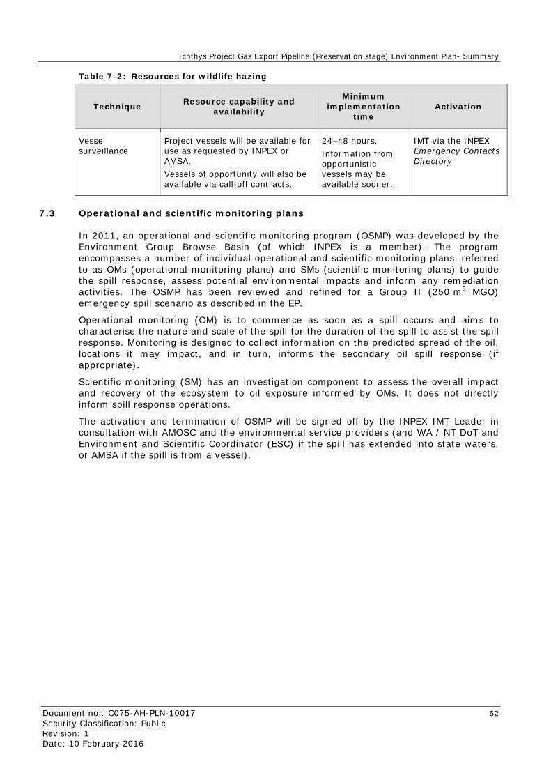
Ichthys Project Gas Export Pipeline (Preservation stage) Environment Plan- Summary
Document no.: C075-AH-PLN-10017 52 Security Classification: Public Revision: 1 Date: 10 February 2016
Table 7-2: Resources for wildlife hazing
Technique Resource capability and availability
Minimum implementation
time Activation
Vessel surveillance
Project vessels will be available for use as requested by INPEX or AMSA. Vessels of opportunity will also be available via call-off contracts.
24–48 hours. Information from opportunistic vessels may be available sooner.
IMT via the INPEX Emergency Contacts Directory
7.3 Operational and scientific monitoring plans
In 2011, an operational and scientific monitoring program (OSMP) was developed by the Environment Group Browse Basin (of which INPEX is a member). The program encompasses a number of individual operational and scientific monitoring plans, referred to as OMs (operational monitoring plans) and SMs (scientific monitoring plans) to guide the spill response, assess potential environmental impacts and inform any remediation activities. The OSMP has been reviewed and refined for a Group II (250 m3 MGO) emergency spill scenario as described in the EP.
Operational monitoring (OM) is to commence as soon as a spill occurs and aims to characterise the nature and scale of the spill for the duration of the spill to assist the spill response. Monitoring is designed to collect information on the predicted spread of the oil, locations it may impact, and in turn, informs the secondary oil spill response (if appropriate).
Scientific monitoring (SM) has an investigation component to assess the overall impact and recovery of the ecosystem to oil exposure informed by OMs. It does not directly inform spill response operations.
The activation and termination of OSMP will be signed off by the INPEX IMT Leader in consultation with AMOSC and the environmental service providers (and WA / NT DoT and Environment and Scientific Coordinator (ESC) if the spill has extended into state waters, or AMSA if the spill is from a vessel).

Ichthys Project Gas Export Pipeline (Preservation stage) Environment Plan- Summary
Document no.: C075-AH-PLN-10017 53 Security Classification: Public Revision: 1 Date: 10 February 2016
8 REFERENCES
AMEC Ltd. 2011. CPF and FPSO Environmental Conditions Data Sheets. (Doc. No. A075-AH-DAT-5000 Rev. G). AMEC Ltd.
BOM – see Bureau of Meteorology.
Bureau of Meteorology. 2015a. Climate Statistics. <http://www.bom.gov.au/> (Accessed: 01 March 2015).
Bureau of Meteorology. 2015b. Climate statistics for Australian locations: Summary statistics Darwin Airport. Viewed online on 17 March 2015 at: <http://www.bom.gov.au/climate/averages/tables/cw_014015.shtml>.
CALM – see Department of Conservation and Land Management.
Department of Agriculture and Water Resources (DAWR). 2013. Australian Ballast Water Management Requirements, Version 5. Department of Agriculture and Water Resources, Canberra, ACT.
Department of Conservation and Land Management (CALM). 2005. Management Plan for the Ningaloo Marine Park and Muiron Islands Marine Management Area 2005–2015 Management Plan. Number 52. Viewed online on 17 March 2015 at: <http://www.dpaw.wa.gov.au/images/documents/parks/management-plans/decarchive/ningaloo_mp_01_2005_withmaps.pdf>
DEWHA – see Department of Environment, Water, Heritage and the Arts.
Department of the Environment, Water, Heritage and the Arts. 2008. North Marine Bioregional Plan bioregional profile: a description of the ecosystems, conservation values and uses of the North Marine Region. Viewed online on 22 September 2015 at: <http://www.environment.gov.au/resource/north-marine-bioregional-plan-bioregional-profile-description-ecosystems-conservation>.
Department of Parks and Wildlife. 2015. Proposed North Kimberley Marine Park. Viewed online on 05 August 2015 at <http://marineparks.dpaw.wa.gov.au/dive-in-to-marine-parks/130-proposed-north-kimberley-marine-park.html>.
Department of Sustainability, Environment, Water, Population and Communities (DSEWPaC). 2012. Marine bioregional plan for the North-west Marine Region. Viewed online on 22 September 2015 at <http://www.environment.gov.au/system/files/pages/1670366b-988b-4201-94a1-1f29175a4d65/files/north-west-marine-plan.pdf>.
DPAW – see Department of Parks and Wildlife.
DSEWPaC – see Department of Sustainability, Environment, Water, Population and Communities.
Duke, N., Wood, A., Hunnam, K., Mackenzie, J., Haller, A., Christiansen, N., Zahmel, K. and Green, T. 2010. Shoreline Ecological Assessment Aerial and Ground Surveys 7–19 November 2009 as part of the Scientific Monitoring Study of the Montara Monitoring Plan. A report commissioned by PTTEP Australasia (Ashmore Cartier) PL for the Department of the Environment, Water, Heritage and the Arts (DEWHA).
Environmental Protection Authority (WA EPA). 2009. Protection of benthic primary producer habitats in Western Australia’s marine environment. Environmental Assessment Guideline No. 3. Environmental Protection Authority, Perth, Western Australia. Viewed online on 22 September 2015 at <http://www.epa.wa.gov.au/Policies_guidelines/EAGs/Pages/3080_EAG3-EnvironmentalAssessmentGuidelinesforPr.aspx>.

Ichthys Project Gas Export Pipeline (Preservation stage) Environment Plan- Summary
Document no.: C075-AH-PLN-10017 54 Security Classification: Public Revision: 1 Date: 10 February 2016
INPEX. 2010. Ichthys Gas Field Development Project: draft environmental impact statement. Report prepared by INPEX Browse Ltd., Perth Western Australia, for the Commonwealth Government, Canberra ACT, and the Northern Territory Government, Darwin, Northern Territory.
Neptune Geomatics. 2009. Ichthys Gas Field Development: Plan C Offshore Pipeline Geophysical and Geotechnical Survey Results Report. Report prepared by Neptune Geomatics, Perth, for INPEX Browse, Ltd., Perth, Western Australia.
RPS MetOcean Pty Ltd. 2011. Final Metocean Design Criteria for Ichthys Development Browse Basin. R1285v6. Report prepared by RPS MetOcean Pty Ltd, Perth, for INPEX Browse, Ltd., Perth, Western Australia.
Standards Australia/Standards New Zealand. 2001. Occupational Health and Safety Management Systems—Specification with guidance for use. AS/NZS 4801:2001.
Standards Australia/Standards New Zealand. 2004. Environmental Management Systems—Requirements with guidance for use. AS/NZS 14001:2004.
Standards Australia and Standards New Zealand. 2009. Risk management—Principles and guidelines. AS/NZS ISO 31000:2009.
Standards Australia and Standards New Zealand. 2012 Managing environment-related risk. AS/NZS HB 203:2012.
WA EPA – see Environmental Protection Authority.

Ichthys Project Gas Export Pipeline (Preservation stage) Environment Plan- Summary
Document no.: C075-AH-PLN-10017 55 Security Classification: Public Revision: 1 Date: 10 February 2016
APPENDIX A: EPBC ACT PROTECTED MATTERS SUMMARY

Ichthys Project Gas Export Pipeline (Preservation stage) Environment Plan- Summary
Document no.: C075-AH-PLN-10017 56 Security Classification: Public Revision: 1 Date: 10 February 2016

Ichthys Project Gas Export Pipeline (Preservation stage) Environment Plan- Summary
Document no.: C075-AH-PLN-10017 57 Security Classification: Public Revision: 1 Date: 10 February 2016
Summary
Matters of National EnVironmental Significance
Th.is part of the report summari ses tile matters of national environmental sig:ni:ficance that may occur in, or may relate to, tile area you nominated. Further information is available in the detail part of the report, which can be accessed by scrolling or fol)ov.'ing the links below. If you are proposing to unde rtake an activity that may have a significant impact on one or more matters of national environmental significance then you should consider the Administrative Guidelines on Sign ificance.
World Heritaae Prooerties: None
Natjooa! H eritage Place~;: None
Wetlands of lntemational lmoortance: None
Great Barrier Reef Marine papr None
Commonwealth Mnrine Are a·
Listed Threatened Ecolooical Communities: None
I isted Threatened SOecjefr 30
Listed Migratorv Species:
Other Matters Protected by the EPBC Act
This part of the report sum marises other matters protected under the Act that may r elate to the area. you nom inated. Approval may be required for a proposed activity that signific.lfltly affec ts the environment on Commonwealth land, when the action is outside the Co m monwealth land, or me env ironment anywhere when the action is taken on Com monwealth land. Approval m ay also be required for the Commonwealth or Com monwealth agencies proposing to take an action that is l ik ely to hav e a signifiC;lflt impaa on the environment .lflywher e.
The EPBC Ac• protectS me env ironm ent on Com monwealth land, me env ironm ent from the actions taken on Com monwealth land, and the env ironment from actions t:tken by Com monwealth a.sencies. A s her itage v alues of a place are part of the 'env ironm ent', these aspeas of the EPBC Act protect the C omm onwealth Heritage v alues of a Com monwealth Heritage place. tnformation on the new heritage laws can be found a; http://www. environment. gov .au/h eritage/index. html
A~ m ay be required for activities in or o n a C ommonwealth area that m ay affect a mem ber of a listed threatened species or ecological comm unity. a mem ber of a listed m igratory species . whales a.:nd other ceta.ceans, or a member of a li sted m arine species .
Commonwealth Land:
Commonwealth Hedtage p la<tefi·
Listed Marine Soecies:
Whale~ a nd OttJer cetacean~r
Critical Habitats:
Commonwealth Re~.ervefi Terrestrial·
Commonwealth Reserves Marine:
Extra Information
2
None
98
26 None None 2
This part at me report provides in.'Onnation tha: may also be relevam to me area you have nominated.
State and Territror R§eNes·
Regional Forest Agreements:
Invasive Soecies:
Natjooally Important Wetlands·
Key Ecological Features (Marine>
2 None
22
6