ignimbrite analyses of batur caldera, bali, based on 14c...
TRANSCRIPT

Jurnal Geologi Indonesia, Vol. 4 No. 3 September 2009: 189-202
189
Naskah diterima: 24 April 2009, revisi kesatu: 22 Mei 2009, revisi kedua: 08 Juli 2009, revisi terakhir: 3 Agustus 2009
Ignimbrite Analyses of Batur Caldera, Bali, based on 14C Dating
Igan S. SutawIdjaja
Centre for Volcanology and Geological Hazard Mitigation, Geological AgencyJln. Diponegoro 57, Bandung - 40122
AbstrAct
The Batur Caldera, in the northeastern part of Bali Island, is an elliptical collapse structure 13.8 by 10 km in size and another circular composite collapse structure with a diameter of 7.5 km in its centre. Two stages of the collapse were interrupted by silicic andesite lavas and domes. The first collapse was initiated by the eruption of about 84 km3 of the dacitic "Ubud Ignimbrite", about 29,300 years B.P., which caused a steep-walled depression about 1 km deep. The second ignimbrite was erupted from a large crater about the present lake, and it produced about 19 km3 of a similar voluminous dacitic ignimbrite, called the "Gunungkawi Ignimbrite" about 20,150 years B.P. This second eruption trig-gered a second collapse, which created the central circular caldera, and formed a basin structure. Both the Ubud and Gunungkawi Ignimbrites consist of a similar dacitic composition, white to red (the most abundant nearly 90 %) and dark grey to black dacitic pumice clasts. The large clasts, up to 20 cm in diameter, are in the non-welded ignimbrite, particularly in the upper part of the Gunungkawi Ignimbrite. The intracaldera ignimbrite, called the "Batur Ignimbrite" about 5 km3 in volume is a densely welded ignimbrite and generally shows typical welded features. The ignimbrite comprises at least five different flow units, separated by thin (15 - 40 cm) welded pumiceous airfall deposits, with flattened pumice clasts. Another large eruption occurred about 5,500 years B.P., producing around 0.09 km3 andesitic ignimbrite. This was initiated by phreatomagmatic eruptions, indicated by thick phreatomagmatic and surge deposits, underlying the ignimbrite. The caldera and its vicinity are partly filled, and variably mantled by later eruptive products of dacitic and andesitic phreatomagmatic and airfall deposits.
Keywords: 14C dating, ignimbrite, pumice clast, pyroclastic airfall deposit, dacite, phreatomagmatic
Sari
Kaldera Batur yang terletak di bagian timur laut Pulau Bali, merupakan sebuah struktur runtuhan ber-bentuk elips berukuran 13,8 x 10 km, dengan struktur runtuhan lainnya yang berbentuk melingkar di bagian pusatnya, dan berdiameter 7,5 km. Pembentukan kedua runtuhan tersebut diselingi oleh erupsi lava andesit silikaan dan pembentukan kubah-kubah lava andesitis. Runtuhan pertama yang terjadi sekitar 29.300 tahun lalu, diawali oleh erupsi 84 km3 ignimbrit dasit, disebut “Ignimbrit Ubud” dan menyebabkan terbentuknya depresi sedalam 1 km. Ignimbrit kedua, yang disebut sebagai “Ignimbrit Gunungkawi”, dierupsikan melalui sebuah kawah besar sekitar danau sekarang, dan memuntahkan 19 km3 ignimbrit dasit yang sama pada 20.150 tahun lalu. Erupsi kedua ini memicu terbentuknya runtuhan di bagian pusat, dan membentuk sebuah cekungan. Ignimbrit Ubud dan Gunungkawi tersebut terdiri atas komposisi dasit yang sama, berwarna putih hingga merah (jumlah paling banyak mencapai 90 %), dengan butiran batuapung dasitis berwarna abu-abu tua hingga hitam. Butiran besar yang mencapai diameter lebih dari 20 cm terdapat pada ignimbrit tidak terlaskan, terutama di bagian atas Ignimbrit Gunungkawi. Ignimbrit di bagian dalam kaldera, yang disebut “Ignimbrit Batur” dengan volume sekitar 5 km3 berupa ignimbrit terlaskan dan umumnya memperlihatkan struktur pengelasan khas yang sekurang-kurangnya terdiri atas lima unit aliran berbeda, masing-masing diselingi endapan jatuhan batuapung terlaskan dengan lensa-lensa batuapung. Erupsi besar lainnya terjadi

190 Jurnal Geologi Indonesia, Vol. 4 No. 3 September 2009: 189-202
IntroductIon
Batur caldera is situated in the northeastern part of Bali Island, and about 70 km north of the capital city of Bali, Denpasar. The area of inves-tigation, located on the eastern part of Bali Island is bounded by latitudes 8005'00" - 8040'00" S, and longitudes 115011'00" - 115°30'00" E (Figure 1). The area includes 2,300 km2 of which the major part is gently sloping to the south and steeply sloping to the north. There are six main routes of travel to the caldera that can be attained from Denpasar and one route from Singaraja. The most useable of these is the road from Denpasar to Kintamani passing Bangli town. The Batur Caldera is one of the finest calderas in the world, about 13.8 by 10 km in size (Bemmelen, 1961) and another circular composite
pada 5.500 tahun lalu yang memuntahkan sekitar 0,09 km3 ignimbrit andesitis. Erupsi ini diawali oleh erupsi freatomagmatik yang ditunjukkan oleh endapan tebal material freatomagmatik dan endapan seruak, yang menindih ignimbrit. Kaldera dan sekitarnya terisi sebagian dan terselimuti oleh hasil erupsi kemudian yang berupa endapan freatomagmatik dan jatuhan andesitis.
Kata kunci: penarikkan 14C, ignimbrit, butiran batuapung, jatuhan piroklastik, dasit, freatomagmatik
collapsed structure with a diameter of 7.5 km formed in its centre. The rim varies in height from 1267 to 2152 m (the marginal cone of Mount Abang). Within the caldera, there is the active stratovolcano of Batur Volcano and a lake. The highest peak of Batur Volcano is about 1717 m above sea level and 686 m above the surface of Lake Batur, and it is located at 8°14'30" S and 115022'30" E (Neumann van Padang, 1951; Kusumadinata, 1979). Accord-ing to Kemmerling (1917), the presence of Mount Sukawana and Abang volcanic remnants indicate that the previous stratovolcano of Mount Batur was higher than Mount Agung (3142 m), and the present caldera complex was produced by a collapse of the old stratovolcano.
The young stratovolcano of Batur has erupted at least 22 times since the 1800's, generally with
FLORES SEA
BUYAN-BRATANCALDERA
BATUR CALDERA
MT. AGUNG
MT. SERAYA
BALI ISLAND
INDIAN OCEAN
BA
LI
ST
RA
IT
BADUNG STRAIT
NUSA PENIDA ISLAND
8000’
8015’
8030’
8045’
9000’
115045’115030’115015’115000’114045’114030’114015’
N
0 5 10 km
Figure 1. Index map of the Batur Caldera in Bali Island.

191Ignimbrite Analyses of Batur Caldera, Bali, based on 14C Dating (I.S. Sutawidjaja)
strombolian eruptions and lava flows. The last eruption on March, 1974 (Samud,1968), led to basaltic andesite lapilli and lava to flow deposit. A large eruption occurred on September 5th, 1963 to May 10th, 1964, mostly lava flows covering a total area of about 5,779,000 m2 in three separate places (Kusumadinata, 1964).
tectonIc settIng
The Indian - Australian Plate converges north-ward into the Southeast Asia Plate as indicated by the magnetic anomalies (Sclater and Fisher, 1974). Oceanic lithosphere subducts with perpendicular incidence beneath the predominantly estimatic island arc of Jawa.
The Indonesian volcanic arc extends for 6,000 km from northern Sumatra to the Maluku Sea (Hutchison, 1981). It consists of four volcanic belts. The longest volcanic arc is Sunda Belt, extending from the northern tip of Sumatra throughout Jawa, Bali, Lombok, Sumbawa, and Flores. The other three belts are Banda, Halmahera, and North Su-lawesi (Katili, 1973; Hamilton, 1979). Along the 6,000 km volcanic island arc there are 500 eruption centres, 129 of which are regarded to be active dur-ing the present time (Padang, 1951; Kusumadinata, 1979). They represent more than 13 % of active volcanoes of the world. Within the Sunda, Banda, Halmahera, and Minahasa volcanic arcs, there are 95, 9, 7, 18 active volcanoes, respectively. In Su-matra and western Jawa, volcanism may have been occurring since Triassic times, but in the eastern part of the arc it seems to have begun only in the Middle to Late Miocene (Hamilton, 1979). The continental crust in the Sumatra and Jawa areas is 20 to 30 km thick, through the intermediate-type crust near Bali and Lombok to the oceanic crust near Wetar and the Banda Islands. The crust beneath Bali Island is about 18 km thick and has seismic velocities similar to those of oceanic crust (Curray et al., 1977). The depth of the Benioff Zone beneath the Batur Volcano is 165 km, which has been computed by multiple linear regression analyses (Hutchison, 1976). Hutchison deduced that an eastwards decrease of 87Sr/86Sr from 0.706 to 0.704 from west Jawa to Bali suggests a transi-tion from a continental to an oceanic basement.
The depth of the seismic zone beneath the arc reaches to approximately 650 km depth between Jawa and Flores.
regIonAl geology
In Jawa and Bali, the oldest widely exposed rocks are lower Tertiary shallow marine sediments, which are intruded and overlain by plutonic and related volcanic rocks in a zone only slightly south of the present-day volcanic arc (Bemmelen, 1949). The igneous activity corresponds to Bemmelen's (1949) first cycle of volcanism and gave rise to the "Old-Andesites", which were relatively common in the Southern Mountains of Jawa and in the Barisan Range of Sumatra, and it culminated in a period of uplift and intrusion in the Mid-Miocene. Bemmelen (1949) recognized a second cycle of volcanism of Late Tertiary age marked by the appearance of more alkaline lavas such as those of the high-K calc-alkaline suite. This second cycle was located further north and north east from the Miocene "Old-Andesites". These rocks are found together with the Quaternary "third cycle of volcanism", and the dis-tinction between the products of these latter cycles is rarely clear-cut.
The rocks of the Sumatra to Bali sector have a spectrum from tholeiitic through calc-alkaline to high-K calc-alkaline series. There is an appar-ent eastwards decrease of 87Sr/86Sr from 0.7059 to 0.7038 from West Jawa to Bali (Whitford, 1975). There is also some evidences of the ratio increase in Benioff Zone depth from about 0.7040 at 130 km to 0.7050 at 200 km, over the range tholeiitic to high-K calc-alkaline series (Hutchison, 1981). In 1976, Hutchison determined that the Bali volcano of Batur belongs to the high-alumina series, with average Al203 values at around 20 wt.%, whereas most Indonesian volcanoes range between 15 to 17 %. This has resulted in a normative deficiency of diopside, as the norm calculation allocated the Ca to Al and Si to overproduce anorthite, whereas in nature the Al content will also be in the clinopyroxene and hornblende.
The Batur volcanic field, which covers about 2,300 km2 in the eastern part of Bali Island of Indonesia, has a large, well formed caldera which formation is correlated with the eruptions about

192 Jurnal Geologi Indonesia, Vol. 4 No. 3 September 2009: 189-202
29,300 years B.P. and 20,150 years B.P. of thick ignimbrite sheets. About 29,300 years B.P., the major volcanic activity changed to explosive pyroclastic flow eruptions of dacitic composition that persisted until the second ash-flow eruption about 20,150 years B.P. Two separate ignimbrite sheets have been recognized; the source areas for these are cor-related to the caldera formations of Batur. Basaltic to basaltic andesite lavas and pyroclastic deposits are interlayered with and underlie the ignimbrite sequences, particularly in the southern slope of the caldera. Other more mafic lavas that are distinguish-able lithologically from the pre-caldera volcanic rocks are recognized as pillow basalts.
strAtIgrAphy of bAlI IslAnd
The basic stratigraphy of Bali and adjacent islands as previously understood was largely estab-lished by Purbo-Hadiwidjojo (1971) (Figure 2). The oldest rocks exposed in Bali are the Ulakan Forma-tion of Lower Miocene age, as volcanic rocks com-prising lavas, breccias and tuffs with intercalations of
calcareous sandstones, but Kadar (1972) determined the oldest rock units in Bali are calcareous sand-stones of Late Miocene age. As described by Wheller and Varne (1986), the oldest Bali volcanic rocks are pillow basalts of Late Pliocene age. The southern part of Bali and Nusa Penida Islands are formed of uplifted coral reefs of Pliocene to Pleistocene age (Kadar, 1977). The basement rocks of the mapped area consist of pillow basalts and pumiceous tephras, which are exposed in the southern part of the caldera in the vicinity of Bangli. Purbo-Hadiwidjojo (1971) described that both rock units are included in the Ulakan Formation. Most of the island is composed of subaerial volcanic deposits which were erupted from the extinct Quaternary Bratan, Batukau, and Seraya Volcanoes, and the two active volcanoes Batur and Agung (Purbo-Hadiwidjojo, 1971).
The Bratan and Batur volcanic products of several kinds make up a large proportion of the rock over the island of Bali. There is no separation between Bratan and Batur caldera products. In this case, the author attempted to separate these volcanic products by petrographical and chemical analyses, and material behavior in the field. The rocks mainly
Alluvial deposit
Volcanic Products of Mt. Pohen, Mt. Sengayang, Mt. Lesong
Lavas of Pawon Parasitic Cone
Volcanic products of Mt. Batukau
Volcanic products of Mt. Agung
Volcanic products of present Mt. Batur
Buyan-Bratan and Batur Tuffs and Lahar Deposits
PALASARI FORMATIONConglomerates, sandstones, reef - limestones
SERAYA VOLCANICS
Volcanics of Old Buyan-Bratan and Batur volcanoes
JEMBRANA VOLCANICSLavas, breccias, tuffsASAH FORMATIONLavas, breccias, pumiceous tuffs with calcareous crack fillingsPRAPATAGUNG FORMATIONLimestones, calcareous sandstones, marlsPULAKI VOLCANICSLavas and brecciasSELATAN FORMATIONPredominantly limestonesSORGA FORMATION
ULAKAN FORMATIONTuffs, marls, sandstones
Volcanic breccias, lavas, tuffs with intercalation of calcareous materials
EARLYQUATERNARY
PLIOCENE
MIO-PLIOCENE
MIDDLE MIOCENE
EARLY MIOCENE
N
0 5 10 km
QUATERNARY
8000’
8015’
8030’
8045’
9000’
115045’115030’115015’115000’114045’114030’114015’
F L O R E S S E A
B A L I
I N D I A N O C E A N
NUSA PENIDAS IS.
BADUNG STRAIT
Figure 2. Geologic map of Bali Island (after Purbo-Hadiwidjojo, 1971).

193Ignimbrite Analyses of Batur Caldera, Bali, based on 14C Dating (I.S. Sutawidjaja)
consisting of ash-flow deposits (ignimbrite) with some are welded, overlies the sedimentary and older volcanic rocks. Some of the volcanic rocks erupted from Mount Pohen, Sengayang and Lesong, oc-cupy the area in the centre of the island, particularly basaltic andesitic lavas and tephras. Volcanologists who have examined the Batur Caldera and areas elsewhere, largely the ignimbrites, have questioned aspects of the locally established sequence. Mari-nelli and Tazieff (1968) believed that the paroxysm phase of the Batur Caldera formation occurred 22,000 years ago, producing rhyodacitic ignimbrite. Moreover the Caldera II culminated in the major ignimbrite eruption about 23,700 years ago were followed by periodic strombolian eruptions of the basaltic magma.
Reinvestigation in 2006 of the Batur Caldera area, resulted that major revisions are required in the previously used stratigraphy. Corroboratory evi-dence has come from 14C dating of partially and non-welded ignimbrites. Charcoal found within the par-tially welded ignimbrite (Gunungkawi Ignimbrite) around the temple of Gunung Kawi, Tampaksiring, or about 15 km southward from the source, has given an age of 20,150 years B.P. Another charcoal was found within the partially welded ignimbrite (Ubud Ignimbrite) in Tukad Wos, Ubud, about 25 km southwestward from the Batur Caldera. The age of this charcoal is 29,300 years B.P. Both of these ages were dated from the small twigs of charcoals scattered in the units in nearly random orientations. The third location of charcoal was found in Tukad Blingkang, within non-welded ignimbrite, about 2 km from Lake Batur inside caldera I. In this place, there was a big log, occuring in the lower part of Blingkang Ignimbrite that had given an age of about 5,500 years B.P.
strAtIgrAphy of the IgnImbrItes
Calderas related to ignimbrites show a positive correlation between caldera area and ejecta vol-ume. This correlation shows constraints on magma drawdown during eruption and implies a systematic relationship between these parameters and magma volume of the chamber (Smith, 1979). He deter-mined that caldera areas ranged from 1 to 104 km2. The volume of ejecta from caldera sites varied from
1 to 104 km3, and the volume of the related magma chambers was thought to range from 10 to 105 km3.
A typical cited example of the collapse related to voluminous dacitic ignimbrite is the caldera of Batur, Bali. About 29,300 years ago the eruption of voluminous dacitic ignimbrite was followed by a second eruption about 20,150 years ago of similar voluminous dacitic ignimbrite. The total erupted volume is about 103 km3 and covers an area of about 1680 km2. Most of the outflow units were erupted toward the south of the caldera, and partially cov-ered an irregular topography of old volcanic rocks (Tertiary volcanic rocks; Purbo-Hadiwidjojo, 1971).
The ignimbrite can be distinguished into four welding units of the Batur Group which are sepa-rated into three stratigraphic units in the field. Some stratigraphic sections will be described below. Those three horizontal sheets are named the "Ubud", "Gunungkawi" and "Batur" Ignimbrites. A younger intracaldera unit is named "Blingkang" Ignimbrite. The Ubud and Gunungkawi Ignimbrites are regarded as outflow facies; and the Batur and Blingkang Ignimbrites are the intracaldera facies. The term fa-cies in relation to volcanic units defined by Wright et al. (1980) as a complete or partial eruptive unit, has distinct spatial and geometrical relations and internal characteristics.
Ubud Ignimbrite The Ubud Ignimbrite is regarded as the oldest
ignimbrite known in the Batur Caldera area, where it rests on the Tertiary and Early Quaternary basement rocks, and underlies the Gunungkawi Ignimbrite. It covers an area of about 1200 km2 with an ap-proximate volume of 84 km3. The Ubud Ignimbrite is strikingly different from the Gunungkawi one, although the two are similar megascopically. The Ubud Ignimbrite is much thicker, consisting of crystal-poor dacitic composition. It is character-ized by being xenolith-poor, but in the proximal parts it contains xenoliths and pumice clasts of lapilli size. Black pumice clasts are common. The rock unit consisting of partially welded ignimbrite, is distinctively uniform and fine-grained, and is characterized by the sparseness and small size of phenocrysts, mainly plagioclase (less than 10 %), clinopyroxene, hypersthene, and magnetite, plus trace amounts of apatite in a groundmass of fine shards. Small inclusions of grey basalt and pumice

194 Jurnal Geologi Indonesia, Vol. 4 No. 3 September 2009: 189-202
clasts are sparse. Pumice lapilli are rounded and oc-casionally poorly flattened, white - reddish brown. Common black clasts are found through most of the exposed ignimbrite.
The distal parts of the deposit, north of Den-pasar, rest on a basement of old pyroclastic flow and lahar deposits. To the east, the ignimbrite lies on pyroclastic flows and basalt lavas of the Ulakan Formation. The ignimbrite shows typical columnar joints and is poorly bedded with thickness more than 120 m. The actual contacts with the older rock units are not observed, but at Tukad Jehajung and possibly elsewhere, the ignimbrite lies on the older pyroclastic flows and lahars. A dark grey ash is at the base of a partially welded bedded sequence of the Ubud Ignimbrite that is found at the base of Tukad Petanu near Margabingung, about 15 km northeast of Denpasar (Figure 3). The basaltic lava basement is exposed in Tukad Jehajung under the bridge about 5 km northeast Denpasar. Some ex-posures of the ignimbrite are preserved along the
Klungkung and Bangli beaches, about 1 km from the south coastline.
In addition to the variations in quantities of phe-nocrysts and pumice clasts, size variations, degree of welding, crystallization, and phenocryst content show lateral gradations from non-welded ash in the eastern part to welded white to grey partially welded ignimbrite. It is uniformly dacite having low pumice and phenocryst contents. Lithic fragments also gradually decrease in size from the eastern (< 15 cm) to the western (< 1 cm) parts, and also the rock shows an increasing SiO2 content from the east to west across the ignimbrite.
Gunungkawi IgnimbriteThe Gunungkawi Ignimbrite is defined as a
younger ignimbrite on the south flank of the caldera. It is a simple cooling unit with widespread flow sheets. The unit is distinguished from the Ubud Ignimbrite by 14C dating and chemical analysis of SiO2 content. The unit is more mafic than the Ubud Ignimbrite, but the contact between the two ignim-brites is very difficult to trace, because the rocks have similar features in the field. Some outcrops have a soil horizon about 20 to 30 cm thick. This has been recognized from several valleys which are eroded deeply in the south flank.
In general, two simple cooling units can be dis-tinguished. The lower sheet consists of fine-grained densely welded ignimbrite, and the upper sheet is very coarse and partially welded. The fine-grained ignimbrite is densely welded to a black vitrophyre, and the sheet is as much as 5 to 20 m thick. It is phenocryst-poor (less than 10 %). Light grey clasts of more silicic appearance contain small plagioclase and augite phenocrysts, and ubiquitous opaque min-erals. It is devitrified in the thicker sections and has sparse, collapsed pumice lapilli lenses as much as 1 cm long and sparse lithic fragments.
The upper part of this unit is a sheet consisting mostly of partially welded, dark grey to brown devit-rified ash, characterized by abundant darker colored pumice and lithic blocks, ranging from 4 to 20 cm, but generally 4 to 7 cm in diameter. The thickness of this sheet is variable, because the top is eroded, and because of irregular pre-eruption topography; it ranges from 50 to 70 m. The best outcrop of this unit is in Tampaksiring area, around Gunungkawi temples (Figure 4), where the people of the Hindus
Figure 3. Non-welded ignimbrite of Ubud in Tukad Petanu, Bangli area.
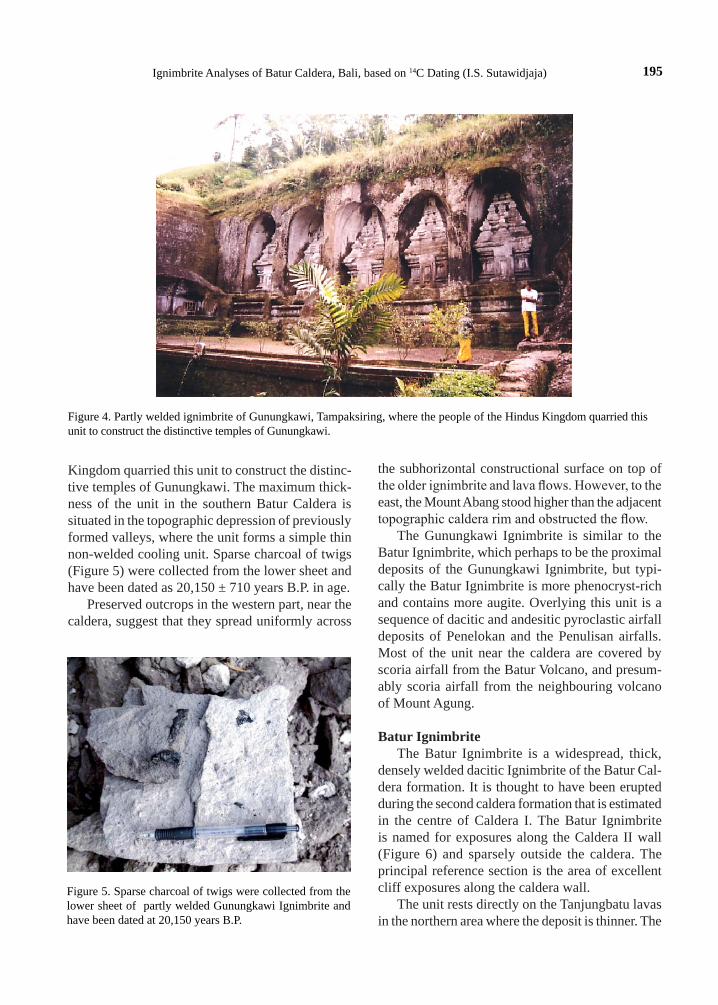
195Ignimbrite Analyses of Batur Caldera, Bali, based on 14C Dating (I.S. Sutawidjaja)
Figure 4. Partly welded ignimbrite of Gunungkawi, Tampaksiring, where the people of the Hindus Kingdom quarried this unit to construct the distinctive temples of Gunungkawi.
Figure 5. Sparse charcoal of twigs were collected from the lower sheet of partly welded Gunungkawi Ignimbrite and have been dated at 20,150 years B.P.
Kingdom quarried this unit to construct the distinc-tive temples of Gunungkawi. The maximum thick-ness of the unit in the southern Batur Caldera is situated in the topographic depression of previously formed valleys, where the unit forms a simple thin non-welded cooling unit. Sparse charcoal of twigs (Figure 5) were collected from the lower sheet and have been dated as 20,150 ± 710 years B.P. in age.
Preserved outcrops in the western part, near the caldera, suggest that they spread uniformly across
the subhorizontal constructional surface on top of the older ignimbrite and lava flows. However, to the east, the Mount Abang stood higher than the adjacent topographic caldera rim and obstructed the flow.
The Gunungkawi Ignimbrite is similar to the Batur Ignimbrite, which perhaps to be the proximal deposits of the Gunungkawi Ignimbrite, but typi-cally the Batur Ignimbrite is more phenocryst-rich and contains more augite. Overlying this unit is a sequence of dacitic and andesitic pyroclastic airfall deposits of Penelokan and the Penulisan airfalls. Most of the unit near the caldera are covered by scoria airfall from the Batur Volcano, and presum-ably scoria airfall from the neighbouring volcano of Mount Agung.
Batur IgnimbriteThe Batur Ignimbrite is a widespread, thick,
densely welded dacitic Ignimbrite of the Batur Cal-dera formation. It is thought to have been erupted during the second caldera formation that is estimated in the centre of Caldera I. The Batur Ignimbrite is named for exposures along the Caldera II wall (Figure 6) and sparsely outside the caldera. The principal reference section is the area of excellent cliff exposures along the caldera wall.
The unit rests directly on the Tanjungbatu lavas in the northern area where the deposit is thinner. The

196 Jurnal Geologi Indonesia, Vol. 4 No. 3 September 2009: 189-202
Batur Ignimbrite is generally overlain by post-caldera eruptive products. Preserved outcrops of the Batur Ignimbrite vary in thickness, suggesting that it spread over topographic irregularities in the pre-eruption surface, mainly inside the caldera. The Batur Ignim-brite is relatively thick, typically 50 to 200 m, but an outflow ignimbrite that surrounds the Batur Caldera is about 30 to 70 m thick of non-welded ignimbrite, that is correlated to the Gunungkawi Ignimbrite.
On the north side of the caldera wall, the unit is as much as 120 m thick . Variations in thickness and welding features of the Batur Ignimbrite also indicate a significant topographic irregularity inside the caldera. In general, the intracaldera area had topographically low relief before the eruption, when the Batur Ignimbrite filled the caldera, and flowed out over the area surrounding the caldera, except to the east and southeast, because of the higher topo-graphy of Mount Abang.
Although most of the non-welded upper parts of the Batur Ignimbrite have been eroded, some non-welded parts have been preserved and crop out along Tukad Blingkang. Here it ranges from 6 to 10 m thick consisting of chalky white, pink and red pumice clasts, about 2 to 25 cm, but generally 4 to 6 cm in diameter, and with abundant lithic fragments. The ignimbrite has uniformly welded inside the caldera. At least, five separate cooling units are recognized, of phenocryst-poor ignimbrite (5 - 10 %), each about
20 to 40 m thick, that grade from grey or pink non-welded margins into red-brown or purplish-brown densely welded devitrified interiors. At the base, the unit, which well crops out on the caldera rim, is black to grayish black phenocryst-poor ignimbrite (5 - 10 %) densely welded completely devitrified. The glass matrix has flow-banded textures (Figure 7), embedding variations in number and size of lithic fragments and phenocrysts. Interlayered welded ash-falls are often found and have well-sorted bedding on a scale of 10 to 50 cm, composed of uniform sized,
Figure 6. Densely welded Batur Ignimbrite on the Caldera II wall.
Figure 7. Close-up of the Batur Ignimbrite exposure. Black lenses are vitrophyre of highly welded ignimbrite, and matrix is obsidian-like with sparse lithic fragments.

197Ignimbrite Analyses of Batur Caldera, Bali, based on 14C Dating (I.S. Sutawidjaja)
collapsed pumice lenses, about 1 to 2 cm long. In general, the Batur Ignimbrite is phenocryst-poor with plagioclase, and clinopyroxene dominant over orthopyroxene, and abundant opaque minerals. Subrounded intermediate and basaltic fragments are abundant, ranging 2 to 7 mm. SiO2 content in 13 analyses of the Batur Ignimbrite ranges from 63 to 68 %. Most of the bulk-rock compositions thus are dacite; and most pumice blocks are low-silica dacite. This can be related to the total phenocryst content, when generally SiO2 increases as total phenocrysts decrease, and the groundmass composition for this ignimbrite appears to be high-silica dacite.
Blingkang IgnimbriteThe Blingkang Ignimbrite is named for expo-
sures along Tukad Blingkang (Blingkang River) inside the Caldera I (Figure 8), overlying the Bling-kang surge deposits (Figure 9). These exposures are designated as the type locality. It is a simple cooling unit about 5 to 15 m thick. The rock unit is grey to black, non-welded to moderately welded, containing plagioclase and two-pyroxenes. Sparse aegirine in a few samples may be xenocrystic. The Blingkang Ignimbrite is characterized throughout by abundant pumice clasts and lithic fragments. These fragments, however, are much more numerous in some flows within the cooling unit than in others. The fragments
compose as much as 10 % of the rock and they range in length from less than 1 cm to more than 10 cm. The fragments are principally lavas of an intermedi-ate to basaltic composition, but they include dacitic ignimbrite fragments.
The Blingkang Ignimbrite commonly has a pale brown to greyish brown basal non-welded sheet of 1 to 4 m thick, consisting of pumice clasts and pum-ice ash as matrix. Sparse charcoal clasts scattered in this sheet give an age of 5,500 ± 200 years B.P. (McLeod, 1988, pers. commun.). The non-welded base grades upward to a moderately welded black or grey devitrified ignimbrite with scattered pumice lapilli, but they have not been completely flattened. The pumice clasts in the welded ignimbrite are el-lipsoid in shape, ranging from 1 to 2 cm length and 0.5 to 1 cm width. There is a little mineralogic and chemical variation in the Batur Ignimbrite; again it is phenocryst-poor (6 - 9 %); it contains sparse lithic fragments of andesitic, basaltic, and welded ignimbrite compositions. The Blingkang Ignimbrite is more mafic than the others . It is indicated by the SiO2 content of some samples from the welded ignimbrite sheet ranging from 61.38 to 62.19 %.
The non-welded upper part that is 3 to 8 m thick, consists of pale brown to grayish brown, poorly sorted non-welded ignimbrite. It contains large (as much as 20 cm long) pumice fragments, generally
Figure 8. An exposure of the Blingkang Ignimbrite in Tukad Blingkang inside the Caldera I, overlying the surge deposit.

198 Jurnal Geologi Indonesia, Vol. 4 No. 3 September 2009: 189-202
black glass, but others are grey and devitrified. Lithic fragments of andesitic and basaltic lavas are conspicuous and abundant throughout the sheet. This non-welded sheet grades downward into the welded zone, which is generally preserved in the pre-eruption gullies.
Passage of the Blingkang Ignimbrite was blocked by the Caldera I wall, where it accumulated in the northeastern part of the caldera, although some probably flowed out as non-welded ignimbrites. The main area of the Blingkang Ignimbrite is along Tukad Blingkang. It wedges out north, probably reflecting the source of the eruption around the centre of the caldera, southward of the deposits. In addition, the non-welded upper part is thicker northward, conta-ing grey pumice blocks, which are darker in colour than the matrix, and less common brown pumice blocks; subangular andesitic and dacitic fragments are abundant. The top of the section is overlain by phreatomagmatic deposits of the Blingkang phre-atomagmatic unit, and pyroclastic fall deposit.
dIscussIon
Fine-grained partially welded zone of the Ubud Ignimbrite, lithic- and crystal-poor, is spread widely as a thick uniform ash flow deposit. This suggests
that it was generated by the collapse of a relatively high eruption column. Low lithic content throughout the ignimbrite indicates that the eruption did not significantly erode the vent. Sparks et al. (1978) suggested that at the beginning of the eruption, the gas content of the magma might be high and the vent dimensions were small, and probably the eruption began along a fissure and a conduit that was formed only after the activity had centralized and begun to widen a localized part of the fissure. In addition, this stage is suitable for formation of a Plinian column. If the eruption continues, the vent will be eroded, as shown by the lithic ejecta continually erupted during the plinian activity (Sparks et al., 1978). Scattered charcoal of twig clasts in the body of the flow may reflect a high turbulence in a large pyroclastic flow.
Vertical changes in composition are shown by the Gunungkawi Ignimbrite, where the lithic content gradually decreases upward and outward, replaced by pumice clasts. This is caused by the flow mecha-nism, where the ignimbrite has been invoked as an evidence of layer by layer deposition from a low turbulence, low particle - concentration pyroclastic flows analogous to deposition from turbidity currents (Fisher, 1966). Again preservation of the scattered charcoal of twig clasts at the lower part of the flow unit probably indicates that the turbulent flow oc-curred.
Figure 9. The Blingkang surge deposit exposures in Tukad Blingkang.

199Ignimbrite Analyses of Batur Caldera, Bali, based on 14C Dating (I.S. Sutawidjaja)
The distal facies of Gunungkawi Ignimbrite hav-ing abundant small lithic fragments, and large poorly sorted pumice clasts, shows no internal bedforms, and is non welded. Wilson and Walker (1982) sup-posed that when the material moved away from vent, the proportion of the flow (the head) which was af-fected by fluidization, caused by air ingestion, must have increased. Abundant large lithic blocks in the proximal flow unit of the Gunungkawi Ignimbrite suggest that erosion and destruction of the vent oc-curred after an initial formation of a large crater in the centre of the caldera. Sparks et al. (1978) argued that eruption column collapse was an important mechanism in the generation of large volume Ignim-brites. The voluminous nature of the Gunungkawi Ignimbrite suggests that it was probably formed in this way. The major deposits were emplaced within the caldera as the intracaldera facies of the Batur Ignimbrite.
The intracaldera accumulations of the Batur Ig-nimbrite 60 - 120 m thick ponded within the caldera as a result of collapse during eruption and filling of the first caldera collapse. In general, the base of the intracaldera ignimbrite is concealed, but rare out-crops of its base are underlain by andesitic lavas at the base of the caldera wall. The intracaldera deposit of the Ubud Ignimbrite is completely buried by the younger eruptive products.
A prominent lineament within the caldera with northeast - southwest trend, controls the alignment of volcanic vents and domes. Most of the active eruption points of the Batur Volcano are on this lineament, although some volcanic vents, maars, and cinder cones scatter around the caldera moat. They are probably due to fractures formed before the large stratovolcano of Batur was constructed. These fractures may also relate to the formation of dykes which crop out at the caldera wall. All the major volcanic lineaments described here are based on imprecise geographical data. The fault evidence in the field is obscured, because of the thick and widespread cover by younger volcanic rocks.
The major Quaternary structural features of the area are two calderas and the doming and faulting that resulted from the ignimbrite sequence. The calderas range in diameter from 10 to 7.5 km, and the collapse of the larger caldera (Caldera I) caused a steep-walled depression about 1 km deep. The subsidence was probably differential during col-
lapse, being greater in the northwestern part than at the southern end, and was followed by a graben with northwest - southeast trend. This evidence is related to the high silica andesites, which were ex-truded from the northeastern caldera rim, and flowed out along the interpreted graben reaching the north coast. The volume of erupted material for the Ubud (84 km3) and Gunungkawi (19 km3) Ignimbrites are roughly proportional to the size, of related collapses of Caldera I (80 km3) and Caldera II (18 km3).
The second caldera (Caldera II) formed in the centre of the Caldera I. The Caldera II wall must have been modified by a landslide during collapse, as shown by scars about 1 km across, around the rim.
According to the commonly used terminology, the Batur Caldera would be considered as "calderas associated with voluminous explosive eruptions of siliceous magmas" by Williams (1941) and McBirney (1980) or "collapse caldera associated primarily with differentiated volcanoes" by Smith and Bailey (1968). Calderas belonging to this group are generally classified into the Valley (Smith and Bailey, 1968) or Krakatau (Williams, 1941) types.
The concept of Valley-type caldera is clear. Many Valley-type calderas of Oligocene to Pleistocene in the southern Rocky Mountains and adjacent areas were investigated, and their genesis and subsurface structures have been clarified, e.g. Valley Caldera (Smith and Bailey, 1968), Timber-Mountain-Oasis Valley Caldera Complex (Carr, 1964; Christiansen et al. 1977), and Long Valley Caldera (Bailey et al. 1976). Subvolcanic equivalent of the Valley-type caldera has been considered to be a volcano plutonic complex with ring intrusions and central pluton (Smith and Bailey, 1968). On the other hand, the characteristic features of the Krakatau-type caldera are well defined and the deep structure and genesis of the Krakatau caldera are not well understood (Williams, 1941; Yokoyama, 1981, 1982; Self and Rampino, 1982). Yokoyama (1981) emphasized, using gravity anomaly data that the deep structure of Krakatau-type caldera was funnel-shaped, and the deposits within the caldera consisted of fall-back of lithic fragments and volcanic ejecta.
Yokoyama and Siswowidjojo (1970) classified the Batur Caldera into one of the Kilauean-type, that is the caldera-forming collapses on shield vol-canoes of basalt as a result of a lowering magma level in the central conduit by a dyke injection. That

200 Jurnal Geologi Indonesia, Vol. 4 No. 3 September 2009: 189-202
statement is not in accordance with the previous description of Batur Caldera by Kemmerling (1917) and Stehn (1928).
Three stages of caldera collapse are recognized in the Batur Caldera, as represented by the first and second collapses. The first collapse is caused by the eruption of the first voluminous dacitic ignimbrite (Ubud Ignimbrite), 29,300 years B.P. that formed an ellipsoidal shape, 13.8 km long and 10 wide. During the first collapse, the subsided block formed a dis-tinct basin structure and its marginal part had a nearly vertical dip, and during this eruption, there is no significant destruction of the previous stratovolcano, as indicated by very fine-grained welded ignimbrite with few xenolithic fragments. This features of the first collapse differ from these of funnel-shaped or the Krakatau-type caldera, but may be similar from those of the Valley-type. Therefore, the second col-lapse of Batur Caldera prior to 20,150 years ago as a result of the second voluminous dacitic ignimbrites (Gunungkawi and Batur Ignimbrites), can be con-sidered as the Krakatau- and Valey-types. The third stage is probably a second collapse of the Caldera I. The Caldera I is inferred to have collapsed twice, once after eruption of the Ubud Ignimbrite and again after the Gunungkawi and Batur Ignimbrites. This interpretation is based on the hypothesis of a dis-placement of the andesites and the Batur Ignimbrite, and this collapse has subsided less than 500 m deep to form the Kintamani Terrace. On the other hand, the Batur Caldera is similar to the Platoro Caldera, Colorado (Lipman, 1975) that existed as a depres-sion before a completion of the eruptions, and the collapse resulted from the withdrawal of magma, with the emptied part of the magma chamber being filled by the subsided block.
conclusIons
The volcanic rocks of Batur Caldera are pre-dominantly composed of dacites and andesites (58 - 68 % SiO2) with only subordinate amounts of pre-caldera basalts to basaltic andesites and post-caldera basalts to basaltic andesites, all of which have geochemical characteristics typical of island arc calc-alkaline suites. There is an overall trend of decreasing proportions of silicic rock-types with decreasing age.
The calc-alkaline rocks of Batur Caldera are associated with an active continental margin, and generally the dacite rocks are believed to be derived from basaltic melts by fractional crystallization processes, and the andesites are mainly due to the mixing of magmas of basaltic and dacitic composi-tions. The magma mixing is commonly intimately associated with a fractional crystallization during differentiation of calc-alkaline volcanic suites. There is a diversity in abundance of trace elements in an-desites and dacites that is to be expected as a result of differentiation of parental mafic magma, which is also characterized by a considerable degree of variation in abundance of trace elements.
The overall Batur volcanic rocks do not show any systematic chemical variations with the age of erup-tions. Rocks of a given SiO2 content with different ages have nearly identical contents of most major and trace elements. This large-scale uniformity of composition over a long time interval suggests the repetition of a petrogenetic process without a change in magma composition or physical condition of dif-ferentiation. Homogeneous source material and low (< 5 %) potassium content suggests that the amount of fractional or partial melting in the mantle or in the descending slab must decrease with depth.
The general petrologic progression of the Batur Caldera suggests the progressive rise, differentiation, and crystallization of the magma beneath the caldera. The rocks become more mafic as age decreases from voluminous dacitic composition (63 - 68 % SiO2) to the postcaldera lavas and tephras of basalt to basaltic andesite composition (51 - 54 % SiO2). This may indicate a compositional zonation in the magma chamber in which more silicic differentiated magma overlies more mafic magma.
The formation of Batur Caldera can be gener-ally related to seven stages. Premonitory activity (Stage 1) would be represented by the pre-caldera stratovolcano which was about 3000 m above sea level, and consisted of basalt and basaltic andesite compositions. The eruption of voluminous dacitic ignimbrite (Ubud Ignimbrites) about 29,300 years B.P. represents Stage 2, accompanied by a collapse to produce an ellipsoidal caldera depression as Caldera I (Stage 3). The depression was deeper in the northwestern part and caused leaking from the evolving andesitic magma reservoir and eruption of high silica andesite lavas (Stage 4). Stage 5 is

201Ignimbrite Analyses of Batur Caldera, Bali, based on 14C Dating (I.S. Sutawidjaja)
the second large eruption of dacitic ignimbrites (Gunungkawi and Batur Ignimbrites) about 20,150 years B.P., accompanied by rising andesitic magma through the cracks or ring fracture to produce domes and dykes. The second caldera collapse (Stage 6) formed a circular shape in the centre of the first cal-dera, as Caldera II, followed by the second collapse of Caldera I, and formation of the lake, maars, and cinder cones in the caldera moat. The terminal stage (Stage 7) is a postcaldera volcanism, represented by a stratovolcano constructed in the centre of the Caldera II, comprising basalt to basaltic andesite compositions.
Acknowledgments---The author would like to thank his su-pervisor, Professor Dr. Tetsuo Kobayashi of Kagoshima Uni-versity, for his help and patience with continuing guidance in the field and laboratory work. The author wishes to thank the previous Head of Centre for Volcanology and Geologi-cal Hazard Mitigation, Dr. A.D. Wirakusumah for allowing the author to broaden his knowledge in several branches of volcanological science, and supporting his investigation.
references
Bailey, R.A., Dalrymple, G.B., and Lanphere, M.A., 1976. Volcanism, structure, and geochronology of Long Valley Caldera, Mono County, California. Journal of Geophysical Research, 81, 725 pp.
Bemmelen, R.W.Van, 1949. The geology of Indonesia. Vol I A. Government Printing Office, The Hague, p.505-506.
Bemmelen, R.W.Van, 1961. Volcanology and geology of Ignimbrites in Indonesia, North Italy and U.S.A., 46 pp.
Carr, W.J., 1964. Structure of part of the Timber Mountain dome and caldera, Nye County, Nevada. U.S. Geological Survey Professional Paper 501-B B 16-B 19.
Christiansen, R.L., Lipman, P.W., Carr, W.J., Byers, F.M.Jr., Orkild, P.P., and Sargent, K.A., 1977. Timber Mountain - Oasis Valley Caldera Complex of Southern Nevada. Geological Society of America Bulletin, 88, p.943-959.
Curray, J.R., Shor, G.G., Raitt, R.W., and Henry, M., 1977. Seismic refraction and reflection studies of crustal structure of the eastern Sunda and western Banda arcs. Journal of Geophysical Research, 82, p.2479-2489.
Fisher, R.V., 1966. Rocks composed of volcanic fragments and their classification. Earth Science Review, 1, p.287-298.
Hamilton, W., 1978. Tectonic map of Indonesia. U.S. Geological Survey.
Hamilton, W., 1979. Tectonics of the Indonesian region. U.S. Geological Survey Professional Paper, 1078 pp.
Hattherton, T. and Dickinson, W.R., 1969. The relationship between andesitic volcanism and seismicity in Indonesia, the Lesser Antilles, and other island arcs. Journal of Geophysical Research, 74, p.5301-5310.
Hutchison, C.S., 1976. Indonesian active volcanic arcs: K, Sr, and Rb variation with depth to the Benioff zone. Geology, 4, p.407-408.
Hutchison, C.S., 1981. Review of the Indonesian volcanic arc. In: Barber, A. J. and Wiryosujono, S (Eds.), The Geology and Tectonics of Eastern Indonesia. Geological Research and Development Centre Special Publication, 2, p.65-80.
Kadar, D., 1972. Upper Miocene planktonic foraminifera from Bali. Jaarboek Geologische Bundensant, Sonderb, 19, p.8-70.
Kadar, D., 1977. Upper Pliocene planktonic foraminiferal zonation of Ambengan drill hole, southern part of Bali island. Geological Research Development Centre (Indonesia) Special Publication, 1, p.137-158.
Katili, J.A., 1973. Geochronology of West Indonesia and its implication on plate tectonics. Tectonophysics, 19, p.195-212.
Kemmerling, G.L.L., 1917. De vulkanen goenoeng Batur en goenoeng Agoeng op Bali. Jaarboek van het Mijnwezen, Nederlandsch-Oost Indie, p.0-74.
Kusumadinata, K., 1964. The eruption of the Batur volcano in Bali in 1963. Volcanological Survey of Indonesia, unpublished.
Kusumadinata, K., 1979. Catalogue of references on Indonesian volcanoes with eruptions in historical time. Volcanological Survey of Indonesia Special Publication (in Indonesian with English abstract), 820 pp.
Lipman, P.W., 1975. Evolution of the Platoro caldera complex and related volcanic rocks, southern San Juan Mountains, Colorado. U.S. Geological Survey Professional Paper, 852, p.128.
Marinelli, G. and Tazieff, H., 1968. L'Ignimbrite et la caldera de Batur (Bali, Indonesie). Bulletin Volcanologique, 32, p.89-120.
McBirney, A.R., 1980. Mixing and unmixing of magmas. Journal of Volcanology and Geothermal Research, 7, p.357-371.
Neumann van Padang, M., 1951. Catalogue of the active volcanoes of the world. Part I. International Volcanological Association.
Purbo-Hadiwidjojo, M., 1972. The geologic map of Bali, Indonesia, scale 1:250.000. Geological Survey of Indonesia.
Samud, 1968. Laporan pendahuluan penyebaran lava G. Batur (Bali) 1968. Volcanological Survey of Indonesia, unpublished.
Sclater, J.G. and Fisher, R.L., 1974. Evolution of the east Central Indian Ocean, with emphasis on the tectonic setting of the Ninetyeast Ridge. Geological Society of America Bulletin, 85, p.683-702.
Self, S. and Rampino, M.R., 1982. Historic eruptions of Tambora (1815), Krakatau (1883) and Agung (1963), their stratospheric aerosols and climatic impact. Quaternary Research, 18, p.127-143.
Smith, R.L., 1979. Ash flow magmatism. In: Chapin and Elston (eds.), Ash-flow tuffs, Geological Society of America Special Paper, 180, p.5-27.

202 Jurnal Geologi Indonesia, Vol. 4 No. 3 September 2009: 189-202
Smith, R.L. and Bailey, R.A., 1968. Resurgent cauldrons. Geological Society of America Memoir, 116, p.613-662.
Sparks, R.S.J., Wilson, L., and Hulme, G., 1978. Theoretical modelling of the generation, movement and emplacement of pyroclastic flow by column collapse. Journal of Geophysical Research, 83, p.1727-1739.
Stehn, C.E., 1928. De Batoer op Bali en zijn eruptie in 1926. Vulkanologisch en Seismologisch Mededeelingen, 9, p. 1-67.
Wheller, G.E. and Varne, R., 1986. Genesis of dacitic magmatism at Batur volcano, Bali, Indonesia: Implications for the origin of stratovolcano calderas. Journal of Volcanology and Geothermal Research, 28, p. 363-378.
Whitford, D.J., 1975. Strontium isotopic studies of the volcanic rocks of the Sunda arc, Indonesia, and their petrogenetic implications. Geochemica et Cosmochimica Acta, 39, p.1287-1302.
Williams, H., 1941. Calderas and their origin. California University, Department of Geology Science Bulletin, 25, p.239-346.
Wilson, C.J.N. and Walker, G.P.L., 1982. Ignimbrite depositional facies: the anatomy of a pyroclastic flow. Geological Society of London Journal, 139, p.581-592.
Wright, J.V., Smith, A.L. and Self, S., 1980, A working terminology of pyroclastic deposits. Journal of Volcanology and Geothermal Research, 8, p. 315-336.
Yokoyama, I., 1981. A Geophysical interpretation of the 1883 Krakatau eruption. Journal of Volcanology and Geothermal Research, 9, p.359-378.
Yokoyama, I., 1982. Author's reply to the comments by S. Self and M.R. Rampino. Journal of Volcanology and Geothermal Research, 13, p.384-386.
Yokoyama, I. and Siswowidjojo, S., 1970. A gravity survey on and around Batur Caldera, Bali. Bulletin of the Earthquake Research Institute, 48, p.317-329.