image processing workflows, classification, and terrain ...image processing workflows,...
TRANSCRIPT

Remote Sensing from Unmanned Aircraft: Image processing workflows, classification,
and terrain extraction
earthmetrics, Brownsville, OR
formerly with USDA ARS Jornada Experimental Range, Las Cruces, NM
Andrea S. Laliberte
Tactical Fire RSAC meeting, Mar. 20, 2012, Sacramento, CA
earthmetrics

UAS for vegetation
mapping
• Increased interest in using UAS for natural resource remote sensing tasks
• Smaller, light weight sensors for small UAS
• Low operating costs, imagery with very high resolution, repeated deployment for change detection, vegetation health
• FAA: Integration of UAS in National Airspace by 2015

UAS Operations at the
Jornada Experimental Range • Objectives: development of operational UAS-based remote
sensing program for ecological applications
• Operated 2 UAS since 2006
• Areas of interests: – Access to airspace
– Image acquisition
– Terrain extraction
– Orthorectification
– Mosaicking
– Vegetation classifications
– Geometric and classification accuracies
– Operational workflows

Restricted
airspace
National
airspace
UAS Missions • New Mexico
– In National Airspace under a COA
– In restricted (military) airspace
• Idaho 2008: COA issued to USDA
• Arizona 2011: COA issued to USDA
Jornada Experimental Range, 780 km2 • Team of 6
• 2 private pilot license
• Private pilot ground school
• FAA Class II med. cert.
Arizona

Sensors
• Video camera
• Canon SD900 10 mp
• Tetracam MiniMCA, 6 narrow bands, blue to near infrared
Image acquisition
• 700 ft AGL
• 75% forward, 40% sidelap
• Data file: X,Y,Z, roll, pitch, heading
BAT 3 UAS
• 1.8 m wingspan, 10 kg weight
• Flight duration: 2-5 hours
Canon Multispectral
Footprint: 160m x 213m 145m x 182m
Spatial: 6 cm 13 cm
Spectral: 3 bands 6 bands
Radiometric: 8-bit 10-bit

Same flight
multispectral and
RGB
orthomosaics
Jornada
Sept. 2, 2011

PreSync
Initial Tie Point
Alignment
Rigid Block
Adjustment
Individual Image
Adjustment
Realignment of
Tie Points
Corrected EO and tie points
with ground coordinates
Further alignment
required?
No Yes
Repeat Rigid Block
Adjustment
Aerotriangulation
Automatic tie point
generation (optional)
Mosaic
Ortho
Images
LPS
DEM
extraction
Final
Mosaic
AutoSync
Generate
Autopano
tie points
All UAV
Images
Initial EO
DOQ
1 m
DEM
5 m
Camera calibration
parameters
Orthorectification and Mosaicking

New Mexico
173 ha
257 images
Elevation diff: 14 m
Reference: dGPS points
Idaho
116 ha
156 images
Elevation diff: 113 m
Reference: UltraCam
X image
Accuracy of Orthorectified Mosaics

Data download from camera
Band-to-band registration
Multipage tif splitting
Band stacking
Radiometric calibration
Raw to multipage tifconversion
Orthorectification and mosaicking
Training/test samples
Field spectrometer data
Image classification
Field data collection
8-bit to 10-bit conversion
Multispectral image processing
workflow
Poor band co-registration
Proprietary file format incompatible with GIS/RS software
Software cannot handle 10-bit data in tif format
Strong vignetting
Issues encountered:

Radiometric calibration • Obtain ASD reflectance for calibration targets and
dominant vegetation/soil
• Empirical line method to derive coefficients to fit digital
numbers to field measured reflectance spectra
0.00
0.05
0.10
0.15
0.20
0.25
0.30
0.35
450 550 650 720 750 850
Surf
ace
re
fle
ctan
ce
Wavelength (nm)
SoilPRGLLATRFLCEGUSAPAIN

1000 m
Strong vignetting
Image dodging approach during
mosacking process in Erdas
Color balancing

Vegetation Classifications
• Object-based image analysis workflow: eCognition
– Feature extraction through image segmentation and
classification
– Develop approaches for large image files: transferable
rule-base
– Determine features suitable for imagery from low-cost
digital cameras (I-H-S, shape, texture)
– Use of decision trees to determine optimal features
– Develop field sampling approaches suitable for very
high resolution imagery

Owyhee
uplands,
Idaho
330 ha
403
images
7-9 cm
GSD
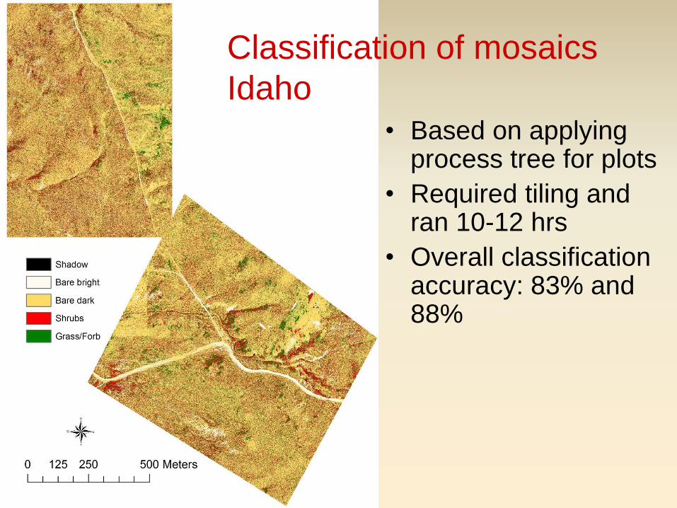
Classification of mosaics
Idaho
• Based on applying process tree for plots
• Required tiling and ran 10-12 hrs
• Overall classification accuracy: 83% and 88%


Class Producers
Acc. (%)
Users
Acc. (%)
Tarbush 52 83
Broom snakeweed 72 73
Creosote 94 79
Bush muhly 79 72
Marioly 86 81
Mesquite 89 92
Sumac 49 96
Tobosa 93 98
Overall Acc. (%) 87
Kappa 0.83
Multispectral classification 130m x 130m

Terrain Extraction from RGB
• Extraction of digital surface model (DSM)
• Sparse DSM at 0.5-1 m resolution
– Erdas ATE
– Represents general terrain
• Dense DSM based on 3-D point cloud at pixel level
– Erdas eATE
– Fusion of RGB values with elevation data
– Deriving vegetation heights
• Data used to estimate parameters for hydrologic and
erosion models

Orthomosaic (387 images) and 50-cm resolution DSM

Terrain extraction from UAS imagery Watershed delineation
1 m resolution DSM

1450
1455
1460
1465
1470
1475
1450 1455 1460 1465 1470 1475
Ele
vati
on
1m
DEM
(m)
Elevation dGPS (m)
1450
1455
1460
1465
1470
1475
1450 1455 1460 1465 1470 1475
Ele
vati
on
75
cm
DEM
(m
)
Elevation dGPS (m)
Elevation values derived from the
DSM and from field measurements
with survey grade dGPS Hillslope profiles derived from the
DSM and from field measurements
with survey grade dGPS
R2 = 0.9961
RMSE = 0.55 m (3.8%)
N = 470
1458145914601461146214631464146514661467146814691470
275 285 295 305 315 325 335 345
Hillslope North exp., n=80
dGPS
DTM 1m
1451
1452
1453
1454
1455
1456
1457
1458
1459
26
36
46
56
66
76
86
96 1… 1… 1… 1… 1… 1… 1…
Hillslope South exp., n=149
dGPS
DTM 1m
Ele
vati
on
(m)
DSM 1m
DSM 1m
DSM validation

Dense DSM based on 3D point cloud
80 m
Using Erdas eATE module

Fusion of terrain model,
imagery, and vegetation
classification
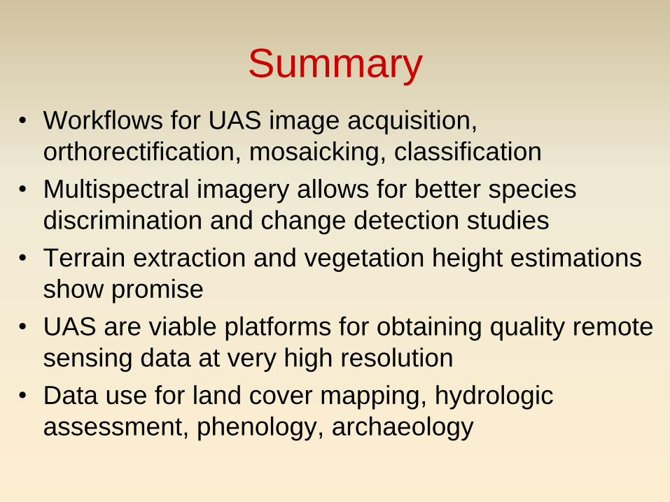
Summary
• Workflows for UAS image acquisition,
orthorectification, mosaicking, classification
• Multispectral imagery allows for better species
discrimination and change detection studies
• Terrain extraction and vegetation height estimations
show promise
• UAS are viable platforms for obtaining quality remote
sensing data at very high resolution
• Data use for land cover mapping, hydrologic
assessment, phenology, archaeology

Ongoing and Future Research
• Multispectral imagery
– Ongoing spectral ground and airborne measurements, change detection, vegetation indices
• Terrain extraction
– Streamline processing of point clouds
– Compare elevations and vegetation heights with field data
• Scale these approaches to larger areas
• Compare/upscale using WorldView-2 data
• Test other UAS sensors (thermal, lidar, hyperspectral)

BAT 4
13 ft wingspan
35 lb payload
150 W generator

Thank
you!