in compliance with the americans with disabilities act …
TRANSCRIPT

IN COMPLIANCE WITH THE AMERICANS WITH DISABILITIES ACT AND OTHER APPLICABLE FEDERAL AND STATE LAWS, ALL PUBLIC HEARINGS AND MEETINGS HELD OR SPONSORED BY THE CITY OF BETTENDORF, IOWA, WILL BE ACCESSIBLE TO INDIVIDUALS WITH DISABILITIES. PERSONS REQUIRING AUXILIARY AIDS AND SERVICES SHOULD CONTACT BETTENDORF CITY HALL AT (563) 344-4000 FIVE (5) DAYS PRIOR TO THE HEARING OR MEETING TO INFORM OF THEIR ANTICIPATED ATTENDANCE.
NOTICE TO THE AUDIENCE: Please remember that if you are interested in matters on the agenda that will have subsequent meetings, it is your responsibility to note their dates, times, and places. No further letters or reminders will be sent. Of course, if you have any questions about any given matter, do not hesitate to contact the Planning Department in the City Hall Annex, 4403 Devils Glen Road, Bettendorf, Iowa 52722 or phone (563) 344-4071. The Planning and Zoning Commission meeting will be open to the public. Additional and necessary measures will be taken to adhere to social distancing recommendations. Any members of the public who wish to be heard may attend the meeting in person or may call (563) 344-4071 for specific questions or alternative participation. In an effort to practice social distancing and in support of CDC guidelines, the City of Bettendorf will broadcast this meeting online at http://www.bettendorf.org/live-meeting. Constituents who do not have a matter to address with the Planning and Zoning Commission in person are strongly encouraged to stay at home and view the meeting online.
PLANNING AND ZONING COMMISSION CITY OF BETTENDORF
JUNE 17, 2020 AT 5:30 PM CITY HALL COUNCIL CHAMBERS
1609 STATE STREET 1. Roll Call: Adam _____, Gannaway _____, Kappeler _____, Ormsby _____, Rafferty _____,
Stoltenberg _____, Wennlund _____ 2. Approval of minutes of the meeting of May 20, 2020. 3. Review of Commission procedures. Rezoning 4. Case 20-033; West side of the 5800 block of Middle Road, A-1 Agricultural/Urban Reserve
District to R-5 High-Density Multi-Family Residence District, submitted by BESW. Site Development Plan 5. Case 20-034; 2564 Middle Road, submitted by Russell Ewing Bett, LLC. 6. Case 20-035; 7171 Valley Drive, submitted by Oak Grove Storage. Other 7. Commission Update.

NOTICE TO THE AUDIENCE: Please remember that if you are interested in matters on the agenda that will have subsequent meetings, it is your responsibility to note their dates, times, and places. No further letters or reminders will be sent. Of course, if you have any questions about any given matter, do not hesitate to contact the Planning Department in the City Hall Annex, 4403 Devils Glen Road, Bettendorf, Iowa 52722 or phone (563) 344-4071.
MINUTES
PLANNING AND ZONING COMMISSION MAY 20, 2020
5:30 P.M. The Planning and Zoning Commission meeting of May 20, 2020 was called to order by Stoltenberg at 5:30 p.m. in the City Hall Council Chambers, 1609 State Street. 1. Roll Call MEMBERS PRESENT: Adam, Gannaway, Kappeler, Ormsby, Rafferty, Stoltenberg, Wennlund MEMBERS ABSENT: None STAFF PRESENT: Greg Beck, City Planner; Brent Morlok, City Engineer; Troy Said, Assistant Fire
Chief (video); Jeff Reiter, Economic Development Director 2. Approval of the minutes of the meeting of April 15, 2020.
On motion by Adam, seconded by Rafferty, that the minutes of the meeting of April 15, 2020 be approved as submitted.
ALL AYES
Motion carried. 3. Review of Commission procedures. Stoltenberg announced that Reiter had informed him that if anyone has any issues with the Zoom video conferencing application, the meeting is also available for viewing on YouTube. Stoltenberg asked what the procedure would be for a viewer to comment on a case. Reiter explained that anyone using Zoom can take part in the conversation. Preliminary Plat 4. Case 20-025; Fields Edge Addition, submitted by Edgebrooke Homes, LLC. Beck reviewed the staff report.

Planning and Zoning Commission Meeting May 20, 2020 Page 2
Wennlund asked if Lot 8 is buildable given the large required setbacks, swale, and topography. Morlok stated that there are grading challenges on Lots 6-8 and drainage running through those lots. He indicated that the topography lines show existing contours and that grading will be required to allow those lots to be built upon. Wennlund asked if a pipe would be required under 185th Street between Lots 1 and 8 or if the proposed grading will make that unnecessary. Ryan Dolan, the applicant, explained that storm sewer will run under 185th Street, that substantial grading will take place to allow construction on the lots, and that there will be a large retention area on Outlot A so that water can be released at an appropriate rate. Wennlund asked how the water will be conveyed to Outlot A. Dolan explained that it would be conveyed via the storm sewer which will be angled from northwest to southeast to Outlot A. He added that the retention area on Outlot A will occupy approximately 2/3 of the lot. Kappeler asked if the existing buildings shown on Lot 3 will remain or be demolished. Dolan stated that they will be removed. Kappeler asked if Outlot A is intended to accommodate water from properties north of any future extension of 185th Street. Dolan confirmed this, adding that it would not only retain water from the subdivision but would accommodate the water from the property to the north and also from a culvert that runs under Criswell Street just north of his property. Dolan stated that at the Scott County Planning and Zoning meeting the question was raised as to whether the city would require sidewalks along 185th Street even though it is a private street. Morlok commented that because the proposed subdivision is not located within the city limits, that decision would be the County’s. He suggested that sidewalks be installed if the developer plans to build the streets to city standards with regard to width, thickness, and paving materials. He reiterated that the because the subdivision is outside city limits and the city has no means to sewer the property right now, the decision is ultimately at the discretion of Scott County. Rafferty asked if there would be a high wall at the south end of the detention area given the significant slope on Outlot A. Morlok confirmed this, adding that north side will be cut into to flatten the slope and to gain some volume and that a berm will be rebuilt on the south side. He added that the given the size of the subdivision, the volume of water will not be very large. Morlok explained that because it is not hard-surfaced, the off-site water is not intended to be detained but merely to pass through the system. He indicated that staff has no concerns about the basin acting as a small dam. Rafferty commented that that had been his concern.
On motion by Rafferty, seconded by Ormsby, that the preliminary plat of Fields Edge Addition be recommended for approval subject to staff recommendations.
ALL AYES Motion carried. Final Plat 5. Case 20-026; Wilderness Pointe First Addition, submitted by Jared Kerkhoff Homes. Beck reviewed the staff report.

Planning and Zoning Commission Meeting May 20, 2020 Page 3
Kappeler asked for clarification of Condition 3 in the staff report regarding the required 30-foot buffer and the drainageway. Morlok explained that as a part of the storm water ordinance changes a few years ago, a requirement for a 30-foot buffer from top of slope in both directions was instituted. He added that the buffer cannot be disturbed. He stated that the outlots are sized accordingly to accommodate the required buffer. Wennlund commented that the plat notes indicate that the owner of Lot 18 is the owner of Outlot C and is therefore responsible for its maintenance. He stated that he believes that the homeowner’s association should be responsible for ownership and maintenance as is indicated for the other outlots. Beck indicated that he had been under the impression that the HOA would control and be responsible for Outlot C given that it is to be used for a drainage area. Morlok explained that ownership is likely tied to Lot 18 because of its adjacency. He suggested that perhaps a separate agreement could be entered into assigning the responsibility for maintenance to the HOA. Jared Kerkhoff, the applicant, explained that in the past the outlots were under the ownership of individual owners because they were located in the flood plain. He indicated that he would be willing to meet with staff to clarify the responsibilities for the detention basin on Outlot C. Rafferty asked why the outlots adjacent to individual lots are necessary. Morlok explained that Outlots D-K are in the designated flood plain and are separate from the individual lots so that the homeowners are not required to pay flood insurance. He stated that each owner is responsible for the maintenance of those adjacent outlots. Gannaway asked why sanitary sewer is required for this subdivision but not for Fields Edge Addition which is across the street. Morlok explained that sanitary sewer is available to serve properties on the west side of Criswell Street, but because of the topography it is not possible on the east side. Wennlund commented that Fields Edge Addition is not located within the city limits but is only being reviewed because its proximity. Morlok added that the city had discussed annexation with the applicant but had decided against it because sewer cannot be extended.
On motion by Wennlund, seconded by Gannaway, that the final plat of Wilderness Pointe First Addition be recommended for approval subject to staff recommendations and the clarification of the rights and responsibilities of the owner of Outlot C relative to access and maintenance.
ALL AYES
Motion carried. Replat 6. Case 20-024; Gipple’s 1st Addition, submitted by Todd Gipple. Beck reviewed the staff report.

Planning and Zoning Commission Meeting May 20, 2020 Page 4
Stoltenberg asked if the developer is proposing the same lot configuration as the lots to the south. Beck confirmed this.
On motion by Ormsby, seconded by Rafferty, that the final plat of Gipple’s 1st Addition be recommended for approval subject to staff recommendations.
ALL AYES
Motion carried. Other 12. Commission Update. Morlok stated that the following cases were approved by City Council subsequent to the last meeting: Glenbrook Ridge Third Addition, final plat Old Hunters Woods Seventh Addition, final plat Pleasant Harbor 2nd Addition, final plat Creek Ridge Estates 3rd Addition, final plat Spencer Hollow 4th Addition, final plat Spencer Hollow 5th Addition, final plat Lots 13-18, Forest Grove Crossing Third Addition, site development plan 4465 - 53rd Avenue, site development plan Lot 3, Glenbrook Ridge Third Addition, site development plan Morlok announced that Mark Hunt has accepted the city’s offer to become the new Community Development Director and will start on June 22. There being no further business, the meeting adjourned at approximately 6:00 p.m. These minutes approved Gregory W. Beck City Planner

COMMUNITY DEVELOPMENT
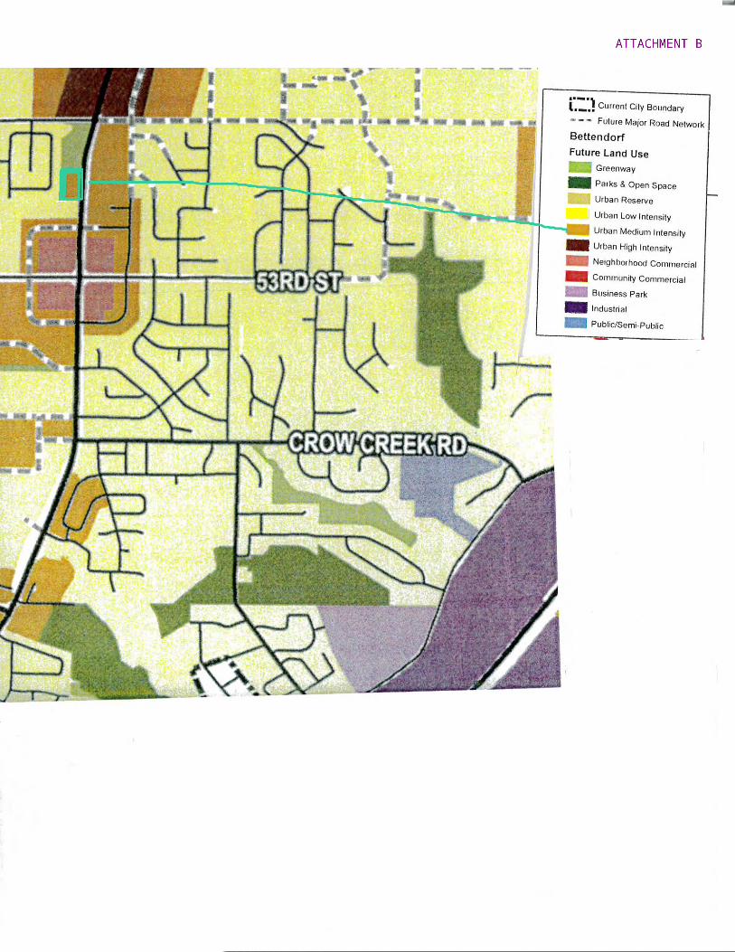
City Hall Annex 4403 Devils Glen Road, Bettendorf, Iowa 52722 (563) 344-4100 June 17, 2020 Staff Report Case No. 20-033 Location: West side of the 5800 block of Middle Road – Rezoning Applicant: BESW Current Zoning Classification: A-1, Agricultural/Urban Reserve District Proposed Zoning Classification: R-5, High-Density Multi-family Residence District Current Land Use Designation: Urban Medium Intensity Background Information and Facts BESW has submitted an application for rezoning of property located along the west side of Middle Road between 53rd Avenue and Hopewell Avenue (see Aerial Photo, Attachment A). The petitioner would like to change the zoning from A-1, Agricultural/ Urban Reserve District to R-5, High-Density Multi-family Residence District The future land use designation for this site is Urban Medium Intensity (UMI) (see Future Land Use Map and R-5 Zoning - Attachments B and C). The site is anticipated to have two entries from Middle Road (see Site Concept - Attachment D). The proposed building for the site will be a 3-story, 72-unit multi-family structure. Given the property’s location being adjacent to an arterial, the recently-approved revisions to the R-5 Zoning Ordinance, including an increased front yard setback, do apply. Land Use The land use designation for the site is Urban Medium Intensity. Surrounding land use designations are Urban Low Intensity, Urban Reserve, and Urban Medium Intensity. The UMI land use facilitates a rezoning to R-5, High-Density Multi-family Residence District. Utilities Utilities are available along Middle Road. Water service and electrical will originate along Middle Road from the south. It is the responsibility of the property owner to connect to all utilities. Sanitary sewer is available for connection to the site from the west.

Thoroughfare Plan/Access Two driveways to the site will originate from Middle Road. All drive areas shall be privately-owned and maintained. Storm Water Detention Storm water detention is required, and the design shall be approved by the City Engineer at the time a site development plan is submitted. Recommended Action Staff recommends the Planning and Zoning Commission evaluate the same factors considered for other conditional rezonings in recommending approval of the rezoning. Staff would add the following conditions to approval of the rezoning:
1. Approval of the rezoning does not waive any applicable city, state, or federal provisions as required by law.
2. A site development plan must be submitted for the development. 3. The developer shall be governed by a Conditional Zoning Agreement as will any of
the subsequent owners of the parcel.
Respectfully submitted, Greg Beck City Planner

C-2 C-2
C-2
PR-3
R5
R-1 53RD AVE
HOPEWELL AVE
MID
DLE
RD
EMILY R
D
RED
FOX R
D
KRISTI LN
53RD AVENUE BIKE PATH
BERKSH
IRE ST
57TH AVE
59TH AVE
MASON RUN
55TH AVE
IDAH
O D
R
EMIL
Y C
T
CH
ARLIE
CH
ASE LN
VAND
ER
GIN
ST CT
BUTTERFIELD CT
ARIZONA DR
HO
PEW
ELL CT
WH
ITE PO
ST CT
56TH AVENUE CT
55TH AVE
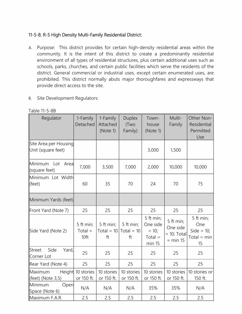
11-5-8. R-5 High Density Multi-Family Residential District: A. Purpose: This district provides for certain high-density residential areas within the
community. It is the intent of this district to create a predominantly residential environment of all types of residential structures, plus certain additional uses such as schools, parks, churches, and certain public facilities which serve the residents of the district. General commercial or industrial uses, except certain enumerated uses, are prohibited. This district normally abuts major thoroughfares and expressways that provide direct access to the site.
B. Site Development Regulators:
Table 11-5-8B Regulator 1-Family
Detached
1-Family Attached (Note 1)
Duplex (Two
Family)
Town-house
(Note 1)
Multi- Family
Other Non-Residential Permitted
Use Site Area per HousingUnit (square feet)
3,000 1,500
Minimum Lot Area(square feet)
7,000 3,500 7,000 2,000 10,000 10,000
Minimum Lot Width(feet)
60 35 70 24 70 75
Minimum Yards (feet)
Front Yard (Note 7) 25 25 25 25 25 25
Side Yard (Note 2) 5 ft min; Total =
10ft
5 ft min; Total = 10
ft
5 ft min; Total = 10
ft
5 ft min; One side
= 10; Total = min 15
5 ft min; One side
= 10; Total = min 15
5 ft min; One
Side = 10; Total = min
15 Street Side Yard,Corner Lot
25 25 25 25 25 25
Rear Yard (Note 4) 25 25 25 25 25 25
Maximum Height(feet) (Note 3,5)
10 stories or 150 ft.
10 stories or 150 ft.
10 stories or 150 ft.
10 stories or 150 ft.
10 stories or 150 ft.
10 stories or 150 ft.
Minimum OpenSpace (Note 6)
N/A N/A N/A 35% 35% N/A
Maximum F.A.R. 2.5 2.5 2.5 2.5 2.5 2.5

Note 1: Density regulators are shown on a per unit basis. Note 2 - Separation of Townhouse Buildings: There shall be a minimum of 15 feet separation between adjacent townhouse row dwellings. Note 3: Height limit in table for one- or two-story structures; the combined side yard requirement shall be increased by five feet for each additional story over two and shall be distributed equally among the two side yards. Note 4: Twenty five feet rear yard setback for one- or two-story structures; the required rear yard shall be increased by five feet for each additional story over two. Note 5: Churches, schools, and hospitals are permitted a maximum height of 60 feet for the main structure and 75 feet for towers or steeples. Note 6: Open space does not include driveways, parking areas, or structures. (2008 Code) Note 7: Where lots are not subject to established front yard setback requirements, lots in the Downtown Master Plan area may reduce the front yard setback to 5 feet.
Note 8: The required front yard or rear yard setback adjacent to any collector, minor arterial, or principal arterial street as defined in the Bettendorf Transportation Plan (April 11, 2013) shall be fifty (50) feet OR thirty-five (35) feet when a berm, acceptable to the Planning and Zoning Commission and City Council, is provided adjacent to the involved roadway.
Note 9: The maximum height allowed for any portion of any townhouse or multi-family residential structure within fifty (50) feet of any lesser-zoned district shall be less than or equal to the maximum height allowed in the lesser-zoned district.


COMMUNITY DEVELOPMENT
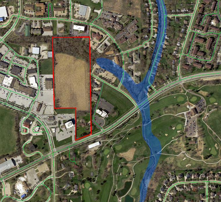
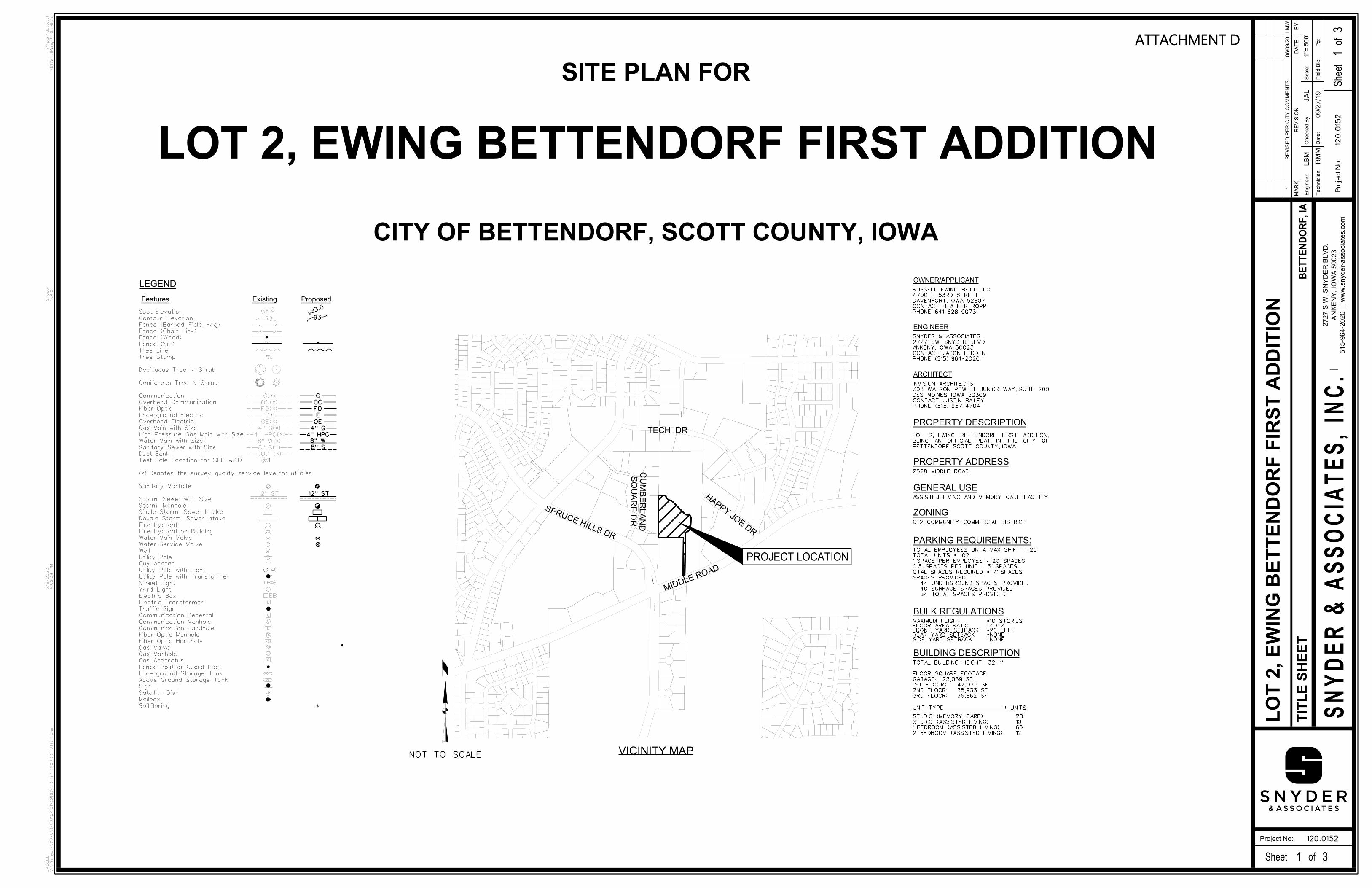
City Hall Annex 4403 Devils Glen Road, Bettendorf, Iowa 52722 (563) 344-4100 June 17, 2020 Staff Report Case No. 20-034 Location: 2564 Middle Road - Site Development Plan (Lot 2, Ewing Bettendorf First Addition) Applicant: Russell Ewing Bett, LLC Current Zoning Classification: C-2, Community Commercial District Current Land Use Designation: Community Commercial Background Information and Facts Russell Ewing Bett, LLC has submitted a site development plan for 2564 Middle Road (see Aerial Photo and Final Plat - Attachments A and B). The City previously approved a site development plan for Lot 1 consisting of a single senior living facility and parking (see Prior Site Plan - Attachment C). The current site development plan proposes an additional senior living facility and parking which will be built on Lot 2 (see Site Development Plan - Attachment D). Access will be the same as approved for Lot 1, with two access points being through the Northwest Bank property and via Happy Joe Drive. The landscape plan meets the tree count requirements of the Landscape Ordinance (see Landscape Plan - Attachment E.) Elevations show the 3-story structure which will have 102 units (see Elevations - Attachment F). Land Use The Community Commercial land use designation permits C-2, Community Commercial District zoning which would allow the proposed senior living facility. Utilities Utilities are available along Middle Road and from Happy Joe Drive. It is the responsibility of the property owner to connect to all utilities. Water, sanitary sewer, gas and electric will be available from within the site itself as provided for Lot 1. Thoroughfare Plan/Access The site is required to have two entry points for emergency services: one from Happy Joe Drive and from Middle Road through an easement on the Northwest Bank property. A traffic impact study was prepared by an independent third party engineering consultant prior to the

approval for the first building, and the results confirm that no additional traffic control devices will be required for either the first phase of the project or the anticipated full buildout. The study analyzed the intersections of Spruce Hills Drive and Middle Road, Middle Road and Happy Joe Drive, and the Northwest Bank Tower entrance off Middle Road. All three are anticipated to function at acceptable levels of service at full build out. The report did suggest that an updated analysis be performed in the future to evaluate actual traffic patterns. Given that Lot 2 is developing sooner than expected and knowing that Lot 3 is also attracting potential developers, staff is recommending that a traffic agreement between the owners of Lots 1, 2, and 3 and the City addressing any future traffic control devices be approved prior to Council approval of the plan. Storm Water Detention Storm water detention is required and must be approved by the City Engineer at the time a site development plan is considered by City Council. Storm water detention will be accommodated for the entire subdivision in Outlot X. Recommended Action Staff recommends approval of the site development plan subject to the conditions listed below:
1. Approval of the site development plan does not waive any applicable city, state, or federal provisions as required by law.
2. All fire hydrant placement and turning radii must be approved by the Fire Department prior to City Council consideration of the site development plan.
3. A traffic agreement between the owners of Lots 1, 2, and 3 and the City addressing any future traffic control devices be approved prior to Council approval of the plan
Respectfully submitted, Greg Beck City Planner
MIDDLE RD
TECH DR
29TH
ST
LUNDY LN
23R
D S
T
18TH S
T
STAF
FOR
D B
LVD
WIL
LOW
DR
SPRUCE HILLS DR
HAPPY JOE DR
CU
MBE
RLAN
D SQ
UAR
E DR
CAMDEN DR
CH
ATEA
U K
NL
MIDDLE
ROAD PA
RK
VIC
TOR
IA S
T
SAINT D
AVID D
R
CHAT
EAU
KNL


BY
DA
TE
MA
RK
Scale:
Checked B
y:
Engineer:
Technicia
n:
Date:
Field B
k: Pg:
1"=
Sheet
of
Sheet of
Project No:
SN
YD
ER
& A
SS
OCIA
TE
S, IN
C.
Project
No:
515-9
64-2
020 | w
ww.s
nyder-associates.c
om
AN
KE
NY, IO
WA 5
0023
2727 S.W. S
NY
DE
R B
LV
D.
Y:\
pen\
date.t
bl
V8iB
WFull
Weig
htP
DF.pltcfg
Snyder
1:5
00
6/9/2020
4:0
6:3
4
PM
LM
CG
EE
V:\
Projects\
2020\
120.0
152.0
1\
CA
DD\
BID
_S
P_
1200152_
01T
SH.d
gn
BE
TT
EN
DO
RF, IA
120.0152
3
120.0
152
3
RM
M
LB
M
09/2
7/1
9
JA
L
RE
VISIO
N
LO
T 2, E
WIN
G B
ET
TE
ND
OR
F FIR
ST A
DDITIO
N1
RE
VIS
ED P
ER CIT
Y C
OM
ME
NTS
06/0
9/2
0L
MW
SP
RU
CE HIL
LS D
R
SP
RU
CE HIL
LS D
R
TEC
H D
R
VIC
TO
RIA S
T
MIDDLE ROAD
HAPPY JOE DRIVE
NOT TO SCALE VICINITY MAP
PROJECT LOCATION
CITY OF BETTENDORF, SCOTT COUNTY, IOWA
SITE PLAN FOR
1
TIT
LE S
HE
ET
1
500'
VIC
TO
RIA S
T
TEC
H D
R
HAPPY JOE DRIVE
MIDDLE ROAD
SP
RU
CE HIL
LS D
R
PHONE: 641-628-0073
CONTACT; NICK CRALL
PELLA, IOWA 50219
2521 WASHINGTON STREET
EWING LAND DEVELOPMENT AND SERVICES LLC
SPRUCE HILLS DR
HAPPY JO
E D
R
TECH DR
MIDDLE ROAD
SQ
UA
RE D
R
CU
MB
ER
LA
ND
OWNER/APPLICANT
ENGINEER
PHONE (515) 964-2020
CONTACT: JASON LEDDEN
ANKENY, IOWA 50023
2727 SW SNYDER BLVD
SNYDER & ASSOCIATES
ARCHITECT
ZONING
PROPERTY DESCRIPTION
PROPERTY ADDRESS
GENERAL USE
PARKING REQUIREMENTS:
9393.
0
93
C
OC
FO
E
OE
4" G
4" HPG
8" W
8" S
12" ST12" ST
G
G
AST
UST
Features Existing Proposed
G
EB
W
LEGEND
8" W(*)
8" S(*)
4" G(*)
4" HPG(*)
C(*)
OC(*)
FO(*)
E(*)
OE(*)
DUCT(*)
93.0
1
Soil Boring
Mailbox
Satellite Dish
Sign
Above Ground Storage Tank
Underground Storage Tank
Fence Post or Guard Post
Gas Apparatus
Gas Manhole
Gas Valve
Fiber Optic Handhole
Fiber Optic Manhole
Communication Handhole
Communication Manhole
Communication Pedestal
Traffic Sign
Electric Transformer
Electric Box
Yard Light
Street Light
Utility Pole with Transformer
Utility Pole with Light
Guy Anchor
Utility Pole
Well
Water Service Valve
Water Main Valve
Fire Hydrant on Building
Fire Hydrant
Double Storm Sewer Intake
Single Storm Sewer Intake
Storm Manhole
Storm Sewer with Size
Sanitary Manhole
(*) Denotes the survey quality service level for utilities
Test Hole Location for SUE w/ID
Duct Bank
Sanitary Sewer with Size
Water Main with Size
High Pressure Gas Main with Size
Gas Main with Size
Overhead Electric
Underground Electric
Fiber Optic
Overhead Communication
Communication
Coniferous Tree \ Shrub
Deciduous Tree \ Shrub
Tree Stump
Tree Line
Fence (Silt)
Fence (Wood)
Fence (Chain Link)
Fence (Barbed, Field, Hog)
Contour Elevation
Spot Elevation
2528 MIDDLE ROAD
BULK REGULATIONS
=NONESIDE YARD SETBACK=NONEREAR YARD SETBACK=20 FEETFRONT YARD SETBACK=400%FLOOR AREA RATIO=10 STORIESMAXIMUM HEIGHT
C-2: COMMUNITY COMMERCIAL DISTRICT
LOT 2, EWING BETTENDORF FIRST ADDITION
PHONE: 641-628-0073
CONTACT; HEATHER ROPP
DAVENPORT, IOWA 52807
4700 E 53RD STREET
RUSSELL EWING BETT LLC
PHONE: (515) 657-4704
CONTACT: JUSTIN BAILEY
DES MOINES, IOWA 50309
303 WATSON POWELL JUNIOR WAY, SUITE 200
INVISION ARCHITECTS
ASSISTED LIVING AND MEMORY CARE FACILITY
BETTENDORF, SCOTT COUNTY, IOWA.
OF CITY THE IN PLAT OFFICIAL AN BEING
ADDITION, FIRST BETTENDORF EWING 2, LOT
BUILDING DESCRIPTION
UNIT TYPE # UNITS
36,862 SF3RD FLOOR:
35,933 SF2ND FLOOR:
47,075 SF1ST FLOOR:
23,059 SFGARAGE:
FLOOR SQUARE FOOTAGE
TOTAL BUILDING HEIGHT= 32'-1"
12
60
10
20
2 BEDROOM (ASSISTED LIVING)
1 BEDROOM (ASSISTED LIVING)
STUDIO (ASSISTED LIVING)
STUDIO (MEMORY CARE)
84 TOTAL SPACES PROVIDED
40 SURFACE SPACES PROVIDED
44 UNDERGROUND SPACES PROVIDED
SPACES PROVIDED
OTAL SPACES REQUIRED = 71 SPACES
0.5 SPACES PER UNIT = 51 SPACES
1 SPACE PER EMPLOYEE = 20 SPACES
TOTAL UNITS = 102
TOTAL EMPLOYEES ON A MAX SHIFT = 20
ATTACHMENT D

BY
DA
TE
MA
RK
Scale:
Checked B
y:
Engineer:
Technicia
n:
Date:
Field B
k: Pg:
1"=
Sheet
of
Sheet of
Project No:
SN
YD
ER
& A
SS
OCIA
TE
S, IN
C.
Project
No:
515-9
64-2
020 | w
ww.s
nyder-associates.c
om
AN
KE
NY, IO
WA 5
0023
2727 S.W. S
NY
DE
R B
LV
D.
Y:\
pen\
date.t
bl
V8iB
WFull
Weig
htP
DF.pltcfg
Snyder
1:5
0
6/9/2020
4:0
6:3
7
PM
LM
CG
EE
V:\
Projects\
2020\
120.0
152.0
1\
CA
DD\
BID
_S
P_
1200152_
02
SIT.d
gn
BE
TT
EN
DO
RF, IA
120.0152
3
120.0
152
3
RM
M
LB
M
09/2
7/1
9
JA
L
RE
VISIO
N
LO
T 2, E
WIN
G B
ET
TE
ND
OR
F FIR
ST A
DDITIO
N1
RE
VIS
ED P
ER CIT
Y C
OM
ME
NTS
06/0
9/2
0L
MW
C-4
92.70'
46.6
7'
254.00'
7.5
0'
C-1
C-2
C-3
476.54'
314.3
3'
8.46'
88.8
6'
524.77'
N0°49'41"E 532.48'
28.0
5'
SPRUCE HILLS D
R
15
2
MID
DLE R
OA
D
HAPP
Y J
OE D
RIV
E
8"S
AN
8"SAN
8"S
AN
8"S
AN
Conc
Concrete
Curb
&
Gutter
15
15
8"
W
8"
W
8"W
8"W
8"W
8"SAN
8"S
AN
8"S
AN
H
8"W
30"ST
24"ST
24"ST
10"S
T
8"S
T8"S
T
8"S
T
10"ST
18"S
T
10"ST
8"S
T
8"ST 8"ST 8"ST
24"S
T
15"ST
24"ST
10"ST
24"S
T
10"ST 24"ST
8"ST
18"ST
18"S
T
15"S
T
18"S
T
T
G
4"W
6"W
8"
W8"
W
10"ST 15"ST 15"ST
15"S
T
15"S
T18
"S
T
12"ST
10"S
T
10"S
T
12"S
T
12"S
T
15"S
T
12"ST
12"S
T
8"S
AN
6"W
6"W
UP
10"S
T
13
7
11
9
659
658
655
654
613
613
614
614
615616
617
618
619
620
621
622
623
624
624
625
625
625
626
626
626
626
627
627
627
628
628
628
629
629
630
630
630
631
631
632
632
632
632
633
633
633
633
633
634
634
634
634
634
634
635
635
635
635
635
635
636
636
636
637
637
637
638
638
638
638
639
639
639
639
640
640
640
641
641
641
642
642
642
643
643
644
644
64
4
645
645
645
64
5
646
646
647
647
64
7
648
648
648
649
649
649
650
650
650
650
650
651
651
652
652
653
653
654
654
654
654
654
654
654
654
654
655
655
655
655
655
655
655
655
655
655
656
656
656
656
656
656
656
656
656
656
656
656
656
657
657
657
657
657
657
657
657
657
657
657
657
657
658
658
658
658
658
658
658
6586
58
658
658
658
658 658
658
658
658
658
658
658
658
659
659
659
659
659
659
659
659
659
659
659
659
659
659
659
659
660
660
660
660
660
660
660
660
660
660
660
660
660
660
660
661
661
661
661
661
661
661
661
661
661
661
661
661
662
662
662
662
662
662
662
662
662
662
662
662
662
663
663
663
663
663
663
663
663
663
663
663
663
663
663
663
663
664
664
664
664
664
664
664
664
664
664
6646
64
664
664
664
664
665
665
665
665
665
665
665
665
666
666
666
666
666
666
666
667
667
667
667
667667
667
668
668
668
66866
9669
669
654
655
658
660
660
661
661
662
662
662
663
663
663
663
663
663
663
663
663
664
664
664
664
664
664
664
664
665
665
665
665
665
665
665665665666
667668
BM2
CP1
CP5
IC
V
FO
IC
V
CC
FO
E
C
C
Inv
=626.0
8 8"
VC
P
SE
Rim
=634.3
1
F.L.=
653.1
7
12"
RC
P
E
F.L.=
653.1
5 12"
RC
P
S
Intake
=658.6
8
F.L.=
654.4
7
12"
RC
P
W
Intake
=658.8
7
Bric
k
Concrete
Concrete
Concrete
Conc
Asphalt
Concrete
Curb
&
Gutter
12" R
CP
BW=654.95(E)
BW=654.95(E)
BW=654.9
5(E)
BW=654.9
5(E)
TW=659.00(W)
TW=659.00(W)
TW=660.0
0(W)
TW=665.9
5(W)
LOT 2
LEGEND
4" PCC SIDEWALK
6" PCC PAVEMENT
LOT 3
3.91 AC
170,482 SF
LOT 1
Park Sec
ond Addit
ionProf
essionalPalm
er HillsLot 2
Lot 2 Lot 4
Lot 1
Lot 7Technolog
ical Cente
rQuad
CityBlock
4
Lot 1
Lot 3Third
AdditionCumberla
nd Squar
e
Lot 4
Lot 4Four
th Additio
nCumberla
nd Squar
e
Lot 5Lot 6
1st Additio
nCumberla
nd Commercia
l Park
and Outlot
"A"Lots 1 &
2
SIT
E P
LA
N50'
0 50
FEET
Sewer EasementExisting 30' Sanitary
Sewer EasementExisting 30' Sanitary
2
2
BFE=655.00
FFE=666.00
Main EasementExisting 10' Public Water
Sewer EasementExisting 30' Public Sanitary
Main EasementExisting 10' Public Water
EasementExisting 26' Private Ingress/Egress
Easement Ingress/Egress
Existing 26' Private
EasementIngress/Egress Existing Private
First Addition
Ewing Bettendorf
SHARED MONUMENT SIGN
Sewer EasementExisting 20' Private Storm
TYPSILT FENCE
TYPSILT FENCE
TYPSILT FENCE
B/B
51.7'
Sewer EasementExisting 20' Private Storm
EasementMain
Public Water Existing 10'
Second A
ddition
Cumberland S
quareLot 2
1" = 20'RETAINING WALL DETAIL
887.4'
N0°49'36.37"E
ROW99.3'
26.0'
26.0'
26.0'
24.0'
26.0'
26.0'
26.0'
BY
DA
TE
MA
RK
Scale
:C
heck
ed
By
:E
ng
ineer:
Tech
nic
ian
:D
ate
:F
ield
Bk:
P
g:
1"=
Sh
eet
of
Sheet of
Project No:
SN
YD
ER
& A
SS
OC
IA
TE
S, IN
C.
Pro
ject
No:
515-9
64-2
020 | w
ww
.snyder-
associa
tes.c
om
AN
KE
NY
, IO
WA
50
02
3
27
27
S.W
. S
NY
DE
R B
LV
D.
Y:\pen\date.t
bl
V8
iBW
Fu
llW
eig
htP
DF
.plt
cfg
Sn
yd
er
1:4
0
6/9/2020
4:0
6:3
8 P
M
LM
CG
EE
V:\
Pro
jects
\20
20
\12
0.0
15
2.0
1\C
AD
D\B
ID
_S
P_
12
00
15
2_
03
LN
D.d
gn
BE
TT
EN
DO
RF
, IA
120.0152
3
12
0.0
15
23
RM
M
LB
M
09/2
7/1
9
JA
L
RE
VIS
ION
LO
T 2
, E
WIN
G B
ET
TE
ND
OR
F F
IRS
T A
DD
ITIO
N1
RE
VIS
ED
PE
R C
ITY
CO
MM
EN
TS
06
/09
/20
LM
W
LOT1
C-4
92.70'
46.6
7'
254.00'
7.5
0'
C-1
LOT2171,838 SF
C-2
C-3
314.3
3'
8.46'
88.8
6'
524.77'
15
2
8"S
AN
Conc
Concrete
Curb &
Gutt
er
15
15
8"W
8"W
8"SAN
8"S
AN
8"S
AN
H
8"W
8"S
T
24"S
T
15"ST
24"ST
10"ST
24"S
T
10"ST 24"ST
8"ST
18"ST
18"S
T
15"S
T
18"S
T
4"W
6"W
8"W
8"W
10"ST 15"ST 15"ST
15"S
T
15"S
T18
"S
T
12"ST
10"S
T
10"S
T
12"S
T
12"S
T
15"S
T
12"ST
12"S
T
8"S
AN
6"W
6"W
UP
10"S
T
13
7
11
9
PLANT SCHEDULE
SLOPE PLANTING PIT DETAIL
SCARIFY SIDES OF PIT
EXISTING SLOPE
FINISH GRADE
PLACE ROOT BALL ON UNDISTURBED SOIL
TREE OR SHRUB
ROOT BALL
BEGIN TRANSITION AT EDGE OF
2:1 MAXIMUM TRANSITION SLOPE. MINIMUM 6' DIAMETER, 3" DEPTH MULCH RING
BEYOND EDGE OF ROOT BALL
3" HEIGHT WATER RETENTION BERM
LOCATED AT TOP OF ROOTBALL
2" OF TRUNK. ROOT COLLAR IS NOT ALWAYS
FINISH GRADE. DO NOT PLACE MULCH WITHIN
SET ROOT COLLAR AND ROOT FLARE 2" ABOVE
MINIMUM FOR SHRUBS
2X ROOTBALL
MINIMUM FOR TREES
3X ROOTBALL
ROOT SYSTEM
OR CONTAINER
DEPTH OF ROOT BALL
BASKET MINIMUM.
MINIMUM TOP 1/2 OF BURLAP AND WIRE
BALLED AND BURLAP (B&B) PLANTS REMOVE
MATERIAL. REMOVE ALL TWINE. FOR
IMPEDE THE GROWTH OF THE PLANT
CONTAINERS OR OTHER MATERIAL THAT WILL
REMOVE ALL NON-BIODEGRADABLE MATERIAL, Root
Ball
Dia
mete
r 1
1/2
to
2 T
imes
SCARIFY SIDES OF PIT
TYPICAL PLANTING PIT DETAIL
FINISH GRADE
BEYOND EDGE OF ROOT BALL
3" HEIGHT WATER RETENTION BERM
LOCATED AT TOP OF ROOTBALL
2" OF TRUNK. ROOT COLLAR IS NOT ALWAYS
FINISH GRADE. DO NOT PLACE MULCH WITHIN
SET ROOT COLLAR AND ROOT FLARE 2" ABOVE
MINIMUM FOR SHRUBS
2X ROOTBALL
MINIMUM FOR TREES
3X ROOTBALL
ROOT SYSTEM
OR CONTAINER
DEPTH OF ROOT BALL
MINIMUM 6' DIAMETER, 3" DEPTH MULCH RING
BASKET MINIMUM.
MINIMUM TOP 1/2 OF BURLAP AND WIRE
BALLED AND BURLAP (B&B) PLANTS REMOVE
MATERIAL. REMOVE ALL TWINE. FOR
IMPEDE THE GROWTH OF THE PLANT
CONTAINERS OR OTHER MATERIAL THAT WILL
REMOVE ALL NON-BIODEGRADABLE MATERIAL,
PLACE ROOT BALL ON UNDISTURBED SOIL
NO SCALE
PLANTING PIT DETAILS
NO SCALE
(Trees larger than 2 1/2 inch diameter)
STAKING PLAN
1
1
DETAILS
SEE PLANTING PIT
(Trees 2 1/2 inch diameter or smaller)
STAKING PLAN
TO SOUTHWEST
PLACE ON STAKE
(4'-0" MIN.)
TREE HEIGHT
1/2 TO 2/3
branch.
Wrap trunk from ground line to first
DECIDUOUS TREE STAKING DETAIL
MATERIAL
FLAGGING
STRAP
GROMMETED NYLON
STEEL POSTS
TO SOUTHWEST
PLACE ON STAKE 6"
(2'-0" MIN.)
TREE HEIGHT
1/4 TO 1/3
NO-MOW TALL FESCUE SEED MIX
AREAS TO BE SODDED
DETENTION BASIN SEED MIX
0 40
FEET
2-PO
6-CA
3-AM
6-CA
6-CA
5-AM
2-PO
6-CA
3-AM
20-CA
3-AM
10-CA
20-CA
3-AM
1-HY
3-SB
1-JV
5-JC
(TYP.)
2-CO
KEY COMMON NAME SIZEBOTANICAL NAME
SH
RU
BS
QTY COMMENTS
OV
ER
ST
OR
YP
ER
EN
NIA
LS
GR
AS
S &
Hemerocallis x 'Stella D'Oro'
Calamagrostis x acutifolia 'Karl Foerster'
Spiraea betulifolia 'Tor'
Physocarpus opulifolius 'Little Devil'
Juniperus virginiana 'Skyrocket'
Juniperus chinensis 'Kallay's Compact'
Hydrangea paniculata 'Rehny'
Aronia melanocarpa 'Morton'
Gleditsia triacanthos f. inermis 'Skycole'
Celtis occidentalis 'Prairie Pride'
HS
CA
SB
PO
JV
JC
HY
AM
GT
CO
STELLA D'ORO DAYLILY
KARL FOERSTER FEATHER REED GRASS
TOR BIRCHLEAF SPIREA
LITTLE DEVIL NINEBARK
SKYROCKET JUNIPER
KALLAY'S COMPACT JUNIPER
VANILLA STRAWBERRY HYDRANGEA
IROQUOIS BEAUTY CHOKEBERRY
SKYLINE HONEYLOCUST
PRAIRIE PRIDE HACKBERRY
1 GAL.
1 GAL.
18" HT.
18" HT.
4' HT.
24" HT.
36" HT.
24" HT.
2" CAL.
2" CAL.
CONT.; 2' O.C.
CONT.; 30" O.C.
CONT.; 4' O.C.
CONT.; 4' O.C.
CONT.; 4' O.C.
CONT.; 6' O.C.
CONT.; 6' O.C.
CONT.; 4' O.C.
B&B
B&B
15
84
3
4
1
7
1
14
2
2
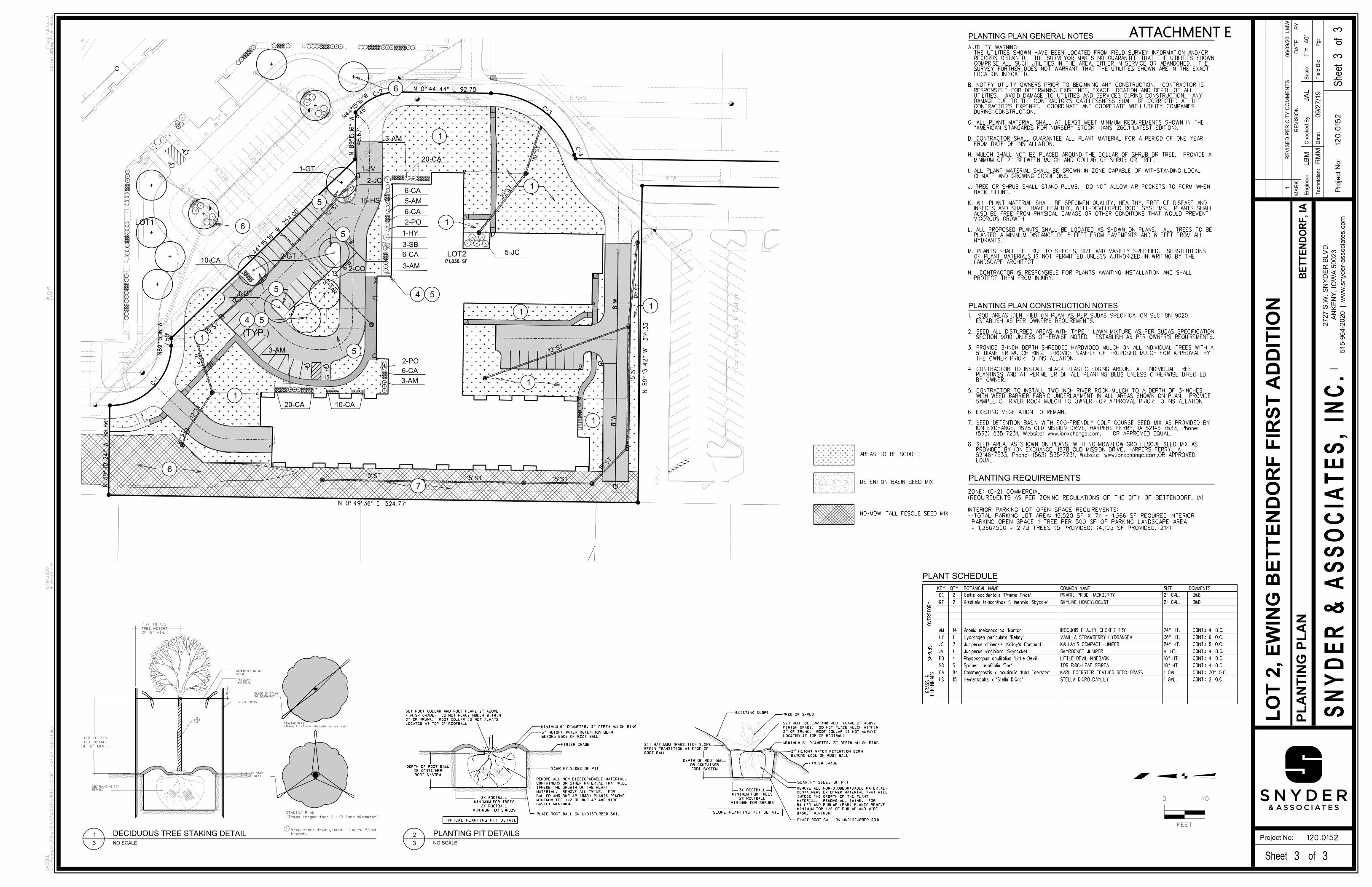
PLANTING PLAN CONSTRUCTION NOTES
PLANTING PLAN GENERAL NOTES
PROTECT THEM FROM INJURY. N. CONTRACTOR IS RESPONSIBLE FOR PLANTS AWAITING INSTALLATION AND SHALL
LANDSCAPE ARCHITECT.OF PLANT MATERIALS IS NOT PERMITTED UNLESS AUTHORIZED IN WRITING BY THE
M. PLANTS SHALL BE TRUE TO SPECIES, SIZE AND VARIETY SPECIFIED. SUBSTITUTIONS
HYDRANTS. PLANTED A MINIMUM DISTANCE OF 5 FEET FROM PAVEMENTS AND 6 FEET FROM ALL
L. ALL PROPOSED PLANTS SHALL BE LOCATED AS SHOWN ON PLANS. ALL TREES TO BE
VIGOROUS GROWTH. ALSO BE FREE FROM PHYSICAL DAMAGE OR OTHER CONDITIONS THAT WOULD PREVENT INSECTS AND SHALL HAVE HEALTHY, WELL-DEVELOPED ROOT SYSTEMS. PLANTS SHALL
K. ALL PLANT MATERIAL SHALL BE SPECIMEN QUALITY, HEALTHY, FREE OF DISEASE AND
BACK FILLING.J. TREE OR SHRUB SHALL STAND PLUMB. DO NOT ALLOW AIR POCKETS TO FORM WHEN
CLIMATE AND GROWING CONDITIONS.I. ALL PLANT MATERIAL SHALL BE GROWN IN ZONE CAPABLE OF WITHSTANDING LOCAL
MINIMUM OF 2" BETWEEN MULCH AND COLLAR OF SHRUB OR TREE. H. MULCH SHALL NOT BE PLACED AROUND THE COLLAR OF SHRUB OR TREE. PROVIDE A
FROM DATE OF INSTALLATION.D. CONTRACTOR SHALL GUARANTEE ALL PLANT MATERIAL FOR A PERIOD OF ONE YEAR
"AMERICAN STANDARDS FOR NURSERY STOCK" (ANSI Z60.1-LATEST EDITION).C. ALL PLANT MATERIAL SHALL AT LEAST MEET MINIMUM REQUIREMENTS SHOWN IN THE
DURING CONSTRUCTION.CONTRACTOR'S EXPENSE. COORDINATE AND COOPERATE WITH UTILITY COMPANIES DAMAGE DUE TO THE CONTRACTOR'S CARELESSNESS SHALL BE CORRECTED AT THE UTILITIES. AVOID DAMAGE TO UTILITIES AND SERVICES DURING CONSTRUCTION. ANY RESPONSIBLE FOR DETERMINING EXISTENCE, EXACT LOCATION AND DEPTH OF ALL
B. NOTIFY UTILITY OWNERS PRIOR TO BEGINNING ANY CONSTRUCTION. CONTRACTOR IS
LOCATION INDICATED.SURVEY FURTHER DOES NOT WARRANT THAT THE UTILITIES SHOWN ARE IN THE EXACT COMPRISE ALL SUCH UTILITIES IN THE AREA, EITHER IN SERVICE OR ABANDONED. THE RECORDS OBTAINED. THE SURVEYOR MAKES NO GUARANTEE THAT THE UTILITIES SHOWN THE UTILITIES SHOWN HAVE BEEN LOCATED FROM FIELD SURVEY INFORMATION AND/OR
A.UTILITY WARNING:
EQUAL. 52146-7533, Phone: (563) 535-7231, Website: www.ionxchange.com,OR APPROVED PROVIDED BY ION EXCHANGE, 1878 OLD MISSION DRIVE, HARPERS FERRY, IA
8. SEED AREA, AS SHOWN ON PLANS, WITH NO-MOW/LOW-GRO FESCUE SEED MIX AS
OR APPROVED EQUAL. (563) 535-7231, Website: www.ionxchange.com,ION EXCHANGE, 1878 OLD MISSION DRIVE, HARPERS FERRY, IA 52146-7533, Phone:
7. SEED DETENTION BASIN WITH ECO-FRIENDLY GOLF COURSE SEED MIX AS PROVIDED BY
6. EXISTING VEGETATION TO REMAIN.
SAMPLE OF RIVER ROCK MULCH TO OWNER FOR APPROVAL PRIOR TO INSTALLATION.WITH WEED BARRIER FABRIC UNDERLAYMENT IN ALL AREAS SHOWN ON PLAN. PROVIDE
5. CONTRACTOR TO INSTALL TWO INCH RIVER ROCK MULCH TO A DEPTH OF 3-INCHES
BY OWNER.PLANTINGS AND AT PERIMETER OF ALL PLANTING BEDS UNLESS OTHERWISE DIRECTED
4. CONTRACTOR TO INSTALL BLACK PLASTIC EDGING AROUND ALL INDIVIDUAL TREE
THE OWNER PRIOR TO INSTALLATION.5' DIAMETER MULCH RING. PROVIDE SAMPLE OF PROPOSED MULCH FOR APPROVAL BY
3. PROVIDE 3-INCH DEPTH SHREDDED HARDWOOD MULCH ON ALL INDIVIDUAL TREES WITH A
SECTION 9010 UNLESS OTHERWISE NOTED. ESTABLISH AS PER OWNER'S REQUIREMENTS.2. SEED ALL DISTURBED AREAS WITH TYPE 1 LAWN MIXTURE AS PER SUDAS SPECIFICATION
ESTABLISH AS PER OWNER'S REQUIREMENTS.1. SOD AREAS IDENTIFIED ON PLAN AS PER SUDAS SPECIFICATION SECTION 9020.
PLANTING REQUIREMENTS
= 1,366/500 = 2.73 TREES (5 PROVIDED) (4,105 SF PROVIDED, 21%)
PARKING OPEN SPACE 1 TREE PER 500 SF OF PARKING LANDSCAPE AREA
--TOTAL PARKING LOT AREA: 19,520 SF X 7% = 1,366 SF REQUIRED INTERIOR
INTERIOR PARKING LOT OPEN SPACE REQUIREMENTS:
(REQUIREMENTS AS PER ZONING REGULATIONS OF THE CITY OF BETTENDORF, IA)
ZONE: (C-2) COMMERCIAL
1-GT
2-JC
15-HS
2-GT10-CA
1-GT
PL
AN
TIN
G P
LA
N4
0'
3
3
3
1
3
2
7
4 5
4 5
1
1
6
5
5
6
1
1
5
6
1
1
1
1
1
5
ATTACHMENT E

FIRST FLOOR
0' - 0"
SECOND FLOOR
12' - 1 1/8"
ROOF
32' - 0 7/8"
THIRD FLOOR
23' - 1"
FIRST FLOOR
0' - 0"
SECOND FLOOR
12' - 1 1/8"
ROOF
32' - 0 7/8"
GARAGE
-11' - 0"
THIRD FLOOR
23' - 1"
FIRST FLOOR
0' - 0"
SECOND FLOOR
12' - 1 1/8"
ROOF
32' - 0 7/8"
GARAGE
-11' - 0"
THIRD FLOOR
23' - 1"
FIRST FLOOR
0' - 0"
SECOND FLOOR
12' - 1 1/8"
ROOF
32' - 0 7/8"
THIRD FLOOR
23' - 1"
SCALE:
SHEET:
DATE:
3/32" = 1'-0"EXTERIOR ELEVATIONS
BETTENDORF ASSISTED LIVING & MEMORY CARE
19121
EXTERIOR ELEVATIONS
BETTENDORF ASSISTED LIVING & MEMORY CARE
19121
A2.00
05/29/2020
3/32" = 1'-0"3
E ELEVATION
3/32" = 1'-0"4
N ELEVATION
3/32" = 1'-0"2
S ELEVATION
3/32" = 1'-0"1
W ELEVATION
ATTACHMENT F

COMMUNITY DEVELOPMENT
City Hall Annex 4403 Devils Glen Road, Bettendorf, Iowa 52722 (563) 344-4100 June 17, 2020 Staff Report Case No. 20-035 Location: 7171 Valley Drive (Lot 1, Great River Addition) – Site Development Plan Applicant: Oak Grove Storage Current Zoning Classification: I-2, General Industrial District Current Land Use Designation: Industrial Background Information and Facts Oak Grove Storage has submitted an application for a site development plan for 7171 Valley Drive (see Aerial Photo - Attachment A). The final plat denotes the approximate 100 year floodplain limits and dedicated right-of-way for a future extension of Criswell Street and widening of Valley Drive (see Final Plat - Attachment B). The prior site plan shows a total of 8 structures to be used as storage units (See Site Development Plan - Attachment C). The current site plan adds two more storage buildings to the south end of the property (see Site Development Plan - Attachment D). The landscape plan meets the Landscape Ordinance requirements. Land Use The land use designation is Industrial. The site is zoned I-2, General Industrial District which permits storage facilities. Utilities Utilities already extend to the site, and the developer has the responsibility for connection. A future connection to sanitary sewer shall be required from the southwest for the commercial portion of the subdivision which will be addressed at such time as a site development plan is submitted. Thoroughfare Plan/Pedestrian Access Access to the site will be from Valley Drive. Future access to US 67 will be evaluated at the time the commercial area develops.

Storm Water Detention Storm water detention will be provided at the southwest corner of the site. All detention calculations must be approved by the City Engineer. Staff Recommendation Staff recommends that the petitioner’s request for approval of the site development plan be granted subject to the following conditions: 1. Approval of the site development plan does not waive any applicable city, state, or
federal provisions as required by law. 2. No building permits will be issued for structures shown in the 100 year flood zone
until an approved Letter of Map Revision is received. 3. CLOMA-Fill will be required before grading associated with this project is allowed. 4. All storm water detention calculations must be approved by the City Engineer.
Respectfully submitted, Greg Beck City Planner

VALLEY DR
STAT
E ST
180TH ST
FIELDS DR
RIDGES C
T
CROW CREEK RD
CR
ISWE
LL ST
181ST ST
COLONIAL AVE
GREAT RIVER RD


7,200 Sq. Ft.
40'x180' Building
400 L.
F. - 1
0" Dia
.
Futur
e San
itary
Sewe
rEXISTIN
G 430 L.F. 8" D
IP WATER
MAIN
60' Landscape Buffer
& Utility Easem
ent
60' Landscape Buffer
Fiber OpticSign
Existing24" Dia. CMPFL = 580.41
Existing24" Dia. CMPFL = 580.64
24' P
rivat
e D
rive
LOT 1GREAT RIVER ADDITION
Corrosion
Control
Service
, Inc.
PARCEL #
851801008
11.723 ACRES ±
FutureSan. Sewer MHRim = 585.00FL IN = 578.09
7,875 Sq. Ft.
3,500 Sq. Ft.
4,375 Sq. Ft.
Existing 8' Tall Chain Link Fence
Existing 8' Tall Chain Link Fence
Exis
ting
8' T
all C
hain
Lin
k Fe
nce
ExistingFence Gate
20' Drainage
F.F. ELV. = 592.00
F.F. ELV. = 591.00
F.F. ELV. = 592.50
F.F. ELV. = 592.00
F.F. ELV. = 593.50
F.F. ELV. = 591.00
F.F. ELV. = 593.00
F.F. ELV. = 594.00
7,875 Sq. Ft.
7,875 Sq. Ft.
7,875 Sq. Ft.
7,875 Sq. Ft.
7,875 Sq. Ft.
25'x175' Building
45'x175' Building
45'x175' Building
45'x175' Building
45'x175' Building
45'x175' Building
45'x175' Building
20'x175' Building
Existing 8' Tall Chain Link Fence
Existing 8' Tall Chain Link Fence
Zoning - I-2
HYDRANTEXISTING
EX. HYDRANT
Ex. AsphaltShoulder
Ex. Conc.Approach
12.5' Building Setback
F.F. ELV. = 590.00
7,200 Sq. Ft.
40'x180' Building
F.F. ELV. = 589.40PR. 5" PCC PAVEMENT- 2,292 S.Y.
EXISTING GRAVEL
588.37
588.00
588.90
589.28589.43
589.84
589.16
588.83
588.46
589.26
586
587
588
588
589
589
-0.50%
-0.50%
-0.7
5%-0
.75%
-0.5
0%
589.69
Maintain Temporary Turn-Around AtEnd of Private Drive Until
Drive Is Connected To US-67(See Detail Sht. C-2)
8-inch thick rock - 2,200 sq.ft.
Proposed10'x10'x1' Rip Rap
Proposed10'x10'x1' Rip Rap
PR. CA-6 AGG. PAVEMENTEXTENSION - 2,491 S.F.
30'
25'-6"
25'-6"
30'
43'-7"
10'
20'
249'-114"
9'-412"
25'-6"
-0.5
0%-0
.50%
-0.50%-0.50%
REMOVE
HYDRANTRESET
MAIN 160 LFEXTEND WATER
586 FLOOD ELEVATIONACCORDING TO THE 2011 FEMA FLOOD PLAN MAPSPANEL 383 OF 500, 19163C0383F(POTENTIALLY REMOVED FROM SITE ON THE PRELIMINARY 2018 MAPS)
587.87
588.25
588.54
588.74
587.98
PROPOSED 4" OUTLET PIPE
PROPOSED 4" OUTLET PIPEEL = 584.00
Proposed 180'x50'Detention Basin
588587
586
Proposed 6" Outlet
SITE DEVELOPMENT PLAN
Great River
Bettendorf, IowaSTORAGE UNITS
IO WA
LICEN
SED
PROFESSIONAL ENGINEER
LOCATION MAP
GENERAL CONSTRUCTION NOTES:
1. THE LOCATION OF ALL UTILITIES INDICATED ON THE PLANSWERE TAKEN FROM EXISTING RECORDS OR FIELD LOCATED.THE EXACT LOCATION AND ELEVATION OF ALL PUBLICUTILITIES MUST BE DETERMINED BY THE CONTRACTOR. ITSHALL BE THE DUTY OF THE CONTRACTOR TO ASCERTAINWHETHER ANY ADDITIONAL FACILITIES OTHER THAN THOSESHOWN OR INDICATED ON THE PLANS MAY BE PRESENT.EXISTING UNDERGROUND UTILITIES SHOWN ON THEDRAWINGS ARE SHOWN FOR CONVENIENCE ONLY AND THEOWNER ACCEPTS NO RESPONSIBILITY FOR IMPROPERLOCATIONS OR FAILURE TO SHOW UTILITY LOCATIONS ON THEPLANS. THE CONTRACTOR SHALL BE RESPONSIBLE TOEXCAVATE AND LOCATE THE EXACT LOCATIONS OF UTILITYCROSSINGS BEFORE INSTALLING ANY PROPOSED UTILITIES.
2. ALL PROPOSED WATER MAINS AND SERVICE LINES SHALLBE INSTALLED AT A 5.5 FOOT BURY DEPTH, WRAPPED INTRACER WIRE.
3. ALL PROPOSED VALVE BOXES AND SERVICE CURB STOPBOXES SHALL BE INSTALLED FLUSH WITH THE FINAL GRADEOR AS INDICATED BY THE ENGINEER.
4. CONNECTIONS TO EXISTING WATER UTILITIES SYSTEM ASDETAILED SCHEMATICALLY ON THE PLANS SHALL BE MADEWITH CLASS 52, DUCTILE IRON PIPE WITH MECHANICAL JOINTSAND RESTRAINING FITTINGS. CAST COUPLINGS UTILIZED TOCONNECT TO EXISTING MAINS SHALL BE SERIES 433 OR 431CAST COUPLINGS, 175 PSI PRESSURE CLASS BY ROCKWELL;OR APPROVED EQUAL.
5. CONNECTIONS BETWEEN TEE OR CROSSES AND VALVESSHALL BE MADE WITH DUCTILE IRON HOLDING SPOOLS ORDUCTILE IRON PIPE USING TWO 3/4 INCH DIAMETER TIE RODS(ASPHALT COATED).
6. THE EXACT LOCATIONS OF ALL VALVES AND HYDRANTSMUST BE VERIFIED BY THE PROJECT MANAGER PRIOR TOINSTALLATION.
7. TRAFFIC CONTROL SIGNAGE IS REQUIRED AND IS THERESPONSIBILITY OF THE CONTRACTOR AND IS CONSIDEREDINCIDENTAL TO THE COST OF THE PROJECT.
8. ALL DISTURBED AREAS SHALL BE GRADED BACK TOEXISTING OR BETTER CONDITION.
9. THE EXACT LOCATION OF ALL BUILDING UTILITIES SHOULDBE VERIFIED PRIOR TO THE INSTALLATION OF ANY SITEUTILITY.
10. ALL UTILITIES SHALL BE INSTALLED IN ACCORDANCE WITHTHE CITY OF BETTENDORF STANDARD SPECIFICATIONS.
11. THE CONTRACTOR IS RESPONSIBLE FOR OBTAINING ALLREQUIRED PERMITS FROM THE CITY PRIOR TO THE START OFCONSTRUCTION.
12. ALL GAS AND ELECTRIC SERVICES SHALL BECOORDINATED WITH MID-AMERICAN ENERGY.
13. ALL STORM SEWER PIPING SHALL BE BID AS EITHERREINFORCED CONCRETE PIPE OR ADS N-12 PIPE ORAPPROVED EQUAL
14. THE SOUTHERLY PORTION OF THE SITE IS LOCATED INFEMA DESIGNATED FLOOD ZONE AE PER FLOOD INSURANCERATE MAP 19163C0383F, EFFECTIVE DATE FEBRUARY 18, 2011.THE FLOOD SOURCE IS THE EAST FORK OF PIGEON CREEK.THE 1% ANNUAL CHANCE FLOOD PLAIN VARIES FROMELEVATION 584 TO 586, SOUTH TO NORTH. LOW OPENINGELEVATION FOR BUILDINGS WITHIN THE FLOODPLAIN SHALLBE AT LEAST 1.0 FOOT ABOVE THE 1% ANNUAL CHANCEELEVATION.
GENERAL LEGEND
EXISTING Landscaping Requirements Along Valley DriveZoning: I-2 With R-1 On North Side of Valley DriveRequired Street Yard Greenspace = 60' Min. DepthRequired Street Yard Greenspace Area = 32,280 Sq. Ft.32,280 \ 700 = 46.11 Tree Factors (46.5) Total
30 - Deciduous Overstory Trees @ 1 T.F. Each (30 Tree Factors)2-inch Caliper & 22-inch Ball or Pot33 - Evergreen Trees @ 0.5 T.F. Each (16.5 Tree Factors)6 Foot Height & 16-inch Ball or Pot
EXISTING Landscaping Requirements Along State Street (U.S. 67)Zoning: I-2 Required Street Yard Greenspace = 20' Min. DepthRequired Street Yard Greenspace Area = 15,200 Sq. Ft.15,200 \ 700 = 46.11 Tree Factors (46.5) Total
15 - Deciduous Overstory Trees @ 1 T.F. Each (15 Tree Factors)2-inch Caliper & 22-inch Ball or Pot14 - Evergreen Trees @ 0.5 T.F. Each (7 Tree Factors)6 Foot Height & 16-inch Ball or Pot
Landscaping Requirements For Interior Drive Area19 - Trees As Per The City Of Bettendorf Review Letter (July 3rd, 2014)
NOTESALL EASEMENTS SHOWN ON THIS PLAT ARE TO BE PRIVATELY OWNED AND MAINTAINED.
ALL PUBLIC UTILITIES SHALL BE LOCATED WITHIN EASEMENTS OR PUBLIC ROADRIGHT-OF-WAY.
ALL ROADWAYS AND UTILITIES LOCATED WITHIN THE BOUNDARY OF THIS SUBDIVISION SHALLBE PRIVATELY OWNED AND MAINTAINED, EXCLUDING RIGHTS-OF-WAY DEDICATED TO THECITY OF BETTENDORF.
THERE SHALL BE NO ACCESS ALLOWED FORM THIS SUBDIVISION TO CRISWELL STREET.
A 60 FEET LANDSCAPED BUFFER SHALL BE PLACED BETWEEN THE RESIDENTIAL ZONE ANDTHE I-2 ZONED PROPERTY FOR BOTH THE VALLEY DRIVE AND THE US 67 BOUNDARIES.
ALL IMPROVEMENTS TO BE INSTALLED IN ACCORDANCE WITH THE CITY OF BETTENDORFSTANDARD SPECIFICATIONS.
BLANKET UNDERGROUND EASEMENTS GRANTED FOR SEWER, WATER, GAS, ELECTRIC,TELEPHONE, AND CABLE T.V. SERVICES TO INDIVIDUAL STRUCTURES WITHIN THE LOT WHERETHE STRUCTURE IS LOCATED.
THE SUBJECT AND ADJOINING PROPERTIES ARE ZONED I-2: GENERAL INDUSTRIAL DISTRICT.ZONING SETBACK LINES ARE BASED ON ZONING REQUIREMENTS AS OF THE DATE OF CITYCOUNCIL APPROVAL, IN CASE OF CONFLICT BETWEEN LINES SHOWN AND FUTURE CODEREQUIREMENTS THE CODE REQUIREMENTS SHALL GOVERN.
C1SHEET NO.DATE: DRAWN BY:
S:\Kardell\Great River Buildings 2020DRAWING LOCATION:
KRZ/MDR
CRTCHECKED BY:
REVISIONS:DESCRIPTIONNO. DATE
SITE PLANPROJECT
BETTENDORF, IOWA 527227171 VALLEY DRIVE P.O. BOX 567
MILAN, IL 61266
DEVELOPERGREAT RIVER STORAGE1.
2.3.
6/12/2020
7,200 Sq. Ft.
40'x180' Building
24' P
rivat
e D
rive
590
591
591
592
592
592
591
591591
F.F. ELV. = 591.00
F.F. ELV. = 592.00
F.F. ELV. = 591.00
7,875 Sq. Ft.
7,875 Sq. Ft.
7,875 Sq. Ft.
45'x175' Building
45'x175' Building
588.5Match
589.57
589.89Match
589.10Match
589.69
589.45
588.84Match
585
585
585
585
590
590
583 583
584
584
586
586
586
586
587
587
587
587
587
587 58
7
587
588
588
588
588
591
592
589.44
F.F. ELV. = 590.00
7,200 Sq. Ft.
40'x180' Building
F.F. ELV. = 589.40
EXISTING GRAVEL
589.55Match
Match
588.37
588.00
588.90
589.28589.43
589.84
589.16
588.83
588.46
589.84Match
589
589
589.26
585
584
586
586
587
587
588
588
589
589
-0.50%
-0.50%
-0.7
5%-0
.75%
-0.5
0%
589.69
Proposed10'x10'x1' Rip Rap
Proposed10'x10'x1' Rip Rap
30'
25'-6"
25'-6"
30'
43'-7"
10'
20'
249'-114"
9'-412"
25'-6"
-0.5
0%-0
.50%
-0.5
0%
-0.50%
-0.50%
-0.50%
587.87
588.25
588.54
588.74
587.98
PROPOSED 11x55 BIOCELL #1OVERFLOW EL = 588.25OUTLET ELEVATION = 585.2518" OF AMENDED SOIL18" OF CLEAN ROCK
PROPOSED 11x55 BIOCELL #2OVERFLOW EL = 587.75OUTLET ELEVATION = 584.7518" OF AMENDED SOIL18" OF CLEAN ROCK
PROPOSED 11x45 BIOCELL #3OVERFLOW EL = 587.25OUTLET ELEVATION = 584.2518" OF AMENDED SOIL18" OF CLEAN ROCK
Proposed 180'x50'Detention Basin
588587
586
Proposed 6" Outlet
GRADING PLAN
Great River
Bettendorf, IowaSTORAGE UNITS
C2SHEET NO.DATE: DRAWN BY:
S:\Kardell\Great River Buildings 2020DRAWING LOCATION:
KRZ/MDR
CRTCHECKED BY:
REVISIONS:DESCRIPTIONNO. DATE
PHASE 3 SITE PLANPROJECT
BETTENDORF, IOWA 527227171 VALLEY DRIVE P.O. BOX 567
MILAN, IL 61266
DEVELOPERGREAT RIVER STORAGE1.
2.3.
6/12/2020
11'
1" CLEAN ROCK
ELEVATION TO MATCHFOR EMERGENCY OVERFLOW
TYP. BIO-CELL DETAIL
3.0'
1'
4" PERFORATED TILE(FIELD VERIFY ELEV)
2" LAYER OF3/8" CHIP ROCK
24" DEEP
SAND/COMPOST/TOPSOILAMENDED SOIL MIX90/5/5
4" SOLID STANDPIPE W/GRATE
1.5'
TOP OF BIO-CELL
(not to scale)Overflow Standpipes @ 30' O.C Max.
1.5'
-2.5
0
-3.5
-1'