inception report - mme.gov.qa
TRANSCRIPT

Climate Change Strategy for Urban Planning and
Urban Development Sector in the State of Qatar
1INCEPTION REPORT


iiiClimate Change Strategy | Inception Report
5.5 Situation analysis ........................................... 23
5.6 Presentation workshop .................................. 32
5.7 Limitations ..................................................... 32
5.8 Deliverables ................................................... 32
6. Stage 4: Strategy development and action plans _________________________________ 33
6.1 Introduction ................................................... 34
6.2 MME input ..................................................... 34
6.3 CCS role, vision and objectives ...................... 34
6.4 Mitigation and adaptation options .................. 35
6.5 Considering options for managing climate change impacts and vulnerabilities ............................. 38
6.6 Agreeing preferred options (regulatory requirements) with the MME........................... 38
6.7 Development of action plans .......................... 38
6.8 Presentation workshop ................................. 39
6.9 Limitations ..................................................... 39
6.10 Deliverables ................................................. 39
7. Stage 5: Climate change impact assessment tools and studies ______________________ 41
7.1 Introduction ................................................... 42
7.2 MME input ..................................................... 42
7.3 Tool Development .......................................... 43
7.4 GHG urban planning tool ............................... 44
7.5 GHG asset or building application tool ........... 44
7.6 GHG emission tracker .................................... 44
7.7 Climate data tool ............................................ 44
7.8 MME training ................................................. 45
7.9 Deliverables ................................................... 45
Acronyms and abbreviations _______________ v
1. Introduction ___________________________ 1
1.1 Background ..................................................... 2
1.2 Project objective .............................................. 2
1.3 Scope .............................................................. 3
1.4 Purpose of document ...................................... 4
2. Project plan ___________________________ 5
2.1 Key stages of the project ................................. 6
2.2 Project timing ................................................... 6
2.3 Project management and communications plan 6
3. Stage 1: Inception report _______________ 9
3.1 Introduction ................................................... 10
3.2 MME inputs ................................................... 10
3.3 Inception report ............................................. 10
3.4 Deliverables ................................................... 10
4. Stage 2: Data and information collection and analysis ___________________________ 11
4.1 Introduction ................................................... 12
4.2 MME inputs ................................................... 12
4.3 Data collection ............................................... 12
4.4 Data inventory ................................................ 13
4.5 Data collection assessment ........................... 14
4.6 Limitations ..................................................... 15
4.7 Deliverables ................................................... 15
5. Stage 3: Situation analysis______________ 17
5.1 Introduction ................................................... 18
5.2 MME input ..................................................... 18
5.3 Situation analysis framework .......................... 18
5.4 Benchmarking ............................................... 23
1
2
3
4
5
Contents
7
6
ivClimate Change Strategy | Inception Report
8.9. Peer review ___________________________ 47
8.1 Introduction ................................................... 48
8.2 MME input ..................................................... 48
8.3 Peer review contact ....................................... 48
8.4 Peer review tasks ........................................... 48
8.5 Peer review process ....................................... 48
10. References ____________________________ 49
Table index
Table 2-1: Project stages ....................................... 6
Table 3-1: Action from MME ................................ 10
Table 4-1: Action from MME ................................ 12
Table 5-1: Action from MME ................................ 18
Table 5-2: Example Situation Analysis Framework 19
Table 5-3: Primary and secondary stakeholders ... 24
Table 5-4: Proposed framework for analysis ........ 26
Table 5-5: Consequence vs. Likelihood................ 29
Table 5-6: Consequence descriptors ................... 29
Table 5-7: Likelihood descriptors ......................... 30
Table 5-8: Risk assessment table ........................ 31
Table 6-1: Action from MME ................................ 34
Table 6-2: Possible options for climate change mitigation and adaptation for urban development plans in Qatar .................................................... 36
Table 7-1: Action from MME ................................ 42
Table 8-1: Action from MME ................................ 48
Table 8-2: Example spatial analysis framework .... 48
Figure index
Figure 2-1: Method flowchart ................................. 7
Figure 6-1: Where cities have made measurable reduction (source: MIT, 2014) ............... 37
Figure 6-2: Strategies (Source: UCCRN, 2015) .... 37
9
8
Contents

vClimate Change Strategy | Inception Report
Acronym / abbreviation
Definition
Ashghal Public Works Authority
CCIAT Climate Change Impact Assessment Tool
CCS Climate Change Strategy
COP21 Conference of Parties 21
EAD Environment Agency – Abu Dhabi
EHSMS Environment, Health and Safety Management System
GDP Gross Domestic Product
GHD GHD Global Pty Ltd
GHG Greenhouse Gas
GIS Geographical Information System
GORD Gulf Organisation for Research and Development
GSAS Global Sustainability Assessment System
GSDP General Secretariat for Development Planning
HSE Health, Safety and Environment
ICZMP Integrated Coastal Zone Management Plan
KAHRAMAA Qatar General Electricity and Water Corporation
km Kilometre
Acronyms and abbreviations
Acronym / abbreviation
Definition
M/A M Mitigation or Adaptation Measure
MDPS Ministry of Development Planning and Statistics
MENA Middles East and North Africa
MIT Massachusetts Institute of Technology
MME Ministry of Municipality and Environment
MMUP Ministry of Municipality and Urban Planning
MSDP Municipal Spatial Development Plans
QEERI Qatar Environment and Energy Research Institute
QNDF Qatar National Development Framework
QNDS Qatar National Development Strategy
QNMP Qatar National Master Plan
QNV2030 Qatar National Vision 2030
SLR Sea Level Rise
UAE United Arab Emirates
UCCRN Urban Climate Change Research Network

viClimate Change Strategy | Inception Report
1

Introduction
1

2Climate Change Strategy | Inception Report
1.0 Introduction1
GHD Global Pty Ltd (GHD) has been engaged by the Urban Planning Department of the Ministry of Municipality and Environment (MME) to develop a Climate Change Strategy (CCS) for the Urban Planning and Urban Development Sector in the State of Qatar.
1.1 Background
Qatar has seen immense growth during the last 30 years, including in industry, population and the size of urban settlements. This growth has been driven by the oil and natural gas reserves that have been developed, contributing to one of the highest per capita Gross Domestic Product (GDP) in the world (Forbes, 2012).
In 2008, the General Secretariat for Development Planning (GSDP) (now the Ministry of Development Planning and Statistics [MDPS]) developed the Qatar National Vision 2030 (QNV2030). The QNV2030 seeks to manage the opportunities and challenges associated with rapid growth through four key sectors:
• Human development
• Social development
• Economic development
• Environmental development
A number of documents supporting the implementation of this plan have been developed including the Qatar National Development Strategy (QNDS) and the Qatar National Master Plan (QNMP). The QNMP has two key aspects: the Qatar National Development Framework (QNDF) and the Municipal Spatial Development Plans (MSDPs). Both the QNDF and MSDPs aim to manage the planning challenges faced by Qatar. Some of the challenges detailed in the QNDF include:
• Sensitive environments are being degraded by urban and industrial activities, land reclamation and excavations, and major infrastructure projects with declines in air and water quality and loss of biodiversity (Box 1 in the QNDF, 2010)
• Inefficient use and management of energy is increasing the level of greenhouse gas emissions (Box 1 in the QNDF, 2010)
• The lack of an integrated Government policy on food security, sustainable water supply and environmental protection is creating pressures on the future of the agricultural industry and the nation’s natural environment assets (Box 1 in the QNDF, 2010)
• The townscape and landscape of the country are being compromised by the location and massing of national utilities corridors through Qatar and major power and water structures along the coast (Box 1 in the QNDF, 2010)
The development of this strategy was proposed in the QNDF under Policy “ENV2: Climate change management” that states “Safeguard human life, infrastructure development, economic activities and natural environment of Qatar from the potential impacts of climate change in the Gulf region” (QNDF, 2010). This plan aims to cover the urban planning and development sectors associated with this statement.
1.2 Project objective
The objective of this project is to “prepare a CCS for the urban planning and development sector in the State of Qatar” (MMUP, 2015). The focus on urban planning and development will be achieved by focusing on aspects directly or indirectly related to spatial land use in Qatar. This may include those “policies and regulatory tools”, as well as the administrative authorities that manage them. The CCS will be based on proposing mitigation and adaptation measures that can be incorporated into the urban planning and development sector. Objectives, as detailed in the tender documents, include:
• Mitigation
- Investigate current and future land use plans to understand opportunities for reduction in carbon emissions through planning aspects.
- Investigate connectivity within the future land use plans to assess Greenhous Gas (GHG) emission potential and ways to reduce it.

3Climate Change Strategy | Inception Report
• Adaptation
- Analysis of current standards and practice to understand the mechanisms that make developers and investors take climate change and associated issues into account.
- Consider potential impacts associated with climate change on availability of services and utilities, and how these will be managed.
- Recommend contingency plans and spatial planning strategies for affected communities.
• Adaptation-Mitigation
- Identify opportunities to record GHG emissions from future developments to raise awareness and encourage reduction through regulatory tools.
- Investigate level of governance and attributes of the development approval to assess their effectiveness in understanding and raising awareness about potential impacts from climate change. Understand the willingness of individuals/sectors to take actions to mitigate/adapt to climate change.
1.3 Scope
The primary objective of this Project is to prepare a Climate Change Strategy (CCS) for the Urban Planning and Urban Development Sector in the State of Qatar.
The focus on urban planning and development will be achieved by focusing on aspects directly or indirectly related to spatial land use in Qatar. This will include the policies and regulatory tools (QNMP and subsidiary plans) as well as the administrative authorities that manage them. The CCS will be based on proposing mitigation and adaptation measures that can be incorporated into the urban planning and development sector.
GHD considers 2032 (working target) to be the end date of the emerging climate change strategy or action plans. This is in line with the QNDF.
GHD has been engaged to develop a CCS through the following stages:
• Stage 1: Inception (this report)
• Stage 2: Data and information collection and assessment
• Stage 3: Situation analysis
• Stage 4: Strategy development and action plans
• Stage 5: Climate Change Impact Assessment Tool (CCIAT)
Geographically, this project applies to the areas that are covered by the QNMP. Those areas exempt from the QNMP will also be exempt from the scope of this project. This includes the following:
• Military areas including, army, navy and air force
• Industrial cities/Qatar Petroleum (QP) areas
• Emir’s palaces/royal family residences
• US air base
Areas where master plans already exist (e.g. Lusail, Qatar Foundation, Aspire Zone etc.) will be considered. However, this will be dependent upon receiving up to date information from those stakeholders and understanding the extent of the MME’s influence in these areas.

4Climate Change Strategy | Inception Report
High and low levels of development, and eventual post high development scenarios as proposed in the QNMP, will be considered to establish baseline GHG emission levels with an understanding of what can be influenced by a spatial plan and associated urban form. Due to the nature of rapid economic development experience and planned development in Qatar, these baseline levels would be used for future comparison rather than to establish framework target emission levels.
The established baseline will support the development of conceptual mitigation and adaptation options to reduce greenhouse gas emissions and reduce climate change risks to urban development. The mitigation and adaptation options will be developed on the basis of the literature search of Stage 2, the benchmarking exercise, the findings of the Stage 3 workshop and risk assessment, and cost effectiveness and knowledge from GHD and the MME’s Technical team.
The following in scope and out of scope activities, in addition to the items specified in the Terms of Reference for the Climate Change Strategy (Ref:TC-B-55-2015), have been detailed below.
1.3.1 In Scope:
• Review of current land use policies, policy actions and planning framework relevant to GHG mitigation and adaptation within the areas that are covered by the QNMP.
• Spatial land use and urban planning including the location of housing, parks, community facilities, employment areas, infrastructure and human connections between these areas and major transport gateways, the location of future growth areas, the review of planned major infrastructure investments, the neighbourhood design and walk ability, the streetscape design and design of other public spaces, and the design of housing (e.g. cool rooms and commercial buildings)
• Spatial extents of areas zoned as green belts and agriculture.
• Consideration of how major events, such as the World Cup 2022, interact with QNMP areas and land use planning
• Areas where master plans already exist (e.g. Lusail, Qatar Foundation, Aspire Zone) will be considered. However, this will be dependent upon receiving up to date information from those stakeholders and understanding the extent of the MME’s influence in these areas.
1.3.2 Out of scope:
• Matters that are not influenced directly by urban spatial planning such as design, including architecture and operation of heavy industry.
• Within Qatar, there are areas that are outside the QNMP’s scope as mentioned earlier in this section such as Qatar Petroleum (QP) concession areas, including Industrial cities and petroleum facilities. These areas, which occupy a percentage of the overall land area of Qatar, are excluded from the CCS because they are under the jurisdiction of Qatar Petroleum or its subsidiary Industrial City management authorities in Mesaieed, Dukhan and Ras Laffan. These industrial cities have their own respective legislative frameworks and authorities. Climate change performance and initiatives of each industrial facility are captured in the Sustainable Development Industry Reporting (SDIR) Programme administered by QP. The SDIR Programme will only be utilised or referenced where required for information only. The information from the QP SDIR report is sourced from companies in the industry and energy sector, which are based in the confines of the Industrial Cities of Qatar. As such, the reports are not expected to impact the Project’s result which focuses on the broader areas that are covered by the QNMP,
• Detailed economic and project cost analysis.
1.4 Purpose of document
This document provides details of how GHD will complete the scope defined in the tender documents.
2

Project Plan
2

6Climate Change Strategy | Inception Report
2.0 Project plan
2.1 Key stages of the project
To meet the requirements of the tender documents, GHD will undertake this study in the stages detailed in Figure 2.1.
Table 2-1: Project stages
Stage Title
1 Inception
2 Data and information collection and assessment
3 Situation analysis
4 Strategy development and action plans
5 Climate Change Impact Assessment Tool (CCIAT)
6 Specific task
Figure 2.1 provides a summary of the Project Plan and key deliverables that will be provided at the end of each stage of the project.
2.2 Project timing
The project duration is 12 months, with the official project commencement date on 15 May 2016, and the project completion set to occur on 14 May 2017. A detailed project schedule is presented in Volume 1: Project Management and Communication Plan (75/11199/102888). The schedule will be updated and re-issued following the submission of each deliverable to include any changes to the process.
2.3 Project management and communications plan
This document should be read in conjunction with Volume 1: Project Management and Communication Plan (75/11199/102888).
2

7Climate Change Strategy | Inception Report
CCIAT AND STUDIES
STRATEGY DEVELOPMENT AND ACTION PLANS
SITUATION ANALYSISDATAINCEPTIOND
ELI
VE
RA
BLE
SP
HA
SE
PEER REVIEW
MM
E -
Clim
ate
Cha
nge
Str
ateg
y Fo
r U
rban
Pla
nnin
g a
nd D
evel
op
men
t
Rev
iew
Pro
po
sed
S
cop
e an
d
Del
iver
able
s
Dev
elo
p
Pro
ject
Pla
n
Ben
chm
arki
ngS
ituat
ion
Ana
lysi
s (C
limat
e C
hang
e an
d
Oth
er P
ress
ures
)
Dev
elo
p
Co
llect
ion
Dev
elo
p D
ata
Inve
nto
ryA
sses
smen
t o
f D
ata
Rev
iew
Rel
evan
t E
lem
ent
of
QN
V,
QN
DS
, QN
MP
Dev
elo
p
Met
hod
Ince
ptio
n W
ork
sho
p
PQ
P -
Co
veri
ng R
isks
&
Miti
gat
ion,
Ro
les
and
R
esp
ons
ibili
ties
and
C
om
mun
icat
ion
Pla
n
Iden
tify
Dat
a S
our
ces
Dev
elo
p S
ituat
ion
Ana
lysi
s F
ram
ewo
rk
Iden
tify
CC
S R
ole
Miti
gat
ion
and
A
dap
tatio
n O
ptio
nsD
evel
op
men
t o
f A
ctio
n P
lans
Fin
al P
rese
ntat
ion
Set
Vis
ion
and
O
bje
ctiv
es
Dev
elo
p
CC
IA T
oo
lsA
naly
ze 3
AA
Ps
MM
E T
rain
ing
Pro
po
se o
ptio
ns t
o
red
uce
GH
G a
nd
vuln
erab
ility
Sta
keho
lder
E
ngag
emen
t
Ana
lysi
s o
f C
limat
e C
hang
e an
d O
ther
P
ress
ures
Ana
lysi
s o
f P
lans
&
Initi
ativ
es
Ris
k A
sses
smen
t o
f Id
entifi
ed
Imp
acts
Clim
ate
Cha
nge
Imp
acts
/
Vuln
erab
ilitie
sP
rese
ntat
ion
Iden
tifica
tion
of
Clim
ate
Cha
nge
Imp
acts
/
Vuln
erab
ilitie
s
Clim
ate
Cha
nge
Str
ateg
y In
cep
tion
Rep
ort
Situ
atio
n A
naly
sis
and
Ris
k A
sses
smen
t R
epo
rt
Dat
a A
sses
smen
t R
epo
rt
Dat
a In
vent
ory
Clim
ate
Cha
nge
Act
ion
Pla
ns
Clim
ate
Cha
nge
Str
ateg
y R
epo
rt
Sp
ecifi
c Ta
sks
CC
IAT
CC
IAT
U
ser
Gui
de
Fig
ure
2.1:
Met
hod
flo
wch
art

8Climate Change Strategy | Inception Report
3

Stage 1: Inception Report
3

10Climate Change Strategy | Inception Report
3.1 Introduction
This report is part of Stage 1: Inception Report.
3.2 MME inputs
GHD requires input from the MME. Details of the actions required are provided in Table 3-1.
Table 3-1: Action from MME
Item Action
1a Attending Inception Meeting
1b Provision of information requested in Inception meeting.
1c Provision of a letter authorising GHD to undertake data collection on the MMUP’s behalf
1d Provision of contact details for data holders.
1e Provision of contact details for stakeholders
1f Selection of Peer Reviewer
1g Attending technical inception workshop
1h Review and comments of Inception Report and Project Quality Plan (Detailed information and flow of document review is presented in Section 3.12 of the Project Management and Communication Plan)
1i Written approval of Inception Report
3.3 Inception report
3.3.1 Inception Meeting
The Project Inception Meeting was held at MME’s Project office. The Inception Meeting was held to establish the project management components, including:
• Introduction of key team members
• Establishment of points of contact and lines of communication
• Confirmation of format and timelines for reporting
• Requesting data, reports and other background information from the MME
3.3.2 Development of the report
The Inception Report has been developed to further detail the proposed method submitted during the tender stage. It also provides written details on Project Management protocol and communications, internally and with external entities.
3.3.3 Technical Inception Workshop
After submission of the Inception Report, a Technical Inception Workshop will also be undertaken. The focus of this workshop is to confirm the project approach and methodology.
3.4 Deliverables
• Volume 1 of 2: Project Management and Communication Plan (ref: 75/11199/102888)
• Volume 2 of 2: Method Statement (ref: 75/11199/102227)
3.0 Stage 1: Inception report33
4

Stage 2: Data and
information collection and
analysis
4

12Climate Change Strategy | Inception Report
4.0 Stage 2: Data and information collection and analysis
4
4.1 Introduction
Elements of Stage 2 will commence in parallel with Stage 1.
4.2 MME inputs
GHD requires input from the MME. Details of the action required is provided in Table 4-1.
Table 4-1: Action from MME
Item Action
2a MME to provide all requested GIS layers and any other data required for the CCS project.
2b Contact data holders on behalf of GHD and issue contact details for GHD to follow-up
2c Review and comments of Data Collection and Data Assessment Report (Detailed information and flow of document review is presented in Section 3.12 of the Project Management and Communication Plan)
2d Written approval of Data Collection and Data Assessment Report
4.3 Data collection
GHD will undertake a rigorous data collection program. Data collection is required from Government departments and private entities. A list of data categories are detailed below.
MME will provide to GHD the data from the relevant categories that are in its possession only. As a mitigation strategy for collecting other necessary data, GHD will source information externally (through publically available and published Qatar, regional and international documents, reports and studies) and utilise relevant data from other projects undertaken by GHD for the MME (the Strategic Environmental Assessment of the Qatar National Development Framework and the Flood Study for the State of Qatar).
• Spatial land use plans
• Details related to existing and planned residential, commercial and light industry development projects
• Details related to existing and planned transport and other infrastructure projects
• GHG emissions available data
• Temperature and precipitation data in Qatar
• Height above sea level
• Sea level rise predictions
• Climate change scenarios for Qatar
• Future plans of Qatar in relation to food security
• Water sources, water security, saltwater intrusion into aquifers
• Data on energy uses, sources and infrastructure
• Qatar’s economy plan that could have an impact on climate change
• Details of imported goods contributing to GHG emissions
• Available air quality data
4

13Climate Change Strategy | Inception Report
• Number and locations of parks and green areas
• Ecology / habitat available data
• Protected Areas available data
• Ecologically sensitive sites available data
• Available soil quality data
• Available onshore and offshore heritage data
• Sand extraction / quarrying available history and data
• Construction life cycle baseline data
• Approved and available construction equipment to be used in Qatar
• Energy production method, plant capacities and future plansEmissions and emission factors as available
• Proposed vegetation species breakdown
• Details of areas exempt from the QNMP/Urban planning jurisdiction
4.3.1 Data request process
GHD will submit a detailed data request to the MME stating the data required, the justification, the preferred format and the stage it will be utilised in. The MME will provide the data in the native file format that they use and GHD will convert it to the necessary format as required.
4.3.2 Communication and collection
The MME will coordinate with the data holders in obtaining the data for GHD. GHD will assist and attend meetings with the MME. GHD will follow-up with the data holder if the MME is able to release the contact information.
4.4 Data inventory
Data management will be an ongoing task over the life of the project, thus ensuring that as the project progresses, a rich database of information will be built up and improved over time. The key to this will be Data Inventory development and population at the beginning and during the project so as to develop and maintain a database of up-to-date base data. In line with existing data management structures, relevant and required attributes for all location-based data will be created in a simple, shared tabular document. The specific attributes will be reviewed and confirmed by the Project Team at regular intervals, but would initially include:
• Type of data/classification
• Format
• Source origin or location
• Date and year created
• Date updated (if utilised and manipulated)
• GHD file name
• Origin file name
• Use within the Project and/or description
This would be developed in ESRI or a similar compatible format and projected spatially, where possible.
Classifications for each type of data will also be specified, but will evolve over the course of the Project. Initially, the classification would include, but is not limited to:
• Urban land use - locations of housing, industry, infrastructure and likely future land use
• Housing and Built Form - number of homes (current and expected), electricity & gas use per home, and what it is used for, examples of good practice such as energy efficient homes, energy generation by homes, profile of built structures, area building codes and building height restrictions.
• Industrial / economy - main sectors (current and expected), energy use by sector, imports/exports and mode of transport
• Transport - vehicle-km travelled, proportion of various travel modes, average petrol/electricity use of various travel modes
• Infrastructure - waste management, energy, water, types and quantity/location (current and expected), energy use by infrastructure, how electricity is produced

14Climate Change Strategy | Inception Report
• GHG emissions - direct emissions of carbon and other indirect sources such as quantities of waste and water consumption
• Climate change indicators - including meteorological, sea level rise, changes in extreme events, and vulnerability. For areas subject to impact from climate change, it is likely to include the identification of areas impacted directly by sea level rise, storm surge and potential flood events. Indicators will mainly be based on the World Bank Climate Change Knowledge Portal indicator definitions that are publically available. Initial definitions of primary indicators (Vulnerability and Temperature) are provided below. A more comprehensive list will be developed and provided in Stage 3 of the CCS.
- The following IPCC Third Assessment Report (TAR) definition of biophysical vulnerability will be utilized, “The degree to which a system is susceptible to, or unable to cope with, adverse effects of climate change, including climate variability and extremes. Vulnerability is a function of the character, magnitude, and rate of climate variation to which a system is exposed, its sensitivity, and its adaptive capacity” (IPCC, 2001, p. 995) (IPCC Def. 1).
- The temperature indicator will be defined as “consecutive days over 45 °C”
- IPCC AR5 scenarios, as necessary, will also be considered as per the ICZMP sea level rise report.
Throughout the life of the project, the data Inventory document will be updated as required.
Should there be gaps in data or knowledge, GHD would develop estimates, based on data and information in other similar regional studies, collected during bench marking and situation analysis to be undertaken in Stage 2 (see Section 0 and 5.5). We would attempt to find, through research, data most applicable to Qatar regionally and culturally. This would likely be data related to behavioural based impacts rather than physical impacts, most of which is data in place and either available through or from previous related studies. We also have a large catalogue of international greenhouse gas data and commercially available emissions data from the many studies we have undertaken globally.
4.5 Data collection assessment
GHD will identify data requirements and collect additional data to support emission factor development. The best sources of data for developing a robust GHG emission inventory would be from existing reporting mechanisms to government agencies. We understand the QP Health, Safety and Environment (HSE) Regulations and associated department captures some of this information, however, a consistent State wide reporting mechanism currently does not exist and subsequent data collection will be required. To capture the most accurate data, it would be prudent to obtain this information from KAHRAMAA on the quantity of natural gas and electricity delivered by their distribution system to each category of clients (residential and industrial sectors). The MME’s assistance in liaising with KAHRAMAA to collect this data is required. For industries that have the potential to generate their own fuel to meet their energy demands, data will need to be collected from individual facilities on the quantity and composition of fuel that is generated onsite. In addition, to capture GHG emissions from mobile sources, data can be collected from the fuel distributors (fuel bulk terminals) which would account for all fuels delivered into the retail market, and as such, vehicle emission estimates in spatial extents of each municipality.
Data collected will be reviewed for quality and consistency in methodology across sectors. This data will be used to develop the GHG emission inventory by sector. Details of the data quality, collection methodology, data analysis, and GHG emission inventory will be provided in a report. If and when necessary, GHD will continue to collect relevant data during the project period to inform the relevant components of the climate change strategy and supplement the initial data collected.
4.5.1 Data and information collection for risk assessment and framework development
GHD will undertake a review of scientific literature, including relevant elements of the IPCC reports (http://www.ipcc.ch/publications_and_data/publications_and_data_reports.shtml#1, http://www.ipcc.ch/ipccreports/sres/emission/index.php?idp=25) surrounding climate change drivers, scenarios and impacts. The review will also include the Integrated Coastal Zone Management Plan (ICZMP) and an assessment to ensure project deliverables do not duplicate any work already been completed or will be completed in the ICZMP. This review will consider other aspects related to climate change such as food and water security. GHD will record all literature reviewed.
Data will be assessed for impacts of climate change on:
• Water quality and quantity (changes to aquifer and other natural waters)
• Air quality
• Soil quality
• Biodiversity
• Food, energy and water security
• Health and quality of life
• Natural events (potentially influenced by climate change)

15Climate Change Strategy | Inception Report
This activity will also be used to research, estimate and extrapolate any missing data from the data list, through regional or international studies. GHD will clearly state which data has been defined using this method and the articles/studies to formulate it.
In addition, subsequently how these affect dimensions of urban planning and development including:
• Land use
• Housing
• Industrial and economy
• Transport
• Infrastructure
4.6 Limitations
GHD requires access to all relevant plans and initiatives as soon as possible during Stage 2. This will ensure we can begin to develop the situation analysis framework and make sure we have the relevant data in place to drive that and our strategy development and action plans in the latter stages.
The outcomes and timing of Stage 3 depend on the availability and timing of data in Stage 2. For instance, where only national level data are available, disaggregation by local plan area will not be possible. Since GHD has data for a range of other MME projects, including the “Strategic Environmental Assessment (SEA) of the Qatar National Master Plan (QNMP)” and the “Flood Study for the State of Qatar”, GHD may be able to utilise data from these projects, but this would be dependent upon receiving permission from the MME’s Project Manager. In addition, if no data is available, GHD will utilise Stage 2’s review of literature and regional studies to extrapolate relevant data and information that can be utilised as an alternative.
As subsequent stages and workshops are undertaken, other information may become known. This will be iterated where possible into our findings and included in deliverables up to and including the final report.
4.7 Deliverables
• Data and Information Collection and Assessment Report
• Data and information inventory
• Data collection code module

16Climate Change Strategy | Inception Report
5

17Climate Change Strategy | Inception Report
Stage 3: Situation analysis
5

18Climate Change Strategy | Inception Report
5.0 Stage 3: Situation analysis
5.1 Introduction
The Stage 3 ‘Situation Analysis’ seeks to assess gaps in the spatial planning sector covering:
• Climate change awareness (public, private and community entities)
• Background and issues associated with climate change and the Spatial Planning Sector in Qatar
• Initiatives currently undertaken in public and private sectors (that may be impacted or impact spatial planning and urban form)
• Tools that can be utilized to assess climate change risks and inform the necessary actions
• Need for immediate, short, medium and long term actions
GHD will develop a framework of ‘Key Climate Change Drivers and Impacts’ that will guide the assessment of the details above.
5.2 MME input
GHD requires input from the MME. Details of the action required is provided in Table 5-1.
Table 5-1: Action from MME
Item Action
3a Review and comments of Situation Analysis and Risk Assessment Report (Detailed information and flow of document review is presented in Section 3.12 of the Project Management and Communication Plan)
3b Written approval of Situation Analysis and Risk Assessment Report
5.3 Situation analysis framework
GHD will develop a framework for the evaluation of vulnerability reduction strategies. This will consist of ‘climate change drivers and outcomes’, as understood in wider literature, international standards, guidelines and reports from accredited sources. Climate change and related sustainability aspects of the QNMP would also inform and assist with building the framework.
An example framework is provided in Table 5-2. Issues in definitions will be resolved in Stage 2. At this Stage, we have provided examples adapted from The World Bank Climate Change Knowledge Portal. These are subject to change dependent upon Stage 2 data analysis and assessment.
The proposed situation analysis will be presented in Workshop 1 with the MME’s Technical Team.
5

19Climate Change Strategy | Inception Report
Table 5-2: Example Situation Analysis Framework
Aspect Data Possible issue in climate change strategy for urban planning
Urban and other sources of GHG emissions / causes of climate change (dimensions of urban development planning)
Land use
(locations of housing, industry, infrastructure etc., and likely future land use)
Management of land use in urban development plans (e.g. whether/where to promote more sea defences, robust locations for new developments)
Housing and Built Form
• No. of homes (current and expected)
• Housing type
• Electricity & gas use per home, and what it is used for (e.g. air conditioning, lighting, appliances)
• Examples of good practice re: energy efficient homes
• Energy generation by buildings (e.g. PV)
• Profile of built structures, area building codes and building height restrictions.
Requirements for new homes re: energy efficiency, types of structures to minimize air-conditioning requirements, use of photovoltaics etc.
Consideration of links between housing, employment sites, services and transport (e.g. minimize need to travel)
Recommendations to be formulated will be at the land use planning level (not house level), with mapping where appropriate.
Industrial/economy
• Main sectors (current and expected)
• Energy use by sector
• Imports/exports and mode of transport
Requirements for industrial/economic developments re: energy efficiency, types of structures to minimize air conditioning requirements, use of photovoltaics etc.
Consideration of links between industry/economy, employment sites, services and transport (e.g. minimize need to travel)
Transport
• Vehicle-km travelled
• Proportion of various travel modes
• Average petrol/electricity use of various travel modes
Management of transport in urban development plans (e.g. promotion of public transport, walking, cycling)
Management of transport impacts in other plans (e.g. tighter vehicle efficiency requirements as per Euro 6, poss. promotion of electric vehicles)
Infrastructure (e.g. waste management, energy, water, waste water)
• Types and quantity/location (current and expected)
• Energy use by infrastructure
• How electricity is produced
Location of infrastructure (e.g. to minimize need to pump water over long distances)
Infrastructure technology that minimizes GHG emissions
GHG emissions GHG emissions
By type and source
Climate change Climate change scenarios:
expected changes in temperature, sea levels, rainfall etc.

20Climate Change Strategy | Inception Report
Aspect Data Possible issue in climate change strategy for urban planning
Impacts of climate change on…
Water supply and security
(e.g. Annual freshwater withdrawals, total (% of internal resource)
Predicted changes to water access in Gulf region
Expected changes to aquifers, other forms of ‘natural’ water, desalinated water needed quantities, water security etc.
Annual freshwater withdrawals refer to total water withdrawals, not counting evaporation losses from storage basins. Withdrawals also include water from desalination plants in countries where they are a significant source. Withdrawals can exceed 100 percent of total renewable resources where extraction from nonrenewable aquifers or desalination plants is considerable or where there is significant water reuse. Withdrawals for agriculture and industry are total withdrawals for irrigation and livestock production and for direct industrial use (including withdrawals for cooling thermoelectric plants). Withdrawals for domestic uses include drinking water, municipal use or supply, and use for public services, commercial establishments, and homes (World Bank, 2016).
Air quality e.g. definitions below:
• PM2.5 air pollution, mean annual exposure (micrograms per cubic meter)
• Methane emissions (% change from 1990)
Predicted changes to air quality in Qatar
Population-weighted exposure to ambient PM2.5 pollution is defined as the average level of exposure of a nation’s population to concentrations of suspended particles measuring less than 2.5 microns in aerodynamic diameter, which are capable of penetrating deep into the respiratory tract and causing severe health damage. Exposure is calculated by weighting mean annual concentrations of PM2.5 by population in both urban and rural areas (World Bank, 2016).
Methane emissions are those stemming from human activities such as agriculture and from industrial methane production. Each year of data shows the percentage change to that year from 1990 (World Bank, 2016).
Soil quality
(Agricultural land in sq. km)
Agricultural land refers to the share of land area that is arable, under permanent crops, and under permanent pastures. Arable land includes land defined by the FAO as land under temporary crops (double-cropped areas are counted once), temporary meadows for mowing or for pasture, land under market or kitchen gardens, and land temporarily fallow. Land abandoned as a result of shifting cultivation is excluded. Land under permanent crops is land cultivated with crops that occupy the land for long periods and need not be replanted after each harvest, such as cocoa, coffee, and rubber. This category includes land under flowering shrubs, fruit trees, nut trees, and vines, but excludes land under trees grown for wood or timber. Permanent pasture is land used for five or more years for forage, including natural and cultivated crops. (World Bank, 2016).
Biodiversity
Examples are:
• Marine protected areas (% of territorial waters)
• Terrestrial protected areas (% of total land area)
Predicted changes to biodiversity in Qatar, both terrestrial and marine
Marine protected areas are areas of intertidal or subtidal terrain--and overlying water and associated flora and fauna and historical and cultural features--that have been reserved by law or other effective means to protect part or all of the enclosed environment (World Bank, 2016).
Food security
e.g. Food production index (2004-2006 = 100)
Food production index covers food crops that are considered edible and that contain nutrients. Coffee and tea are excluded because, although edible, they have no nutritious value (World Bank, 2016).

21Climate Change Strategy | Inception Report
Aspect Data Possible issue in climate change strategy for urban planning
Energy security e.g. Energy use (kg of oil equivalent per capita)
Predicted changes to energy security in the Gulf region
Energy use refers to use of primary energy before transformation to other end-use fuels, which is equal to indigenous production plus imports and stock changes, minus exports and fuels supplied to ships and aircraft engaged in international transport (World Bank, 2016).
Health and quality of life Predicted impacts on health and quality of life that may be impacted by climate change
This will have to be discussed with stakeholders as it is a sensitive issue. To be explicitly defined in Stage 2.
Natural events (e.g. drought, flooding etc.)
Predicted frequencies of climate change related natural events, predicted intensity changes of events
Definitions will be sourced from established studies undertaken in Qatar including the Flood Study and the ICZMP.
… and how these affect… (dimensions of urban development planning)
Land use Suggestions for where new developments should / should not be sited (e.g. to avoid areas prone to sea level rise)
Housing and built form Location and design of homes to be more resilient in case of power outages, extreme weather etc.
Possibly technologies for the home that would be recommended / required (e.g. a ‘cool room’ that does not require air conditioning, water storage for emergencies)
Possibley suggestions for use of the homes, i.e. behavioral change
Height of lowest building, height above sea level and related building codes and height restrictions in each area.
Recommendations to be formulated will be at the land use planning level (not house level), with mapping where appropriate.
Industrial/economy Making the best use of the advantages of climate change
Identification of sectors that would be vulnerable under future climate change scenarios (e.g. requiring uninterrupted energy supplies, vulnerable to >50°C temperatures).
Transport Identification of routes that may be vulnerable to climate change impacts
Provision of multiple transport infrastructure to reduce dependence on cars
Infrastructure (e.g. waste management, energy, water, waste water)
Suggestions for future flood defenses (or areas where managed realignment is more appropriate)
Consideration of the impact of temperature extremes on infrastructure

22Climate Change Strategy | Inception Report
Aspect DataPossible issue in climate change strategy for urban planning
… and how these affect… (dimensions of urban development planning)
Land use Suggestions for where new developments should / should not be sited (e.g. to avoid areas prone to sea level rise)
Housing and built form Location and design of homes to be more resilient in case of power outages, extreme weather etc.
Possibly technologies for the home that would be recommended / required (e.g. a ‘cool room’ that does not require air conditioning, water storage for emergencies)
Possible suggestions for use of the homes, i.e. behavioral change
Height of lowest building, height above sea level and related building codes and height restrictions in each area.
Recommendations to be formulated will be at the land use planning level (not house level), with mapping where appropriate.
Industrial/economy Making the best use of the advantages of climate change
Identification of sectors that would be vulnerable under future climate change scenarios (e.g. requiring uninterrupted energy supplies, vulnerable to >50°C temperatures)
Transport Identification of routes that may be vulnerable to climate change impacts
Provision of multiple transport infrastructure to reduce dependence on cars
Infrastructure (e.g. waste management, energy, water, waste water)
Suggestions for future flood defenses (or areas where managed realignment is more appropriate)
Consideration of the impact of temperature extremes on infrastructure

23Climate Change Strategy | Inception Report
5.4 Benchmarking
The GHD team will undertake a benchmarking exercise in parallel with the development of the situation analysis framework.
The aim of the benchmarking exercise would be to identify existing good/best practice in climate change mitigation and adaptation for urban development plans in other countries. While it is more relevant to refer to countries with climates and issues similar to those in Qatar (e.g. the Middle East and North Africa [MENA] region), other countries with effective planning systems or world leadership in climate change will be considered. Examples of countries that will be included are:
• Denmark: has established challenging greenhouse gas emission targets, has a high quality of life with comparatively low per capita emissions.
• United Kingdom: has established challenging greenhouse gas emission targets, has a high quality of life with comparatively low per capita emissions.
• City of Gold Coast (Australia): has established a strategy focused on key actions for governance and leadership, research, advocacy and awareness, infrastructure, planning and regulation.
• City of Chicago (USA): has established a strategy for climate change resiliency focused on energy efficient buildings, clean energy sources, improved transportation, reduced waste and community adaptation.
• Singapore: has established a comprehensive strategy for greenhouse gas emissions reduction and climate change resiliency to be implemented through local and international, public and private partnerships.
• Hong Kong (China): has established a comprehensive adaptation strategy with key actions on power generation and supply, land use planning, buildings and infrastructure, transport and waste sectors.
• Quebec State (Canada): has a structured strategy that cuts across key issues of population and community resilience, economic prosperity, safety and durability of infrastructure, and ecological preservation.
As part of this benchmarking exercise, GHD would include a national and global trends analysis of matters which may impact Qatar or be organically incorporated into Qatari practices. In our literature review, we will consider advances in technology that could directly impact climate change. This may include energy efficiency breakthroughs and improvements in internet speed and hardware, allowing reduced travel and hence reduced climate change impact.
If available, Qatar data would also be compared against regional data collected as a result of mechanisms in the Abu Dhabi Environment Agency – Abu Dhabi (EAD’s) Environmental Health and Safety Management System (EHSMS) regulations and additional information emerging from the Paris Climate Change Conference.
5.5 Situation analysis
The situation analysis will be achieved through a number of mechanisms including analysis of climate change and other pressures and identification of impacts and vulnerabilities.
GHD will also consider the following:
• Review of climate change impacts on Qatar and the Arabian Gulf;
• Evaluate climate change consideration in current policies and plans including but not limited to the QNV2030, Qatar Development Strategy 2011-2016 and the QNMP; and
• Review of key studies in progress or about to begin including but not limited to the Integrated Coastal Zone Management Plan and the Qatar Flood Study.
Further details on each of these aspects is provided in Sections 5.5.1 to 5.5.6
5.5.1 Stakeholders
Stakeholders identified and proposed levels of engagement are provided in Table 5-3. They will be contacted, as necessary, to
inform stage 3 data requirements.

24Climate Change Strategy | Inception Report
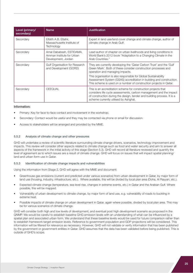
Table 5-3: Primary and secondary stakeholders
Level (primary/ secondary)
Name Justification
Primary Qatar Environment and Energy Research Institute (QEERI)
Currently undertaking research on climate change impacts and Qatar.
Primary KAHRAMA
Electricity transmission department
Water network operation and control department
District cooling services department
Conservation and efficiency department
Energy production. Energy consumption in new developments will be a major factor in GHG emissions. We need to understand their current supply and future plans.
Water supply is also heavily energy intensive and utilisation of water will result in indirect GHG emissions.
Primary Ashghal
Drainage Department
TSE use, infrastructure associated with the plan and sustainable development plans going forward.
Primary MME
Planning department
Infrastructure department
Building application department
To gain an understanding of species breakdown of green spaces and plans for regulation of designated agricultural land.
Waste breakdown, pick up plans and future landfill plans.
Primary Abdulhadi Nasser al-Marri, Head of Ministry of Environment’s Climate Change Department
Key COP21 participant, head of key government department.
Primary Ministry of Development Planning and Statistics
Scheduled to release the upcoming Development Strategy in January 2017.
Primary Parks and Garden Department The Parks Department have a planned Project that is aimed at addressing the heat island effect.
Primary United Development Company Main developers in Qatar.
Primary Qatari Diar
Primary Msheireb
Secondary Qatar Green Building Council (GBC)
A non-profit organisation providing leadership and encouraging collaboration in conducting environmentally sustainable practices for green building design and development in Qatar
Secondary Dr. Anna Grichting Solder
Assistant Professor – Qatar University
As suggested by MME. Expert in “blue urbanism”, a concept that explores the interface between cities and seas.
Secondary Anna Paolini, UNESCO Doha Impact of climate change on culture/heritage of urban areas, participant in climate change meeting of 20 March 16 on post COP21.
Secondary Jon Truby, College of Law, Qatar University
Expert in environmental law and public policy, participant in meeting of 20 March on post COP21.
Secondary Laurent Lambert, Social & Economic Survey Research Institute, Qatar University
Expert in water, energy, climate and food security, participant in meeting of 20 March on post COP21.
25Climate Change Strategy | Inception Report
Level (primary/ secondary)
Name Justification
Secondary Elfatih A.B. Eltahir, Massachusetts Institute of Technology
Expert in land use/land cover change and climate change, author of climate change in Arab Gulf.
Secondary Amal Dababseh, ESTIDAMA, Amman Institute for Urban Development, Jordan
Lead author of chapter on urban livelihoods and living conditions in World Bank’s 2012 book “Adaptation to a Changing Climate in the Arab Countries.”
Secondary Gulf Organisation for Research and Development (GORD)
They are currently developing the ‘Qatar Carbon Trust’ and the ‘Gulf Green Mark’. Both of these consider construction processes and operation and managing impacts.
This organisation is also responsible for Global Sustainability Assessment System (GSAS) accreditation in building and construction. This scheme is used on a number of construction projects in Qatar.
Secondary CEEQUAL This is an accreditation scheme for construction projects that considers life cycle assessments, carbon management and the impact of construction during the design, tender and building process. It is a scheme currently utilised by Ashghal.
Information:
• Primary: Key for face-to-face contact and involvement in the workshop.
• Secondary: Contact would be useful and they may be contacted via phone or email for discussion.
• Access to stakeholders will be arranged and provided by the MME.
5.5.2 Analysis of climate change and other pressures
GHD will undertake a review of scientific literature surrounding climate change drivers, scenarios, technology improvement and impacts. This review will consider other aspects related to climate change such as food and water security and aim to answer all aspects of the framework in the initial activity of this stage (Section 5.3). GHD will record all literature reviewed and quantify the level of agreement as to which issues are a result of climate change. GHD will focus on issues that will impact spatial planning/land and urban form use in Qatar.
5.5.3 Identification of climate change impacts and vulnerabilities
Using the information from Stage 2, GHD will agree with the MME and document:
• Greenhouse gas emissions (current and predicted under various scenarios) from urban development in Qatar, by major form of land use (housing, industry, infrastructure, etc.). Where available, this will be divided by local plan area (Doha, Al Rayyan, etc.).
• Expected climate change (temperature, sea level rise, changes in extreme events, etc.) in Qatar and the Arabian Gulf. Where possible, this will be mapped.
• Vulnerability of urban development to climate change, by major form of land use, e.g. vulnerability of roads to buckling in extreme heat.
• Possible impacts of climate change on urban development in Qatar, again where possible, divided by local plan area. This may be for various scenarios of climate change.
GHD will consider both high and low levels of development, and eventual post high development scenario as proposed in the QNMP. We would be careful to establish baseline GHG emission levels with an understanding of what can be influenced by a spatial plan and associated urban form. We understand that these baseline levels would be used for future comparison rather than to establish framework target emission levels. Reference to government population and GDP projections will be considered. This information will be filtered for relevance as necessary. However, GHD will not validate or verify information that has been published by the government or government entities in Qatar. GHD assumes that the data has been validated before being published. This is outside of GHD’s scope.

26Climate Change Strategy | Inception Report
A GIS platform will be developed by GHD to map potential impacts from climate change including, but not limited to, sea level rise (based on the ICZMP). This will provide a visual format which in turn will identify the scale and location of the potential impact on Qatar. The spatial unit will be at zone level.
5.5.4 Analysis of plans and initiatives
Using the Situation Analysis Framework, GHD will analyse the climate change related strengths and weaknesses/gaps of all key relevant plans and initiatives including
• QNV2030
• Qatar Development Strategy 2011-2016
• QNMP
• Integrated Coastal Zone Management Plan
• Qatar Flood Study
• Agreements made at COP21
• Others recommended by MME.
The proposed framework for the analysis of each plan is shown in Table 5-4.
Table 5-4: Proposed framework for analysis
Aspect Criterion (from the situation analysis framework)How the plan covers the criterion
Sou
rces
of G
HG
em
issi
ons
/ ca
uses
of c
limat
e ch
ange
(miti
gatio
n)
Urban land use:
• How the plan deals with management of land use in urban development plans (e.g. whether/where to promote more sea defences, robust locations for new developments)
Housing:
• Requirements for new homes (e.g. energy efficiency, types of structures to minimize air-conditioning requirements, use of photovoltaics etc.)
• Consideration of links between housing, employment sites, services and transport (e.g. minimize need to travel)
Industrial/economy
• Location of key industry/economic areas
• Considering sectors contributing to GHG emissions
• Management of GHG emissions in industry
Transport
• Management of transport in urban development plans (e.g. promotion of public transport, walking, cycling)
• Management of transport impacts in other plans (e.g. tighter vehicle efficiency requirements as per Euro 6, possible promotion of electric vehicles)
Infrastructure
(e.g. waste management, energy, water, waste water)
• Location of infrastructure (e.g. to minimize need to pump water over long distances)
• Infrastructure technology that minimizes GHG emissions

27Climate Change Strategy | Inception Report
Aspect Criterion (from the situation analysis framework)How the plan covers the criterion
Impa
cts
of c
limat
e ch
ange
(ada
ptat
ion)
Urban land use
• Suggestions for where new developments should / should not be sited (e.g. to avoid areas prone to sea level rise)
• Suggestions on the set back distance from the high water mark
Housing
• Location and design of homes to be more resilient in case of power outages, extreme weather etc.
• Possible technologies for the home that would be recommended / required (e.g. a ‘cool room’ that does not require air conditioning, water storage for emergencies)
• Possible suggestions for use of the homes, i.e. behavioural change
Industrial/economy
• Making best use of advantages of climate change
• Identification of sectors that would be vulnerable under future climate change scenarios (e.g. requiring uninterrupted energy supplies, vulnerable to >50 °C temperatures)
• Location and design of industrial and commercial buildings to be more resilient in case of power outages or extreme weather. Secondary impacts from traffic and access to public transport will be considered.
Infrastructure e.g. waste management, energy, water, waste water)
• Suggestions for future flood defences (or areas where managed realignment is more appropriate)
Comments (particular strengths and weaknesses):
Initial ideas for strengthening the plan (climate change mitigation and adaptation):
The analysis of the plans would then be brought together to identify strengths and weaknesses as well as any gaps. This will be compared to the benchmarks, established in Section 5.5.1, to identify existing strengths and possible improvements to the plans/initiatives.
5.5.5 Agreement on climate change impacts and vulnerabilities
GHD will utilize a range of tools to understand the impacts and vulnerabilities of urban development on and to climate change. These include the findings of the analysis, and a GIS platform to identify spatial impacts. Feedback from stakeholders will be analysed by the GHD team to understand the impacts of urban development on climate change, and the impacts on urban development that stakeholders associate with climate change. These impacts will be discussed further and mapped, where possible, to understand the scale and location of the potential impacts on Qatar.
The analysis of climate change and other pressures will highlight potential impacts and vulnerabilities resulting from climate change. These will be assessed in the context of local Qatar conditions to understand whether the identified impact/vulnerability is applicable and the scale of its impact. This will assist with determining the likelihood and consequence required to undertake a risk assessment. Multiple complementary hazards will be combined where synergies for vulnerability reduction exist – such as sea level rise and coastal development.

28Climate Change Strategy | Inception Report
5.5.6 Risk assessment of identified impacts
The GHD team will undertake an assessment of potential impacts and vulnerabilities relating to climate change. For significant impacts and vulnerabilities, a risk assessment will be carried out to understand:
• Likelihood of risk
• Associated consequence
• Potential mitigation measures
A potential framework to identify significant impacts is:
• Type of impact on GHG emissions (e.g. CO2 emissions from energy use in homes)
• Current scale of impact on GHG emissions (xxx tonnes of CO2 emissions per year attributable to housing)
• Expected future (in year 2040) scale of impact on GHG emissions in 20xx (yyy tonnes of CO2 per year attributable to housing)
• Current relevance of urban development to the impact (e.g. 93% of energy use in homes is from urban areas)
• Expected future relevance (e.g. 95% of energy use in homes is from urban areas)
• Scope of urban development planning to control the impact (e.g. location and design of homes and any requirements for homes to generate their own energy, but not energy efficiency of appliances or behavioral change)
The greater the impact, the greater the relevance of urban development, and the greater the scope of urban development planning to control the impact so the more significant the impact would be. A similar framework will be utilised to identify significant vulnerabilities.
Key impacts and vulnerabilities are likely to include:
• Urban heat island impacts including the impacts of average temperature increase and also periods of high temperature or prolonged heat waves
• Potential storms/hurricanes and associated impacts on coastal and inland areas
• Increased wind speeds and loading issues regarding structures
• Variability of rainfall, including increased probability of high precipitation events causing flooding or stress on drainage and storm water systems
• Impacts on water supply and shortages
• Impacts on emergency services and disruption to critical infrastructure.
The impacts/vulnerabilities and the approach to risk assessment will be discussed and agreed upon with the MME.
Currently the descriptor levels are qualitative; however, following review and assessment of data through Stage 3, these may be altered. The descriptors will be updated as necessary through Stage 3 to consider the relevant outcomes and risks identified in the ICZMP sea level rise report such as coastal erosion, flooding, operability and reliability impacts to key areas.
Where possible, descriptors will be assigned quantitative ranges. These ranges will be set to ensure repeatability and consistency with the risk assessment, but also in keeping with common sense for a climate change impact of the corresponding consequence descriptor. Any changes would be proposed to the MME during the progress meetings.
The likelihood descriptors are consistent with other work GHD has undertaken including all levels of SEA, and follows the process approved by the Ministry of Environment (now MME). We believe following this format as closely as possible is important for consistency between assessment of the plans and for comparison of different assessments, should this be undertaken by the MME in future.

29Climate Change Strategy | Inception Report
Examples of the risk assessment are provided below:
• Risk matrix (Table 5-5)
• Consequence and likelihood descriptors (Table 5-6 and Table 5-7)
• Risk assessment table (Table 5-8)
Table 5-5: Consequence vs. Likelihood
Consequence
Negligible Minor Moderate Major Severe
Like
liho
od
Almost certain Moderate High High Extreme Extreme
Likely Moderate Moderate High High Extreme
Possible Low Moderate High High High
Unlikely Low Low Moderate Moderate High
Rare Low Low Moderate Moderate High
Table 5-6: Consequence descriptors
Consequence Descriptor
Significant • Significant reduction in water quality, water quantity, air quality, soil quality, biodiversity (marine or terrestrial), population health and or quality of life.
• Significant increase of pressure on food security, energy and water security.
• Significant increase in number or intensity of natural events.
• Significant increase in land area vulnerable to sea level rise, storm surge or flooding.
Major • Major reduction in water quality, water quantity, air quality, soil quality, biodiversity (marine or terrestrial), population health and or quality of life.
• Major increase of pressure on food security, energy and water security.
• Major increase in number or intensity of natural events.
• Major increase in land area vulnerable to sea level rise, storm surge or flooding.
Moderate • Moderate reduction in water quality, water quantity, air quality, soil quality, biodiversity (marine or terrestrial), population health and or quality of life.
• Moderate increase of pressure on food security, energy and water security.
• Moderate increase in number or intensity of natural events.
• Moderate increase in land area vulnerable to sea level rise, storm surge or flooding.

30Climate Change Strategy | Inception Report
Consequence Descriptor
Minor • Minor reduction in water quality, water quantity, air quality, soil quality, biodiversity (marine or terrestrial), population health and or quality of life.
• Minor increase of pressure on food security, energy and water security.
• Minor increase in number or intensity of natural events.
• Minor increase in land area vulnerable to sea level rise, storm surge or flooding.
Negligible • Negligible reduction in water quality, water quantity, air quality, soil quality, biodiversity (marine or terrestrial), population health and or quality of life.
• Negligible increase of pressure on food security, energy and water security.
• Negligible increase in number or intensity of natural events.
• Negligible increase in land area vulnerable to sea level rise, storm surge or flooding.
Table 5-7: Likelihood descriptors
Likelihood Descriptor
Almost certain Twenty events between 2010 and 2032
Ongoing cumulative impact
Likely Ten events between 2010 and 2032
Ongoing impact lasting up to five years
Possible Five events between 2010 and 2032
Ongoing impact lasting up to one year
Unlikely One event between 2010 and 2032
Ongoing impact lasting up to one month
Rare Will not likely occur between 2010 and 2032
No ongoing cumulative impact
5.5.7 Identification of priority risks / impacts
Following the outcomes of the risk assessment, it is envisaged that these would in turn inform the priority items requiring analysis that is more detailed at a later stage of the engagement. These will then be filtered down to a more manageable list appropriate for consideration in the next stages.
In the context of the CCS project, these will span social and environmental impacts associated with land use and development as contributing to or affected by climate change scenarios. In addition, ICZMP climate change and sea level rise reports will be reviewed, and priority risks and impacts relevant to the CCS project only will be identified and incorporated, as necessary.

31Climate Change Strategy | Inception Report
Tab
le 5
-8:
Ris
k as
sess
men
t ta
ble
Item
Clim
ate
chan
ge
imp
act/
vuln
erab
ility
Imp
act
Co
nseq
uenc
eLi
kelih
oo
dR
isk
Miti
gat
ion
/ A
dap
tatio
n M
easu
re
(M/A
M)
Po
st M
/A M
C
ons
eque
nce
Po
st M
/A M
Li
kelih
oo
dP
ost
M/A
M
Ris
k

32Climate Change Strategy | Inception Report
5.6 Presentation workshop
A presentation workshop will be undertaken with the MME and relevant stakeholders to present Stage 3 findings. The presentation slides will be issued to the MME for review 10 working days before the scheduled presentation workshop.
5.7 Limitations
The outcomes and timing of Stage 3 will depend on the availability and timing of data in Stage 2. For instance, where only national level data are available, disaggregation by local plan area will not be possible.
We have assumed that a maximum of 40 plans/initiatives will be analysed concisely, up to 12 plans/initiatives will be analysed in detail, up to seven countries will be used as benchmarks, and up to 20 key impacts and vulnerabilities will be subject to risk analysis.
In case a specific set of data is not available from the MME, GHD will source data from the public domain. Where this is not available, GHD will utilise regional (Arabian Gulf/GCC) or international data, depending on the context during stage 2’s review of literature and regional studies to extrapolate relevant data and information that can be utilised as an alternative.
5.8 Deliverables
• Situation Analysis and Risk Assessment Report
• One presentation workshop 6

6
Stage 4: Strategy
development and action plans
34Climate Change Strategy | Inception Report
6.0 Stage 4: Strategy development and action plans
6.1 Introduction
Based on the findings of stages 1, 2 and 3, international standards and benchmarks, and principal Qatari Initiatives (e.g. QNV2030), GHD will develop the Climate Change Strategy (CCS) for Urban Planning and Urban Development in the State of Qatar. Depending on the findings of the Stage 3 workshops, this could be a free-standing strategy, or recommended policies and statements for inclusion in existing and future urban development plans. GHD will also develop an implementation plan and/or action plans to ensure that the CCS is implemented effectively and that its effectiveness is monitored.
This will be undertaken through the following tasks:
• Identifying the role and setting the vision and objectives of the CCS
• Proposing mitigation and adaptation options
• Discussing these options in workshops and with the MME
• Agreeing on preferred options with the MME
• Developing action plans / implementation plan
• Preparing a report supporting the action plans / implementation plan
• Presenting the CCS and associated action plans
Examples of mitigation and adaptation options are provided in Section 6.4.
6.2 MME input
GHD requires input from the MME. Details of the action required is provided in Table 6-1.
Table 6-1: Action from MME
Item Action
4aReview and comments of Strategy Report and Action Plans (Detailed information and flow of document review is presented in Section 3.12 of the Project Management and Communication Plan)
4b Written approval of Strategy Report and Action Plans
6.3 CCS role, vision and objectives
6.3.1 Development of role vision and objectives
When developing the CCS, GHD will take into consideration and align with Qatar’s long term planning and strategy objectives (including 2022 FIFA World Cup Projects) and the agreements made at COP21. This will be a tailored strategy plan that incorporates Qatar’s unique needs, goals and aspirations. It will be critical to achieve integration with QNV2030 and commitments made at Paris, and to ensure climate change mitigation and adaptation are aligned with this and other strategies.
6
35Climate Change Strategy | Inception Report
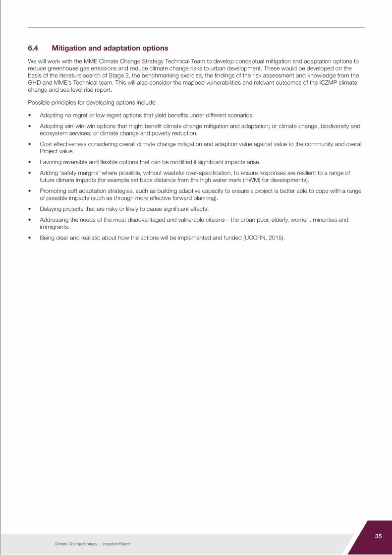
6.4 Mitigation and adaptation options
We will work with the MME Climate Change Strategy Technical Team to develop conceptual mitigation and adaptation options to reduce greenhouse gas emissions and reduce climate change risks to urban development. These would be developed on the basis of the literature search of Stage 2, the benchmarking exercise, the findings of the risk assessment and knowledge from the GHD and MME’s Technical team. This will also consider the mapped vulnerabilities and relevant outcomes of the ICZMP climate change and sea level rise report.
Possible principles for developing options include:
• Adopting no regret or low regret options that yield benefits under different scenarios.
• Adopting win-win-win options that might benefit climate change mitigation and adaptation; or climate change, biodiversity and ecosystem services; or climate change and poverty reduction.
• Cost effectiveness considering overall climate change mitigation and adaption value against value to the community and overall Project value.
• Favoring reversible and flexible options that can be modified if significant impacts arise.
• Adding ‘safety margins’ where possible, without wasteful over-specification, to ensure responses are resilient to a range of future climate impacts (for example set back distance from the high water mark (HWM) for developments).
• Promoting soft adaptation strategies, such as building adaptive capacity to ensure a project is better able to cope with a range of possible impacts (such as through more effective forward planning).
• Delaying projects that are risky or likely to cause significant effects.
• Addressing the needs of the most disadvantaged and vulnerable citizens – the urban poor, elderly, women, minorities and immigrants.
• Being clear and realistic about how the actions will be implemented and funded (UCCRN, 2015).

36Climate Change Strategy | Inception Report
Table 6-2 lists some possible options that could be considered during this stage.
Table 6-2: Possible options for climate change mitigation and adaptation for urban development plans in Qatar
Aspect Mitigation Adaptation
Land use Integrated planning to reduce reliance on cars and lorries
Integrated planning to maximize the efficiency of infrastructure and systems
Reducing urban heat island effect through infrastructure and urban design, planning, codes and initiatives
Encouragement of parks and other green areas, including water sensitive urban design which also integrate with vegetation and heat island reduction strategies
Avoiding further intensification of coastal development
Management and installation of appropriate coastal protection works (soft and/or hard engineering structures)
Housing Building design criteria to reduce HVAC energy load
Suggestions for where to locate (and avoid locating) housing
Building design criteria to cope with anticipated changes in temperature, possible power outages, etc.
Industry/ economy
Energy efficiency requirements for buildings and technology
Suggestions for where to locate (and avoid locating) employment sites
Building design criteria as above
Suggestions for future-proof and resilient industry types to support through the planning process
Transport Public and private clean energy transport infrastructure
Active transport systems
Parking controls and other disincentives to using cars and lorries
Ensuring the robustness of transport infrastructure to e.g. road and rail buckling in high temperatures, bus stop comfort in high temperatures, etc.
Infrastructure Clean energy system alternatives
Water efficient systems and water re-use / recycling
Reducing energy demand / reliance on desalinated water supply
Best practice waste management systems and infrastructure
Ensuring robustness and integrity of water supply to accommodate prolonged drought periods and increased population
Improved stormwater capture to reduce flooding and provide an alternative water source
Food security and alternative food supply options
Energy security and energy supply reliability
Suggestions for future sea defences or where to encourage ‘managed retreat’ of the shore in urban areas
Identification of the need for new infrastructure and/or retrofits of existing infrastructure to cope with anticipated weather patterns
Possible development of relocatable or sacrificial structures

37Climate Change Strategy | Inception Report
Options will include actions for both the public and the private sector. They will include actions related to the industrial/employment sector, which has traditionally been under-represented in urban development climate change policies, as shown in Figure 6.1.
Figure 6.1: Where cities have made measurable reduction (Source: MIT, 2014)
In terms of scale, the options will primarily focus on the city, and to a lesser extent on the community scale. Examples of possible approaches are shown in Figure 6.2.
Figure 6.2: Strategies (Source: UCCRN, 2015)
Although there may be potential differences between the level of development, infrastructure and community expectations in an international setting versus that of Qatar, the overall concepts of community, science, engineering, consultation and decision-making processes are similar.

38Climate Change Strategy | Inception Report
6.5 Considering options for managing climate change impacts and vulnerabilities
Based on previous experience, the development of agreed mitigation and adaptation strategies is best undertaken in a workshop environment where a range of stakeholders are able to provide their professional advice on what is likely, necessary and feasible. At such a workshop, local project managers, planning team and specialist staff can also ensure that mitigation and adaptation measures will work in, and be applied correctly, to our local context. As such, GHD will incorporate the acceptability feedback in this stakeholder meeting to further develop and improve proposed strategies.
The workshop may also provide a good forum in which to score, rank and weight initial options developed during the consultation and development phase against agreed social, environmental and economic criteria of Qatar.
Requested stakeholders are shown in Table 5-3. An agenda will be issued to all attendees at least five working days before the workshop.
The presentation slides for the workshop will be issued to the MME for review 10 working days before the scheduled workshop.
6.6 Agreeing upon preferred options (regulatory requirements) with the MME
Once the relevant set of mitigation and adaptation options are prepared, a series of preferred options – including proposed regulatory requirements for urban planning – would be agreed upon with the MME. The regulatory requirements are likely to include urban planning policies, standards, guidelines and recommendations for non-planning related initiatives. These requirements will:
• Enable filling of existing gaps in regulatory requirements
• Clearly link to existing Qatari laws, transboundary treaties, international conventions, and other initiatives
• Be benchmarked against regional and international approaches
• Utilize any regulations (e.g. QNMP) and voluntary initiatives (e.g. GSAS) currently existing in Qatar
The agreed upon regulatory requirements will focus on achievable and realistic applications that can be implemented effectively given the context of local requirements and needs. It is envisaged that this initiative will represent an opportunity for Qatar to:
• Plan a critical role in ‘future proofing’ Qatar as a leading global state
• Articulate longer-term goals, aspirations and vision for sustainable and livable communities
• Determine appropriate and priority actions to be implemented to mitigate and adapt to a changing climate, informed by an understanding of the level of risk that might arise under certain events and climate scenarios
• Develop an approach for continued monitoring and assessment to identify and adapt to potential climate changes and their associated risks
6.7 Development of action plans
Once the regulatory requirements are proposed, GHD will develop action plans (one of which will be an implementation plan) to ensure timely and full implementation of these requirements. This could include suggesting changes to existing urban development plans and development of a new freestanding CCS (guidance documents, etc.). The precise wording of the CCS policies and/or planning policies will be agreed upon at this stage.
The action plans, including implementation plan, will also propose:
• Timings for implementation
• Responsibility for implementation
• Targets, if appropriate, to be achieved through the regulatory requirements
• Monitoring framework for monitoring and assessing the effectiveness of the regulatory requirements

39Climate Change Strategy | Inception Report
6.8 Presentation workshop
A presentation workshop will be undertaken with MME and relevant stakeholders to present Stage 4 findings. The presentation slides will be issued to the MME for review 10 working days before the scheduled presentation workshop.
6.9 Limitations
The development of regulatory requirements and action/implementation plans depends on the data of Stage 2, and agreement on expected climate change and risk assessment of Stage 3. There is the possibility that the choice of preferred options (the regulatory requirements) will be politically contentious and so held up on grounds outside of GHD’s control. We will also need to agree with the MME whether the climate change measures will be integrated into existing plans or developed through a separate CCS.
Up to five action plans, including an implementation plan will be developed during this stage.
6.10 Deliverables
• CCS for Urban Planning and Urban Development Sector
• Action plans
• One presentation workshop

40Climate Change Strategy | Inception Report
7

7Stage 5: Climate
change impact assessment tools
and studies

42Climate Change Strategy | Inception Report
7.0 Stage 5: Climate change impact assessment tools and studies
7.1 Introduction
The development of the Climate Change Impact Assessment Tools (CCIAT) and associated User’s Guide is a key output of this project. The previous stages will be fundamental to formulating the Tool and User’s Guide. Accordingly, GHD will develop formats to assess GHG impacts on urban development and assets, as well as a climate data tool and durability and temperature guidelines, all of which will form the CCIAT Tool and User’s Guide. Details are outlined in the following sections.
To summarize, the first three parts of the tool are GHG estimators, based on requirements of Section 2.B.3.5 of the CCS ToR (TC-B-55-2105). A climate data tool will be developed in addition to the previously mentioned GHG estimations (refer to Section 7.7).
We understand emission data will not be available. Sections 7.4, 7.5 and 7.6 discuss how each tool will utilize information and data to calculate GHG emissions for areas or developments. For example, the GHG Urban Planning Tool will be developed to integrate with geographical information systems (GIS) data to determine a range of planning land types and develop robust default GHG emissions for each land type area based on a square metre land/building/asset basis. To provide input into this model, a detailed evaluation and benchmarking of known GHG emissions and default factors will be factored to apply to each urban planning category. This will be developed to suit local conditions in Qatar.
7.2 MME input
GHD requires input from the MME. Details of the action required are provided in Table 7-1. It is important to note that software development is a very iterative process and MME input is required at frequent intervals during the process to ensure the tool caters to the MME team’s needs.
Table 7-1: Action from MME
Item Action
5a MME PM (and relevant stakeholder staff) to review and approve specifications of methodologies and emission factors to be used by the climate change tools with the MME
5b MME to review and approve mock screen layout
5c MME to participate in sandbox testing and provide feedback
5d MME staff to attend training sessions associated with CCIAT tools
5e MME staff to attend training sessions associated with CCIAT tools
5f Review and comments of CCIAT Tools and user guide (Detailed information and flow of document review is presented in Section 3.12 of the Project Management and Communication Plan)
5g Written approval of CCIAT Tools
5h Written approval of CCIAT Tools User Guide
7

43Climate Change Strategy | Inception Report
7.3 Tool Development
7.3.1 Overarching tool development process
Development of each tool would follow the same basic process and include the following tasks:
• Develop methodologies and emission factors to be used by the climate change tools
• Identify data requirements and collect additional data to support emission factor development (as undertaken in the stage 2 data collection)
• Finalize specifications of methodologies and emission factors to be used by the climate change tools with the MME
• Prepare mock input screens and a tool-generated report outline for review and comment by stakeholders
• Start software development process (database tables, queries, GIS integration as needed, and tool front end)
• Test the developed tool to identify any software bugs
• Fix any identified bugs during testing
• Present to MME for sandbox testing
• Fix any bugs identified during sandbox testing by the MME and their selected stakeholders
• Rollout and implement developed tools
This tool development process will be accomplished in two phases:
• Methodology development
• Software development
7.3.2 Methodology development
The methodology development phase will include identifying and evaluating all phases of proposed project development and operational activities that have an impact on climate change as specified in the spatial planning framework.
During the methodology development, GHD will identify the calculation methodologies and GHG emission factor development for different project development phases. Should additional data needs be identified, this data will be obtained from appropriate stakeholders during this phase. All assumptions and data sources used in GHG emission factor development will be documented in the user’s guide to be made available along with the developed climate change tools.
Once the draft methodology to be used in the climate change tools has been prepared, it will be submitted for peer review. GHD will address any comments and suggestions in the draft methodology by the peer review team to complete the methodology development phase.
7.3.3 Software development
GHD will initiate the software development phase after completion of the methodology development phase. Before embarking on any programming tasks, GHD will prepare mock input screens and a tool-generated report outline to clearly identify the scope for software development. These mock screens and the report will be submitted to the MME and peer review team for comment.
Once the tool appearance and functionality are agreed on, the software development process (database tables, queries, report templates, tool front end, and GIS integration as appropriate) will be initiated. Following the software programming, the GHD team will test the developed tools to ensure that any potential programming bugs are identified and fixed as part of the tool development process. After completing the programming and testing activities, these tools will be made available to stakeholders for sandbox testing. The GHD team will fix any bugs encountered by the stakeholders during sandbox testing of the tools and rollout the final product for implementation. A user’s guide for all the developed tools will also be made available during the final implementation task.
A sandbox test is when an isolated environment is utilised to evaluate, monitor or test the codes in the developed software (Techopedia, 2016).

44Climate Change Strategy | Inception Report
7.4 GHG urban planning tool
The first tool will be developed to integrate with geographical information systems (GIS) data to determine a range of planning land types and develop robust default GHG emissions for each land type area based on a square metre land/building/asset basis. To provide input into the model detailed evaluation and benchmarking of known GHG emissions and default factors will be factored to apply to each urban planning category. This will be developed to suit local conditions in Qatar.
The data output will be based on GHG per quantity of land/building and will integrate with GIS data to provide a representative GHG factor.
7.5 GHG asset or building application tool
GHD will develop a second tool to be applied at a single asset or precinct level for new developments.
The asset/building application tool will be designed as a calculator in which developers can provide inputs – material quantities and construction activities to determine both a total GHG emission for the development but also apply this on a square metre floorspace/land area basis.
This data can then be applied to planning guidelines for regions or zones in which the MME can indicate default ranges for GHG emissions for new developments.
By developing this tool and having this available to developers, it will allow the MME to manage GHG emissions from new developments under future planning codes.
Developers can submit their estimated GHG emissions using the tool with planning applications and the consenting authorities can indicate what parameters can be applied in terms of GHG per square metre or total emissions. This can be audited at project completion to confirm compliance with the GHG requirements.
7.6 GHG emission tracker
GHD will develop a separate tool, which will also be developed utilising the International Greenhouse Gas Protocols, to enable authorities to track emissions in specific organisations, assets or sites.
The tracker will be a calculator design to input data on energy use, vegetated area, and other emissions sources such as fugitive emissions.
This tool will provide base level data on annual GHG emissions emitted by the defined entity, asset or organisation boundary.
This tool can be used for specific high emitters or controversial developments/operations to monitor GHG use and potential savings.
7.7 Climate data tool
GHD will develop a Climate Data Tool that will track key climate change indicators across five-year intervals and integrate with GIS data for regions across Qatar (e.g. 10 km square regions). Key features for this model are likely to include:
• Tracking output for rainfall averages, temperature averages, wind speed averages, solar radiation averages and, from other studies, Sea Level Rise (SLR) and Flood data.
• High-end and low-end forecast data can be applied in the model based on IPCC scenarios – to be determined with the client.
• Using this data to be accessible and applicable for developers/agencies to determine impacts for future developments and urban planning.

45Climate Change Strategy | Inception Report
GHD will assist the development of a Durability and Temperature guideline for infrastructure, buildings and materials, which will include:
• A guideline manual for best practice application of design and materials for infrastructure and buildings to enhance durability; and
• Guidelines that will specifically focus on heat impacts and asset degradation.
Provide a streamlined approach for best practice. As there are so many variables on assets and material durability can only be measured over long-term cycles, it is felt a best practice-planning guide will provide the best approach to integrating durability into built structures.
If warranted planning authorities could adopt the guidelines as requirements for planning permits being granted.
The above aspects will allow GHD to undertake the following assessments:
• Estimates of sea level rise, based on international predictions, and associate potential impacts;
• Potential depths of inundation, based on international predictions, and associate potential impacts; and
• Proposal of mitigation measures based on the outcomes of the assessments.
Information from other MME studies, Integrated Coastal Zone Management Plan and State of Qatar Flood Study, will be utilized in order to develop a consistent and cohesive approach.
7.8 MME training
GHD will provide up to three members of the MME staff with training in using the CCIAT tools developed for the Project. The training will occur over two days and will provide the MME with an opportunity to work with the tool developers in gaining a better understanding of the tools.
7.9 Deliverables
• CCIAT Tools and user guide

46Climate Change Strategy | Inception Report
8

8
Peer review

48Climate Change Strategy | Inception Report
8.0 Peer review
8.1 Introduction
The Peer Review process is a key aspect of this contract. It will provide an independent, third party review of all deliverables. The peer review was chosen by the MME and has been engaged by GHD. Details on communication protocol and other project management issues are detailed in Project Management Plan (ref: 75/11199/102888) and Communications Plan (ref: 75/11199/102973).
8.2 MME input
GHD requires input from the MME. Details of the action required is provided in Table 8-1.
Table 8-1: Action from MME
Item Action
6a Provision of peer reviewers contact details
8.3 Peer review contact
GHD will primary be dealing with the Peer Review Panel Lead, Mr Ashantha Goonetileke. He will coordinate with the other peer reviewers, David Hood and Dr Evan Thomas.
8.4 Peer review tasks
The peer review team shall review and provide comments on all documentation, prior to submission to the MME. This will include all deliverables detailed in Table 8-2.
Table 8-2: Deliverables for Peer Review
Stage Deliverable
1 Project Inception Report
2 Data collection and assessment report
3 Situation Framework and Analysis Report
4 Strategy and Action Plans
5 CCIAT
User manual
8.5 Peer review process
GHD will follow the peer review process detailed in the Project Management and Communications Plan (ref: 75/11199/102888) This will include:
• All deliverables to be submitted by GHD directly to Mr Ashantha
• Review comments to be sent from Ashantha to GHD
• GHD to respond to the comments and update the document accordingly and submit to the MME for review
8

9
References

50Climate Change Strategy | Inception Report
9.0 References
Forbes (2012) The World’s Richest Countries. Accessed on 01 June 2016 through http://www.forbes.com/sites/bethgreenfield/2012/02/22/the-worlds-richest-countries/#ca2e26697bd5
IPCC (2001) Climate change 2001: Impacts, Adaptation and Vulnerability, Summary for Policymakers, WMO
MIT (2014) Progress and challenges in the Urban Governance of Climate Change: Results of a Global Survey.
MMUP (2015) Tender Documents for the Provision of Climate Change Strategy for Urban Planning and Urban Development Sector in the State of Qatar – Part Two: Terms of Engagement.
QNMP (2010) Qatar National Development Framework (Final Draft Revised)
Techopedia (2016) Sandbox. Accessed on 19 June 2016 through https://www.techopedia.com/definition/27681/sandbox-software-development
Urban Climate Change Research Network (UCCRN) (2015) Climate Change and Cities: Second Assessment Report of the Urban Climate Change Research Network – Summary for City Leaders
The World Bank. 2016. Climate Change Knowledge Portal. http://sdwebx.worldbank.org/climateportal/index.cfm?page=country_vulnerabilities&ThisRegion=Middle%20East&ThisCcode=QAT#. Accessed on 25 June 2016.
9

51Climate Change Strategy | Inception Report

DisclaimerThis report: has been prepared by GHD for the Ministry of Municipality and Environment and may only be used and relied on by the Ministry of Municipality and Environment for the purpose agreed on between GHD and the Ministry of Municipality and Environment.
GHD otherwise disclaims responsibility to any person other than the Ministry of Municipality and Environment arising in connection with this report. GHD also excludes implied warranties and conditions, to the extent legally permissible.
The services undertaken by GHD in connection with preparing this report were limited to those specifically detailed in the report and are subject to the scope limitations set out in the report.
The opinions, conclusions and any recommendations in this report are based on conditions encountered and information reviewed at the date of preparation of the report. GHD has no responsibility or obligation to update this report to account for events or changes occurring subsequent to the date that the report was prepared.
The opinions, conclusions and any recommendations in this report are based on assumptions made by GHD described in this report (refer to each section of this report). GHD disclaims liability arising from any of the assumptions being incorrect.
GHD has prepared this report on the basis of information provided by the Ministry of Municipality and Environment and others who provided information to GHD (including Government authorities], which GHD has not independently verified or checked beyond the agreed scope of work. GHD does not accept liability in connection with such unverified information, including errors and
omissions in the report, which were caused by errors or omissions in that information.


Ministry of Municipality and Environment
Inception Report
Climate Change Strategy for Urban Planning and Urban Development
Sector in the State of Qatar