incident name - national interagency fire center · web viewan incident’s complexity can change...
TRANSCRIPT
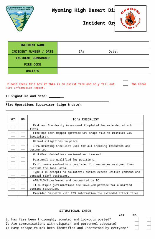
INCIDENT NAME
INCIDENT NUMBER / DATE IA# Date:
INCIDENT COMMANDER FIRE CODE UNIT/FO
Please check this box if this is an assist fire and only fill out the Final Fire Information Report.
IC Signature and date: ______ _______________________________________________________Fire Operations Supervisor (sign & date): ____________________________________
YES NO IC’s CHECKLIST
Risk and Complexity Assessment Completed for extended attack fires.
Fire has been mapped (provide GPS shape file to District GIS Specialist).
Hazard mitigations in place.
IRPG Briefing Checklist used for all incoming resources and documented.
Work/Rest Guidelines reviewed and tracked.
Personnel are qualified for positions.
Performance evaluations completed for resources assigned from outside the local area.
Type 3 IC accepts no collateral duties except unified command and general staff positions.
AAR/PLOWS performed and documented by IC.
If multiple jurisdictions are involved provide for a unified command structure.
Provided Dispatch with 209 information for extended attack fires.
SITUATIONAL CHECKYes No
L: Has fire been thoroughly scouted and lookouts posted? C: Are communications with dispatch and personnel adequate? E: Have escape routes been identified and understood by everyone? S: Have safety zones been identified and understood by everyone?
Provide explanation for “NO” answers:
Wyoming High Desert District
Incident Organizer- 2017
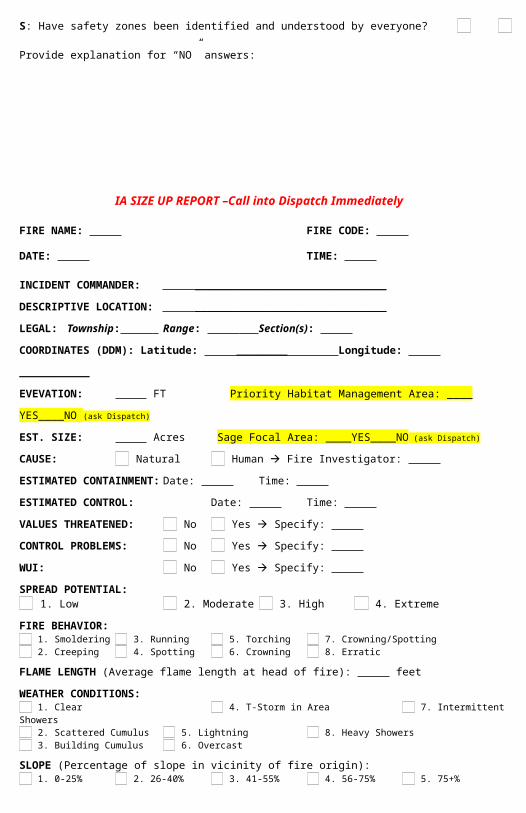
IA SIZE UP REPORT –Call into Dispatch Immediately
FIRE NAME: FIRE CODE: DATE: TIME:
INCIDENT COMMANDER: ______________________________
DESCRIPTIVE LOCATION: ______________________________
LEGAL: Township: Range: Section(s): COORDINATES (DDM): Latitude: ________ Longitude: ___________
EVEVATION: FT Priority Habitat Management Area: ____ YES____NO (ask Dispatch)
EST. SIZE: Acres Sage Focal Area: ____YES____NO (ask Dispatch)
CAUSE: Natural Human Fire Investigator: ESTIMATED CONTAINMENT: Date: Time: ESTIMATED CONTROL: Date: Time: VALUES THREATENED: No Yes Specify: CONTROL PROBLEMS: No Yes Specify: WUI: No Yes Specify: SPREAD POTENTIAL:
1. Low 2. Moderate 3. High 4. Extreme
FIRE BEHAVIOR: 1. Smoldering 3. Running 5. Torching 7. Crowning/Spotting 2. Creeping 4. Spotting 6. Crowning 8. Erratic
FLAME LENGTH (Average flame length at head of fire): feet
WEATHER CONDITIONS: 1. Clear 4. T-Storm in Area 7. Intermittent Showers 2. Scattered Cumulus 5. Lightning 8. Heavy Showers 3. Building Cumulus 6. Overcast
SLOPE (Percentage of slope in vicinity of fire origin): 1. 0-25% 2. 26-40% 3. 41-55% 4. 56-75% 5. 75+%
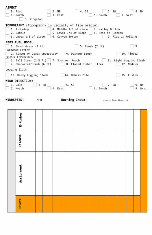
ASPECT 0. Flat 2. NE 4. SE 6. SW 8. NW 1. North 3. East 5. South 7. West 9. Ridgetop
TOPOGRAPHY (Topography in vicinity of fire origin): 1. Ridgetop 4. Middle 1/3 of slope 7. Valley Bottom 2. Saddle 5. Lower 1/3 of slope 8. Mesa or Plateau 3. Upper 1/3 of slope 6. Canyon Bottom 9. Flat or Rolling
FBPS FUEL MODEL: 1. Short Grass (1 ft) 5. Brush (2 ft) 9. Hardwood Litter 2. Timber w/ Grass Understory 6. Dormant Brush 10. Timber (Litter & Understory) 3. Tall Grass (2 ½ ft) 7. Southern Rough 11. Light Logging Slash 4. Chaparral/Brush (6 ft) 8. Closed Timber Litter 12. Medium Logging Slash
13. Heavy Logging Slash 14. Debris Pile 15. Custom
WIND DIRECTION: 1. Calm 3. NE 5. SE 7. SW 9. NW 2. North 4. East 6. South 8. West
WINDSPEED: MPH Burning Index: (request from dispatch)
STAT
US
SUM
MAR
Y
E-N
umbe
r
DO
CUM
ENT
BRIE
FIN
G F
OR
ALL
INCO
MIN
G R
ESO
URC
ES (
use
insi
de b
ack
cove
r pa
ge o
f IRP
G)
Rel
ease
Ti
me
Ass
ignm
ent
Brie
fed
No.
of
Peop
le
Arr
ival
Ti
me
ETA
/OS
Res
ourc
e Ty
pe
Res
ourc
e ID
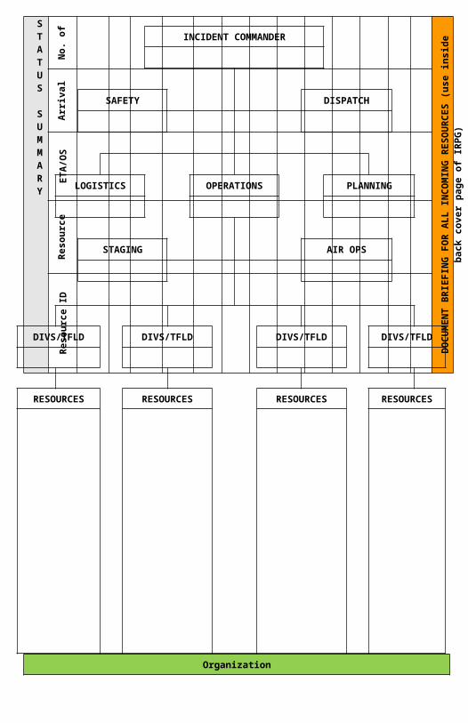
INCIDENT COMMANDER
SAFETY DISPATCH
LOGISTICS OPERATIONS PLANNING
STAGING AIR OPS
DIVS/TFLD DIVS/TFLD DIVS/TFLD DIVS/TFLD
RESOURCES RESOURCES RESOURCES RESOURCES
Organization
Wildland Fire Risk and Complexity Assessment
The Wildland Fire Risk and Complexity Assessment should be used to evaluate firefighter safety issues, assess risk, and identify the appropriate incident management organization. Determining incident complexity is a subjec-tive process based on examining a combination of indicators or factors. An incident’s complexity can change over time; incident managers should periodically re-evaluate incident complexity to ensure that the incident is managed properly with the right resources.
Instructions:
Incident Commanders should complete Part A and Part B and relay this information to the Agency Administrator. If the fire exceeds initial attack or will be managed to accomplish resource management objectives, Incident Com-manders should also complete Part C and provide the information to the Agency Administrator. Part A: Fire-fighter Safety Assessment
Evaluate the following items, mitigate as necessary, and note any concerns, mitigations, or other informa-tion.
Evaluate these items Concerns, mitigations, notes
LCES
Fire Orders and Watch Out Situations
Multiple operational periods have occurred without achieving initial objectives
Incident personnel are overextended men-tally and/or physically and are affected by cumulative fatigue.
Communication is ineffective with tactical resources and/or dispatch.
Operations are at the limit of span of con-trol.
Aviation operations are complex and/or avi-ation oversight is lacking.
Logistical support for the incident is inade-quate or difficult.
Part B: Relative Risk AssessmentValues Notes/Mitigation
B1. Infrastructure/Natural/Cultural ConcernsBased on the number and kinds of values to be protected, and the difficulty to protect them, rank this element low, moderate, or high.Considerations: key resources potentially affected by the fire such as urban interface, structures, critical municipal watershed, commercial timber, developments, recreational facilities, power/pipelines, communication sites, highways, potential for evacuation, unique natural resources, designated areas (i.e. wilderness), T&E species habitat, and cultural sites.
L M H
B2. Proximity and Threat of Fire to ValuesEvaluate the potential threat to values based on their prox-imity to the fire, and rank this element low, moderate, or high.
LFar
M HNear
B3.Social/Economic ConcernsEvaluate the potential impacts of the fire to social and/or economic concerns, and rank this element low, moderate, or high. Considerations: impacts to social or economic concerns of an individual, business, community or other stakeholder; degree of support for the wildland fire program and resulting fire effects; other fire management jurisdictions; tribal subsistence or gather-ing of natural resources; air quality regulatory requirements; public tolerance of smoke, including health impacts; potential for evacuation and ingress/egress routes; and restrictions and/or closures in effect or being considered.
L M H
Hazards Notes/MitigationB4. Fuel ConditionsConsider fuel conditions ahead of the fire and rank this ele-ment low, moderate, or high.Evaluate fuel conditions that exhibit high ROS and intensity for your area, such as those caused by invasive species or insect/dis-ease outbreaks; and/or continuity of fuels.
L M H
B5. Fire BehaviorEvaluate the current and expected fire behavior and rank this element low, moderate, or high. Considerations: intensity; rates of spread; crowning; profuse or long-range spotting.
L M H
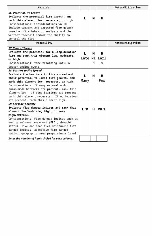
B6. Potential Fire GrowthEvaluate the potential fire growth, and rank this element low, moderate, or high.Considerations: Considerations would include current and ex-pected fire growth based on fire behavior analysis and the weather forecast and/or the ability to control the fire.
L M H
Probability Notes/MitigationB7. Time of SeasonEvaluate the potential for a long-duration fire and rank this element low, moderate, or high. Considerations: time remaining until a season ending event.
LLate
MMid
HEarly
B8. Barriers to Fire SpreadEvaluate the barriers to fire spread and their potential to limit fire growth, and rank this element low, moderate, or high. Considerations: If many natural and/or human-made bar-riers are present, rank this element low. If some barriers are present, rank this element moderate. If no barriers are present, rank this element high.
LMany
M HFew
B9. Seasonal SeverityEvaluate fire danger indices and rank this element low/mod-erate, high, or very high/extreme.Considerations: Fire danger indices such as energy release com-ponent (ERC); drought status; live and dead fuel moistures; fire danger indices; adjective fire danger rating; geographic area pre-paredness level.
L/M H VH/E
Enter the number of items circled for each column.
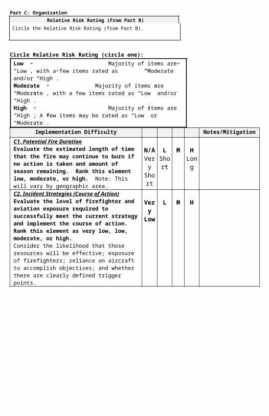
Part C: OrganizationRelative Risk Rating (From Part B)
Circle the Relative Risk Rating (from Part B).H
Circle Relative Risk Rating (circle one): Low Majority of items are “Low”, with a few items rated as “Moderate” and/or “High”. Moderate Majority of items are “Moderate”, with a few items rated as “Low” and/or “High”.High Majority of items are “High”; A few items may be rated as “Low” or “Moderate”.
Implementation Difficulty Notes/MitigationC1. Potential Fire DurationEvaluate the estimated length of time that the fire may continue to burn if no action is taken and amount of season remaining. Rank this element low, moderate, or high. Note: This will vary by geographic area.
N/AVery Shor
t
LShor
t
M HLong
C2. Incident Strategies (Course of Action)Evaluate the level of firefighter and aviation exposure required to successfully meet the current strategy and implement the course of action. Rank this element as very low, low, moderate, or high.Consider the likelihood that those resources will be ef-fective; exposure of firefighters; reliance on aircraft to accomplish objectives; and whether there are clearly de-fined trigger points.
Very Low
L M H
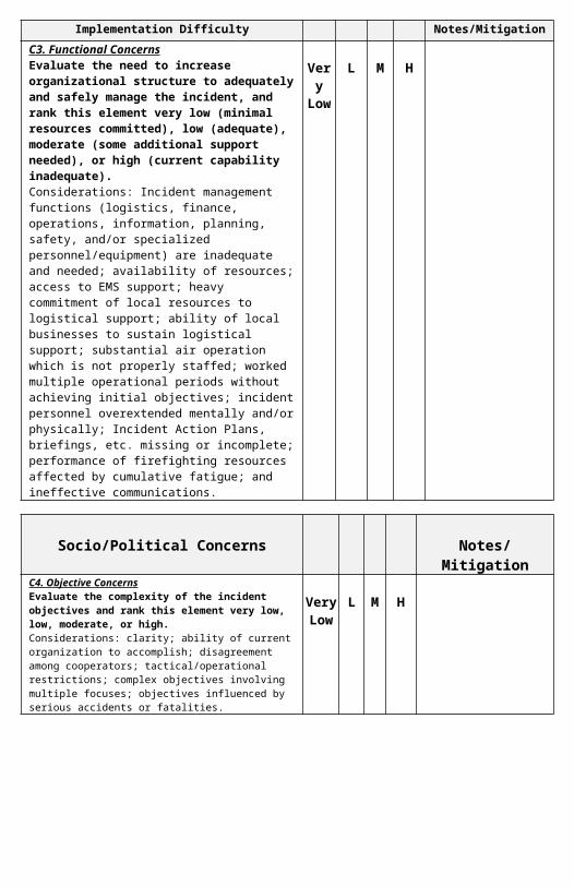
C3. Functional ConcernsEvaluate the need to increase organizational struc-ture to adequately and safely manage the incident, and rank this element very low (minimal resources committed), low (adequate), moderate (some addi-tional support needed), or high (current capability in-adequate). Considerations: Incident management functions (logis-tics, finance, operations, information, planning, safety, and/or specialized personnel/equipment) are inadequate and needed; availability of resources; access to EMS support; heavy commitment of local resources to logisti-cal support; ability of local businesses to sustain logisti-cal support; substantial air operation which is not prop-erly staffed; worked multiple operational periods without achieving initial objectives; incident personnel overex-tended mentally and/or physically; Incident Action Plans, briefings, etc. missing or incomplete; performance of firefighting resources affected by cumulative fatigue; and ineffective communications.
Very Low
L M H
Part C: Organization (continued)
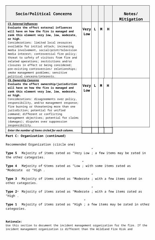
Recommended Organization (circle one)
Type 5 Majority of items rated as “Very Low”; a few items may be rated in the other categories.
Type 4 Majority of items rated as “Low”; with some items rated as “Moderate” or “High”.
Type 3 Majority of items rated as “Moderate”; with a few items rated in other categories.
Type 2 Majority of items rated as “Moderate”; with a few items rated as “High”.
Type 1 Majority of items rated as “High”; a few items may be rated in other categories.
Rationale:Use this section to document the incident management organization for the fire. If the incident management organization is differ-ent than the Wildland Fire Risk and Complexity Assessment recommends, document why an alternative organization was selected. Use the “Notes/Mitigation” column to address mitigation actions for a specific element, and include these mitigations in the ratio-nale.
Name of Incident: Unit(s):
Socio/Political Concerns Notes/MitigationC4. Objective ConcernsEvaluate the complexity of the incident objectives and rank this element very low, low, moderate, or high.Considerations: clarity; ability of current organization to accom-plish; disagreement among cooperators; tactical/operational re-strictions; complex objectives involving multiple focuses; objec-tives influenced by serious accidents or fatalities.
Very Low
L M H
C5. External InfluencesEvaluate the effect external influences will have on how the fire is managed and rank this element very low, low, moder-ate, or high.Considerations: limited local resources available for initial at-tack; increasing media involvement, social/print/television media interest; controversial fire policy; threat to safety of visitors from fire and related operations; restrictions and/or closures in effect or being considered; pre-existing controversies/ relationships; smoke management problems; sensitive political concerns/inter-ests.
Very Low
L M H
C6. Ownership ConcernsEvaluate the effect ownership/jurisdiction will have on how the fire is managed and rank this element very low, low, mod-erate, or high.Considerations: disagreements over policy, responsibility, and/or management response; fire burning or threatening more than one jurisdiction; potential for unified command; different or conflict-ing management objectives; potential for claims (damages); dis-putes over suppression responsibility.
Very Low
L M H
Enter the number of items circled for each column.
Date/Time: Signature of Preparer:

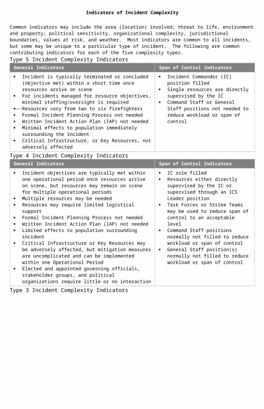
Indicators of Incident Complexity
Common indicators may include the area (location) involved; threat to life, environment and property; political sensitivity, organi-zational complexity, jurisdictional boundaries, values at risk, and weather. Most indicators are common to all incidents, but some may be unique to a particular type of incident. The following are common contributing indicators for each of the five complexity types.Type 5 Incident Complexity Indicators
General Indicators Span of Control Indicators
Incident is typically terminated or concluded (objective met) within a short time once resources arrive on scene
For incidents managed for resource objectives, minimal staffing/oversight is required
Resources vary from two to six firefighters Formal Incident Planning Process not needed Written Incident Action Plan (IAP) not needed Minimal effects to population immediately surrounding the incident Critical Infrastructure, or Key Resources, not adversely affected
Incident Commander (IC) position filled Single resources are directly supervised by
the IC Command Staff or General Staff positions
not needed to reduce workload or span of control
Type 4 Incident Complexity IndicatorsGeneral Indicators Span of Control Indicators
Incident objectives are typically met within one operational period once resources arrive on scene, but resources may remain on scene for multiple operational periods
Multiple resources may be needed Resources may require limited logistical support Formal Incident Planning Process not needed Written Incident Action Plan (IAP) not needed Limited effects to population surrounding incident Critical Infrastructure or Key Resources may be adversely affected,
but mitigation measures are uncomplicated and can be implemented within one Operational Period
Elected and appointed governing officials, stakeholder groups, and political organizations require little or no interaction
IC role filled Resources either directly supervised by the
IC or supervised through an ICS Leader po-sition
Task Forces or Strike Teams may be used to reduce span of control to an acceptable level
Command Staff positions normally not filled to reduce workload or span of control
General Staff position(s) normally not filled to reduce workload or span of control
Type 3 Incident Complexity IndicatorsGeneral Indicators Span of Control Indicators
Incident typically extends into multiple operational periods Incident objectives usually not met within the first or second opera-
tional period Resources may need to remain at scene for multiple operational peri-
ods, requiring logistical support Numerous kinds and types of resources may be required Formal Incident Planning Process is initiated and followed Written Incident Action Plan (IAP) needed for each Operational Pe-
riod Responders may range up to 200 total personnel Incident may require an Incident Base to provide support Population surrounding incident affected Critical Infrastructure or Key Resources may be adversely affected
and actions to mitigate effects may extend into multiple Operational Periods
Elected and appointed governing officials, stakeholder groups, and political organizations require some level of interaction
IC role filled Numerous resources supervised indirectly
through the establishment and expansion of the Operations Section and its subordinate positions
Division Supervisors, Group Supervisors, Task Forces, and Strike Teams used to re-duce span of control to an acceptable level
Command Staff positions may be filled to reduce workload or span of control
General Staff position(s) may be filled to re-duce workload or span of control
ICS functional units may need to be filled to reduce workload
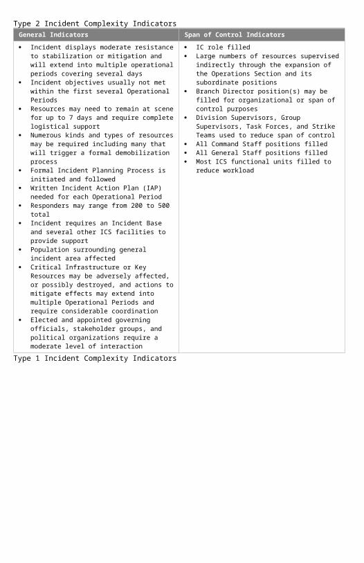
Type 2 Incident Complexity IndicatorsGeneral Indicators Span of Control Indicators
Incident displays moderate resistance to stabilization or mitigation and will extend into multiple operational pe-riods covering several days
Incident objectives usually not met within the first sev-eral Operational Periods
Resources may need to remain at scene for up to 7 days and require complete logistical support
Numerous kinds and types of resources may be re-quired including many that will trigger a formal demo-bilization process
Formal Incident Planning Process is initiated and fol-lowed
Written Incident Action Plan (IAP) needed for each Operational Period
Responders may range from 200 to 500 total Incident requires an Incident Base and several other
ICS facilities to provide support Population surrounding general incident area affected Critical Infrastructure or Key Resources may be ad-
versely affected, or possibly destroyed, and actions to mitigate effects may extend into multiple Operational Periods and require considerable coordination
Elected and appointed governing officials, stakeholder groups, and political organizations require a moderate level of interaction
IC role filled Large numbers of resources supervised indirectly
through the expansion of the Operations Section and its subordinate positions
Branch Director position(s) may be filled for organiza-tional or span of control purposes
Division Supervisors, Group Supervisors, Task Forces, and Strike Teams used to reduce span of control
All Command Staff positions filled All General Staff positions filled Most ICS functional units filled to reduce workload
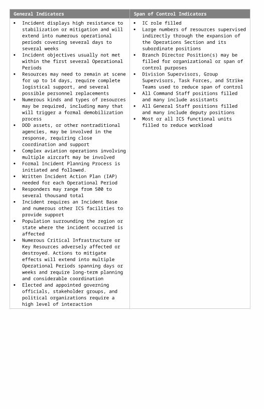
Type 1 Incident Complexity IndicatorsGeneral Indicators Span of Control Indicators
Incident displays high resistance to stabilization or mit-igation and will extend into numerous operational peri-ods covering several days to several weeks
Incident objectives usually not met within the first sev-eral Operational Periods
Resources may need to remain at scene for up to 14 days, require complete logistical support, and several possible personnel replacements
Numerous kinds and types of resources may be re-quired, including many that will trigger a formal demo-bilization process
DOD assets, or other nontraditional agencies, may be involved in the response, requiring close coordination and support
Complex aviation operations involving multiple air-craft may be involved
Formal Incident Planning Process is initiated and fol-lowed.
Written Incident Action Plan (IAP) needed for each Operational Period
Responders may range from 500 to several thousand total
Incident requires an Incident Base and numerous other ICS facilities to provide support
Population surrounding the region or state where the incident occurred is affected
Numerous Critical Infrastructure or Key Resources ad-versely affected or destroyed. Actions to mitigate ef-fects will extend into multiple Operational Periods spanning days or weeks and require long-term planning and considerable coordination
Elected and appointed governing officials, stakeholder groups, and political organizations require a high level of interaction
IC role filled Large numbers of resources supervised indirectly
through the expansion of the Operations Section and its subordinate positions
Branch Director Position(s) may be filled for organiza-tional or span of control purposes
Division Supervisors, Group Supervisors, Task Forces, and Strike Teams used to reduce span of control
All Command Staff positions filled and many include assistants
All General Staff positions filled and many include deputy positions
Most or all ICS functional units filled to reduce work-load
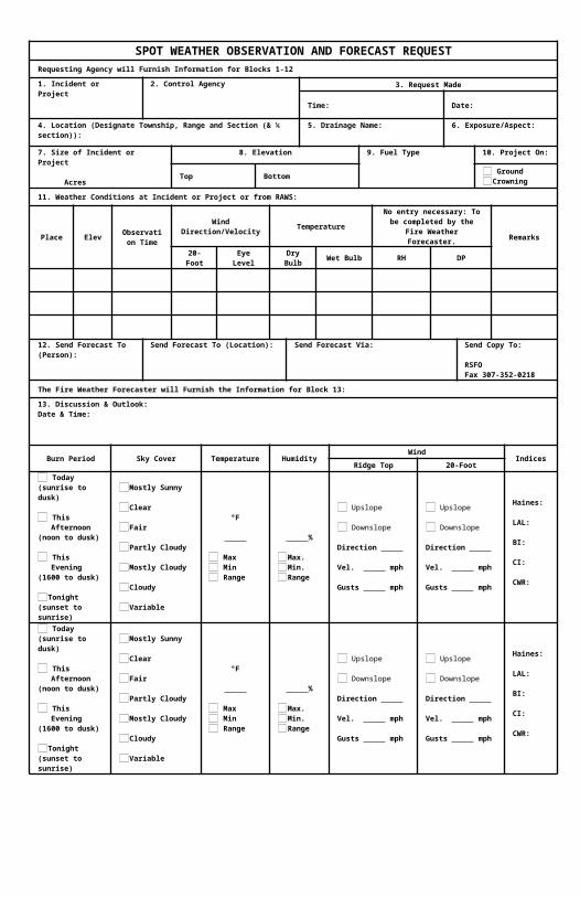
SPOT WEATHER OBSERVATION AND FORECAST REQUESTRequesting Agency will Furnish Information for Blocks 1-12
1. Incident or Project
2. Control Agency
3. Request Made
Time: Date:
4. Location (Designate Township, Range and Section (& ¼ section)):
5. Drainage Name:
6. Exposure/Aspect:
7. Size of Incident or Project
Acres
8. Elevation 9. Fuel Type
10. Project On:
Top Bottom Ground Crowning
11. Weather Conditions at Incident or Project or from RAWS:
Place Elev Observation Time
Wind Direction/Velocity TemperatureNo entry necessary: To be
completed by the Fire Weather Forecaster. Remarks
20-Foot Eye Level Dry Bulb Wet Bulb RH DP
12. Send Forecast To (Per-son):
Send Forecast To (Location):
Send Forecast Via:
Send Copy To: RSFO Fax 307-352-0218
The Fire Weather Forecaster will Furnish the Information for Block 13:
13. Discussion & Outlook: Date & Time:
Burn Period Sky Cover Temperature HumidityWind
IndicesRidge Top 20-Foot
Today(sunrise to dusk)
This Afternoon(noon to dusk)
This Evening(1600 to dusk)
Tonight(sunset to sunrise)
Mostly Sunny
Clear
Fair
Partly Cloudy
Mostly Cloudy
Cloudy
Variable
°F
Max Min Range
%
Max.Min.Range
Upslope
Downslope Direction Vel. mph Gusts mph
Upslope
Downslope Direction Vel. mph Gusts mph
Haines: LAL: BI: CI: CWR:
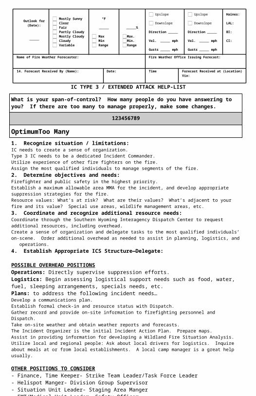
Outlook for (Date):
Mostly Sunny Clear Fair Partly Cloudy Mostly Cloudy Cloudy Variable
°F
Max Min Range
%
Max.Min.Range
Upslope
Downslope Direction Vel. mph Gusts mph
Upslope
Downslope Direction Vel. mph Gusts mph
Haines: LAL: BI: CI:
Name of Fire Weather Forecaster:
Fire Weather Office Issuing Forecast:
14. Forecast Received By (Name):
Date:
Time
Forecast Received at (Location) Via:
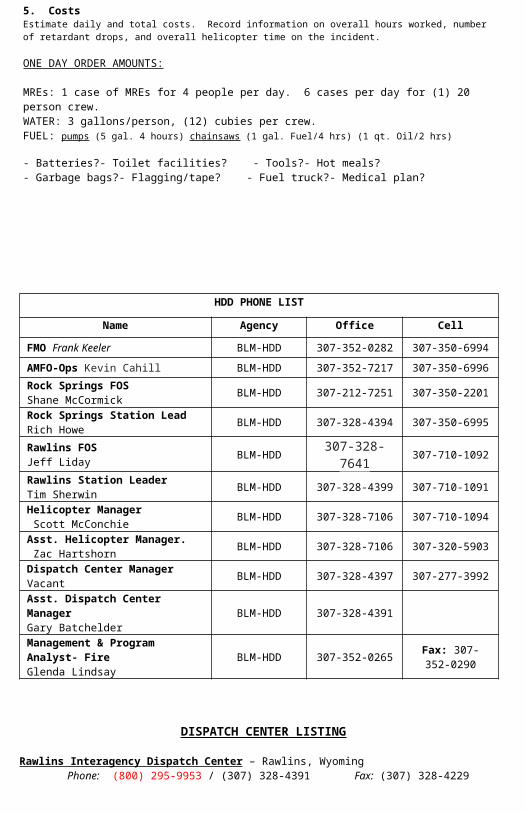
IC TYPE 3 / EXTENDED ATTACK HELP-LIST
HDD PHONE LIST
1. Recognize situation / limitations: IC needs to create a sense of organization. Type 3 IC needs to be a dedicated Incident Commander. Utilize experience of other fire fighters on the fire. Assign the most qualified individuals to manage segments of the fire.
2. Determine objectives and needs: Firefighter and public safety in the highest priority. Establish a maximum allowable area MMA for the incident, and develop appropriate sup-
pression strategies for the fire. Resource values: What’s at risk? What are their values? What’s adjacent to your fire and
its value? Special use areas, wildlife management areas, etc.3. Coordinate and recognize additional resource needs:
Coordinate through the Southern Wyoming Interagency Dispatch Center to request ad-ditional resources, including overhead.
Create a sense of organization and delegate tasks to the most qualified individuals’ on-scene. Order additional overhead as needed to assist in planning, logistics, and opera-tions.
4. Establish Appropriate ICS Structure—Delegate:
POSSIBLE OVERHEAD POSITIONSOperations: Directly supervise suppression efforts.Logistics: Begin assessing logistical support needs such as food, water, fuel,
sleeping arrangements, specials needs, etc.Plans: to address the following incident needs…
Develop a communications plan. Establish formal check-in and resource status with Dispatch. Gather record and provide on-site information to firefighting personnel and Dispatch. Take on-site weather and obtain weather reports and forecasts. The Incident Organizer is the initial Incident Action Plan. Prepare maps. Assist in providing information for developing a Wildland Fire Situation Analysis. Utilize local and regional people: Ask about local drivers for logistics. Inquire about meals
at or from local establishments. A local camp manager is a great help usually.
OTHER POSITIONS TO CONSIDER- Finance, Time Keeper - Strike Team Leader/Task Force Leader- Helispot Manger - Division Group Supervisor- Situation Unit Leader - Staging Area Manger- EMT/Medical Unit Leader - Safety Officer
5. Costs Estimate daily and total costs. Record information on overall hours worked, number of re-
tardant drops, and overall helicopter time on the incident.
ONE DAY ORDER AMOUNTS:
MREs: 1 case of MREs for 4 people per day. 6 cases per day for (1) 20 person crew.
WATER: 3 gallons/person, (12) cubies per crew. FUEL: pumps (5 gal. 4 hours) chainsaws (1 gal. Fuel/4 hrs) (1 qt. Oil/2 hrs)
- Batteries? - Toilet facilities? - Tools? - Hot meals?- Garbage bags? - Flagging/tape? - Fuel truck? - Medical plan?
Optimum Too Many
1 2 3 4 5 6 7 8 9
What is your span-of-control? How many people do you have answering to you? If there are too many to manage properly, make some changes.
Name Agency Office Cell
FMO Frank Keeler BLM-HDD 307-352-0282 307-350-6994AMFO-Ops Kevin Cahill BLM-HDD 307-352-7217 307-350-6996Rock Springs FOS Shane McCormick BLM-HDD 307-212-7251 307-350-2201Rock Springs Station Lead Rich Howe BLM-HDD 307-328-4394 307-350-6995Rawlins FOS Jeff Liday BLM-HDD 307-328-7641 307-710-1092Rawlins Station Leader Tim Sherwin BLM-HDD 307-328-4399 307-710-1091Helicopter Manager Scott McConchie BLM-HDD 307-328-7106 307-710-1094Asst. Helicopter Manager. Zac Hartshorn BLM-HDD 307-328-7106 307-320-5903Dispatch Center ManagerVacant BLM-HDD 307-328-4397 307-277-3992Asst. Dispatch Center ManagerGary Batchelder
BLM-HDD 307-328-4391
Management & Program Analyst- FireGlenda Lindsay
BLM-HDD 307-352-0265 Fax: 307-352-0290
DISPATCH CENTER LISTING
Rawlins Interagency Dispatch Center – Rawlins, WyomingPhone: (800) 295-9953 / (307) 328-4391 Fax: (307) 328-4229
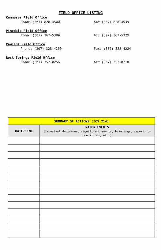
FIELD OFFICE LISTINGKemmerer Field Office
Phone: (307) 828-4500 Fax: (307) 828-4539
Pinedale Field OfficePhone: (307) 367-5300 Fax: (307) 367-5329
Rawlins Field OfficePhone: (307) 328-4200 Fax: (307) 328 4224
Rock Springs Field OfficePhone: (307) 352-0256 Fax: (307) 352-0218
SUMMARY OF ACTIONS (ICS 214)
DATE/TIME MAJOR EVENTS(Important decisions, significant events, briefings, reports on conditions, etc…)
SUMMARY OF ACTIONS (ICS 214)
DATE/TIME MAJOR EVENTS(Important decisions, significant events, briefings, reports on conditions, etc…)
FINAL FIRE INFORMATION REPORTGeneral Reporting Information
Fire Name: Fire Number:FIELD OFFICE AREA: Kemmerer Pinedale Rawlins Rock Springs
FIRE TYPE /PROTECTION TYPE CODE: (See Below: please fill in with correct number)
Cause Category: Natural/Human (Circle one)REIMBERSABLE: Yes No FIRE TYPE /PROTECTION TYPE CODE11) Response Fire - BLM land (point of origin) where BLM has protection responsibility12) Response Fire - BLM land (point of origin) protected by another Federal agency13) Response Fire - BLM land (point of origin) protected by a non-Federal agency under a contract or agreement15) Response Fire - Other land (non-BLM point of origin), action taken by the BLM to prevent spread to BLM land16) Response Fire - Other land (non-BLM point of origin, BLM response requested1B) Response Fire - Other land (non-BLM point of origin) BLM response legally required1D) Response Fire - Other land (non-BLM point of origin) BLM land burns21) Natural Out - BLM land (point of origin) where BLM has protection responsibility2A) Natural Out - BLM land (point of origin) independent of protection responsibility2B) Natural Out - Other land (non-BLM point of origin) BLM response would have been legally required37) Support Action - Support action by BLM on wildland fire5E) False Alarm - Agency responds to a reported wildland fire…(fire not found/did not occur)
Statistical Data STATE: COUNTY: Landowner: Burned Acres:
Location DataLandowner:Merged Fire: Yes/No If “YES” is this the parent fire?: Yes/NoOrigin Accuracy: (Circle one of the Following)
Uncertain) Location Coordinates are within the burn perimeter; the exact point of origin is unde-termined.General) Location coordinates correspond to the probable point of origin.Accurate) Location coordinates correspond to the point of origin.Other) None of the choices above apply; explain in remarks.
Location Method: (Circle one of the Following)
Area Map) 1:100,000 or coarser scale map or equivalent precision.Quad Map) 1:24,000 scale map or equivalent precision.RawGPS) Uncorrected GPS coordinates or equivalent precision.Corrected GPS) Corrected GPS coordinates or equivalent precision.Other) None of the choices above apply; explain in remarks.
Coordinates: Enter Lat/Long or UTM not both. (Circle One)
Lat/Long: UTM: Zone EastingDatum: All GPS units use WGS 84 Northing Datum:
Fire Management Data
DISCOVERY DATE: Date: Time: INITIAL ATTACK: Date: Time: CONTAIN: Date: Time: CONTROLLED/COMPLETED: Date: Time:DECLARED OUT: Date: Time:Final Fire Size: Acres Site DataTopography: Ridgetop, Saddle, Upper 1/3 of slope, Middle 1/3 of slope, Lower 1/3 of slope,Canyon Bottom, Valley Bottom, Mesa or Plateau, Flat or Rolling (Circle one)
Aspect: Flat, North, NE, East, SE, South, SW, West, NW, Ridgetop (Circle one)
Slope: 0-25%, 26-40%, 41-55%, 56-75%, 75+% (Circle one)
Elevation:Residence Structures Burned/Destroyed: Other Structures Burned/Destroyed: Yes/NoIntersect Existing Fuels Treatment: Yes/No Added to NFPORS: Yes/NoWildland Urban Interface (WUI): Yes/NoFBPS Fuel Model: (Circle one of the Following)
01) Short Grass (1 Foot)02) Timber (Grass & Understory)03) Tall Grass (2.5 Feet)04) Chaparral (6 Feet)05) Brush (2 Feet)06) Dormant Brush, Hardwood Slash07) Southern Rough08) Closed Timber Litter09) Hardwood Litter10) Timber (Litter & Understory)11) Light Logging Slash12) Medium Logging Slash13) Heavy Logging Slash14) Debris Pile15) Custom