indigenous stylistic & conceptual innovation in the
TRANSCRIPT

Artl@s BulletinVolume 7Issue 2 Cartographic Styles and Discourse Article 2
2018
Indigenous Stylistic & Conceptual Innovation inthe Uppsala Map of Mexico City (c. 1540)Jennifer SaracinoFlagler College, [email protected]
Follow this and additional works at: https://docs.lib.purdue.edu/artlas
Part of the History of Art, Architecture, and Archaeology Commons
This document has been made available through Purdue e-Pubs, a service of the Purdue University Libraries. Please contact [email protected] foradditional information.
This is an Open Access journal. This means that it uses a funding model that does not charge readers or their institutions for access. Readers may freelyread, download, copy, distribute, print, search, or link to the full texts of articles. This journal is covered under the CC BY-NC-ND license.
Recommended CitationSaracino, Jennifer. "Indigenous Stylistic & Conceptual Innovation in the Uppsala Map of Mexico City (c. 1540)." Artl@s Bulletin 7, no.2 (2018): Article 2.

10
Cartographic Styles and Discourse
ARTL@S BULLETIN, Vol. 7, Issue 2 (Fall 2018)
Indigenous Stylistic & Conceptual Innovation in the Uppsala Map of Mexico City (c. 1540)
Abstract
The only known map of Mexico City painted with the collaboration of indigenous artists, the Mapa Uppsala (c. 1540) depicts the city and surrounding Valley of Mexico. This essay counters previous characterizations of the map’s formal composition as one that has fully espoused European cartographic modes. This essay contextualizes the Mapa Uppsala within the extant corpus of pre-Hispanic and early colonial cartographies to demonstrate that a closer analysis of pictorial conventions and structures can shed light on how and why the artists might have consciously selected particular pictorial strategies.
Jennifer Saracino * Flagler College
* Jennifer Saracino received her Ph.D. in Art History and Latin American Studies from Tulane University. Her dissertation focuses on the Mapa Uppsala, the earliest known map of Mexico City painted by indigenous artists after Spanish Conquest. She is currently Assistant Professor of Art History at Flagler College in St. Augustine, Florida.
Resumen
El único mapa conocido de la ciudad de México pintado con la colaboración de artistas indígenas, el Mapa Uppsala (c. 1540) representa la ciudad y el valle de México que lo rodea. Este ensayo contrarresta las caracterizaciones previas de la composición formal del mapa como una que ha adoptado modos cartográficos europeos. Este ensayo contextualiza el Mapa Uppsala dentro del corpus existente de cartografías indígenas para demostrar que un análisis más detallado de las convenciones y estructuras pictóricas puede arrojar luz sobre cómo y por qué los artistas pueden haber seleccionado conscientemente estrategias pictóricas particulares.

Saracino – Mapa Uppsala
11 ARTL@S BULLETIN, Vol. 7, Issue 2 (Fall 2018) Cartographic Styles and Discourse
Introduction
Named for the city in Sweden where it resides
today, the Mapa Uppsala is the earliest known map
(c. 1540) of Mexico City painted by indigenous
artists after Spanish Conquest.1 The map reveals
the urban plan of the city, the former capital of the
Mexica Empire, its neighboring altepetl
(community) of Tlatelolco, and their environs,
covering the area between the city and its
surrounding mountain ranges, an average 40 km in
all directions.2 The map is oriented with west at the
top, and a cartouche in the lower right-hand corner
dedicates the map to the Holy Roman Emperor
Charles V from his royal cosmographer Alonso de
Santa Cruz. In one of the first publications
regarding the map, Erik W. Dahlgren initially
attributed the map to Santa Cruz.3 Manuel
Toussaint first argued for its indigenous authorship,
highlighting the fact that Santa Cruz had never set
foot in New Spain and that the map includes almost
200 pre-Hispanic glyphs for native place names,
among other indigenous pictorial conventions.4 It is
not clear why the map was made, but the
dedicatory cartouche makes known that it was
intended for the Spanish Crown. The cartouche and
ornamental frame prompted Donald Robertson to
characterize the map as a “presentation piece… an
artistic tour de force possibly to be considered
almost as an item of propaganda…before the eyes
of important powers in the Court of Spain, who
might be useful as patrons.”5
Author’s note: Readers may find a high-resolution, digitized version of the Mapa Uppsala at the following web address: http://art.alvin-portal.org/alvin/view.jsf?file=4289 I thank the Uppsala University Library for making this invaluable resource available to the public. I also thank the editors and reviewers for their generous comments and suggestions on earlier drafts of this article. 1 Manuel Toussaint dated the map to c. 1555 or later due to an unsubstantiated identification of a dike depicted on the map as the Albarradón of San Lazaro, a dike with pre-Hispanic foundations first constructed by the native population and later rebuilt. There is no evidence that the colonial reconstruction is the one the authors intended. (Toussaint, Manuel, Gomez De Orozco, Federico, Fernandez, Justino, Planos De La Ciudad De Mexico: Siglos XVI Y XVII, Estudio Historico, Urbanistico Y Bibliografico. Mexico: [Impreso En Los Talleres De La Editorial "Cvltvra"], 1938.) Later, Miguel Leon-Portilla and Carmen Aguilera dated the map to c. 1555, a year before the abdication of Charles V, to whom the map is dedicated. (Leon Portilla, Miguel., Aguilera, Carmen, and Santa Cruz, Alonso De. Mapa De Mexico Tenochtitlan Y Sus Contornos Hacia 1550. Mexico, D.F: Celanese Mexicana, 1986.) Ample evidence within the urban plan of the map (through cross-referencing building foundation dates in town council minutes and other historical sources) strongly suggests an earlier date of c. 1540, a subject I address in more detail in my dissertation. (Saracino, Jennifer R. “Shifting Landscapes: Depictions of Cultural & Environmental Disruption the Mapa Uppsala of Mexico-Tenochtitlan.” PhD Diss., Tulane University, 2018.) 2 In pre-Hispanic Central Mexico, the altepetl conceptually referred to a group of people who identified with and largely controlled a specific geographic territory. The
The mapmakers fastidiously depicted the urban
plan of Mexico-Tenochtitlan and its adjacent
altepetl Tlatelolco, labeling key institutions that
comprised the sociopolitical backbone of the
Spanish viceregal capital. Thus, the map, soon after
its rediscovery in the late eighteenth-century,
proved to be a treasure trove of information for
scholars interested in the city’s early colonial urban
history.6 The plan is remarkable for its accuracy.
Most recently, Edward Calnek has corroborated the
layout of roads, canals, and buildings with the plan
of the historic center of Mexico City as it exists
today, and Susan Toby-Evans’ analysis of the tecpan
(indigenous ruler houses) and their distribution
shed light on the city’s urban development at the
time of the map’s creation.7 However, the
information presented outside of the urban plan
has proved more enigmatic, and this is partially
because the perspective and formal features of the
surrounding landscape dramatically depart from
that of the urban plan.
A complex planimetric network of roads,
waterways, and canals extends from the urban plan
and stretches across the valley. In the interstices of
this roadmap, however, the artists created the
impression of verdant landscape with washes of
green pigment and conventionalized trees. The
trees generally have triangular, scallop-edged
foliage, and their crosshatched shading was most
likely copied from woodcut prints found in
imported European books. In some places,
altepetl served as the heart of sociopolitical organization for the indigenous population. The word comes from the Nahuatl language, the predominant language spoken by the indigenous population in Central Mexico at the time of Spanish Conquest. James Lockhart, The Nahuas after the Conquest: A Social and Cultural History of the Indians of Central Mexico, Sixteenth through Eighteenth Centuries (Stanford, Calif.: Stanford University Press, 1992), 14. 3 Erik Wilhelm Dahlgren, N\a Agot Om Det Forna Och Nuvarande Mexico: Med Anledning Af En Gammal Karta Öfver Staden Och Dess Omgifningar (Norman, 1889). 4 Manuel Toussaint et al, Planos de la ciudad de Mexico: siglos XVI y XVII, estudio historico, urbanistico y bibliografico (Mexico: Impreso en los talleres de la editorial "Cvltvra, 1938), 142. 5 Donald Robertson, Mexican Manuscript Painting of the Early Colonial Period: The Metropolitan Schools, Yale Historical Publications. History of Art 12 (New Haven: Yale University Press, 1959), 159. 6 This is particularly the case for Toussaint et al, Planos de la ciudad de Mexico, a collaborative work focusing on the urban history of Mexico City as pieced together through a compilation of its extant maps. . 7 Edward E. Calnek, “Tenochtitlan-Tlatelolco: The Natural History of a City,” Urbanism in Mesoamerica 1 (2003): 149–202; Susan T. Evans, “The Aztec Palace under Spanish Rule: Disk Motifs in the Mapa de México de 1550 (Uppsala Map or Mapa de Santa Cruz),” The Postclassic to Spanish-Era Transition in Mesoamerica: Archaeological Perspectives ( Albuquerque: University of New Mexico Press, 2005), 13–33.

Saracino – Mapa Uppsala
12 Cartographic Styles and Discourse ARTL@S BULLETIN, Vol. 7, Issue 2 (Fall 2018)
however, the artists specified plant life indigenous
to the area such as maguey plants and nopal cacti.
Conventionalized and naturalistic forms are
integrated to convey a more intentional and specific
representation of the local landscape. For example,
in the upper left-hand corner of the map, grey and
green brushstrokes are intermingled to indicate the
rocky volcanic terrain of the Pedregal lava fields
caused by a millennia-old eruption from the nearby
Xitle volcano. In the lower left-hand corner, a
volcano emits puffs of smoke, marking it as a
representation of Popocatepetl, an iconic feature of
the landscape that is still active today.
In terms of the map’s style, Donald Robertson noted
the pronounced influence of European visual
culture on the artists of the Mapa Uppsala.8 Miguel
León-Portilla and Carmen Aguilera believed the
naturalistic landscape to be entirely due to
European influence and that European friars who
worked with the artists likely had the idea for the
map’s composition.9 The mapmakers also included
depictions of almost two hundred, mostly
indigenous figures engaged in a wide, diverse array
of activities. Some of the human figures display the
artists’ attempt to render convincing musculature
and knowledge of the human form, a characteristic
of European pictorial tradition. León-Portilla and
Aguilera observed that these vignettes of daily life
were reminiscent of sixteenth-century Dutch genre
and “map-landscapes” (“mapa-paisajes”).10 Indeed,
some of the architecture displays linear
perspective, Greco-Roman columns, and medieval
turrets. These European visual traits often led
scholars to explain the map's style in dichotomous
terms (that is, how much the mapmakers adhered
to either European vs. indigenous convention),
ascribing what they perceived as the map's
dominant naturalism to European influence.
Sigvald Linné first posited that the artists of the
Mapa Uppsala might have originated from the
8 Robertson, Mexican Manuscript Painting of the Early Colonial Period, 159–63. 9 Miguel León Portilla, Mapa de Mexico Tenochtitlan y sus contornos hacia 1550 (Mexico, D.F: Celanese Mexicana, 1986), 25–27, 31. 10 León Portilla, Mapa de Mexico Tenochtitlan y sus contornos hacia 1550, 31. 11 Linné first observes how the Uppsala illustrations look similar to those found in Sahagún’s Florentine Codex. Sigvald Linné, El Valle y La Ciudad de Mexico En 1550; Relacion Historica Fundada Sobre Un Mapa Geografico, Que Se Conserva En La
scriptorium of the Colegio de Santa Cruz
(henceforth referred to as the Colegio), a monastic
school of higher education for indigenous students,
for two main reasons: 1) the Colegio is the largest
feature in the urban plan, a trait consistent with
other indigenous maps in which the artists’
community (typically the map’s site of production)
is emphasized, and 2) the map’s style, which many
have concurred is similar to other documents
known to have come from the Colegio.11
This essay reconsiders these two features of the
map—that is, its representation of space as well as
the map’s overall style—and argues that a closer
analysis of the map's conventions, composition, and
historic context reveals a much more nuanced
exchange of cartographic cultures between
indigenous and European actors across the surface
of the map. It argues that the unique circumstances
of the Colegio, as a hotbed of cultural exchange
between indigenous and European actors,
informed the singularity of the map's composition
within the extant corpus of sixteenth-century maps
of Mexico-Tenochtitlan and Tlatelolco. This essay
serves to complicate past assertions that the map
represents a teleological culmination of European
stylistic influence on indigenous artistic production
and foreground the contributions of its indigenous
authors to sixteenth-century cartographic culture.
Building on previous assertions that the artists
hailed from the Colegio de Santa Cruz in Tlatelolco,
this essay argues that, owing to their unique
position as cultural mediators within early colonial
society, the Mapa Uppsala artists innovated
cartographic culture by incorporating distinctly
indigenous spatial engagements with European
pictorial illusionism. It argues for a shift in how we
view the aesthetics of the Mapa Uppsala, that is, as
the product of the artists’ specific cultural
formation in a collaborative monastic setting
between colonial officials and native artists, and not
as emblematic of complete acculturation or
Biblioteca de La Universidad de Uppsala, Suecia, Series: Statens Etnografiska Museum (Sweden). (Statens etnografiska museum (Sweden). Publication, no. 9). Stockholm: [Esselte], 201; León-Portilla and Aguilera even wonder if Fray Bernardino de Sahagún, the compiler of the Florentine Codex, might have been responsible for the Mapa Uppsala. León Portilla and Aguilera, Mapa de Mexico Tenochtitlan y sus contornos hacia 1550, (México, D.F.: Celanese Mexicana, 1986), 34.

Saracino – Mapa Uppsala
13 ARTL@S BULLETIN, Vol. 7, Issue 2 (Fall 2018) Cartographic Styles and Discourse
assimilation to European pictorial tradition. This
essay highlights the sociocultural complexity of the
map's site of production and its makers as an
explanation for its singular composition amid a
scant corpus of sixteenth-century maps of Mexico
City in the early colonial period.
Indigenous Mapmakers and Artists in
Pre-Hispanic and Early Colonial Central
Mexico
In Nahuatl—the most widely spoken language in
central Mexico at the time of Spanish conquest—
the painter-scribe who possessed the knowledge of
manuscript art and production was known as the
tlahcuiloh (pl. tlahcuilohque). In pre-Hispanic
society, the tlahcuilohque acquired profound
knowledge of creation mythology, genealogy, and
community history so they could represent these
values on paper according to strict iconographic
convention. Colonial accounts describe the
tlahcuiloh simultaneously as an artist, craftsman,
painter, and draftsman.12
Although Spanish conquest and colonization
majorly disrupted indigenous scribal culture,
aspects of pre-Hispanic pictorial tradition survived
well into the colonial period. This occurred
especially at monastic schools established by the
first mendicant missionaries for the inculcation and
Christianization of the children of indigenous
nobility. The first of these schools included San José
de los Naturales (1527) in Tenochtitlan and,
subsequently, the Colegio de Santa Cruz (1536) in
Tlatelolco, two areas of prominence in the urban
plan of the Mapa Uppsala.13
Franciscan friar Pedro de Gante, one of the first
missionaries to arrive in New Spain, first
12 “The scribe: writings, ink, [are] his special skills. [He is] a craftsman, an artist, a user of charcoal, a drawer with charcoal; a painter who dissolves colors, grinds pigment, uses colors. The good scribe is honest, circumspect, far-sighted, pensive; a judge of colors, an applier of the colors, who makes shadows, forms feet, face, hair. He paints, applies colors, makes shadows, draws gardens, paints flowers, creates works of art.” English translation by Barbara Mundy, “Pictography, Writing, and Mapping in the Valley of Mexico and the Beinecke Map,” in Painting a Map of Sixteenth-Century Mexico City: Land, Writing, and Native Rule, ed. Mary Ellen Miller et al. (New Haven, Conn: Beinecke Rare Book & Manuscript Library, Yale University : Distributed by Yale University Press, 2012), 31. The original Spanish text can be found in Book 10, Chapter 8 of The General History of the Things of New Spain: Florentine Codex, 2nd. ed., Sahagún, Bernardino de, Arthur J. O. Anderson, and
established San José de los Naturales in 1527. The
Franciscan faculty there endeavored not only to
raise their indigenous pupils as Christians, but also
to impart a traditional monastic education that
included the instruction of reading, writing, and
mechanical arts such as carpentry and painting.
Their aim in teaching these skills was to raise a
class of faithful indigenous converts skilled in the
production of religious art for the monasteries and
churches prolifically constructed in the wake of
Conquest.
San José de los Naturales facilitated the training of
blacksmiths, carpenters, masons, tailors, and
cobblers in addition to a group of painters,
sculptors, and jewelers.14 Fray Toribio de
Benavente (more commonly known as Motolinía)
wrote in his chronicle that these indigenous artists
learned to illuminate, bind, and engrave, and he
lauded the skills of the indigenous painters,
goldbeaters, leather workers, gold and
silversmiths, and embroiderers.15 The students’
quick adaptation of new artistic forms and styles
impressed their European instructors. Many of
these young Nahua students came from the ranks of
the indigenous elite and were quite possibly
descendants of members of the tlahcuilohque. They
adapted what they learned of European visual
culture into their pre-Hispanic pictorial vocabulary.
As such, these Christianized indigenous pupils were
invaluable cultural mediators.
The friars’ glowing approval of their students’
artistic talents coincided with a similar
appreciation for their intellectual capabilities.
Bishop Fray Juan de Zumárraga stated that he
found the native students, “with great ability,
liveliness of wit, and a ready power of memory” and
that they “had the capacity to study grammar and
other subjects.”16 In 1534, New Spain’s most
Charles E. Dibble, Monographs of the School of American Research, no. 14 (Santa Fe, N.M.: Salt Lake City, Utah: School of American Research, University of Utah, 1970). 13 Robert Ricard, The Spiritual Conquest of Mexico: An Essay on the Apostolate and the Evangelizing Methods of the Mendicant Orders in New Spain, 1523-1572 (Berkeley: University of California Press, 1966); Georges Baudot, Utopia and History in Mexico: The First Chroniclers of Mexican Civilization (1520-1569), Mesoamerican Worlds (Niwot: University Press of Colorado, 1995). 14 Ricard, The Spiritual Conquest of Mexico, 212–213. 15 Ibid, 214. 16 Luis Nicolau D’Olwer, Fray Bernardino de Sahagún 1499-1599 (Salt Lake City: University of Utah Press, 1987), 14.

Saracino – Mapa Uppsala
14 Cartographic Styles and Discourse ARTL@S BULLETIN, Vol. 7, Issue 2 (Fall 2018)
influential religious leaders, Sebastián Ramírez de
Fuenleal, Bishop of Santo Domingo and president of
the Second Audiencia; Juan de Zumárraga, first
Bishop of Mexico; and Antonio de Mendoza, the first
viceroy, together ordered the foundation of the
Colegio de Santa Cruz in nearby Tlatelolco.17
Through the foundation of the Colegio, they sought
to create an institution of higher education for the
continuing advancement of their accomplished
pupils and partially in the hopes of creating a class
of indigenous clergymen.
The Representation of Space in the
Mapa Uppsala—A Statement of the
Artists’ Identity
In 1948, Sigvald Linné noted that the monastic site
that housed the Colegio de Santa Cruz occupies an
area on the map disproportionately larger than any
other depicted on the island.18 The monastic
complex stands at the center of the altepetl of
Tlatelolco on the right half of the island. This
enlargement of the monastic site follows a well-
established tradition in indigenous mapmaking
wherein the author would enlarge the community
from which he or she hailed to emphasize its
importance, leading Linné to posit that the artists
likely came from the Colegio de Santa Cruz. This
section reconsiders the treatment of space first
discussed by Linné and further analyzes the
compositional layout of the two altepetl that
comprised the island city. It argues that the map’s
artists adhered to certain indigenous traditions of
mapping space as a statement of the importance of
Tlatelolco to their cultural identity.
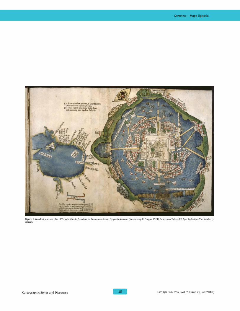
The Mapa Uppsala notably departs from a
contemporaneous depiction of Mexico-
Tenochtitlan. The well-known image, first printed
17 Elizabeth H. Boone, “The Multilingual Bivisual World of Sahagún’s Mexico” in Sahagún at 500: Essays on the Quincentenary of the Birth of Fr. Bernardino de Sahagún, ed. John Frederick Schwaller (Berkeley, California: Academy of American Franciscan History, 2003), 141. 18 Linné, El Valle y La Ciudad de Mexico En 1550; Relacion Historica Fundada Sobre Un Mapa Geografico, Que Se Conserva En La Biblioteca de La Universidad de Uppsala, Suecia. 200. 19 For more in-depth analyses of the composition, see Elizabeth Hill Boone, “This New World Now Revealed: Hernan Cortes and the Presentation of Mexico to Europe,” Word & Image 27, no. 1 (2011): 31–46; Barbara E. Mundy, “Mapping the
in 1524 in Nuremberg, Germany, accompanied
Hernan Cortes’s letters to Charles V and became a
kind of prototype for subsequent representations
of the city printed in Europe for centuries.19 The
Cortés plan shows the island city in the center of a
schematized circular lake surrounded by a narrow
strip of its mainland shores (Fig. 1). The Mexica
ritual precinct is significantly enlarged, creating a
fish-eye view of the city and its surroundings.20 The
map shows the multiple causeways that connected
the city to the mainland. A series of buildings
radiate outwards from the ritual precinct in
concentric circles, with their foundations oriented
towards the center.
Although a European artist most likely produced
the woodcut, Barbara Mundy has compellingly
argued that its composition was based on native
sources.21 The spatial composition is consistent
with other indigenous representations of
Tenochtitlan as a city in the center of either a circle
or square. Mundy, for example, compared it to the
depiction of the Spanish and their indigenous allies
marching to Tenochtitlan in 1521 that appears in
the Lienzo de Tlaxcala. In the lienzo, a
conventionalized temple in the center of the
composition stands as a metonymic symbol for the
city of Tenochtitlan. A lake inscribed with spirals
and geometric patterns surrounds it. Framing the
island, its four corners are denoted as the
surrounding cities of Tecpatepec, Xochimilco,
Tlacopan, and Coyoacan. The physical description
of Tenochtitlan surrounded by these four cities
follows a symbolic prototype that reinforces a
cosmological belief in Tenochtitlan as the center of
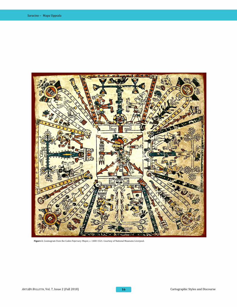
the universe.22 This visual tradition relates to pre-
Hispanic depictions of the cosmos as a symmetrical
quadripartite design, as conveyed in cosmograms
like that found in the Codex Fejérváry-Mayer (Fig.
2).
Aztec Capital: The 1524 Nuremberg Map of Tenochtitlan, Its Sources and Meanings,” Imago Mundi 50, no. 1 (1998): 11–33. 20 Boone, “This New World Now Revealed," 36. 21 Mundy, “Mapping the Aztec Capital”; Richard Fraser Townsend, “State and Cosmos in the Art of Tenochtitlan,” Studies in Pre-Columbian Art and Archaeology, no. 20 (1979): 1–78; Johanna Broda, David Carrasco, and Eduardo Matos Moctezuma, The Great Temple of Tenochtitlan: Center and Periphery in the Aztec World (Berkeley: Univ of California Press, 1988). 22 Mundy, “Mapping the Aztec Capital,” 15.
Saracino – Mapa Uppsala
15 ARTL@S BULLETIN, Vol. 7, Issue 2 (Fall 2018) Cartographic Styles and Discourse
Figure 1. Woodcut map and plan of Tenochtitlan, in Praeclara de Nova maris Oceani Hyspania Narratio (Nuremberg, F. Peypus, 1524). Courtesy of Edward E. Ayer Collection, The Newberry Library.
Saracino – Mapa Uppsala
16 Cartographic Styles and Discourse ARTL@S BULLETIN, Vol. 7, Issue 2 (Fall 2018)
Figure 2. Cosmogram from the Codex Fejervary-Mayer, c. 1400-1521. Courtesy of National Museums Liverpool.

Saracino – Mapa Uppsala
17 ARTL@S BULLETIN, Vol. 7, Issue 2 (Fall 2018) Cartographic Styles and Discourse
The Fejérváry-Mayer image diagrams the shape
and layout of the universe. In this image, the world’s
four cardinal directions—(counterclockwise from
top) east, north, west, and south—each occupy one
branch of a Formée cross.23 In between the four
main branches are intercardinal loops that
collectively form a St. Andrew’s cross. Outlining the
diagram is a band of calendrical time, punctuated
by glyphs of the twenty-day signs. The count starts
at the lower right corner of the eastern branch with
the symbol of Cipactli, or Crocodile. In the Aztec
calendar, the year count was subdivided into 20
groups of 13 days called trecenas. Each day
corresponded with one of thirteen symbols, and the
trecena took the name of the first day. Thus, Cipactli
marks the first trecena as well as the first day of the
year. Simple dots, or spacers,24 mark the
subsequent days of the trecena, and this calendrical
count runs along each branch of the cardinal and
intercardinal branches and loops to mark the entire
260-day calendrical year.
The Fejérváry-Mayer cosmogram demonstrates
how each of the four directions pertained to a
thirteen-year period. Miguel León-Portilla has
explained:
Then, not only in each year, but also in each day, the
influence of one of the four spatial directions
predominated. Space and time, combining and
interpenetrating, made possible the harmony among
the gods (the four cosmic forces) and, consequently,
the movement of the sun and the existence of life.25
Within each arm of the cross is each cardinal
direction’s tree, one of the four trees in each corner
of the world that supported the heavens. Each of the
four world trees rests upon a different base that
corresponds to each direction’s cosmological
associations. As Mundy demonstrated in her
analysis of the Cortés plan, indigenous mapmakers
translated the divine symmetry and idealized
23 Eduard Seler et al., Codex Fejérváry-Mayer: An Old Mexican Picture Manuscript in the Liverpool Free Public Museums (12014/M) / Loubat, J. F.; 1831-1927. ; (Joseph Florimond), (Berlin and London : [s.n.] ; [Edinburgh : Printed by T. and A. Constable ... at the Edinburgh University Press], 1901), 5–31; Elizabeth Hill Boone, Cycles of Time and Meaning in the Mexican Books of Fate, 1st ed, Joe R. and Teresa Lozano Long Series in Latin American and Latino Art and Culture (Austin: University of Texas Press, 2007), 114–17; Barbara E. Mundy, “Mesoamerican Cartography,” Cartography in the Traditional African, American, Arctic, Australian, and East Asian Societies, 1998, 229–32; Karl Anton Nowotny, Tlacuilolli: Style and Contents of the Mexican Pictorial Manuscripts with a Catalog of the Borgia Group (Norman: University of Oklahoma Press, 2005).
quadripartite design of the cosmogram to
depictions of the perceived center of the Mexica
universe: Tenochtitlan. Although all extant
representations of the Mexica capital were made
after Conquest, many of them share striking
similarities in compositional layout and depiction
of space.
The Cortés plan also recalls indigenous
cartographic presentations by the way in which the
most important feature is situated, not only at the
center of the composition, but at a much larger
scale comparative to its peripheral features.26 The
Mexica ritual precinct occupies a large square space
in the center of the island that dwarfs its
surrounding edifices. As the composition extends
outward, space collapses, so that cities that were
leagues away from Tenochtitlan are brought closer
to the central square and island.
Space is similarly manipulated in the Mapa Uppsala
to emphasize the city center at the expense of its
environs. The island of Tenochtitlan in the moment
of its rendering would have been dwarfed by the
expanse of its surrounding lakes; however, in the
Mapa Uppsala, the lakes occupy a significantly
smaller area in relation to the island. The artists
likely enlarged the island to accommodate the
detailed representation of the urban plan and the
altepetl of Tlatelolco. 27 Because the island city
occupies so much space within the map, the
distances between the island and its outlying
settlements are significantly compressed, much like
the representation of Tenochtitlan and its environs
in the Cortés plan. Thus, Otumba, a settlement in
the lower right-hand corner that is approximately
60 km away, is rendered at the same scale as the
width of the island, approximately 5 km.
The Mapa Uppsala differs markedly from the Cortés
plan, however, in that it displays the island city as
24 Boone, Cycles of Time and Meaning in the Mexican Books of Fate, 114. 25 Miguel León Portilla, Aztec Thought and Culture; a Study of the Ancient Nahuatl Mind, 1st ed., The Civilization of the American Indian Series, v. 67 (Norman: University of Oklahoma Press, 1963), 56. 26 Mundy, “Mesoamerican Cartography,” 200. 27 In the 1540s, however, the population of Mexico-Tenochtitlan experienced a prolonged period of drought, thus, it is possible that the representation of water indicates the mapmakers’ attempts to capture the hydrographic situation of the city. Given the detailed rendering of the urban plan, its constituent edifices, and their careful labeling, however, I do think it is arguable that the lakes’ volume was minimized in order to accommodate the detail of the urban plan.
Saracino – Mapa Uppsala
18 Cartographic Styles and Discourse ARTL@S BULLETIN, Vol. 7, Issue 2 (Fall 2018)
two adjoining altepetl (Mexico-Tenochtitlan and
Tlatelolco) and not just as Mexico-Tenochtitlan
alone. While the Cortés plan’s artist depicted
Mexico-Tenochtitlan, with its ritual precinct, as the
physical center of the island, the artists of the Mapa
Uppsala placed Mexico-Tenochtitlan towards the
left of the center to make room for the geographic
entity of Tlatelolco to its right. The representation
of the two altepetl occurs on two separate pieces of
parchment that are notably joined between their
borders at the center of the map.
The composition of Mexico-Tenochtitlan, at left,
follows the template of the divinely organized city
revealed in Cortés’ plan. The capital is situated at
the center of a symmetrical quadripartite division
of space; however, Tlatelolco, too, follows certain
indigenous conventions for representing social
space that have been outlined. The monastery of
Santiago Tlatelolco occupies the central space of
the altepetl of Tlatelolco. The monastery’s doctrinas
(secondary churches for conversion of the
indigenous population) surround it in a
symmetrical circle, like the spokes of a wheel. These
doctrinas are all rendered to the same scale, that is,
as secondary to the monastic complex of Santiago
Tlatelolco they encircle.
Although all the buildings in this altepetl are
depicted in either linear perspective or elevation,
the area encompassed by the Santiago Tlatelolco
monastery complex is rendered in plan, a recurring
feature of indigenous made maps. In indigenous
made maps, buildings–calli (houses), tecpan
(palaces), and teocalli (temples)–were most often
rendered in elevation or profile view.28 Sometimes,
however, mapmakers would represent the exterior
of a building in elevation and the interior
planimetrically to frame a narrative scene
occurring inside.
If the mapmakers did indeed hail from the
monastery of Santiago Tlatelolco, an assertion with
which I agree, then the spatial layout of the urban
plan adheres to traditions of representing social
space in indigenous maps. The mapmakers’
28 “Elevation” is an architectural term used to denote a depiction of the face of a building (in contrast to a representation of a building in linear perspective.
emphasis on Tlatelolco as almost half of the island,
a depiction that does not exist in the Cortés plan,
could also be a testament to the importance of
Tlatelolco to the artists. But why is this significant
to our understanding of indigenous cartography in
the early colonial period?
In pre-Hispanic times, Tlatelolco operated as an
altepetl independent from Tenochtitlan. But in
1473, Tlatelolco capitulated to the imperial forces
of Tenochtitlan and became subsumed within the
Mexica Empire. The conquest of the Mexica by the
Spanish reignited pre-Hispanic indigenous
factionalisms, and formerly subjugated elites
suddenly found new opportunities within the
colonial system to gain power and prestige. The
establishment of the Colegio de Santa Cruz in
Tlatelolco proper, for example, likely added to the
altepetl’s prestige.
In the Mapa Uppsala, it is not only the Colegio de
Santa Cruz that has been enlarged and emphasized,
but Tlatelolco as an altepetl is rendered at the
center of the map alongside Mexico-Tenochtitlan.
The two neighboring altepetl are equal in size and
compositional importance, a spatial representation
that is unprecedented in contemporaneous
representations of the post-Conquest island city.
Thus, the spatial representation does not only
indicate that the map was produced at the Colegio
de Santa Cruz, but it also provides compelling visual
evidence of the importance of Tlatelolco to these
artists more broadly. This depiction could be read
as the artists’ attempt to not only visually elevate
the status of Tlatelolco, but also to portray it as
equal to that of Mexico-Tenochtitlan. From this
analysis, it is evident that indigenous cartographic
traditions for mapping social space and community
informed the composition of the urban plan, a
paramount feature of the map. The differences
between the spatial representations of Mexico City
in the Mapa Uppsala versus the Cortés plan indicate
that cartography developed differently depending
on specific sociopolitical circumstances of the site
of production in Central Mexico at this time.
Saracino – Mapa Uppsala
19 ARTL@S BULLETIN, Vol. 7, Issue 2 (Fall 2018) Cartographic Styles and Discourse
Because the map was made in the altepetl of
Tlatelolco, it reveals a view of the island city that is
distinct from maps that may have been made within
Mexico-Tenochtitlan proper.
Style and Artistic Production at the
Colegio de Santa Cruz in Tlatelolco
The Mapa Uppsala is also considered to be a
product of the Colegio because of its pronounced
European stylistic influence, a trait shared by other
documents produced there including the Badianus
Herbal, a compendium of illustrations of native
plant life and pharmacopeia and the Florentine
Codex, an illustrated encyclopedia of indigenous
culture and customs. In this section, I revisit past
considerations of the map’s landscape, a feature
that is frequently cited as evidence of the map’s
pronounced Europeanized style. This analysis
reconsiders the mapmaker’s representation of
landscape, not as a teleological culmination of
European influence, but rather as a product of the
map’s site of production at the Colegio, an
institution that became a productive site of artistic
collaboration between Franciscan friars and
indigenous converts. By comparing the Mapa
Uppsala’s landscape to the Codex Xolotl, a
contemporaneous map made by indigenous
authors, I demonstrate that the composition and
perspective in the Mapa Uppsala adhere more to
indigenous cartographic tradition than has been
traditionally acknowledged in past scholarship.
This section also includes a brief discussion of the
glyphs incorporated into the landscape of the Mapa
Uppsala. In various places throughout the map, the
artists incorporated logographic and pictographic
glyphs for indigenous place names that doubled as
figural representations of features of the landscape.
These instances complicate previous assertions
that the mapmakers adhered predominantly to
29 For a more in-depth analysis of the structures of cartographic histories, see Elizabeth Hill Boone, Stories in Red and Black: Pictorial Histories of the Aztecs and Mixtecs, 1st ed (Austin: University of Texas Press, 2000), 162–96. 30 For a thorough analysis of the structure and content of extant cartographic histories of Central Mexico, see “Stories of Migration, Conquest, and Consolidation in the Central Valleys." Boone, 162–96.
European representational techniques. This section
demonstrates how indigenous cartographers
served a fundamental role in the formation of a
burgeoning visual language, emanating from the
Colegio de Santa Cruz, in maps and a wide range of
pictorial documents more broadly.
The Codex Xolotl belongs to a category of
indigenous pictorial documents known as
cartographic histories.29 Authors of cartographic
histories endeavored to pictorially describe
migrations of people from sacred points of origin to
final homelands whilst explaining how they settled,
defined their territory, and created an independent
altepetl.30 These maps were not expressly intended
to represent only the geographical scope of a given
area, as we might expect of terrestrial maps in the
European tradition, but rather, these documents
served as a vehicle for a community’s history. Thus,
a temporal element figured into their representa-
-tion just as much as a geographic one, and their
main point was to represent a historical narrative.31
Although Donald Robertson argued that, “[t]hese
maps are diagrams rather than indications of the
spatial relationships of nature,”32 some extant
indigenous made maps display representations of
topography and the geographic features of the
natural environment. This topographic specificity
allowed the mapmaker to convey the cartographic
dimensions of migrations and events in the
pictorial history. In these instances, mapmakers
depicted geographic setting to ground the
narrative, and topography served as a secondary
detail to the narrative action, like in the Codex
Xolotl.33
A document comprising ten pages, the Codex
Xolotl’s first eight pages each reveal a map of the
central Valley of Mexico. Maps 1, 2, and 5-7 show
the whole valley (with East at the top) including the
eastern Sierra Nevada mountain range and the
31 Ibid., 165; Dana Leibsohn, “Primers for Memory: Cartographic Histories and Nahua Identity,” Writing without Words: Alternative Literacies in Mesoamerica and the Andes, (Durham: Duke University Press, 1994), 161–187. 32 Robertson, Mexican Manuscript Painting of the Early Colonial Period, 180. 33 For a brief overview of various indigenous maps and their treatment of landscape, see “Cartography and Landscape,” Donald Robertson, Mexican Manuscript Painting of the Early Colonial Period: The Metropolitan Schools, Yale Historical Publications. History of Art 12 (New Haven: Yale University Press, 1959), 179–189.

Saracino – Mapa Uppsala
20 Cartographic Styles and Discourse ARTL@S BULLETIN, Vol. 7, Issue 2 (Fall 2018)
valley’s lake system.34 The topographical elements
of the valley are placed in relatively accurate
geographical relation to one another, and they
anchor the events that transpire throughout the
narrative.35 The artist’s depiction of the lake system
below displays an interest in the general shape and
contours of the interconnected five-lake system.
The loop at the far left indicates Lake Xaltocan (with
its toponym inscribed within the circular band of
water), Lake Texcoco occupies the central area, and
Lake Xochimilco and Chalco form the curve to the
right.
The wide geographic scope of the cartographic
histories and their depiction of topographic
features make them an obvious comparison for the
Mapa Uppsala. However, the Uppsala’s striking
differences—mainly the mapmakers’ naturalistic
representation of landscape—prompted Robertson
to regard the Mapa Uppsala as a document that
displayed the artists’ complete embrace of Western
pictorial illusionism. In his analysis “Cartography
and Landscape,” Robertson defined the Codex
Xolotl’s maps as a “protolandscape painted as
though seen from a height” and the Mapa Uppsala
as a landscape.36 He wrote:
One feels immediately that the artist of the Mapa de
Santa Cruz [the Mapa Uppsala] was a landscapist of
genius. His ability to paint a continuity of space from
foreground to background puts him in the class with
the landscapists of Northern Europe in the sixteenth
century. In the Mexican context we can consider the
Mapa de Santa Cruz the latest stage of sequence
running from the rectangular formalized maps of the
Historia Tolteca-Chichimeca, the maps of Codex
Xolotl where protolandscape begins in the central
area of the composition, the Mapa de Teozacoalco
where the landscape qualities of the central area are
more marked than they are in Codex Xolotl, and the
Mapa de Santa Cruz marking the point where true
landscape appears.37
34 A digital facsimile of the Codex Xolotl can be found in the Gallica Digital Library made available by the Bibliothèque Nationale de France https://gallica.bnf.fr/ark:/12148/btv1b10303816n/f1.image 35 It is worth noting, however, that although the geographic form symbolizes an actual mountain range located east of Texcoco, the mapmaker also embodied the mountains’ cosmological associations in its representation. On sheet 1 of the Codex Xolotl, the artist overlaid a diagonal checkerboard pattern inscribed with dots. This pattern recalls the reptilian skin of the crocodile associated with the earth in Mesoamerican cosmology. The artist’s use of this pattern reveals the indigenous
Although the Mapa Uppsala displays a map of the
valley’s networks anchored into a bucolic
representation of landscape, the map does not
exactly convey “a continuity of landscape from
foreground to background,” as Robertson
described. There is no clear foreground or
background in the Mapa Uppsala’s representation
of landscape. The buildings, churches, people, and
even flora and fauna are rendered at exactly the
same scale and from the same perspective from top
to bottom (generally in elevation with the
exception of a few buildings in linear perspective).
The viewer does not have the impression of being
any closer to the eastern edge of Lake Texcoco than
to the western edge, as they technically should in
true bird’s eye view, since the viewer is regarding
the valley from the east.
The mapmakers’ view of the entire valley is still
planimetric, similarly to the representation of
landscape displayed on the Codex Xolotl. What
causes the viewer to believe that the perspective is
a bird’s eye view, is that the mapmakers have
drawn and painted many of the valley’s
surrounding features with carefully placed
brushstrokes that give the appearance of volume
and depth. For example, the artists alternated
brown and gray brushstrokes to make the southern
mountain range appear rocky. Human figures walk
through the hilly terrain directly north of
Tlatelolco, however, the range itself is constituted
by a series of duplicated hill forms crowned with
conventionalized shrubs. The continuity of the
various mountain ranges across large areas gives
the impression of an integrated landscape across
the map’s surface. To reinforce this continuity, the
artists filled blank spaces between roads and
vignettes with washes of green pigment. The
representation of mountain ranges and the limits of
certain natural features (like the lakes) more
closely approximate the artists’ treatment of
artist’s intrinsic cosmological associations with his or her surrounding natural environment. Boone, Stories in Red and Black, 50. 36 Robertson, Mexican Manuscript Painting of the Early Colonial Period, 181–83. 37 Before Toussaint argued that the Mapa Uppsala’s artists must have been indigenous, the Mapa Uppsala was largely referred to as the Mapa de Santa Cruz, or the Santa Cruz Map. It is interesting to note that although Robertson acknowledged that the artists were likely indigenous, he continued to refer to the map as the Mapa de Santa Cruz. Ibid., 183–84.

Saracino – Mapa Uppsala
21 ARTL@S BULLETIN, Vol. 7, Issue 2 (Fall 2018) Cartographic Styles and Discourse
geography in the Codex Xolotl maps. What
differentiates them is style. The mapmakers of the
Mapa Uppsala used painterly brushstrokes to
create illusionistic texture.
The Codex Xolotl provides a useful point of
comparison in my analysis of the representation of
landscape in the Mapa Uppsala. If we discard the
notion that the artists have surpassed those of the
Codex Xolotl by more skillfully emulating European
perspective and instead closely analyze the artists’
representation of the Valley, it is clear that the
artists created the illusion of naturalism through
style—using impressionistic brushstrokes—a
technique uncharacteristic of pre-Hispanic artistic
tradition. The perspective represented by the
mapmakers in the Codex Xolotl and the Mapa
Uppsala is largely the same. This is an important
distinction for it allows us to consider how
indigenous mapmaking traditions developed and
diverged in the Valley of Mexico
contemporaneously in the mid-sixteenth-century.
The Codex Xolotl came from the Texcoco region
east of Lake Texcoco, while the Mapa Uppsala was
likely produced within the confines of the Colegio
de Santa Cruz, an artistic and intellectual center
with a specific pedagogy, library, and climate of
cultural exchange and collaboration. In effect, the
artists’ formation within the Colegio de Santa Cruz
at Tlatelolco fostered a style quite distinct from
other centers of indigenous artistic production
whilst retaining aspects of pre-Hispanic pictorial
tradition. This assertion can be further supported
through a comparative analysis with images of
landscape from the Florentine Codex.
As briefly mentioned, the Florentine Codex, also
known as the Historia general de las cosas de la
Nueva España (The General History of Things of
New Spain), is a compendium of information
regarding indigenous daily life, customs, and
knowledge produced partially at the Colegio de
Santa Cruz by Fray Bernardino de Sahagún and a
team of indigenous collaborators. In 1557, elected
Provincial of the Franciscan Order Fray Francisco
38 Ibid., 173. 39 Ibid.
de Toral ordered Sahagún to create a compendium
of indigenous culture for the instruction of the
missionaries, ultimately, to aid in the task of
conversion. In response, Sahagún created the
Florentine Codex in stages over a series of decades.
He and his team of native collaborators first
interviewed community elders and informants in
the village of Tepeapulco who answered their
questions by drawing pictures. Then, his assistants
recorded the elders’ interpretations of these
pictures and transcribed them in Nahuatl and
Spanish. The final copy of the text and images
resulted in what we know of today as the Florentine
Codex, and its artists transcribed its text and
created its illustrations over many years ranging
from 1566 to 1585.38 Illustrations from the
Florentine Codex make a fruitful point of
comparison because they exhibit stylistic
continuities with the Mapa Uppsala.
Book 11 of the Florentine Codex entitled “Earthly
Things,” which Robertson dates to an approximate
range of 1566 – 1577, consists of text and images
regarding the natural environment and daily life of
Nahua inhabitants.39 Included in the volume are
descriptions of the fishermen of Lake Texcoco, their
pictorial depiction strikingly like the scenes of
fisherman in the Mapa Uppsala.40 Another image
shows a couple of farmers, tilling the earth and
harvesting maguey (Fig. 3). The figure in the
foreground of figure 4 wears a tumpline that holds
his bundle in place. These figures are staggered
along a series of zigzagging planes that recedes into
space, creating the impression of a vanishing point;
however, the figure in the background appears
slightly larger, revealing the artist’s struggle with
the concept of linear perspective. If the second
figure were standing in the background, as implied
by the illusionistic receding space, then he should
be smaller than the person in the foreground. The
artists of the Mapa Uppsala represented the
relationship between landscape and human figures
similarly. All of the human figures are roughly the
same height, regardless of their position in the map.
40 Linné first pointed out the stylistic similarities between the Florentine Codex and the Mapa Uppsala. Linne, El Valle y La Ciudad de Mexico En 1550, 201.
Saracino – Mapa Uppsala
22 Cartographic Styles and Discourse ARTL@S BULLETIN, Vol. 7, Issue 2 (Fall 2018)
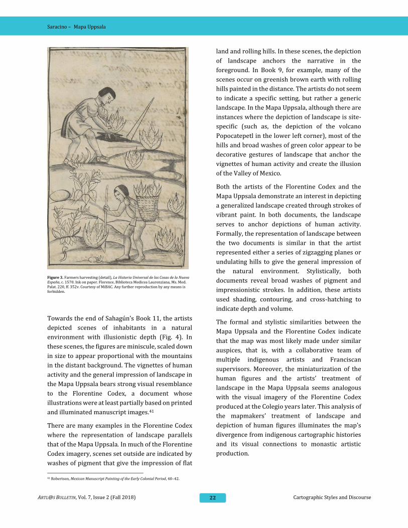
Figure 3. Farmers harvesting (detail), La Historia Universal de las Cosas de la Nueva España, c. 1570. Ink on paper. Florence, Biblioteca Medicea Laurenziana, Ms. Med. Palat. 220, ff. 352v. Courtesy of MiBAC. Any further reproduction by any means is forbidden.
Towards the end of Sahagún’s Book 11, the artists
depicted scenes of inhabitants in a natural
environment with illusionistic depth (Fig. 4). In
these scenes, the figures are miniscule, scaled down
in size to appear proportional with the mountains
in the distant background. The vignettes of human
activity and the general impression of landscape in
the Mapa Uppsala bears strong visual resemblance
to the Florentine Codex, a document whose
illustrations were at least partially based on printed
and illuminated manuscript images.41
There are many examples in the Florentine Codex
where the representation of landscape parallels
that of the Mapa Uppsala. In much of the Florentine
Codex imagery, scenes set outside are indicated by
washes of pigment that give the impression of flat
41 Robertson, Mexican Manuscript Painting of the Early Colonial Period, 40–42.
land and rolling hills. In these scenes, the depiction
of landscape anchors the narrative in the
foreground. In Book 9, for example, many of the
scenes occur on greenish brown earth with rolling
hills painted in the distance. The artists do not seem
to indicate a specific setting, but rather a generic
landscape. In the Mapa Uppsala, although there are
instances where the depiction of landscape is site-
specific (such as, the depiction of the volcano
Popocatepetl in the lower left corner), most of the
hills and broad washes of green color appear to be
decorative gestures of landscape that anchor the
vignettes of human activity and create the illusion
of the Valley of Mexico.
Both the artists of the Florentine Codex and the
Mapa Uppsala demonstrate an interest in depicting
a generalized landscape created through strokes of
vibrant paint. In both documents, the landscape
serves to anchor depictions of human activity.
Formally, the representation of landscape between
the two documents is similar in that the artist
represented either a series of zigzagging planes or
undulating hills to give the general impression of
the natural environment. Stylistically, both
documents reveal broad washes of pigment and
impressionistic strokes. In addition, these artists
used shading, contouring, and cross-hatching to
indicate depth and volume.
The formal and stylistic similarities between the
Mapa Uppsala and the Florentine Codex indicate
that the map was most likely made under similar
auspices, that is, with a collaborative team of
multiple indigenous artists and Franciscan
supervisors. Moreover, the miniaturization of the
human figures and the artists’ treatment of
landscape in the Mapa Uppsala seems analogous
with the visual imagery of the Florentine Codex
produced at the Colegio years later. This analysis of
the mapmakers’ treatment of landscape and
depiction of human figures illuminates the map’s
divergence from indigenous cartographic histories
and its visual connections to monastic artistic
production.

Saracino – Mapa Uppsala
23 ARTL@S BULLETIN, Vol. 7, Issue 2 (Fall 2018) Cartographic Styles and Discourse
Figure 4. Landscape scenes (details), La Historia Universal de las Cosas
de la Nueva España, c. 1570. Ink on paper. Florence, Biblioteca Medicea
Laurenziana, Ms. Med. Palat. 220, ff. 388r. Courtesy of MiBAC. Any further
reproduction by any means is forbidden.
42 The comparison to "landscape-maps" (mapas-paisajes) in the Civitates Orbis Terrarum (first published in 1573) is made by León Portilla and Aguilera, Mapa de Mexico Tenochtitlan y sus contornos hacia 1550, (México, D.F.: Celanese Mexicana, 1986) 25–27. Donald Robertson compares the Mapa Uppsala to Pieter Bruegel’s
The similarities between the representation of
landscape in both documents are also significant if
we consider the attributed dates of both. The Mapa
Uppsala’s attributed date of production ranges
from c. 1540 – 1555 and Book 11 of the Florentine
Codex about a decade or two later. This means that
the artists of the Mapa Uppsala were not only
innovating cartographic production but also
fomenting a distinct visual culture coalescing
specifically at the Colegio de Santa Cruz. This fact
reinforces a need to reconsider the style of the
Mapa Uppsala not as one of mere emulation or
acculturation but of innovation and experi-
-mentation, with long-lasting influences on the
visual culture of the Colegio.
Problematizing the Notion of
“Landscape” in the Mapa Uppsala
Past art historians compared the Mapa Uppsala to
what they viewed as similar examples produced
across the ocean (albeit decades later) including
Dutch landscapes and “landscape-maps” (such as
those found in the late sixteenth-century atlas
Civitates Orbis Terrarum by Georg Braun and Frans
Hogenberg.)42 These comparisons tended to
diminish the fact that the artists rendered almost
two hundred indigenous glyphs for place names
and sites that embody the indigenous community’s
cultural associations with sites established long
before the arrival of the Spanish. In addition, these
descriptions of the map’s pictorial style position it
at the end of an artistic spectrum in which
indigenous artists fully assimilated European
representational techniques, neglecting a
consideration of how the artists’ integration of
glyphs into the naturalistic landscape innovated
artistic and cartographic production in early
colonial Mexico City. In this section, I demonstrate
how in several instances, the artists creatively
wielded glyphic representation to double as figural
imagery, blurring the distinction between figural
Tower of Babel (1563) and the Battle of Alexander by Adam Elsheimer (a Baroque painter born in 1578). Robertson, Mexican Manuscript Painting of the Early Colonial Period, 160.

Saracino – Mapa Uppsala
24 Cartographic Styles and Discourse ARTL@S BULLETIN, Vol. 7, Issue 2 (Fall 2018)
representation and writing on the surface of the
Mapa Uppsala.
In the upper left corner of the map (the
southwestern region of the valley), three figures in
white tunics energetically wield axes above their
heads as they approach the schematized trees of
the grove (Fig. 5). Although this appears to be
another example of the many vignettes that
illustrate scenes of everyday life, Miguel León-
Portilla and Carmen Aguilera have argued that this
might be the artist’s innovative way of representing
Cuauhximalpan, meaning “The place where wood is
worked.”43 In the detail, the axe in motion is a
salient identifier of Cuauximalpan. In the etymology
of the place name, the root ‘Cuauxim(a)’ is a verb
meaning, ‘to do carpentry, to work wood.’44 Since
the place name implicitly embodied a verb, the
artist might have adapted the glyph into a narrative
scene that would create more visual coherence
within the representation. The settlement of
present-day Cuaximalpan can be generally
correlated to its approximate location in the Mapa
Uppsala.
In the lower left-hand corner, the artists also
rendered the great volcano of Popocatepetl with its
characteristic smoking peak rendered as bulbous
puffs of smoke shaded with a light gray wash.
Popocatepetl derives its name from two Nahuatl
words popoca and tepetl, collectively signifying
“The mountain which continually smokes.” Even
today, Popocatepetl can be distinguished from its
neighboring peak Iztaccihuatl by its ever-present
stream of smoke that emerges from its active
volcanic vent. The map’s artists capitalized on the
glyph’s linguistic connotations along with its
pictorial representation to both identify the site by
its name and visually describe its characteristic
physical features.
A final example of this pictorial doubling can be
observed in the left side of the map in the volcanic
region of the Pedregal lava fields just south of
Coyoacan. The landscape is pictorially described
43 Alonso de Santa Cruz et al., Mapa de México Tenochtitlan y Sus Contornos Hacia 1550 (México, D.F: Celanese Mexicana, S.A, 1986), 64. 44 Frances E. Karttunen, An Analytical Dictionary of Nahuatl, 1st ed, Texas Linguistics Series (Austin: University of Texas Press, 1983), 66.
with maguey plants and nopal cacti. In addition, a
series of grass blades, marked with short, staccato-
like pen strokes, are sketched in a break in the
range.
Figure 5. Cuauximalpan (detail), Mapa Uppsala. Courtesy of Carolina Rediviva
Library, Uppsala University, Uppsala, Sweden.
Unlike the maguey and cacti that emerge more
illusionistically from the crevices of the mountains,
these grass blades are unanchored to the
surrounding landscape. Some blades of grass are
depicted outside of the range on white background.
Although it may seem that the artist disregarded
Western conventions of illusionistic landscape,
grass blades glyphically identify Zacatepec, or
“grass-hill,” which we can identity on a modern
map of the region. In pre-Hispanic times, Zacatepec
served as a hunting preserve for Aztec rulers, a
notable feature on the Cortés plan. In indigenous
pictorial tradition, the tecpan, or ruler house, was
demarcated with a concentric circle lintel (alluding
to jade, a symbol of preciousness and authority).45
Notably, a tecpan is rendered close to Zacatepec,
likely alluding to the pre-Hispanic hunting lodge of
the Aztec rulers.46
45 For further analysis on the role of the tecpan in the Mapa Uppsala, see Evans, “The Aztec Palace under Spanish Rule.” 46 I thank Elizabeth Boone for pointing this out to me.

Saracino – Mapa Uppsala
25 ARTL@S BULLETIN, Vol. 7, Issue 2 (Fall 2018) Cartographic Styles and Discourse
Conclusion
This essay has aimed to complicate past
characterizations of the Mapa Uppsala as displaying
features more influenced by European stylistic and
cartographic tradition than indigenous through an
analysis of spatial representation, composition,
style, and pictorial conventions. The first section
revealed how the artists’ rendering of Tlatelolco
presented its equal status to the neighboring
altepetl of Mexico-Tenochtitlan through indigenous
pictorial conventions. These included de-centering
Mexico-Tenochtitlan to the left and depicting the
island as comprised of both altepetl, joined at the
center of the map. The mapmakers also emphasized
the Colegio de Santa Cruz through scale and by
centering it within Tlatelolco. Finally, the artists
rendered the monastic complex in a manner
consistent with other contemporary indigenous
made maps, that is, with a combination of
perspectives including a planimetric outline for the
limits of the complex. These choices served to
amplify the importance of Tlatelolco relative to its
neighboring altepetl and present it as equal in
status in early colonial Mexico City.
The second section revisited previous characteri-
-zations of the map’s style as predominantly
European, particularly regarding the representa-
-tion of the landscape that surrounds the urban
plan. A comparison of the mapmakers’ view of the
central valley of Mexico with that in the Codex
Xolotl demonstrated that the perspectival
presentation in both maps was similar, that is,
planimetric. What differs between them, as many
scholars have highlighted, is the naturalistic style of
the landscape in the Mapa Uppsala. By connecting
this style to other representations of landscape
found in documents also produced at the Colegio de
Santa Cruz, such as the Florentine Codex, I argue for
a reconsideration of how we view the aesthetics of
the Mapa Uppsala, not as a teleological endpoint to
native artists’ adaptation of European
representational style, but rather as an indication
of a coalescing visual style and language fomenting
at the Colegio itself. In addition, my presentation of
a few cases in which glyphs double as figural
representation also complicate the argument that
the artists were influenced entirely by European
modes of representation since the incorporation of
glyphs reflects an understanding of both European
and indigenous visual traditions and a desire to
creatively blend the two.
This essay has focused on the unique collaborative
artistic and intellectual climate of the Colegio de
Santa Cruz to contextualize the aesthetic and
cartographic choices made by the map’s indigenous
artists. It argues for viewing the stylistic choices
made by the artists as indicative of a new visual
style and vocabulary coalescing specifically at the
Colegio that would go on to influence other well-
known products produced there (like the
Florentine Codex.) These multiple instances in
which the artists selected indigenous pictorial
conventions and intermingled them with European
influences gleaned from their monastic setting
demonstrates the intellectual savvy of the artists
and rightly recognizes and amplifies their
contributions to cartographic production in early
colonial Mexico City.