initial study - files.ceqanet.opr.ca.gov
TRANSCRIPT
I N I T I A L S T U D Y
KAISER PERMANENTE HESPERIA - MEDICAL OFFICE BUILDING PROJECT
CITY OF HESPERIA
SAN BERNARDINO COUNTY, CALIFORNIA
FEBRUARY 2019

THIS PAGE INTENTIONALLY LEFT BLANK

I N I T I A L S T U D Y
KAISER PERMANENTE HESPERIA- MEDICAL OFFICE BUILDING PROJECT
CITY OF HESPERIA
SAN BERNARDINO COUNTY, CALIFORNIA
Prepared for:
City of Hesperia Development Services Department
9700 Seventh Avenue Hesperia, California 92345
(760) 947-1473
Prepared by:
LSA Associates, Inc. 1500 Iowa Avenue, Suite 200
Riverside, California 92507 (951) 781-9310
LSA Project No. KSP1801
FEBRUARY 2019

THIS PAGE INTENTIONALLY LEFT BLANK
ADMINISTRATIVE DRAFT INITIAL STUDY KAISER PERMANENTE HESPERIA - MEDICAL OFFICE BUILDING
i
TABLE OF CONTENTS
TABLE OF CONTENTS ...................................................................................................................................... i
APPENDICES ............................................................................................................................................ ii
FIGURES .................................................................................................................................................. ii
TABLES .................................................................................................................................................. ii
ACRONYMS AND ABBREVIATIONS ................................................................................................................ v
1.0 INTRODUCTION AND PURPOSE .............................................................................................................. 1
1.1 INTRODUCTION ......................................................................................................................... 1
1.2 PURPOSE .................................................................................................................................... 1
1.3 INTENDED USE OF THIS INITIAL STUDY ..................................................................................... 2
1.4 PUBLIC REVIEW OF THE INITIAL STUDY ..................................................................................... 2
2.0 PROJECT DESCRIPTION ........................................................................................................................... 3
2.1 PROJECT LOCATION ................................................................................................................... 3
2.2 LAND USE ................................................................................................................................... 3
2.3 PROJECT DESCRIPTION .............................................................................................................. 3
2.4 METHODOLOGY ......................................................................................................................... 5
2.5 REQUIRED PERMITS AND APPROVALS ...................................................................................... 6
2.6 INITIAL STUDY APPENDICES/REFERENCE DOCUMENTS ............................................................ 6
3.0 INITIAL STUDY CHECKLIST ..................................................................................................................... 27
ENVIRONMENTAL FACTORS POTENTIALLY AFFECTED ......................................................................... 29
DETERMINATION (TO BE COMPLETED BY THE LEAD AGENCY) ............................................................ 29
EVALUATION OF ENVIRONMENTAL IMPACTS ...................................................................................... 30
3.1 AESTHETICS.............................................................................................................................. 31
3.2 AGRICULTURE RESOURCES ...................................................................................................... 34
3.3 AIR QUALITY ............................................................................................................................ 36
3.4 BIOLOGICAL RESOURCES ......................................................................................................... 43
3.5 CULTURAL RESOURCES ............................................................................................................ 53
3.6 GEOLOGY AND SOILS ............................................................................................................... 57
3.7 GREENHOUSE GAS EMISSIONS ................................................................................................ 62
3.8 HAZARDS AND HAZARDOUS MATERIALS ................................................................................ 63
3.9 HYDROLOGY AND WATER QUALITY ........................................................................................ 69
3.10 LAND USE AND PLANNING ...................................................................................................... 79

ADMINISTRATIVE DRAFT INITIAL STUDY KAISER PERMANENTE HESPERIA - MEDICAL OFFICE BUILDING
ii
3.11 MINERAL RESOURCES .............................................................................................................. 81
3.12 NOISE ....................................................................................................................................... 82
3.13 POPULATION AND HOUSING ................................................................................................... 97
3.14 PUBLIC SERVICES ..................................................................................................................... 99
3.15 RECREATION .......................................................................................................................... 103
3.16 TRANSPORTATION/TRAFFIC .................................................................................................. 104
3.17 TRIBAL CULTURAL RESOURCES .............................................................................................. 112
3.18 UTILITIES AND SERVICE SYSTEMS .......................................................................................... 114
3.19 MANDATORY FINDINGS OF SIGNIFICANCE ........................................................................... 120
4.0 REFERENCES ....................................................................................................................................... 125 APPENDICES APPENDIX A: CALIFORNIA EMISSIONS ESTIMATOR MODEL (CALEEMOD) APPENDIX B-1: BIOLOGICAL RESOURCES ASSESSMENT APPENDIX B-2: DESERT TORTOISE SURVEY APPENDIX B-3: BURROWING OWL SURVEY APPENDIX B-4: JOSHUA TREE RELOCATION PLAN APPENDIX C-1: CULTURAL RESOURCES ASSESSMENT APPENDIX C-2: PALEONTOLOGICAL ANALYSIS APPENDIX D: GEOTECHNICAL REPORT APPENDIX E: PHASE I ENVIRONMENTAL SITE ASSESSMENT APPENDIX F: WATER QUALITY MANAGEMENT PLAN APPENDIX G: FEDERAL HIGHWAY ADMINISTRATION ROADWAY NOISE LEVEL ANALYSIS APPENDIX H: TRAFFIC IMPACT ANALYSIS
FIGURES Figure 1: Regional and Project Location ....................................................................................................... 7 Figure 2: On-site and Adjacent Land Uses .................................................................................................... 9 Figure 3a: Site Plan ...................................................................................................................................... 11 Figure 3b: North-South Elevations .............................................................................................................. 13 Figure 3c: East-West Elevations .................................................................................................................. 15 Figure 3d: Architectural Renderings ........................................................................................................... 17 Figure 4: Vehicle and Pedestrian Access ..................................................................................................... 19 Figure 5: Public Amenities........................................................................................................................... 21 Figure 6: Site Plan Landscaping ................................................................................................................... 23 Figure 7: WQMP Site Plan ........................................................................................................................... 25 TABLES Table A: Surrounding Land Uses and Setting ................................................................................................ 3 Table B: Short-Term Regional Construction Emissions ............................................................................... 39 Table C: Operational Emissions with Regional Effects ................................................................................ 40 Table D: Long-Term Operational Greenhouse Gas Emissions .................................................................... 63
ADMINISTRATIVE DRAFT INITIAL STUDY KAISER PERMANENTE HESPERIA - MEDICAL OFFICE BUILDING
iii
Table E: General Best Management Practices ............................................................................................ 71 Table F: State of California Land Use Compatibility Plan ............................................................................ 84 Table G: City of Hesperia Municipal Code Noise Standards ....................................................................... 85 Table H: City of Hesperia General Plan Interior and Exterior Noise Standards .......................................... 85 Table I: Existing Noise Level Measurements ............................................................................................... 86 Table J: Typical Maximum Construction Equipment Noise Levels (Lmax) .................................................... 87 Table K: Existing Traffic Noise Levels Without Project................................................................................ 89 Table L: Existing Traffic Noise Levels With Project ..................................................................................... 90 Table M: Future (Opening Year 2020) Traffic Noise Levels Without Project .............................................. 91 Table N: Future (Opening Year 2020) Traffic Noise Levels With Project .................................................... 92 Table O: HVAC Noise Calculations .............................................................................................................. 94 Table P: Projected Water Supply/Demand (acre-feet/year) .................................................................... 117
ADMINISTRATIVE DRAFT INITIAL STUDY KAISER PERMANENTE HESPERIA - MEDICAL OFFICE BUILDING
iv
THIS PAGE INTENTIONALLY LEFT BLANK
ADMINISTRATIVE DRAFT INITIAL STUDY KAISER PERMANENTE HESPERIA - MEDICAL OFFICE BUILDING
v
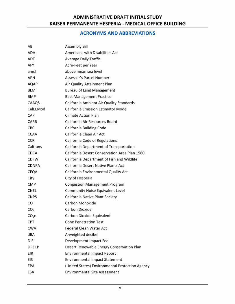
ACRONYMS AND ABBREVIATIONS
AB Assembly Bill ADA Americans with Disabilities Act ADT Average Daily Traffic AFY Acre-Feet per Year amsl above mean sea level APN Assessor’s Parcel Number AQAP Air Quality Attainment Plan BLM Bureau of Land Management BMP Best Management Practice CAAQS California Ambient Air Quality Standards CalEEMod California Emission Estimator Model CAP Climate Action Plan CARB California Air Resources Board CBC California Building Code CCAA California Clean Air Act CCR California Code of Regulations Caltrans California Department of Transportation CDCA California Desert Conservation Area Plan 1980 CDFW California Department of Fish and Wildlife CDNPA California Desert Native Plants Act CEQA California Environmental Quality Act City City of Hesperia CMP Congestion Management Program CNEL Community Noise Equivalent Level CNPS California Native Plant Society CO Carbon Monoxide CO2 Carbon Dioxide CO2e Carbon Dioxide Equivalent CPT Cone Penetration Test CWA Federal Clean Water Act dBA A-weighted decibel DIF Development Impact Fee DRECP Desert Renewable Energy Conservation Plan EIR Environmental Impact Report EIS Environmental Impact Statement EPA (United States) Environmental Protection Agency ESA Environmental Site Assessment
ADMINISTRATIVE DRAFT INITIAL STUDY KAISER PERMANENTE HESPERIA - MEDICAL OFFICE BUILDING
vi
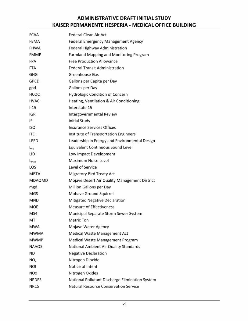
FCAA Federal Clean Air Act FEMA Federal Emergency Management Agency FHWA Federal Highway Administration FMMP Farmland Mapping and Monitoring Program FPA Free Production Allowance FTA Federal Transit Administration GHG Greenhouse Gas GPCD Gallons per Capita per Day gpd Gallons per Day HCOC Hydrologic Condition of Concern HVAC Heating, Ventilation & Air Conditioning I-15 Interstate 15 IGR Intergovernmental Review IS Initial Study ISO Insurance Services Offices ITE Institute of Transportation Engineers LEED Leadership in Energy and Environmental Design Leq Equivalent Continuous Sound Level LID Low Impact Development Lmax Maximum Noise Level LOS Level of Service MBTA Migratory Bird Treaty Act MDAQMD Mojave Desert Air Quality Management District mgd Million Gallons per Day MGS Mohave Ground Squirrel MND Mitigated Negative Declaration MOE Measure of Effectiveness MS4 Municipal Separate Storm Sewer System MT Metric Ton MWA Mojave Water Agency MWMA Medical Waste Management Act MWMP Medical Waste Management Program NAAQS National Ambient Air Quality Standards ND Negative Declaration NO2 Nitrogen Dioxide NOI Notice of Intent NOx Nitrogen Oxides NPDES National Pollutant Discharge Elimination System NRCS Natural Resource Conservation Service
ADMINISTRATIVE DRAFT INITIAL STUDY KAISER PERMANENTE HESPERIA - MEDICAL OFFICE BUILDING
vii
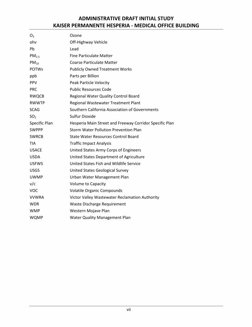
O3 Ozone ohv Off-Highway Vehicle Pb Lead PM2.5 Fine Particulate Matter PM10 Coarse Particulate Matter POTWs Publicly Owned Treatment Works ppb Parts per Billion PPV Peak Particle Velocity PRC Public Resources Code RWQCB Regional Water Quality Control Board RWWTP Regional Wastewater Treatment Plant SCAG Southern California Association of Governments SO2 Sulfur Dioxide Specific Plan Hesperia Main Street and Freeway Corridor Specific Plan SWPPP Storm Water Pollution Prevention Plan SWRCB State Water Resources Control Board TIA Traffic Impact Analysis USACE United States Army Corps of Engineers USDA United States Department of Agriculture USFWS United States Fish and Wildlife Service USGS United States Geological Survey UWMP Urban Water Management Plan v/c Volume to Capacity VOC Volatile Organic Compounds VVWRA Victor Valley Wastewater Reclamation Authority WDR Waste Discharge Requirement WMP Western Mojave Plan WQMP Water Quality Management Plan
ADMINISTRATIVE DRAFT INITIAL STUDY KAISER PERMANENTE HESPERIA - MEDICAL OFFICE BUILDING
viii
THIS PAGE INTENTIONALLY LEFT BLANK
ADMINISTRATIVE DRAFT INITIAL STUDY KAISER PERMANENTE HESPERIA - MEDICAL OFFICE BUILDING
1
1.0 INTRODUCTION AND PURPOSE
1.1 INTRODUCTION Section 1.0 of this Initial Study (IS) describes the purpose, environmental authorization, the intended uses of the IS, documents incorporated by reference, and the processes and procedures governing the preparation of the environmental document. Pursuant to Section 15367 of the State of California Guidelines for Implementation of the California Environmental Quality Act (CEQA Guidelines), the City of Hesperia (City) is the Lead Agency under the California Environmental Quality Act (CEQA). The City has primary responsibility for compliance with CEQA and consideration of the Kaiser Permanente Medical Office Building Project (project or proposed project).
The Initial Study is organized as follows:
Section 1.0 Introduction and Purpose provides a discussion of the Initial Study’s purpose, focus, legal requirements.
Section 2.0 Project Description provides a detailed description of the proposed project.
Section 3.0 Environmental Checklist includes a checklist and accompanying analyses of the project’s effect on the environment. For each environmental issue, the analysis identifies the level of project’s environmental impact.
Section 4.0 References details the references cited throughout the document.
Appendices Includes the technical material prepared to support the analyses contained in the IS.
1.2 PURPOSE CEQA requires that the proposed project be reviewed to determine the environmental effects that would result if the project were approved and implemented. The City is the Lead Agency and has the responsibility of preparing and adopting the associated environmental document prior to consideration of the approval of the proposed project. The City has the authority to make decisions regarding discretionary actions relating to implementation of the proposed project.
This IS has been prepared in accordance with the relevant provisions of CEQA (California Public Resources Code Section 21000 et seq.); the CEQA Guidelines,1 and the rules, regulations, and procedures for implementing CEQA as adopted by the City. The objective of the Initial Study is to inform City decision-makers, representatives of other affected/responsible agencies, the public, and interested parties of the potential environmental consequences of the project.
As established in CEQA Guidelines Section 15063(c), the purposes of an IS are to:
• Provide the Lead Agency (City of Hesperia) with information to use as the basis for deciding whether to prepare an Environmental Impact Report (EIR), Negative Declaration (ND), or Mitigated Negative Declaration (MND);
• Enable an applicant or Lead Agency to modify a project, mitigating adverse impacts before an EIR is prepared, thereby enabling the project to qualify for an ND or MND;
1 California Code of Regulations, Title 14, Chapter 3, Sections 15000 through 15387.
ADMINISTRATIVE DRAFT INITIAL STUDY KAISER PERMANENTE HESPERIA - MEDICAL OFFICE BUILDING
2
• Assist in the preparation of an EIR, if one is required;
• Facilitate environmental assessment early in the design of a project;
• Provide a factual basis for finding in an ND or MND that a project will not have a significant effect on the environment;
• Eliminate unnecessary EIRs; and
• Determine whether a previously prepared EIR could be used with the project.
1.3 INTENDED USE OF THIS INITIAL STUDY The City formally initiated the environmental process for the proposed project with the preparation of this Initial Study. The IS screens out those impacts that would be less than significant and do not warrant mitigation, while identifying those issues that require further mitigation to reduce impacts to a less than significant level. As identified in the following analyses, project impacts related to various environmental issues either do not occur, are less than significant (when measured against established significance thresholds), or have been rendered less than significant through implementation of mitigation measures. Based on these analytical conclusions, this IS supports adoption of an MND for the proposed project.
CEQA2 permits the incorporation by reference of all or portions of other documents that are generally available to the public. The IS has been prepared utilizing information from City planning and environmental documents, technical studies specifically prepared for the project, and other publicly available data. The documents utilized in the IS are identified in Section 4.0 and are hereby incorporated by reference. These documents are available for review at the City of Hesperia, Development Services Department.
1.4 PUBLIC REVIEW OF THE INITIAL STUDY
The IS and a Notice of Intent (NOI) to adopt an MND will be distributed to responsible and trustee agencies, other affected agencies, and other parties for a 30-day public review period. Written comments regarding this IS should be addressed to:
Ryan Leonard, AICP, Senior Planner City of Hesperia Development Services Department 9700 Seventh Avenue Hesperia, California 92345 (760) 947-1651 [email protected]
Consideration of comments raised during the 30-day public review period will be taken into account and addressed prior to adoption of the MND by the City.
2 CEQA Guidelines Section 15150.
ADMINISTRATIVE DRAFT INITIAL STUDY KAISER PERMANENTE HESPERIA - MEDICAL OFFICE BUILDING
3
2.0 PROJECT DESCRIPTION
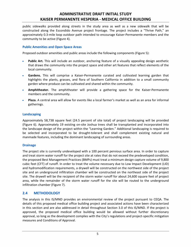
2.1 PROJECT LOCATION Geographically, the project site is in the northeast quarter of Section 23, Township 4 North, Range 5 West, as shown on the Hesperia, California United States Geological Survey (USGS) 7.5-minute quadrangle. As Figure 1 shows, the project site is located at the southwest corner of the Escondido Avenue/The Marketplace intersection in the City of Hesperia. (All figures are located at the end of this chapter.) The proposed project site is located within the Hesperia Main Street and Freeway Corridor Specific Plan (Specific Plan). The Specific Plan area encompasses both major regional access to the City of Hesperia, Interstate 15 (approximately 0.4 mile west), as well as the major arterial, Main Street (0.2 mile north), supporting local circulation that provides access to commercial centers within the City.
2.2 LAND USE The project site is located on 9.9 vacant acres encompassing all or parts of Assessor Parcel Numbers (APNs) 3057-011-22 through 26. However, approximately 5.7 acres comprised of portions of APNs 3057-011-22 through 24 of the project site will be developed.
The project site is bounded by vacant or undeveloped properties to the north, south, and west and Escondido Avenue to the east. A retail center (Walmart with outlying retail and restaurant uses) and hotel uses are located approximately 0.16 mile to the northeast and northwest, respectively. It is important to note that the west side of the existing project site will be bordered in the future by the southerly extension of Mountain Vista Avenue. Figure 2 identifies existing on-site and adjacent land uses.
Table A: Surrounding Land Uses and Setting
Direction Existing Land Use General Plan Designation Zoning Designation
Project Site
Vacant/Undeveloped Regional Commercial (RC)
Hesperia Main Street and Freeway Corridor Specific Plan
North Undeveloped building pad, paved driveways and parking lot
Regional Commercial (RC)
Hesperia Main Street and Freeway Corridor Specific Plan
East Escondido Avenue, gravel parking lot Regional Commercial (RC)
Hesperia Main Street and Freeway Corridor Specific Plan
South Vacant/Undeveloped Regional Commercial (RC)
Hesperia Main Street and Freeway Corridor Specific Plan
West Vacant/Undeveloped Regional Commercial (RC)
Hesperia Main Street and Freeway Corridor Specific Plan
2.3 PROJECT DESCRIPTION The project consists of the construction and operation of a 3 story, approximately 55,000-square foot outpatient medical office building with parking and landscaped areas (Figures 3a through 3d). The medical office building will be comprised of 30 provider offices, 46 exam rooms, a vision care center, pharmacy, radiology/imaging suites, physical therapy, ancillary services and building support. The Kaiser-Permanente Hesperia complex will provide additional outdoor amenities to support both members and the community at large. The project has been planned to achieve the LEED Gold Design benchmark.
ADMINISTRATIVE DRAFT INITIAL STUDY KAISER PERMANENTE HESPERIA - MEDICAL OFFICE BUILDING
4
Grading
Existing site elevations range from 3,504 to 3,524 feet above mean sea level (amsl) with the site sloping slightly southwest to northeast. The proposed finished pad elevation for the proposed structure is approximately 3,516 feet amsl. The upper 5 to 6 feet of existing soils will be removed to lower the elevation of the site to accommodate the proposed structures and parking areas. Earthwork quantity estimates anticipate 13,410 and 12,312 cubic yards of cut and fill material, respectively. Approximately, 1,096 cubic yards of material will be exported from the site.
Parking and Site Access
A drop-off/pick up zone will be provided along the eastern portion the medical office building. A total of 274 parking spaces is planned to be provided on site, including 249 standard stalls, 14 Americans with Disabilities Act (ADA) stalls, and eight stalls dedicated for electric vehicles. The project provides three additional parking stalls to accommodate motorcycles.
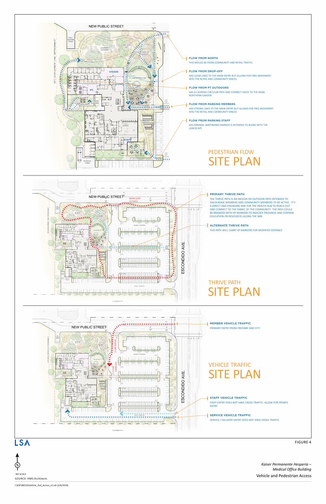
Vehicular and pedestrian access to the proposed project site will be provided as follows (Figure 4):
• Escondido Avenue Northerly Project Driveway. This project driveway will be located on the west side of Escondido Avenue, across The Marketplace driveway. This driveway will be made possible through a shared use agreement with the adjacent parcel to the north. The northerly driveway will be a primary access point and is planned to accommodate access both for the proposed project and the adjacent parcels. The project site driveway will provide a direct connection to the internal drive aisles surrounding the medical office building, the planned drop-off and pickup area located east of the building, and the proposed service/loading dock located at the southern portion of the site.
As part of the proposed project, this driveway will create the west leg of the Escondido Avenue/The Marketplace intersection and full access (i.e., left-turn and right-turn ingress and egress turning movements) will be accommodated at this driveway. Traffic signal modifications will also be required at this intersection as part of the proposed project. The proposed improvements at the Escondido Avenue/The Marketplace intersection would be constructed by the Project Applicant per City of Hesperia design standards.
• Escondido Avenue Southerly Project Driveway. This project driveway is planned to be located on the west side of Escondido Avenue, at the southeast corner of the project site. The Escondido Avenue southerly driveway is planned to provide access to the medical office building and associated parking areas. Full access is planned to be provided (i.e., right-turn and left-turn ingress and egress turning movements) at this project driveway via the existing two-way left-turn lane provided on Escondido Avenue. The Escondido Avenue southerly driveway would be constructed to City of Hesperia design standards.
It should be noted that, based on information provided by City of Hesperia staff, a future raised median island is planned for Escondido Avenue as part of the ultimate cross-section configuration. Therefore, when the raised median is constructed along Escondido Avenue, the southerly project driveway would be limited to right-turn ingress and egress movements only.
Pedestrian and Bicycle Connectivity
The project site is accessible from nearby public bus stops as well as other amenities along nearby major corridors. The majority of pedestrian access to the project site is envisioned to occur via the existing
ADMINISTRATIVE DRAFT INITIAL STUDY KAISER PERMANENTE HESPERIA - MEDICAL OFFICE BUILDING
5
public sidewalks provided along streets in the study area as well as a new sidewalk that will be constructed along the Escondido Avenue project frontage. The project includes a “Thrive Path,” an approximately 0.3-mile loop outdoor path intended to encourage Kaiser-Permanente members and the community to be active (Figure 4).
Public Amenities and Open Space Areas
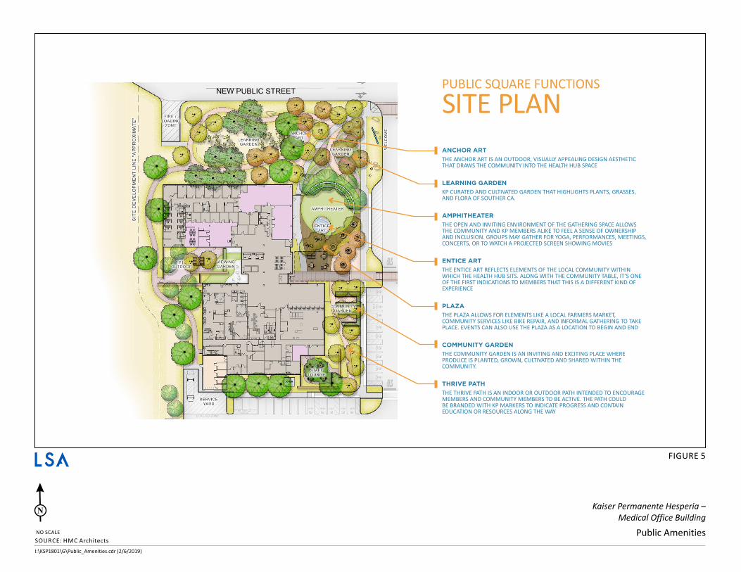
Proposed outdoor amenities and public areas include the following components (Figure 5):
• Public Art. This will include an outdoor, anchoring feature of a visually appealing design aesthetic that draws the community into the project space and other art features that reflect elements of the local community.
• Gardens. This will comprise a Kaiser-Permanente curated and cultivated learning garden that highlights the plants, grasses, and flora of Southern California in addition to a small community garden where produce can be cultivated and shared within the community.
• Amphitheater. The amphitheater will provide a gathering space for the Kaiser-Permanente members and the community.
• Plaza. A central area will allow for events like a local farmer’s market as well as an area for informal gatherings.
Landscaping
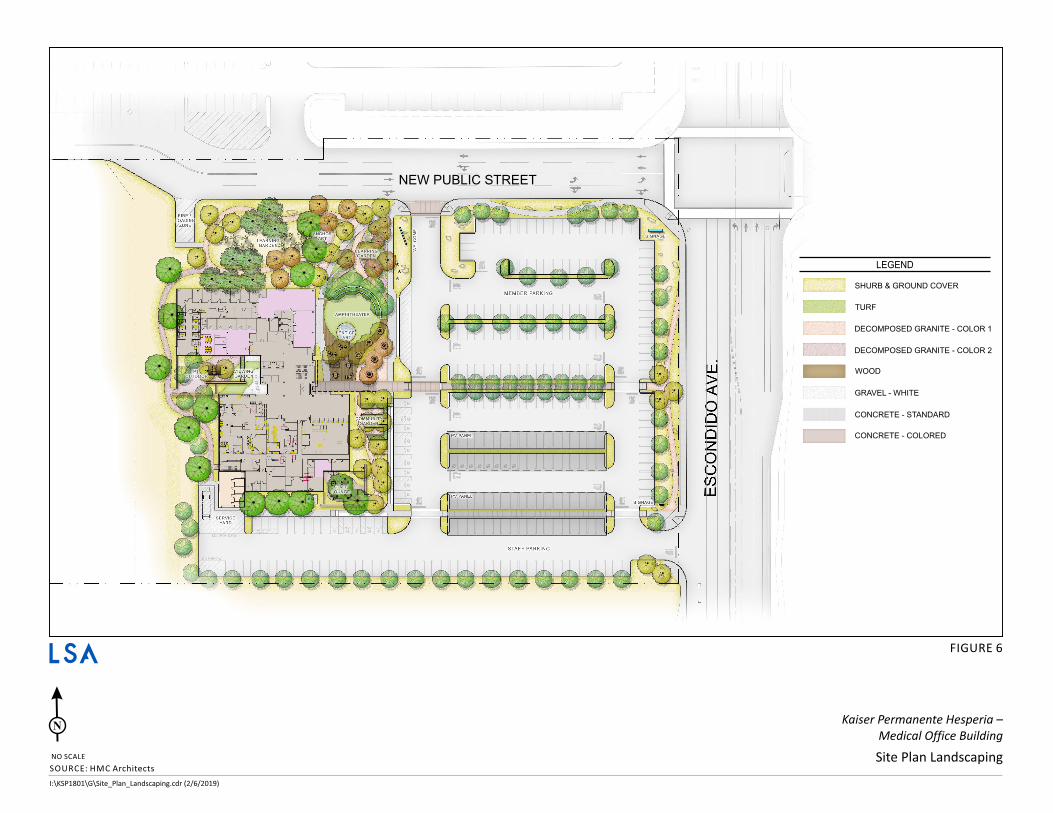
Approximately 58,738 square feet (24.5 percent of site total) of project landscaping will be provided (Figure 6). Approximately 19 existing on-site Joshua trees shall be transplanted and incorporated into the landscape design of the project within the “Learning Garden.” Additional landscaping is required to be selected and incorporated to be drought-tolerant and shall complement existing natural and manmade features, including the dominant landscaping of surrounding areas.
Drainage
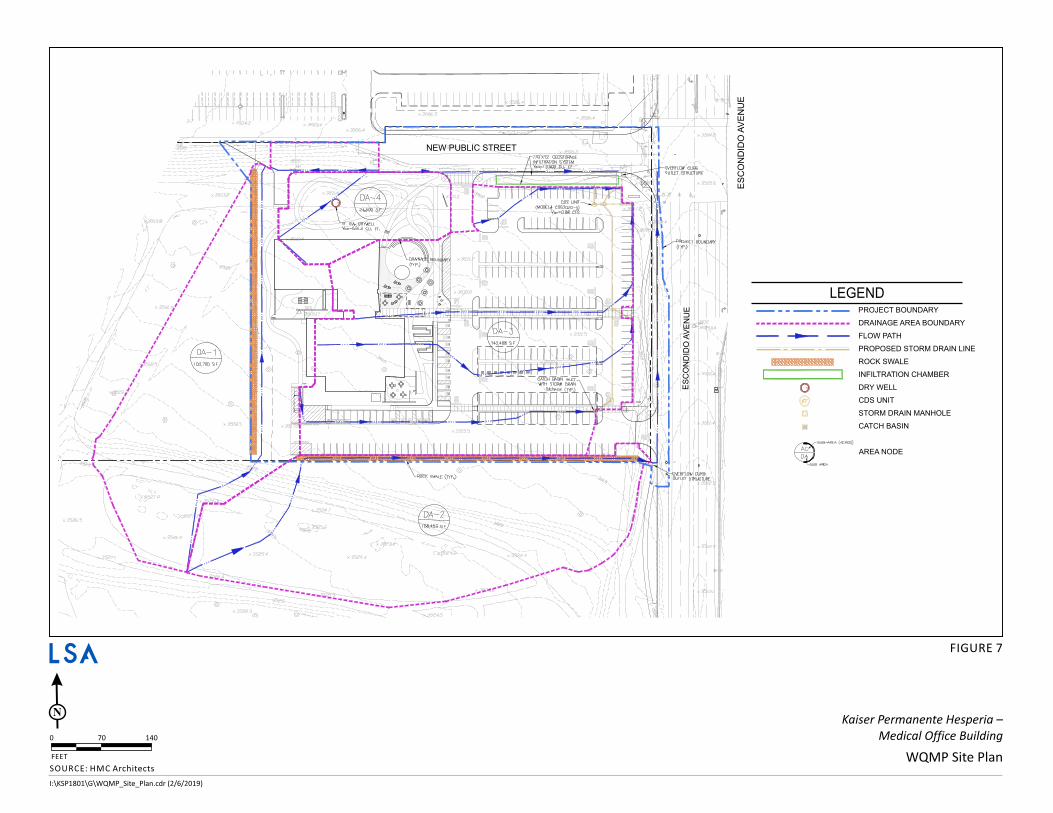
The project site is currently undeveloped with a 100 percent pervious surface area. In order to capture and treat storm water runoff for the project site at rates that do not exceed the predeveloped condition, the proposed Best Management Practices (BMPs) must treat a minimum design capture volume of 9,800 cubic feet (CFT) of runoff. In order to treat the volume necessary due to Low Impact Development (LID) and hydromodification requirements, a drywell will be constructed on the northwest side of the project site and an underground infiltration chamber will be constructed on the northeast side of the project site. The drywell will be the recipient of the storm water runoff for about 24,600 square feet of project area, while the remainder of the storm water runoff for the site will be routed to the underground infiltration chamber (Figure 7).
2.4 METHODOLOGY The analysis in this IS/MND provides an environmental review of the project pursuant to CEQA. The details of this proposed medical office building project and associated actions have been characterized in this section and are also addressed in detail throughout Section 3.0 of this IS/MND. If the project is approved, the proposed medical office building would be allowed without further discretionary approval, so long as the development complies with the City’s regulations and project-specific mitigation measures and Conditions of Approval.
ADMINISTRATIVE DRAFT INITIAL STUDY KAISER PERMANENTE HESPERIA - MEDICAL OFFICE BUILDING
6
2.5 REQUIRED PERMITS AND APPROVALS The City is expected to use this IS/MND in consideration of the proposed medical office building and associated actions. These actions may include, but are not limited to, the following:
• Site Plan Review pursuant to Article II of the Hesperia Municipal Code.
• Lot merger pursuant to Chapter 17.17.020 of the Hesperia Municipal Code.
• Construction permits, grading permits, and building permits.
The following approvals from other regulatory agencies may also be required:
• State Water Resources Control Board (SWRCB): Notice of Intent to comply with the General Construction Activity National Pollutant Discharge Elimination System (NPDES) Permit.
• Utility Providers: Connection permits.
2.6 INITIAL STUDY APPENDICES/REFERENCE DOCUMENTS The Initial Study is based on the following environmental documents and technical studies:
Appendix A: California Emissions Estimator Model (CalEEMod) Outputs and Climate Action Plan Screening Table
Appendix B-1: Biological Resources Assessment
Appendix B-2: Desert Tortoise Survey
Appendix B-3: Burrowing Owl Survey
Appendix B-4: Joshua Tree Relocation Plan
Appendix C-1: Cultural Resources Assessment
Appendix C-2: Paleontological Analysis
Appendix D: Geotechnical Report
Appendix E: Phase 1 Environmental Site Assessment
Appendix F: Water Quality Management Plan
Appendix G: Federal Highway Administration Roadway Noise Level Analysis Model Outputs
Appendix H: Traffic Impact Analysis
§̈¦15
§̈¦15
ESCO
NDID
O AV
ENUE
MAIN STREET
MARIPO
SA R
OAD
Project Location
SOURCE: USGS 7.5' Quads: Hesperia, 1980, Baldy Mesa, 1988, CAI:\KSP1801\GIS\MXD\IS\RegLoc.mxd (12/19/2018)
FIGURE 1
Kaiser Permanente Hesperia - Medical Office BuildingRegional and Project Location
0 1000 2000FEET
LEGENDProject Location
SanBernardino
County£¤395
ÃÃ138
ÃÃ18
ÃÃ173
ProjectLocation
§̈¦15
§̈¦215
Project Vicinity
~·
LSA

ADMINISTRATIVE DRAFT INITIAL STUDY KAISER PERMANENTE HESPERIA - MEDICAL OFFICE BUILDING
8
THIS PAGE INTENTIONALLY LEFT BLANK
Service Layer Credits:
Main St
Escondido Ave
Sultana St
§̈¦15
California Aqueduct
Undeveloped Undeveloped
UndevelopedResidential
Commercial
CommercialCommercial
Commercial
School
LEGENDProject Location
SOURCE: Google (2018)I:\KSP1801\GIS\MXD\IS\LandUses.mxd (12/19/2018)
FIGURE 2
Kaiser Permanente Hesperia - Medical Office BuildingOn-Site and Adjacent Land Uses
0 300 600FEET
LSA
$ D

ADMINISTRATIVE DRAFT INITIAL STUDY KAISER PERMANENTE HESPERIA - MEDICAL OFFICE BUILDING
10
THIS PAGE INTENTIONALLY LEFT BLANK
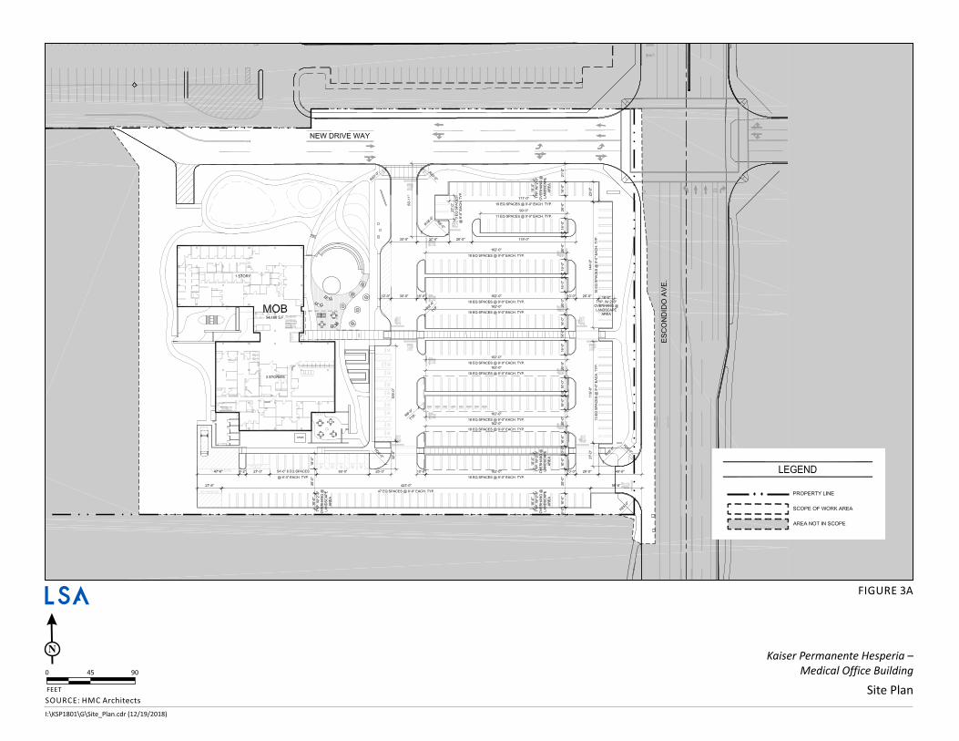
I:\KSP1801\G\Site_Plan.cdr (12/19/2018)
FIGURE 3A
Site Plan
Kaiser Permanente Hesperia –
Medical Office Building
SOURCE HMC Architects:
FEET
90450
N
LSA
¢
◊ II l
\~w-.-...-----
\ \
\ \
' I I I I I I I
I i I
I I i I
I ,.---:::::7 r - J (f7L __________________ ~
L __________________ ~
NEW DRIVE WAY
18EQSPACES CD 9'-0"EACH.TYP.
18 EOSPACES @ 9'QEACH.TYP.
•HEOSPACES Q 'il-U'EACH. TYP.
'-------------------------------------------------- ' -.IQ.\.-------
ui ~
I 0 I C \ i5
q I
d I
_J
z 0 () Cl) w
LEGEND
- • • - PROPERTY LINE
t" - - - - - , SCOPEOF WORKAREA ._ _____ .,

ADMINISTRATIVE DRAFT INITIAL STUDY KAISER PERMANENTE HESPERIA - MEDICAL OFFICE BUILDING
12
THIS PAGE INTENTIONALLY LEFT BLANK
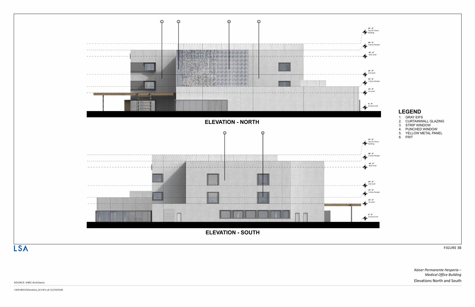
I:\KSP1801\G\Elevations_N-S-W-E.cdr (12/19/2018)
SOURCE HMC Architects:Elevations North and South
FIGURE 3B
Kaiser Permanente Hesperia –
Medical Office Building
0’ - 0”
Ground Level
14’ - 6”
1st Level
19’ - 6”
1-Story Parapet
29’ - 0”
2nd Level
53’ - 6”
Top Of 3-Story
Building
48’ - 6”
3-Story Parapet
43’ - 6”
Roof Level
2 161
1. GRAY EIFS
2. CURTAINWALL GLAZING
3. STRIP WINDOW
4. PUNCHED WINDOW
5. YELLOW METAL PANEL
6. FRIT
0’ - 0”
Ground Level
14’ - 6”
1st Level
19’ - 6”
1-Story Parapet
29’ - 0”
2nd Level
53’ - 6”
Top Of 3-Story
Building
48’ - 6”
3-Story Parapet
43’ - 6”
Roof Level
41
ELEVATION - NORTH
ELEVATION - SOUTH
LEGEND
---------------- t--~~I~~:~~: -
__ :r
LSA
I ___ l _______________________ ! -------------------------------- ,,♦
----------♦
----------♦ ,♦
I
----------♦
,♦ I
1- - - - - - - - - - - - - - - - - - - - - - - - - - - - - - - - - - - _: :-:, ...
-----------+-
-----------+,,♦

ADMINISTRATIVE DRAFT INITIAL STUDY KAISER PERMANENTE HESPERIA - MEDICAL OFFICE BUILDING
14
THIS PAGE INTENTIONALLY LEFT BLANK

I:\KSP1801\G\Elevations_N-S-W-E.cdr (12/19/2018)
SOURCE HMC Architects:Elevations North and South
FIGURE 3B
Kaiser Permanente Hesperia –
Medical Office Building
0’ - 0”
Ground Level
14’ - 6”
1st Level
19’ - 6”
1-Story Parapet
29’ - 0”
2nd Level
53’ - 6”
Top Of 3-Story
Building
48’ - 6”
3-Story Parapet
43’ - 6”
Roof Level
2 161
1. GRAY EIFS
2. CURTAINWALL GLAZING
3. STRIP WINDOW
4. PUNCHED WINDOW
5. YELLOW METAL PANEL
6. FRIT
0’ - 0”
Ground Level
14’ - 6”
1st Level
19’ - 6”
1-Story Parapet
29’ - 0”
2nd Level
53’ - 6”
Top Of 3-Story
Building
48’ - 6”
3-Story Parapet
43’ - 6”
Roof Level
41
ELEVATION - NORTH
ELEVATION - SOUTH
LEGEND
---------------- t--~~I~~:~~: -
__ :r
LSA
I ___ l _______________________ ! -------------------------------- ,,♦
----------♦
----------♦ ,♦
I
----------♦
,♦ I
1- - - - - - - - - - - - - - - - - - - - - - - - - - - - - - - - - - - _: :-:, ...
-----------+-
-----------+,,♦

ADMINISTRATIVE DRAFT INITIAL STUDY KAISER PERMANENTE HESPERIA - MEDICAL OFFICE BUILDING
16
THIS PAGE INTENTIONALLY LEFT BLANK
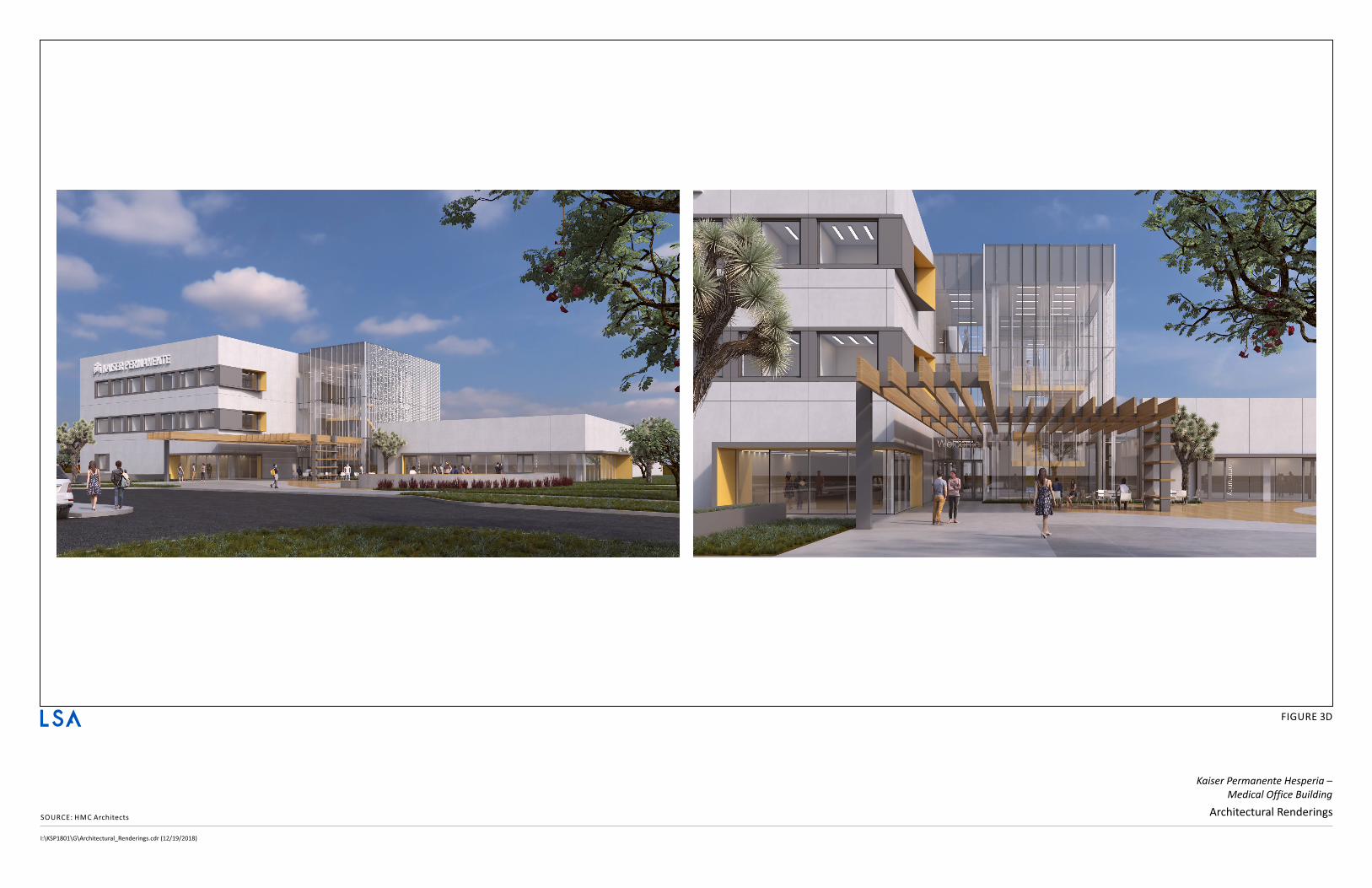
I:\KSP1801\G\Architectural_Renderings.cdr (12/19/2018)
SOURCE HMC Architects:Architectural Renderings
FIGURE 3D
Kaiser Permanente Hesperia –
Medical Office Building
LSA
ADMINISTRATIVE DRAFT INITIAL STUDY KAISER PERMANENTE HESPERIA - MEDICAL OFFICE BUILDING
18
THIS PAGE INTENTIONALLY LEFT BLANK
I:\KSP1801\G\Vehicle_Ped_Access_v2.cdr (2/6/2019)
FIGURE 4
Vehicle and Pedestrian AccessSOURCE HMS Architects:
NO SCALE
N Kaiser Permanente Hesperia –
Medical Office Building
VISION
CONF.
STAFF
PT.
PEDESTRIAN FLOW
SITE PLAN
FLOW FROM NORTH
THIS WOULD BE FROM COMMUNITY AND RETAIL TRAFFIC.
FLOW FROM DROP-OFF
HAS CLEAR LINES TO THE MAIN ENTRY BUT ALLOWS FOR FREE MOVEMENT
INTO THE RETAIL AND COMMUNITY SPACES
FLOW FROM PT OUTDOORS
HAS A CALMING CIRCULAR PATH AND CONNECT EASILY TO THE MAIN
NORTHERN GARDEN
FLOW FROM PARKING MEMBERS
HAS STRONG LINES TO THE MAIN ENTRY BUT ALLOWS FOR FREE MOVEMENT
INTO THE RETAIL AND COMMUNITY SPACES
FLOW FROM PARKING STAFF
HAS MINIMAL WAYFINDING MARKER IS INTENDED TO BLEND WITH THE
LANDSCAPE
THRIVE PATH
SITE PLAN
PRIMARY THRIVE PATH
THE THRIVE PATH IS AN INDOOR OR OUTDOOR PATH INTENDED TO
ENCOURAGE MEMBERS AND COMMUNITY MEMBERS TO BE ACTIVE. IT’S
A DIRECT AND ENGAGING WAY FOR THE HEALTH HUB TO REACH OUT
AND CONNECT TO THE FABRIC OF THE COMMUNITY. THE PATH COULD
BE BRANDED WITH KP MARKERS TO INDICATE PROGRESS AND CONTAIN
EDUCATION OR RESOURCES ALONG THE WAY.
ALTERNATE THRIVE PATH
THIS PATH WILL CARRY KP MARKERS FOR MODIFIED DISTANCE
MAIN LOOP
1/3 MILE
VEHICLE TRAFFIC
SITE PLAN
MEMBER VEHICLE TRAFFIC
PRIMARY ENTRY FROM FREEWAY AND CITY
STAFF VEHICLE TRAFFIC
STAFF ENTRY DOES NOT HAVE CROSS TRAFFIC. ALLOW FOR PRIVATE
ENTRY
SERVICE VEHICLE TRAFFIC
SERVICE / DELIVERY ENTRY DOES NOT HAVE CROSS TRAFFIC
3 C
AR
QU
EU
E3
CA
R
DR
OP
-OF
F
NEW PUBLIC STREET
NEW PUBLIC STREET
NEW PUBLIC STREET
LSA
T I
\ \
~ x ~ Q. Q.
~ w z :::; 1-z w
" Q.
g w > w 0 w I-iii
\ \ I I I I I I I I I I I I
_ I
T I
I I I I I I I I I I I I I I I I I I I \ \
' \ I I I I I I I I I I I I
_ I_
\ \
\ \ I I I I I I I I I
FIRE I OADIN ZONE
/
7
--~
0 D
· - - ~
0 D
O~=O
u.i ~ 0 0 0 z 0 (.) (J) w
.. t t ,.

ADMINISTRATIVE DRAFT INITIAL STUDY KAISER PERMANENTE HESPERIA - MEDICAL OFFICE BUILDING
20
THIS PAGE INTENTIONALLY LEFT BLANK
I:\KSP1801\G\Public_Amenities.cdr (2/6/2019)
PUBLIC SQUARE FUNCTIONS
SITE PLAN
ANCHOR ART
THE ANCHOR ART IS AN OUTDOOR, VISUALLY APPEALING DESIGN AESTHETICTHAT DRAWS THE COMMUNITY INTO THE HEALTH HUB SPACE
LEARNING GARDEN
KP CURATED AND CULTIVATED GARDEN THAT HIGHLIGHTS PLANTS, GRASSES,AND FLORA OF SOUTHER CA.
AMPHITHEATER
THE OPEN AND INVITING ENVIRONMENT OF THE GATHERING SPACE ALLOWSTHE COMMUNITY AND KP MEMBERS ALIKE TO FEEL A SENSE OF OWNERSHIPAND INCLUSION. GROUPS MAY GATHER FOR YOGA, PERFORMANCES, MEETINGS,CONCERTS, OR TO WATCH A PROJECTED SCREEN SHOWING MOVIES
ENTICE ART
THE ENTICE ART REFLECTS ELEMENTS OF THE LOCAL COMMUNITY WITHINWHICH THE HEALTH HUB SITS. ALONG WITH THE COMMUNITY TABLE, IT’S ONEOF THE FIRST INDICATIONS TO MEMBERS THAT THIS IS A DIFFERENT KIND OFEXPERIENCE
PLAZA
THE PLAZA ALLOWS FOR ELEMENTS LIKE A LOCAL FARMERS MARKET,COMMUNITY SERVICES LIKE BIKE REPAIR, AND INFORMAL GATHERING TO TAKEPLACE. EVENTS CAN ALSO USE THE PLAZA AS A LOCATION TO BEGIN AND END
COMMUNITY GARDEN
THE COMMUNITY GARDEN IS AN INVITING AND EXCITING PLACE WHEREPRODUCE IS PLANTED, GROWN, CULTIVATED AND SHARED WITHIN THECOMMUNITY.
THRIVE PATH
THE THRIVE PATH IS AN INDOOR OR OUTDOOR PATH INTENDED TO ENCOURAGEMEMBERS AND COMMUNITY MEMBERS TO BE ACTIVE. THE PATH COULDBE BRANDED WITH KP MARKERS TO INDICATE PROGRESS AND CONTAINEDUCATION OR RESOURCES ALONG THE WAY
FIGURE 5
Public Amenities
Kaiser Permanente Hesperia –
Medical Office Building
SOURCE HMC Architects:
NO SCALE
N
NEW PUBLIC STREET
LSA
wl i i §1 0:
~I ~I z
21 ~I g; 1
~I ~I t-in l I
I I
I I \
\ \
\ I I I I I I I I I

ADMINISTRATIVE DRAFT INITIAL STUDY KAISER PERMANENTE HESPERIA - MEDICAL OFFICE BUILDING
22
THIS PAGE INTENTIONALLY LEFT BLANK
LEGEND
SHURB & GROUND COVER
TURF
DECOMPOSED GRANITE - COLOR 1
DECOMPOSED GRANITE - COLOR 2
WOOD
GRAVEL - WHITE
CONCRETE - STANDARD
CONCRETE - COLORED
I:\KSP1801\G\Site_Plan_Landscaping.cdr (2/6/2019)
FIGURE 6
Site Plan Landscaping
Kaiser Permanente Hesperia –
Medical Office Building
SOURCE HMC Architects:
NO SCALE
N
NEW PUBLIC STREET
LSA
"<~
~ ~ _J
I I I

ADMINISTRATIVE DRAFT INITIAL STUDY KAISER PERMANENTE HESPERIA - MEDICAL OFFICE BUILDING
24
THIS PAGE INTENTIONALLY LEFT BLANK
ES
CO
ND
IDO
AV
EN
UE
ES
CO
ND
IDO
AV
EN
UE
LEGEND
PROJECT BOUNDARY
DRAINAGE AREA BOUNDARY
FLOW PATH
PROPOSED STORM DRAIN LINE
ROCK SWALE
INFILTRATION CHAMBER
DRY WELL
CDS UNIT
STORM DRAIN MANHOLE
CATCH BASIN
AREA NODE
I:\KSP1801\G\WQMP_Site_Plan.cdr (2/6/2019)
FEET
140700
N
FIGURE 7
WQMP Site Plan
Kaiser Permanente Hesperia –
Medical Office Building
SOURCE HMC Architects:
NEW PUBLIC STREET
I I I 10 1 rT
,J
I I I I I
\r-~~ ~" lJ 11 ~ )¥~ ~ 1 J i c, ~lt", '_ ><35064 :I I _ ______ _ _ _ _ _ _ _ _ _ o o, I
LSA
¢
I
I
I
I I
__ ,, ,_.,, __ lilOOilOOililililililO
0 @
1:11
■
SUB-AAEA (ACRES)
C A
SUB AAEA

ADMINISTRATIVE DRAFT INITIAL STUDY KAISER PERMANENTE HESPERIA - MEDICAL OFFICE BUILDING
26
THIS PAGE INTENTIONALLY LEFT BLANK
ADMINISTRATIVE DRAFT INITIAL STUDY KAISER PERMANENTE HESPERIA - MEDICAL OFFICE BUILDING
27
3.0 INITIAL STUDY CHECKLIST
1. Project Title: Kaiser Permanente Medical Office Building Project
2. Lead Agency Name and Address: City of Hesperia Development Services Department 9700 Seventh Avenue Hesperia, California 92345
3. Contact Person and Phone Number: Ryan Leonard, AICP, Senior Planner (760) 947-1651 [email protected]
4. Project Location: The project site is in the northeast quarter of Section 23, Township 4 North, Range 5 West, as shown on the Hesperia, California USGS 7.5-minute quadrangle. The project site is located on 9.9 vacant acres at the southwest corner of the Escondido Avenue/The Marketplace intersection in the City of Hesperia and encompasses all or portions of APNs 3057-011-22 through 26. Only 5.7 acres on all or portions of APNs 3057-011-22 through -24 of the 9.9-acre project site will be developed, with no development planned on APNs 3057-011-25 and -26 at this time.
5. Project Sponsor’s Name and Address: Kaiser Permanente 9700 Seventh Avenue Hesperia, California 92345
6. General Plan Designation: Regional Commercial (RC)
7. Zoning: Hesperia Main Street and Freeway Corridor Specific Plan
8. Description of Property: The project site is vacant, undeveloped desert landscape comprising Joshua tree woodland and salt brush scrub, including Joshua tree, California juniper, annual bur-sage, and bladder sage at an elevation of approximately 3,500 feet above mean sea level. The site is subjected to surface disturbance from off-highway vehicle use and dumping of refuse.
9. Setting and Surrounding Land Uses: The setting is relatively flat Joshua tree woodland and salt brush scrub with a northerly slope aspect of less than one percent. Surrounding land uses include commercial development to the north, Escondido Avenue and commercial development to the east, and undeveloped land to the south and west. Interstate 15 (I-15) is located approximately 1,500 feet to the northwest of the site, and the California Aqueduct is located approximately 1,500 feet northeast of the site.

ADMINISTRATIVE DRAFT INITIAL STUDY KAISER PERMANENTE HESPERIA - MEDICAL OFFICE BUILDING
28
10. Required Actions: The City is expected to use this IS/MND in consideration of the proposed medical office building and associated actions. These actions may include, but are not limited to, the following:
• Site Plan Review pursuant to Article II of the Hesperia Municipal Code.
• Lot merger pursuant to Chapter 17.17.020 of the Hesperia Municipal Code.
• Construction permits, grading permits, and building permits.
• The following approvals from other regulatory agencies may also be required:
• SWRCB: NOI to comply with the General Construction Activity NPDES Permit.
• Utility Providers: Connection permits.
11. Have California Native American tribes traditionally and culturally affiliated with the project area requested consultation pursuant to Public Resources Code Section 21080.3.1? If so, has consultation begun? Please refer to Checklist Section 3.17 (Tribal Cultural Resources).
Note: Conducting consultation early in the CEQA process allows tribal governments, lead agencies, and project proponents to discuss the level of environmental review, identify and address potential adverse impacts to tribal cultural resources, and reduce the potential for delay and conflict in the environmental review process. (See Public Resources Code Section 21083.3.2.) Information may also be available from the California Native American Heritage Commission’s Sacred Lands File per Public Resources Code Section 5097.96 and the California Historical Resources Information System administered by the California Office of Historic Preservation. Please also note that Public Resources Code Section 21082.3(c) contains provisions specific to confidentiality.
ADMINISTRATIVE DRAFT INITIAL STUDY KAISER PERMANENTE HESPERIA - MEDICAL OFFICE BUILDING
29
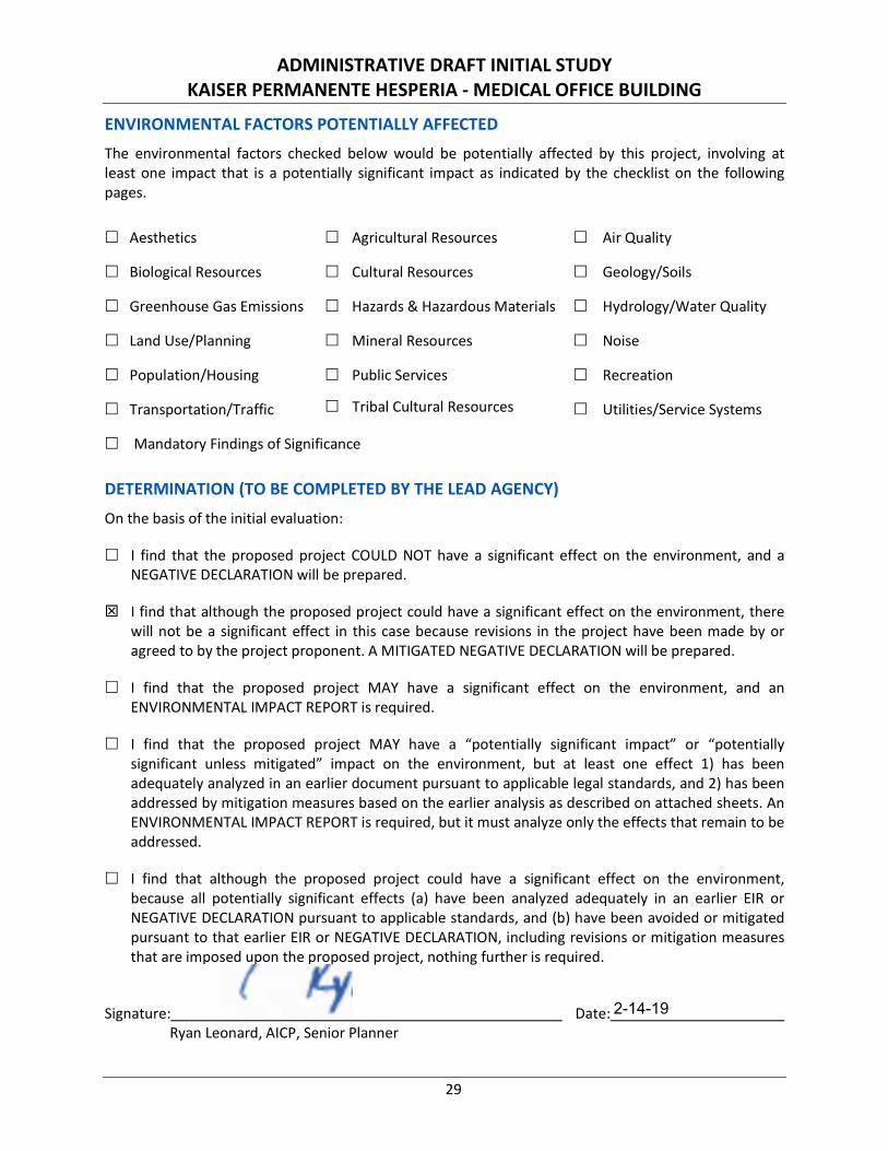
ENVIRONMENTAL FACTORS POTENTIALLY AFFECTED The environmental factors checked below would be potentially affected by this project, involving at least one impact that is a potentially significant impact as indicated by the checklist on the following pages.
Aesthetics Agricultural Resources Air Quality
Biological Resources Cultural Resources Geology/Soils
Greenhouse Gas Emissions Hazards & Hazardous Materials Hydrology/Water Quality
Land Use/Planning Mineral Resources Noise
Population/Housing Public Services Recreation
Transportation/Traffic Tribal Cultural Resources Utilities/Service Systems
Mandatory Findings of Significance
DETERMINATION (TO BE COMPLETED BY THE LEAD AGENCY)
On the basis of the initial evaluation:
I find that the proposed project COULD NOT have a significant effect on the environment, and a NEGATIVE DECLARATION will be prepared.
I find that although the proposed project could have a significant effect on the environment, there will not be a significant effect in this case because revisions in the project have been made by or agreed to by the project proponent. A MITIGATED NEGATIVE DECLARATION will be prepared.
I find that the proposed project MAY have a significant effect on the environment, and an ENVIRONMENTAL IMPACT REPORT is required.
I find that the proposed project MAY have a “potentially significant impact” or “potentially significant unless mitigated” impact on the environment, but at least one effect 1) has been adequately analyzed in an earlier document pursuant to applicable legal standards, and 2) has been addressed by mitigation measures based on the earlier analysis as described on attached sheets. An ENVIRONMENTAL IMPACT REPORT is required, but it must analyze only the effects that remain to be addressed.
I find that although the proposed project could have a significant effect on the environment, because all potentially significant effects (a) have been analyzed adequately in an earlier EIR or NEGATIVE DECLARATION pursuant to applicable standards, and (b) have been avoided or mitigated pursuant to that earlier EIR or NEGATIVE DECLARATION, including revisions or mitigation measures that are imposed upon the proposed project, nothing further is required.
Signature: Date: Ryan Leonard, AICP, Senior Planner
2-14-19
ADMINISTRATIVE DRAFT INITIAL STUDY KAISER PERMANENTE HESPERIA - MEDICAL OFFICE BUILDING
30
EVALUATION OF ENVIRONMENTAL IMPACTS 1. A brief explanation is required for all answers except “No Impact” answers that are adequately
supported by the information sources a lead agency cites in the parentheses following each question. A “No Impact” answer is adequately supported if the referenced information sources show that the impact simply does not apply to projects like the one involved (e.g., the project falls outside a fault rupture zone). A “No Impact” answer should be explained where it is based on project-specific factors as well as general standards (e.g., the project will not expose sensitive receptors to pollutants, based on a project-specific screening analysis).
2. All answers must take account of the whole action involved, including off-site as well as on-site, cumulative as well as project-level, indirect as well as direct, and construction as well as operational impacts.
3. Once the lead agency has determined that a particular physical impact may occur, then the checklist answers must indicate whether the impact is potentially significant, less than significant with mitigation, or less than significant. “Potentially Significant Impact” is appropriate if there is substantial evidence that an effect may be significant. If there are one or more “Potentially Significant Impact” entries when the determination is made, an Environmental Impact Report (EIR) is required.
4. “Negative Declaration: Less Than Significant With Mitigation Incorporated” applies where the incorporation of mitigation measures has reduced an effect from “Potentially Significant Impact” to a “Less Than Significant Impact.” The lead agency must describe the mitigation measures, and briefly explain how they reduce the effect to a less than significant level (mitigation measures from “Earlier Analyses,” as described in (5) below, may be cross-referenced).
5. Earlier analyses may be used where, pursuant to the tiering, program EIR, or other CEQA process, an effect has been adequately analyzed in an earlier EIR or negative declaration. Section 15063(c)(3)(D). In this case, a brief discussion should identify the following:
a. Earlier Analysis Used. Identify and state where they are available for review.
b. Impacts Adequately Addressed. Identify which effects from the above checklist were within the scope of and adequately analyzed in an earlier document pursuant to applicable legal standards, and state whether such effects were addressed by mitigation measures based on the earlier analysis.
c. Mitigation Measures. For effects that are “Less than Significant with Mitigation Measures Incorporated,” describe the mitigation measures which were incorporated or refined from the earlier document and the extent to which they address site-specific conditions for the project.
6. Lead agencies are encouraged to incorporate into the checklist references to information sources for potential impacts (e.g., general plans, zoning ordinances). Reference to a previously prepared or outside document should, where appropriate, include a reference to the page or pages where the statement is substantiated.
7. Supporting Information Sources: A source list should be attached, and other sources used or individuals contacted should be cited in the discussion.
8. This is only a suggested form, and lead agencies are free to use different formats; however, lead agencies should normally address the questions from this checklist that are relevant to a project’s environmental effects in whatever format is selected.
9. The explanation of each issue should identify:
a. The significance criteria or threshold, if any, used to evaluate each question; and
b. The mitigation measure identified, if any, to reduce the impact to less than significance.
ADMINISTRATIVE DRAFT INITIAL STUDY KAISER PERMANENTE HESPERIA - MEDICAL OFFICE BUILDING
31
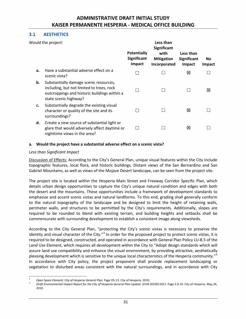
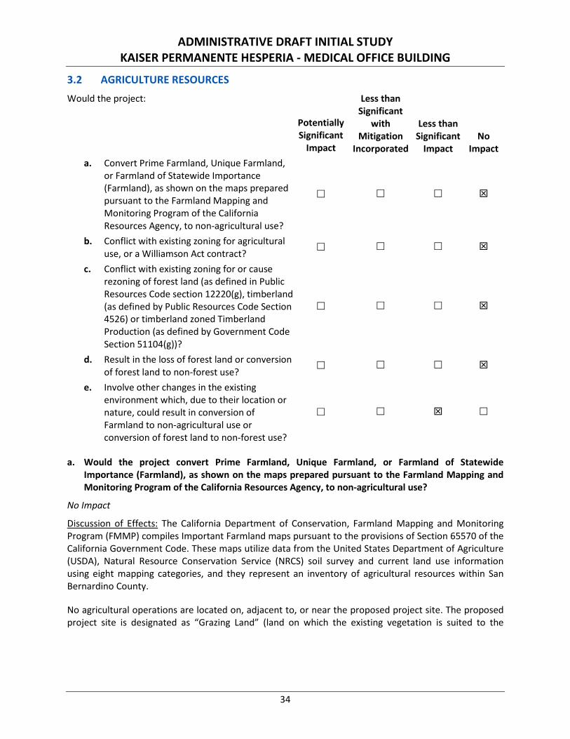
3.1 AESTHETICS
Would the project:
Potentially Significant
Impact
Less than Significant
with Mitigation
Incorporated
Less than Significant
Impact No
Impact a. Have a substantial adverse effect on a
scenic vista?
b. Substantially damage scenic resources, including, but not limited to trees, rock outcroppings and historic buildings within a state scenic highway?
c. Substantially degrade the existing visual character or quality of the site and its surroundings?
d. Create a new source of substantial light or glare that would adversely affect daytime or nighttime views in the area?
a. Would the project have a substantial adverse effect on a scenic vista?
Less than Significant Impact
Discussion of Effects: According to the City’s General Plan, unique visual features within the City include topographic features, local flora, and historic buildings. Distant views of the San Bernardino and San Gabriel Mountains, as well as views of the Mojave Desert landscape, can be seen from the project site.
The project site is located within the Hesperia Main Street and Freeway Corridor Specific Plan, which details urban design opportunities to capture the City’s unique natural condition and edges with both the desert and the mountains. These opportunities include a framework of development standards to emphasize and accent scenic vistas and natural landforms. To this end, grading shall generally conform to the natural topography of the landscape and be designed to limit the height of retaining walls, perimeter walls, and structures to be permitted by the City’s requirements. Additionally, slopes are required to be rounded to blend with existing terrain, and building heights and setbacks shall be commensurate with surrounding development to establish a consistent image along viewsheds.
According to the City General Plan, “protecting the City’s scenic vistas is necessary to preserve the identity and visual character of the City.”3 In order for the proposed project to protect scenic vistas, it is required to be designed, constructed, and operated in accordance with General Plan Policy LU-8.5 of the Land Use Element, which requires all development within the City to “Adopt design standards which will assure land use compatibility and enhance the visual environment, by providing attractive, aesthetically pleasing development which is sensitive to the unique local characteristics of the Hesperia community.”4 In accordance with City policy, the project proponent shall provide replacement landscaping or vegetation to disturbed areas consistent with the natural surroundings, and in accordance with City
3 Open Space Element, City of Hesperia General Plan. Page OS-13. City of Hesperia. 2010. 4 Draft Environmental Impact Report for the City of Hesperia General Plan Update, SCH# 2010011011. Page 3.9-10. City of Hesperia. May 26,
2010.
ADMINISTRATIVE DRAFT INITIAL STUDY KAISER PERMANENTE HESPERIA - MEDICAL OFFICE BUILDING
32
Municipal Code Section 16.24.150 (Subject Desert Native Plants). Pursuant to these codes, 19 on-site Joshua trees shall be transplanted and incorporated into the landscape design of the project as detailed in the Kaiser Permanente Medical Office Project—Joshua Tree Relocation Plan.5 Additional landscaping is required to be selected and incorporated to be drought-tolerant and shall complement existing natural and manmade features, including the dominant landscaping of surrounding areas.
Through compliance with the Hesperia Main Street and Freeway Corridor Specific Plan, the City’s General Plan, and Municipal Code, the proposed project would minimize the contrast between project features and the surrounding Mojave Desert landscape and ensure adverse effects on scenic vistas remain less than significant. No mitigation is required.
b. Would the project substantially damage scenic resources, including, but not limited to trees, rock outcroppings and historic buildings within a State scenic highway?
No Impact
Discussion of Effects: The proposed project is not located along a State scenic highway and there are no State scenic highways located within the project vicinity.6 Therefore, the project will not affect any scenic resources within a State scenic highway. No impact would occur and no mitigation is required.
c. Would the project substantially degrade the existing visual character or quality of the site and its surroundings?
Less than Significant Impact
Discussion of Effects: The construction phase of the project could potentially result in temporary visual impacts. During construction, the presence of construction vehicles and equipment could temporarily degrade the visual quality of the project site; however, the presence of construction vehicles would be temporary and would cease once construction is complete. The visual character and quality of the project site would be temporarily affected by removal of vegetation, heavy equipment use, and storage, excavation, and the presence of other visible general construction activity. Due to the temporary nature of construction activities, impacts to visual character of the site and its surroundings would be less than significant during construction.
The project site is subject to surface disturbance from off-highway vehicle use and dumping of refuse, and it is abutted to the north and east by existing commercial uses. Additionally, I-15 is located approximately 1,500 feet to the northwest of the site and the California Aqueduct is located approximately 1,500 feet northeast of the site. These existing conditions diminish the visual character of the project site and its surroundings. Another element to be considered in the regional landscape is the smog and blowing dust that frequently develop in the area and obscure the views of the mountains, which further diminishes the overall appearance of the regional landscape.
The project will be designed and constructed in accordance with the Hesperia Main Street and Freeway Corridor Specific Plan, which details urban design opportunities to capture the City’s unique natural condition and edges with both the desert and the mountains. These opportunities include a framework of development standards to encourage good design and high quality development that make such uses compatible with the character of surrounding commercial areas.
5 Kaiser Permanente Medical Office Project—Joshua Tree Relocation Plan. LSA. July 10, 2018. 6 California Scenic Highway Mapping System. California Department of Transportation. http://www.dot.ca.gov/hq/LandArch/16_livability/
scenic_highways/ (Accessed November 1, 2028).
ADMINISTRATIVE DRAFT INITIAL STUDY KAISER PERMANENTE HESPERIA - MEDICAL OFFICE BUILDING
33
Design schemes are required to be a blending of compatible materials and colors in a single façade or composition to add character and variety, while reducing, or breaking up the mass of the building. The proposed building will incorporate 360-degree architecture where all elevations of the building receive equal articulation and design consideration. Perimeter walls and light fixtures will be architecturally compatible with the overall building design, and the project site will incorporate native desert landscaping to complement existing natural and manmade features, including the dominant landscaping of surrounding areas. All mechanical equipment (e.g., heating, ventilation & air conditioning [HVAC] units) are required to be concealed from public view, and all rooftop mechanical equipment shall be screened by structural elements incorporated through cohesive architecture, material, and color to achieve an integrated appearance to the building design. The project building shall deemphasize the “box” appearance through the use of multi-form roof combinations, step-backs, varied massing, projecting elements, recessed windows, trim, eaves, material and color massing, and other features. Therefore, it is anticipated that the proposed scale, architectural design, and articulation of the development on the site would both complement and enhance the site and surrounding development.
Through compliance with the design guidelines of the Hesperia Main Street and Freeway Corridor Specific Plan and the City Municipal Code Section 16.24.150 (Subject Desert Native Plants), the proposed project would incorporate with the surrounding development and minimize the contrast between project features and the surrounding Mojave Desert landscape. Therefore, adverse effects on visual character would be less than significant. No mitigation is required.
d. Would the project create a new source of substantial light or glare that would adversely affect daytime or nighttime views in the area?
Less than Significant Impact
Discussion of Effects: Development of the proposed project will necessitate the installation of lighting necessary for the maintenance of public safety and security as well as to accommodate use of the medical office building after dark. All lighting shall comply with applicable City standards related to the installation and operation of lighting features. The City Municipal Code Lighting Standards require that all lighting associated with non-residential uses to be shielded and arranged to reflect, or illuminate, away from adjoining properties and public streets. As indicated in the project-specific photometric site plan,7 lighting shall not exceed one-half-foot candles of illumination beyond the property and shall not blink, flash, oscillate, or be of unusually high intensity of brightness in accordance with City Municipal Code.8 The selection of building materials and colors, subject to City design review, would reduce the potential for architectural glare. Furthermore, incorporation of project site perimeter and streetscape landscaping would serve to further shield surrounding properties from light and/or glare generated on site.
The incorporation of lighting similar to what is currently being used on surrounding developed properties and those used throughout the City, and implementation of lighting development standards prescribed by the City and in the Hesperia Main Street and Freeway Corridor Specific Plan, will be required for the project. Therefore, proposed lighting within the project limits would have a less than significant impact on daytime or nighttime views of the area. No mitigation is required.
7 Photometric Site Plan. Sheet 7. HMC Architects. September 28, 2018. 8 Hesperia Municipal Code Title 16, Section 16.20.135 - Glare (Amended during 1997 codification; SBCC § 87.1320).
ADMINISTRATIVE DRAFT INITIAL STUDY KAISER PERMANENTE HESPERIA - MEDICAL OFFICE BUILDING
34
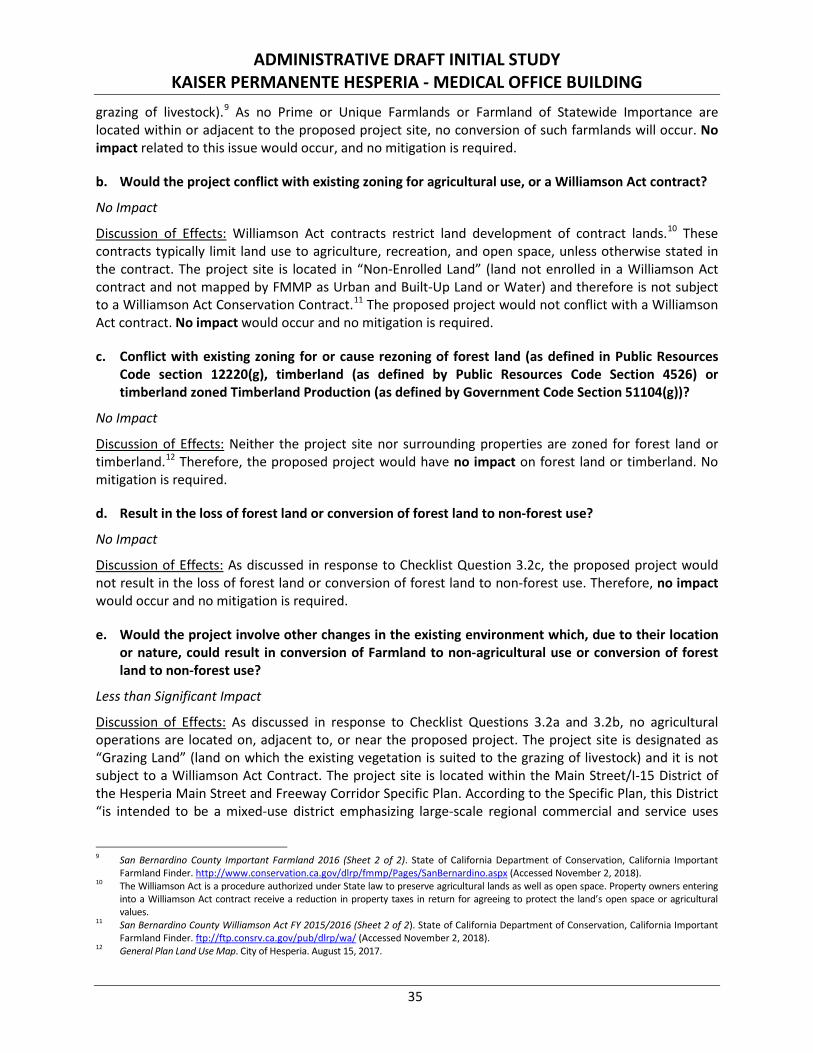
3.2 AGRICULTURE RESOURCES
Would the project:
Potentially Significant
Impact
Less than Significant
with Mitigation
Incorporated
Less than Significant
Impact No
Impact a. Convert Prime Farmland, Unique Farmland,
or Farmland of Statewide Importance (Farmland), as shown on the maps prepared pursuant to the Farmland Mapping and Monitoring Program of the California Resources Agency, to non-agricultural use?
b. Conflict with existing zoning for agricultural use, or a Williamson Act contract?
c. Conflict with existing zoning for or cause rezoning of forest land (as defined in Public Resources Code section 12220(g), timberland (as defined by Public Resources Code Section 4526) or timberland zoned Timberland Production (as defined by Government Code Section 51104(g))?
d. Result in the loss of forest land or conversion of forest land to non-forest use?
e. Involve other changes in the existing environment which, due to their location or nature, could result in conversion of Farmland to non-agricultural use or conversion of forest land to non-forest use?
a. Would the project convert Prime Farmland, Unique Farmland, or Farmland of Statewide Importance (Farmland), as shown on the maps prepared pursuant to the Farmland Mapping and Monitoring Program of the California Resources Agency, to non-agricultural use?
No Impact
Discussion of Effects: The California Department of Conservation, Farmland Mapping and Monitoring Program (FMMP) compiles Important Farmland maps pursuant to the provisions of Section 65570 of the California Government Code. These maps utilize data from the United States Department of Agriculture (USDA), Natural Resource Conservation Service (NRCS) soil survey and current land use information using eight mapping categories, and they represent an inventory of agricultural resources within San Bernardino County.
No agricultural operations are located on, adjacent to, or near the proposed project site. The proposed project site is designated as “Grazing Land” (land on which the existing vegetation is suited to the
ADMINISTRATIVE DRAFT INITIAL STUDY KAISER PERMANENTE HESPERIA - MEDICAL OFFICE BUILDING
35
grazing of livestock).9 As no Prime or Unique Farmlands or Farmland of Statewide Importance are located within or adjacent to the proposed project site, no conversion of such farmlands will occur. No impact related to this issue would occur, and no mitigation is required.
b. Would the project conflict with existing zoning for agricultural use, or a Williamson Act contract?
No Impact
Discussion of Effects: Williamson Act contracts restrict land development of contract lands.10 These contracts typically limit land use to agriculture, recreation, and open space, unless otherwise stated in the contract. The project site is located in “Non-Enrolled Land” (land not enrolled in a Williamson Act contract and not mapped by FMMP as Urban and Built-Up Land or Water) and therefore is not subject to a Williamson Act Conservation Contract.11 The proposed project would not conflict with a Williamson Act contract. No impact would occur and no mitigation is required.
c. Conflict with existing zoning for or cause rezoning of forest land (as defined in Public Resources Code section 12220(g), timberland (as defined by Public Resources Code Section 4526) or timberland zoned Timberland Production (as defined by Government Code Section 51104(g))?
No Impact
Discussion of Effects: Neither the project site nor surrounding properties are zoned for forest land or timberland.12 Therefore, the proposed project would have no impact on forest land or timberland. No mitigation is required.
d. Result in the loss of forest land or conversion of forest land to non-forest use?
No Impact
Discussion of Effects: As discussed in response to Checklist Question 3.2c, the proposed project would not result in the loss of forest land or conversion of forest land to non-forest use. Therefore, no impact would occur and no mitigation is required.
e. Would the project involve other changes in the existing environment which, due to their location or nature, could result in conversion of Farmland to non-agricultural use or conversion of forest land to non-forest use?
Less than Significant Impact
Discussion of Effects: As discussed in response to Checklist Questions 3.2a and 3.2b, no agricultural operations are located on, adjacent to, or near the proposed project. The project site is designated as “Grazing Land” (land on which the existing vegetation is suited to the grazing of livestock) and it is not subject to a Williamson Act Contract. The project site is located within the Main Street/I-15 District of the Hesperia Main Street and Freeway Corridor Specific Plan. According to the Specific Plan, this District “is intended to be a mixed-use district emphasizing large-scale regional commercial and service uses
9 San Bernardino County Important Farmland 2016 (Sheet 2 of 2). State of California Department of Conservation, California Important
Farmland Finder. http://www.conservation.ca.gov/dlrp/fmmp/Pages/SanBernardino.aspx (Accessed November 2, 2018). 10 The Williamson Act is a procedure authorized under State law to preserve agricultural lands as well as open space. Property owners entering
into a Williamson Act contract receive a reduction in property taxes in return for agreeing to protect the land’s open space or agricultural values.
11 San Bernardino County Williamson Act FY 2015/2016 (Sheet 2 of 2). State of California Department of Conservation, California Important Farmland Finder. ftp://ftp.consrv.ca.gov/pub/dlrp/wa/ (Accessed November 2, 2018).
12 General Plan Land Use Map. City of Hesperia. August 15, 2017.
ADMINISTRATIVE DRAFT INITIAL STUDY KAISER PERMANENTE HESPERIA - MEDICAL OFFICE BUILDING
36
that are designed to serve the region as a whole, as well as residential uses in a range of densities.”13 As no agricultural activities occur or are intended to occur on or in the vicinity of the project site, impacts would be less than significant and no mitigation is required.
3.3 AIR QUALITY
Would the project:
Potentially Significant
Impact
Less than Significant
with Mitigation
Incorporated
Less than Significant
Impact No
Impact a. Conflict with or obstruct implementation of
the applicable air quality plan?
b. Violate any air quality standard or contribute substantially to an existing or projected air quality violation?
c. Result in a cumulatively considerable net increase of any criteria pollutant for which the project region is non-attainment under an applicable Federal or State ambient air quality standard (including releasing emissions that exceed quantitative thresholds for ozone precursors)?
d. Expose sensitive receptors to substantial pollutant concentrations?
e. Create objectionable odors affecting a substantial number of people?
a. Would the project conflict with or obstruct implementation of the applicable air quality plan?
No Impact
Discussion of Effects: The project site is in the Mojave Desert Air Basin, which is managed by the Mojave Desert Air Quality Management District (MDAQMD). The Mojave Desert Air Basin is designated nonattainment for ozone (O3) and coarse inhalable particulate matter less than 10 microns in size (PM10) under the California and National Ambient Air Quality Standards (CAAQS and NAAQS, respectively) and nonattainment for fine inhalable particulate matter less than 2.5 microns in size (PM2.5) under the CAAQS. The MDAQMD and Southern California Association of Governments (SCAG) are responsible for formulating and implementing the Air Quality Attainment Plan (AQAP) for the Mojave Desert Air Basin. The applicable AQAP is the 2017 MDAQMD Federal 75 ppb (parts per billion) Ozone Attainment Plan (Western Mojave Desert Nonattainment Area).14 Consistency with the AQAP would be achieved if the project complies with all applicable District rules and regulations and is consistent with the growth forecasts in the applicable plan. Consistency with growth forecasts can be established by demonstrating that the project is consistent with the land use plan that was used to generate the growth forecast.
13 Hesperia Main Street and Freeway Corridor Specific Plan. Page 47. City of Hesperia. Effective October 16, 2008, Amended April 17, 2014. 14 MDAQMD Federal 75 ppb Ozone Attainment Plan (Western Mojave Desert Nonattainment Area). Mojave Desert Air Quality Management
District. Adopted February 27, 2017.
ADMINISTRATIVE DRAFT INITIAL STUDY KAISER PERMANENTE HESPERIA - MEDICAL OFFICE BUILDING
37
The proposed project includes the construction of a 55,000-square foot medical office building with parking and landscaped areas. The proposed land use would be consistent with the City’s General Plan land use designation of Regional Commercial for the project site, as well as with the Regional Commercial zone of the Hesperia Main Street and Freeway Corridor Specific Plan, which permits by right medical services facilities such as clinics, medical/dental offices, laboratory, urgent/express care, and optometrist offices.15
The proposed project is a medical office commercial development and is below the 250,000-square foot threshold for regionally significant commercial projects under CEQA; therefore, it does not meet SCAG’s Intergovernmental Review (IGR) criteria for regional significance. Additionally, the regional emissions generated by construction and operation phases of the proposed project would be less than the MDAQMD emissions thresholds (refer to Section 3.3 (b) below), and MDAQMD would not consider the project a substantial source of air pollutant emissions that would have the potential to affect the attainment designations in the air basin. Therefore, the proposed project would not affect the regional emissions inventory or conflict with strategies in the AQAP.
The project is governed by the City’s General Plan, which includes a Conservation Element. The following goal and policies are applicable to air quality and energy (affecting greenhouse gas emissions).
• Goal CN-7: Provide programs and incentives to encourage residents, businesses and developers to reduce consumption and efficiently use energy resources.
○ Implementation Policy: CN-7.2: Encourage the use of green building standards and Leadership in Energy and Environmental Design (LEED) or similar programs in both private and public projects.
• Goal CN-8: Develop, promote and implement policies to reduce and limit Greenhouse Gas Emissions.
○ Implementation Policy: CN-8.5: Promote the utilization of environmentally sensitive construction materials to limit impacts on the ozone, global climate change and mineral resources.
• Goal CN-9: Implement policies and measures to reduce air pollution and emissions of pollutants.
○ Implementation Policy: CN-9.1: Implement measures to reduce fugitive dust from unpaved areas, parking lots, and construction sites.
○ Implementation Policy: CN-9.2: Implement measures to reduce exhaust emissions from construction equipment.
○ Implementation Policy: CN-9.5: Minimize exposure of sensitive receptor land uses and sites to health risks related to air pollution.
The proposed project would not exceed the MDAQMD emissions thresholds for the construction and operation of the project (refer to response to Checklist Question 3.3b, below) and the proposed land use is consistent with the land use assumptions of the General Plan, upon which the AQAP emissions projections were predicated. Therefore, the proposed project would not conflict with or obstruct implementation of the applicable air quality plan. No impact would occur and no mitigation is required.
15 Hesperia Main Street and Freeway Corridor Specific Plan. Page 167. City of Hesperia. Effective October 16, 2008, amended April 17, 2014.
ADMINISTRATIVE DRAFT INITIAL STUDY KAISER PERMANENTE HESPERIA - MEDICAL OFFICE BUILDING
38
b. Would the project violate any air quality standard or contribute substantially to an existing or projected air quality violation?
Less than Significant Impact
Discussion of Effects: A project could have a significant impact where project-related emissions would exceed federal, State, or regional standards or thresholds, or where project-related emissions would substantially contribute to an existing or projected air quality violation. As required by the Federal Clean Air Act (FCAA), NAAQS have been established for seven major air pollutants: ozone (O3), carbon monoxide (CO), coarse inhalable particulate matter less than 10 microns in size (PM10), fine inhalable particulate matter less than 2.5 microns in size (PM2.5), sulfur dioxide (SO2), nitrogen dioxide (NO2), and lead (Pb). The FCAA requires the United States Environmental Protection Agency (EPA) to designate areas as attainment, nonattainment, or maintenance for each criteria pollutant based on whether the NAAQS have been achieved. The EPA has classified the Mojave Desert Air Basin as nonattainment for O3 and PM10.
In addition to being subject to the requirements of FCAA, air quality in California is also governed by regulations under the California Clean Air Act (CCAA). The California Air Resources Board (CARB) is responsible for administering the CCAA and establishing the CAAQS. The CCAA requires the CARB to designate areas within California as either attainment or non-attainment for each criteria pollutant based on whether the CAAQS have been achieved. Under the CCAA, areas are designated as non-attainment for a pollutant if air quality shows that a State standard for the pollutant was violated at least once during the previous three calendar years. Exceedances that are affected by highly irregular or infrequent events are not considered violations of a State standard and are not used as a basis for designating areas as non-attainment. Under the CCAA, the Mojave Desert Air Basin is designated as a non-attainment area for O3, PM2.5, and PM10.
The MDAQMD is responsible for monitoring air quality, as well as planning, implementing, and enforcing programs designed to attain and maintain CAAQS and NAAQS in the Mojave Desert Air Basin. All areas designated as non-attainment under the CCAA are required to prepare plans showing how they will meet the air quality standards. The MDAQMD prepared the AQAP to address FCAA and CCAA requirements by identifying policies and control measures. The SCAG assists by preparing the transportation portion of the AQAP.
The project site is currently undeveloped and is located within the Regional Commercial zone of the Hesperia Main Street and Freeway Corridor Specific Plan. The Specific Plan area encompasses major regional access to the City, I-15, as well as Main Street, supporting local circulation that provides access to commercial centers within the City.
Short-term Emissions: Construction activities produce emissions from off-road construction vehicle exhaust, asphalt off-gassing, fugitive dust, as well as exhaust from on-road vehicles associated with construction workers reporting to work and making material delivery trips. Emissions from construction activities envisioned on-site would vary daily as construction activity levels change. Project construction would occur in 2019 and would consist of the construction of a 55,000-square foot medical office building, a 274-stall parking lot, and landscaped area on a 9.9-acre site, of which approximately 5.7 acres will be developed.
The most recent version of the California Emission Estimator Model (CalEEMod) (Version 2016.3.2) was used to calculate construction emissions from development of the proposed project. For purposes of air
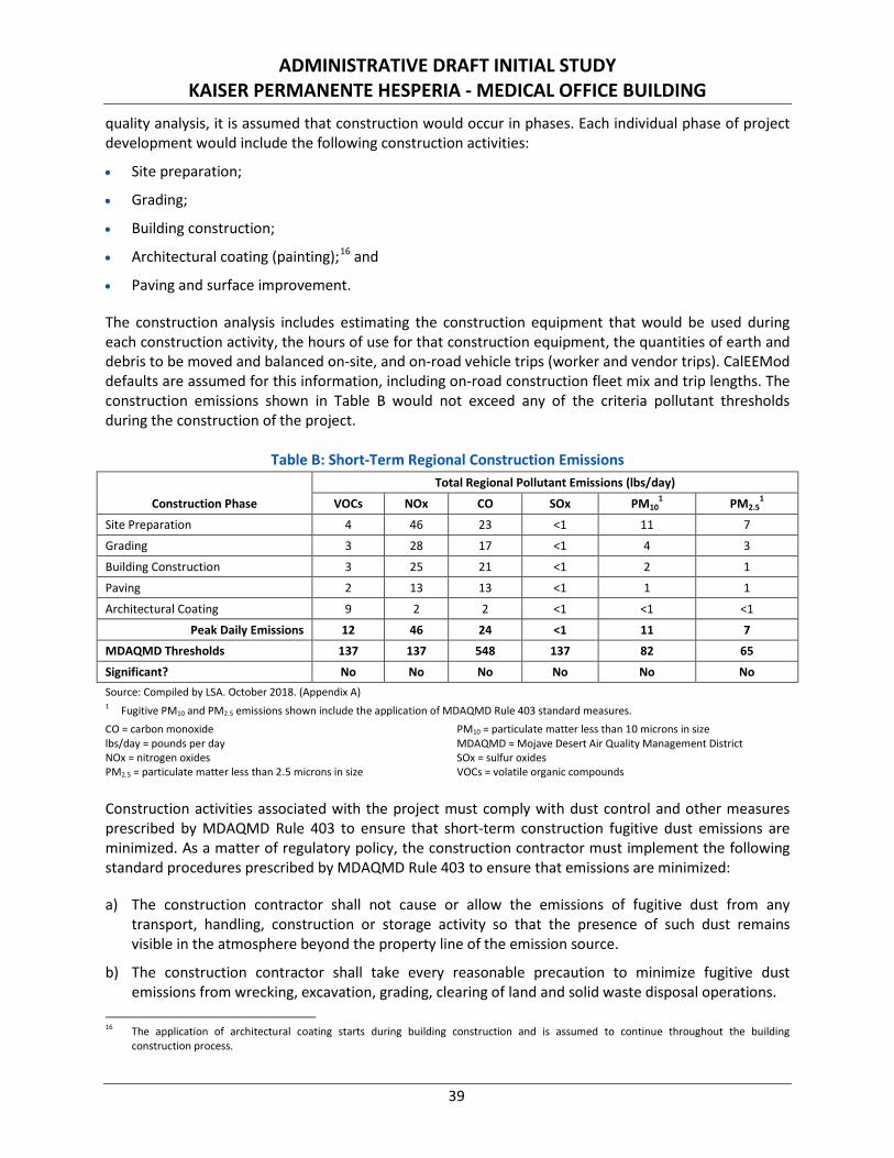
ADMINISTRATIVE DRAFT INITIAL STUDY KAISER PERMANENTE HESPERIA - MEDICAL OFFICE BUILDING
39
quality analysis, it is assumed that construction would occur in phases. Each individual phase of project development would include the following construction activities:
• Site preparation;
• Grading;
• Building construction;
• Architectural coating (painting);16 and
• Paving and surface improvement.
The construction analysis includes estimating the construction equipment that would be used during each construction activity, the hours of use for that construction equipment, the quantities of earth and debris to be moved and balanced on-site, and on-road vehicle trips (worker and vendor trips). CalEEMod defaults are assumed for this information, including on-road construction fleet mix and trip lengths. The construction emissions shown in Table B would not exceed any of the criteria pollutant thresholds during the construction of the project.
Table B: Short-Term Regional Construction Emissions
Construction Phase
Total Regional Pollutant Emissions (lbs/day)
VOCs NOx CO SOx PM101 PM2.5
1
Site Preparation 4 46 23 <1 11 7
Grading 3 28 17 <1 4 3
Building Construction 3 25 21 <1 2 1
Paving 2 13 13 <1 1 1
Architectural Coating 9 2 2 <1 <1 <1
Peak Daily Emissions 12 46 24 <1 11 7
MDAQMD Thresholds 137 137 548 137 82 65
Significant? No No No No No No Source: Compiled by LSA. October 2018. (Appendix A) 1 Fugitive PM10 and PM2.5 emissions shown include the application of MDAQMD Rule 403 standard measures. CO = carbon monoxide lbs/day = pounds per day NOx = nitrogen oxides PM2.5 = particulate matter less than 2.5 microns in size
PM10 = particulate matter less than 10 microns in size MDAQMD = Mojave Desert Air Quality Management District SOx = sulfur oxides VOCs = volatile organic compounds
Construction activities associated with the project must comply with dust control and other measures prescribed by MDAQMD Rule 403 to ensure that short-term construction fugitive dust emissions are minimized. As a matter of regulatory policy, the construction contractor must implement the following standard procedures prescribed by MDAQMD Rule 403 to ensure that emissions are minimized:
a) The construction contractor shall not cause or allow the emissions of fugitive dust from any transport, handling, construction or storage activity so that the presence of such dust remains visible in the atmosphere beyond the property line of the emission source.
b) The construction contractor shall take every reasonable precaution to minimize fugitive dust emissions from wrecking, excavation, grading, clearing of land and solid waste disposal operations.
16 The application of architectural coating starts during building construction and is assumed to continue throughout the building
construction process.
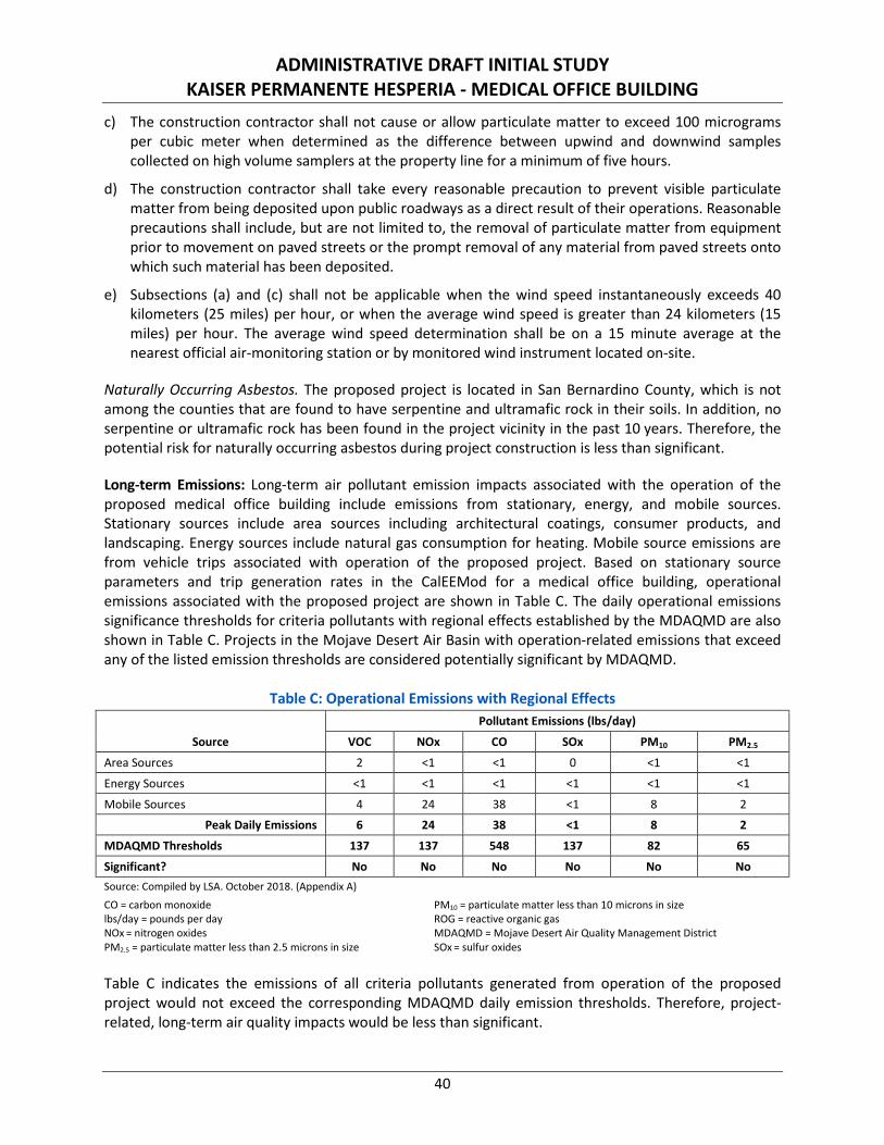
ADMINISTRATIVE DRAFT INITIAL STUDY KAISER PERMANENTE HESPERIA - MEDICAL OFFICE BUILDING
40
c) The construction contractor shall not cause or allow particulate matter to exceed 100 micrograms per cubic meter when determined as the difference between upwind and downwind samples collected on high volume samplers at the property line for a minimum of five hours.
d) The construction contractor shall take every reasonable precaution to prevent visible particulate matter from being deposited upon public roadways as a direct result of their operations. Reasonable precautions shall include, but are not limited to, the removal of particulate matter from equipment prior to movement on paved streets or the prompt removal of any material from paved streets onto which such material has been deposited.
e) Subsections (a) and (c) shall not be applicable when the wind speed instantaneously exceeds 40 kilometers (25 miles) per hour, or when the average wind speed is greater than 24 kilometers (15 miles) per hour. The average wind speed determination shall be on a 15 minute average at the nearest official air-monitoring station or by monitored wind instrument located on-site.
Naturally Occurring Asbestos. The proposed project is located in San Bernardino County, which is not among the counties that are found to have serpentine and ultramafic rock in their soils. In addition, no serpentine or ultramafic rock has been found in the project vicinity in the past 10 years. Therefore, the potential risk for naturally occurring asbestos during project construction is less than significant.
Long-term Emissions: Long-term air pollutant emission impacts associated with the operation of the proposed medical office building include emissions from stationary, energy, and mobile sources. Stationary sources include area sources including architectural coatings, consumer products, and landscaping. Energy sources include natural gas consumption for heating. Mobile source emissions are from vehicle trips associated with operation of the proposed project. Based on stationary source parameters and trip generation rates in the CalEEMod for a medical office building, operational emissions associated with the proposed project are shown in Table C. The daily operational emissions significance thresholds for criteria pollutants with regional effects established by the MDAQMD are also shown in Table C. Projects in the Mojave Desert Air Basin with operation-related emissions that exceed any of the listed emission thresholds are considered potentially significant by MDAQMD.
Table C: Operational Emissions with Regional Effects
Source
Pollutant Emissions (lbs/day)
VOC NOx CO SOx PM10 PM2.5
Area Sources 2 <1 <1 0 <1 <1
Energy Sources <1 <1 <1 <1 <1 <1
Mobile Sources 4 24 38 <1 8 2
Peak Daily Emissions 6 24 38 <1 8 2
MDAQMD Thresholds 137 137 548 137 82 65
Significant? No No No No No No Source: Compiled by LSA. October 2018. (Appendix A)
CO = carbon monoxide lbs/day = pounds per day NOx = nitrogen oxides PM2.5 = particulate matter less than 2.5 microns in size
PM10 = particulate matter less than 10 microns in size ROG = reactive organic gas MDAQMD = Mojave Desert Air Quality Management District SOx = sulfur oxides
Table C indicates the emissions of all criteria pollutants generated from operation of the proposed project would not exceed the corresponding MDAQMD daily emission thresholds. Therefore, project-related, long-term air quality impacts would be less than significant.
ADMINISTRATIVE DRAFT INITIAL STUDY KAISER PERMANENTE HESPERIA - MEDICAL OFFICE BUILDING
41
CO Hot-Spot Analysis. There is a direct relationship between traffic/circulation congestion and CO impacts since exhaust from vehicular traffic are the primary source of CO, a localized gas that dissipates very quickly under normal meteorological conditions. Therefore, CO concentrations decrease quickly as the distance from the source (intersection) increases. The highest CO concentrations are typically found in areas adjacent to congested roadway intersections. These areas of vehicle congestion have historically had the potential to create pockets of elevated levels of CO that are called “hot spots.” However, with the turnover of older vehicles, introduction of cleaner fuels, and implementation of control technology on industrial facilities, CO concentrations in the project vicinity have steadily declined.17
Micro-scale air quality impacts traditionally have been analyzed in environmental documents for which the region was a nonattainment area for CO. However, the MDAQMD has demonstrated in the CO attainment re-designation request to the EPA that there are no “hot spots” anywhere in Southern California, even at intersections with much higher volumes, much worst congestion, and much higher background CO levels than anywhere in the project area.18 If the worst-case intersections in the air basin have no “hot spot” potential, any local impacts near the project site would be well below thresholds with an even larger margin of safety. Therefore, no project-specific CO hot-spot analysis was conducted.
As stated previously, the proposed project is required to comply with MDAQMD Rule 403, which includes implementation of standard control measures for fugitive dust. Tables B and C demonstrate that, with compliance with applicable regulatory policy designed to reduce emissions, the proposed project would not exceed any MDAQMD threshold during construction or operation. Therefore, the project would not violate any air quality standard or contribute substantially to an existing or projected air quality violation. Impacts would be less than significant and no mitigation is required.
c. Would the project result in a cumulatively considerable net increase of any criteria pollutant for which the project region is non-attainment under an applicable federal or State ambient air quality standard (including releasing emissions that exceed quantitative thresholds for ozone precursors)?
Less than Significant Impact
Discussion of Effects: As discussed in response to Checklist Question 3.3b, no exceedance of MDAQMD criteria pollutant emission thresholds is anticipated for the proposed project. The proposed project would not contribute significantly to cumulative impacts on any pollutants for which the region is in non-attainment. Specifically, the proposed project construction and operational emissions would not exceed the MDAQMD’s mass daily thresholds for volatile organic compounds (VOC) and nitrogen oxides (NOx) that serve as project and cumulative impact thresholds of significance for gauging regional ozone impacts. Therefore, the proposed project’s contribution to cumulative air quality impacts would not be cumulatively considerable.
As for cumulative impacts to regional ozone air quality, the discussion in response to Checklist Question 3.3a indicates the proposed medical office land use would neither conflict with the MDAQMD’s AQAP nor jeopardize the region’s attainment of air quality standards. The project is consistent with the City’s General Plan, as well as the population growth projections used by SCAG to identify future regional air
17 The California Almanac of Emissions and Air Quality. California Air Resources Board. http://www.arb.ca.gov/aqd/almanac/almanac.htm
(Accessed November 2, 2018). 18 Carbon Monoxide Redesignation Request and Maintenance Plan. Mojave Desert Air Quality Management District. February 2005.
ADMINISTRATIVE DRAFT INITIAL STUDY KAISER PERMANENTE HESPERIA - MEDICAL OFFICE BUILDING
42
pollutant concentrations necessary to meet the attainment standards identified in the AQAP. Therefore, impacts would be less than significant.
The MDAQMD uses the project-level significance thresholds to determine whether a project’s emissions are cumulatively considerable. Because the project’s emissions do not exceed the MDAQMD’s regional significance thresholds, as shown in Table C, the MDAQMD does not consider the project to contribute significantly to a cumulative air quality impact. Impacts are less than significant and no mitigation is required.
d. Expose sensitive receptors to substantial pollutant concentrations?
Less than Significant Impact
Discussion of Effects: The closest sensitive receptors in proximity to the project site are two hotels approximately 590 feet to the northwest and single-family residences approximately 950 feet to the east (along W. Nolina Drive). The residential tract is still under development; when completed, there will be single-family residential homes within approximately 660 feet of the project site. Due to the substantial distance between the project site and these receptors, substantial pollutant concentrations from construction and operation of the project are not expected.
As described in response to Checklist Question 3.3b, the proposed project would not significantly increase short-term or long-term emissions within the project site or vicinity. Although construction of the proposed project may expose surrounding sensitive receptors to airborne particulates, as well as a small quantity of construction equipment pollutants (i.e., usually diesel-fuel emissions from vehicles and equipment), pollutants from construction operations would disperse rapidly in the atmosphere and would not present substantial concentrations at sensitive receptors located between 650 and 900 feet from the project construction limits. Thus, potential short-term impacts are considered less than significant. No mitigation is required.
As demonstrated in Table C (refer to response to Checklist Question 3.3b above), operational emissions from the proposed project would not exceed MDAQMD thresholds for any criteria pollutants and therefore would not result in exposure of a sensitive receptor to substantial pollutant concentrations. Impacts related to substantial pollutant concentration for operation would be less than significant. No mitigation is required.
e. Create objectionable odors affecting a substantial number of people?
Less than Significant Impact
Discussion of Effects: MDAQMD Rule 402 regarding nuisances states: “A person shall not discharge from any source whatsoever such quantities of air contaminants or other material which cause injury, detriment, nuisance, or annoyance to any considerable number of persons or to the public, or which endanger the comfort, repose, health or safety of any such persons or the public, or which cause, or have a natural tendency to cause injury or damage to business or property.”
During construction, the various diesel-powered vehicles and equipment in use on the site may create odors from exhaust emissions. Additionally, the installation of asphalt may generate odors. These odors are temporary and not likely to be noticeable beyond the project boundaries. Project construction would include best available control measures as required by MDAQMD Rule 1113 for architectural coatings and would not result in VOC emissions that would violate any air quality standard or contribute
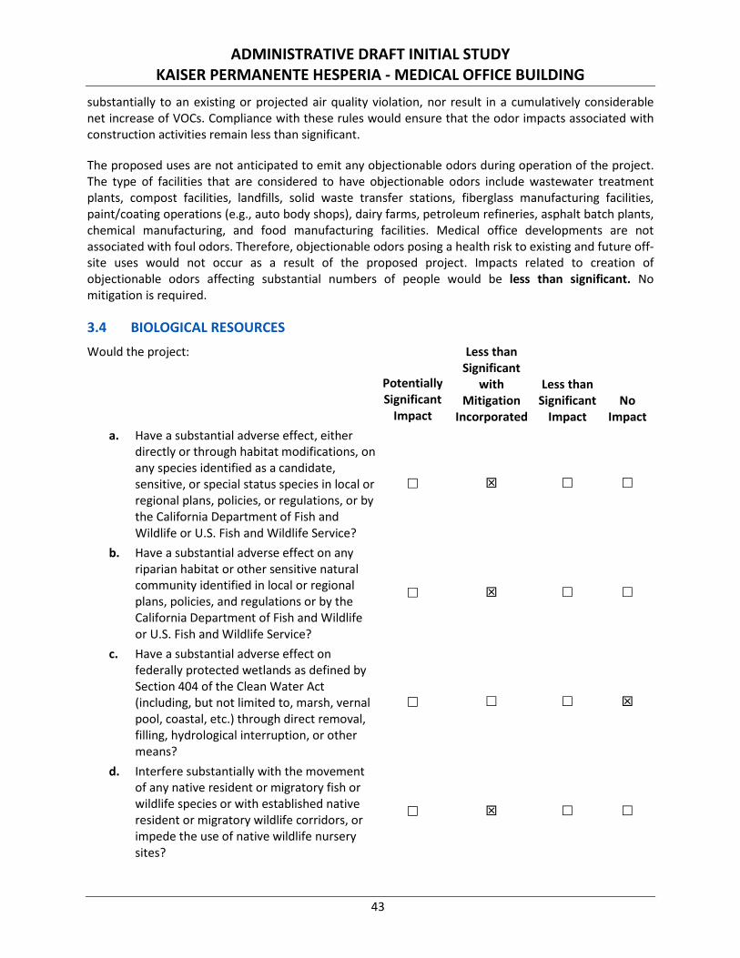
ADMINISTRATIVE DRAFT INITIAL STUDY KAISER PERMANENTE HESPERIA - MEDICAL OFFICE BUILDING
43
substantially to an existing or projected air quality violation, nor result in a cumulatively considerable net increase of VOCs. Compliance with these rules would ensure that the odor impacts associated with construction activities remain less than significant.
The proposed uses are not anticipated to emit any objectionable odors during operation of the project. The type of facilities that are considered to have objectionable odors include wastewater treatment plants, compost facilities, landfills, solid waste transfer stations, fiberglass manufacturing facilities, paint/coating operations (e.g., auto body shops), dairy farms, petroleum refineries, asphalt batch plants, chemical manufacturing, and food manufacturing facilities. Medical office developments are not associated with foul odors. Therefore, objectionable odors posing a health risk to existing and future off-site uses would not occur as a result of the proposed project. Impacts related to creation of objectionable odors affecting substantial numbers of people would be less than significant. No mitigation is required.
3.4 BIOLOGICAL RESOURCES
Would the project:
Potentially Significant
Impact
Less than Significant
with Mitigation
Incorporated
Less than Significant
Impact No
Impact a. Have a substantial adverse effect, either
directly or through habitat modifications, on any species identified as a candidate, sensitive, or special status species in local or regional plans, policies, or regulations, or by the California Department of Fish and Wildlife or U.S. Fish and Wildlife Service?
b. Have a substantial adverse effect on any riparian habitat or other sensitive natural community identified in local or regional plans, policies, and regulations or by the California Department of Fish and Wildlife or U.S. Fish and Wildlife Service?
c. Have a substantial adverse effect on federally protected wetlands as defined by Section 404 of the Clean Water Act (including, but not limited to, marsh, vernal pool, coastal, etc.) through direct removal, filling, hydrological interruption, or other means?
d. Interfere substantially with the movement of any native resident or migratory fish or wildlife species or with established native resident or migratory wildlife corridors, or impede the use of native wildlife nursery sites?
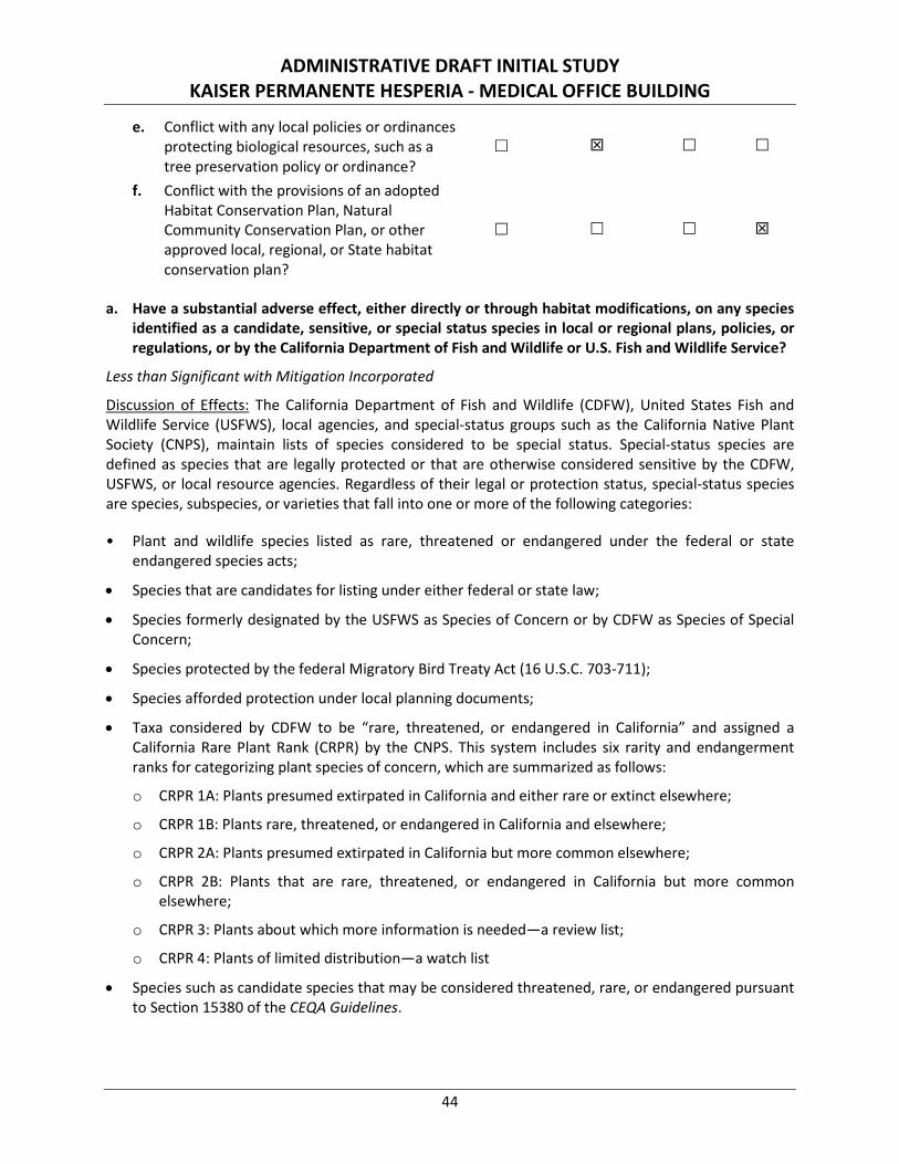
ADMINISTRATIVE DRAFT INITIAL STUDY KAISER PERMANENTE HESPERIA - MEDICAL OFFICE BUILDING
44
e. Conflict with any local policies or ordinances protecting biological resources, such as a tree preservation policy or ordinance?
f. Conflict with the provisions of an adopted Habitat Conservation Plan, Natural Community Conservation Plan, or other approved local, regional, or State habitat conservation plan?
a. Have a substantial adverse effect, either directly or through habitat modifications, on any species identified as a candidate, sensitive, or special status species in local or regional plans, policies, or regulations, or by the California Department of Fish and Wildlife or U.S. Fish and Wildlife Service?
Less than Significant with Mitigation Incorporated
Discussion of Effects: The California Department of Fish and Wildlife (CDFW), United States Fish and Wildlife Service (USFWS), local agencies, and special-status groups such as the California Native Plant Society (CNPS), maintain lists of species considered to be special status. Special-status species are defined as species that are legally protected or that are otherwise considered sensitive by the CDFW, USFWS, or local resource agencies. Regardless of their legal or protection status, special-status species are species, subspecies, or varieties that fall into one or more of the following categories:
• Plant and wildlife species listed as rare, threatened or endangered under the federal or state endangered species acts;
• Species that are candidates for listing under either federal or state law;
• Species formerly designated by the USFWS as Species of Concern or by CDFW as Species of Special Concern;
• Species protected by the federal Migratory Bird Treaty Act (16 U.S.C. 703-711);
• Species afforded protection under local planning documents;
• Taxa considered by CDFW to be “rare, threatened, or endangered in California” and assigned a California Rare Plant Rank (CRPR) by the CNPS. This system includes six rarity and endangerment ranks for categorizing plant species of concern, which are summarized as follows:
o CRPR 1A: Plants presumed extirpated in California and either rare or extinct elsewhere;
o CRPR 1B: Plants rare, threatened, or endangered in California and elsewhere;
o CRPR 2A: Plants presumed extirpated in California but more common elsewhere;
o CRPR 2B: Plants that are rare, threatened, or endangered in California but more common elsewhere;
o CRPR 3: Plants about which more information is needed—a review list;
o CRPR 4: Plants of limited distribution—a watch list
• Species such as candidate species that may be considered threatened, rare, or endangered pursuant to Section 15380 of the CEQA Guidelines.
ADMINISTRATIVE DRAFT INITIAL STUDY KAISER PERMANENTE HESPERIA - MEDICAL OFFICE BUILDING
45
To determine the existence or potential occurrence of special-status plant and animal species on or in the vicinity of the project site, a literature review and general reconnaissance-level field survey were conducted as part of a Biological Resources Assessment (Appendix B-1).
Database records for the Hesperia, California USGS 7.5-minute quadrangle within a three-mile radius of the project were searched using the CDFW’s Natural Diversity Data Base (CNDDB) application Rarefind 5 (v 2018) and the CNPS’s Electronic Inventory of Rare and Endangered Vascular Plants of California. The entire project site was surveyed on foot to identify vegetation communities, habitats for special-status species, potential jurisdictional waters, and other biological resource issues.
In addition to the Biological Resources Assessment, a desert tortoise survey (Appendix B-2) was conducted according to currently accepted survey protocol. A protocol burrowing owl (Athene cunicularia) survey (Appendix B-3) was also conducted. The burrowing owl survey protocol requires four field visits, the first between February 15 and April 15, and three visits between April 15 and July 15. Due to the timing of project start up, the first field visit between February 15 and April 15 was not conducted, but surveys were conducted on May 3, 2018, June 22, 2018, and July 1, 2018.
LSA Biologist Leo Simone, who is authorized by the CDFW to trap for Mohave ground squirrel (Xerospermophilus mohavensis) (MGS) under Scientific Collecting permit number SC-005243, coordinated with the CDFW to assess whether or not trapping would be required to determine the presence/absence of MGS on the project site.19 The coordination effort with the CDFW resulted in the determination by the CDFW that trapping surveys would not be required to determine the presence/absence of the MGS on the project site. Therefore, MGS is considered absent from the project site.
Finally, LSA conducted a protected desert native plant survey (Appendix B-4) for Joshua trees (Yucca brevifolia) from which a Joshua Tree Relocation Plan was prepared.
The dominant plant communities on site are salt bush scrub and Joshua tree juniper woodland. Dominant species identified in these communities include annual bur-sage (Ambrosia acanthicarpa), bladder sage (Salazaria mexicana), Joshua tree, and California juniper (Juniperus californica). Wildlife species observed during the field surveys include common side-blotched lizard (Uta stansburiana), common raven (Corvus corax), mainland cactus wren (Campylorhynchus brunneicapillus anthonyi), and black-tailed jackrabbit (Lepus californicus deserticola). A complete list of species observed during the field surveys is provided in Appendix B-1.
The CDFW CNDDB identifies plants and habitats considered to be sensitive due to their scarcity or their potential to support state and/or federal listed endangered or threatened plants. No federally designated critical habitat is present on or in the immediate vicinity of the project site. However, two federally listed species, desert tortoise and MGS, have been known to occur in the project vicinity. Additionally, the CNDDB identifies five special-status species—short-joint beavertail (Opuntia basilaris var. brachyclada), Cooper’s hawk (Accipiter cooperii), burrowing owl, loggerheaded shrike (Lanius ludovicianus), and yellow warbler (Setophagia petechial)—known to occur in the region.
Four of the five special-status species known to occur in the region are avian (bird) species and therefore are protected pursuant to the Migratory Bird Treaty Act (16 U.S.C. 703-711). Meanwhile, the short-joint
19 Heather Elder, California Department of Fish and Wildlife, Inland Deserts Region. Personal Communication via Electronic Mail. October 2,
2018.
ADMINISTRATIVE DRAFT INITIAL STUDY KAISER PERMANENTE HESPERIA - MEDICAL OFFICE BUILDING
46
beavertail [plant species] has a CRPR of 1B according to the CNPS.20 The CDFW recommends that CRPR 1A, 1B, 2B, and 3 species be addressed in CEQA projects pursuant to CEQA Guidelines Section 15380. Accordingly, the five special-status species—short-joint beavertail, Cooper’s hawk, burrowing owl, loggerheaded shrike, and yellow warbler—known to occur in the region require consideration in accordance with Appendix G of the CEQA Guidelines.
The results of the desert tortoise survey indicate no desert tortoise or desert tortoise sign within the survey area. There are no recorded occurrences of the desert tortoise within a three-mile radius of the project site. Additionally, the project site is not within designated critical habitat for this species or within any Desert Wildlife Management Areas proposed for the desert tortoise identified in the draft West Mojave Plan. Based on the results of the focused desert tortoise survey and the lack of desert tortoise occurrences within a three-mile radius of the project site, the species is considered absent from the project site. Therefore, the project will have no effects on the desert tortoise.
Four of the special-status species (short-joint beavertail, Cooper’s hawk, burrowing owl, and yellow warbler) are considered absent based on the lack of suitable habitat or determined to be absent based on the results of focused and other field surveys. However, one special-status bird species, loggerhead shrike, has the potential to utilize the habitat within the project site. A pre-construction survey for the loggerhead shrike and other nesting/migratory birds will be required in accordance with Mitigation Measure BIO-1.
Mitigation Measures
BIO-1 If project activities are planned during the bird nesting season (February 1 to August 31), a nesting bird survey shall be conducted within three days (72 hours) prior to any ground-disturbing activities, including, but not limited to clearing, grubbing, and/or rough grading, to ensure birds protected under the Migratory Bird Treaty Act (MBTA) are not disturbed by on-site activities. Any such survey(s) shall be conducted by a qualified biologist. If no active nests are found, no additional actions related to this measure are required. If active nests are found, the nest locations shall be mapped by the biologist. The nesting bird species shall be documented and, to the degree feasible, the nesting stage (e.g., incubation of eggs, feeding of young, near fledging) determined. Based on the species present and surrounding habitat, a no-disturbance buffer shall be established around each active nest. The buffer shall be identified by a qualified biologist and confirmed by the City; non-raptor bird species nests shall be buffered up to 280 feet, while raptor nests shall be buffered up to 820 feet. No construction or ground disturbance activities shall be conducted within the buffer until the biologist has determined the nest is no longer active and has informed the City and construction supervisor that activities may resume.
In addition, although the burrowing owl was determined to be absent from the project site, the burrowing owl is a mobile species and may subsequently occupy the site. Therefore, a pre-construction burrowing owl survey is required in accordance with Mitigation Measure BIO-2 and Mitigation Measure BIO-3.
BIO-2 Prior to the issuance of a grading permit, a pre-construction burrowing owl clearance survey must be conducted in accordance with the Staff Report on Burrowing Owl Mitigation, State of California Natural Resource Agency, Department of Fish and Game, May 7, 2012 by a qualified biologist within 14 days prior to the beginning of project construction, and a second survey must
20 Kaiser Permanente Medical Office Project: Results of a Biological Resources Assessment. LSA. Page 5, Table B. October 10, 2018.

ADMINISTRATIVE DRAFT INITIAL STUDY KAISER PERMANENTE HESPERIA - MEDICAL OFFICE BUILDING
47
be conducted by a qualified biologist within 24 hours prior to the beginning of project construction to determine if the project site contains suitable burrowing owl habitat and to avoid any potential impacts to the species. The surveys shall include 100 percent coverage of the project site. If both surveys reveal no burrowing owls are present, no additional actions related to this measure are required. If occupied burrows are found within the development footprint during the pre-construction clearance surveys, Mitigation Measure BIO-3 shall apply.
BIO-3 If occupied burrows are found within the development footprint during the pre-construction clearance surveys, site-specific buffer zones shall be established by the qualified biologist through consultation with the California Department of Fish and Wildlife (CDFW). The buffer zones may vary depending on burrow location and burrowing owl sensitivity to human activity, and no construction activity shall occur within a buffer zone(s) until appropriate avoidance and minimization measures are determined through consultation with the CDFW
As part of the consultation process, the CDFW may require some or all of the following avoidance and minimization measures:
• Preparation of a burrowing owl relocation/translocation plan describing the methodology for passive and active relocation of burrowing owls from the project site, a monitoring strategy, and long-term conservation of relocated owls for submittal to the CDFW for approval prior to ground-disturbing activities.
• Replacement of burrowing owl habitat acreage in accordance with the guidelines provided in Appendix A of the Staff Report on Burrowing Owl Mitigation, State of California Natural Resource Agency, Department of Fish and Game, May 7, 2012.
• Establishment of permanent conservation lands comprised of similar vegetation communities to provide for burrowing owl nesting, foraging, wintering, and dispersal (i.e., during breeding and non-breeding seasons) comparable to or better than that of the impact area. Such conservation lands must be of sufficiently large acreage and be occupied by fossorial mammals. Conservation lands may require habitat enhancements including enhancement or expansion of burrows for breeding, shelter and dispersal opportunity, and removal or control of population stressors as determined by the CDFW. If the conservation lands are located adjacent to the impacted burrow site, the nearest neighbor artificial or natural burrow clusters must be at least within 210 meters of the impacted burrow site.
• Development and implementation of a mitigation land management plan to address long-term ecological sustainability and maintenance of the site for burrowing owls.
• Funding of maintenance and management of mitigation land through the establishment of a long-term funding mechanism such as an endowment.
• Restoration of any temporarily disturbed areas to the pre-project condition, including decompacting soil and revegetating.
In the event the CDFW requires establishment of permanent conservation lands, such lands must be on, adjacent, or proximate to the impact site where possible and where habitat is
ADMINISTRATIVE DRAFT INITIAL STUDY KAISER PERMANENTE HESPERIA - MEDICAL OFFICE BUILDING
48
sufficient to support burrowing owls present. Where there is insufficient habitat on, adjacent to, or near project sites where burrowing owls will be excluded, the selection of conservation lands m u s t then focus on consolidating and enlarging conservation areas located outside of urban and planned growth areas, within foraging distance of other conserved lands, in consultation with the CDFW. This measure shall be implemented to the satisfaction of the City of Hesperia Planning Department and the CDFW.
Thorough implementation of Mitigation Measures BIO-1 through BIO-3, impacts to species identified as a candidate, sensitive, or special-status would be reduced to less than significant levels with mitigation incorporated.
b. Have a substantial adverse effect on any riparian habitat or other sensitive natural community identified in local or regional plans, policies, and regulations or by the California Department of Fish and Wildlife or U.S. Fish and Wildlife Service?
Less than Significant with Mitigation Incorporated
Discussion of Effects: Certain habitats/natural communities are considered to be of special concern based on, 1) federal, State, or local laws regulating their development; 2) limited distributions; and/or 3) whether they support the habitat requirements of special-status plants or animals.
As stated previously, the project site was surveyed for biological resources to determine the existence or potential occurrence of riparian habitat or other sensitive natural communities. The dominant plant communities on site are salt bush scrub and Joshua tree juniper woodland. Dominant species identified in these communities include annual bur-sage, bladder sage, Joshua tree, and California juniper. Joshua tree woodland is a CDFW natural community of concern. Joshua trees are also protected from harvesting without a permit under the CDFW California Desert Native Plants Act, Division 23 of the Food and Agricultural Code (CDNPA), and Chapter 16.24 of the City of Hesperia’s Municipal Code, established to comply with the CDNPA.
No riparian habitat subject to jurisdiction of the CDFW, United States Army Corps of Engineers (USACE), and/or Regional Water Quality Control Board (RWQCB) was identified within the project site. The project site is located on 9.9 acres, of which approximately 5.7 acres will be developed and would result in the loss of Joshua tree woodland.
LSA conducted a protected desert native plant survey for Joshua trees from which a Joshua Tree Relocation Plan was prepared in accordance with Chapter 16.24 of the City of Hesperia’s Municipal Code in order to mitigate impacts to Joshua trees as a result of the proposed project. A total of 39 Joshua trees were inventoried on the 9.9-acre survey area. Of the 39 Joshua trees inventoried, 20 are determined to be unsuitable for transplantation and 19 are suitable for transplant and salvage efforts.21 The 20 Joshua trees determined to be unsuitable for transplantation exhibited features such as pest infestation, immaturity, over-circumference, over-tall, over-balanced, incompatible with spade, over-mature, dependent clone, down live, or they were dead, which are features rendering them unlikely to survive transplantation. Even if all 9.9 acres of the site were developed, the removal of 20 Joshua trees would be an incremental loss of this natural community in the region when taking into account the vast landscape of the western Mojave Desert. The 19 Joshua trees suitable for transplant and salvage efforts
21 Although the protected desert native plant survey for Joshua trees encompassed 9.9 acres, development, and therefore impacts to Joshua
tree woodland, is anticipated to occur only on 5.7 acres of the site.
ADMINISTRATIVE DRAFT INITIAL STUDY KAISER PERMANENTE HESPERIA - MEDICAL OFFICE BUILDING
49
will either be left in place as part of the site to remain undeveloped, transplanted on site, or adopted through an adoption program in accordance with the Joshua Tree Relocation Plan and Mitigation Measures BIO-4 and BIO-5.
Mitigation Measures
BIO-4 Prior to any on site construction activities, the project proponent shall retain a qualified Transplantation Contractor with a successful track record of Joshua tree transplantation to use a large tree spade truck to transplant the Joshua trees in accordance with the project-specific Joshua Tree Relocation Plan. Joshua trees that will be transplanted shall be pre-watered 24 hours in advance of their removal. The receiver hole shall be excavated with the tree spade prior to extraction of the transplant Joshua tree, and the receiver hole shall be thoroughly irrigated. Where practicable, the Joshua tree shall be placed in the receiver hole at the same north-south orientation as it was in its original location to minimize sunscald. After placement in the new location, the soil around the Joshua tree shall be tamped to eliminate air spaces, and a 2- to 3-inch-high, hand-compacted earthen ring shall be formed just outside the circumference of the planting hole to form a watering basin. The Joshua tree will then be thoroughly deep-watered. At no time shall excavation or receiver holes remain uncovered overnight.
Following the initial watering at the time of transplantation, the Joshua trees shall be deep-watered by laying the hose within the watering basin and running the water at a slow trickle for several hours. Full-size Joshua trees shall be watered with 30–50 gallons over several hours. Irrigation of smaller Joshua trees shall be reduced accordingly. The Transplantation Contractor shall take care to avoid oversaturation of the soil when watering the Joshua trees, as this may cause the Joshua trees to topple or may cause root rot. The soil surrounding the Joshua trees shall be allowed to dry out between watering events.
Staff conducting the irrigation activities shall be on site more frequently and may be able to make important observations regarding tree health. The following guidelines for irrigation frequency shall be followed (with allowances made for natural rainfall):
• First 6 Months
o Large Joshua trees: Once every 2 weeks in the winter and once per week in the summer.
o Small Joshua trees: Once per week in the winter an twice per week in the summer.
o During winter: Simulate rainfall during watering events by showering the Joshua trees from above for several minutes. Do not directly or forcefully spray the Joshua tree. This may not be necessary in normal rainfall years.
• Remainder of maintenance period
o Large Joshua trees: Once per month in the winter and once every 2 weeks in the summer.
o Small Joshua trees: Once every 2 weeks in the winter and once per week in the summer.
o During winter: Simulate rainfall during watering events by showering the Joshua trees from above for several minutes. Do not directly or forcefully spray the Joshua tree. This may not be necessary in normal rainfall years.
To ensure that the transplanted Joshua trees are kept in compliance with the Joshua Tree Relocation Plan, the transplanted Joshua trees will be evaluated quarterly prior to final
ADMINISTRATIVE DRAFT INITIAL STUDY KAISER PERMANENTE HESPERIA - MEDICAL OFFICE BUILDING
50
landscape planting. A “Special Inspector” is required to monitor all Joshua tree transplantation activities. The Special Inspector shall be an International Society of Arboriculture-certified arborist or registered botanist qualified to assess the progress and success of the transplantation effort and to recommend corrective measures, if needed.
• Monitoring for survival, appearance, and function of all transplanted Joshua trees will be completed quarterly. General compliance with this Plan will also be monitored.
• As part of the quarterly inspections, the Special Inspector will make note of the general health of the transplanted Joshua trees and will make maintenance recommendations, if necessary.
Normal maintenance will include irrigation, weeding, and herbivore control. The transplant site(s) shall be kept neat, clean, and free of all non-vegetative debris and trash and vegetative debris accumulated during weeding activities. The amount of weeding required will be determined by the amount of weed seed in the soil, weather conditions, and the Transplantation Contractor’s diligence in removing the weeds, thereby reducing the weed seed bank. All weeds present shall be removed manually; no herbicide shall be permitted without express written authorization from the Special Inspector. No weed whipping or string-line trimmers shall be permitted within the Joshua tree transplanted area(s) without express written authorization from the Special Inspector. Special care must be taken to prevent damage to transplanted Joshua trees and other native plants.
The Transplantation Contractor shall use only those methods approved by the Special Inspector. The Transplantation Contractor shall not use chemical fertilizer on the Joshua trees during transplantation or stockpiling, unless directed by the Special Inspector. The Transplantation Contractor shall implement control measures, which may require fencing of the site at the earliest sign of damage. In addition, the Transplantation Contractor shall treat any insect infestation as necessary to protect the health and establishment of the transplanted Joshua trees, per the recommendation of the Special Inspector.
General observations shall be made regarding the establishment of the transplanted Joshua trees. If the Joshua trees appear to be stressed (e.g., either too much or too little water), the watering regime shall be adjusted accordingly. Staff conducting the irrigation activities shall be on site more frequently and may be able to make important observations regarding tree health. Signs of disease or structural changes (e.g., leaning or sagging) shall be noted. The Joshua trees shall be assessed by the Special Inspector selected by the City on a periodic basis; further guidance or remedial measures may be suggested as needed.
The City requires that healthy, transplantable Joshua trees not relocated on site must be placed into an adoption program. If all Joshua trees suitable for transplant and salvage efforts are preserved or transplanted on site in accordance with the Joshua Tree Relocation Plan, no further work is required. However, if any of the Joshua trees suitable for transplant and salvage efforts are not preserved or transplanted on site, then Mitigation Measure BIO-5 shall apply. Furthermore, to account for the potential of unsuccessful Joshua tree transplantation, any transplanted Joshua tree determined by the Special Inspector not to have a favorable prognosis for long-term survival shall be subject to an in-lieu replacement fee of $350 per Joshua tree to be paid to the City in accordance with the City’s Protected Plant Policy (Municipal Code Chapter 16.24). This measure shall be implemented to the satisfaction of the City Planning Department.
ADMINISTRATIVE DRAFT INITIAL STUDY KAISER PERMANENTE HESPERIA - MEDICAL OFFICE BUILDING
51
BIO-5 If any of the Joshua trees suitable for transplant and salvage efforts are not preserved or transplanted on site, the project proponent shall establish an adoption program for the healthy, transplantable Joshua trees not used on site. The proponent shall submit a letter on company letterhead to the City describing the adoption program and the community notification process. The program requirements, which must be described in the letter to the City, are as follows:
• The public notification process shall occur for a minimum of 3 weeks and may include notification via publications in local newspapers, radio advertisements, hand-distributed fliers, and similar notification techniques.
• The public notices shall identify the location where the Joshua trees may be viewed and the period of time during which the Joshua trees are available for adoption. The Joshua trees shall be made available for adoption for a minimum of two weeks, including weekends.
• The public notices shall provide the contact information, including an on-site or cellular phone number, for the person who will be available on site to assist with the Joshua tree adoption process. This person shall be responsible for locating the specific Joshua trees that will be removed and are thus available for adoption.
• Each adopter shall be provided with a copy of the City Joshua Tree Transplanting Guidelines.
• A log shall be submitted to the City that includes the name, address, and phone number of each participant in the adoption program, and the number of Joshua trees he/she has received.
• If fewer than 50 percent of the healthy, transplantable Joshua trees are adopted, the developer shall purchase the remaining adoptable Joshua trees (up to 50 percent of the total) at $350 per Joshua tree and recycle them at Advance Disposal in accordance with the City’s Protected Plant Policy (Municipal Code Chapter 16.24).
This measure shall be implemented to the satisfaction of the City Planning Department..
Purchase at a rate of $350 per transplantable Joshua tree that either is transplanted and determined by the Special Inspector to have a low chance of long-term survival or 50 percent of which are suitable but not preserved or transplanted on site shall occur in accordance with the City’s Protected Plant Policy as amended in City Municipal Code Chapter 16.24 - Protected Plants. Therefore, it is reasonable to conclude the funds spent to purchase transplantable Joshua trees in accordance with the City’s Protected Plant Policy as amended in City Municipal Code Chapter 16.24 - Protected Plants is allocated for the purpose of implementing this ordinance. Through adherence to City Municipal Code Chapter 16.24 - Protected Plants and with implementation of Mitigation Measures BIO-4 and BIO-5, impacts to sensitive natural communities within the project site would be reduced to less than significant levels.
c. Have a substantial adverse effect on federally protected wetlands as defined by Section 404 of the Clean Water Act (including, but not limited to, marsh, vernal pool, coastal, etc.) through direct removal, filling, hydrological interruption, or other means?
No Impact
Discussion of Effects: The USACE regulates discharges of dredge or fill material into water of the U.S. including wetlands and non-wetland bodies of water that meet specific criteria. In order to be considered a jurisdictional wetland under Section 404 of the Clean Water Act (CWA), an area must possess three wetland characteristics: hydrophytic vegetation, hydric soils, and wetland hydrology.

ADMINISTRATIVE DRAFT INITIAL STUDY KAISER PERMANENTE HESPERIA - MEDICAL OFFICE BUILDING
52
No drainage features, ponded areas, wetlands, or riparian habitat subject to jurisdiction of the USACE were found on the project site. Therefore, the proposed project will have no effects on federally protected wetlands as defined by Section 404 of the CWA. No impact would occur and no mitigation is required.
d. Interfere substantially with the movement of any native resident or migratory fish or wildlife species or with established native resident or migratory wildlife corridors, or impede the use of native wildlife nursery sites?
Less than Significant with Mitigation Incorporated
Discussion of Effects: Habitat fragmentation occurs when a single, contiguous habitat area is divided into two or more areas, or where an action isolates two or more new areas from each other. Isolation of habitat occurs when wildlife cannot move freely from one portion of the habitat to another or to/from one habitat type to another. Habitat fragmentation may occur when a portion of one or more habitats is converted into another habitat, as when scrub habitats are converted into annual grassland habitat because of frequent burning. Wildlife movement includes seasonal migration along corridors, as well as daily movements for foraging. Examples of migration corridors may include areas of unobstructed movement for deer, riparian corridors providing cover for migrating birds, routes between breeding waters and upland habitat for amphibians, and between roosting and feeding areas for birds.
The project site is located in an area of encroaching development and has been regionally isolated from expanses of natural open space by I-15 located 1,500 feet to the northwest and by the California Aqueduct located 1,500 feet to the northeast to the east. As a result, the project site does not provide for regional wildlife movement or serve as a regional wildlife corridor. Additionally, the site does not contain nursery sites, such as bat colony roosting sites or colonial bird nesting areas. Although the project does have potential to affect migratory birds, implementation of Mitigation Measures BIO-1 through BIO-3 would ensure development of the project site would not significantly affect wildlife movement opportunities, established native resident or migratory wildlife corridors, or native wildlife nursery sites. Therefore, impacts to wildlife corridors or linkages would be reduced to less than significant with mitigation incorporated.
e. Conflict with any local policies or ordinances protecting biological resources, such as a tree preservation policy or ordinance?
Less Than Significant with Mitigation Incorporated
Discussion of Effects: The City of Hesperia has a Protected Plant Ordinance as a means of managing the preservation of trees and native desert flora, where necessary. Construction activities, including grading, vehicle access, equipment staging areas, development of access roads, and other construction-related activities have the potential to result in temporary impacts to desert flora within the project site.
The project is subject to Chapter 16.24 of the City’s Municipal Code, established to comply with the CDNPA, which protects non-listed native desert plants, such as Joshua tree. As stated previously, a Joshua Tree Relocation Plan has been prepared to comply with Chapter 16.24 of the City’s Municipal Code. A permit from the City will be required prior to any relocation of Joshua trees. Through adherence to City Municipal Code Chapter 16.24 - Protected Plants and with implementation of Mitigation Measures BIO-4 and BIO-5, impacts to biological resources protected by local policies or ordinances would be reduced to less than significant with mitigation incorporated.
ADMINISTRATIVE DRAFT INITIAL STUDY KAISER PERMANENTE HESPERIA - MEDICAL OFFICE BUILDING
53
f. Conflict with the provisions of an adopted Habitat Conservation Plan, Natural Community Conservation Plan, or other approved local, regional, or state habitat conservation plan?
No Impact
Discussion of Effects: The project is within the California Desert Conservation Area Plan 1980 (CDCA).22 Amendments to the CDCA include the Western Mojave Desert Habitat Conservation Plan known as the Western Mojave Plan (WMP)23 and the Desert Renewable Energy Conservation Plan (DRECP).24
Pursuant to Section 10 of the Federal Endangered Species Act, the City, along with the Bureau of Land Management (BLM), County of San Bernardino, City of Victorville, and other local jurisdictions, is in the process of approving the WMP. The WMP would provide protection for various plant and wildlife species and set aside conservation areas within the Mojave Desert. The final Environmental Impact Report/Environmental Impact Statement (EIR/EIS) for the WMP was disseminated to the public in 2005,25 the BLM issued a Record of Decision for the WMP in 2006, and the WMP has been challenged numerous times by various conservation groups and off-highway vehicle (OHV) organizations since then. The BLM released a Supplemental EIS for the WMP in 2015, but as of November 2018, the WMP has not been adopted, so the project will not conflict with the WMP.
The DRECP is focused on 22.5 million acres in the desert regions and adjacent lands of seven California counties: Imperial, Inyo, Kern, Los Angeles, Riverside, San Bernardino, and San Diego. It is a landscape-level plan that streamlines renewable energy development while conserving unique and valuable desert ecosystems and providing outdoor recreation opportunities. The BLM signed the Record of Decision approving its Land Use Plan Amendment on September 14, 2016, completing Phase I of the DRECP, which covers 10 million acres of BLM-managed lands in the DRECP plan area in support of the overall renewable energy and conservation goals of the DRECP. The project site is not within a DRECP renewable energy development focus area; therefore, project will not conflict with the DRECP.
The proposed project would not conflict with an adopted habitat conservation plan, natural community conservation plan, or other approved local, regional, or State habitat conservation plan applicable to the project. No impact would occur and no mitigation is required.
3.5 CULTURAL RESOURCES Would the project:
Potentially Significant
Impact
Less than Significant
with Mitigation
Incorporated
Less than Significant
Impact No
Impact a. Cause a substantial adverse change in the
significance of a historical resource as defined in §15064.5?
22 The California Desert Conservation Area Plan 1980. United States Department of the Interior, Bureau of Land Management. 1980, as
amended. 23 West Mojave Plan: A Habitat Conservation and California Desert Conservation Area Plan Amendment. Final Environmental Impact Report
and Statement. Vols. 1 and 2. United States Department of the Interior, Bureau of Land Management. January 2005. 24 Desert Renewable Energy Conservation Plan and Record of Decision. United States Department of the Interior, Bureau of Land
Management. September 2016. 25 Final Environmental Impact Report and Statement for the West Mojave Plan, A Habitat Conservation Plan and California Desert
Conservation Area Plan Amendment Vol 1. United States Department of the Interior, Bureau of Land Management. January 2005.

ADMINISTRATIVE DRAFT INITIAL STUDY KAISER PERMANENTE HESPERIA - MEDICAL OFFICE BUILDING
54
b. Cause a substantial adverse change in the significance of an archaeological resource pursuant to §15064.5?
c. Directly or indirectly destroy a unique paleontological resource or site or unique geologic feature?
d. Disturb any human remains, including those interred outside of formal cemeteries?
a. Cause a substantial adverse change in the significance of a historical resource as defined in §15064.5?
b. Cause a substantial adverse change in the significance of an archaeological resource pursuant to §15064.5?
Less Than Significant with Mitigation Incorporated
Discussion of Effects: Pursuant to CEQA Guidelines §15064.5, the term “historical resource” shall include:
(1) A resource listed in, or determined to be eligible by the State Historical Resources Commission, for listing in the California Register of Historical Resources (Pub. Res. Code §5024.1, Title 14 CCR, Section 4850 et seq.).
(2) A resource included in a local register of historical resources, as defined in section 5020.1(k) of the Public Resources Code or identified as significant in an historical resource survey meeting the requirements section 5024.1(g) of the Public Resources Code, shall be presumed to be historically or culturally significant. Public agencies must treat any such resource as significant unless the preponderance of evidence demonstrates that it is not historically or culturally significant.
(3) Any object, building, structure, site, area, place, record, or manuscript which a lead agency determines to be historically significant or significant in the architectural, engineering, scientific, economic, agricultural, educational, social, political, military, or cultural annals of California may be considered to be an historical resource, provided the lead agency’s determination is supported by substantial evidence in light of the whole record. Generally, a resource shall be considered by the lead agency to be “historically significant” if the resource meets the criteria for listing on the California Register of Historical Resources (Pub. Res. Code, § 5024.1, Title 14 CCR, Section 4852) including the following:
A. Is associated with events that have made a significant contribution to the broad patterns of California’s history and cultural heritage.
B. Is associated with the lives of persons important in our past.
C. Embodies the distinctive characteristics of a type, period, region, or method of construction, or represents the work of an important creative individual, or possesses high artistic values.
D. Has yielded, or may be likely to yield, information important in prehistory or history.
A “substantial adverse change” to a historical resource, according to PRC §5020.1(q), “means demolition, destruction, relocation, or alteration such that the significance of a historical resource would be impaired.”
ADMINISTRATIVE DRAFT INITIAL STUDY KAISER PERMANENTE HESPERIA - MEDICAL OFFICE BUILDING
55
A project-specific cultural resources assessment was conducted for the project site and included an archaeological and historical records search and an intensive pedestrian survey (Appendix C-1). The records search revealed 35 cultural resources investigations have been conducted within one mile of the project site, one of which includes a portion of the project site. The records search also revealed 43 cultural resources were previously recorded within one mile of the project site. Only one of these 43 resources, recorded as the Old Baldy Mesa Pole Line (P36-004251), is located within the project site. No prehistoric cultural resources have been recorded within one mile of the project site.
Research of historic aerial photographs reveals that, although there were never any known buildings within the project site, the Old Baldy Mesa Pole Line was in use from at least the early 1940s and was removed sometime in the mid-to-late 1980s. The intensive pedestrian survey of the project site failed to identify any prehistoric or historical archaeological remains or built-environment resources. Results of the survey indicate that the subject pole line no longer occurs on site, but an earthen roadway associated with the pole line continues to traverse the site in a northeast/southwest direction obscured by other earthen roads, tracks, and ohv activity. Based on the cultural resources assessment, the sensitivity for cultural resources deposits within subsurface contexts is low. Therefore, no further cultural resources studies or monitoring are recommended.
The Old Baldy Mesa Pole Line is a typical example of a common resource type: a historic period telephone pole alignment and associated earthen road. This segment of the linear resource does not appear to be associated with any important events or individuals, uniquely represent temporally specific engineering, or retain any potential for significant data. Therefore, it is not a “historical resource” under CEQA, and its cultural resource value has been realized by the current supplementary documentation provided in Appendix C-1.
Based on the results of the Cultural Resources Assessment, the project site does not contain any “historical resources” as defined under CEQA Guidelines §15064.5, and sensitivity for cultural resources deposits within subsurface contexts is low. However, there is always a chance that unanticipated cultural resources could be encountered during ground-disturbing activities. Therefore, Mitigation Measures CUL-1 and CUL-2 are required to ensure impacts to any unanticipated cultural resources would be reduced to less than significant levels.
CUL-1 Prior to the issuance of grading permits, the project proponent shall provide evidence to the City that a Secretary of the Interior (SOI) qualified project archeologist has been retained for the duration of earth disturbance operations (e.g., grading, trenching, and excavation.) The project proponent shall provide evidence to the City for review and approval that the project plans include appropriate and accurate instructions for notification of the project archeologist in the event any suspected cultural material is discovered during the course of on-site ground disturbance activities.
CUL-2 If any suspected cultural resources are discovered during ground-disturbing activities, the construction supervisor shall halt work within a 60-foot radius around the find and notify project archaeologist to the site to assess the significance of the find. The San Manuel Band of Mission Indians Cultural Resources Department (SMBMI) shall be contacted, if any such find occurs and be provided information after the archaeologist makes his/her initial assessment of the nature of the find, so as to provide Tribal input with regards to significance and treatment.
The project archaeologist, the project proponent, SMBMI and the City Planning Department shall confer regarding the disposition of the discovered resource(s). If significant Native
ADMINISTRATIVE DRAFT INITIAL STUDY KAISER PERMANENTE HESPERIA - MEDICAL OFFICE BUILDING
56
American historical resources, as defined by CEQA (as amended, 2015), are discovered and avoidance cannot be ensured, the project archaeologist shall prepare a treatment plan and/or preservation plan to be reviewed by the project proponent, the SMBMI and the City Planning Department and implemented by the project archaeologist. The project archaeologist shall monitor remaining earthmoving activities at the project site to protect the identified cultural resource(s) from damage and destruction in accordance with the treatment plan and/or preservation plan. A final report containing the significance and treatment findings shall be prepared by the project archaeologist and submitted to the SMBMI, the City Planning Department and the South Central Coastal Information Center at California State University, Fullerton. Any cultural material, excluding sacred, ceremonial, grave goods, and human remains, collected during construction and from any previous archaeological studies or excavations on the project site shall be curated, as determined by the treatment plan, according to current professional repository standards.
This measure shall be implemented to the satisfaction of the City Planning Department.
With implementation of Measures CUL-1 and CUL-2, impacts to “historical resources” as defined under CEQA Guidelines §15064.5 or archaeological resources pursuant to CEQA Guidelines §15064.5 would be reduced to less than significant levels with mitigation incorporated.
c. Directly or indirectly destroy a unique paleontological resource or site or unique geologic feature?
Less than Significant with Mitigation Incorporated
Discussion of Effects: The project site was subject to a paleontological analysis (Appendix C-2) that determined underlying soils consist of Young Alluvial Fan Deposits, Unit 3, which are middle Holocene in age (4,200–8,200 years ago). Holocene alluvial deposits are typically too young to yield paleontological resources; however, these deposits are anticipated to reach 10 feet below grade and are underlain by Pleistocene-age sediments (11,000 to 240,000 years ago) that have potential to yield scientifically important paleontological resources. Therefore, Holocene alluvial deposits are assigned low paleontological sensitivity from the surface to a depth of 10 feet, and Pleistocene sediments are assigned high sensitivity below that mark.
Project excavation is not anticipated to extend beyond approximately 7 feet below the surface and will therefore be in deposits with low paleontological sensitivity. Mitigation Measure CUL-3 is provided to ensure impacts to paleontological resources remain less than significant.
CUL-3 If paleontological resources are encountered during the course of ground disturbance, work in the immediate area of the find shall be redirected and a qualified paleontologist shall be retained to assess the find for scientific significance. If determined to be significant, the fossil shall be collected from the field. The paleontologist may also make recommendations regarding additional mitigation measures, such as paleontological monitoring. Scientifically significant resources shall be prepared to the point of identification, identified to the lowest taxonomic level possible, cataloged, and curated into the permanent collections of a museum repository. If scientifically significant paleontological resources are collected, a report of findings shall be prepared to document the collection.
This measure shall be implemented to the satisfaction of the City Planning Department.
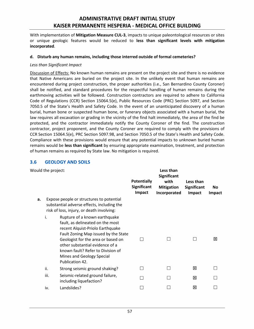
ADMINISTRATIVE DRAFT INITIAL STUDY KAISER PERMANENTE HESPERIA - MEDICAL OFFICE BUILDING
57
With implementation of Mitigation Measure CUL-3, impacts to unique paleontological resources or sites or unique geologic features would be reduced to less than significant levels with mitigation incorporated.
d. Disturb any human remains, including those interred outside of formal cemeteries?
Less than Significant Impact
Discussion of Effects: No known human remains are present on the project site and there is no evidence that Native Americans are buried on the project site. In the unlikely event that human remains are encountered during project construction, the proper authorities (i.e., San Bernardino County Coroner) shall be notified, and standard procedures for the respectful handling of human remains during the earthmoving activities will be followed. Construction contractors are required to adhere to California Code of Regulations (CCR) Section 15064.5(e), Public Resources Code (PRC) Section 5097, and Section 7050.5 of the State’s Health and Safety Code. In the event of an unanticipated discovery of a human burial, human bone or suspected human bone, or funerary objects associated with a human burial, the law requires all excavation or grading in the vicinity of the find halt immediately, the area of the find be protected, and the contractor immediately notify the County Coroner of the find. The construction contractor, project proponent, and the County Coroner are required to comply with the provisions of CCR Section 15064.5(e), PRC Section 5097.98, and Section 7050.5 of the State’s Health and Safety Code. Compliance with these provisions would ensure that any potential impacts to unknown buried human remains would be less than significant by ensuring appropriate examination, treatment, and protection of human remains as required by State law. No mitigation is required.
3.6 GEOLOGY AND SOILS Would the project:
Potentially Significant
Impact
Less than Significant
with Mitigation
Incorporated
Less than Significant
Impact No
Impact a. Expose people or structures to potential
substantial adverse effects, including the risk of loss, injury, or death involving:
i. Rupture of a known earthquake fault, as delineated on the most recent Alquist-Priolo Earthquake Fault Zoning Map issued by the State Geologist for the area or based on other substantial evidence of a known fault? Refer to Division of Mines and Geology Special Publication 42.
ii. Strong seismic ground shaking? iii. Seismic-related ground failure,
including liquefaction?
iv. Landslides?
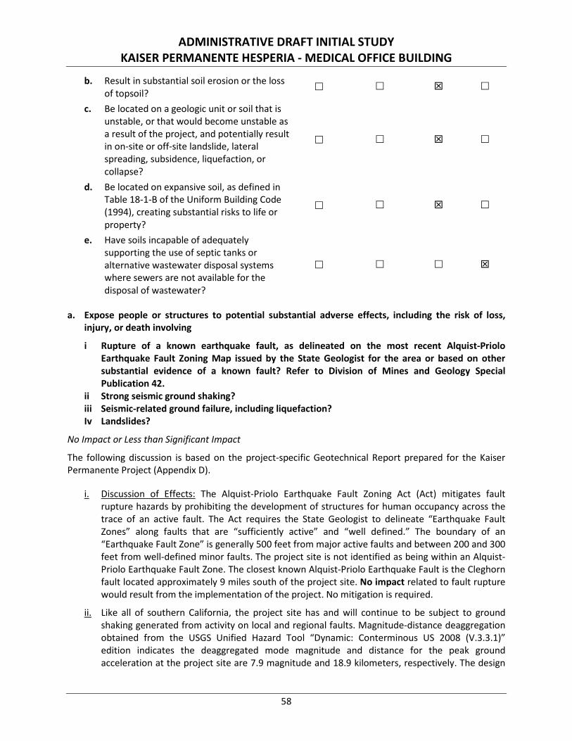
ADMINISTRATIVE DRAFT INITIAL STUDY KAISER PERMANENTE HESPERIA - MEDICAL OFFICE BUILDING
58
b. Result in substantial soil erosion or the loss of topsoil?
c. Be located on a geologic unit or soil that is unstable, or that would become unstable as a result of the project, and potentially result in on-site or off-site landslide, lateral spreading, subsidence, liquefaction, or collapse?
d. Be located on expansive soil, as defined in Table 18-1-B of the Uniform Building Code (1994), creating substantial risks to life or property?
e. Have soils incapable of adequately supporting the use of septic tanks or alternative wastewater disposal systems where sewers are not available for the disposal of wastewater?
a. Expose people or structures to potential substantial adverse effects, including the risk of loss, injury, or death involving
i Rupture of a known earthquake fault, as delineated on the most recent Alquist-Priolo Earthquake Fault Zoning Map issued by the State Geologist for the area or based on other substantial evidence of a known fault? Refer to Division of Mines and Geology Special Publication 42.
ii Strong seismic ground shaking? iii Seismic-related ground failure, including liquefaction? Iv Landslides?
No Impact or Less than Significant Impact
The following discussion is based on the project-specific Geotechnical Report prepared for the Kaiser Permanente Project (Appendix D).
i. Discussion of Effects: The Alquist-Priolo Earthquake Fault Zoning Act (Act) mitigates fault rupture hazards by prohibiting the development of structures for human occupancy across the trace of an active fault. The Act requires the State Geologist to delineate “Earthquake Fault Zones” along faults that are “sufficiently active” and “well defined.” The boundary of an “Earthquake Fault Zone” is generally 500 feet from major active faults and between 200 and 300 feet from well-defined minor faults. The project site is not identified as being within an Alquist-Priolo Earthquake Fault Zone. The closest known Alquist-Priolo Earthquake Fault is the Cleghorn fault located approximately 9 miles south of the project site. No impact related to fault rupture would result from the implementation of the project. No mitigation is required.
ii. Like all of southern California, the project site has and will continue to be subject to ground shaking generated from activity on local and regional faults. Magnitude-distance deaggregation obtained from the USGS Unified Hazard Tool “Dynamic: Conterminous US 2008 (V.3.3.1)” edition indicates the deaggregated mode magnitude and distance for the peak ground acceleration at the project site are 7.9 magnitude and 18.9 kilometers, respectively. The design
ADMINISTRATIVE DRAFT INITIAL STUDY KAISER PERMANENTE HESPERIA - MEDICAL OFFICE BUILDING
59
and construction of the proposed project would include seismic design parameters in accordance with the 2016 California Building Code (CBC) that would reduce the potential for seismic shaking-related impacts to a less than significant level. No mitigation is required.
iii. Liquefaction occurs when loose, unconsolidated, water-laden soils are subject to shaking, causing the soils to lose cohesion. The project site is not identified as being within an area susceptible to liquefaction.26 Because the project site would not be highly susceptible to liquefaction, a less than significant impact related to this issue would occur. No mitigation is required.
iv. The project site is within a relatively flat area and is not adjacent to or near any geographical feature identified by the City that would be susceptible to landslides.27 Therefore, the likelihood of a landslide near or on the project site is low and impacts associated with landslides are less than significant. No mitigation is required.
b. Result in substantial soil erosion or the loss of topsoil?
Less than Significant Impact
Discussion of Effects: Soils are classified by the NRCS into four hydrologic soils groups based on the soil’s runoff potential. “Hydrologic soil group” is a term that represents a group of soils having similar runoff potential under similar storm and cover conditions. Soil properties that influence runoff potential are those that influence the minimum rate of infiltration for bare soil after prolonged wetting. The project site contains Hesperia loamy fine sand, 2 to 5 percent slopes and is considered well drained.28 Runoff of Hesperia loamy fine sand is considered slow.29 Therefore, Hesperia loamy find sand is considered to have a low runoff or erosion potential.
Although the project site soils have a low runoff or erosion potential, the proposed project would require the excavation and movement of on-site soils, which could result in runoff or erosion. State and federal regulations require the project to obtain a National Pollutant Discharge Elimination System (NPDES) permit and to prepare and implement a Storm Water Pollution Prevention Plan (SWPPP) establishing erosion and sediment controls for construction activities. The SWPPP identifies Best Management Practices (BMPs) to limit soil erosion during project construction. Compliance with State and federal requirements will ensure that the proposed project will have a less than significant impact related to soil erosion or loss of topsoil. No mitigation is required.
c. Be located on a geologic unit or soil that is unstable, or that would become unstable as a result of the project, and potentially result in on-site or off-site landslide, lateral spreading, subsidence, liquefaction, or collapse?
Less than Significant Impact
Discussion of Effects: Subsidence is the sudden sinking or gradual downward settling of the earth’s surface with little or no horizontal motion. Subsidence is caused by a variety of activities, which include (but are not limited to) withdrawal of groundwater, pumping of oil and gas from underground, the
26 Draft Environmental Impact Report for the City of Hesperia General Plan Update. Exhibit 3.6-3: Seismic Hazard Areas. Michael Brandman
and Associates. May 26, 2010. 27 Ibid. 28 Web Soil Survey. United States Department of Agriculture, 2017. https://websoilsurvey.sc.egov.usda.gov/App/WebSoilSurvey.aspx.
Accessed November 6, 2018. 29 Soil Survey of San Bernardino County California. Page 44. United States Department of Agriculture. February 1986.
ADMINISTRATIVE DRAFT INITIAL STUDY KAISER PERMANENTE HESPERIA - MEDICAL OFFICE BUILDING
60
collapse of underground mines, liquefaction, and hydro-compaction. The project does not include the on-site withdrawal of groundwater or pumping of oil and/or gas.
As identified above, the project site is not located within landslide or liquefaction zones.30 Seismically-induced lateral spreading involves primarily movement of earth materials due to ground shaking. Lateral Spreading is demonstrated by near vertical cracks with predominantly horizontal movement of the soil mass involved. Since the potential for liquefaction at the site is considered very low, the potential for lateral spreading at the site also is considered very low.
An on-site investigation consisting of twelve soil borings and seven Cone Penetration Tests (CPTs) was performed by Geobase, Inc. on March 29 and 30, 2018. The borings were advanced to a maximum depth of 51.5 feet below grade, and the CPTs were advanced to a maximum depth of 60 feet below grade. None of the borings or CPTs encountered groundwater, which is expected to occur at depths greater than 500 feet below grade.
Electrical conductivity, pH, chloride, and water-soluble sulfate tests were conducted on representative soil samples. The tests indicate that on-site subsoils have a “moderate” corrosive potential with respect to concrete and “moderately corrosive” potential with respect to steel and other metals.
Laboratory tests indicate the site is underlain by dense to very dense native soils, and groundwater level is very deep. Therefore, potential hazards associated with subsidence at the site are very low. However, subsurface soils are considered collapsible and would undergo significant volume reduction (i.e., settlement) upon wetting with or without structural loading. To promote surficial stability, proper surface drainage devices and erosion control shall be implemented.
General Plan Goal SF-1 is implemented to minimize injury, loss of life, and property damage as a result of seismic hazards and other geologic hazards such as slope instability, compressible and collapsible soils, and subsidence through the following implementation policies:
• Compliance with provisions of the latest California Building Code (Policy SF-1.1).
• Preparation of a project-specific geotechnical investigation and implementation of all applicable recommendations therein (Policy SF-1.2).
• Routine inspections of grading operations by City staff (Policy SF-1.3).
• City staff review and approve project-specific geotechnical investigation and implementation of all applicable recommendations therein (Policy SF-1.4).
Pursuant to General Plan Goal SF-1, all future construction and development within the project site would be required to comply with applicable provisions of the 2016 CBC and the City’s building regulations. Accordingly, proper engineering design and construction in conformance with the 2016 CBC standards and project-specific geotechnical recommendations (Standard Condition GEO-1) would ensure that the project is not developed on unstable geologic units or soils.
30 Draft Environmental Impact Report for the City of Hesperia General Plan Update. Exhibit 3.6-3: Seismic Hazard Areas. Michael Brandman
and Associates. May 26, 2010.
ADMINISTRATIVE DRAFT INITIAL STUDY KAISER PERMANENTE HESPERIA - MEDICAL OFFICE BUILDING
61
Standard Condition: No mitigation is required; however, the following Standard Condition is a regulatory requirement that would be implemented to ensure impacts related to unstable geologic units or soils remain less than significant.
Standard Condition GEO-1: Prior to the approval of grading and/or building permits, the project proponent shall provide evidence to the City for review and approval that on-site structures, features, and facilities have been designed and will be constructed in conformance with applicable provisions of the 2016 California Building Code and the recommendations cited in Section VIII (Site Development Recommendations), Section IX (Foundation Recommendations), Section X (Soil Corrosivity), Section XI (Pavement Recommendations), and Section XII (Plan Review, Observations, and Testing) of the project-specific Geotechnical Report. Geotechnical recommendations include remedial earthwork and/or ground improvement to provide a sufficient layer of engineered fill or densified soil beneath the structural footings/foundations, as well as proper surface drainage devices and erosion control. Additionally, Type II Portland cement shall be utilized for the construction of concrete structures in contact with subgrade soils to protect concrete, steel, and other metals from corrosive soils. Verification testing must be performed upon completion of ground improvements to confirm that the compressible soils have been sufficiently densified, and settlement of the footings foundation system must be reviewed by a qualified geotechnical engineer once the configuration of the footings are finalized. This measure shall be implemented to the satisfaction of the Director of the City of Hesperia Development Services Department, Building and Safety Division, or designee.
Upon implementation of the project-specific geotechnical recommendations (Standard Condition GEO-1), total static settlement of the footings is not anticipated to exceed 1 inch and the differential settlement is not expected to exceed 0.5 inch. Proper engineering design and construction in conformance with the 2016 CBC standards and project-specific geotechnical recommendations (Standard Condition GEO-1) would ensure potential impacts from landslides or slope instabilities, subsidence and/or collapse, or lateral spreading at the project site would be less than significant. No mitigation is required.
d. Be located on expansive soil, as defined in Table 18-1-B of the Uniform Building Code (1994), creating substantial risks to life or property?
Less than Significant Impact
Discussion of Effects: Expansive soils generally have a substantial amount of clay particles that can give up water (shrink) or absorb water (swell). The change in the volume exerts stress on structures and other loads placed on these soils. The extent or range of the shrink/swell is influenced by the amount and kind of clay present in the soil. The occurrence of these soils is often associated with geologic units having marginal stability. Expansive soils can be widely dispersed and they can occur in hillside areas as well as low-lying alluvial basins.
Soils on site are Hesperia loamy fine sand, 2 to 5 percent slope. Based on preliminary field investigation and laboratory testing data, on-site soils possess a “very low” expansion potential (expansion index of 0).31 Furthermore, Hesperia loamy fine sand covering the proposed project site is anticipated to have a low shrink-swell potential.32 Development of the proposed project site will be required to adhere to City
31 Geotechnical Report, Kaiser Permanente SFNT 2018 MLF Hesperia MOB D0476, Vacant Parcels 5-9, APN #3057-011-22-0-00 Thru 3057-
011-26-0-000, Escondido Avenue, Hesperia, California. Page 14. Geobase, Inc. May 2018. (Appendix D). 32 Soil Survey of San Bernardino County California. Page 44. United States Department of Agriculture. February 1986.
ADMINISTRATIVE DRAFT INITIAL STUDY KAISER PERMANENTE HESPERIA - MEDICAL OFFICE BUILDING
62
design and engineering standards pursuant to General Plan Goal SF-1. Through implementation of 2016 CBC standards and project-specific geotechnical recommendations (Standard Condition GEO-1), impacts associated with expansive soils would be less than significant. No mitigation is required.
e. Have soils incapable of adequately supporting the use of septic tanks or alternative wastewater disposal systems where sewers are not available for the disposal of wastewater?
No Impact
Discussion of Effects: The proposed project is a new medical office building project that does not have a septic or alternative waste disposal system component. The proposed building will be connected to the municipal wastewater system; therefore, alternative wastewater disposal systems would not be utilized. No impact would occur and no mitigation is required.
3.7 GREENHOUSE GAS EMISSIONS Would the project:
Potentially Significant
Impact
Less than Significant
with Mitigation
Incorporated
Less than Significant
Impact No
Impact a. Generate greenhouse gas emissions, either
directly or indirectly, that may have a significant impact on the environment?
b. Conflict with an applicable plan, policy or regulation adopted for the purpose of reducing the emissions of greenhouse gases?
a. Generate greenhouse gas emissions, either directly or indirectly, that may have a significant impact on the environment?
b. Conflict with an applicable plan, policy or regulation adopted for the purpose of reducing the emissions of greenhouse gases?
Less than Significant Impact
Discussion of Effects: Climate change is a global issue and is described in the context of the cumulative environment. Therefore, the project is considered in the context of multiple sectors and the combined efforts of many industries, including development. The primary greenhouse gas (GHG) generated by the project would be carbon dioxide (CO2). The following analysis represents an estimate of the project’s GHG emissions through the quantification of CO2 emissions. The following project activities were analyzed for their contribution to global CO2 emissions.
Construction Emissions. Construction activities produce combustion emissions from various sources such as site grading, utility engines, on-site heavy-duty construction vehicles, equipment hauling materials to and from the site, asphalt paving, and motor vehicles transporting the construction crew. Exhaust emissions from on-site construction activities would vary daily as construction activity levels change. The construction GHG emission estimates were calculated using CalEEMod Version 2016.3.2 (Appendix A), which indicates the project’s GHG emissions during the construction period (year 2019) would equal 510 metric tons (MT) of carbon dioxide equivalent (CO2e).

ADMINISTRATIVE DRAFT INITIAL STUDY KAISER PERMANENTE HESPERIA - MEDICAL OFFICE BUILDING
63
Operational Emissions. The operational GHG emission estimates were also calculated using CalEEMod (Appendix A). Activities such as natural gas, electricity, water use, solid waste disposal, and motor vehicle use are expected to directly and/or indirectly contribute to the generation of GHG emissions from operation of the proposed project. The GHG emission estimates presented in Table D detail the emissions associated with the level of proposed development at project build out.
Table D: Long-Term Operational Greenhouse Gas Emissions
Source
Greenhouse Gas Emissions, CO2e
Pounds per Day Metric Tons per Year
Area Sources <1 <1
Energy Sources 62 190
Mobile Sources 12,998 1,527
Waste Sources <1 299
Water Usage <1 43
Total Project Emissions 13,060 2,076 Source: Compiled by LSA (October 2018) (Appendix A).
CO2e = carbon dioxide equivalent
As detailed in Table D, project operations would result in daily emissions of 13,060 pounds of CO2e and average annual emissions of 2,076 MT of CO2e per year.
In accordance with Executive Order S-3-05 and AB 32, the City developed a Climate Action Plan (CAP).33 If a project can garner 100 or more points on the City’s CAP GHG Screening Tables, project GHG emissions would be considered less than significant. As detailed in Appendix A, the proposed project includes design features that would allow it to achieve 202 points on the City’s CAP GHG Screening Tables. These project design features shall be implemented to the satisfaction of the City of Hesperia Planning Department. Therefore, impacts related to the generation of GHG emissions, either directly or indirectly, that may have a significant impact on the environment would be less than significant. No mitigation is required.
3.8 HAZARDS AND HAZARDOUS MATERIALS Would the project:
Potentially Significant
Impact
Less than Significant
with Mitigation
Incorporated
Less than Significant
Impact No
Impact a. Create a significant hazard to the public or
the environment through the routine transport, use, or disposal of hazardous materials?
33 Climate Action Plan. City of Hesperia. July 20, 2010.
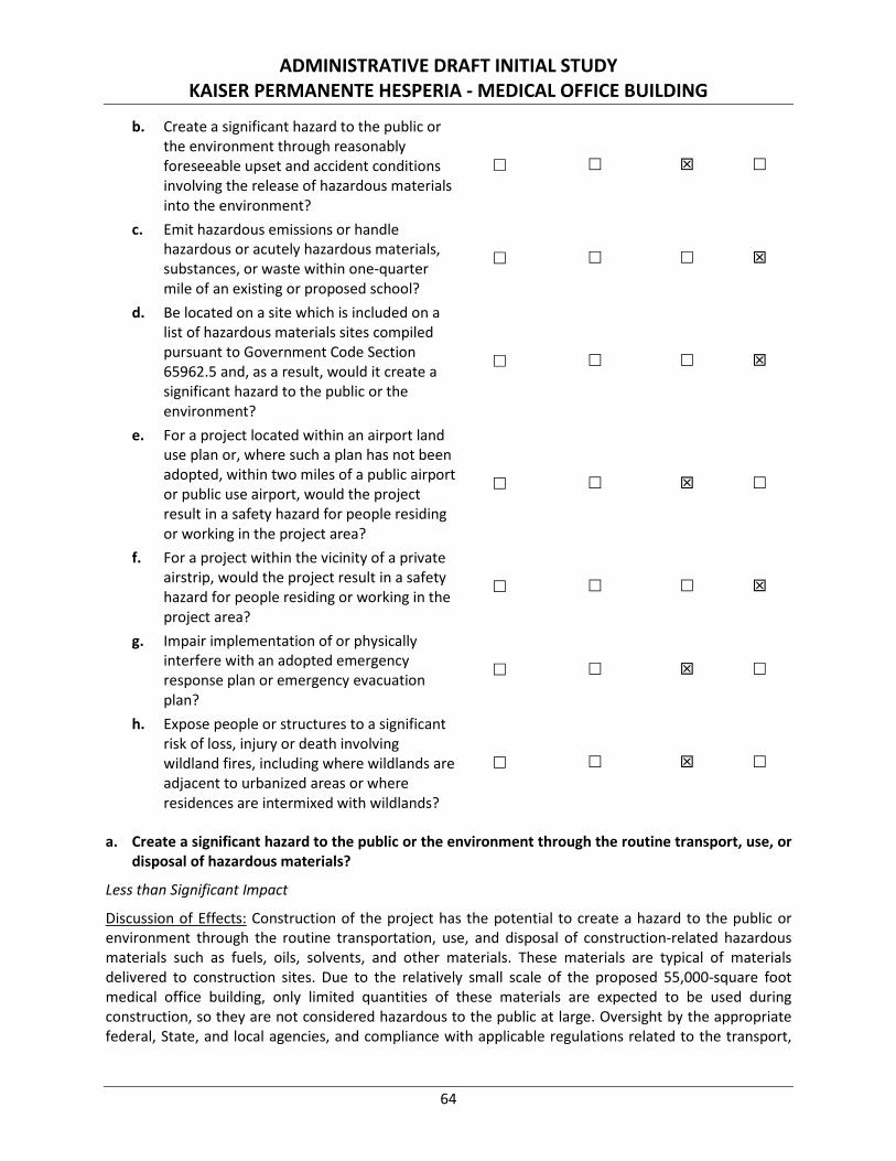
ADMINISTRATIVE DRAFT INITIAL STUDY KAISER PERMANENTE HESPERIA - MEDICAL OFFICE BUILDING
64
b. Create a significant hazard to the public or the environment through reasonably foreseeable upset and accident conditions involving the release of hazardous materials into the environment?
c. Emit hazardous emissions or handle hazardous or acutely hazardous materials, substances, or waste within one-quarter mile of an existing or proposed school?
d. Be located on a site which is included on a list of hazardous materials sites compiled pursuant to Government Code Section 65962.5 and, as a result, would it create a significant hazard to the public or the environment?
e. For a project located within an airport land use plan or, where such a plan has not been adopted, within two miles of a public airport or public use airport, would the project result in a safety hazard for people residing or working in the project area?
f. For a project within the vicinity of a private airstrip, would the project result in a safety hazard for people residing or working in the project area?
g. Impair implementation of or physically interfere with an adopted emergency response plan or emergency evacuation plan?
h. Expose people or structures to a significant risk of loss, injury or death involving wildland fires, including where wildlands are adjacent to urbanized areas or where residences are intermixed with wildlands?
a. Create a significant hazard to the public or the environment through the routine transport, use, or disposal of hazardous materials?
Less than Significant Impact
Discussion of Effects: Construction of the project has the potential to create a hazard to the public or environment through the routine transportation, use, and disposal of construction-related hazardous materials such as fuels, oils, solvents, and other materials. These materials are typical of materials delivered to construction sites. Due to the relatively small scale of the proposed 55,000-square foot medical office building, only limited quantities of these materials are expected to be used during construction, so they are not considered hazardous to the public at large. Oversight by the appropriate federal, State, and local agencies, and compliance with applicable regulations related to the transport,
ADMINISTRATIVE DRAFT INITIAL STUDY KAISER PERMANENTE HESPERIA - MEDICAL OFFICE BUILDING
65
storage, and disposal of hazardous materials would ensure the proposed project would not create a significant hazard to the public or the environment during construction.
The transport, use, and storage of hazardous materials during construction and operation of the project will be regulated by the Hesperia Fire Department, the San Bernardino County Fire District, and the California Occupational Safety and Health Administration. Additionally, the United States Department of Transportation Office of Hazardous Materials Safety prescribes strict regulations for the safe transportation of hazardous materials by truck and rail on state highways and rail lines, as described in Title 49 of the Code of Federal Regulations, and implemented by Title 13 of the CCR.
As applicable, the project tenant(s) would develop a Hazardous Materials Business Emergency Plan administered by Division 1 of the San Bernardino County Fire District. Pursuant to Health and Safety Code Section 25507, a business shall establish and implement a Hazardous Materials Business Emergency Plan for emergency response to a release or threatened release of a hazardous material in accordance with the standards prescribed in the regulations adopted pursuant to Section 25503 if the business handles a hazardous material or a mixture containing a hazardous material that has a quantity at any one time above the thresholds described in Section 25507(a) (1) through (6).
The project would also be required to implement health and safety policies and procedures regarding hazardous materials used where employees would be expected to handle or work around hazardous materials. Pursuant to the Federal Hazard Communication Standard (29 CFR 1910.1200) and the Laboratory Standard (29 CFR 1910.1450), Safety Data Sheets outlining procedures to address spills and leaks for individual chemicals will be used to conduct chemical safety training for all staff who work with chemicals in order to minimize the occurrence of accidental chemical releases and ensure that, when one does occur, it is handled in a safe manner.
The California Department of Public Health has established the Medical Waste Management Program (MWMP) to manage the generation, handling, storage, treatment, and disposal of medical waste in accordance with the Medical Waste Management Act (MWMA) in order to protect the public and the environment from potentially infectious disease causing agents.34 The MWMP permits and inspects all medical waste off-site treatment facilities and medical waste transfer stations.
A Small Quantity Generator is a medical waste generator, other than a trauma scene waste practitioner, that generates less than 200 pounds per month of medical waste. A Large Quantity Generator is a medical waste generator that generates more than 200 pounds per month of medical waste. Medical waste includes, but is not limited to, sharps, biohazardous waste, and pharmaceutical waste. As a generator of medical waste, the project operator is subject to all of the requirements under Chapter 4 of the MWMA, Health and Safety Code Sections 117915 through 117946, including an annual generator fee, as a matter of regulatory policy.
These regulations inherently safeguard life and property from the hazards of fire/explosion arising from the storage, handling, and use of hazardous substances, materials, and devices, as well as hazardous conditions due to the use or occupancy of buildings. Through compliance with all applicable federal, State, and local laws for construction and operation of the proposed project, impacts to the public or
34 Medical Waste Management Program. California Department of Public Health. https://www.cdph.ca.gov/Programs/CEH/DRSEM/Pages/
EMB/MedicalWaste/MedicalWaste.aspx (Accessed November 14, 2018).
ADMINISTRATIVE DRAFT INITIAL STUDY KAISER PERMANENTE HESPERIA - MEDICAL OFFICE BUILDING
66
environment from the routine transportation, use and disposal of hazardous materials would be less than significant. No mitigation is required.
b. Create a significant hazard to the public or the environment through reasonably foreseeable upset and accident conditions involving the release of hazardous materials into the environment?
Less than Significant Impact
Discussion of Effects: A Phase 1 Environmental Site Assessment (ESA) was prepared for the project in accordance with the standards and procedures outlined in the American Society for Testing and Materials E 1527-13, as applicable (Appendix E). The ESA included a records review of various environmental databases, local and State records, historical records, and interviews with present and, to the extent feasible, past owners, as well as an on-site field inspection of the project site. The purpose of the Phase 1 ESA is to identify, to the extent feasible, and pursuant to the processes prescribed therein, recognized environmental conditions in connection with the property.
“Recognized environmental conditions” means the presence or likely presence of any hazardous substances or petroleum products in, on, or at a property: (1) due to any release to the environment; (2) under conditions indicative of a release to the environment; or (3) under conditions that pose a material threat of a future release to the environment. The term is not intended to include de minimis conditions that generally do not present a threat to human health or the environment and that generally would not be the subject of an enforcement action if brought to the attention of appropriate governmental agencies. Conditions determined to be de minimis are not recognized environmental conditions.
“Historical Recognized environmental condition” means an environmental condition which in the past would have been considered a recognized environmental condition, but which may or may not be considered a recognized environmental condition currently. If a past release of any hazardous substances or petroleum products has occurred in connection with the property, with such remediation accepted by the responsible regulatory agency (for example, as evidenced by the issuance of a no further action letter or equivalent), this condition shall be considered a historical recognized environmental condition.
The ESA included federal, State, and local records reviews (up to a one-mile radius) and an on-site inspection of the project site. The site was not identified in any regulatory databases. Documents related to the site were not provided by governmental agencies. Facilities identified within the specified search distances do not represent recognized environmental conditions or historical recognized environmental conditions. Additionally, the on-site inspection did not identify recognized environmental conditions or historical recognized environmental conditions. Based on site observations, the site has a low risk for asbestos, chromium, Freon, lead paint, lead shielding, mercury, polychlorinated biphenyl light ballasts, soil remediation, underground storage tanks, and/or aboveground storage tanks. Additionally, current research indicates there is a low potential for vapor intrusion issues and/or on-site lead in drinking water.
Construction and operation of the proposed project would occur in accordance with all applicable local, state, and federal laws. Compliance with all applicable laws and regulations would ensure impacts associated with reasonably foreseeable upset and accident conditions involving the release of hazardous materials into the environment remain less than significant. No mitigation is required.
ADMINISTRATIVE DRAFT INITIAL STUDY KAISER PERMANENTE HESPERIA - MEDICAL OFFICE BUILDING
67
c. Emit hazardous emissions or handle hazardous or acutely hazardous materials, substances, or waste within one-quarter mile of an existing or proposed school?
No Impact
Discussion of Effects: The nearest school in proximity to the project site is San Joaquin Valley College, located at 9331 Mariposa Road, approximately 0.33 mile west-southwest of the project site. The next nearest school is Canyon Ridge High School, located at 12850 Muscatel Street. No existing schools or proposed school sites are located within a quarter mile of the project site. In the absence of an existing or proposed school within a quarter mile of the project site, no impact would occur. No mitigation is required.
d. Be located on a site which is included on a list of hazardous materials sites compiled pursuant to Government Code Section 65962.5 and, as a result, would it create a significant hazard to the public or the environment?
No Impact
Discussion of Effects: Pursuant to Government Code Section 65962.5, the Hazardous Waste and Substances Sites List has been compiled by the California Environmental Protection Agency Hazardous Materials Data Management Program. The DTSC compiles information from subsets of the following databases to make up the Cortese List:
1. The DTSC list of contaminated or potentially contaminated hazardous waste sites listed in the California Sites database, formerly known as ASPIS, is included;
2. The California State Water Resources Control Board listing of leaking underground storage tanks is included; and
3. The California Integrated Waste Management Board list of sanitary landfills that have evidence of groundwater contamination or known migration of hazardous materials (formerly WB-LF, now AB 3750).
A review of the Hazardous Waste and Substances Sites (Cortese) List revealed no properties in Hesperia are listed.35 Therefore no impact related to the Cortese List or other governmental databases would occur and no mitigation is required.
e. For a project located within an airport land use plan or, where such a plan has not been adopted, within two miles of a public airport or public use airport, would the project result in a safety hazard for people residing or working in the project area?
Less than Significant Impact
Discussion of Effects: The project site is located approximately 4.5 miles northwest of the Hesperia Airport, well outside any airport “referral area” or “safety zone” indicated in the Comprehensive Land Use Plan for the Hesperia Airport.36 Therefore, airport hazard impacts would be less than significant. No mitigation is required.
35 The Hazardous Waste and Substances Sites (Cortese) List. California Department of Toxic Substances Control. 2018.
https://www.dtsc.ca.gov/SiteCleanup/Cortese_List.cfm (Accessed November 6, 2018). 36 Comprehensive Land Use Plan, Hesperia Airport. Figure 1-5 and Figure III-7. San Bernardino County Airport Land Use Commission. January,
1991.
ADMINISTRATIVE DRAFT INITIAL STUDY KAISER PERMANENTE HESPERIA - MEDICAL OFFICE BUILDING
68
f. For a project within the vicinity of a private airstrip, would the project result in a safety hazard for people residing or working in the project area?
No Impact
Discussion of Effects: The project is not located within the vicinity of a private airstrip; therefore, no impact related with this issue would occur. No mitigation is required.
g. Impair implementation of or physically interfere with an adopted emergency response plan or emergency evacuation plan?
Less than Significant Impact
Discussion of Effects: The project entails development of a medical office building in accordance with the design guidelines outlined in the Hesperia Main Street and Freeway Corridor Specific Plan and would not include features that would permanently interfere with emergency access or evacuation plans. Construction activities that may temporarily restrict vehicular traffic would be required to implement adequate and appropriate measures to facilitate the passage of persons and vehicles through/around any required road closures.
Construction of the proposed project would be consistent with the City’s Emergency Operations Plan adopted on April 3, 2002, for the purposes of coordinating efforts during local, State, and/or federal emergency events, including response to hazardous materials incidents. Additionally, site access points or driveway aprons into and out of the site are planned as far as possible from street intersections (minimum distance is 100 feet, or more based on safety considerations) and will be minimized to achieve efficient and productive use of paved access ways and eliminate traffic hazards. Plant material will not interfere with lighting of the premises or restrict access to emergency apparatus such as fire hydrants or fire alarm boxes. The site access points will be coordinated with existing or planned median openings and driveways on the opposite side of the roadway. Entrances and exits to and from parking and loading facilities will be clearly marked with appropriate directional signage where multiple access points are provided.
One driveway will be provided along Escondido Avenue and an additional driveway will be incorporated along a new frontage roadway bordering the northern property boundary, which will provide secondary access to the project site and also facilitate improved reciprocal access to the existing parking lot adjacent to the north. All site access points and driveway aprons are designed and will be constructed to minimum 26-foot widths and shall be reviewed by the Hesperia Fire Department to ensure adequate emergency access to/from the project site.
The project is required to incorporate adequate emergency water flow, fire-resistant design and materials, early warning systems and evacuation routes, and to identify and mitigate any fire hazards during the development review process. The proposed project design would be submitted to and approved by the Hesperia Fire Department pursuant to Chapter 16.12, Article II (Site Plans and Revised Site Plans) of the City Municipal Code prior the issuance of building permits. Furthermore, the project would be required to pay Development Impact Fees (DIFs) used to fund capital costs associated with constructing new public safety structures and purchasing equipment for new public safety structures. Adherence to the emergency access measures required by the City would ensure a less than significant impact related to implementation of or physical interference with an adopted emergency response plan or emergency evacuation plan. No mitigation is required.
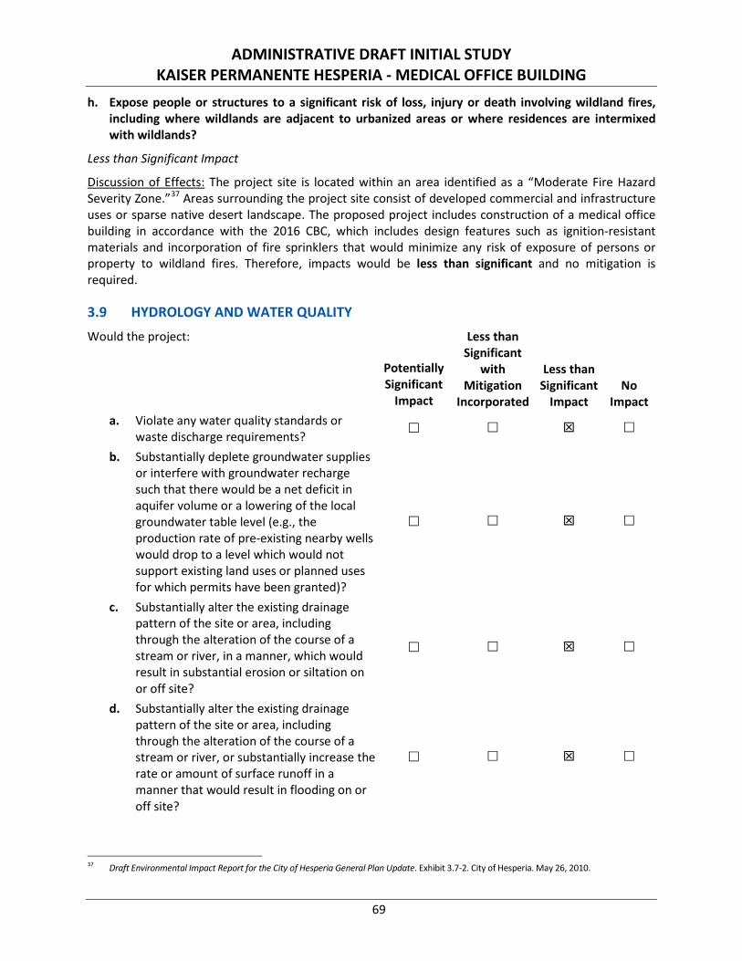
ADMINISTRATIVE DRAFT INITIAL STUDY KAISER PERMANENTE HESPERIA - MEDICAL OFFICE BUILDING
69
h. Expose people or structures to a significant risk of loss, injury or death involving wildland fires, including where wildlands are adjacent to urbanized areas or where residences are intermixed with wildlands?
Less than Significant Impact
Discussion of Effects: The project site is located within an area identified as a “Moderate Fire Hazard Severity Zone.”37 Areas surrounding the project site consist of developed commercial and infrastructure uses or sparse native desert landscape. The proposed project includes construction of a medical office building in accordance with the 2016 CBC, which includes design features such as ignition-resistant materials and incorporation of fire sprinklers that would minimize any risk of exposure of persons or property to wildland fires. Therefore, impacts would be less than significant and no mitigation is required.
3.9 HYDROLOGY AND WATER QUALITY Would the project:
Potentially Significant
Impact
Less than Significant
with Mitigation
Incorporated
Less than Significant
Impact No
Impact a. Violate any water quality standards or
waste discharge requirements?
b. Substantially deplete groundwater supplies or interfere with groundwater recharge such that there would be a net deficit in aquifer volume or a lowering of the local groundwater table level (e.g., the production rate of pre-existing nearby wells would drop to a level which would not support existing land uses or planned uses for which permits have been granted)?
c. Substantially alter the existing drainage pattern of the site or area, including through the alteration of the course of a stream or river, in a manner, which would result in substantial erosion or siltation on or off site?
d. Substantially alter the existing drainage pattern of the site or area, including through the alteration of the course of a stream or river, or substantially increase the rate or amount of surface runoff in a manner that would result in flooding on or off site?
37 Draft Environmental Impact Report for the City of Hesperia General Plan Update. Exhibit 3.7-2. City of Hesperia. May 26, 2010.
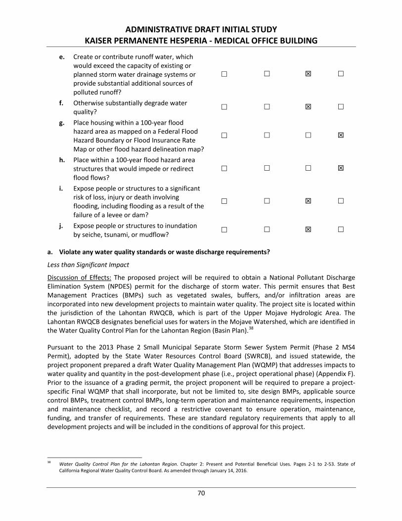
ADMINISTRATIVE DRAFT INITIAL STUDY KAISER PERMANENTE HESPERIA - MEDICAL OFFICE BUILDING
70
e. Create or contribute runoff water, which would exceed the capacity of existing or planned storm water drainage systems or provide substantial additional sources of polluted runoff?
f. Otherwise substantially degrade water quality?
g. Place housing within a 100-year flood hazard area as mapped on a Federal Flood Hazard Boundary or Flood Insurance Rate Map or other flood hazard delineation map?
h. Place within a 100-year flood hazard area structures that would impede or redirect flood flows?
i. Expose people or structures to a significant risk of loss, injury or death involving flooding, including flooding as a result of the failure of a levee or dam?
j. Expose people or structures to inundation by seiche, tsunami, or mudflow?
a. Violate any water quality standards or waste discharge requirements?
Less than Significant Impact
Discussion of Effects: The proposed project will be required to obtain a National Pollutant Discharge Elimination System (NPDES) permit for the discharge of storm water. This permit ensures that Best Management Practices (BMPs) such as vegetated swales, buffers, and/or infiltration areas are incorporated into new development projects to maintain water quality. The project site is located within the jurisdiction of the Lahontan RWQCB, which is part of the Upper Mojave Hydrologic Area. The Lahontan RWQCB designates beneficial uses for waters in the Mojave Watershed, which are identified in the Water Quality Control Plan for the Lahontan Region (Basin Plan).38
Pursuant to the 2013 Phase 2 Small Municipal Separate Storm Sewer System Permit (Phase 2 MS4 Permit), adopted by the State Water Resources Control Board (SWRCB), and issued statewide, the project proponent prepared a draft Water Quality Management Plan (WQMP) that addresses impacts to water quality and quantity in the post-development phase (i.e., project operational phase) (Appendix F). Prior to the issuance of a grading permit, the project proponent will be required to prepare a project-specific Final WQMP that shall incorporate, but not be limited to, site design BMPs, applicable source control BMPs, treatment control BMPs, long-term operation and maintenance requirements, inspection and maintenance checklist, and record a restrictive covenant to ensure operation, maintenance, funding, and transfer of requirements. These are standard regulatory requirements that apply to all development projects and will be included in the conditions of approval for this project.
38 Water Quality Control Plan for the Lahontan Region. Chapter 2: Present and Potential Beneficial Uses. Pages 2-1 to 2-53. State of
California Regional Water Quality Control Board. As amended through January 14, 2016.
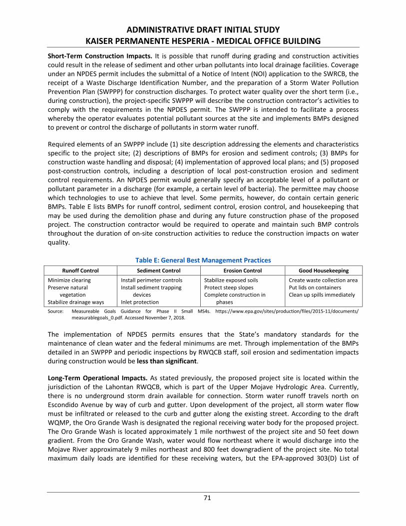
ADMINISTRATIVE DRAFT INITIAL STUDY KAISER PERMANENTE HESPERIA - MEDICAL OFFICE BUILDING
71
Short-Term Construction Impacts. It is possible that runoff during grading and construction activities could result in the release of sediment and other urban pollutants into local drainage facilities. Coverage under an NPDES permit includes the submittal of a Notice of Intent (NOI) application to the SWRCB, the receipt of a Waste Discharge Identification Number, and the preparation of a Storm Water Pollution Prevention Plan (SWPPP) for construction discharges. To protect water quality over the short term (i.e., during construction), the project-specific SWPPP will describe the construction contractor’s activities to comply with the requirements in the NPDES permit. The SWPPP is intended to facilitate a process whereby the operator evaluates potential pollutant sources at the site and implements BMPs designed to prevent or control the discharge of pollutants in storm water runoff.
Required elements of an SWPPP include (1) site description addressing the elements and characteristics specific to the project site; (2) descriptions of BMPs for erosion and sediment controls; (3) BMPs for construction waste handling and disposal; (4) implementation of approved local plans; and (5) proposed post-construction controls, including a description of local post-construction erosion and sediment control requirements. An NPDES permit would generally specify an acceptable level of a pollutant or pollutant parameter in a discharge (for example, a certain level of bacteria). The permittee may choose which technologies to use to achieve that level. Some permits, however, do contain certain generic BMPs. Table E lists BMPs for runoff control, sediment control, erosion control, and housekeeping that may be used during the demolition phase and during any future construction phase of the proposed project. The construction contractor would be required to operate and maintain such BMP controls throughout the duration of on-site construction activities to reduce the construction impacts on water quality.
Table E: General Best Management Practices Runoff Control Sediment Control Erosion Control Good Housekeeping
Minimize clearing Preserve natural
vegetation Stabilize drainage ways
Install perimeter controls Install sediment trapping
devices Inlet protection
Stabilize exposed soils Protect steep slopes Complete construction in
phases
Create waste collection area Put lids on containers Clean up spills immediately
Source: Measureable Goals Guidance for Phase II Small MS4s. https://www.epa.gov/sites/production/files/2015-11/documents/measurablegoals_0.pdf. Accessed November 7, 2018.
The implementation of NPDES permits ensures that the State’s mandatory standards for the maintenance of clean water and the federal minimums are met. Through implementation of the BMPs detailed in an SWPPP and periodic inspections by RWQCB staff, soil erosion and sedimentation impacts during construction would be less than significant.
Long-Term Operational Impacts. As stated previously, the proposed project site is located within the jurisdiction of the Lahontan RWQCB, which is part of the Upper Mojave Hydrologic Area. Currently, there is no underground storm drain available for connection. Storm water runoff travels north on Escondido Avenue by way of curb and gutter. Upon development of the project, all storm water flow must be infiltrated or released to the curb and gutter along the existing street. According to the draft WQMP, the Oro Grande Wash is designated the regional receiving water body for the proposed project. The Oro Grande Wash is located approximately 1 mile northwest of the project site and 50 feet down gradient. From the Oro Grande Wash, water would flow northeast where it would discharge into the Mojave River approximately 9 miles northeast and 800 feet downgradient of the project site. No total maximum daily loads are identified for these receiving waters, but the EPA-approved 303(D) List of
ADMINISTRATIVE DRAFT INITIAL STUDY KAISER PERMANENTE HESPERIA - MEDICAL OFFICE BUILDING
72
Water Quality Limited Segments identifies fluoride, sulfates, and total dissolved solids as 303(D) listed impairments for the Mojave River (Upper Narrows to Lower Narrows).
To address potential water contaminants, the proposed project is required to comply with applicable federal, State, and local water quality regulations. All new development in the City is required to prepare a WQMP to reduce water pollution impacts from construction and operation of the developments. WQMPs include BMPs for source control, pollution prevention, site design, Low Impact Development (LID) implementation, and structural treatment control.
The project site is currently undeveloped with a 100 percent pervious surface area. The proposed land use for this project is commercial with a total project area of 266,871 square feet. It is estimated that 228,155 square feet will be converted from pervious surface area to impervious, which will yield an 85 percent impervious ratio. Pursuant to the requirements of the NPDES permit, the proposed project would be required to retain any additional runoff on site and discharge it to the storm drain system at rates that do not exceed pre-project conditions. Excess runoff generated by the project would be captured by BMPs.
In order to capture and treat storm water runoff for the project site at rates that do not exceed the predeveloped condition, the proposed BMPs must treat a minimum design capture volume of 9,800 cubic feet (CFT) of runoff. In order to treat the volume necessary due to LID and hydromodification requirements, a drywell will be constructed on the northwest side of the project site, and an underground infiltration chamber will be constructed on the northeast side of the project site. The drywell will be the recipient of the storm water runoff for about 24,600 square feet of project area, while the remainder of the storm water runoff for the site will be routed to the underground infiltration chamber.
Standard Conditions: No mitigation is required; however, compliance with the provisions of the NPDES permit and preparation of a project-specific Final WQMP are regulatory requirements that apply to all development projects. These requirements are detailed below as Standard Conditions HYD-1 through HYD-3 to be included in the conditions of approval for this project.
Standard Condition HYD-1: Prior to the issuance of a grading permit, the project applicant shall file and obtain a Notice of Intent (NOI) with the Regional Water Quality Control Board in order to be in compliance with the State National Pollutant Discharge Elimination System (NPDES) General Construction Storm Water Permit for discharge of surface runoff associated with construction activities. Evidence that this has been obtained (i.e., a copy of the Waste Discharger’s Identification Number) shall be submitted to the City for coverage under the NPDES General Construction Permit. The NOI shall address the potential for an extended and discontinuous construction period based on funding availability. This measure shall be implemented to the satisfaction of the City Engineering Department, Sewer/Stormwater Division and Development Services Department, as appropriate.
Standard Condition HYD-2: Prior to the issuance of a grading permit, the project applicant shall submit to and receive approval from the City of Hesperia of a Storm Water Pollution Prevention Plan (SWPPP). The SWPPP shall include a surface water control plan and erosion control plan citing specific measures to control on-site and off-site erosion during the entire demolition, grading, and construction period. In addition, the SWPPP shall emphasize structural and nonstructural Best Management Practices (BMPs) to control sediment and non-visible discharges from the site. The SWPPP shall include inspection forms for routine monitoring of the site during both the demolition
ADMINISTRATIVE DRAFT INITIAL STUDY KAISER PERMANENTE HESPERIA - MEDICAL OFFICE BUILDING
73
and construction phases to ensure National Pollutant Discharge Elimination System (NPDES) compliance and that additional BMPs and erosion control measures will be documented in the SWPPP and utilized if necessary. The SWPPP shall address the potential for an extended and discontinuous construction period based on funding availability. The SWPPP shall be kept on site for the entire duration of project construction and shall be available to the local RWQCB for inspection at any time. BMPs to be implemented may include the following:
• Sediment discharges from the site may be controlled by the following: sandbags, silt fences, straw wattles and temporary basins (if deemed necessary), and other discharge control devices. The construction and condition of the BMPs shall be periodically inspected during construction, and repairs shall be made when necessary as required by the SWPPP.
• Materials that have the potential to contribute to non-visible pollutants to storm water must not be placed in drainage ways and must be contained, elevated, and placed in temporary storage containment areas.
• All loose piles of soil, silt, clay, sand, debris, and other earthen material shall be protected in a reasonable manner to eliminate any discharge from the site. Stockpiles shall be surrounded by silt fences and covered with plastic tarps.
• In addition, the construction contractor shall be responsible for performing and documenting the application of BMPs identified in the SWPPP. Weekly inspections shall be performed on sandbag barriers and other sediment control measures called for in the SWPPP. Monthly reports and inspection logs shall be maintained by the contractor and reviewed by the City of Hesperia and the representatives of the State Water Resources Control Board. In the event that it is not feasible to implement specific BMPs, the City of Hesperia can make a determination that other BMPs will provide equivalent or superior treatment either on or off site.
This measure shall be implemented to the satisfaction of the City Engineering Department, Sewer/Stormwater Division and Development Services Department, as appropriate.
Standard Condition HYD-3: Prior to issuance of a grading permit, the project proponent shall submit a Final Water Quality Management Plan (Final WQMP) to the City of Hesperia for review and approval. The Final WQMP shall specify low impact development best management practices to address the Hydromodification Standard and Hydrologic Conditions of Concern for the project site in accordance with the Mojave River Watershed Technical Guidance Document for Water Quality Management Plans prepared by the County of San Bernardino, National Pollutant Discharge Elimination System Permit Order Number 2013-0001-DWQ. Specifically, the Final WQMP shall demonstrate that proposed low impact development best management practices shall ensure post-project runoff shall not exceed estimated pre-project flow rate for the 10-year, 24-hour storm (Hydromodification Standard). Furthermore, low impact development best management practices shall ensure post-development runoff volume, time of concentration, and peak flow velocity for the 2-year frequency storm shall not exceed that of the pre-development condition by more than five percent (Hydrologic Conditions of Concern). The proposed low impact development best management practices specified in the Final WQMP shall be incorporated into the grading and development plans submitted to the City for review and approval, and periodic maintenance of any such facilities during project occupancy and operation shall be in accordance with the schedule outlined in the Final WQMP. This measure shall be implemented to the satisfaction of the City Engineering Department, Sewer/Stormwater Division and Development Services Department, as appropriate.
ADMINISTRATIVE DRAFT INITIAL STUDY KAISER PERMANENTE HESPERIA - MEDICAL OFFICE BUILDING
74
The Final WQMP would be reviewed and approved as a routine action during the processing of the project by the City; therefore, it is reasonable to conclude that the required measures and features detailed in the Final WQMP to safeguard water quality would be incorporated into the proposed project. Adherence to Standard Conditions HYD-1 through HYD-3 and the requirements included in the NPDES permit, SWPPP, and Final WQMP would ensure potential water quality impacts remain less than significant. No mitigation is required.
b. Substantially deplete groundwater supplies or interfere with groundwater recharge such that there would be a net deficit in aquifer volume or a lowering of the local groundwater table level (e.g., the production rate of pre-existing nearby wells would drop to a level which would not support existing land uses or planned uses for which permits have been granted)?
Less than Significant Impact
Discussion of Effects: There are no known drinking water reservoirs, recharge basins, or treatment BMPs within the proposed project site. The City of Hesperia Water District cooperates with the Mojave Water Agency (MWA) to manage the City’s water resources. MWA is the region’s wholesale water provider, and provides a portion of Hesperia’s water supply directly to Hesperia’s system via the Regional Recharge and Recovery Project. Essentially all water supplies within MWA are pumped from the local groundwater basins, and the District pumps water directly from the Alto Subarea sub-basin of the Mojave River Groundwater Basin.
According to the Hesperia Water District Final Draft 2015 Urban Water Management Plan,39 groundwater levels in the Mojave River Groundwater Basin generally have been declining for the past 50 years or more. Adjudication proceedings were initiated due to concerns that rapid population growth would lead to further overdraft. The resulting Mojave Basin Area Judgment requires that additional surface water be imported to help balance the basin. Alto Subarea water levels near the Mojave River are relatively stable, exhibiting seasonal fluctuations with rising levels in winter and declining levels in summer. It is expected that under current pumping conditions and long-term average flows in the Mojave River, water levels in the Floodplain Aquifer will generally remain stable.
Water levels in the western portion of Alto Subarea in the Regional Aquifer exhibit declines consistent with heavy pumping and limited local recharge. Continued pumping in depleted areas of the Regional Aquifer may result in long-term local negative impacts such as declining yields and water quality problems. As a whole, the Alto Subarea appears to be in regional balance, although portions of the subarea have shown continued historical declines. However, the Alto Subarea sub-basin of the Mojave River Groundwater Basin is adjudicated, so users are assigned a variable Free Production Allowance (FPA). If any producer pumps more than the assigned FPA, then it incurs Replacement Water Obligations to the Watermaster equal to the cost to purchase the amount of production in excess of the FPA. MWA then purchases and recharges to the groundwater imported water from the State Water Project to satisfy those obligations.
The project site is not located within a designated groundwater recharge area, nor does it propose direct additions to or withdrawals of groundwater. Furthermore, the proposed construction does not reach depths that would impair or alter the direction or rate of flow of groundwater. Through implementation of Standard Condition HYD-3, a Final WQMP shall be developed to specify BMPs designed and implemented to retain the project site’s minimum design capture volume and
39 Hesperia Water District Final Draft 2015 Urban Water Management Plan. GEI Consultants, Inc. June 7, 2016.
ADMINISTRATIVE DRAFT INITIAL STUDY KAISER PERMANENTE HESPERIA - MEDICAL OFFICE BUILDING
75
hydromodification volume. Storm water shall be captured on site and allowed to infiltrate into the ground such that post-development storm water runoff volume or time of concentration will not exceed pre-development storm water runoff. Additional project design features designed to maximize groundwater infiltration, such as roof downspouts draining into pervious, landscaped areas and maintenance of existing surface flows across the project site into infiltration basin(s), would further facilitate groundwater recharge. Periodic maintenance of any required infiltration basin and landscaped areas during project occupancy and operation shall be in accordance with the schedule outlined in the WQMP. Through implementation of Standard Condition HYD-3, the amount of water infiltrated on site post-development would not exceed existing conditions and the project’s potential impacts to groundwater availability, quality, or recharge capabilities would be less than significant. No mitigation is required.
c. Substantially alter the existing drainage pattern of the site or area, including through the alteration of the course of a stream or river, in a manner, which would result in substantial erosion or siltation on or off site?
d. Substantially alter the existing drainage pattern of the site or area, including through the alteration of the course of a stream or river, or substantially increase the rate or amount of surface runoff in a manner that would result in flooding on or off site?
Less than Significant Impact
Discussion of Effects: Development of the proposed project (buildings and pavement) would alter the amount of existing pervious surface area and the amount of generated runoff. The project site is currently undeveloped with a 100 percent pervious surface area. The proposed land use for this project is commercial with a total project area of 266,871 square feet. It is estimated that 228,155 square feet will be converted from pervious surface area to impervious, which will yield an 85 percent impervious ratio. Pursuant to the requirements of the NPDES permit, the proposed project would be required to retain any additional runoff on site and discharge it to the storm drain system at rates that do not exceed pre-project conditions. Excess runoff generated by the project would be captured by BMPs.
Construction would disturb vegetated surfaces and expose on-site soils to erosion and siltation potential. Pursuant to Standard Condition HYD-2, the project proponent shall submit to and receive approval from the City of Hesperia of an SWPPP prior to the issuance of a grading permit. The SWPPP shall include a surface water control plan and erosion control plan citing specific measures to control on-site and off-site erosion during the entire grading and construction period. In addition, the SWPPP shall emphasize structural and nonstructural BMPs to control sediment and non-visible discharges from the site. The SWPPP shall include inspection forms for routine monitoring of the site during construction phases to ensure NPDES compliance and that additional BMPs and erosion control measures will be documented in the SWPPP and utilized if necessary. The SWPPP shall address the potential for an extended and discontinuous construction period based on funding availability.
Currently, there is no underground storm drain available for connection. Storm water runoff travels north on Escondido Avenue by way of curb and gutter. Upon project development, all storm water flow must be infiltrated or released to the curb and gutter along the existing street. The project includes a post-development drainage plan designed to maintain the site’s existing drainage pattern from south to north and west to east. Drainage improvements along Escondido Avenue include curb and gutter to convey storm water flow off site to the north to existing municipal storm drains. Additionally, a new
ADMINISTRATIVE DRAFT INITIAL STUDY KAISER PERMANENTE HESPERIA - MEDICAL OFFICE BUILDING
76
east-west frontage roadway bordering the northern property boundary will be constructed and include a storm drain at the northwestern corner of the site to direct storm water flows from the western portion of the site north and east to Escondido Avenue in conformance with the general topography of the site and vicinity.
Pursuant to Standard Condition HYD-3, the applicant shall prepare a Final WQMP to determine if conveyance of storm water runoff would create a Hydrologic Condition of Concern (HCOC). An HCOC occurs when post-development runoff conditions exceed pre-development runoff conditions, and discharge from the project site has a flow rate greater than 105 percent of the pre-development two-year peak flow. Generally, projects are exempt from HCOC analysis if (1) they disturb less than one acre; (2) the volume and time of concentration of storm water runoff under post-development conditions are within five percent of pre-development conditions for a two-year return frequency 24-hour storm; or (3) all downstream conveyance channels to an adequate sump engineered and regularly maintained to ensure design flow capacity, no sensitive stream habitat areas would be adversely affected, or they are not identified on the Co-Permittees Hydromodification Sensitivity Maps.
The proposed project site is greater than one acre and is located within the Co-Permittees Hydromodification Sensitivity Map as having the potential to contribute to an HCOC in a downstream channel (i.e., Oro Grande Wash and Mojave River).40 Through implementation of Standard Condition HYD-3, a Final WQMP shall be developed to specify BMPs designed and implemented to retain the project site’s minimum design capture volume and hydromodification volume. Storm water shall be captured on site and allowed to infiltrate into the ground such that post-development storm water runoff volume or time of concentration will not exceed pre-development storm water runoff by more than five percent. Additional project design features, such as roof downspouts draining into pervious, landscaped areas, and maintenance of existing surface flows across the project site into the infiltration basin(s), would further maintain the site’s existing drainage pattern and prevent erosion, siltation and flooding. Periodic maintenance of any required infiltration basin and landscaped areas during project occupancy and operation shall be in accordance with the schedule outlined in the WQMP. With implementation of Standard Conditions HYD-2 and HYD-3, impacts related to substantial alteration of the existing drainage pattern of the site or area or substantial increase in the rate or amount of surface runoff in a manner that would result in substantial erosion or siltation or result in on-site or off-site flooding would be less than significant. No mitigation is required.
e. Create or contribute runoff water, which would exceed the capacity of existing or planned storm water drainage systems or provide substantial additional sources of polluted runoff?
Less than Significant Impact
Discussion of Effects: The CWA delegates authority to the states to issue NPDES permits for discharges of storm water from construction, industrial, and municipal entities to Waters of the United States. The purpose of the Municipal Separate Storm Sewer System (MS4) permit is to meet the SWRCB’s requirements to mitigate for the negative impact of increases in storm water runoff caused by new development and redevelopment. The project storm water discharge rates cannot exceed the pre-development runoff condition for 2-year 24-hour storm total or the 85th percentile 24-hour storm runoff event by more than five percent to be in compliance with the MS4 post-construction and site design requirements.
40 Stormwater Facility Mapping Tool. County of San Bernardino Watershed Action Plan. http://permitrack.sbcounty.gov/wap/ (Accessed
November 7, 2018).
ADMINISTRATIVE DRAFT INITIAL STUDY KAISER PERMANENTE HESPERIA - MEDICAL OFFICE BUILDING
77
The project is over one acre in size and is required to have coverage under the State’s General Permit for Construction Activities (SWPPP). Pursuant to Standard Condition HYD-2, a project-specific SWPPP will be prepared and detail BMPs to be implemented during demolition and construction to reduce/eliminate adverse water quality impacts resulting from development. All impacts related to runoff during demolition, site preparation, and construction would be addressed by the SWPPP.
Currently, there is no underground storm drain available for connection. Storm water runoff travels north on Escondido Avenue by way of curb and gutter. Upon project development, all storm water flow must be infiltrated or released to the curb and gutter along the existing street. The project includes a post-development drainage plan designed to maintain the site’s existing drainage pattern from south to north and west to east. Drainage improvements along Escondido Avenue include curb and gutter to convey storm water flow off site to the north to existing municipal storm drains. Additionally, a new east-west frontage roadway bordering the northern property boundary will be constructed and include a storm drain at the northwestern corner of the site to direct storm water flows from the western portion of the site north and east to Escondido Avenue in conformance with the general topography of the site and vicinity.
Pursuant to Standard Condition HYD-3, the project proponent is responsible for preparing a Final WQMP to determine if conveyance of storm water runoff would create an HCOC and to reduce storm water runoff to volumes that would prevent an HCOC from occurring. Through implementation of Standard Condition HYD-3, BMPs will be designed and implemented to retain the project site’s minimum design capture volume and hydromodification volume. Storm water will be captured by the proposed drainage facilities described above such that post-development storm water runoff volume or time of concentration would not exceed pre-development storm water runoff by more than five percent. Additional project design features, such as landscaped areas and maintenance of existing surface flows across the project site into the drainage facilities, would further maintain the site’s existing drainage pattern and prevent additional sources of polluted runoff. Periodic maintenance of any required drainage facilities and landscaped areas during project occupancy and operation will be in accordance with the schedule outlined in the WQMP.
Any sources of storm water pollution would be addressed through adherence to NPDES permit requirements. Implementation of Standard Condition HYD-2 and HYD-3 would ensure polluted runoff during site preparation and construction would be addressed by the SWPPP, and post-development storm water runoff volume or time of concentration would not exceed pre-development conditions by more than five percent. Therefore, impacts related to the creation or contribution of runoff water that would exceed the capacity of existing or planned storm water drainage systems or provide substantial additional sources of polluted runoff would be less than significant. No mitigation is required.
f. Otherwise substantially degrade water quality?
Less than Significant Impact
Discussion of Effect: Refer to response to Checklist Question 3.9a. Implementation of Standard Conditions HYD-1 through HYD-3 would ensure compliance with the State NPDES General Construction Storm Water Permit for discharge of surface runoff associated with construction activities; polluted runoff during demolition, site preparation, and construction would be addressed by the SWPPP; and post-development storm water runoff volume or time of concentration would not exceed pre-development conditions by more than five percent. The SWPPP and WQMP would be reviewed and approved as a routine action during the processing of the project by the City; therefore, it is reasonable
ADMINISTRATIVE DRAFT INITIAL STUDY KAISER PERMANENTE HESPERIA - MEDICAL OFFICE BUILDING
78
to conclude that the required measures and features detailed in the SWPPP and Final WQMP to safeguard the existing drainage pattern of the site and area from storm water runoff would be incorporated into the proposed project. The project would not have any substantial effects on a natural stream or river, as no such features exist on or adjacent to the project site, and site-specific structural BMPs would meet or exceed the estimated volume reduction needed to meet HCOC requirements. Adherence to Standard Conditions HYD-1 through HYD-3 and requirements included in the NPDES permit, SWPPP, and Final WQMP would ensure potential water quality impacts remain less than significant. No mitigation is required.
g. Place housing within a 100-year flood hazard area as mapped on a federal Flood Hazard Boundary or Flood Insurance Rate Map or other flood hazard delineation map?
No Impact
Discussion of Effect: The project does not include a residential component; therefore, it will not place housing within a 100-year flood hazard area as mapped on a federal Flood Hazard Boundary or Flood Insurance Rate Map. No impact related to this issue would occur; therefore, no mitigation is required.
h. Place within a 100-year flood hazard area structures that would impede or redirect flood flows?
No Impact
Discussion of Effect: According to the Federal Emergency Management Agency (FEMA) National Flood Hazard Layer, the project site is located within Panels 06071C6475H and 06071C6490H in Zone X, identified as an “area of minimal flood hazard.”41 Since the proposed project is not located within a within a 100-year flood hazard area, no impact would occur. No mitigation is required.
i. Expose people or structures to a significant risk of loss, injury or death involving flooding, including flooding as a result of the failure of a levee or dam?
Less than Significant Impact
Discussion of Effects: The nearest dam to the project site is the Lake Silverwood Dam, located approximately 8.7 miles southeast of the project site at an elevation of approximately 3,150 feet above mean sea level (amsl). The next nearest dam to the project site is the Mojave Forks Dam located approximately 9.4 miles southeast of the project site at an elevation of approximately 2,975 feet amsl. The project site is located at an elevation of approximately 3,520 feet amsl and is therefore not within the dam inundation area of either the Lake Silverwood Dam or the Mojave Forks Dam. Furthermore, both the Lake Silverwood Dam and the Mojave Forks Dam have been engineered and constructed to withstand the projected maximum accelerations that could be produced at the site by seismic events on known faults. As such, a seismically-induced failure of the dam is unlikely. In the remote event of dam failure, it is expected flood waters to follow the general course of the Mojave River to the northeast away from the project site. Therefore, impacts would be less than significant and no mitigation is required.
41 FEMA’s National Flood Hazard Layer (Official). Panels 06071C6475H and 06071C6490H. Federal Emergency Management Agency.
https://msc.fema.gov/portal/search?AddressQuery=highland%2C%20california#searchresultsanchor. (Accessed November 7, 2018).

ADMINISTRATIVE DRAFT INITIAL STUDY KAISER PERMANENTE HESPERIA - MEDICAL OFFICE BUILDING
79
j. Expose people or structures to inundation by seiche, tsunami, or mudflow?
Less than Significant Impact
Discussion of Effects: A tsunami is a series of waves generated in a body of water by a pulsating or abrupt disturbance that vertically displaces water. Inundation of the proposed project site by a tsunami is highly unlikely, as the project site is approximately 62 miles northeast of the Pacific Ocean.
Seiches are oscillations in enclosed bodies of water that are caused by a number of factors, most often wind or seismic activity. The California Aqueduct is an enclosed body of water approximately 1,500 feet northeast of the project site and 45 feet downgradient. Commercial development incorporating engineered drainage facilities is located between the project site and the California Aqueduct. Accordingly, a seiche occurrence that could affect the project site is highly unlikely and less than significant.
A mudflow occurs when there is fast-moving water and a great volume of sediment and debris that surges down a slope, stream, canyon, arroyo, or gulch with tremendous force. The project site is not located in an area of the City where landslide susceptibility is identified.42 There are no hillsides adjacent to or within the immediate project vicinity. Impacts associated with mudslides would be less than significant and no mitigation is required.
3.10 LAND USE AND PLANNING Would the project:
Potentially Significant
Impact
Less than Significant
with Mitigation
Incorporated
Less than Significant
Impact No
Impact a. Physically divide an established community? b. Conflict with any applicable land use plan,
policy, or regulation of an agency with jurisdiction over the project (including, but not limited to the general plan, specific plan, local coastal program, or zoning ordinance) adopted for the purpose of avoiding or mitigating an environmental effect?
c. Conflict with any applicable habitat conservation plan or natural community conservation plan?
a. Physically divide an established community?
No Impact
Discussion of Effects: The project site is currently undeveloped and is located within the Regional Commercial zone of the Hesperia Main Street and Freeway Corridor Specific Plan. The Specific Plan area
42 Draft Environmental Impact Report for the City of Hesperia General Plan Update. Exhibit 3.6-3: Seismic Hazard Areas. Michael Brandman
and Associates. May 26, 2010.
ADMINISTRATIVE DRAFT INITIAL STUDY KAISER PERMANENTE HESPERIA - MEDICAL OFFICE BUILDING
80
encompasses major regional access to the City, I-15, as well as Main Street, supporting local circulation that provides access to commercial centers within the City. One access driveway will be provided along Escondido Avenue, and an additional driveway will be incorporated along a new frontage roadway bordering the northern property boundary, which will provide secondary access to the project site and also facilitate improved reciprocal access to the existing parking lot adjacent to the north.
The nearest residential uses are located approximately 660 feet to the southeast, but the I-15, commercial uses, and vacant, undeveloped land zoned Regional Commercial of the Hesperia Main Street and Freeway Corridor Specific Plan are on the opposite side of the proposed project site. Since proximal land uses are commercial, the proposed project would integrate uniformly with the existing, developed land uses surrounding the project site. Therefore, the proposed project would not physically divide an existing community or introduce a barrier between existing or planned residential uses. Therefore, no impact related to this issue would occur. No mitigation is required.
b. Conflict with any applicable land use plan, policy, or regulation of an agency with jurisdiction over the project (including, but not limited to the general plan, specific plan, local coastal program, or zoning ordinance) adopted for the purpose of avoiding or mitigating an environmental effect?
No Impact
Discussion of Effects: The project site is located within the Main Street/I-15 District of the Hesperia Main Street and Freeway Corridor Specific Plan. According to the Specific Plan, this District “is intended to be a mixed-use district emphasizing large-scale regional commercial and service uses that are designed to serve the region as a whole, as well as residential uses in a range of densities.”43
The proposed project involves the construction of a 55,000-square foot medical office building. The proposed land use would be consistent with the City’s General Plan land use designation of Regional Commercial for the project site, as well as with the Regional Commercial zone of the Hesperia Main Street and Freeway Corridor Specific Plan, which permits by right medical services facilities such as clinics, medical/dental offices, laboratory, urgent/express care, and optometrist offices.44
Since the project is proposed in accordance with the Hesperia Main Street and Freeway Corridor Specific Plan and implementation of the project does not require any amendments to the General Plan or City’s zoning designations, no impact related to a conflict with approved City plans would occur. No mitigation is required.
c. Conflict with any applicable habitat conservation plan or natural community conservation plan?
No Impact
Discussion of Effects: As stated in response to Checklist Question 3.4f, the project is within the CDCA.45 Amendments to the CDCA include the Western Mojave Desert Habitat Conservation Plan known as the WMP46 and the DRECP.47
43 Hesperia Main Street and Freeway Corridor Specific Plan. Page 47. City of Hesperia. Effective October 16, 2008, Amended April 17, 2014. 44 Ibid. Page 167. 45 The California Desert Conservation Area Plan 1980. United States Department of the Interior, Bureau of Land Management. 1980, as
amended. 46 West Mojave Plan: A Habitat Conservation and California Desert Conservation Area Plan Amendment. Final Environmental Impact Report
and Statement. Vols. 1 and 2. United States Department of the Interior, Bureau of Land Management. January 2005.

ADMINISTRATIVE DRAFT INITIAL STUDY KAISER PERMANENTE HESPERIA - MEDICAL OFFICE BUILDING
81
Pursuant to Section 10 of the Federal Endangered Species Act, the City, along with the BLM, County of San Bernardino, City of Victorville, and other local jurisdictions, is in the process of approving the WMP. The WMP would provide protection for various plant and wildlife species and set aside conservation areas within the Mojave Desert. The final EIR/EIS for the WMP was disseminated to the public in 2005,48 the BLM issued a Record of Decision for the WMP in 2006, and the WMP has been challenged numerous times by various conservation groups and OHV organizations since then. The BLM released a Supplemental EIS for the WMP in 2015, but as of November 2018, the WMP has not been adopted, so the project will not conflict with the WMP.
The DRECP is focused on 22.5 million acres in the desert regions and adjacent lands of seven California counties: Imperial, Inyo, Kern, Los Angeles, Riverside, San Bernardino, and San Diego. It is a landscape-level plan that streamlines renewable energy development while conserving unique and valuable desert ecosystems and providing outdoor recreation opportunities. The BLM signed the Record of Decision approving its Land Use Plan Amendment on September 14, 2016, completing Phase I of the DRECP, which covers 10 million acres of BLM-managed lands in the DRECP plan area in support of the overall renewable energy and conservation goals of the DRECP. The project site is not within a DRECP renewable energy development focus area; therefore, project will not conflict with the DRECP.
The proposed project would not conflict with an adopted habitat conservation plan, natural community conservation plan, or other approved local, regional, or State habitat conservation plan applicable to the project. No impact would occur and no mitigation is required.
3.11 MINERAL RESOURCES
Would the project:
Potentially Significant
Impact
Less than Significant
with Mitigation
Incorporated
Less than Significant
Impact No
Impact a. Result in the loss of availability of a known
mineral resource that would be of value to the region and the residents of the State?
b. Result in the loss of availability of a locally important mineral resource recovery site delineated on a local general plan, specific plan or other land use plan?
47 Desert Renewable Energy Conservation Plan and Record of Decision. United States Department of the Interior, Bureau of Land
Management. September 2016. 48 Final Environmental Impact Report and Statement for the West Mojave Plan, A Habitat Conservation Plan and California Desert
Conservation Area Plan Amendment Vol 1. United States Department of the Interior, Bureau of Land Management. January 2005.
ADMINISTRATIVE DRAFT INITIAL STUDY KAISER PERMANENTE HESPERIA - MEDICAL OFFICE BUILDING
82
a. Result in the loss of availability of a known mineral resource that would be of value to the region and the residents of the State?
No Impact
Discussion of Effect: The City has not identified any known mineral resources of value to the region or residents of the State within the City limits.49 Therefore, no impact on regionally or statewide significant mineral resources would occur. No mitigation is required.
b. Result in the loss of availability of a locally important mineral resource recovery site delineated on a local general plan, specific plan or other land use plan?
No Impact
Discussion of Effect: The City has not identified any known mineral resources of local importance within the City limits.50 Therefore, no impact on locally significant mineral resources would occur. No mitigation is required.
3.12 NOISE Would the project:
Potentially Significant
Impact
Less than Significant
with Mitigation
Incorporated
Less than Significant
Impact No
Impact a. Result in exposure of persons to or
generation of noise levels in excess of standards established in the local general plan or noise ordinance, or applicable standards of other agencies?
b. Result in exposure of persons to or generation of excessive groundborne vibration or groundborne noise levels?
c. Result in a substantial permanent increase in ambient noise levels in the project vicinity above levels existing without the project?
d. Result in a substantial temporary or periodic increase in ambient noise levels in the project vicinity above levels existing without the project?
e. For a project located within an airport land use plan or, where such a plan has not been adopted, within two miles of a public airport or public use airport, would the project expose people residing or working in the project area to excessive noise levels?
49 Draft Environmental Impact Report for the City of Hesperia General Plan Update. Page 3.10-3. City of Hesperia. May 26, 2010. 50 Ibid.
ADMINISTRATIVE DRAFT INITIAL STUDY KAISER PERMANENTE HESPERIA - MEDICAL OFFICE BUILDING
83
f. For a project within the vicinity of a private airstrip, would the project expose people residing or working in the project area to excessive noise levels?
a. Result in exposure of persons to or generation of noise levels in excess of standards established in the local general plan or noise ordinance, or applicable standards of other agencies?
Less than Significant Impact
Discussion of Effects: The project site is surrounded by commercial properties, including hotels and vacant land. The closest sensitive receptors to the project site are two existing hotels approximately 590 feet to the northwest, a residential tract of single-family residences that is under development approximately 660 feet to the southeast, and existing single-family residences approximately 950 feet to the east.
The City of Hesperia General Plan Goal Implementation Policy NS-1.2 states that sound should be controlled through the use the land use compatibility criteria from the State of California Land Use Compatibility Plan, the Federal and California State Traffic Noise Abatement Criteria, and City Municipal Code Section 16.20.125(B). As shown in Table F, the State of California Land Use Compatibility Plan categorizes noise levels below 70 dBA CNEL (Community Noise Equivalent Level in A-weighted decibels) as normally acceptable for office buildings. The federal and California State Traffic Noise Abatement Criteria are only applicable to certain roadway projects. The Municipal Code Section 16.20.125(B) standards shown in Table G are used for the evaluation of stationary noise impacts.
The City of Hesperia General Plan specifies the maximum acceptable interior CNEL shall not exceed 50 dBA. The City’s General Plan standard for single-family, duplex, and multifamily residence uses in the City shall not exceed 65 dBA, and the maximum acceptable interior CNEL shall not exceed 45 dBA. The City standards for hotels, motels, and transient lodging are 65 dBA CNEL (exterior) and 45 dBA CNEL (interior). Table H details the City of Hesperia General Plan Noise Standards. The CNEL is a 24-hour A-weighted average sound level obtained after the addition of 5 decibels (dB) to sound levels occurring between 7:00 p.m. and 10:00 p.m. and after the addition of 10 dB to the sound levels occurring between 10:00 p.m. and 7:00 a.m. The 5 dB and 10 dB penalties added to the evening and nighttime hours account for the added sensitivity of humans to noise during these time periods.
The City Municipal Code provides noise standards for the evaluation of stationary noise (Table G). If ambient noise levels exceed the City’s L50, L25, L8, or L2, noise standards, the standards are adjusted to the ambient level. If the ambient noise level exceeds the maximum instantaneous noise level (Lmax) standard, the maximum allowable noise level under this category shall be increased to reflect the maximum ambient noise level. The Municipal Code exempts certain activities from the noise standards, including temporary construction, repair, or demolition activities between 7:00 a.m. and 7:00 p.m., except on Sundays and federal holidays.
Noise levels at the project site are dominated by traffic on the surrounding streets. In order to assess the existing noise conditions in the project study area, two long-term (24-hour) and two short-term (15-minute) measurements were gathered on August 29, 2018 at nearby sensitive receptors. The locations of the noise measurements are shown in Appendix G with the results shown in Table I.
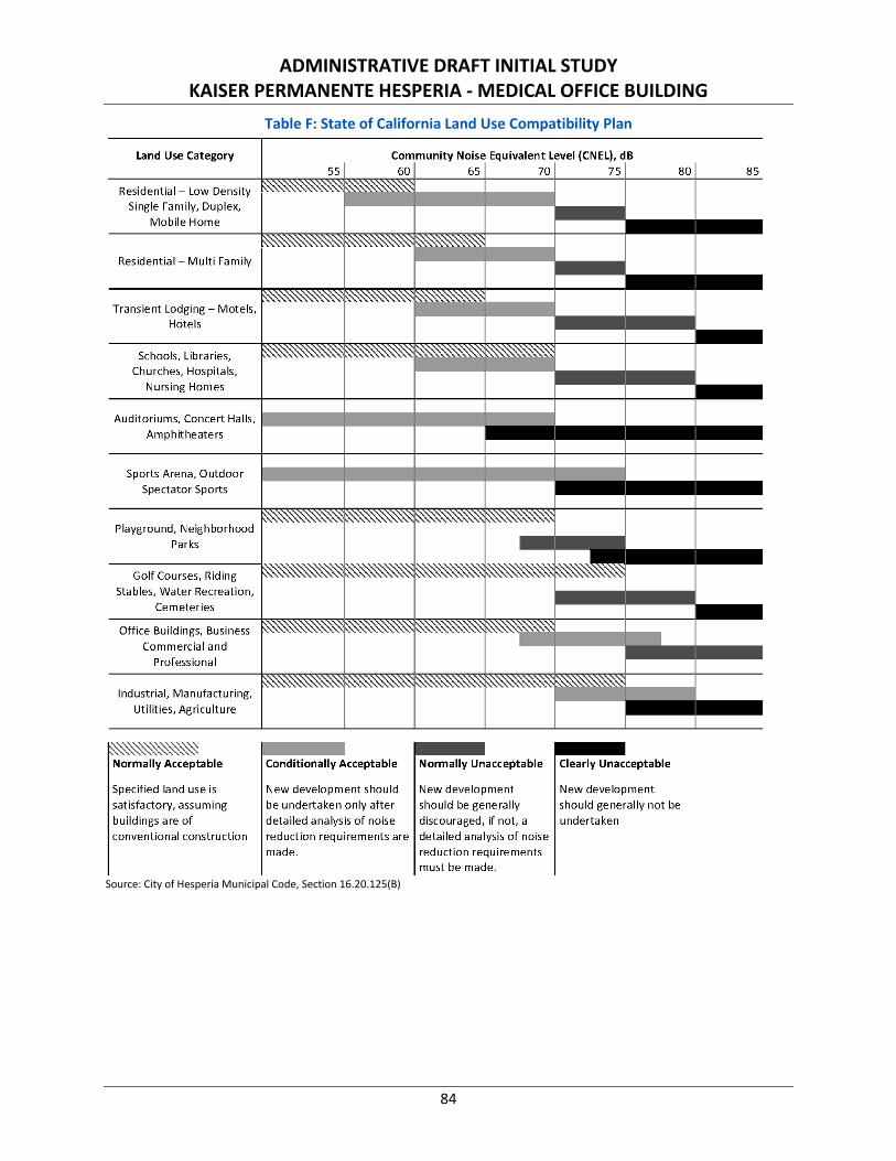
ADMINISTRATIVE DRAFT INITIAL STUDY KAISER PERMANENTE HESPERIA - MEDICAL OFFICE BUILDING
84
Table F: State of California Land Use Compatibility Plan
Source: City of Hesperia Municipal Code, Section 16.20.125(B)
Land Use Category
Residential Low Density Single Family, Duplex,
Mobile Home
Residential - Multi Family
Transient Lodging - Motels,
Hotels
Schools, Libraries, Churches, Hospitals,
Nursing Homes
Auditoriums, Concert Halls,
Amphitheaters
Sports Arena, Outdoor
Spectator Sports
Playground, Neighborhood
Parks
Golf Courses, Riding
Stables, Water Recreation,
Cemeteries
Office Buildings, Business
Commercial and
Professional
Industrial, Manufacturing,
Utilities, Agriculture
~ Normally Acceptable
Specified land use is
satisfactory, assuming buildings are of
conventional construction
Community Noise Equivalent Level (CNEL), dB
55 60 65 70 I 75 1 80 .. ~~,~~,~
. . . .. ~
... ., . .. ' ~
I ~ ~
I I
I I I I
I
~ ~ ~ ~~~~~ I
. ~,,~ I I I I
I . . ~,~~,~~
I
Normally Unacceptable Clearly Unacceptable Conditionally Acceptable
New development should
be undertaken only after
New development
should be generally detailed analysis of noise discouraged, if not, a
New development
should generally not be
undertaken
reduction requirements are detailed analysis of noise
made. reduction requirements must be made.
85
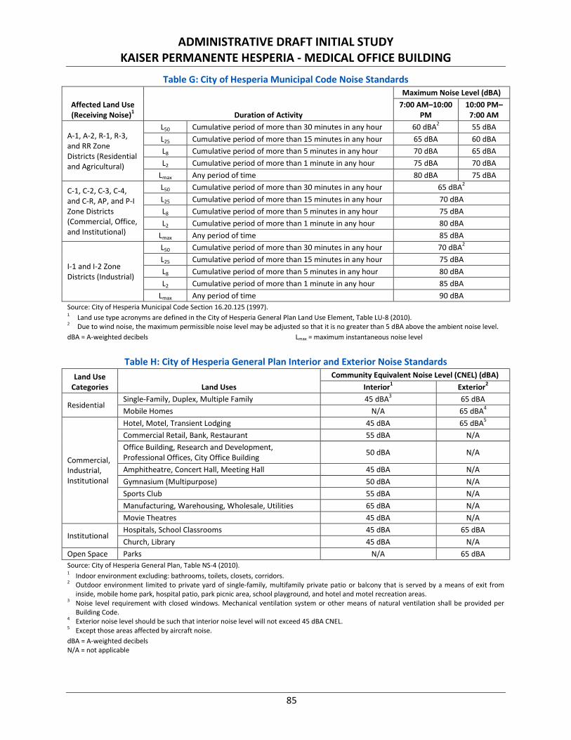
ADMINISTRATIVE DRAFT INITIAL STUDY KAISER PERMANENTE HESPERIA - MEDICAL OFFICE BUILDING
85
Table G: City of Hesperia Municipal Code Noise Standards
Affected Land Use (Receiving Noise)1 Duration of Activity
Maximum Noise Level (dBA) 7:00 AM–10:00
PM 10:00 PM–
7:00 AM
A-1, A-2, R-1, R-3, and RR Zone Districts (Residential and Agricultural)
L50 Cumulative period of more than 30 minutes in any hour 60 dBA2 55 dBA L25 Cumulative period of more than 15 minutes in any hour 65 dBA 60 dBA L8 Cumulative period of more than 5 minutes in any hour 70 dBA 65 dBA L2 Cumulative period of more than 1 minute in any hour 75 dBA 70 dBA
Lmax Any period of time 80 dBA 75 dBA
C-1, C-2, C-3, C-4, and C-R, AP, and P-I Zone Districts (Commercial, Office, and Institutional)
L50 Cumulative period of more than 30 minutes in any hour 65 dBA2 L25 Cumulative period of more than 15 minutes in any hour 70 dBA L8 Cumulative period of more than 5 minutes in any hour 75 dBA L2 Cumulative period of more than 1 minute in any hour 80 dBA
Lmax Any period of time 85 dBA
I-1 and I-2 Zone Districts (Industrial)
L50 Cumulative period of more than 30 minutes in any hour 70 dBA2 L25 Cumulative period of more than 15 minutes in any hour 75 dBA L8 Cumulative period of more than 5 minutes in any hour 80 dBA L2 Cumulative period of more than 1 minute in any hour 85 dBA
Lmax Any period of time 90 dBA Source: City of Hesperia Municipal Code Section 16.20.125 (1997). 1 Land use type acronyms are defined in the City of Hesperia General Plan Land Use Element, Table LU-8 (2010). 2 Due to wind noise, the maximum permissible noise level may be adjusted so that it is no greater than 5 dBA above the ambient noise level. dBA = A-weighted decibels Lmax = maximum instantaneous noise level
Table H: City of Hesperia General Plan Interior and Exterior Noise Standards
Land Use Categories Land Uses
Community Equivalent Noise Level (CNEL) (dBA) Interior1 Exterior2
Residential Single-Family, Duplex, Multiple Family 45 dBA3 65 dBA Mobile Homes N/A 65 dBA4
Commercial, Industrial, Institutional
Hotel, Motel, Transient Lodging 45 dBA 65 dBA5 Commercial Retail, Bank, Restaurant 55 dBA N/A Office Building, Research and Development, Professional Offices, City Office Building 50 dBA N/A
Amphitheatre, Concert Hall, Meeting Hall 45 dBA N/A Gymnasium (Multipurpose) 50 dBA N/A Sports Club 55 dBA N/A Manufacturing, Warehousing, Wholesale, Utilities 65 dBA N/A Movie Theatres 45 dBA N/A
Institutional Hospitals, School Classrooms 45 dBA 65 dBA Church, Library 45 dBA N/A
Open Space Parks N/A 65 dBA Source: City of Hesperia General Plan, Table NS-4 (2010). 1 Indoor environment excluding: bathrooms, toilets, closets, corridors. 2 Outdoor environment limited to private yard of single-family, multifamily private patio or balcony that is served by a means of exit from
inside, mobile home park, hospital patio, park picnic area, school playground, and hotel and motel recreation areas. 3 Noise level requirement with closed windows. Mechanical ventilation system or other means of natural ventilation shall be provided per
Building Code. 4 Exterior noise level should be such that interior noise level will not exceed 45 dBA CNEL. 5 Except those areas affected by aircraft noise. dBA = A-weighted decibels N/A = not applicable
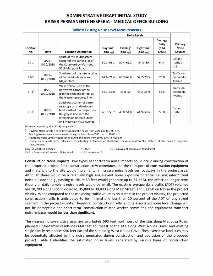
ADMINISTRATIVE DRAFT INITIAL STUDY KAISER PERMANENTE HESPERIA - MEDICAL OFFICE BUILDING
86
Table I: Existing Noise Level Measurements
Location No. Date Location Description
Noise Levels
Primary Noise
Sources Daytime1 (dBA Leq)
Evening2 (dBA Leq)
Nighttime3 (dBA Leq)
Average Daily (dBA CNEL)
LT-1 8/29–8/30/2018
South of the southeastern corner of the parking lot of the Courtyard by Marriott, 9619 Mariposa Road.
50.1–63.1 57.4–61.2 54.3–60 64.4 Distant traffic on I-15.
LT-2 8/29–8/30/2018
Southwest of the intersection of Escondido Avenue and Major Place.
67.6–71.4 68.3–69.6 57.7–70.5 73.0 Traffic on Escondido Avenue
ST-14 8/29–8/30/2018
West Nolina Drive at the northwest corner of the planned residential tract at the western property line.
53.1–56.8 53.8–55 43.2–55.9 58.5 Traffic on Escondido Avenue
ST-24 8/29–8/30/2018
Southwest corner of barren rectangle on undeveloped land south of the project site. Roughly in line with the intersection of Main Street and Mountain Vista Avenue.
40.7–53.7 48.0–51.8 44.9–50.6 55.0 Distant traffic on I-15
Source: Compiled by LSA (2018). (Appendix G). 1 Daytime Noise Levels = noise levels during the hours from 7:00 a.m. to 7:00 p.m. 2 Evening Noise Levels = noise levels during the hours from 7:00 p.m. to 10:00 p.m. 3 Nighttime Noise Levels = noise levels during the hours from 10:00 p.m. to 7:00 a.m. 4 Hourly noise levels were calculated by adjusting a 15-minute, short-term measurement to the pattern of the nearest long-term
measurement. dBA = A-weighted decibels CNEL = Community Equivalent Noise Level
ft = feet I-15 = Interstate 15
Leq = equivalent continuous sound level
Construction Noise Impacts. Two types of short-term noise impacts could occur during construction of the proposed project. First, construction crew commutes and the transport of construction equipment and materials to the site would incrementally increase noise levels on roadways in the project area. Although there would be a relatively high single-event noise exposure potential causing intermittent noise nuisance (e.g., passing trucks at 50 feet would generate up to 84 dBA), the effect on longer term (hourly or daily) ambient noise levels would be small. The existing average daily traffic (ADT) volumes are 18,200 along Escondido Road, 35,880 to 39,800 along Main Street, and 62,050 on I-15 in the project vicinity. When compared to these existing traffic volumes on streets in the project vicinity, the projected construction traffic is anticipated to be minimal and less than 10 percent of the ADT on any street segment in the project vicinity. Therefore, construction traffic and its associated noise level change will not be perceptible and short-term, construction-related worker commutes and equipment transport noise impacts would be less than significant.
The nearest noise-sensitive uses are two hotels 590 feet northwest of the site along Mariposa Road, planned single-family residences 660 feet southeast of the site along West Nolina Drive, and existing single-family residences 950 feet east of the site along West Nolina Drive. These sensitive land uses may be potentially affected by the noise generated during construction and operation of the proposed project. Table J identifies the estimated noise levels generated by various types of construction equipment.
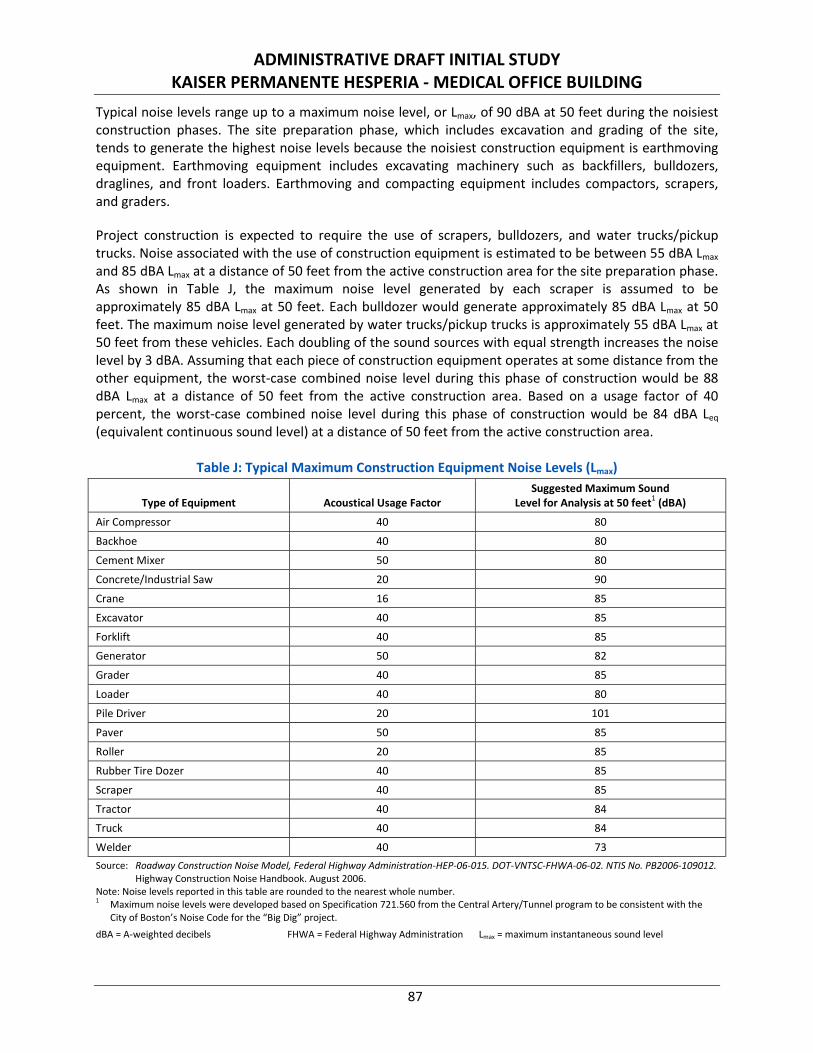
ADMINISTRATIVE DRAFT INITIAL STUDY KAISER PERMANENTE HESPERIA - MEDICAL OFFICE BUILDING
87
Typical noise levels range up to a maximum noise level, or Lmax, of 90 dBA at 50 feet during the noisiest construction phases. The site preparation phase, which includes excavation and grading of the site, tends to generate the highest noise levels because the noisiest construction equipment is earthmoving equipment. Earthmoving equipment includes excavating machinery such as backfillers, bulldozers, draglines, and front loaders. Earthmoving and compacting equipment includes compactors, scrapers, and graders.
Project construction is expected to require the use of scrapers, bulldozers, and water trucks/pickup trucks. Noise associated with the use of construction equipment is estimated to be between 55 dBA Lmax and 85 dBA Lmax at a distance of 50 feet from the active construction area for the site preparation phase. As shown in Table J, the maximum noise level generated by each scraper is assumed to be approximately 85 dBA Lmax at 50 feet. Each bulldozer would generate approximately 85 dBA Lmax at 50 feet. The maximum noise level generated by water trucks/pickup trucks is approximately 55 dBA Lmax at 50 feet from these vehicles. Each doubling of the sound sources with equal strength increases the noise level by 3 dBA. Assuming that each piece of construction equipment operates at some distance from the other equipment, the worst-case combined noise level during this phase of construction would be 88 dBA Lmax at a distance of 50 feet from the active construction area. Based on a usage factor of 40 percent, the worst-case combined noise level during this phase of construction would be 84 dBA Leq (equivalent continuous sound level) at a distance of 50 feet from the active construction area.
Table J: Typical Maximum Construction Equipment Noise Levels (Lmax)
Type of Equipment Acoustical Usage Factor Suggested Maximum Sound
Level for Analysis at 50 feet1 (dBA)
Air Compressor 40 80
Backhoe 40 80
Cement Mixer 50 80
Concrete/Industrial Saw 20 90
Crane 16 85
Excavator 40 85
Forklift 40 85
Generator 50 82
Grader 40 85
Loader 40 80
Pile Driver 20 101
Paver 50 85
Roller 20 85
Rubber Tire Dozer 40 85
Scraper 40 85
Tractor 40 84
Truck 40 84
Welder 40 73 Source: Roadway Construction Noise Model, Federal Highway Administration-HEP-06-015. DOT-VNTSC-FHWA-06-02. NTIS No. PB2006-109012.
Highway Construction Noise Handbook. August 2006. Note: Noise levels reported in this table are rounded to the nearest whole number. 1 Maximum noise levels were developed based on Specification 721.560 from the Central Artery/Tunnel program to be consistent with the
City of Boston’s Noise Code for the “Big Dig” project. dBA = A-weighted decibels FHWA = Federal Highway Administration Lmax = maximum instantaneous sound level
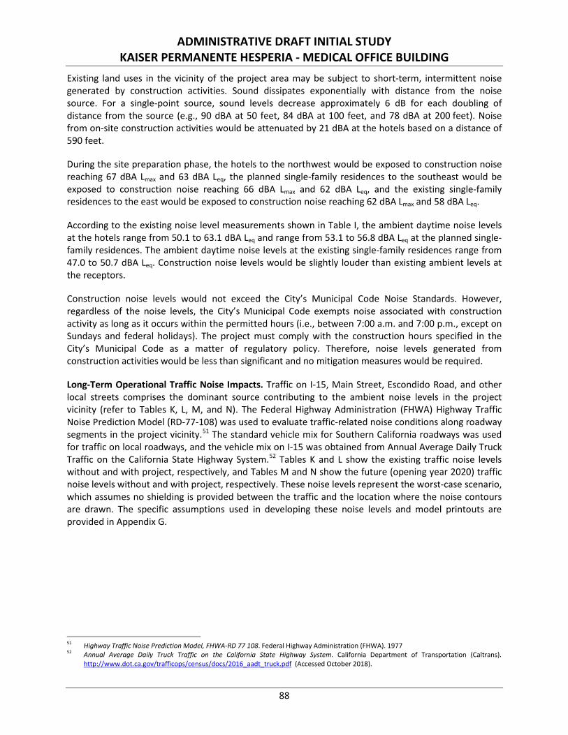
ADMINISTRATIVE DRAFT INITIAL STUDY KAISER PERMANENTE HESPERIA - MEDICAL OFFICE BUILDING
88
Existing land uses in the vicinity of the project area may be subject to short-term, intermittent noise generated by construction activities. Sound dissipates exponentially with distance from the noise source. For a single-point source, sound levels decrease approximately 6 dB for each doubling of distance from the source (e.g., 90 dBA at 50 feet, 84 dBA at 100 feet, and 78 dBA at 200 feet). Noise from on-site construction activities would be attenuated by 21 dBA at the hotels based on a distance of 590 feet.
During the site preparation phase, the hotels to the northwest would be exposed to construction noise reaching 67 dBA Lmax and 63 dBA Leq, the planned single-family residences to the southeast would be exposed to construction noise reaching 66 dBA Lmax and 62 dBA Leq, and the existing single-family residences to the east would be exposed to construction noise reaching 62 dBA Lmax and 58 dBA Leq.
According to the existing noise level measurements shown in Table I, the ambient daytime noise levels at the hotels range from 50.1 to 63.1 dBA Leq and range from 53.1 to 56.8 dBA Leq at the planned single-family residences. The ambient daytime noise levels at the existing single-family residences range from 47.0 to 50.7 dBA Leq. Construction noise levels would be slightly louder than existing ambient levels at the receptors.
Construction noise levels would not exceed the City’s Municipal Code Noise Standards. However, regardless of the noise levels, the City’s Municipal Code exempts noise associated with construction activity as long as it occurs within the permitted hours (i.e., between 7:00 a.m. and 7:00 p.m., except on Sundays and federal holidays). The project must comply with the construction hours specified in the City’s Municipal Code as a matter of regulatory policy. Therefore, noise levels generated from construction activities would be less than significant and no mitigation measures would be required.
Long-Term Operational Traffic Noise Impacts. Traffic on I-15, Main Street, Escondido Road, and other local streets comprises the dominant source contributing to the ambient noise levels in the project vicinity (refer to Tables K, L, M, and N). The Federal Highway Administration (FHWA) Highway Traffic Noise Prediction Model (RD-77-108) was used to evaluate traffic-related noise conditions along roadway segments in the project vicinity.51 The standard vehicle mix for Southern California roadways was used for traffic on local roadways, and the vehicle mix on I-15 was obtained from Annual Average Daily Truck Traffic on the California State Highway System.52 Tables K and L show the existing traffic noise levels without and with project, respectively, and Tables M and N show the future (opening year 2020) traffic noise levels without and with project, respectively. These noise levels represent the worst-case scenario, which assumes no shielding is provided between the traffic and the location where the noise contours are drawn. The specific assumptions used in developing these noise levels and model printouts are provided in Appendix G.
51 Highway Traffic Noise Prediction Model, FHWA-RD 77 108. Federal Highway Administration (FHWA). 1977 52 Annual Average Daily Truck Traffic on the California State Highway System. California Department of Transportation (Caltrans).
http://www.dot.ca.gov/trafficops/census/docs/2016_aadt_truck.pdf (Accessed October 2018).
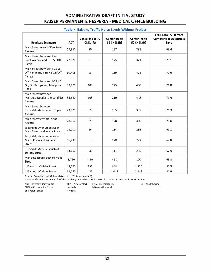
ADMINISTRATIVE DRAFT INITIAL STUDY KAISER PERMANENTE HESPERIA - MEDICAL OFFICE BUILDING
89
Table K: Existing Traffic Noise Levels Without Project
Roadway Segments ADT Centerline to 70
CNEL (ft) Centerline to 65 CNEL (ft)
Centerline to 60 CNEL (ft)
CNEL (dBA) 50 ft from Centerline of Outermost
Lane
Main Street west of Key Point Avenue 17,860 80 157 331 69.4
Main Street between Key Point Avenue and I-15 SB Off-Ramp
27,020 87 175 371 70.1
Main Street between I-15 SB Off-Ramp and I-15 NB On/Off-Ramps
30,405 93 189 401 70.6
Main Street between I-15 NB On/Off-Ramps and Mariposa Road
39,800 109 225 480 71.8
Main Street between Mariposa Road and Escondido Avenue
35,880 103 210 448 71.4
Main Street between Escondido Avenue and Topaz Avenue
29,925 89 185 397 71.3
Main Street east of Topaz Avenue 28,060 85 178 380 71.0
Escondido Avenue between Main Street and Major Place 18,200 66 134 285 69.1
Escondido Avenue between Major Place and Sultana Street
16,930 63 128 272 68.8
Escondido Avenue south of Sultana Street 13,600 56 111 235 67.9
Mariposa Road south of Main Street 3,750 < 50 < 50 100 63.8
I-15 north of Main Street 45,570 395 848 1,826 80.5
I-15 south of Main Street 62,050 485 1,042 2,243 81.9 Source: Compiled by LSA Associates, Inc. (2018) (Appendix G). Note: Traffic noise within 50 ft of the roadway centerline should be evaluated with site-specific information. ADT = average daily traffic CNEL = Community Noise Equivalent Level
dBA = A-weighted decibels ft = feet
I-15 = Interstate 15 NB = northbound
SB = southbound
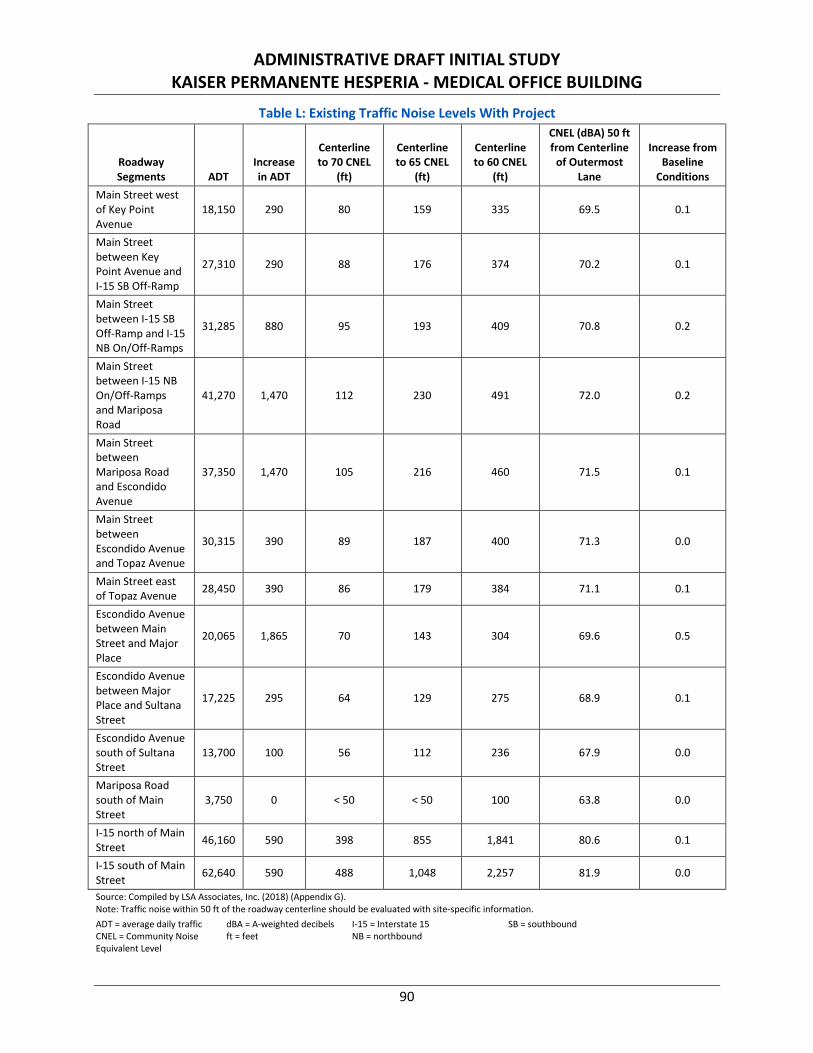
ADMINISTRATIVE DRAFT INITIAL STUDY KAISER PERMANENTE HESPERIA - MEDICAL OFFICE BUILDING
90
Table L: Existing Traffic Noise Levels With Project
Roadway Segments ADT
Increase in ADT
Centerline to 70 CNEL
(ft)
Centerline to 65 CNEL
(ft)
Centerline to 60 CNEL
(ft)
CNEL (dBA) 50 ft from Centerline
of Outermost Lane
Increase from Baseline
Conditions Main Street west of Key Point Avenue
18,150 290 80 159 335 69.5 0.1
Main Street between Key Point Avenue and I-15 SB Off-Ramp
27,310 290 88 176 374 70.2 0.1
Main Street between I-15 SB Off-Ramp and I-15 NB On/Off-Ramps
31,285 880 95 193 409 70.8 0.2
Main Street between I-15 NB On/Off-Ramps and Mariposa Road
41,270 1,470 112 230 491 72.0 0.2
Main Street between Mariposa Road and Escondido Avenue
37,350 1,470 105 216 460 71.5 0.1
Main Street between Escondido Avenue and Topaz Avenue
30,315 390 89 187 400 71.3 0.0
Main Street east of Topaz Avenue 28,450 390 86 179 384 71.1 0.1
Escondido Avenue between Main Street and Major Place
20,065 1,865 70 143 304 69.6 0.5
Escondido Avenue between Major Place and Sultana Street
17,225 295 64 129 275 68.9 0.1
Escondido Avenue south of Sultana Street
13,700 100 56 112 236 67.9 0.0
Mariposa Road south of Main Street
3,750 0 < 50 < 50 100 63.8 0.0
I-15 north of Main Street 46,160 590 398 855 1,841 80.6 0.1
I-15 south of Main Street 62,640 590 488 1,048 2,257 81.9 0.0
Source: Compiled by LSA Associates, Inc. (2018) (Appendix G). Note: Traffic noise within 50 ft of the roadway centerline should be evaluated with site-specific information. ADT = average daily traffic CNEL = Community Noise Equivalent Level
dBA = A-weighted decibels ft = feet
I-15 = Interstate 15 NB = northbound
SB = southbound

ADMINISTRATIVE DRAFT INITIAL STUDY KAISER PERMANENTE HESPERIA - MEDICAL OFFICE BUILDING
91
Table M: Future (Opening Year 2020) Traffic Noise Levels Without Project
Roadway Segments ADT Centerline to 70 CNEL (ft)
Centerline to 65 CNEL (ft)
Centerline to 60 CNEL (ft)
CNEL (dBA) 50 ft from Centerline of Outermost
Lane
Main Street west of Key Point Avenue 22,250 90 181 383 70.3
Main Street between Key Point Avenue and I-15 SB Off-Ramp
31,680 96 194 412 70.8
Main Street between I-15 SB Off-Ramp and I-15 NB On/Off-Ramps
37,725 106 217 463 71.6
Main Street between I-15 NB On/Off-Ramps and Mariposa Road
49,835 125 260 557 72.8
Main Street between Mariposa Road and Escondido Avenue
43,580 115 239 509 72.2
Main Street between Escondido Avenue and Topaz Avenue
35,450 98 207 444 72.0
Main Street east of Topaz Avenue 32,220 93 195 417 71.6
Escondido Avenue between Main Street and Major Place 20,880 71 147 312 69.7
Escondido Avenue between Major Place and Sultana Street
19,535 69 140 299 69.4
Escondido Avenue south of Sultana Street 16,070 61 124 263 68.6
Mariposa Road south of Main Street 4,020 < 50 < 50 104 64.1
I-15 north of Main Street 47,410 406 871 1,875 80.7
I-15 south of Main Street 64,560 498 1,070 2,303 82.0 Source: Compiled by LSA Associates, Inc. (2018) (Appendix G). Note: Traffic noise within 50 ft of the roadway centerline should be evaluated with site-specific information.
ADT = average daily traffic CNEL = Community Noise Equivalent Level
dBA = A-weighted decibels ft = feet
I-15 = Interstate 15 NB = northbound
SB = southbound
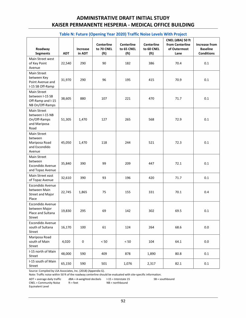
ADMINISTRATIVE DRAFT INITIAL STUDY KAISER PERMANENTE HESPERIA - MEDICAL OFFICE BUILDING
92
Table N: Future (Opening Year 2020) Traffic Noise Levels With Project
Roadway Segments ADT
Increase in ADT
Centerline to 70 CNEL
(ft)
Centerline to 65 CNEL
(ft)
Centerline to 60 CNEL
(ft)
CNEL (dBA) 50 ft from Centerline
of Outermost Lane
Increase from Baseline
Conditions Main Street west of Key Point Avenue
22,540 290 90 182 386 70.4 0.1
Main Street between Key Point Avenue and I-15 SB Off-Ramp
31,970 290 96 195 415 70.9 0.1
Main Street between I-15 SB Off-Ramp and I-15 NB On/Off-Ramps
38,605 880 107 221 470 71.7 0.1
Main Street between I-15 NB On/Off-Ramps and Mariposa Road
51,305 1,470 127 265 568 72.9 0.1
Main Street between Mariposa Road and Escondido Avenue
45,050 1,470 118 244 521 72.3 0.1
Main Street between Escondido Avenue and Topaz Avenue
35,840 390 99 209 447 72.1 0.1
Main Street east of Topaz Avenue 32,610 390 93 196 420 71.7 0.1
Escondido Avenue between Main Street and Major Place
22,745 1,865 75 155 331 70.1 0.4
Escondido Avenue between Major Place and Sultana Street
19,830 295 69 142 302 69.5 0.1
Escondido Avenue south of Sultana Street
16,170 100 61 124 264 68.6 0.0
Mariposa Road south of Main Street
4,020 0 < 50 < 50 104 64.1 0.0
I-15 north of Main Street 48,000 590 409 878 1,890 80.8 0.1
I-15 south of Main Street 65,150 590 501 1,076 2,317 82.1 0.1
Source: Compiled by LSA Associates, Inc. (2018) (Appendix G). Note: Traffic noise within 50 ft of the roadway centerline should be evaluated with site-specific information. ADT = average daily traffic CNEL = Community Noise Equivalent Level
dBA = A-weighted decibels ft = feet
I-15 = Interstate 15 NB = northbound
SB = southbound
ADMINISTRATIVE DRAFT INITIAL STUDY KAISER PERMANENTE HESPERIA - MEDICAL OFFICE BUILDING
93
Tables K, L, M, and N show that the project-related traffic noise increase would be up to 0.5 dBA in the existing year and up to 0.4 dBA in the opening year. These noise level increases are less than 3 dBA and would not be perceptible to the human ear in the outdoor environment. Therefore, off-site traffic noise impacts from project-related traffic would be less than significant. No mitigation measures would be required.
Land Use Compatibility Assessment. The land use compatibility of the project site was assessed based on the Land Use Compatibility guidelines contained in the City of Hesperia General Plan. The proposed medical office building would be exposed to traffic noise from I-15, Main Street, and Escondido Road, which was modeled using the FHWA Highway Traffic Noise Prediction. In the opening year, exterior traffic noise levels at the proposed medical office building would reach 62.3 dBA CNEL. The City’s General Plan has no exterior noise standard for office buildings.
Based on EPA Protective Noise Levels,53 with a combination of exterior walls, doors, and windows, standard construction for Southern California (warm climate) commercial or residential buildings would provide more than 24 dBA in exterior-to-interior noise reduction with windows closed. With windows and doors closed, interior noise levels would be 38.3 dBA CNEL (i.e., 62.3 dBA - 24 dBA = 38.3 dBA). An interior noise level of 38.3 dBA CNEL would not exceed the City’s General Plan interior noise standard of 45 dBA CNEL for office buildings. Therefore, impacts would be less than significant and no mitigation is required.
Long-Term Stationary Noise Impacts. The proposed project would potentially result in stationary source noise impacts from truck delivery and truck loading/unloading activities, parking lot activities, and heating, ventilation and air conditioning (HVAC) associated with on-site uses, which would be less than significant.
Truck Delivery and Truck Loading/Unloading Activity. Delivery trucks for the on-site uses would generate a noise level of 75 dBA Lmax at 50 feet based on typical truck noise level estimates. Delivery trucks would park at the loading area at the southwest of the project site to unload goods and may have multiple deliveries occurring throughout the day. The loading area is located approximately 780 feet from the hotels to the northwest. At this distance, a noise reduction of 24 dBA compared to the noise level measured at 50 feet from the noise source would occur, resulting in a noise level of 51 dBA Lmax. The distance between the loading area and the planned single-family residences to the southeast, approximately 1,070 feet, would provide a noise reduction of 27 dBA, compared to the noise level measured at 50 feet from the noise source, resulting in noise levels of 48 dBA Lmax.
The distance between the loading area and the existing single-family residences to the east, approximately, 1,370 feet, would provide noise reductions of 29 dBA, resulting in noise levels of 46 dBA Lmax.
Although a typical truck unloading process takes an average of 15–20 minutes, this maximum noise level occurs in a much shorter period of time (less than 5 minutes). Noise levels generated from truck delivery and truck loading and unloading activities would not exceed the City’s exterior L8, L2, and Lmax (i.e., 5-minute, 1-minute, and anytime) noise standards of 75, 80, and 85 dBA, respectively, for residential uses. In addition, noise levels from truck delivery and truck loading and unloading activities would not exceed
53 Protective Noise Levels, Condensed Version of EPA Levels Document, EPA 550/9-79-100. United States Environmental Protection Agency.
November 1978.

ADMINISTRATIVE DRAFT INITIAL STUDY KAISER PERMANENTE HESPERIA - MEDICAL OFFICE BUILDING
94
the City’s exterior L8, L2, and Lmax (i.e., 5-minute, 1-minute, and anytime) noise standards of 65, 70, and 75 dBA, respectively, for commercial uses, which is the noise standard under which the hotel was evaluated. Therefore, noise levels generated from truck delivery and truck loading and unloading activities would be less than significant and no mitigation measures would be required.
Parking Lot Activity. Representative parking activities (e.g., vehicles traveling at slow speeds, engine start-up noise, car door slams, car horns, car alarms, tire squeals, and people conversing) on the project site would generate approximately 60 to 70 dBA Lmax at 50 feet. This level of noise is lower than that of the truck delivery and loading/unloading activities and is intermittent in nature. All of the on-site parking areas are provided at street level.
The closest receptors (i.e., the planned single-family residences to the southeast) will be located 750 feet from the nearest parking area. This distance would provide a reduction of 24 dBA. Noise from the on-site parking areas would be reduced to 45 dBA Lmax or lower at the hotels to the northwest of the project site, 46 dBA Lmax or lower at the planned single-family residences to the southeast, and 44 dBA Lmax or lower at the existing single-family residences to the east. Noise levels associated with these parking lot activities would not exceed the City’s Municipal Code Noise Standards for exterior daytime and nighttime noise levels of 80 dBA Lmax and 75 dBA Lmax, respectively, for residential land uses. In addition, noise levels associated with parking lot activities would not exceed the City’s Municipal Code Noise Standards for both daytime and nighttime exterior noise levels of 85 dBA Lmax for commercial land uses. Noise levels generated from parking lot activities would be less than significant and no mitigation measures are required.
Heating, Ventilation, and Air Conditioning. The project would have rooftop HVAC units, which could operate 24 hours per day. Each rooftop HVAC unit would generate noise levels of 66.6 dBA Leq at 5 feet based on previous measurements conducted by LSA. The proposed building would have three rooftop HVAC units, which would generate a combined noise level of 71 dBA Leq at 5 feet. Table O details the nearest sensitive uses to the proposed HVAC units, the distance from the HVAC units to the receptor, noise reductions due to distance and shielding, and the predicted noise levels from the proposed HVAC units at each receptor location.
Table O: HVAC Noise Calculations
Receptor (Location)
Average Distance from
HVAC Units (ft)
Distance Attenuation
(dBA)
Shielding from Roofline and
Parapet (dBA)
Noise Level
(dBA Leq)
Daytime Noise Standard (dBA
L50)
Nighttime Noise Standard
(dBA L50)
Hotels to the northwest 795 44 5 22 65 N/A
Planned single-family residences to the southeast
1,160 47 5 19 60 55
Existing single-family residences to the east
1,415 49 5 17 60 55
Source: Compiled by LSA (May 2018)
dBA Leq = average A-weighted hourly noise level ft = feet HVAC = heating, ventilation, and air conditioning Lmax = maximum instantaneous sound level L50 = 30-minute average sound level N/A = not applicable
ADMINISTRATIVE DRAFT INITIAL STUDY KAISER PERMANENTE HESPERIA - MEDICAL OFFICE BUILDING
95
Noise generated from on-site HVAC equipment at the hotels to the northwest would reach 22 dBA Leq, which would not exceed the City’s exterior L50 (30-minute) noise standard of 65 dBA for commercial uses. Noise generated from on-site HVAC equipment at the planned single-family residences to the southeast and the existing single-family residences to the east would reach 19 dBA Leq and 17 dBA Leq, respectively, which would not exceed the City’s exterior L50 (30-minute) noise standard of 60 dBA daytime and 55 dBA nighttime for residential land uses. Noise levels generated from HVAC equipment would be less than significant and no mitigation measures are required.
The project would not result in exposure of persons to or generation of noise levels in excess of standards established in the local General Plan or noise ordinance, or applicable standards of other agencies. Impacts are less than significant and no mitigation is required.
b. Result in exposure of persons to or generation of excessive groundborne vibration or groundborne noise levels?
Less than Significant Impact
Discussion of Effects:
Short-Term Vibration Impacts. Vibration refers to groundborne noise and perceptible motion. Groundborne vibration is almost exclusively a concern inside buildings and is rarely perceived as a problem outdoors, where the motion may be discernable but, without the effect associated with the shaking of a building, there is less of a reaction. Typical sources of groundborne vibration are construction activities (e.g., blasting, pile driving, and operating heavy-duty earthmoving equipment), steel-wheeled trains, and occasional traffic on rough roads. Problems with groundborne vibration and noise from these sources are usually localized to areas within about 100 feet from the vibration source. When roadways are smooth, vibration from traffic, even heavy trucks, is rarely perceptible. Roadways surrounding the project site are paved and project traffic is therefore not expected to generate perceptible vibration.
The City Municipal Code (Section 16.20.130) provides vibration standards for the evaluation of vibration. No ground vibration shall be allowed that can be felt without the aid of instruments at or beyond the lot line, nor will any vibration be permitted that produces a particle velocity greater than or equal to 0.2 inch per second (in/sec) measured at or beyond the lot line. However, the Municipal Code (Section 16.20.130(C)(2)) exempts temporary construction maintenance or demolition activities between 7:00 a.m. and 7:00 p.m., except on Sundays and federal holidays.
Because the City’s Municipal Code exempts construction vibration, the vibration standards included in the 2006 Federal Transit Administration’s (FTA) Transit Noise and Vibration Impact Assessment54 are used to evaluate potential human annoyance and building damage from project construction. The FTA’s annoyance threshold for residences and buildings where people normally sleep is 72 VdB (vibration velocity decibels), and the threshold for institutional land uses with primarily daytime use is 75 VdB. The FTA’s construction vibration damage criteria for structures constructed of non-engineered timber and masonry buildings is 94 VdB (0.2 PPV [peak particle velocity] in/sec).
54 Roadway Construction Noise Model, Federal Highway Administration-HEP-06-015. DOT-VNTSC-FHWA-06-02. NTIS No. PB2006-109012.
Highway Construction Noise Handbook. August 2006.
ADMINISTRATIVE DRAFT INITIAL STUDY KAISER PERMANENTE HESPERIA - MEDICAL OFFICE BUILDING
96
During the construction of the project, the equipment with the highest vibration generation potential would be the vibratory rollers used during the paving phase, which would generate 94 VdB at 25 feet, based on the Transit Noise and Vibration Impact Assessment.55 The closest structure to the project site (the Panda Express restaurant located 195 feet northeast of the project site) would experience a vibration level of 67 VdB (0.010 PPV in/sec). This vibration level would not result in human annoyance or building damage. All other structures are located more than 195 feet from the project site and would experience lower levels of vibration. Therefore, vibration levels generated from construction activities would be less than significant and no mitigation is required.
Long-Term Vibration Impacts. The proposed medical office building would not generate vibration. In addition, vibration generated from project-related traffic on the adjacent roadway (Escondido Avenue) would be unusual for on-road vehicles because the rubber tires and suspension systems of on-road vehicles provide vibration isolation. Vibration generated from project-related traffic on the adjacent roadways would be less than significant and no mitigation is required.
The project would not result in exposure of persons to or generation of excessive groundborne vibration or groundborne noise levels. Impacts would be less than significant and no mitigation is required.
c. Result in a substantial permanent increase in ambient noise levels in the project vicinity above levels existing without the project?
Less than Significant Impact
Discussion of Effects: Noise increases are anticipated to result from vehicle activity and human activity (e.g., truck loading and unloading and parking lot noise). The noise resulting from the long-term operation of the proposed medical office building is anticipated to cause an incremental permanent increase in existing ambient noise levels. Since surrounding adjacent development also consists of transportation facilities and commercial uses, the incremental increase in ambient noise under the proposed project would not be perceptible. The response to Checklist Question 3.12a provided an assessment of potential long-term noise impacts from project-related activity and concluded that operational, long-term noise impacts are less than significant. The project would not result in a substantial permanent increase in ambient noise levels in the project vicinity above levels existing without the project. Impacts would be less than significant and no mitigation is required.
d. Result in a substantial temporary or periodic increase in ambient noise levels in the project vicinity above levels existing without the project?
Less than Significant Impact
Discussion of Effects: Although development of the project site would temporarily increase ambient noise due to on-site construction activities, no significant construction-related, off-site noise impact would occur. As stated in response to Checklist Question 3.12a, construction noise would temporarily increase ambient noise levels, but construction would comply with the construction hours in the City of Hesperia Municipal Code (Sections 160.20.125(E)(3) and 160.20.13(C)(2)). The project would not result in a substantial temporary or periodic increase in ambient noise levels in the project vicinity above levels existing without the project. Impacts would be less than significant and no mitigation is required.
55 Transit Noise and Vibration Impact Assessment. Federal Transit Administration, Office of Planning and Environment. FTA-VA-90-1003-06.
May 2006.
ADMINISTRATIVE DRAFT INITIAL STUDY KAISER PERMANENTE HESPERIA - MEDICAL OFFICE BUILDING
97
e. For a project located within an airport land use plan or, where such a plan has not been adopted, within two miles of a public airport or public use airport, would the project expose people residing or working in the project area to excessive noise levels?
No Impact
Discussion of Effect: Hesperia Airport is located approximately 4.5 miles southeast of the project site, Southern California Logistics Airport is located approximately 10.5 miles north of the site, and Apple Valley Airport is located approximately 14.6 miles northeast of the project site. A review of their respective Airport Land Use Compatibility Plans confirms that the project site is located outside of the 60 and 65 dBA CNEL noise contours of these airports. Therefore, the proposed project would not expose people residing or working in the project area to excessive noise levels from aircraft. No impacts would occur and no mitigation is required.
f. For a project within the vicinity of a private airstrip, would the project expose people residing or working in the project area to excessive noise levels?
No Impact
Discussion of Effect: The project is not located within the vicinity of a private airstrip; therefore, no impact related with this issue would occur. No mitigation is required.
3.13 POPULATION AND HOUSING Would the project:
Potentially Significant
Impact
Less than Significant
with Mitigation
Incorporated
Less than Significant
Impact No
Impact a. Induce substantial population growth in an
area, either directly (for example, by proposing new homes and businesses) or indirectly (for example, through extension of roads or other infrastructure)?
b. Displace substantial amounts of existing housing, necessitating the construction of replacement housing elsewhere?
c. Displace substantial numbers of people, necessitating the construction of replacement housing elsewhere?
a. Induce substantial population growth in an area, either directly (for example, by proposing new homes and businesses) or indirectly (for example, through extension of roads or other infrastructure)?
Less than Significant Impact
Discussion of Effects: According to the City’s General Plan EIR, new development that would occur as a result of build out of the General Plan Update would be directed towards the I-15 freeway corridor and
ADMINISTRATIVE DRAFT INITIAL STUDY KAISER PERMANENTE HESPERIA - MEDICAL OFFICE BUILDING
98
would create new opportunities for development of residential, commercial, and industrial land uses.56 This area of the City was planned for development through the Hesperia Main Street and Freeway Corridor Specific Plan.57 The project site is located within the Main Street/I-15 District of the Hesperia Main Street and Freeway Corridor Specific Plan. According to the Specific Plan, this District “is intended to be a mixed-use district emphasizing large-scale regional commercial and service uses that are designed to serve the region as a whole, as well as residential uses in a range of densities.”58
The proposed project involves the construction of a 55,000-square foot medical office building. The proposed land use would be consistent with the City’s General Plan land use designation of Regional Commercial for the project site, as well as with the Regional Commercial zone of the Hesperia Main Street and Freeway Corridor Specific Plan, which permits by right medical services facilities such as clinics, medical/dental offices, laboratory, urgent/express care, and optometrist offices.59
Since the project is proposed in accordance with the Hesperia Main Street and Freeway Corridor Specific Plan, its inducement of employment growth has been anticipated in the City’s General Plan and accompanying EIR, for which growth inducing impacts from City buildout were deemed less than significant. Therefore, development of the proposed project in accordance with the City’s General Plan and Hesperia Main Street and Freeway Corridor Specific Plan would not induce substantial population growth, which could have significant impacts to the environment. Impacts would be less than significant and no mitigation is required.
b. Displace substantial amounts of existing housing, necessitating the construction of replacement housing elsewhere?
No Impact
Discussion of Effects: The project site is vacant and no housing would be displaced from development of the proposed project. Therefore, no impact would occur to existing housing and no mitigation is required.
c. Displace substantial numbers of people, necessitating the construction of replacement housing elsewhere?
No Impact
Discussion of Effects: Please refer to response to Checklist Question 3.13.b.
56 Draft Environmental Impact Report for the City of Hesperia General Plan Update. Page 3.12-9. Michael Brandman and Associates. May 26,
2010. 57 Ibid. 58 Hesperia Main Street and Freeway Corridor Specific Plan. Page 47. City of Hesperia. Effective October 16, 2008, Amended April 17, 2014. 59 Ibid. Page 167.
ADMINISTRATIVE DRAFT INITIAL STUDY KAISER PERMANENTE HESPERIA - MEDICAL OFFICE BUILDING
99
3.14 PUBLIC SERVICES Would the project result in substantial adverse physical impacts associated with the provision of new or physically altered governmental facilities, need for new or physically altered governmental facilities, the construction of which could cause significant environmental impacts, in order to maintain acceptable service ratios, response times or other performance objectives for any of the public services:
Potentially Significant
Impact
Less than Significant
with Mitigation
Incorporated
Less than Significant
Impact No
Impact Fire protection? Police protection? Schools? Parks? Other public facilities?
No Impact or Less than Significant Impact
Discussion of Effects:
Fire Protection. Fire protection and emergency medical response services are provided by the Hesperia Fire Department and the San Bernardino County Fire District. The nearest fire station to the project site is San Bernardino County Fire Station 305 located at 8331 Caliente Road (approximately 3.3 miles southwest of the project site) with an estimated 7-minute travel time to the site.
Based on a cumulative point system that weighs a community’s fire suppression delivery system, including fire dispatch, fire department representation (in the form of equipment, personnel, training, distribution of fire stations), and water supply adequacy and condition, the Insurance Services Offices (ISO) ranks a community’s fire protection needs and services. Rating varies from Class 1 (best) to Class 10 (worst). Hesperia has a Class 5 ISO rating in the developed portions of the City and a rating of Class 9 in the outlying areas.60 Through compliance with California Vehicle Code 21806(A)(1), which requires all vehicles to yield to emergency vehicles, travel time between the nearest fire station and the site is not expected to exceed seven minutes. Additionally, in accordance with Implementation Policy SF-3.10 of the City’s General Plan Safety Element, the City will adopt the most recent version of the Wildland –Urban Interface Code and Chapter 7A of the California Building Code for use in the City where the ISO number exceeds 5.
CBC Chapter 7A specifies that new buildings use ignition-resistant construction methods and materials.61 The proposed project will implement the latest fire protection measures through project design features. The proposed project design would be submitted to and approved by the HFD pursuant to Chapter 16.12, Article II (Site Plans and Revised Site Plans) of the City Municipal Code prior the issuance of building permits. Accordingly, all on-site structures will be constructed pursuant to the 2016 CBC, and in accordance with Implementation Policy SF-3.10 of the City’s General Plan Safety Element (i.e.,
60 Draft Environmental Impact Report for the City of Hesperia General Plan Update. Page 3.7-28 and 3.7-29. Michael Brandman and
Associates. May 26, 2010. 61 Chapter 7A - Materials and Construction Methods for Exterior Wildfire Exposure. California Building Code, Part 2, Volume 1. 2016.
https://codes.iccsafe.org/public/chapter/content/1774/. (Accessed November 8, 2018).
ADMINISTRATIVE DRAFT INITIAL STUDY KAISER PERMANENTE HESPERIA - MEDICAL OFFICE BUILDING
100
Chapter 7A of the CBC) as applicable. Most of the primary components of the layered fire protection system provided for the proposed project are required by HFD and County of San Bernardino Standards. Interior fire sprinklers (now required by Code), have a track record of extinguishing up to 95 percent of interior fires, which significantly reduces structural damage.62 Should embers succeed in entering a structure, sprinklers provide an additional layer of life safety and structure protection.
Once the proposed project is built out, the on-site fire potential will be lower than existing conditions due to conversion of open space fuels to managed landscapes, improved accessibility to fire personnel, and structures built to the latest ignition-resistant fire codes. According to the 2016 CBC and Chapter 15.04, California codes adopted, of the City Municipal Code, the following project design features will be incorporated into the proposed development:
1. Application of the latest adopted ignition-resistant building codes;
2. Exterior wall coverings are to be non-combustible or ignition resistant;
3. Multi-pane glazing with a minimum of one tempered pane;
4. Ember resistant vents;
5. Interior, automatic fire sprinklers to code for occupancy type;
6. Modern infrastructure, access roads, and water delivery system;
7. Appropriate storage and maintenance of flammable and combustible materials;
8. Maintained fuel modification areas/abate fire hazards; and
9. Appropriately constructed and unobstructed fire apparatus access roads throughout the project.
The project will meet or exceed all applicable Fire Code requirements and incorporate project design features as follows:
1. Project buildings will be constructed of ignition-resistant construction materials and include automatic fire sprinkler systems based on the latest Building and Fire Codes for occupancy types.
2. Fuel modification will be provided around the perimeter of the site, where required, and will be maintained by the landlord, or another approved entity, at least annually and as needed.
3. Landscape plantings will not utilize prohibited plants that have been found to be highly flammable.
4. Fire apparatus access roads (i.e., public and private streets) will be provided throughout the site and will vary in width and configuration, but will all provide at least the minimum required unobstructed travel lanes, lengths, turnouts, turnarounds, and clearances. Primary access and internal circulation will comply with the requirements of the Hesperia Fire Department.
5. Water capacity and delivery will be provided for a reliable water source for operations and during emergencies requiring extended fire flow.
Compliance with applicable provisions of the 2016 CBC and Chapter 15.04, California codes adopted, of the City Municipal Code will form the basis of the systems of protection necessary to minimize structural
62 U.S. Experience with Sprinklers, Fact Sheet, Sprinklers in Reported U.S. Fires during 2010 to 2014. National Fire Protection Association. July
2017. http://www.nfpa.org/news-and-research/fire-statistics-and-reports/fire-statistics/fire-safety-equipment/us-experience-with-sprinklers. (Accessed November 8, 2018)

ADMINISTRATIVE DRAFT INITIAL STUDY KAISER PERMANENTE HESPERIA - MEDICAL OFFICE BUILDING
101
ignitions as well as provide adequate access by emergency responders. The project design features described above would aid fire-fighting personnel and minimize the demand placed on the existing emergency services system. Additionally, through the execution of mutual aid agreements maintained with surrounding cities (e.g., Victorville and Apple Valley), and with San Bernardino County Fire Department/Cal Fire, the City will have the additional firefighting support of nearby fire departments to provide assistance during major emergencies.
As with all new development within the City, the project would be required to pay DIFs to the City. These fees are determined by the City Council, in consultation with the Hesperia Fire Department, based on an assessment of the activity occurring within the City as well as the needs of the City. Such fees would be used to fund capital costs associated with land acquisition, construction, purchasing equipment, and providing for additional staff. The current fee schedule requires the payment $187 per thousand square feet for commercial/office/retail uses to support fire suppression.63 Additionally, Appendix B of the San Bernardino County Fire Protection District Fiscal Year 2018/2019 Fee Schedule levies various DIFs for mandatory services including, but not limited to, fire sprinkler system inspections, site plan review, construction and operation permit issuance, and special event/temporary use permits.64
Any future construction of new or expansion of existing fire protection facilities in the City would be subject to project-level environmental review and site-specific mitigation as appropriate in order to ensure significant environmental impacts are avoided or mitigated. However, it is reasonable to conclude that the addition of a 55,000-square foot medical office building constructed in accordance with State and local policies would not require new or physically altered fire protection facilities, the construction of which could cause significant environmental impacts. Therefore, impacts would be less than significant and no mitigation is required.
Police Protection. According to the City’s General Plan EIR, new development that would occur as a result of buildout of the General Plan would be directed toward the I-15 freeway corridor and would create new opportunities for development of residential, commercial, and industrial land uses.65 The City monitors staffing levels to ensure that adequate police protection and response times continue to be provided as individual development projects are proposed and on an annual basis as part of the City Council’s budgeting process. The City’s General Plan EIR states that increases in demand for police services are expected to be funded through existing funding mechanisms, principally the general fund revenue. The City’s current development impact fee requires the payment of $4 per thousand square feet for commercial/office/retail uses to support police services.66 General Plan Goals OS-5 and LU-5 ensure that new development is fiscally sound and able to pay for the infrastructure and services needed to protect the City and existing residents from additional growth. Therefore, the continual monitoring of police staffing levels by the City would ensure the proposed project would not result in a significant reduction in police response times.
In addition, the City maintains mutual aid agreements with police agencies in the surrounding cities (e.g., Victorville and Apple Valley) and with the San Bernardino County Sheriff’s Department, which allow for the services of nearby police departments to assist the Hesperia Police Department during major
63 Fee Schedule. Appendix A. City of Hesperia. Effective October 21, 2018. 64 Ibid. Appendix B. 65 Draft Environmental Impact Report for the City of Hesperia General Plan Update. Page 3.12-9. Michael Associates. May 26, 2010. 66 Fee Schedule. Appendix A. City of Hesperia. Effective October 21, 2018.

ADMINISTRATIVE DRAFT INITIAL STUDY KAISER PERMANENTE HESPERIA - MEDICAL OFFICE BUILDING
102
emergencies. Payment of DIFs commensurate with the increased demand for services in the City would offset any increase in demand for police services.
Any future construction of new or expansion of existing police protection facilities would be subject to project-level environmental review and site-specific mitigation as appropriate in order to ensure significant environmental impacts are avoided or mitigated. However, it is reasonable to conclude that the addition of a 55,000-square foot medical office building constructed in accordance with local policies would not require new or physically altered police protection facilities, the construction of which could cause significant environmental impacts. Therefore, impacts would be less than significant and no mitigation is required.
Schools. The project does not include a residential component; therefore, it is not expected to generate any schoolchildren, the addition of which could cause negative impacts to existing or future school facilities or programs.
California Government Code (Section 65995[b]) establishes the base amount of allowable developer fees imposed by school districts. These base amounts are commonly referred to as “Level 1 fees” and are subject to inflation adjustment every two years. School districts are placed into a specific “level” based on school impact fee amounts that are imposed on the development. With the adoption of Senate Bill 50 and Proposition 1A in 1998, schools meeting certain criteria can now adopt Level 2 and 3 developer fees. The amount of fees that can be charged over the Level 1 amount is determined by the district’s total facilities needs and the availability of State matching funds. If there is State facility funding available, districts are able to charge fees equal to 50 percent of their total facility costs, termed “Level 2” fees. If, however, there are no State funds available, “Level 3” fees may be imposed for the full cost of their facility needs.67
Per California Government Code, “The payment or satisfaction of a fee, charge, or other requirement levied or imposed … are hereby deemed to be full and complete mitigation of the impacts … on the provision of adequate school facilities.” The project will be required to pay these development fees in accordance with Government Code 65995 and Education Code 17620. Through payment of development fees in accordance with Government Code 65995 and Education Code 17620, no impact related to school services would occur. No mitigation is required.
Parks/Recreational Facilities. The proposed project does not include development of residential uses; therefore, there would be no increase in population or corresponding demand for park facilities or programs. No impact would occur. No mitigation is required.
Other Public Facilities. The proposed project would serve as a community resource to improve the health of its patrons and it would result in improved curbs, gutters, sidewalks, and bicycle lanes along the project site frontage and approach roadways, which are public facilities. These improvements are anticipated in the City’s General Plan and are proposed in accordance with the Hesperia Main Street and Freeway Corridor Specific Plan. It is reasonable to conclude the payment of required fees, taxes, and other payments by the project proponent would sufficiently offset any incremental increase in demand for governmental services. But for the proposed project as analyzed throughout this Initial Study, the
67 An Evaluation of the School Facility Fee Affordable Housing Assistance Programs. Legislative Analyst’s Office. January 2001.
http://www.lao.ca.gov/2001/011701_school_facility_fee.html (Accessed November 8, 2018).
ADMINISTRATIVE DRAFT INITIAL STUDY KAISER PERMANENTE HESPERIA - MEDICAL OFFICE BUILDING
103
construction of new or expansion of existing governmental facilities is not required. Impacts to other public facilities would be less than significant and no mitigation is required.
3.15 RECREATION Would the project:
Potentially Significant
Impact
Less than Significant
with Mitigation
Incorporated
Less than Significant
Impact No
Impact a. Increase the use of existing neighborhood
and regional parks or other recreational facilities such that substantial physical deterioration of the facility would occur or be accelerated?
b. Include recreational facilities or require the construction or expansion of recreational facilities that might have an adverse physical effect on the environment?
a. Increase the use of existing neighborhood and regional parks or other recreational facilities such that substantial physical deterioration of the facility would occur or be accelerated?
b. Include recreational facilities or require the construction or expansion of recreational facilities that might have an adverse physical effect on the environment?
Less than Significant Impact
Discussion of Effects: The proposed project does not include development of residential uses; therefore, there would be no direct increase in population or corresponding demand for park facilities or programs. Project-generated population estimates are based on anticipated employment generation from development of the proposed project for [low-rise] professional office uses. SCAG anticipates 1 employee per 599 square feet or 16.8 employees per acre of development of a [low-rise] professional office building in San Bernardino County;68 therefore, development of the project site with 55,000 square feet of medical office uses could generate approximately 92 jobs but no permanent residences in the City.69
The proposed project includes various recreational amenities for its employees and patrons. For example, the northern portion of the project site would be dedicated to an outdoor learning garden with anchor art and an amphitheater. Additional outdoor amenities include a community garden on the east site of the proposed building and an outdoor staff lounge with picnic tables and various landscape features. On the western portion of the project site, an outdoor physical therapy facility and therapy garden would serve patrons. All of these recreational amenities collectively would serve the employees and patrons of the proposed project, which would minimize any significant new increase in utilization of nearby recreational facilities such that it would result in a substantial or accelerated physical deterioration of such facilities. Therefore, impacts would be less than significant and no mitigation is required.
68 Employment Density Study Summary Report. Table 8B. Southern California Association of Governments. October 31, 2001. 69 55,000 square feet of proposed [low rise] professional office uses ÷ 599 square feet per employee = 91.82 employees.
ADMINISTRATIVE DRAFT INITIAL STUDY KAISER PERMANENTE HESPERIA - MEDICAL OFFICE BUILDING
104
3.16 TRANSPORTATION/TRAFFIC Would the project:
Potentially Significant
Impact
Less than Significant
with Mitigation
Incorporated
Less than Significant
Impact No
Impact a. Cause an increase in traffic that is
substantial in relation to the existing traffic load and capacity of the street system (i.e., result in a substantial increase in either the number of vehicle trips, the volume to capacity ratio on roads, or congestion at intersections)?
b. Exceed, either individually or cumulatively, a level of service standard established by the county congestion management agency for designated roads or highways?
c. Result in a change in air traffic patterns, including either an increase in traffic levels or a change in location that results in substantial safety risks?
d. Substantially increase hazards due to a design feature (e.g., sharp curves or dangerous intersections) or incompatible uses (e.g., farm equipment)?
e. Result in inadequate emergency access? f. Conflict with adopted policies, plans, or
programs supporting alternative transportation (e.g., bus turnouts, bicycle racks)?
a. Cause an increase in traffic that is substantial in relation to the existing traffic load and capacity of the street system (i.e., result in a substantial increase in either the number of vehicle trips, the volume to capacity ratio on roads, or congestion at intersections)?
Less than Significant with Mitigation Incorporated
Discussion of Effects: Roadway operations and the relationship between capacity and traffic volumes are generally expressed in terms of levels of service (LOS), which are defined using the letter grades A through F.70,71 These levels recognize that, while an absolute limit exists as to the amount of traffic traveling through a given intersection (the absolute capacity), the conditions that motorists experience
70 For signalized intersections, LOS A delay in seconds is <=10. LOS B delay in seconds is between >10 and ≤20. LOS C delay in seconds is
between >20 and ≤35. LOS D delay in seconds is between >35 and ≤55. LOS E delay in seconds is between >55 and ≤80/ LOS F delay in seconds is >80.
71 For unsignalized intersections, LOS A delay in seconds is <=10. LOS B delay in seconds is between >10 and ≤15. LOS C delay in seconds is between >15 and ≤25. LOS D delay in seconds is between >25 and ≤35. LOS E delay in seconds is between >35 and ≤50. LOS F delay in seconds is >50.
ADMINISTRATIVE DRAFT INITIAL STUDY KAISER PERMANENTE HESPERIA - MEDICAL OFFICE BUILDING
105
rapidly deteriorate as traffic approaches the absolute capacity. Under such conditions, congestion is experienced.
All study intersections are under the jurisdiction of the City of Hesperia, which uses LOS D as the minimum level of service standard for intersection operations, except during peak hours at freeway interchanges and on Bear Valley Road, Main Street/Phelan Road, and US-395 where LOS E is acceptable.72 This policy is consistent with the San Bernardino Congestion Management Program (CMP) level of service standard of LOS E. Therefore, study intersections in the City that operate at LOS E or F are required to be mitigated to LOS D or better. In the case of the previously noted exceptions where LOS E is acceptable, LOS F must be mitigated to E or better.
A project-specific Traffic Impact Analysis (TIA) was prepared and included the following eight intersections as the project study area for LOS analysis (Appendix H):
1. Key Point Avenue/Main Street;
2. I-15 Freeway Southbound Off-Ramp/Main Street;
3. I-15 Freeway Northbound On/Off-Ramps/Main Street;
4. Mariposa Road/Main Street;
5. Escondido Avenue/Main Street;
6. Escondido Avenue/Sultana Street;
7. Topaz Avenue/Main Street; and
8. Escondido Avenue/The Marketplace.
Each of these intersections was analyzed for LOS under the following 10 scenarios:
[a] Existing Conditions;
[b] Existing with Project Conditions;
[c] Condition [b] with implementation of project mitigation measures, where necessary;
[d] Condition [a] plus 2.0 percent annual ambient traffic growth through year 2020 (i.e., Opening Year) and with completion and occupancy of the related projects (i.e., future without project conditions);
[e] Condition [d] with completion and occupancy of the proposed project; and
[f] Condition [e] with implementation of project mitigation measures, where necessary.
The traffic volumes for each new condition were added to the volumes in the prior condition to determine the change in capacity utilization at the study intersections.
For the purposes of analyzing traffic scenarios, the project will be constructed in a single phase with an anticipated opening year of 2020. Trip generation rates are calculated using rates from the Institute of Transportation Engineers (ITE) Trip Generation Manual for Land Use 720 “Medical-Dental Office Building.” The proposed project is expected to generate 131 vehicle trips (103 inbound trips and 28 outbound trips) during the weekday a.m. peak hour and 196 vehicle trips (55 inbound trips and 141
72 Circulation Element. City of Hesperia General Plan. 2010.
ADMINISTRATIVE DRAFT INITIAL STUDY KAISER PERMANENTE HESPERIA - MEDICAL OFFICE BUILDING
106
outbound trips) during the weekday p.m. peak hour. Over a 24-hour period, the proposed project is forecast to generate 1,987 daily trip ends during a typical weekday (994 inbound trips and 994 outbound trips). The following analysis is based on the findings of the project-specific TIA.
Existing 2018 Without and With Project Conditions. All study area intersections currently operate at satisfactory LOS D or better under existing conditions. Under with project conditions, incremental, but not significant, impacts are noted at the study intersections, but all are forecast to continue to operate at satisfactory LOS D or better.73
Opening Year (2020) Without Project Conditions. A 2.0 percent per year growth rate was applied to the project study area due to the combined effects of continuing development, intensification of existing developments, and other factors (i.e., ambient growth). The volume to capacity (v/c) ratios at all of the study intersections are incrementally increased with the addition of ambient traffic and traffic generated by the related (i.e., cumulative) projects listed in Table 6–1 of the TIA (Appendix H). Six of the eight study intersections are expected to operate at LOS E or better during the weekday a.m. and p.m. peak hours with the addition of growth in ambient traffic and cumulative projects traffic under the future without project condition.74 The following two study intersections are expected to operate at LOS F during the peak hours with the addition of growth in ambient traffic and related projects traffic under the future without project conditions:75
• Intersection No. 6: Escondido Avenue/Sultana Street (AM Peak Hour: Delay = 52.9 seconds, LOS F).
• Intersection No. 7: Topaz Avenue/Main Street (PM Peak Hour: Delay = 82.8 seconds, LOS F).
Opening Year (2020) With Project Conditions. Application of the City’s threshold criteria to the “With Project” scenario indicates that the proposed project is expected to result in a significant impact at two of the eight study intersections, for which mitigation is required:76
• Intersection No. 6: Escondido Avenue/Sultana Street (Weekday AM Peak Hour).
• Intersection No. 7: Topaz Avenue/Main Street (Weekday PM Peak Hour).
Incremental but not significant impacts are noted at the remaining study area intersections.
Opening Year (2020) With Project Conditions and Application of Mitigation. Project design includes site access and circulation improvements proposed at the Escondido Avenue/The Marketplace intersection in order to create the west leg of the intersection (i.e., the project driveway) and incorporation of the west leg into the existing traffic signal operation via a traffic signal modification. The proposed improvements at the Escondido Avenue/The Marketplace intersection would be constructed by the project proponent per City design standards and in accordance with the Hesperia Main Street and Freeway Corridor Specific Plan.
All new development within the planning area of the Hesperia Main Street and Freeway Corridor Specific Plan is required to provide a fair-share contribution to necessary roadway and intersection improvements. The City has adopted a development fee program to collect fair-share contributions. The 73 Kaiser Permanente Hesperia Medical Office Building Project, Traffic Impact Study. Table 9-1. Linscott, Law & Greenspan. October 23, 2018.
(Appendix H). 74 Ibid. 75 Ibid. Page 38. 76 Ibid. Table 9-1.
ADMINISTRATIVE DRAFT INITIAL STUDY KAISER PERMANENTE HESPERIA - MEDICAL OFFICE BUILDING
107
Hesperia Main Street and Freeway Corridor Specific Plan Nexus Study includes a list of projects/measures proposed partially or entirely within its planning area, including development of a future raised median island along Escondido Avenue as part of the ultimate cross section configuration. As stated above, the proposed project is forecast to result in a significant cumulative impact at Intersection No. 6: Escondido Avenue/Sultana Street (Weekday AM Peak Hour) and Intersection No. 7: Topaz Avenue/Main Street (Weekday PM Peak Hour). Accordingly, the following independent projects within the Hesperia Main Street and Freeway Corridor Specific Plan planning area, and which are included in the Hesperia Main Street and Freeway Corridor Specific Plan Nexus Study, are applicable to the proposed project study area:
• Widen Escondido Avenue between Main Street and Sultana Street from 2 lanes to 4 lanes;
• Widen Main Street between I-15 Freeway and Escondido Avenue from 4 lanes to 6 lanes; and
• Widen Main Street between Escondido Avenue and Eleventh Avenue from 4 lanes to 6 lanes, including widening of the bridge over the California Aqueduct.
For the Topaz Avenue/Main Street intersection, an additional eastbound and westbound through lane (i.e., a subset of the improvements identified in the third bullet above) would reduce the proposed project’s significant impact to less than significant levels. Therefore, the proposed project is required to pay the appropriate development impact fee for the necessary improvements as outlined above in accordance with the Hesperia Main Street and Freeway Corridor Specific Plan Nexus Study and Mitigation Measure TRA-1.
TRA-1 Prior to issuance of an occupancy permit, the City of Hesperia Traffic Engineer, or designee, shall verify that the project proponent has made payment of the project’s development impact fee in accordance with the Hesperia Main Street and Freeway Corridor Specific Plan Nexus Study to fund an additional eastbound and westbound through lane on Main Street necessary for the Topaz Avenue/Main Street intersection. This measure shall be coordinated to the satisfaction of the City of Hesperia Public Works Department.
For the Escondido Avenue/Sultana Street intersection, the Escondido Avenue widening from 2 lanes to 4 lanes between Main Street and Sultana Street outlined above has been completed. However, the recommended project-specific mitigation at this intersection consists of installation of a traffic signal, which was not part of the Hesperia Main Street and Freeway Corridor Specific Plan Nexus Study. Therefore, the project must make a fair-share contribution toward a traffic signal installation at the intersection in accordance with Mitigation Measure TRA-2 to reduce the project’s significant impact to less than significant levels.
TRA-2 Prior to issuance of an occupancy permit, the City of Hesperia Traffic Engineer, or designee, shall verify that the project proponent has made payment of the project’s fair-share to fund installation of a traffic signal at the Escondido Avenue/Sultana Street intersection. The calculated fair-share percentage for the project is 7.25 percent. This measure shall be coordinated to the satisfaction of the City of Hesperia Public Works Department.
With implementation of Mitigation Measures TRA-1 and TRA-2, the proposed project’s impacts from an increase in traffic that is substantial in relation to the existing traffic load and capacity of the street system would be reduced to less than significant with mitigation incorporated.
ADMINISTRATIVE DRAFT INITIAL STUDY KAISER PERMANENTE HESPERIA - MEDICAL OFFICE BUILDING
108
A supplemental freeway analysis was prepared based on the 2010 Highway Capacity Manual operational analysis methodologies pursuant to the California Department of Transportation’s (Caltrans) Guide for the Preparation of Traffic Impact Studies.77 According to the Caltrans document, the LOS for operating State highway facilities is based upon measures of effectiveness (MOEs). For mainline freeway segments, the MOE is determined based on density in passenger cars per mile per lane (pc/mi/ln). Caltrans endeavors to maintain a target LOS at the transition between LOS C and LOS D on State highway facilities; however, Caltrans acknowledges that this may not always be feasible and recommends that the lead agency consult with Caltrans to determine the appropriate target LOS. If an existing State highway facility is operating at less than the appropriate target LOS, the existing MOE should be maintained. Furthermore, based on coordination with Caltrans, when a mainline freeway segment is operating near capacities under existing conditions (i.e., LOS E or LOS F), the corresponding LOS is also determined based on speed in miles per hour.
The following mainline freeway segments along I-15 have been identified for analysis based on their proximity to the project site and the expected level of project-generated traffic. These segments are forecast to experience a relatively greater percentage of project-related traffic than other mainline freeway segment locations:
• I-15 Freeway north of Main Street; and
• I-15 Freeway south of Main Street.
The proposed project is expected to add 10 or more vehicle trips during the weekday a.m. peak hour to some of the adjacent freeway off-ramp locations, which is the threshold for preparation of a Caltrans ramp analysis. Therefore, a detailed review was undertaken with respect to vehicle queuing on the freeway off-ramp approaches listed below.
• Intersection No. 2: I-15 Freeway southbound off-ramp/Main Street
• Intersection No. 3: -15 Freeway northbound ramps/Main Street.
The proposed project’s effect on the regional mainline freeway system has been determined based on a review of available traffic volume data for existing weekday peak hour conditions. As detailed in the TIA, the proposed project is not expected to result in any traffic impacts at freeway mainline segments and ramp intersections based on the Caltrans analysis methodology. In addition, no impacts with respect to vehicle queuing at the analyzed freeway off-ramp locations are expected due to the proposed project.
Furthermore, a supplemental review of the Escondido Avenue/The Marketplace-Project Driveway intersection has been conducted in order to account for the future access modification at the southerly project driveway (i.e., the prohibition of left-turn ingress and left-turn egress traffic movements) due to the planned installation of a raised median island along Escondido Avenue as part of the Hesperia Main Street and Freeway Corridor Specific Plan buildout. When the future raised median island is constructed in the proximity of the southerly project driveway, the raised median island would prohibit northbound left-turn entry into the site from Escondido Avenue and eastbound left-turn exit from the site at this location. Therefore, the southerly project driveway will be limited to right-turn ingress and right-turn egress traffic movements only in the future. In addition, patrons coming from the south will need to utilize the newly modified Escondido Avenue/The Marketplace-Project Driveway intersection to access
77 Guide for the Preparation of Traffic Impact Studies. State of California Department of Transportation. December 2002.
ADMINISTRATIVE DRAFT INITIAL STUDY KAISER PERMANENTE HESPERIA - MEDICAL OFFICE BUILDING
109
the project site via a left turn at the signal. No additional significant traffic impacts are forecast upon completion of this future construction.
With implementation of Mitigation Measures TRA-1 and TRA-2, all study area intersections are forecast to operate at satisfactory LOS under all the scenarios specified above. Impacts would be reduced to less than significant with mitigation incorporated.
b. Exceed, either individually or cumulatively, a level of service standard established by the County congestion management agency for designated roads or highways?
Less than Significant with Mitigation Incorporated
Discussion of Effects: Please refer to response to Checklist Question 3.16a. Based on the San Bernardino County’s CMP 2016 update, the LOS at an intersection or roadway is considered to be unsatisfactory when the v/c ratio exceeds 1.00 (indicated as LOS F).78 As noted in Table 9-1 of the project-specific TIA, two intersections (Intersection No. 6: Escondido Avenue/Sultana Street during the Weekday AM Peak Hour and Intersection No. 7: Topaz Avenue/Main Street during the Weekday PM Peak Hour) would operate at unsatisfactory LOS F with the addition of growth in ambient traffic and related projects’ traffic under the future “without” as well as “with” project conditions.79 With implementation of Mitigation Measures TRA-1 and TRA-2, the proposed project’s traffic would not exceed, either individually or cumulatively, an LOS standard established by the County congestion management agency for designated roads or highways, and impacts to an LOS standard would be reduced to less than significant with mitigation incorporated.
c. Result in a change in air traffic patterns, including either an increase in traffic levels or a change in location that results in substantial safety risks?
No Impact
Discussion of Effects: The project site is located approximately 4.5 miles northwest of the Hesperia Airport, well outside any airport “referral area” or “safety zone” indicated in the Comprehensive Land Use Plan for the Hesperia Airport.80 Therefore, the project would not result in the development of structures or facilities that would generate additional air traffic levels or place objects in flight paths that would result in substantial safety risks. The project would not cause any changes to air traffic patterns. No impact would occur and no mitigation is required.
d. Substantially increase hazards due to a design feature (e.g., sharp curves or dangerous intersections) or incompatible uses (e.g., farm equipment)?
Less than Significant Impact
Discussion of Effects: The project includes the development of a medical office building in accordance with the design guidelines outlined in the Hesperia Main Street and Freeway Corridor Specific Plan and would not include features that would increase hazards due to a design feature or an incompatible use. Construction activities that may temporarily restrict vehicular traffic would be required to implement
78 V/C ratio 0.00–0.60 = LOS A; V/C ratio 0.61–0.70 = LOS B; V/C ratio 0.71–0.80 = LOS C; V/C ratio 0.81–0.90) = LOS D; V/C ratio 0.91–1.00 = LOS
E; V/C ratio >1.00 = LOS F. 79 Kaiser Permanente Hesperia Medical Office Building Project, Traffic Impact Study. Table 9-1. Linscott, Law & Greenspan. October 23, 2018.
(Appendix H). 80 Comprehensive Land Use Plan, Hesperia Airport. Figure 1-5 and Figure III-7. San Bernardino County Airport Land Use Commission. January,
1991.
ADMINISTRATIVE DRAFT INITIAL STUDY KAISER PERMANENTE HESPERIA - MEDICAL OFFICE BUILDING
110
adequate and appropriate measures to facilitate the safe passage of persons and vehicles through/around any required road or lane closures.
Site access points or driveway aprons into and out of the site are planned as far as possible from street intersections (minimum distance is 100 feet, or more based on safety considerations) and will be minimized to achieve efficient and productive use of paved accessways and eliminate traffic hazards. Plant material will not interfere with lighting of the premises or restrict access to emergency apparatus such as fire hydrants or fire alarm boxes. The site access points will be coordinated with existing or planned median openings and driveways on the opposite side of the roadway. Entrances and exits to and from parking and loading facilities will be clearly marked with appropriate directional signage where multiple access points are provided.
One driveway will be provided along Escondido Avenue and an additional driveway will be incorporated along a new frontage roadway bordering the northern property boundary, which will provide secondary access to the project site and also facilitate improved reciprocal access to the existing parking lot adjacent to the north. All site access points and driveway aprons are designed and will be constructed to minimum 26-foot widths and shall be reviewed by the Hesperia Fire Department to ensure adequate emergency access to and from the project site.
The proposed project design would be submitted to and approved by the Hesperia Fire Department pursuant to Chapter 16.12, Article II (Site Plans and Revised Site Plans) of the City Municipal Code prior the issuance of building permits. Furthermore, the project would be required to pay Development Impact Fees (DIFs) used to fund capital costs associated with constructing new public safety structures and purchasing equipment for new public safety structures. Adherence to the circulation measures required by the City would ensure a less than significant impact related to increased hazards due to a design feature or incompatible use. No mitigation is required.
e. Result in inadequate emergency access?
Less than Significant Impact
Discussion of Effects: The project includes the development of a medical office building in accordance with the design guidelines outlined in the Hesperia Main Street and Freeway Corridor Specific Plan and would not include features that would permanently interfere with emergency access or evacuation plans. Construction activities that may temporarily restrict vehicular traffic would be required to implement adequate and appropriate measures to facilitate the passage of persons and vehicles through/around any required road or lane closures.
Construction of the proposed project would be consistent with the City’s Emergency Operations Plan adopted on April 3, 2002, for the purposes of coordinating efforts during local, State, and/or federal emergency events, including response to hazardous materials incidents. Additionally, site access points or driveway aprons into and out of the site are planned as far as possible from street intersections (minimum distance is 100 feet, or more based on safety considerations) and will be minimized to achieve efficient and productive use of paved accessways and eliminate traffic hazards. Plant material will not interfere with lighting of the premises or restrict access to emergency apparatus such as fire hydrants or fire alarm boxes. The site access points will be coordinated with existing or planned median openings and driveways on the opposite side of the roadway. Entrances and exits to and from parking and loading facilities will be clearly marked with appropriate directional signage where multiple access points are provided.
ADMINISTRATIVE DRAFT INITIAL STUDY KAISER PERMANENTE HESPERIA - MEDICAL OFFICE BUILDING
111
One driveway will be provided along Escondido Avenue and an additional driveway will be incorporated along a new frontage roadway bordering the northern property boundary, which will provide secondary access to the project site and also facilitate improved reciprocal access to the existing parking lot adjacent to the north. All site access points and driveway aprons are designed and will be constructed to minimum 26-foot widths and shall be reviewed by the Hesperia Fire Department to ensure adequate emergency access to and from the project site.
The proposed project design would be submitted to and approved by the Hesperia Fire Department pursuant to Chapter 16.12, Article II (Site Plans and Revised Site Plans) of the City Municipal Code prior the issuance of building permits to ensure incorporation of adequate evacuation routes. Adherence to the emergency access measures required by the City would ensure a less than significant impact related to adequacy of emergency access. No mitigation is required.
f. Conflict with adopted policies, plans, or programs supporting alternative transportation (e.g., bus turnouts, bicycle racks)?
No Impact
Discussion of Effects: The City’s objective is to enhance service to its residents and businesses by accommodating existing and future vehicular, pedestrian, and bicycle traffic capacity on its major roadways such as Escondido Avenue and Main Street. According to the project-specific TIA, the project site is assigned a walkability score of 35 (car dependent) out of 100.81 The proposed project would improve pedestrian and bicycle circulation by providing improved curbs, gutters, sidewalks, and bicycle lanes along the project site frontage and approach roadways.
The project site is accessible from three public bus stops along Escondido Avenue and Main Street operated by Victor Valley Transit within 0.25 mile of the site as well as from other amenities along nearby major corridors. The majority of pedestrian and bicycle access to the project site is envisioned to occur via the existing public sidewalks and bicycle lanes provided along streets in the study area as well as a new sidewalk and bicycle lane, which will be constructed along the Escondido Avenue project frontage.
As a result of the proposed sidewalks and bicycle lanes along the project site frontage and approach roadways, the project would facilitate and encourage the use of alternative transportation (e.g., bicycling and walking). Therefore, the proposed project would not conflict with adopted policies, plans, or programs supporting alternative transportation. No impact would occur and no mitigation is required.
81 Kaiser Permanente Hesperia Medical Office Building Project. Traffic Impact Study. Page 10. Linscott, Law & Greenspan. October 23, 2018.
(Appendix H).
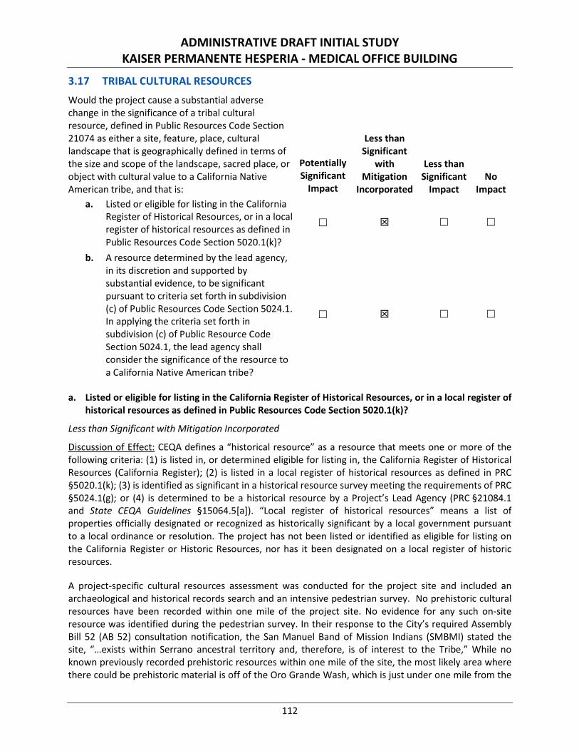
ADMINISTRATIVE DRAFT INITIAL STUDY KAISER PERMANENTE HESPERIA - MEDICAL OFFICE BUILDING
112
3.17 TRIBAL CULTURAL RESOURCES Would the project cause a substantial adverse change in the significance of a tribal cultural resource, defined in Public Resources Code Section 21074 as either a site, feature, place, cultural landscape that is geographically defined in terms of the size and scope of the landscape, sacred place, or object with cultural value to a California Native American tribe, and that is:
Potentially Significant
Impact
Less than Significant
with Mitigation
Incorporated
Less than Significant
Impact No
Impact a. Listed or eligible for listing in the California
Register of Historical Resources, or in a local register of historical resources as defined in Public Resources Code Section 5020.1(k)?
b. A resource determined by the lead agency, in its discretion and supported by substantial evidence, to be significant pursuant to criteria set forth in subdivision (c) of Public Resources Code Section 5024.1. In applying the criteria set forth in subdivision (c) of Public Resource Code Section 5024.1, the lead agency shall consider the significance of the resource to a California Native American tribe?
a. Listed or eligible for listing in the California Register of Historical Resources, or in a local register of historical resources as defined in Public Resources Code Section 5020.1(k)?
Less than Significant with Mitigation Incorporated
Discussion of Effect: CEQA defines a “historical resource” as a resource that meets one or more of the following criteria: (1) is listed in, or determined eligible for listing in, the California Register of Historical Resources (California Register); (2) is listed in a local register of historical resources as defined in PRC §5020.1(k); (3) is identified as significant in a historical resource survey meeting the requirements of PRC §5024.1(g); or (4) is determined to be a historical resource by a Project’s Lead Agency (PRC §21084.1 and State CEQA Guidelines §15064.5[a]). “Local register of historical resources” means a list of properties officially designated or recognized as historically significant by a local government pursuant to a local ordinance or resolution. The project has not been listed or identified as eligible for listing on the California Register or Historic Resources, nor has it been designated on a local register of historic resources.
A project-specific cultural resources assessment was conducted for the project site and included an archaeological and historical records search and an intensive pedestrian survey. No prehistoric cultural resources have been recorded within one mile of the project site. No evidence for any such on-site resource was identified during the pedestrian survey. In their response to the City’s required Assembly Bill 52 (AB 52) consultation notification, the San Manuel Band of Mission Indians (SMBMI) stated the site, “…exists within Serrano ancestral territory and, therefore, is of interest to the Tribe,” While no known previously recorded prehistoric resources within one mile of the site, the most likely area where there could be prehistoric material is off of the Oro Grande Wash, which is just under one mile from the
ADMINISTRATIVE DRAFT INITIAL STUDY KAISER PERMANENTE HESPERIA - MEDICAL OFFICE BUILDING
113
project area. Alluvial activity has uncovered near-surface material and re-deposited it along the surface of the wash. The site’s location on the edge of the alluvial fan increase the potential that any prehistoric cultural material found on the surface (either before or during construction) could be re-deposited from the wash itself, and therefore removed from its original context. Due to the site’s location in historic Serrano territory and past depositional processes, a potential exists for the on-site presence of previous undetected Native American cultural material. With implementation of Mitigation Measures TCR-1 and TCR-2, in tandem with Mitigation Measures CUL-1 and CUL-2, potential impacts to tribal cultural resource impacts would be reduced to a less than significant level.
b. A resource determined by the lead agency, in its discretion and supported by substantial evidence, to be significant pursuant to criteria set forth in subdivision (c) of Public Resources Code Section 5024.1. In applying the criteria set forth in subdivision (c) of Public Resource Code Section 5024.1, the lead agency shall consider the significance of the resource to a California Native American tribe?
Less than Significant with Mitigation Incorporated
Discussion of Effect: Assembly Bill 52 requires Lead Agencies evaluate a project’s potential impacts to “tribal cultural resources.” Such resources include “[s]ites, features, places, cultural landscapes, sacred places, and objects with cultural value to a California Native American Tribe that are eligible for inclusion in the California Register of Historical Resources or included in a local register of historical resources.” AB 52 also gives Lead Agencies the discretion to determine, supported by substantial evidence, whether a resource qualifies as a “tribal cultural resource.”
Pursuant to AB 52, the City notified the following tribes of the project on October 26, 2018:
• San Manuel Band of Mission Indians;
• Cabazon Band of Mission Indians; and
• Torres Martinez Desert Cahuilla Indians.
Of the tribes notified, the San Manuel Band of Mission Indians (SMBMI) responded with “no concerns with the project’s implementation, as planned, at this time.” No response has been received from the other contracted tribes. Mitigation Measures CUL-1 and CUL-2 have been previously identified to mitigate for potential impacts related to the discovery of archeological material during ground disturbance operations. Those measures apply equally to any potential tribal cultural material. The SMBMI has further identified the following measures to address potential impacts to Tribal Cultural resources:
TCR-1 The San Manuel Band of Mission Indians Cultural Resources Department (SMBMI) shall be contacted, as detailed in Mitigation Measure CUL-2, of any pre-contact cultural resources discovered during project implementation, and be provided information regarding the nature of the find, so as to provide Tribal input with regards to significance and treatment. Should the find be deemed significant, as defined by CEQA (as amended, 2015), a cultural resources Monitoring and Treatment Plan shall be created by the archaeologist, in coordination with SMBMI, and all subsequent finds shall be subject to this Plan. This Plan shall allow for a monitor to be present that represents SMBMI for the remainder of the project, should SMBMI elect to place a monitor on-site. The Monitoring and Treatment Plan shall implement SMBMI’s preferred mitigation
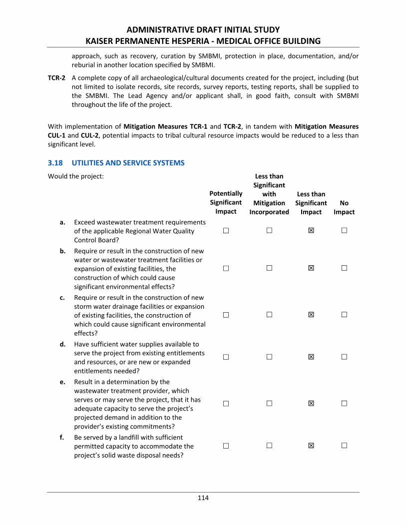
ADMINISTRATIVE DRAFT INITIAL STUDY KAISER PERMANENTE HESPERIA - MEDICAL OFFICE BUILDING
114
approach, such as recovery, curation by SMBMI, protection in place, documentation, and/or reburial in another location specified by SMBMI.
TCR-2 A complete copy of all archaeological/cultural documents created for the project, including (but not limited to isolate records, site records, survey reports, testing reports, shall be supplied to the SMBMI. The Lead Agency and/or applicant shall, in good faith, consult with SMBMI throughout the life of the project.
With implementation of Mitigation Measures TCR-1 and TCR-2, in tandem with Mitigation Measures CUL-1 and CUL-2, potential impacts to tribal cultural resource impacts would be reduced to a less than significant level. 3.18 UTILITIES AND SERVICE SYSTEMS Would the project:
Potentially Significant
Impact
Less than Significant
with Mitigation
Incorporated
Less than Significant
Impact No
Impact a. Exceed wastewater treatment requirements
of the applicable Regional Water Quality Control Board?
b. Require or result in the construction of new water or wastewater treatment facilities or expansion of existing facilities, the construction of which could cause significant environmental effects?
c. Require or result in the construction of new storm water drainage facilities or expansion of existing facilities, the construction of which could cause significant environmental effects?
d. Have sufficient water supplies available to serve the project from existing entitlements and resources, or are new or expanded entitlements needed?
e. Result in a determination by the wastewater treatment provider, which serves or may serve the project, that it has adequate capacity to serve the project’s projected demand in addition to the provider’s existing commitments?
f. Be served by a landfill with sufficient permitted capacity to accommodate the project’s solid waste disposal needs?
ADMINISTRATIVE DRAFT INITIAL STUDY KAISER PERMANENTE HESPERIA - MEDICAL OFFICE BUILDING
115
g. Comply with federal, State, and local statutes and regulations related to solid waste.
a. Exceed wastewater treatment requirements of the applicable Regional Water Quality Control Board?
Less than Significant Impact
Discussion of Effects: Local governments and water districts are responsible for complying with federal regulations, both for wastewater plant operation and the collection systems (e.g., sanitary sewers) that convey wastewater to the wastewater treatment facility. Proper operation and maintenance is critical for sewage collection and treatment as impacts from these processes can degrade water resources and affect human health. Publicly owned treatment works (POTWs) receive Waste Discharge Requirements (WDRs) to ensure that such wastewater facilities operate in compliance with the water quality regulations set forth by the Lahontan RWQCB. WDRs, issued by the State, establish effluent limits on the kinds and quantities of pollutants that POTWs can discharge. These permits also contain pollutant monitoring, record-keeping, and reporting requirements. Each POTW that intends to discharge into the nation’s waters must obtain a WDR prior to initiating its discharge.
Wastewater from the project site would be conveyed through interconnected municipal sewer facilities to the Victor Valley Wastewater Reclamation Authority (VVWRA) 3-mile interceptor that runs along the northeast boundary of the City and ultimately flows to the Regional Wastewater Treatment Plant (RWWTP) that is owned and operated by the VVWRA.82 VVWRA has a current wastewater treatment capacity of 18.0 million gallons per day (mgd) (55.2 acre-feet per day) and utilizes 2.0 mgd or 6.14 acre-feet per day/2,240 acre-feet per year (AFY).83 Accordingly, VVWRA utilizes approximately 11 percent of the available capacity, with an average daily surplus of 16 mgd.
Because VVWRA is considered a POTW, operational discharge flows treated by the wastewater treatment facility system would be required to comply with applicable WDRs issued by the Lahontan RWQCB. Compliance with conditions or permit requirements established by the City as well as WDRs outlined by the Lahontan RWQCB would ensure that wastewater discharges coming from the project site and treated by the wastewater treatment facility system would not exceed applicable Lahontan RWQCB wastewater treatment requirements. In addition, as discussed in response to Checklist Question 3.3.17b, below, the proposed project is analyzed as a worst-case scenario to generate 11,316 gallons of wastewater per day, which is approximately 0.07 percent of the available daily surplus treatment capacity at VVWRA. Therefore, project-generated demand for increased wastewater flows can be accommodated within the existing design capacity of VVWRA, would be typical of wastewater flows in the City, and would not result in the VVWRA exceeding its wastewater treatment requirements. Therefore, because the capacity of the treatment facility that serves the proposed project would not be exceeded with project implementation, no potential exists for the proposed project to exceed the wastewater treatment requirements of the RWQCB. Impacts would be less than significant. No mitigation is required.
82 Final Draft 2015 Urban Water Management Plan. Hesperia Water District. Page 33. GEI Consultants, Inc. June 2016. 83 Ibid.
ADMINISTRATIVE DRAFT INITIAL STUDY KAISER PERMANENTE HESPERIA - MEDICAL OFFICE BUILDING
116
b. Require or result in the construction of new water or wastewater treatment facilities or expansion of existing facilities, the construction of which could cause significant environmental effects?
Less than Significant Impact
Discussion of Effects: Future development of a 55,000-square foot medical office building would generate approximately 92 jobs in the City84,85 and therefore increase the demand for water and wastewater services. According to the Hesperia Water District 2015 Urban Water Management Plan (UWMP), the Hesperia Water District’s actual 2015 Gross Water Use was 12,668 acre-feet and the population was 92,177, which equals a per-capita water use of 123 gallons per capita per day.86 Even if one hundred percent of the Hesperia Water District’s Gross Water Use were dedicated to wastewater demand, the proposed project would demand approximately 11,316 gallons per day (gpd) or 0.011 mgd of wastewater.87 Therefore, as a worst-case scenario, the project would use approximately 0.07 percent88 of the daily surplus capacity at VVWRA. This is an incremental increase in demand for wastewater services. Therefore, the project would not require the construction or expansion of wastewater treatment facilities. Impacts would be less than significant and no mitigation is required.
The Hesperia Water District cooperates with the MWA to manage the City’s water resources. MWA is the region’s wholesale water provider, and provides a portion of Hesperia’s water supply directly to Hesperia’s system via the Regional Recharge and Recovery Project. Essentially all water supplies within MWA are pumped from the local groundwater basins and the District pumps water directly from the Alto Subarea sub-basin of the Mojave River Groundwater Basin.
As stated previously, the Hesperia Water District calculated the average gallons per capita per day (GPCD) Gross Water Use to be 123 GPCD. Even if one hundred percent of the Hesperia Water District’s Gross Water Use were dedicated to potable water demand, the generation of 92 jobs would generate a demand of approximately 11,316 gpd or 0.035 acre-feet per day (12.68 AFY) of potable water.
The Hesperia Water District 2015 UWMP estimated the City’s water demand based on SCAG population data and General Plan land use designations at the time of the report. Table P details the Hesperia Water District’s water supply and demand during normal, dry, and multiple dry years.
84 SCAG anticipates 1 employee per 599 square feet or 16.8 employees per acre of development of a [low-rise] professional office building in
San Bernardino County per the Employment Density Study Summary Report. Table 8B. Southern California Association of Governments. October 31, 2001.
85 55,000 square feet of proposed [low rise] professional office uses ÷ 599 square feet per employee = 91.82 employees. 86 Ibid. Page 22. 87 92 employees × 123 per capita per day = 11,316 gpd ÷ 1,000,000 = 0.011 mgd 88 0.011 mgd demand ÷ 16 mgd surplus × 100 = 0.068 percent.
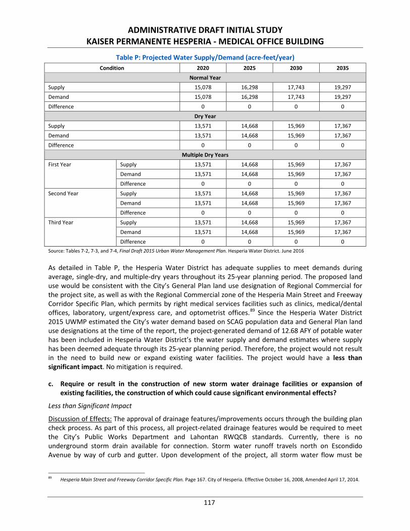
ADMINISTRATIVE DRAFT INITIAL STUDY KAISER PERMANENTE HESPERIA - MEDICAL OFFICE BUILDING
117
Table P: Projected Water Supply/Demand (acre-feet/year) Condition 2020 2025 2030 2035
Normal Year
Supply 15,078 16,298 17,743 19,297
Demand 15,078 16,298 17,743 19,297
Difference 0 0 0 0
Dry Year
Supply 13,571 14,668 15,969 17,367
Demand 13,571 14,668 15,969 17,367
Difference 0 0 0 0
Multiple Dry Years
First Year Supply 13,571 14,668 15,969 17,367
Demand 13,571 14,668 15,969 17,367
Difference 0 0 0 0
Second Year Supply 13,571 14,668 15,969 17,367
Demand 13,571 14,668 15,969 17,367
Difference 0 0 0 0
Third Year Supply 13,571 14,668 15,969 17,367
Demand 13,571 14,668 15,969 17,367
Difference 0 0 0 0 Source: Tables 7-2, 7-3, and 7-4, Final Draft 2015 Urban Water Management Plan. Hesperia Water District. June 2016
As detailed in Table P, the Hesperia Water District has adequate supplies to meet demands during average, single-dry, and multiple-dry years throughout its 25-year planning period. The proposed land use would be consistent with the City’s General Plan land use designation of Regional Commercial for the project site, as well as with the Regional Commercial zone of the Hesperia Main Street and Freeway Corridor Specific Plan, which permits by right medical services facilities such as clinics, medical/dental offices, laboratory, urgent/express care, and optometrist offices.89 Since the Hesperia Water District 2015 UWMP estimated the City’s water demand based on SCAG population data and General Plan land use designations at the time of the report, the project-generated demand of 12.68 AFY of potable water has been included in Hesperia Water District’s the water supply and demand estimates where supply has been deemed adequate through its 25-year planning period. Therefore, the project would not result in the need to build new or expand existing water facilities. The project would have a less than significant impact. No mitigation is required.
c. Require or result in the construction of new storm water drainage facilities or expansion of existing facilities, the construction of which could cause significant environmental effects?
Less than Significant Impact
Discussion of Effects: The approval of drainage features/improvements occurs through the building plan check process. As part of this process, all project-related drainage features would be required to meet the City’s Public Works Department and Lahontan RWQCB standards. Currently, there is no underground storm drain available for connection. Storm water runoff travels north on Escondido Avenue by way of curb and gutter. Upon development of the project, all storm water flow must be
89 Hesperia Main Street and Freeway Corridor Specific Plan. Page 167. City of Hesperia. Effective October 16, 2008, Amended April 17, 2014.
ADMINISTRATIVE DRAFT INITIAL STUDY KAISER PERMANENTE HESPERIA - MEDICAL OFFICE BUILDING
118
infiltrated or released to the curb and gutter along the existing street at rates that do not exceed the predevelopment condition by more than five percent. In order to treat the volume necessary due to Low Impact Development and hydromodification requirements, a drywell will be constructed on the northwest side of the project site, and an underground infiltration chamber will be constructed on the northeast side of the project site. The drywell will be the recipient of the storm water runoff for about 24,600 square feet of project area, while the remainder of the storm water runoff for the site will be routed to the underground infiltration chamber.
Project-related drainage features would be designed, installed, and maintained per Public Works Department standards and the requirements identified in the Final WQMP (per Standard Condition HYD-3). The Final WQMP would be reviewed and approved as a routine action during the processing of the project by the City; therefore, it is reasonable to conclude that the required measures and features detailed in the Final WQMP to safeguard water quality would be incorporated into the proposed project. All proposed improvements to storm water drainage facilities are encompassed within the analytical footprint of this Initial Study and mitigated as necessary. Therefore, drainage impacts would be less than significant. No additional mitigation is required.
d. Have sufficient water supplies available to serve the project from existing entitlements and resources, or are new or expanded entitlements needed?
Less than Significant Impact
Discussion of Effects: There are no known drinking water reservoirs, recharge basins, or treatment BMPs within the proposed project site. The Hesperia Water District cooperates with the MWA to manage the City’s water resources. MWA is the region’s wholesale water provider, and provides a portion of Hesperia’s water supply directly to Hesperia’s system via the Regional Recharge and Recovery Project. Essentially all water supplies within MWA are pumped from the local groundwater basins, and the District pumps water directly from the Alto Subarea sub-basin of the Mojave River Groundwater Basin.
According to the Hesperia Water District 2015 UWMP,90 groundwater levels in the Mojave River Groundwater Basin generally have been declining for the past 50 years or more. Adjudication proceedings were initiated due to concerns that rapid population growth would lead to further overdraft. The resulting Mojave Basin Area Judgment requires that additional surface water be imported to help balance the basin. Alto Subarea water levels near the Mojave River are relatively stable, exhibiting seasonal fluctuations with rising levels in winter and declining levels in summer. It is expected that under current pumping conditions and long-term average flows in the Mojave River, water levels in the Floodplain Aquifer will generally remain stable.
Water levels in the western portion of Alto Subarea in the Regional Aquifer exhibit decline consistent with heavy pumping and limited local recharge. Continued pumping in depleted areas of the Regional Aquifer may result in long-term local negative impacts such as declining yields and water quality problems. As a whole, the Alto Subarea appears to be in regional balance, although portions of the subarea have shown continued historical declines. However, the Alto Subarea sub-basin of the Mojave River Groundwater Basin is adjudicated, so users are assigned a variable Free Production Allowance (FPA). If any producer pumps more than the assigned FPA, then it incurs Replacement Water Obligations to the Watermaster equal to the cost to purchase the amount of production in excess of the FPA. MWA
90 Hesperia Water District Final Draft 2015 Urban Water Management Plan. GEI Consultants, Inc. June 7, 2016.

ADMINISTRATIVE DRAFT INITIAL STUDY KAISER PERMANENTE HESPERIA - MEDICAL OFFICE BUILDING
119
then purchases and recharges to the groundwater imported water from the State Water Project to satisfy those obligations.
As detailed in Table P of response to Checklist Question 3.18b, the Hesperia Water District has adequate supplies to meet demands during average, single-dry, and multiple-dry years throughout its 25-year planning period. The proposed land use would be consistent with the City’s General Plan land use designation of Regional Commercial for the project site, as well as with the Regional Commercial zone of the Hesperia Main Street and Freeway Corridor Specific Plan, which permits by right medical services facilities such as clinics, medical/dental offices, laboratory, urgent/express care, and optometrist offices. Since the Hesperia Water District 2015 UWMP estimated the City’s water demand based on SCAG population data and General Plan land use designations at the time of the report, the project-generated demand of 12.68 AFY of potable water91 has been included in Hesperia Water District’s the water supply and demand estimates where supply has been deemed adequate through its 25-year planning period. Therefore, the City has sufficient water supply to serve the project from existing supplies and entitlements. Impacts would be less than significant. No mitigation is required.
e. Result in a determination by the wastewater treatment provider, which serves or may serve the project, that it has adequate capacity to serve the project’s projected demand in addition to the provider’s existing commitments?
Less than Significant Impact
Discussion of Effects: Please refer to response to Checklist Question 3.18b.
f. Be served by a landfill with sufficient permitted capacity to accommodate the project’s solid waste disposal needs?
Less than Significant Impact
Discussion of Effects: Solid waste collection is a “demand-responsive” service, and current service levels can be expanded and funded through user fees without difficulty. Future development of a 55,000-square foot medical office building would generate approximately 92 jobs in the City and therefore increase the demand for solid waste disposal services.
Solid waste in the City is transported to the Victorville Sanitary Landfill located at 18600 Stoddard Wells Road, Victorville. The Victorville Sanitary Landfill has a daily permitted throughput of 3,000 tons per day, a remaining capacity of 81,510,000 cubic yards, and has an estimated closure year of 2047.92 According to the City’s General Plan EIR, the landfill is equipped to meet the current and identified future demands of the City.93 Since the proposed land use would be consistent with the City’s General Plan land use designation of Regional Commercial for the project site, as well as with the Regional Commercial zone of the Hesperia Main Street and Freeway Corridor Specific Plan, which permits by right medical services facilities such as clinics, medical/dental offices, laboratory, urgent/express care, and optometrist offices, the proposed project will not induce a population increase above that which has been planned for by the City and for which solid waste services were determined to be adequate. Therefore, development of
91 Refer to response to Checklist Question 3.18b. 92 Facility/Site Summary Details: Victorville Sanitary Landfill (36-AA-0045). CalRecycle. https://www2.calrecycle.ca.gov/swfacilities/
Directory/36-AA-0045/. (Accessed on November 9, 2018). 93 Draft Environmental Impact Report for the City of Hesperia General Plan Update. Page 3.16-21. Michael Brandma and Associates. May 26,
2010.
ADMINISTRATIVE DRAFT INITIAL STUDY KAISER PERMANENTE HESPERIA - MEDICAL OFFICE BUILDING
120
the proposed project would not significantly affect current operations or the expected lifetime of the landfills serving the project area. Impacts would be less than significant. No mitigation is required.
g. Comply with Federal, State, and local statutes and regulations related to solid waste?
Less than Significant Impact
Discussion of Effects: All land uses within the City that generate waste are required to coordinate with the City’s franchise waste hauler, Advance Disposal, to collect solid waste on a common schedule as established in applicable local, regional, and State programs. Additionally, all development within the City is required to comply with applicable elements of AB 1327, Chapter 18 (California Solid Waste Reuse and Recycling Access Act of 1991), AB 939 (CalRecycle), and other local, State, and federal solid waste disposal standards. Specifically for commercial uses, recycling is mandatory pursuant to AB 341 if a business generates four or more cubic yards of waste per week.
According to the City’s General Plan EIR, the City is in compliance with the 50 percent diversion rate established by the California Integrated Waste Management Act of 1989 (AB 939).94 The proposed project would be required to comply with applicable elements of AB 1327, Chapter 18 (California Solid Waste Reuse and Recycling Access Act of 1991), AB 939, AB 341, and other applicable local, State, and federal solid waste disposal standards (i.e., Chapter 4 of the Medical Waste Management Act and Health and Safety Code Sections 117915 through 117946) as a matter of regulatory policy, thereby ensuring that the solid waste stream to the waste disposal facilities is reduced in accordance with existing regulations. Impacts would be less than significant and no mitigation is required.
3.19 MANDATORY FINDINGS OF SIGNIFICANCE
Does the project:
Potentially Significant
Impact
Less than Significant
with Mitigation
Incorporated
Less than Significant
Impact No
Impact a. Have the potential to degrade the quality of
the environment, substantially reduce the habitat of a fish or wildlife species, cause a fish or wildlife population to drop below self-sustaining levels, threaten to eliminate a plant or animal community, reduce the number or restrict the range of a rare or endangered plant or animal or eliminate important examples of the major periods of California history or prehistory?
94 Draft Environmental Impact Report for the City of Hesperia General Plan Update. Page 3.16-21. Michael Brandman and Associates. May
26, 2010.
ADMINISTRATIVE DRAFT INITIAL STUDY KAISER PERMANENTE HESPERIA - MEDICAL OFFICE BUILDING
121
b. Have impacts that are individually limited, but cumulatively considerable? (“Cumulatively considerable” means that the incremental effects of a project are considerable when viewed in connection with the effects of past projects, the effects of other current projects, and the effects of probable future projects.)
c. Have environmental effects that will cause substantial adverse effects on human beings, either directly or indirectly?
a. Have the potential to degrade the quality of the environment, substantially reduce the habitat of a fish or wildlife species, cause a fish or wildlife population to drop below self-sustaining levels, threaten to eliminate a plant or animal community, reduce the number or restrict the range of a rare or endangered plant or animal or eliminate important examples of the major periods of California history or prehistory?
Less than Significant with Mitigation Incorporated
Discussion of Effects: Although potential hydrology and water quality impacts could result from the proposed project, implementation of NPDES permits ensures the State’s mandatory standards for the maintenance of clean water and the federal minimums are met. No mitigation is required; however, compliance with the provisions of the NPDES permit and preparation of a Final WQMP are regulatory requirements that apply to all development projects. These requirements are detailed as Standard Conditions HYD-1 through HYD-3 to be included in the conditions of approval for this project. The WQMP would be reviewed and approved as a routine action during the processing of the project by the City; therefore, it is reasonable to conclude that the required measures and features detailed in the WQMP to safeguard water quality would be incorporated into the proposed project. Adherence to Standard Conditions HYD-1 through HYD-3 and the requirements included in the NPDES permit, SWPPP, and WQMP would reduce potential water quality impacts to less than significant.
Four of the five special-status species (short-joint beavertail, Cooper’s hawk, burrowing owl, and yellow warbler) with potential to occur on the project site are considered absent based on the lack of suitable habitat or determined to be absent based on the results of focused and other field surveys. However, one special-status bird species, loggerhead shrike, has the potential to utilize the habitat within the project site. A pre-construction survey for the loggerhead shrike and other nesting/migratory birds in accordance with Mitigation Measure BIO-1 will reduce impacts to special-status species to less than significant levels. In addition, although the burrowing owl was determined to be absent from the project site, the burrowing owl is a mobile species and may subsequently occupy the site. Therefore, a pre-construction burrowing owl survey in compliance with Staff Report on Burrowing Owl Mitigation, State of California Natural Resource Agency, Department of Fish and Game, May 7, 2012 in accordance with Mitigation Measures BIO-2 and BIO-3 will reduce impacts to burrowing owls to less than significant levels.
The 19 Joshua trees on site suitable for transplant and salvage efforts will either be transplanted on site or adopted through an adoption program in accordance with the Joshua Tree Relocation Plan and Mitigation Measures BIO-4 and BIO-5.
ADMINISTRATIVE DRAFT INITIAL STUDY KAISER PERMANENTE HESPERIA - MEDICAL OFFICE BUILDING
122
Based on the results of the Cultural Resources Assessment, the project site does not contain any “historical resources” as defined under CEQA Guidelines §15064.5, and sensitivity for cultural resources deposits within subsurface contexts is low. However, there is always a chance that unanticipated cultural resources could be encountered during ground-disturbing activities. Therefore, Mitigation Measure CUL-2 is required to ensure impacts to any unanticipated cultural resources would be reduced to less than significant levels. Because project excavation is not anticipated to extend below a depth of approximately 7 feet below the surface and will therefore remain in deposits with low paleontological sensitivity, Mitigation Measure CUL-3 will ensure impacts to paleontological resources remain less than significant. With implementation of Mitigation Measures TCR-1 and TCR-2, in tandem with Mitigation Measures CUL-1 and CUL-2, potential impacts to tribal cultural resource impacts would be reduced to a less than significant level.
The proposed project has either no impact, a less than significant impact, or a less than significant impact with mitigation incorporated with respect to all environmental issues pursuant to CEQA. Due to the limited scope of physical impacts to the environment associated with the proposed project, implementation of the mitigation measures described above would reduce impacts to the quality of the environment to less than significant levels. No additional mitigation is required.
b. Have impacts that are individually limited, but cumulatively considerable? (“Cumulatively considerable” means that the incremental effects of a project are considerable when viewed in connection with the effects of past projects, the effects of other current projects, and the effects of probable future projects.)
Less than Significant with Mitigation Incorporated
Discussion of Effects: In evaluating the cumulative effects of the project, Section 21100(e) of CEQA states that “previously approved land use documents including, but not limited to, general plans, specific plans, and local coastal plans, may be used in cumulative impact analysis.” The proposed land use would be consistent with the City’s General Plan land use designation of Regional Commercial for the project site, as well as with the Regional Commercial zone of the Hesperia Main Street and Freeway Corridor Specific Plan, which permits by right medical services facilities such as clinics, medical/dental offices, laboratory, urgent/express care, and optometrist offices, the proposed project will not induce a population increase above that which has been planned for by the City.
The proposed project would not exceed the MDAQMD emissions thresholds for the construction and operation of the project (refer to Section 3.3b) and the proposed land use is consistent with the land use assumptions of the General Plan, upon which the AQAP emissions projections were predicated. Therefore, the proposed project would not conflict with or obstruct implementation of the applicable air quality plan.
For the Opening Year (2020) “without” and “with” project traffic analysis, a 2.0 percent per year growth rate was applied to the project study area due to the combined effects of continuing development, intensification of existing developments, and other factors (i.e., ambient growth). The v/c ratios at all of the study intersections are incrementally increased with the addition of ambient traffic and traffic generated by the related (i.e., cumulative) projects listed in Table 6–1 of the TIA (Appendix H). Six of the eight study intersections are expected to operate at LOS E or better during the weekday a.m. and p.m. peak hours with the addition of growth in ambient traffic and cumulative projects’ traffic under the
ADMINISTRATIVE DRAFT INITIAL STUDY KAISER PERMANENTE HESPERIA - MEDICAL OFFICE BUILDING
123
future “without” and “with” project conditions.95 The following two study intersections are expected to operate at LOS F during the peak hours shown below with the addition of growth in ambient traffic and related projects traffic under Opening Year (2020) “without” and “with” project conditions:96
• Intersection No. 6: Escondido Avenue/Sultana Street (AM Peak Hour: Delay = 52.9 seconds, LOS F).
• Intersection No. 7: Topaz Avenue/Main Street (PM Peak Hour: Delay = 82.8 seconds, LOS F).
For the Topaz Avenue/Main Street intersection, an additional eastbound and westbound through lane would reduce the proposed project’s significant impact to less than significant levels. Therefore, impacts would be reduced to less than significant levels through fair-share contributions for the necessary improvements in accordance with Mitigation Measure TRA-1. For the Escondido Avenue/Sultana Street intersection, the Escondido Avenue widening from 2 lanes to 4 lanes between Main Street and Sultana Street has been completed. To reduce impacts to less than significant levels, Mitigation Measure TRA-2 requires fair-share contribution toward a traffic signal installation at the intersection. With implementation of Mitigation Measures TRA-1 and TRA-2, the proposed project’s impacts from an increase in traffic that is substantial in relation to the existing traffic load and capacity of the street system would be reduced to less than significant with mitigation incorporated.
As detailed in Table P of response to Checklist Question 3.18b, the Hesperia Water District has adequate supplies to meet demands during average, single-dry, and multiple-dry years throughout its 25-year planning period. The proposed land use would be consistent with the City’s General Plan land use designation of Regional Commercial for the project site, as well as with the Regional Commercial zone of the Hesperia Main Street and Freeway Corridor Specific Plan, which permits by right medical services facilities such as clinics, medical/dental offices, laboratory, urgent/express care, and optometrist offices. Since the Hesperia Water District 2015 UWMP estimated the City’s water demand based on SCAG population data and General Plan land use designations at the time of the report, the project-generated demand of 12.68 AFY of potable water has been included in Hesperia Water District’s the water supply and demand estimates where supply has been deemed adequate through its 25-year planning period. Therefore, the City has sufficient water supply to serve the project from existing supplies and entitlements. Impacts would be less than significant.
As stated previously, the project has no impact, a less than significant impact, or a less than significant impact with implementation of mitigation with respect to all environmental issues. Additionally, the project proposes a use that is consistent with the development anticipated in the City’s General Plan and the Hesperia Main Street and Freeway Corridor Specific Plan. Therefore, a less than significant cumulative impact would occur with development of the project and no additional mitigation is required.
c. Have environmental effects that will cause substantial adverse effects on human beings, either directly or indirectly?
Less than Significant Impact
Discussion of Effects: Pursuant to General Plan Goal SF-1, all future construction and development within the project site would be required to comply with applicable provisions of the 2016 CBC and the City’s building regulations. Accordingly, proper engineering design and construction in conformance
95 Ibid. 96 Ibid. Page 38.
ADMINISTRATIVE DRAFT INITIAL STUDY KAISER PERMANENTE HESPERIA - MEDICAL OFFICE BUILDING
124
with the 2016 CBC standards and project-specific geotechnical recommendations (Standard Condition GEO-1) would ensure that the project does not subject people to significant geologic hazards.
The Final WQMP would be reviewed and approved as a routine action during the processing of the project by the City; therefore, it is reasonable to conclude that the required measures and features detailed in the Final WQMP to safeguard water quality would be incorporated into the proposed project. Adherence to Standard Conditions HYD-1 through HYD-3 and the requirements included in the NPDES permit, SWPPP, and Final WQMP would ensure hazards related to flooding remain less than significant. No mitigation is required.
ADMINISTRATIVE DRAFT INITIAL STUDY KAISER PERMANENTE HESPERIA - MEDICAL OFFICE BUILDING
125
4.0 REFERENCES
California Air Resources Board. The California Almanac of Emissions and Air Quality. http://www.arb.ca.gov/aqd/almanac/almanac.htm (accessed November 2, 2018).
California Building Code, Part 2, Volume 1. Chapter 7A - Materials and Construction Methods for Exterior Wildfire Exposure. 2016. https://codes.iccsafe.org/public/chapter/content/1774/ (accessed November 8, 2018).
California Department of Public Health. Medical Waste Management Program. https://www.cdph.ca.gov/Programs/CEH/DRSEM/Pages/EMB/MedicalWaste/MedicalWaste.aspx (accessed November 14, 2018).
California Department of Toxic Substances Control. The Hazardous Waste and Substances Sites (Cortese) List. https://www.dtsc.ca.gov/SiteCleanup/Cortese_List.cfm (accessed November 6, 2018).
California Department of Transportation. Annual Average Daily Truck Traffic on the California State Highway System. http://www.dot.ca.gov/trafficops/census/docs/2016_aadt_truck.pdf (accessed October 2018).
California Department of Transportation. California Scenic Highway Mapping System. http://www.dot.ca.gov/hq/LandArch/16_livability/scenic_highways/ (accessed November 1, 2028).
CalRecycle. Facility/Site Summary Details: Victorville Sanitary Landfill (36-AA-0045). https://www2.calrecycle.ca.gov/swfacilities/Directory/36-AA-0045/ (accessed on November 9, 2018).
City of Hesperia. City of Hesperia General Plan. 2010.
City of Hesperia. Climate Action Plan. July 20, 2010.
City of Hesperia. Draft Environmental Impact Report for the City of Hesperia General Plan Update, SCH# 2010011011. May 26, 2010.
City of Hesperia. Fee Schedule. Effective October 21, 2018.
City of Hesperia. Hesperia Main Street and Freeway Corridor Specific Plan. Effective October 16, 2008, Amended April 17, 2014.
City of Hesperia. Municipal Code Title 16, Section 16.20.135 - Glare (Amended during 1997 codification; SBCC § 87.1320).
County of San Bernardino. Stormwater Facility Mapping Tool. San Bernardino County Watershed Action Plan. http://permitrack.sbcounty.gov/wap/ (accessed November 7, 2018).
Federal Emergency Management Agency. FEMA’s National Flood Hazard Layer (Official). Panels 06071C6475H and 06071C6490H. Federal Emergency Management Agency.
ADMINISTRATIVE DRAFT INITIAL STUDY KAISER PERMANENTE HESPERIA - MEDICAL OFFICE BUILDING
126
https://msc.fema.gov/portal/search?AddressQuery=highland%2C%20california#searchresultsanchor (accessed November 7, 2018).
Federal Highway Administration. Highway Construction Noise Handbook. Roadway Construction Noise Model, Federal Highway Administration-HEP-06-015. DOT-VNTSC-FHWA-06-02. NTIS No. PB2006-109012. August 2006.
Federal Highway Administration. Highway Traffic Noise Prediction Model, FHWA-RD 77 108. 1977.
Federal Transit Administration, Office of Planning and Environment. Transit Noise and Vibration Impact Assessment. FTA-VA-90-1003-06. May 2006.
GEI Consultants, Inc. Hesperia Water District Final Draft 2015 Urban Water Management Plan. June 7, 2016.
Geobase, Inc. Geotechnical Report, Kaiser Permanente SFNT 2018 MLF Hesperia MOB D0476, Vacant Parcels 5-9, APN #3057-011-22-0-00 Thru 3057-011-26-0-000, Escondido Avenue, Hesperia, California. May 2018.
Heather Elder, California Department of Fish and Wildlife, Inland Deserts Region. Personal Communication via Electronic Mail. October 2, 2018.
HMC Architects. Photometric Site Plan. September 28, 2018.
Legislative Analyst’s Office. An Evaluation of the School Facility Fee Affordable Housing Assistance Programs. January 2001. http://www.lao.ca.gov/2001/011701_school_facility_fee.html (accessed November 8, 2018).
Linscott, Law & Greenspan. Kaiser Permanente Hesperia Medical Office Building Project, Traffic Impact Study. October 23, 2018.
LSA. Kaiser Permanente Medical Office Project—Joshua Tree Relocation Plan. July 2018.
LSA. Kaiser Permanente Medical Office Project: Results of a Biological Resources Assessment. October, 2018.
Mojave Desert Air Quality Management District. Carbon Monoxide Redesignation Request and Maintenance Plan. February 2005.
National Fire Protection Association. U.S. Experience with Sprinklers, Fact Sheet, Sprinklers in Reported U.S. Fires during 2010 to 2014. July 2017. http://www.nfpa.org/news-and-research/fire-statistics-and-reports/fire-statistics/fire-safety-equipment/us-experience-with-sprinklers (accessed November 8, 2018).
San Bernardino County Airport Land Use Commission. Comprehensive Land Use Plan, Hesperia Airport. January 1991.
Southern California Association of Governments. Employment Density Study Summary Report. October 31, 2001.
ADMINISTRATIVE DRAFT INITIAL STUDY KAISER PERMANENTE HESPERIA - MEDICAL OFFICE BUILDING
127
State of California Department of Conservation, California Important Farmland Finder. San Bernardino County Important Farmland 2016 (Sheet 2 of 2). http://www.conservation.ca.gov/dlrp/fmmp/Pages/SanBernardino.aspx (accessed November 2, 2018).
State of California Department of Conservation, California Important Farmland Finder. San Bernardino County Williamson Act FY 2015/2016 (Sheet 2 of 2). ftp://ftp.consrv.ca.gov/pub/dlrp/wa/ (accessed November 2, 2018).
State of California Department of Transportation. Guide for the Preparation of Traffic Impact Studies. December 2002.
State of California Regional Water Quality Control Board. Water Quality Control Plan for the Lahontan Region. Chapter 2: Present and Potential Beneficial Uses. As amended through January 14, 2016.
State of California. California Code of Regulations, Title 14, Division 6, Chapter 3, Sections 15000–15387, as amended December 1, 2004.
United States Department of Agriculture, 2017. Web Soil Survey. https://websoilsurvey.sc.egov.usda.gov/App/WebSoilSurvey.aspx (accessed November 6, 2018).
United States Department of Agriculture. February 1986. Soil Survey of San Bernardino County California.
United States Department of the Interior, Bureau of Land Management. Desert Renewable Energy Conservation Plan and Record of Decision. September 2016.
United States Department of the Interior, Bureau of Land Management. Final Environmental Impact Report and Statement for the West Mojave Plan, A Habitat Conservation Plan and California Desert Conservation Area Plan Amendment Vol 1. January 2005.
United States Department of the Interior, Bureau of Land Management. The California Desert Conservation Area Plan 1980. 1980, as amended.
United States Department of the Interior, Bureau of Land Management. West Mojave Plan: A Habitat Conservation and California Desert Conservation Area Plan Amendment. Final Environmental Impact Report and Statement. Vols. 1 and 2. January 2005.

ADMINISTRATIVE DRAFT INITIAL STUDY KAISER PERMANENTE HESPERIA - MEDICAL OFFICE BUILDING
128
THIS PAGE INTENTIONALLY LEFT BLANK
ADMINISTRATIVE DRAFT INITIAL STUDY KAISER PERMANENTE HESPERIA - MEDICAL OFFICE BUILDING
APPENDIX A
CALIFORNIA EMISSIONS ESTIMATOR MODEL (CALEEMOD)
ADMINISTRATIVE DRAFT INITIAL STUDY KAISER PERMANENTE HESPERIA - MEDICAL OFFICE BUILDING
THIS PAGE INTENTIONALLY LEFT BLANK

ADMINISTRATIVE DRAFT INITIAL STUDY KAISER PERMANENTE HESPERIA - MEDICAL OFFICE BUILDING
APPENDIX B-1
BIOLOGICAL RESOURCES ASSESSMENT

ADMINISTRATIVE DRAFT INITIAL STUDY KAISER PERMANENTE HESPERIA - MEDICAL OFFICE BUILDING
THIS PAGE INTENTIONALLY LEFT BLANK
ADMINISTRATIVE DRAFT INITIAL STUDY KAISER PERMANENTE HESPERIA - MEDICAL OFFICE BUILDING
APPENDIX B-2
DESERT TORTOISE SURVEY

ADMINISTRATIVE DRAFT INITIAL STUDY KAISER PERMANENTE HESPERIA - MEDICAL OFFICE BUILDING
THIS PAGE INTENTIONALLY LEFT BLANK
ADMINISTRATIVE DRAFT INITIAL STUDY KAISER PERMANENTE HESPERIA - MEDICAL OFFICE BUILDING
APPENDIX B-3
BURROWING OWL SURVEY

ADMINISTRATIVE DRAFT INITIAL STUDY KAISER PERMANENTE HESPERIA - MEDICAL OFFICE BUILDING
THIS PAGE INTENTIONALLY LEFT BLANK
ADMINISTRATIVE DRAFT INITIAL STUDY KAISER PERMANENTE HESPERIA - MEDICAL OFFICE BUILDING
APPENDIX B-4
JOSHUA TREE RELOCATION PLAN

ADMINISTRATIVE DRAFT INITIAL STUDY KAISER PERMANENTE HESPERIA - MEDICAL OFFICE BUILDING
THIS PAGE INTENTIONALLY LEFT BLANK

ADMINISTRATIVE DRAFT INITIAL STUDY KAISER PERMANENTE HESPERIA - MEDICAL OFFICE BUILDING
APPENDIX C-1
CULTURAL RESOURCES ASSESSMENT

ADMINISTRATIVE DRAFT INITIAL STUDY KAISER PERMANENTE HESPERIA - MEDICAL OFFICE BUILDING
THIS PAGE INTENTIONALLY LEFT BLANK
ADMINISTRATIVE DRAFT INITIAL STUDY KAISER PERMANENTE HESPERIA - MEDICAL OFFICE BUILDING
APPENDIX C-2
PALEONTOLOGICAL ANALYSIS

ADMINISTRATIVE DRAFT INITIAL STUDY KAISER PERMANENTE HESPERIA - MEDICAL OFFICE BUILDING
THIS PAGE INTENTIONALLY LEFT BLANK
ADMINISTRATIVE DRAFT INITIAL STUDY KAISER PERMANENTE HESPERIA - MEDICAL OFFICE BUILDING
APPENDIX D
GEOTECHNICAL REPORT

ADMINISTRATIVE DRAFT INITIAL STUDY KAISER PERMANENTE HESPERIA - MEDICAL OFFICE BUILDING
THIS PAGE INTENTIONALLY LEFT BLANK
ADMINISTRATIVE DRAFT INITIAL STUDY KAISER PERMANENTE HESPERIA - MEDICAL OFFICE BUILDING
APPENDIX E
PHASE I ENVIRONMENTAL SITE ASSESSMENT

ADMINISTRATIVE DRAFT INITIAL STUDY KAISER PERMANENTE HESPERIA - MEDICAL OFFICE BUILDING
THIS PAGE INTENTIONALLY LEFT BLANK

ADMINISTRATIVE DRAFT INITIAL STUDY KAISER PERMANENTE HESPERIA - MEDICAL OFFICE BUILDING
APPENDIX F
WATER QUALITY MANAGEMENT PLAN

ADMINISTRATIVE DRAFT INITIAL STUDY KAISER PERMANENTE HESPERIA - MEDICAL OFFICE BUILDING
THIS PAGE INTENTIONALLY LEFT BLANK
ADMINISTRATIVE DRAFT INITIAL STUDY KAISER PERMANENTE HESPERIA - MEDICAL OFFICE BUILDING
APPENDIX G
NOISE ANALYSIS

ADMINISTRATIVE DRAFT INITIAL STUDY KAISER PERMANENTE HESPERIA - MEDICAL OFFICE BUILDING
THIS PAGE INTENTIONALLY LEFT BLANK

ADMINISTRATIVE DRAFT INITIAL STUDY KAISER PERMANENTE HESPERIA - MEDICAL OFFICE BUILDING
APPENDIX H
TRAFFIC IMPACT ANALYSIS

ADMINISTRATIVE DRAFT INITIAL STUDY KAISER PERMANENTE HESPERIA - MEDICAL OFFICE BUILDING
THIS PAGE INTENTIONALLY LEFT BLANK