institut für physik der atmosphäre etrec 2007 george c. craig dlr-institut für physik der...
Post on 21-Dec-2015
215 views
TRANSCRIPT

Institut für Physik der Atmosphäre
ETReC 2007 George C. CraigDLR-Institut für Physik der Atmosphäre

Folie 2 > Vortrag > AutorInstitut für Physik der Atmosphäre
THORPEX-COPS Relevance Large scale influence on local high-impact weather
JapanJapan AustriaAustria
11 Aug.
1 Aug.
Hovmöller (time-longitude) diagram of the 250-mb meridional wind component (ms-1) for the period 28 July - 14 August 2002 and the latitudinal belt 40-60º N.
A Rossby wave train was excited by cyclogenesis off Japan, followed by rapid downstream development of high-amplitude Rossby waves, culminating in extreme flooding in central Europe.
Figure reproduced from THORPEX International Science Plan

Folie 3 > Vortrag > AutorInstitut für Physik der Atmosphäre
ETReC 2007 Goals
1. Predictability - quantify relative roles of synoptic environment and local scales (link COPS)
2. Sensitive Regions - summer season, where timescales are shorter, moist physics important
3. Observing Systems - test potential of cost effective targeted observations (link EURORISK PREVIEW)
4. Impact of observations through global and regional forecast chain (link D-PHASE)

Folie 4 > Vortrag > AutorInstitut für Physik der Atmosphäre
ETReC 2007 Strategy and Timeline
ATReC 2003 timeline
T-5 days select target region(subjective)
T-4 days compute sensitive regions(imprecisely defined)
T-3 days targeted observations(limited sampling)
T-2.5 days improved forecast(modestly)
ETReC 2007 timeline
All times
fixed target regions
T-3 days compute sensitive regions(focused by short lead time)
T-2 days targeted observations(better coverage)
T-1.5 days improved forecast(significantly?)

Folie 5 > Vortrag > AutorInstitut für Physik der Atmosphäre
Proposed ETReC 2007 Target Regions
COPSD-PHASE
MEDEXCYPRIM

Folie 6 > Vortrag > AutorInstitut für Physik der Atmosphäre
ETReC 2007 Observing Systems1. Targeted additional Radiosonde, AMDAR, ASAP
EUCOS proposedoperationalobserving system
Folie 7 > Vortrag > AutorInstitut für Physik der Atmosphäre
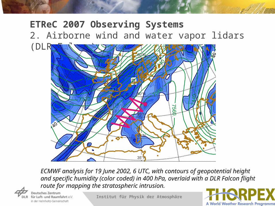
ETReC 2007 Observing Systems2. Airborne wind and water vapor lidars (DLR Falcon)
ECMWF analysis for 19 June 2002, 6 UTC, with contours of geopotential height and specific humidity (color coded) in 400 hPa, overlaid with a DLR Falcon flight route for mapping the stratospheric intrusion.

Folie 8 > Vortrag > AutorInstitut für Physik der Atmosphäre
Sensitive Region Verification Area
ETReC 2007 Sensitive Regions
Methods
MeteoFrance - Singular Vectors
ECMWF - Moist Singular Vectors
Met Office - Ensemble Transform Kalman Filter