integrated water resource management of catchment...
TRANSCRIPT

Integrated Water Resource Management of catchment consisting Kushiyara River
and Haors, Sylhet, Bangladesh
Presenter: Fatima-Tuz-Zahra
Co-authors: Sharmin Akter, Md. Arif Chowdhury
Theme: Natural Resource Management
1

2
Introduction (2/1)
The Kushiyara, a vey dynamic river travels over a distance of about 130 km around Madna and flows to the Dhakeshwari River which at last turns to the upper Meghna river (Uddin, 2010).
The surface water system of the area consists of the major river networks, haors, beels, and the massive flood plains which become inundated during the monsoon season and used for cultivation for the rest of the year to supply most of the agricultural crops.
The rivers contribute to the agriculture, general economy of the country by providing navigation, fish, water for irrigation and fresh alluvial sediment replenishing the soil.
This relatively higher region of the Surma-Kushiyara floodplain has been formed on sediments of the rivers draining into the Meghna catchment area from the hills.
Most of the haor areas are covered by alluvial clay and silt deposits of the Meghna River and its tributaries.

3
• The massive flash flood and a large sediment load causes continuous erosion and sedimentation, which affects river banks stabilization, navigation, flood control, fisheries and agriculture.
• Being an Environmentally Critical Area (ECA) Hakaluki haor and other haors have deeper connection with the environmental flow in the river. This river haor ecosystem maintains the balance of instream flow required for river and haor habitat which is important for both aquatic fauna and human population of this area.
Introduction (2/2)
In this study, we will look forward to make IWRM plan to manage and resolute the existing water use conflicts in the Kushiyara river and Haor catchment and to ensure sustainable resource exploitation including environmental and economic efficiency and social equity
Figure 1: Pictorial View of Degradation and Conversion of Flooded (Swamp) Forest into Fallow, Grazing and Agricultural Land in Hakaluki Haor

4
• The catchment of river Kushiyara, and other haors which mainly links the Barak river and the Meghna River, is selected as the study area.
• The catchment lies between 24.469◦ and 24.638◦ north latitudes and between 91.699◦and 92.229◦ east longitudes and includes both Sylhet and Moulvibazar districts.
• SylhetSadar, Golabganj, Beanibajar, Balaganj, and Fenchuganjupazillas in Sylhet district and Rajnagar, Barlekha, Kulaura, MoulvibajarSadar, Kamalganj, and Sreemangalupazillas in Moulvibazar district are within the study area.
Methodology (5/1)
Figure 2: Study area
Figure 3: Bank erosion at River Kushiyara

5
Methodology (5/2)
Probable scenarios: Depending on the present situation of the study area there are some issues identified which can be aggravated in the near future for which water resources management plans need to be prepared. Following are some future scenarios of present issues: Increased population Growth will create pressure on surface water
bodies Increased river flow or flooding due to climate change may increase river
bank erosion Water management of upstream Riparian countries with optimization will
be needed economic development Multi-criteria Analysis (MCA): Strategies under criteria has been ranked after calculation of total scoring ranging between 0-10 and weightage was given based on moral, cultural and ecological factors. As it is a subjective process, so the result can vary from person to person. But the factors considering all sectors are included in calculation process.

6
Goal: Integrated Haor & River Basin Management
Issues Objectives Strategies Criteria/Indicator
Insufficient lean
period flow
Maintenance of
environmental flow
Storage basin,
Rubber Dam
Water Level
Fish Species
Bird Species
Capture fisheries
Sanctuaries
River bank erosion Bank stabilization
and protection
Structural
(Revetment,
Groin)
Livelihood
opportunity
Migration
Operation &
Maintenance
Erosion Rate
Non-structural
(Plantation,
Sandbag)
Table 1: List of Objectives, strategies, criteria/indicators
Methodology (5/3)
7
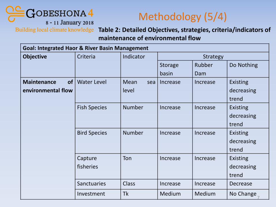
Goal: Integrated Haor & River Basin Management
Objective Criteria Indicator Strategy
Storage
basin
Rubber
Dam
Do Nothing
Maintenance of
environmental flow
Water Level Mean sea
level
Increase Increase Existing
decreasing
trend
Fish Species Number Increase Increase Existing
decreasing
trend
Bird Species Number Increase Increase Existing
decreasing
trend
Capture
fisheries
Ton Increase Increase Existing
decreasing
trend
Sanctuaries Class Increase Increase Decrease
Investment Tk Medium Medium No Change
Table 2: Detailed Objectives, strategies, criteria/indicators of maintenance of environmental flow
Methodology (5/4)

8
Methodology (5/5)
Goal: Integrated Haor & River Basin Management
Objective
Bank
stabilization
and
protection
Criteria Indicator Strategy
Structural Non Structural Do
Nothing Revetment groin Plantation Sandbag
Investment Tk/unit High High Low Medium No
Change
Livelihood
opportunity
Class Increase Increase Increase Increase No
Change
Migration No of
people
Less Less Less less Bad
O & M Tk/unit High Low Low High No
Change
Erosion Rate m/yr Decrease Decrease Decrease Decrease No
Change
Table 3: Detailed Objectives, criteria/indicators , strategies of Bank stabilization and protection
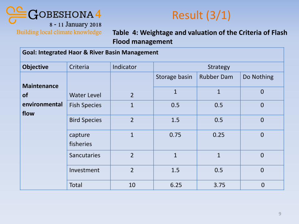
9
Goal: Integrated Haor & River Basin Management
Objective Criteria Indicator Strategy
Maintenance
of
environmental
flow
Water Level
2
Storage basin Rubber Dam Do Nothing
1 1 0
Fish Species 1 0.5 0.5 0
Bird Species 2 1.5 0.5 0
capture
fisheries
1 0.75 0.25 0
Sancutaries 2 1 1 0
Investment 2 1.5 0.5 0
Total 10 6.25 3.75 0
Table 4: Weightage and valuation of the Criteria of Flash Flood management
Result (3/1)

10
Result (3/2)
Goal: Sustainable Haor River Basin Management
Objective Criteria Weight Strategy
Structural Non Structural Do
Nothing Revetment Groin Plantation Sandbag
Bank
stabilization
and
protection
Investment 2 0.25 0.25 0.25 0.75 0
Livelihood
opportunity
1 0.5 0.25 0 0.25 0
Migration 1 0 0 0.5 0.5 0
O & M 3 1 0.5 0.5 1 0
Erosion Rate 3 1 0.5 0.75 0.75 0
Total 10 2.75 1.5 2 3.25 0
Table 5: Weightage and valuation of the Criteria of Bank stabilization and protection

11
Result (3/3)
Issues Objectives Best Strategies from MCA
Insufficient lean period
flow
Maintenance of
environmental flow
Storage basin
River bank erosion Bank stabilization and
protection
Non structural option:
Sandbag
The most promising strategies selected from the multi-criteria analysis of the indicators and available option are shown below for respective issues in the planning units -
The selected catchment is very crucial and environmentally vulnerable to fight against climate change. So, optimizing different needs and strategies using integrated approach is a necessity for future safety of the people living in this area.

Proposed Local Solution
12
Water demand
Sectoral conflicts; Economic and ecological
degradation; Dependency on surface water
Natural Hazards
Goal: Integrated River and Haor Management (MCA)
Defining Objectives
Criteria/indicators under objectives
Best Strategy

13
Solution with addressing Problems
Figure 4: Major land use pattern in Hakaluki Haor in the catchment area
• Compared to conditions in 1980, the proportion of degraded Haors has increased from 10% of the total Haor areas to more than 75%, which has caused a steady decline in fisheries resources (Khan, 2011).
• In both city and rural areas water quality and water availability is depleting due to all these conflicts in the catchment area.
• By conserving and restoring the ecosystem of Haorss and rivers in this catchment, people can be safe from various natural hazards and resource depletion.

How the Implementing Agency
Reach Out the Beneficiaries
14
Existing projects like Habitat Restoration for Fish Diversity and Introduction of comparatively short duration HYV/Hybrid rice varieties for Boro season are being implemented respectively by Bangladesh Water Development Board (BWDB) and Department of Agricultural Extension (DAE). These are mainly focusing on only one issue and sectoral conflicts are prevailing in the study area for long time. So, to reach out fishermen, farmers, city dwellers, navigation beneficiaries and adapt with climate induced extreme conditions like erosion or scarce water in surface integrated approach like this is largely needed considering future scenarios and all sectors as well.
References: Khan, S. M. M. H. (2011). Participatory wetland resource governance in Bangladesh: an analysis of community based experiments in Hakaluki haor. Doctor of philosophy, University of Manitoba. Uddin, M. M., (2010). Assessment of Morphological Aspects of Kushiyara-Monu River System, Thesis paper, Department of Water Resource Engineering, BUET. Zila Statistics, Moulvibazar. BBS. 2011

Final Words
15
This slide is made possible by the support of American people through the United States Agency for International Development (USAID). The contents are the sole responsibility of the presenter and do not necessarily reflect the views of USAID or the United States government.
Integrated water resources management should be applied properly for the sake of holistic approach to
manage this river and Haor basin in the north east area as an weapon against future climate extremity.