integrated watershed management for sustainable water use in a
TRANSCRIPT

Integrated Watershed Management for
Sustainable Water Use ina Humid Tropical Region
Bulletin of the Terrestrial Environment Research CenterUniversity of Tsukuba, No. 10, Supplement, no. 1
March, 2010
JSPS-DGHE Joint Research Project
Final ReportEdited by
T. TANAKAH. PAWITAN
T. YAMANAKA
ISSN 1346-3381

iii
Preface Water resources in the Asia region are very severe and scarce that should be
supplying by only 36 % of world’s water resources amount for a half of population in the world. In addition, a very rapid population increase is apparent in recent years and the problem is getting very serious. This rapid population increase causes not only increase of water demand but also affects largely the land use change, which causes land degradation, soil erosion, change in hydrologic regimes and environmental qualities.
To overcome those water crises, it is necessary to clarify the causes and effects of watershed hydrology aspects on water resources conservation through the collaborative research among Asian countries by developing a methodology and analytical methods for the desired watershed management. It is also necessary to enhance the technology transfer, the capacity building and the water governance to maintain and continue the established watershed management for sustainable water resources development, water uses and its conservation in a future.
The JSPS (Japan Society for the Promotion of Science)-DGHE (Directorate General of Higher Education, Indonesia) Joint Research Project on “Watershed Management for Sustainable Water Resources Development in a Humid Tropical Region” has been launched in 2007 for three years continue project. The specific objectives of the project are as follows: 1) Understand the role of land use management and its impact on water conservation, livelihood, ecosystem and water resources services in selected watershed (Scientific Research and Ecohydrological and Socioeconomic Aspects), 2) Enhance the technology transfer and capacity building of individuals, communities and government organizations in the managing land use for conserving water resources to promote sustainable water resources development and use (Capacity Building Aspect), and 3) Identify and promote appropriate institutions and support mechanisms in selected watershed to enhance desired watershed management for sustainable water resources development, use and conservation (Governance Aspect).
For those objectives, we selected the Ciliwung river watershed where rapidly increases the population and progresses the land use/cover changes as a representative watershed and make clarify the characteristics of hydrological cycle of the watershed. Furthermore, the project organized three International Workshops on Watershed Management, Governance and Capacity Building, respectively, in Japan and Indonesia.
This Final Report summarizes the scientific research results on the Ciliwung river watershed conducted during 2-year period from 2008 to 2009 including the summary of three Workshops held in 2007, 2008 and 2009. For the scientific research on the Ciliwung river watershed, we approached the subject by collecting the existing data and its analyses and using environmental isotope techniques, remote sensing and GIS techniques, end member mixing model and numerical simulation model.
The final goal of the project is to clarify what the desired watershed management should be for sustainable water resources development and water uses with an

iv
emphasis on the land use management for water resources conservation and to construct a new model of “Integrated Watershed Management” which will lead the decision making together with the capacity building and the water governance.
We hope that this initiative of the project and its deliberations will bring benefit to many of us and the concept of an integrated watershed management by supporting with the framework of capacity building, water governance and decision making process will be widely spread in Asia regions in near future.
30 March, 2010
Prof. Dr. Tadashi TANAKA Japanese Principal Researcher
Director of Terrestrial Environment Research Center Graduate School of Life and Environmental Sciences
University of Tsukuba Japan
Prof. Ph.D. Hidayat PAWITAN Indonesian Principal Researcher Faculty of Mathematics and Natural Sciences Bogor Agricultural University Indonesia

V Contents
Preface ......................................................................................................................... iii I. Introduction Tadashi TANAKA, Hidayat PAWITAN, HENDRAYANTO and Kasdi SUBAGYONO …………........................................................................…... 3
II. Methodology Methodology of Integrated Watershed Management for Sustainable Water Resources Development, Use and Conservation Tadashi TANAKA …………………………………………………………………. 9 III. Results and Discussion III-1. Basic and Raw Data
Eleonora RUNTUNUWU, HENDRAYANTO, Hidayat PAWITAN, Akihiko KONDO, Tsutomu YAMANAKA and Ken’ichirou KOSUGI ....... 19
III-2. Geology and Hydrogeology of Ciliwung Watershed Robert M. DELINOM ……………………………………………………... 27
III-3. Ciliwung River Flow Discharge and Flow Regime HENDRAYANTO, Kasdi SUBAGYONO and Hidayat PAWITAN …….… 35
III-4. Stable Isotopes of Water in Ciliwung River Watershed Tsutomu YAMANAKA, Eleonora RUNTUNUWU, Hidayat PAWITAN, and Tadashi TANAKA ………………………………………………........... 41
III-5. Effect of Land Use on Spatial and Seasonal Variations of Water Quality in Ciliwung River Eleonora RUNTUNUWU, Akihiko KONDO and Kasdi SUBAGYONO .…55 III-6. Stable Isotope of Nitrate in Ciliwung River Nobuhito OHTE, Yuhya WATANABE, Chikage YOSHIMIZU, Akihiko KONDO, Eleonora RUNTUNUWU, Tsutomu YAMANAKA and Tadashi TANAKA ……………………................................................... 65 III-7. Effects of Soil Hydraulic Properties on Rainwater Discharge at the Gunung Walat Educational Forest Ken’ichirou KOSUGI, Yuki HAYASHI, Hiroyuki KATO and Fukue ITABASHI ……………………………………….............................. 75 III-8. Summary of Workshops on Integrated Watershed Management Kasdi SUBAGYONO and Tadashi TANAKA ………................................... 85 IV. Summary and Conclusions
Hidayat PAWITAN and Tadashi TANAKA ........................................................... 91 V. Appendixes V-1. Press Release …………………………………………………………….…. 97 V-2. List of Contributions ……........................................................................... 101

I. Introduction

Final Report on Integrated Watershed Management for Sustainable Water Use in a Humid Tropical Region, JSPS-DGHE Joint Research Project 2007-2009
3
I. Introduction Tadashi TANAKA1, Hidayat PAWITAN2, HENDRAYANTO3 and Kasdi SUBAGYONO4 1 Japanese Principal Researcher, Graduate School of Life and Environmental Science,
University of Tsukuba, Ibaraki 305-8572, Japan [email protected] 2 Indonesian Principal Researcher, Faculty of Mathematics and Natural Sciences, Bogor
Agricultural University, Bogor 16680, Indonesia 3 Faculty of Forestry, Bogor Agricultural University, Bogor 16680, Indonesia 4 Central Java Assessment Institute for Agricultural Technology, Ungaran 50501, Indonesia BACKGROUNDS In a humid tropical region, specially in Indonesia, water resources is becoming crucial issue because of the rapid population growth and accompanied changes of land use, yet the management for sustainable water resources are still facing many constraints and growing up very severe problems that water scarcity, drought, flood, water pollution and many other related things.
In Indonesia, where the rapid population increase is apparent in recent years, the problem is getting very serious. The population density in Java had been quite divers from 9 persons/km2 to 880 persons/km2 in 1815 with an average 35 persons/km2, and this average increased to 330 persons/km2 in 1930 and 1,000 person/km2 in 2000. This rapid population increase has severely affected the land use and continuous change in vegetation cover with consequences in land degradation, soil erosion and changes in hydrologic regimes and environmental quality. In the past century, land use changes in Java occurred from forest to agricultural uses, but in the last few decades land use conversion is mostly from agricultural to non-agricultural uses. Population pressure with intensive agriculture and recent rapid industrial development implies extensive land use changes and increases in water demand. Recent conditions of hydrology and water resources in Java were characterized by occurrences of extreme flood and drought with high sediment/pollutant contents in the water bodies. And the water crisis is anticipated as a real threat related to satisfying Java’s increasing water demands due to increased population pressure and land conversion activities.
The critical watershed in Indonesia has identified 22 watersheds in 1984 and has reached up to 60 in 1998. The extent of these critical watersheds influences strongly on the regional hydrological condition and the water resources status. To overcome those water crises, it is necessary to clarify the causes and effects of watershed hydrology aspects through the collaborative research between Indonesia and Japan with discussion on methodologies and analytical methods for the desired watershed management. It is also necessary to enhance the technology transfer, the capacity building and the governance to continue the established watershed management for sustainable water resources development in the future.

T. TANAKA et al.
4
PROCESS OF PLANNING THE PROJECT In July 2004, Prof. Tadashi Tanaka, the Japanese principal researcher, discussed concerning the bilateral collaborative research project with Prof. Hidayat Pawitan, the Indonesia principal researcher, and some other members of Indonesia side at the International Workshop of IUFRO held at Kota Kinabalu, Malaysia and confirmed each other to submit the proposal to JSPS program in 2006. After that, the Japanese principal researcher visited to Indonesia in November 2005 and discussed the theme, contents, methodologies, and analytical methods of the proposal with members of Indonesia side at Bogor Agricultural University (IPB). And the same time, the Japanese principal researcher together with members of Indonesia side visited to the experimental forest of IBP located at 60 km apart from Bogor, discussing the possibility of the proposal project and gathered some related data. In the same time, both of principal researchers attended to UNESCO IHP-RSC meeting held in Bali island and discussed further the contents of the proposal. In December 2005, Japan side invited Dr. Kasdi Subagyono, one of members of Indonesia side, to attend the International Workshop on Vadose Zone Processes held at University of Tsukuba, Japan and discussed the contents of the proposal in concretely together with Mr. Muhamad Askari who just stayed at University of Tsukuba as invited foreign researcher by JSPS. Later in June 2006, Mr. Muhamad Askari has been selected as a Japanese Government (Monbukagakusho) Scholarship Student in 2006, and can join the research program progressed at University of Tsukuba. This result has been accomplished through the negotiation process of the proposal and it also can be possible to make a contribution to the capacity building of yang researchers through the proposed project. OBJETIVES The objective of the project is to clarify what the desired watershed management should be for sustainable water resources development with an emphasis on the land use management for water conservation purpose. The specific objectives of the project are as follows:
1. Understand the role of land use management and its impact on water conservation, livelihood, ecosystem and water resources services in selected different land use watersheds (Scientific Research and Ecohydrological and Socio-economic Aspects),
2. Enhance the technology transfer and capacity building of individuals, communities and government organizations in the managing land use for conserving water resources to promote sustainable water resources development and use (Capacity Building Aspect),
3. Identify and promote appropriate institutions and support mechanisms in each of selected watershed to enhance desired watershed management for sustainable water resources development, use and conservation (Governance Aspect).

I. Introduction
5
THEMATIC RESEARCH ACTIVITIES Thematic research activities regarding each Aspect mentioned above are as follows:
Activity 1: Scientific Research and Ecohydrological and Socio-economic Aspects:
1.1. Review current knowledge on ecohydrological and socio-economic processes and land use management activities contributing to water conservation within each of the target watersheds and to forge alliances with ongoing research groups in order to avoid duplication of activities.
1.2. Undertake the action research on hydrological response of each target watershed under the different system of land use management with an emphasis on the water conservation for sustainable water resources use.
1.3. Document indigenous knowledge with coping strategies that communities employ to minimize water shortage and its impact on livelihoods and understand the drivers that contribute the adoption of this knowledge.
1.4. Undertake the consultation with key decision makers and stakeholders within each of the target watershed to discuss results and their potential impact on policy.
Activity 2: Capacity Building Aspect:
2.1. Undertake the training program for the trainer such as educators, extension people and development officers in monitoring land use changes within the target watershed.
2.2. Training of farmers and other stakeholders in land use management for sustainable water resources use.
2.3. Training of post-graduate students in watershed hydrology and watershed management for enhancing available water resources and livelihoods.
2.4. Develop materials such as OJT (On-the-Job-Training) program, leaflet, booklet, field guide for land use and water resources managements.
Activity 3: Governance Aspect:
3.1. Undertake the community and local stakeholder workshops to review experiences and issues with a focus on the particular roles and responsibilities of marginalized groups, communities, local leaders and government institutions in the management of land use to enhance the available water resources.
3.2. Investigate opinions that would facilitate enhancing social processes, information flow, institutional incentives and other factors necessary for creating effective and inclusive institutional frameworks for assuring available water resource within each of the target watershed.
3.3. Undertake workshops with members of rural extension and development services and regulatory institutions to improve institutional structures and policies that effect an enhancement in land use management for sustainable water resources.
3.4. Conduct round table dialogue discussions with key decision makers to present

T. TANAKA et al.
6
results from research and other activities of the needs of communities in the target watershed and implications associated with policy changes and implementation.
BENEFICIARIES The data and information on the hydrological response of the watershed on the dynamic land use change will benefit for government organizations in re-planning the watershed management strategies. The best bet menu on the land use management will benefit for communities in implementing the correct management enhancing available water resources. Those will maximize benefits from the scientific research for the target watershed as well as other watersheds in Indonesia and elsewhere.

II. Methodology

Final Report on Integrated Watershed Management for Sustainable Water Use in a Humid Tropical Region, JSPS-DGHE Joint Research Project 2007-2009
9
II. Methodology of Integrated Watershed Management for Sus-tainable Water Resources Development, Use and Conservation Tadashi TANAKA1 1 Graduate School of Life and Environmental Sciences, University of Tsukuba,Ibaraki 305-
8572, Japan [email protected]
Abstract Water resources in the Asia region are very severe and scarce, and a very rapid population increase is apparent in recent years. This rapid population increase causes not only increase of water demand but also affect the land use change, resulting land degradation, soil erosion and change in hydrologic regimes. To overcome those water crises, it is necessary to develop a methodology and analytical methods for the desired watershed management. In the paper, the author proposed an integrated watershed management as one of the desired watershed managements for the next generation and showed a framework and a research flow of the management emphasizing the capacity building and the water governance as well as scientific researches on water resources issues. Key words Integrated watershed management, scientific research, capacity building, water governance, decision making, OJT program, Sassari declaration. INTRODUCTION Water resources in the Asia region are very severe and scarce, and a very rapid population increase is apparent in recent years. This rapid population increase causes not only increase of water demand but also affect largely the land use change, that is land degradation, soil erosion and change in hydrologic regimes. In the past century, the land use change in Asia regions occurred from the forest to agricultural uses, but in the last few decades the land use conversion has been mostly from the agricultural to non-agricultural uses. For example, in Indonesia, the critical watersheds reached up to 60 watersheds with areal extent of 43 million hectares in 1998 and have increased to 59 million hectares in 2005, and the extent of these critical watersheds influence strongly on the regional hydrological condition and the water resources status.
To overcome those water crises, it is necessary to develop a methodology and analytical methods for the desired watershed management. It is also necessary to enhance the technology transfer, the capacity building and the water governance to maintain and continue the established watershed management for sustainable water resources development, water use and its conservation in a future. RESEARCH FRAMEWORK AND RESEARCH FLOW The JSPS-DGHE (Directorate General of Higher Education, Indonesia) Joint Research Project on “Watershed Management for Sustainable Water Resources Development in

T. TANAKA
10
a Humid Tropical Region” has been launched in 2007 for three years continue project. The framework and the research flow of the project are shown in Figs. 1 and 2,
Fig. 1 Research framework of integrated watershed management for sustainable water resources development, use and conservation (modified Tanaka, 2008).
Fig. 2 Research flow of integrated watershed management for sustainable water resources development, use and conservation (after Tanaka, 2008).
Research flow
Research on hydrological and substance responses in a model watershed (Clarifying mechanism of watershed response to LUCC)
Mapping of LUCC by RS and GIS techniques (Establishment of RS and GIS techniques)
Diagnosis and evaluation of watershed management based on LUCC (Establishment of diagnostic and evaluation standards for watershed management)
Establishment a method of integrated watershed management for sustainable water resources development
Governance for administrative organization, stake holders and industry/company (Set of communication tables, workshop and action)
Capacity building and OJT for students, yang scientists, environment managers, citizens and etc. (Set of training course, communication, workshop and action)
Future prediction of hydrological and substance responses to LUCC (Establishment of simulation model and validation)
Capacity building・Establishment of knowledge data base
・Methodology and technology for clarifying hydrological cycle
・OJT program
・Monitoring method and technology
・Development of educational media
・Workshop
Governance・Cooperation and hold a information in common
・Establishment of master plan for watershed management
・Offering information for stake holders
・Management of exchange between stake holders
・Development of a public project by industry/company
・Workshop
Academic Research
・Research of model watershed
・Extraction of HSC and LUCC by RS and GIS or historical data base
・Construction of simulation model
・Future prediction of hydrological and substance responses to LUCC
・Determine diagnostic and evaluation standard indices for watershed management
Establishment a method of integrated watershed management for sustainable water resources development
Research framework
Decision making
Fostering human resources (talents)
Build up agreement (mutual understanding) among stakeholders
Understanding occurring phenomena / interaction / mechanism in scientifically
ACGD Synergy(Tanaka, 2008)

II. Methodology of Integrated Watershed Management for Sustainable Water Resources Development, Use and Conservation
11
respectively as slightly modified Tanaka (2008). The specific objectives of the project are as follows:
1. Understand the role of land use management and its impact on water resources conservation, livelihood, ecosystems and water resources services in selected different land use watersheds (Scientific Research and Ecohydrological and Socio-economic Aspects),
2. Enhance the technology transfer and the capacity building of individuals, communities and government organizations in managing land use for conserving water resources to promote sustainable water resources development and use (Capacity Building Aspect),
3. Identify and promote appropriate institutions and develop support mechanisms in each of selected watershed to enhance the desired watershed management for sustainable water resources development, uses and conservation (Governance Aspect).
As mentioned above, the research framework constitutes with three parts of academic research, capacity building and water governance. In the academic research, it is important to extract the historical records of land use/cover change (LUCC) and hydrological structures/or resumes (HS) of a watershed using RS and GIS techniques or historical data base as well as inter-watershed differences of the subject, and to make clarify the inter-relationships and mechanism between the LUCC and HS. It is also important to determine the diagnostic and evaluation standard indices of watershed management for sustainable water use. Figure 3 shows the method of field investigation of hydrological cycle proposed by Kayane (1992) in Bali project. Almost 15 years has passed after the Bali project, it still valid as the method of field investigation of hydrological cycle because this figure includes already recent new technologies to clarifying hydrological cycle. Only the different point from this figure at the present time may be the resolution of equipments and the volume of available data sets.
Fig. 3 Method of field investigation of hydrological cycle (Kayane, 1992).

T. TANAKA
12
In the general speaking, capacity building contains several aspects such as establishment of knowledge database, methodology and technology for clarifying hydrological cycle, OJT (On-the-Job Training) program, monitoring method and technology, development of educational media, workshop and etc. Among them, for the capacity building, it may be the most effective way to make an OJT program for fostering human resources.
As examples, On-the-Job-Training Programs for Water Resources Problem in China for Chinese (Investigative Committee on IReNe-WE Issues, 2008), Sustainable Watershed Management in Headwater Region for Indonesian and Training Course on Sustainable Groundwater Resources Management and Related Environmental Issues for Mongolian (Investigative Committee on IReNe-WE Issues, 2009) have been carried out by University of Tsukuba with each country’s trainers of graduate students and young technicians under the framework of International Cooperation Initiative Program funded by the MEXT (Ministry of Education, Culture, Sports, Science and Technology, Japan). The program for each country was deduced by analyzing the IReNe-WE Database (Database of Intellectual Resources and Needs for Solving Water and Environmental Issues). Analyzing and the evaluation methods for each model are summarized by Yamanaka (2009).
The purpose of each program mentioned above is to build up knowledge, skill, incentive and general business capacity of young talent, and the program also includes the planning and training of field survey, the review of social and scientific backgrounds for water resources and environmental problems in each country. Although, this is one of models of OJT, if the preparation of the program is enough well, it can work very effectively as one of methods to proceed the capacity building. Another important point regarding the capacity building is to become aware of the importance of continuous monitoring the subject matters and to make the database of its monitoring results. For this purpose, it is necessary to carried out a training course of monitoring methods and techniques for students, young scientists and technicians.
The most problem and thus difficult part of the framework shown in Fig. 1 may be the governance. This part includes relationships among local stakeholders, local leaders, government institutions companies and etc. The important point of this part is how to set communication tables/ places and who takes the leadership. Subagyono (2005) has pointed out the practice of governance as follows:
・Undertake community and local stakeholder workshops to review experiences and with focused on the particular roles and responsibilities of marginalized groups, communities, local leaders and government institutions in land use system management to enhance the available water resources.
・Investigate options that would facilitate enhancing social processes, information flows, institutional incentives and other factors necessary for creating effective and inclusive institutional frameworks for assuring available water resource within each of target watersheds.
・ Undertake workshops with members of rural extension and development services and regulatory institutions to improve institutional structures and policies that effect an enhancement in land use management for sustainable water resources.
・Conduct round table dialogue discussions with key decision makers to present

II. Methodology of Integrated Watershed Management for Sustainable Water Resources Development, Use and Conservation
13
results from research and other activities of the needs of communities in the target watersheds and implications associated with policy changes and implementations.
To success the governance, to get the results from academic researches of the subject is the first. In our case, the date and the results/information on hydrological response of a watershed against the dynamic of LUCC would be the necessary ones.
Fig. 4 The ABCG synergic strategy by Supriyanto (2007).
Regarding the forest conservation problems, similar strategy, called the ABCG Synergic Strategy, has been proposed by Supriyanto (2007) as shown in Fig.4. This concept also indicates the importance of mutual communications among stakeholders of ABCG for solving the environment problems such as forest and water conservations.
Another important aspect in watershed management in recent years is to introduce the corporate social responsibility (CSR) as one of tools for the solution of environmental problems. This aspect may be categorized as one of components of the governance in the framework of integrated watershed management rather than that of the capacity building. However, for working effectively the CSR in the watershed management, capacity building for among different stakeholders is also needed.
In case of Japan regarding the CSR, the MLIT (Ministry of Land Infrastructure and Transports) has introduced “Act on Countermeasures Against Flood Damages of Specified Rivers Running Across Cities” in 2003 as the National Law of No. 77. The characteristics of the Act are to ask the management for a watershed unit not a local government unit and to require the permission and countermeasures for actions to damage rainwater infiltration by causing land cover and land use changes. In the case of Tsurumi river watershed, for which the Act was applied in 2005 as the first case in Japan, the CSR has been implemented and accomplished by the Action Plans proposed by several stakeholders such as citizens, NPO, companies and administrations. Figure 5 shows one of examples of flow chart for making action/master plan through
Sinergitas Strategi
Pemerintah
PerguruanTinggi
Masyarakat Industry / Pelaku Bisness
Community
Academic Business
Government

T. TANAKA
14
diagnosis and evaluation of water cycle in a watershed.
Fig. 5 One of examples of flow chart for making action/master plan through diagnosis and evaluation of water cycle in a watershed (Environment Agency, Japan, 1997).
CONCLUDING REMARKS In 2003, FAO organized a regional conference on the “Next Generation Watershed Management” at Sassari Province, Italy. Within the context of the Millennium Development Goals (MDGs) and with the intent of preparing for the next generation of watershed management, the purposes of this conference were to 1) provide an adequate opportunity/platform to all concerned parties to share information and contribute a better understanding of the current situation to watershed management, and 2) provide advocacy and support for the implementation of effective watershed management at different levels. The conference has adopted a declaration “Integrated Watershed Management: Water Resources for the Future” as the Sassari Declaration (FAO, 2003). The Sassari Declaration has emphasized some of the key elements for the next generation of watershed management programs as: a multi-sectoral approach; a combination of bottom-up and top-down planning, monitoring and evaluation; clear procedures for environmental impact assessment of interventions including dams and reservoirs; networking among key stakeholders; consideration of both socio-economic and cultural aspects and natural processes; gender balance in decision making; embracing new approaches for sharing knowledge and learning; sustainable finance; competition mechanisms; capacity building at all levels; reforming governance; linking surface, groundwater and coastal water sources; shift from looking at supply to demand water; efficiency of water use; coping with hydrologic extremes and natural
Item Flow of policy making
Mak
e cl
ear
mec
hani
sm o
f wat
er
cycl
e
Dia
gnos
is・
Eva
luat
ion
Mak
ing
mas
ter p
lan
Impl
emen
tatio
n of
pol
icy
Exam
ine
and
proc
eed
polic
y by
col
labo
ratio
n w
ith a
ll st
akeh
olde
rs in
an
unity
of w
ater
shed
Understand mechanism of water cycle
Extract and examine of indicators diagnosisExamine of evaluation standards
Diagnosis and evaluation of water cycle in a watershed
Examine of basic policy principleEstablishment of planning target
Set up of countermeasures and examine of efficiency
Making master plan of water cycle recovery
Proceeding policy by collaboration with each stakeholder
Examine of countermeasure efficiency
Model watershed

II. Methodology of Integrated Watershed Management for Sustainable Water Resources Development, Use and Conservation
15
hazards; and the integrated management of water, vegetation, soils and sediments. The declaration also recommended that consideration be given to establishing an international forum that focuses on integrated watershed management including land use and human activities that impact water.
The Ninth Kovacs Colloquium was held at UNESCO Headquarters, Paris on 6-7 June, 2008. The theme of this colloquium was “River Basins -from Hydrological Sciences to Water Management-” (IAHS, 2008). Also in recently, voluminous English and Japanese text books regarding the watershed management have been published. The former is “Integrated Watershed Management” by Heathcote (2009) and the latter is “Hierarchical Watershed Management: Creation of a Watershed as a Public Space” by Wada et al. (2009). These scientific activities regarding water resources and environmental problems in a watershed indicate that the current trend of academic activities has been shifted from not only the “science” but also to the “management” and the management should be treated as “integrated”. Heathcote mentioned in the Preface of her book as follows:
…..Yet until the 1970s, most water management practices sought to solve single, localized problems without taking account of the impacts of those actions on the biophysical, economic, and social elements of the larger watershed system. Over the past 20 years, a strong global consensus has begun to develop around the notion that the watershed is, in fact, the best unit for the management of water resources. Now, countries in every part of the world try to place water management actions in the context of natural and human systems: watersheds and the human communities in them. …..Almost without exception, meeting that challenge has required collaboration among specialists in widely varying disciplines- engineering, biological sciences, economics, sociology, law, and ethics- and among government agencies, private industries, nongovernment organizations, and the public. This level of collaboration marks a dramatic change from the technocratic approaches to water management that were typical of earlier generations. It also marks the beginning of a new, and integrated, style of water management, embracing the contribution of a variety of disciplines and viewpoints in the development of strong water management strategies.
As suggested by the Sassari Declaration (FAO, 2003), integrated watershed management means in principally “water resources for the future: next generation watershed management”. In this context, capacity building for students, young scientists and technicians, environment managers and citizens is considered the most important activity as fostering human resources in a future in the framework of the integrated watershed management. It may be not so easy to accomplish and solving the key elements for the next generation of watershed management programs. However, it is the time to establish the actual research framework and do act depending on it for the next generation regarding watershed management issues. REFERENCES Environment Agency, Japan (1997): Secure Sound Water Cycle in a Watershed. 26p. (in
Japanese) FAO (2003): Sassari Declaration Integrated Watershed Management: Water Resources for the

T. TANAKA
16
Future. http://www.fao.org/regional/lamerica/prior/recnat/sassari.htm Heathcote, I.W. (2009): Integrated Watershed Management: Principles and Practice, 2nd
Edition. John Wiley & Sons, 453p. IAHS (2008): http://www.cig.ensmp.fr/~iahs/conferences/2008Kovacs.htm Investigative Committee on IReNe-WE Issues (2008): Educational Cooperation Model on
Water Resources, Environment and Disasters: Optimization and Validation for China. Terrestrial Environment Research Center, University of Tsukuba, 96p. (in Japanese with English Summary)
Investigative Committee on IReNe-WE Issues (2009): Educational Cooperation Model on Water Resources, Environment and Disasters: Optimization and Validation for Indonesia and Mongolia. Terrestrial Environment Research Center, University of Tsukuba, 59p. (in Japanese with English Summary)
Kayane, I. (1992): Methodology of field investigation on water cycle by environmental tracers in the humid tropics. In Kayane, I. ed.: Water Cycle and Water Use in Bali Island, Inst. Geosci., Univ. Tsukuba, 5-18.
Subagyono, K. (2005): Headwater catchment management for sustainable water resources: Effecting a correct land use management in Indonesia. Pre-proposal draft paper for JSPS Program, 4p.
Supriyanto (2007): Presentation at GWEF, the Meeting of JSPS-DGHE Project in June, 2007. Tanaka, T. (2008): Methodology of integrated watershed management of sustainable water
resources use. Proc. Int. Workshop on Integrated Watershed Management for Sustainable Water Use in a Humid Tropical Region, Bull. Terrestrial Environment Research Center, University of Tsukuba, No. 8 Suppl., no. 2, 12-17.
Wada, E. et al., eds. (2009): Hierarchical Watershed Management‐Creation of a Watershed as a Public Space‐. Kyoto University Press, 564p. (in Japanese)
Yamanaka, T. (2009): Intellectual resources and needs related water and environmental issues: Case study of IReNe. Extended Abstract of International Workshop on Capacity Building for Watershed Management, Novotel Hotel, Bogor, Indonesia, 21 July, 2009, 2p.

III. Results and Discussion

Final Report on Integrated Watershed Management for Sustainable Water Use in a Humid Tropical Region, JSPS-DGHE Joint Research Project 2007-2009
19
III-1. Basic and Raw Data Eleonora RUNTUNUWU1, HENDRAYANTO2, Hidayat PAWITAN3, Akihiko KONDO4, Tsutomu YAMANAKA5 and Ken’ichirou KOSUGI6 1 Indonesian Agroclimate and Hydrology Research Institute, Bogor 16111, Indonesia [email protected] 2 Faculty of Forestry, Bogor Agricultural University, Bogor 16680, Indonesia 3 Faculty of Mathematics and Natural Sciences, Bogor Agricultural University, Bogor 16680,
Indonesia 4 Center for Environmental Remote Sensing, Chiba University, Chiba 263-8522, Japan 5 Terrestrial Environment Research Center, University of Tsukuba, Ibaraki 305-8577, Japan 6 Department of Forest Science, Graduate School of Agriculture, Kyoto University, Kyoto
606-8502, Japan MONTHLY RAINFALL DATA The annual rainfall data for period 1990 to 2008 was provided by Indonesian Meteorological Climatological and Geophysical Agency (BMKG). The 10 climatic stations distributed along Ciliwung watershed i.e. upper stream represented by Ciawi, Citeko and Katulampa stations; middle stream represented by Bogor Barat, Ciriung, Depok, Kebun Raya, Empang stations, and down stream represented by Pakubuwono and Halim stations. Rainfall in the upstream ranges about 2470 to 4650 mm/year, in the middle is 2,150 to 4,570 mm/year, and in the lower stream is 1,180 to 2,870 mm/year (Fig. 1).
Fig. 1 Distribution of annual rainfall in Ciliwung watershed. The course of monthly mean rainfall for 1990-2007/9 is shown for two sites in Fig.
2, Katulampa and Bogor stations. Both sites have shown that the significant rainfall
Upper stream Middle stream
Down stream
mm/year

E. RUNTUNUWU et al.
20
begin in October, is increased until arriving at his maximum value in January/February, soon the March and April diminish (Fig. 2). June to August is the driest period during a year.
Fig. 2 Mean monthly rainfall (mm) at (a) Katulampa and (b) Bogor. DISCHARGE DATA
Fig. 3 Position of catchment outlets/river discharge measurement stations in Ciliwung watershed.
Jan Feb Mar Apr May Jun Jul Aug Sep Oct Nov Dec0
50
100
150
200
250
300
350
400
450
500
Monthly rainfall of Katulampa
Month
Rai
nfal
l (m
m)
M o n th ly R a in fa ll o f B o g o r
0
5 0
10 0
15 0
20 0
25 0
30 0
35 0
40 0
45 0
50 0
Ja n F eb M ar A pr M e i Jun Ju l A g t S ep O k t N ov D es
M o n th
(a) (b)
Depok
Ratujaya
Katulampa
DKI JAKARTA
Manggarai
Upper Stream
Down Stream
Sugutamu
Middle Stream

III-1. Basic and Raw Data
21
Discharge data of Ciliwung river is based on daily measurement data report from Water Resource Agency for Ciliwung-Cisadene River Basin, Jawa Barat Province 2004-2008 and research reports related to Ciliwung Watershed. Measurement locations are at outlets in Katulampa, Sugutamu, Ratujaya, and Manggarai as shown in Fig. 3. The longest river until outlet in Manggarai is about 119 km and the total catchment area is about 337 km2. Upper-Middle catcment area up to outlet in Sugutamu is about 285 km2, and Upper catchment area up to outlet in Katulampa is about 128 km2. LAND USE DATA For monitoring the land cover and its changes, Landsat TM 7 of 1990, 2000 and 2006 have been used. The path/row number is 122/64. The Rupa Bumi map at the scale 1:25,000 has been used along with other collateral data such as digital elevation model (DEM).
The overall methodology for the preparation of land use/land cover map and change analysis is shown with the help of a flow chart in Fig. 4. Digital image processing techniques have been used for extracting Ciliwung watershed boundary from DEM. The extracting result has been used as boundary in land cover classifications by using the multi-date of Landsat data with on screen digital approach. ER Mapper processing software and GIS analysis capabilities have been used for the preparation of multi-date land use/ land cover maps and to monitor the change pattern.
Fig. 4 Method of land cover analysis.
The land use/land cover maps prepared using the methodology described above
have been shown in Fig. 5. The various land use/land cover classes delineated include
Land cover 1990
Ciliwung watershed land cover 1990,
2000, 2006
Land caver changes analysis
Landsat TM 7
Land cover 2000
Ciliwung watershed boundary
Land cover 2006
DEM 2008

E. RUNTUNUWU et al.
22
forest, plantation/mixed garden, paddy field, dry land farming, scrub, open/ barren land, settlement, and water body. The spatial coverage of each class may be visualized on three maps. The area of each class for 1900, 2000, and 2006 has been compiled in Table 1.
Fig. 5 Land cover map of Ciliwung watershed (a) 1990, (b) 2000, and (c) 2006.
Tabel 1 Land use by sub-watershed along the Ciliwung watershed.
Year 1990 Land cover types Upper Middle Down Total
Forest 0.52 94 5458 5552 Plantation/Mixed garden 1329 3333 2774 7436 Open land 1122 140 2.38 1265 Settlement 5793 1465 271 7528 Paddy field 199 1867 2354 4421 Shrub 59 101 644 804 Dry land farming 2099 3653 3432 9184 Water body 411 276 142 829
Year 2000 Land cover types Upper Middle Down Total
Forest - 1.86 5156 5158 Plantation/Mixed garden 468 2131 3062 5661 Open land 711 280 45 1036 Settlement 8921 5135 2034 16091 Paddy field 24 261 1332 1617 Shrub 31 97 571 699 Dry land farming 726 3036 2850 6612 Water body 290 194 83 567
(a) (b) (c)

III-1. Basic and Raw Data
23
Year 2006 Land cover types Upper Middle Down Total
Forest - 4976 4976 Plantation/Mixed garden 469 2047 2939 5455 Open land 711 282 43.98 1037 Settlement 8946 5477 2590 17014 Paddy field 24 277 1226 1527 Shrub 8 24 544 577 Dry land farming 728 2876 2748 6352 Water body 285 154 65 504
Figure 6 shows the change pattern in the land utilization from year 1990 to 2006
for the Ciliwung watershed. From Landsat land use/land cover map of year 2006, it may be seen that settlement area constitutes 45 % of total area, while the dry land farming and plantation / mixed garden covers 17 % and 15 % area respectively. In year 1990, the settlement area obtained from digital image processing techniques has been 20 % of the total area. The dry land farming and plantation are 25 % and 20 % area, respectively. The forest constitutes 13 % in year 2006 while it was 15 % in 1990.
Figure 7 shows the change of each land cover types. It shows that forest area has been decreased 10 %, plantation 27 %, open/barren land 18 %, paddy filed 65 %, shrub 28 % and dry land farming 31 %. The largest increased is settlement as respond of increasing population in study area.
Fig. 6 The changes (ha) of each land cover types.
P a d d y F ie ld
-
3 .000
6 .000
9 .000
12 .00 0
15 .00 0
18 .00 0
1990 2000 20 06
F o re st
-
3 .0006 .000
9 .000
12 .00015 .000
18 .000
1990 20 00 2006
P la n ta tio n
-
3 .000
6 .000
9 .000
12 .000
15 .000
18 .000
19 90 2000 2006
B a re la n d
-
3 .000
6 .000
9 .000
12 .000
15 .000
18 .000
1990 20 00 2006
U rb a n
-
3 .000
6 .000
9 .000
12 .000
15 .000
18 .000
1990 2000 2006
S h ru b s
-3 .0006 .0009 .000
12 .00015 .00018 .000
1990 20 00 2006
D ry la n d
-
3 .000
6 .000
9 .000
12 .000
15 .000
18 .000
19 90 2000 2006
W a te r b o d y
-
3 .000
6 .000
9 .000
12 .00 0
15 .00 0
18 .00 0
1990 20 00 2006

E. RUNTUNUWU et al.
24
-
2 .0 00
4 .0 00
6 .0 00
8 .0 00
10 .0 00
12 .0 00
14 .0 00
16 .0 00
18 .0 00
1985 19 90 1995 200 0 2 005 2010
Land
cov
er a
rea
(ha)
F o re s t P la nta tio n/M ixe d g a rd e nB a re la nd P a d d y fie ldS hrub s D ry la nd fa rm ingU rb a n
Fig. 7 Changes of land cover at Ciliwung watershed.
POPULATION DATA The population data was collected from Statistics Bureau of Indonesian (1990, 2000, and 2007). Since 1990 there were changes of administration boundary, therefore the population of several sub districts has decreased. Incomplete data of population has been estimated by comparing two periods of population data. Figure 8 shows that the population is increasing especially at down stream area. In 2000 total population of Ciliwung watershed were 3,222,000 persons with density 4,700 persons/km2, and in 2008 became 4,614,000 persons with density 7,100 persons/km2.
Fig. 8 Population by sub-district along the Ciliwung river.
‐
5 0
1 0 0
1 5 0
2 0 0
2 5 0
3 0 0
3 5 0
4 0 0
4 5 0
1 2 3 4 5 6 7 8 9 1 0 1 1 1 2 1 3 1 4 1 5 1 6 1 7 1 8 1 9 2 0 2 1 2 2 2 3 2 4 2 5 2 6 2 7
Po
pu
lati
on
in
th
ou
san
ds
1 9 9 0 2 0 0 0 2 0 0 6
Kab Bogor Kota Bogor Depok Jakarta
‐
5 0
1 0 0
1 5 0
2 0 0
2 5 0
3 0 0
3 5 0
4 0 0
4 5 0
1 2 3 4 5 6 7 8 9 1 0 1 1 1 2 1 3 1 4 1 5 1 6 1 7 1 8 1 9 2 0 2 1 2 2 2 3 2 4 2 5 2 6 2 7
Po
pu
lati
on
in
th
ou
san
ds
1 9 9 0 2 0 0 0 2 0 0 6
Kab Bogor Kota Bogor Depok Jakarta

III-1. Basic and Raw Data
25
PRECIPITATION SAMPLING DATA The sample of precipitation was observed by using rain gauged (Fig. 9) at three locations represented upper, middle and lower of Ciliwung watershed. The upper is located at S 06° 41.78’E 106° 58.50’, the middle located at S 06° 34.75’ E 106° 47.23’, and the down located at Jakarta city, S 06° 11.52’E 106° 49.75’. The sampling was taken at the beginning of each month since November 2008 until November 2009. Two kinds of monthly data have collected i.e. the collected water amount and rainfall data (Table 2). The monthly rainfall data was obtained from the nearest climatic stations. A 60 ml of rain water was collected every month as samples to further analyze at laboratory.
Fig. 9 The gauge of precipitation sampling.
Tabel 2 The collected rainfall water information.
Year/
Month Upper Middle Lower
Upper Collected water
amount (ml)
Rainfall (mm)
Collected water
amount (ml)
Rainfall (mm)
Collected water
amount (ml)
Rainfall (mm)
2008/11 1615 154 2985 1096 - -
2008/12 3140 101 3430 391 - -
2009/01 10975 676 7230 432 - -
2009/02 2140 643 1660 320 1850 164
2009/03 8600 342 7070 225 2220 196
2009/04 4380 133 7820 183 - 168
2009/05 2120 352 2350 303 3010 268

E. RUNTUNUWU et al.
26
2009/06 1890 183 2200 194 - -
2009/07 340 482 2210 306 350 32
2009/08 220 472 1520 445 110 10
2009/09 660 543 2180 510 540 48
2009/10 3550 524 3120 519 990 88
2009/11 4720 473 8120 436 3760 332
RIVER AND GROUND WATERS SAMPLING DATA A total of 41 sampling points were selected considering the Ciliwung river transect from Mount Pangrango at about 3,000 m.a.s.l. to the Jakarta coast 0 m.a.s.l. as illustrated on Fig. 10. Sampling points were representing the upper (17 points), middle (12 points), and lower (12 points) regions (Fig. 11) at four sampling times to reveal the
Fig. 10 Transect of Ciliwung river.
Fig. 11 Location of water sampling. seasonal effects (Jan. 08, Apr. 08, Jul. 08, and Oct. 08), based on rainfall fluctuation (Fig. 2a). Besides in situ measurement of pH, temperature, and EC, nitrogen analysis (NH4, NO2, and NO3) will be considered as indicator of water quality as influenced by anthropogenic factor, as will be correlated with population data and land use conditions.
Distance (m)
Elev
atio
n (m
asl
)

Final Report on Integrated Watershed Management for Sustainable Water Use in a Humid Tropical Region, JSPS-DGHE Joint Research Project 2007-2009
27
III-2. Geology and Hydrogeology of Ciliwung Watershed Robert M. DELINOM1 1 Research Centre for Geotechnology, Indonesian Institute of Sciences, Bandung 40135,
Indonesia [email protected]
INTRODUCTION The City of Jakarta is the capital city of Republic of Indonesia and it is occupied the coastal plain area that bordered by the Java Sea with elevation varied from 0 to 100 m above sea level. It is one of the most developed basins in Indonesia which is located between 106° 33’-107° E longitude and 5° 48’ 30”-6° 10’ 30” S latitude, and covered area about 652 km² (Fig. 1). It has a humid tropical climate with annual rainfall varied between 1,500-2,500 mm due to monsoon influenced.
Fig. 1 Location map of the Greater Jakarta. It is the Capital City of Republic of Indonesia and located in the coastal area of Java Island.
GEOLOGICAL SETTING Regionally, Jakarta area is occupied by lowland area that has five main landforms (Rimbaman and Suparan, 1999) that consists of:
1. Volcanic and alluvial landforms, that are found in southern part of the basin, 2. Marine origin landforms, which are occupied the northern area adjacent to the
coastline,

R.M. DELINOM
28
3. Beach ridge landforms, which are discovered along the coast with east-west direction,
4. Swamp and mangrove area landforms, which are encountered in the coastal fringe,
5. Paleo-channels, which run perpendicular to the coastline. Geologically, the study area is dominated by quaternary sediment and,
unconformably, the base of the aquifer system is formed by impermeable Miocene sediments which are cropping out at the southern boundary, which were known as Tanggerang High in the west, Depok High in the middle and Rengasdengklok High in the east. They acted as the southern basin boundary.
In detail, Sudjatmiko et al. (1972), Sundana and Ahmad (1972), Effendi et al. (1974) and Turkandi (1992) differentiated the lithology that cropping out in this area into some lithologies and explained as follows (Fig. 3):
a. Banten Tuff, developed by young volcanic eruptive material. b. Bogor Fan, consists of fine tuff, sandy tuff intercalated with conglomerate as
result of Mount Gede-Pangrango volcanic activity. c. Paleo and recent beach ridge deposits which are deposited parallel to recent
coastal line. d. Alluvium deposits consist of silt, sand, and gravel. In some parts, this deposit
was covered by river sediment that composed by gravel, sand, silt and clay. The remnant of vegetation was found at a certain depth.
Based on boreholes analysis, the formation found in subsurface are: a. Rengganis Formation consists of fine sandstones and clay stone outcropped in
the area of Parungpanjang, Bogor. Un-conformably, this formation is covered by coral limestone, marl, and quartz sandstone.
b. Bojongmanik Formation, consist of interbedded of sandstone and clay stone, with intercalated limestone.
c. Genteng Formation, consist of volcanic eruption material such as andesitic breccias and intercalated tuffaceous limestone.
d. Serpong Formation, intebedded of conglomerate, sandstone, marl, pumice conglomerate, and tuffacueous pumice.
The basin fill, which consist of marine Pliocene and quaternary sand and delta sediments, is up to 300 m thick. Individual sand horizons are typically 1-5 m thick and comprise only 20 % of the total fill deposits. Silts and clays separate these horizons. Fine sand and silt are very frequent components of these aquifers (Martodjojo, 1984; Assegaf, 1998), and the sand layers were connected each other (Fachri et al, 2003). This conclusion was based on stratigraphic cross correlation of South-North direction from core and cutting evaluation of 20 boreholes around Jakarta Basin. The geological cross-section of the same direction showed a reflection of the sub-surface Limestone Formation, the so called Depok High, which can be recognized as Bojongmanik or Klapanunggal Formation.
Those geological formations can be simplified as Quaternary Deposits (younger) and Tertiary Deposits (older). The quaternary deposits, which was composed by sand and delta sediment, acts as the aquifer zones, while the tertiary deposits acts as basement of the basin and mostly composed by massive rocks.

III-2. Geology and Hydrogeology of Ciliwung Watershed
29
Fig. 2 Geological map of Greater Jakarta area and its surrounding area. At the surface, the formations were dominated by coastal and deltaic deposits (Effendi, 1974; Sudjatmiko, 1972; Turkandi et al, 1992).
Fig . 3 Simplified model of geological setting of Jakarta and its surrounding area. CHILIWUNG RIVER FLOW FLUCTUATION Delinom and Hehanussa (1988), on their study of the Ciliwung river behaviour found

R.M. DELINOM
30
out that the discharge of this river extremely increased when the river pass through the recording equipment (automatic water level record, AWLR) that was installed at Parung Belimbing site, although there was no rain. The only possibility of this phenomenon to occur is that the groundwater supplied some waters to the river (influent flow). It could happen if the groundwater flow is blocked by a geological feature. A detail geological cross-section was drawn following the measurement location (Fig. 4). This cross-section showed that the location where river discharge increases was coincided with the presentation of massive limestone formation which widely spread out perpendicular to groundwater flow. This formation, among Indonesian geologist, was known as Bojongmanik Formation.
Fig. 4 The surface flow fluctuation along the Ciliwung river (Delinom et al., 1988).
The massive limestone acts as the ‘underground dam’ and blocks the groundwater flow in the area. This condition drives the groundwater to come out and fills the river to increase the discharge. The groundwater which is concentrated along formation distribution creates wetland area as water came out in the area. During the rain day, this area is very easy to be saturated and generates surface flow, for then joins the river. It means that after the Bojongmanik Formation locality, almost all rainfall of the upstream area will flow to river channel and it enters the Jakarta area as surface flow and spread out to the lower land area creating flood. As approximately all rivers that flow to Jakarta perpendicularly to this formation, it can be imagined how important the influence of this formation to create flood in Jakarta area.

III-2. Geology and Hydrogeology of Ciliwung Watershed
31
RECHARGE AND DISCHARGE AREA It is known that the hydrogeology of the Jakarta Basin is a very complex phenomenon. Until now, a good understanding of the hydrogeology of the basin on a regional scale is still not possible, due to lack of systematically sufficient drilling, testing and Fig. 5 Recharge and discharge area delineation using sub-surface temperature data analysis and direction of water flow inferred from the thermal properties.
Jakarta Bay
RECHARGE AREA
RECHARGE AREA
DISCHARGE AREA
DISCHARGE AREA

R.M. DELINOM
32
monitoring data. A collection of the drilling data of additional monitoring boreholes, to establish a closer monitoring network, has made it possible to develop a better understanding of the shallow groundwater flow systems. A chemical analysis of the monitoring well’s water samples will assist in recognizing the water quality decrease and interaction between fresh and salt water. Groundwater level monitoring of boreholes will be required to develop an improved understanding of the water table fluctuations, the regional and local impacts of groundwater abstraction and dewatering related to groundwater yield.
For this study, the thermal profiles in 51 monitoring wells of various depths (20- 200 m) around Greater Jakarta Area were measured. Measurements were carried out using a digital thermistor thermometer of 0.01 oC precision and the accuracy is ± 0.03 oC which was attached to a 300 m long cable measured the subsurface temperature at 2 m intervals from the static water level to the bottom of the hole. The wells were drilled exclusively to monitor groundwater level and subsidence caused by groundwater withdrawal. They are therefore ideal for thermal studies as they had attained a steady-state thermal condition as the time elapsed since their construction was quite a long period.
The recharge area of the aquifer at a depth of 40 m below surface is located at the southern part of Jakarta Basin itself, and the water from Bogor area is discharged at the south boundary of Jakarta basin as it is blocked by the Bojongmanik Formation (Depok High). The recharge of the aquifer at a depth of 95 m below surface comes from the S-E and S-W area of the basin, the recharge area of the aquifer at a depth of 140 m below surface is located at the S-E area, while the deepest aquifer is supplied by water from the east. CONCLUDING REMARKS The preceding discussion about the measured Ciliwung river flow discharge, sub-surface temperature, and micro-paleontology analysis showed that there is a rock formation that blocks the groundwater flow of the area. The formation divides the groundwater basin into upstream basin and downstream basin as the formation was built by the massive limestone and known as the Bojongmanik Formation.
The presentation of wet land on the upstream of this formation area is a evident that the upstream groundwater flow was discharged before it pass through the formation and all water enters the Jakarta Basin as the surface flow. The measured subsurface temperature strengthen this evident by showing that the recharge area of Jakarta groundwater resource was located just in the southern part of the area (Depok – Serpong area). Therefore, it means that there is no water from upstream area enter the Jakarta Basin as the groundwater flow. Those evident lead us to conclude that beside the excessive rainfall, land use changed in the recharged area, and the uncontrolled city development, the geological factors can be counted as the causal factors of flooding in Jakarta.
Based on the above explanation, it can be concluded that Ciliwung watershed is not a main supplier for groundwater resources in Jakarta Basin and Ciliwung watershed plays important rule in contributing flood in Jakarta area.

III-2. Geology and Hydrogeology of Ciliwung Watershed
33
REFERENCES Asseggaf, A. (1998) Hidrodinamika Airtanah Alamiah Cekungan Jakarta. M.Sc. Thesis,
Geological Engineering Dept., Bandung Institute of Technology, unpublished. Beck, A.E., Garven, G. and Stegena, L. (1987) Hydrogeological Regimes and Their
Subsurface Thermal Effects, Geophysical Monograph, 47, IUGG Volume 2, American Geophysical Union, 158 p.
Caljouw, M., Nas, P.J.M. and Pratiwo (2005) Flooding in Jakarta, Towards a Blue City with Improve Water Management. Bidjragen tot de Taal-, Land-en Volkenkunde (BKI) 161 – 4, p.,454 – 484, Koninklijk Instituut voor Taal-,Land-, en Volkunkunde, The Hague, The Netherlands.
Delinom, R.M. and Hehanussa, P.E. (1988) Imbuhan Air ke Dalam Tanah di DAS Ciliwung Bagian Tengah. Technical Report of Mineral, Soil and Water Resource Research and Development Project, R & D Center for Geotechnology, LIPI, unpublished.
Effendi, A.C., Kusnama and Hermanto, B. (1998) Geological Map of Bogor Area, Jawa, Indonesia. Geological Research and Development Center, Bandung. Indonesia.
Fachri, M., Djuhaeni, Hutasoit, L.M. and Ramdhan, A.M. (2003) Stratigraphy and hydrostratigraphy of Jakarta groundwater basin. Bulletin of Geology, Bandung Institute of Technology, 34 (3), 169-189.
Martodjodjo, S. (1984) Evolusi Cekungan Bogor, Jawa Barat. Ph.D. Dissertation, Bandung Institute of Technology, unpublished.
Rimbaman and Suparan, P. (1999) Geomorphology in Coastal Plain Jakarta Bay Project, Coastal Environmental Geology of the Jakarta Reclamation Project and Adjacent Areas. CCOP COASTPLAN Case Study Report No. 2, Jakarta/Bangkok, pp 21-25.
Sakura, Y. (1993) Groundwater flow estimated from temperature in the Yonezawa basin, northeast Japan. IAHS Publ. No. 215, 161-170.
Smith, L. and Chapman, D.S. (1983) On the thermal effects of groundwater flow. 1. Regional scale systems. Journal of Geophysical Research, 88, 593-608.
Soekardi and Koesmono, M. (1973) Pengamatan Neotektonik dan Morfogenesa di Daerah Daratan Jakarta (Neotectonic and Morphogenetic Observations in the Jakarta Area). Unp. Rept., Geol. Survey of Indonesia, no. 1799.
Soekardi, R. and Purbohadiwidjojo (1979) Cekungan artesis Jakarta (The Jakarta artesian basin). Geologi Indonesia, 2(1), 25-28.
Sudjatmiko (1972) Peta Geologi Lembar Cianjur, Jawa. Geological Research and Development Center, Bandung.
Subagio, M. and Untung, M. (1994) A gravity survey in the Jakarta and Kepaulauan Seribu area. Publikasi Teknik Seri Geofisika, No. 12, PPPG.
Suwiyanto (1978) Hubungan Antara Kegempaan dengan Kelurusan Struktur pada Citra Landsat di Daerah Jawa Barat, Suatu Tinjauan Riset. Geologi and Pertambangan-LIPI, Journal, 1, No. 2.
Suwiyanto (1997) Geologi Daerah Jakarta dan Sekitarnya, Teluk Jakarta. LON-LIPI, Jakarta, Laporan Terbuka (unpublished).
Turkandi, T., Sidarto, Agustyanto, D.A. and dan Hadiwidjoyo, M.M.P. (1992) Peta Geologi Lembar Jakarta dan Kepuluan Seribu, Jawa. Geological Research and Development Center, Bandung.

Final Report on Integrated Watershed Management for Sustainable Water Use in a Humid Tropical Region, JSPS-DGHE Joint Research Project 2007-2009
35
III-3. Ciliwung River Flow Discharge and Flow Regime HENDRAYANTO1, Kasdi SUBAGYONO2 and Hidayat PAWITAN3 1 Faculty of Forestry, Bogor Agricultural University, Bogor 16680, Indonesia
[email protected] 2 Central Java Assessment Institute for Agricultural Technology, Ungaran 50501, Indonesia 3 Faculty of Mathematics and Natural Sciences, Bogor Agricultural University, Bogor 16680,
Indonesia MEASURMENT STATIONS IN CILIWUNG WATERSHED Ciliwung river flow discharge and flow regime are described based on daily measurement data report from Water Resource Agency for Ciliwung-Cisadene River
Fig. 1 Position of catchment outlets/river discharge measurement stations in Ciliwung watershed.
Depok
Ratujaya
Katulampa
DKI JAKARTA
Manggarai
Upper Stream
Down Stream
Sugutamu
Middle Stream

HENDRAYANTO et al.
36
Basin, Jawa Barat Province 2004-2008 and research reports related to Ciliwung Watershed. Measurement locations are at outlets in Katulampa, Sugutamu, Ratujaya, and Manggarai (Fig. 1).
The longest river until outlet in Manggarai is about 119 km and the total catchment area is about 337 km2. Upper-Middle catcment area up to outlet in Sugutamu is about 285 km2, and Upper catchment area up to outlet in Katulampa is about 128 km2 (Pujilestari, 2008). DISCHARGES DURING 30 YEARS Monthly average discharges during 30 years (1982-2007) of upper stream catchment at Katulampa outlet, upper-middle catchment at Sugutamu outlet, and whole catchment (upper to down stream) at Manggarai outlet (2004-2008) are presented in Fig. 2. The monthly average discharge of the last five years (2004-2008) of upper stream catchment at Katulampa also shown as comparison of the monthly average discharge (2004-2008) of whole catchment at Manggarai outlet.
0
10
20
30
40
50
60
70
80
Jan Feb Mar Apr May Jun Jul Aug Sep Oct Nov Dec
Qave
rage
(m3/s
ec)
Katulampa 1982-2007 Sugutamu 1982-2007Katulampa 2004-2008 Manggarai 2004-2008
Fig. 2 Monthly average discharge of upper catchment at Katulampa outlet, upper-middle catchment at Sugutamu outlet (1982-2007) and whole Ciliwung catchment at Manggarai outlet (1984-2008).
Maximum discharge during 2004-2008 at upper and whole catchment outlets in Katulampa and Manggarai, and 5 years moving average of daily maximum during 1987-1999 are presented in Fig. 3 and Fig. 4, respectively. Base flow changes during 30 years (1977-2007) is presented in Fig 5.
Figures 2 and 3 show the critical discharge is happen during the months of November to March when the discharges are maximum, and June-September, where the discharge are minimum.
Based on reports of flood occurrence in Jakarta City, as the city located in the down stream of Ciliwung river, the floods cause by over bank full of Ciliwung river occurred in January (1993, 1996, 2002, 2005, 2007), and February (1996, 1997, 2002,
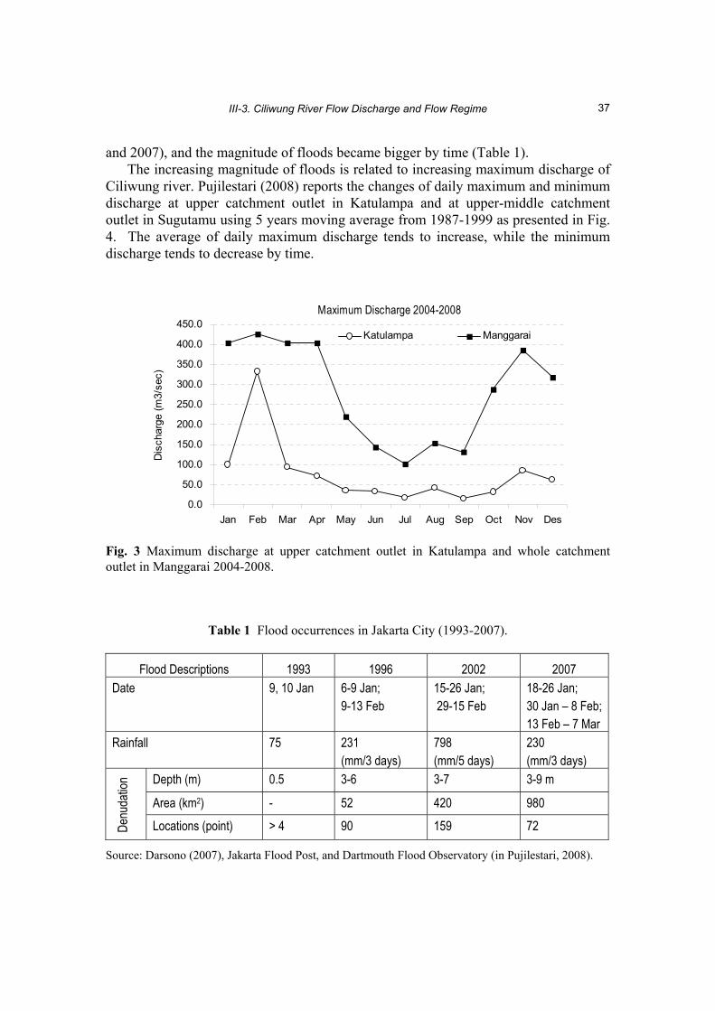
III-3. Ciliwung River Flow Discharge and Flow Regime
37
and 2007), and the magnitude of floods became bigger by time (Table 1). The increasing magnitude of floods is related to increasing maximum discharge of
Ciliwung river. Pujilestari (2008) reports the changes of daily maximum and minimum discharge at upper catchment outlet in Katulampa and at upper-middle catchment outlet in Sugutamu using 5 years moving average from 1987-1999 as presented in Fig. 4. The average of daily maximum discharge tends to increase, while the minimum discharge tends to decrease by time.
Maximum Discharge 2004-2008
0.0
50.0
100.0
150.0
200.0
250.0
300.0
350.0
400.0
450.0
Jan Feb Mar Apr May Jun Jul Aug Sep Oct Nov Des
Dis
char
ge (m
3/se
c)
Katulampa Manggarai
Fig. 3 Maximum discharge at upper catchment outlet in Katulampa and whole catchment outlet in Manggarai 2004-2008.
Table 1 Flood occurrences in Jakarta City (1993-2007).
Flood Descriptions 1993 1996 2002 2007 Date 9, 10 Jan 6-9 Jan;
9-13 Feb 15-26 Jan; 29-15 Feb
18-26 Jan; 30 Jan – 8 Feb; 13 Feb – 7 Mar
Rainfall 75 231 (mm/3 days)
798 (mm/5 days)
230 (mm/3 days)
Depth (m) 0.5 3-6 3-7 3-9 m
Area (km2) - 52 420 980
Denu
datio
n Locations (point) > 4 90 159 72
Source: Darsono (2007), Jakarta Flood Post, and Dartmouth Flood Observatory (in Pujilestari, 2008).

HENDRAYANTO et al.
38
0
50
100
150
200
250
1987
-199
1
1988
-199
2
1989
-199
3
1990
-199
4
1991
-199
5
1992
-199
6
1993
-199
7
1994
-199
8
1995
-199
9
Qmax
(m3/s
ec)
Katulampa Sugutamu
Fig. 4 Average daily maximum discharge at upper catchment outlet in Katulampa and at upper-middle catchment outlet in Sugutamu using 5 years moving average from 1987-1999 (after Pujilestari, 2008).
Yearly average base flow during 30 years (1977-2007) at upper catchment outlet in Katulampa, as well as at upper-middle catchment outlet in Sugutamu tend to increase (Fig. 5). This indicates recharge aquifer decrease, while surface run off decrease.
0
1
2
3
4
5
6
1977
1980
1983
1986
1989
1992
1995
1998
2001
2004
2007
Year
Qbas
eflow
(m3/s
ec)
Katulampa SugutamuLinear (Katulampa) Linear (Sugutamu)
Fig. 5 Base flow change at upper catchment outlet in Katulampa and at upper-middle catchment outlet in Sugutamu (after Pujilestari, 2008).
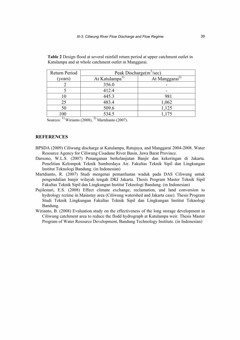
Wirianto (2008) estimate design flood at upper catchment outlet in Katulampa and Martdianto (2007) estimate design flood at whole catchment outlet in Manggarai as presented in Table 2.
III-3. Ciliwung River Flow Discharge and Flow Regime
39
Table 2 Design flood at several rainfall return period at upper catchment outlet in
Katulampa and at whole catchment outlet in Manggarai.
Peak Discharge(m3/sec) Return Period (years) At Katulampa1) At Manggarai2)
2 356.0 - 5 412.4 -
10 445.3 981 25 483.4 1,062 50 509.6 1,125
100 534.5 1,175 Sources: 1) Wirianto (2008), 2) Martdianto (2007).
REFERENCES BPSDA (2009) Ciliwung discharge at Katulampa, Ratujaya, and Manggarai 2004-2008. Water
Resource Agency for Ciliwung Cisadane River Basin, Jawa Barat Province. Darsono, W.L.S. (2007) Penanganan berkelanjutan Banjir dan kekeringan di Jakarta.
Penelitian Kelompok Teknik Sumberdaya Air. Fakultas Teknik Sipil dan Lingkungan Institut Teknologi Bandung. (in Indonesian)
Martdianto, R. (2007) Studi mengenai pemanfaatan waduk pada DAS Ciliwung untuk pengendalian banjir wilayah tengah DKI Jakarta. Thesis Program Master Teknik Sipil Fakultas Teknik Sipil dan Lingkungan Institut Teknologi Bandung. (in Indonesian)
Pujilestari, E.S. (2008) Effect climate exchange, reclamation, and land conversion to hydrology rezime in Mainstay area (Ciliwung watershed and Jakarta case). Thesis Program Studi Teknik Lingkungan Fakultas Teknik Sipil dan Lingkungan Institut Teknologi Bandung.
Wirianto, B. (2008) Evaluation study on the effectiveness of the long storage development in Ciliwung catchment area to reduce the flodd hydrograph at Katulampa weir. Thesis Master Program of Water Resource Development, Bandung Technology Institute. (in Indonesian)

Final Report on Integrated Watershed Management for Sustainable Water Use in a Humid Tropical Region, JSPS-DGHE Joint Research Project 2007-2009
41
III-4. Stable Isotopes of Water in Ciliwung River Watershed Tsutomu YAMANAKA1, Eleonora RUNTUNUWU2, Hidayat PAWITAN3 and Tadashi TANAKA4 1 Terrestrial Environment Research Center, University of Tsukuba, Ibaraki 305-8577, Japan
[email protected] 2 Indonesian Agroclimate and Hydrology Research Institute, Bogor 16111, Indonesia 3 Faculty of Mathematics and Natural Sciences, Bogor Agricultural University, Bogor 16680,
Indonesia 4 Graduate School of Life and Environmental Sciences, University of Tsukuba, Ibaraki 305-
8572, Japan Abstract We reported basic information of hydrogen and oxygen stable isotopes in precipitation, river water and groundwater across Ciliwung river watershed for diagnosing a catchment-scale hydrological cycle. Annual mean of isotope lapse rates (i.e., elevation dependence of isotopic δ values) for precipitation were -1.48 ‰ km-1 for δ18O and -11.6 ‰ km-1 for δD, being considerably smaller than global average reported previously. Isotopic composition of river water and groundwater reflected well this isotopic altitude effect and showed qualitatively differences in residence time and recharge elevation. At lower elevations, residence time is longer and vertical distance from recharge areas is greater. In addition, river water-groundwater interaction at middle elevations is indicated. Key words Isotope, precipitation, river water, groundwater, residence time, recharge zone. INTRODUCTION Stable isotopes of hydrogen (Deuterium; D) and oxygen (18O) comprising a water molecule are useful tracers to reveal terrestrial branch (e.g., Clark and Fritz 1997; Kendall and McDonnell 1998) and atmospheric branch (e.g., Merlivat and Jouzel 1979; Gat 2000; Yamanaka et al. 2002, 2004, 2007) of hydrological cycle. It’s empirically well known that precipitated water tends to be more depleted in heavy isotopes as sampling elevation increases (so-called isotopic “altitude effect”). Based on this nature, some previous studies have revealed recharge elevation of groundwater since isotopic fractionation does not occur during groundwater flow process. Isotopic composition of river water also reflects the altitude effect for precipitation but is more complicated, because river water can be a mixture of precipitated water fallen on to various locations with different elevation and may be changed during flowing downstream by isotopic fractionation due to evaporation and/or isotopic exchange with atmospheric water vapour. However, isotopic composition of river water can potentially provide integrated information concerning hydrological cycle within a watershed.
From the viewpoint mentioned above, we investigated isotopic composition of river water and groundwater throughout Ciliwung river watershed in October 2007 and July 2008. Sampling locations are shown in Fig. 1. At first, for analysing river water

T. YAMANAKA et al.
42
Fig. 1 Map of Ciliwung river watershed and sampling locations for precipitation, river water and groundwater. Streams and sub-catchments were identified by surface hydrology analysis using ArcGIS Spatial Analyst (ESRI Inc.).
isotope, we were planning to use data from GNIP (Global Network for Isotopes in Precipitation, organized by IAEA/WMO; http://www-naweb.iaea.org/napc/ih/GNIP/ IHS_GNIP.html) Jakarta station and global mean value of the altitude effect reported in previous studies (Poage and Chamberlain, 2001; Bowen and Wilkinson, 2002). As

III-4. Stable Isotopes of Water in Ciliwung River Watershed
43
described below, however, we realized that those are not always sufficient for our purpose. Therefore, we newly started monitoring isotopic composition of precipitation from November 2008 to October 2009 at three locations (upstream, middle, and downstream stations in Fig. 1; isotopic analysis for downstream station is not yet completed, so that data only for the other two stations are presented here). Isotope data for all waters herein are reported by δ-notation in permil relative to Vienna Standard Mean Ocean Water (VSMOW; Gonfiatini, 1978). BASIC CHARACETERISITCS OF ISOTOPES IN PRECIPIATION
Meteoric Water Line In general, hydrogen and oxygen isotopic compositions of meteoric water are highly correlated each other and form “meteoric water line” in the δ-diagram (a diagram taking δ18O as horizontal axis and δD as vertical axis). The global meteoric water line (GMWL) defined by Craig (1961) is expressed as δD = 8 δ18O + 10, and local meteoric water line (LMWL) can be obtained by regression analysis of the δ18O-δD relationship for local precipitation, as shown in Fig. 2. The LMWL obtained from GNIP Jakarta data (1962-1997) is δD = 7.47(±0.11) δ18O + 8.0(±0.6) and that from newly monitored data in this study is δD = 7.96(±0.17) δ18O + 15.2(±1.1). The slope and intercept values of these regression lines are significantly different. Thus, meteoric water line seems to have slightly changed in this decade. On the other hand, regression coefficients are not significantly different between upstream and middle stations, indicating that the coefficients are hardly dependent on elevation.
-16 -12 -8 -4 0 4
δ18O (‰)
-100
-80
-60
-40
-20
0
20
δD (‰
)
LMWL: δD = 7.47 δ18O + 8.0 (r2 = 0.95)
-16 -12 -8 -4 0 4
δ18O (‰)
LMWL: δD = 7.96 δ18O + 15.2 (r2 = 0.99)
a) GNIP Jakarta b) This study
Fig. 2 The δ-diagram representation of precipitation isotope data for (a) GNIP data base and (b) this study. A solid line represents local meteoric water line (LMWL) derived from liner regression analysis (r2 is the determination coefficient).

T. YAMANAKA et al.
44
Seasonal Variation of Isotopic Composition The δD and δ18O values tend to be lower in rainy season (from November to April) and higher in dry season (from May to October), while those at the upstream station exhibit a temporal depression in June and July (Fig. 3). The δ values are always lower at the upstream station than at the middle station. Negative correlation between δD (or δ18O) and precipitation amount (so-called “amount effect”) can be found, though it is very weak (Fig. 4). The deuterium excess, d (≡ δD - 8 δ18O), at the middle station is slightly lower than at the upstream station in rainy season and considerably higher in dry season (Fig. 3). However, the amplitude of annual variation and the difference between the upstream and middle stations are nearly equivalent to measurement error in d (±1 ‰).
Nov Dec Jan Feb Mar Apr May Jun Jul Aug Sep Oct
0
200
400
600
800
1000
Pre
cipi
tatio
n (m
m) 10
12
14
16
18
d (‰
)
-10
-8
-6
-4
δ18O
(‰)
-70
-60
-50
-40
-30
-20
-10
δD (‰
)
2008 2009
Upstream
Middle
Fig. 3 Seasonal variations of precipitation δD, δ18O, d, and precipitation amount. Black triangle with solid line represents data obtained at the upstream station, and gray diamond with dashed line at the middle station.
0 200 400 600 800 1000Precipitation (mm)
10
12
14
16
18
20
d (‰
)
-10
-8
-6
-4
-2
δ18O
(‰)
-70
-60
-50
-40
-30
-20
-10δD
(‰)
UpstreamMiddle
Fig. 4 Precipitation amount versus δD, δ18O and d for precipitation.

III-4. Stable Isotopes of Water in Ciliwung River Watershed
45
Altitude Effect Isotope lapse rates, ∆δD and ∆δ18O (i.e., elevation dependence of δD and δ18O, respectively; in ‰ km-1), are generally negative and their variations appear to have a periodicity of a half year with lower values at around both summer and winter solstices (Fig. 4). The global mean ∆δ18O reported by Poage and Chamberlain (2001) is -2.8 ‰ km-1, and that computed by Bowen and Wilkinson (2002) is -2.1 ‰ km-1. The ∆δ18O for the Ciliwung river watershed are less negative than these values, except for June and July. Annual value of ∆δ18O computed using annual mean δ18O weighted by monthly precipitation is -1.48 ‰ km-1, and that of ∆δD is -11.6 ‰ km-1. Seasonal variation of ∆d (i.e., elevation dependence of d) shows a 1-yr periodicity with positive values in rainy season and negative in dry season. Monthly ∆d ranges from -4 to 2 ‰ km-1, and annual value of ∆d is 0.2 ‰ km-1.
Nov Dec Jan Feb Mar Apr May Jun Jul Aug Sep Oct
0
200
400
600
800
1000
Pre
cipi
tatio
n (m
m) -4
-3
-2
-1
0
1
2
∆d (‰
km
-1)
-4
-3
-2
-1
0
∆δ18
O (‰
km
-1)
-40
-30
-20
-10
0
10
∆δD
(‰ k
m-1)
2008 2009
Middle
Upstream
Fig. 5 Seasonal variations of isotopic lapse rates (∆δD, ∆δ18O and ∆d for precipitation) and precipitation amount.
ISOTOPIC ALTITUDE EFFECTS FOR RIVER WATER AND GROUNDWATER δD-δ18O Relationship for River Water and Groundwater Correlation between δD and δ18O for river water is remarkably high, though the slope and intercept values of the regression line are lower than those for LMWL (Fig. 6a). In

T. YAMANAKA et al.
46
addition, these two values are significantly smaller in July 2008 than in October 2007. These results indicate that river water was affected by isotopic enrichment due to evaporation during flowing downstream, and that the effect is more significant in dry season.
For groundwater the δD-δ18O correlation is also high (Fig. 6b) as well as for river water. The slope and intercept values are greater than those for river water at the same time, suggesting that the evaporative enrichment effect is minor for groundwater than for river water. Data with low δ values for both river water and groundwater and for both October 2007 and July 2008 are plotted on the left of LMWL, suggesting that d of river water and groundwater at high elevations are slightly higher than that expected from precipitation isotope data. The reason for this is unclear at present.
-8 -7 -6 -5 -4 -3
δ18O (‰)
-50
-40
-30
-20
-10
δD (‰
)
LMWL
-8 -7 -6 -5 -4 -3
δ18O (‰)
LMWLOctober 2007:δD = 7.16 δ18O + 10.2 (r2 = 0.99)
July 2008:δD = 5.94 δ18O + 0.7 (r2 = 0.99)
July 2008:δD = 6.44 δ18O + 4.7 (r2 = 0.99)
a) River water b) Groundwater
Fig. 6 The δ-diagram representation of isotopic composition of (a) river water sampled in October 2007 (black circle) and July 2008 (gray circle), and (b) groundwater sampled in July 2008 (gray square). A solid line represents LMWL shown in Fig. 2b. Dashed lines are derived from liner regression analysis (r2 is the determination coefficient). Relationship of River Water Isotopic Composition with Sampling Elevation Figure 7 shows relationship of δD, δ18O and d for river water in October 2007 with sampling elevation. In the figure, a solid line represents the relationship for weighted annual mean of precipitation, and a dashed line represents that for weighted mean value during a period of May-September, a half year prior to the sampling (but October samples are not yet analysed). Data For δD and δ18O exhibit a decreasing trend with increasing elevation and are plotted between the solid and dashed lines, excluding some exceptions. Exceptional data are potentially reflection of isotopic peculiarity of rainfall event just antecedent to river water sampling. The d tends to decrease with decreasing elevation. This trend is never expected from precipitation isotope data, indicating greater evaporative enrichment effect at downstream.
The features mentioned above are also found in Fig. 8 showing data in July 2008.

III-4. Stable Isotopes of Water in Ciliwung River Watershed
47
It should be noted that a dashed line in this figure represents the elevation dependence of weighted mean value during a period of February-July instead of May-September. As the difference between annual mean (solid line) and a half year mean (dashed line) for precipitation is small, river water data is distributed within a narrower band than that in October 2007. In addition, evaporative enrichment effect at downstream appears to be more remarkable.
10 12 14 16 18d (‰)
-8 -7 -6 -5 -4 -3
δ18O (‰)-50 -40 -30 -20 -10
δD (‰)
0
200
400
600
800
1000
1200
1400
1600
1800
Sam
plin
g el
evat
ion
(m)
Fig. 7 Sampling elevation versus δD, δ18O and d for river water in October 2007. Solid lines represent the elevation dependence of weighted annual means of precipitation, and dashed lines represent that of weighted means during a period of May-September.
10 12 14 16 18d (‰)
-8 -7 -6 -5 -4 -3
δ18O (‰)-50 -40 -30 -20 -10
δD (‰)
0
200
400
600
800
1000
1200
1400
1600
1800
Sam
plin
g el
evat
ion
(m)
Fig. 8 Same as Fig. 7, but for river water in July 2008, and dashed lines represent the elevation dependence of the weighted means during a period of May-September.

T. YAMANAKA et al.
48
The evaporative enrichment effect can be corrected by the combined use of δD and δ18O (Philips et al., 1986; Yamanaka et al. 2009), as follows,
asabsOsDD mm
o /1/18
−⋅−⋅−
=δδδ , (1)
where subscripts o and m denote original (i.e., non-affected) and measured values, respectively, s is the slope of the evaporation line, and a and b are the slope and intercept of the LMWL, respectively. In this study, a = 7.96 and b = 15.2. The s depends on environmental conditions; in particular, the relative humidity when evaporation occurred. Given the relative humidity is 95, 75 and 50 %, we obtain s = 6.8, 5.2 and 4.5, respectively (Clark and Fritz, 1997). We adopted s = 5.2, since the long-term average of annual mean relative humidity in Bangkok is 78 % (National Astronomical Observatory, Japan, 2004). If getting δDo, one can estimate δ18Oo using the equation of LMWL and then calculate do. In some cases where river water data are plotted on the left of LMWL in the δ-diagram, we didn’t make this correction since negligible evaporative enrichment is expected.
Figures 9-10 show the elevation dependence of original isotopic compositions. The δDo and δ18Oo at lower elevations in July 2008 are clearly lower than those expected from precipitation isotopes, suggesting the “catchment effect” (Dutton et al., 2005); river water is a mixture of precipitation fallen onto upstream catchment higher than the sampling location.
10 12 14 16 18d (‰)
-8 -7 -6 -5 -4 -3
δ18O (‰)-50 -40 -30 -20 -10
δD (‰)
0
200
400
600
800
1000
1200
1400
1600
1800
Sam
plin
g el
evat
ion
(m)
Fig. 9 Same as Fig. 7, but for river water in October 2008 with the evaporative enrichment correction.

III-4. Stable Isotopes of Water in Ciliwung River Watershed
49
10 12 14 16 18d (‰)
-8 -7 -6 -5 -4 -3
δ18O (‰)-50 -40 -30 -20 -10
δD (‰)
0
200
400
600
800
1000
1200
1400
1600
1800
Sam
plin
g el
evat
ion
(m)
Fig. 10 Same as Fig. 7, but for river water in July 2008 with the evaporative enrichment correction. Relationship of River Water Isotopic Composition with Mean Elevation of Catchment Figure 11 shows relationship of measured isotopic compositions for river water in October 2007 with mean elevation of catchment, and Fig. 12 shows that of corrected, original isotopic compositions. Liner relationship with mean elevation of catchment is more remarkable for corrected data (Fig. 12) than for non-corrected data (Fig. 11). In Fig. 12, many plots are situated along δD (or δ18O) -elevation line for a half year period prior to sampling, while some plots are situated close to the line for the annual mean. Such difference may reflect difference in residence time.
Similar diagrams are given as Figs. 13-14, but for river water in July 2007. Non-corrected isotope data exhibit a great deviation from precipitation data (Fig. 13), whereas corrected data are in very good agreement with precipitation data (Fig. 14). The corrected data suggest longer residence time at lower reach of the river, although the estimation error of original isotopic compositions is not always negligible.

T. YAMANAKA et al.
50
10 12 14 16 18d (‰)
-8 -7 -6 -5 -4 -3
δ18O (‰)-50 -40 -30 -20 -10
δD (‰)
0
200
400
600
800
1000
1200
1400
1600
1800
Mea
n el
evat
ion
of c
atch
men
t (m
)
Fig. 11 Mean elevation of catchment for each sampling location versus δD, δ18O and d for river water in October 2007. Solid lines represent the elevation dependence of weighted annual means of precipitation, and dashed lines represent that of weighted means during a period of May-September, same as in Fig. 7.
10 12 14 16 18d (‰)
-8 -7 -6 -5 -4 -3
δ18O (‰)-50 -40 -30 -20 -10
δD (‰)
0
200
400
600
800
1000
1200
1400
1600
1800
Mea
n el
evat
ion
of c
atch
men
t (m
)
Fig. 12 Same as Fig. 11, but for river water in October 2007 with the evaporative enrichment correction.

III-4. Stable Isotopes of Water in Ciliwung River Watershed
51
10 12 14 16 18d (‰)
-8 -7 -6 -5 -4 -3
δ18O (‰)-50 -40 -30 -20 -10
δD (‰)
0
200
400
600
800
1000
1200
1400
1600
1800
Mea
n el
evat
ion
of c
atch
men
t (m
)
Fig. 13 Same as Fig. 11, but for river water in July 2008.
10 12 14 16 18d (‰)
-8 -7 -6 -5 -4 -3
δ18O (‰)-50 -40 -30 -20 -10
δD (‰)
0
200
400
600
800
1000
1200
1400
1600
1800
Mea
n el
evat
ion
of c
atch
men
t (m
)
Fig. 14 Same as Fig. 11, but for river water in July 2008 with the evaporative enrichment correction. Relationship of Groundwater Isotopic Composition with Sampling Elevation Figures 15-16 show relationship of non-corrected and corrected isotopic compositions for groundwater in July 2008 with sampling elevation, respectively. Non-corrected d values at downstream suggest clearly the effect of evaporative enrichment. The effect is smaller than that for river water in July 2008, though it is not negligible.
Corrected δD and δ18O are almost identical to those of precipitation, suggesting that groundwater at higher elevations (e.g., > 200 m) are recharged at a zone with almost same elevation. At Jakarta with lower elevations, however, corrected δD and δ18O are somewhat lower than those of precipitation there, indicating such groundwater was recharged at higher elevations, for instance, from 100 to 600 m.

T. YAMANAKA et al.
52
These elevations are nearly identical to the mean elevation of catchment for rivers there. This fact suggests that groundwater at lower elevations is potentially recharged by not only direct infiltration at the ground surface but also seepage from rivers at alluvial fans. Moderate evaporative-enrichment effect found for groundwater may be a reflection of contribution from both less affected infiltration and highly affected river seepage.
It is noticeable that corrected δD and δ18O become close to dashed line than to solid line with increasing elevation. This suggests that residence time of groundwater becomes shorter as the elevation increases.
10 12 14 16 18d (‰)
-8 -7 -6 -5 -4 -3
δ18O (‰)-50 -40 -30 -20 -10
δD (‰)
0
200
400
600
800
1000
1200
1400
1600
1800
Sam
plin
g el
evat
ion
(m)
Fig. 15 Sampling elevation versus δD, δ18O and d for groundwater in July 2008. Solid lines represent the elevation dependence of weighted annual means of precipitation, and dashed lines represent that of weighted means during a period of May-September.
10 12 14 16 18d (‰)
-8 -7 -6 -5 -4 -3
δ18O (‰)-50 -40 -30 -20 -10
δD (‰)
0
200
400
600
800
1000
1200
1400
1600
1800
Sam
plin
g el
evat
ion
(m)
Fig. 16 Same as Fig. 15, but with the evaporative enrichment correction.

III-4. Stable Isotopes of Water in Ciliwung River Watershed
53
CONCLUDING REMARKS We reported basic information of isotopes in precipitation, river water and groundwater. Annual mean of isotope lapse rate is -1.48 ‰ km-1 for δ18O and -11.6 ‰ km-1 for δD, being considerably smaller than global average reported previously. Results of stable isotope analysis of water showed qualitatively differences in residence time and recharge elevation within Ciliwung river watershed. At lower elevations, residence time is longer and vertical distance from recharge areas is greater. In addition, river water-groundwater interaction at middle elevations is indicated.
To strengthen quantitative aspects of interpretation of the results and improve their accuracy, higher temporal resolution of water sampling is necessary. If we obtain sufficient isotope data, it will be possible to address sub-catchment scale variations and their relation to land use pattern in more details, which are important for better watershed management. Acknowledgements This work was partly funded by JSPS-DGHE Joint Project. The authors are grateful to Prof. Akihiko Kondo, Prof. Nobuhito Ohte, Prof. Ken’ichiro Kosugi, Prof. Hendrayanto, Dr. Robert Delinom, Dr. Kasdi Subagyono for their help in field investigation and valuable discussion. REFERENCES Bowen, G.B. and Wilkinson, B.H. (2002) Spatial distribution of 18O in meteoric precipitation.
Geology, 30(4), 315-318. Clark, I.D. and Fritz, P. (1997) Environmental Isotopes in Hydrogeology. Lewis/CRS Press,
Boca Raton, Florida, USA. 311 p. Craig, H. (1961) Isotopic variations in meteoric waters. Science, 133, 1702-1703. Dutton, A., Wilkinson, B.H., Welker, J.M., Bowen, G.J. and Lohmann, K.C. (2005) Spatial
distribution and seasonal variation in 18O/16O of modern precipitation and river water across the conterminous USA. Hydrol. Processes, 19, 4121-4146.
Gat, J.R. (2000) Atmospheric water balance – the isotopic perspective. Hydrol. Processes, 14, 1357-1369.
Gonfiantini, R. (1978) Standards for stable isotope measurements in natural compounds. Nature, 271, 534-536.
Kendall, C. and McDonnell, J.J. (1998) Isotope Tracers in Catchment Hydrology. Elsevier, Amsterdam, Netherland. 839 p.
Merlivat, L. and Jouzel, J. (1979) Global climatic interpretation of the deuterium-oxygen 18 relationship for precipitation. J. Geophys. Res., 84, 5029-5033.
National Astronomical Observatory, Japan (2004) Rika Nenpyo (Chronological Scientific Tables 2004). Maruzen, Tokyo. 945 p. (in Japanese)
Poage, M.A. and Chamberlain, C.P. (2001) Empirical relationships between elevation and the stable isotope composition of precipitation and surface waters: considerations for studies of paleoelevation change. Am. J. Sci., 301, 1-15.
Philips, F.M., Peeters, L.A. and Tansley, M.K. (1986) Paleoclimatic inferences from an isotopic investigation of groundwater in the central San Juan basin, New Mexico. Quaternary Res., 26, 179-193.
Yamanaka, T., Shimada, J. and Miyaoka, K. (2002) Footprint analysis using event-based isotope data for identifying source area of precipitated water. J. Geophys. Res., 107(D22),

T. YAMANAKA et al.
54
4624, doi10.1029/2001JD001187. Yamanaka, T., Shimada, J., Hamada, Y., Tanaka, T., Yang, Y., Zhang, W. and Hu, Chunsheng
(2004) Hydrogen and oxygen isotopes in precipitation in the northern part of North China Plain: climatology and inter-storm variability. Hydrol. Processes, 18, 2211-2222.
Yamanaka, T., Tsujimura, M., Oyunbaatar, D. and Davaa, G. (2007) Isotopic variation of precipitation over eastern Mongolia and its implication for the atmospheric water cycle. J.Hydrol., 333, 21-34.
Yamanaka, T., Shimada, J., Tsujimura, M., Lorphensriand, O., Mikita, M., Hagihara, A. and Onodera, S. (2009) Tracing of confined groundwater flow system under the pressure of excessive groundwater-use in the Lower Central Plain, Thailand. Hydrol. Processes. (in press)

Final Report on Integrated Watershed Management for Sustainable Water Use in a Humid Tropical Region, JSPS-DGHE Joint Research Project 2007-2009
55
III-5. Effect of Land Use on Spatial and Seasonal Variations of Water Quality in Ciliwung River Eleonora RUNTUNUWU1, Akihiko KONDO2 and Kasdi SUBAGYONO3 1 Indonesian Agroclimatology and Hydrology Research Institute, Bogor 16111, Indonesia
[email protected] 2 Center for Environmental Remote Sensing, Chiba University, Chiba263-8522, Japan 3 Central Java Assessment Institute for Agricultural Technology, Ungaran 50501, Indonesia Abstract Study on water quality aspects of Ciliwung river has been conducted from January 2008 to November 2009 to address the impact of land use change on its seasonal variation. Nitrogen compound of NO2 and NH4 were monitor along the Ciliwung river with different time. Land use change within the Ciliwung watershed was analyzed using remote sensing data and correlate with NO2, NO3, NH4 concentration, conductivity and pH along the river. The results showed that in area with higher populated areas such as found in the middle and downstream area of Ciliwung watershed, NO3 concentration is higher. This obvious variation was also observed for conductivity and pH. It was also observed that the more dense area as in the middle and downstream area the change of land use was obvious. The NO3 concentration is much influenced by land use and vegetation change prior to human activity. In general, NO3 observed on October 2008 was higher compared with that observed on January, April and July 2008. In October where it is rainy season, flushing of NO3 is higher and it was transported into the Ciliwung river. The temporal variation is seem to be due to variation of rainfall generating different runoff and nutrient flushing surrounding river. Key words Water quality, land use, anthropogenic, spatial and seasonal variation, Ciliwung river. INTRODUCTION Recent concern over increased human-induced atmospheric N-deposition, in addition to diffuse source N-inputs to surface waters from agriculture and forestry practices, has stimulated investigations of controls on the biogeochemistry and transport of N. Meanwhile, the hydrologic routing of N from the hillslope through the near-stream zone is relatively unstudied (Cirmo and McDonnel, 1997). This phenomenon has also been studied in the Ciliwung watershed, West Java, Indonesia.
N-losses from the agricultural and forested lands have been reported by many researchers. According to Walton et al. (2000), the removal of chemicals in solution by overland flow from agricultural land has the potential to be a significant source of chemical loss, although the chemical loss can be incorporated with the sediment loss through the erosion. Furthermore, it was identified that the most common chemical loss through the runoff is in the form of solution. A proportion of nitrogen (8 to 80 %) losses in runoff is in solution (Menzel et al., 1978; Hubbard et al., 1982). In-stream processes resulted in net removal of about 17 % of the NO3
- flux from the catchment to the stream (Mulholland and Hill, 1997). In addition, attempt to identify the increase of

E. RUNTUNUWU et al.
56
N in stream water requires a knowledge of N-sources and its pathways from hillslope through the riparian zone within a catchment.
The JSPS-DGHE Joint Research Project titled “Watershed Management for Sustainable Water Resources Development in a Humid Tropical Region” dealt with water quality aspect of Ciliwung river as a part of the activities set up since 2007. The purpose of the project is to clarify what the necessary watershed management should be for sustainable water resources development and water uses with an emphasis on the land use management for water resources conservation and to construct a new model of “Integrated Watershed Management” which will lead the decision making, together with the capacity building and the water governance (Tanaka, 2008). In the second year of the project, water quality study along the Ciliwung river has been the concern to deal with its relation to land use change and human activities.
The objective of the study is to elucidate the relationship between water quality and land use change as well as human activities along the Ciliwung river. The results are used for building up best bet menu of integrated watershed management as water quality is important indicator to identify the change of watershed condition. MATERIALS AND METHODS A total of 41 sampling points were selected along the Ciliwung river from Mount Pangrango at about 3,000 m a.s.l. to the Jakarta coast at 0 m a.s.l. (Fig. 1). Sampling points were divided into three parts, i.e. the upper (17 points), middle (12 points), and lower (12 points) part (Fig. 2). To monitor seasonal variation of the water quality along the river, water sampling has been conducted at the different time of Jan. 08, Apr. 08, Jul. 08, and Oct. 08 to understand the effect of rainfall variation (Fig. 3) on water quality. Besides in situ measurement of pH, temperature, and EC, nitrogen analysis (NH4, NO2, and NO3) will be considered as indicator of water quality as influenced by anthropogenic factor, as will be correlated with population data and land use conditions.
Fig. 1 Transect of Ciliwung river.
Distance (m)
Elev
atio
n (m
asl
)
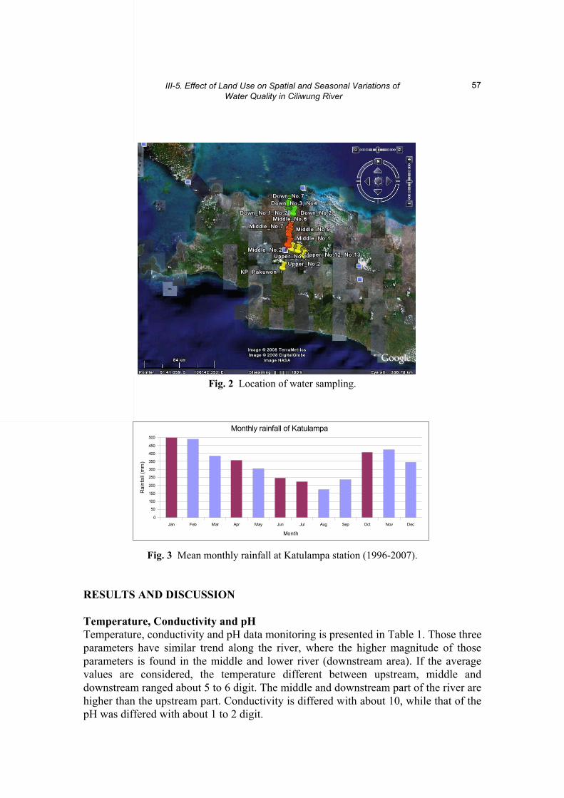
III-5. Effect of Land Use on Spatial and Seasonal Variations of Water Quality in Ciliwung River
57
Fig. 2 Location of water sampling.
Fig. 3 Mean monthly rainfall at Katulampa station (1996-2007). RESULTS AND DISCUSSION Temperature, Conductivity and pH Temperature, conductivity and pH data monitoring is presented in Table 1. Those three parameters have similar trend along the river, where the higher magnitude of those parameters is found in the middle and lower river (downstream area). If the average values are considered, the temperature different between upstream, middle and downstream ranged about 5 to 6 digit. The middle and downstream part of the river are higher than the upstream part. Conductivity is differed with about 10, while that of the pH was differed with about 1 to 2 digit.
Jan Feb Mar Apr May Jun Jul Aug Sep Oct Nov Dec0
50
100
150
200
250
300
350
400
450
500
Monthly rainfall of Katulampa
Month
Rai
nfal
l (m
m)

E. RUNTUNUWU et al.
58
Tabel 1 Temperature, conductivity and PH of water sampling.
Variable Upper Middle Down Min Max Min Max Min Max
Temperature (oC)
19.6 25.2 26.0 29.4 27.1 32.8
Conductivity 0.20 184.0 0.20 192.0 0.20 190.0 (ms/cm) (ms/cm) (ms/cm) (µs/cm) (ms/cm) (µs/cm)
pH 1.9 8.1 4.9 7.4 6.0 7.1
Nitrate (NO3) Concentration NO3 concentration is higher in the middle and downstream area compared with that in upstream area. It is obvious that in area with higher populated areas such as found in the middle and downstream area, NO3 concentration is higher. This is the fact that NO3 concentration is much influenced by human activity. The activity is prior to those affecting land use and vegetation. In populated area, disturbance of land use and vegetation by converting forest into agricultural land and other uses. In upland-urban area as found in Bogor regency area, NO3 concentration was observed at the highest level among the area in Ciliwung watershed. At the area with tea plantation and secondary crops, NO3 concentration was the lowest level.
It did not only vary spatially, the NO3 concentration also varies with time. The data observed on January, April, July and October 2008 shows very significantly the difference between those dates. In general, NO3 observed on October 2008 was higher compared with that observed on January, April and July 2008. In October where it is rainy season, flushing of NO3 is higher and it was transported into the Ciliwung river. NH4 Concentration In general, NH4 concentration in river water at the lower area was higher compared with those at the upper and middle areas. The temporal variation of NH4 concentration was obvious at the lower area compared with that at the upper and middle areas. In the upper area its concentration at 8 sampling point was significantly higher compared that at other sampling points.
Temporal variation of NH4 concentration at the middle area was not obvious except at 18-22 sampling points. The variation of NH4 concentration at lower areas seems to be due to human activities either directly or indirectly through the disturbance to land use. The disturbance of land use due to human activities is in function of population density meaning that the more dense population the more NH4 are flushed to the river and cause its concentration in the river water increase.

III-5. Effect of Land Use on Spatial and Seasonal Variations of Water Quality in Ciliwung River
59
Fig. 4 NO3 concentration at (a) up stream, (b) middle stream and (c) down stream area of the Ciliwung river.
(c)DOWNSTREAM OF CILIWUNG
0
1
2
3
45
6
7
8
9
30 31 32 33 34 35 36 37 38 39 40 41
NO3
(ppm
)
Jan-08 Apr-08 Jul-08 Oct-08
Urban (Jakarta)
MIDDLE AREA OF CILIWUNG
0
1
23
4
5
67
8
9
18 19 20 21 22 23 24 25 26 27 28 29
NO3
(ppm
)
Jan-08 Apr-08 Jul-08 Oct-08
Urban (Bogor & Depok)
(b)
UPPER AREA OF CILIWUNG
0
12
3
45
6
78
9
1 2 3 4 5 6 7 8 9 10 11 12 13 14 15 16 17
NO3
(ppm
)
Jan-08 Apr-08 Jul-08 Oct-08
Tea plantation Upland, urban (Bogor) Urban (Bogor)Crop secondary
(a)
(C)

E. RUNTUNUWU et al.
60
Fig. 5 NH4 concentration at (a) up stream, (b) middle stream and (c) down stream area of the Ciliwung river.
U P P E R A R E A O F C IL IW U N G
0 ,0
0 ,5
1 ,0
1 ,5
2 ,0
2 ,5
3 ,0
3 ,5
1 2 3 4 5 6 7 8 9 10 11 12 13 14 15 16 17
NH4
(ppm
)Jan -08 A p r-08 Ju l-08 O c t -08
Tea plantation Upland, urban (Bogor) Urban (Bogor)Crop secondary
M ID D L E A R E A O F C IL IW U N G
0 ,0
0 ,5
1 ,0
1 ,5
2 ,0
2 ,5
3 ,0
3 ,5
18 19 20 21 22 23 24 25 26 27 28 29
NH
4 (p
pm)
Jan -08 A p r-08 Ju l-08 O c t -08
Urban (Bogor & Depok)
D O W N S T R E A M O F C IL IW U N G
0 ,0
0 ,5
1 ,0
1 ,5
2 ,0
2 ,5
3 ,0
3 ,5
30 31 32 3 3 34 35 36 37 38 39 40 41
NH4
(ppm
)
Jan -08 A p r-08 Ju l-08 O c t -08
Urban (Jakarta)
(a)
(b)
(c)

III-5. Effect of Land Use on Spatial and Seasonal Variations of Water Quality in Ciliwung River
61
Fig. 6 NO2 concentration at (a) up stream, (b) middle stream and (c) downs stream area of the Ciliwung river.
U P P E R AR E A O F C IL IW U N G
0 ,0
0 ,1
0 ,2
0 ,3
1 2 3 4 5 6 7 8 9 10 1 1 12 13 14 15 16 17
NO
2 (p
pm)
Jan -08 A p r-08 Ju l-08 O c t -08
Tea plantation Upland, urban (Bogor) Urban (Bogor)Crop secondary
M ID D L E A R E A O F C IL IW U N G
0 ,0
0 ,1
0 ,2
0 ,3
18 19 20 21 22 23 24 25 26 27 28 29
NO
2 (p
pm)
Jan -08 A p r-0 8 Ju l-08 O c t -08
Urban (Bogor & Depok)
D O W N S T R E A M O F C IL IW U N G
0 ,0
0 ,1
0 ,2
0 ,3
3 0 31 3 2 3 3 3 4 3 5 36 3 7 3 8 3 9 4 0 4 1
NO
2 (p
pm)
Ja n -08 A p r-08 Ju l-08 O c t -0 8
Urban (Jakarta)
(a)
(b)
(c)

E. RUNTUNUWU et al.
62
Fig. 7 Relationship between NO3 and runoff at the Ciliwung watershed.
Fig. 8 Seasonal distribution of NO3 in relation to Katulampa rainfall.
Jan Feb Mar Apr May Jun Jul Aug Sep Oct Nov Dec0
50
100
150
200
250
300
350
400
450
500
Monthly rainfall of Katulampa
Month
Rainfall (mm)
Jan-08
0
1
2
3
4
5
6
7
8
9
1 5 9 13 17 21 25 29 33 37 41
NO3
Apr-08
0
1
2
3
4
5
6
7
8
9
1 5 9 13 17 21 25 29 33 37 41
NO3
Jul-08
0
1
2
3
4
5
6
7
8
9
1 5 9 13 17 21 25 29 33 37 41
NO3
Oct-08
0
1
2
3
4
5
6
7
8
9
1 5 9 13 17 21 25 29 33 37 41
NO3Rainy
season
TransitionDry
season
July 2008
NO3 = 0.0009 Q + 1.0706
R2 = 0.14
0
0.5
1
1.5
2
2.5
0 200 400 600 800 1000
Runoff (m3/s)
NO
3 Con
cent
ratio
n (p
pm)
October 2008
NO3 = 0.0015 Q + 0.9066
R2 = 0.90
0
0.5
1
1.5
2
2.5
0 200 400 600 800 1000
Runoff (m3/s)
NO
3 Con
cent
ratio
n (p
pm)
January 2008
NO3 = 0.0019 Q + 0.4098
R2 = 0.57
0
0.5
1
1.5
2
2.5
0 200 400 600 800 1000
Runoff (m3/s)
NO
3 Con
cent
ratio
n (p
pm) April 2008
NO3 = 0.0012 Q + 0.4693
R2 = 0.16
0
0.2
0.4
0.6
0.8
1
1.2
1.4
1.6
1.8
2
0 200 400 600 800 1000
Runoff (m3/s)
NO
3 Con
cent
ratio
n (p
pm)

III-5. Effect of Land Use on Spatial and Seasonal Variations of Water Quality in Ciliwung River
63
Fig. 9 Population by sub-district along the Ciliwung river. NO2 Concentration Spatial and temporal Variation of NO2 concentration was more obvious compared with that of NO3 and NH4 concentration. Spatially NO2 concentration varies at upper, middle and lower areas despite the magnitude of variation was obviously different. Land use and population density are assumed to be the most factors influencing the variation. In urban area such as it was found in the upper, middle and lower areas within the watershed, the variation of NO2 concentration was significantly varies. NO3 Concentration vs Runoff NO3 concentration increased with the increase of runoff meaning that NO3 was transported by water flow during runoff process. This is the fact that NO3 is transported through water flow. The higher the flow the higher the transported NO3 will be. It also means that NO3 is easily transported by water flow during runoff process. The data on January and October 2008 showed very clearly that the relationship between NO3 concentration and runoff is obvious, as it is respectively shown by R2 = 0.57 and R2 = 0.90. Although R2 are low, it was shown a positive relationship between NO3 concentration and runoff. This data provides insight that NO3 was flushed during runoff process and discharged into the Ciliwung river.
Depending upon the NO3 concentration which is much affected by human activity, the magnitude of flushed NO3 varies with area. The Middle and downstream areas have higher NO3 concentration and provides contribution to the magnitude of NO3 to be transported into the river. As NO3 is mobile, it is easily to transport by water flow during runoff process. CONCLUSIONS From water quality data and the analysis on relationship between runoff and water
‐
5 0
1 0 0
1 5 0
2 0 0
2 5 0
3 0 0
3 5 0
4 0 0
4 5 0
1 2 3 4 5 6 7 8 9 1 0 1 1 1 2 1 3 1 4 1 5 1 6 1 7 1 8 1 9 2 0 2 1 2 2 2 3 2 4 2 5 2 6 2 7
Po
pu
lati
on
in
th
ou
san
ds
1 9 9 0 2 0 0 0 2 0 0 6
Kab Bogor Kota Bogor Depok Jakarta

E. RUNTUNUWU et al.
64
quality, it can be concluded that: ・Human activity and land use are most dominant factors influencing water quality
variation along the Ciliwung river, west Java, Indonesia. The dynamic behaviour of the variation of water quality at the middle and lower areas of Ciliwung river is much influenced by those factors.
・Since it was not any measurement of runoff inland especially at each area of upper, middle and lower part of the watershed, the river flow at each area is used and it is found that NO3, NH4, NO2 concentration have good correlation with the river flow.
Acknowledgements This study is conducted as a Joint Research Project between JSPS (Japan Society for the Promotion of Sciences) and DGHE (the Directorate General of Higher Education, Indonesia) for the period of April 2007 to March 2010. Some of the results presented take the benefits of previous and on going research activities of each team members that were financially supported by various sources. REFERENCES Cirmo, C.P. and McDonnell, J.J. (1997) Linking the hydrologic and biogeochemical controls
of nitrogen transport in near-stream zones of temperate-forested catchment: a review. J. Hydrol., 199, 88-120.
Hubbard, R.K., Erickson, A.E., Ellis, B.G. and Wolcott, A.R. (1982) Movement of diffuse source pollutants in small agricultural watersheds of the Great Lake Basin. J. Environ. Qual., 11, 117-123.
Lubis, R.F., Sakura, Y. and Delinom, R. (2008) Groundwater recharge and discharge processes in the Jakarta groundwater basin, Indonesia. Hydrogeology J., 16(5), 927-938.
Menzel, R.G., Rhodes, E.D., Olness, A.E. and Smith, S.J. (1978) Variability of annual nutrient and sediment discharges in runoff from Oklahoma cropland and rangeland. J. Environ. Qual., 7, 401-406.
Mulholland, P.J. and Hill, W.R. (1997) Seasonal patterns in streamwater nutrient and dissolved organic carbon concentrations: Separating catchment flow path and in-stream effects. Water Resour. Res., 33, 1297-1306.
Pawitan, H. ed. (2008) (Draft) Proceedings of Int’l Workshop on Water Governance in Indonesia, JSPS-DGHE Joint Research Project, IPB Campus-Dramaga, July 23, 2008.
Pawitan, H., Subagyono, K. Runtunuwu, E., Hendrayanto and Delinom, R.M. (2008) Sustainable watershed resources management in humid tropical region: The case of Cicatih-Cimandiri basin, West Java. In: Kamaruddin, A., Wijaya, C.H. and Fahrudin, M. eds. (2008) JSPS-DGHE Joint Research Project 2005-2008 Compilation of Research Results, DGHE-RI, 22-32.
Tanaka, T. ed. (2008) Proceedings of Int’l Workshop on Integrated Watershed Management for Sustainable Water Use in a Humid Tropical Region, Tsukuba-Japan, 31 October, 2007. Bulletin of TERC, University of Tsukuba No 8, Supplement No. 2, 78p.
Walton, R.S., Volker, R.E., Bristow, K.L. and Smettem, K.R.J. (2000) Solute transport by surface runoff from low-angel slopes: theory and application. Hydrol. Process., 14, 1139-1158.

Final Report on Integrated Watershed Management for Sustainable Water Use in a Humid Tropical Region, JSPS-DGHE Joint Research Project 2007-2009
65
III-6. Stable Isotope of Nitrate in Ciliwung River Nobuhito OHTE1, Yuhya WATANABE1, Chikage YOSHIMIZU2, Akihiko KONDO3, Eleonora RUNTUNUWU4, Tsutomu YAMANAKA5
and Tadashi TANAKA5
1 Graduate School of Agricultural and Life Sciences, University of Tokyo, Tokyo 113-8657,
Japan [email protected]
2 Center for Ecological Research, Kyoto University, Ohtsu 520-2113, Japan 3 Center for Environmental Remote Sensing, Chiba University, Chiba 263-8522, Japan 4 Indonesian Agroclimate and Hydrology Research Institute, Bogor 16111, Indonesia 5 Terrestrial Environment Research Center, University of Tsukuba, Ibaraki 305-8577, Japan Abstract To clarify the origins of dissolved nitrate (NO3
-) in the Ciliwung river flowing through the western part of Java Island, Indonesia, river transect sampling was conducted. The δ15NNO3 was significantly positively correlated with the population density of each catchment. A mass balance model assuming the δ15NNO3 and the flow rate of sewage effluent was developed. The model simulated the relationship between the population density and the δ15NNO3 reasonably well, suggesting that the dominant source contributing to the increase in δ15NNO3 was the sewage effluent. This study demonstrated that multi-scale investigation is a promising strategy for describing the spatial distribution of NO3
- sources synoptically, and useful for evaluating the influences of land use and human impact. Key words Nitrate isotopes, Ciliwung river, anthropogenic nitrogen input, sewage, denitrifier method. INTRODUCTION Anthropogenic nitrogen supply to natural ecosystems has increased nitrogen loads in many rivers (e.g., Paces, 1982; Turner and Rabalais, 1991; Goolsby, 2000). Atmospheric deposition is a major pathway of anthropogenic inorganic nitrogen loading into terrestrial ecosystems (Galloway et al., 1995; Galloway and Cowling, 2002). Other major sources of environmental nitrogen are fertilizers and wastewater discharged from farms and livestock facilities, and sewage from residential areas which leak into rivers. Excess nitrate (NO3
-) and ammonium (NH4+) can lead to
eutrophication of rivers, lakes and estuaries, often accompanied by extreme algal blooms (Reynolds and Descy, 1996; Anderson et al., 2002; Rabalais, 2002).
A load-factor method (calculating the cumulative load using a previously determined load per unit area and unit time: load factor for each type of land use) has often been used to estimate nitrogen load. To estimate nitrogen load from each type of land use and evaluate in-stream biogeochemical processes in river systems, a mass balance approach is used based on the concentrations of various nitrogen compounds and discharge rates (Allan, 1995; Kalff, 2001; Ohte et al., 2007). However, there are many uncertainties in the calculation of load factors for various land uses, because the

N. OHTE et al.
66
nitrogen load in rivers generally depends on multiple terrestrial factors (e.g., hydrology, geomorphology and land use) as well as in-stream biogeochemical processes.
The isotope composition of nitrogen compounds can provide more detailed insight into nitrogen transport and transformation dynamics in catchment and river systems (Kendall, 1998). As anthropogenic nitrate originating from wastewaters and fertilizers has a unique range of d15N values (e.g., Kreitler, 1983 for animal waste; Kohl et al., 1971; Shearer et al., 1974 for fertilizers), the isotope tracer technique is useful particularly for assessing nitrogen pollutions in rivers and lakes. In several cases in North America, for example, a positive correlation has been found between the dissolved inorganic nitrogen concentration or the ratio of waste water contributions, and the d15N of various nitrogen compounds including NO3
-, particulate organic matter and tissues of organisms (e.g., Valiera et al., 2000; Lake et al., 2001; Carmichael et al. 2004).
Particularly for NO3- in rivers, lakes and reservoirs, sources and transformations of
nitrogen have been inferred from isotope measurements, since in temperate regions NO3
- plays an extremely important role in the nutrient cycle and flow within and among ecosystems.
Several previous studies have investigated NO3- source variations for
geographically or environmentally distinct rivers, mainly in North America; using both the δ15N and δ18O of dissolved NO3
- (hereafter denoted as δ15NNO3 and δ18ONO3, respectively) (e.g., Chang et al., 2002; Mayer et al., 2002; Rock and Mayer, 2004). These studies showed that the NO3
- produced by microbial nitrification in natural soils has relatively low δ15NNO3 values, and it is found in stream water from forests and natural grasslands mostly in headwaters. Thus, these concentrations and isotope compositions of NO3
- are treated as background values. The major factors of increasing δ15NNO3 values are denitrification and the inputs of human sewage and animal waste (Bohlke et al., 1995; Mayer et al., 2002; Rock and Mayer, 2004; Sebilo et al., 2006). On the other hand, nitrogen fertilizer is the major source of river NO3
- from agricultural land without dairy farming (Townsend-Small et al., 2007). Since synthetic fertilizers including NH4
+ produced from atmospheric nitrogen have a δ15N of 0 ± 3 ‰ (Kohl et al., 1971), NO3
- originating from fertilizers does not elevate the δ15NNO3 value of stream NO3
-, while NO3- originating from sewage or animal
wastewater increases δ15NNO3 remarkably. It is generally difficult to distinguish the impact of sewage and animal waste when both wastewaters flow into a river. To evaluate the relative contributions of these inputs, additional geographical information such as land-use characteristics of a target catchment is needed (Chang et al., 2002), and other additional isotope information (e.g., boron isotope composition) is used as a tracer for human waste (Widory et al., 2005). Moreover, denitrification in riverbed sediments adjacent to riparian zones and/or groundwater bodies increases the δ15NNO3 value of stream NO3
- (McMahone and Bohlke, 1996; Panno et al., 2001; Sebilo et al., 2003; Townsend-Small et al., 2007; Nishikawa et al., 2009).
The Ciliwung river is one of the major rivers in the Java Island, and originates at the Mount Skabumi in the western part of Java, eventually flowing into the Java Sea. In the Ciliwung River Basin, there is a forested mountainous part in the headwater, urbanized Bogor city area in the middle part, and heavily urbanized Jakarta metropolitan area at the lower most part of the catchment. Details of geographical

III-6. Stable Isotope of Nitrate in Ciliwung River
67
characteristics of the Ciliwung river and its basin are described in the chapter written by Runntunuwu et al. in this volume. The purposes of this report are to elucidate the factors controlling NO3
- concentration in the Ciliwung river, and to evaluate the impact of human activities. For the above purposes, we conducted a river transect survey from headwater in Gunung Pangrango to the river mouth to the Java Sea. METHODS Sampling Design River transect surveys were conducted in July 2008. Samples were collected along the rivers from the headwaters to the mouths, including several tributaries. A collection bucket was used to sample water near the surface, and samples were collected as far as possible from the bank. Sampling locations and altitudes are summarized in Table 1. Human population density and forest coverage of each catchment area at the sampling points are also presented in Table 1. Groundwaters were also sampled at several locations mostly near to the sampling points for river waters.
Table 1 Altitude of sampling sites and human population density of the catchment area at each sampling point.
Chemical and Isotopic Analysis The NO3
- concentrations of water samples were measured using an ion chromato- graphy (IC10A, Shimadzu, Kyoto Japan) at the Laboratory of Forest Hydrology and
Site code Altitude (m) Human populationdensity (ind. km-1)
Riverine
u0 1226 - u0' 1151 0 u3 1139 0 u1 1105 76.8 u4 1062 46.9 u5 650 38.5 u7 482 253.7 u9 358 1062.3 m1 262 1994.5 m6 91 4415.6 d-1 25 6954.4 d-1' 25 - d0 20 6954.4 d1 12 - d8 0 - Groundwater u-1 1381 u2 1105 u6 650 u8 360 u10 358 m2 262 m5 91 d0' 20 d2 12

N. OHTE et al.
68
Erosion Control Engineering, Department of Forest Science, University of Tokyo, after filtration with 0.2-µm-membrane syringe filters.
Frozen aliquots were stored, thawed, and analyzed for the δ15NNO3 and δ18ONO3 using the microbial denitrifier method (Sigman et al., 2001; Casciotti et al., 2002) at the stable isotope laboratory of CER, Kyoto University. Cultured denitrifying bacteria (Pseudomonas chlororaphis f. sp. aureofaciens (ATCC 13985)) were used to convert NO3
- to N2O for measuring isotopic composition. A minimum of 30 nmol NO3- was
needed to analyze samples on a stable isotope mass spectrometer (Delta Plus XP, Thermo Fisher Scientific). Isotopic data of NO3
- were calibrated using USGS34, USGS35 (Böhlke et al., 2003), and an internal KNO3 laboratory standard calibrated at the United States Geological Survey, Stable Isotope Laboratory in Menlo Park, California. Measurements were within ±0.14 ‰ for δ15NNO3 and ±0.66 ‰ for δ18ONO3 of an internal KNO3 laboratory standard.
The N and O stable isotope ratios are expressed in the following generally accepted delta notation as d values in parts per thousand (‰);
δsample(‰) = ((Rsample – Rstandard) / Rstandard) × 1000 (1)
where R is the 15N/14N or 18O/16O ratio of NO3
- of a sample and the standard. The δ15NNO3 values are reported relatively to air, and the δ18ONO3 values are reported relatively to V-SMOW. RESULTS The NO3
- concentration of river water was lowest (21.1 µM) at the uppermost sampling point in the forest headwater, and did not always increase monotonically. It was high (152.4 µM) in the upper middle part of the entire river transect where the urban drainage from the Bogor metropolitan area affected the river NO3
- concentration.
Fig. 1 NO3- concentrations of river and groundwater plotted to
the altitude of each sampling point.

III-6. Stable Isotope of Nitrate in Ciliwung River
69
Fig. 2 δ15NNO3 (right) and δ18ONO3 (left) of river and groundwater plotted to the altitude of each sampling point. There was large heterogeneity in the NO3
- concentration of the groundwater samples, showing no consistent tendency along the riverine transect (Fig. 1). δ15NNO3 was also lowest at the uppermost reach (1.0 ‰), and increased slowely up to 12.0 ‰ at the lowest pont of the river. The δ15NNO3 values of groundwaters were distributed heterogeneously, but were relatively high in the downstream areas (Fig.2). While all δ18ONO3 values of the river waters fell into the range from +2 to -2 ‰, the δ18ONO3 of groundwaters were distributed heterogeneously and relatively high in the down stream areas like as those of the δ15NNO3 values (Fig. 2). DISCUSSION Sources of NO3
- in Ciliwung River In order to discuss the sources of river NO3
-, several geographical parameters, such as human population density, percentages of various land use areas are examined their correlation with NO3
- concentration and δ15NNO3 value. Fig. 3 shows the relationships between the human population density of catchment area at each sampling point and the river NO3
- concentration and the δ15NNO3 value. Both the concentration and δ15NNO3 increased with the human population density, especially the correlation between the human population density and δ15NNO3 was significant. These suggest that the major impact on the NO3
- concentration and δ15NNO3 in river waters was sewage loading.
To examine this interpretation and evaluate its impact quantitatively, the following simple mass balance model was used to simulate the relationship between human population density and the NO3
- concentrations and δ15NNO3; CR = (CS QS + CB QB)/(QS + QB) (2)
δ15NR = (CSQS δ15NS + CBQBδ15NB) / (CSQS + CBQB) (3)

N. OHTE et al.
70
where CR, CS, and CB are the NO3- concentrations at the River mouth, in treated human
Sewage, and in Background river water, respectively; δ15NR, δ15NS, and δ15NB are the δ15NNO3 values at the river mouth, in treated human sewage, and in background river water, respectively. QS and QB are the discharge rates of sewage effluent and background river flow, respectively, which can be obtained as follows;
QS = DS P (4)
QB = QT – QS (5)
where DS and QT are the human sewage discharge per person and the total discharge, respectively, and P is the human population density. The model was applied to the observed δ15NNO3 in the river transect survey in order to examine the importance of population density as an explanatory factor of the δ15NNO3 in river water. For QT we assumed a typical daily average river discharge of 3.0 mm day-1 (= 3000 kL day-1km-2), which was roughly estimated from the mean annual precipitation of the Ciliwung river basin. Daily human sewage discharge per person (DS) was assumed to be 0.032 kL day-1 individual-1 by trial and error approach. The parameters CS, CB, δ15NS and δ15NS were also tuned using the least-square method to maximize the correlation between the predicted and measured δ15NR as a function of the population density (P), and using some trial error approach.
Curves in Fig. 3 presents the simulated relationships between P and NO3–
concentration and between P and δ15NR using the optimum parameters. The calibrated parameters were 3200 µM for CS, 40 µM for CB, 12 ‰ for δ15NS and 6 ‰ for δ15NB, respectively. For the NO3
– concentration and δ15NNO3 level in the upper reaches, the calibrated CB and δ15NB were sufficiently realistic (Fig. 3).
Although no data on the CS and δ15NS in human sewage were available for the study area, the calibrated CS fell within the reasonable range according to previous reports in Indonesia (Subagyono, personal communication).
Fig. 3 Relationships between human population density and NO3
- concentration and δ15NNO3. Predicted curve are drawn by the isotopic mass balance model using equations. (2)-(5).

III-6. Stable Isotope of Nitrate in Ciliwung River
71
The value of δ15NS also agree with the reasonable range according to the reports for the δ15NNO3 originated from sewage (Kendall, 1998). These simulations suggest that a simple mixing model is reasonably useful to quantitatively explain the impact of human sewage to particularly the accelerated increase in the δ15NNO3 of river water. The spatial patterns of δ15NNO3 and NO3
- concentration depend strongly on the distribution of population density.
Several previous studies have reported the correlation between human population density and δ15N of various organisms living in rivers and lakes (e.g., Cabana and Rusmussen, 1996; Nishikawa et al., 2009, Ohte et al., 2010). Kohzu et al. (2009) reported similar correlation for the Lake Biwa basin in Japan. Effect of Denitrification The spatial distributions of δ15NNO3 and δ18ONO3 of groundwaters were different from those of river waters. To examine the denitrification effect on the isotopic enrichment in groundwater aquifer, the δ15N-δ18O diagram is useful. There was typical relationship between the δ15NNO3 and δ18ONO3 values of groundwaters (Fig. 4). The line in the Fig. 4 indicates the 2:1 relationship, and is often used as the indicator for isotopic enrichment by denitrification (Kendall, 1998). One river sample from the river mouth was also along the line. These suggest that the NO3
- of groundwater were affected by denitrification, but their degree varied with locations. The factors controlling the impact of denitrification are not clear in this study. More detailed site information will be needed in the future work.
Fig. 4 Relationship between δ15NNO3 and δ18ONO3 of groundwaters and river waters. Solid line indicates 2:1 ratio.
CONCLUDING REMARKS The transect survey in the Ciliwung River showed that the most impactful NO3
- source was human sewage. Similar characteristics have been reported in the Lake Biwa Basin in central Japan (Ohte et al., 2010). In European and American regions, the animal

N. OHTE et al.
72
waste from daily farming and related industry areas is treated as a major controlling factor that increases NO3
- concentration and δ15NNO3 in the river waters in the middle stream of rivers. The cases in this study and Japan are quite typical and symbolic for the Asian countries, because the daily farming is not dominant form of agricultural industry in Asian countries. Clear correlation between the human population density and the δ15NNO3 value indicate this socio geographical feature in Asian countries.
Seasonal variations and more short-term temporal variations of NO3- loading and
biogeochemical dynamics will also be interesting. Further riverine investigations focusing on the nitrogen flow and dynamics are desirable. Acknowledgements This work was partly funded by JSPS-DGHE Joint Project. The authors are grateful to Prof. Ken’ichiro Kosugi, Prof. Hendrayanto, Dr. Robert Delinom, Dr. Kasdi Subagyono for their help in field investigation and valuable discussion. REFERENCES Allan, J.D. (1995) Stream Ecology: Structure and function of running waters. Kluwer
Academic, London. Anderson, D., Glibert, P. and Burkholder, J. (2002) Harmful algal blooms and eutrophication:
Nutrient sources, composition, and consequences. Estuaries and Coasts, 25, 704-726, doi: 710.1007/BF02804901.
Böhlke, J.K., Mroczkowski, S.J. and Coplen, T.B. (2003) Oxygen isotopes in nitrate: new reference materials for 18O:17O:16O measurements and observations on nitrate-water equilibration. Rapid Communications in Mass Spectrometry, 17, 1835-1846.
Böhlke, J.K. and Denver, J.M. (1995) Combined use of groundwater dating, chemical, and isotopic analyses to resolve the history and fate of nitrate contamination in two agricultural watersheds, Atlantic Coastal Plain, Maryland. Water Resources Research, 31, 2319–2339.
Cabana, G. and Rasmussen, J. (1996) Comparison of aquatic food chains using nitrogen isotopes. Proceedings of the National Academy of Sciences of the United States of America, 93, 10844-10847.
Carmichael, R.H., Annett, B. and Valiela, I. (2004) Nitrogen loading to Pleasant Bay, Cape Cod: application of models and stable isotopes to detect incipient nutrient enrichment of estuaries. Marine Pollution Bulletin, 48, 137-143, doi:110.1016/S0025-1326X(1003) 00372-00372.
Casciotti, K.L., Sigman, D.M., Hastings, M.G., Böhlke, J.K. and Hilkert, A. (2002) Measurement of the oxygen isotopic composition of nitrate in seawater and freshwater using the denitrifier method. Analytical Chemistry, 74, 4905-4912, doi: 4910.1021/ ac020113w.
Chang, C.C.Y., Kendall, C., Silva, S.R., Battaglin, W.A. and Campbell, D.H. (2002) Nitrate stable isotopes: tools for determining nitrate sources among different land uses in the Mississippi River Basin. Canadian Journal of fisheries and aquatic sciences, 59, 1874–1885.
Galloway, J.N. and Cowling, E.B. (2002) Reactive nitrogen and the World: 200 Years of Change. Ambio, 31, 64-71.
Galloway, J.N., Schlesinger, W.H., Levy, H., II, Michaels, A. and Schnoor, J.L. (1995) Nitrogen fixation: Anthropogenic enhancement-environmental response. Global Biogeo-chemical Cycles, 9, 227-234, doi: 210.1029/1095GB00158.

III-6. Stable Isotope of Nitrate in Ciliwung River
73
Goolsby, D.A. (2000) Mississippi basin nitrogen flux believed to cause gulf hypoxia. Eos Transactions AGU, 81, 321-327, doi: 310.1029/1000EO00244.
Kalff, J. (2001) Limnology: Inland Water Ecosystems. Prentice-Hall, NJ. Kendall, C. and McDonnell, J.J. (1998) Isotope Tracers in Catchment Hydrology. Elsevier
Science Ltd, Amsterdam. Kohl, D.H., Shearer, G.B. and Commoner, B. (1971) Fertilizer Nitrogen: Contribution to
Nitrate in Surface Water in a Corn Belt Watershed. Science, 174, 1331-1334. Kohzu, A., Tayasu, I., Yoshimizu, C., Maruyama, A., Kohmatsu, Y., Hyodo, F., Onoda, Y.,
Igeta, A., Matsui, K., Nakano, T., Wada, E., Nagata, T. and Takemon, Y. (2009) Nitrogen-stable isotopic signatures of basal food items, primary consumers and omnivores in rivers with different levels of human impact. Ecological Research, 24, 127-136, doi: 110.1007/s11284-11008-10489-x.
Kreitler, C.W. and Browning, L.A. (1983) Nitrogen-isotope analysis of groundwater nitrate in carbonate aquifers: Natural sources versus human pollution. Journal of Hydrology, 61, 285-301.
Lake, J.L., McKinney, R.A., Osterman, F.A., Pruell, R.J., Kiddon, J., Ryba, S.A. and Libby, A. D. (2001) Stable nitrogen isotopes as indicators of anthropogenic activities in small freshwater systems. Canadian Journal of fisheries and aquatic sciences, 58, 870-878, doi:810.1139/cjfas-1158-1135-1870.
Mayer, B., Boyer, E.W., Goodale, C., Jaworski, N.A., van Breemen, N., Howarth, R.W., Seitzinger, S., Billen, G., Lajtha, K., Nadelhoffer, K., Van Dam, D., Hetling, L.J., Nosal, M. and Paustian, K. (2002) Sources of nitrate in rivers draining sixteen watersheds in the northeastern U.S.: Isotopic constraints. Biogeochemistry, 57-58, 171-197, doi: 110.1023/ A:1015744002496.
McMahon, P.B. and Bˆhlke, J.K. (1996) Denitrification and mixing in a stream--aquifer system: effects on nitrate loading to surface water. Journal of Hydrology, 186, 105-128.
Nishikawa, J., Kohzu, A., Boontanon, N., Iwata, T., Tanaka, T., Ogawa, N.O., Ishii, R. and Wada, E. (2009) Isotopic composition of nitrogenous compounds with emphasis on anthropogenic loading in river ecosystems. Isotopes in Environmental and Health Studies, 45, 27-40.
Ohte, N., Dahlgren, R.A., Silva, S.R., Kendall, C., Kratzer, C.R. and Doctor, D.H. (2007) Sources and transport of algae and nutrients in a Californian river in a semi-arid climate. Freshwater Biology, 52, 2476-2493, doi: 2410.1111/ j.1365- 2427.2007.01849.x.
Ohte, N., Tayasu, I., Kohzu, A., Yoshimizu, C., Osaka, K.I., Makabe, A., Koba, K., Yoshida, N. and Nagata, T. (2010) Spatial distribution of nitrate sources of rivers in the Lake Biwa watershed, Japan: Controlling factors revealed by nitrogen and oxygen isotope values. Water Resources Research (in press).
Paces, T. (1982) Natural and anthropogenic fluxes of major elements from Central Europe. Ambio, 11, 206-208.
Panno, S.V., Hackley, K.C., Hwang, H.H. and Kelly, W.R. (2001) Determination of the sources of nitrate contamination in karst springs using isotopic and chemical indicators. Chemical Geology, 179, 113-128.
Rabalais, N.N. (2002) Nitrogen in Aquatic Ecosystems. AMBIO: A Journal of the Human Environment, 31, 102-112.
Reynolds, C.S. and Descy, J.-P. (1996) The production, biomass and structure of phytoplankton in large rivers. Archiv für Hydrobiologie. Supplement-Band, 113, 161-187.
Rock, L. and Mayer, B. (2004) Isotopic Assessment of Sources of Surface Water Nitrate within the Oldman River Basin, Southern Alberta, Canada. Water, Air, and Soil Pollution: Focus, 4, 545-562.

N. OHTE et al.
74
Sebilo, M., Billen, G., Grably, M. and Mariotti, A. (2003) Isotopic composition of nitrate-nitrogen as a marker of riparian and benthic denitrification at the scale of the whole Seine River system. Biogeochemistry, 63, 35-51.
Sebilo, M., Billen, G., Mayer, B., Billiou, D., Grably, M., Garnier, J. and Mariotti, A. (2006) Assessing Nitrification and Denitrification in the Seine River and Estuary Using Chemical and Isotopic Techniques. Ecosystems, 9, 564-577.
Shearer, G., Kohl, D.H. and Commoner, B. (1974) The precision of determinations of the natural abundance of nitrogen-15 in soils, fertilizer, and shelf chemicals. Soil Science, 118, 308-316.
Sigman, D.M., Casciotti, K.L., Andreani, M., Barford, C., Galanter, M. and Böhlke, J.K. (2001) A bacterial method for the nitrogen isotopic analysis of nitrate in seawater and freshwater. Analytical Chemistry, 73, 4145-4153, doi: 4110.1021/ac010088e.
Townsend-Small, A., McCarthy, M., Brandes, J., Yang, L., Zhang, L. and Gardner, W. (2007) Stable isotopic composition of nitrate in Lake Taihu, China, and major inflow rivers. Hydrobiologia, 581, 135-140.
Turner, R.E. and Rabalais, N.N. (1991) Changes in Mississippi River water quality this century. BioScience, 41, 140-147.
Valiela, I., Geist, M., McClelland, J. and Tomasky, G. (2000 ) Nitrogen loading from watersheds to estuaries: Verification of the Waquoit Bay nitrogen loading model. Biogeochemistry, 49, 277-293.
Widory, D., Petelet-Giraud, E., Negrel, P. and Ladouche, B. (2004) Tracking the sources of nitrate in groundwater using coupled nitrogen and boron isotopes: A synthesis. Environmental Science and Technology, 39, 539-548.

Final Report on Integrated Watershed Management for Sustainable Water Use in a Humid Tropical Region, JSPS-DGHE Joint Research Project 2007-2009
75
III-7. Effects of Soil Hydraulic Properties on Rainwater Discharge at the Gunung Walat Educational Forest Ken’ichirou KOSUGI1, Yuki HAYASHI1, Hiroyuki KATO1 and Fukue ITABASHI1 1 Department of Forest Science, Graduate School of Agriculture, Kyoto University, Kyoto
606-8502, Japan [email protected]
INTRODUCTION In recent years, Jakarta city suffers occurrences of flood events which cause a lot of damages on human lives and properties. Some largest floods happened in 1996, 2002, and 2007. While the climate change can be one of the main reasons for the increasing number of flood, land use changes in headwater catchments in Java Island have large effects on the occurrences of flood events. Here, it has been reported that alterations of forested hillslopes to agricultural fields or residential area can bring most dramatic changes in hydrological processes.
The objective of this study is to clarify soil hydraulic properties of a forested hillslope in the Gunung Walat Educational Forest, and to evaluate their effects on storm discharge processes. For this purpose, soil physical observations were combined with numerical simulation analyses. Based on the results, we examine the importance of the forest soils on the disaster prevention and water resource conservation. METHOD Study Site Soil samplings and field monitoring were conducted at the Gunung Walat Educational Forest, in Sukabumi, Java Island. We selected a forested hillslope predominantly covered with Queensland kauri pine (Agathis) planted in 1960s. Soil Sampling and Laboratory Experiments At the studied hillslope, undisturbed soil samples were collected at a point located at middle part of the slope (Fig. 1a). Three undisturbed soil samples were collected using thin-walled steel core samplers with a volume of 100 cm3 (5 cm inner diameter and 5.1 cm height) at each depth of 2.5, 10, 20, 30, 40, 60, 80, and 100 cm (Fig. 1b). A sampler with a sharpened edge was inserted vertically into the soil. Impact energy was applied to the cylinder using a hammer-driven device (DIK-1630, Daiki Rika Kogyo, Tokyo, Japan). To ensure sampling with minimum disturbance, we followed the method for collecting undisturbed soil samples described by Grossman and Reinsch (2002). During the process of insertion, roots and organic material were carefully severed from the soil layer around the sampler.

K. KOSUGI et al.
76
Fig. 1 (a) Vertical soil profile at the sampling site and (b) triplicated soil sampling at each depth.
In the laboratory, soil samples were placed in aluminum trays, slowly saturated by
wetting from the bottom over a 24-h period, and then weighed to determine the saturated water content, θs. Volumetric soil water contents, θ, were then measured using the pressure plate method (Jury et al., 1991) for a matric pressure head, ψ, of –5, –10, –20, –30, –50, –70, –100, –200, –500, and –1000 cm. After measuring the water content at ψ = –1000 cm, the soil samples were resaturated from the bottom over 24 h. The saturated hydraulic conductivity, Ks, of each sample was then measured by the falling head method (Klute and Dirksen, 1986). After the measurement of Ks, each sample was oven-dried to determine the bulk soil density. The analyses described below were performed using average water contents and conductivities of the three replicate samples (each had a volume of 100 cm3) collected at each depth. Monitoring of Rainwater Infiltration and Redistribution Processes Field monitoring of rainwater infiltration and redistribution processes was conducted at a point about 2-m apart from the soil sampling point. Six tensiometers were installed at depths of 2.5, 10, 20, 30, 40, 50 cm below the soil surface and connected to pressure transducers for automated recoding at intervals of 30 to 60 seconds (Fig. 2). At the beginning of the monitoring, an artificial rainfall with intensity of 120 mm/h was applied for 1 h by using electric sprayers. Then, redistribution processes and infiltration processes by natural rainfall were monitored for the following 12 days.
Fig. 2 Tensiometers for monitoring of rainwater infiltration and redistribution processes.
a b

III-7. Effects of Soil Hydraulic Properties on Rainwater Discharge at the Gunung Walat Educational Forest
77
RESULTS Water Retention Curves Figure 3 shows the observed water retention curves. The saturated water content, θs, decreased as soil depth increased, whereas the water content at ψ = –5 cm showed increases as soil depth increased. It was because the rate of change in ψ in the range of –5 < ψ < 0 cm decreased as depth increased. This is to say, the amount of large pores decreased as depth increased.
At the depths of 2.5, 10, 20, and 30 cm, the soils clearly exhibited retention curves with two inflection points. This bimodality of pore size distribution may be the result of the formation of secondary pore systems (macroporosity) by soil genetic processes such as soil aggregation or biological soil-forming (Durner, 1994). For these types of soils, the fitting of a single, sigmoidal retention curve model will be unsatisfactory. Therefore, we applied the following multi-model function to the observed data:
( )[ ] rjjm
J
jjQ θσψψφθ += ∑
=
//ln ,1
(1)
where J is the number of pore systems from which the total pore size distribution is determined, and φi is the weighting factor for each pore system i, subjected to the
constraint that 0 ≤ φi ≤ (θs–θr) and rs
J
jj θθφ −=∑
=1. Here, θs and θr represent the
saturated and residual volumetric water contents, respectively. For a bimodal soil
Fig. 3 Observed soil water retention curves. system, J = 2, and φ1 and φ2 represent porosities of the primary and secondary pore systems, respectively (Fig. 4). The parameters ψm,1 and ψm,2 represent matric pressure heads corresponding to the median pore radii of the primary and secondary pore systems, respectively. Moreover, σ1 and σ2 represent widths of the pore size distributions of the primary and secondary pore systems, respectively.
0.4
0.5
0.6
0.7
1101001000
2.5 10 20
30 40 60
80 100cm
- Matric pressure head ψ (cm)
Vol
umet
ric w
ater
con
tent
θ

K. KOSUGI et al.
78
Fig. 4 Separations among residual, primary, and secondary soil pores. Figure 5 shows that excellent results obtained by fitting the bimodal retention function to the retention data for the soils at the depths of 2.5, 10, 20, and 30 cm. For the soils at the depths of 40, 60, 80, and 100 cm, the simple unimodal function (i.e., Eq. [1] with J = 1) can described the observed data well (Fig. 6). Figure 7 summarized the optimized
Fig. 5 Observed and fitted water retention curves (2.5 to 30 cm deep).
0.4
0.5
0.6
0.7
1101001000
2.5cm
Cal.
Primary φ1
- Matric pressure head ψ (cm)
Vol
umet
ric w
ater
con
tent
θ
Residualθr
Secondaryφ2
0.4
0.5
0.6
0.7
1101001000
2.5cm
Cal.
0.4
0.5
0.6
0.7
1101001000
10cm
Cal.
0.4
0.5
0.6
0.7
1101001000
20cm
Cal.
0.4
0.5
0.6
0.7
1101001000
30cm
Cal.
- Matric pressure head ψ (cm)
Vol
umet
ric w
ater
con
tent
θ
a b
c d

III-7. Effects of Soil Hydraulic Properties on Rainwater Discharge at the Gunung Walat Educational Forest
79
Fig. 6 Observed and fitted water retention curves (40 to 100 cm deep).
Fig. 7 Vertical distributions of the derived soil hydraulic parameters. parameter values. While the total porosity (i.e., the summation of residual, primary, and secondary porosities) increases as the soil depth decreases, the residual porosity decreases as the soil depth decreases (Fig. 7a). The secondary pore systems were formed in the soils shallower than 40-cm depth, and the volume of the secondary pores increased as the soil depth decreases (Fig. 7a). As shown in Fig. 7b, the median pore
0.4
0.5
0.6
0.7
1101001000
40cm
Cal.
0.4
0.5
0.6
0.7
1101001000
60cm
Cal.
0.4
0.5
0.6
0.7
1101001000
80cm
Cal.
0.4
0.5
0.6
0.7
1101001000
100cm
Cal.
- Matric pressure head ψ (cm)
Volu
met
ric w
ater
con
tent
θ
a b
c d
0
10
20
30
40
50
60
70
80
90
100
0 0.1 0.2 0.3 0.4 0.5 0.6 0.7
1101001000
0.001 0.01 0.1 1
Residualθr
Primaryφ1
Secondaryφ2
Soil pore volume ratioMedian poreradius (cm)
Median matric pressurehead ψm (cm)
Dep
th (c
m)
0.0150.0015
Saturated hydraulicconductivity (cm/s)
a b c

K. KOSUGI et al.
80
radius of the secondary pore system increased as the soil depth decreases. Figure 7c clearly shows that the formation of the secondary pore system has large effects on the saturated hydraulic conductivity, Ks; Ks of the soils shallower than 40-cm depth, which includes the secondary pore system, were greater than those of the deeper soils, in which the secondary pore system was not developed, by two to three orders of magnitude. Transient Matric Pressure Data Figure 8 shows the observed hyetograph and changes in the matric pressure heads. When the rainfall intensity increased, the matric pressure heads at shallow depths sharply increased, followed by gradual decrease after cessations of the rainwater supply. Generally, the matric pressure heads at depths exhibited gradual responses.
Fig. 8 Hyetograph and changes in the matric pressure heads. Calculation of Unsaturated Hydraulic Conductivities The matric pressure heads observed for the periods during which the evapotranspiration was negligible (i.e., the periods shown by arrows in Fig. 8) were subsequently used to compute the unsaturated hydraulic conductivities, K, using the conventional instantaneous profile method (Dirksen, 1999). Applying the instantaneous profile method, the observed matric pressure heads were converted into volumetric water contents using the retention functions fitted to the observed data (i.e., Figs. 5 and 6). The derived K-ψ relationships were as shown in Fig. 9.
Then, the following functional relationship was applied to the derived K-ψ data:
( )[ ]σ212 += −ees SQQSKK (2)
where
( )[ ]σψψ //ln me QS = (3)
-225
-200
-175
-150
-125
-100
-75
-50
-25
0
25
7/24 12:00 7/25 0:00 7/25 12:00 7/26 0:00 7/26 12:00 7/27 0:00 7/27 12:00 7/28 0:00 7/28 12:00 7/29 0:00 7/29 12:00 7/30 0:00 7/30 12:00 7/31 0:00
0
10
20
30
40
50
60
70
2.5cm 10cm
20cm 30cm
40cm 50cm
Natural rain
1 2 3 4 5 6
Month/Day hh:mm
Mat
ricpr
essu
re h
ead
ψ(c
m)
Rai
nfal
l (m
m/1
0min
)

III-7. Effects of Soil Hydraulic Properties on Rainwater Discharge at the Gunung Walat Educational Forest
81
Here, the saturated hydraulic conductivities, Ks, were fixed at the observed values, while the parameters ψm and σ were optimized. As shown in Fig. 9, the functional K-ψ relationship exhibited acceptable matches to the observed data.
Fig. 9 Observed and fitted curves for hydraulic conductivity-matric pressure head relationship. NUMERICAL SIMULATION Based on the results of the soil hydraulic property measurements, numerical simulations for saturated and unsaturated water flow were conducted for analyzing rainwater infiltration and discharge processes at a forested hillslope in the Gunung Walat Educational Forest.Two-dimensional Richards' equation was solved numerically by using the finite element method assuming triangle elements. The entire calculation domain is shown in Fig. 10. An assumed storm hyetograph (Fig. 11) was supplied to the soil surface. The measured soil hydraulic properties (i.e., Figs. 5, 6, and 9) were used. We also examined the case that the secondary pore systems were not developed in the soils shallower than 40 cm depth. That is, we assigned the hydraulic properties observed for the soil at the depth of 40 cm to the soils shallower than 40 cm depth (Fig. 12). The no-flux boundary condition was applied to the bottom and the upstream end of the domain. Then, we computed the discharge from the whole slope which consisted of the saturated through flow from soil and overland flow.
Figure 13 shows the computed discharge hydrographs. With the formations of the secondary pore systems (i.e., the thick line in Fig. 13), the discharge started at 5 h, followed by the sharp peaks at 12, 19, 26, 33 h. Without the formation of the secondary pore system (i.e., the thin line in Fig. 13), the discharge rate was smaller until 15 h. This was attributable to the low Ks values of the surface soils (Fig. 12).
1.E-08
1.E-07
1.E-06
1.E-05
1.E-04
1.E-03
1.E-02
1.E-01
-140 -120 -100 -80 -60 -40 -20 0
5cm 15cm
25cm 35cm
45cm Cal.
Cal. Cal.
Cal. Cal.
Matric pressure head ψ (cm)
Hyd
raul
ic c
ondu
ctiv
ity K
(cm
/s)

K. KOSUGI et al.
82
Fig. 10 Domain for the numerical simulation showing the locations of nodes.
Fig. 11 Hyetograph assumed in the numerical simulation.
Fig. 12 Vertical distributions of the soil hydraulic parameters used in the numerical simulation. Thick dotted lines represent the parameters assumed for the case in which no secondary pore systems were developed.
0
200
400
600
800
0 200 400 600 800 1000
Horizontal distance (cm)
Verti
cal d
ista
nce
(cm
)
R (m
m/h
)
0
5
10
15
20
25
30
0 6 12 18 24 30 36 42 48
Rain
Time (h)
0
10
20
30
40
50
60
70
80
90
100
0 0.1 0.2 0.3 0.4 0.5 0.6 0.7
1101001000
0.001 0.01 0.1 1
Residualθr
Primaryφ1
Secondaryφ2
Soil pore volume ratioMedian poreradius (cm)
Median matric pressurehead ψm (cm)
Dep
th (c
m)
0.0150.0015
Saturated hydraulicconductivity (cm/s)
a b c

III-7. Effects of Soil Hydraulic Properties on Rainwater Discharge at the Gunung Walat Educational Forest
83
Fig. 13 Simulated discharge hydrographs. After 15h, the case without the formation of the secondary pore system produced the higher discharge peaks and steeper recession hydrographs than the case with the formations of the secondary pore systems. This was due to the occurrences of saturation overland flow in the case without the formation of the secondary pore system. Thus, the numerical simulation demonstrated that the formations of the secondary pore systems are effective to reduce the storm discharge by increasing the permeability of the surface soils. CONCLUSIONS In order to evaluate the effects of forest soils on the flood prevention and water resource conservation, this study conducted measurements of hydraulic properties of forest soils in the Gunung Walat Educational Forest. Then, based on the measured soil hydraulic properties, numerical simulations for saturated and unsaturated water flow were conducted for analyzing rainwater infiltration and discharge processes.
The results showed that, at the depths shallower than 40 cm, the soils clearly exhibit retention curves with two inflection points, indicating the formations of the secondary pore systems (macroporosity) affected by soil genetic processes such as soil aggregation or biological soil-forming. The formations of the secondary pore systems had large effects on the saturated hydraulic conductivity, Ks, values. That is, when the secondary pore systems were formed, Ks increased by two to three orders of magnitude.
With the formations of the secondary pore systems, peak storm discharge rates were decreased and the recession hydrographs became gentle, because the increased Ks prevented the occurrences of the saturation overland flow. Thus, this study demonstrated that the forest soils at the Gunung Walat Educational Forest, which contain the secondary pore systems, are effective to reduce the flood damages and preserve the water resources.
0
5
10
15
20
25
30
0 6 12 18 24 30 36 42 48
Discharge Discharge(No Second. Pore)
Rain(m
m/h
)
Time (h)

K. KOSUGI et al.
84
REFERENCES Dirksen, C. (1999) Soil Physics Measurements. Catena Verlag, Reiskirchen, Germany, 96-113. Durner, W. (1994) Hydraulic conductivity estimation for soils with heterogeneous pore
structure. Water Resour. Res., 30, 211-223. Grossman, R.B. and Reinsch, T.G. (2002) Core method. In A. Klute (ed.) Methods of Soil
Analysis, Part 4, 207–209, Agron. Monogr. No. 9, SSSA Book Ser. 5. SSSA, Madison, WI. Jury, W.A., Gardner, W.R. and Gardner, W.H. (1991) Soil physics. John Wiley & Sons, New
York. Klute, A., and Dirksen, C. (1986) Hydraulic conductivity and diffusivity: laboratory methods,
In: Klute, A. (ed.), Methods of Soil Analysis, Part 1: Physical and Mineralogical Methods, Monograph, Vol. 9, Am. Soc. Agron., Madison, WI.

Final Report on Integrated Watershed management for Sustainable Water Use in a Humid Tropical Region, JSPS-DGHE Joint Research Project 2007-2009
85
III-8. Summary of Workshops on Integrated Watershed Management Kasdi SUBAGYONO1 and Tadashi TANAKA 2
1 Central Java Assessment Institute for Agricultural Technology, Ungaran 50501, Indonesia [email protected]
2 Graduate School of Life and Environmental Sciences, University of Tsukuba, Ibaraki 305-8572, Japan
INTRODUCTION Integrated watershed management covers various issues and activities for achieving comprehensive results. Various aspects of bio-physical, technical, economical, social, cultural, and environmental are important aspects should be considered in integrated watershed management. Attempt to deal with bio-physical, technical, social and cultural, economic and environmental issues need efforts which have to be supported by a proper capacity related management including human capacity, financial capacity, instrument capacity and management capacity. These efforts are being more critical when it is deals with critical watershed in the humid tropical regions. In Indonesia, the critical watersheds reached up to 60 with area extent of 43 million hectares in 1998 and have increased to 59 million hectares in 2005, and the extent of these critical watersheds influence strongly on the regional hydrological condition and the water resources status. Problems and constraints associated with critical watershed are very crucial to be handled involving appropriate capacities. In most cases, it is often that the capacity to handle the problems and constrain particularly and in general capacities to manage watershed are considerably low. Human capacity and financial capacity are the two have to be increased, despite it has to be complementary with the capacities to deal with instruments and environmental impact. In addition, since water resources issue is crucial in watershed management, water governance is prerequisite for sustainable watershed management. Water prices, water right, and proportional water sharing are three important indicators for water governance.
Three workshops have been conducted through JSPS-DGHE collaborative research during 3 years programs, i.e. (1) International Workshop on Integrated Watershed Management for Sustainable Water Use in a Humid Tropical Region held on October 31, 2007 at University of Tsukuba, Tsukuba, Japan; (2) International Workshop on Water Governance on July 23, 2008 at Bogor Agricultural University (IPB), Bogor, Indonesia and (3) International Workshop on Capacity Building for Watershed Management held on July 21, 2009 at Novotel Hotel, Bogor, Indonesia. In general the workshops were aimed to discuss comprehensive framework for integrated watershed management which focused on sustainable water use, water governance and capacity building. Each workshop has specific aim as follow:
1. The first workshop was aimed to discuss approach of integrated watershed management for sustainable water resources;
2. The second workshop was aimed to elucidate the important of water governance aspect in watershed management;

K. SUBAGYONO and T. TANAKA
86
3. The third workshop was aimed to identify how to cope with improving capacity of the stakeholders in many aspects of human resources, facilities, budgeting, policy and institutional frameworks for technical program of watershed management.
Those three workshops come up with the results which are significant for the integrated watershed management and summarized as follow. SUSTAINABLE WATER USE Sustainable water resources appears to be critical issue when water can not only be evaluated in term of benefit for human live but also management involving risks and hazards related water. Two remarkable issues of deterioration of watershed function and climate change make sustainable water resources management is difficult. The workshop had come up with very important issues to support sustainable watershed management and summarized as follow:
1. Development of new methodology and techniques related water resources exploitation, uses and conservation for a sustainable integrated watershed management. These approaches include delineating hydrological processes generating runoff defining the surface water resources potential such as river, lakes, and other water storage body in the earth. Identification of groundwater potential and delineating groundwater hydrological processes is also part of the way to characterize water resources potential for sustainable use. New techniques including the use of isotope and chemical composition through mixing analysis is remarkable penetration in hydrology.
2. Understanding the role of land use management and its impact on water resources conservation, livelihood, ecosystems and water resources services in selected different land use watersheds have been topics to have further research with a focus on Eco-hydrological and Socio-economic Aspects.
3. Improve water resources data base management for sustainable water resources management. Water resources information system (WRIS) needs to be building up for better access and use water resources.
4. Water conservation and water resources management should be put into priority activities to be implemented in the field on the watershed basis. Dams, channel reservoirs, infiltration ditches, infiltration well, and other water storage infrastructures should be included in the watershed management planning and implementation. The use of water in efficient ways is also part of sustainable water resources use which should be complemented with the water conservation programs.
WATER GOVERNANCE Several issues such as good governance of water management, payment of environmental services (PES) scheme for water management, proportional water sharing, and other issues have been raised up in the workshop. From the discussion

III-8. Summary of Workshops on Integrated Watershed Management
87
there were various remarks have been noted as follow: 1. For good governance of water management four important stakeholders should
be involved in the program including academicians, business, government and community. The stakeholders and their roles as well as the interaction among the stakeholders are formulated under the ABGC concept as described in the following diagram:
Fig. 1 ABGC concept.
2. Proportional water sharing is a concept to be implemented in integrated watershed management since a conflict of interest concerning water use has appeared. The use of water for agriculture has potentially reduced due to increase number of interest and magnitude of water used in different interests such as domestic, municipal, industry, tourists, hydropower electricity and other uses. Water prices have also become an important issue in watershed management since the water scarcity appeared.
3. Integrated watershed management should also consider externality function especially concern with environmental services. Beneficiaries situated at the downstream area of watershed should contribute to soil and water conservation activities at the upstream areas. Reducing flood hazard and improving the water available at the downstream areas are beneficial has been received. Payment of environmental services needs to be implemented for the downstream communities either through taxes scheme or other schemes of payment.
CAPACITY BUILDING To conduct an appropriate integrated watershed management, capacity building is other important determinant factor for success. A proper capacity related management of watershed including human capacity, financial capacity, instrument capacity, and
Academician
Business Government
Community

K. SUBAGYONO and T. TANAKA
88
management capacity needs to be improved to deal with bio-physical, technical, social and cultural, economic and environmental issues. Experiences of Indonesia, Japan and Philippines in watershed management were presented in the workshop. There were several issues have been pointed out and summarized as follow:
1. Japanese experiences to save watershed through soil conservation with forests restoration is the long term effort, and multi generation. It is important to know the steps to rehabilitate watershed which has to be provided for next generation. Through training and education in the fields of hydrology, water resources management, forests restoration, and environmental issues capacity building has been raised up.
2. Benefits of technical supports is improved and distributed information (e.g. flood hazard warning) and created selves confidential. Collaboration strengthening and involved institutes (Agriculture, Forestry, Environment) that done to generate national sense belonging to recover ecosystem. Farmer groups are actually lag with skill and new technologies that save for water resources. Communities will be pushed to participate, if they know that the final goals of their participation are linked with improvement of their live quality. Planning and implementation among the sectors and between communities can be succeeded even it is implemented across region. This approach is even slow, time consume, and costly, but it may facilitate the integrated program across Ministries, local authorities, NGO and community groups.
3. Policy strengthening which so far still under sectoral approaches and not be integrated, and to be proposed in a set of policy direction that accommodates sustainable watershed and needs and not for management by separate institutes.
4. Improvement of infrastructures related water should be done since many of those do not function anymore. This needs to be supported by adequate budget which designed for multi years planning and executing program. Other capacity to be built up is institutional building since in many cases ego-sectoral is concerned.
The Press Release “Save Watershed: Time to act now” on 21 July, 2009 regarding the third Workshop on Capacity Building for Watershed Management is attached in this Final Report as the Appendix 1.
From those three workshops it was learned that integrated watershed management for sustainable water resources in the humid tropic has to be planned in comprehensive manner which involves many aspects of bio-physic, economic, social, culture, and environmental and supported by improvement of water governance and capacity building.

IV. Summary and Conclusions

Final Report on Integrated Watershed Management for Sustainable Water Use in a Humid Tropical Region, JSPS-DGHE Joint Research Project 2007-2009
91
IV. Summary and Conclusions Hidayat PAWITAN1 and Tadashi TANAKA2 1 Faculty of Mathematics and Natural Sciences, Bogor Agricultural University, Bogor 16680,
Indonesia hpawitan@ ipb.ac.id
2 Graduate School of Life and Environmental Sciences, University of Tsukuba, Ibaraki 305-8572, Japan
SUMMARY As mentioned before, water resources in Asia region are getting scarce and in critical condition that should be supplying by only 36% of world’s water resources amount for a half of population in the world. Especially in part of Indonesia as a humid tropical region with rapid population increase as apparent in recent years, the problem is getting very serious. The critical watersheds reached up to 60 with areal extent of 43 million hectares in 1998 and have increased to 59 million hectares in 2005, and the extent of these critical watersheds influence strongly on the regional hydrological condition and the water resources status. Critical water conditions have become every year phenomena in recent years, especially in Java. Therefore, the project is to clarify what the desired watershed management should be for sustainable water resources development with an emphasis on the land use management for water conservation purpose.
As already mentioned, the specific objectives of the project are as follows: 1) Understand the role of land use management and its impact on water conservation, livelihood, ecosystem and water resources services in selected watershed (Scientific Research and Ecohydrological and Socio-economic Aspects), 2) Enhance the technology transfer and capacity building of individuals, communities and government organizations in the managing land use for conserving water resources to promote sustainable water resources development (Capacity Building Aspect), and 3) Identify and promote appropriate institutions and support mechanisms in selected watershed to enhance desired watershed management for sustainable water resources development (Governance Aspect).
For those objectives, we selected the Ciliwung river watershed where rapidly increases the population and progresses the land use/cover changes as a representative watershed and make clarify the characteristics of hydrological cycle of the watershed using environmental isotope techniques, remote sensing and GIS techniques and end member mixing and numerical simulation models. Based on the results of these scientific researches, we tried to establish a suitable watershed management including land use for sustainable water resources development in a humid tropical region. Furthermore, the project organized three International Workshops on watershed management, governance and capacity building, respectively, in Japan and Indonesia.
The project approached the subject with three frameworks of scientific research, capacity building and governance and contributed to establish the methodology for

H. PAWITAN and T. TANAKA
92
these three frameworks and also attributed to produce a new concept of “Integrated Watershed Management” for sustainable water resources development in a humid tropical region for the next generations.
Mutual visiting to each country reached 16 persons and 85 days staying in total during the three year activities by Japanese side and that of 21 persons and 132 days staying by Indonesian side including five Indonesian young talents for the fostering. CONCLUSIONS Scientific Values It was made clear that the urbanization expanding around the Mega City, in our case Jakarta, is closely related to the annual decreasing of river discharges in recent years. Also it was made clear that the peak discharge is quickly after rainfall events and it occurs surface runoff which is seldom observed in a natural forested watershed by the simulation which assumed no attention to the actual characteristics of forest soils. Furthermore, the results of research using stable isotopic ratios of nitrogen indicated that water quality of Ciliwung river, especially the loading concentrations of nitric acid closely reflects the population densities of the watershed. Those research results suggest that the land use/cover changes of the watershed affects largely the change of water cycle system of the watershed and resulting operates as a deteriorated factor for water resources of a watershed in both of quantity and quality. Through the international workshops organized by the project, it could be shared as a common recognition that it is necessary the establishment of a new concept “integrated watershed management” including capacity building and governance as well as scientific researches for proceeding the watershed management in effectively to secure sustainable water resources. Especially for the capacity building, it was confirmed the efficiency of the OJT (On-the-Job-Training) program proposed by the project. Social Contributions It was reported that about 60 watersheds in Indonesia have been identified to be degraded since year 2000 because many factors affecting, such as development of critical land, illegal logging and disturbance of protected forest. To save the watershed in Indonesia, the Ministry of Forestry decided the 108 watersheds as the first priority to be handled for a period of five years from 2010 to 2014. For proceeding this political decision effectively, it is an urgent matter in Indonesia to create a new concept for watershed management and to establish the methodology of it. On this situation, the concept and the contents of our project have been arrested with highly attention by the Indonesian government, and the Ministry of Forestry supported by USAID (United State Agency International Development)-ESP (Environmental Services Program), IPB and JSPS had hold an international workshop on the theme of “Building the Capacity of Stakeholders for Saving Watershed” on 21 July, 2009 at Novotel Hotel Bogor, Indonesia. This workshop was opened by the Minister of Forestry Mr. MS Kaban with plenary talks were distinguished scientists of environment of Prof. Emil Salim, Prof. Tadashi Tanaka, Leader of Japanese side of JSPS-DGHE Project and Prof. Hidayat Pawitan, Leader of Indonesian side and also

IV. Summary and Conclusions
93
other JSPS-DGHE Project members attended the workshop and discussions. The contents of the workshop were press released as “Save the Watershed: Time to Act Now” on 21 July, 2009 by the Ministry of Forestry, Indonesia. Our project seems to act as a social contribution regarding the overcome and the solution in the aspect of “Saving and Management of Forested Watershed” which is the most serious problem at the present time in Indonesia. Contributions for Fostering Young Talents In this project, one of Scholarship Students of Japanese Government (Monbu-kagakusho), Mr. Muhamad Askari who graduated Master course of Bogor Agricultural University, Indonesia in 2006, was accepted by the University of Tsukuba, Japan in 2007 and joined the project for fostering the young talent. He graduated the Doctoral Program of University of Tsukuba under the Supervisor of Prof. Tadashi Tanaka, Japanese reader of the project, in March, 2010 just after official three years and got his Ph.D. He also got his job at the Technology University of Malaysia and will work there from April, 2010. This means that one of purposes for the fostering young talents has been accomplished effectively by the project. Another contribution for fostering young talents was conducted by the project together with International Cooperative Initiative Program supported by the MEXT. In this program, Japanese side invited five Indonesian young talents belonging counter part’s institutions and carried out training course including field survey and hearing survey at local governments/private companies regarding problems on conservation of watershed, water resources and environments at sites. Through these OJT (On-The-Job-Training) program and international exchanges on mutual understanding between young talents of both countries, the purpose of fostering young talents has been done effectively by the project. Future Developments As mentioned before, in Indonesia, the Ministry of Forestry has collaborated with many partners related the watershed management which resulted the “Framework of Watershed Management in Indonesia”. This framework is based on Presidential Decree No.5/2008 focused on economic program on 2008-2009, with special attention on the strategy of watershed management as well as the basic efforts to be conducted for the coming 20 years by related Ministry and government offices. On this occasion, the results of our project will be developed to contribute for long term policy direction of Indonesian government regarding the strategy of watershed management.
The project members of Indonesian side, except the Leader, are all scholarship students got their Ph.D. in Japanese Universities and the Japanese members are their supervisors or related researchers. So the members of project are constituted as the organization able to conduct research cycle as a nuclear of scholarship student. By accomplishment of the fostering for the next generation through the project, it is expected and desired for a long term progress and development with continuing this research cycle between the two countries. Others The project co-organized UNESCO Chair Workshop on International Strategy for

H. PAWITAN and T. TANAKA
94
Sustainable Groundwater Management: Transboundary Aquifers and Integrated Watershed Management held on 6 October, 2009 at University of Tsukuba, Japan. The workshop was organized as following up the adoption of “International Law on Transboundary Aquifers” by the 63rd United Nations General Assembly in December, 2008. In this workshop, two Indonesian members presented their research reports depending on the results of our three year project and all other members of the project attended the workshop and discussions and exchanged international friendships among the participants. Acknowledgements The Principal Researchers of both sides acknowledge the JSPS and the DGHE for their funding the project. They also acknowledge the Ministry of Forestry, Indonesia, USAID (United State Agency International Development)-ESP (Environmental Service Program), IPB (Bogor Agricultural University), TERC (Terrestrial Environment Research Center, University of Tsukuba) and UNESCO Chair in Mongolia for their supporting the workshops. Thanks also the MEXT (Ministry of Education, Culture, Sports, Science and Technology, Japan), ACCU (Asia/Pacific Cultural Center for UNESCO), Indonesian Agroclimate and Hydrology Research Institute, Central Java Assessment Institute for Agricultural Technology, Research Center for Geotechnology of Indonesian Institute of Sciences, University of Tsukuba, Kyoto University, Chiba University and University of Tokyo for their collaborations. Finally, thanks give to all of project members of both sides for their earnest contributions and cooperation.

V. Appendixes

Final Report on Integrated Watershed Management for Sustainable Water Use in a Humid Tropical Region, 97 JSPS-DGHE Joint Research Project 2007-2009
V-1. Press Release Press Release Published immediately
21 July 2009
Save Watershed Time to act now
Jakarta. On 21 July 2009, Ministry of Forestry supported by USAID Environmental Services Program (ESP) had hold a workshop for two days with theme of “Building the capacity of stakeholders for saving watershed” in Novotel Hotel, Bogor. This workshop was opened by the Minister of Forestry Mr. MS Kaban with plenary talk was scientist of environment Prof. Emil Salim, Japan Society for the Promotion of Science (JSPS) Tadashi Tanaka, and expert of Water Resources and Hydrology of Bogor Agriculture University, Prof. Dr. Hidayat Parwitan. The minister of Mr. MS Kaban reported that about 60 watershed in Indonesia have been identified to be degraded since 2000 because many factors affecting such as development of critical land, illegal logging and disturbance of protected forest. To save the watershed in Indonesia, Ministry of Forestry decided the 108 watershed as the first priority to be handled for a period of 5 years (2010-2014). Mr. MS Kaban added, the challenge of watershed management include land and forest degradation, food and energy generation, and water, local autonomy which tends to target short term economic as well as global environmental issues. At the same time during press release, the Director of Forestry and Water Resources, of the Agency for National Development Planning (Bappenas) Mr. Basah Hernowo stated that water resources used is part of national program. Land use settlement of upstream and downstream areas has to be integrated especially in term of policy, strategy, and program with attention on the balance between the potential of upstream area and the downstream area as a user.
MINISTRY OF FORESTRY

V-1. Press Release
98
The workshop was aimed to identify how to cope with improving capacity of the stakeholders in many aspects of human resources, facilities, budgeting, policy and institutional frameworks for technical program of watershed management. The workshop has been attended by about 100 people from related government institutions which linked with watershed management, universities, community group on environment from central java, and staff members of the Watershed Management Institutes all over the country. The workshop also provided the electronic information of watershed either as spatial data (maps) and tabular data which may easily analyzed by decision makers. Prof. Tadashi Tanaka of Japan presented the Japanese experiences to save watershed through soil conservation with forest restoration is the long term effort, and multi generation. It is important to know the steps to rehabilitate watershed which has to be provided by next generation. Other speakers, Prof. Hidayat Pawitan from Bogor Agriculture University brought the experiences from Volta watershed in Africa which covers 6 countries and HELP (Hydrology, Environment, and Life Program) UNESCO at Davao City, the Philippines which has integrated watershed management experience. In the panel discussion, it was discussed policy strengthening which so far still under sectoral approaches and not be integrated, and it was suggested to be proposed in a set of policy direction that accommodates sustainable watershed and needs and not for management by separate institutes. Now, the Ministry of Forestry has collaborated with varies partners related the watershed management which resulted the "Framework of watershed management in Indonesia”. This framework is based on Presidential Decree No. 5/2008 about the focus economic program on 2008-2009, with special attention on the strategy of watershed management as well as the basic efforts to be conducted for coming 20 years by related Ministry and government offices.
*** Finish *** For further information, contact to: Dr. Silver Hutabarat 0813 1404 1755
Direktur Pengelolaan DAS Ditjen Rehabilitasi Lahan dan Perhutanan Sosial Departemen Kehutanan

V-1. Press Release
99
Fact Sheet Source: Hidayat Pawitan Ph.D. Professor of Water Resources Hydrology Faculty of Mathematic and Natural Sciences Bogor Agriculture University Learning from capacity building of Volta watershed, Africa which covered six countries and HELP (Hydrology, Environment, and Life Program) UNESCO in Davao City, the Phillippines with integrated watershed management. 1. Benefits of technical supports is improve and distributed informations (e.g. flood hazard warning) and created selves confidential. 2. Collaboration strengthening and involved institutes (Agriculture, Forestry, Environment) that done to generate national sense belonging to recover ecosystem. 3. Farmer groups are actually lag with skill and new technologies that save for water resources. 4. Communities will be pushed to participate, if they know that the final goals of their participation is linked with improvement of their live quality. 5. Planning and implementation among the sectors and between communities can be succeeded even it is implemented across region. This approach is even slow, time consume, and costly, but it may facilitate the integrated program across Ministries, local authorities, NGO and community groups.

Final Report on Integrated Watershed Management for Sustainable Water Use in a Humid Tropical Region, 101 JSPS-DGHE Joint Research Project 2007-2009
V-2. List of Contributions 1. Oral Presentations Delinom, R.: Groundwater management issues in the Greater Jakarta area, Indonesia.
Int. Workshop on Integrated Watershed Management for Sustainable Water Use in a Humid Tropical Region, Univ. Tsukuba, 31 Oct., 2007.
Hendrayanto: Transboundary watershed management: A case study of upstream-downstream relationships in Ciliwung watershed. Int. Workshop on Integrated Watershed Management for Sustainable Water Use in a Humid Tropical Region, Univ. Tsukuba, 31 Oct., 2007.
Hendrayanto: Integrated watershed management: From concept to implementation; Indonesian case. UNESCO Chair Workshops on International Strategy for Sustainable Groundwater Management: Transboundary Aquifers and Integrated Watershed Management, Univ. Tsukuba, 6 Oct., 2009.
Kondo, A.: RS/GIS in supporting water resources management. Int. Workshop on Water Governance, IPB, 23 July, 2008.
Kosugi, K.: Effects of weathered granitic bedrock on runoff processes in a small headwater catchment. Int. Workshop on Integrated Watershed Management for Sustainable Water Use in a Humid Tropical Region, Univ. Tsukuba, 31 Oct., 2007.
Nugroho, B., Hendrayanto and Kartodihardjo, H.: PES-payment for environmental services sheme for watershed management. Int. Workshop on Water Governance, IPB, 23 July, 2008.
Ohte, N. et al.: Nitrogen and oxygen isotope measurements of nitrate to survey the sources and transformation of nitrogen loads in rivers. Int. Workshop on Integrated Watershed Management for Sustainable Water Use in a Humid Tropical Region, Univ. Tsukuba, 31 Oct., 2007.
Ohte, N.: Integrated assessment on river environments: New approach from ecological viewpoint. Int. Workshop on Water Governance, IPB, 23 July, 2008.
Pawitan, H.: Resource management issues of environmental services in a changing upper watershed: the case of Cicatih-Cimandiri basin, West Java. Int. Workshop on Integrated Watershed Management for Sustainable Water Use in a Humid Tropical Region, Univ. Tsukuba, 31 Oct., 2007.
Pawitan. H.: Linking environment and livelihoods in integrated watershed management: Capacity building illustrations from Africa and the Philippines. Int. Workshop on Capacity Building for Watershed Management, Novotel Hotel, Bogor, 21 July, 2009.
Pawitan, H. and Rachman, S.: Linking environment and livelihood in watershed management: Experiences in Indonesia. UNESCO Chair Workshops on International Strategy for Sustainable Groundwater Management: Transboundary Aquifers and Integrated Watershed Management, Univ. Tsukuba, 6 Oct., 2009.
Rejekiningrum, P., Subagyono, K. and Pawitan, H.: Proportional water sharing for

V-2. List of Contributions
102
good water resources governance: Case study of Cicatih-Cimandiri basin. Int. Workshop on Water Governance, IPB, 23 July, 2008.
Runtunuwu, E. and Pawitan, H.: Hydrometeorological monitoring network of Java Island and hydrologic characteristics of the major river basins. Int. Workshop on Integrated Watershed Management for Sustainable Water Use in a Humid Tropical Region, Univ. Tsukuba, 31 Oct., 2007.
Subagyono, K. and Pawitan, H.: Water harvesting techniques for sustainable water resources management in catchments area. Int. Workshop on Integrated Watershed Management for Sustainable Water Use in a Humid Tropical Region, Univ. Tsukuba, 31 Oct., 2007.
Tanaka, T.: Methodology of integrated watershed management for sustainable water resources use. Int. Workshop on Integrated Watershed Management for Sustainable Water Use in a Humid Tropical Region, Univ. Tsukuba, 31 Oct., 2007.
Tanaka, T.: Integrated watershed management: Current issue in hydrological sciences. Int. Workshop on Water Governance, IPB, 23 July, 2008.
Tanaka, T.: Japanese experiences in dealing with capacity building and corporate social responsibility for watershed management. Int. Workshop on Capacity Building for Watershed Management, Novotel Hotel, Bogor, 21 July, 2009.
Yamanaka, T. and Wakui, H.: Mixing analysis of groundwater recharge sources for better watershed management. Int. Workshop on Integrated Watershed Management for Sustainable Water Use in a Humid Tropical Region, Univ. Tsukuba, 31 Oct., 2007.
Yamanaka, T.: Living together with water: A review of the Japanese experience. Int. Workshop on Water Governance, IPB, 23 July, 2008.
Yamanaka, T.: Intellectual Resources and needs related to water and environmental issues: Toward optimizing capacity building programs. Int. Workshop on Capacity Building for Watershed Management, Novotel Hotel, Bogor, 21 July, 2009.
2. Published Papers Askari, M. and Tanaka, T. et al.: Infiltration characteristics of tropical soil based on
water retention data. Jour. Japan Soc. Hydrolo. and Water Resour., 21, 215-227, 2008.
Delinom, R.: Groundwater management issues in the Greater Jakarta area, Indonesia. Proc. Int. Workshop on Integrated Watershed Management for Sustainable Water Use in a Humid Tropical Region, Bull. Terre. Environ. Res. Cent., Univ. Tsukuba No.8 Suppl., No.2, 40-54, 2008.
Delinom, R.: Geology and hydrogeology of Ciliwung watershed. Final Report on Integrated Watershed Management for Sustainable Water Use in a Humid Tropical Region, JSPS-DGHE Joint Research Project 2007-2009, 27-33, 2010. (this Issue)
Hendrayanto: Transboundary watershed management: A case study of upstream- downstream relationships in Ciliwung watershed. Proc. Int. Workshop on

V-2. List of Contributions
103
Integrated Watershed Management for Sustainable Water Use in a Humid Tropical Region, Bull. Terre. Environ. Res. Cent., Univ. Tsukuba No.8 Suppl., No.2, 8-11, 2008.
Hendrayanto: Integrated watershed management: From concept to implementation; Indonesian case. Proc. UNESCO Chair Workshops on International Strategy for Sustainable Groundwater Management: Transboundary Aquifers and Integrated Watershed Management. IHP VII Tech. Doc. Hydrol., No.2, UNESCO Office Beijing 2009, Doc. No.CN/2009/SC/RP/5, UNESCO Office Beijing and Terre. Environ. Res. Cent., Univ. Tsukuba, 69-76, 2009.
Hendrayanto, Subagyono, K. and Pawitan, H.: Ciliwung river flow discharge and flow regime. Final Report on Integrated Watershed Management for Sustainable Water Use in a Humid Tropical Region, JSPS-DGHE Joint Research Project 2007-2009, 35-39, 2010. (this Issue)
Kosugi, K.: Effects of weathered granitic bedrock on runoff processes in a small headwater catchment. Proc. Int. Workshop on Integrated Watershed Management for Sustainable Water Use in a Humid Tropical Region, Bull. Terre. Environ. Res. Cent., Univ. Tsukuba No.8 Suppl., No.2, 65-74, 2008.
Kosugi, K., Hayashi, Y., Kato, H. and Itabashi, F.: Effects of soil hydraulic properties on rainwater discharge at the Gunung Walat Educational Forest. Final Report on Integrated Watershed Management for Sustainable Water Use in a Humid Tropical Region, JSPS-DGHE Joint Research Project 2007-2009, 75-84, 2010. (this Issue)
Nugroho, B., Hendrayanto and Kartodihardjo, H.: PES-Payment for environmental services scheme for watershed management. Extended Abstract of International Workshop on Water Governance, IPB, Bogor, 23 July, 2008, 2p.
Ohte, N. et al.: Nitrogen and oxygen isotope measurements of nitrate to survey the sources and transformation of nitrogen loads in rivers. Proc. Int. Workshop on Integrated Watershed Management for Sustainable Water Use in a Humid Tropical Region, Bull. Terre. Environ. Res. Cent., Univ. Tsukuba No.8 Suppl., No.2, 31-39, 2008.
Ohte, N.: Integrated assessment on river environments: New approach from ecological viewpoint. Extended Abstract of International Workshop on Water Governance, IPB, Bogor, 23 July, 2008, 3p.
Ohte, N., Watanabe, Y., Yoshimizu, C., Kondo A., Runtunuwu, E., Yamanaka, T. and Tanaka, T.: Stable isotope of nitrate in Ciliwung river. Final Report on Integrated Watershed Management for Sustainable Water Use in a Humid Tropical Region, JSPS-DGHE Joint Research Project 2007-2009, 65-74, 2010. (this Issue)
Pawitan, H.: Resource management issues of environmental services in a changing upper watershed: the case of Cicatih-Cimandiri basin, West Java. Proc. Int. Workshop on Integrated Watershed Management for Sustainable Water Use in a Humid Tropical Region, Bull. Terre. Environ. Res. Cent., Univ. Tsukuba No.8 Suppl., No.2, 1-7, 2008.
Pawitan, H. and Rachman, S.: Linking environment and livelihood in watershed

V-2. List of Contributions
104
management: Experiences in Indonesia. Proc. UNESCO Chair Workshops on International Strategy for Sustainable Groundwater Management: Transboundary Aquifers and Integrated Watershed Management. IHP VII Tech. Doc. Hydrol., No.2, UNESCO Office Beijing 2009, Doc. No.CN/2009/SC/RP/5, UNESCO Office Beijing and Terre. Environ. Res. Cent., Univ. Tsukuba, 77-84, 2009.
Pawitan, H.: Linking environment and livelihoods in integrated watershed management: capacity building illustrations from Africa and the Philippines. Extended Abstract of International Workshop on Capacity Building for Watershed Management, Novotel Hotel, Bogor, 21 July, 2009, 10p.
Pawitan, H. and Tanaka, T.: Summary and conclusions. Final Report on Integrated Watershed Management for Sustainable Water Use in a Humid Tropical Region, JSPS-DGHE Joint Research Project 2007-2009, 91-94, 2010. (this Issue)
Rejekiningrum, P., Subagyono, K. and Pawitan, H.: Proportional water sharing for good water resources governance: Case study of Cicatih-Cimandiri basin. Extended Abstract of International Workshop on Water Governance, IPB, Bogor, 23 July, 2008, 6p.
Runtunuwu, E. and Pawitan, H.: Hydrometeorological monitoring network of Java Island and hydrologic characteristics of the major river basins. Proc. Int. Workshop on Integrated Watershed Management for Sustainable Water Use in a Humid Tropical Region, Bull. Terre. Environ. Res. Cent., Univ. Tsukuba No.8 Suppl., No.2, 55-64, 2008.
Runtunuwu, E., Hendrayanto, Pawitan, H., Kondo, A. Yamanaka, T. and Kosugi, K.: Basic and raw data. Final Report on Integrated Watershed Management for Sustainable Water Use in a Humid Tropical Region, JSPS-DGHE Joint Research Project 2007-2009, 19-26, 2010. (this Issue)
Runtunuwu, E., Kondo, A. and Subagyono, K.: Effect of land use on spatial and seasonal variations of water quality in Ciliwung river. Final Report on Integrated Watershed Management for Sustainable Water Use in a Humid Tropical Region, JSPS-DGHE Joint Research Project 2007-2009, 55-64, 2010. (this Issue)
Subagyono, K. and Pawitan, H.: Water harvesting techniques for sustainable water resources management in catchments area. Proc. Int. Workshop on Integrated Watershed Management for Sustainable Water Use in a Humid Tropical Region, Bull. Terre. Environ. Res. Cent., Univ. Tsukuba No.8 Suppl., No.2, 18-30, 2008.
Subagyono, K. and Tanaka, T.: Summary of workshops on integrated watershed management. Final Report on Integrated Watershed Management for Sustainable Water Use in a Humid Tropical Region, JSPS-DGHE Joint Research Project 2007-2009, 85-88, 2010. (this Issue)
Tanaka, T.: Methodology of integrated watershed management for sustainable water resources use. Proc. Int. Workshop on Integrated Watershed Management for Sustainable Water Use in a Humid Tropical Region, Bull. Terre. Environ. Res. Cent., Univ. Tsukuba No.8 Suppl., No.2, 12-17, 2008.
Tanaka, T.: Integrated watershed management: Current issue in hydrological sciences.

V-2. List of Contributions
105
Extended Abstract of International Workshop on Water Governance, IPB, Bogor, 23 July, 2008, 3p.
Tanaka, T.: Japanese experiences in dealing with capacity building and coeporate social responsibility for water shed management. Extended Abstract of International Workshop on Capacity Building for Watershed Management, Novotel Hotel, Bogor, 21 July, 2009, 3p.
Tanaka, T.: Methodology of integrated watershed management for sustainable water resources development, use and conservation. Final Report on Integrated Watershed Management for Sustainable Water Use in a Humid Tropical Region, JSPS-DGHE Joint Research Project 2007-2009, 9-16, 2010. (this Issue)
Tanaka, T., Pawitan, H., Hendrayanto and Subagyono, K.: Introduction. Final Report on Integrated Watershed Management for Sustainable Water Use in a Humid Tropical Region, JSPS-DGHE Joint Research Project 2007-2009, 3-6, 2010. (this Issue)
Yamanaka, T. and Wakui, H.: Mixing analysis of groundwater recharge sources for better watershed management. Proc. Int. Workshop on Integrated Watershed Management for Sustainable Water Use in a Humid Tropical Region, Bull. Terre. Environ. Res. Cent., Univ. Tsukuba No.8 Suppl., No.2, 75-78, 2008.
Yamanaka, T., Tanaka, T. et al.: Cognitive structure of water and environmental issues in the international cooperation in higher education: Mapping of intellectual resources and needs using quantification method of the third type. J. Japan Soc. Hydrol. and Water Resour., 21, 39-49, 2008. (in Japanese with English Abstract)
Yamanaka, T.: Living together with water: A review of the Japanese experience. Extended Abstract of International Workshop on Water Governance, IPB, Bogor, 23 July, 2008, 5p.
Yamanaka, T.: Intellectual resources and needs related to water and environmental issues: Toward optimizing capacity building programs. Extended Abstract of International Workshop on Capacity Building for Watershed Management, Novotel Hotel, Bogor, 21 July, 2009, 2p.
Yamanaka, T., Runtunuwu, E., Pawitan, H. and Tanaka, T.: Stable isotopes of water in Ciliwung river watershed. Final Report on Integrated Watershed Management for Sustainable Water Use in a Humid Tropical Region, JSPS-DGHE Joint Research Project 2007-2009, 41-54, 2010. (this Issue)
3. Publications Investigative Committee on Intellectual Resources and Needs Related to Water/
Environmental Issues (PI: Tanaka, T.) ed.: IReNe in the field of Water & Environment. Terrestrial Environment Research Center, University of Tsukuba, 21p., 2008.
Investigative Committee on Intellectual Resources and Needs Related to Water/ Environmental Issues (PI: Tanaka, T.) ed.: Educational Cooperation Model on

V-2. List of Contributions
106
Water Resources, Environment and Disasters: Optimization and Variation for Indonesia and Mongolia. Terrestrial Environment Research Center, University of Tsukuba, 59p., 2009. (in Japanese with English Summary)
Tanaka, T. ed.: Extended Abstracts of International Workshop on Integrated Watershed Management for Sustainable Water Use in a Humid Tropical Region. JSPS-DGHE Joint Research Project, Terrestrial Environment Research Center, University of Tsukuba, 34p., 2007.
Tanaka, T. ed.: Proceedings of International Workshop on Integrated Watershed Management for Sustainable Water Use in a Humid Tropical Region. Bulletin of Terrestrial Environment Research Center, University of Tsukuba, No.8, Suppl., no.2, 78p., 2008.
Tanaka, T., Jayakumar, R. and Tsujimura, M. eds.: Proceedings of UNESCO Chair Workshops on International Strategy for Sustainable Groundwater Management: Transboundary Aquifers and Integrated Watershed Management. IHP VII Technical Document in Hydrology, No.2, UNESCO Office Beijing 2009, Document No.CN/2009/SC/RP/5, UNESCO Office Beijing and Terrestrial Environment Research Center, University of Tsukuba, 107p., 2009.
Tanaka, T., Pawitan, H. and Yamanaka, T. eds: Final Report on Integrated Watershed Management for Sustainable Water Use in a Humid Tropical Region, JSPS-DGHE Joint Research Project 2007-2009. Bulletin of Terrestrial Environment Research Center, University of Tsukuba, No.10, Suppl., no.1, 106p, 2010. (this Issue)